Embed Size (px)
Citation preview

Low
er D
ead
Riv
er, W
ater
shed
Mgm
t. P
lan
200
3
LOW
ER
DE
AD
RIV
ER
WA
TER
SHE
D M
AN
AG
EM
EN
T P
LAN
July
200
3
Low
er
Dead
Riv
er
Wate
rsh
ed
Co
un
cil:
Mau
ra D
aven
port
Wat
ersh
ed P
rope
rty
Ow
ner
Kat
hy P
eter
sW
ater
shed
Pro
pert
y O
wne
rLe
w P
eter
sW
ater
shed
Pro
pert
y O
wne
rC
laire
Tw
ohey
WeE
nerg
ies
Jim C
ompt
onM
arqu
ette
Hyd
rolo
gy E
ngin
eer
Kur
t Si
man
dlPr
ofes
sion
al E
ngin
eer
Sara
h C
ody
Low
er D
ead
Rive
r W
ater
shed
Cou
ncil
Pat
Moy
leN
egau
nee
Tow
nshi
pK
irk P
age
Mar
quet
te T
owns
hip
Dan
Mar
tell
Trou
t U
nlim
ited
Mik
e Fa
rrel
lM
arqu
ette
Cou
nty
Dra
in C
omm
issi
oner
Lind
sey
Vill
aD
epar
tmen
t of
Env
ironm
enta
l Qua
lity
Tech
nic
al
Su
pp
ort
Sta
ff:
Laur
ie D
hond
tM
arqu
ette
Cou
nty
Con
serv
atio
n D
istr
ict
Car
l Lin
dqui
stC
entr
al L
ake
Supe
rior
Wat
ersh
ed P
artn
ersh
ipM
ike
LaPo
inte
Nat
ural
Res
ourc
es C
onse
rvat
ion
Serv
ice
Chr
istin
e Bo
nde
Nat
ural
Res
ourc
es C
onse
rvat
ion
Serv
ice
Bob
Swee
tD
epar
tmen
t of
Env
ironm
enta
l Qua
lity
In C
oo
per
atio
n w
ith
th
eM
arq
uet
te C
ou
nty
Co
nse
rvat
ion
Dis
tric
t an
dC
entr
al L
ake
Sup
erio
r W
ater
shed
Par
tner
ship


TAB
LE O
F C
ON
TEN
TS
Ch
apte
r O
ne
INTR
OD
UC
TIO
N 1
Goa
ls 1
Stak
ehol
ders
1
Ch
apte
r Tw
oA
NA
LYSIS
OF
THE N
ATU
RA
L EN
VIR
ON
MEN
T
3H
ydro
logy
5M
acro
inve
rteb
rate
Stu
dies
11To
pogr
aphy
13Ve
geta
tion
15Su
rfac
e G
eolo
gy17
Ch
apte
r Th
ree
AN
ALY
SIS
OF
THE B
UIL
T EN
VIR
ON
MEN
T19
Des
igna
ted
Use
s19
Exis
ting
Land
Use
23Fu
ture
Gro
wth
Are
as25
Ch
apte
r Fo
ur
AR
EA
S O
F C
ON
CER
NS
27
Alte
red
Hyd
rolo
gy29
Tran
spor
tatio
n Is
sues
31Im
pact
s of
Dev
elop
men
t33
Recr
eatio
nal
Act
iviti
es41
Ch
apte
r Fi
veM
AN
AG
EM
EN
T STR
ATE
GIE
S,
REC
OM
MEN
DA
TIO
NS &
WA
TER
SH
ED
PR
OTE
CTI
ON
GO
ALS
43
Stre
am M
onito
ring
43Ri
paria
n Bu
ffer
s45
Stor
mw
ater
Man
agem
ent
47Pu
blic
Par
ticip
atio
n &
Edu
catio
n51
Plan
ning
Str
ateg
ies
55
Ch
apte
r Si
xIM
PLE
ME
NTA
TIO
N5
9Th
e Pl
anni
ng P
roce
ss59
Prio
ritiz
ing
Are
as o
f C
once
rn61
Iden
tifyi
ng D
esire
d U
ses
61Id
entif
ying
Wat
ersh
ed E
nhan
cem
ent
Proj
ects
63Ev
alua
tion
Proc
ess
63
Ch
apte
r Se
ven
FLO
OD
UPD
ATE
- I
MPA
CTS
& O
PPO
RTU
NIT
IES
65
Ch
apte
r Ei
gh
tFU
ND
ING
SO
UR
CES
67
RE
FER
EN
CE
S7
3
APPEN
DIC
ES
App
endi
x A
- G
loss
ary
77A
ppen
dix
B -
Bric
kyar
d H
ydro
logi
c St
udy
79A
ppen
dix
C -
Rip
aria
n Bu
ffer
s O
rdin
ance
87

MA
PS
Map
1:
Reg
iona
l Con
text
2M
ap 2
: W
ater
shed
Hyd
rolo
gy 4
Map
3:
Dea
d Ri
ver
Bypa
ss 6
Map
4:
Sam
plin
g St
atio
ns10
Map
5:
Top
ogra
phy
12M
ap 6
: E
xist
ing
Vege
tatio
n14
Map
7:
Surf
ace
Geo
logy
16M
ap 8
: Ex
istin
g La
nd U
se22
Map
9:
Futu
re D
evel
opm
ent
Are
as24
Map
10:
A
reas
of
Stre
am D
egra
datio
n26
Map
11:
St
ream
Cro
ssin
gs30
FIG
UR
ES
Figu
re 2
.1:
Veg
etat
ed B
uffe
rs P
rote
ct S
teep
Slo
pes
13Fi
gure
4.1
: Im
pact
s of
Impe
rvio
us S
urfa
ces
33Fi
gure
4.2
: D
epic
tion
of S
torm
wat
er “
Flas
h”34
Figu
re 4
.3:
Hig
h Le
vel o
f C
onta
min
atio
n in
“Fi
rst
Flus
h”34
Figu
re 5
.1:
Tw
o-zo
ne R
ipar
ian
Buff
er44
Figu
re 5
.2:
Bio
rete
ntio
n Sy
stem
46Fi
gure
5.3
: E
xam
ple
of C
onse
rvat
ion
Subd
ivis
ion
Plan
ning
56
Low
er D
ead
Riv
er, W
ater
shed
Mgm
t. P
lan
200
3
TAB
LES
Tabl
e 2.
1:
Des
crip
tion
of D
ead
Rive
r Tr
ibut
arie
s 5
Tabl
e 2.
2:
Hab
itat
Ratin
g 5
Tabl
e 2.
3:
Resu
lts o
f M
acro
inve
rteb
rate
Sam
plin
g11
Tabl
e 2.
4:
Exis
ting
Land
Use
15Ta
ble
2.5:
Ex
istin
g Ve
geta
tion
15Ta
ble
3.1:
Th
reat
ened
Use
s in
the
Low
er D
ead
Rive
r w
ater
shed
20Ta
ble
3.2:
Ex
istin
g La
nd U
se23
Tabl
e 3.
3:
Brea
kdow
n of
Urb
an L
and
Use
s23
Tabl
e 4.
1:
Prin
cipa
l Con
tam
inan
ts in
Sto
rmw
ater
35Ta
ble
5.1:
G
uide
lines
for
Tw
o-zo
ne B
uffe
r44
Tabl
e 5.
2:
Exce
ptio
ns t
o Bu
ffer
Wid
th44
Tabl
e 5.
3:
Publ
ic P
artic
ipat
ion
and
Educ
atio
n St
rate
gies
50Ta
ble
5.4:
Inf
orm
atio
n / E
duca
tion
Stra
tegi
es52
Tabl
e 5.
5 C
ompo
nent
s of
a W
ater
shed
Ove
rlay
Ord
inan
ce54
Tabl
e 6.
1: B
est
Man
agem
ent
Prac
tice
Stra
tegy
and
Sch
edul
e58
Tabl
e 6.
2: S
umm
ary
of W
ater
shed
Enh
ance
men
t Pr
ojec
ts60
Tabl
e 6.
3: P
roje
ct P
artn
er /
Tech
nica
l Ass
ista
nce
Stra
tegy
62Ta
ble
6.4:
Exp
endi
ture
s by
Prio
rity
63Ta
ble
6.5
Exp
endi
ture
s by
Pha
sing
Sch
edul
e63
Tabl
e 7.
1: A
sses
smen
t of
Are
as Im
pact
ed b
y D
ead
Rive
r Fl
ood
64

1111 1
Low
er D
ead
Riv
er, W
ater
shed
Mgm
t. P
lan
200
3
The
prim
ary
goal
of
the
Low
er D
ead
Rive
r W
ater
shed
Man
agem
ent
Plan
is t
o de
velo
p a
stra
tegy
for t
he p
rote
ctio
n an
d en
hanc
emen
t of n
atur
al re
sour
ces
with
in th
e Lo
wer
Dea
d Ri
ver w
ater
shed
.Th
is m
anag
emen
t pla
n is
des
igne
d to
pro
vide
long
-ter
m w
ater
qua
lity
and
aqua
tic h
abita
t ben
efits
to t
he D
ead
Rive
r, its
trib
utar
ies,
and
Lak
e Su
perio
r. In
add
ition
to
the
envi
ronm
enta
l ben
efits
asso
ciat
ed w
ith p
rope
r wat
ersh
ed m
anag
emen
t, th
is a
ppro
ach
can
help
to s
hape
the
deve
lop-
men
t pa
tter
ns o
f an
are
a to
ens
ure
they
are
sus
tain
able
. Su
ch c
aref
ul d
evel
opm
ent
prac
tices
can
resu
lt in
not
onl
y th
e pr
otec
tion
of th
e en
viro
nmen
t, b
ut th
e qu
ality
of l
ife fo
r the
resi
dent
s of
the
wat
ersh
ed a
s w
ell.
Go
als
of
the L
ow
er
Dead
Riv
er
Man
ag
em
en
t Pla
n:
•Id
entif
y ar
eas
of s
edim
enta
tion,
ero
sion
, an
d st
orm
wat
er r
unof
f co
ntrib
utin
gto
the
dec
line
of w
ater
qua
lity
and
aqua
tic h
abita
t in
the
Low
er D
ead
Rive
rw
ater
shed
•C
reat
e st
ream
mon
itorin
g pr
ogra
ms,
impr
ove
rip
aria
n z
onin
g or
dina
nces
, an
dde
velo
p be
tter
sto
rmw
ater
man
agem
ent
tech
niqu
es t
hat
will
hel
p to
pro
tect
the
wat
er q
ualit
y an
d aq
uatic
hab
itat
in t
he L
ower
Dea
d Ri
ver
wat
ersh
ed•
Iden
tify
open
spa
ce p
lann
ing
and
low
impa
ct d
evel
opm
ent
prac
tices
in o
rder
to
prot
ect
ecol
ogic
al r
esou
rces
whi
le s
till s
uppo
rtin
g ec
onom
ic a
nd s
ocia
l gro
wth
with
in t
he c
omm
unity
•C
reat
e a
wat
ersh
ed m
anag
emen
t pl
an t
hat
assi
sts
in t
he r
ealiz
atio
n of
the
vis
ion
for
Lake
Sup
erio
r as
def
ined
by
the
Lake
Sup
erio
r Bi
natio
nal F
orum
This
man
agem
ent
plan
incl
udes
an
inve
ntor
y an
d an
alys
is o
f bo
th t
he n
atur
al a
nd b
uilt
feat
ures
of t
he w
ater
shed
. It
also
incl
udes
a d
iscu
ssio
n of
spe
cific
are
as o
f co
ncer
n an
d th
eir
effe
cts
onth
e he
alth
of
the
wat
ersh
ed.
From
the
inve
ntor
y co
nduc
ted
on t
he n
atur
al f
eatu
res,
the
wat
ersh
ed c
ounc
il pr
iorit
ized
the
se a
reas
bas
ed o
n hu
man
dis
turb
ance
s (a
ltere
d hy
drol
ogy,
tran
spor
tatio
n is
sues
, in
crea
sed
deve
lopm
ent,
and
rec
reat
iona
l act
iviti
es).
Fin
ally
, a
serie
s of
man
agem
ent
stra
tegi
es a
nd r
ecom
men
datio
ns a
re p
rese
nted
. T
hese
str
ateg
ies
are
desi
gned
to
allo
w lo
cal c
omm
uniti
es t
o co
ntin
ue t
heir
grow
th w
ithou
t co
mpr
omis
ing
the
envi
ronm
enta
lqu
ality
and
des
igna
ted
uses
of
the
wat
ersh
ed.
Sta
ke
ho
lde
rs:
•Ri
paria
n la
ndow
ners
•Lo
cal r
esid
ents
•M
arqu
ette
Tow
nshi
p•
Neg
aune
e To
wns
hip
•C
ity o
f M
arqu
ette
•M
arqu
ette
Cou
nty
Con
serv
atio
n D
istr
ict
•C
entr
al L
ake
Supe
rior
Wat
ersh
ed P
artn
ersh
ip•
Nor
ther
n M
ichi
gan
Uni
vers
ity
INTR
OD
UC
TIO
NC
hapt
er O
ne -
Intr
oduc
tion
•Pl
anni
ng C
omm
issi
oner
•M
arqu
ette
Cou
nty
Road
Com
mis
sion
er•
Mar
quet
te C
ount
y D
rain
Com
mis
sion
er•
Non
-pro
fit O
rgan
izat
ions
•M
ichi
gan
DEQ
•M
ichi
gan
DN
R•
Indu
stria
l and
Com
mer
ical
Dev
elop
ers
Up
per
Har
bo
r at
du
sk
Low
er D
ead
Riv
er
Ch
apte
r O
ne

2222 2
H a
r l
o w
C
r e
e k
W
a t
e r
s h
e d
C o
m p
e a
u
C r
e e
k
W
a t
e r
s h
e d
W h
e t
s t
o n
e
B r
o o
k
/
O r
i a
n n
a
C r
e e
k
W a
t e
r s
h e
d
C a
r p
R
i v
e r
W
a t
e r
s h
e d
D e
a d
R
i v
e r
W
a t
e r
s h
e d
L o
w e
r
D e
a d
R
i v
e r
W a
t e
r s
h e
dC
i t
y o
f
M a
r q
u e
t t
e
M a
r q
u e
t t
e
T w
p .
N e
g a
u n
e e
T
w p
.
N e
g a
u n
e e
IÀ?ì
IÀ?ì
IÀ?ì
IÂ
%g550 %g492
%g492
?ó%g480
?ö
?î
L a
k e
S u
p e
r i
o r 1
01
2M
iles
LOW
ER
DEA
D R
IVER
WA
TE
RSH
ED M
AN
AG
EM
ENT
PLA
N
Reg
ion
al C
on
text

3333 3
Low
er D
ead
Riv
er, W
ater
shed
Mgm
t. P
lan
200
3
Cha
pter
Tw
o -
Nat
ural
Env
ironm
ent
The
Low
er D
ead
Rive
r W
ater
shed
cov
ers
a 22
squ
are
mile
are
a (1
4,08
0 ac
res)
with
in t
he L
ake
Supe
rior
Basi
n. T
he w
ater
shed
incl
udes
the
mai
n st
em o
f th
e D
ead
Rive
r as
wel
l as
seve
ral
trib
utar
ies,
a s
torm
dra
inag
e ou
tlet,
and
the
mou
th o
f the
rive
r, w
hich
em
ptie
s in
to L
ake
Supe
rior.
Alth
ough
the
entir
e D
ead
Rive
r Wat
ersh
ed fr
om h
eadw
ater
s to
mou
th c
over
s a
164
squa
re m
ilear
ea, t
he m
ost h
eavi
ly im
pact
ed re
gion
is fo
und
with
in th
e bo
unda
ries
of th
e Lo
wer
Dea
d Ri
ver
sub-
wat
ersh
ed.
This
sub
-wat
ersh
ed is
loca
ted
with
in th
e m
unic
ipal
ities
of N
egau
nee
Tow
nshi
p,M
arqu
ette
Tow
nshi
p, a
nd t
he C
ity o
f M
arqu
ette
. A
map
of
the
regi
onal
con
text
for
the
Low
erD
ead
Rive
r w
ater
shed
is s
how
n on
the
fac
ing
page
.
AN
ALY
SIS
OF
THE
NA
TUR
AL
EN
VIR
ON
ME
NT
AN
ALY
SIS
OF
THE
NA
TUR
AL
EN
VIR
ON
ME
NT
AN
ALY
SIS
OF
THE
NA
TUR
AL
EN
VIR
ON
ME
NT
AN
ALY
SIS
OF
THE
NA
TUR
AL
EN
VIR
ON
ME
NT
AN
ALY
SIS
OF
THE
NA
TUR
AL
EN
VIR
ON
ME
NT
Ch
apte
r Tw
o

4444 4
Low
er D
ead
Riv
er W
ater
shed
Road
way
Railr
oad
Pere
nnia
l Str
eam
Inte
rmitt
ent S
trea
m
Wet
lan
dsLa
ke, P
ond
Tour
ist P
ark
Dam
McC
lure
Dam
Fore
stvi
lle D
am# # #
LOW
ER
DE
AD
RIV
ER W
ATE
RSH
ED
MA
NA
GEM
ENT
PLA
N
Wat
ersh
ed H
ydro
logy
0.5
00.
51
Mile
s
%g550
%g492
?ìIÀ
Reany
Cre
e k
Hol
yoke
Cre
ek
Mid
way
Cre
ek
Dea
d River
Bric
ky a
rd C
reek
Badg
er C
reek
Wolner Creek#
Fore
stvi
lle B
asin
#
##
#
McC
lure
Bas
in
#
Dea
d R
iver
Bas
in
#
Tour
ist P
ark
Bas
in
Raney Creek
Back
yard
Cree
k

5555 5
Low
er D
ead
Riv
er, W
ater
shed
Mgm
t. P
lan
200
3
HY
DR
OLO
GY
Eigh
t m
ain
trib
utar
ies,
alo
ng w
ith s
ever
al s
mal
ler,
unna
med
str
eam
s fe
ed in
to t
he m
ain
stem
of
the
Dea
d Ri
ver.
The
Wat
ersh
ed H
ydro
logy
map
(see
fac
ing
page
) sho
ws
the
loca
tion
of e
ach
ofth
ese
trib
utar
ies,
whi
le a
gen
eral
des
crip
tion
of e
ach
trib
utar
y is
giv
en in
Tab
le 2
.1.
As
the
Dea
dRi
ver
mak
es it
s w
ay t
owar
ds it
s fin
al o
utle
t in
to L
ake
Supe
rior,
it is
impo
unde
d th
ree
times
:M
cClu
re D
am, l
ocat
ed ju
st d
owns
trea
m o
f th
e M
cClu
re S
tora
ge B
asin
, For
estv
ille
Dam
, loc
ated
at
the
Fore
stvi
lle S
tora
ge B
asin
, and
Tou
rist
Park
Dam
, loc
ated
at
the
Tour
ist
Park
Sto
rage
Bas
in.
Inad
ditio
n to
the
se m
an-m
ade
impo
undm
ents
, st
ream
s ar
e af
fect
ed b
y va
rious
bea
ver
dam
s or
othe
r de
bris
tha
t in
terr
upt
the
natu
ral f
low
reg
ime.
In g
ener
al,
the
trib
utar
ies
loca
ted
with
in t
he L
ower
Dea
d Ri
ver
wat
ersh
ed a
re r
elat
ivel
y hi
ghqu
ality
. In
an
anal
ysis
of
coas
tal t
ribut
arie
s co
nduc
ted
in J
uly
of 2
001
by t
he M
DEQ
(God
by20
02),
five
of th
e m
ain
trib
utar
ies
in th
e w
ater
shed
wer
e gi
ven
a ha
bita
t rat
ing
of fa
ir or
goo
d(S
ee T
able
2.2
). T
he a
naly
sis
also
sho
wed
eac
h w
ere
mee
ting
the
requ
irem
ents
out
lined
in t
heM
ichi
gan
Wat
er Q
ualit
y St
anda
rds
(God
by 2
002)
.
Ther
e ar
e tw
o m
ajor
wat
er b
odie
s w
ithin
the
Low
er D
ead
Rive
r w
ater
shed
: For
estv
ille
Basi
n an
dth
e To
uris
t Pa
rk B
asin
. In
add
ition
to
thes
e la
rge
impo
undm
ents
, the
re a
re s
ever
al s
mal
ler
pond
san
d la
kes
scat
tere
d th
roug
hout
the
wat
ersh
ed in
clud
ing
Bish
op P
ond,
Lon
g La
ke, a
nd th
e Th
ree
Lake
s. I
n to
tal,
295
acre
s (2
%) o
f th
e w
ater
shed
is c
over
ed b
y w
ater
with
an
addi
tiona
l 130
acr
es(1
%) o
f ass
ocia
ted
wet
land
s. B
isho
p Po
nd is
con
side
red
the
head
wat
ers
of B
ricky
ard
Cre
ek a
ndbe
gins
as
a fla
t sy
stem
of
wet
land
dra
inag
e (S
iman
dl 2
002)
. The
se w
etla
nds
are
of p
artic
ular
sign
ifica
nce,
as
they
ser
ve t
o he
lp b
uffe
r Br
icky
ard
Cre
ek a
nd a
djac
ent
stre
ams
from
spi
kes
inw
ater
vol
ume
or v
eloc
ity, w
hile
usi
ng th
ese
natu
ral f
luct
uatio
ns in
wat
er le
vel t
o m
aint
ain
biol
ogi-
cal d
iver
sity
. A
ccor
ding
to
the
Lake
Sup
erio
r La
kew
ide
Man
agem
ent
Plan
upd
ated
in 2
002,
the
“gre
ates
t thr
eat t
o w
etla
nds
are
wat
er le
vel r
egul
atio
ns a
nd s
ite-s
peci
fic s
tres
ses
such
as
shor
elin
ede
velo
pmen
t” (L
aMP
2002
).
Cha
pter
Tw
o -
Nat
ural
Env
ironm
ent
Stre
am B
ran
chH
ead
wat
er L
oca
tio
n A
vg. S
trea
mSu
bst
rate
Mat
eria
lW
idth
Dep
thRe
any
Cre
ekT4
8N,
R26W
Sec
tion
065-
10’
1.5
– 4’
grav
elM
idw
ay C
reek
T48N
, R2
6W S
ectio
n 22
4’1-
2’gr
avel
ly s
and
Hol
yoke
Cre
ekT4
8N,
R26W
Sec
tion
021-
3’1-
2’sa
nd/g
rave
lly s
and
Bric
kyar
d C
reek
T48N
, R2
5W S
ectio
n 20
2.5
– 9’
1-2’
sand
/gra
velly
san
dW
olne
r C
reek
T48N
, R2
5W S
ectio
n 17
4’1-
1.5’
sand
/gra
vel
Back
yard
Cre
ekT4
8N,
R25W
Sec
tion
161-
2.5’
1-2’
sand
Badg
er C
reek
T48N
, R2
5W S
ectio
n 20
4-6’
1-2’
sand
Rane
y C
reek
T48N
, R2
5W S
ectio
n 15
1-3’
1-2’
sand
/gra
vel
Tab
le 2
.1: D
escr
ipti
on
of
Dea
d R
iver
Tri
bu
tari
es
Stre
am B
ran
chH
abit
atM
acro
inve
rteb
rate
Rat
ing
Rat
ing
Dea
d Ri
ver
(Byp
asse
d C
hann
el)
Goo
dA
ccep
tabl
eRe
any
Cre
ekG
ood
Exce
llent
Mid
way
Cre
ekFa
irEx
celle
ntBr
icky
ard
Cre
ekFa
irA
ccep
tabl
eBa
dger
Cre
ekFa
irA
ccep
tabl
e
Tab
le 2
.2: H
abit
at R
atin
g
Bri
ckyard
Hyd
rolo
gy S
tud
yIn
an
atte
mpt
to
furt
her
unde
rsta
nd t
hepo
tent
ial e
ffec
ts o
f U
.S.-
41 c
orrid
or d
evel
op-
men
t, t
he L
ower
Dea
d Ri
ver
Wat
ersh
edC
ounc
il so
ught
out
eng
inee
ring
serv
ices
fro
mST
S C
onsu
ltant
s to
com
plet
e a
deta
iled
anal
ysis
of
Bric
kyar
d C
reek
. Pl
ease
see
App
endi
x B
for
the
resu
lts o
f th
is r
epor
t,in
clud
ing
its f
ield
inve
stig
atio
n, h
ydro
logi
cm
odel
ing,
con
clus
ions
, an
d re
com
men
da-
tions
.

6666 6
0.5
00.
51
Mile
sLO
WE
R D
EAD
RIV
ER W
ATER
SHE
D M
AN
AG
EMEN
T P
LAN
Dea
d R
iver
Byp
ass
Low
er D
ead
Rive
r W
ater
shed
Road
way
Railr
oad
Pere
nnia
l Str
eam
Inte
rmitt
ent S
trea
m
Wet
land
sLa
ke, P
ond
Tour
ist P
ark
Dam
McC
lure
Dam
Fore
stvi
lle D
am# # #
Bypa
ssed
Rea
ch o
f Dea
d Ri
ver
%g550
%g492
%g480
#
McC
lure
Bas
in
#
Dea
d R
iver
Bas
in
#
Tour
ist P
ark
Bas
in
#
Tour
ist P
ark
Bas
in
#
Dea
d R
iver
Bas
in#
McC
lure
Bas
in
##
#
#
Fore
stvi
lle
Basi
n
Wolner Cre
ek Bad
ger C
reek
Bri c
kya
rd C
reek
Dea
d River
Mid
way
Cr e
ekHol
yoke
Cre
e kR ea
ny C
ree k
IÀ?ì
%g480
%g492
%g550
Raney Creek
Back
yard
Cre
ek

7777 7
Low
er D
ead
Riv
er, W
ater
shed
Mgm
t. P
lan
200
3
Hig
h-r
isk A
reas
Are
as o
f th
e w
ater
shed
tha
t ha
ve s
uffe
red
degr
adat
ion
of h
abita
t or
wat
er q
ualit
y ar
e ge
nera
llybe
ing
impa
cted
by
hum
an c
hang
es m
ade
to t
he h
ydro
logy
, ei
ther
thr
ough
the
cre
atio
n of
impo
undm
ents
, or
sim
ply
due
to t
he a
dditi
onal
str
ess
that
exp
andi
ng d
evel
opm
ent
plac
es o
nw
ater
shed
res
ourc
es.
Dead
Riv
er
Byp
ass
One
are
a of
the
wat
ersh
ed w
here
hyd
rolo
gy a
nd a
quat
ic h
abita
t has
bee
n pa
rtic
ular
ly im
pact
edby
impo
undm
ents
is t
he D
ead
Rive
r be
twee
n th
e M
cClu
re D
am a
nd t
he F
ores
tvill
e St
orag
e Ba
sin.
In t
his
area
, the
mai
n flo
w o
f w
ater
is b
ypas
sed
for
6.1
mile
s th
roug
h a
pens
tock
whi
le t
he n
atur
alflo
w o
f th
e D
ead
Rive
r re
ceiv
es o
nly
dam
leak
age
and
trib
utar
y flo
w t
hat
is e
stim
ated
to
be 7
cubi
c fe
et p
er s
econ
d (c
fs) (
God
by a
nd S
uppn
ick
2001
). T
he m
ap o
n th
e fa
cing
pag
e id
entif
ies
the
loca
tion
of t
he b
ypas
s ch
anne
l in
the
Dea
d Ri
ver.
In A
ugus
t of
200
0, t
he M
ichi
gan
Dep
art-
men
t of E
nviro
nmen
tal Q
ualit
y co
nduc
ted
an a
naly
sis
of th
is b
ypas
sed
reac
h of
the
Dea
d Ri
ver t
oas
cert
ain
its e
ffec
t on
the
fish
com
mun
ity a
nd te
mpe
ratu
re o
f thi
s st
retc
h of
rive
r. R
esul
ts o
f the
iran
alys
is a
re s
umm
ariz
ed b
elow
(God
by a
nd S
uppn
ick
2001
).
Fish
Com
mun
ities
The
MD
EQ s
ampl
ed f
ish
popu
latio
ns in
thr
ee r
each
es o
f th
e D
ead
Rive
r by
pass
ed c
hann
el:
Reac
h A
(fro
m t
he L
S& I
railr
oad
trac
ks t
o th
e m
outh
of
Mid
way
Cre
ek),
Reac
h B
(fro
m M
idw
ayC
reek
to
the
mou
th o
f un
nam
ed t
ribut
ary)
, and
Rea
ch C
(fro
m u
nnam
ed t
ribut
ary
to t
he m
outh
of B
ricky
ard
Cre
ek).
Bro
ok t
rout
wer
e th
e m
ost
abun
dant
fis
h, h
owev
er, t
heir
size
was
sub
stan
-tia
lly s
mal
ler
than
wha
t w
ould
be
expe
cted
. O
nly
2.7%
of
the
fish
sam
pled
wer
e of
lega
l siz
e,w
hile
63%
of
all c
aptu
red
trou
t w
ere
the
youn
g of
the
yea
r. T
his
imba
lanc
e is
due
to
the
low
volu
me
of w
ater
tha
t ex
ists
in t
he b
ypas
sed
reac
h (a
vera
ge d
epth
= 1
.1 f
eet)
. Th
is s
hallo
wch
anne
l doe
s no
t pr
ovid
e su
itabl
e ha
bita
t fo
r la
rger
tro
ut.
Tem
pera
ture
sTe
mpe
ratu
res
in t
he b
ypas
sed
reac
h m
et M
ichi
gan’
s te
mpe
ratu
re s
tand
ard
for
cold
wat
er f
ishe
r-ie
s an
d w
ere
foun
d to
be
suita
ble
habi
tat
for
trou
t.
Acc
ordi
ng t
o th
e re
adin
gs t
aken
by
MD
EQ,
tem
pera
ture
s in
crea
sed
an a
vera
ge o
f 5.
2 de
gree
s ce
ntig
rade
fro
m t
he u
pstr
eam
sta
rt o
f th
eby
pass
to
the
dow
nstr
eam
end
.
Cha
pter
Tw
o -
Nat
ural
Env
ironm
ent

8888 8
Exp
and
ing
dev
elo
pm
ent
is c
on
trib
uti
ng
to
th
e re
du
ced
wat
er q
ual
ity
of
loca
l str
eam
s

9999 9
Low
er D
ead
Riv
er, W
ater
shed
Mgm
t. P
lan
200
3
Flow
Aug
men
tatio
nPl
ans
have
bee
n m
ade
to a
ugm
ent
the
flow
in t
he b
ypas
sed
chan
nel b
y re
quiri
ng t
he U
pper
Peni
nsul
a Po
wer
Com
pany
to
rele
ase
a m
inim
um f
low
of
20 c
fs f
rom
the
McC
lure
Dam
to
the
bypa
ssed
riv
er c
hann
el in
the
200
4-20
05 t
imef
ram
e.
The
augm
ente
d flo
w is
exp
ecte
d to
incr
ease
the
vel
ocity
and
ave
rage
dep
th o
f th
e w
ater
in t
he b
ypas
s, r
esul
ting
in im
prov
edha
bita
t fo
r la
rger
tro
ut.
Ther
e m
ay b
e so
me
chan
ges
in t
he c
hann
el s
hape
in a
reas
tha
t ar
esu
scep
tible
to
scou
ring
due
to t
he in
crea
sed
velo
city
. Th
e te
mpe
ratu
re o
f th
e w
ater
is n
otex
pect
ed t
o be
aff
ecte
d, d
ue t
o th
e de
ep-w
ater
dra
w a
t th
e M
cClu
re D
am.
Exp
an
din
g D
evelo
pm
en
tA
sec
ond
pote
ntia
l cau
se fo
r wat
er q
ualit
y de
grad
atio
n is
the
influ
ence
of e
xpan
ding
dev
elop
-m
ent.
Be
caus
e m
ost
of t
his
deve
lopm
ent
is t
akin
g pl
ace
near
the
City
of
Mar
quet
te a
nd a
long
the
US4
1-M
28 c
orrid
or,
wat
er q
ualit
y in
the
sou
thea
ster
n po
rtio
n of
the
wat
ersh
ed is
mos
t at
risk.
Th
is in
crea
sed
deve
lopm
ent
prom
pted
the
Cen
tral
Lak
e Su
perio
r W
ater
shed
Par
tner
ship
to
cond
uct
a st
ream
mon
itorin
g st
udy
of t
hree
loca
l str
eam
s: R
eany
Cre
ek, B
ricky
ard
Cre
ek, a
ndW
hets
tone
Bro
ok.
Rese
arch
ers
used
wat
er q
ualit
y, a
quat
ic h
abita
t con
ditio
ns, a
nd fi
sh p
opul
atio
nsto
hel
p de
term
ine
the
gene
ral h
ealth
of
each
str
eam
. Th
eir
stud
y sh
owed
tha
t th
e re
ache
sdi
rect
ly a
ffec
ted
by d
evel
opm
ent
(Bric
kyar
d an
d W
hets
tone
) ha
d lo
wer
ove
rall
stre
am h
ealth
than
Rea
ny C
reek
, w
hich
is s
till i
n a
rela
tivel
y un
dist
urbe
d ar
ea o
f th
e w
ater
shed
. “
Alth
ough
thes
e st
ream
s ar
e le
ss t
han
thre
e m
iles
apar
t re
spec
tivel
y, t
hey
are
light
yea
rs a
part
in t
erm
s of
over
all s
trea
m h
ealth
. Mon
itorin
g sh
owed
that
an
incr
ease
in th
e am
ount
of d
evel
opm
ent a
ndim
per
vio
us
surf
aces
(roa
ds, p
arki
ng lo
ts, r
oofs
) dire
ctly
cor
rela
ted
with
a d
ecre
ase
in w
ater
qual
ity,
aqua
tic h
abita
t co
nditi
ons,
and
fis
h po
pula
tions
” (C
LSW
P 20
02).
Oth
er a
naly
ses
of t
his
area
hav
e fo
und
that
, w
hile
dev
elop
men
t ha
s no
t ye
t ha
d a
sign
ifica
ntim
pact
on
the
wat
er q
ualit
y, t
he p
oten
tial e
xist
s fo
r st
ream
s to
suf
fer
from
fut
ure
degr
adat
ion.
For
exam
ple,
in t
he a
reas
of
Bric
kyar
d an
d W
olne
r C
reek
s, e
rosi
on is
beg
inni
ng t
o af
fect
str
eam
bank
s, w
hile
poo
rly p
lace
d cu
lver
ts in
crea
se t
he s
cour
ing
of t
he s
trea
m c
hann
el d
ue t
o ex
cess
ive
velo
city
(A
LNM
200
2, S
iman
dl 2
002)
.
Cha
pter
Tw
o -
Nat
ural
Env
ironm
ent
Ero
sio
n a
lon
g t
he
Bri
ckya
rd C
reek
acc
ess
road
Sco
uri
ng
of
stre
am b
ank
alo
ng
Bri
ckya
rd C
reek

10
1010
10 10
0.5
00.
51
Mile
sLO
WE
R D
EAD
RIV
ER W
AT
ERSH
ED M
AN
AG
EM
ENT
PLA
N
Sam
pli
ng
Stat
ion
s#
Mac
roin
vert
ebra
te
Sam
plin
g St
atio
ns
Lake
, Pon
dW
etla
nds
Low
er D
ead
Rive
r Wat
ersh
edRo
adw
ayRa
ilroa
d
Pere
nnia
l Str
eam
Inte
rmitt
ent S
trea
m
%g550
%g492
%g480
#
McC
lure
Bas
in
#
Dea
d R
iver
Bas
in
#
Tour
ist P
ark
Bas
in
Back
yard
Cre
ek
Raney Creek#
Tour
ist P
ark
Bas
in
#
Dea
d R
iver
Bas
in#
McC
lure
Bas
in#
#
Fore
stvi
lle
Basi
n
Wolner Cre
ek
Bad
ger C
reek
Bri c
ky a
rd C
reek
Dea
d R
iver
Mid
way
Cr e
ekHol
yoke
Cr e
e kRea
ny C
r eek
IÀ?ì
%g480
%g492
%g550
##
#
##
##
#1
#7#8
#2
#5#3
#4
#6
11
1111
11 11
Low
er D
ead
Riv
er, W
ater
shed
Mgm
t. P
lan
200
3
Cha
pter
Tw
o -
Nat
ural
Env
ironm
ent
MA
CR
OIN
VER
TEB
RA
TE S
TUD
IES
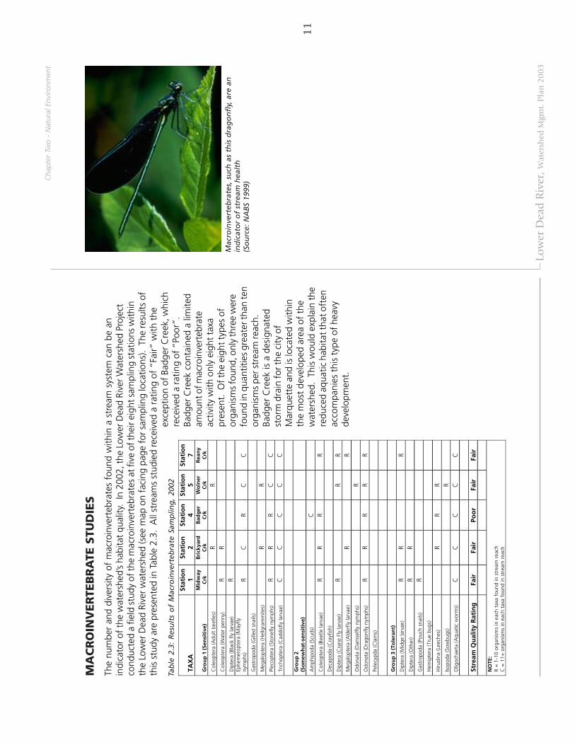
The
num
ber
and
dive
rsity
of
mac
roin
vert
ebra
tes
foun
d w
ithin
a s
trea
m s
yste
m c
an b
e an
indi
cato
r of
the
wat
ersh
ed’s
habi
tat
qual
ity.
In 2
002,
the
Low
er D
ead
Rive
r W
ater
shed
Pro
ject
cond
ucte
d a
field
stu
dy o
f the
mac
roin
vert
ebra
tes
at fi
ve o
f the
ir ei
ght s
ampl
ing
stat
ions
with
inth
e Lo
wer
Dea
d Ri
ver
wat
ersh
ed (s
ee m
ap o
n fa
cing
pag
e fo
r sa
mpl
ing
loca
tions
). T
he r
esul
ts o
fth
is s
tudy
are
pre
sent
ed in
Tab
le 2
.3.
All
stre
ams
stud
ied
rece
ived
a r
atin
g of
“Fa
ir” w
ith t
heex
cept
ion
of B
adge
r Cre
ek, w
hich
rece
ived
a ra
ting
of “
Poor
”.Ba
dger
Cre
ek c
onta
ined
a li
mite
dam
ount
of m
acro
inve
rteb
rate
activ
ity w
ith o
nly
eigh
t tax
apr
esen
t. O
f the
eig
ht ty
pes
ofor
gani
sms
foun
d, o
nly
thre
e w
ere
foun
d in
qua
ntiti
es g
reat
er th
an te
nor
gani
sms
per s
trea
m re
ach.
Badg
er C
reek
is a
des
igna
ted
stor
m d
rain
for t
he c
ity o
fM
arqu
ette
and
is lo
cate
d w
ithin
the
mos
t de
velo
ped
area
of
the
wat
ersh
ed.
This
wou
ld e
xpla
in t
here
duce
d aq
uatic
hab
itat t
hat o
ften
acco
mpa
nies
thi
s ty
pe o
f he
avy
deve
lopm
ent.
TAX
A
Stat
ion
1
Stat
ion
2
Stat
ion
4
Stat
ion
5
Stat
ion
7
Gro
up
1 (
Sen
siti
ve)
Mid
way
C
rk
Bri
ckya
rd
Crk
B
adg
er
Crk
W
oln
er
Crk
R
ean
y C
rk
Col
eopt
era
(Adu
lt be
etle
s)
R
R
C
oleo
pter
a (W
ater
pen
ny)
R R
D
ipte
ra (B
lack
fly
larv
ae)
R
Ep
hem
erop
tera
(May
fly
nym
phs)
R
C
R C
C
G
astr
opod
a (G
illed
sna
ils)
M
egal
opte
ra (H
ellg
ram
mite
s)
R
R
Pl
ecop
tera
(Sto
nefly
nym
phs)
R
R R
C
C
Tric
hopt
era
(Cad
disf
ly la
rvae
) C
C
C
C
C
G
rou
p 2
(S
om
ewh
at-s
ensi
tive
)
Am
phip
oda
(Scu
ds)
C
Col
eopt
era
(Bee
tle la
rvae
) R
R R
R
Dec
apod
a (C
rayf
ish)
Dip
tera
(Cra
ne F
ly la
rvae
) R
R R
Meg
alop
tera
(Ald
erfly
larv
ae)
R
R O
dona
ta (D
amse
lfly
nym
phs)
R
Odo
nata
(Dra
gonf
ly n
ymph
s)
R R
R R
R Pe
lecy
pda
(Cla
ms)
Gro
up
3 (
Tole
ran
t)
D
ipte
ra (M
idge
larv
ae)
R R
R D
ipte
ra (O
ther
) R
R
Gas
trop
oda
(Pou
ch s
nails
) R
Hem
ipte
ra (T
rue
bugs
)
Hiru
dina
(Lee
ches
)
R R
R
Isop
oda
(Sow
bugs
)
R
Olig
ocha
eta
(Aqu
atic
wor
ms)
C
C
C
C
C
Stre
am Q
ual
ity
Rat
ing
Fa
ir
Fair
Po
or
Fair
Fa
ir
NO
TE:
R =
1-1
0 or
gani
sms
in e
ach
taxa
fou
nd in
str
eam
rea
ch
C =
11+
org
anis
ms
in e
ach
taxa
fou
nd in
str
eam
rea
ch
Tab
le 2
.3:
Res
ult
s o
f M
acro
inve
rteb
rate
Sam
plin
g,
2002
Mac
roin
vert
ebra
tes,
su
ch a
s th
is d
rag
on
fly,
are
an
ind
icat
or
of
stre
am h
ealt
h(S
ou
rce:
NA
BS
1999
)

12
1212
12 12
0.5
00.
51
Mile
sLO
WER
DE
AD
RIV
ER W
AT
ERSH
ED
MA
NA
GE
MEN
T P
LAN
Top
ogr
aph
yLo
wer
Dea
d R
iver
Wat
ersh
ed
Inte
rmitt
ent S
trea
mPe
renn
ial S
trea
m
Wat
erCo
ntou
rs
Railr
oad
Road
way
%g550
%g492
IÀ?ì
%g492
%g550

13
1313
13 13
Low
er D
ead
Riv
er, W
ater
shed
Mgm
t. P
lan
200
3
TOPO
GR
APH
Y
The
effe
cts
of t
he P
leis
toce
ne ic
e ag
e ca
n be
see
n in
the
var
ying
top
ogra
phy
thro
ugho
ut t
heLo
wer
Dea
d Ri
ver
wat
ersh
ed.
Thi
s va
riety
incl
udes
rel
ativ
ely
flat
area
s, g
ently
rol
ling
hills
, an
dve
ry s
teep
slo
pes,
par
ticul
arly
adj
acen
t to
str
eam
and
riv
er c
orrid
ors
(God
by a
nd S
uppn
ick
2001
,C
UPP
AD
199
8).
In M
arqu
ette
Tow
nshi
p ne
arly
25%
of
the
tow
nshi
p ha
s sl
opes
gre
ater
tha
n15
% (S
undb
erg
et a
l. 19
95).
The
map
on
the
faci
ng p
age
show
s th
e to
pogr
aphy
of
the
wat
ersh
ed a
rea.
This
var
ied
topo
grap
hy c
an b
e a
dete
rmin
ing
fact
or in
the
pat
tern
of
deve
lopm
ent
in t
hew
ater
shed
. C
urre
nt c
onst
ruct
ion
tech
niqu
es a
nd t
he m
arke
t’s s
tron
g de
sire
to
take
adv
anta
geof
long
vie
ws
and
attr
activ
e vi
stas
exe
rts
sign
ifica
nt d
evel
opm
ent
pres
sure
on
thes
e fr
agile
area
s.
How
ever
, whe
n de
velo
pmen
t oc
curs
nea
r st
eep
slop
es t
here
is a
n in
crea
sed
risk
ofer
osio
n, s
edim
enta
tion,
and
dam
age
to a
quat
ic h
abita
t.
In t
heir
com
preh
ensi
ve d
evel
opm
ent
plan
s, b
oth
Mar
quet
te a
nd N
egau
nee
Tow
nshi
ps d
isco
urag
e hi
gh-d
ensi
ty d
evel
opm
ent
onm
oder
ate
slop
es (
15%
-25%
), pr
efer
ring
such
dev
elop
men
t be
loca
ted
on a
reas
with
less
rel
ief
(Sun
dber
g et
al.
1995
, C
UPP
AD
199
8).
Acc
ordi
ng t
o M
arqu
ette
Tow
nshi
p’s
deve
lopm
ent
plan
,im
prop
er p
lann
ing
as it
rel
ates
to
the
area
’s to
pogr
aphy
can
res
ult
in n
ot o
nly
the
dest
ruct
ion
ofan
aes
thet
ic f
eatu
re,
but
also
“so
il st
abili
ty d
istu
rban
ces,
alte
ring
of e
stab
lishe
d dr
aina
gew
ays,
elim
inat
ion
of n
atur
al w
inds
cree
ns (
vege
tatio
n),
land
slip
page
, an
d ra
pid
eros
ion
whi
ch a
dds
silt
and
sedi
men
t to
dow
nstr
eam
wat
erw
ays”
(Su
ndbe
rg e
t al
. 19
95).
Cha
pter
Tw
o -
Nat
ural
Env
ironm
ent
Pro
tect
ing
Ste
ep
Slo
pes:
The
Low
er D
ead
Rive
r w
ater
shed
con
tain
sst
eepl
y sl
oped
are
as,
man
y of
whi
ch a
read
jace
nt t
o w
ater
way
s.
In o
rder
to
prot
ect
thes
e fr
agile
slo
pes,
it is
rec
omm
ende
d th
atve
geta
tion
alon
g th
e ed
ge o
f th
e st
ream
not
be d
istu
rbed
. T
his
vege
tatio
n he
lps
to c
ontr
oler
osio
n an
d pr
even
ts p
ollu
ted
stor
mw
ater
from
flo
win
g in
to t
he s
trea
m.
Figu
re 2
.1gi
ves
gene
ral g
uide
lines
for
how
larg
e th
isrip
aria
n bu
ffer
are
a sh
ould
be.
M
ore
info
r-m
atio
n on
rip
aria
n bu
ffer
s is
pre
sent
ed in
Cha
pter
Fiv
e -
Stra
tegi
es &
Rec
omm
enda
-tio
ns.
Fig
ure
2.1
: Veg
etat
ed B
uff
ers
Pro
tect
Ste
ep S
lop
es

14
1414
14 14
IÀ?ì
%g480
%g492
%g550
0.5
00.
51
Mile
sLO
WE
R D
EA
D R
IVER
WAT
ER
SHE
D M
AN
AG
EMEN
T P
LAN
Exis
tin
g V
eget
atio
nA
spen
, Bir
chCo
nife
rCr
opla
ndH
ardw
ood
Her
bace
ous O
penl
and
Shru
blan
d
Wat
erPe
renn
ial S
trea
mIn
term
itten
t Str
eam
Railr
oad
Road
way

15
1515
15 15
Low
er D
ead
Riv
er, W
ater
shed
Mgm
t. P
lan
200
3
VEG
ETA
TIO
N
An
exam
inat
ion
of la
nd u
se t
hrou
ghou
t th
e w
ater
shed
sho
ws
that
the
maj
ority
(78
.5%
) of
the
wat
ersh
ed r
emai
ns f
ores
ted,
with
ano
ther
3%
cla
ssifi
ed a
s op
en f
ield
or
agric
ultu
re a
reas
. T
here
mai
ning
land
is d
esig
nate
d as
urb
an,
barr
en,
or w
ater
-rel
ated
land
use
s (S
ee T
able
2.4
).
Fore
sts
spec
ies
incl
ude
mat
ure
stan
ds o
f no
rthe
rn h
ardw
oods
suc
h as
oak
and
map
le a
ndst
ands
of
mat
ure
hem
lock
. Th
ere
are
also
low
er q
ualit
y sp
ecie
s su
ch a
s ta
g al
ders
, asp
en, a
ndbi
rch
(God
by a
nd S
uppn
ick
2001
, C
UPP
AD
199
8).
The
Exi
stin
g Ve
geta
tion
map
on
the
faci
ngpa
ge s
how
s a
deta
iled
map
ping
of
vege
tatio
n w
ithin
the
wat
ersh
ed,
whi
le T
able
2.5
sho
ws
the
brea
kdow
n by
acr
eage
.
Muc
h of
the
for
este
d ar
ea is
ow
ned
by la
rge
corp
orat
ions
and
is d
esig
nate
d as
Com
mer
cial
Fore
st R
eser
ve (
CFR
). O
wne
rs in
clud
e co
rpor
atio
ns s
uch
as E
scan
aba
Pape
r C
o.,
Bens
on F
ores
tLt
d.,
Long
year
Rea
lty,
and
the
Cle
vela
nd-C
liffs
Iron
Com
pany
(Su
nber
g et
al.
1995
, C
UPP
AD
1998
). A
reas
tha
t ar
e de
sign
ated
as
a C
omm
erci
al F
ores
t Re
serv
e m
ust
be m
aint
aine
d as
afo
rest
ed t
ract
of
land
and
allo
w p
ublic
acc
ess
for
dayt
ime
recr
eatio
n ac
tiviti
es s
uch
as h
untin
gor
fis
hing
(C
UPP
AD
199
8).
Cha
pter
Tw
o -
Nat
ural
Env
ironm
ent
Veg
etat
ion
Typ
e A
cres
%
of
To
tal
Asp
en, B
irch
5,00
8 43
%
Con
ifer
927
8%
Cro
plan
d 21
<
1%
Har
dwoo
d 5,
247
45%
O
penl
and
73
<1%
S
hrub
land
32
1 3%
T
ota
l Acr
eag
e 11
,597
10
0%
Tab
le 2
.5:
Exis
tin
g V
eget
atio
n
Lan
d U
se
Acr
es
% o
f T
ota
l F
ores
ted
11,1
83
78.5
%
Agr
icul
tura
l 21
0.
1%
Bar
ren
16
0.1%
O
pen
Fie
ld
394
2.8%
U
rban
2,
207
15.5
%
Wat
er
295
2.1%
W
etla
nd
130
0.9%
T
ota
l Acr
eag
e 14
,246
10
0%
Tab
le 2
.4: E
xist
ing
Lan
d U
se

16
1616
16 16
0.5
00.
51
Mile
sLO
WER
DEA
D R
IVER
WAT
ERSH
ED
MA
NA
GE
MEN
T P
LAN
Surf
ace
Geo
logy
Low
er D
ead
Rive
r Wat
ersh
edRo
adw
ayRa
ilroa
d
Pere
nnia
l Str
eam
Inte
rmitt
ent S
trea
mW
ater
Coar
se-t
extu
red
gla
cial
till
Glac
ial o
utw
ash
sand
and
grav
el a
nd p
ostg
laci
al a
lluvi
umLa
cust
rine
sand
and
grav
el
Thin
to d
iscon
tinuo
us g
laci
al ti
ll ov
er b
edro
ck
IÀ?ì
%g480
%g492
%g550

17
1717
17 17
Low
er D
ead
Riv
er, W
ater
shed
Mgm
t. P
lan
200
3
SU
RFA
CE G
EO
LOG
Y
The
surf
ace
geol
ogy
and
soil
com
posi
tion
of a
wat
ersh
ed c
an b
e im
port
ant
fact
ors
whe
nse
ekin
g w
ays
to b
est
prot
ect
the
wat
er q
ualit
y of
an
area
. W
ithin
the
Low
er D
ead
Rive
r w
ater
-sh
ed th
e su
rfac
e ge
olog
y co
nsis
ts p
rimar
ily o
f fou
r cat
egor
ies
(as
show
n in
the
map
of S
urfa
ceG
eolo
gy o
n th
e fa
cing
pag
e):
•C
oars
e-te
xtur
ed g
laci
al t
ill•
Thin
till
ove
r be
droc
k•
Gla
cial
out
was
h sa
nd a
nd g
rave
l•
Lacu
stri
ne
sand
and
gra
vel
The
area
s of
gla
cial
out
was
h, s
and
and
grav
el a
re o
f pa
rtic
ular
impo
rtan
ce s
ince
the
y se
rve
asgr
ound
wat
er r
echa
rge
area
s.
Thes
e sa
ndy
soils
pro
vide
opp
ortu
nitie
s fo
r in
filtr
atio
n an
d se
rve
tore
plen
ish
loca
l wat
er s
yste
ms
thro
ugh
grou
ndw
ater
rec
harg
e (A
LMN
200
2).
Are
as w
here
bedr
ock
is n
ear
to t
he s
urfa
ce d
o no
t pr
ovid
e go
od s
ourc
es o
f gr
ound
wat
er.
Cha
pter
Tw
o -
Nat
ural
Env
ironm
ent

18
1818
18 18
New
dev
elo
pm
ent
alo
ng
th
e U
S41-
M28
co
rrid
or
19
1919
19 19
Low
er D
ead
Riv
er, W
ater
shed
Mgm
t. P
lan
200
3
Alth
ough
a la
rge
port
ion
of th
e Lo
wer
Dea
d Ri
ver w
ater
shed
stil
l rem
ains
in it
s na
tura
l sta
te,
exis
ting
grow
th a
nd d
evel
opm
ent
are
alre
ady
havi
ng a
n ef
fect
on
the
qual
ity o
f th
e w
ater
shed
’sna
tura
l res
ourc
es.
In o
rder
to b
ette
r und
erst
and
the
patt
ern
of d
evel
opm
ent,
Cha
pter
3 w
ill fo
cus
on id
entif
ying
the
wat
ersh
ed’s
desi
gnat
ed u
ses,
the
patt
ern
of e
xist
ing
land
use
, and
are
as th
atar
e lik
ely
to e
xper
ienc
e fu
ture
gro
wth
.
DESIG
NA
TED
USES
Acc
ordi
ng t
o Br
own
et a
l. (2
000)
the
iden
tific
atio
n of
des
igna
ted
uses
with
in a
par
ticul
arw
ater
shed
is a
crit
ical
firs
t st
ep t
owar
d an
alyz
ing
thos
e us
es t
hat
are
not
bein
g m
et a
nd t
hose
that
are
bei
ng t
hrea
tene
d by
act
iviti
es o
n la
nd.
The
se “
desi
gnat
ed u
ses”
are
def
ined
as
the
prot
ecte
d us
es o
f w
ater
as
they
are
est
ablis
hed
by s
tate
and
fed
eral
wat
er q
ualit
y pr
ogra
ms
(Bro
wn
et a
l. 20
00).
The
sta
te o
f M
ichi
gan
prov
ides
a s
et o
f de
sign
ated
use
s th
at a
ll su
rfac
ew
ater
s in
the
sta
te a
re r
equi
red
to m
eet.
Th
e fo
llow
ing
list
iden
tifie
s th
e de
sign
ated
use
s th
atar
e cu
rren
tly b
eing
met
by
the
Low
er D
ead
Rive
r W
ater
shed
:
•In
dust
rial w
ater
sup
ply
- Th
e W
e En
ergi
es P
resq
ue Is
le P
ower
Pla
nt, l
ocat
ed a
t th
em
outh
of
the
Dea
d Ri
ver,
extr
acts
wat
er f
rom
Lak
e Su
perio
r to
coo
l the
ir ge
nera
ting
faci
lity.
The
wat
er is
the
n di
scha
rged
into
Lak
e Su
perio
r. U
nder
em
erge
ncy
cond
ition
s,th
e po
wer
pla
nt h
as t
he a
bilit
y to
use
the
Dea
d Ri
ver
as a
n in
dust
rial w
ater
sou
rce
and
disc
harg
e ou
tfal
l.
•Pu
blic
wat
er s
uppl
y at
the
poi
nt o
f in
take
– P
otab
le w
ater
is s
uppl
ied
to t
he C
ity o
fM
arqu
ette
by
the
city
wat
er s
yste
m. T
he m
unic
ipal
wat
er in
take
is lo
cate
d ne
ar L
ower
Har
bor.
Tow
nshi
ps w
ithin
the
wat
ersh
ed b
ound
arie
s ex
trac
t gro
undw
ater
as
thei
r mea
nsof
pot
able
wat
er.
•N
avig
atio
n –
The
Dea
d Ri
ver
syst
em is
con
side
red
navi
gabl
e w
ater
s w
ith p
ublic
acc
ess
site
s lo
cate
d at
the
McC
lure
Bas
in,
the
Fore
stvi
lle B
asin
, an
d th
e To
uris
t Pa
rk B
asin
.
•C
oldw
ater
fis
hery
– S
trea
ms
in t
he w
ater
shed
mee
t M
ichi
gan’
s te
mpe
ratu
re s
tand
ards
to
supp
ort c
oldw
ater
fish
hab
itat.
•In
dige
nous
aqu
atic
life
and
wild
life
– A
ccor
ding
to n
atur
al fe
atur
es in
vent
ory
the
Low
erD
ead
Rive
r W
ater
shed
is r
ecog
nize
d to
sup
port
a v
arie
ty o
f aq
uatic
and
wild
life
spec
ies.
Cha
pter
Thr
ee -
Bui
lt En
viro
nmen
t
AN
ALY
SIS
OF
THE
BU
ILT
EN
VIR
ON
ME
NT
AN
ALY
SIS
OF
THE
BU
ILT
EN
VIR
ON
ME
NT
AN
ALY
SIS
OF
THE
BU
ILT
EN
VIR
ON
ME
NT
AN
ALY
SIS
OF
THE
BU
ILT
EN
VIR
ON
ME
NT
AN
ALY
SIS
OF
THE
BU
ILT
EN
VIR
ON
ME
NT
Ch
apte
r Th
ree

20
2020
20 20
Tab
le 3
.1: T
hre
aten
ed U
ses
in t
he
Low
er D
ead
Riv
er W
ater
shed
Thre
aten
ed U
ses
Sou
rce
of
Imp
airm
ent
Pollu
tan
ts
Sou
rces
Pu
blic
Wat
er S
uppl
y In
crea
sed
stor
mw
ater
inpu
ts
Sedi
men
tatio
n O
ils, g
reas
e, a
nd m
etal
s U
rban
Run
off
Nav
igat
ion
Dam
impo
undm
ents
St
ream
cha
nnel
izat
ion
Sedi
men
t St
ream
ban
ks
Col
dwat
er f
ishe
ry
Sedi
men
tatio
n N
utrie
nt L
oadi
ng
Stre
am c
ross
ings
H
ydro
logi
c flo
w
Dam
impo
undm
ents
Sedi
men
t N
utrie
nts
Stre
am c
ross
ings
Fa
iling
sep
tic s
yste
ms
Resi
dent
ial f
ertil
izer
us
e
Indi
geno
us A
quat
ic
life/
Wild
life
Erod
ing
stre
am c
ross
ings
Ri
ver
flood
ing
Tran
spor
tatio
n/U
tility
cor
ridor
s In
crea
sed
deve
lopm
ent
Loss
of
ripar
ian
vege
tatio
n
Sedi
men
t H
ydro
logi
c flo
w
Stre
am c
ross
ings
St
ream
ban
ks
Hyd
rolo
gic
flow
U
rban
sto
rmw
ater

21
2121
21 21
Low
er D
ead
Riv
er, W
ater
shed
Mgm
t. P
lan
200
3
•Pa
rtia
l bod
y co
ntac
t rec
reat
ion
– W
ater
s ar
e co
nsid
ered
sui
tabl
e fo
r par
tial b
ody
cont
act
recr
eatio
n, w
ith m
inim
al t
hrea
t to
pub
lic h
ealth
due
to
wat
er q
ualit
y.
•To
tal b
ody
cont
act
recr
eatio
n be
twee
n M
ay 1
and
Oct
ober
31
– A
ll w
ater
s w
ithin
the
Low
er D
ead
Rive
r wat
ersh
ed a
re c
onsi
dere
d su
itabl
e fo
r ful
l bod
y co
ntac
t dur
ing
the
recr
eatio
n se
ason
.
As
deve
lopm
ent
cont
inue
s an
d th
e ef
fect
s of
the
bui
lt en
viro
nmen
t ha
ve a
gre
ater
eff
ect
onth
e qu
ality
of
natu
ral r
esou
rces
, man
y of
the
se d
esig
nate
d us
es c
an b
e at
ris
k. P
ollu
tant
s,se
dim
ents
, sto
rmw
ater
runo
ff, a
nd o
ther
man
-mad
e im
pairm
ents
can
sig
nific
antly
redu
ce th
enu
mbe
r of
des
igna
ted
uses
tha
t a
part
icul
ar w
ater
bod
y ca
n su
ppor
t. T
he L
ower
Dea
d Ri
ver
wat
ersh
ed is
beg
inni
ng to
see
som
e of
thes
e de
sign
ated
use
s be
ing
thre
aten
ed d
ue to
impa
cts
from
the
bui
lt en
viro
nmen
t. T
able
3.1
iden
tifie
s th
ese
thre
aten
ed u
ses
alon
g w
ithpo
tent
ial s
ourc
es fo
r im
pact
with
in th
e w
ater
shed
.
Thre
ate
ne
d U
ses
The
next
ste
p in
a w
ater
shed
man
agem
ent
plan
is t
o id
entif
y th
e de
sign
ated
use
s th
at a
re b
eing
thre
aten
ed o
r im
paire
d. I
dent
ifyin
g th
reat
ened
use
s w
ill h
elp
deve
lop
a lis
t of
kno
wn
orsu
spec
ted
pollu
tant
s in
the
wat
ersh
ed a
nd c
reat
e a
serie
s of
con
trol
mea
sure
s fo
r ea
ch a
rea
ofco
ncer
n. I
nfor
mat
ion
rega
rdin
g th
e ca
uses
and
sou
rces
that
nee
d to
be
cont
rolle
d w
asex
trap
olat
ed fr
om th
e w
ater
shed
inve
ntor
y, s
trea
m c
ross
ing
inve
ntor
y, a
nd m
acro
inve
rteb
rate
mon
itorin
g. T
he fo
llow
ing
list i
dent
ifies
thre
aten
ed u
ses
of th
e Lo
wer
Dea
d Ri
ver w
ater
shed
:
•Pu
blic
wat
er s
uppl
y –
The
desi
gnat
ed u
se o
f pu
blic
wat
er s
uppl
y is
thr
eate
ned
due
to a
nin
crea
se in
hea
vy m
etal
s an
d or
gani
c co
mpo
unds
. Th
e on
ly k
now
n so
urce
of
thes
epo
lluta
nts
is u
rban
runo
ff.
•N
avig
atio
n –
The
desi
gnat
ed u
se o
f na
viga
tion
is im
paire
d du
e to
sed
imen
t in
the
stre
am. T
he k
now
n so
urce
of
this
pol
luta
nt is
str
eam
ban
ks t
hat
impa
irs d
amim
poun
dmen
ts a
nd n
atur
al s
trea
m h
ydro
logy
.•
Col
dwat
er f
ishe
ry –
The
des
igna
ted
use
of c
oldw
ater
fis
hery
is t
hrea
tene
d du
e to
an
incr
ease
in s
edim
ent
and
nutr
ient
s. T
he s
uspe
cted
sou
rce
of t
hese
pol
luta
nts
is s
trea
mcr
ossi
ngs,
faili
ng s
eptic
sys
tem
s, a
nd re
side
ntia
l fer
tiliz
er.
•In
dige
nous
aqu
atic
life
/wild
life
– Th
e de
sign
ated
use
of
indi
geno
us a
quat
ic li
fe/w
ildlif
e is
thre
aten
ed d
ue t
o in
crea
sed
sedi
men
t in
the
wat
erw
ay. T
he s
uspe
cted
sou
rce
ofse
dim
ent i
s fr
om s
trea
m c
ross
ings
, str
eam
ban
ks, a
nd u
rban
sto
rmw
ater
.
An
iden
tific
atio
n of
the
cau
ses
and
sour
ces
that
nee
d to
be
cont
rolle
d an
d es
timat
es o
f th
eex
tent
to w
hich
they
are
pre
sent
in th
e w
ater
shed
are
furt
her d
iscu
ssed
in C
hapt
er 6
:Im
plem
enta
tion.

22
2222
22 22
0.5
00.
51
Mile
sLO
WE
R D
EAD
RIV
ER W
AT
ER
SHE
D M
AN
AG
EM
ENT
PLA
N
Exis
tin
g La
nd
Use
Inte
rmitt
ent S
trea
mPe
renn
ial S
trea
m
Railr
oad
Road
way
s
Fore
sted
Com
mer
cial
Indu
stri
alIn
stitu
tiona
lM
ulti-
Fam
ily R
esid
entia
lSi
ngle
-Fam
ily R
esid
entia
l
Cro
plan
dEx
pose
d Ro
ckEx
trac
tive
Wat
er
Recr
eatio
nal
/ C
ultu
ral
Util
ities
/ T
rans
port
atio
n
Shru
b/ H
erba
ceou
s
IÀ?ì
%g492
%g550
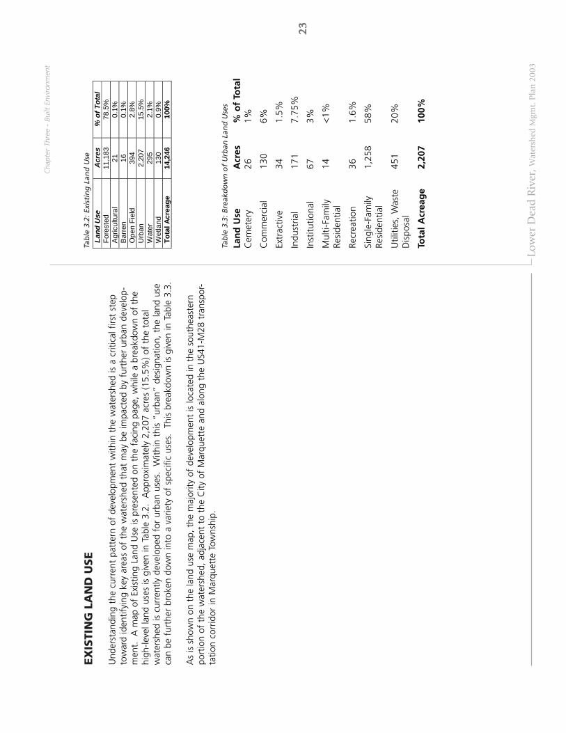
23
2323
23 23
Low
er D
ead
Riv
er, W
ater
shed
Mgm
t. P
lan
200
3
EX
ISTI
NG
LA
ND
USE
Und
erst
andi
ng t
he c
urre
nt p
atte
rn o
f de
velo
pmen
t w
ithin
the
wat
ersh
ed is
a c
ritic
al f
irst
step
tow
ard
iden
tifyi
ng k
ey a
reas
of
the
wat
ersh
ed t
hat
may
be
impa
cted
by
furt
her
urba
n de
velo
p-m
ent.
A
map
of
Exis
ting
Land
Use
is p
rese
nted
on
the
faci
ng p
age,
whi
le a
bre
akdo
wn
of t
hehi
gh-le
vel l
and
uses
is g
iven
in T
able
3.2
. A
ppro
xim
atel
y 2,
207
acre
s (1
5.5%
) of
the
tot
alw
ater
shed
is c
urre
ntly
dev
elop
ed f
or u
rban
use
s.
With
in t
his
“urb
an”
desi
gnat
ion,
the
land
use
can
be f
urth
er b
roke
n do
wn
into
a v
arie
ty o
f sp
ecifi
c us
es.
This
bre
akdo
wn
is g
iven
in T
able
3.3
.
As
is s
how
n on
the
land
use
map
, the
maj
ority
of
deve
lopm
ent
is lo
cate
d in
the
sou
thea
ster
npo
rtio
n of
the
wat
ersh
ed,
adja
cent
to
the
City
of
Mar
quet
te a
nd a
long
the
US4
1-M
28 t
rans
por-
tatio
n co
rrid
or in
Mar
quet
te T
owns
hip.
Cha
pter
Thr
ee -
Bui
lt En
viro
nmen
t
Tab
le 3
.3: B
reak
do
wn
of
Urb
an L
and
Use
s
Lan
d U
seA
cres
% o
f To
tal
Cem
eter
y26
1%
Com
mer
cial
130
6%
Extr
activ
e34
1.5%
Indu
stria
l17
17.
75%
Inst
itutio
nal
673%
Mul
ti-Fa
mily
14<
1%Re
side
ntia
l
Recr
eatio
n36
1.6%
Sing
le-F
amily
1,25
858
%Re
side
ntia
l
Util
ities
, W
aste
451
20%
Dis
posa
l
Tota
l A
crea
ge
2,20
710
0%
Lan
d U
se
Acr
es
% o
f T
ota
l F
ores
ted
11,1
83
78.5
%
Agr
icul
tura
l 21
0.
1%
Bar
ren
16
0.1%
O
pen
Fie
ld
394
2.8%
U
rban
2,
207
15.5
%
Wat
er
295
2.1%
W
etla
nd
130
0.9%
T
ota
l Acr
eag
e 14
,246
10
0%
Tab
le 3
.2: E
xist
ing
Lan
d U
se

24
2424
24 24
0.5
00.
51
Mile
sLO
WER
DEA
D R
IVER
WA
TER
SHED
MA
NA
GEM
ENT
PLA
N
Futu
re D
evel
opm
ent
Are
asIn
term
itten
t Str
eam
Pere
nnia
l Str
eam
Wat
er
Road
way
City
of M
arqu
ette
(Bui
lt O
ut)
Railr
oad
Indu
stria
l
Dev
elop
men
t Dist
rict
Resi
dent
ial
Low
er D
ead
Riv
er W
ater
shed
Com
mer
cial
Wolner Creek
Badg
er C
reek
Bric
kyar
d C
reek
Dea
d River
Mid
way
Cre
e kHol
yoke
Cre
ekRea
ny C
reek
IÀ?ì
%g480
%g492
%g550 Bac
kyar
d Cree
k
Raney Creek

25
2525
25 25
Low
er D
ead
Riv
er, W
ater
shed
Mgm
t. P
lan
200
3
FUTU
RE G
RO
WTH
AR
EA
S
Beca
use
the
area
of
the
wat
ersh
ed t
hat
is w
ithin
the
City
of
Mar
quet
te is
ful
ly d
evel
oped
, mos
tof
the
fut
ure
grow
th w
ithin
the
wat
ersh
ed w
ill h
appe
n in
the
Mar
quet
te a
nd N
egau
nee
Tow
n-sh
ips.
Bo
th t
owns
hips
hav
e ex
perie
nced
rap
id g
row
th o
ver
the
last
50
year
s.
Mar
quet
teTo
wns
hip
saw
a 6
2% in
crea
se in
pop
ulat
ion
betw
een
1970
-199
0 (S
undb
erg
et a
l. 19
95),
whi
leN
egau
nee’
s po
pula
tion
incr
ease
d ov
er 3
00%
sin
ce 1
940
(CU
PPA
D 1
998)
. T
his
grow
th h
aspr
ompt
ed b
oth
tow
nshi
ps t
o de
velo
p co
mpr
ehen
sive
pla
ns t
o he
lp g
uide
fut
ure
grow
th a
nd t
oen
sure
the
pro
tect
ion
of t
heir
exis
ting
natu
ral r
esou
rces
. B
oth
tow
nshi
ps h
ave
plac
ed a
prio
rity
on p
rote
ctin
g th
eir
rura
l im
age
and
are
mak
ing
conc
erte
d ef
fort
s to
con
trol
the
pat
tern
of
deve
lopm
ent.
In
gen
eral
, fu
ture
gro
wth
will
be
dire
cted
tow
ards
infil
l are
as n
orth
and
sou
th o
fth
e U
S41-
M28
hig
hway
and
in a
reas
whe
re in
fras
truc
ture
and
ser
vice
s ar
e al
read
y av
aila
ble
(Sun
dber
g et
al.
1995
, C
UPP
AD
199
8).
The
se p
oten
tial d
evel
opm
ent
area
s ar
e in
dica
ted
on t
hem
ap o
f Fu
ture
Dev
elop
men
t A
reas
.
The
US4
1-M
28 h
ighw
ay s
erve
s as
the
bac
kbon
e fo
r m
uch
of t
he d
evel
opm
ent
in t
hese
tw
oto
wns
hips
. A
ccor
ding
to
the
Com
preh
ensi
ve P
lan
for
Mar
quet
te T
owns
hip,
the
com
mer
cial
deve
lopm
ent
and
regi
onal
sho
ppin
g m
alls
alo
ng t
he U
S41-
28 c
orrid
or s
erve
as
a “m
ajor
cor
efo
r a
varie
ty o
f fu
nctio
ns”
(Sun
dber
g et
al.
1995
). W
hile
thi
s de
velo
pmen
t ar
ea p
rovi
des
a se
tof
ret
ail a
men
ities
it is
not
with
out
issu
es.
Acc
ordi
ng t
o M
arqu
ette
’s C
ompr
ehen
sive
Pla
n, t
heco
st o
f de
velo
pmen
t ha
s in
clud
ed “
envi
ronm
enta
l deg
rada
tion,
tra
ffic
con
gest
ion,
hou
sing
shor
tage
s, c
hang
es in
the
rur
al la
ndsc
ape
and
the
skyr
ocke
ting
cost
s of
mun
icip
al s
ervi
ces”
(Sun
dber
g et
al.
1995
).
In a
dditi
on t
o th
e ne
w c
omm
erci
al d
evel
opm
ent
alon
g th
e U
S41-
M28
cor
ridor
, se
vera
l are
asw
ithin
Neg
aune
e an
d M
arqu
ette
Tow
nshi
ps a
re e
xper
ienc
ing
new
res
iden
tial d
evel
opm
ent
pres
sure
s in
the
ir ou
tlyin
g ru
ral a
reas
and
adj
acen
t to
the
larg
e st
orag
e ba
sins
, pa
rtic
ular
ly D
ead
Rive
r an
d M
cClu
re B
asin
s.
Unf
ortu
nate
ly, m
uch
of t
his
new
dev
elop
men
t is
not
ser
ved
bym
unic
ipal
ser
vice
s an
d re
side
nts
rely
on
sept
ic f
ield
s an
d pr
ivat
e w
ells
to
mee
t th
eir
infr
astr
uc-
ture
nee
ds (
CU
PPA
D 1
998)
. T
hese
out
lyin
g ar
eas
of r
esid
entia
l dev
elop
men
t ca
n be
a b
urde
non
mun
icip
aliti
es d
ue t
o th
e in
crea
sed
cost
of
serv
ices
to
thes
e ar
eas.
Th
ey c
an a
lso
have
ade
trim
enta
l im
pact
on
the
envi
ronm
ent,
par
ticul
arly
whe
re d
evel
opm
ent
exce
eds
the
capa
city
of
an a
rea
to s
uppo
rt s
eptic
sys
tem
s, t
hus
posi
ng a
ris
k fo
r gr
ound
wat
er c
onta
min
atio
n.
Thou
gh it
may
be
poss
ible
to
exte
nd t
he p
ublic
infr
astr
uctu
re,
plan
ning
for
add
ition
al s
ervi
ce a
reas
is a
diff
icul
t ta
sk.
Cur
rent
ly,
Mar
quet
te T
owns
hip
is e
xplo
ring
optio
ns t
o ex
tend
mun
icip
al w
aste
wa-
ter
in t
he T
row
brid
ge P
ark
area
. W
hile
util
ities
suc
h as
city
sew
er a
nd w
ater
can
allo
w f
or m
ore
dens
e de
velo
pmen
t, p
erha
ps h
altin
g th
e sp
raw
ling
tend
enci
es o
f la
rge
lot
deve
lopm
ent,
thi
sex
pans
ion
can
also
hav
e si
gnifi
cant
det
rimen
tal e
ffec
ts o
n th
e en
viro
nmen
tal r
esou
rces
of
thes
ene
wly
dev
elop
ed a
reas
.
Cha
pter
Thr
ee -
Bui
lt En
viro
nmen
t
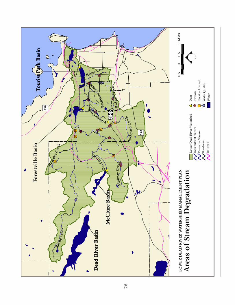
26
2626
26 26
0.5
00.
51
Mile
sLO
WE
R D
EA
D R
IVER
WAT
ER
SHED
MA
NA
GE
MEN
T P
LAN
Are
as o
f St
ream
Deg
rad
atio
nLo
wer
Dea
d R
iver
Wat
ersh
edIn
term
itten
t Str
eam
Pere
nnia
l Str
eam
Road
way
Railr
oad
Wat
er
$TD
am# S
Eros
ion
% UPh
ysic
al H
azar
dW
ater
Qua
lity
ÊÚ
% U% U
# S $T
# S
$T
# S
% U
# S
ÊÚ
% U% U
ÊÚ
# S
ÊÚ # SÊÚ
% U
# S
# S
# S
# S# S
# S
# S ÊÚ
#
Tour
ist P
ark
Bas
in
#
Dea
d R
iver
Bas
in#
McC
lure
Bas
in$T
#
Fore
stvi
lle B
asin
Wolner Creek
Badg
er C
reek
Bric
kyar
d C
reek
Dea
d River
Mid
way
Cre
ekHol
yoke
Cre
ekRea
ny C
reek
IÀ?ì
%g492
%g550 $T$T
%g550
%g492
#
McC
lure
Bas
in
#
Dea
d R
iver
Bas
in
#
Tour
ist P
ark
Bas
in
Raney Creek
Back
yard
Cre
ek

27
2727
27 27
Low
er D
ead
Riv
er, W
ater
shed
Mgm
t. P
lan
200
3
The
Low
er D
ead
Rive
r W
ater
shed
is im
pact
ed in
myr
iad
way
s fr
om h
uman
inte
ract
ion
with
the
wat
ersh
ed’s
natu
ral s
yste
ms.
In
its
2002
Pro
gres
s Re
port
, th
e La
ke S
uper
ior
Lake
wid
e M
anag
e-m
ent
Plan
iden
tifie
d a
num
ber
of s
tres
sors
tha
t ca
n ha
ve a
dire
ct e
ffec
t on
the
hea
lth o
f a
wat
ersh
ed.
The
se in
clud
ed it
ems
such
as
incr
ease
d le
vels
of
cont
amin
atio
n, d
am c
onst
ruct
ion,
habi
tat
frag
men
tatio
n, r
ecre
atio
n, r
oad
cons
truc
tion,
and
sho
relin
e re
side
ntia
l dev
elop
men
t(L
aMP
2002
) (S
ee m
ap o
n fa
cing
pag
e sh
owin
g ex
istin
g ar
eas
of s
trea
m d
egra
datio
n).
Whi
leth
eir
effe
cts
may
be
easi
ly d
emon
stra
ted,
it c
an s
omet
imes
be
diff
icul
t to
dia
gnos
e th
e so
urce
of
thes
e pr
oble
ms
due
to t
he v
arie
ty o
f w
ays
in w
hich
our
act
ions
can
aff
ect
the
heal
th a
nd v
italit
yof
the
wat
ersh
ed.
Evid
ence
of
hum
an im
pact
ran
ges
from
the
obv
ious
, suc
h as
dire
ct m
anip
ula-
tion
of t
he s
trea
m h
ydro
logy
, to
the
subt
le e
ffec
ts t
hat
even
sm
all p
erso
nal c
hoic
es c
an h
ave
onth
e he
alth
of
a st
ream
sys
tem
mile
s aw
ay.
In t
he f
ace
of in
crea
sing
dev
elop
men
t pr
essu
res,
esta
blis
hing
pro
tect
ive
mea
sure
s to
buf
fer
thes
e di
stur
banc
es is
par
amou
nt if
the
bio
tic in
tegr
ityof
the
riv
er s
yste
m is
to
be p
rote
cted
acc
ordi
ng t
o th
e es
tabl
ishe
d go
als
of t
his
stud
y.
Add
ition
-al
ly,
the
prot
ectio
n of
the
se w
ater
shed
s di
rect
ly a
ffec
ts t
he q
ualit
y of
the
aqu
atic
eco
syst
em in
Lake
Sup
erio
r.
In t
he L
ower
Dea
d Ri
ver
wat
ersh
ed s
yste
m,
the
follo
win
g hu
man
dis
turb
ance
s ha
ve le
d to
subs
tant
ial i
mpa
cts
on t
he w
ater
shed
’s he
alth
:
1)A
ltere
d H
ydro
logy
– d
am im
poun
dmen
ts a
nd s
trea
m c
hann
eliz
atio
n ha
sre
sulte
d in
dec
reas
ed s
trea
m le
ngth
and
sev
ere
loss
of
aqua
tic h
abita
t.
2)Tr
ansp
orta
tion
Issu
es –
cre
atio
n of
tra
nspo
rtat
ion
and
utili
ty c
orrid
ors
incl
udin
gst
ream
cro
ssin
gs a
nd t
he u
se o
f rip
aria
n co
rrid
ors
for
road
s an
d ut
ilitie
s, h
as le
dto
incr
ease
d se
dim
ent,
nut
rient
, an
d co
ntam
inan
t in
puts
, an
d th
e re
duct
ion
ofha
bita
t qu
ality
.
3)Im
pact
s of
Dev
elop
men
t –
incr
easi
ng u
rban
izat
ion
with
in t
he w
ater
shed
has
resu
lted
in in
crea
sed
impe
rvio
us s
urfa
ces,
incr
ease
d st
orm
wat
er in
puts
, po
int
and
non-
poin
t so
urce
pol
lutio
n, s
edim
enta
tion,
sur
face
wat
er d
rain
age,
nut
rient
inpu
ts,
and
loss
of
ripar
ian
vege
tatio
n.
4)Re
crea
tiona
l Act
iviti
es –
rec
reat
iona
l acc
ess
has
led
to t
he t
ram
plin
g of
vege
tatio
n, s
oil c
ompa
ctio
n, s
oil e
rosi
on,
and
othe
r di
stur
banc
es le
adin
g to
incr
ease
d se
dim
enta
tion
and
nutr
ient
inpu
ts in
to t
he s
trea
m s
yste
m.
Cha
pter
Fou
r -
Are
as o
f C
once
rn
AR
EA
S O
F C
ON
CE
RN
New
dev
elo
pm
ent
alo
ng
US4
1-M
28
Ch
apte
r Fo
ur
New
dev
elo
pm
ent
wit
hin
th
e w
ater
shed

28
2828
28 28
Mar
qu
ette
Val
ley
Mill
ing
Co
mp
any
His
tori
cal
Hig
hli
gh
t –
Rem
nan
ts o
f H
isto
ry A
lon
g t
he D
ead
Riv
er
Ther
e w
ere
seve
ral i
ndus
trie
s th
at o
nce
lined
the
ban
ks o
f th
e D
ead
Rive
r.
Are
as a
long
the
wat
erw
ay s
aw t
he e
stab
lishm
ent
of d
ams,
gene
ratin
g pl
ants
, bl
ast
furn
aces
, si
lver
and
gol
d m
ines
, flo
ur m
ills,
saw
mill
s, a
nd b
last
ing
furn
aces
. O
ne s
uch
indu
stry
’s re
mai
ns t
hat
can
still
be
foun
d in
the
Low
er D
ead
Rive
r w
ater
shed
is t
he f
ound
atio
n of
the
late
Mar
quet
te V
alle
y M
illin
g C
ompa
ny.
The
first
flo
ur m
ill in
the
U.P
. was
ow
ned
and
oper
ated
by
Alp
hons
e Be
rtra
nd in
188
7. T
he o
rigin
al s
ite w
as s
ituat
ed o
n a
smal
l cre
ek t
hat
empt
ied
into
the
Dea
d Ri
ver,
dow
nriv
er f
rom
the
tow
n of
Col
linsv
ille.
The
cre
ek w
as d
amm
ed a
nd s
erve
d as
an
abun
dant
wat
er s
uppl
y fo
rm
illin
g op
erat
ions
. 6
00 b
ushe
ls o
f lo
cally
rai
sed
whe
at w
ere
grou
nd in
the
fal
l in
addi
tion
to r
ye a
nd g
rain
for
fee
d.
Dur
ing
the
next
few
yea
rs,
the
mill
exp
erie
nced
insu
ffic
ient
wat
er s
uppl
y.
In M
arch
189
1, M
r. Be
rtra
nd s
old
the
mill
to
loca
l bus
ines
smen
and
the
Mar
quet
te V
alle
y M
illin
g C
ompa
ny w
as e
stab
lishe
d.
The
Mill
ing
Com
pany
neg
otia
ted
with
the
city
to
purc
hase
a n
ew s
ite a
long
the
Dea
d Ri
ver.
The
firs
t flo
ur w
as g
roun
d in
Mar
ch 1
892.
Th
e be
st g
rade
s of
flo
ur w
ere
sent
to
its U
.P. m
erch
ants
whi
le v
ario
us o
ther
grad
es w
ere
ship
ped
to N
ew Y
ork,
Geo
rgia
, and
as
far
as E
ngla
nd.
Aft
er t
he t
urn
of t
he c
entu
ry, t
he f
lour
mill
bus
ines
s be
gan
to w
ane.
C
ompe
titio
n fr
om b
igge
r m
ills,
hig
her
frei
ght
cost
s, a
nd t
he lo
ss o
fw
ater
pow
er f
rom
the
Dea
d Ri
ver
attr
ibut
ed t
o th
e M
arqu
ette
Val
ley
Mill
ing
Com
pany
clo
sing
its
door
s.
The
last
flo
ur w
as m
illed
in J
une
1904
and
soo
n th
erea
fter
the
mill
and
ele
vato
r bu
ildin
gs w
ere
torn
dow
n.
The
ruin
s of
the
old
sto
ne f
ound
atio
n ca
n st
ill b
e se
en o
n th
eso
uth
bank
of
the
Dea
d Ri
ver,
east
of
the
old
light
pla
nt o
n W
right
Str
eet.

29
2929
29 29
Low
er D
ead
Riv
er, W
ater
shed
Mgm
t. P
lan
200
3
ALT
ER
ED
HY
DR
OLO
GY
Man
has
mod
ified
the
Dea
d Ri
ver
for
over
130
yea
rs.
Sinc
e th
e or
igin
al s
ettle
rs t
o M
arqu
ette
disc
over
ed t
he r
iver
, dam
s w
ere
cons
truc
ted
to a
id in
log
driv
es, a
ssis
t in
pow
er f
or s
awm
ills,
and
to c
reat
e hy
droe
lect
ricity
for
the
com
mun
ity.
Begi
nnin
g in
188
9 w
hen
the
city
bui
lt a
woo
den
dam
for
its
first
ele
ctric
al p
lant
(cur
rent
ly k
now
n as
the
Tou
rist
Park
dam
) the
re h
asbe
en a
ser
ies
of c
hang
es t
o th
e na
tura
l flo
w r
egim
e of
the
Dea
d Ri
ver
syst
em.
By 1
919
thre
em
ore
dam
s ha
d be
en b
uilt
on t
he L
ower
Dea
d Ri
ver
incl
udin
g th
e Fo
rest
ville
and
McC
lure
Dam
s.Th
ese
impo
undm
ents
con
trib
ute
to t
he 2
.5 m
illio
n da
ms
foun
d on
riv
ers
and
stre
ams
thro
ugh-
out
the
Uni
ted
Stat
es.
Whi
le d
ams
and
the
hydr
oele
ctric
fac
ilitie
s th
ey p
ower
can
be
impo
rtan
ten
ergy
pro
duce
rs f
or a
n ar
ea, t
hey
also
exa
ct a
tol
l on
the
heal
th o
f th
e riv
er s
yste
m t
hey
depe
nd o
n. A
lthou
gh th
e re
duct
ion
in th
e us
e of
coa
l-fire
d pl
ants
can
cur
b th
e am
ount
of t
oxic
outp
ut b
eing
em
itted
into
the
syst
em, t
he c
hang
e in
the
river
hyd
rolo
gy c
an le
ad to
deg
rade
daq
uatic
hab
itat.
By
hold
ing
the
wat
er, t
here
is p
oten
tial f
or lo
wer
ed s
trea
m d
epth
, inc
reas
edw
ater
tem
pera
ture
s, a
nd a
redu
ctio
n in
the
dis
solv
ed o
xyge
n le
vels
in t
he w
ater
, all
of w
hich
can
affe
ct a
quat
ic s
peci
es (L
aMP
2002
).
Alt
ere
d H
yd
rolo
gy Im
pact
sA
s da
ms
beco
me
deco
mm
issi
oned
and
dila
pida
ted,
ther
e ar
e co
mpe
lling
reas
ons
to c
onsi
der
rem
oval
of
thes
e st
ruct
ures
. A
side
fro
m t
he p
oten
tial c
ost
of d
am m
aint
enan
ce a
nd r
epai
r,th
ere
are
ecol
ogic
al r
easo
ns t
o co
nsid
er t
heir
rem
oval
:
•D
ams
frag
men
t riv
ers
and
bloc
k th
e m
ovem
ent
of f
ish
and
othe
r sp
ecie
s•
Dam
s ha
rm w
ater
qua
lity,
bot
h ab
ove
and
belo
w t
he s
truc
ture
•D
ams
impe
de t
he r
iver
’s na
tura
l “flu
shin
g” f
unct
ions
•D
am f
ailu
re c
an b
e de
vast
atin
g to
peo
ple,
ani
mal
s, p
rope
rty,
and
hab
itat
Cha
pter
Fou
r -
Are
as o
f C
once
rn
Fore
stvi
lle D
am
Smal
l re
sid
enti
al d
am a
lon
g B
rick
yard
Cre
ek

30
3030
30 30
0.5
00.
51
Mile
sLO
WER
DE
AD
RIV
ER W
ATE
RSH
ED
MA
NA
GE
MEN
T P
LAN
Stre
am C
ross
ings
Low
er D
ead
Rive
r W
ater
shed
Inte
rmitt
ent S
trea
mPe
renn
ial S
trea
mRo
adw
ayRa
ilroa
dW
ater
Ford
Brid
geCu
lver
t# S # S # S # S
Cros
sing
(ty
pe u
nkno
wn)
# S
# S# S
# S # S
# S# S
# S# S # S
# S
# S
# S# S
# S
# S# S
# S# S# S# S
# S# S
# S# S
# S# S
# S
# S
# S
# S
# S# S # S
# S# S# S# S# S# S
# S # S# S
# S
# S # S
# S
%g550
%g492
%g480
#
McC
lure
Bas
in
#
Dea
d R
iver
Bas
in
#
Tour
ist P
ark
Basi
n
#
Tour
ist P
ark
Basi
n
#
Dea
d R
iver
Bas
in#
McC
lure
Bas
in
%g480
%g492
%g550 %g550
%g492
%g480
?ìIÀ
Reany
Cre
ek
Holyo
ke C
reek
Mid
way
Cre
e k
Dea
d River
Bric
kyar
d C
reek
Badg
er C
reek
Wolner Cree
k#
Fore
stvi
lle
Basi
n
#
McC
lure
Bas
in
#
Dea
d R
iver
Bas
in
#
Tour
ist P
ark
Basi
n
Raney Creek
Back
yard
Cre
ek
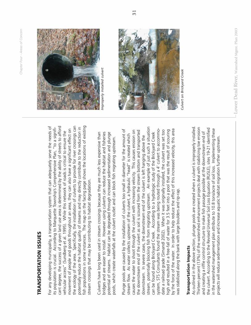
31
3131
31 31
Low
er D
ead
Riv
er, W
ater
shed
Mgm
t. P
lan
200
3
TRA
NSPO
RTA
TIO
N I
SSU
ES
For
any
deve
lopi
ng m
unic
ipal
ity,
a tr
ansp
orta
tion
syst
em t
hat
can
adeq
uate
ly s
erve
the
nee
ds o
fits
pop
ulat
ion
is c
ruci
al.
Acc
ordi
ng t
o M
arqu
ette
Tow
nshi
p’s
Com
preh
ensi
ve P
lan,
“to
a s
igni
fi-ca
nt d
egre
e, t
he s
ucce
ss o
f a
give
n la
nd u
se a
rea
is d
eter
min
ed b
y th
e ab
ility
of
stre
ets
to a
ffor
dve
hicu
lar
acce
ss”
(Sun
dber
g et
al.
1995
). W
hile
thi
s ne
twor
k of
roa
ds is
crit
ical
to
ensu
re t
hem
ovem
ent
of p
eopl
e an
d go
ods
thro
ugho
ut a
n ar
ea,
they
can
als
o ha
ve a
sig
nific
ant
effe
ct o
nth
e ec
olog
y of
the
are
a.
Spec
ifica
lly, t
he in
stal
latio
n of
cul
vert
s to
pro
vide
for
riv
er c
ross
ings
can
pote
ntia
lly r
educ
e th
e ha
bita
t qu
ality
of
stre
ams
and
may
dire
ctly
con
trib
ute
to t
he r
educ
tion
infis
h po
pula
tions
in s
ome
inst
ance
s.
The
map
on
the
faci
ng p
age
show
s th
e lo
catio
ns o
f ex
istin
gst
ream
cro
ssin
gs t
hat
may
be
cont
ribut
ing
to h
abita
t de
grad
atio
n.
Cul
vert
s ha
ve lo
ng b
een
used
in s
trea
m c
ross
ings
bec
ause
the
y ar
e m
uch
less
exp
ensi
ve t
han
brid
ges
and
are
easi
er t
o in
stal
l. H
owev
er u
sing
cul
vert
s ca
n re
duce
the
hab
itat
and
fishe
ries
pote
ntia
l of
stre
ams.
H
abita
t ca
n be
deg
rade
d th
roug
h in
crea
sed
sedi
men
tatio
n an
d pl
unge
pool
s, w
hich
cre
ate
wat
erfa
lls a
t th
e cu
lver
t ou
tlet
and
can
bloc
k fis
h m
igra
ting
upst
ream
.
Plun
ge p
ools
are
cau
sed
by t
he in
stal
latio
n of
cul
vert
s to
o sm
all i
n di
amet
er f
or t
he a
mou
nt o
fst
ream
flo
w.
As
wat
er c
olle
cts
upst
ream
of
the
culv
ert,
a h
ydra
ulic
“he
ad”
is c
reat
ed w
hich
caus
es t
he w
ater
to
shoo
t th
roug
h th
e cu
lver
t w
ith in
crea
sing
vel
ocity
. T
his
caus
es e
rosi
on o
nth
e do
wns
trea
m e
nd o
f th
e cu
lver
t as
soi
l is
scou
red
from
the
str
eam
bot
tom
and
tra
nspo
rted
dow
nstr
eam
. In
sev
ere
case
s, t
he d
owns
trea
m e
nd o
f th
e cu
lver
t is
left
han
ging
abo
ve t
hest
ream
, po
tent
ially
blo
ckin
g fis
h fr
om m
igra
ting
upst
ream
.
An
exam
ple
of ju
st s
uch
a si
tuat
ion
can
be f
ound
alo
ng B
ricky
ard
Cre
ek.
Acc
ordi
ng t
o a
hydr
olog
ic s
tudy
of
the
Bric
kyar
d C
reek
syst
em, S
TS C
onsu
ltant
s fo
und
the
stre
am w
as b
eing
rou
ted
thro
ugh
a 4’
cul
vert
to
acco
mm
o-da
te a
rai
lroad
gra
de (S
iman
dl 2
002)
. W
hen
it w
as o
rigin
ally
inst
alle
d, t
he c
ulve
rt w
as s
et t
oohi
gh a
nd r
esul
ted
in a
fre
e-fa
ll of
wat
er f
or 3
.5 f
eet
into
a p
ool t
hat
was
the
res
ult
of s
cour
ing
by t
he f
orce
of
the
wat
er.
In o
rder
to
help
red
uce
the
effe
ct o
f th
is in
crea
sed
velo
city
, thi
s ar
eaw
as s
tabi
lized
alo
ng th
e ba
nk w
ith la
rge
boul
ders
and
rip-
rap.
Tran
spo
rtati
on
Im
pact
sA
s ou
tline
d in
the
abo
ve s
ectio
n, p
lung
e po
ols
are
crea
ted
whe
n a
culv
ert
is im
prop
erly
inst
alle
d.Th
irtee
n pe
rcen
t (13
%) o
f the
wat
ersh
ed e
nhan
cem
ent p
roje
cts
deal
with
sta
biliz
ing
toe
eros
ion
and
crea
ting
a rif
fle c
ontr
ol s
truc
ture
to m
ake
fish
pass
age
poss
ible
at t
he d
owns
trea
m e
nd o
fth
e cu
lver
t. A
ccor
ding
to
the
Revi
sed
Uni
vers
al S
oil L
oss
Equa
tion
(RU
SLE)
, site
s 19
-21
iden
tifie
din
the
wat
ersh
ed m
anag
emen
t pla
n at
trib
ute
to 1
0.8
tons
/acr
e of
soi
l los
s. I
mpl
emen
ting
thes
epr
ojec
ts w
ill re
duce
sed
imen
tatio
n an
d in
crea
se a
quat
ic h
abita
t mig
ratio
n fu
rthe
r ups
trea
m.
Cha
pter
Fou
r -
Are
as o
f C
once
rn
Imp
rop
erly
in
stal
led
cu
lver
t
Cu
lver
t o
n B
rick
yard
Cre
ek

32
3232
32 32
The
imp
ervi
ou
s su
rfac
e as
soci
ated
wit
h n
ew d
evel
op
men
t ca
n h
ave
a d
etri
men
tal e
ffec
t o
n t
he
hea
lth
of
the
wat
ersh
ed

33
3333
33 33
Low
er D
ead
Riv
er, W
ater
shed
Mgm
t. P
lan
200
3
IMPA
CTS
OF
DEV
ELO
PM
EN
T
Rese
arch
has
sho
wn
that
incr
ease
d de
velo
pmen
t ca
n ha
ve p
rofo
und
effe
cts
on t
he w
ater
qual
ity a
nd h
abita
t po
tent
ial w
ithin
a w
ater
shed
. M
ost
mun
icip
aliti
es,
how
ever
, re
cogn
ize
that
halti
ng a
ll de
velo
pmen
t is
not
a p
ract
ical
way
to
addr
ess
thes
e is
sues
. T
his
man
agem
ent
plan
iden
tifie
s so
me
of t
he m
ost
com
mon
fac
tors
tha
t co
ntrib
ute
to w
ater
shed
deg
rada
tion.
By
conc
entr
atin
g on
add
ress
ing
thes
e is
sues
, co
mm
uniti
es c
an p
rote
ct t
heir
natu
ral r
esou
rces
,w
hile
stil
l pro
tect
ing
thei
r co
mm
unity
’s qu
ality
of
life.
So
me
of t
he w
orst
off
ende
rs t
hat
con-
trib
ute
to t
he d
egra
datio
n of
hab
itat
and
wat
er q
ualit
y in
clud
e:•
Impe
rvio
us S
urfa
ces
•St
orm
wat
er•
Sedi
men
tatio
n /
Eros
ion
•Te
mpe
ratu
re F
luct
uatio
ns
Imp
erv
iou
s Su
rface
As
deve
lopm
ent i
n M
arqu
ette
Cou
nty
cont
inue
s, s
o do
es th
e am
ount
of l
and
clea
red
for i
mpe
rvi-
ous
surf
aces
. W
hile
the
upp
er r
each
es o
f th
e D
ead
Rive
r w
ater
shed
sys
tem
is m
ostly
for
este
d, t
hela
nd u
se w
ithin
the
Low
er D
ead
Rive
r w
ater
shed
incl
udes
2,2
07 a
cres
(15.
5%) o
f de
velo
ped
land
.St
ruct
ures
with
in th
is a
rea,
suc
h as
road
s an
d ro
ofto
ps, a
ll co
ntrib
ute
to th
e am
ount
of i
mpe
rvio
ussu
rfac
e fo
und
in th
e w
ater
shed
.
Whi
le s
ome
natu
rally
impe
rvio
us s
ourc
es,
such
as
rock
-out
crop
ping
s or
cla
y so
ils,
do e
xist
, th
em
ajor
ity o
f th
em a
re m
an-m
ade.
A
s m
ore
impe
rvio
us s
urfa
ces
are
crea
ted,
the
am
ount
of
wat
er r
unni
ng o
ff o
f th
ese
surf
aces
and
into
loca
l wat
er s
yste
ms
also
incr
ease
s (S
ee F
igur
e 4.
1).
Stud
ies
show
tha
t on
ave
rage
, a t
ypic
al c
ity b
lock
gen
erat
es n
ine
times
mor
e ru
noff
tha
n a
natu
ral w
oodl
and
area
of
the
sam
e si
ze (E
PA 1
996)
. A
ccor
ding
to
stud
ies
cond
ucte
d by
the
Mic
higa
n D
NR,
“hi
gher
run
off
corr
elat
es t
o de
crea
sed
grou
nd w
ater
rec
harg
e, d
ecre
ased
base
flow
, in
crea
sed
and
flash
ier
stre
am f
low
, in
crea
ses
in t
empe
ratu
re,
turb
idity
, po
lluta
nts,
eros
ion,
and
cha
nges
in a
quat
ic b
iota
” (P
rem
o et
al.
2001
). E
xper
ts g
ener
ally
con
side
r a
wat
ersh
ed t
hat
has
11%
-25%
impe
rvio
us s
urfa
ce t
o be
“im
pact
ed”,
whi
le a
reas
tha
t co
ntai
nm
ore
than
25%
impe
rvio
us s
urfa
ces
are
cons
ider
ed “
degr
aded
” (P
rem
o et
al.
2001
).
Fort
unat
ely,
the
re a
re s
teps
tha
t ca
n be
tak
en t
o re
duce
the
impa
ct o
f im
perv
ious
sur
face
s on
the
heal
th o
f th
e w
ater
shed
. D
evel
oper
s an
d st
akeh
olde
rs h
ave
show
n a
conc
ern
rega
rdin
gst
orm
wat
er a
nd r
elat
ed n
on-p
oint
sou
rce
pollu
tion,
and
are
look
ing
for
inno
vativ
e w
ays
to h
elp
miti
gate
som
e of
the
ir ef
fect
s.
Spec
ific
stra
tegi
es f
or r
educ
ing
the
impa
ct o
f im
perv
ious
sur
-fa
ces
will
be
addr
esse
d in
the
“M
anag
emen
t St
rate
gies
& R
ecom
men
datio
ns”
sect
ion
of t
his
wat
ersh
ed m
anag
emen
t pl
an.
Cha
pter
Fou
r -
Are
as o
f C
once
rn
Fig
ure
4.1
: Im
pac
ts o
f Im
per
vio
us
Surf
aces
(So
urc
e: S
chu
eler
199
4)

34
3434
34 34
Fig
ure
4.2
: D
epic
tio
n o
f St
orm
wat
er “
Flas
h”
(So
urc
e: F
erg
uso
n 1
998)
Fig
ure
4.3
: H
igh
Lev
el o
f C
on
tam
inat
ion
in
“Fi
rst
Flu
sh”
(So
urc
e: F
erg
uso
n 1
998)

35
3535
35 35
Low
er D
ead
Riv
er, W
ater
shed
Mgm
t. P
lan
200
3
Sto
rmw
ate
rBe
caus
e th
e is
sue
of s
torm
wat
er is
clo
sely
rel
ated
to
that
of
impe
rvio
us s
urfa
ces,
sto
rmw
ater
issu
es a
re t
ypic
ally
ass
ocia
ted
with
bro
ad la
nd u
se c
ateg
orie
s, s
uch
as r
esid
entia
l, co
mm
erci
al,
orin
dust
rial u
ses.
A
s ra
inw
ater
fal
ls o
n an
impe
rvio
us s
urfa
ce,
it is
qui
ckly
col
lect
ed in
sto
rmw
ater
syst
ems
and
rele
ased
into
the
loca
l str
eam
sys
tem
, usu
ally
with
no
pre-
trea
tmen
t.
Whe
n th
era
te a
t w
hich
thi
s st
orm
wat
er is
rel
ease
d is
not
pro
perly
man
aged
, it
can
ente
r th
e st
ream
syst
em a
t a
muc
h hi
gher
vel
ocity
and
tem
pera
ture
tha
n w
ater
wou
ld n
atur
ally
ent
er (S
ee F
igur
e4.
2).
This
“fla
sh”
of w
ater
ent
erin
g th
e st
ream
can
ero
de s
trea
m b
anks
, dam
age
ripar
ian
vege
tatio
n, a
nd a
lter
the
shap
e of
str
eam
cha
nnel
s.
Sinc
e th
e st
orm
wat
er is
oft
en a
muc
hhi
gher
tem
pera
ture
tha
n th
e na
tura
l str
eam
wat
er,
it ca
n al
so c
ause
sig
nific
ant
fluct
uatio
ns in
the
tem
pera
ture
of
the
wat
erw
ay,
resu
lting
in d
amag
e to
aqu
atic
spe
cies
.
Stor
mw
ater
is a
lso
a tr
ansp
ort
mec
hani
sm f
or s
edim
ent
and
pollu
tant
s th
at c
an a
dver
sely
aff
ect
the
heal
th o
f a
stre
am s
yste
m.
Acc
ordi
ng t
o th
e EP
A, “
sedi
men
ts a
nd s
olid
s co
nstit
ute
the
larg
est
volu
me
of p
ollu
tant
load
s to
rec
eivi
ng w
ater
s in
urb
an a
reas
” (E
PA 1
996)
. T
hese
pol
lut-
ants
are
col
lect
ed f
rom
are
as s
uch
as c
onst
ruct
ion
site
s, p
arki
ng lo
ts,
road
way
s, a
nd r
esid
entia
lla
wns
, and
ent
er t
he s
trea
m s
yste
m w
ith t
he in
itial
run
off
(ref
erre
d to
as
“firs
t flu
sh”)
(See
Figu
re 4
.3).
Con
tam
inan
ts c
an in
clud
e “o
il, g
reas
e, a
nd t
oxic
che
mic
als
from
aut
omob
iles;
nutr
ient
s an
d pe
stic
ides
fro
m t
urf
man
agem
ent
and
gard
enin
g; v
iruse
s an
d ba
cter
ia f
rom
fai
ling
sept
ic s
yste
ms;
roa
d sa
lts; a
nd h
eavy
met
als”
(EPA
199
6).
See
Tabl
e 4.
1 fo
r a
list
of p
rinci
pal
cont
amin
ants
com
mon
ly f
ound
in s
torm
wat
er.
In 1
997,
Ste
uer
et a
l. (1
997)
con
duct
ed a
n an
alys
is o
f st
orm
wat
er r
unof
f fo
r 12
sto
rm e
vent
sw
ithin
a 3
00-a
cre
wat
ersh
ed in
the
Mar
quet
te a
rea.
A
lthou
gh t
hese
stu
dies
are
not
spe
cific
to
the
Low
er D
ead
Rive
r w
ater
shed
, the
se d
ata
may
ref
lect
sto
rmw
ater
tre
nds
in t
he M
arqu
ette
area
and
off
er id
eas
in b
ette
r m
anag
emen
t pr
actic
e.
Acc
ordi
ng t
o th
ese
stud
ies,
the
hig
hest
run
off
coef
ficie
nt w
as r
ecor
ded
for
com
mer
cial
par
king
lots
, fo
llow
ed b
y st
reet
s. P
arki
ng lo
ts p
rodu
ced
a di
spro
port
iona
tely
hig
h lo
ad o
f hy
droc
arbo
nsan
d m
etal
s co
mpa
red
to a
ll ot
her
sour
ce a
reas
(Pitt
, R. a
nd J
. Voo
rhee
s. 1
989)
. A
s su
ch, w
ater
-sh
ed m
anag
ers
can
just
ifiab
ly c
lass
ify m
any
park
ing
lots
as
stor
mw
ater
“ho
tspo
ts”.
With
dev
elop
-m
ent i
ncre
asin
g al
ong
the
US4
1-M
28 c
orrid
or, p
rope
r sto
rmw
ater
trea
tmen
t will
bec
ome
a cr
itica
lco
mpo
nent
of w
ater
shed
pro
tect
ion
as m
ore
road
way
s an
d pa
rkin
g lo
ts a
re c
onst
ruct
ed.
Cha
pter
Fou
r -
Are
as o
f C
once
rn
Pollu
tan
ts
Exam
ple
s M
etal
s zi
nc, c
adm
ium
, cop
per,
ch
rom
ium
, ars
enic
, lea
d O
rgan
ic c
ompo
unds
pe
stic
ides
, oil,
gas
olin
e, g
reas
e Pa
thog
ens
viru
ses,
bac
teria
, pro
tozo
a N
utrie
nts
nitr
ogen
, pho
spho
rus
Bioc
hem
ical
Oxy
gen
Dem
and
(BO
D)
gras
s cl
ippi
ngs,
fal
len
leav
es,
hydr
ocar
bons
, hum
an /
anim
al
was
te
Sedi
men
t sa
nd, s
oil,
silt
Salts
so
dium
chl
orid
e, c
alci
um c
hlor
ide
Tab
le 4
.1:
Pri
nci
pal
Co
nta
min
ants
in
Sto
rmw
ater
(So
urc
e: N
RD
C 2
001)
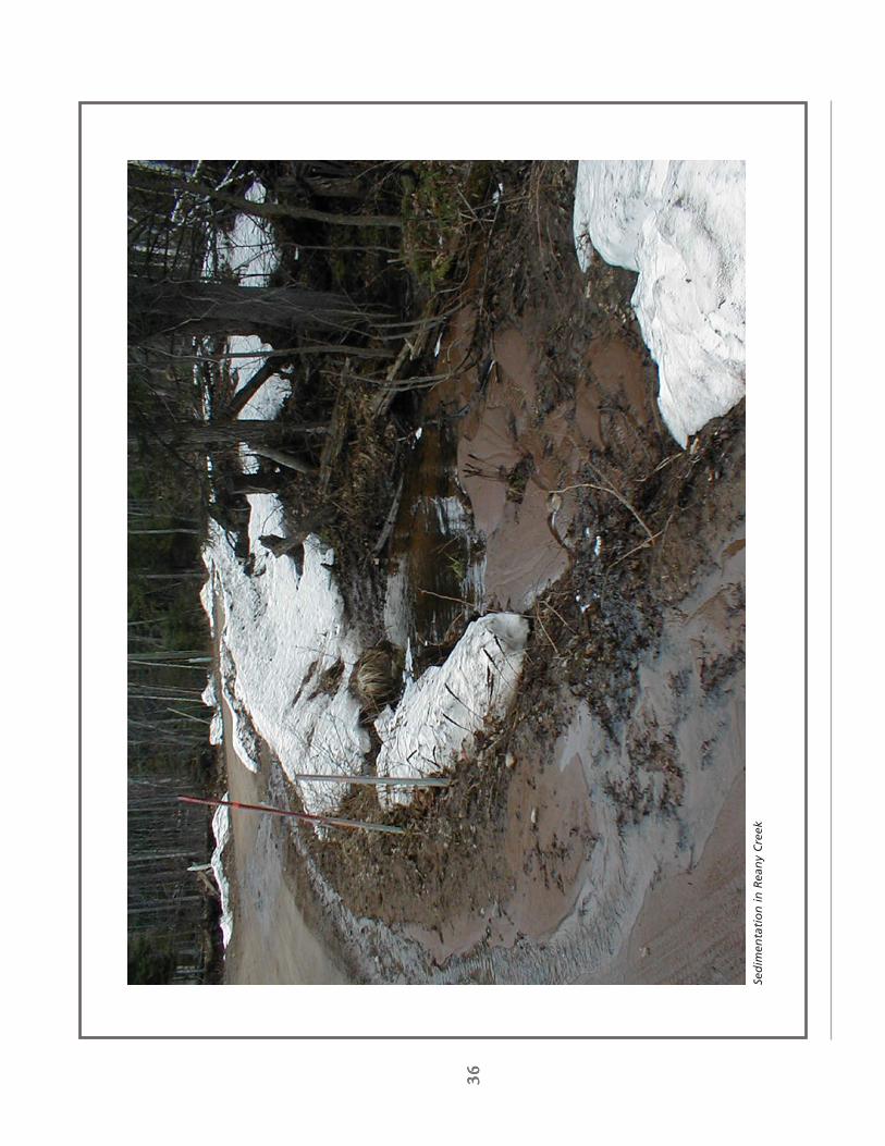
36
3636
36 36
Sed
imen
tati
on
in
Rea
ny
Cre
ek

37
3737
37 37
Low
er D
ead
Riv
er, W
ater
shed
Mgm
t. P
lan
200
3
Sto
rmw
ate
r Im
pact
sTh
e ro
ad-s
trea
m c
ross
ing
inve
ntor
y id
entif
ied
seve
ral c
ulve
rts
in t
he r
esid
entia
l are
a of
Trow
brid
ge P
ark
as s
torm
wat
er “
hots
pots
.” T
houg
h th
e pr
actic
al s
olut
ion
wou
ld b
e to
inst
all
curb
, gut
ter,
and
stor
m s
ewer
in T
row
brid
ge it
is, h
owev
er, n
ot a
cos
t-ef
fect
ive
one.
The
re a
rese
vera
l reg
ions
with
in 0
.2 s
quar
e m
iles
(128
acr
es) o
f th
e Ba
ckya
rd C
reek
sub
wat
ersh
ed in
nee
dof
sto
rmw
ater
man
agem
ent.
Pra
ctic
es s
uch
as g
rass
ed s
wal
es w
ill b
e us
ed t
o co
nvey
sto
rmw
ater
at a
low
vel
ocity
in o
rder
to
avoi
d er
osio
n an
d m
aint
ain
the
natu
ral v
eget
atio
n ad
jace
nt t
o ro
ads
and
wat
erw
ays.
73,
000
squa
re f
eet
of t
he A
mer
ican
par
king
lot
has
also
bee
n si
ted
as a
n ar
ea in
need
of s
torm
wat
er m
anag
emen
t. R
unof
f and
sno
wpa
ck m
elt f
rom
the
sout
heas
t cor
ner f
low
sof
f the
par
king
lot a
nd o
nto
Broo
kton
Roa
d, c
reat
ing
a gr
eat d
eal o
f poo
ling
and
sedi
men
tde
posi
tion.
By
tran
spor
ting
snow
pack
off
site
and
inst
allin
g a
serie
s of
gra
ssed
sw
ales
, par
king
lot
runo
ff w
ill b
e co
ntro
lled.
Ero
sio
n a
nd
Sed
imen
tati
on
Sedi
men
t dep
ositi
on in
trou
t str
eam
s is
a c
hron
ic p
robl
em in
the
Low
er D
ead
Rive
r wat
ersh
ed. A
sst
ream
ban
ks e
rode
or a
s st
orm
wat
er w
ashe
s in
to s
trea
ms,
sed
imen
t is
depo
site
d in
to th
e w
ater
-w
ay.
Thes
e de
posi
ts c
an h
ave
a se
rious
eff
ect
on a
quat
ic s
peci
es, p
artic
ular
ly t
rout
. A
ccor
ding
to
Mic
higa
n D
NR
fishe
ries
biol
ogis
ts, t
he n
umbe
r one
pol
luta
nt a
ffec
ting
fishe
ries
in th
e ar
ea is
sedi
men
t (S
undb
erg
et a
l. 19
95).
The
se d
epos
its c
an f
ill t
he h
oles
and
spa
wni
ng a
reas
of
cold
-w
ater
str
eam
s, le
avin
g th
e tr
out w
ith in
adeq
uate
hab
itat f
or re
prod
uctio
n.
The
sour
ce o
f th
is s
edim
ent
is v
arie
d.
Road
way
s th
at h
ave
inad
equa
te d
itche
s, b
anks
, an
dve
geta
tion
can
all c
ontr
ibut
e to
the
rel
ease
of
sedi
men
t in
to w
ater
way
s.
Con
stru
ctio
n si
tes
can
also
rel
ease
ton
s of
sed
imen
t if
prev
enta
tive
mea
sure
s ar
e no
t ta
ken
to c
ontr
ol e
rosi
on.
Poo
rlypl
anne
d de
velo
pmen
t ad
jace
nt t
o la
kes
and
stre
ams
can
also
cre
ate
unst
able
con
ditio
ns,
part
icul
arly
if a
veg
etat
ed b
uffe
r is
not
mai
ntai
ned
alon
g th
e riv
er’s
cour
se.
Ero
sio
n a
nd
Sed
imen
tati
on
Im
pact
sTh
irty-
eigh
t per
cent
(38%
) of t
he 2
4 w
ater
shed
enh
ance
men
t pro
ject
s de
al w
ith s
tabi
lizin
ger
osio
n an
d co
ntro
lling
sed
imen
tatio
n. P
rivat
e ro
ads,
cul
vert
s, s
trea
mba
nks,
and
recr
eatio
nal
trai
ls a
re th
e so
urce
s of
som
e of
the
eros
ion
and
sedi
men
tatio
n oc
curr
ing
in th
e w
ater
shed
. In
tota
l, th
ese
site
s co
ntrib
ute
to 6
1.3
tons
/acr
e of
soi
l los
s. B
est m
anag
emen
t pra
ctic
es th
at w
ill b
eus
ed to
con
trol
thes
e si
tes
incl
ude
bank
sta
biliz
atio
n, c
ulve
rt s
tabi
lizat
ion,
wat
er d
iver
sion
s,se
dim
ent t
raps
, and
reve
geta
tion.
Cha
pter
Fou
r -
Are
as o
f C
once
rn
Seve
re e
rosi
on
ad
jace
nt
to B
rick
yard
acc
ess
road
Ero
sio
n a
lon
g B
rick
yard
Cre
ek

38
3838
38 38
Co
ldw
ater
str
eam
s in
th
e Lo
wer
Dea
d R
iver
wat
ersh
ed s
up
po
rt t
rou
t p
op
ula
tio
ns
like
the
Bro
ok
Tro
ut
sho
wn
her
e

39
3939
39 39
Low
er D
ead
Riv
er, W
ater
shed
Mgm
t. P
lan
200
3
Tem
pera
ture
Flu
ctu
ati
on
sBa
sed
on c
urre
nt f
ish
com
mun
ity a
nd s
trea
m t
empe
ratu
re d
ata
colle
cted
by
the
Mic
higa
nD
epar
tmen
t of
Env
ironm
enta
l Qua
lity,
the
Low
er D
ead
Rive
r co
ntin
ues
to b
e cl
assi
fied
as a
cold
wat
er f
ishe
ry.
At
pres
ent,
how
ever
, the
tre
nd o
f th
e w
ater
shed
is le
adin
g to
war
ds a
war
mw
ater
fis
hery
due
to
envi
ronm
enta
l deg
rada
tion,
a d
eclin
e in
mat
ure
fish
popu
latio
n, a
ndex
istin
g da
m im
poun
dmen
ts.
The
Low
er D
ead
Rive
r W
ater
shed
Cou
ncil,
who
se m
issi
onin
clud
es a
com
mitm
ent
to s
usta
in t
he c
oldw
ater
fis
herie
s in
the
Low
er D
ead
Rive
r w
ater
shed
,is
see
king
way
s to
rev
erse
thi
s de
grad
atio
n an
d pr
otec
t th
e ex
istin
g co
ldw
ater
hab
itat
for
fish
popu
latio
ns in
the
Low
er D
ead
Rive
r.
Mos
t ty
pes
of e
nviro
nmen
tal d
egra
datio
n (e
.g.
disc
harg
es,
chan
neliz
atio
n, w
ater
shed
dev
elop
-m
ent)
incr
ease
sum
mer
tem
pera
ture
s in
str
eam
s (H
ynes
197
0; W
arre
n 19
71;
Kar
a an
dSc
hlos
ser
1978
). O
pen
cano
pies
, de
crea
sed
shad
ing,
and
wid
er,
shal
low
er s
trea
m c
hann
els
crea
te m
ore
effe
ctiv
e so
lar
radi
atio
n ab
sorp
tion
and
lead
to
war
mer
str
eam
tem
pera
ture
s.C
ulve
rts
and
pond
s in
tens
ify t
he p
robl
em b
y ba
ckin
g up
wat
er a
nd a
llow
ing
susp
ende
dse
dim
ents
to
sett
le t
o th
e bo
ttom
, th
us d
ecre
asin
g de
pth,
wid
enin
g th
e st
ream
, an
d in
crea
sing
wat
er t
empe
ratu
re.
Stor
mw
ater
run
off,
whi
ch is
gen
eral
ly a
t a
muc
h hi
gher
tem
pera
ture
, can
also
rai
se t
he a
vera
ge t
empe
ratu
re o
f lo
cal s
trea
m s
yste
ms
and
may
be
a so
urce
for
non
-poi
ntso
urce
pol
lutio
n.
In A
ugus
t 20
00, a
stu
dy w
as p
erfo
rmed
by
the
Mic
higa
n D
EQ t
o m
easu
re t
he t
empe
ratu
re o
fth
e D
ead
Rive
r al
ong
the
bypa
ssed
cha
nnel
bet
wee
n th
e M
cClu
re d
am a
nd t
he F
ores
tvill
eSt
orag
e Ba
sin
(God
by a
nd S
uppn
ick
2001
). T
his
stud
y do
cum
ente
d te
mpe
ratu
re t
rend
s in
thi
sby
pass
ed a
rea
and
com
pare
d th
em t
o re
adin
gs t
aken
fro
m R
eany
Cre
ek,
whi
ch is
onl
y af
fect
edby
nat
ural
wea
ther
pat
tern
s.
Resu
lts c
onfir
med
a g
ener
al p
atte
rn o
f in
crea
sing
tem
pera
ture
from
one
mon
itorin
g st
atio
n to
the
nex
t, w
ith a
n av
erag
e te
mpe
ratu
re in
crea
se o
f 5.
2° c
enti-
grad
e al
ong
the
entir
e by
pass
ed r
each
. W
hile
the
str
eam
seg
men
t st
ill m
eets
Mic
higa
n W
ater
Qua
lity
Stan
dard
s fo
r a
cold
wat
er s
trea
m,
the
fluct
uatio
n in
tem
pera
ture
may
poi
nt t
o po
ten-
tial f
utur
e pr
oble
ms.
Th
e ex
pans
ion
of d
evel
opm
ent
in t
he w
ater
shed
cou
pled
with
man
-mad
ean
d na
tura
l im
poun
dmen
ts a
re f
acto
rs in
war
min
g te
mpe
ratu
re t
rend
s re
sulti
ng in
deg
rada
tion
of c
oldw
ater
str
eam
s an
d a
decr
ease
in b
iotic
inte
grity
.
Cha
pter
Fou
r -
Are
as o
f C
once
rn
Sam
plin
g o
f lo
cal
fish
po
pu
lati
on

40
4040
40 40
Foo
tpat
hs
can
en
cou
rag
e er
osi
on
, par
ticu
larl
y o
n s
lop
esD
esig
nat
ed s
trea
m c
ross
ing
s sh
ou
ld b
e u
sed
to
pro
tect
fra
gile
str
eam
ban
ks

41
4141
41 41
Low
er D
ead
Riv
er, W
ater
shed
Mgm
t. P
lan
200
3
REC
REA
TIO
NA
L A
CTI
VIT
IES
Act
iviti
es s
uch
as b
oatin
g an
d hi
king
can
oft
en le
ad t
o th
e gr
adua
l deg
rada
tion
of t
he w
ater
shed
.Th
e lo
adin
g an
d un
load
ing
of w
ater
craf
t can
impa
ct s
trea
m b
anks
by
tram
plin
g th
e ve
geta
tion,
crea
ting
a fo
otpa
th t
o th
e w
ater
’s ed
ge, a
nd e
ncou
ragi
ng e
rosi
on.
Thes
e th
reat
s ca
n be
elim
inat
ed b
y es
tabl
ishi
ng p
ublic
acc
ess
site
s an
d pe
rman
ent
dock
str
uctu
res
alon
g na
viga
ble
wat
er b
odie
s. A
s ne
w h
ikin
g tr
ails
are
cre
ated
, con
stan
t fo
ot t
raff
ic t
o th
ese
area
s ca
n le
ad t
oso
il co
mpa
ctio
n an
d er
osio
n. B
y di
rect
ing
hike
rs to
a d
esig
nate
d tr
ail o
r cre
atin
g pe
rman
ent
wal
kway
s in
are
as t
hat
are
susc
eptib
le t
o er
osio
n, t
hese
thr
eats
can
be
elim
inat
ed.
Re
cre
ati
on
al I
mp
act
sTh
ere
are
two
recr
eatio
nal a
reas
with
in t
he L
ower
Dea
d Ri
ver
wat
ersh
ed t
hat
have
bee
n si
ted
asar
eas
of c
once
rn.
The
loca
lly k
now
n hi
king
tra
il le
adin
g to
the
Dea
d Ri
ver
Falls
has
yie
lded
maj
or s
oil c
ompa
ctio
n, e
xpos
ure
of tr
ee ro
ots,
and
loss
of r
ipar
ian
vege
tatio
n. A
ppro
xim
atel
y3,
520
linea
r fe
et o
f st
ream
bank
has
bee
n id
entif
ied
as n
eedi
ng s
ome
sort
of
stab
iliza
tion
and
reve
geta
tion.
Ero
sion
was
acc
eler
ated
in t
his
area
as
the
surg
e of
flo
od w
ater
s to
re t
hrou
gh o
nM
ay 2
003
and
rem
oved
sev
eral
ton
s of
soi
l fro
m t
he t
rail.
In a
dditi
on t
o th
e D
ead
Rive
r fa
llsar
ea, a
pro
pose
d na
ture
trai
l with
in M
arqu
ette
Tow
nshi
p w
ill re
quire
ripa
rian
buff
er p
rote
ctio
nal
ong
Badg
er C
reek
. Th
e an
ticip
ated
tra
il w
ill p
rote
ct 2
,740
line
ar f
eet
of s
trea
mba
nk b
yre
stor
ing
nativ
e ve
geta
tion
and
crea
ting
wal
kway
s in
are
as t
hat
are
in n
eed
of s
tabi
lizat
ion.
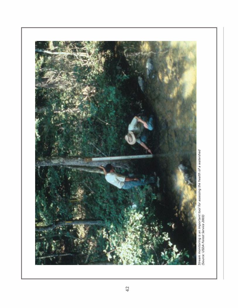
42
4242
42 42
Stre
am m
on
ito
rin
g is
an
imp
ort
ant
too
l fo
r as
sess
ing
th
e h
ealt
h o
f a
wat
ersh
ed(S
ou
rce:
USD
A F
ore
st S
ervi
ce 2
003)

43
4343
43 43
Low
er D
ead
Riv
er, W
ater
shed
Mgm
t. P
lan
200
3
It ca
n be
dis
cour
agin
g to
con
side
r th
at h
uman
act
ions
and
the
impa
ct o
f ou
r ex
pand
ing
deve
l-op
men
t re
mai
n th
e pr
imar
y so
urce
s of
env
ironm
enta
l deg
rada
tion
with
in t
he L
ower
Dea
d Ri
ver
wat
ersh
ed.
For
tuna
tely
, ou
r in
volv
emen
t ca
n al
so b
e th
e st
artin
g po
int
for
mea
ning
ful c
hang
eth
at r
esul
ts in
the
pro
tect
ion
of t
he in
tegr
ity o
f th
e Lo
wer
Dea
d Ri
ver
wat
ersh
ed.
In o
rder
to
affe
ct t
his
chan
ge,
the
sust
aine
d co
mm
itmen
t fr
om a
var
iety
of
invo
lved
par
ties
is r
equi
red.
Thes
e pa
rtic
ipan
ts in
clud
e lo
cal g
over
nmen
t, c
omm
unity
lead
ers,
city
and
tow
nshi
p pl
anne
rs,
deve
lope
rs,
busi
ness
ow
ners
, la
ndow
ners
, an
d lo
cal r
esid
ents
. T
his
chap
ter
focu
ses
on s
ever
alm
anag
emen
t st
rate
gies
par
ticip
ants
can
use
to
addr
ess
man
y of
the
issu
es d
escr
ibed
in C
hapt
erFo
ur a
s w
ell a
s a
wat
ersh
ed p
rote
ctio
n go
al f
or e
ach
reco
mm
enda
tion.
STR
EA
M M
ON
ITO
RIN
GIn
ord
er t
o cl
early
tra
ck t
he im
pact
of
deve
lopm
ent
on t
he h
ealth
of
the
wat
ersh
ed, a
tho
roug
hin
vent
ory
of r
esou
rces
and
per
iodi
c m
onito
ring
of lo
cal w
ater
way
s sh
ould
be
unde
rtak
en.
Alth
ough
sev
eral
stu
dies
hav
e be
en d
one
on in
divi
dual
rea
ches
of
the
wat
ersh
ed,
it is
nec
essa
ryto
com
pile
a c
ompl
ete
inve
ntor
y of
bas
elin
e da
ta f
rom
whi
ch f
utur
e pr
ogre
ss c
an b
e m
easu
red.
One
rec
omm
enda
tion
is t
o em
ploy
the
SW
QA
S Pr
oced
ure
#51
Surv
ey P
roto
cols
for
Wad
able
Rive
rs (
form
erly
kno
wn
as t
he G
LEA
S Pr
oced
ure
#51)
as
defin
ed b
y th
e M
ichi
gan
Dep
artm
ent
ofEn
viro
nmen
tal Q
ualit
y Su
rfac
e W
ater
Qua
lity
Div
isio
n (S
chne
ider
200
0).
Thi
s pr
otoc
ol in
volv
esth
e m
easu
rem
ent
of b
iolo
gica
l and
hab
itat
indi
cato
rs t
hat
resu
lt in
a r
atin
g of
the
rel
ativ
e he
alth
of a
str
eam
sys
tem
. Th
e su
rvey
con
sist
s of
3 p
arts
; eva
luat
ion
of t
he m
acro
inve
rteb
rate
com
mu-
nity
, ev
alua
tion
of t
he f
ish
com
mun
ity,
and
eval
uatio
n of
hab
itat
qual
ity.
(Sch
neid
er 2
000)
. A
serie
s of
met
rics
are
used
to
eval
uate
the
wat
er s
yste
m a
t a
num
ber
of s
ampl
ing
loca
tions
and
ara
ting
indi
catin
g th
e le
vel o
f st
ream
qua
lity
is a
ssig
ned
(exc
elle
nt,
good
, fa
ir, o
r po
or).
Thi
sra
ting
syst
em a
lso
inco
rpor
ates
an
anal
ysis
of
limiti
ng f
acto
rs t
hat
can
be a
use
ful d
iagn
ostic
too
lw
hen
a de
taile
d an
alys
is o
f th
e ca
use
for
stre
am im
pairm
ent
is r
equi
red.
St
ream
sur
veyo
rs n
ote
stre
am d
istu
rban
ces
such
as
impo
undm
ents
, ca
nopy
rem
oval
, or
the
pre
senc
e of
inva
sive
fis
h or
plan
t sp
ecie
s.
This
tho
roug
h co
llect
ion
of b
asel
ine
data
will
ser
ve a
s a
star
ting
poin
t fr
om w
hich
futu
re p
rogr
ess
can
be m
easu
red,
and
the
suc
cess
of
rem
edia
tion
stra
tegi
es c
an b
e ev
alua
ted.
WA
TER
SHED
PR
OTE
CTI
ON
GO
AL
It is
the
obj
ectiv
e of
the
Low
er D
ead
Rive
r W
ater
shed
Cou
ncil
to m
aint
ain
the
esta
blis
hed
stre
am m
onito
ring
prog
ram
. A
s w
ater
shed
enh
ance
men
t pr
ojec
ts a
re in
stal
led,
str
eam
s w
ill b
eas
sess
ed w
ith t
he g
oal o
f w
ater
qua
lity
ratin
gs t
o be
impr
oved
by
five
poin
ts o
n ea
ch t
ribut
ary.
Add
ition
al s
ites
will
be
crea
ted
as t
he n
eed
for
mon
itorin
g ar
ises
.
MA
NA
GE
ME
NT
STR
ATE
GIE
S, R
EC
OM
ME
ND
ATI
ON
S, &
WA
TER
SHE
D P
RO
TEC
TIO
N G
OA
LS
Cha
pter
Fiv
e -
Stra
tegi
es,
Reco
mm
enda
tions
, an
d G
oals
SW
QA
S P
roce
du
re N
o.
51
:Fo
r a
mor
e de
taile
d de
scrip
tion
of t
he P
51pr
otoc
ol,
an o
utlin
e of
thi
s pr
oces
s is
pres
ente
d th
roug
h M
ichi
gan’
s D
epar
tmen
t of
Nat
ural
Res
ourc
es w
ebsi
te.
For
add
ition
alas
sist
ance
, co
ntac
t th
e Su
rfac
e W
ater
Qua
lity
Div
isio
n of
the
Mic
higa
n D
epar
tmen
t of
Envi
ronm
enta
l Qua
lity
or t
he M
ichi
gan
Dep
artm
ent
of N
atur
al R
esou
rces
.w
ww
.mic
higa
n.go
v/dn
r/w
ww
.mic
higa
n.go
v/de
q/
Ch
apte
r Fi
ve

44
4444
44 44
Tab
le 5
.1: G
uid
elin
es f
or
Two
-zo
ne
Bu
ffer
Tab
le 5
.2: E
xcep
tio
ns
to B
uff
er W
idth
S
ensi
tive
are
a A
dd
itio
nal
bu
ffer
wid
th
Ste
ep S
lop
es
15%
-17%
+
10
feet
18%
-20%
+
30
feet
21%
-23%
+
50
feet
24%
-25%
+
60
feet
> 2
5%
+ 7
0 fe
et
Wet
lan
ds
E
xten
d to
enc
ompa
ss w
etla
nd
+ 2
0 fe
et p
ast w
etla
nd e
dge
Wat
er P
ollu
tio
n
Haz
ard
s
Site
150
’-300
’ fro
m e
dge
of
wat
erw
ay
Fig
ure
5.1
: Tw
o-z
on
e R
ipar
ian
Bu
ffer

45
4545
45 45
Low
er D
ead
Riv
er, W
ater
shed
Mgm
t. P
lan
200
3
RIP
AR
IAN
BU
FFER
SO
ne s
impl
e, y
et e
xtre
mel
y ef
fect
ive
tool
for
pro
tect
ing
the
heal
th a
nd in
tegr
ity o
f lo
cal w
ater
way
sis
the
use
of
vege
tate
d bu
ffer
s al
ong
ripar
ian
corr
idor
s.
Thes
e rip
aria
n bu
ffer
s ar
e ar
eas
ofve
geta
tion
loca
ted
imm
edia
tely
adj
acen
t to
a w
ater
bod
y or
str
eam
sys
tem
. A
ccor
ding
to
the
EPA
, th
ese
sim
ple
strip
s of
veg
etat
ed la
nd c
an o
ffer
eno
rmou
s en
viro
nmen
tal b
enef
its,
incl
udin
g:•
Rest
orin
g an
d m
aint
aini
ng t
he p
hysi
cal a
nd b
iolo
gica
l int
egrit
y of
the
wat
er r
esou
rces
•Re
mov
ing
pollu
tant
s fr
om u
rban
sto
rmw
ater
•St
abili
zing
str
eam
ban
ks r
esul
ting
in r
educ
ed e
rosi
on a
nd s
edim
enta
tion
•Pr
ovid
ing
infil
trat
ion
of s
torm
wat
er r
unof
f•
Mai
ntai
ning
bas
e flo
w o
f st
ream
s•
Con
trib
utin
g or
gani
c m
atte
r th
at s
erve
s as
a s
ourc
e of
foo
d an
d en
ergy
for
the
aqua
tic e
cosy
stem
•Pr
ovid
ing
tree
can
opy
to s
hade
str
eam
s an
d re
gula
te t
empe
ratu
re (
EPA
200
2)
To h
elp
esta
blis
h gu
idel
ines
for
per
mitt
ed a
nd r
estr
icte
d us
es,
the
EPA
and
the
Mic
higa
n D
epar
t-m
ent
of E
nviro
nmen
tal Q
ualit
y re
com
men
d us
ing
a m
ulti-
zone
app
roac
h to
diff
eren
tiate
app
ro-
pria
te le
vels
of
activ
ity w
ithin
diff
eren
t ar
eas
of t
he r
ipar
ian
corr
idor
. Th
e C
entr
al L
ake
Supe
rior
Wat
ersh
ed P
artn
ersh
ip is
cur
rent
ly w
orki
ng o
n a
draf
t rip
aria
n bu
ffer
ord
inan
ce in
hop
es th
at it
mig
ht b
e ap
plie
d to
wat
erw
ays
in M
arqu
ette
Cou
nty.
Suc
h an
ord
inan
ce w
ould
reco
mm
end
abu
ffer
of
50 f
eet
in t
otal
wid
th f
or b
oth
side
s of
the
str
eam
sys
tem
. W
ithin
thi
s 50
fee
t, t
hebu
ffer
wou
ld b
e di
vide
d in
to t
wo
dist
inct
zon
es, a
Str
eam
side
Zon
e an
d an
Out
er Z
one
(See
Figu
re 5
.1).
Cor
resp
ondi
ng t
o ea
ch z
one
wou
ld b
e a
set
of p
erm
itted
and
res
tric
ted
uses
tha
tw
ould
hel
p to
pro
tect
the
wat
er q
ualit
y an
d aq
uatic
hab
itat
in t
he a
djac
ent
stre
am (S
ee T
able
5.1
for
a su
mm
ary
of t
hese
gui
delin
es).
Whi
le t
he 5
0’ b
uffe
r is
con
side
red
the
gene
ral s
tand
ard,
the
re a
re s
ituat
ions
whe
re t
he p
rese
nce
of a
n ec
olog
ical
ly s
ensi
tive
area
req
uire
s a
mod
ifica
tion
to t
his
buff
er w
idth
. In
ord
er t
o en
sure
the
prot
ectio
n of
str
eam
inte
grity
, bu
ffer
exp
ansi
ons
wou
ld b
e re
quire
d fo
r w
etla
nds
and
area
s of
stee
p sl
ope.
Se
e Fi
gure
s 5.
2 fo
r a
sum
mar
y of
the
se b
uffe
r ex
tens
ions
.
WA
TER
SHED
PR
OTE
CTI
ON
GO
AL
It is
the
goa
l of
the
Low
er D
ead
Rive
r W
ater
shed
Cou
ncil
to w
ork
coop
erat
ivel
y w
ith t
he C
entr
alLa
ke S
uper
ior
Wat
ersh
ed P
artn
ersh
ip a
nd lo
cal c
ity a
nd t
owns
hip
offic
ials
to
esta
blis
h th
ere
com
men
ded
buff
er s
trip
and
set
back
gui
delin
es.
Spe
cial
are
as o
f co
ncer
n th
at n
eed
rem
edia
tion
incl
ude
appr
oxim
atel
y 5,
000
feet
of
erod
ed s
trea
mba
nk c
ause
d by
the
Dea
d Ri
ver
flood
. In
con
junc
tion
with
the
men
tione
d ag
enci
es,
the
Wat
ersh
ed C
ounc
il w
ill a
lso
supp
ort
the
mis
sion
of
the
Cen
tral
Lak
e Su
perio
r La
nd C
onse
rvan
cy b
y pr
omot
ing
cons
erva
tion
ease
men
tsw
ith r
ipar
ian
land
ow
ners
.
Cha
pter
Fiv
e -
Stra
tegi
es,
Reco
mm
enda
tions
, an
d G
oals
Mo
del
Ord
inan
ce:
To s
ee a
ful
l cop
y of
the
dra
ft r
ipar
ian
buff
eror
dina
nce
that
is b
eing
dev
elop
ed b
y th
eC
LSW
P, p
leas
e se
e A
ppen
dix
C.
Both
the
EPA
and
Mic
higa
n’s
Dep
artm
ent
of E
nviro
nmen
tal
Qua
lity
have
als
o sp
ecifi
ed b
est
man
agem
ent
prac
tices
for
the
impl
emen
tatio
n of
the
serip
aria
n bu
ffer
s an
d of
fer
addi
tiona
l inf
orm
a-tio
n re
gard
ing
thei
r us
e.
For
addi
tiona
las
sist
ance
with
thi
s pr
oces
s, c
onta
ct t
he E
PA’s
Off
ice
of W
etla
nds,
Oce
ans,
and
Wat
ersh
eds
or t
he M
ichi
gan
Dep
artm
ent
of E
nviro
nmen
-ta
l Qua
lity.
ww
w.e
pa.g
ov/o
wow
/w
ww
.mic
higa
n.go
v/de
q/
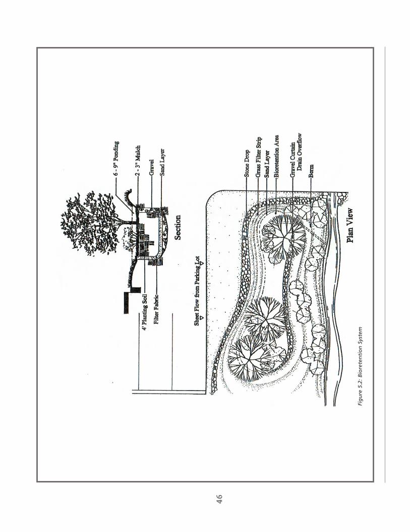
46
4646
46 46
Fig
ure
5.2
: B
iore
ten
tio
n S
yste
m

47
4747
47 47
Low
er D
ead
Riv
er, W
ater
shed
Mgm
t. P
lan
200
3
STO
RM
WA
TER
MA
NA
GEM
EN
TTh
ere
are
seve
ral s
torm
wat
er m
anag
emen
t st
rate
gies
tha
t ca
n be
ado
pted
in a
reas
exp
erie
ncin
gin
crea
sed
deve
lopm
ent
in t
he L
ower
Dea
d Ri
ver
wat
ersh
ed.
The
se s
trat
egie
s ar
e de
sign
ed t
oad
dres
s th
e th
ree
mos
t cr
itica
l com
pone
nts
of a
suc
cess
ful s
torm
wat
er m
anag
emen
t pl
an:
trea
tmen
t of
con
tam
inan
ts,
man
agem
ent
of w
ater
rel
ease
rat
es,
and
tem
pera
ture
mod
erat
ion.
The
stra
tegi
es o
utlin
ed b
elow
are
des
igne
d to
add
ress
the
se is
sues
, ul
timat
ely
resu
lting
in t
hein
crea
sed
prot
ectio
n of
loca
l wat
erw
ays.
Infi
ltra
tio
n S
yst
em
sIn
filtr
atio
n sy
stem
s m
ost
clos
ely
rese
mbl
e na
tura
l hyd
rolo
gic
proc
esse
s.
Thes
e sy
stem
s al
low
stor
mw
ater
to
natu
rally
infil
trat
e ba
ck in
to g
roun
dwat
er a
quife
rs t
hat
even
tual
ly r
eple
nish
loca
lst
ream
s an
d w
ater
way
s.
Acc
ordi
ng t
o a
stud
y co
nduc
ted
by A
yres
, Lew
is, N
orris
, & M
ay, I
nc(2
002)
, st
rate
gies
“su
ch a
s in
filtr
atio
n tr
ench
es,
rain
gar
dens
, an
d bi
oret
entio
n ar
eas
shou
ld b
eut
ilize
d, s
ite p
erm
ittin
g”.
Unf
ortu
nate
ly,
the
succ
ess
of a
n in
filtr
atio
n sy
stem
is h
ighl
y de
pen-
dent
on
the
spec
ific
char
acte
ristic
s of
a s
ite,
such
as
soil
prop
ertie
s an
d po
tent
ial f
or g
roun
dwa-
ter
cont
amin
atio
n.
Gen
eral
ly, it
is a
lso
only
fea
sibl
e fo
r sm
all d
rain
age
area
s (B
obrin
200
0).
Beca
use
they
can
be
impl
emen
ted
on a
sm
alle
r sc
ale,
infil
trat
ion
syst
ems
may
be
a go
odal
tern
ativ
e fo
r re
trof
it pr
ojec
ts w
here
exi
stin
g de
velo
pmen
t do
es n
ot a
llow
for
the
nec
essa
rysp
ace
to in
stal
l a c
onve
ntio
nal d
eten
tion
basi
n.
For
exam
ple,
an
exis
ting
park
ing
lot
can
bem
odifi
ed t
o in
clud
e a
bior
eten
tion
swal
e th
at c
an p
roce
ss r
unof
f fr
om t
he lo
t an
d di
rect
it in
to a
smal
l inf
iltra
tion
syst
em.
Figu
re 5
.2 s
how
s ho
w s
uch
a sy
stem
cou
ld b
e im
plem
ente
d in
are
lativ
ely
smal
l are
a.
Gra
ssed
Sw
ale
sIn
a n
atur
al, u
ndev
elop
ed s
yste
m, w
ater
oft
en t
akes
a s
low
, circ
uito
us r
oute
tow
ard
its f
inal
dest
inat
ion.
To
day,
with
our
incr
ease
d at
tent
ion
tow
ard
effic
ienc
y an
d sa
fety
, ou
r us
e of
pip
esan
d en
gine
ered
sto
rmw
ater
sys
tem
s “f
ocus
on
dire
ctin
g an
d dr
aini
ng w
ater
off
of
pave
dsu
rfac
es a
s qu
ickl
y an
d ef
ficie
ntly
as
poss
ible
” (A
rnol
d an
d G
ibbo
ns 1
996)
. T
his
syst
em o
fco
nvey
ance
, w
hile
eff
icie
nt,
has
serio
us e
nviro
nmen
tal i
mpa
cts.
Th
e us
e of
gra
ssed
sw
ales
and
sedi
men
t fo
reba
ys a
ttem
pt t
o m
ore
clos
ely
mim
ic t
he n
atur
al s
yste
m o
f w
ater
con
veya
nce.
Gra
ssed
sw
ales
hel
p to
slo
w t
he w
ater
and
allo
w t
he w
ater
to
be “
clea
ned”
by
the
vege
tatio
nas
it m
oves
thr
ough
the
sys
tem
.
Dete
nti
on
/Rete
nti
on
Po
nd
sO
ne o
f th
e m
ost
com
mon
str
ateg
ies
for
addr
essi
ng o
n-si
te s
torm
wat
er t
reat
men
t is
the
use
of
stor
age
faci
litie
s su
ch a
s de
tent
ion
or r
eten
tion
pond
s.
Gen
eral
ly,
the
goal
of
thes
e sy
stem
s is
to
colle
ct s
torm
wat
er r
unof
f fr
om t
he d
evel
oped
are
a of
a s
ite, h
old
it fo
r a
pred
eter
min
ed p
erio
dof
tim
e, a
nd r
elea
se t
he w
ater
at
a ra
te t
hat
is s
imila
r to
pre
-dev
elop
men
t ra
tes.
By
hol
ding
the
Cha
pter
Fiv
e -
Stra
tegi
es,
Reco
mm
enda
tions
, an
d G
oals

48
4848
48 48
The
“day
ligh
tin
g”
of
a lo
cal s
trea
m d
emo
nst
rate
s h
ow
veg
etat
ion
can
hel
p e
nco
ura
ge
infi
ltra
tio
n o
f st
orm
wat
er r
un
-off

49
4949
49 49
Low
er D
ead
Riv
er, W
ater
shed
Mgm
t. P
lan
200
3
Cha
pter
Fiv
e -
Stra
tegi
es,
Reco
mm
enda
tions
, an
d G
oals
A d
eten
tio
n b
asin
ret
ain
s an
d t
reat
s st
orm
wat
er
wat
er,
part
icul
ate
mat
ter
such
as
sedi
men
t, h
eavy
met
als,
and
oth
er p
ollu
tant
s ar
e al
low
ed t
ose
ttle
out
of
the
wat
er.
Thi
s pr
oces
s re
sults
in le
ss c
onta
min
atio
n be
ing
rele
ased
into
the
loca
lst
ream
sys
tem
. T
he e
ffec
tiven
ess
of t
his
syst
em c
an b
e in
crea
sed
by in
corp
orat
ing
sedi
men
tfo
reba
ys in
to t
he d
esig
n of
the
det
entio
n ba
sin
(Ayr
es, L
ewis
, Nor
ris, &
May
200
2).
Sedi
men
tfo
reba
ys a
re s
mal
l, sh
allo
w p
ools
loca
ted
near
the
inle
t of
the
sto
rage
bas
in.
Fore
bays
ser
ve a
s a
type
of
pre-
trea
tmen
t, a
llow
ing
coar
se s
edim
ents
to
drop
out
prio
r to
ent
erin
g th
e la
rger
stor
age
basi
n.
In a
reas
whe
re t
he b
asin
will
be
disc
harg
ing
to a
col
dwat
er s
trea
m, t
empe
ratu
re,
as w
ell a
s po
llutio
n co
ntro
l mus
t be
con
side
red.
In
thi
s ca
ses,
the
use
of
a bo
ttom
-dra
w d
is-
char
ge s
houl
d be
con
side
red
as a
way
to
ensu
re w
ater
ent
erin
g th
e lo
cal s
trea
m s
yste
m w
ill n
otca
use
sign
ifica
nt p
eaks
in w
ater
tem
pera
ture
.
Ma
inte
na
nce
Rega
rdle
ss o
f th
e ty
pe o
f st
orm
wat
er s
trat
egy
empl
oyed
, the
suc
cess
of
any
syst
em is
hig
hly
depe
nden
t on
reg
ular
mai
nten
ance
. M
aint
enan
ce m
ay in
clud
e in
spec
tion
of f
acili
ties,
rem
oval
of c
onta
min
ated
sed
imen
t, m
aint
enan
ce o
f ve
geta
tion,
and
rep
lace
men
t of
filt
ers
or o
ther
supp
ortin
g m
echa
nism
s.
Ho
meo
wn
er
Eff
ort
sH
omeo
wne
rs c
an a
lso
take
ste
ps t
o co
ntro
l the
sto
rmw
ater
on
thei
r ow
n pr
oper
ty.
Sig
nific
ant
amou
nts
of r
ainw
ater
and
sno
wm
elt
are
colle
cted
fro
m r
ooft
ops
and
driv
eway
s of
priv
ate
hom
es a
nd b
ecom
e pa
rt o
f th
e la
rger
vol
ume
of s
torm
wat
er t
hat
is d
irect
ed in
to lo
cal s
torm
sew
ers.
Th
e fo
llow
ing
is a
list
of
easy
ste
ps t
hat
loca
l hom
eow
ners
can
tak
e to
red
uce
the
amou
nt o
f st
orm
wat
er t
hat
flow
s of
f of
the
ir pr
oper
ty a
nd in
to t
he s
torm
wat
er s
yste
m:
•D
irect
dow
nspo
uts
to d
isch
arge
into
yar
ds o
r ot
her
vege
tate
d ar
eas
rath
erth
an o
nto
driv
eway
s or
oth
er im
perv
ious
sur
face
s.•
Redu
ce t
he a
mou
nt o
f fe
rtili
zer
or p
estic
ides
use
d.
Thes
e ca
n be
tra
nspo
rted
via
stor
mw
ater
into
loca
l wat
erw
ays.
•Pa
rk a
utom
obile
s on
law
ns b
efor
e w
ashi
ng t
hem
. L
awns
will
app
reci
ate
the
extr
a w
ater
and
will
hel
p br
eakd
own
the
soap
, kee
ping
it o
ut o
f ne
arby
str
eam
s.•
Use
nat
ive
vege
tatio
n w
hen
poss
ible
. T
hese
spe
cies
gen
eral
ly h
ave
deep
roo
tsy
stem
s th
at w
ill s
oak
up e
xces
s w
ater
, pre
vent
ing
it fr
om b
ecom
ing
runo
ff.
WA
TER
SHED
PR
OTE
CTI
ON
GO
AL
It is
the
goa
l of
Low
er D
ead
Rive
r W
ater
shed
Cou
ncil
to e
ncou
rage
alte
rnat
ive
stor
mw
ater
man
agem
ent
stra
tegi
es t
hat
will
res
ult
in in
crea
sed
prot
ectio
n of
the
trib
utar
ies
lead
ing
into
the
Dea
d Ri
ver.
The
coun
cil e
nvis
ions
a 2
0% lo
ad r
educ
tion
from
par
king
lots
and
impe
rvio
ussu
rfac
es o
ver
the
next
thr
ee y
ears
.

50
5050
50 50
Tab
le 5
.3:
Pub
lic P
arti
cip
atio
n a
nd
Ed
uca
tio
n S
trat
egie
s
The
follo
win
g m
ater
ials
an
d a
ctiv
itie
s ar
e an
ess
enti
al p
art
of
the
Low
er D
ead
Riv
er W
ater
shed
Pla
nn
ing
Pro
ject
:•
A r
egul
ar p
roje
ct n
ewsl
ette
r m
aile
d to
all
resi
dent
s an
d bu
sine
sses
of
the
wat
ersh
ed•
Ann
ual c
omm
unity
eve
nts
to r
aise
pub
lic a
war
enes
s:-
Con
serv
atio
n fe
stiv
al-
Wat
ersh
ed p
ublic
mee
tings
•Vo
lunt
eer
oppo
rtun
ities
:-
Ado
pt-A
-Str
eam
cle
anup
s-
Stre
am m
onito
ring
- N
ativ
e pl
ant
nurs
ery
volu
ntee
ring
•Yo
uth
educ
atio
n:-
Gra
de s
choo
l pro
gram
s-
Inte
rnsh
ip o
ppor
tuni
ties
•Re
gula
r ne
wsp
aper
art
icle
s an
d ne
ws
upda
tes
on lo
cal t
elev
isio
n an
d ra
dio
•Pu
blic
par
ticip
atio
n on
the
Low
er D
ead
Rive
r W
ater
shed
Cou
ncil
and
the
Cen
tral
Lak
e Su
perio
r W
ater
shed
Par
tner
ship
•Pu
blic
wor
ksho
ps o
n w
ater
shed
-rel
ated
issu
es:
- So
il er
osio
n co
ntro
l-
Ripa
rian
land
man
agem
ent
- Bu
ffer
str
ips
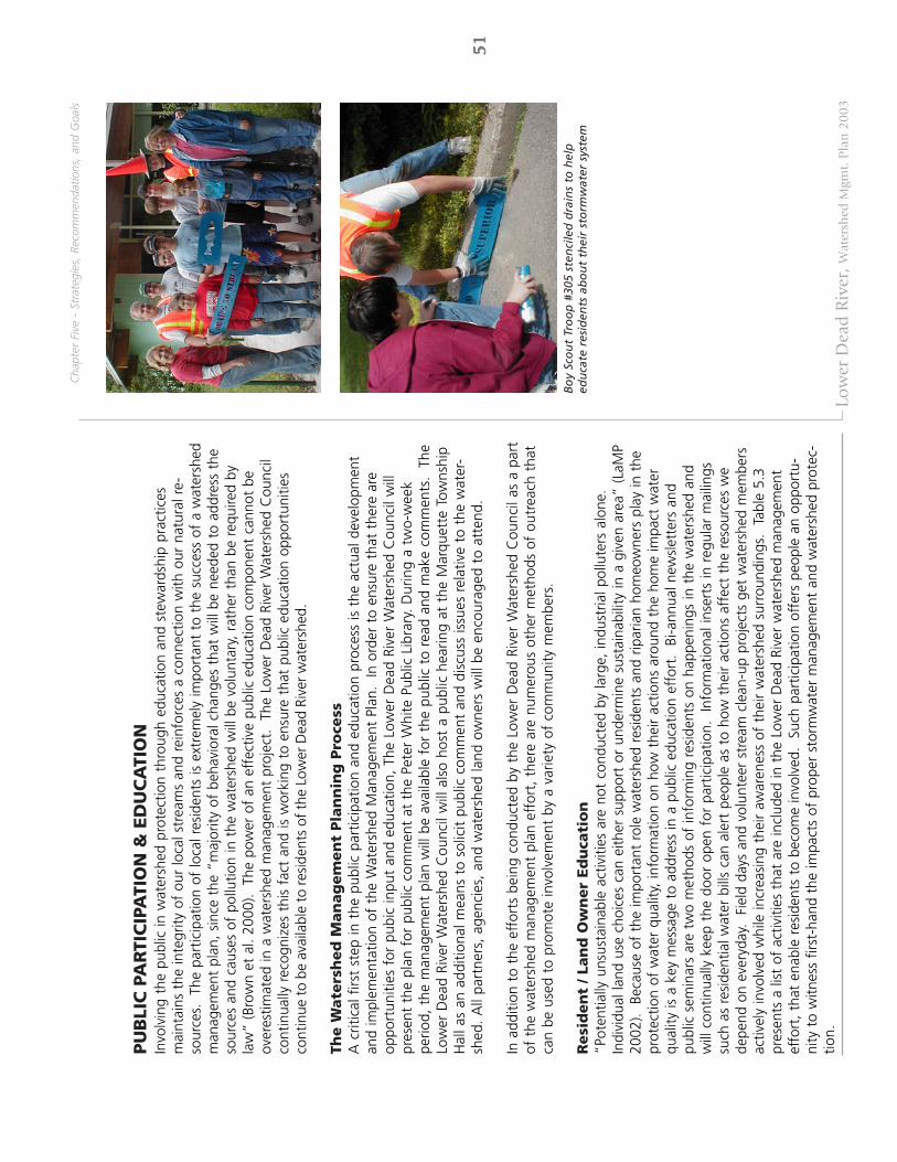
51
5151
51 51
Low
er D
ead
Riv
er, W
ater
shed
Mgm
t. P
lan
200
3
PU
BLI
C P
AR
TIC
IPA
TIO
N &
ED
UC
ATI
ON
Invo
lvin
g th
e pu
blic
in w
ater
shed
pro
tect
ion
thro
ugh
educ
atio
n an
d st
ewar
dshi
p pr
actic
esm
aint
ains
the
inte
grity
of
our
loca
l str
eam
s an
d re
info
rces
a c
onne
ctio
n w
ith o
ur n
atur
al r
e-so
urce
s.
The
part
icip
atio
n of
loca
l res
iden
ts is
ext
rem
ely
impo
rtan
t to
the
suc
cess
of
a w
ater
shed
man
agem
ent
plan
, si
nce
the
“maj
ority
of
beha
vior
al c
hang
es t
hat
will
be
need
ed t
o ad
dres
s th
eso
urce
s an
d ca
uses
of
pollu
tion
in t
he w
ater
shed
will
be
volu
ntar
y, r
athe
r th
an b
e re
quire
d by
law
” (B
row
n et
al.
2000
). T
he p
ower
of
an e
ffec
tive
publ
ic e
duca
tion
com
pone
nt c
anno
t be
over
estim
ated
in a
wat
ersh
ed m
anag
emen
t pr
ojec
t.
The
Low
er D
ead
Rive
r W
ater
shed
Cou
ncil
cont
inua
lly r
ecog
nize
s th
is f
act
and
is w
orki
ng t
o en
sure
tha
t pu
blic
edu
catio
n op
port
uniti
esco
ntin
ue t
o be
ava
ilabl
e to
res
iden
ts o
f th
e Lo
wer
Dea
d Ri
ver
wat
ersh
ed.
The W
ate
rsh
ed
Man
ag
em
en
t Pla
nn
ing
Pro
cess
A c
ritic
al f
irst
step
in t
he p
ublic
par
ticip
atio
n an
d ed
ucat
ion
proc
ess
is t
he a
ctua
l dev
elop
men
tan
d im
plem
enta
tion
of t
he W
ater
shed
Man
agem
ent
Plan
. In
ord
er t
o en
sure
tha
t th
ere
are
oppo
rtun
ities
for
pub
ic in
put
and
educ
atio
n, T
he L
ower
Dea
d Ri
ver
Wat
ersh
ed C
ounc
il w
illpr
esen
t th
e pl
an f
or p
ublic
com
men
t at
the
Pet
er W
hite
Pub
lic L
ibra
ry.
Dur
ing
a tw
o-w
eek
perio
d, t
he m
anag
emen
t pl
an w
ill b
e av
aila
ble
for
the
publ
ic t
o re
ad a
nd m
ake
com
men
ts.
The
Low
er D
ead
Rive
r W
ater
shed
Cou
ncil
will
als
o ho
st a
pub
lic h
earin
g at
the
Mar
quet
te T
owns
hip
Hal
l as
an a
dditi
onal
mea
ns t
o so
licit
publ
ic c
omm
ent
and
disc
uss
issu
es r
elat
ive
to t
he w
ater
-sh
ed.
All
part
ners
, ag
enci
es,
and
wat
ersh
ed la
nd o
wne
rs w
ill b
e en
cour
aged
to
atte
nd.
In a
dditi
on t
o th
e ef
fort
s be
ing
cond
ucte
d by
the
Low
er D
ead
Rive
r W
ater
shed
Cou
ncil
as a
par
tof
the
wat
ersh
ed m
anag
emen
t pl
an e
ffor
t, t
here
are
num
erou
s ot
her
met
hods
of
outr
each
tha
tca
n be
use
d to
pro
mot
e in
volv
emen
t by
a v
arie
ty o
f co
mm
unity
mem
bers
.
Resi
den
t / L
an
d O
wn
er
Ed
uca
tio
n“P
oten
tially
uns
usta
inab
le a
ctiv
ities
are
not
con
duct
ed b
y la
rge,
indu
stria
l pol
lute
rs a
lone
.In
divi
dual
land
use
cho
ices
can
eith
er s
uppo
rt o
r un
derm
ine
sust
aina
bilit
y in
a g
iven
are
a” (
LaM
P20
02).
Bec
ause
of
the
impo
rtan
t ro
le w
ater
shed
res
iden
ts a
nd r
ipar
ian
hom
eow
ners
pla
y in
the
prot
ectio
n of
wat
er q
ualit
y, in
form
atio
n on
how
the
ir ac
tions
aro
und
the
hom
e im
pact
wat
erqu
ality
is a
key
mes
sage
to
addr
ess
in a
pub
lic e
duca
tion
effo
rt.
Bi-a
nnua
l new
slet
ters
and
publ
ic s
emin
ars
are
two
met
hods
of
info
rmin
g re
side
nts
on h
appe
ning
s in
the
wat
ersh
ed a
ndw
ill c
ontin
ually
kee
p th
e do
or o
pen
for
part
icip
atio
n.
Info
rmat
iona
l ins
erts
in r
egul
ar m
ailin
gssu
ch a
s re
side
ntia
l wat
er b
ills
can
aler
t pe
ople
as
to h
ow t
heir
actio
ns a
ffec
t th
e re
sour
ces
we
depe
nd o
n ev
eryd
ay.
Fie
ld d
ays
and
volu
ntee
r st
ream
cle
an-u
p pr
ojec
ts g
et w
ater
shed
mem
bers
activ
ely
invo
lved
whi
le in
crea
sing
the
ir aw
aren
ess
of t
heir
wat
ersh
ed s
urro
undi
ngs.
Ta
ble
5.3
pres
ents
a li
st o
f ac
tiviti
es t
hat
are
incl
uded
in t
he L
ower
Dea
d Ri
ver
wat
ersh
ed m
anag
emen
tef
fort
, th
at e
nabl
e re
side
nts
to b
ecom
e in
volv
ed.
Suc
h pa
rtic
ipat
ion
offe
rs p
eopl
e an
opp
ortu
-ni
ty t
o w
itnes
s fir
st-h
and
the
impa
cts
of p
rope
r st
orm
wat
er m
anag
emen
t an
d w
ater
shed
pro
tec-
tion.
Cha
pter
Fiv
e -
Stra
tegi
es,
Reco
mm
enda
tions
, an
d G
oals
Bo
y Sc
ou
t Tr
oo
p #
305
sten
cile
d d
rain
s to
hel
ped
uca
te r
esid
ents
ab
ou
t th
eir
sto
rmw
ater
sys
tem

52
5252
52 52
Tab
le 5
.4:
Info
rmat
ion
/ E
du
cati
on
Str
ateg
ies
Info
rmat
ion
/Ed
uca
tio
n S
trat
egy
Targ
etPo
lluta
nt
Au
die
nce
Mes
sag
eC
on
tro
lled
Del
iver
y M
ech
anis
ms
Pote
nti
al E
valu
atio
n
Resi
dent
/Ÿ
Wat
er c
onse
rvat
ion
Ÿ P
ollu
ted
Dis
trib
ute
flyer
s w
ithSu
rvey
wat
ersh
ed r
esid
ents
;La
ndow
ner
Ÿ P
rope
r la
wn
care
s
torm
wat
erw
ater
con
serv
atio
n tip
s an
d tr
ack
hhw
col
lect
ion
num
bers
;Ÿ
Sto
rm d
rain
aw
aren
ess
Ÿ O
ils, g
reas
e, a
ndhh
w in
form
atio
n;tr
ack
num
ber
of o
ne-o
n-on
eŸ
Sep
tic s
yste
m m
aint
enan
ce
hea
vy m
etal
sim
plem
ent
stor
m d
rain
cont
acts
fro
m p
ublic
ser
vice
Ÿ P
rope
r ho
useh
old
haza
rdou
sŸ
Sed
imen
tst
enci
ling
proj
ect
with
anno
unce
men
ts a
nd in
form
atio
nal
w
aste
(hhw
) dis
posa
lw
ater
shed
cou
ncil
or s
ervi
cebr
ochu
res
and
hand
outs
orga
niza
tion;
dev
elop
a p
ublic
serv
ice
anno
uncm
ent
for
loca
lra
dio
stat
ions
; ini
tiate
a v
olun
teer
mon
itorin
g pr
ogra
m
Dev
elop
ers
Ÿ L
ow im
pact
dev
elop
men
t (li
d)Ÿ
Sed
imen
tW
ork
with
Con
serv
atio
n D
istr
ict
Trac
k nu
mbe
r of
low
impa
ct
tec
hniq
ues
Ÿ P
ollu
ted
staf
f to
pro
vide
dev
elop
ers
with
deve
lopm
ent
tech
niqu
es a
nd
Ÿ R
ipar
ian
buff
ers
s
torm
wat
erin
form
atio
n re
gard
ing
lid t
echn
ique
srip
aria
n bu
ffer
s im
plem
ente
d;Ÿ
Ero
sion
con
trol
and
con
stru
ctio
nan
d rip
aria
n bu
ffer
s; h
ost
a su
rvey
of
wor
ksho
p at
tend
ees;
s
ite r
unof
fbi
enni
al d
evel
oper
wor
ksho
pon
e-on
-one
con
tact
s
You
th
Ÿ W
ater
shed
pro
tect
ion
Ÿ H
ydro
logi
c flo
wO
ffer
sch
ool p
rese
ntat
ions
tha
tTr
ack
num
ber
of p
rese
ntat
ions
Educ
atio
nŸ
Hum
an im
pact
on
the
envi
ronm
ent
prom
ote
wat
er q
ualit
y an
d w
ater
shed
cond
ucte
d; s
urve
y te
ache
rs o
nŸ
Env
ironm
enta
l ste
war
dshi
paw
aren
ess;
par
ticip
ate
in
pres
enta
tion
effe
ctiv
enes
s; t
rack
C
onse
rvat
ion
Dis
tric
t an
nual
num
ber
of s
tude
nts
at C
onse
rvat
ion
cons
erva
tion
fest
ival
Fest
ival
Gov
ernm
ent
Ÿ S
torm
wat
er m
anag
emen
tŸ
Pol
lute
d Es
tabl
ish
a st
orm
wat
er t
ask
forc
eEv
alua
te e
ffec
tiven
ess
of s
torm
wat
erA
genc
ies
Ÿ Z
onin
g is
sues
s
torm
wat
eran
d pl
an f
or M
arqu
ette
Tow
nshi
p;ta
sk f
orce
; tra
ck n
umbe
r of
low
Ÿ
Rip
aria
n bu
ffer
sŸ
Sed
imen
tho
st b
iann
ual u
pdat
es t
o m
unic
ipal
ities
impa
ct d
evel
opm
ent
tech
niqu
es a
ndŸ
Low
impa
ct d
evel
opm
ent
(lid)
Ÿ
Oils
, gre
ase,
and
rega
rdin
g w
ater
shed
issu
es; c
reat
erip
aria
n bu
ffer
s im
plem
ente
d by
t
echn
ique
s
hea
vy m
etal
sin
form
atio
nal h
ando
uts
that
pro
mot
elo
cal m
unic
ipal
ities
Ÿ H
ydro
logi
c flo
wrip
aria
n bu
ffer
s an
d lid
tec
hniq
ues

53
5353
53 53
Low
er D
ead
Riv
er, W
ater
shed
Mgm
t. P
lan
200
3
Cha
pter
Fiv
e -
Stra
tegi
es,
Reco
mm
enda
tions
, an
d G
oals
You
th e
du
cati
on
at
Van
den
bo
om
Ele
men
tary
Sch
oo
l
Joe
Wag
ner
wo
rks
wit
h a
gro
up
of
sch
oo
l ch
ildre
nat
th
e an
nu
al C
on
serv
atio
n F
esti
val
Develo
per
Ed
uca
tio
nTh
roug
h co
ntac
t w
ith t
he S
oil E
rosi
on a
nd S
edim
ent
Con
trol
Pro
gram
, de
velo
pers
sho
uld
been
cour
aged
to
view
site
pla
nnin
g in
ter
ms
of w
ater
shed
-wid
e ef
fect
s an
d pr
omot
e lo
w im
pact
deve
lopm
ent
into
the
site
des
ign
proc
ess.
A
ssis
tanc
e w
ith r
ipar
ian
buff
ers,
bio
rete
ntio
n, a
ndin
filtr
atio
n m
etho
ds c
an b
e of
fere
d to
less
en t
he im
pact
of
stor
mw
ater
run
off
.
Yo
uth
Ed
uca
tio
nW
ater
shed
edu
catio
n to
are
a sc
hool
chi
ldre
n is
a f
unda
men
tal t
ool t
hat
enco
urag
es f
utur
est
ewar
ds o
f th
e en
viro
nmen
t.
Wat
ersh
ed e
duca
tion
in t
he c
lass
room
, fie
ld d
ay e
xerc
ises
, as
wel
l as
the
annu
al C
onse
rvat
ion
Fest
hos
ted
by t
he M
arqu
ette
Cou
nty
Con
serv
atio
n D
istr
ict
are
som
e w
ays
that
chi
ldre
n le
arn
of h
uman
impa
ct o
n th
e en
viro
nmen
t.
Such
edu
catio
nal
proj
ects
sho
uld
incl
ude
info
rmat
ion
on n
atur
al f
eatu
res
of t
he lo
cal a
rea,
ero
sion
, w
ater
shed
prot
ectio
n, a
nd t
ips
for
how
the
y ca
n in
divi
dual
ly m
ake
an im
pact
on
the
heal
th o
f th
eir
envi
ronm
ent.
Invo
lvem
en
t fr
om
Mu
nic
ipali
ties
Loca
l mun
icip
aliti
es a
re a
n in
tegr
al c
onne
ctio
n in
ove
rsee
ing
loca
l dev
elop
men
t w
ithou
tco
mpr
omis
ing
the
sust
aina
bilit
y of
the
wat
ersh
ed.
Invo
lvem
ent
of t
owns
hip
and
city
boa
rdm
embe
rs w
ith t
he L
ower
Dea
d Ri
ver
Wat
ersh
ed C
ounc
il w
ill h
elp
mai
ntai
n an
act
ive
rela
tion-
ship
and
enc
oura
ge a
dia
logu
e re
gard
ing
zoni
ng is
sues
, up
com
ing
deve
lopm
ent,
and
bes
tm
anag
emen
t pr
actic
es.
WA
TER
SHED
PR
OTE
CTI
ON
GO
AL
It is
the
goa
l of
the
coun
cil t
o co
ntin
uous
ly im
prov
e re
side
nt a
war
enes
s of
the
Low
er D
ead
Rive
r W
ater
shed
. O
utre
ach
activ
ities
suc
h as
pro
ject
new
slet
ters
, ne
wsp
aper
art
icle
s, a
ndpu
blic
wor
ksho
ps o
n w
ater
shed
-rel
ated
issu
es a
re w
ays
to in
crea
se t
his
awar
enes
s, w
ith t
heho
pes
of in
crea
sing
cou
ncil
part
icip
atio
n by
50%
.

54
5454
54 54
Co
mp
on
ent
Def
init
ion
Po
ten
tial
Exa
mp
les
Purp
ose
Goa
ls a
nd o
bjec
tives
for
the
ena
ctm
ent
of t
he o
verla
y zo
ne
D
efin
ition
s D
efin
ition
of
term
inol
ogy
W
ater
shed
Ove
rlay
Zone
Bou
ndar
y Ph
ysic
al b
ound
ary
defin
ed b
y th
e na
tura
l dra
inag
e ba
sin
of
the
wat
ersh
ed b
eing
pro
tect
ed
Revi
ew A
utho
rity
Iden
tific
atio
n of
par
ties
resp
onsi
ble
for
the
revi
ew a
nd
enfo
rcem
ent
of t
he o
verla
y zo
ne
App
licat
ion
Use
and
Pro
visi
ons
Spec
ifica
tions
of
rest
ricte
d an
d pe
rmitt
ed u
ses
with
in
envi
ronm
enta
lly s
ensi
tive
area
s Se
nsiti
ve a
reas
incl
ude:
-
Ripa
rian
corr
idor
s -
Rech
arge
are
as
- W
etla
nds
- C
ritic
al s
lope
s D
evel
opm
ent
Gui
delin
es
Spec
ifica
tion
of r
estr
icte
d an
d pe
rmitt
ed u
ses
durin
g si
te
deve
lopm
ent
May
incl
ude
rest
rictio
ns o
n:
- G
radi
ng a
nd f
illin
g -
Use
of
fert
ilize
r an
d pe
stic
ides
-
Road
s an
d in
fras
truc
ture
-
Trea
tmen
t of
exi
stin
g co
nditi
ons
Tab
le 5
.5:
Co
mp
on
ents
of
a W
ater
shed
Ove
rlay
Ord
inan
ce

55
5555
55 55
Low
er D
ead
Riv
er, W
ater
shed
Mgm
t. P
lan
200
3
PLA
NN
ING
STR
ATE
GIE
SBe
caus
e w
ater
shed
bou
ndar
ies
typi
cally
spa
n m
ultip
le m
unic
ipal
juris
dict
ions
, the
suc
cess
ful
impl
emen
tatio
n of
a w
ater
shed
man
agem
ent
plan
dep
ends
on
the
coop
erat
ion
of a
num
ber
ofdi
ffer
ent
gove
rnm
enta
l or
gani
zatio
ns.
Cre
ati
ng
Lin
es
of
Co
mm
un
icati
on
An
impo
rtan
t fir
st s
tep
tow
ard
the
prot
ectio
n of
wat
ersh
ed r
esou
rces
is t
he c
reat
ion
of c
omm
u-ni
catio
n ch
anne
ls b
etw
een
the
thre
e m
unic
ipal
ities
loca
ted
with
in t
he L
ower
Dea
d Ri
ver
wat
er-
shed
. W
hile
mos
t of
the
new
dev
elop
men
t w
ill t
ake
plac
e w
ithin
the
tow
nshi
ps o
f M
arqu
ette
and
Neg
aune
e, t
he C
ity o
f M
arqu
ette
, as
the
com
mun
ity lo
cate
d in
the
low
est
reac
hes
of t
hew
ater
shed
, may
be
mos
t di
rect
ly a
ffec
ted
by t
he h
ealth
and
sta
bilit
y of
the
wat
ersh
ed.
The
inte
rcon
nect
edne
ss o
f al
l of
thes
e co
mm
uniti
es a
s th
ey r
elat
e to
the
Low
er D
ead
Rive
r w
ater
-sh
ed w
as m
ade
pain
fully
obv
ious
in t
he S
prin
g of
200
3, w
hen
the
City
of
Mar
quet
te s
uffe
red
seve
re f
lood
ing
due
to d
egra
ded
cond
ition
s fu
rthe
r up
stre
am in
the
wat
ersh
ed.
By
esta
blis
hing
regu
lar
com
mun
icat
ion
amon
g th
e go
vern
ing
and
plan
ning
boa
rds
in e
ach
of t
he m
unic
ipal
i-tie
s, e
ach
com
mun
ity w
ill b
e be
tter
info
rmed
and
pre
pare
d to
mak
e th
e ne
cess
ary
chan
ges
toen
sure
the
pro
tect
ion
of t
he e
ntire
Low
er D
ead
Rive
r w
ater
shed
.
Bu
ild
Ou
t A
naly
sis
In C
hapt
er T
hree
’s an
alys
is o
f ex
istin
g bu
ilt c
ondi
tions
, se
vera
l are
as w
ere
desi
gnat
ed a
s lik
ely
deve
lopm
ent
site
s ba
sed
on e
xist
ing
land
use
pla
ns a
nd z
onin
g.
To b
ette
r un
ders
tand
the
eff
ect
that
ful
ly b
uild
ing
thes
e de
velo
pmen
t ar
eas
wou
ld h
ave
on t
he h
ealth
of
the
wat
ersh
ed,
ade
taile
d bu
ild o
ut a
naly
sis
of t
hese
are
as s
houl
d be
con
duct
ed.
Thi
s pr
oces
s us
es e
xist
ing
zoni
ng a
nd la
nd u
se p
lans
to
iden
tify
the
fulle
st e
xten
t to
whi
ch d
evel
opm
ent
coul
d oc
cur.
Thi
san
alys
is t
akes
into
acc
ount
the
sco
pe o
f “b
uild
able
land
” ba
sed
on p
hysi
cal c
hara
cter
istic
s(s
lope
, sui
tabl
e so
ils, e
tc.)
as w
ell a
s th
e w
hat
impa
ct c
urre
nt o
wne
rshi
p pa
tter
ns m
ight
hav
e on
deve
lopm
ent.
Fo
r ex
ampl
e, if
the
larg
e tr
acts
of
CFR
for
est
land
cur
rent
ly h
eld
by p
rivat
eco
rpor
atio
ns w
ere
to b
ecom
e av
aila
ble
for
priv
ate
deve
lopm
ent,
the
eff
ect
on p
oten
tial b
uild
-ab
le a
reas
wou
ld b
e si
gnifi
cant
.
Wate
rsh
ed
Overl
ay O
rdin
an
ceBe
caus
e th
e Lo
wer
Dea
d Ri
ver
wat
ersh
ed c
ross
es s
ever
al ju
risdi
ctio
nal b
ound
arie
s, t
he im
ple-
men
tatio
n of
a w
ater
shed
ove
rlay
ordi
nanc
e ca
n be
a c
onve
nien
t w
ay t
o en
sure
the
sam
epr
otec
tion
mea
sure
s ar
e ap
plie
d in
mul
tiple
mun
icip
aliti
es.
An
over
lay
zone
is a
sep
arat
e zo
ning
desi
gnat
ion
that
is p
lace
d on
top
of
the
exis
ting
zoni
ng c
lass
ifica
tion.
O
verla
y zo
nes
are
rout
inel
y us
ed f
or t
he p
rote
ctio
n of
spe
cific
are
as s
uch
as f
lood
plai
ns,
wet
land
s, h
isto
rical
dist
ricts
, an
d st
ream
set
back
s.
Tabl
e 5.
4 sh
ows
info
rmat
ion
typi
cally
add
ress
ed in
a w
ater
shed
over
lay
ordi
nanc
e.
Cha
pter
Fiv
e -
Stra
tegi
es,
Reco
mm
enda
tions
, an
d G
oals
Co
mm
un
icat
ion
bet
wee
n i
nvo
lved
mu
nic
ipal
itie
s is
crit
ical

56
5656
56 56
Fig
ure
5.3
: Exa
mp
le o
f a
Co
nse
rvat
ion
Su
bd
ivis
ion
(So
urc
e: A
dap
ted
fro
m A
ren
dt
et a
l. 19
94)
Con
vent
iona
l Su
bdiv
isio
n D
esig
n
Con
serv
atio
n Su
bdiv
isio
n D
esig
n
Ballf
ield
Park
Nat
ural
Are
a

57
5757
57 57
Low
er D
ead
Riv
er, W
ater
shed
Mgm
t. P
lan
200
3
PLA
NN
ING
STR
ATE
GIE
S (
CO
NTI
NU
ED
)
Op
en
Sp
ace
Pla
nn
ing
All
of t
he c
omm
uniti
es lo
cate
d w
ithin
the
Low
er D
ead
Rive
r w
ater
shed
hav
e ex
pres
sed
anin
tere
st in
mai
ntai
ning
the
nat
ural
qua
litie
s of
the
ir co
mm
uniti
es.
Thi
s no
t on
ly p
rote
cts
thei
rvi
tal n
atur
al r
esou
rces
, bu
t al
so t
he q
ualit
y of
life
for
loca
l res
iden
ts.
A n
umbe
r of
pla
nnin
g to
ols
can
be e
mpl
oyed
to
faci
litat
e th
is p
roce
ss.
Suc
h to
ols
incl
ude
the
use
of c
lust
er d
evel
opm
ent
and
cons
erva
tion
subd
ivis
ion
desi
gn f
or n
ew r
esid
entia
l dev
elop
men
t, g
reen
way
s an
d co
nser
va-
tion
corr
idor
s fo
r th
e pr
otec
tion
of o
pen
spac
e, a
nd P
lann
ed U
nit
Dev
elop
men
ts (
PUD
s) t
oco
ntro
l the
spe
ed a
nd p
atte
rn o
f ne
w c
omm
erci
al d
evel
opm
ent
with
in t
he w
ater
shed
.
Each
of
thes
e to
ols
atte
mpt
s to
miti
gate
the
eff
ects
of
deve
lopm
ent
by m
aint
aini
ng a
reas
of
open
spa
ce w
here
nat
ural
eco
logi
cal s
yste
ms
are
still
per
mitt
ed t
o fu
nctio
n (S
ee F
igur
e 5.
3).
Ope
n sp
ace
area
s of
ten
enco
mpa
ss e
nviro
nmen
tally
sen
sitiv
e ar
eas,
suc
h as
uni
que
fore
st s
tand
sor
larg
e w
etla
nd a
reas
. In
som
e ca
ses,
how
ever
, the
pur
pose
of
the
desi
gnat
ed o
pen
spac
e is
to
prom
ote
publ
ic a
cces
s an
d ap
prec
iatio
n of
the
se “
gree
n” s
pace
s.
City
par
ks,
gree
nway
cor
ri-do
rs,
or in
terp
retiv
e tr
ails
can
all
be u
sefu
l too
ls f
or p
rom
otin
g co
nser
vatio
n be
havi
or w
ithin
the
loca
l com
mun
ity.
It al
so h
elps
to
mai
ntai
n th
e ru
ral a
esth
etic
pre
ferr
ed b
y lo
cal r
esid
ents
. In
ast
udy
cond
ucte
d by
the
Cen
tral
Lak
e Su
perio
r W
ater
shed
Par
tner
ship
, lo
cal r
esid
ents
exp
ress
edth
eir
conc
ern
rega
rdin
g fr
agm
enta
tion
of f
ores
t ar
eas,
loss
of
gree
n sp
ace,
and
com
mer
cial
spra
wl w
ithou
t co
nsis
tent
land
use
pla
nnin
g am
ong
mun
icip
aliti
es.
The
y al
so e
xpre
ssed
a d
esire
to p
rote
ct t
he r
ural
cha
ract
er,
natu
ral v
iew
shed
, an
d pu
blic
acc
ess
to t
he e
xten
sive
nat
ural
reso
urce
s of
the
Low
er D
ead
Rive
r w
ater
shed
(Peo
ple
and
Land
).
Low
Im
pact
Develo
pm
en
tLo
w Im
pact
Dev
elop
men
t (L
ID) i
s de
fined
by
Ayr
es, L
ewis
, Nor
ris, &
May
, Inc
(200
2) a
s a
deve
lop-
men
t pr
oces
s th
at “
inte
grat
es s
ite h
ydro
logy
con
side
ratio
ns in
to t
he s
ite d
esig
n pr
oces
s in
ord
erto
ach
ieve
sto
rm w
ater
con
trol
thr
ough
the
dev
elop
men
t of
a la
ndsc
ape
that
mim
ics
the
natu
ral
hydr
olog
ic r
egim
e of
the
site
”.
This
typ
e of
dev
elop
men
t in
clud
es a
sui
te o
f to
ols
that
can
be
help
ful i
n pr
otec
ting
the
natu
ral h
ydro
logy
of
a ne
wly
dev
elop
ed s
ite.
The
se in
clud
e:•
Redu
cing
the
am
ount
of
impe
rvio
us s
urfa
ce•
Prot
ectin
g na
tura
l res
ourc
es a
nd e
cosy
stem
s•
Mai
ntai
ning
nat
ural
dra
inag
e co
urse
s•
Min
imiz
ing
the
amou
nt o
f gr
adin
g•
Spec
ifyin
g pr
oper
mai
nten
ance
of
stor
mw
ater
con
trol
mea
sure
s
Cha
pter
Fiv
e -
Stra
tegi
es,
Reco
mm
enda
tions
, an
d G
oals

58
5858
58 58
Tab
le 6
.1:
Bes
t M
anag
emen
t Pr
acti
ce S
trat
egy
and
Sch
edu
le # o
fR
esp
on
sib
leEs
tim
ated
Ob
ject
ive
Task
stru
ctu
res
par
tyB
MPs
Mile
sto
nes
Tim
elin
eco
st/s
ite
Redu
ce s
edim
ent
Stab
ilize
ero
ding
6
Priv
ate
land
owne
rRe
plac
e or
res
eat
Dev
elop
a p
lan
for
Yea
r 1
$8,8
34an
d ru
noff
fro
mro
ad-s
trea
m c
ross
ings
cu
lver
ts, r
esha
pe a
ndea
ch o
f th
e 6
site
sro
ad-s
trea
m c
ross
ings
need
ing
repl
acem
ent
Road
ve
geta
te s
lope
s, in
stal
lIm
plem
ent
plan
at
Yea
r 1
(Site
s 1-
2,8-
11)
or s
tabi
lizat
ion
Com
mis
sion
wat
er d
iver
sion
s to
site
s 2,
8,9,
&10
infil
trat
e ru
noff
, roc
kIm
plem
ent
plan
at
Yea
r 2
rip r
apsi
tes
1&11
Redu
ce s
edim
ent
from
Stab
ilize
ero
ding
roa
d-1
Priv
ate
Stab
ilize
cul
ver
ends
,D
evel
op a
pla
n fo
rY
ear
1$1
0,00
0on
e pr
ivat
ely
owne
dst
ream
cro
ssin
gs
land
owne
r(s)
inst
all s
edim
ent
trap
s th
e si
tero
ad (S
ite 3
)ne
edin
g st
abili
zatio
nan
d w
ater
div
ersi
ons,
cre
ate
Impl
emen
t pl
an
Yea
r 2
roa
d m
aint
enan
ce g
uide
lines
at s
ite 3
Redu
ce s
edim
ent
from
St
abili
ze e
rodi
ng4
Priv
ate
Rem
ove
a de
com
mis
sion
edD
evel
op a
pla
n fo
rY
ear
1$3
,000
erod
ing
stre
amba
nks
stre
amba
nks
land
owne
r cu
lver
t, s
tabi
lize
bank
s,ea
ch s
ite(S
ites
4-7)
rem
ove
sedi
men
t, v
eget
ate
Impl
emen
t pl
an
Yea
r 1
Road
at
site
s 4&
5C
omm
issi
onIm
plem
ent
plan
Y
ear
2at
site
6Im
plem
ent
plan
Y
ear
3at
site
7Re
duce
sed
imen
t fr
om
Stab
ilize
ero
ding
1
Priv
ate
Stab
ilize
str
eam
bank
s,D
evel
op a
pla
n fo
rY
ear
1$4
,500
criti
cal e
rosi
on s
itest
ream
bank
s an
d de
ter
land
owne
rre
vege
tate
, de
ter
trai
l acc
ess
each
site
(Site
12)
trai
l tra
ffic
in a
reas
of
soil
com
pact
ion
Impl
emen
t pl
anY
ear
2at
site
12
Redu
ce p
ollu
ted
stor
m-
Bypa
ss p
arki
ng lo
t/ro
ad2
Road
In
stal
l gra
ssed
sw
ales
,D
evel
op a
pla
n fo
rY
ear
3$2
0,00
0w
ater
run
off
from
roa
ds,
runo
ff in
to g
rass
ed
Com
mis
sion
asph
alt
turn
outs
each
site
park
ing
lots
(Site
s 13
&14
)sw
ales
,asp
halt
turn
outs
Impl
emen
t pl
an a
tY
ear
3Pr
ivat
e la
ndow
ner
site
s 13
&14
Redu
ce e
rosi
on f
rom
St
abili
ze s
trea
mba
nks
1C
ity o
f M
arqu
ette
Rem
ove
debr
is f
rom
str
eam
,D
evel
op a
pla
n fo
rY
ear
1$1
0,00
0st
orm
wat
er r
unof
f (S
ite 1
5)re
sulti
ng f
rom
fla
shy
flow
stab
ilize
ban
ks,
reve
geta
teea
ch s
iteIm
plem
ent
plan
Yea
r 1
at s
ite 1
5Im
prov
e hy
drol
ogic
flo
wRe
duce
vel
ocity
of
perc
hed
3LS
&I R
ailro
adC
reat
e rif
fle c
ontr
ol s
truc
ture
s,D
evel
op a
pla
n fo
rY
ear
1$2
,000
of r
oad-
stre
am c
ross
ings
culv
ert
impe
ding
fis
hst
abili
ze b
anks
at
outle
t,
each
site
(Site
s 19
-21)
pass
age
Priv
ate
land
owne
rre
mov
e ex
cess
deb
risIm
plem
ent
plan
Yea
r 3
Road
Com
mis
sion
at s
ites
19-2
1Im
prov
e hy
drol
ogic
flo
wFi
x co
llaps
ed c
ulve
rt e
nd1
LS&
I Rai
lroad
Rem
ove
debr
is a
t ou
tfal
l,D
evel
op a
pla
n fo
rY
ear
1$8
,000
of r
ailro
ad-s
trea
m c
ross
ing
impe
ding
str
eam
flo
wse
cure
foo
tings
, sta
biliz
eea
ch s
ite(S
ite 2
2)st
ream
bank
sIm
plem
ent
plan
Yea
r 2
at s
ite 2
2Im
prov
e hy
drol
ogic
flo
wRe
mov
e w
eir
used
to
1Pr
ivat
e la
ndow
ner
Rem
ove
wei
r, s
tabi
lize
Dev
elop
a p
lan
for
Yea
r 1
$2,0
00of
Bric
kyar
d C
reek
(Site
23)
impo
und
wat
erst
ream
bank
sea
ch s
iteD
evel
op a
pla
nY
ear
3at
site
23
Rest
ore
ripar
ian
buff
er a
long
Stab
ilize
str
eam
bank
s al
ong
1M
arqu
ette
Inst
all n
ativ
e pl
ans,
res
tore
Dev
elop
a p
lan
for
Yea
r 1
$7,5
00Ba
dger
Cre
ek n
atur
e tr
ail
Badg
er C
reek
Tow
nshi
prip
aria
n bu
ffer
each
site
Impl
emen
t pl
an a
tY
ear
2si
te 2
4

59
5959
59 59
Low
er D
ead
Riv
er, W
ater
shed
Mgm
t. P
lan
200
3
Cha
pter
Six
- Im
plem
enta
tion
IMP
LEM
EN
TATI
ON
IMP
LEM
EN
TATI
ON
IMP
LEM
EN
TATI
ON
IMP
LEM
EN
TATI
ON
IMP
LEM
EN
TATI
ON
Ch
apte
r Si
x
THE P
LAN
NIN
G P
RO
CESS
The
Low
er D
ead
Rive
r W
ater
shed
Pla
nnin
g pr
ojec
t w
as d
evel
oped
with
the
ass
ista
nce
and
over
sigh
t of
sev
eral
loca
l age
ncie
s. M
embe
rs o
f th
e Lo
wer
Dea
d Ri
ver
Wat
ersh
ed C
ounc
il in
clud
ere
pres
enta
tives
from
:•
Mar
quet
te T
owns
hip
•N
egau
nee
Tow
nshi
p•
City
of
Mar
quet
te•
Mar
quet
te C
ount
y Bo
ard
of C
omm
issi
oner
sA
com
plet
e lis
t of
par
ticip
ants
by
nam
e an
d ag
ency
is in
clud
ed o
n th
e in
side
cov
er o
f th
isre
port
.
Thro
ugho
ut t
he c
ours
e of
thi
s pl
an,
the
Low
er D
ead
Rive
r W
ater
shed
Cou
ncil
will
hos
t pu
blic
info
rmat
ion
mee
tings
to
revi
ew t
he p
rogr
ess
of t
he s
tudy
and
dis
cuss
issu
es r
elat
ive
to t
hew
ater
shed
. A
s a
mea
ns t
o so
licit
publ
ic in
volv
emen
t, m
eetin
gs w
ill b
e ad
vert
ised
in t
he M
inin
gJo
urna
l, lo
cal r
adio
, an
d lo
cal t
elev
isio
n st
atio
ns.
In a
dditi
on t
o th
ese
publ
ic m
eetin
gs,
the
wat
ersh
ed c
ounc
il w
ill c
ontin
ue t
o pu
rsue
a n
umbe
r of
oth
er p
ublic
par
ticip
atio
n an
d ed
ucat
ion
oppo
rtun
ities
as
desc
ribed
in C
hapt
er F
ive’
s “P
ublic
Par
ticip
atio
n an
d Ed
ucat
ion”
sec
tion
(See
Tabl
e 5.
3 fo
r a
revi
ew o
f th
e m
ater
ials
and
act
iviti
es t
hat
will
be
incl
uded
in t
he c
ounc
il’s
publ
iced
ucat
ion
effo
rts)
. T
hrou
ghou
t th
e pl
anni
ng p
roce
ss,
the
wat
ersh
ed c
ounc
il w
ill c
ontin
ue t
ow
ork
with
the
loca
l med
ia t
o re
ach
a w
ider
wat
ersh
ed a
udie
nce.
It is
the
fun
ctio
n of
the
Low
er D
ead
Rive
r W
ater
shed
Cou
ncil
to a
dvis
e th
e pr
ojec
t m
anag
er in
the
plan
ning
pro
cess
and
to
help
coo
rdin
ate
the
impl
emen
tatio
n st
rate
gies
out
lined
in t
he p
lan.
•M
arqu
ette
Cou
nty
Dra
in C
omm
issi
on•
Mic
higa
n D
EQ•
Trou
t U
nlim
ited
•W
ater
shed
Pro
pert
y O
wne
rs

60
6060
60 60
Si
te
#
Wat
ersh
ed E
nh
ance
men
t Pr
oje
cts
Pr
ob
lem
Es
tim
ated
C
ost
Pr
iori
ty
Sug
ges
ted
BM
P 1
Rean
y C
reek
for
ds (2
)
Sedi
men
tatio
n
12,0
00
M
ediu
m
Stre
amba
nk s
tabi
lizat
ion;
Inst
all g
ate
to d
eter
veh
icul
ar t
raff
ic
2 Ex
pose
d cu
lver
t, H
olyo
ke C
reek
Se
dim
enta
tion
Hyd
rolo
gy
10
,000
Hig
h In
stal
l new
cul
vert
; str
eam
bank
sta
biliz
atio
n 3
Whi
te B
ear
Road
sed
imen
tatio
n si
te, R
eany
Cre
ek
Se
dim
enta
tion
12
,000
Hig
h
Inst
all s
edim
ent
trap
s an
d w
ater
div
ersi
ons;
Wor
k w
ith W
hite
Bea
r Ro
ad
Ass
ocia
tion
to c
reat
e ro
ad m
aint
enan
ce g
uide
lines
4
Sand
erso
n’s
culv
ert,
Bric
kyar
d C
reek
Er
osio
n H
ydro
logy
5,00
0
Low
Re
mov
e cu
lver
t, s
trea
mba
nk s
tabi
lizat
ion
5 W
right
Str
eet
eros
ion,
Ran
ey C
reek
Eros
ion
2,
000
Lo
w
Stab
ilize
ban
ks w
ith a
dditi
onal
roc
k rip
rap
6 U
S 41
/Bric
kyar
d C
reek
site
St
orm
wat
er
Runo
ff
2,
000
Lo
w
Gra
de s
tabi
lizat
ion
stru
ctur
e 7
Fore
stvi
lle R
oad
eros
ion
site
, Wol
ner
Cre
ek
Stor
mw
ater
Ru
noff
3,00
0
Low
Ex
tend
roc
k rip
rap
8 C
R510
Cul
vert
Impr
ovem
ents
, M
idw
ay C
reek
Stor
mw
ater
Run
off
Se
dim
enta
tion
15
,000
Hig
h C
reat
e se
ries
of c
heck
dam
s; G
rade
sta
biliz
atio
n st
ruct
ure;
Fix
rai
ling
supp
orts
9 Br
ookt
on R
oad
cros
sing
impr
ovem
ents
, Ba
dger
Cre
ek
Er
osio
n
2,50
0
Low
St
ream
bank
sta
biliz
atio
n 10
M
ontg
omer
y St
reet
cro
ssin
g im
prov
emen
ts, B
acky
ard
Cre
ek
Stor
mw
ater
Run
off
Sedi
men
tatio
n
7,50
0
Med
ium
G
rade
sta
biliz
atio
n st
ruct
ure;
Dre
dge
exce
ss s
edim
ent
from
toe
of
culv
ert
11
CR5
10 e
rosi
on s
ite, R
eany
Cre
ek
Er
osio
n
6,00
0
Hig
h St
ream
bank
sta
biliz
atio
n 12
D
ead
Rive
r Fa
lls e
rosi
on p
roje
ct
Er
osio
n
4,50
0
Hig
h St
abili
ze u
nder
cut
bank
s, W
ork
with
Lon
gyea
r C
orpo
ratio
n to
cre
ate
alte
rnat
ive
trai
l rou
te
13
Back
yard
Cre
ek D
rain
age
impr
ovem
ents
St
orm
wat
er R
unof
f
5,00
0
Hig
h In
stal
l gra
ssed
sw
ales
to
elim
inat
e fla
shy
stor
mw
ater
flo
w
14
Am
eric
an S
ite
Stor
mw
ater
Ru
noff
5,00
0
Med
ium
In
stal
l gra
ssed
sw
ale
to e
limin
ate
flash
y st
orm
wat
er f
low
15
Ra
ney
Cre
ek r
esid
entia
l ero
sion
site
St
orm
wat
er R
unof
f Er
osio
n
10,0
00
M
ediu
m
Bank
sta
biliz
atio
n 16
V
ehic
le r
emov
al, B
adge
r C
reek
H
ydro
logy
2,
000
Low
Re
mov
e ve
hicl
e; D
redg
e ex
cess
sed
imen
t 17
V
ehic
le r
emov
al, B
adge
r C
reek
H
ydro
logy
2,
000
Low
Re
mov
e ve
hicl
e; D
redg
e ex
cess
sed
imen
t
18
Veh
icle
rem
oval
, Ran
ey C
reek
H
ydro
logy
2,
000
Low
Re
mov
e ve
hicl
e; D
redg
e ex
cess
sed
imen
t 19
LS
&I P
erch
ed c
ulve
rt
Hyd
rolo
gy
8,50
0 M
ediu
m
Cre
ate
riffle
con
trol
str
uctu
re; S
trea
mba
nk s
tabi
lizat
ion
20
Pete
rs’ p
erch
ed c
ulve
rt, U
nnam
ed T
ribut
ary
Hyd
rolo
gy
8,50
0 M
ediu
m
Cre
ate
riffle
con
trol
str
uctu
re; S
trea
mba
nk s
tabi
lizat
ion
21
CR
510
perc
hed
culv
ert
Hyd
rolo
gy
10,0
00
Low
C
reat
e rif
fle c
ontr
ol s
truc
ture
; Str
eam
bank
sta
biliz
atio
n 22
Ra
ilroa
d cu
lver
t im
prov
emen
ts,
Mid
way
Cre
ek
H
ydro
logy
8,00
0
Low
M
ake
chan
nel i
mpr
ovem
ents
to
a
colla
psed
191
2 Ra
ilroa
d cu
lver
t 23
Re
side
ntia
l wei
r re
mov
al a
nd
educ
atio
n, B
ricky
ard
Cre
ek
Hyd
rolo
gy
Sedi
men
tatio
n
2,00
0
Low
Re
mov
e re
side
ntia
l wei
r; S
trea
mba
nk s
tabi
lizat
ion
24
Nat
ure
trai
l pro
posa
l, Ba
dger
Cre
ek
Info
rmat
ion/
Ed
ucat
ion
7,
500
H
igh
Nat
ive
plan
t in
stal
latio
n to
sta
biliz
e rip
aria
n bu
ffer
s w
alkw
ays
to e
limin
ate
soil
com
pact
ion;
I/E
com
pone
nt
Tab
le 6
.2:
Sum
mar
y o
f W
ater
shed
En
han
cem
ent
Pro
ject
s
61
6161
61 61
Low
er D
ead
Riv
er, W
ater
shed
Mgm
t. P
lan
200
3
PR
IOR
ITIZ
ING
AR
EA
S O
F C
ON
CER
NIn
ord
er to
iden
tify
thre
aten
ed u
ses,
pol
luta
nts,
and
thei
r pot
entia
l sou
rces
, the
pro
ject
man
ager
cond
ucte
d a
phys
ical
inve
ntor
y an
d an
alys
is o
f the
Low
er D
ead
Rive
r wat
ersh
ed.
Met
hods
use
d to
inve
ntor
y th
e w
ater
shed
incl
ude:
•Ro
ad c
ross
ing
inve
ntor
y –
crea
te a
bas
elin
e in
vent
ory
of c
ulve
rts,
iden
tify
area
s w
here
stor
mw
ater
or
sedi
men
t m
ay b
e re
achi
ng t
he s
trea
m,
reco
gniz
e as
soci
ated
land
use
and
futu
re d
evel
opm
ent
that
may
occ
ur.
•M
acro
inve
rteb
rate
mon
itorin
g –
eval
uate
hab
itat
for
mac
roin
vert
ebra
te a
nd f
ish
com
mun
ity,
esta
blis
h ba
selin
e da
ta f
rom
whi
ch f
utur
e pr
ogre
ss c
an b
e m
easu
red,
iden
tify
sour
ces
or a
reas
tha
t m
ay b
e im
pact
ing
the
stre
am.
Usi
ng t
he id
entif
ied
“Are
as o
f C
once
rn”,
the
Low
er D
ead
Rive
r W
ater
shed
Cou
ncil
crea
ted
anov
eral
l prio
ritiz
atio
n m
etho
dolo
gy b
ased
on
the
follo
win
g w
ater
qua
lity
conc
erns
:co
ntam
inat
ed s
torm
wat
er r
unof
f, f
lash
y st
orm
wat
er f
low
, ob
stru
ctio
ns t
o fis
h m
igra
tion,
stre
am c
ross
ings
, la
ck o
f pu
blic
edu
catio
n, w
ater
qua
lity
impa
cts
to L
ake
Supe
rior,
and
pote
ntia
l im
pact
s to
drin
king
wat
er s
uppl
y.
Thes
e co
ncer
ns w
ere
orga
nize
d in
to g
ener
alca
tego
ries
– st
orm
wat
er, s
edim
enta
tion,
ero
sion
, hyd
rolo
gy, a
nd p
ublic
info
rmat
ion/
educ
atio
n –
and
rank
ed in
divi
dual
ly w
ithin
eac
h ca
tego
ry.
Each
pro
ject
was
ass
igne
d a
prio
rity
of “
high
,”“m
ediu
m,”
or “
low
.” T
he re
sults
of t
his
prio
ritiz
atio
n pr
oces
s w
as th
e id
entif
icat
ion
of th
ew
ater
shed
enh
ance
men
t pro
ject
s id
entif
ied
late
r in
this
cha
pter
.
IDEN
TIFY
ING
DESIR
ED
USES
In a
dditi
on t
o w
ater
qua
lity
conc
erns
, des
ired
uses
for
the
Low
er D
ead
Rive
r w
ater
shed
wer
e al
soid
entif
ied.
A d
esire
d us
e is
bas
ed o
n fa
ctor
s im
port
ant t
o th
e w
ater
shed
com
mun
ity, h
owre
side
nts
wan
t to
use
the
wat
ersh
ed, o
r ho
w t
hey
wan
t it
to lo
ok.
The
follo
win
g lis
t id
entif
ies
the
desi
red
uses
for t
he w
ater
shed
:•
Rest
orat
ion
of th
e de
sign
ated
use
s to
the
Low
er D
ead
Rive
r wat
ersh
ed th
at in
clud
esph
ysic
al im
prov
emen
ts a
nd q
uant
ifiab
le p
rote
ctio
n go
als
•Pr
otec
tion
of t
he D
ead
Rive
r sy
stem
thr
ough
enf
orce
men
t of
zon
ing
ordi
nanc
es,
buff
erst
rip a
nd s
etba
ck g
uide
lines
, an
d pe
rman
ent
cons
erva
tion
ease
men
ts•
Cre
atio
n of
bet
ter
stor
mw
ater
man
agem
ent
tech
niqu
es t
hrou
gh e
duca
tion/
dem
onst
ratio
n si
tes
and
stor
mw
ater
ord
inan
ces
impl
emen
ted
by lo
cal m
unic
ipal
ities
•C
ontin
uatio
n of
wat
ersh
ed o
utre
ach
thro
ugh
bi-a
nnua
l new
slet
ters
, co
mm
unity
wat
ersh
ed e
vent
s, y
outh
edu
catio
n, a
nd v
olun
teer
cle
an u
ps a
nd m
onito
ring
•Id
entif
icat
ion
of o
pen
spac
e pl
anni
ng a
nd lo
w im
pact
dev
elop
men
t pr
actic
es t
hat
will
prot
ect
the
ecol
ogic
al r
esou
rces
of
the
wat
ersh
ed.

62
6262
62 62
Tab
le 6
.3:
Pro
ject
Par
tner
/ T
ech
nic
al A
ssis
tan
ce I
mp
lem
enta
tio
n S
trat
egy
Pro
ject
Part
ner
/Tec
hn
ical
Ass
ista
nce
Imp
lem
enta
tio
n S
trat
egy
Key
Pla
yer
Do
llar
Val
ue
Task
Co
mm
itte
dM
arqu
ette
Cou
nty
Gra
nt a
dmin
istr
atio
n, f
inan
cial
rep
ortin
g,C
onse
rvat
ion
Dis
tric
t$3
1,36
7pr
ojec
t co
ordi
natio
nC
entr
al L
ake
Supe
rior
Gra
nt c
oord
inat
ion,
pro
ject
man
agem
ent
Wat
ersh
ed P
artn
ersh
ip$3
4,20
0an
d ov
ersi
ght,
pos
t-in
stal
latio
n m
onito
ring
Kur
t Si
man
dl,
prof
essi
onal
eng
inee
r$9
00Im
plem
enta
tion
engi
neer
ing
assi
stan
ceC
ity o
f M
arqu
ette
$20,
000
Hyd
rolo
gy e
ngin
eerin
g as
sist
ance
Redu
ce e
rosi
on f
rom
sto
rmw
ater
run
off
(Site
15)
Mar
quet
te T
owns
hip
$19,
583
Proj
ect
supp
ort;
loca
l mat
chRe
stor
e rip
aria
n bu
ffer
alo
ng B
adge
r C
reek
tra
il;In
form
atio
n/Ed
ucat
ion
outr
each
com
pone
net
(Site
24)
Neg
aune
e To
wns
hip
$5,0
00Pr
ojec
t su
ppor
t; lo
cal m
atch
Mar
quet
te C
ount
y$7
,374
Redu
ce s
edim
ent
from
ero
ding
str
eam
bank
s (S
ites
5-7)
Road
Com
mis
sion
Redu
ce s
edim
ent
and
runo
ff f
rom
roa
d-st
ream
cros
sing
s (S
ites
8-11
)Re
duce
pol
lute
d ru
noff
fro
m p
arki
ng lo
ts, r
oads
(Site
s 13
&14
)Im
prov
e hy
drol
ogic
flo
w o
f ro
ad-s
trea
m c
ross
ing
(Site
21)
LS&
I Rai
lroad
$2
,000
Impr
ove
hydr
olog
ic f
low
of
railr
oad-
stre
am c
ross
ing
(Site
22)
Long
year
Cor
pora
tion
$3,3
35En
gine
erin
g as
sist
ance
; loc
al c
ash
mat
chRe
duce
sed
imen
t fr
om c
ritic
al e
rosi
on s
ite (S
ite 1
2)Pr
ivat
e La
ndow
ners
$7,9
58Re
duce
sed
imen
t an
d ru
noff
fro
m r
oad-
stre
amcr
ossi
ngs
(Site
s 1&
2)Re
duce
sed
imen
t fr
om p
rivat
ely
owne
d ro
ad (S
ite 3
)Re
duce
sed
imen
t fr
om e
rodi
ng s
trea
mba
nks
(Site
4)
Impr
ove
hydr
olog
ic f
low
of
road
-str
eam
cro
ssin
g(S
ites
19&
20)
Rem
ove
wei
r to
impr
ove
hydr
olog
ic f
low
(Site
23)

63
6363
63 63
Low
er D
ead
Riv
er, W
ater
shed
Mgm
t. P
lan
200
3
Cha
pter
Six
- Im
plem
enta
tion
IDEN
TIFY
ING
WA
TER
SH
ED
EN
HA
NC
EM
EN
T PR
OJE
CTS
The
Low
er D
ead
Rive
r W
ater
shed
Cou
ncil
com
pile
d a
list
of w
ater
shed
enh
ance
men
t pr
ojec
tsba
sed
on th
e fin
ding
s of
the
man
agem
ent p
lan.
In
tota
l, th
ey id
entif
ied
twen
ty-t
wo
proj
ects
with
an e
stim
ated
val
ue o
f $2
39,0
00 (S
ee T
able
6.2
). M
any
of t
he p
roje
cts
focu
s on
red
ucin
g po
llute
dst
orm
wat
er ru
noff
and
sed
imen
tatio
n, re
duci
ng e
rosi
on, a
nd le
ssen
ing
the
impa
cts
to fi
sh m
igra
-tio
n an
d hy
drol
ogic
flow
. The
cou
ncil
then
prio
ritiz
ed e
ach
proj
ect a
s “h
igh”
, “m
ediu
m”,
or
“low
”, e
stim
ated
the
cos
t of
eac
h pr
ojec
t, a
nd c
ompi
led
a ph
asin
g sc
hedu
le f
or e
ach.
Tabl
e 6.
4 pr
esen
ts a
sum
mar
y of
the
prio
ritiz
ed e
xpen
ditu
res
for
the
Low
er D
ead
Rive
r w
ater
-sh
ed.
Fort
y-fo
ur p
erce
nt (4
4%) o
f the
exp
endi
ture
s ar
e fo
r the
hig
h pr
iorit
y pr
ojec
ts in
the
wat
ersh
ed.
Som
e of
the
se p
roje
cts
incl
ude
drai
nage
impr
ovem
ents
for
Bac
kyar
d C
reek
, ins
talla
-tio
n of
a n
ew c
ulve
rt o
n H
olyo
ke C
reek
, ban
k st
abili
zatio
n on
the
Dea
d Ri
ver
Falls
tra
il, a
nd t
hein
stal
latio
n of
sed
imen
t tra
ps a
nd th
e cr
eatio
n of
road
mai
nten
ance
gui
delin
es fo
r the
Whi
te B
ear
Road
Ass
ocia
tion.
Thi
rty-
nine
per
cent
(39%
) of w
ater
shed
enh
ance
men
t exp
endi
ture
s ar
eco
nsid
ered
med
ium
prio
rity
whi
le s
even
teen
per
cent
(17%
) are
con
side
red
to b
e lo
w p
riorit
ypr
ojec
ts.
Base
d on
the
prio
rity
of e
ach
proj
ect,
a p
hasi
ng s
ched
ule
with
the
fore
cast
ed e
xpen
ditu
res
was
crea
ted.
Eac
h pr
ojec
t w
as r
anke
d “i
mm
edia
te”,
“m
id t
erm
”, o
r “l
ong
term
” w
ith a
ntic
ipat
edre
sults
for
all
wat
ersh
ed e
nhan
cem
ent
proj
ects
to
be c
ompl
eted
with
in t
en y
ears
. Ta
ble
6.5
high
light
s th
e ph
asin
g sc
hedu
le a
nd e
xpen
ditu
res.
App
roxi
mat
ely
31%
of t
he fo
reca
sted
exp
endi
ture
s ar
e de
sign
ated
as
“im
med
iate
” in
nat
ure.
Proj
ects
wer
e al
mos
t eve
nly
dist
ribut
ed a
mon
gst t
hese
cat
egor
ies,
with
all
enha
ncem
ent p
roje
cts
to b
e co
mpl
eted
with
in te
n ye
ars.
Thi
s ph
asin
g st
rate
gy w
ill a
llow
var
ious
uni
ts o
f gov
ernm
ent
suff
icie
nt ti
me
to b
udge
for t
he p
roje
cts
and
secu
re o
ther
fund
ing
sour
ces.
Pro
ject
Pa
rtn
ers
an
d T
ech
nic
al
Ass
ista
nce
In a
dditi
on t
o th
e Lo
wer
Dea
d Ri
ver
Wat
ersh
ed C
ounc
il, t
here
are
sev
eral
par
tner
s th
at w
ill b
eca
lled
upon
to
impl
emen
t th
e pl
an. T
echn
ical
ass
ista
nce
in t
he f
orm
of
engi
neer
ing,
site
pla
nre
view
, and
pro
ject
ove
rsig
ht w
ill b
e pr
ovid
ed b
y th
e C
entr
al L
ake
Supe
rior
Wat
ersh
ed P
artn
er-
ship
, Kur
t Sim
andl
(pro
fess
iona
l eng
inee
r and
wat
ersh
ed c
ounc
il m
embe
r), M
arqu
ette
Cou
nty
Road
Com
mis
sion
, LS&
I Rai
lroad
, and
the
Long
year
Cor
pora
tion.
Oth
er p
artn
ers
prov
idin
g th
eir
over
all s
uppo
rt to
the
plan
incl
ude
the
Mar
quet
te C
ount
y C
onse
rvat
ion
Dis
tric
t, th
e C
ity o
fM
arqu
ette
, Mar
quet
te a
nd N
egau
nee
Tow
nshi
p, a
nd p
rivat
e la
ndow
ners
. A t
able
sho
win
g co
stes
timat
es o
f te
chni
cal a
ssis
tanc
e is
pro
vide
d on
the
adj
acen
t pa
ge.
EV
ALU
ATI
ON
PR
OC
ESS
The
succ
ess
of th
e im
plem
enta
tion
prog
ram
out
lined
in th
e Lo
wer
Dea
d Ri
ver W
ater
shed
Man
age-
men
t Pl
an w
ill b
e m
easu
red
by a
n im
prov
emen
t in
wat
er q
ualit
y. B
ecau
se t
his
plan
incl
uded
an
asse
ssm
ent o
f str
eam
qua
lity
usin
g SW
QA
S Pr
oced
ure
51 it
wou
ld b
e su
gges
ted
that
this
ana
lysi
sw
as u
sed
as a
bas
elin
e fo
r fut
ure
asse
ssm
ents
. C
ondu
ctin
g a
SWQ
AS
Proc
edur
e 51
with
in th
esa
me
stre
am r
each
es o
n re
gula
r in
terv
als
(5 y
ears
) wou
ld p
rovi
de a
mea
sure
of
how
wel
l the
impl
emen
tatio
n pl
an is
pro
gres
sing
, and
if th
e go
al o
f the
pro
gram
is b
eing
ach
ieve
d.
Tab
le 6
.5:
Exp
end
itu
res
by
Phas
ing
Sch
edu
le
Low
er D
ead
Riv
er W
ater
shed
Tab
le 6
.4:
Exp
end
itu
res
by
Prio
rity
Low
er D
ead
Riv
er W
ater
shed
Hig
hM
ediu
mLo
wTo
tal
$105
,000
$93,
500
$40,
500
$239
,000
44%
39%
17%
100%
Imm
edia
teM
id T
erm
Lon
g T
erm
(Yea
r 1)
(Yea
r 2)
(Yea
r 3)
Tota
l$7
4,00
0$5
3,50
0$1
11,5
00$2
39,0
0031
%22
%47
%10
0%

64
6464
64 64
Tab
le 7
.1:
Ass
essm
ent
of
Are
as Im
pac
ted
by
the
Dea
d R
iver
Flo
od
Site
#
Are
a o
f C
on
cern
Li
nea
r fe
et
of
ero
sio
n
Sect
ion
3
Fro
m M
cClu
re D
am t
o M
cClu
re P
ow
er H
ou
se
1a
. Er
osio
n be
low
the
McC
lure
Dam
, cau
sed
by b
asin
ove
rflo
w
40 f
t 2a
. Sc
oure
d ba
nk
20 f
t 3a
. Ro
ck d
epos
its a
nd e
rode
d ba
nk
160
ft
4a.
Shor
elin
e er
osio
n 18
0 ft
5a
. U
nder
cut
river
ban
k 80
ft
6a.
Long
year
brid
ge w
asho
ut, d
amag
ed s
hore
line
50 f
t
Tota
l lin
ear
feet
of
ero
sio
n in
Sec
tio
n 3
53
0 fe
et
Se
ctio
n 4
Fo
rest
ville
Dam
to
up
per
en
d o
f To
uri
st P
ark
Bas
in
1b
. Ba
nk e
rosi
on n
ext
to F
ores
tvill
e D
am
250
ft
2b.
Scou
red
bank
20
0 ft
3b
. U
nder
cut
bank
30
ft
4b.
Larg
e de
bris
pile
5b.
Low
und
ercu
t ba
nk
200
ft
6b.
Low
und
ercu
t ba
nk
200
ft
7b.
Scou
ring
alon
g rip
rap
and
bed
rock
bel
ow d
am #
1
8b.
Scou
ring
unde
r w
ood
pens
tock
, ban
k fa
ilure
exp
osin
g ol
d fo
unda
tion
15 f
t 9b
. U
nder
cut
river
ban
k 15
0 ft
10
b.
Larg
e de
bris
pile
, str
eam
ban
k er
osio
n 30
ft
11b.
La
rge
debr
is p
ile, s
trea
m b
ank
eros
ion
30 f
t 12
b.
Bank
ero
sion
50
ft
13b.
Ba
nk e
rosi
on
20 f
t 14
b.
Slum
ping
ban
k 10
0 ft
15
b.
Bank
fai
lure
50
ft
To
tal l
inea
r fe
et o
f er
osi
on
in S
ecti
on
4
1,32
5 fe
et
Se
ctio
n 5
Fr
om
To
uri
st P
ark
Dam
to
Mo
uth
of
Dea
d R
iver
1c.
East
ban
k be
low
Tou
rist
Park
, ero
ded
bank
2,
100
ft
2c.
Wes
t ba
nk b
elow
Tou
rist
Park
, ero
ded
bank
2,
150
ft
3c.
Railr
oad
brid
ge, f
ootin
gs w
ashe
d ou
t, 4
0 ft
wid
e, 8
ft
tall
320
ft
4c.
Ver
tical
ban
k fa
ilure
, 40
ft lo
ng, 1
5 ft
tal
l 60
0 ft
Tota
l lin
ear
feet
of
ero
sio
n in
Sec
tio
n 5
5,
170
feet
To
tal l
inea
r fe
et o
f er
osi
on
in t
he
Low
er D
ead
Riv
er W
ater
shed
7,
025
feet

65
6565
65 65
Low
er D
ead
Riv
er, W
ater
shed
Mgm
t. P
lan
200
3
Cha
pter
Sev
en -
Flo
od U
pdat
e
FLO
OD
UP
DA
TE -
IM
PA
CTS
& O
PP
OR
TUN
ITIE
SFL
OO
D U
PD
ATE
- I
MP
AC
TS &
OP
PO
RTU
NIT
IES
FLO
OD
UP
DA
TE -
IM
PA
CTS
& O
PP
OR
TUN
ITIE
SFL
OO
D U
PD
ATE
- I
MP
AC
TS &
OP
PO
RTU
NIT
IES
FLO
OD
UP
DA
TE -
IM
PA
CTS
& O
PP
OR
TUN
ITIE
SC
hap
ter
Seve
n
The
seve
re d
amag
e do
ne b
y th
e M
ay f
lood
ing
alon
g th
e Lo
wer
Dea
d Ri
ver
serv
es t
o hi
ghlig
htth
e im
port
ance
of
prot
ectiv
e m
easu
res
disc
usse
d in
the
man
agem
ent
plan
. Ru
shin
g w
ater
sfr
om a
n up
stre
am b
reac
h in
the
Silv
er L
ake
caus
ed t
he e
arth
en d
am a
t To
uris
t Pa
rk t
o gi
ve w
ay,
resu
lting
in t
he d
rain
ing
of t
he T
ouris
t Pa
rk B
asin
. In
add
ition
to
the
Silv
er L
ake
brea
ch,
imm
edia
te e
ffec
ts o
f th
e flo
od d
amag
e in
clud
ed:
Nin
e br
idge
s ei
ther
dam
age
or d
estr
oyed
Mon
th-lo
ng s
hutd
own
of a
maj
or c
oal-f
ired
pow
er p
lant
Two
park
s an
d th
ree
publ
ic a
cces
s si
tes
dam
aged
Maj
or r
iver
cha
nnel
sco
urin
g an
d re
alig
nmen
tM
ajor
soi
l ero
sion
and
veg
etat
ion
loss
alo
ng s
trea
m b
anks
Sign
ifica
nt a
mou
nts
of s
edim
ent
depo
site
d al
ong
the
river
and
into
Lak
e Su
perio
rD
amag
e to
Chi
nook
sal
mon
hat
cher
y fis
h-pe
ns,
stre
ssin
g or
kill
ing
130,
000
fish
Lim
ited
road
acc
ess
for
resi
dent
s an
d em
erge
ncy
vehi
cles
nor
th o
f th
e riv
erSi
gnifi
cant
eco
nom
ic im
pact
s to
doz
en o
f lo
cal b
usin
esse
sTe
mpo
rary
shu
t do
wn
of t
wo
iron-
min
es,
layi
ng o
ff o
ver
1,00
0 w
orke
rs
In t
he w
eeks
imm
edia
tely
fol
low
ing
the
flood
, nu
mer
ous
fede
ral,
stat
e, a
nd lo
cal o
ffic
ials
surv
eyed
and
ass
esse
d th
e flo
od d
amag
e by
hel
icop
ter,
boat
, an
d on
-gro
und
inve
ntor
ies.
The
Fede
ral E
mer
genc
y M
anag
emen
t A
dmin
istr
atio
n (F
EMA
) w
as r
eque
sted
to
eval
uate
the
dis
aste
rin
hop
e of
rec
eivi
ng f
eder
al a
id a
nd a
ssis
tanc
e. T
houg
h FE
MA
ref
used
to
decl
are
Mar
quet
te a
disa
ster
are
a, f
unds
wer
e se
cure
d th
roug
h th
e N
atur
al R
esou
rces
Con
serv
atio
n Se
rvic
e‘E
mer
genc
y W
ater
shed
Pro
tect
ion’
pro
gram
to
rem
edia
te s
ever
al s
ever
e ar
eas
of e
rosi
on a
ndse
dim
enta
tion.
To h
elp
rem
edia
te t
hese
dam
aged
are
as,
bank
s w
ere
regr
aded
and
sta
biliz
ed w
ith r
ock
rip-r
ap,
and
both
Silv
er L
ake
and
Tour
ist
Park
bas
in w
ere
hydr
osee
ded
to p
reve
nt f
urth
er e
rosi
on.
The
stat
us o
f re
build
ing
the
eart
hen
dike
at
Silv
er L
ake
Basi
n an
d th
e da
m a
t To
uris
t Pa
rk b
asin
rem
ains
unk
now
n as
opt
ions
are
inve
stig
ated
and
ana
lyze
d.
The
affe
cted
mun
icip
aliti
esco
ntin
ue t
o w
ork
toge
ther
to
seek
add
ition
al f
undi
ng s
ourc
es.
Site
of
the
dra
ined
To
uri
st P
ark
Bas
in(S
ou
rce:
Pet
erso
n 2
003)
Tou
rist
Par
k d
am g
ave
way
un
der
pre
ssu
re f
rom
flo
od
wat
ers
Rip
-rap
an
d n
ewly
see
ded
gra
ss h
elp
pre
ven
t er
osi
on

66
6666
66 66

67
6767
67 67
Low
er D
ead
Riv
er, W
ater
shed
Mgm
t. P
lan
200
3
The
follo
win
g is
a p
artia
l lis
t of
som
e gr
ants
and
fun
ds t
hat
can
be u
sed
to h
elp
in t
he im
ple-
men
tatio
n of
the
Low
er D
ead
Rive
r w
ater
shed
man
agem
ent
plan
. F
undi
ng s
ourc
es a
re c
ontin
u-al
ly c
hang
ing
and
beco
min
g av
aila
ble.
In
form
atio
n on
new
sou
rces
of
fund
ing
can
be f
ound
thro
ugh
the
EPA
, M
ichi
gan’
s D
NR
and
DEQ
, an
d th
roug
h m
any
non-
prof
it or
gani
zatio
ns d
edi-
cate
d to
the
pro
tect
ion
of n
atur
al r
esou
rces
and
wat
er q
ualit
y.
Inla
nd
Fis
heri
es
Reso
urc
e G
ran
ts (
MD
NR
)Th
ese
fund
s ar
e in
tend
ed t
o en
cour
age
and
enha
nce
inla
nd f
ishi
ng o
ppor
tuni
ties
and
topr
otec
t, m
aint
ain,
or
rest
ore
inla
nd a
quat
ic e
nviro
nmen
ts.
Pro
ject
s m
ight
incl
ude
bank
sta
biliz
a-tio
n, p
iers
, er
osio
n co
ntro
l, an
d ac
cess
site
s.
App
lican
ts m
ust
dem
onst
rate
the
y ca
n co
ntrib
ute
at le
ast
50%
of
the
proj
ect’s
cos
t as
a m
atch
to
the
stat
e-sp
onso
red
gran
t.
Con
tact
Tod
dG
risch
ke,
DN
R, F
ishe
ries
Div
isio
n, a
t 51
7-37
3-67
62 f
or m
ore
appl
icat
ion
info
rmat
ion.
Urb
an
an
d C
om
mu
nit
y F
ore
stry
Pro
gra
m (
MD
NR
)Fu
nds
unde
r th
is p
rogr
am a
re u
sed
to p
rovi
de in
form
atio
n an
d te
chni
cal a
ssis
tanc
e to
mun
icip
algo
vern
men
ts a
nd v
olun
teer
gro
ups
for
urba
n an
d co
mm
unity
for
est
activ
ities
. A
ppro
pria
tepr
ojec
ts in
clud
e tr
ee in
vent
orie
s, la
nd m
anag
emen
t pl
ans,
pla
ntin
g, a
nd o
ther
mai
nten
ance
activ
ities
. T
hese
fun
ds a
re s
peci
fical
ly s
et a
side
for
loca
l gov
ernm
ents
and
non
prof
it de
velo
p-m
ent
in lo
cal c
omm
uniti
es.
App
ropr
iate
pro
ject
s w
ould
incl
ude
refo
rest
atio
n or
rev
eget
atio
n of
degr
aded
are
as,
com
mun
ity e
duca
tion
proj
ects
tha
t sp
ecifi
cally
add
ress
for
estr
y or
ref
ores
tatio
nis
sues
, and
tre
e pl
antin
gs.
The
dead
line
for
proj
ect
prop
osal
s is
May
of
each
yea
r.
Mic
hig
an
Natu
ral
Reso
urc
es
Tru
st F
un
dTh
is f
und
prov
ides
gra
nts
to lo
cal u
nits
of
gove
rnm
ent
for
acqu
isiti
on a
nd d
evel
opm
ent
of la
nds
and
faci
litie
s fo
r ou
tdoo
r re
crea
tion
or t
he p
rote
ctio
n of
Mic
higa
n’s
sign
ifica
nt n
atur
al r
esou
rces
.A
ppro
pria
te u
ses
incl
ude
the
crea
tion
or p
rote
ctio
n of
wild
life
or e
colo
gica
l cor
ridor
s th
roug
hth
e co
nnec
tion
or b
uffe
ring
of s
tate
or
loca
l nat
ural
are
as, f
ores
ts, o
r ga
me
area
s.
App
lican
tsm
ust
incl
ude
thei
r co
mm
unity
’s ad
opte
d re
crea
tion
plan
alo
ng w
ith t
heir
subm
issi
on.
The
dead
line
for
appl
icat
ion
is A
pril
1 of
each
yea
r.
Co
ast
al
Man
ag
em
en
t Pro
gra
m (
MD
NR
)Th
ese
fund
s ca
n be
use
d to
cre
ate
or e
nhan
ce p
ublic
acc
ess
to t
he g
reat
lake
s, r
edev
elop
men
tof
a d
eter
iora
ting
urba
n w
ater
fron
t, p
rote
ctio
n of
sen
sitiv
e co
asta
l fea
ture
s, e
rosi
on/h
azar
dco
ntro
l in
coas
tal a
reas
and
res
tora
tion
of h
isto
ric c
oast
al f
eatu
res.
No
n-P
oin
t So
urc
e P
oll
uti
on
Co
ntr
ol
Gra
nt
(MD
NR
)Th
e pu
rpos
e of
thi
s gr
ant
is t
o im
plem
ent
impr
ovem
ents
out
lined
in a
ppro
ved
wat
ersh
edm
anag
emen
t pl
ans.
Th
ese
impr
ovem
ents
can
be
used
to
addr
ess
sour
ces
of n
on-p
oint
sou
rce
pollu
tion.
A
pplic
ants
mus
t co
ntrib
ute
a 25
% m
atch
to
the
stat
e-sp
onso
red
gran
t.
Cha
pter
Eig
ht -
Fun
ding
Sou
rces
FUN
DIN
G S
OU
RC
ES
FUN
DIN
G S
OU
RC
ES
FUN
DIN
G S
OU
RC
ES
FUN
DIN
G S
OU
RC
ES
FUN
DIN
G S
OU
RC
ES
Ch
apte
r Ei
gh
t

68
6868
68 68

69
6969
69 69
Low
er D
ead
Riv
er, W
ater
shed
Mgm
t. P
lan
200
3
FUN
DIN
G S
OU
RC
ES (
CO
NTI
NU
ED
)
Gre
at
Lakes
Pro
tect
ion
Fu
nd
This
fun
d se
eks
and
sele
cts
proj
ects
bas
ed o
n th
e an
ticip
ated
ben
efits
to
the
heal
th o
f th
e G
reat
Lake
s ec
osys
tem
. To
be
succ
essf
ul, t
ying
the
pro
ject
wor
k in
to a
larg
er, b
asin
-wid
e ef
fort
wou
ldth
eref
ore
be n
eces
sary
. P
roje
cts
shou
ld a
ntic
ipat
e an
d pr
even
t im
pact
s to
the
Gre
at L
akes
ecos
yste
m o
r th
e sp
ecifi
c co
mpo
nent
(lik
e a
deve
lope
d w
ater
shed
) of
the
Gre
at L
akes
eco
syst
emra
ther
tha
n at
tem
pt t
o co
rrec
t ar
eas
alre
ady
impa
cted
. A
pplic
atio
ns a
re a
ccep
ted
at a
ny t
ime.
EPA
Gra
nt
thro
ug
h G
reat
Lakes
Nati
on
al
Pro
gra
m O
ffic
e (
EPA
)Th
ese
fund
s ar
e di
strib
uted
to
actio
n-or
ient
ed,
colla
bora
tive
effo
rts,
leve
rage
d by
oth
er f
undi
ngso
urce
s.
Like
the
Gre
at L
akes
Pro
tect
ion
Fund
, thi
s pr
ogra
m s
elec
ts p
roje
cts
base
d on
the
irco
ntrib
utio
n to
the
hea
lth o
f th
e G
reat
Lak
es s
yste
m.
Wate
rsh
ed
Su
rveys
an
d P
lan
nin
gTh
is o
rgan
izat
ion
prov
ides
pla
nnin
g as
sist
ance
to
Fede
ral,
Stat
e, a
nd lo
cal a
genc
ies
for
the
deve
lopm
ent
of c
oord
inat
ed w
ater
and
rel
ated
land
res
ourc
es p
rogr
ams
in w
ater
shed
s an
d riv
erba
sins
. P
riorit
y w
ill b
e gi
ven
to s
tudi
es w
hich
: (1
) C
ontr
ibut
e to
ach
ievi
ng t
he N
atio
nal C
onse
r-va
tion
Prog
ram
hig
h pr
iorit
y ob
ject
ives
; (2
) ha
ve a
hig
h lik
elih
ood
of b
eing
impl
emen
ted;
(3)
will
be im
plem
ente
d w
ith n
o or
rel
ativ
ely
little
Fed
eral
ass
ista
nce;
(4)
hav
e St
ate
and
loca
l ass
ista
nce
in t
he s
tudy
; and
(5) a
re o
f sh
ort
dura
tion
(2 t
o 4
year
s) a
nd (6
) low
cos
t.
Spec
ial p
riorit
y is
give
n to
the
obj
ectiv
es o
f se
ttin
g pr
iorit
ies
in h
elpi
ng t
o so
lve
prob
lem
s of
ups
trea
m r
ural
com
mun
ity f
lood
ing,
wat
er q
ualit
y im
prov
emen
t co
min
g fr
om a
gric
ultu
ral n
on-p
oint
sou
rces
,w
etla
nd p
rese
rvat
ion
and
drou
ght
man
agem
ent
for
agric
ultu
re a
nd r
ural
com
mun
ities
. S
peci
alem
phas
is is
giv
en t
o as
sist
ing
com
mun
ities
whi
ch d
esire
to
adop
t flo
odpl
ain
man
agem
ent
regu
latio
ns t
o m
eet
the
requ
irem
ents
of
the
Nat
iona
l Flo
od In
sura
nce
Prog
ram
and
Sta
teag
enci
es in
dev
elop
ing
a st
rate
gic
wat
er r
esou
rce
plan
. T
ypes
of
assi
stan
ce in
clud
e pr
ovis
ion
ofsp
ecia
lized
ser
vice
s, a
dvis
ory
serv
ices
and
cou
nsel
ing.
Wate
rsh
ed
Pro
tect
ion
an
d F
loo
d P
reven
tio
nTh
is g
roup
pro
vide
s te
chni
cal a
nd f
inan
cial
ass
ista
nce
in c
arry
ing
out
wor
ks o
f im
prov
emen
t to
prot
ect,
dev
elop
, an
d ut
ilize
the
land
and
wat
er r
esou
rces
in s
mal
l wat
ersh
eds.
T
echn
ical
assi
stan
ce is
pro
vide
d in
des
igni
ng,
and
inst
allin
g w
ater
shed
wor
ks o
f im
prov
emen
t.
Fina
ncia
las
sist
ance
is p
rovi
ded
for
shar
ing
cost
s of
mea
sure
s fo
r w
ater
shed
pro
tect
ion,
flo
od p
reve
ntio
n,ag
ricul
tura
l wat
er m
anag
emen
t, s
edim
enta
tion
cont
rol,
publ
ic w
ater
-bas
ed f
ish,
wild
life,
and
recr
eatio
n; a
nd in
ext
endi
ng lo
ng t
erm
cre
dit
to h
elp
loca
l int
eres
ts w
ith t
heir
shar
e of
the
cos
ts.
Wat
ersh
ed a
reas
mus
t no
t ex
ceed
250
,000
acr
es.
Cap
acity
of
a si
ngle
str
uctu
re is
lim
ited
to25
,000
acr
e-fe
et o
f to
tal c
apac
ity a
nd 1
2,50
0 ac
re-f
eet
of f
lood
wat
er d
eten
tion
capa
city
. Ty
pes
of a
ssis
tanc
e in
clud
e pr
ovis
ion
of s
peci
aliz
ed s
ervi
ces,
adv
isor
y se
rvic
es a
nd c
ouns
elin
g.
Cha
pter
Eig
ht -
Fun
ding
Sou
rces

70
7070
70 70

71
7171
71 71
Low
er D
ead
Riv
er, W
ater
shed
Mgm
t. P
lan
200
3
FUN
DIN
G S
OU
RC
ES (
CO
NTI
NU
ED
)
Co
nse
rvati
on
Rese
rve P
rog
ram
This
pro
gram
’s go
al is
to
prot
ect
the
Nat
ion’
s lo
ng-t
erm
cap
abili
ty t
o pr
oduc
e fo
od a
nd f
iber
; to
redu
ce s
oil e
rosi
on;
to r
educ
e se
dim
enta
tion;
to
impr
ove
wat
er q
ualit
y; t
o cr
eate
a b
ette
rha
bita
t fo
r w
ildlif
e.
Elig
ible
ow
ners
or
oper
ator
s m
ay p
lace
hig
hly
erod
ible
or
othe
r en
viro
n-m
enta
lly s
ensi
tive
land
into
a 1
0-15
yea
r co
ntra
ct.
The
part
icip
ant,
in r
etur
n fo
r an
nual
pay
-m
ents
, ag
rees
to
impl
emen
t a
cons
erva
tion
plan
app
rove
d by
the
loca
l con
serv
atio
n di
stric
t fo
rco
nver
ting
high
ly e
rodi
ble
crop
land
or
othe
r en
viro
nmen
tally
sen
sitiv
e la
nd t
o a
long
-ter
mre
sour
ce c
onse
rvin
g co
ver
i.e.,
elig
ible
land
mus
t be
pla
nted
with
a v
eget
ativ
e co
ver,
such
as,
pere
nnia
l gra
sses
, le
gum
es,
shru
bs,
or t
rees
. F
inan
cial
and
tec
hnic
al a
ssis
tanc
e ar
e av
aila
ble
topa
rtic
ipan
ts t
o as
sist
in t
he e
stab
lishm
ent
of a
long
-ter
m r
esou
rce
cons
ervi
ng c
over
.
An
ad
rom
ou
s Fi
sh C
on
serv
ati
on
Act
Pro
gra
mTh
is p
rogr
am a
ssis
ts o
rgan
izat
ions
in t
he c
onse
rvat
ion,
dev
elop
men
t, a
nd e
nhan
cem
ent
of t
hena
tion’
s A
nadr
omou
s fis
h st
ocks
and
the
fis
h in
the
Gre
at L
akes
tha
t as
cend
str
eam
s to
spa
wn.
Fund
s ca
n be
use
d fo
r sp
awni
ng a
rea
impr
ovem
ent,
inst
allm
ent
of f
ishw
ays,
dat
a co
llect
ion,
cons
truc
tion
of f
ish
prot
ectio
n de
vice
s an
d ha
tche
ries,
and
res
earc
h to
impr
ove
man
agem
ent
and
incr
ease
Ana
drom
ous
fish
reso
urce
s.
Fund
s ca
nnot
be
used
for
law
enf
orce
men
t, p
ublic
rela
tions
, or
con
stru
ctio
n of
fac
ilitie
s an
d ve
ssel
s, t
he p
rimar
y pu
rpos
e of
whi
ch is
to
com
mer
-ci
ally
har
vest
, ha
ndle
, an
d pr
oces
s fis
hery
pro
duct
s.
Cha
pter
Eig
ht -
Fun
ding
Sou
rces

72
7272
72 72

73
7373
73 73
Low
er D
ead
Riv
er, W
ater
shed
Mgm
t. P
lan
200
3
Refe
renc
es
RE
FER
EN
CE
SR
EFE
RE
NC
ES
RE
FER
EN
CE
SR
EFE
RE
NC
ES
RE
FER
EN
CE
S
Are
ndt,
R.,
E. B
rabe
c, H
.L. D
odso
n, C
. Rei
d, a
nd R
. D. Y
aro.
199
4. R
ural
by
Des
ign:
Mai
ntai
ning
Smal
l Tow
n C
hara
cter
. C
hica
go:
Am
eric
an P
lann
ing
Ass
ocia
tion.
Arn
old
Jr., C
hest
er l.
and
C. J
ames
Gib
bons
. 199
6. Im
perv
ious
Sur
face
Cov
erag
e –
The
Emer
-ge
nce
of a
Key
Env
ironm
enta
l Ind
icat
or.
Jour
nal o
f th
e A
mer
ican
Pla
nnin
g A
ssoc
iatio
n. V
ol.
62N
o. 2
, Spr
ing.
Ayr
es, L
ewis
, Nor
ris, &
May
, Inc
. (A
LMN
). 20
02.
Mar
quet
te T
owns
hip
Wat
ersh
ed A
naly
sis.
Proj
ect
No.
734
18-0
4.
Bobr
in,
Jani
s A
. 20
00.
Rule
s of
the
Was
hten
aw C
ount
y D
rain
Com
mis
sion
er:
Proc
edur
es a
ndD
esig
n C
riter
ia f
or S
torm
Wat
er M
anag
emen
t Sy
stem
s. M
ay 2
000.
Brow
n, E
., A
. Pet
erso
n, R
. Klin
e-Ro
bach
, K. S
mith
and
L. W
olfs
on. 2
000.
Dev
elop
ing
a W
ater
-sh
ed M
anag
emen
t Pl
an f
or W
ater
Qua
lity:
An
Intr
oduc
tory
Gui
de.
Lans
ing:
Mill
broo
k Pr
intin
g.
Cen
tral
Lak
e Su
perio
r W
ater
shed
Par
tner
ship
(C
LSW
P).
2002
. Pe
ople
and
Lan
d. M
arqu
ette
, M
I.
CU
PPA
D R
egio
nal C
omm
issi
on.
1998
. N
egau
nee
Tow
nshi
p C
ompr
ehen
sive
Pla
n.
Envi
ronm
enta
l Pro
tect
ion
Age
ncy
(EPA
). 19
96.
Man
agin
g U
rban
Run
off.
Po
inte
r N
o. 7
, EP
A84
1-F-
96_0
04G
.
Ferg
uson
, Br
uce
K.
1998
. In
trod
uctio
n to
Sto
rmw
ater
: C
once
pt,
Purp
ose,
Des
ign.
Joh
n W
iley
&So
ns,
Inc.
God
by,
Nea
l and
Joh
n Su
ppni
ck.
2001
. C
hann
el M
orph
olog
y, F
ish
Com
mun
ity,
and
Tem
pera
ture
Con
ditio
ns o
f th
e D
ead
Rive
r By
pass
ed C
hann
el P
rior
to F
low
Aug
men
tatio
n. M
ichi
gan
Dep
art-
men
t of
Nat
ural
Res
ourc
es,
Surf
ace
Wat
er Q
ualit
y D
ivis
ion
Repo
rt:
MI/D
EQ/S
WQ
-00/
104.
God
by,
Nea
l. 20
02.
A B
iolo
gica
l Sur
vey
of L
ake
Supe
rior
Cos
tal T
ribut
arie
s in
Nor
ther
nM
arqu
ette
Cou
nty.
Mic
higa
n D
epar
tmen
t of
Env
ironm
enta
l Qua
lity,
Sur
face
Wat
er Q
ualit
yD
ivis
ion
Repo
rt M
I/DEQ
/SW
Q-0
2/01
7.
Hyn
es, H
.B.N
. 197
0.
The
ecol
ogy
of r
unni
ng w
ater
s.
Uni
vers
ity o
f To
ront
o Pr
ess.
Tor
onto
.
Kar
a, J
.R.,
and
I. J.
Sch
loss
er.
1978
. W
ater
Res
ourc
es a
nd t
he L
and-
wat
er In
terf
ace.
Sc
ienc
e20
1:22
9-23
4.
Lake
Sup
erio
r W
ork
Gro
up (
LaM
P).
2002
. La
ke S
uper
ior
Lake
wid
e M
anag
emen
t Pl
an -
LaM
P:20
02 P
rogr
ess
Repo
rt.
Lak
e Su
perio
r Bi
natio
nal P
rogr
am.

74
7474
74 74

75
7575
75 75
Low
er D
ead
Riv
er, W
ater
shed
Mgm
t. P
lan
200
3
REFE
REN
CES (
CO
NTI
NU
ED
)
Nat
ural
Res
ourc
es D
efen
se C
ounc
il (N
RDC
). 20
01.
Sto
rmw
ater
Str
ateg
ies:
Com
mun
ity R
e-sp
onse
s to
Run
off
Pollu
tion.
CD
-RO
M.
Nor
th A
mer
ican
Ben
thol
ogic
al S
ocie
ty (
NA
BS).
1999
. Fr
eshw
ater
Alg
ae a
nd M
acro
inve
rteb
rate
Slid
e Li
brar
y [o
nlin
e].
[cite
d 25
Jul
y 20
03].
Ava
ilabl
e <
http
://w
ww
.ben
thos
.org
/info
/con
serv
/fr
eshw
slid
elib
.htm
>.
Pete
rson
, A
aron
. 20
03.
FEM
A A
sses
ses
Floo
d. T
he M
inin
g Jo
urna
l Onl
ine
[onl
ine]
. 21
May
[cite
d 30
May
200
3].
Ava
ilabl
e <
http
://w
ww
.min
ingj
ourn
al.n
et>
.
Pitt
, R. a
nd J
. Voo
rhee
s.
1989
. So
urce
load
and
man
agem
ent
mod
el (S
LAM
M) -
An
urba
nno
npoi
nt s
ourc
e w
ater
qua
lity
man
agem
ent
mod
el.
Wis
cons
in D
epar
tmen
t of
Nat
ural
Re-
sour
ces.
PU
BL-W
R-21
8-89
.
Prem
o, B
.J.,
D.T
. Lon
g, R
.J. H
ugge
tt, D
. Pre
mo,
W.W
. Tay
lor,
G.T
. Wol
ff a
nd K
.G. H
arris
on. 2
001.
Reco
mm
ende
d En
viro
nmen
tal I
ndic
ator
s Pr
ogra
m f
or t
he S
tate
of
Mic
higa
n, J
uly
2001
. M
ichi
-ga
n En
viro
nmen
tal S
cien
ce B
oard
, La
nsin
g.
Schu
eler
, To
m.
199
4.
The
Impo
rtan
ce o
f Im
perv
ious
ness
. W
ater
shed
Pro
tect
ion
Tech
niqu
es.
Vol.
1 N
o. 3
, Fal
l.
Schn
eide
r, Ja
mes
C.
(ed.
) 20
00.
Man
ual o
f Fi
sher
ies
Surv
ey M
etho
ds II
: With
Per
iodi
c U
pdat
es.
Mic
higa
n D
epar
tmen
t of
Nat
ural
Res
ourc
es,
Fish
erie
s Sp
ecia
l Rep
ort
25,
Ann
Arb
or.
Sim
andl
, Kur
t J.
200
2. B
ricky
ard
Cre
ek H
ydro
logi
c St
udy.
STS
Con
sulta
nts
Ltd,
Pro
ject
No.
2-
1025
1.
Steu
er, J
., W
. Sel
big,
N. H
orne
wer
, and
J. P
rey.
199
7.
Sour
ces
of C
onta
min
atio
n in
an
Urb
anBa
sin
in M
arqu
ette
, Mic
higa
n an
d an
Ana
lysi
s of
Con
cent
ratio
ns, L
oads
, and
Dat
a Q
ualit
y.
U.S
.G
eolo
gica
l Sur
vey,
Wat
er-R
esou
rces
Inve
stig
atio
ns R
epor
t 97
-424
2.
Sund
berg
, C
arls
on a
nd A
ssoc
iate
s, In
c. 1
995.
Cha
rter
Tow
nshi
p of
Mar
quet
te -
Com
preh
ensi
veD
evel
opm
ent
Plan
. P
roje
ct #
93-4
64.
USD
A F
ores
t Se
rvic
e. 2
003.
Fi
eld
Wor
k an
d Fo
rest
Inve
ntor
y an
d A
naly
sis
[onl
ine]
. [ci
ted
22 J
uly
2003
]. A
vaila
ble
<ht
tp://
ww
w.s
rs.f
s.us
da.g
ov/g
alle
ry/f
ield
_wor
k.ht
m>
.
War
ren,
C.E
. 19
71.
Bio
logy
and
wat
er p
ollu
tion
cont
rol.
Sau
nder
s, P
hila
delp
hia.
Refe
renc
es

76

App
endi
x A
AP
PE
ND
IX A
- G
loss
ary
AP
PE
ND
IX A
- G
loss
ary
AP
PE
ND
IX A
- G
loss
ary
AP
PE
ND
IX A
- G
loss
ary
AP
PE
ND
IX A
- G
loss
ary
Low
er D
ead
Riv
er, W
ater
shed
Mgm
t. P
lan
200
3
Imp
ervi
ou
s su
rfac
e1
Har
d gr
ound
cov
er t
hat
prev
ents
or
reta
rds
the
entr
y of
wat
er in
to t
he s
oil a
nd in
crea
ses
runo
ff, s
uch
as a
spha
lt, c
oncr
ete,
or
roof
tops
.
Lacu
stri
ne2
Rela
ting
to,
form
ed in
, liv
ing
in,
or g
row
ing
in la
kes.
Rip
aria
n2
Rela
ting
to o
r lo
cate
d on
the
ban
k of
a n
atur
al w
ater
cour
se, s
uch
as a
riv
er, l
ake,
or
tidew
ater
.
Sto
rmw
ater
1
Prec
ipita
tion
that
acc
umul
ates
in n
atur
al a
nd/o
r co
nstr
ucte
d st
orag
e an
d st
orm
wat
er s
yste
ms
durin
g an
d im
med
iate
ly f
ollo
win
g a
stor
m e
vent
.
1 Fo
rest
er C
omm
unic
atio
ns,
Inc.
200
3. S
torm
wat
er [
onlin
e].
[cite
d 21
Jul
y 20
03].
Ava
ilabl
e <
http
://w
ww
.for
este
r.net
/sw
.htm
l>.
2 M
erria
m-W
ebst
er.
2003
. M
erria
m-W
ebst
er O
n-lin
e –
The
Lang
uage
Dic
tiona
ry [
onlin
e].
[cite
d 21
Jul
y 20
03].
Ava
ilabl
e <
http
://w
ww
.m-w
.com
/hom
e.ht
m>
77

78

App
endi
x B
AP
PE
ND
IX B
- B
rick
yard
Cre
ek H
ydro
logi
c St
ud
yA
PP
EN
DIX
B -
Bri
ckya
rd C
reek
Hyd
rolo
gic
Stu
dy
AP
PE
ND
IX B
- B
rick
yard
Cre
ek H
ydro
logi
c St
ud
yA
PP
EN
DIX
B -
Bri
ckya
rd C
reek
Hyd
rolo
gic
Stu
dy
AP
PE
ND
IX B
- B
rick
yard
Cre
ek H
ydro
logi
c St
ud
y
Low
er D
ead
Riv
er, W
ater
shed
Mgm
t. P
lan
200
3
TAB
LE O
F C
ON
TEN
TS1.
Intr
oduc
tion
2.Su
mm
ary
3.D
escr
iptiv
e W
ater
shed
Nar
rativ
e4.
Des
ign
Stor
m R
unof
f A
naly
sis
5.C
oncl
usio
ns6.
Reco
mm
enda
tions
7.Ta
bles
a.TR
-55
Sum
mar
yb.
Base
Flo
w S
umm
ary
8.Fi
gure
sa.
Wat
ersh
ed M
ap (
USG
S)b.
Soils
Map
(U
SDA
/SC
S)9.
App
endi
ces
a.SC
S TR
-55
Dat
a Sh
eets
b.U
SDA
/SC
S So
ils C
lass
ifica
tion
INTR
OD
UC
TIO
N
The
Low
er D
ead
Rive
r W
ater
shed
Cou
ncil
was
for
med
as
one
of t
he w
ater
shed
gro
ups
unde
r th
e C
entr
al L
ake
Supe
rior
Wat
ersh
ed P
artn
ersh
ip f
or t
hepu
rpos
e of
obs
ervi
ng a
nd s
tudy
ing
the
Dea
d Ri
ver
and
its t
ribut
arie
s fr
om t
he M
cClu
re D
am t
o La
ke S
uper
ior.
Mem
bers
of
the
coun
cil i
nclu
de la
nd-
owne
rs a
nd o
ther
con
cern
ed c
itize
ns,
com
mer
cial
and
indu
stria
l rep
rese
ntat
ives
, en
viro
nmen
tal/e
ngin
eerin
g co
nsul
tant
s an
d st
uden
t in
tern
s.
The
coun
cil w
as f
orm
ed in
res
pons
e to
a r
eque
st f
rom
Mar
quet
te T
owns
hip
to o
bser
ve
the
exis
ting
and
furt
her
pote
ntia
l eff
ects
fro
m U
S 41
cor
ridor
deve
lopm
ent,
est
ablis
h a
basi
s fo
r fu
rthe
r st
udy,
rai
se p
ublic
aw
aren
ess,
and
mak
e re
com
men
datio
ns f
or c
orre
ctiv
e m
easu
res
thro
ugh
coop
erat
ive
effo
rt.
For
this
stu
dy,
the
Mar
quet
te C
ount
y C
onse
rvat
ion
Dis
tric
t is
sued
a R
eque
st f
or P
ropo
sals
for
eng
inee
ring
serv
ices
to
prov
ide
hydr
olog
ic a
naly
ses,
obse
rvat
ions
and
rec
omm
enda
tions
for
wat
ersh
ed a
nd s
trea
m s
tabi
lizat
ion
for
two
trib
utar
y st
ream
s of
the
low
er D
ead
Rive
r w
ater
shed
. T
he t
wo
stre
ams
desi
gnat
ed f
or s
tudy
wer
e Er
ie C
reek
, whi
ch is
a w
ater
shed
in T
row
brid
ge P
ark,
and
Bric
kyar
d C
reek
. D
ue t
o fu
ndin
g lim
itatio
ns, t
he s
tudy
was
rev
ised
to
only
one
wat
erco
urse
, and
bec
ause
of
its p
roxi
mity
to
curr
ent
com
mer
cial
dev
elop
men
t, B
ricky
ard
Cre
ek w
as s
elec
ted
as t
he m
ore
criti
cal o
f th
e tw
o st
ream
s.
This
rep
ort
pres
ents
the
res
ults
of
field
inve
stig
atio
n, h
ydro
logi
c m
odel
ling,
con
clus
ions
and
rec
omm
enda
tions
.
79

SU
MM
AR
Y
In p
artic
ular
, the
rea
ch e
xten
ding
fro
m t
he U
S 41
cro
ssin
g up
stre
am t
o th
e ou
tlet
from
the
Bis
hop
Pond
wet
land
s w
as d
esig
nate
d as
the
stu
dy a
rea.
This
rea
ch b
egin
s ad
jace
nt t
o th
e Bi
shop
Woo
ds r
esid
entia
l sub
divi
sion
and
flo
ws
by c
ulve
rt t
hrou
gh t
he r
ailro
ad g
rade
, N
orth
woo
ds R
oad,
Bric
kyar
dRo
ad a
nd U
S 41
. W
ithin
thi
s re
ach,
fou
r si
tes
wer
e se
lect
ed f
or m
easu
ring
base
flo
w a
nd d
esig
n st
orm
flo
w f
or t
he 2
4 ho
ur 2
yea
r, 10
yea
r an
d 10
0ye
ar e
vent
s.
Exce
pt f
or t
he B
isho
p Po
nd w
etla
nd o
utle
t, t
hese
poi
nts
are
loca
ted
at t
he d
owns
trea
m e
nds
of c
ulve
rt c
ross
ings
: at
the
rai
lroad
gra
de,
Bric
kyar
d Ro
ad a
nd U
S 41
.
Base
str
eam
flo
ws
wer
e ta
ken
at t
hese
poi
nts
by d
irect
mea
sure
men
t us
ing
chan
nel s
ectio
n/cu
lver
t ge
omet
ry,
grad
ient
and
str
eam
vel
ocity
. F
ield
verif
icat
ion
was
mad
e to
iden
tify
any
poin
ts o
f “s
igni
fican
t di
scha
rge”
to
the
stre
am,
with
sig
nific
ant
disc
harg
e de
fined
as
any
flow
gre
ater
tha
n 50
%of
bas
e flo
w f
or t
he s
trea
m a
t th
at p
oint
. D
esig
n st
orm
flo
w r
ates
at
thes
e po
ints
wer
e ca
lcul
ated
usi
ng t
he f
ollo
win
g so
urce
s:
USD
A S
oils
Con
serv
a-tio
n Se
rvic
e Te
chni
cal R
elea
se N
o 55
(TR
-55)
; th
e M
DEQ
Lan
d &
Wat
er M
anag
emen
t D
ivis
ion
publ
icat
ion,
“C
ompu
ting
Floo
d D
isch
arge
s fo
r Sm
all
Ung
auge
d W
ater
shed
s” b
y Ri
char
d So
rrel
l PE,
Hyd
rolo
gic
Stud
ies
Gro
up,
2000
; ae
rial m
appi
ng b
y A
erom
etric
for
Mar
quet
te C
hart
er T
owns
hip;
USG
S7.
5’ M
arqu
ette
qua
dran
gle;
and
USD
A S
oils
Con
serv
atio
n Se
rvic
e A
tlas
for
Mar
quet
te C
ount
y, M
ichi
gan
(she
et 4
7).
Fin
ding
s, c
oncl
usio
ns a
nd r
ecom
-m
enda
tions
mad
e in
thi
s re
port
are
bas
ed o
n th
e ab
ove
met
hods
and
info
rmat
iona
l sou
rces
.
NA
RR
ATI
VE
Whi
le b
ase
flow
s w
ere
mea
sure
d di
rect
ly f
rom
the
fou
r de
sign
ated
gau
ging
site
s, d
eter
min
atio
n of
des
ign
stor
m f
low
s re
quire
d ch
arac
teriz
atio
n an
dm
odel
ling
of t
he e
ntire
upp
er w
ater
shed
. Th
e w
ater
shed
whi
ch is
dra
ined
by
Bric
kyar
d C
reek
may
be
cons
ider
ed a
s co
nsis
ting
of t
wo
reac
hes:
fr
omth
e he
adw
ater
s to
Bis
hop
Pond
and
sur
roun
ding
wet
land
s, a
nd f
rom
the
Bis
hop
Pond
wet
land
s to
the
Dea
d Ri
ver.
In g
ener
al,
the
uppe
r w
ater
shed
is c
hara
cter
ized
by
area
s of
roc
k ou
tcro
p an
d in
term
itten
t w
etla
nd,
and
is h
eavi
ly w
oode
d by
a m
ixed
har
dwoo
d an
dco
nife
r fo
rest
in h
ighl
and
area
s an
d bo
real
con
ifero
us t
ypic
al o
f is
olat
ed w
etla
nds
in t
his
regi
on.
It is
app
roxi
mat
ely
1483
acr
es a
nd e
xten
ds s
outh
of
Cou
nty
Road
492
, wes
t to
the
LS&
I tre
stle
at
US
41, a
nd e
ast
to t
he B
isho
p W
oods
res
iden
tial s
ubdi
visi
on.
Elev
atio
ns in
the
upp
er w
ater
shed
ran
gefo
rm 1
320
ft in
the
wes
tern
hig
hlan
ds t
o 11
00 f
t in
the
Bis
hop
Pond
wet
land
s.
Belo
w 1
100
ft,
relie
f of
the
wat
ersh
ed b
ecom
es p
rogr
essi
vely
less
pro
noun
ced,
and
mak
es a
tra
nsiti
on t
o an
are
a pr
edom
inat
ed b
y op
en a
nd s
crub
wet
land
s w
hich
sur
roun
ds B
isho
p Po
nd.
Thi
s ar
ea,
incl
udin
g Bi
shop
Pon
d is
app
roxi
mat
ely
129
acre
s in
ext
ent.
It
is in
thi
s lo
wer
are
a, e
leva
tion
1100
to 1
060
ft, t
hat
the
two
trib
utar
ies
from
the
wes
tern
wat
ersh
ed f
orm
a c
onflu
ence
at
Bish
op P
ond.
A
s se
en in
the
wat
ersh
ed m
ap (F
igur
e a)
, the
drai
nage
pat
tern
shi
fts,
flo
win
g to
war
d th
e D
ead
Rive
r in
a n
orth
wes
terly
dire
ctio
n.
The
topo
grap
hy a
nd g
eom
orph
olog
y of
the
sou
thea
ster
n up
per
wat
ersh
ed a
rea
sugg
ests
tha
t th
e ar
ea w
est
of B
isho
p Po
nd in
late
r Pl
eist
ocen
e tim
es m
ay h
ave
serv
ed a
s he
adw
ater
s fo
r th
e Ba
dger
and
Whe
tsto
new
ater
shed
sys
tem
s, w
ith B
isho
p Po
nd a
nd s
urro
undi
ng w
etla
nds
the
head
wat
er f
or B
ricky
ard
Cre
ek.
Bish
op W
oods
is a
70
acre
res
iden
tial d
evel
opm
ent
loca
ted
imm
edia
tely
eas
t of
Bis
hop
Pond
, an
d is
ser
ved
by p
aved
roa
ds a
nd u
tiliti
es w
hich
incl
ude
ast
orm
wat
er c
olle
ctio
n an
d co
nvey
ance
sys
tem
. S
torm
wat
er o
utfa
lls f
rom
the
sys
tem
do
not
disc
harg
e di
rect
ly in
to t
he B
isho
p Po
nd w
etla
nds,
but
are
rout
ed t
o re
tent
ion/
dete
ntio
n ba
sins
con
stru
cted
with
ove
rflo
w d
isch
arge
str
uctu
res.
U
pon
insp
ectio
n of
the
se b
asin
s, it
is a
ppar
ent
that
the
y ha
vebe
en d
esig
ned
as “
dry”
bas
ins,
with
the
flo
or o
f th
e ba
sin
situ
ated
abo
ve t
he g
roun
dwat
er t
able
. In
add
ition
, th
e ov
erflo
w s
truc
ture
s do
not
sho
wev
iden
ce o
f flo
win
g w
ater
, w
hich
wou
ld in
dica
te t
hat
thes
e ba
sins
hav
e th
us f
ar o
pera
ted
by r
eten
tion
and
infil
trat
ion
to g
roun
dwat
er.
80

App
endi
x B
Low
er D
ead
Riv
er, W
ater
shed
Mgm
t. P
lan
200
3
Loca
lly, t
he o
utle
t of
Bis
hop
Pond
is c
onsi
dere
d to
be
the
head
wat
er/b
egin
ning
of
Bric
kyar
d C
reek
. Ba
se f
low
was
det
erm
ined
to
be a
bout
2 t
o 3
cubi
c fe
et p
er s
econ
d (c
fs).
Fro
m t
he o
utle
t, t
he s
trea
m f
low
s th
roug
h ab
out
1,00
0 fe
et o
f an
inde
term
inat
e re
lativ
ely
flat
syst
em o
f w
etla
nd d
rain
age,
and
from
the
re b
egin
s to
dro
p at
an
aver
age
grad
ient
of
abou
t 1%
unt
il th
e gr
adie
nt a
gain
dec
reas
es n
orth
of
US
41.
It is
app
aren
t th
at t
he B
isho
p Po
nd/w
etla
nds
area
pro
vide
s a
very
sig
nific
ant
runo
ff s
tora
ge f
acto
r, an
d it
is t
his
wat
ersh
ed c
hara
cter
istic
whi
ch in
eff
ect
sepa
rate
s th
e up
per
and
low
er r
each
es o
f th
e w
ater
shed
.
As
Bric
kyar
d C
reek
flo
ws
out
of t
he B
isho
p Po
nd w
etla
nds,
it f
orm
s in
to a
wel
l-def
ined
per
man
ent
wat
erco
urse
. It
is a
t th
is p
oint
in t
he s
trea
m,
appr
oxim
atel
y 1,
000
feet
dow
nstr
eam
of
Bish
op P
ond,
tha
t th
e fir
st g
augi
ng p
oint
was
est
ablis
hed.
Be
ginn
ing
at t
he n
orth
end
of
the
wet
land
s, it
isev
iden
t th
at t
he b
ase
flow
of
the
cree
k as
it d
esce
nds
is m
aint
aine
d by
the
hyd
roge
olog
y of
the
san
d/gr
avel
aqu
ifer
driv
en b
y th
e so
urce
at
the
wet
-la
nds.
Th
e cr
eek
flow
s fr
om t
he w
etla
nds
thro
ugh
an u
ndev
elop
ed a
rea
to t
he r
ailro
ad g
rade
. Th
is a
rea
is h
eavi
ly w
oode
d w
ith t
hick
und
ergr
owth
.Th
e st
ream
cha
nnel
thr
ough
thi
s ar
ea is
3 t
o 4
feet
in w
idth
and
1 f
oot
in d
epth
, with
dep
th o
f flo
win
g w
ater
3 t
o 4
inch
es.
The
stre
am p
asse
s th
roug
h th
e ra
ilroa
d gr
ade
by m
eans
of
a 4
foot
dia
met
er c
ulve
rt s
et a
t a
grad
ient
whi
ch c
ondu
cts
flow
fro
m a
n up
stre
am p
ool a
t a
velo
city
vis
ibly
gre
ater
tha
n th
at o
f th
e ex
istin
g st
ream
. Ba
se f
low
was
det
erm
ined
to
be a
bout
3 t
o 4
cfs.
Thi
s flo
w d
isch
arge
s fr
om t
he c
ulve
rt b
yfr
ee-f
allin
g ab
out
3.5
feet
to
a po
ol 5
to
6 fe
et in
dia
met
er a
nd 3
to
4 fe
et d
eep,
whi
ch h
as e
vide
ntly
bee
n sc
oure
d fr
om t
he s
trea
mbe
d.
Back
wat
eran
d ta
ilwat
er c
ondi
tions
sug
gest
tha
t th
e cu
lver
t w
as s
et (c
irca
1910
) too
hig
h, a
nd v
eloc
ity s
ugge
sts
that
it w
as s
et a
t an
exc
essi
ve g
radi
ent
rela
tive
toth
e ex
istin
g st
ream
bed.
Th
e ou
tfal
l are
a ha
s be
en s
tabi
lized
by
the
plac
emen
t of
roc
k rip
rap
and
larg
er b
alla
st a
t th
e to
e of
the
slo
pe a
nd s
urro
undi
ngba
nk a
reas
.
From
thi
s po
int
the
stre
am p
asse
s th
roug
h a
rela
tivel
y fla
t w
etla
nds
flood
plai
n 40
to
50 f
eet
wid
e, w
ith t
he s
trea
m c
hann
el s
ectio
n ge
omet
ry r
emai
n-in
g fa
irly
cons
tant
at
3 to
4 f
eet
wid
e by
1 f
oot
in d
epth
fro
m s
trea
mbe
d to
ove
rban
k.
Base
flo
w t
hrou
gh t
his
sect
ion,
whi
ch r
uns
from
the
rai
lroad
grad
e cr
ossi
ng t
o th
e N
orth
woo
ds R
oad
cros
sing
at
a de
pth
of 3
to
4 in
ches
, app
ears
to
be v
aria
ble.
Th
ese
obse
rvat
ions
sug
gest
tha
t th
e st
ream
chan
nel i
s of
ade
quat
e de
pth
to a
ccom
mod
ate
som
e am
ount
of
stor
mw
ater
flo
w,
with
the
wet
land
/flo
odpl
ain
actin
g as
res
erve
sto
rage
/det
entio
n in
larg
er e
vent
s.
The
stre
am p
asse
s th
roug
h a
3 fo
ot d
iam
eter
cul
vert
und
er N
orth
woo
ds R
oad,
flo
ws
for
a sh
ort
dist
ance
alo
ng t
he n
orth
sid
e of
the
roa
d in
the
for
mof
a d
itch,
the
n pa
sses
und
er B
ricky
ard
Road
thr
ough
ano
ther
3 f
oot
diam
eter
cul
vert
. B
oth
the
Nor
thw
oods
Roa
d cu
lver
t an
d th
e Br
icky
ard
Road
culv
erts
are
wel
l situ
ated
, ha
ving
bee
n se
t w
ith u
pstr
eam
and
dow
nstr
eam
inve
rts
at o
r sl
ight
ly b
elow
the
exi
stin
g st
ream
bed.
Base
flo
w m
easu
rem
ent
at t
he d
owns
trea
m e
nd o
f th
e Br
icky
ard
Road
cul
vert
indi
cate
s a
flow
of
abou
t 3
cfs.
Th
is in
tur
n w
ould
indi
cate
tha
t th
ere
isa
degr
ee o
f lo
ss in
vol
ume
as t
he s
trea
m f
low
s th
roug
h th
e w
etla
nds
flood
plai
n ar
ea b
etw
een
the
railr
oad
grad
e an
d N
orth
woo
ds R
oad.
The
mos
t lik
ely
caus
e fo
r th
is lo
ss is
the
gro
undw
ater
div
ide
(of
the
Wol
lner
Cre
ek w
ater
shed
) loc
ated
imm
edia
tely
eas
t of
Bric
kyar
d C
reek
. Te
rrai
nel
evat
ions
onl
y 30
0 fe
et e
ast
of B
ricky
ard
Cre
ek a
re lo
wer
tha
n th
is s
ectio
n of
the
str
eam
. It
is o
f in
tere
st t
o no
te t
hat
grou
ndw
ater
fro
m t
he s
and/
grav
el a
quife
r in
thi
s ar
ea w
as e
ncou
nter
ed in
ver
y si
gnifi
cant
qua
ntiti
es d
urin
g th
e co
nstr
uctio
n of
fou
ndat
ions
for
Men
ards
. A
n ex
tens
ive
syst
em o
ffo
unda
tion
and
perim
eter
gra
de d
rain
s w
as c
onst
ruct
ed t
o al
levi
ate
the
high
gro
undw
ater
leve
ls.
The
out
fall
for
the
Men
ards
sub
grad
e dr
ain
syst
emis
loca
ted
at t
he h
ead
of t
he c
onst
ruct
ed m
itiga
tion
wet
land
s at
the
nor
thea
st c
orne
r of
the
pro
pert
y.
This
out
fall
is a
lway
s flo
win
g.
From
Bric
kyar
d Ro
ad,
the
stre
am b
egin
s flo
w in
a w
ell-d
efin
ed r
avin
e w
ith a
rel
ativ
ely
narr
ow f
lood
plai
n.
This
cha
ract
eris
tic s
ectio
n ge
omet
ry d
eepe
nsan
d w
iden
s as
the
str
eam
app
roac
hes
its c
onflu
ence
with
the
Dea
d Ri
ver.
Fro
m B
ricky
ard
Road
to
US
41 t
he s
trea
m d
rops
abo
ut 3
0 fe
et o
ver
a flo
wdi
stan
ce o
f ap
prox
imat
ely
1,20
0 fe
et a
t a
grad
ient
of
abou
t 3%
.
81

At
a di
stan
ce o
f 35
fee
t up
stre
am o
f U
S 41
are
the
rem
nant
s of
a lo
w h
ead
dam
whi
ch im
poun
ds a
sm
all p
ool.
The
bac
kwat
er d
isch
arge
s th
roug
h a
spill
way
/low
sec
tion
in t
he d
am a
nd f
low
s to
the
box
cul
vert
und
er U
S 41
. Th
e bo
x cu
lver
t co
nsis
ts o
f tw
o 6
ft d
eep
by 6
ft
wid
e ba
rrel
s w
ell s
ituat
edw
ith r
espe
ct t
o th
e ex
istin
g st
ream
bed.
A
s is
typ
ical
of
tand
em b
ox c
ulve
rts,
one
sid
e (in
thi
s ca
se t
he w
est
barr
el) t
akes
mos
t of
the
flo
w w
hile
the
othe
r be
com
es p
artia
lly o
bstr
ucte
d w
ith s
trea
m s
edim
ent.
The
bas
e flo
w m
easu
rem
ent
mad
e at
the
dow
nstr
eam
end
of
the
US
41 c
ulve
rt in
dica
ted
that
tw
o th
irds
of t
he v
olum
e flo
win
g th
roug
h th
e w
est
barr
el a
nd o
ne t
hird
flo
win
g th
roug
h th
e ea
st b
arre
l, to
talli
ng a
bout
3 t
o 4
cfs.
The
abov
e po
int
is t
he la
st d
esig
nate
d ga
ugin
g po
int.
Muc
h of
the
str
eam
fro
m t
his
poin
t do
wns
trea
m t
o th
e D
ead
Rive
r is
inac
cess
ible
, du
e to
prop
erty
ow
ners
hip
and
the
cons
ider
able
phy
sica
l bar
rier
pose
d by
the
flo
odpl
ain
wet
land
s w
hich
wid
en a
s th
e st
ream
app
roac
hes
its c
onflu
ence
with
the
Dea
d Ri
ver.
How
ever
, the
fol
low
ing
obse
rvat
ions
may
be
mad
e:
1) n
orth
of
US
41 a
nd w
est
of t
he p
ower
line
ser
vice
roa
d, t
he c
hann
el d
eepe
ns,
wid
ens
and
begi
ns t
o ex
hibi
t si
nuso
idal
mea
nder
ing
typi
cal o
f lo
w g
radi
ent
and
sedi
men
t lo
ad w
ith t
ailw
ater
con
trol
(at
the
Dea
d Ri
ver)
; 2)
the
rav
ine
wid
ens
with
pro
gres
sion
dow
nstr
eam
, en
com
pass
ing
incr
easi
ng a
reas
of
flood
plai
n w
etla
nds;
3)
the
Bric
kyar
d C
reek
/Dea
d Ri
ver
flood
plai
n co
nflu
ence
is c
ompl
ex a
nd c
onta
ins
a sy
stem
of
cuto
ff m
eand
er p
onds
and
mea
nder
sca
rs; 4
) the
ver
tical
dep
th o
f th
e ra
vine
, fro
m u
plan
d ed
ge t
o w
ater
sur
face
rang
es f
rom
35
to 4
0 fe
et, a
nd 5
) the
dep
th o
f flo
w in
Bric
kyar
d C
reek
incr
ease
s an
d th
e ve
loci
ty d
ecre
ases
pro
gres
sive
ly t
owar
d th
e co
nflu
ence
.Th
ese
obse
rvat
ions
indi
cate
tha
t th
e lo
wer
rea
ch o
f Br
icky
ard
Cre
ek f
rom
the
pow
er li
ne s
ervi
ce r
oad
to c
onflu
ence
with
Dea
d Ri
ver
prov
ides
a v
ery
sign
ifica
nt s
tora
ge o
f vo
lum
e an
d de
tent
ion
of s
torm
wat
er f
low
to
the
Dea
d Ri
ver.
CO
NC
LUSIO
NS
•Th
e st
orm
wat
er c
olle
ctio
n an
d re
tent
ion/
dete
ntio
n sy
stem
for
Bis
hop
Woo
ds r
esid
entia
l dev
elop
men
t is
obs
erve
d to
be
desi
gned
and
mai
ntai
ned
adeq
uate
ly.
Dire
ct o
r “s
igni
fican
t” f
low
to
the
Bish
op P
ond
wet
land
s is
not
evi
dent
.
•Th
e cu
lver
t pa
ssin
g un
der
the
railr
oad
grad
e is
set
hig
h an
d at
an
exce
ssiv
e gr
ade
rela
tive
to t
he e
xist
ing
stre
ambe
d.
•Th
e ar
ea w
est
of t
he s
trea
m b
etw
een
the
railr
oad
grad
e an
d N
orth
woo
ds R
oad
is t
he lo
catio
n of
a r
enta
l sto
rage
fac
ility
, and
itap
pear
s as
if t
he g
rave
l par
king
lot
for
this
fac
ility
has
dis
plac
ed s
ome
of t
he f
lood
plai
n w
etla
nds.
•By
dire
ct m
easu
rem
ent
the
stre
am a
ppea
rs t
o lo
se v
olum
e as
it f
low
s fr
om t
he r
ailro
ad g
rade
to
the
Bric
kyar
d Ro
ad c
ulve
rt,
prob
ably
fro
m e
xfilt
ratio
n to
the
Wol
lner
Cre
ek h
eadw
ater
s aq
uife
r im
med
iate
ly e
ast
of B
ricky
ard
Cre
ek.
•Fr
om t
he B
ricky
ard
Road
cul
vert
dow
nstr
eam
to
the
Dea
d Ri
ver,
the
wat
ersh
ed m
orph
olog
y is
unu
sual
in t
hat
it is
rel
ativ
ely
very
narr
ow a
nd a
s a
resu
lt flo
w in
crea
ses
very
litt
le w
ith p
rogr
essi
on d
owns
trea
m.
•Ru
noff
fro
m t
he c
omm
erci
al e
stab
lishm
ents
alo
ng N
orth
woo
ds a
nd B
ricky
ard
Road
s is
in t
he f
orm
of
shee
t flo
w w
hich
is a
non
-poi
ntdi
scha
rge,
and
the
refo
re d
oes
not
cons
titut
e a
“sig
nific
ant
flow
” of
any
deg
ree.
•Th
e ex
istin
g sm
all d
am im
med
iate
ly s
outh
of
the
high
way
is in
a d
eter
iora
ted
cond
ition
and
impo
unds
a s
mal
l bac
kwat
er.
•Ru
noff
fro
m U
S 41
, alth
ough
cau
sing
som
e er
osio
n im
med
iate
ly o
ff t
he s
houl
der
on t
he s
outh
sid
e of
the
roa
d, is
in t
he f
orm
of
shee
t flo
w/n
on-p
oint
dis
char
ge a
nd d
oes
not
cons
titut
e a
sign
ifica
nt f
low
.
82

App
endi
x B
Low
er D
ead
Riv
er, W
ater
shed
Mgm
t. P
lan
200
3
•Th
e ac
cess
to
the
pow
erlin
e se
rvic
e ro
ad f
rom
Bric
kyar
d Ro
ad n
orth
of
US
41 is
sub
ject
to
repe
ated
was
hout
, ero
sion
and
str
eam
sedi
men
tatio
n.
•W
est
of t
he p
ower
line
serv
ice
road
, th
e st
ream
ent
ers
a de
eply
inci
sed
and
incr
easi
ngly
wid
e w
etla
nd f
lood
plai
n ca
pabl
e of
ade
tain
ing
a co
nsid
erab
le v
olum
e of
sto
rm r
unof
f fr
om im
med
iate
dis
char
ge t
o th
e D
ead
Rive
r.
•Th
e Bi
shop
Pon
d/w
etla
nds
com
plex
act
s as
a v
ery
sign
ifica
nt s
torm
wat
er r
unof
f de
tent
ion/
rete
ntio
n ar
ea o
f th
e up
per
wat
ersh
ed.
REC
OM
MEN
DA
TIO
NS
•O
ccas
iona
lly m
onito
r th
e Bi
shop
Woo
ds s
ubdi
visi
on r
eten
tion/
dete
ntio
n ba
sin
disc
harg
es.
•Si
nce
it w
ould
be
impr
actic
al t
o re
plac
e or
adj
ust
the
railr
oad
grad
e cu
lver
t, a
n en
ergy
dis
sipa
tion
stru
ctur
e sh
ould
be
desi
gned
and
con
stru
cted
to
furt
her
stab
ilize
the
out
fall
pool
are
a.
•Ru
noff
and
ero
sion
fro
m t
he r
enta
l sto
rage
fac
ility
par
king
are
a sh
ould
be
m
onito
red
for
sedi
men
tatio
n an
d/or
pol
luta
nts.
•Th
e gr
avel
sho
ulde
rs o
f N
orth
woo
ds a
nd B
ricky
ard
Road
s an
d an
y co
mm
erci
al o
r re
side
ntia
l est
ablis
hmen
ts a
djac
ent
to t
hecr
eek
shou
ld b
e m
onito
red
on o
ccas
ion
for
eros
ion.
•Fo
llow
ing
rem
oval
of
the
dete
riora
ted
dam
sou
th o
f U
S 41
, th
e st
ream
sho
uld
be r
esto
red
as n
early
as
poss
ible
to
its o
rigin
alco
nditi
on.
In t
he e
vent
of
sign
ifica
nt u
pstr
eam
dev
elop
men
t su
ch a
s th
e M
enar
ds N
o 3
outlo
t, t
his
area
cou
ld b
e co
nsid
ered
for
an o
ffse
t de
tent
ion/
sett
ling
basi
n.
•Th
e er
oded
ban
k of
f th
e so
uth
shou
lder
of
US
41 s
houl
d be
gra
ded
and
seed
ed/p
lant
ed w
ith a
n ap
prop
riate
gro
und
cove
r.
•Th
e ac
cess
fro
m B
ricky
ard
Road
nor
th o
f U
S 41
to
the
pow
erlin
e se
rvic
e ro
ad s
houl
d be
gra
ded
and
stab
ilize
d ag
ains
t er
osio
nan
d se
dim
enta
tion
to t
he s
trea
m.
A s
edim
enta
tion
trap
dow
nstr
eam
of
the
culv
ert
shou
ld b
e co
nsid
ered
in a
ny c
ase.
•In
ord
er t
o m
ore
accu
rate
ly d
eter
min
e th
e ex
istin
g st
orag
e/de
tent
ion
capa
city
and
gro
undw
ater
infil
trat
ion
char
acte
ristic
s of
the
Bish
op P
ond/
wet
land
s co
mpl
ex (
and
prop
osed
des
ign
enha
ncem
ents
), a
mor
e de
taile
d st
udy
of t
his
area
in t
he u
pper
wat
ersh
edsh
ould
be
unde
rtak
en.
83

Flow
cl
ass
(K)
coef
ficie
nt
(L)
Leng
th
(ft.
)
Elev
atio
n C
hang
e (f
t.)
(s)
Slop
e (%
)
v=K
(s)e
xp0.
5 ve
loci
ty
(ft/
sec)
T= L
/v
Trav
el t
ime
(hrs
)
head
wat
ers
shee
t 0.
48
2,00
0 50
2.
5 0.
76
0.73
w
ater
way
1.
2 20
0 20
10
.0
3.79
0.
02
“ “
600
20
3.33
2.
19
0.08
“
“ 2,
600
20
0,77
1.
05
0.69
“
“ 1,
200
20
1.67
1.
55
0.21
“
“ 1,
000
20
2.00
1.
70
0.16
“
“ 70
0 20
2.
86
2.03
0.
10
“ “
1,30
0 20
1.
54
1.49
0.
24
“ “
3,00
0 20
0.
67
0.98
0.
85
“ “
2,50
0 20
0.
80
1.07
0.
65
Trib
utar
y 2.
1 1,
900
2 0.
11
0.70
0.
75
“ “
160
2 1.
25
2.35
0.
02
Bish
op P
ond
Out
let
16
,620
23
4 1.
44
1.02
6 4.
50
Trib
utar
y 2.
1 80
0 18
2.
25
3.15
0.
07
Railr
oad
grad
e
17,4
20
252
1.45
1.
059
4.57
Trib
utar
y 2.
1 56
0 14
2.
50
3.32
0.
05
Bric
kyar
d Ro
ad
17
.980
26
6 1.
48
1.08
1 4.
62
Trib
utar
y 2.
1 1,
150
37
3.22
3.
37
0.08
U
.S.-
41
19
.130
30
3 1.
58
1.13
1 4.
70
Tab
le (
a): T
R-5
5 SU
MM
AR
Y
84
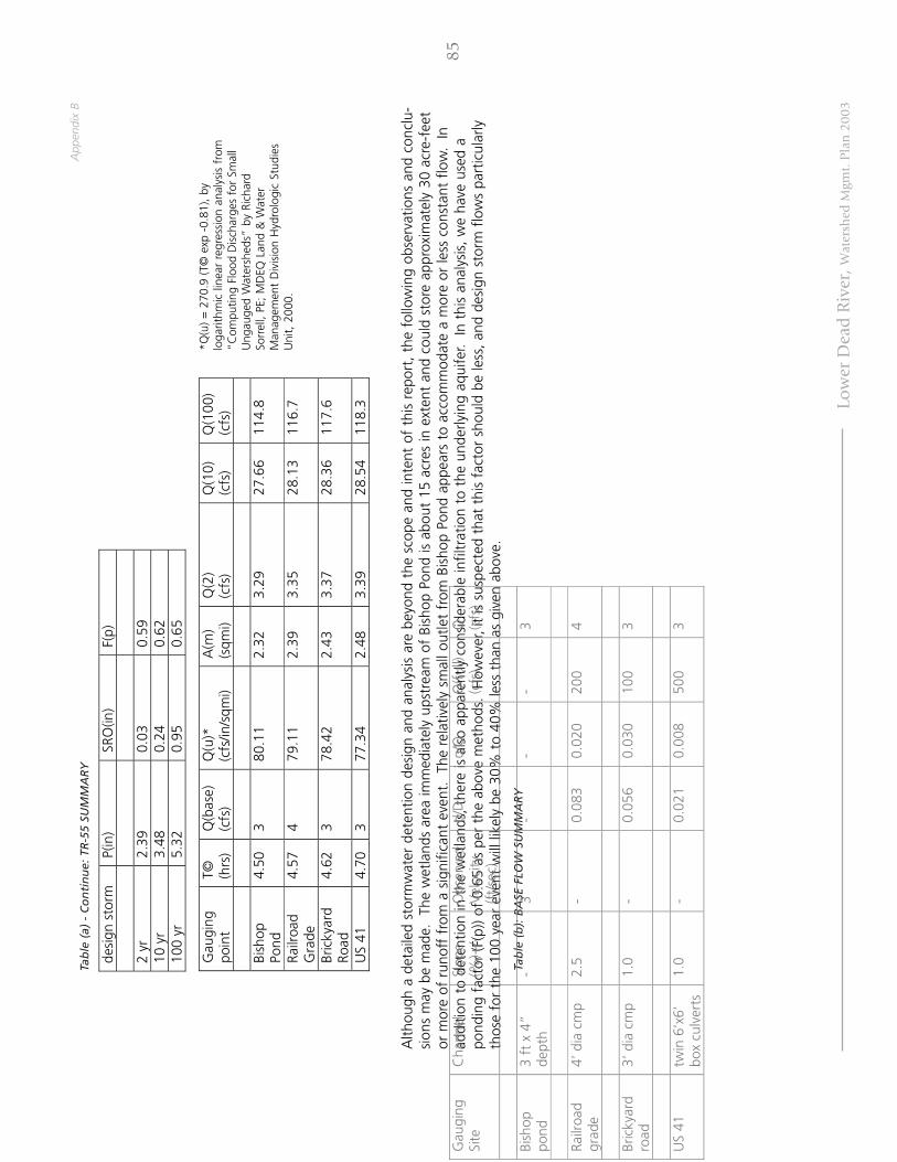
App
endi
x B
Low
er D
ead
Riv
er, W
ater
shed
Mgm
t. P
lan
200
3
Alth
ough
a d
etai
led
stor
mw
ater
det
entio
n de
sign
and
ana
lysi
s ar
e be
yond
the
sco
pe a
nd in
tent
of
this
rep
ort,
the
fol
low
ing
obse
rvat
ions
and
con
clu-
sion
s m
ay b
e m
ade.
Th
e w
etla
nds
area
imm
edia
tely
ups
trea
m o
f Bi
shop
Pon
d is
abo
ut 1
5 ac
res
in e
xten
t an
d co
uld
stor
e ap
prox
imat
ely
30 a
cre-
feet
or m
ore
of r
unof
f fr
om a
sig
nific
ant
even
t.
The
rela
tivel
y sm
all o
utle
t fr
om B
isho
p Po
nd a
ppea
rs t
o ac
com
mod
ate
a m
ore
or le
ss c
onst
ant
flow
. In
addi
tion
to d
eten
tion
in t
he w
etla
nds,
the
re is
als
o ap
pare
ntly
con
side
rabl
e in
filtr
atio
n to
the
und
erly
ing
aqui
fer.
In t
his
anal
ysis
, w
e ha
ve u
sed
apo
ndin
g fa
ctor
(F(p
)) of
0.6
5 as
per
the
abo
ve m
etho
ds.
How
ever
, it
is s
uspe
cted
tha
t th
is f
acto
r sh
ould
be
less
, and
des
ign
stor
m f
low
s pa
rtic
ular
lyth
ose
for
the
100
year
eve
nt w
ill li
kely
be
30%
to
40%
less
tha
n as
giv
en a
bove
.
desi
gn s
torm
P(
in)
SRO
(in)
F(p)
2
yr
2.39
0.
03
0.59
10
yr
3.48
0.
24
0.62
10
0 yr
5.
32
0.95
0.
65
Gau
ging
po
int
T©
(hrs
) Q
(bas
e)
(cfs
) Q
(u)*
(c
fs/in
/sqm
i) A
(m)
(sqm
i) Q
(2)
(cfs
) Q
(10)
(c
fs)
Q(1
00)
(cfs
)
Bi
shop
Po
nd
4.50
3
80.1
1 2.
32
3.29
27
.66
114.
8
Railr
oad
Gra
de
4.57
4
79.1
1 2.
39
3.35
28
.13
116.
7
Bric
kyar
d Ro
ad
4.62
3
78.4
2 2.
43
3.37
28
.36
117.
6
US
41
4.70
3
77.3
4 2.
48
3.39
28
.54
118.
3
Tab
le (
a) -
Co
nti
nu
e: T
R-5
5 SU
MM
AR
Y
Tab
le (
b):
BA
SE F
LOW
SU
MM
AR
Y
*Q(u
) =
270
.9 (
T© e
xp -
0.81
), by
loga
rithm
ic li
near
reg
ress
ion
anal
ysis
fro
m“C
ompu
ting
Floo
d D
isch
arge
s fo
r Sm
all
Ung
auge
d W
ater
shed
s” b
y Ri
char
dSo
rrel
l, PE
; M
DEQ
Lan
d &
Wat
erM
anag
emen
t D
ivis
ion
Hyd
rolo
gic
Stud
ies
Uni
t, 2
000.
85G
augi
ng
Site
C
hann
el
Slop
e (%
)+/-
O
bser
ved
Vel
ocity
(f
t/se
c)
d/D
q/
Q
Q(f
ull)
(cfs
) Q
(c
fs)
Bish
op
pond
3
ft x
4”
dept
h -
3 -
- -
3
Railr
oad
grad
e 4’
dia
cm
p 2.
5 -
0.08
3 0.
020
200
4
Bric
kyar
d ro
ad
3’ d
ia c
mp
1.0
- 0.
056
0.03
0 10
0 3
US
41
twin
6’x
6’
box
culv
erts
1.
0 -
0.02
1 0.
008
500
3

FIG
URE
(a) –
USG
S W
ATE
RSH
ED M
AP
(see
orig
inal
stu
dy f
or f
igur
es)
FIG
URE
(b) -
USD
A/S
CS
SOIL
S M
AP
(see
orig
inal
stu
dy f
or f
igur
es)
APP
END
IX (a
) - S
CS
TR-5
5 D
ATA
SH
EETS
(see
orig
inal
stu
dy f
or d
ata
shee
ts)
APP
END
IX (
b) -
USD
A S
OIL
S C
LASS
IFIC
ATI
ON
& H
YD
ROLO
GIC
GRO
UPS
(se
e be
low
)
Ap
pen
dix
(b
) -
USD
A S
OIL
S C
LASS
IFIC
ATI
ON
& H
YD
RO
LOG
IC G
RO
UPS
Soils
D
esig
natio
n D
escr
iptio
n H
ydro
logi
c G
roup
U
plan
d So
ils
125D
K
ewee
naw
/Kal
kask
a ro
ck o
utcr
op c
ompl
ex
A
125F
K
ewee
naw
/Kal
kask
a di
ssec
ted
com
plex
(m
orai
ne f
orm
atio
n)
A/B
40B
Wai
ska
cobb
ly/lo
amy
sand
B
13B
Kal
kask
a sa
nd
A
12B
Rubi
con
sand
(out
was
h pl
ains
& s
trea
m t
erra
ces)
A
W
etla
nds
Soils
93
Ta
was
/Def
ord
Muc
k/Sa
nd
D/A
57
C
arbo
ndal
e/Ta
was
Muc
k/Sa
nd
D/A
86

App
endi
x C
Low
er D
ead
Riv
er, W
ater
shed
Mgm
t. P
lan
200
3
AP
PE
ND
IX C
- R
ipar
ian
Bu
ffer
Ord
inan
ce (
Dra
ft)
AP
PE
ND
IX C
- R
ipar
ian
Bu
ffer
Ord
inan
ce (
Dra
ft)
AP
PE
ND
IX C
- R
ipar
ian
Bu
ffer
Ord
inan
ce (
Dra
ft)
AP
PE
ND
IX C
- R
ipar
ian
Bu
ffer
Ord
inan
ce (
Dra
ft)
AP
PE
ND
IX C
- R
ipar
ian
Bu
ffer
Ord
inan
ce (
Dra
ft)
Rip
aria
n B
uff
er O
rdin
ance
- O
utl
ine
Rip
aria
n B
uff
er O
rdin
ance
- O
utl
ine
Rip
aria
n B
uff
er O
rdin
ance
- O
utl
ine
Rip
aria
n B
uff
er O
rdin
ance
- O
utl
ine
Rip
aria
n B
uff
er O
rdin
ance
- O
utl
ine
The
follo
win
g rip
aria
n bu
ffer
ord
inan
ce w
as a
dapt
ed f
rom
the
EPA
’s m
odel
buf
fer
ordi
nanc
e an
d de
sign
ed t
o su
it th
e sp
ecifi
c ne
eds
of M
arqu
ette
Cou
nty.
Pu
rpo
seTh
e pu
rpos
e of
a r
ipar
ian
buff
er o
rdin
ance
in M
arqu
ette
Cou
nty
is t
o en
sure
the
pro
tect
ion
of w
ater
qua
lity
and
aqua
tic h
abita
t w
ithin
the
loca
lst
ream
sys
tem
s.
The
prot
ectio
n of
the
nat
ural
veg
etat
ion
adja
cent
to
wat
erw
ays
is in
tend
ed t
o pr
otec
t th
e ph
ysic
al in
tegr
ity o
f th
e sy
stem
, red
uce
the
amou
nt o
f no
n-po
int
sour
ce p
ollu
tion
ente
ring
thes
e sy
stem
s, a
nd t
o pr
otec
t an
d en
hanc
e th
e aq
uatic
hab
itat
of t
he r
egio
n.
Ou
tlin
e o
f O
rdin
an
ceTh
e pr
opos
ed o
rdin
ance
incl
udes
the
fol
low
ing
info
rmat
ion:
Sect
ion
I -
Inte
nt
Out
lines
the
pur
pose
of
the
ordi
nanc
e
Sect
ion
II -
Bac
kgro
un
dRe
view
s th
e be
nefit
s su
ch a
n or
dina
nce
wou
ld h
ave
for
the
loca
l str
eam
sys
tem
Sect
ion
III -
Def
init
ion
sEs
tabl
ishe
s st
anda
rd d
efin
ition
s to
ens
ure
clea
r co
mm
unic
atio
n of
the
ord
inan
ce
Sect
ion
IV -
Des
ign
Sta
nd
ard
s fo
r R
ipar
ian
Bu
ffer
sD
escr
ibes
the
det
aile
d de
sign
of
the
ripar
ian
buff
er in
clud
ing
perm
itted
and
res
tric
ted
uses
Sect
ion
V -
Bu
ffer
Man
agem
ent
and
Mai
nte
nan
ceO
utlin
es p
erm
itted
and
res
tric
ted
activ
ities
rel
ated
to
buff
er m
anag
emen
t an
d m
aint
enan
ce
Sect
ion
VI -
En
forc
emen
t Pr
oce
du
res
Revi
ews
the
proc
edur
es f
or e
nfor
cem
ent
of t
he o
rdin
ance
Sect
ion
IX -
Wai
vers
/ V
aria
nce
sD
escr
ibes
the
pro
cess
for
obt
aini
ng a
wai
ver
or v
aria
nce
rela
ted
to t
he b
uffe
r or
dina
nce
87

88
Sect
ion
I. I
nte
nt
The
purp
ose
of t
his
ordi
nanc
e is
to
esta
blis
h m
inim
al a
ccep
tabl
e re
quire
men
ts f
or t
he d
esig
n of
buf
fers
to
prot
ect
the
stre
ams,
wet
land
s, a
nd f
lood
-pl
ains
of
____
____
____
____
___
[juris
dict
ion]
; to
pro
tect
the
wat
er q
ualit
y of
wat
erco
urse
s, r
eser
voirs
, la
kes,
and
oth
er s
igni
fican
t w
ater
res
ourc
esw
ithin
___
____
____
____
____
[juris
dict
ion]
; to
pro
tect
___
____
____
____
____
‘s
[Jur
isdi
ctio
n’s]
rip
aria
n an
d aq
uatic
eco
syst
ems;
and
to
prov
ide
for
the
envi
ronm
enta
lly s
ound
use
of
____
____
____
____
___
‘s [
juris
dict
ion’
s] la
nd r
esou
rces
.
Sect
ion
II.
Back
gro
un
dBu
ffer
s ad
jace
nt t
o st
ream
sys
tem
s an
d co
asta
l are
as p
rovi
de n
umer
ous
envi
ronm
enta
l pro
tect
ion
and
reso
urce
man
agem
ent
bene
fits
that
can
incl
ude
the
follo
win
g:1.
Rest
orin
g an
d m
aint
aini
ng t
he c
hem
ical
, ph
ysic
al,
and
biol
ogic
al in
tegr
ity o
f th
e w
ater
res
ourc
es2.
Rem
ovin
g po
lluta
nts
deliv
ered
fro
m u
rban
sto
rmw
ater
3.Re
duci
ng e
rosi
on a
nd s
edim
ent
ente
ring
the
stre
am4.
Stab
ilizi
ng s
trea
m b
anks
5.Pr
ovid
ing
infil
trat
ion
of s
torm
wat
er r
unof
f6.
Mai
ntai
ning
bas
e flo
w o
f st
ream
s7.
Con
trib
utin
g th
e or
gani
c m
atte
r th
at is
a s
ourc
e of
foo
d an
d en
ergy
for
the
aqu
atic
eco
syst
em8.
Prov
idin
g tr
ee c
anop
y to
sha
de s
trea
ms
and
prom
ote
desi
rabl
e aq
uatic
org
anis
ms
9.Pr
ovid
ing
ripar
ian
wild
life
habi
tat
10.
Furn
ishi
ng s
ceni
c va
lue
and
recr
eatio
nal o
ppor
tuni
tyIt
is t
he d
esire
of
the
____
____
____
____
____
____
____
[juris
dict
ion]
to
prot
ect
and
mai
ntai
n th
e na
tive
vege
tatio
n in
rip
aria
n an
d w
etla
nd a
reas
by
impl
emen
ting
spec
ifica
tions
for
the
est
ablis
hmen
t, p
rote
ctio
n, a
nd m
aint
enan
ce o
f ve
geta
tion
alon
g al
l str
eam
sys
tem
s an
d/or
coa
stal
zon
es w
ithin
our
juris
dict
iona
l aut
horit
y.
Sect
ion
III
. Defi
nit
ion
sA
ctiv
e C
han
nel
The
area
of
the
stre
am c
hann
el t
hat
is s
ubje
ct t
o fr
eque
nt f
low
s (a
ppro
xim
atel
y on
ce p
er o
ne a
nd a
hal
f ye
ars)
and
tha
t in
clud
es t
he p
ortio
n of
the
chan
nel b
elow
the
flo
odpl
ain.
Best
Man
ag
em
en
t Pra
ctic
es
(BM
Ps)
Con
serv
atio
n pr
actic
es o
r m
anag
emen
t m
easu
res
that
con
trol
soi
l los
s an
d re
duce
wat
er q
ualit
y de
grad
atio
n ca
used
by
nutr
ient
s, a
nim
al w
aste
s,to
xics
, se
dim
ent,
and
run
off.
Bu
ffer
A v
eget
ated
are
a, in
clud
ing
tree
s, s
hrub
s, a
nd h
erba
ceou
s ve
geta
tion,
tha
t ex
ists
or
is e
stab
lishe
d to
pro
tect
a s
trea
m s
yste
m,
lake
, res
ervo
ir, o
r co
asta
les
tuar
ine
area
. A
ltera
tion
of t
his
natu
ral a
rea
is s
tric
tly li
mite
d.
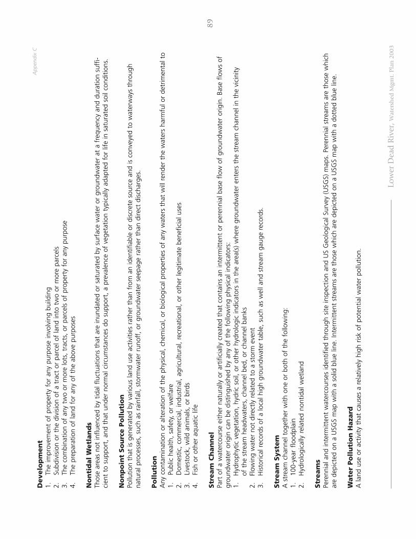
Low
er D
ead
Riv
er, W
ater
shed
Mgm
t. P
lan
200
3
App
endi
x C
89
De
ve
lop
me
nt
1.Th
e im
prov
emen
t of
pro
pert
y fo
r an
y pu
rpos
e in
volv
ing
build
ing
2.Su
bdiv
isio
n or
the
div
isio
n of
a t
ract
or
parc
el o
f la
nd in
to t
wo
or m
ore
parc
els
3.Th
e co
mbi
natio
n of
any
tw
o or
mor
e lo
ts, t
ract
s, o
r pa
rcel
s of
pro
pert
y fo
r an
y pu
rpos
e4.
The
prep
arat
ion
of la
nd f
or a
ny o
f th
e ab
ove
purp
oses
No
nti
dal
Wetl
an
ds
Thos
e ar
eas
not
influ
ence
d by
tid
al f
luct
uatio
ns t
hat
are
inun
date
d or
sat
urat
ed b
y su
rfac
e w
ater
or
grou
ndw
ater
at
a fr
eque
ncy
and
dura
tion
suff
i-ci
ent
to s
uppo
rt,
and
that
und
er n
orm
al c
ircum
stan
ces
do s
uppo
rt,
a pr
eval
ence
of
vege
tatio
n ty
pica
lly a
dapt
ed f
or li
fe in
sat
urat
ed s
oil c
ondi
tions
.
No
np
oin
t So
urc
e P
oll
uti
on
Pollu
tion
that
is g
ener
ated
by
vario
us la
nd u
se a
ctiv
ities
rat
her
than
fro
m a
n id
entif
iabl
e or
dis
cret
e so
urce
and
is c
onve
yed
to w
ater
way
s th
roug
hna
tura
l pro
cess
es,
such
as
rain
fall,
sto
rmw
ater
run
off,
or
grou
ndw
ater
see
page
rat
her
than
dire
ct d
isch
arge
s.
Po
llu
tio
nA
ny c
onta
min
atio
n or
alte
ratio
n of
the
phy
sica
l, ch
emic
al,
or b
iolo
gica
l pro
pert
ies
of a
ny w
ater
s th
at w
ill r
ende
r th
e w
ater
s ha
rmfu
l or
detr
imen
tal t
o1.
Publ
ic h
ealth
, sa
fety
, or
wel
fare
2.D
omes
tic,
com
mer
cial
, in
dust
rial,
agric
ultu
ral,
recr
eatio
nal,
or o
ther
legi
timat
e be
nefic
ial u
ses
3.Li
vest
ock,
wild
ani
mal
s, o
r bi
rds
4.Fi
sh o
r ot
her
aqua
tic li
fe
Str
eam
Ch
an
nel
Part
of
a w
ater
cour
se e
ither
nat
ural
ly o
r ar
tific
ially
cre
ated
tha
t co
ntai
ns a
n in
term
itten
t or
per
enni
al b
ase
flow
of
grou
ndw
ater
orig
in.
Base
flo
ws
ofgr
ound
wat
er o
rigin
can
be
dist
ingu
ishe
d by
any
of
the
follo
win
g ph
ysic
al in
dica
tors
:1.
Hyd
roph
ytic
veg
etat
ion,
hyd
ric s
oil,
or o
ther
hyd
rolo
gic
indi
cato
rs in
the
are
a(s)
whe
re g
roun
dwat
er e
nter
s th
e st
ream
cha
nnel
in t
he v
icin
ityof
the
str
eam
hea
dwat
ers,
cha
nnel
bed
, or
cha
nnel
ban
ks2.
Flow
ing
wat
er n
ot d
irect
ly r
elat
ed t
o a
stor
m e
vent
3.H
isto
rical
rec
ords
of
a lo
cal h
igh
grou
ndw
ater
tab
le,
such
as
wel
l and
str
eam
gau
ge r
ecor
ds.
Str
eam
Syst
em
A s
trea
m c
hann
el t
oget
her
with
one
or
both
of
the
follo
win
g:1.
100-
year
flo
odpl
ain
2.H
ydro
logi
cally
rel
ated
non
tidal
wet
land
Str
eam
sPe
renn
ial a
nd in
term
itten
t w
ater
cour
ses
iden
tifie
d th
roug
h si
te in
spec
tion
and
US
Geo
logi
cal S
urve
y (U
SGS)
map
s. P
eren
nial
str
eam
s ar
e th
ose
whi
char
e de
pict
ed o
n a
USG
S m
ap w
ith a
sol
id b
lue
line.
Inte
rmitt
ent
stre
ams
are
thos
e w
hich
are
dep
icte
d on
a U
SGS
map
with
a d
otte
d bl
ue li
ne.
Wate
r Po
llu
tio
n H
aza
rdA
land
use
or
activ
ity t
hat
caus
es a
rel
ativ
ely
high
ris
k of
pot
entia
l wat
er p
ollu
tion.

90
Sect
ion
IV.
Desi
gn
Sta
nd
ard
s fo
r R
ipari
an
Bu
ffers
A.
A r
ipar
ian
buff
er f
or a
str
eam
sys
tem
sha
ll co
nsis
t of
a f
ores
ted
strip
of
land
ext
endi
ng a
long
bot
h si
des
of a
str
eam
and
its
adja
cent
wet
land
s or
ste
ep s
lope
s. T
he r
ipar
ian
buff
er w
idth
sha
ll be
adj
uste
d to
incl
ude
cont
iguo
us s
ensi
tive
area
s, s
uch
as s
teep
slo
pes
and
wet
land
s, w
here
dev
elop
men
t or
dis
turb
ance
may
adv
erse
ly a
ffec
t w
ater
qua
lity,
str
eam
s, w
etla
nds,
or
othe
r w
ater
bodi
es.
B.Th
e rip
aria
n bu
ffer
sha
ll be
gin
at t
he e
dge
of t
he s
trea
m b
ank
of t
he a
ctiv
e ch
anne
l.
C.
The
ripar
ian
buff
er s
hall
be c
ompo
sed
of t
wo
dist
inct
zon
es, w
ith e
ach
zone
hav
ing
its o
wn
set
of p
erm
itted
and
res
tric
ted
uses
(See
Fig
ure
1).
1.Zo
ne 1
- S
trea
msi
de Z
one
1.Pr
otec
ts t
he p
hysi
cal a
nd e
colo
gica
l int
egrit
y of
the
str
eam
eco
syst
em.
2.Be
gins
at
the
edge
of
the
stre
am b
ank
of t
he a
ctiv
e ch
anne
l and
ext
ends
25
feet
fro
m t
he t
op o
f th
e ba
nk p
lus
any
addi
tiona
lbu
ffer
wid
th a
s sp
ecifi
ed in
thi
s se
ctio
n.3.
Allo
wab
le u
ses
with
in t
his
zone
are
hig
hly
rest
ricte
d to
:1.
Floo
d co
ntro
l str
uctu
res
2.U
tility
rig
ht o
f w
ays
3.Fo
otpa
ths
4.Ro
ad c
ross
ings
, w
here
per
mitt
ed.
4.St
ream
side
Zon
e co
ntai
ns u
ndis
turb
ed n
atur
al v
eget
atio
n.
Fig
ure
1: T
wo
-zo
ne
Rip
aria
n B
uff
er

Low
er D
ead
Riv
er, W
ater
shed
Mgm
t. P
lan
200
3
App
endi
x C
91
2.Zo
ne 2
- O
uter
Zon
e1.
Prot
ects
key
com
pone
nts
of t
he s
trea
m a
nd p
rovi
des
dist
ance
bet
wee
n up
land
dev
elop
men
t an
d th
e St
ream
side
Zon
e.2.
Begi
ns a
t th
e ou
ter
edge
of
the
Stre
amsi
de Z
one
and
exte
nds
25 f
eet.
3.A
llow
able
use
s w
ithin
the
Out
er Z
one
are
rest
ricte
d to
1.Bi
king
or
hiki
ng p
aths
2.St
orm
wat
er m
anag
emen
t fa
cilit
ies,
with
the
app
rova
l of
____
____
____
[ju
risdi
ctio
n].
3.Re
crea
tiona
l use
s as
app
rove
d by
___
____
____
__ [
juris
dict
ion]
.4.
Rem
oval
of
mat
ure
tree
cov
er4.
Mid
dle
Zone
req
uire
s th
e re
tent
ion
of t
he s
hrub
laye
r an
d he
rbac
eous
gro
und
cove
r to
allo
w in
filtr
atio
n of
run
off.
Exte
nsi
on
s to
Min
imu
m B
uff
er
Wid
thA
.Th
e re
quire
d w
idth
for
the
Rip
aria
n Bu
ffer
tot
als
50 f
eet
(Zon
e 1
= 2
5’, Z
one
2 =
25’
). Th
is b
uffe
r sh
all b
e ex
tend
ed if
wet
land
s or
ste
epsl
opes
are
pre
sent
.
1.W
etla
nds:
W
hen
wet
land
s ar
e pr
esen
t, t
he w
idth
of
the
Stre
amsi
de Z
one
shal
l be
adju
sted
so
that
the
Zon
e 1
buff
er w
ill c
onsi
stof
the
ext
ent
of t
he w
etla
nd p
lus
20-f
eet
beyo
nd t
he w
etla
nd e
dge.
2.Pe
rcen
t Sl
ope:
Th
e rip
aria
n bu
ffer
wid
th s
hall
be m
odifi
ed if
ste
ep s
lope
s ar
e w
ithin
clo
se p
roxi
mity
to
the
stre
am a
nd d
rain
into
the
stre
am s
yste
m.
The
fol
low
ing
exte
nsio
ns w
ill b
e ad
ded
to t
he s
tand
ard
50’
Ripa
rian
Buff
er in
rel
atio
n to
the
slo
peof
the
str
eam
ban
k.
The
exte
nsio
ns a
re c
alcu
late
d as
fol
low
s:Pe
rcen
t Sl
op
eB
uff
er E
xten
sio
nTo
tal W
idth
of
Rip
aria
n B
uff
er15
%-1
7%ad
d 10
fee
t60
fee
t18
%-2
0%ad
d 30
fee
t80
fee
t21
%-2
3%ad
d 50
fee
t10
0 fe
et24
%-2
5%ad
d 60
fee
t11
0 fe
et>
25%
add
70 f
eet
120
feet
B.W
ater
Pol
lutio
n H
azar
ds:
The
fol
low
ing
land
use
s an
d/or
act
iviti
es a
re d
esig
nate
d as
pot
entia
l wat
er p
ollu
tion
haza
rds,
and
mus
tbe
set
bac
kfr
om a
ny s
trea
m o
r w
ater
body
by
the
dist
ance
indi
cate
d be
low
:1.
Stor
age
of h
azar
dous
sub
stan
ces
- (1
50 f
eet)
2.A
bove
gro
und
or u
nder
grou
nd p
etro
leum
sto
rage
fac
ilitie
s -
(150
fee
t)3.
Dra
infie
lds
from
ons
ite s
ewag
e di
spos
al a
nd t
reat
men
t sy
stem
s (i.
e.,
sept
ic s
yste
ms)
- (
100
feet
)4.
Rais
ed s
eptic
sys
tem
s -
(250
fee
t)5.
Solid
was
te la
ndfil
ls o
r ju
nkya
rds
- (3
00 f
eet)
6.C
onfin
ed a
nim
al f
eedl
ot o
pera
tions
- (
250
feet
)7.
Subs
urfa
ce d
isch
arge
s fr
om a
was
tew
ater
tre
atm
ent
plan
t -
(100
fee
t)8.
Land
app
licat
ion
of b
ioso
lids
- (1
00 f
eet)

92
Sect
ion
V. B
uff
er
Man
ag
em
en
t an
d M
ain
ten
an
ceA
.Th
e rip
aria
n bu
ffer
, in
clud
ing
wet
land
s sh
all b
e m
anag
ed t
o en
hanc
e an
d m
axim
ize
the
uniq
ue v
alue
of
thes
e re
sour
ces.
Man
agem
ent
incl
udes
spe
cific
lim
itatio
ns o
n al
tera
tion
of t
he n
atur
al c
ondi
tions
of
thes
e re
sour
ces.
The
fol
low
ing
prac
tices
and
activ
ities
are
res
tric
ted
with
inbo
th z
ones
of
the
ripar
ian
buff
er,
exce
pt w
ith a
ppro
val b
y __
____
____
___
[juris
dict
ion]
:1.
Cle
arin
g of
exi
stin
g ve
geta
tion
(exc
ept
as n
oted
pre
viou
sly)
2.So
il di
stur
banc
e by
gra
ding
, st
rippi
ng,
or o
ther
pra
ctic
es3.
Filli
ng o
r du
mpi
ng4.
Dra
inag
e by
ditc
hing
, un
derd
rain
s, o
r ot
her
syst
ems
5.U
se,
stor
age,
or
appl
icat
ion
of p
estic
ides
, ex
cept
for
spo
t sp
rayi
ng o
f no
xiou
s w
eeds
or
non-
nativ
e sp
ecie
s co
nsis
tent
with
reco
mm
enda
tions
of
____
____
____
_ [ju
risdi
ctio
n]6.
Hou
sing
, gr
azin
g, o
r ot
her
mai
nten
ance
of
lives
tock
7.St
orag
e or
ope
ratio
n of
mot
oriz
ed v
ehic
les
with
in Z
one
1, e
xcep
t fo
r m
aint
enan
ce o
r em
erge
ncy
use.
B.Th
e fo
llow
ing
stru
ctur
es,
prac
tices
, an
d ac
tiviti
es a
re p
erm
itted
in t
he r
ipar
ian
buff
er,
with
spe
cific
des
ign
or m
aint
enan
ce f
eatu
res,
sub
ject
to t
he r
evie
w o
f __
____
____
___
[juris
dict
ion]
:1.
Road
s, b
ridge
s, p
aths
, an
d ut
ilitie
s:1.
An
anal
ysis
nee
ds t
o be
con
duct
ed t
o en
sure
tha
t no
eco
nom
ical
ly f
easi
ble
alte
rnat
ive
is a
vaila
ble.
2.Th
e rig
ht-o
f-w
ay s
houl
d be
the
min
imum
wid
th n
eede
d to
allo
w f
or m
aint
enan
ce a
cces
s an
d in
stal
latio
n.3.
The
angl
e of
the
cro
ssin
g sh
all b
e pe
rpen
dicu
lar
to t
he s
trea
m o
r bu
ffer
in o
rder
to
min
imiz
e cl
earin
g re
quire
men
ts.
4.Th
e m
inim
um n
umbe
r of
roa
d cr
ossi
ngs
shou
ld b
e us
ed w
ithin
eac
h su
bdiv
isio
n, a
nd n
o m
ore
than
one
fai
rway
cro
ssin
gis
allo
wed
for
eve
ry 1
,000
fee
t of
buf
fer.
2.St
orm
wat
er m
anag
emen
t:1.
An
anal
ysis
nee
ds t
o be
con
duct
ed t
o en
sure
tha
t no
eco
nom
ical
ly f
easi
ble
alte
rnat
ive
is a
vaila
ble
and
that
the
pro
ject
isei
ther
nec
essa
ry f
or f
lood
con
trol
, or
sig
nific
antly
impr
oves
the
wat
er q
ualit
y or
hab
itat
in t
he s
trea
m.
2.In
new
dev
elop
men
ts,
onsi
te a
nd n
onst
ruct
ural
alte
rnat
ives
will
be
pref
erre
d ov
er la
rger
fac
ilitie
s w
ithin
the
str
eam
buf
fer.
3.W
hen
cons
truc
ting
stor
mw
ater
man
agem
ent
faci
litie
s (i.
e.,
BMPs
), th
e ar
ea c
lear
ed w
ill b
e lim
ited
to t
he a
rea
requ
ired
for
cons
truc
tion
and
adeq
uate
mai
nten
ance
acc
ess,
as
outli
ned
in t
he m
ost
rece
nt e
ditio
n of
___
____
____
[ref
er t
o lo
cal
juris
dict
ion’
s st
orm
wat
er r
equi
rem
ents
].4.
Mat
eria
l dre
dged
or
othe
rwis
e re
mov
ed s
hall
be s
tore
d ou
tsid
e th
e bu
ffer
.
3.St
ream
res
tora
tion
proj
ects
, fa
cilit
ies
and
activ
ities
app
rove
d by
___
____
__ [j
uris
dict
ion]
ar
e pe
rmitt
ed w
ithin
the
rip
aria
n bu
ffer
.
4.W
ater
qua
lity
mon
itorin
g an
d st
ream
gau
ging
are
per
mitt
ed w
ithin
the
rip
aria
n bu
ffer
, as
app
rove
d by
___
____
____
[ju
risdi
ctio
n].
5.In
divi
dual
tre
es w
ithin
the
rip
aria
n bu
ffer
tha
t ar
e in
dan
ger
of f
allin
g, c
ausi
ng d
amag
e to
dw
ellin
gs o
r ot
her
stru
ctur
es,
orca
usin
g bl
ocka
ge o
f th
e st
ream
may
be
rem
oved
.
6.O
ther
tim
ber
cutt
ing
tech
niqu
es a
ppro
ved
by t
he a
genc
y m
ay b
e un
dert
aken
with
in t
he r
ipar
ian
buff
er u
nder
the
adv
ice
and
guid
ance
of
____
____
____
___
[juris
dict
ion]
if n
eces
sary
to
pres
erve
the
for
est
from
ext
ensi
ve p
est
infe
stat
ion,
dis
ease
infe
stat
ion,
or t
hrea
t fr
om f
ire.

Low
er D
ead
Riv
er, W
ater
shed
Mgm
t. P
lan
200
3
App
endi
x C
93
C.
All
plan
s pr
epar
ed f
or r
ecor
ding
and
all
right
-of-
way
pla
ns s
hall
clea
rly:
1.Sh
ow t
he e
xten
t of
any
rip
aria
n bu
ffer
on
the
subj
ect
prop
erty
2.La
bel t
he r
ipar
ian
buff
er3.
Prov
ide
a no
te t
o re
fere
nce
each
zon
e of
the
rip
aria
n bu
ffer
sta
ting:
“Th
ere
shal
l be
no c
lear
ing,
gra
ding
, co
nstr
uctio
n or
dist
urba
nce
of v
eget
atio
n ex
cept
as
perm
itted
by
the
agen
cy”.
4.Pr
ovid
e a
note
to
refe
renc
e an
y pr
otec
tive
cove
nant
s go
vern
ing
all r
ipar
ian
buff
ers
area
s st
atin
g: “
Any
rip
aria
n bu
ffer
sho
wn
here
on is
sub
ject
to
prot
ectiv
e co
vena
nts
that
may
be
foun
d in
the
land
rec
ords
and
tha
t re
stric
t di
stur
banc
e an
d us
e of
the
se a
reas
.”
D.
All
ripar
ian
buff
er a
reas
sha
ll be
mai
ntai
ned
thro
ugh
a de
clar
atio
n of
pro
tect
ive
cove
nant
, w
hich
is r
equi
red
to b
e su
bmitt
ed f
or a
ppro
val
by _
____
____
___
[juris
dict
ion]
. Th
e co
vena
nt s
hall
be r
ecor
ded
in t
he la
nd r
ecor
ds a
nd s
hall
run
with
the
land
and
con
tinue
in p
erpe
tuity
.
E.A
ll le
ase
agre
emen
ts m
ust
cont
ain
a no
tatio
n re
gard
ing
the
pres
ence
and
loca
tion
of p
rote
ctiv
e co
vena
nts
for
ripar
ian
buff
er a
reas
and
shal
l con
tain
info
rmat
ion
on t
he m
anag
emen
t an
d m
aint
enan
ce r
equi
rem
ents
for
the
for
est
buff
er f
or t
he n
ew p
rope
rty
owne
r.
F.A
n of
fer
of d
edic
atio
n of
a r
ipar
ian
buff
er a
rea
to t
he a
genc
y sh
all n
ot b
e in
terp
rete
d to
mea
n th
at t
his
auto
mat
ical
ly c
onve
ys t
o th
ege
nera
l pub
lic t
he r
ight
of
acce
ss t
o th
is a
rea.
G.
____
____
__ [j
uris
dict
ion]
sha
ll in
spec
t th
e bu
ffer
ann
ually
and
imm
edia
tely
fol
low
ing
seve
re s
torm
s fo
r ev
iden
ce o
f se
dim
ent,
dep
ositi
on,
eros
ion,
or
conc
entr
ated
flo
w c
hann
els
and
corr
ectiv
e ac
tions
tak
en t
o en
sure
the
inte
grity
and
fun
ctio
ns o
f th
e rip
aria
n bu
ffer
.
H.
Ripa
rian
buff
er a
reas
may
be
allo
wed
to
grow
into
the
ir ve
geta
tive
targ
et s
tate
nat
ural
ly, b
ut m
etho
ds t
o en
hanc
e th
e su
cces
sion
alpr
oces
s su
ch a
s ac
tive
refo
rest
atio
n m
ay b
e us
ed w
hen
deem
ed n
eces
sary
by
____
____
____
__ [
juris
dict
ion]
to
ensu
re t
he p
rese
rvat
ion
and
prop
agat
ion
of t
he b
uffe
r ar
ea.
Ripa
rian
buff
er a
reas
may
als
o be
enh
ance
d th
roug
h re
fore
stat
ion
or o
ther
gro
wth
tec
hniq
ues
as a
form
of
miti
gatio
n fo
r ac
hiev
ing
buff
er p
rese
rvat
ion
requ
irem
ents
.
Sect
ion
VI.
En
forc
em
en
t Pro
ced
ure
sA
.__
____
____
___
[juris
dict
ion]
is a
utho
rized
and
em
pow
ered
to
enfo
rce
the
requ
irem
ents
of
this
ord
inan
ce in
acc
orda
nce
with
the
proc
edur
es o
f th
is s
ectio
n.
B.If,
upo
n in
spec
tion
or in
vest
igat
ion,
the
___
____
____
__ [
juris
dict
ion]
is o
f th
e op
inio
n th
at a
ny p
erso
n ha
s vi
olat
ed a
ny p
rovi
sion
of
this
ordi
nanc
e, h
e/sh
e sh
all w
ith r
easo
nabl
e pr
ompt
ness
issu
e a
corr
ectio
n no
tice
to t
he p
erso
n. E
ach
such
not
ice
shal
l be
in w
ritin
g an
d sh
all
desc
ribe
the
natu
re o
f th
e vi
olat
ion,
incl
udin
g a
refe
renc
e to
the
pro
visi
on w
ithin
thi
s or
dina
nce
that
has
bee
n vi
olat
ed.
In a
dditi
on,
the
notic
e sh
all s
et a
rea
sona
ble
time
for
the
abat
emen
t an
d co
rrec
tion
of t
he v
iola
tion.
C.
Vio
latio
ns o
f th
ese
prov
isio
ns a
re s
ubje
ct t
o th
e en
forc
emen
t pr
ovis
ions
of
____
____
____
__ [
juris
dict
ion’
s] z
onin
g or
dina
nce.

94
Sect
ion
VII
. Waiv
ers
/Vari
an
ces
A.
This
ord
inan
ce s
hall
appl
y to
all
prop
osed
dev
elop
men
t ex
cept
for
act
iviti
es t
hat
wer
e co
mpl
eted
prio
r to
the
eff
ectiv
e da
te o
f th
isor
dina
nce
and
had
rece
ived
the
fol
low
ing:
1.A
val
id,
unex
pire
d pe
rmit
in a
ccor
danc
e w
ith d
evel
opm
ent
regu
latio
ns2.
A c
urre
nt,
exec
uted
pub
lic w
orks
agr
eem
ent
3.A
val
id,
unex
pire
d bu
ildin
g pe
rmit
4.A
wai
ver
in a
ccor
danc
e w
ith c
urre
nt d
evel
opm
ent
regu
latio
ns.
B.Th
e __
____
____
____
___
[juris
dict
ion’
s] Z
onin
g Bo
ard
of A
ppea
ls m
ay g
rant
a v
aria
nce
for
the
follo
win
g:1.
Thos
e pr
ojec
ts o
r ac
tiviti
es f
or w
hich
it c
an b
e de
mon
stra
ted
that
str
ict
com
plia
nce
with
the
ord
inan
ce w
ould
res
ult
in a
pra
ctic
aldi
ffic
ulty
.2.
Thos
e pr
ojec
ts o
r ac
tiviti
es s
ervi
ng a
pub
lic n
eed
whe
re n
o fe
asib
le a
ltern
ativ
e is
ava
ilabl
e.3.
The
repa
ir an
d m
aint
enan
ce o
f pu
blic
impr
ovem
ents
whe
re a
void
ance
and
min
imiz
atio
n of
adv
erse
impa
cts
to n
ontid
al w
etla
nds
and
asso
ciat
ed a
quat
ic e
cosy
stem
s ha
ve b
een
addr
esse
d.4.
Thos
e de
velo
pmen
ts w
hich
hav
e ha
d bu
ffer
s ap
plie
d in
con
form
ance
with
pre
viou
sly
issu
ed r
equi
rem
ents
.
C.
Wai
vers
for
dev
elop
men
t m
ay a
lso
be g
rant
ed in
tw
o ad
ditio
nal f
orm
s, if
dee
med
app
ropr
iate
by
the
Zoni
ng B
oard
of
App
eals
:1.
The
buff
er w
idth
mad
e be
red
uced
at
som
e po
ints
as
long
as
the
aver
age
wid
th o
f th
e bu
ffer
mee
ts t
he m
inim
um r
equi
rem
ent.
This
ave
ragi
ng o
f th
e bu
ffer
may
be
used
to
allo
w f
or t
he p
rese
nce
of a
n ex
istin
g st
ruct
ure
or t
o re
cove
r a
lost
lot,
as
long
as
the
Stre
amsi
de Z
one
(Zon
e I)
is n
ot d
istu
rbed
by
the
redu
ctio
n an
d no
new
str
uctu
res
are
built
with
in t
he 1
00-y
ear
flood
plai
n.2.
____
____
____
____
_ [ju
risdi
ctio
n] m
ay o
ffer
cre
dit
for
addi
tiona
l den
sity
els
ewhe
re o
n th
e si
te in
com
pens
atio
n fo
r th
e lo
ss o
fde
velo
pabl
e la
nd d
ue t
o th
e re
quire
men
ts o
f th
is o
rdin
ance
. Th
is c
ompe
nsat
ion
may
incr
ease
the
tot
al n
umbe
r of
dw
ellin
gun
its o
n th
e si
te u
p to
the
am
ount
per
mitt
ed u
nder
the
bas
e zo
ning
.
D.
The
appl
ican
t sh
all s
ubm
it a
writ
ten
requ
est
for
a va
rianc
e to
the
___
____
____
____
__ [j
uris
dict
ion]
. T
he a
pplic
atio
n sh
all i
nclu
de s
peci
ficre
ason
s ju
stify
ing
the
varia
nce
and
any
othe
r in
form
atio
n ne
cess
ary
to e
valu
ate
the
prop
osed
var
ianc
e re
ques
t. T
he a
genc
y m
ay r
equi
re a
nal
tern
ativ
e an
alys
is t
hat
clea
rly d
emon
stra
tes
that
no
othe
r fe
asib
le a
ltern
ativ
es e
xist
and
tha
t m
inim
al im
pact
will
occ
ur a
s a
resu
lt of
the
proj
ect
or d
evel
opm
ent.
E.In
gra
ntin
g a
requ
est
for
a va
rianc
e, t
he
____
____
____
____
_ [ju
risdi
ctio
n] m
ay r
equi
re s
ite d
esig
n, la
ndsc
ape
plan
ting,
fen
cing
, si
gns,
and
wat
er q
ualit
y be
st m
anag
emen
t pr
actic
es t
o re
duce
adv
erse
impa
cts
on w
ater
qua
lity,
str
eam
s, w
etla
nds,
and
flo
odpl
ains
.
Sect
ion
VII
I. C
on
flic
t W
ith
Oth
er
Reg
ula
tio
ns
Whe
re t
he s
tand
ards
and
man
agem
ent
requ
irem
ents
of
this
ord
inan
ce a
re in
con
flict
with
oth
er la
ws,
reg
ulat
ions
, an
d po
licie
s re
gard
ing
stre
ams,
stee
p sl
opes
, er
odib
le s
oils
, w
etla
nds,
flo
odpl
ains
, tim
ber
harv
estin
g, la
nd d
istu
rban
ce a
ctiv
ities
, or
oth
er e
nviro
nmen
tal p
rote
ctiv
e m
easu
res,
the
mor
ere
stric
tive
shal
l app
ly.

Low
er D
ead
Riv
er, W
ater
shed
Mgm
t. P
lan
200
3
App
endi
x C
95
Foll
ow
-up
In
form
atio
nFo
llo
w-u
p I
nfo
rmat
ion
Foll
ow
-up
In
form
atio
nFo
llo
w-u
p I
nfo
rmat
ion
Foll
ow
-up
In
form
atio
nA
dditi
onal
info
rmat
ion
on t
he c
reat
ion
and
esta
blis
hmen
t of
rip
aria
n co
rrid
ors
can
be f
ound
at
the
EPA
or
the
Mic
higa
n D
EQ w
ebsi
tes.
Ex
ampl
es s
uch
as m
odel
ord
inan
ces
or b
est
man
agem
ent
prac
tices
for
the
impl
emen
tatio
n of
rip
aria
n bu
ffer
s ar
e pr
ovid
ed.
Vis
it:<
http
://w
ww
.epa
.gov
/ow
ow>
<ht
tp://
ww
w.m
ichi
gan.
gov/
deq>
Ref
eren
ces
Ref
eren
ces
Ref
eren
ces
Ref
eren
ces
Ref
eren
ces
Envi
ronm
enta
l Pro
tect
ion
Age
ncy
(EPA
). 19
96.
Man
agin
g U
rban
Run
off.
Po
inte
r N
o. 7
, EP
A84
1-F-
96_0
04G
.
Envi
ronm
enta
l Pro
tect
ion
Age
ncy
(EPA
). 20
02.
Mod
el O
rdin
ance
s to
Pro
tect
Loc
al R
esou
rces
[onl
ine]
. [c
ited
27 M
ay 2
003]
. A
vaila
ble
<ht
tp://
ww
w.e
pa.g
ov/o
wow
/nps
/ord
inan
ce/m
ol1.
htm
>.
Prem
o, B
.J.,
D.T
. Lon
g, R
.J. H
ugge
tt, D
. Pre
mo,
W.W
. Tay
lor,
G.T
. Wol
ff a
nd K
.G. H
arris
on. 2
001.
Rec
omm
ende
d En
viro
nmen
tal I
ndic
ator
s Pr
ogra
m f
orth
e St
ate
of M
ichi
gan,
Jul
y 20
01.
Mic
higa
n En
viro
nmen
tal S
cien
ce B
oard
, La
nsin
g.
Tone
llo,
M.,
C.
Frie
burg
er,
A.
Nuh
fer,
and
S. S
utto
n. R
ipar
ian
Zone
Man
agem
ent
and
Trou
t St
ream
s: 2
1st C
entu
ry a
nd B
eyon
d. M
ichi
gan
Dep
artm
ent
ofN
atur
al R
esou
rces
, Fi
sher
ies
Div
isio
n Re
port
.
Mic
higa
n D
epar
tmen
t of
Env
ironm
enta
l Qua
lity
(MD
EQ).
1997
. Be
st M
anag
emen
t Pr
actic
es –
Buf
fer/
Filte
r St
rips
[onl
ine]
. [c
ited
29 M
ay 2
003]
. A
vail-
able
<ht
tp://
ww
w.d
eq.s
tate
.mi.u
s/do
cum
ents
/deq
-sw
q-np
s-bf
s.pd
f>.
Wel
sch,
D.
1991
. Ri
paria
n fo
rest
buf
fers
. FS
Pub
. N
o. N
A-P
R-07
-91.
US
Dep
artm
ent
of A
gric
ultu
re,
Fore
st S
ervi
ce.
Fore
st R
esou
rces
Man
agem
ent,
Radn
or,
PA.