Embed Size (px)
Citation preview
WO
RK
SH
EE
TP
RO
FIL
ED
ES
CR
IPT
ION
Distance (km)
Hei
ght
(m)
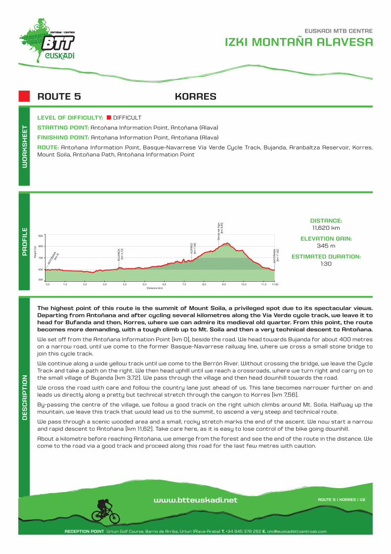
The highest point of this route is the summit of Mount Soila, a privileged spot due to its spectacular views. Departing from Antoñana and after cycling several kilometres along the Vía Verde cycle track, we leave it to head for Bufanda and then, Korres, where we can admire its medieval old quarter. From this point, the route becomes more demanding, with a tough climb up to Mt. Soila and then a very technical descent to Antoñana.
We set off from the Antoñana Information Point [km 0], beside the road. We head towards Bujanda for about 400 metres on a narrow road, until we come to the former Basque-Navarrese railway line, where we cross a small stone bridge to join this cycle track.
We continue along a wide yellow track until we come to the Berrón River. Without crossing the bridge, we leave the Cycle Track and take a path on the right. We then head uphill until we reach a crossroads, where we turn right and carry on to the small village of Bujanda [km 3,72]. We pass through the village and then head downhill towards the road.
We cross the road with care and follow the country lane just ahead of us. This lane becomes narrower further on and leads us directly along a pretty but technical stretch through the canyon to Korres [km 7,56].
By-passing the centre of the village, we follow a good track on the right which climbs around Mt. Soila. Halfway up the mountain, we leave this track that would lead us to the summit, to ascend a very steep and technical route.
We pass through a scenic wooded area and a small, rocky stretch marks the end of the ascent. We now start a narrow and rapid descent to Antoñana [km 11,62]. Take care here, as it is easy to lose control of the bike going downhill.
About a kilometre before reaching Antoñana, we emerge from the forest and see the end of the route in the distance. We come to the road via a good track and proceed along this road for the last few metres with caution.
DISTANCE:11,620 km
ELEVATION GAIN:345 m
ESTIMATED DURATION:1:30
LEVEL OF DIFFICULTY: DIFFICULT
STARTING POINT: Antoñana Information Point, Antoñana (Alava)
FINISHING POINT: Antoñana Information Point, Antoñana (Alava)
ROUTE: Antoñana Information Point, Basque-Navarrese Vía Verde Cycle Track, Bujanda, Aranbaltza Reservoir, Korres, Mount Soila, Antoñana Path, Antoñana Information Point
KORRESROUTE 5
----
-- A
NTO
ÑAN
A[k
m 0
]
----
-- B
UJA
ND
A[k
m 3
,72]
----
-- K
OR
RE
S[k
m 7
,56]
----
-- S
end
a d
el A
gín
[km
8,8
5]
----
-- A
NTO
ÑA
NA
[km
11,
62]
500
600
700
800
900
0.0 1.0 2.0 3.0 4.0 5.0 6.0 7.0 8.0 9.0 10.0 11.0 11.62
IZKI MONTAÑA ALAVESA
RECEPTION POINT Urturi Golf Course, Barrio de Arriba, Urturi (Álava-Araba) T. +34 945 378 262 E. [email protected]
ROUTE 5 | KORRES | 1/2www.btteuskadi.net
EUSKADI MTB CENTRE
MA
P
A-4
125
A-3136
!( !(
!(
!(
!(!(
!(!(
!(
!(!(
!(
!(
!(
!(
!(
!(!(
!(
!(
!(
!(!(
!(
!(
!(
!(
!(
!(
!(
!(!(
!(
Á Á
Á
Á
Á
Á
Á
Á
Á
Á
Á
Á
Á
Á
Á
Á
ÁÁ
Á
Á
Á
ÁÁ
Á
Á
Á
Á
Á
Á
Á
ÁÁ
Á
#
#
#
#
Eta.
de
la P
ena
Pres
a de
Ara
nbal
za
Min
as d
e As
falto
Erm
ita S
an M
igue
l
Horn
illo
Villa
nuev
a
a
de
Vitoria
Estella
Ferroca
rril
Korres
Bujan
da
Antoña
na
San
Rom
án d
e Ca
mpe
zo
Izki
Arro
yo
erre
ka
Soila
993
Mue
la10
55
Gazt
elua
867
Peña
del
San
to10
42
1:25
.000
01
km0,
250,
50,
75
Rec
eptio
n p
oint
Sta
rtin
g p
oint
Rou
te a
nd d
irect
ion
Nat
ural
Par
k
Fore
st
ROUTE ACCOMMODATION
Boa
rdin
g ho
use
Par
ador
Hot
el
Cot
tage
Cam
p s
ite
Sp
a re
sort
Flat
Hos
tel
Agr
itour
ism
IZKI MONTAÑA ALAVESA
RECEPTION POINT Urturi Golf Course, Barrio de Arriba, Urturi (Álava-Araba) T. +34 945 378 262 E. [email protected]
ROUTE 5 | KORRES | 2/2www.btteuskadi.net
EUSKADI MTB CENTRE
Tex
ts a
nd
ma
ps
: Ge
ote
ch
S.L
.P
arq
ue
Té
cn
olo
gic
o d
e Á
lava
, Alb
ert
Ein
ste
in 4
4, E
difi
cio
E6
, 015
10 M
iña
no
(Á
lava
-Ara
ba
) T.
+3
4 9
45
010
94
9 E
. in
fo@
info
ge
ote
ch
.co
m


![· 2015-02-16 · Catedral Santa María Katedrala Fundazioa, [2010] 20 p. : principalmente il. ; 26 cm. - (Discovering our past, building our future ; 2) ATA 8158 Martínez de Antoñana](https://img.dokumen.tips/doc/110x75/5ed8860b6714ca7f476815c2/2015-02-16-catedral-santa-mara-katedrala-fundazioa-2010-20-p-principalmente.jpg)