Embed Size (px)
Citation preview

www.esta-uk.net Vol 37 No 1 2012 Teaching Earth Sciences 1
Contents
From the Editor 3Hazel Clark
From the Chair 4
Maggie Williams
Digital tools for geology teaching - ESTA AnnualCourse and Conference at the British GeologicalSurvey, Keyworth 2012 5
David Bailey
Photographic round up from the Annual Courseand Conference 2011 at the University of Durham 7
Enhancing the curriculum through fieldwork 9
Carole Rushall
Geological stories at Harehope Quarry 13
Jill Essam
Field visit to Cullercoats led by Bob Holdsworth 16
Peter Kennett
Field visit to Staithes led by Stuart Jones 18
Hazel Clark
Making fieldwork resources assessable to all 20
Pauline Kneale, Michael Sanders and Alison Stokes
Bring and share 23
AGM reports 37
Conference timing questionnaire results 40
Maggie Williams
Towards a balanced Earth science curriculum forEngland – science and geography perspectives 45
Chris King and Nic Bilham
‘Fracking’ on the Fylde coast 49
Maggie Williams
Simulating partial melting in the classroom 52
Pete Loader
The stones in our garden 54
Mark Hayward
Making use of Tweets, Blogs and Apps in yourteaching 56
Angela Bentley
Earth Science in the news – coverage by UKnational newspapers 58
Chris King and Fiona Hyden
Skills showcase for new talent 62
Reviews 64
Diary dates 68
COPY DeaDliNesTES 37 2 30 June 2012 for publication in September 2012TES 38 1 31 December 2012 for publication in March 2013
TES Issue 37 1 Text.indd 1 12/04/2012 15:56:25
Secondary CoordinatorChris [email protected]
Higher Education CoordinatorJim [email protected]
Front coverPersepective froma canoe just southof Berry Head nearBrixham, SouthDevon. The overallgeneral descriptionof rocks in thisarea is interbeddedDevonian limestonesand mudstones of the Berry HeadMember of the Brixham LimestoneFormation.Royanne [email protected]
Do you have a picture for thecover? If so, please send it in.
2 Vol 37 No 1 2012 Teaching Earth Sciences www.esta-uk.net
Teaching earth sciencesTeaching Earth Sciences is published biannuallyby the Earth Science Teachers’ Association. ESTAaims to encourage and support the teaching ofEarth sciences, whether as a single subject, oras part of science or geography courses.
Full membership is £32.00; student and retiredmembership £16.00.
Registered Charity No. 1005331
Contributions to future issues of TeachingEarth Sciences will be welcomed and should beaddressed to the Editor
Opinions and comments in this issue arethe personal views of the authors and donot necessarily represent the views of theAssociation
Designed, typeset and printed in the UnitedKingdom by Hobbs the Printers Ltd, Totton,Hampshire, SO40 3WXWebsite: www.hobbs.uk.com
Editor TESHazel [email protected]@gmail.com
Editor ESTA NewsMaggie [email protected]
Reviews EditorPete [email protected]
AdvertisingHazel [email protected]
COUNCIL OFFICERS
ChairMaggie [email protected]
Chair designatePete [email protected]
SecretaryDavid [email protected]
TreasurerJane [email protected]
Membership SecretaryMike [email protected]
Primary CoordinatorTracy [email protected]
Paper fromresponsible sources
FSC® C020438
MIX
®
You can now follow us on Facebook. You can find us under Earth Science Teachers’ Association
TES Issue 37 1 Text.indd 2 12/04/2012 15:56:26
www.esta-uk.net Vol 37 No 1 2012 Teaching Earth Sciences 3
It has got to that time of the year again where I sitand stare blankly at my computer screen and wait forinspiration (divine or otherwise) regarding what to writein my editorial. Then my email pinged and spookily therewas a link to an article in the Telegraph about Googledoodles (http://www.telegraph.co.uk/technology/google/google-doodle/9006549/Nicolas-Steno-remembered-with-a-Google-doodle.html). Being a bitof a computer Luddite, it had not even impinged on myconsciousness that such things existed. Anyway, they havemade a Google doodle that reflects Nicolas Steno’s workon stratigraphy and fossils. I am all for getting geology/Earth science out there to the public in any way, shapeor form but I have to wonder why they have chosen tocelebrate his 374th birthday! Who was Nicolas Steno doI hear you ask? Well, we all use the principle of originalhorizontality and law of superposition but how many ofyou know that they were devised by a Danish anatomistand geologist who lived 1638-1686? (Wearing anotherhat – it would make a jolly good quiz question). He isvariously known as the ‘father of geology’ or the ‘father ofstratigraphy’. If you want to find out more about him thereis an interesting and readable book called The seashell onthe mountaintop: a story of science, sainthood and thehumble genius who discovered a new history of the Earthby Alan Cutler published by Arrow Books in 2004 [ISBN-13:978-0099421498]. I did read it many years ago and it hassince been collecting a patina of dust and waiting to berediscovered! Maybe now is the time to reacquaint myselfwith it and unearth it from beneath the unconformity onthe bookcase.
I hope that you all enjoyed the recent BBC offering TheFrozen Planet. Some of the footage was spectacular,(formation of snowflakes and glacier movement time lapsesequences) but am I in a minority of one to get incensedby the hijacking of such eminently Earth science-potentialprogrammes by fluffy, cuddly biology? In fear of becoming
a ‘Grumpy Old Woman’ - am I the only one who findsthe formation of snow and ice, movement of glaciers etc,sufficiently interesting to warrant a whole series withoutthe introduction of something living? It happens all thetime – every time I settle down to watch a programme thatsounds like Earth science, I get a few minutes of Geology/Geography and then have Biology thrust upon me forthe vast majority of the show. Don’t get me wrong, I likefluffy-cuddly but if you are going to call the programmeThe Frozen Planet I expect to watch a programme aboutice and maybe even permafrost, not the things that liveon/under it. After all they had a whole series (Life in thefreezer) devoted to them in 1993.
At the same time as The Frozen Planet, BBC Four ran aprogramme called the Secret life of ice (http://www.bbc.co.uk/programmes/b016fpyy). Thankfully thatdid exactly what it said on the tin. It was a fascinatingwatch; the presenter, Gabrielle Walker, was so obviouslyenthusiastic about the subject and there were even ideasfor teaching built in (which I have forwarded to theEarthlearningidea team). Hurrah – grumpiness muchdiminished!!!
I hope that the last bumper issue TES didn’t leave too biga dent in the carpet when it dropped through the door.This issue is as varied as ever with articles associated withthe Durham conference (with a strong bent towards thefieldwork elements) and an eclectic mixture of other items.I hope that it inspires you into writing up that amazingteaching idea/research/field experience/photograph/bookreview that you have been meaning to share. As always,the magazine is only as good as you, the contributors,make it. So take the hint and get your fingers busy on thekeyboard and send your contributions to [email protected]. The deadlines are the ends of June and Decemberbut I am extremely happy (in fact ecstatic) to receivearticles/letters to the Editor etc. all year round.
From the Editor
Hazel Clark
TES Issue 37 1 Text.indd 3 12/04/2012 15:56:26
4 Teaching Earth Sciences Vol 37 No 1 2012 www.esta-uk.net
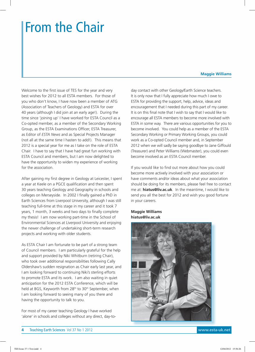
Welcome to the first issue of TES for the year and verybest wishes for 2012 to all ESTA members. For those ofyou who don’t know, I have now been a member of ATG(Association of Teachers of Geology) and ESTA for over40 years (although I did join at an early age!). During thetime since ‘joining up’ I have worked for ESTA Council as aCo-opted member, as a member of the Secondary WorkingGroup, as the ESTA Examinations Officer, ESTA Treasurer,as Editor of ESTA News and as Special Projects Manager(not all at the same time I hasten to add!). This means that2012 is a special year for me as I take on the role of ESTAChair. I have to say that I have had great fun working withESTA Council and members, but I am now delighted tohave the opportunity to widen my experience of workingfor the association.
After gaining my first degree in Geology at Leicester, I spenta year at Keele on a PGCE qualification and then spent30 years teaching Geology and Geography in schools andcolleges on Merseyside. In 2002 I finally gained a PhD inEarth Sciences from Liverpool University, although I was stillteaching full-time at this stage in my career and it took 7years, 1 month, 3 weeks and two days to finally completemy thesis! I am now working part-time in the School ofEnvironmental Sciences at Liverpool University and enjoyingthe newer challenge of undertaking short-term researchprojects and working with older students.
As ESTA Chair I am fortunate to be part of a strong teamof Council members. I am particularly grateful for the helpand support provided by Niki Whitburn (retiring Chair),who took over additional responsibilities following CallyOldershaw’s sudden resignation as Chair early last year, andI am looking forward to continuing Niki’s sterling effortsto promote ESTA and its work. I am also waiting in quietanticipation for the 2012 ESTA Conference, which will beheld at BGS, Keyworth from 28th to 30th September, whenI am looking forward to seeing many of you there andhaving the opportunity to talk to you.
For most of my career teaching Geology I have worked‘alone’ in schools and colleges without any direct, day-to-
day contact with other Geology/Earth Science teachers.It is only now that I fully appreciate how much I owe toESTA for providing the support, help, advice, ideas andencouragement that I needed during this part of my career.It is on this final note that I wish to say that I would like toencourage all ESTA members to become more involved withESTA in some way. There are various opportunities for you tobecome involved. You could help as a member of the ESTASecondary Working or Primary Working Groups, you couldwork as a Co-opted Council member and, in September2012 when we will sadly be saying goodbye to Jane Giffould(Treasurer) and Peter Williams (Webmaster), you could evenbecome involved as an ESTA Council member.
If you would like to find out more about how you couldbecome more actively involved with your association orhave comments and/or ideas about what your associationshould be doing for its members, please feel free to contactme at: [email protected]. In the meantime, I would like tosend you all the best for 2012 and wish you good fortunein your careers.
Maggie [email protected]
From the Chair
Maggie Williams
TES Issue 37 1 Text.indd 4 12/04/2012 15:56:26
www.esta-uk.net Vol 37 No 1 2012 Teaching Earth Sciences 5
Digital tools for geology teaching:ESTA Annual Course and Conference at theBritish Geological Survey, Keyworth 2012
David Bailey
In 2001 I attended my first ESTA Annual Course andConference, held at Kingston University, where I wasintroduced to the friendliest, most enthusiastic anddedicated bunch of professionals in Earth scienceeducation. That conference planted the seeds of afruitful partnership of mutual support between ESTAand the BGS, formalised with a memorandum ofunderstanding in 2003.
My principal motivation for attending Kingston was tolearn how Conference ‘works’ as the next one was to beheld at BGS Keyworth. But since the best way to learn isthrough one’s mistakes, it was only after the 2002 eventthat I realised how I should have organised things. So,when John Ludden, the Executive Director at BGS, invitedESTA to hold their conference at Keyworth in 2012, I fellfor the challenge! It was only later I was told that nobodypreviously had been foolish enough to attempt the tricktwice...
So what can delegates expect to see in 2012?
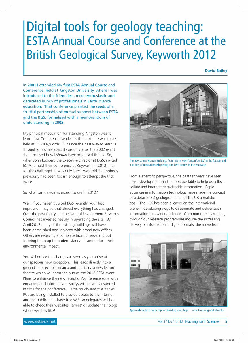
Well, if you haven’t visited BGS recently, your firstimpression may be that almost everything has changed.Over the past four years the Natural Environment ResearchCouncil has invested heavily in upgrading the site. ByApril 2012 many of the existing buildings will havebeen demolished and replaced with brand new offices.Others are receiving a complete facelift inside and outto bring them up to modern standards and reduce theirenvironmental impact.
You will notice the changes as soon as you arrive atour spacious new Reception. This leads directly into aground-floor exhibition area and, upstairs, a new lecturetheatre which will form the hub of the 2012 ESTA event.Plans to enhance the new reception/conference suite withengaging and informative displays will be well advancedin time for the conference. Large touch-sensitive ‘tablet’PCs are being installed to provide access to the internetand the public areas have free WiFi so delegates will beable to check their websites, ‘tweet’ or update their blogswhenever they like!
From a scientific perspective, the past ten years have seenmajor developments in the tools available to help us collect,collate and interpret geoscientific information. Rapidadvances in information technology have made the conceptof a detailed 3D geological ‘map’ of the UK a realisticgoal. The BGS has been a leader on the internationalscene in developing ways to disseminate and deliver suchinformation to a wider audience. Common threads runningthrough our research programmes include the increasingdelivery of information in digital formats, the move from
The new James Hutton Building, featuring its own ‘unconformity’ in the façade anda variety of natural British paving and kerb stones in the walkway.
Approach to the new Reception building and shop — now featuring added rocks!
TES Issue 37 1 Text.indd 5 12/04/2012 15:56:28
6 Teaching Earth Sciences Vol 37 No 1 2012 www.esta-uk.net
two-dimensional maps to three-dimensional models and anincreasing focus on delivering information tailored to suitparticular users. The key themes of the conference will beto explore how this digital ‘revolution’ is opening up newways to help us understand Earth processes, and how thenew tools that are available are helping geologists explaincomplex concepts to non-specialist audiences.
Our visualisation facility for viewing geological models inthree-dimensional splendour is conveniently located closeto the exhibition area and we plan to make full use of thisstate-of-the-art facility. There will also be demonstrationsof our ‘3D Models for Teaching’ project.
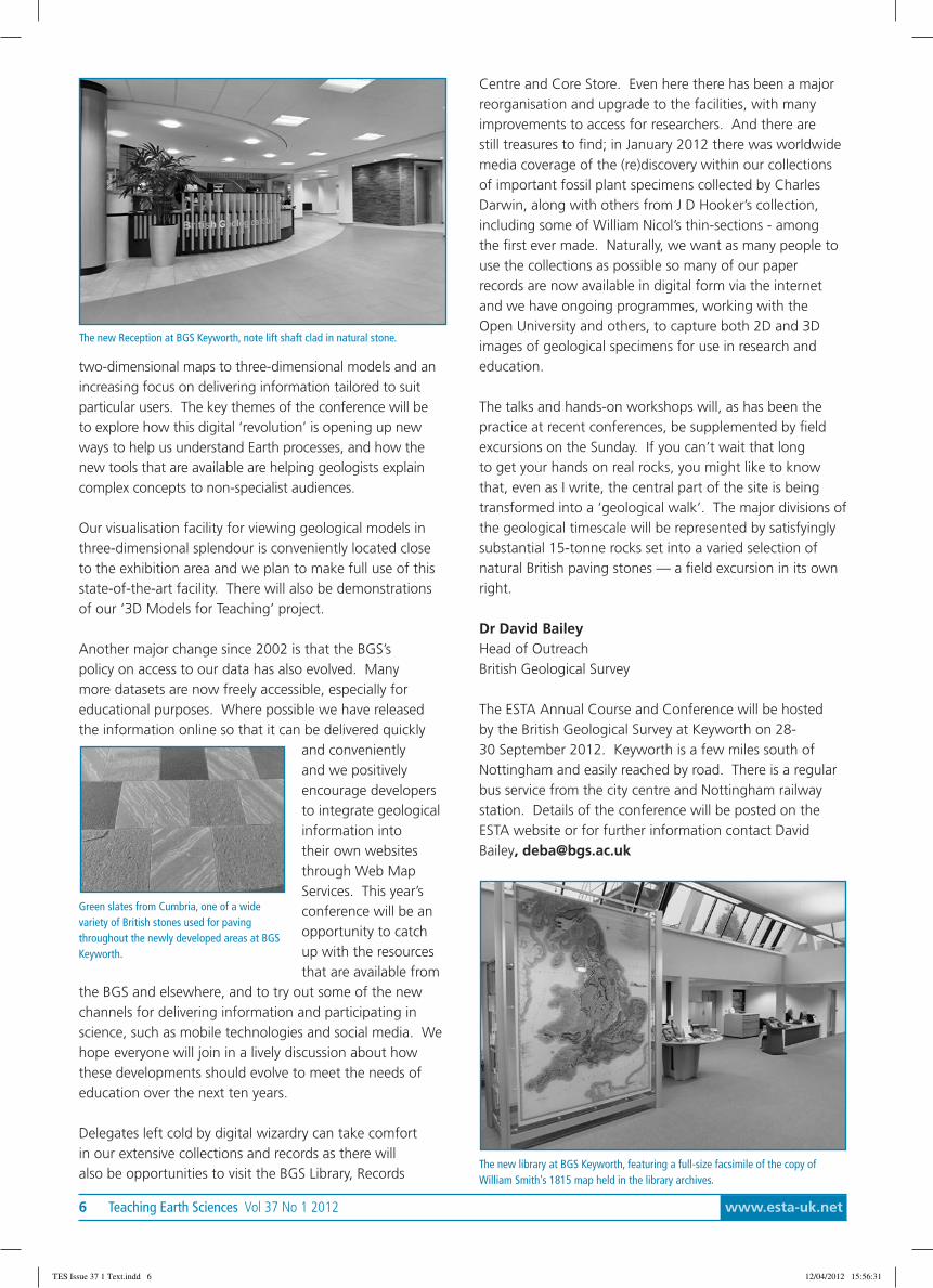
Another major change since 2002 is that the BGS’spolicy on access to our data has also evolved. Manymore datasets are now freely accessible, especially foreducational purposes. Where possible we have releasedthe information online so that it can be delivered quickly
and convenientlyand we positivelyencourage developersto integrate geologicalinformation intotheir own websitesthrough Web MapServices. This year’sconference will be anopportunity to catchup with the resourcesthat are available from
the BGS and elsewhere, and to try out some of the newchannels for delivering information and participating inscience, such as mobile technologies and social media. Wehope everyone will join in a lively discussion about howthese developments should evolve to meet the needs ofeducation over the next ten years.
Delegates left cold by digital wizardry can take comfortin our extensive collections and records as there willalso be opportunities to visit the BGS Library, Records
Centre and Core Store. Even here there has been a majorreorganisation and upgrade to the facilities, with manyimprovements to access for researchers. And there arestill treasures to find; in January 2012 there was worldwidemedia coverage of the (re)discovery within our collectionsof important fossil plant specimens collected by CharlesDarwin, along with others from J D Hooker’s collection,including some of William Nicol’s thin-sections - amongthe first ever made. Naturally, we want as many people touse the collections as possible so many of our paperrecords are now available in digital form via the internetand we have ongoing programmes, working with theOpen University and others, to capture both 2D and 3Dimages of geological specimens for use in research andeducation.
The talks and hands-on workshops will, as has been thepractice at recent conferences, be supplemented by fieldexcursions on the Sunday. If you can’t wait that longto get your hands on real rocks, you might like to knowthat, even as I write, the central part of the site is beingtransformed into a ‘geological walk’. The major divisions ofthe geological timescale will be represented by satisfyinglysubstantial 15-tonne rocks set into a varied selection ofnatural British paving stones — a field excursion in its ownright.
Dr David BaileyHead of OutreachBritish Geological Survey
The ESTA Annual Course and Conference will be hostedby the British Geological Survey at Keyworth on 28-30 September 2012. Keyworth is a few miles south ofNottingham and easily reached by road. There is a regularbus service from the city centre and Nottingham railwaystation. Details of the conference will be posted on theESTA website or for further information contact DavidBailey, [email protected]
Green slates from Cumbria, one of a widevariety of British stones used for pavingthroughout the newly developed areas at BGSKeyworth.
The new library at BGS Keyworth, featuring a full-size facsimile of the copy ofWilliam Smith’s 1815 map held in the library archives.
The new Reception at BGS Keyworth, note lift shaft clad in natural stone.
TES Issue 37 1 Text.indd 6 12/04/2012 15:56:31
www.esta-uk.net Vol 37 No 1 2012 Teaching Earth Sciences 7
Annual Course and Conference 2011
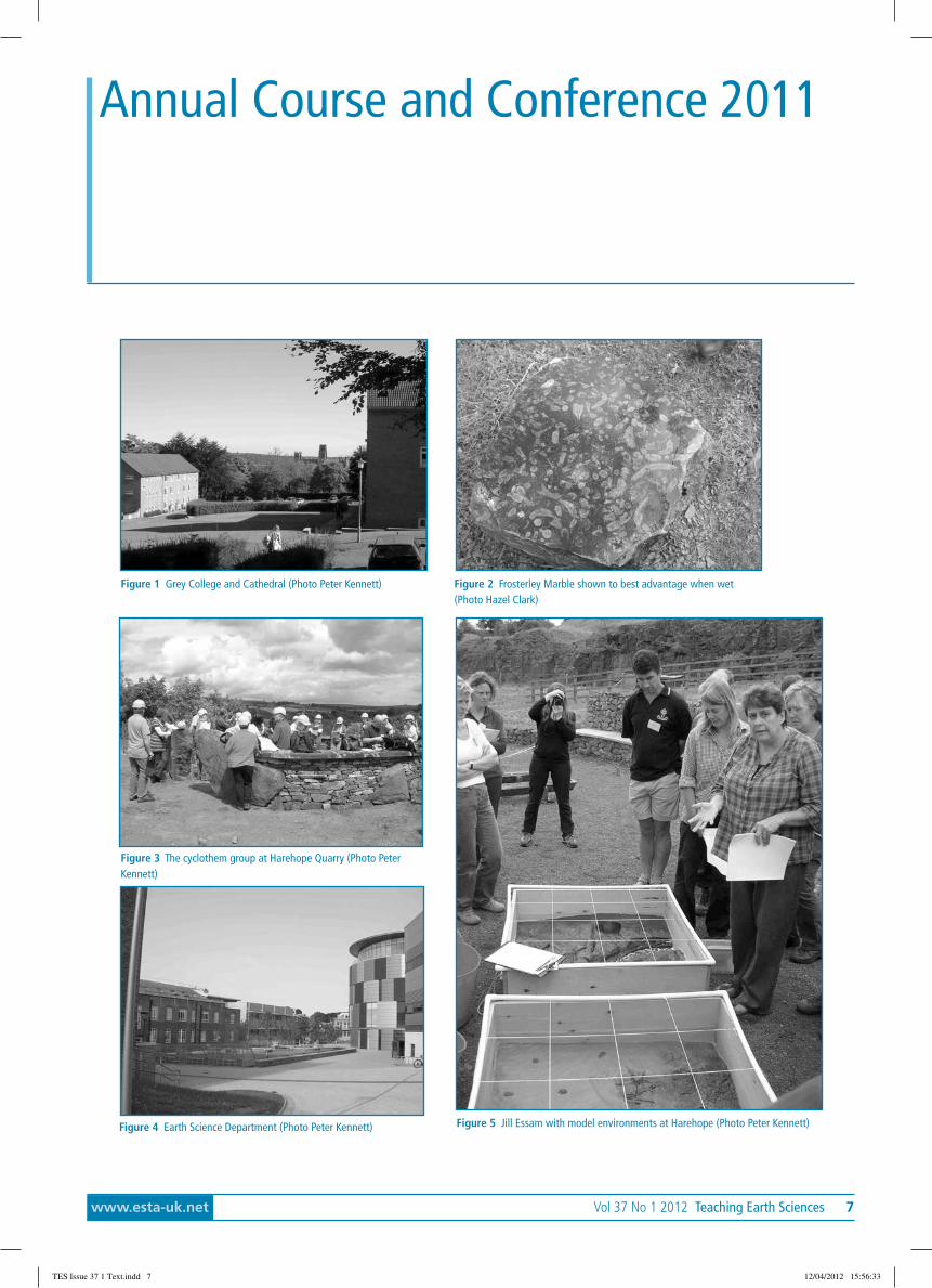
Figure 1 Grey College and Cathedral (Photo Peter Kennett) Figure 2 Frosterley Marble shown to best advantage when wet(Photo Hazel Clark)
Figure 3 The cyclothem group at Harehope Quarry (Photo PeterKennett)
Figure 4 Earth Science Department (Photo Peter Kennett) Figure 5 Jill Essam with model environments at Harehope (Photo Peter Kennett)
TES Issue 37 1 Text.indd 7 12/04/2012 15:56:33
8 Teaching Earth Sciences Vol 37 No 1 2012 www.esta-uk.net
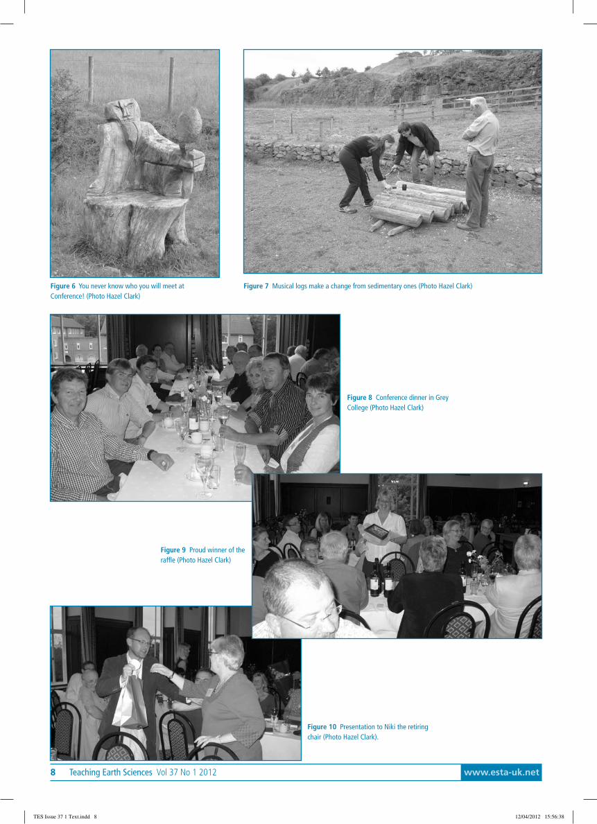
Figure 6 You never know who you will meet atConference! (Photo Hazel Clark)
Figure 7 Musical logs make a change from sedimentary ones (Photo Hazel Clark)
Figure 8 Conference dinner in GreyCollege (Photo Hazel Clark)
Figure 9 Proud winner of theraffle (Photo Hazel Clark)
Figure 10 Presentation to Niki the retiringchair (Photo Hazel Clark).
TES Issue 37 1 Text.indd 8 12/04/2012 15:56:38

www.esta-uk.net Vol 37 No 1 2012 Teaching Earth Sciences 9
AbstractOrganising a fieldtrip may seem daunting but thefollowing account will outline why it is worth doing,where it fits into the National Curriculum, where to goand how to arrange fieldwork. This was presented atHarehope Quarry as a whistle-stop list of informationand online resources preceding the practical workshopsession How to make use of a Quarry near you by JillEssam and myself. I hope you find it useful.
For many people the benefits of fieldwork will be selfevident, but I bring them all together here for convenience.
Benefits of fieldwork: Why it’s worth doing.Primary (Key Stage 1 & 2)
• It improves long-term retention of knowledge andunderstanding
• It can improve interpersonal & social skills• It gives students contact with the natural, ‘real’
world, weather and seasons.• It can develop a respect for the environment (not
automatic but at least an awareness)• It can be used to develop communication,
language , literacy, problem solving, reasoning andnumeracy skills
• It supports those children who learn best throughactivity or movement
• It provides safe and supervised opportunities toexperience new challenges, assess risk, developpractical skills and dexterity
• Nothing beats ‘hands-on’ experience.
Secondary (Key Stage 3 & 4)In addition to the above,
• It improves confidence in observation and problemsolving skills
• It reveals how the world works in real lifesituations
• It offers ‘out of the ordinary’ activities such as nighttime surveys or simulations (e.g. via residentialcourses)
Enhancing the Curriculum throughFieldwork
Carole Rushall
• It facilitates getting to know staff and students‘out of school’
• It teaches coping with physical challenges• It introduces practical field skills and use of
equipment
Where it fits into the National CurriculumThe Earth science on-site website has mapped NationalCurriculum links for Key Stages 1-4. It suggests linksbetween the field exercises and aspects of the ScienceNational Curriculum, http://www.ukrigs.org.uk/esos/wiki/index.php5?title=National_Curriculum
Research into the benefits of fieldworkOf course, there is considerable pedagogical research onthe benefits of fieldwork and for making better use ofthe outdoor classroom. This may be useful if you wish topersuade senior managers of such benefits. For those whorequire this information or wish to investigate the subjectfurther, try the following sources.
1. The Higher Education Academy (HEA) SubjectCentre for Geography, Earth and EnvironmentalSciences (GEES). Provide support for teaching andlearning in these subject areas in higher education(including HE in FE). Take a look at the websiteon the following link: http://www.gees.ac.uk/ forresearch papers and resources.
2. Planet is the bi-annual publication of the HEAGEES subject centre. The December 2003 SpecialEdition 5 (Part B) includes the outputs of the GEESpedagogic research programme concentratingon fieldwork. The papers are most relevant toHE teachers and can be downloaded from thefollowing link : http://www.gees.ac.uk/pubs/planet/pse5front.pdf
3. Despite the Department for Education and Skillslearning outside the classroom manifesto (DfES,2006), there has been a decline in the provisionof and engagement with outdoor educationin science. The 2011 report produced by theAssociation for Science Education’s (ASA) OutdoorScience Working Group (OSWG) summarises
TES Issue 37 1 Text.indd 9 12/04/2012 15:56:38

10 Teaching Earth Sciences Vol 37 No 1 2012 www.esta-uk.net
recommendations from a series of seminarswhich aim to increase the uptake and quality offieldwork and outdoor science activities. This15 page report provides links to research articleswhich are invaluable if you wish to justify includingor increasing fieldwork opportunities in yourteaching.
4. The Geographical Association website has links toprojects, articles, reports and research articles onthe benefits of fieldwork and outdoor learning.http://www.geography.org.uk/resources/fieldwork
5. The National Foundation for Educational Research(NFER) produced an overview of fieldwork in aneducational context (Rickinson et al 2004).
Where to go?
1. If you do not know where your local sites ofgeological interest are contact GeoConservationUK.It has a membership of over 50 LocalGeoconservation Groups, lately known as RIGSGroups (Regionally Important Geological andGeomorphological Sites) across the British Isles.It promotes local “Geo” sites for education andpublic benefit. See:http://www.ukrigs.org.uk/esos/wiki/index.php5?title=Main_PageThe UKRIGS Education Project has produced theEarth Science On-Site guides for a range of sites.The guides to the sites include the followinginformation to assist group leaders and teacherswhen planning field activities:
• Details of location, access and initial riskassessments.
• Background information relating to the site and itsgeological (Earth science) and geomorphological(landscape) interest.
• Materials to support field activities, theirpreparation and follow-up primarily by teachersand their pupils. These are informed by theNational Curriculum at Key stages 2, 3 or 4, and therequirements of the syllabuses of the various GCSEexamination boards. Although use is made ofspecific terms, they are written for appreciation bya wider, less technical, audience.
2. The Field Studies Council has 17 centres acrossthe UK, 3 specifically for geology. For furtherinformation look at their website:http://www.field-studies-council.org/
3. Online Geotrails can be downloaded and adaptedfor fieldtrips. Links to some of the sites areincluded below:http://www.tvrigs.org.uk/tees-valley-rigs-grouphttp://www.esci.keele.ac.uk/srigs/Geotrails/HampsManifold/index.htmlhttp://www.shropshiregeology.org.uk/Geotrails/Geotrails.asp
4. There are also nine regional (and one National)Science Learning Centres offering ContinuingProfessional Development for everyone involvedin science education, at all levels. Schools canalso borrow equipment.https://www.sciencelearningcentres.org.uk/
5. North of the border, Scottish Outdoor EducationCentres (SOEC) run three centres offering arange of outdoor activities.http://soec.org.uk/our-centres/
Figure 1. Durham University Foundation students on the summit of Roseberry Topping (Middle Jurassic Saltwick Formation sandstone) on a fieldtrip adapted from a Tees ValleyRIGS Geotrail
TES Issue 37 1 Text.indd 10 12/04/2012 15:56:38
www.esta-uk.net Vol 37 No 1 2012 Teaching Earth Sciences 11
Where to go: Background and PlanningA necessary task is the preparation of Risk Assessments.This may put some off fieldwork but a Model RiskAssessment for school fieldtrip leaders has been producedon the Geographical Association website:http://www.geography.org.uk/eyprimary/geographysubjectleaders/fieldwork/A Fieldtrip Guidance Document has been prepared byAlan Parkinson, the Geographical Association’s SecondaryCurriculum Development Leader. It suggests somestrategies to deal with practical arrangements. Thedocument, Fieldwork – an essential part of a geographicaleducation is available to download from:http://www.geography.org.uk/resources/fieldwork
Insurance is essential. You will need to discuss this withyour school or Department.
Virtual and Online FieldworkVirtual fieldwork may be used if you are unable to get outinto the field and it may be used to extend fieldwork andexpand classroom activities. The sites listed below are afew of the many available online.
1. Tedbury Camp Quarry. This website has beendeveloped by Dr Martin Whiteley on behalf of theEarth Science Teachers’ Association (ESTA). http://www.esta-uk.net/tedbury_camp_quarry.html
2. Virtual Geology Fieldtrips. A series of Virtual fieldtrips in the UK, USA and France have been producedby geology students at Oxford Brookes University.http://www.virtual-geology.info/vft.html
3. Ian West (School of Ocean and Earth Sciences,Southampton) has produced an amazing websitewhich includes a series of fieldtrips. http://www.soton.ac.uk/~imw/
Online Fieldwork suppliesAn easy way to browse and buy fieldwork equipment is byusing online suppliers. The following companies are wortha look:
1. Geo supplies LTD. This company also has its own‘Down to Earth’ magazine to download.http://www.geosupplies.co.uk/
2. UK Geological Equipment.http://www.ukge.co.uk/
3. Geology Superstore.http://www.geologysuperstore.com/
Online ResourcesThe Earth Science Teachers Association resource pageincludes links to a number of web-based teaching resourcessuitable for all levels of the National Curriculum.http://www.esta-uk.net/resources.htm
Other online geology and fieldwork teaching resources canbe found using the following web pages:
1. The Earth Science Education Forum (England andWales) has excellent resources for both Primaryand Secondary schools. http://www.bgs.ac.uk/esef/
2. ROCKWATCH is the junior club for young geologistsin the Geologists’ Association and is suitable forPrimary aged children. http://www.rockwatch.org.uk/
3. The Field Studies Council website includes resourcesand information for the Primary, Secondaryand HE sector. It also includes information onEnvironmental courses and In-service Training forTeachers. http://www.field-studies-council.org/
4. The Council for Learning Outside the Classroomsupports outdoor education for primary andsecondary aged students. http://www.lotc.org.uk/
5. Learning Through Landscapes is a great resourcealthough it requires membership. It concentrateson outdoor learning in schools and centres ratherthan the countryside. http://www.ltl.org.uk/resources/index.php
6. The National Association for EnvironmentalEducation (UK). This is an established Nationalcharity run by teachers and teacher trainers tosupport the teaching of environmental educationto all ages. http://www.nationalrural.org/organisation.aspx?id=caeafb14-5fac-42a0-9904-05cd911eb257
7. Geographical Association. The website includesarticles and reports on Outdoor Learning andhas lots of Fieldwork resources, links, fundingopportunities and hosts a ‘Learning Outside theClassroom Special Interest Group’ http://www.geography.org.uk/resources/fieldwork/
8. The Geological Society. This site is a major onlineresource well worth a visit for those teaching inPrimary, Secondary or HE. http://www.geolsoc.org.uk/index.html
9. The Geological Society established a HigherEducation Network, in January 2011 to bringtogether those researching and teaching in theHigher Education sector to develop and discuss bestpractice in areas of shared interest. The Networkwork collaboratively with the Society’s EducationCommittee, the HE Academy, GEES Subject Centreand of course, ESTA. http://www.geolsoc.org.uk/gsl/groups/hen
ConclusionWhat I have tried to do here is point out the value offieldwork and the outdoor classroom and suggest thatbetter and more frequent use may be made of them.
TES Issue 37 1 Text.indd 11 12/04/2012 15:56:38
12 Teaching Earth Sciences Vol 37 No 1 2012 www.esta-uk.net
The resources listed are intended to prepare and smooththe way. Inevitably in a short article of this nature I havepresented only a snapshot of what is out there to helpteachers. I hope that this is sufficient to encourage you togive it a try and sample the enormous variety of resourcesavailable on the internet and elsewhere.
ReferencesAssociation for Science Education Outdoor Science Working Group(ASA OSWG) (2011). Outdoor Science: A co-ordinated approach tohigh-quality teaching and learning in fieldwork for science education.Shrewsbury: Field Studies Council and King’s College London.
Department for Education and Skills (DfES) (2006). Learning Outside theClassroom Manifesto. London: DfES. https://www.education.gov.uk/publications/standard/publicationdetail/page1/DFES-04232-2006[Accessed:20th June 2011]
Rickinson, M., Dillon, J., Teamey, K., Morris, M., Choi, M.Y., Sanders, D. &Benefield, P. (2004) Research on Outdoor Learning. National Foundationfor Educational Researchand King’s College London. http://www.field-studies-council.org/documents/general/NFER/A_review_of_research_on_outdoor_learning.pdf [Accessed January 2012]
Carole RushallUniversity of [email protected]
Disclaimer: All web sites were active at the time ofwriting, December 2011
Map resource available on lineMany of you will know of the Ordnance Survey Planning Maps Series, initiated during the 1940s, aiming to form asurvey of national life and resources, particularly to support the war effort and post-war reconstruction. The basemaps cover Great Britain on two sheets at a scale of 1:625,000, overlaid with the British National Grid.
The National Library of Scotland (NLS) have just released a new website, allowing these thematic maps of GreatBritain in the 1940s and 1950s to be browsed as a set of georeferenced overlays: http://geo.nls.uk/search/ten_mile/
The main themes shown on the maps illustrate a broad range of natural and man-made subjects. These includeAdministrative Areas, Coal and Iron, Farming, Geology, Land Classification and Land Utilisation, Limestone, LocalAccessibility, Population Density and Population Change, Railways, Rainfall, and Roads. The original plans for theseries included over 40 titles, but not all of these were published. In addition, the NLS holdings are incomplete, andsome maps were not published until the 1960s, so are therefore still in copyright. The website here presents an initalset of 22 thematic maps, each covering Great Britain on two sheets.
Through georeferencing, the maps can now be easily compared to modern maps, including Google maps andsatellite images, through a transparency slider (currently working in most browsers!). Searching is also possible by agazetteer and Grid Reference. The different thematic maps can then be viewed successively for any particular place.
The website also includes a little Further information about the Planning Maps series along with a set of ExplanatoryTexts, published at the time to explain the compilation of the maps (http://geo.nls.uk/search/ten_mile/info.html).These often have further details of how the thematic content was obtained and aggregated, and sometimes includeadditional statistical information.
TES Issue 37 1 Text.indd 12 12/04/2012 15:56:38
www.esta-uk.net Vol 37 No 1 2012 Teaching Earth Sciences 13
AbstractThe Harehope Quarry Project was established toreclaim Harehope Quarry, a redundant Carboniferouslimestone quarry in Frosterley, Co. Durham. Thequarry is most famous for its exposures of FrosterleyMarble. The Project has developed, and nowmanages, an environmental education centre, anature reserve and a smallholding on the 15 hectaresite. The majority of school visits to the site requesta day’s programme based around Earth Sciences. Thequarry has five main geological stories to tell andincludes stories around geological time, Carboniferousenvironments, mineralisation in the North Pennines,geomorphological processes and the environmentalimpact of quarrying.
The geology of Harehope QuarryHarehope Quarry (Figure 1) is at the eastern end ofWeardale in the North Pennines, an Area of OutstandingNatural Beauty (AONB) and a European Geopark. Themajority of the rocks of the Geopark are Carboniferousin age (354 – 290 Ma). During the Carboniferous, theBritish Isles were situated close to the Equator. A featureof the succession of rocks formed during this period is acyclicity or regular repetition of rock types. These cyclesof sedimentation are called cyclothems. The cyclothemrepresents changing depositional environments as a result
Geological stories at Harehope Quarry
Jill Essam
of rising and falling sea levels. The succession of rocks isgenerally represented by limestone, shale, sandstone andcoal.
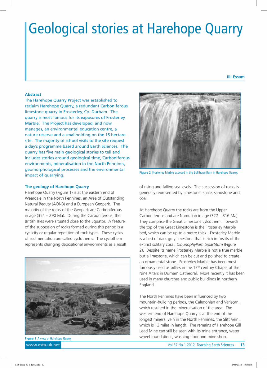
At Harehope Quarry the rocks are from the UpperCarboniferous and are Namurian in age (327 – 316 Ma).They comprise the Great Limestone cylcothem. Towardsthe top of the Great Limestone is the Frosterley Marblebed, which can be up to a metre thick. Frosterley Marbleis a bed of dark grey limestone that is rich in fossils of theextinct solitary coral, Dibunophyllum bipartitum (Figure2). Despite its name Frosterley Marble is not a true marblebut a limestone, which can be cut and polished to createan ornamental stone. Frosterley Marble has been mostfamously used as pillars in the 13th century Chapel of theNine Altars in Durham Cathedral. More recently it has beenused in many churches and public buildings in northernEngland.
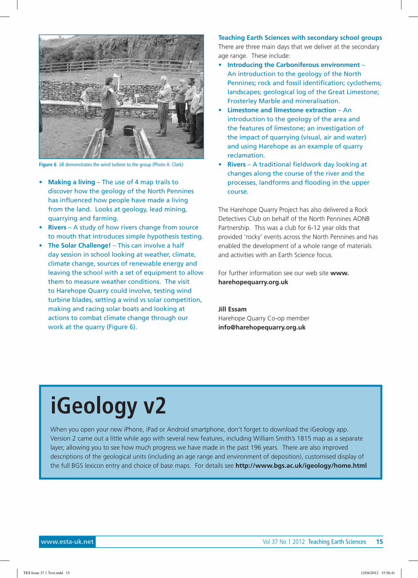
The North Pennines have been influenced by twomountain-building periods, the Caledonian and Variscan,which resulted in the mineralisation of the area. Thewestern end of Harehope Quarry is at the end of thelongest mineral vein in the North Pennines, the Slitt Vein,which is 13 miles in length. The remains of Harehope GillLead Mine can still be seen with its mine entrance, waterwheel foundations, washing floor and mine shop.Figure 1 A view of Harehope Quarry
Figure 2 Frosterley Marble exposed in the Bollihope Burn in Harehope Quarry.
TES Issue 37 1 Text.indd 13 12/04/2012 15:56:38

14 Teaching Earth Sciences Vol 37 No 1 2012 www.esta-uk.net
In more recent times both geomorphological processes andpeople have influenced the landscape around HarehopeQuarry. Although the Great Limestone is quite an impurelimestone some karst features have developed including potholes in the riverbed; an underground river system; resurgentstreams; caves and a gorge. Erosional and depositionalfeatures resulting from the last ice age are present.
The history of Harehope QuarryLimestone has been quarried at Harehope for more than900 years. Quarrying on a small-scale has taken place sincethe 12th century, but larger-scale quarrying did not beginuntil 1901 and had stopped again by 1931. The quarryre-opened in 1954 and continued until 1987, although thequarry was used more recently as a tarmac coating plant,receiving limestone from other quarries in Weardale. Eventhough Harehope Quarry is now redundant the adjacentBroadwood Quarry is still producing limestone for roadstone.
Originally the limestone was used in the process of refiningiron from iron ore. This process took place at ironworksin Consett, Tyneside and Teesside. More recently thelimestone has been used in road construction. TheFrosterley Marble found within the Great Limestone wasquarried for its ornamental value.
The Harehope Quarry ProjectThe Harehope Quarry Project, a workers’ co-operative,has been established since 1999 to reclaim the quarry anddemonstrate a more sustainable way of living. The Projectmanages an area of the quarry as a nature reserve withfreshwater habitats, alder carr, limestone grassland and asmall area of goat willow woodland. There is permissiveaccess to areas of the nature reserve and informal andformal interpretation are provided, which includes a‘geology garden’ (Figure 3). An eco-classroom (Figure 4)has been built by volunteers and now provides the focusfor environmental education, field studies, education for
sustainable development and a programme of communityevents. The Project also runs a smallholding providing asource of local food and bringing the limestone grasslandback into management.
Teaching Earth Sciences with primary school groupsA range of primary Earth Science teaching days have beendeveloped using Harehope Quarry as a resource. The dayshave been designed to encourage a hands-on approach tolearning with the geological themes re-enforced through avariety of activities. The main days include:
• Rocks and fossils at Harehope Quarry – Time lineactivity; time line sticker trail; identification of rocktypes; fossil hunt; uses of rocks and then a rangeof craft activities to re-enforce the messages in thefieldwork (fossil puppets, plaster of Paris fossils,mineral panning).
• Be a palaeontologist for the day! – Time lineactivity and time line sticker trail; use of thegeorium to discover fossil environments from theCambrian period to the present day (Figure 5);fossil hunt; fossil formation activities or fossil crafts.
Figure 3 The Geology Garden Figure 4 The Eco-classroom
Figure 5 Georium of the Upper Carboniferous (Photo H. Clark)
TES Issue 37 1 Text.indd 14 12/04/2012 15:56:40
www.esta-uk.net Vol 37 No 1 2012 Teaching Earth Sciences 15
Figure 6 Jill demonstrates the wind turbine to the group (Photo H. Clark)
• Making a living – The use of 4 map trails todiscover how the geology of the North Pennineshas influenced how people have made a livingfrom the land. Looks at geology, lead mining,quarrying and farming.
• Rivers – A study of how rivers change from sourceto mouth that introduces simple hypothesis testing.
• The Solar Challenge! – This can involve a halfday session in school looking at weather, climate,climate change, sources of renewable energy andleaving the school with a set of equipment to allowthem to measure weather conditions. The visitto Harehope Quarry could involve, testing windturbine blades, setting a wind vs solar competition,making and racing solar boats and looking atactions to combat climate change through ourwork at the quarry (Figure 6).
Teaching Earth Sciences with secondary school groupsThere are three main days that we deliver at the secondaryage range. These include:• Introducing the Carboniferous environment –
An introduction to the geology of the NorthPennines; rock and fossil identification; cyclothems;landscapes; geological log of the Great Limestone;Frosterley Marble and mineralisation.
• Limestone and limestone extraction – Anintroduction to the geology of the area andthe features of limestone; an investigation ofthe impact of quarrying (visual, air and water)and using Harehope as an example of quarryreclamation.
• Rivers – A traditional fieldwork day looking atchanges along the course of the river and theprocesses, landforms and flooding in the uppercourse.
The Harehope Quarry Project has also delivered a RockDetectives Club on behalf of the North Pennines AONBPartnership. This was a club for 6-12 year olds thatprovided ‘rocky’ events across the North Pennines and hasenabled the development of a whole range of materialsand activities with an Earth Science focus.
For further information see our web site www.harehopequarry.org.uk
Jill EssamHarehope Quarry Co-op [email protected]
iGeology v2When you open your new iPhone, iPad or Android smartphone, don’t forget to download the iGeology app.Version 2 came out a little while ago with several new features, including William Smith’s 1815 map as a separatelayer, allowing you to see how much progress we have made in the past 196 years. There are also improveddescriptions of the geological units (including an age range and environment of deposition), customised display ofthe full BGS lexicon entry and choice of base maps. For details see http://www.bgs.ac.uk/igeology/home.html
TES Issue 37 1 Text.indd 15 12/04/2012 15:56:41
16 Teaching Earth Sciences Vol 37 No 1 2012 www.esta-uk.net
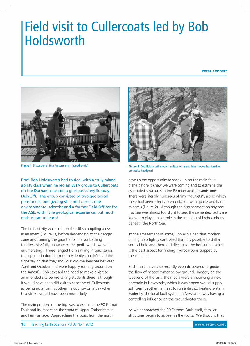
Prof. Bob Holdsworth had to deal with a truly mixedability class when he led an ESTA group to Cullercoatson the Durham coast on a glorious sunny Sunday(July 3rd). The group consisted of two geologicalpensioners; one geologist in mid career; oneenvironmental scientist and a former Field Officer forthe ASE, with little geological experience, but muchenthusiasm to learn!
The first activity was to sit on the cliffs compiling a riskassessment (Figure 1), before descending to the dangerzone and running the gauntlet of the sunbathingfamilies, blissfully unaware of the perils which we wereenumerating! These ranged from sinking in quicksandsto stepping in dog dirt (dogs evidently couldn’t read thesigns saying that they should avoid the beaches betweenApril and October and were happily running around onthe sands!). Bob stressed the need to make a visit toan intended site before taking students there, althoughit would have been difficult to conceive of Cullercoatsas being potential hypothermia country on a day whenheatstroke would have been more likely.
The main purpose of the trip was to examine the 90 FathomFault and its impact on the strata of Upper Carboniferousand Permian age. Approaching the coast from the north
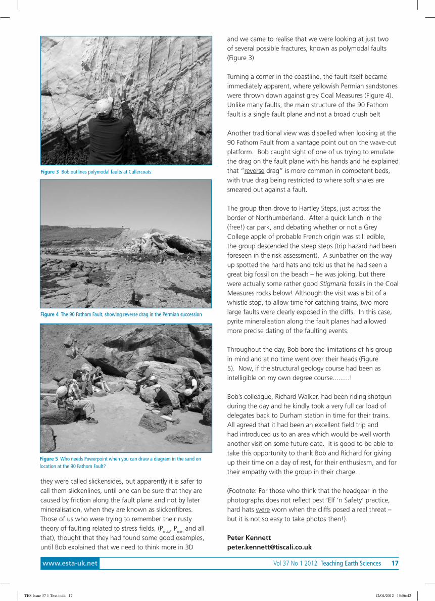
gave us the opportunity to sneak up on the main faultplane before it knew we were coming and to examine theassociated structures in the Permian aeolian sandstones.There were literally hundreds of tiny “faultlets”, along whichthere had been selective cementation with quartz and bariteminerals (Figure 2). Although the displacement on any onefracture was almost too slight to see, the cemented faults areknown to play a major role in the trapping of hydrocarbonsbeneath the North Sea.
To the amazement of some, Bob explained that moderndrilling is so tightly controlled that it is possible to drill avertical hole and then to deflect it to the horizontal, whichis the best aspect for finding hydrocarbons trapped bythese faults.
Such faults have also recently been discovered to guidethe flow of heated water below ground. Indeed, on theweekend of the visit, the media were announcing a newborehole in Newcastle, which it was hoped would supplysufficient geothermal heat to run a district heating system.Evidently, the local fault system in Newcastle was having acontrolling influence on the groundwater there.
As we approached the 90 Fathom Fault itself, familiarstructures began to appear in the rocks. We thought that
Field visit to Cullercoats led by BobHoldsworth
Peter Kennett
Figure 1 Discussion of Risk Assessments – hypothermia? Figure 2 Bob Holdsworth models fault patterns and Jane models fashionableprotective headgear!
TES Issue 37 1 Text.indd 16 12/04/2012 15:56:42
www.esta-uk.net Vol 37 No 1 2012 Teaching Earth Sciences 17
and we came to realise that we were looking at just twoof several possible fractures, known as polymodal faults(Figure 3)
Turning a corner in the coastline, the fault itself becameimmediately apparent, where yellowish Permian sandstoneswere thrown down against grey Coal Measures (Figure 4).Unlike many faults, the main structure of the 90 Fathomfault is a single fault plane and not a broad crush belt
Another traditional view was dispelled when looking at the90 Fathom Fault from a vantage point out on the wave-cutplatform. Bob caught sight of one of us trying to emulatethe drag on the fault plane with his hands and he explainedthat “reverse drag” is more common in competent beds,with true drag being restricted to where soft shales aresmeared out against a fault.
The group then drove to Hartley Steps, just across theborder of Northumberland. After a quick lunch in the(free!) car park, and debating whether or not a GreyCollege apple of probable French origin was still edible,the group descended the steep steps (trip hazard had beenforeseen in the risk assessment). A sunbather on the wayup spotted the hard hats and told us that he had seen agreat big fossil on the beach – he was joking, but therewere actually some rather good Stigmaria fossils in the CoalMeasures rocks below! Although the visit was a bit of awhistle stop, to allow time for catching trains, two morelarge faults were clearly exposed in the cliffs. In this case,pyrite mineralisation along the fault planes had allowedmore precise dating of the faulting events.
Throughout the day, Bob bore the limitations of his groupin mind and at no time went over their heads (Figure5). Now, if the structural geology course had been asintelligible on my own degree course.........!
Bob’s colleague, Richard Walker, had been riding shotgunduring the day and he kindly took a very full car load ofdelegates back to Durham station in time for their trains.All agreed that it had been an excellent field trip andhad introduced us to an area which would be well worthanother visit on some future date. It is good to be able totake this opportunity to thank Bob and Richard for givingup their time on a day of rest, for their enthusiasm, and fortheir empathy with the group in their charge.
(Footnote: For those who think that the headgear in thephotographs does not reflect best ‘Elf ‘n Safety’ practice,hard hats were worn when the cliffs posed a real threat –but it is not so easy to take photos then!).
Peter [email protected]
Figure 5 Who needs Powerpoint when you can draw a diagram in the sand onlocation at the 90 Fathom Fault?
Figure 3 Bob outlines polymodal faults at Cullercoats
Figure 4 The 90 Fathom Fault, showing reverse drag in the Permian succession
they were called slickensides, but apparently it is safer tocall them slickenlines, until one can be sure that they arecaused by friction along the fault plane and not by latermineralisation, when they are known as slickenfibres.Those of us who were trying to remember their rustytheory of faulting related to stress fields, (Pmax, Pmin and allthat), thought that they had found some good examples,until Bob explained that we need to think more in 3D
TES Issue 37 1 Text.indd 17 12/04/2012 15:56:42
18 Teaching Earth Sciences Vol 37 No 1 2012 www.esta-uk.net
We left Durham on an unbelievably sunny day andtravelled the fifty or so miles southeast to the coast atStaithes, bypassing Middlesbrough and Guisborough.En route we had fine views of Roseberry Topping andthe Cleveland Hills (Lower and Middle Jurassic).
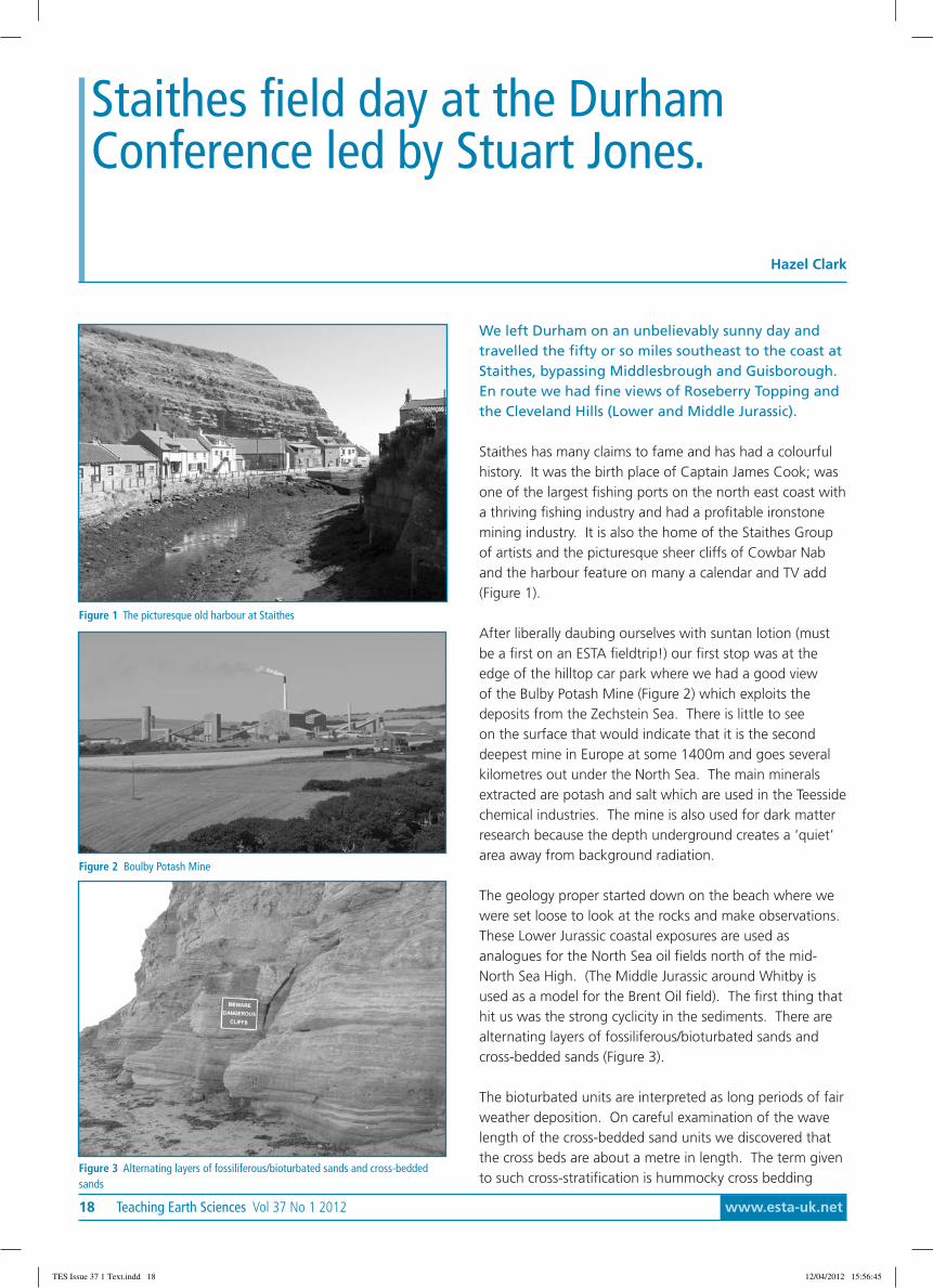
Staithes has many claims to fame and has had a colourfulhistory. It was the birth place of Captain James Cook; wasone of the largest fishing ports on the north east coast witha thriving fishing industry and had a profitable ironstonemining industry. It is also the home of the Staithes Groupof artists and the picturesque sheer cliffs of Cowbar Naband the harbour feature on many a calendar and TV add(Figure 1).
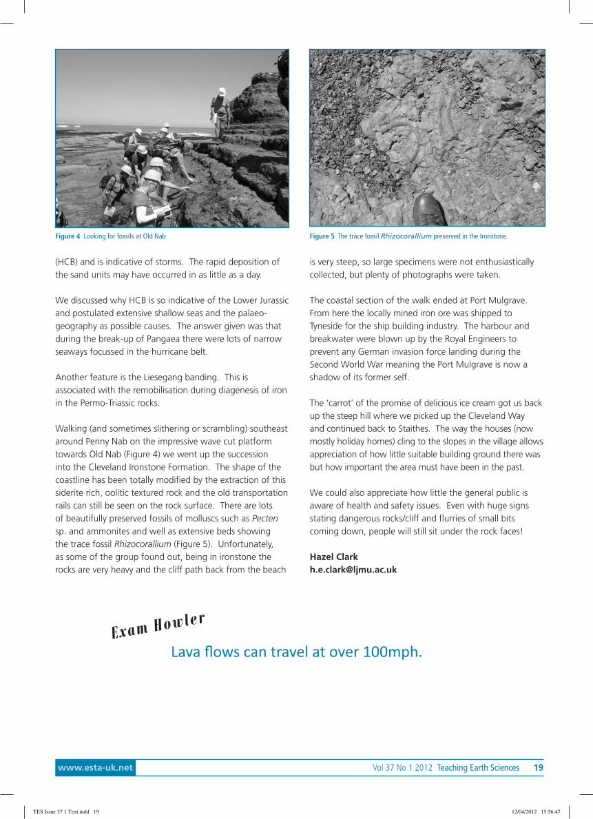
After liberally daubing ourselves with suntan lotion (mustbe a first on an ESTA fieldtrip!) our first stop was at theedge of the hilltop car park where we had a good viewof the Bulby Potash Mine (Figure 2) which exploits thedeposits from the Zechstein Sea. There is little to seeon the surface that would indicate that it is the seconddeepest mine in Europe at some 1400m and goes severalkilometres out under the North Sea. The main mineralsextracted are potash and salt which are used in the Teessidechemical industries. The mine is also used for dark matterresearch because the depth underground creates a ‘quiet’area away from background radiation.
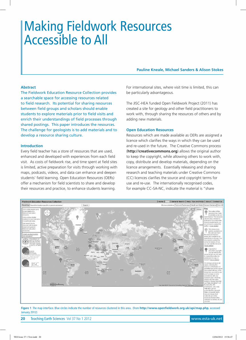
The geology proper started down on the beach where wewere set loose to look at the rocks and make observations.These Lower Jurassic coastal exposures are used asanalogues for the North Sea oil fields north of the mid-North Sea High. (The Middle Jurassic around Whitby isused as a model for the Brent Oil field). The first thing thathit us was the strong cyclicity in the sediments. There arealternating layers of fossiliferous/bioturbated sands andcross-bedded sands (Figure 3).
The bioturbated units are interpreted as long periods of fairweather deposition. On careful examination of the wavelength of the cross-bedded sand units we discovered thatthe cross beds are about a metre in length. The term givento such cross-stratification is hummocky cross bedding
Staithes field day at the DurhamConference led by Stuart Jones.
Hazel Clark
Figure 1 The picturesque old harbour at Staithes
Figure 2 Boulby Potash Mine
Figure 3 Alternating layers of fossiliferous/bioturbated sands and cross-beddedsands
TES Issue 37 1 Text.indd 18 12/04/2012 15:56:45
www.esta-uk.net Vol 37 No 1 2012 Teaching Earth Sciences 19
(HCB) and is indicative of storms. The rapid deposition ofthe sand units may have occurred in as little as a day.
We discussed why HCB is so indicative of the Lower Jurassicand postulated extensive shallow seas and the palaeo-geography as possible causes. The answer given was thatduring the break-up of Pangaea there were lots of narrowseaways focussed in the hurricane belt.
Another feature is the Liesegang banding. This isassociated with the remobilisation during diagenesis of ironin the Permo-Triassic rocks.
Walking (and sometimes slithering or scrambling) southeastaround Penny Nab on the impressive wave cut platformtowards Old Nab (Figure 4) we went up the successioninto the Cleveland Ironstone Formation. The shape of thecoastline has been totally modified by the extraction of thissiderite rich, oolitic textured rock and the old transportationrails can still be seen on the rock surface. There are lotsof beautifully preserved fossils of molluscs such as Pectensp. and ammonites and well as extensive beds showingthe trace fossil Rhizocorallium (Figure 5). Unfortunately,as some of the group found out, being in ironstone therocks are very heavy and the cliff path back from the beach
Figure 4 Looking for fossils at Old Nab Figure 5 The trace fossil Rhizocorallium preserved in the Ironstone.
is very steep, so large specimens were not enthusiasticallycollected, but plenty of photographs were taken.
The coastal section of the walk ended at Port Mulgrave.From here the locally mined iron ore was shipped toTyneside for the ship building industry. The harbour andbreakwater were blown up by the Royal Engineers toprevent any German invasion force landing during theSecond World War meaning the Port Mulgrave is now ashadow of its former self.
The ‘carrot’ of the promise of delicious ice cream got us backup the steep hill where we picked up the Cleveland Wayand continued back to Staithes. The way the houses (nowmostly holiday homes) cling to the slopes in the village allowsappreciation of how little suitable building ground there wasbut how important the area must have been in the past.
We could also appreciate how little the general public isaware of health and safety issues. Even with huge signsstating dangerous rocks/cliff and flurries of small bitscoming down, people will still sit under the rock faces!
Hazel [email protected]
Lava flows can travel at over 100mph.Exam How
ler
TES Issue 37 1 Text.indd 19 12/04/2012 15:56:47
20 Teaching Earth Sciences Vol 37 No 1 2012 www.esta-uk.net
AbstractThe Fieldwork Education Resource Collection providesa searchable space for accessing resources relatedto field research. Its potential for sharing resourcesbetween field groups and scholars should enablestudents to explore materials prior to field visits andenrich their understandings of field processes throughshared postings. This paper introduces the resources.The challenge for geologists is to add materials and todevelop a resource sharing culture.
IntroductionEvery field teacher has a store of resources that are used,enhanced and developed with experiences from each fieldvisit. As costs of fieldwork rise, and time spent at field sitesis limited, active preparation for visits through working withmaps, podcasts, videos, and data can enhance and deepenstudents’ field learning. Open Education Resources (OERs)offer a mechanism for field scientists to share and developtheir resources and practice, to enhance students learning.
Making Fieldwork ResourcesAccessible to All
Pauline Kneale, Michael Sanders & Alison Stokes
For international sites, where visit time is limited, this canbe particularly advantageous.
The JISC-HEA funded Open Fieldwork Project (2011) hascreated a site for geology and other field practitioners towork with, through sharing the resources of others and byadding new materials.
Open Education ResourcesResources which are made available as OERs are assigned alicence which clarifies the ways in which they can be usedand re-used in the future. The Creative Commons process(http://creativecommons.org) allows the original authorto keep the copyright, while allowing others to work with,copy, distribute and develop materials, depending on thelicence arrangements. Essentially releasing and sharingresearch and teaching materials under Creative Commons(CC) licences clarifies the source and copyright terms foruse and re-use. The internationally recognised codes,for example CC-SA-NC, indicate the material is “share
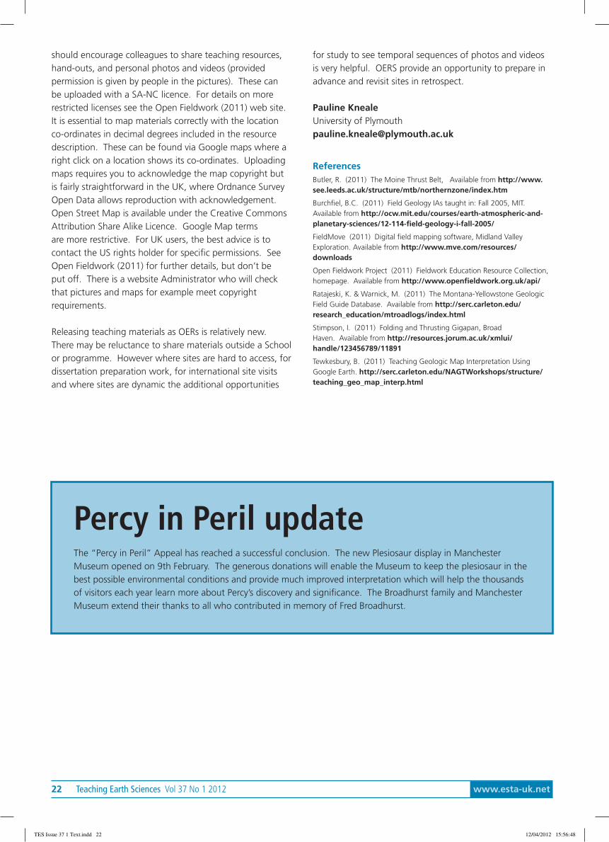
Figure 1 The map interface. Blue circles indicate the number of resources clustered in this area. (from http://www.openfieldwork.org.uk/api/map.php, accessedJanuary 2012)
TES Issue 37 1 Text.indd 20 12/04/2012 15:56:47

www.esta-uk.net Vol 37 No 1 2012 Teaching Earth Sciences 21
alike” (SA), and non-commercial (NC). This means anyearth scientist can use the resource without contactingthe original owner/author. A more restrictive copyrightresource can be referred to, but copying or re-use needspermission from the author.
The Fieldwork Education Resource CollectionThe project has created an interface to enable fieldworkresources to be collated and accessed through a mapinterface (Figure 1), a text search or an interactive wordcloud search from the home page. Resources wereidentified and connected from a broad range of academicand non-academic sites. There were relatively few Earthscience resources available with open creative commonslicences in the major OER repositories: Jorum, MERLOT andOERcommons. To enhance value of the Collection to theEarth Science community, copyrighted resources were alsoincluded, for example making links to the US Digital Libraryfor Earth System Education.
To clarify the “open” status of the resources in theCollection a traffic light coding was devised and used totag the field location on the map:
(Green) The author of this resource has made itavailable under an open licence. The resource can beused, remixed or built upon. If you follow the licence
requirements you do not have to contact the author.(Amber ) This resource is publicly available on theweb but check the resource licence / terms andconditions for restrictions on its use. You may need
to contact the owner for details of how you can use theresource.
(Red) Copyright or assumed copyright - you can referto the resource but you will need to contact theauthor for permission to copy or reuse it.
The fieldwork resources vary from pictures, hand-outsand power-points to include video and podcast materials.See, for example, The Moine Thrust Belt: an introductionto the most important sites (Figure 2) (Butler 2011); TheMontana-Yellowstone Geologic Field Guide Database,(Ratajeski and Warnick, 2011); and Stimpson (2011) Foldingand Thrusting Gigapan, Broad Haven, Pembrokeshire,Wales. Butler is a red copyrighted resource, the lattertwo are available as green CC BY-NC-SA resources. Theopportunity to show students gigapan views of field sitesis potentially very useful in introducing sites before a visit.The picture can be used for interpretation by individuals orclasses.
Field techniques, safety briefings, and good practiceinformation have many generic qualities, which shouldbenefit from sharing. These can be found through thehome page search facility. Amongst the techniques andskills links of interest to geologists is the FieldMove (2011)digital field mapping software, developed by Midland ValleyExploration; Teaching Geologic Map Interpretation UsingGoogle Earth (Tewkesbury, 2011); and a Field geology 1:online course from Burchfiel (2011). The Midland Valleymaterials are freely available to institutions through thecompany’s Academic Software Package, with a numberof class licences available. This gets an amber ratingfor access. The Tewkesbury and Burchfiel resources areaccessible under the green, CC BY-NC-SA licence.
Adding Your Fieldwork ResourcesThe Collection currently has 160 resources from geology,environmental science and geography. Its value willdevelop when Earth scientists add to the resources. Onthe Home page, follow the “Would you like to add a newresource?” and transfer copies of your files. These will bechecked and uploaded by the FERC Administrator. The site
Figure 2. A snapshot of a map linked resource. Note also that there are two more resources at Loch Laxford to the south west. The territory can also be viewed in satelliteform – see top left link on the map.
TES Issue 37 1 Text.indd 21 12/04/2012 15:56:47
22 Teaching Earth Sciences Vol 37 No 1 2012 www.esta-uk.net
should encourage colleagues to share teaching resources,hand-outs, and personal photos and videos (providedpermission is given by people in the pictures). These canbe uploaded with a SA-NC licence. For details on morerestricted licenses see the Open Fieldwork (2011) web site.It is essential to map materials correctly with the locationco-ordinates in decimal degrees included in the resourcedescription. These can be found via Google maps where aright click on a location shows its co-ordinates. Uploadingmaps requires you to acknowledge the map copyright butis fairly straightforward in the UK, where Ordnance SurveyOpen Data allows reproduction with acknowledgement.Open Street Map is available under the Creative CommonsAttribution Share Alike Licence. Google Map termsare more restrictive. For UK users, the best advice is tocontact the US rights holder for specific permissions. SeeOpen Fieldwork (2011) for further details, but don’t beput off. There is a website Administrator who will checkthat pictures and maps for example meet copyrightrequirements.
Releasing teaching materials as OERs is relatively new.There may be reluctance to share materials outside a Schoolor programme. However where sites are hard to access, fordissertation preparation work, for international site visitsand where sites are dynamic the additional opportunities
for study to see temporal sequences of photos and videosis very helpful. OERS provide an opportunity to prepare inadvance and revisit sites in retrospect.
Pauline KnealeUniversity of [email protected]
ReferencesButler, R. (2011) The Moine Thrust Belt, Available from http://www.see.leeds.ac.uk/structure/mtb/northernzone/index.htm
Burchfiel, B.C. (2011) Field Geology IAs taught in: Fall 2005, MIT.Available from http://ocw.mit.edu/courses/earth-atmospheric-and-planetary-sciences/12-114-field-geology-i-fall-2005/
FieldMove (2011) Digital field mapping software, Midland ValleyExploration. Available from http://www.mve.com/resources/downloads
Open Fieldwork Project (2011) Fieldwork Education Resource Collection,homepage. Available from http://www.openfieldwork.org.uk/api/
Ratajeski, K. & Warnick, M. (2011) The Montana-Yellowstone GeologicField Guide Database. Available from http://serc.carleton.edu/research_education/mtroadlogs/index.html
Stimpson, I. (2011) Folding and Thrusting Gigapan, BroadHaven. Available from http://resources.jorum.ac.uk/xmlui/handle/123456789/11891
Tewkesbury, B. (2011) Teaching Geologic Map Interpretation UsingGoogle Earth. http://serc.carleton.edu/NAGTWorkshops/structure/teaching_geo_map_interp.html
Percy in Peril updateThe “Percy in Peril” Appeal has reached a successful conclusion. The new Plesiosaur display in ManchesterMuseum opened on 9th February. The generous donations will enable the Museum to keep the plesiosaur in thebest possible environmental conditions and provide much improved interpretation which will help the thousandsof visitors each year learn more about Percy’s discovery and significance. The Broadhurst family and ManchesterMuseum extend their thanks to all who contributed in memory of Fred Broadhurst.
TES Issue 37 1 Text.indd 22 12/04/2012 15:56:48
www.esta-uk.net Vol 37 No 1 2012 Teaching Earth Sciences 23
Participants:• Mike Tuke: ‘Coral architecture’• Hazel Mather, Derby University: Sub-surf Rocks!• Jacqui Malpas, Geodiversity Officer, Clwydian Range Area of Outstanding Natural Beauty: ‘Geology and the
Clwydian Range’• Ian Kenyon, Truro School: ‘The Compass Clinometer is Dead, Long Live The iPhone‘• Dawn Windley ‘The partially sighted leading the blind?!’• David Bailey ‘Landslides in 3D’• Toyin Solanke: Geothrillogy.• Simon Kelley: The virtual microscope.• Julia Kungu : Revision PowerPoints for OCR AS and A2 Geology• Peter Kennett : ‘Earthlearningidea’ – The unfair ‘build your own crystal race’: ‘Crystallisation in a pudding dish’:
Take a ‘Chance’ on the volcano erupting (pp Dave Turner).
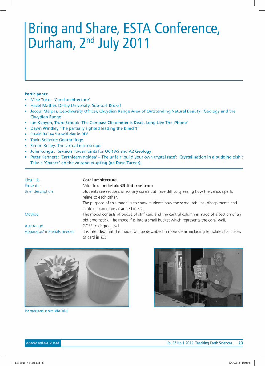
Idea title Coral architecturePresenter Mike Tuke [email protected] description Students see sections of solitary corals but have difficulty seeing how the various parts
relate to each other.The purpose of this model is to show students how the septa, tabulae, dissepiments andcentral column are arranged in 3D.
Method The model consists of pieces of stiff card and the central column is made of a section of anold broomstick. The model fits into a small bucket which represents the coral wall.
Age range GCSE to degree levelApparatus/ materials needed It is intended that the model will be described in more detail including templates for pieces
of card in TES
Bring and Share, ESTA Conference,Durham, 2nd July 2011
The model coral (photo. Mike Tuke)
TES Issue 37 1 Text.indd 23 12/04/2012 15:56:48

24 Teaching Earth Sciences Vol 37 No 1 2012 www.esta-uk.net
Idea title Sub-surf Rocks!Presenter Hazel Mather, [email protected] description The UK Onshore Geophysical Library website Sub-Surf Rocks! now has a whole new section
entitled: Deformation. It is free on the internet or on CD and offers seismic data illustratinga wide range of brittle and ductile deformation structures.
Method The material consists of a large selection of seismic images and has several set exercises thatlink into many parts of the specification. For example there is a cut-out-and-keep 3D faultmodel with a fault plane (see photo), the model can then be used in a mapping exercisethat relates to resource geology. In another exercise students have the chance to apply theprinciples of superposition and cross-cutting relationships.
Age range A levelApparatus/ materials needed • Computer to run CD/ internet access downloadable PowerpointTM presentations,
• Printer for 3D models and maps.• As with the earlier material, everything is available to print or edit.www.sub-surfrocks.co.ukFor a CD contact Dr Dorothy Satterfield at [email protected]
Cut-out-and-keep 3D fault model
The slopes of Mt St Helens could be stabilised by using rock bolts andgabions.
Exam Howler
TES Issue 37 1 Text.indd 24 12/04/2012 15:56:48

www.esta-uk.net Vol 37 No 1 2012 Teaching Earth Sciences 25
Idea title Geology and the Clwydian RangePresenter Dr Jacqui Malpas, [email protected] description DVD with PowerPoint presentations of 3 field trips;13 ppts of WJEC, GCSE Geology
curriculum using Key Ideas; Introduction, Glossary; Risk Assessment; Case study of cementmaking: The Sustainable Earth? Limestone to cement; Quarry planning debate
Method To be used/adapted/changed/updated as required.Age range 11-18Apparatus/ materials needed Free to schools
Please email Jacqui Malpas at [email protected] as the DVD is too big toput on a website!
A Level students in a working limestone quarry (Photo: J. Malpas)
Briefly explain what hard water is …… iceExam How
ler
TES Issue 37 1 Text.indd 25 12/04/2012 15:56:49
26 Teaching Earth Sciences Vol 37 No 1 2012 www.esta-uk.net
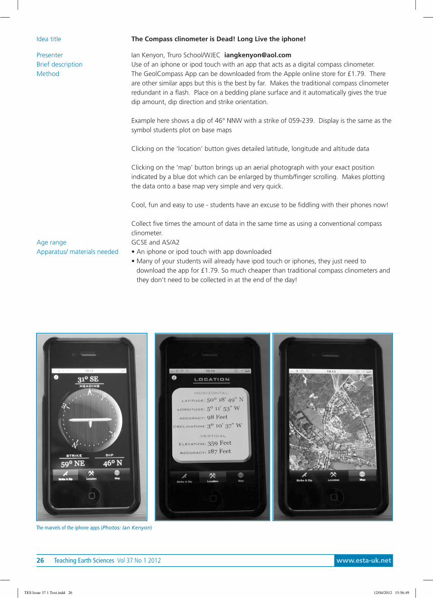
Idea title The Compass clinometer is Dead! Long Live the iphone!
Presenter Ian Kenyon, Truro School/WJEC [email protected] description Use of an iphone or ipod touch with an app that acts as a digital compass clinometer.Method The GeolCompass App can be downloaded from the Apple online store for £1.79. There
are other similar apps but this is the best by far. Makes the traditional compass clinometerredundant in a flash. Place on a bedding plane surface and it automatically gives the truedip amount, dip direction and strike orientation.
Example here shows a dip of 46° NNW with a strike of 059-239. Display is the same as thesymbol students plot on base maps
Clicking on the ‘location’ button gives detailed latitude, longitude and altitude data
Clicking on the ‘map’ button brings up an aerial photograph with your exact positionindicated by a blue dot which can be enlarged by thumb/finger scrolling. Makes plottingthe data onto a base map very simple and very quick.
Cool, fun and easy to use - students have an excuse to be fiddling with their phones now!
Collect five times the amount of data in the same time as using a conventional compassclinometer.
Age range GCSE and AS/A2Apparatus/ materials needed • An iphone or ipod touch with app downloaded
• Many of your students will already have ipod touch or iphones, they just need todownload the app for £1.79. So much cheaper than traditional compass clinometers andthey don’t need to be collected in at the end of the day!
The marvels of the iphone apps (Photos: Ian Kenyon)
TES Issue 37 1 Text.indd 26 12/04/2012 15:56:49
www.esta-uk.net Vol 37 No 1 2012 Teaching Earth Sciences 27
Idea title Revision PowerPoints for OCR AS and A2 GeologyPresenter Julia Kungu [email protected] description PowerPoints have been written for F791, F792 and F794 (F795 will be available shortly -
well before Christmas at any rate!) These take the form of questions and answers drawingfrom mark schemes of past papers. They can be used as a teaching resource in theclassroom or placed on the intranet for independent study by students.
MethodAge range AS and A2
Apparatus/ materials needed • Computer• Email [email protected] for copies
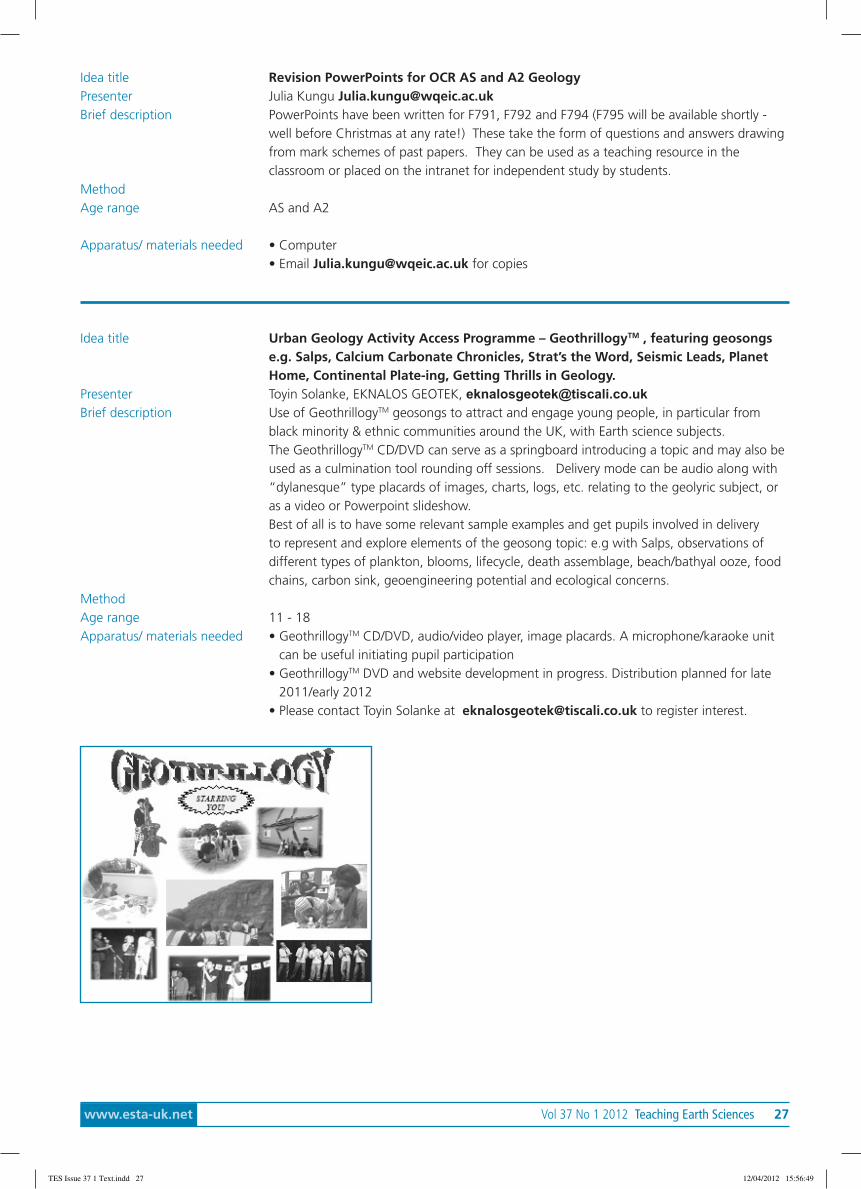
Idea title Urban Geology Activity Access Programme – GeothrillogyTM , featuring geosongse.g. Salps, Calcium Carbonate Chronicles, Strat’s the Word, Seismic Leads, PlanetHome, Continental Plate-ing, Getting Thrills in Geology.
Presenter Toyin Solanke, EKNALOS GEOTEK, [email protected] description Use of GeothrillogyTM geosongs to attract and engage young people, in particular from
black minority & ethnic communities around the UK, with Earth science subjects.The GeothrillogyTM CD/DVD can serve as a springboard introducing a topic and may also beused as a culmination tool rounding off sessions. Delivery mode can be audio along with“dylanesque” type placards of images, charts, logs, etc. relating to the geolyric subject, oras a video or Powerpoint slideshow.Best of all is to have some relevant sample examples and get pupils involved in deliveryto represent and explore elements of the geosong topic: e.g with Salps, observations ofdifferent types of plankton, blooms, lifecycle, death assemblage, beach/bathyal ooze, foodchains, carbon sink, geoengineering potential and ecological concerns.
MethodAge range 11 - 18Apparatus/ materials needed • GeothrillogyTM CD/DVD, audio/video player, image placards. A microphone/karaoke unit
can be useful initiating pupil participation• GeothrillogyTM DVD and website development in progress. Distribution planned for late
2011/early 2012• Please contact Toyin Solanke at [email protected] to register interest.
TES Issue 37 1 Text.indd 27 12/04/2012 15:56:49

28 Teaching Earth Sciences Vol 37 No 1 2012 www.esta-uk.net
Idea title On-line virtual microscope slides of meteorites, moon rocks and rocks that CharlesDarwin collected on his journey on the Beagle
Presenter Simon Kelley, Department of Physical Sciences, Open University, Milton Keynes, MK7 [email protected]
Brief description A new on-line tool that provides access to unique rocks in thin section. The virtualmicroscope is a new distance learning tool for Earth and environmental science, and recentoutreach projects making available rare and unique rocks such as those collected by CharlesDarwin during the voyage of the Beagle, and Moon rocks brought back to Earth by theApollo astronauts. While the first virtual microscope teaching collections are used only bythe Open University students, we want to make this available as a more general educationalresource.
The skill of recognising and classifying rocks in thin sections has fallen from the generalcurriculum (probably because petrological microscopes are too expensive for school labsand need maintaining). We are interested in learning how people might use this resourceand helping us to develop it further.
MethodAge range 11 – any ageApparatus/ materials needed • PC with access to the internet and either the most recent Internet Explorer or Firfox
browser• New website now active http://www.virtualmicroscope.co.uk/• Please contact Simon Kelley at [email protected] with any comments or
feedback
Idea title ‘Earthlearningidea’ – The unfair ‘build your own crystal race’:Presenter Peter Kennett, [email protected] description A crystal-building race, showing the greater the time, the larger the crystals. This is related
to the crystallisation rates of igneous rocks.Method Two teams are set to build a crystal model, given a selection of coloured Molymod™ balls
and rods. One team is told to stop after it has assembled just a few items, simulating rapidcooling, as in the case of a lava. The other team is given longer to build a more complexmodel, simulating slow cooling deep underground
Age range 14 -1 8Apparatus/ materials needed • About 70 assorted Molymod™ balls and rods, or any similar components, as normally
used to build molecular models. The colours do not matter.• www.earthlearningidea.com – The unfair ‘build your own crystal race’, posted on
14th February 2011.
Three simulations of rapid cooling on the left, and slow cooling on the right. (Photo: Chris King)
TES Issue 37 1 Text.indd 28 12/04/2012 15:56:50
www.esta-uk.net Vol 37 No 1 2012 Teaching Earth Sciences 29
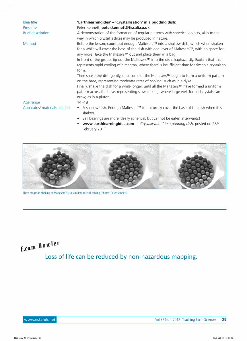
Idea title ‘Earthlearningidea’ – ‘Crystallisation’ in a pudding dish:Presenter Peter Kennett, [email protected] description A demonstration of the formation of regular patterns with spherical objects, akin to the
way in which crystal lattices may be produced in nature.Method Before the lesson, count out enough Maltesers™ into a shallow dish, which when shaken
for a while will cover the base of the dish with one layer of Maltesers™, with no space forany more. Take the Maltesers™ out and place them in a bag.In front of the group, tip out the Maltesers™ into the dish, haphazardly. Explain that thisrepresents rapid cooling of a magma, where there is insufficient time for sizeable crystals toform.Then shake the dish gently, until some of the Maltesers™ begin to form a uniform patternon the base, representing moderate rates of cooling, such as in a dyke.Finally, shake the dish for a while longer, until all the Maltesers™ have formed a uniformpattern across the base, representing slow cooling, where large well-formed crystals cangrow, as in a pluton.
Age range 14 -18Apparatus/ materials needed • A shallow dish. Enough Maltesers™ to uniformly cover the base of the dish when it is
shaken.• Ball bearings are more ideally spherical, but cannot be eaten afterwards!• www.earthlearningidea.com – ‘Crystallisation’ in a pudding dish, posted on 28th
February 2011
Three stages in shaking of Maltesers™, to simulate rate of cooling (Photos: Peter Kennett)
Loss of life can be reduced by non-hazardous mapping.Exam How
ler
TES Issue 37 1 Text.indd 29 12/04/2012 15:56:52

30 Teaching Earth Sciences Vol 37 No 1 2012 www.esta-uk.net
Idea title ‘Earthlearningidea’ – Take a ‘Chance’ on the volcano eruptingPresenter Peter Kennett, [email protected] , on behalf of Dave Turner,
[email protected] description Party poppers are used to demonstrate how difficult it is to predict an event, analogous to
a volcanic eruption. Participants take cards randomly from a pack, which instruct them howmany masses to add to or subtract from the loading on the party popper
Method Set up a party popper on each of three separate clamp stands. Hang a mass hanger ontoeach one (you will need to tie a loop in the pull-string first). Ask participants to turn overthe ‘Chance’ cards at random and add the given number of masses to the load. The cardsdescribe typical activity on a volcano, some of which may indicate a forthcoming eruption.Cards ask for one or two masses to be added, depending on the perceived risk, and afew tell participants to remove a mass, e.g. If swelling of the volcano summit subsides.Participants can elect to play a card to evacuate the town, or to tell its inhabitants to gohome again
Age range 11 - 91Apparatus/ materials needed • Say three clamp stands, with a boss and clamp for each:
• Three party poppers with a loop tied in the string;• Three mass hangers;• About 70 100g masses;• A set of ‘Chance’ cards per group, downloaded from the website and cut up.
“Oops; mine’s blown up already!” (Photo: Peter Kennett)
TES Issue 37 1 Text.indd 30 12/04/2012 15:56:53

www.esta-uk.net Vol 37 No 1 2012 Teaching Earth Sciences 31
esTa secretary’s Report 2010-11Although the date of the AGM has been brought forward, the usual three Council meetings were held during theyear: on 16 October 2010, 26 March 2011 and 21 May 2011. Topics discussed by Council have included:
• Preparation, planning, funding and expenditure for the 2011 Conference at Durham and future conferences.Unfortunately, plans to hold the 2012 conference at Birmingham fell through but John Ludden, ExecutiveDirector, has agreed to host the event at the new conference facility at BGS headquarters in Keyworth. Atthe time of writing, we plan to hold the 2013 at the University of Plymouth and it is hoped the date willbe confirmed soon. Thanks to Paula Martin and Linda Marshall for their hard work organising the 2011Conference so soon after Leicester, and especially to Susan Beale who steps down from the role of ConferenceLiaison Officer after 3 years having also previously served as Secretary.
• Consultation on the place of Earth sciences in the National Curriculum.• The future of Earth science teacher training in the UK.• Strengthening liaison with the HE sector, especially through the new Geological Society HE Network.• Funding for development of projects, including a maintenance fund for GEOTREX and other online resources.• Representation of the Primary Group at Conference and storage for the Primary Group resources.• Membership benefits for PEST members and new ESTA members.• Policies on collecting and using members’ email addresses for ESTA correspondence.• Representing ESTA at conferences and managing the ESTA display boards.• Seeking volunteers to take up positions on Council.• Our new Chair, Cally Oldershaw has had to resign for personal reasons and this post is now vacant.• Niki Whitburn’s term as Retiring Chair concludes at this AGM.• We are due to elect a new Chair Designate at this AGM.• Susan Beale stands down as Conference Liaison Officer, Gordon Neighbour is nominated by Council to take
over.• The post of Advertising Officer was briefly taken up by Elaine Mason, but she resigned following her departure
from BGS to set up a new business. Maggie Williams has been acting as Advertising Officer.• Stephen Davies has resigned the post of Boards Manager, Michelle Evans of Keele University and SLCWM has
kindly agreed to take this on.• Clive Trueman has resigned as HE Coordinator owing to work commitments, Council is grateful to Jim
Andrews, Chair of the Geological Society’s HE Network, who has agreed to stand for election, therebystrengthening links both with the HE sector as a whole and the Geological Society.
• A number of posts are due for re-election and nominations for Advertising Officer and Webmaster would beespecially welcome.
• All those stepping down or stepping in are heartily thanked for giving up their time to help run ESTA. I wouldalso like to thank Ros Todhunter for her help and for handing over the Secretary’s files in such immaculateorder.
David BaileyESTA SecretaryMay 2011
Reports tabled at the 44th AnnualGeneral Meeting held at theUniversity of Durham, 2nd July 2011
ESTA Chair Position vacant
TES Issue 37 1 Text.indd 31 12/04/2012 15:56:53
32 Teaching Earth Sciences Vol 37 No 1 2012 www.esta-uk.net
esTa Treasurer’s Report, 2010-11Below is the summary of the accounts for the Year 2010 - 2011. The full accounts are available for review. Inkeeping with the Charity Commission requirements and for the satisfaction of our membership these full accountsare examined by 2 external examiners to ensure their accuracy. Thank you to John Reynolds and Carole Rushallfor their offers to do this.
This summary sheet shows our 2 main accounts, Current and Deposit. 2 other accounts not shown are:
a) The PT Carr account: a memorial fund used for awards. The interest is paid into the current account. Currently thisaccount has £1284.08 accrued interest from the P.T. Carr legacy.
b) The Conference account: solely for ESTA conference. Current account conference money is either transfers orconference payments for ESTA council members. The conference account is expected to be self-sustaining retainingany surplus. We give sincere thanks to PESGB for their donation of £5000 for the ESTA Leicester 2010 conference. Thiskeeps the conference price to an affordable level. Our thanks go to our other donors listed on the conference accountsspreadsheet. This is available for viewing. The Leicester conference surplus of £2827.92 provided start-up for Durham andwas available for the bumper conference edition of TES.
Designated funds are for specified projects. Previously these have been provided by generous donations from PESGB andare held as part of the Current Account. To continue with the maintenance of the GEOTREX project we now have a projectmaintenance fund from the ESTA accounts.
Overall there is a negative money movement shown from the Current and Deposit accounts. This is due to:Rising costs but we have not asked for an increase in subscriptions due to the relatively healthy accounts.The conference surplus, previously coming to the current account, has remained in the conference account.Donations from PESGB for further special projects, previously allocated to our designated funds were not available this year ,although PESGB have very generously supported our annual Conference. Thus there have been payouts from the designatedfund but no income. £1214.77 remains for completion of a primary project.
A reminder, this is a members’ organisation run by members for members, depending on members’ subscriptions. Membersare encouraged to recruit new members to increase our income so allowing us to expand our activities.
Jane GiffouldESTA TreasurerMay 2011
When Mt St Helens erupted the first ever death on continental US wasrecorded.
Exam Howler
TES Issue 37 1 Text.indd 32 12/04/2012 15:56:53

www.esta-uk.net Vol 37 No 1 2012 Teaching Earth Sciences 33
Summary sheet- on going 01 April 2010 to 31 March 2011
Income Current Expenditure
Subscriptions post primary 13964.98 Council Expenses 4722.12
Primary 200.00 Refunds & rejects 640.00
Promotions 260.90 Subs - other orgs 25.00
Adverts 360.00 Insurance & Data Reg 201.00
Journals 239.00 Promotions 370.15
P T Carr Interest 96.10 Publicity 692.02
Conference Leicester 240.00 Journal & Newsletter 12047.40
Conference GA + ASE 484.01 Bank charges 72.82
Pub LS 78.98
PESGB projects 860.00
Conference Leicester 700.00
Total income 15923.97 Total expenditure 20330.51
Start balance 11868.28 Deposit
Income 15923.97 Start 28700.44
Expenditure 20330.51 Interest 14.32
Final balance 7461.74 End balance 28714.76
Bank statement 7558.74 Money movement 14.32
Uncleared Income 0.00 Total accounts
Uncleared Expenditure 97.00 Start 40568.72
Balance 7461.74 End 36176.50
Money movement -4406.54 Money movement -4392.22
esTa Membership secretary’s Report 2010-2011Ordinary members 376
Student and retired members 68
Complimentary members 28
Total number of members 472
We have had 16 new members since Oct 1st 2010.This is lower than normal. Usually we have about 30 new members peryear.
Mike TukeMembership SecretaryMay 2011
TES Issue 37 1 Text.indd 33 12/04/2012 15:56:53

34 Teaching Earth Sciences Vol 37 No 1 2012 www.esta-uk.net
esTa Primary Committee Report 2010-2011Since the last AGM the second pair of PESTs in the Climate Through Time series and the first of the 2011 PESTs,Edible Earth Science and Soil Art, have been published and the next two issues are being finalized.
Extended versions of three of our workshops; Minerals, Rocks and Soils, followed by a drop-in session were presented at theASE Conference in Reading in January. Five of the participants were from overseas and these have become PEST membersand receive their issues electronically.
Three members of the Primary Team presented four workshops at the Geographical Association’s conference in Guildfordon Saturday 16th April 2011. Previously we have only presented Rivers and Coasts. The GA paid for our travel andaccommodation so ESTA only covered our meals.
Some delegates attended two or three of the workshops, others only one. This had an impact on the running of theworkshops as we had to fit more explanatory introductions into an already very tight schedule. This was necessary as theworkshops are so closely linked and designed to follow on from each other. The number of attendees was as follows:
Minerals and Rocks 17
Soils 10
Rivers and Coasts 12
Sweet Geography 24
As can be seen, the workshops were well attended. The delegates were very enthusiastic and participated fully, askedinteresting questions and gave us some excellent feedback. Those who did attend them all were impressed withsubject areas covered, the range of information given and the number of practical activities they participated in or haddemonstrated. Due to a shortage of space it was very hectic and hard work as only one workshop could be set up at a timewith each needing clearing before the next could be got ready. However, with the exposure for ESTA to this enthusiasticaudience, who were geographers rather than Earth scientists, we are sure the hard work was well worth it.
The Primary resources are now safely stored in the shared office space at the National Stone Centre and, with special thanksto David Bailey and BGS, the room has now been enhanced with some otherwise redundant shelving units.
Tracy AtkinsonPrimary Education Co-ordinatorMay 2011
Pyroclastic flows don’t damage the exterior or structure of buildings,however if they get inside they can be devastating to furniture, personal
property and electrical equipment.
Exam Howler
TES Issue 37 1 Text.indd 34 12/04/2012 15:56:53
www.esta-uk.net Vol 37 No 1 2012 Teaching Earth Sciences 35
esTa secondary Committee Report 2010-2011ESTA Conference, Leicester, 2010The report from the post-16 ‘Bring and share session’ at Leicester was published as: ESTA Leicester ‘Bring andshare’: partytime! Teaching Earth Sciences, (2011) 36 (1) pp.26 – 36.
ESTA Secondary Working Day – Saturday 7th MayAnother very successful day saw three main issues being addressed:
• developing maths/geology exercises - for the teaching of maths through geological approaches and visa versa,led by Vinay Kathotia from the Nuffield Foundation (several ideas of geology/maths crossover were developed);
• developing the Derby University seismology work - led by Hazel Mather from Derby University (Hazel wentaway with several ideas for development);
• progression in Earth science fieldwork – we tried an exercise to see if there is progression in Earth sciencefieldwork and, if so, to see what this progression might be. (We found there is progression in Earth sciencefieldwork – but what this progression is will require a good deal more work)
All of these topics provoked some lively discussion and Maggie Williams was kind enough to record some of this as the basisof a report for Teaching Earth Sciences. On top of this, some new topics for Earthlearningideas were suggested too.
ASE Annual Conference, Liverpool University, Wednesday 4th - Saturday 7th January, 2012As in previous years, the conference will have an Earth science input on all four days, with a short Earthlearningideaworkshop on Wednesday 4th January (International Day), ESEU workshops on the Thursday and Friday, a ‘Distinguished ESTA/ESEU Lecture’ from Dr. David Rothery of the Open University , on ‘Dealing with volcanoes, earthquakes and tsunamis inbroadcast news: my experiences on BBC, ITN, Sky News, Al Jazeera, Talk Sport etc’ on the Thursday, and a booked workshopfollowed by a drop in session presented by the ESTA Primary group on Saturday, the primary day.
Geology teacher training• Since my annual report last year, things have become even more difficult for geology teacher training:• Bath University announced the closure of their course;• Keele University was allocated only 12 training places for ‘biology and other sciences’ including geology and
so, to protect biology teaching, decided to close geology;• following a letter to the Training and Development Agency for Schools (TDA) that explained that a probable
‘unintended consequence’ of their cuts would be the demise of geology teacher training, they allocated aadditional six training places to Keele for geology teacher training;
• Keele decided to honour this offer by continuing its training on the ‘no cost’ basis of the previous year (withthe PGCE Geologists being taught alongside a module being given to other students) providing a ‘distancelearning’ course was developed in the longer term;
• a meeting of Stakeholders in Geology Teacher Training was convened in London on 17th May; support forfuture training of geology teachers was expressed and a further meeting was called for mid-June to determinethe best mechanisms for providing this support and, hopefully, the long term security for geology teachertraining in this country.
Geology examinationsFollowing the rise in entries for all Geology examinations in England and Wales last year (see: King, C. and Jones, B. (2011) Agood news story – the recent rise of Geology exam entries. Teaching Earth Sciences, 36 (1) pp.63–70.) – this trend seems tobe continuing in 2011, although all the statistics are not yet available. The news from Scotland is not so good, where thereare plans by the Scottish Qualifications Authority (SQA) to close all geology exams (intermediate and higher) and replacethem with environmental studies exams that currently seem to contain little geology. This is being fought by our ScottishEarth Science Education Forum (SESEF) colleagues in Scotland, with our support.
EarthlearningideaDuring 2011, Earthlearningidea has continued to publish ideas at the rate of one per fortnight and published its 100th ideain March. We have been able to access more data on uptake, which shows that our best month to date was February 2011,
TES Issue 37 1 Text.indd 35 12/04/2012 15:56:53
36 Teaching Earth Sciences Vol 37 No 1 2012 www.esta-uk.net
with more than 38,000 downloads across the world in that month. Please continue to support the Earthlearningidea team,Chris King, Peter Kennett and Elizabeth Devon, by publicising the website to your friends and colleagues around the world:http://www.earthlearningidea.com/
Chris King,Secondary Education Co-ordinatorMay 2011
earth science education Unit (eseU) Report 2010-2011This Report covers ESEU business (primary, secondary, Scottish and Earth Physics) from September 2010 to June 2011.
Business for 2010/11 had been fairly steady between September and December 2010 but ESEU noticed that during January toMay 2011 booking figures taken for primary, secondary and Earth Physics workshops had slowed down considerably. However,towards the end of May the school marketing campaigns distributed in the Spring started to generate more bookings andsecondary workshop figures now match those for 2009/10. There is still room for improvement regarding to primary and EarthPhysics bookings, but ESEU is hopeful that the current figures will increase before the end of August 2011.
Although teacher training bookings for secondary workshops in 2010/11 are down, students numbers have not beensignificantly affected, which suggests that although visits are fewer, group sizes are slightly larger. This is also supportedby the primary teacher training figures, as the same number of institutions have been visited for 2009/10 and 2010/11 butstudents numbers for 2010/11 have increased by 84.
ESEU is delighted to report that bookings in Scotland have doubled since last year, an increase in both teacher traininginstitutions and school visits. This could be due to a combination of the continuous marketing efforts and the need forCurriculum for Excellence teacher CPD in Science and Social Sciences in Scotland.
The increased marketing campaigns are beginning to make a difference but maintaining repeat bookings with institutions orkeeping schools engaged with the idea of securing a workshop have been mainly due to the perseverance of reminders bythe Central Team or ESEU facilitators.
Evaluation feedback (all workshops) and post workshop follow-up (primary, secondary and Scottish) show that participantsand host providers are happy with the content and workshop delivery and are keen to book other ESEU workshops.Meanwhile, there is no reason to suggest that material is not applicable to the curricula or teaching practice. Reasons fordelays in contacting ESEU whether to book a workshop or in response to follow-up have mainly been pressures of teachingtimetables or little opportunity to discuss/consider CPD available with colleagues.
The quality assurance evaluation of ESEU’s workshops by the Training and Development Agency for Schools (TDA) also gaveESEU a good review as well as highlighting areas which ESEU might like to incorporate in future delivery (the points madehave already taken into consideration as part of workshop revisions).
By ESEU facilitators’ participation in ‘Science Week’ activities and attendance/participation at home and overseas conferences,ambassadorial work for the Unit has also increased, helping to promote the work of the Unit and Earth science education.
ESEU is also waiting to receive further details regarding the Geological Society’s ‘Schools Geology Competition’ which takesinto account ESEU’s offer of a £500 prize fund.
As ever, ESEU shows a willingness to offer support to internal (Keele University) and external activities/projects as well asextending on-line support to teachers and trainees after workshop delivery.
Bernadette CallanESEU ManagerJune 2011
TES Issue 37 1 Text.indd 36 12/04/2012 15:56:53
www.esta-uk.net Vol 37 No 1 2012 Teaching Earth Sciences 37
esTa Higher education Committee ReportPosition vacant
esTa editors’ reports 2011Teaching Earth SciencesIssues 35(2) and 36(1) have been produced on time and have been well received by the membership from thefeedback that I have received. Indeed Issue 36(1) was a bumper issue mainly due to the sterling efforts of GawenJenkin alerting conference participants about the opportunity to provide articles for the greater membership.Hopefully there will be more items related to the Leicester conference in the next issue. I have attended the GEESHigher Education meeting, held at the University of Leeds, which should also generate some future articles.
The comment about lack of teaching related material has been addressed and many recent articles have had specificsuggestions for educational material embedded within them.
Once again, I am greatly indebted to the group of people who go through the draft copy with a fine tooth comb and pointout all that the editor has missed!
Please keep the articles and any suggestions for material to be included coming in to [email protected]
Hazel ClarkTeaching Earth Sciences EditorMay 2011
ESTA NewsTwo issues of ESTA News have been published over the last year. In December 2010 Volume 2, Issue 2 was produced. Thisissue featured old and new quarries and included photographs taken during the field visit to Bardon Hill, organised as part ofthe ESTA 2010 conference. Volume 3, Issue 1 is now ready to send to the printers and should be mailed to ESTA membersduring June 2010. This issue features stunning photographs kindly provided by the TES editor and includes the views,statues, buildings and pyramids of Egypt.
I wish to offer my thanks to the volunteers who have helped with proof-reading of these publications. I am also grateful tothose ESTA members who have sent me encouraging comments about ESTA News and I do hope that this newsletter willcontinue to be published biannually. Copy deadlines will be 15th November and 15th May each year.
If ESTA members have photographs or items of news that they would like to see included in future newsletters, please emailthem to the Newsletter Editor at: [email protected]
Maggie WilliamsNewsletter EditorMay 2011
TES Issue 37 1 Text.indd 37 12/04/2012 15:56:53

38 Teaching Earth Sciences Vol 37 No 1 2012 www.esta-uk.net
esTa Webmaster’s report 2010-2011New this yearThanks to the work of Joanie Marion, we now have a structured resource area with materials suitable for GCSE Geology. Itis called STEGO (sorry about that) which means Secondary Teachers Exchanging Geology Online. It can be accessed from theresource tab on the website menus. We would be grateful for any contributions to this resource – sent [email protected].
After the last Annual Conference we also set up an ESTA forum. Members have begun to use this in a small way. It isprovided for free by an organisation who will close the forum if we do not use it. It can be found from the link on the frontpage of the ESTA web site or athttp://estauk.freeforums.org/
RetirementI have been the webmaster for the last 5 years and have enjoyed the experience. A year ago I mentioned that I wished tofinish webmastering when I reached 65. It is now time for someone new to take over the role.
I will, of course, continue to look after the web until a new webmaster can be found and look forward to working with thatperson to ensure a smooth transition. To that end I have started to recode the site so that the job of maintaining it will beeasier for my successor and those changes should be complete in the next few weeks.
Peter WilliamsWebmasterMay 2011
esTa advertising Officer’s Report 2010-2011The Advertising Officer post was vacant for most of this year, until Elaine Mason was appointed. In NovemberElaine tendered her resignation and although Elaine was only in post for a very short time she created notes ofadvertising rates and administrative procedures and produced a useful Excel sheet with potential advertisingcontacts. After Elaine’s departure I have taken over her work. We now have a comprehensive list of existingadvertising contacts and new potential advertising contacts, including all UK Field Centres and more companiesoffering outdoor-themed excursions. It is hoped that these potential contacts will respond to a letter offeringadvertising in either the next two editions of TES and/or web advertising.
Journal advertisingTwo advertising flyers have been sent out with ESTA publications this year. Both flyers advertised INSET courses at LiverpoolUniversity. Flyers were placed in the September and March issues of Teaching Earth Sciences.
Web advertisingThree adverts have been placed on the ESTA website by Leeds University, Williams GeoAdventures and ESEU. The EarthScience Education Unit’s web advert will be renewed annually each January.
Maggie WilliamsAdvertising OfficerMay 2011
TES Issue 37 1 Text.indd 38 12/04/2012 15:56:53

www.esta-uk.net Vol 37 No 1 2012 Teaching Earth Sciences 39
Projects Report 2010-2011Working with Rivers ProjectThis PESGB-sponsored project involves developing a pack for the primary school curriculum. Originally based on EarthScience in the Geography curriculum, the project is linked to the theme of water, rivers and coastlines. It has involvedwriting a workbook and practical exercises suitable for Key Stage 2 primary school pupils. During 2009/10 the design andlayout of the storybook and work book was completed and the storybook illustrations drafted. It is hoped that this resourcewill eventually be available via the ESTA website. Since last June the author and key worker on this project has beenseriously ill and is just starting recovery. Once she is fully recovered, it is envisaged that the project will be finished (with helpfrom others if necessary).
Virtual Experiments in Geology ProjectThe virtual experiments entitled Strength of rocks and Metamorphic aureole were completed last year with the aidof PESGB funding. The aim of the Virtual Experiments in Geology Project is to develop a series of IT-based activities. Keypersonnel in this project are Mike Tuke, Chris King and two programmers: Julian and Philippa Priddle. This year a proposal todevelop 8 virtual experiments was submitted to PESGB. The request to sponsor this project has been put into a “pending”file for review at the mid-year meeting of the PESGB Sub Committee for Investments and Disbursements (SCID).
ESTA ConferencesPESGB agreed to our requests for sponsorship of the ESTA Annual Course and Conferences at Leicester in 2010 and Durhamthis year. We are grateful for PESGB’s generous funding of these events to help defray costs for ESTA members attendingthese events.
Maggie WilliamsProjects Manager,May 2011
In future AGM reports will be published on the web site
You may have noticed that the website has been redesigned. The software used is called Xara Web Design. Thesoftware is very easy to use and it produces an excellent site.
The reason for making this change was to make it easy to hand over to a new webmaster, since I have reached themagic age of 65 and I am involved with a new educational project for the next year or more!
The ESTA webmaster gets an honorarium for looking after the site and there are extra payments for maintaining theGEOTREX area of the site. It only takes a few hours each month to keep it going and the experience (and expertise)that you gain are both valuable for keeping up-to-date with web developments – and for adding extra value to yourcv.
I am sure that ESTA would buy the necessary software and I am prepared to support a new webmaster whilst youlearn the trade. If you are interested and want to know more then contact me at [email protected].
Peter Williams‘Hoping-to-be-ex’ webmaster @ esta-uk.net
TES Issue 37 1 Text.indd 39 12/04/2012 15:56:53
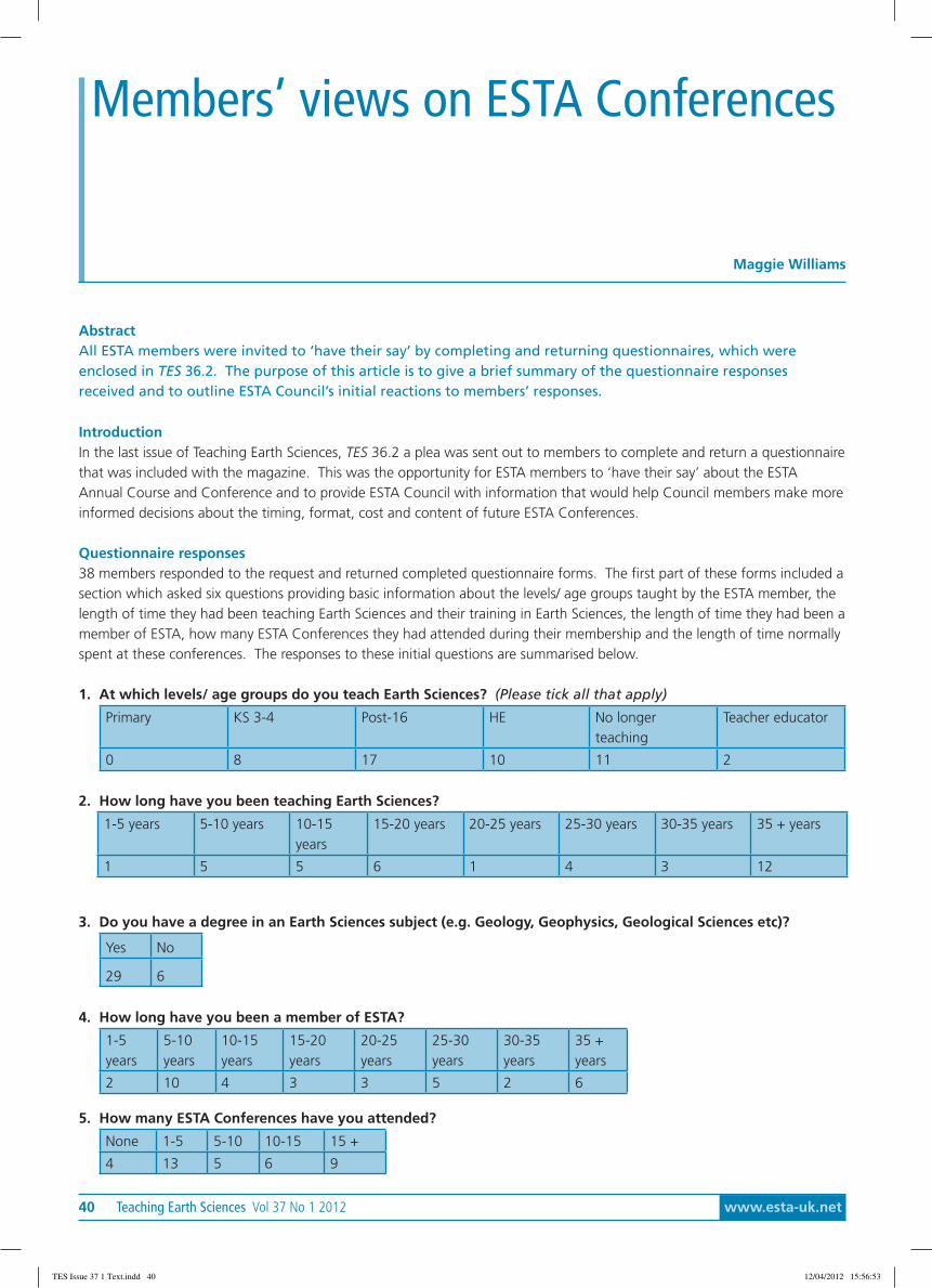
40 Teaching Earth Sciences Vol 37 No 1 2012 www.esta-uk.net
AbstractAll ESTA members were invited to ‘have their say’ by completing and returning questionnaires, which wereenclosed in TES 36.2. The purpose of this article is to give a brief summary of the questionnaire responsesreceived and to outline ESTA Council’s initial reactions to members’ responses.
IntroductionIn the last issue of Teaching Earth Sciences, TES 36.2 a plea was sent out to members to complete and return a questionnairethat was included with the magazine. This was the opportunity for ESTA members to ‘have their say’ about the ESTAAnnual Course and Conference and to provide ESTA Council with information that would help Council members make moreinformed decisions about the timing, format, cost and content of future ESTA Conferences.
Questionnaire responses38 members responded to the request and returned completed questionnaire forms. The first part of these forms included asection which asked six questions providing basic information about the levels/ age groups taught by the ESTA member, thelength of time they had been teaching Earth Sciences and their training in Earth Sciences, the length of time they had been amember of ESTA, how many ESTA Conferences they had attended during their membership and the length of time normallyspent at these conferences. The responses to these initial questions are summarised below.
1. At which levels/ age groups do you teach Earth Sciences? (Please tick all that apply)
Primary KS 3-4 Post-16 HE No longerteaching
Teacher educator
0 8 17 10 11 2
2. How long have you been teaching Earth Sciences?
1-5 years 5-10 years 10-15years
15-20 years 20-25 years 25-30 years 30-35 years 35 + years
1 5 5 6 1 4 3 12
3. Do you have a degree in an Earth Sciences subject (e.g. Geology, Geophysics, Geological Sciences etc)?
Yes No
29 6
4. How long have you been a member of ESTA?
1-5years
5-10years
10-15years
15-20years
20-25years
25-30years
30-35years
35 +years
2 10 4 3 3 5 2 6
5. How many ESTA Conferences have you attended?
None 1-5 5-10 10-15 15 +
4 13 5 6 9
Members’ views on ESTA Conferences
Maggie Williams
TES Issue 37 1 Text.indd 40 12/04/2012 15:56:53

www.esta-uk.net Vol 37 No 1 2012 Teaching Earth Sciences 41
6. How long do you normally attend at the ESTA Conference?
Attend for oneday
Attend for the wholeevent
Attend twodays
4 25 2
After these six basic questions the questionnaire posed a further ten questions. A summary of the responses received foreach of these questions is given below. Numbers in brackets after each response show the number of times responseswere received.
7. If you have attended an ESTA Conference, what were your reasons for attending? (Please tick all that apply)• Meeting colleagues (24)• Meeting other ESTA members (25)• Getting updates on current research in Earth Sciences (24)• Getting updates on exam changes (13)• Getting updates on the curriculum (13)• Finding out more about the teaching of Earth Sciences (24)• The social side of things (21)• Other (see below) (8)
Other reasons given:• Finding out about new fieldwork sites (3)• Chief Examiner for Geology – support (1)• To exhibit and purchase from the exhibition (1)• Getting and giving information on exam changes and updates to the curriculum (1)• To see the Giant’s Causeway and marvellous visits to Belfast and N.I. (1)• Getting ideas from other educators (1)• I am the TES Editor and attend to solicit articles for TES (1)
8. Which parts of the conference are most useful to you? (Please tick all that apply)• All of them (2)• Primary INSET (0)• KS 3-4 INSET (4)• Post-16 INSET (21)• HE INSET (8)• Keynote lectures (20)• Field visits (24)• Updating lectures (23)• Exhibition (18)• AGM (2)• Interactive workshops (17)• Bring and share sessions (16)• Other (see below) (1)
Other reasons given:• Networking. Perhaps make AGM more attractive by integrating an annual session on ‘national developments
in Geoscience curriculum and education’?
9. If you did NOT attend the Durham conference, can you tell us why not? (Please tick all that apply)• I could not get financial support to attend (7)• I had other commitments (e.g. marking examination papers, running school field visits) (16)• There was no specific INSET day (1)• The location - it was too far&/or too expensive to travel (3)• There were two ESTA Conferences in the 2010-11 year (6)• Other (see below).(8)
TES Issue 37 1 Text.indd 41 12/04/2012 15:56:53
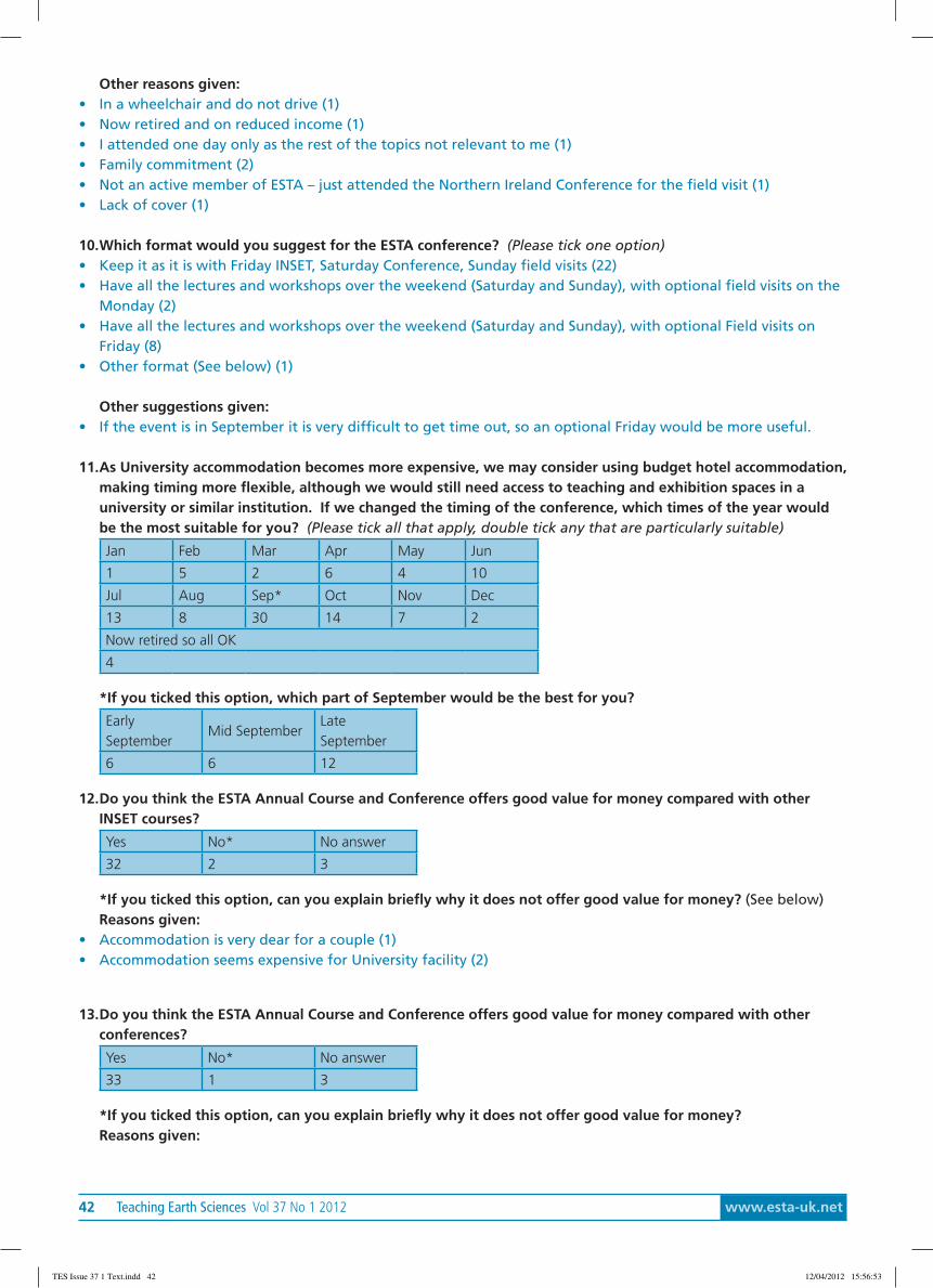
42 Teaching Earth Sciences Vol 37 No 1 2012 www.esta-uk.net
Other reasons given:• In a wheelchair and do not drive (1)• Now retired and on reduced income (1)• I attended one day only as the rest of the topics not relevant to me (1)• Family commitment (2)• Not an active member of ESTA – just attended the Northern Ireland Conference for the field visit (1)• Lack of cover (1)
10.Which format would you suggest for the ESTA conference? (Please tick one option)• Keep it as it is with Friday INSET, Saturday Conference, Sunday field visits (22)• Have all the lectures and workshops over the weekend (Saturday and Sunday), with optional field visits on the
Monday (2)• Have all the lectures and workshops over the weekend (Saturday and Sunday), with optional Field visits on
Friday (8)• Other format (See below) (1)
Other suggestions given:• If the event is in September it is very difficult to get time out, so an optional Friday would be more useful.
11.As University accommodation becomes more expensive, we may consider using budget hotel accommodation,making timing more flexible, although we would still need access to teaching and exhibition spaces in auniversity or similar institution. If we changed the timing of the conference, which times of the year wouldbe the most suitable for you? (Please tick all that apply, double tick any that are particularly suitable)
Jan Feb Mar Apr May Jun
1 5 2 6 4 10
Jul Aug Sep* Oct Nov Dec
13 8 30 14 7 2
Now retired so all OK
4
*If you ticked this option, which part of September would be the best for you?
EarlySeptember
Mid SeptemberLateSeptember
6 6 12
12.Do you think the ESTA Annual Course and Conference offers good value for money compared with otherINSET courses?
Yes No* No answer
32 2 3
*If you ticked this option, can you explain briefly why it does not offer good value for money? (See below)Reasons given:
• Accommodation is very dear for a couple (1)• Accommodation seems expensive for University facility (2)
13.Do you think the ESTA Annual Course and Conference offers good value for money compared with otherconferences?
Yes No* No answer
33 1 3
*If you ticked this option, can you explain briefly why it does not offer good value for money?Reasons given:
TES Issue 37 1 Text.indd 42 12/04/2012 15:56:53
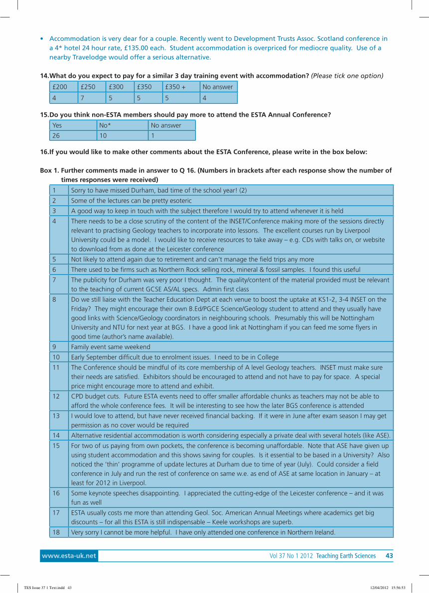
www.esta-uk.net Vol 37 No 1 2012 Teaching Earth Sciences 43
• Accommodation is very dear for a couple. Recently went to Development Trusts Assoc. Scotland conference ina 4* hotel 24 hour rate, £135.00 each. Student accommodation is overpriced for mediocre quality. Use of anearby Travelodge would offer a serious alternative.
14.What do you expect to pay for a similar 3 day training event with accommodation? (Please tick one option)
£200 £250 £300 £350 £350 + No answer
4 7 5 5 5 4
15.Do you think non-ESTA members should pay more to attend the ESTA Annual Conference?
Yes No* No answer
26 10 1
16.If you would like to make other comments about the ESTA Conference, please write in the box below:
Box 1. Further comments made in answer to Q 16. (Numbers in brackets after each response show the number oftimes responses were received)
1 Sorry to have missed Durham, bad time of the school year! (2)
2 Some of the lectures can be pretty esoteric
3 A good way to keep in touch with the subject therefore I would try to attend whenever it is held
4 There needs to be a close scrutiny of the content of the INSET/Conference making more of the sessions directlyrelevant to practising Geology teachers to incorporate into lessons. The excellent courses run by LiverpoolUniversity could be a model. I would like to receive resources to take away – e.g. CDs with talks on, or websiteto download from as done at the Leicester conference
5 Not likely to attend again due to retirement and can’t manage the field trips any more
6 There used to be firms such as Northern Rock selling rock, mineral & fossil samples. I found this useful
7 The publicity for Durham was very poor I thought. The quality/content of the material provided must be relevantto the teaching of current GCSE AS/AL specs. Admin first class
8 Do we still liaise with the Teacher Education Dept at each venue to boost the uptake at KS1-2, 3-4 INSET on theFriday? They might encourage their own B.Ed/PGCE Science/Geology student to attend and they usually havegood links with Science/Geology coordinators in neighbouring schools. Presumably this will be NottinghamUniversity and NTU for next year at BGS. I have a good link at Nottingham if you can feed me some flyers ingood time (author’s name available).
9 Family event same weekend
10 Early September difficult due to enrolment issues. I need to be in College
11 The Conference should be mindful of its core membership of A level Geology teachers. INSET must make suretheir needs are satisfied. Exhibitors should be encouraged to attend and not have to pay for space. A specialprice might encourage more to attend and exhibit.
12 CPD budget cuts. Future ESTA events need to offer smaller affordable chunks as teachers may not be able toafford the whole conference fees. It will be interesting to see how the later BGS conference is attended
13 I would love to attend, but have never received financial backing. If it were in June after exam season I may getpermission as no cover would be required
14 Alternative residential accommodation is worth considering especially a private deal with several hotels (like ASE).
15 For two of us paying from own pockets, the conference is becoming unaffordable. Note that ASE have given upusing student accommodation and this shows saving for couples. Is it essential to be based in a University? Alsonoticed the ‘thin’ programme of update lectures at Durham due to time of year (July). Could consider a fieldconference in July and run the rest of conference on same w.e. as end of ASE at same location in January – atleast for 2012 in Liverpool.
16 Some keynote speeches disappointing. I appreciated the cutting-edge of the Leicester conference – and it wasfun as well
17 ESTA usually costs me more than attending Geol. Soc. American Annual Meetings where academics get bigdiscounts – for all this ESTA is still indispensable – Keele workshops are superb.
18 Very sorry I cannot be more helpful. I have only attended one conference in Northern Ireland.
TES Issue 37 1 Text.indd 43 12/04/2012 15:56:53
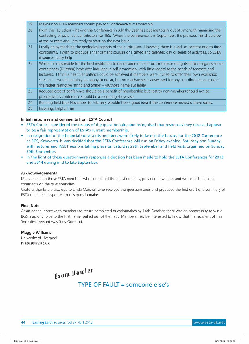
44 Teaching Earth Sciences Vol 37 No 1 2012 www.esta-uk.net
19 Maybe non ESTA members should pay for Conference & membership
20 From the TES Editor – having the Conference in July this year has put me totally out of sync with managing thecontacting of potential contributors for TES. When the conference is in September, the previous TES should beat the printers and I am ready to start on the next issue.
21 I really enjoy teaching the geological aspects of the curriculum. However, there is a lack of content due to timeconstraints. I wish to produce enhancement courses or a gifted and talented day or series of activities, so ESTAresources really help
22 While it is reasonable for the host institution to direct some of its efforts into promoting itself to delegates someconferences (Durham) have over-indulged in self-promotion, with little regard to the needs of teachers andlecturers. I think a healthier balance could be achieved if members were invited to offer their own workshopsessions. I would certainly be happy to do so, but no mechanism is advertised for any contributions outside ofthe rather restrictive ‘Bring and Share’ – (author’s name available)
23 Reduced cost of conference should be a benefit of membership but cost to non-members should not beprohibitive as conference should be a recruiting showcase
24 Running field trips November to February wouldn’t be a good idea if the conference moved o these dates.
25 Inspiring, helpful, fun
Initial responses and comments from ESTA Council• ESTA Council considered the results of the questionnaire and recognised that responses they received appear
to be a fair representation of ESTA’s current membership.• In recognition of the financial constraints members were likely to face in the future, for the 2012 Conference
at BGS, Keyworth, it was decided that the ESTA Conference will run on Friday evening, Saturday and Sundaywith lectures and INSET sessions taking place on Saturday 29th September and field visits organised on Sunday30th September.
• In the light of these questionnaire responses a decision has been made to hold the ESTA Conferences for 2013and 2014 during mid to late September.
AcknowledgementsMany thanks to those ESTA members who completed the questionnaires, provided new ideas and wrote such detailedcomments on the questionnaires.Grateful thanks are also due to Linda Marshall who received the questionnaires and produced the first draft of a summary ofESTA members’ responses to this questionnaire.
Final NoteAs an added incentive to members to return completed questionnaires by 14th October, there was an opportunity to win aBGS map of choice to the first name ‘pulled out of the hat’. Members may be interested to know that the recipient of this‘incentive’ reward was Tony Grindrod.
Maggie WilliamsUniversity of [email protected]
TYPE OF FAULT = someone else’sExam How
ler
TES Issue 37 1 Text.indd 44 12/04/2012 15:56:53
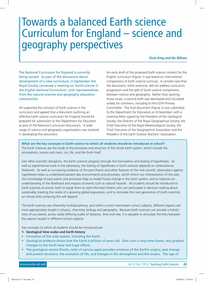
www.esta-uk.net Vol 37 No 1 2012 Teaching Earth Sciences 45
The National Curriculum for England is currentlybeing revised. As part of the discussions aboutdevelopment of a new curriculum, in September theRoyal Society convened a meeting on ‘Earth science inthe English National Curriculum’, with representativesfrom the natural sciences and geography educationcommunities.
All supported the inclusion of Earth science in thecurriculum and agreed that a document outlining aneffective Earth science curriculum for England should beprepared for submission to the Department for Educationas part of the National Curriculum discussions. A widerange of science and geography organisations was involvedin developing this document.
An early draft of the proposed Earth science content for theEnglish curriculum (Figure 1) was based on internationalcomparisons of Earth science curricula. A concern was thatthe document, while welcome, did not address curriculumprogression and the split of Earth science componentsbetween science and geography. Rather than duckingthose issues, a second draft was developed and circulatedwidely for comment, including to the ESTA PrimaryCommittee. The final document (Figure 2) was submittedto the Department for Education on 9 December, with acovering letter signed by the President of the GeologicalSociety, the Director of the Royal Geographical Society, theChief Executive of the Royal Meteorological Society, theChief Executive of the Geographical Association and thePresident of the Earth Science Teachers’ Association.
Towards a balanced Earth scienceCurriculum for England – science andgeography perspectives
Chris King and Nic Bilham
What are the key concepts in Earth science to which all students should be introduced at school?The Earth Sciences are the study of the processes and structure of the whole Earth system, which include theatmosphere, oceans and rivers, ice, life, and the Earth itself.
Like other scientific disciplines, the Earth sciences progress through the formulation and testing of hypotheses. Aswell as experimental work in the laboratory, the testing of hypotheses in Earth sciences depends on observationalfieldwork. As well as uncovering evidence of the past (fossils and other features of the rock record), observation againsthypotheses helps us understand present day environments and processes, which inform our interpretation of the past.Our knowledge of past events and processes help us model future change in the Earth system, and to improve ourunderstanding of the likelihood and impacts of events such as natural hazards. All students should be introduced toEarth sciences at school, both to equip them as well-informed citizens who can participate in decision-making aboutsustainably meeting the needs of a growing global population, and to stimulate the next generation of Earth scientistson whose skills achieving this will depend.
The Earth sciences are inherently multidisciplinary, and within current mainstream school subjects, different aspects aremost appropriately taught in physics, chemistry, biology and geography. Because Earth sciences can provide a holisticview of our planet, across vastly differing scales of distance, time and rate, it is valuable to articulate the links betweenthe aspects taught in different school subjects.
Key concepts to which all students should be introduced are:1. Geological time scales and Earth history• Formation of the solar system, including the Earth.• Geological evidence shows that the Earth is billions of years old. Over such a long time frame, very gradual
changes to the Earth have had huge effects.• The geological record (fossils, rocks of various ages) provides evidence of the Earth’s origins, past change
and present structure, the evolution of life, and changes in the atmosphere and the oceans. The age of
TES Issue 37 1 Text.indd 45 12/04/2012 15:56:53
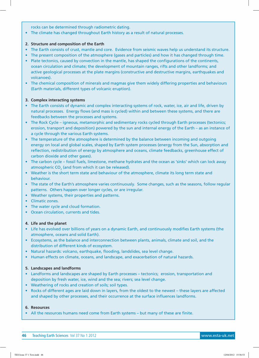
46 Teaching Earth Sciences Vol 37 No 1 2012 www.esta-uk.net
rocks can be determined through radiometric dating.• The climate has changed throughout Earth history as a result of natural processes.
2. Structure and composition of the Earth• The Earth consists of crust, mantle and core. Evidence from seismic waves help us understand its structure.• The present composition of the atmosphere (gases and particles) and how it has changed through time.• Plate tectonics, caused by convection in the mantle, has shaped the configurations of the continents,
ocean circulation and climate; the development of mountain ranges, rifts and other landforms; andactive geological processes at the plate margins (constructive and destructive margins, earthquakes andvolcanoes).
• The chemical composition of minerals and magmas give them widely differing properties and behaviours(Earth materials, different types of volcanic eruption).
3. Complex interacting systems• The Earth consists of dynamic and complex interacting systems of rock, water, ice, air and life, driven by
natural processes. Energy flows (and mass is cycled) within and between these systems, and there arefeedbacks between the processes and systems.
• The Rock Cycle – igneous, metamorphic and sedimentary rocks cycled through Earth processes (tectonics;erosion, transport and deposition) powered by the sun and internal energy of the Earth – as an instance ofa cycle through the various Earth systems.
• The temperature of the atmosphere is determined by the balance between incoming and outgoingenergy on local and global scales, shaped by Earth system processes (energy from the Sun, absorption andreflection, redistribution of energy by atmosphere and oceans, climate feedbacks, greenhouse effect ofcarbon dioxide and other gases).
• The carbon cycle – fossil fuels, limestone, methane hydrates and the ocean as ‘sinks’ which can lock awayatmospheric CO2 (and from which it can be released).
• Weather is the short term state and behaviour of the atmosphere, climate its long term state andbehaviour.
• The state of the Earth’s atmosphere varies continuously. Some changes, such as the seasons, follow regularpatterns. Others happen over longer cycles, or are irregular.
• Weather systems, their properties and patterns.• Climatic zones.• The water cycle and cloud formation.• Ocean circulation, currents and tides.
4. Life and the planet• Life has evolved over billions of years on a dynamic Earth, and continuously modifies Earth systems (the
atmosphere, oceans and solid Earth).• Ecosystems, as the balance and interconnection between plants, animals, climate and soil, and the
distribution of different kinds of ecosystem.• Natural hazards: volcano, earthquake, flooding, landslides, sea level change.• Human effects on climate, oceans, and landscape, and exacerbation of natural hazards.
5. Landscapes and landforms• Landforms and landscapes are shaped by Earth processes – tectonics; erosion, transportation and
deposition by fresh water, ice, wind and the sea; rivers; sea level change.• Weathering of rocks and creation of soils; soil types.• Rocks of different ages are laid down in layers, from the oldest to the newest – these layers are affected
and shaped by other processes, and their occurrence at the surface influences landforms.
6. Resources• All the resources humans need come from Earth systems – but many of these are finite.
TES Issue 37 1 Text.indd 46 12/04/2012 15:56:53

www.esta-uk.net Vol 37 No 1 2012 Teaching Earth Sciences 47
Figure 1. An early attempt at compiling a recommendation for the Earth science component of the National Curriculum in England.
Figure 2. The Earth science curriculument document submitted to the Department for Education.
In their letter to the Department, the signatoryorganisations welcomed the inclusion of Earth science, inits broadest sense, in the present curriculum, and set outsome of the reasons why it is vital that this should continue,as follows.• They observed that Earth science can provide a
holistic view of our planet, across vastly differingscales of distance, time and rate of change.
• They noted that these insights, together with theopportunity to observe evidence in the field andto use the evidence to formulate and test scientifictheory, equips students with valuable knowledge,understanding and skills, and encouragesinterdisciplinary thinking and problem solving.
• They stressed that is essential for all students to beintroduced to key knowledge, processes, conceptsand interpretive models in Earth science, in order
to help them become well-informed citizens, andto stimulate the next generation of Earth scientistson whose skills our future prosperity and socialwellbeing will depend.
Other organisations involved in the process but lacking theexpertise to comment on and support the Earth sciencedetail of the document, have written separately in supportof the general direction of the proposal.
This is the first time that the Earth science educationcommunity in the UK has come together with colleaguesfrom science and geography to develop a recommendedcurriculum that divides the teaching of Earth sciencerationally between science and geography and whichidentifies a logical progression of concepts suitablefor the different key stages. It is to be hoped that the
• Economic reserves, e.g. ores (rocks from which it is economic to extract metals, which will change over time).• Global distribution of mineral resources is dependent on past geological processes, which concentrate
materials, but slowly and unevenly.• Impacts of resource use (mining, wastes, land contamination etc), and sustainability.• Most of our energy currently comes from fossil fuels, releasing much of the carbon locked up over long
periods rapidly back into the atmosphere.• Renewable energy, energy efficiency and other low carbon technologies (e.g. CCS).
TES Issue 37 1 Text.indd 47 12/04/2012 15:56:53
48 Teaching Earth Sciences Vol 37 No 1 2012 www.esta-uk.net
recommendations will be taken very seriously and adoptedinto the curriculum.
The proposals for the National Curriculum for Scienceshould be published for consultation soon and it is tobe hoped that many or all of the recommendations inFigure 2 are included. If so, then those involved can becongratulated on a job well done, and begin to focus ondeveloping materials for the implementation of the newcurriculum. As deliberations continue, our organisationswill continue working to ensure that this happens, and ifnecessary we will call on the support of the wider Earthscience community in doing so. All that can be said fornow is ‘watch this space …’.
Stop press:The following was published on the Department forEducation website on 21st December 2011:
‘Revised timetable. The Secretary of State … announcedthat he has decided to change the planned timetablefor the introduction of the new National Curriculum toallow for more radical reform of both curriculum and
qualifications. … Instead of new curricula for English,mathematics, science and PE being introduced from 2013 -and any other subjects in 2014 - the new curriculum for allsubjects will now be introduced in 2014.’
AcknowledgementsWe are pleased to acknowledge and thank the manyorganisations and individuals involved in the preparation ofthese recommendations.
Chris King,Chair of the Secondary Committee of the Earth ScienceTeachers’ Association, Keele University,[email protected].
Nic BilhamHead of Strategy and External Relations at the [email protected].
ReferenceDepartment for Education website: http://www.education.gov.uk/schools/teachingandlearning/curriculum/nationalcurriculum/a0075667/national-curriculum-update
The transit of Venus 2012On June 5th or 6th (depending on your location) 2012, the last Transit of Venus to occur in our lifetimes will takeplace. Details of this and other historic transit events can be found at http://transitofvenus.nl/wp/
The phone app for the transit of Venus will be will be available in March.
TES Issue 37 1 Text.indd 48 12/04/2012 15:56:53
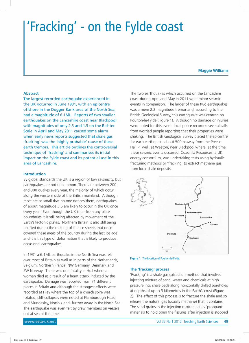
www.esta-uk.net Vol 37 No 1 2012 Teaching Earth Sciences 49
AbstractThe largest recorded earthquake experienced inthe UK occurred in June 1931, with an epicentreoffshore in the Dogger Bank area of the North Sea,had a magnitude of 6.1ML. Reports of two smallerearthquakes on the Lancashire coast near Blackpoolwith magnitudes of only 2.3 and 1.5 on the RichterScale in April and May 2011 caused some alarmwhen early news reports suggested that shale gas‘fracking’ was the ‘highly probable’ cause of theseearth tremors. This article outlines the controversialtechnique of ‘fracking’ and summarises its initialimpact on the Fylde coast and its potential use in thisarea of Lancashire.
IntroductionBy global standards the UK is a region of low seismicity, butearthquakes are not uncommon. There are between 200and 300 quakes every year, the majority of which occuralong the western side of the British mainland. Althoughmost are so small that no one notices them, earthquakesof about magnitude 3.5 are likely to occur in the UK onceevery year. Even though the UK is far from any plateboundaries it is still being affected by movement of theEarth’s tectonic plates. Northern Britain is also still beinguplifted due to the melting of the ice sheets that oncecovered these areas of the country during the last ice ageand it is this type of deformation that is likely to produceoccasional earthquakes.
In 1931 a 6.1ML earthquake in the North Sea was feltover most of Britain as well as in parts of the Netherlands,Belgium, Northern France, NW Germany, Denmark andSW Norway. There was one fatality in Hull where awoman died as a result of a heart attack induced by theearthquake. Damage was reported from 71 differentplaces in Britain and although the strongest effects wererecorded at Filey where the top of a church spire wasrotated, cliff collapses were noted at Flamborough Headand Mundesley, Norfolk and, further away in the North Sea.The earthquake was even felt by crew members on vesselsout at sea at the time.
The two earthquakes which occurred on the Lancashirecoast during April and May in 2011 were minor seismicevents in comparison. The larger of these two earthquakeswas a mere 2.2 magnitude tremor and, according to theBritish Geological Survey, this earthquake was centred onPoulton-le-Fylde (Figure 1). Although no damage or injurieswere noted for this event, local police recorded several callsfrom worried people reporting that their properties wereshaking. The British Geological Survey placed the epicentrefor each earthquake about 500m away from the PreeseHall -1 well, at Weeton, near Blackpool where, at the timethese seismic events occurred, Cuadrilla Resources, a UKenergy consortium, was undertaking tests using hydraulicfracturing methods or ‘fracking’ to extract methane gasfrom local shale deposits.
‘Fracking’ - on the Fylde coast
Maggie Williams
Figure 1. The location of Poulton-le-Fylde.
The ‘fracking’ process‘Fracking’ is a shale gas extraction method that involvesinjecting mixture of sand, water and chemicals at highpressure into shale beds along horizontally drilled boreholesat depths of up to 3 kilometres in the Earth’s crust (Figure2). The effect of this process is to fracture the shale and sorelease the natural gas (usually methane) that it contains.The sand grains in the injection mixture act as ‘proppant’materials to hold open the fissures after injection is stopped
TES Issue 37 1 Text.indd 49 12/04/2012 15:56:54

50 Teaching Earth Sciences Vol 37 No 1 2012 www.esta-uk.net
so that the gas can easily flow up the borehole to thesurface where it can then be extracted and either usedto generate electricity or to be fed into the gas grid. Thismeans that proppant materials are sorted for size andshape to provide the most efficient channels to allow fluidsto flow from the reservoir to the wellbore.
Initial responses to the shale gas discovery on theFylde coastAfter the minor earthquakes in April and May closeto the test drilling site at Weeton, near Blackpool anindependent geological report found that it was “highlyprobable” that the ‘fracking’ technique used had triggeredthese minor earthquakes. In June, following this report,Cuadrilla Resources suspended its fracking test operationsfor 30 days pending the results of a public enquiry. Theexploration company insisted however that the conditionsthat had caused the tremors were unlikely to occur again.
Protesters opposed to the gas extraction method soongathered in Blackpool claiming that shale gas extraction inBritain is untested, expensive and dangerous. Six protestersfrom the campaign group Frack Off subsequently climbed adrilling rig at one of Cuadrilla’s test drilling sites in HeskethBank, near Southport. Other protesters followed suitand a further three, who attached themselves to a rig inprotest against the contentious method of extracting gas,spent more than 12 hours on a shale gas drilling rig beforecoming down on 2nd December.
The ‘fracking’ controversyThe euphoria created by the media reporting the extentof the size of the Bowland Shale gas reserves did notcompletely ignore the problems associated with the‘fracking’ process. Even The Daily Mail in its Septemberonline headline posed the question: ‘Or will tapping intothis precious resource cause earthquakes and poison thewater in your tap?’
Sceptics point to the fact that ‘fracking’ has already beenbanned in France, New York and New Jersey, as wellas in Quebec and parts of Switzerland. The ‘fracking’controversy mainly centres on various problems caused bythe extraction process. These problems include:• The triggering of minor earthquakes.• Possible pollution problems. (Although much
of the water used in fracking is collected fromthe well and processed, water supplies may becontaminated with potentially toxic materialse.g. benzene which is added to the water to killoff bacteria that could clog the fissures in thefractured rocks, and to improve the efficiency ofthe process)
• High concentrations of methane in drinking watere.g. 64 milligrams of methane per litre of drinkingwater, compared with a normal level of onemilligram or lower. (Although there is no concernabout drinking the water with these levels ofmethane, there is a possible associated explosionhazard)
• The generation of shale gas may present a problemfor global warming.
Figure 2. The process of hydraulic fracturing or ‘fracking’
The advantages of using ‘fracking’ in the Fylde coastarea.Cuadrilla Resources discovered that Lancashire is sitting onone of largest reserves of ‘shale gas’ in Europe which couldbe extracted by ‘fracking’. The source rocks for this shalegas are the Carboniferous Bowland Shale Group of earlyNamurian age and according to results from Cuadrilla’s testwells, there are 200 trillion cubic feet of natural gas underthe ground, trapped in the Bowland Shales. Shale gas isnatural gas produced from such shale reservoirs. Methane(CH4) is the main constituent of most natural gas. Otherconstituents are ethane (C2H6), butane (C4H10) and pentane(C5H12), but it is only the thermally immature rocks that willcontain the greatest proportion of heavier hydrocarboncomponents.
By 23rd September, 2011 The Daily Mail had conjured upimages of the Fylde coast becoming one of the biggest gasdrilling projects in Europe with the online headline: ‘Willa vast gas field turn Blackpool into Dallas of the North?’As The Daily Mail reported, 200 trillion cubic feet of gasis ten times more than all the gas known to be left underthe North Sea, is one-fifth the size of the biggest gas fieldin the world, and is the volume of 66,666 Royal AlbertHalls. If all of this gas can be recovered, it was suggestedthat it could not only provide Britain with enough fuel tolast 50 years, but could also produce 400 gas wells acrossLancashire and create 5,600 jobs.
TES Issue 37 1 Text.indd 50 12/04/2012 15:56:54
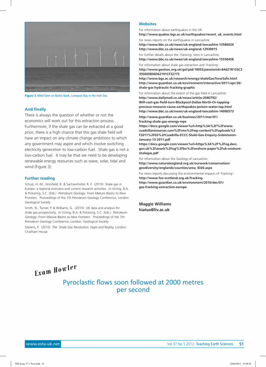
www.esta-uk.net Vol 37 No 1 2012 Teaching Earth Sciences 51
And finallyThere is always the question of whether or not theeconomics will work out for this extraction process.Furthermore, if the shale gas can be extracted at a goodprice, there is a high chance that this gas shale field willhave an impact on any climate change ambitions to whichany government may aspire and which involve switchingelectricity generation to low-carbon fuel. Shale gas is not alow-carbon fuel. It may be that we need to be developingrenewable energy resources such as wave, solar, tidal andwind (Figure 3).
Further readingSchulz, H.-M., Horsfield, B. & Sachsenhofer, R. F. (2010) Shale gas inEurope: a regional overview and current research activities. In Vining, B.A.& Pickering, S.C. (Eds.) Petroleum Geology: From Mature Basins to NewFrontiers. Proceedings of the 7th Petroleum Geology Conference, London:Geological Society
Smith, N., Turner, P. & Williams, G. (2010) UK data and analysis forshale gas prospectivity. In Vining, B.A. & Pickering, S.C. (Eds.) PetroleumGeology: From Mature Basins to New Frontiers. Proceedings of the 7thPetroleum Geology Conference, London: Geological Society
Stevens, P. (2010) The ‘Shale Gas Revolution: Hype and Reality, London:Chatham House
WebsitesFor information about earthquakes in the UK:http://www.quakes.bgs.ac.uk/earthquakes/recent_uk_events.html
For news reports on the earthquakes in Lancashire:http://www.bbc.co.uk/news/uk-england-lancashire-13586024http://www.bbc.co.uk/news/uk-england-12930915
For further details about the ‘fracking’ tests in Lancashire:http://www.bbc.co.uk/news/uk-england-lancashire-15550458
For information about shale gas extraction and ‘fracking’:http://www.geolsoc.org.uk/gsl/pid/10053;jsessionid=4A621B133C335DDE8D6D62191CF32773http://www.bgs.ac.uk/research/energy/shaleGas/howSafe.htmlhttp://www.guardian.co.uk/environment/interactive/2011/apr/26/shale-gas-hydraulic-fracking-graphic
For information about the extent of the gas field in Lancashire:http://www.dailymail.co.uk/news/article-2040792/Will-vast-gas-field-turn-Blackpool-Dallas-North-Or-tapping-precious-resource-cause-earthquakes-poison-water-tap.htmlhttp://www.bbc.co.uk/news/uk-england-lancashire-14990573
http://www.guardian.co.uk/business/2011/mar/01/fracking-shale-gas-energy-mpshttps://docs.google.com/viewer?url=http%3A%2F%2Fwww.cuadrillaresources.com%2Fcms%2Fwp-content%2Fuploads%2F2011%2F03%2FCuadrilla-ECCC-Shale-Gas-Enquiry-Submission-January-13-2011.pdfhttps://docs.google.com/viewer?url=https%3A%2F%2Fog.decc.gov.uk%2Fassets%2Fog%2Fbo%2Fonshore-paper%2Fuk-onshore-shalegas.pdf
For information about the Geology of Lancashire:http://www.naturalengland.org.uk/ourwork/conservation/geodiversity/englands/counties/area_ID20.aspx
For news reports discussing the environmental impacts of ‘fracking’:http://www.foe-scotland.org.uk/frackinghttp://www.guardian.co.uk/environment/2010/dec/01/gas-fracking-extraction-europe
Maggie [email protected]
Figure 3. Wind farm on Burbo Bank, Liverpool Bay in the Irish Sea.
Pyroclastic flows soon followed at 2000 metresper second
Exam Howler
TES Issue 37 1 Text.indd 51 12/04/2012 15:56:55
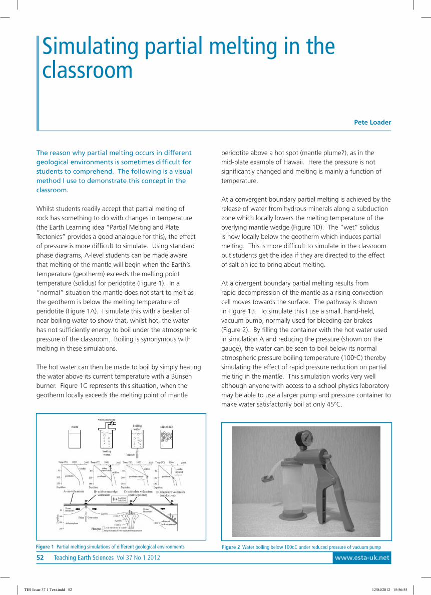
52 Teaching Earth Sciences Vol 37 No 1 2012 www.esta-uk.net
The reason why partial melting occurs in differentgeological environments is sometimes difficult forstudents to comprehend. The following is a visualmethod I use to demonstrate this concept in theclassroom.
Whilst students readily accept that partial melting ofrock has something to do with changes in temperature(the Earth Learning idea “Partial Melting and PlateTectonics” provides a good analogue for this), the effectof pressure is more difficult to simulate. Using standardphase diagrams, A-level students can be made awarethat melting of the mantle will begin when the Earth’stemperature (geotherm) exceeds the melting pointtemperature (solidus) for peridotite (Figure 1). In a“normal” situation the mantle does not start to melt asthe geotherm is below the melting temperature ofperidotite (Figure 1A). I simulate this with a beaker ofnear boiling water to show that, whilst hot, the waterhas not sufficiently energy to boil under the atmosphericpressure of the classroom. Boiling is synonymous withmelting in these simulations.
The hot water can then be made to boil by simply heatingthe water above its current temperature with a Bunsenburner. Figure 1C represents this situation, when thegeotherm locally exceeds the melting point of mantle
peridotite above a hot spot (mantle plume?), as in themid-plate example of Hawaii. Here the pressure is notsignificantly changed and melting is mainly a function oftemperature.
At a convergent boundary partial melting is achieved by therelease of water from hydrous minerals along a subductionzone which locally lowers the melting temperature of theoverlying mantle wedge (Figure 1D). The “wet” solidusis now locally below the geotherm which induces partialmelting. This is more difficult to simulate in the classroombut students get the idea if they are directed to the effectof salt on ice to bring about melting.
At a divergent boundary partial melting results fromrapid decompression of the mantle as a rising convectioncell moves towards the surface. The pathway is shownin Figure 1B. To simulate this I use a small, hand-held,vacuum pump, normally used for bleeding car brakes(Figure 2). By filling the container with the hot water usedin simulation A and reducing the pressure (shown on thegauge), the water can be seen to boil below its normalatmospheric pressure boiling temperature (100oC) therebysimulating the effect of rapid pressure reduction on partialmelting in the mantle. This simulation works very wellalthough anyone with access to a school physics laboratorymay be able to use a larger pump and pressure container tomake water satisfactorily boil at only 45oC.
Simulating partial melting in theclassroom
Pete Loader
Figure 2 Water boiling below 100oC under reduced pressure of vacuum pumpFigure 1 Partial melting simulations of different geological environments
TES Issue 37 1 Text.indd 52 12/04/2012 15:56:55

www.esta-uk.net Vol 37 No 1 2012 Teaching Earth Sciences 53
A Powerpoint presentation on this topic is availableon GEOTREX with ideas generated from a new book,Introducing Volcanology.
References and further readingPartial melting and plate tectonics
(http://earthlearningidea.blogspot.com/2010/06/partial-melting-and-plate-tectonics.html)
Minivac vacuum pump (www.minivac.com)
Jerram, D. (2011) Introducing Volcanology: A guide to Hot Rocks -Dunedin Academic Press
(reviewed in this journal)
Loader, P. (2012) Partial Melting Tutorial (Powerpoint) - GEOTREX
Peter LoaderSt Bede’s College, [email protected]
ESTA Treasurer - job vacancyThe current Treasurer has done the job for nearly 3 years and feels that it is now time for a change. Thismeans that ESTA is looking for a new Treasurer w.e.f. September 2012. As a senior officer of the associationthe Treasurer is at the centre of ESTA business. There is scope to be involved with a range of ESTA activities,although the new Treasurer will probably want to stick to the financial side at first and see how things go. ESTA’saccounting systems have been computerised.
Basic requirements• Patience and the ability to get on with others (e.g. Membership Secretary)• Time to devote to the task (e.g. a couple of hours each week, although the treasurer’s life is hectic in April when
dealing with the year-end accounts, in September/October when the AGM and Conference occur and DirectDebits have to be collected and in November when the Annual Return to the Charity Commission hasto be prepared).
• Ability to use common sense, a computer and a calculator!• Ability to use an accounting package such as EXCEL. (Most of ESTA’s accounting systems have been
computerized)
Main benefits of the Treasurer’s job• It is a challenging and rewarding job.• You meet lots of interesting people.
If you have reached this far then you are a good candidate for the job. Please email me to arrange a chat. (N.B. Iwill be available to help for as long as the handover takes!)
Maggie Williams(ESTA Chairman) and ESTA Treasurer (2002-2009)[email protected]
TES Issue 37 1 Text.indd 53 12/04/2012 15:56:56

54 Teaching Earth Sciences Vol 37 No 1 2012 www.esta-uk.net
AbstractGeology offers opportunities for study “on yourdoorstep” (sometimes almost literally) as well asvisits to exciting locations. This paper describes alithological analysis of pebbles from the soil in a backgarden in Hampshire. Although dominated by flint,this rock type fell into two distinct categories: wellrounded pebbles, and subangular pebbles, probablyreflecting two distinct sources which have beenmapped by the British Geological Survey (B.G.S.).
IntroductionAfter moving house, the stony nature of the soil in theback garden of our new home was immediately apparent,even though we had only moved about one mile and werein the same postcode area (SO53). We decided to collecta sample of stones and identify their types, counting thenumber of each rock type.
LocationThe garden is in a relatively new development (1987)on the North West edge of Chandler’s Ford, Hampshire.The underlying bedrock is the Earnley Sand Formation ofPalaeogene age, which is fine-grained. However, closeby are other early Tertiary units, including the ReadingFormation (with a basal pebble bed and pebble lenses) andremnants of a Quaternary river terrace lying on interfluvesin the neighbourhood (British Geological Survey, 1987).Down slope transport to the study site would have been
The stones in our garden
Mark Hayward
Figure 2 Tom Hayward and canine helper (?) sampling pebbles.
very likely. Both of these could be sources of gravel. Figure1 is a Google Earth image of the neighbourhood.
MethodStones already exposed at the surface by gardening, rainsplash and (possibly) frost heave were sampled (Figure 2).For ease of identification and sampling, only pebbles morethan 10 mm (long axis) were removed. 214 were obtained,and were placed into categories determined by lithology(rock type) and particle shape (Table 1).
Table 1 Results of pebble count
Lithology NumberFlint: well rounded, often stained (iron, manganese) 62
Flint: subangular, patinated 136
Orthoquartzite or sarsen 6
Anthropogenic, e.g. concrete, cement 10
DiscussionThe local bedrock is not chalk, so all of the flint musthave been transported into the area. As flint gravel isroutinely used in the building and construction industry,an anthropogenic source cannot be ruled out. However,the geology mapped by the B.G.S. indicates two probablesources of the flint. The well rounded flint gravel indicatesa long period of transport, possibly reworking of oldermaterial. The basal pebble bed of the Reading Formation ischaracterised by subangular flints, but localised gravel lensesoccur within the formation, including very well roundedpebbles, frequently bearing chatter marks, the result of
Figure 1 Google Earth image of the study area (accessed 29.06.11). Areas ofriver terrace remnants have been sketched in. A railway line curves from South Eastto North West. South of this line, the solid geology is mainly Earnley Sand; north ofthe line, London Clay and Reading Formation. Scale line 500 metres.
TES Issue 37 1 Text.indd 54 12/04/2012 15:56:56
www.esta-uk.net Vol 37 No 1 2012 Teaching Earth Sciences 55
high energy collisions, e.g. on a beach (Edwards & Freshney,1987). The rounding may have taken place over anextended period of reworking, including into river terraces.
Subangular flints are abundant and many less than 10mm long were ignored. The patination (weathering rind)suggests weathering of the flint, particularly of impuritiesin the silica (Hurst &Kelly, 1961) possibly in a pedogenic(soil) environment. These flints are presumed to have beenderived from Quaternary river terrace deposits. The terracesediments themselves are possibly related to cold-stageaggradation, when transport may have been relatively shortin duration during the thaw seasons (and short distance,with the nearest chalk outcrop only a few kilometresaway). There was clear evidence that fractures, includingcharacteristic conchoidal ones, occurred before patination.Some breakage could have resulted from frost-shattering(noted elsewhere, e.g. Catt, no date). Possibly the flintgravel was weathered in its terrace deposit for an extendedperiod. This distinction between two distinct populationsof flint gravel is a common phenomenon, as, for example,in exposures of Quaternary deposits along the shore of theSolent (West, 2007).
The observation, above, that flint gravel could have beenleft by building work, should be taken into account,especially as several pieces of cement and concrete werefound.
Lithological analysis outside of areas subjected toQuaternary glaciations is unlikely to throw up exotic andfar-travelled material, particularly in an area of soft rock.However, the stone-count revealed a few examples of rocksother than flint. A few small pebbles of quartzite or sarsen(siliceous sandstone) were found, and a single small quartzpebble (included with the former in the table). Sarsenstone (from a virtually destroyed Palaeogene deposit ontop of the chalk) would not be surprising as it is reasonablycommon in river terrace deposits in the region. Thepossibility of a very small amount of far-travelled materialfrom the South West can be considered as it is clear thatTertiary river systems flowed eastwards from Devon andCornwall (Gibbard & Lewin, 2003).
ConclusionThis simple study in an area of decidedly unspectaculargeology has shown that evidence can be found to drawsome interesting conclusions. If such a study were spreadmore widely, for example involving a class, interestingpatterns could emerge that prompt further interpretationsor hypotheses. Perhaps more important, a real sense ofthe passage of time, similar to the wonder felt when JamesHutton showed John Playfair the Siccar Point unconformity,can be felt if the history of a rounded flint pebble from asuburban garden is considered:
1. Upper Cretaceous (maybe 75 million years ago):silica deposited on the floor of a warm sea.
2. Subsequent burial under many metres of morechalk and later deposits.
3. Initial uplift and erosion (probably the firstphase of removal of great thickness of overlyingdeposits). The original flint nodule is exposed toweathering and erosion.
4. Rounding and reduction in size, possibly on severaloccasions, on beaches 40-50 million years ago.Occasional storms cause pebbles to clash togetherand cause chatter marks.
5. Further uplift (the result of Alpine tectonics andthe continued opening of the Atlantic, maybe25 million years ago) resulting in the great latePalaeogene/Neogene gap in our rock record: ourpebble’s story is lost during this time.
6. During the Quaternary (roughly the last twomillion years), recycling of the pebble throughcycles of erosion and deposition in the river system.
7. Washed down slope from its latest resting placein a river terrace deposit, maybe in prehistory.Further movement during deforestation.
It would be a less romantic story if the last episode in thestory was being a leftover of a builder’s aggregate!
AcknowledgementThanks to Tom Hayward for help with the sampling,identification and counting.
ReferencesBritish Geological Survey (1987) Southampton. England and Wales Sheet315. Solid and Drift Geology. 1:50,000. Keyworth, Nottingham. BritishGeological Survey.
Catt, J.A. (no date) Geology on your doorstep.Hertfordshire geologicalSociety. http://www.hertsgeolsoc.ology.org.uk/IntroToHertsGeology.htm [Accessed 30.06.11]
Edwards, R. A. & Freshney, E.C. (1987) Geology of the Country aroundSouthampton. Memoir of the British Geological Survey. Sheet 315(England and Wales).
Hurst, V.J. & Kelly, J.R. (1961) Patination of cultural flints. Science 28,pp.251-256.
Gibbard, P. & Lewin, J. (compilers) (2003) History of the major riversof southern Britain during the Tertiary. Quaternary PalaeoenvironmentsGroup, University of Cambridge. http://www.qpg.geog.cam.ac.uk/research/projects/tertiaryrivers/ [Accessed 30.06.11]
West, I. (2007) Solent Estuaries Introduction: Geology Field Trip Guide.Internet site: www.soton.ac.uk/~imw/solshore.htm. School of Oceanand Earth Sciences, Southampton University, UK. Version: 6 February2007. [Accessed 30.06.11]
Mark HaywardHavant Sixth Form [email protected]
Editor’s comment: If you want to read more about geologicalhistory deduced from pebbles I can recommend The planetin a pebble: a journey into Earth’s deep history by JanZalasiewicz, published by OUP in 2010.
TES Issue 37 1 Text.indd 55 12/04/2012 15:56:56
56 Teaching Earth Sciences Vol 37 No 1 2012 www.esta-uk.net
Teenagers are a demanding audience and as teacherswe are supposed to be informative and entertaining.Hence I find myself trying to ‘infotain’ (inform andentertain) a sizeable gaggle of computer-savvy sixteento eighteen year olds that belong to the Harry Pottergeneration and are used to CGI, X Factor and Ipods.
‘Today we are going to learn about “Unformitarianism”’ .I can hear the panic rising in the room – such a long wordin our snappy acronym filled world! ‘Nvm’ (nevermind)the concept itself! And geological time is hardlyinstantaneous!! So how do we tap into the minds of thosewho have never seen a record, can’t remember tapes andas for videos – sigh (Mum and Dad had one of those whenthey got married)?? Instant Apps, Twitter and Blogs – that’swhat they want! Can we provide it? Yes, we can and asbait into wider reading they work very well.
TwitterActually opening an account is relatively easy, type ‘Twitter’into Google and follow the instructions. Then give thestudents your ‘Twitter’ account address and they’ll followyou, usually via their smart phone. I’ve had some goodlinks posted to me by students - one for calculatingstandard deviation was particularly useful. You can nagthem via ‘Twitter’ too: Why not do an hour’s revisiontoday? Think how smug you’ll feel.
Yet the way I have found ‘Twitter’ to be most useful is fromthe wider links with the Earth science community: otherteachers, science magazines, Brian Cox, NASA, BGS, USGS.By following a variety of ‘Tweeters’ I gained a variety ofknowledge: a competition in Geo Times, BGS summer workplacements, the latest in the debate on partial melting andso forth. I ‘Retweet’ any posts that I believe my studentswill find interesting or educational: small bite-sized nuggetsof information. Sometimes the students will click on linksand read on further.
One of my best sources of information is the BBC NewsApp (on my phone but you can get it on any computer).I ‘Tweet’ allsorts from here: the recently discovered HoffCrab, storms in the UK, landslide in the Philippines,
crocodile ate lawnmower (they really loved that one),ostriches have bloodless erections (they really loved thatone!). I have no personal information on my account onlythat I teach Geography and Geology ‘A levels’ in Stockport.Just type ‘geoggeol’ into the Twitter search box and you’llfind me– anyone interested in Earth Sciences is welcome tofollow. Note: You may occasionally have to remove EasternEuropean call girls from following you if you set up yourown Twitter account – or not if you prefer.
My BlogAgain it’s relatively easy to open an account, type ‘blogspot’into Google and follow the instructions. Admittedly it’shelpful if you are with someone who has already set oneup. There is a ‘dashboard’ link at the top of the screen.From here you can control your account: what you upload,how the blog looks and the information on your profile.Embedding data such as ‘Youtube’ clips and ‘PowerPoints’requires some computer skills and knowledge and you needto open a ‘Slideshare’ account (again follow the instructionson Google). Get a geeky student to help you if necessary.Once you are up and running the blogspot format itself isvery logical and user friendly. The advantage of a blog isthat the information posted does not disappear down ‘TheTimeline’ as with ‘Twitter’. You can label your posts so thatstudents can access sections easily: Careers, Earthquakes,Faults, Folds, Homework, Revision, Volcanoes, World Cities.Students can ‘join’ you and then post questions but theycan easily access the information without being members.It’s a little like ‘Moodle’ (for those of you that have usedsuch things) but more open, more flexible and easier touse. Mine is: http://aquinasgeology.blogspot.com/
AppsQuakeWatch, Geotimescale, GeolCompass, Pangaea,GeoQuiz, Microscope, iGeology, BBC News, to name buta few, are apps which are either free or very cheap. Thestudents love to download them right there and then inthe lesson (any excuse to get the phone out). It’s amazinghow many students will greet me with recent earthquakedata or ask if I’ve seen news on a discovery at a deep seavolcanic vent. They use this cyber world, they are at homein it, somehow geological time is less scary in an App.
Making use of Tweets, Blogs and Appsin your teaching
Angela Bentley
TES Issue 37 1 Text.indd 56 12/04/2012 15:56:56

www.esta-uk.net Vol 37 No 1 2012 Teaching Earth Sciences 57
The use of Tweets, Blogs and Apps doesn’t immediatelyencourage the development of higher skills, but as ‘bait’ tolead students in to wider knowledge and understanding,their use is invaluable and works well for my gaggle ofstudents.
Angela [email protected]
GeoConservationExposuresESTA members may not be aware of the consequences of not-so-recent governmentcutbacks at the Joint Nature Conservancy Council. Publication of the internationallyimportant volumes of the Geoconservation Review series has been rescued, largely fundedby the Geologists’ Association and issued as parts of the Proceedings. The Marine Devonian of Great Britain is the firstvolume under the GA, as Proceedings Geological Association 122 (4) October 2011.
PGA 122 (5) November 2011 is a Special Issue on the Geological History of the Isle of Wight, arising from the BritishGeological Survey’s Isle of Wight Integrated Project. A new 1:50,000 scale Geological Special Sheet and Explanationbooklet are due later.
Go to www.geologistsassociation.org.uk for membership details. For purchases click on “Proceedings” and followthe links to the publishers, Elsevier.
Earth Heritage Magazine is now all-electronic. Go to www.earthheritage.org.uk to download recent issues and signup for future mailings.
GeoConservationUK Newsletter is also available. E-mail the Editor, Tom Hose, at: [email protected]
To contact any of the 52 county-based Member Groups of GeoConservationUK go to www.gcuk.org.uk click onContacts or e-mail [email protected]
For Earth Science On-Site teaching materials for KS2 - GCSE at 16 sites in England, go to www.gcuk.org.uk click onEducation.
TES Issue 37 1 Text.indd 57 12/04/2012 15:56:56

58 Teaching Earth Sciences Vol 37 No 1 2012 www.esta-uk.net
The Earth Science Education Unit has carried out anewspaper survey as a contribution to the debatearound the English National Curriculum, which iscurrently being revised. Eight UK newspapers weresurveyed for three weeks over a five week period latein 2011. The survey found that, although more thanhalf the stories covered health/medical topics, 10% ofthe stories were Earth science-related, and that thiswas more than all the physics- and chemistry-relatedstories put together.
The survey focussed mainly on the ‘quality’ newspapers,since they contain a higher proportion of science storiesthan the ‘tabloids’ or ‘popular press’ (Bauer et al., 1995).The newspapers were surveyed over three separate weeksspanning a five-week interval; the weeks beginning 9th
October, 23rd October and 6th November, 2011. The eightnewspapers included were the Daily Mail, Daily Telegraph,Guardian, Times, Independent on Sunday, Mail on Sunday,Sunday Telegraph and Sunday Times; 170 articles wereidentified covering 148 different stories.
The approach was chosen to mirror a similar survey,carried out in 2003 to contribute to the previous NationalCurriculum debate (Hyden & King, 2006). The 2003survey covered the same newspapers for three of fiveweeks in March/April 2003. Two hundred science-based
Earth science in the news- sciencecoverage by UK national newspapers
Chris King and Fiona Hyden
Science topic Findings of the 2011 survey Findings of the 2003 survey
No. of stories % of stories No. of stories % of stories
Health/Medical 80 54 60 40
Environment/Ecology 24 16 27 18
Biology 10 7 23 15
Physics 6 4 7 4
Chemistry 3 2 0 0
Earth Science 14 10 10 7
Technology 7 5 16 11
Public understanding of science 2 1 8 5
Not categorised 1 1 0 0
Total 147 100 151 100
Table 1. Findings of the 2011 survey set against those of the 2003 survey.
Figure 1. Diagrammatic findings of the 2011 survey set against those of the 2003survey.
TES Issue 37 1 Text.indd 58 12/04/2012 15:56:56

www.esta-uk.net Vol 37 No 1 2012 Teaching Earth Sciences 59
articles covering 151 different stories were identified. Thecategorisation of these stories, compared with the 2011findings, is shown in Table 1 and Figure 1.
The table and diagrams show the following:
• the very high percentage of ‘health/medical’ storiesrecorded in 2003 had increased to more than halfof the stories by 2011 (54%);
• the number of stories about ‘Earth science’ hadincreased in 2011, to 10% of all the stories;
• whilst no stories related to chemistry appearedin the 2003 survey, ‘chemistry’-related storiescomprised 2% of the data in 2011;
• the numbers of ‘environment/ecology’- and‘physics’-focussed stories remained similar;
• the percentage of stories related directly to‘biology’ and to ‘technology’ approximately halved(to 7% and 5% respectively);
• the percentage of ‘public understanding of science’stories reduced from 5% to 1%.
There were the 18 Earth science-related headlines from the2011 survey which are shown in Table 2
Given that the two surveys were eight years apart andone was conducted in the spring and the other in theautumn, it seems fair to combine the data from these two‘snapshots’ together to give a reasonable representation
of the UK newspaper coverage as a whole over this time.Thus, taken together, the results of the two surveys give thefollowing rank order of topics:
• Health/medical (47%)• Environment/ecology (17%)• Biology (11%)• Earth science (8%)• Technology (8%)• Physics (4%)• Public understanding of science (3%)• Chemistry (1%)
Headline Newspaper and date
Undisturbed for million years…until now The Times, Tuesday 11/10/11
Meteorite smashes through roof of Comette family’s Paris home The Guardian, Tuesday 11/10/11
Kazakh gas sector quietly gains momentum The Daily Telegraph, Tuesday 11/10/11
Scientists count every grain of sand in erosion study The Times, Thursday 13/10/2011
T rex just got bigger The Daily Telegraph, Thursday 13/10/2011
Airlines feel the heat as volcano rumbles The Guardian, Friday 14/10/2011
The wonder gas that could cut your energy bill The Times, Sunday 23/10/2011
Earthquake death toll may reach 1,000 The Times, Monday 24/10/2011
1,000 feared dead in Turkish earthquake as survivors left to fend forthemselves
The Guardian, Monday 24/10/2011
Gone with the wind: the dinosaurs who kicked up a stink The Times, Thursday 27/10/2011
Migration clue to giant size of dinosaurs The Guardian, Thursday 27/10/2011
Did all life begin in a Greenland volcano? The Daily Mail, Friday 28/10/2011
Origins of life traced to a volcano in Greenland The Daily Telegraph, Friday 28/10/2011
Scientists scour suburbs for the rare space rock that fell to earth The Times, Monday 07/11/2011
Commodities. Advocates keep the shale gas flame alight The Daily Telegraph, Monday 07/11/2011
Hope amid ruins as quake city bids cathedral farewell The Times, Thursday 10/11/2011
Obama to delay $7bn oil pipeline The Times, Friday 11/11/2011
The science column. The law that shows why wealth flows to the 1% The Guardian, Saturday 12/11/2011
Table 2. The headlines of Earth science-related stories found in the 2011 survey.
Figure 2. Diagrammatic representation of the balance of science across theNational Curriculum for Science at KS3/4 (11-16 year olds), omitting the ‘Scientificconcepts and processes (KS3)/ How science works (KS4)’ (2007 version, as statutoryin 2012).
TES Issue 37 1 Text.indd 59 12/04/2012 15:56:57

60 Teaching Earth Sciences Vol 37 No 1 2012 www.esta-uk.net
This rank order of newspaper coverage can be comparedwith the balance of science in the current NationalCurriculum for Science (NCS) (2007 version, current in 2012)by summing the statements relating to each area of science(DfE, KS3 science; DfE, KS4 science). The percentages foundby this exercise are shown in Table 3. Figure 2 shows thedata for KS3 and 4 together, but with the omission of the‘Scientific concepts and processes (KS3)/ How science works(KS4)’ section, since this is about how scientists ‘do’ science,and was not a category of the newspaper survey
Whilst summing the statements in the NSC only gives acrude picture of the balance of science in the curriculum,nevertheless, comparisons between the balance of the NSCand that of the newspaper surveys are revealing:
• even if only part of the ‘health/medical’ and‘environment/ecology’ newspaper categories areassigned to ‘biology’, the biology-related contentof the newspaper survey is still far greater thanthat of the current NCS;
• there is significantly less physics and much lesschemistry in the newspaper survey than in the NCS;
Scientificdiscipline N
o.s
tate
men
tsat
KS3
%st
atem
ents
atK
S3
No
.sta
tem
ents
atK
S4
%st
atem
ents
atK
S4
Tota
lno
.sta
tem
ents
atK
S3&
KS4
Tota
l%st
atem
ents
atK
S3&
KS4
Biology 5 19 5 17 10 18
Physics 3 12 4 13 7 13
Chemistry 3 12 4 13 7 13
Earth science 1 4 1 3 2 4
Astronomy 1 4 1 3 2 4
Environmentalscience
1 4 1 3 2 4
Scientificconcepts andprocesses (KS3)/How scienceworks (KS4)
12 46 14 47 26 46
Totals 26 100 30 100 56 100
Table 3. The percentage of science content in the National Curriculum for Science atKey Stage 3 (KS3, 11-14 year olds) and Key Stage 4 (KS4, 14-16 year olds) obtainedby summing the relevant numbers of statements.
• although ‘environment’ was not treated separatelyin the newspaper survey, the percentage of storiesrelated to the environment is likely to be far largerthan the ‘environmental science’ content of the NCS;
• the ‘Earth science’ content of the newspaper surveyis greater than that of the NCS.
The findings of the newspaper surveys need to be setagainst the low percentage of science-related stories foundin newspapers overall. One of the articles covered by the2003 survey contained the following, ‘The ratio of arts toscience writers on most broadsheets is still something inthe region of 20:1. It’s very rare for serious science storiesto fight their way on to front pages.’ ‘There is no escapingthe fact that science is a difficult thing to cover. Any half-trained reporter can hammer out a story on child poverty,immigration or archaeology. It’s rather more difficult toattempt something on superstrings, RNA interference,or nanotechnology.’ (Rusbridger, 2003). This statistic isreinforced by the findings of the Science Museum MediaMonitor (Bauer et al., 1995) that, between 1946 and1990, science stories occupied only around 5% of the totalspace in UK newspapers. Meanwhile Greek newspaperscontained 2% of science stories (Dimopoulos & Koulaidis,2003); US newspapers had 2% science (Pellechia, M.,1997); and the Australian press contained 2.9% of science-related stories (Metcalfe & Gasgoine, 1995).
Newspapers are only one of the media outlets availabletoday, and the balance of science stories elsewhere inthe media may differ. However, a survey of European TVcoverage found that only 8% of stories (218/2676) werescience-related (León, 2008) – similar to the 5% sciencecoverage of UK newspapers, reported above.
In a review carried out in 1996, Hutton found that thescience coverage by UK newspapers was complementaryto the UK curriculum at the time. However, this wasnot the case for the 2003 survey of Hyden and King(2006) where, ‘The content of biological science in thenewspapers is clearly very much greater than that of theNational Curriculum for Science; the Earth science contentis also greater; the content of physics and chemistry in thenewspapers is significantly less.’ (p83).
The findings of the 2011 newspaper survey describedabove were similar to the 2003 survey, with high levels ofbiological science, higher levels of environmental scienceand Earth science, and a low level of physics and chemistrycoverage in the newspapers, when compared with thepresent version of the NCS.
In the current educational climate in the UK, where thereis much talk by the government of the science curriculumin terms of ‘biology, chemistry and physics’ (e.g. see: DfE
TES Issue 37 1 Text.indd 60 12/04/2012 15:56:57
www.esta-uk.net Vol 37 No 1 2012 Teaching Earth Sciences 61
website, Review of the National Curriculum n EnglandSummary report of the call for evidence), it is to be hopedthat the government will still see the need to preparepupils for the scientific and technological aspects of theirfuture lives, including to, ‘be able to understand andrespond critically to, media reports of issues with a sciencecomponent’ (Miller & Osborne, 1998, p2012). In thiscontext, the breadth and balance of science in the UKnewspaper coverage should be taken into account as thenext revision is being debated.
ESTA, together with other organisations interested inthe Earth science content of the revised English NationalCurriculum, has submitted a formal contribution to thedebate; this can be seen in King and Bilham (2012).
ReferencesBauer, M., Durant, J., Ragnarsodottir, A. & Rudolphsdottir, A. (1995)Science and Technology in the British Press, 1946 – 1990. London: TheScience Museum.
Department for Education (DfE) website, Review of the NationalCurriculum in England Summary report of the call for evidence: https://www.education.gov.uk/publications/eOrderingDownload/NCR%20-%20Call%20for%20Evidence%20Summary%20Report.pdf
Department for Education website, secondary curriculum subjects, KS3(DfE, KS3 science): http://media.education.gov.uk/assets/files/pdf/q/science%202007%20programme%20of%20study%20for%20key%20stage%203.pdf
Department for Education website, secondary curriculum subjects, KS4(DfE, KS4 science): http://media.education.gov.uk/assets/files/pdf/q/science%202007%20programme%20of%20study%20for%20key%20stage%204.pdf
Dimopoulos, K. & Koulaidis, V. (2003) Science and technology educationfor citizenship: the potential role of the press. Science Education, 87,pp.241-256.
Hutton, N. (1996) Interactions between the formal UK school sciencecurriculum and the public understanding of science. Public Understandingof Science, 5(1) pp.41-53.
Hyden, F. & King, C. (2006) What the papers say: science coverage by UKnational newspapers. School Science Review, 88 (322), pp.81-86.
León, B. (2008) Science related information in European television:a study of prime-time news. Public Understanding of Science, 17(4),pp.443-460.
King, C. & Bilham, N. (2012) Towards a balanced Earth science Curriculumfor England – science and geography perspectives. Teaching EarthSciences. 37(1) pp. 45-48.
Metcalfe, J. & Gascoigne, T. (1995) Science journalism in Australia. Publicunderstanding of science, 4, pp.411-428.
Millar, R. & Osborne, J. (1998) Beyond 2000: science education for thefuture. London: King’s College.
Pellechia, M. (1997) Trends in science coverage: a content analysis ofthree US newspapers. Public Understanding of Science, 6, pp.49-68.
Rusbridger, A. (2003) Making sense of Life. The Guardian 3/4/2003.London: The Guardian.
Chris King is Professor of Earth Science Education in theSchool of Public Policy and Professional Practice at KeeleUniversity,[email protected]
Fiona Hyden is an associate lecturer with the OpenUniversity and a consultant sedimentologist in the [email protected] , [email protected]
The 34th International Geological Congress (IGC) will be held in Brisbane, Australia 5-10th August 2012. Detailscan be found at http://www.geoscied.org/
TES Issue 37 1 Text.indd 61 12/04/2012 15:56:57
62 Teaching Earth Sciences Vol 37 No 1 2012 www.esta-uk.net
The next generation of scientists and engineers hasbeen given a unique chance to shine – with the helpof Prospect. In October, the union helped organisethe first ever union-led competition at the WorldSkills2011 event at the ExCel Centre, London, viewed bymore than 200,000 visitors. The union worked witha range of partners, including members at the BritishGeological Survey, supported by WorldSkills UK, indevising an environmental science competition.
Five teams from the UK and one from the Netherlandswere asked to design a sustainable energy solution for anisland community; build a renewable energy generator;and present a report to judges justifying their solution andwinning over members of the local community.
Head of research for Prospect, Sue Ferns said: “TheWorldSkills event is an exciting shop window for youngtalent to demonstrate their skills and dedication to solvingtomorrow’s problems. It is a great opportunity for youngpeople to show prospective employers that they representthe future of engineering and science. Climate change isone of the greatest challenges facing the UK and worldeconomy. It is essential to attract skilled and motivatedyoung scientists to work in this vital area. Prospect isproud to have played a part in raising awareness of theopportunities that exist for them to make a difference.”
Principal sponsors of the competition were the Tec TrustFund and the National Skills Academy for Power, supportedby BGS, Semta, Unionlearn, EAL, Green Collar Academy,Summit Skills, National Nuclear Laboratory and EnergySolutions.
Jacqui Henderson, trustee of the Tec Trust Fund said:“Science, maths, engineering, manufacturing and
technology skills are now recognised as essential to thefuture wellbeing of the UK economy.”
Steve Davies, chief executive of the power skills academy,said: “The power sector is facing increasingly critical skillsissues, which if not addressed now will have a dramaticimpact on electricity supply in the UK and the government’senergy and low carbon strategies.”Tom Wilson, director of Unionlearn, hailed the opportunityto recognise that excelling in making things and doingthings is just as valuable as academic ability. “Evidenceshows that where unions and employers work togetherthey can develop the skills of staff to compete in acompetitive global market.”
Teams from Newcastle College and Pembrokeshire Collegewon gold and silver medals respectively at the competition.
Entries are now open for 2012 and details, includingpre-competition activities, can be found at http://worldskillsuk.apprenticeships.org.uk/get-involved/national-competitions/browse-competitions/built-environment/environmental-science
There is a 10-minute video at http://www.youtube.com/watch?v=oXoiPOk4YEY featuring interviews withcompetitors and sponsors (as well as the ‘party popperexperiment’).
This competition was very rewarding for everyoneinvolved with a very high calibre of entries. We hope theenvironmental science competition will be fully integratedinto World Skills by the time the next international event isheld in Leipzig in 2013.
http://worldskillsuk.apprenticeships.org.uk/home
Skills showcase for new talent
TES Issue 37 1 Text.indd 62 12/04/2012 15:56:57

TES Issue 37 1 Text.indd 63 12/04/2012 15:56:58

64 Teaching Earth Sciences Vol 37 No 1 2012 www.esta-uk.net
Caught in the CrunchRebecca Ansell & John TaberHarper Collins Publishers (New Zealand) Ltd. 1996(Reprinted 1999)ISBN 1 86950 201 9Paperback - NZ$34.95 (approx £17)
Are you planning a trip to New Zealand; or know someonewho is - a neighbour, family member or one of yourstudents? This, I understand, will be the only way of gettinghold of a copy of this book. “Why bother with a review fora book that is so difficult to get hold of?” you will be asking.I aim to assure you that it will be worth the trouble.
This is not a textbook yet it covers topics in a thorough andorderly way with excellent illustrations. It is not a coffee-table book - it is not primarily devoted to splendid colourphotographs with text that leaves you needing more. The16 photographs (all colour) are of a high quality and sotoo are the diagrams and maps so essential to a completeexplanation. It is far more than merely a record of thedisasters that the country has suffered. It has 188 pages, is18.5 x 24.2x1.2cm with stiff cover.
One of the special features, of course, is the unusualpoint of view – the map showing plate movement, forexample, is centred on the Pacific plate (moving at 10cm/yr); examples of events, both seismic and volcanic, includethose we’ve heard of before (Hawke’s Bay 1931) as well assome we’ve probably not heard of (Inangahua 1968).
Here comes the big one starts by noting that NZ is similarto Japan in being on the western edge of the pacific plate.Wellington sits on the Wellington Fault which has beengiven a 40%-45% chance of moving in the next 50yrs; thereader is then asked to imagine what the experience wouldbe like when it occurs.
Are we ready? refers to building codes, the need ofbuildings to be demolished or strengthened; flexibleframes and rubber bearings. A map of Wellington showszones of different shaking potential – the greatest damageassociated with liquifaction. The precautions to be takenand the survival kit for the home and for school are listed.
Planet of conveyor belts deals with convection, theearly days of plate tectonic theory, the development ofmagnetometers, magnetic stripes, plate movements.
The next two chapters Explaining Earthquakes andRecording Earthquakes extending over 28 pages, coverwhat one expects but also includes detailed instructions formaking a coffee-can seismometer – rather more chance ofit proving effective in NZ than in UK!
There are two chapters, one on the Napier and Hastingsearthquake (1931) and the other on the Edgecumbeearthquake (1987) and the special feature of the treatmentis the use of recollections of those affected, both childrenand adults. At the end of the section on earthquakes(Chapter 10) the author writes about predicting ‘quakesand particularly about the consequences of actually issuinga prediction.
The last 50 pages are devoted to volcanic topics. Chapter12 is about Auckland being situated on a hot spot (11pages). Within the last chapter (24 pp) there is a focus onthe Taupo Volcanic Zone from White Island to Ruapehu butalso included are Christchurch and Dunedin in South Island.
The book ends with an Appendix on the Modified MercalliScale (I – VI) referring separately to people, fittings,structures and environment; and four pages of Glossary.Those who manage to obtain a copy for their class will
Reviews
TES Issue 37 1 Text.indd 64 12/04/2012 15:56:58

www.esta-uk.net Vol 37 No 1 2012 Teaching Earth Sciences 65
have problems supervising fair sharing!And, lastly, it weighs 544g.
Peter Perkins
Geology for DummiesAlecia M. SpoonerWiley Publicating Inc. – 2011ISBN 978-1-118-02152-1Paperback: £9.27 (Amazon)Kindle edition: £8.81(Amazon)
My concerns on receiving this book for review werethat Geology for Dummies would be just another oneof those watered-down, American style text books ongeology that tried to do too much and fell short of beinguseful for GCSE and A-level students for either of thecurrent specifications on offer in the UK. My fears weresomewhat unfounded and I found the reality very readable,informative and, though lacking detail, never-the-less agood sound introduction for students new to the subjectand certainly helpful for both AS and A2 students.
The book comprises 25 separate chapters organised undersix main headings:
1. Studying the Earth: 4 chapters providing anintroduction to geological science giving an overviewof the scope and practise of the subject involved withits laws and principles. The later part gives a basicoutline of the Earth’s systems and structure from theatmosphere to the core.
2. Elements, Minerals and Rocks: 3 chapters outliningthe physical and chemical properties of minerals andin particular the structure of silicate minerals. Igneous,sedimentary and metamorphic rocks are then explainedwith reference to their mineralogy, texture and mode offormation within the rock cycle. Within 30 pages rocksare identified, classified and their processes of formationbriefly explained using jargon-free language that is easy
to access for later reference – all appropriate for AS levelat least.
3. One Theory to explain it all: Plate Tectonics: 3 chaptersreviewing current understanding of plate theory andthe evidence. This is a good section with a basic butfull outline of the evidence for the various boundariesand processes involved, including partial melting,earthquakes and current models for mantle convection.
4. Superficially speaking: About Surface Processes: 5chapters which inevitably cover all the surface processes(above and below ground) in the rock cycle as in mostphysical geology texts for the American market. Thisis in more detail than is really needed for UK geologyspecifications (e.g. geomorphology of braided streams,meandering streams, straight channels, oxbow lakes etc.all included in detail) though useful background. Whilstglacial, aeolian and fluvial and coastal sedimentaryenvironments are included, sadly shallow (coral reef)and deep marine environments and processes (turbiditycurrents) are not mentioned or are poorly covered.Interestingly, in the chapter on glaciers, the authorbriefly deals with Milankovich cycles and climatechange.
5. Long, long ago, in this galaxy right here: 7 chapterscovering the 4.6 billion years of geological time. Thissection includes geochronological principles andabsolute dating methods in some detail (isotopic anddendrochronological methods). It also covers basicpalaeontology, the evolution of animals and plantsand their increasing diversity through time along withtheories of mass extinctions. As a basic grounding ofthe stratigraphic column it is excellent, even mentioningthe Burgess Shale lagerstätten and Snowball Earththeory though this book does not attempt to cover fossilmorphology and many faunal groups are not mentioned(e.g. graptolites, brachiopods or bivalves).
6. The part of tens: This short section of 2 chapter brieflydeals with the human influence of man on geology(building dams, fracking for gas, climate change etc.)and vice versa (hazards associated with earthquakes,landslides, and volcanic eruptions). There are few casestudies and little detail for answering exam questionsand this section is more a note to refer you othersources.
The book is presented in the format of other Dummiespublications, written in a clear, often humorous style andillustrated with a large number of black and white linedrawings to visually illustrate an idea. Some of these aregood but often they are over stylised and sometimes theydetract and give a false impression particularly when they
TES Issue 37 1 Text.indd 65 12/04/2012 15:56:58

66 Teaching Earth Sciences Vol 37 No 1 2012 www.esta-uk.net
are devoid of scales and annotation. In addition thereare 8 pages of excellent colour photos. As yet I have notfound any glaring howlers in the text that would endorsethe misconceptions already given by other sources though Idid wince when I read that “The line where the material inthe Earth’s lithosphere changes from the crustal rock to themantle rock (the asthenosphere) is named the Moho….”
Like all books in the Dummies series, Geology for Dummiesis not meant to be anything other than a general courseintroduction to the extensive subject that encompassesgeology, and as such it does its job well. Whilst in placesit is possibly less relevant to modern UK specifications, it ischeap and there is enough in here for me to recommendit to my students as a useful supplementary course guide,particularly as they start the subject from scratch. Indeed,there is little excuse for them feeling like “dummies” for tolong with this as a guide.
Pete LoaderChief Examiner (AS/A2 WJEC)
introducing Volcanology: aguide to Hot Rocks.Dougal JerramDunedin Academic Press Ltd. – Oct. 2011ISBN 978-1-906716-22-6Paperback: £9.99
This is the next book to be published in the popular“Introducing…” range of earth science texts from Dunedin(previously titles were reviewed in past journals) and, putquite simply, it is excellent. Indeed I have spent this year’sWJEC INSET courses orally promoting it and I am nowpleased to be able to do so in print.
Introducing Volcanology is written by Dr Dougal Jerram(aka “Dr Volcano”) whom many will know from TVappearances and in particular his reporting in the aftermath
of the 2010 Eyjafjallajökull eruption in Iceland – whichnaturally features in this book. The book is the same size(19.4 x 16.2 x 1.2 cm) and format as the other books inthe series and is divided into 10 chapters plus a glossary(Dr Volcano’s A-Z of Volcanoes covering from aa lava tozeolites).
Writing authoritatively for an informed adult audience,which would include A-level students and above, theauthor answers the questions: What are volcanoes? Howdo rocks melt? How do volcanoes relate to plate tectonicsand movement of the continents? What are eruptionsand why do they occur? How have volcanoes affected theearth’s climate? And can we predict eruptions? He alsodescribes the most notable eruptions in history and theireffects.
This is a modern book exploring evidence from 2D and3D seismic images, magnetic anomaly maps, grounddeformation GPS data, satellite interferometry andthermal imaging maps and the latest 3D laser scanningtechniques to produce high resolution virtual outcropreconstructions, all of which are adequately explainedwith the minimum use of technical terms; ideal to keepstudents up to date without losing them in jargon. Thetext is lavishly illustrated with some 85 colour illustrationsincluding photos, diagrams, tables and charts and I wasparticularly impressed by the graphic illustrations and clearexplanation of partial melting which I have used to producea power point on the subject available for ESTA memberson GEOTREX. The chapter on “monitoring volcanoes”also gives a clear and modern approach to the subject forstudents studying geology and the human environmentcourses at AS level. Throughout there are some excellentcase study materials for both student and teacher (andexaminer!) alike along with coverage of other importantaspects of current geology courses – Bowen’s ReactionSeries, mineral descriptions, igneous rock classification andigneous structures.
But don’t just take my word for it. Go out and get yourselfa copy and I am sure, like me, you will soon be directingyour AS and A2 students to the best coverage of this topicon the market, written to a level suitable for them and atan affordable price.
Indeed. I can’t wait for other titles in the series to becomeavailable in the spring and summer of 2012, if they are ofthis standard.
Pete LoaderGeology Master – St Bede’s College, Manchester
TES Issue 37 1 Text.indd 66 12/04/2012 15:56:58
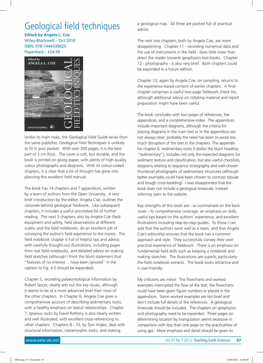
www.esta-uk.net Vol 37 No 1 2012 Teaching Earth Sciences 67
Geological field techniquesEdited by Angela L. CoeWiley-Blackwell – Oct 2010ISBN: 978-1444330625Paperback : £24.99
Unlike its main rivals, the Geological Field Guide series fromthe same publisher, Geological Field Techniques is unlikelyto fit in your pocket. With over 300 pages, it is the bestpart of 2 cm thick. The cover is soft, but durable, and thebook is printed on glossy paper, with plenty of high-qualitycolour photographs and diagrams. With its colour-codedchapters, it is clear that a lot of thought has gone intoplanning this excellent field manual.
The book has 14 chapters and 7 appendices, writtenby a team of authors from the Open University. A verybrief introduction by the editor, Angela Coe, outlines therationale behind geological fieldwork. Like subsequentchapters, it includes a useful annotated list of furtherreading. The next 3 chapters, also by Angela Coe (fieldequipment and safety; field observations at differentscales; and the field notebook), do an excellent job ofconveying the author’s field experience to the novice. Thefield notebook chapter is full of helpful tips and advice,with carefully thought-out illustrations, including pagesfrom real field notebooks, and detailed advice on makingfield sketches (although I think the blunt statement that“features of no interest ... have been ignored” in thecaption to Fig. 4.5 should be expanded).
Chapter 5, recording palaeontological information byRobert Spicer, clearly sets out the key issues, althoughit seems to be at a more advanced level than most ofthe other chapters. In Chapter 6, Angela Coe gives acomprehensive account of describing sedimentary rocks,with a healthy emphasis on lateral relationships. Chapter7, igneous rocks by David Rothery, is also clearly writtenand well illustrated, with excellent cross-referencing toother chapters. Chapters 8 - 10, by Tom Argles, deal withstructural information, metamorphic rocks, and making
a geological map. All three are packed full of practicaladvice.
The next two chapters, both by Angela Coe, are moredisappointing. Chapter 11 - recording numerical data andthe use of instruments in the field - does little more thandirect the reader towards geophysics text-books. Chapter12 - photography - is also very brief. Both chapters couldbe expanded in a future edition.
Chapter 13, again by Angela Coe, on sampling, returns tothe experience-based content of earlier chapters. A finalchapter comprises a useful two-page fieldwork check-list,although additional advice on collating material and reportpreparation might have been useful.
The book concludes with two pages of references, theappendices, and a comprehensive index. The appendicesinclude important diagrams, although the criteria forplacing diagrams in the main text or in the appendices arenot always clear; probably the need has been to avoid toomuch disruption of the text in the chapters. The appendixfor chapter 6, sedimentary rocks (I dislike the blunt heading:“Sedimentary”), includes not only the expected diagrams forsediment texture and classification, but also useful checklists,diagrams relating to sequence stratigraphy and well-chosenthumbnail photographs of sedimentary structures (althoughbetter examples could have been chosen to contrast tabularand trough cross-bedding). I was disappointed that thebook does not include a geological timescale, insteadreferring users to the website.
Key strengths of this book are - as summarised on the backcover - its comprehensive coverage, an emphasis on skills,useful tips based on the authors’ experience, and excellentillustrations including step-by-step guides. To those I canadd that the authors work well as a team, and that AngelaCoe’s editorship ensures that the book has a commonapproach and style. They successfully convey their ownpractical experience of fieldwork. There is an emphasis onfundamental field skills such as keeping a notebook andmaking sketches. The illustrations are superb, particularlythe field notebook extracts. The book looks attractive andis user-friendly.
My criticisms are minor. The flowcharts and workedexamples interrupted the flow of the text; the flowchartscould have been given figure numbers or placed in theappendices. Some worked examples are too brief anddon’t include full details of the references. A geologicaltimescale should be included. The chapters on geophysicsand photography need to be expanded. Three pages ondetermining location by triangulation seems excessive incomparison with less than one page on the practicalities ofusing gps. More emphasis and detail should be given to
TES Issue 37 1 Text.indd 67 12/04/2012 15:56:58

68 Teaching Earth Sciences Vol 37 No 1 2012 www.esta-uk.net
magnetic declination and how to deal with it. Eye protectionwhen hammering should be given more emphasis. The useof a carbide-tipped chainsaw is probably beyond the scopeof most intended users. Although the safety advice forworking at active volcanoes emphasises the need to wear ahelmet, the geologists illustrated in this section are not. Itis a shame that peperite is not illustrated. Actual errors arevery few: there are a handful of typos, one or two errors inthe flow charts and a wrong heading in Figure 6.6.
The main disadvantage, of course, is that this book won’tslip into a pocket. But it does deserve space in yourbackpack. And if I had to choose between this and anyone of the Geological Field Guide series, I’d choose thisbook on account of its comprehensive coverage, lovelyillustrations, practical tips and attractive appearance.Teachers and students of geology at all levels will benefitfrom this clearly written, well organised, superbly illustratedbook packed with helpful advice.
Geraint OwenSwansea University
Plates vs Plumes: aGeological ControversyGillian R. FoulgerWiley-Blackwell - 2010ISBN 978-1-4443-3679-5Paperback: £39.95
Since the inception of the mantle plume hypothesis in1971, the advent of new evidence has precipitated revisionsof the hypothesis. In the opinion of Gillian Foulger, authorof Plates vs Plumes: a Geological Controversy, theserevisions have rendered the hypothesis unfalsifiable, andas such, it is currently of little scientific value. This detailedand well argued book presents an alternative theory; thatmantle melting anomalies are driven by established platetectonic processes. This review serves as an assessment ofthe book’s utility for teaching, and not a specific commenton the ‘plates vs plumes’ debate.
The book begins with an introduction to both theoriesbefore dealing with specific topics of interest to thedebate, including chapters on petrology and geochemistry,seismology and volcanology. Each chapter is conciselyintroduced to better place the reader within the argument,and ends with a series of ‘exercises for the student’. Theseconsist of questions to focus the student’s reading of theprevious chapter. While these questions are sometimes alittle broad in scope, they support the text and are by nomeans unimportant – questions such as ‘are “hot spots”hot?’ are central to the debate. The text is abundantlyillustrated with schematic figures and well presented graphsin both colour and black and white, which a geologyteacher (or examiner) would find particularly useful.
In order to assess properly this complex debate, it is clearlynecessary for the author to address complex issues. Despitethe challenging material, which may be beyond the interestof the non-technical reader, the author introduces andoutlines deftly such technical concepts as are necessary, andthe comprehensive reference list ably directs the interestedreader to further material.
In spite of the apparently even handed title, this bookunashamedly sets out to banish the plume model andits proponents to the same fate as those who unwiselyargued against Wegener’s theory of Continental Drift overa century ago. In its place, the author presents a newmodel in which she clearly has overwhelming confidence.While one admires the conviction required to challenge theestablished scientific order, the partiality of the text is a littleconstricting from time to time. With this said, the bookdoes introduce students to topics at the forefront of currentresearch, and provides a valuable insight into is ‘howscience works’ and the nature of academic debate.
While the author may not convince every sceptical readerto abandon the mantle plumes hypothesis, and the ‘plumesor plates’ debate will no doubt rumble on, she has certainlyproduced here an excellent, up-to-date synthesis of botharguments. Part detailed text book, part personal crusadefor parity, this book serves not only as a comprehensive(if a little biased) guide through the debate, but alsoan excellent introduction to the many aspects of Earthsciences. The complex and occasionally esoteric nature ofthe discussion (plus the price) will perhaps preclude all butthe most interested A-Level students, but should find awilling readership amongst their teachers, undergraduateuniversity students, and beyond. Further reference can befound at www.mantleplumes.org
Matt LoaderDept. of Earth Science and Engineering, Imperial College,London
TES Issue 37 1 Text.indd 68 12/04/2012 15:56:59
www.esta-uk.net Vol 37 No 1 2012 Teaching Earth Sciences 69
april 201212th-14th AprilGeographical Association Conference: Geographies ofDifferenceUniversity of ManchesterContact: www.geography.org.uk/
18th AprilShell London Lecture: Reconciling past and future worlds:geology and ground engineeringThe Geological Society, Burlington House, Piccadilly,London, W1J 0BGContact: www.geolsoc.org.uk/gsl/events/shelllondonlectures12
23rd-25th AprilGeosciences Information for Teachers (GIFT) Symposium:WaterViennaContact: www.egu.eu/
May 20129th MayShell London Lecture: Unconventional GasThe Geological Society, Burlington House, Piccadilly,London, W1J 0BGContact: www.geolsoc.org.uk/gsl/events/shelllondonlectures12
12th-13th MayManchester Rock’n’Gem Show,Contact: www.rockngem.co.uk
June 20129th – 10th JuneKempton Park Rock’n’Gem Show,Contact: www.rockngem.co.uk
16th-17th JuneSomerset Rock’n’Gem Show,Shepton Mallet, SomersetContact: www.rockngem.co.uk
27th JuneShell London Lecture: Sustainability of groundwaterin a changing worldThe Geological Society, Burlington House, Piccadilly,London, W1J 0BGContact: www.geolsoc.org.uk/gsl/events/shelllondonlectures12
august 20124th-8th AugustKempton Park Rock’n’Gem Show,Contact: www.rockngem.co.uk
11th-12th AugustRock’n’Gem Show,Royal Welsh Showground, Builth WellsContact: www.rockngem.co.uk
september 20128th-9th SeptemberNewton Abbott Rock’n’Gem Show,Newton Abbott RacecourseContact: www.rockngem.co.uk
26th SeptemberShell London Lecture: Volcanoes and manThe Geological Society, Burlington House, Piccadilly,London, W1J 0BGContact: www.geolsoc.org.uk/gsl/events/shelllondonlectures12
28th-30th SeptemberESTA Annual Conference: Digital tools for geology teachingBGS, KeyworthContact: [email protected]
Diary
TES Issue 37 1 Text.indd 69 12/04/2012 15:56:59

70 Teaching Earth Sciences Vol 37 No 1 2012 www.esta-uk.net
October 201210th OctoberShell London Lecture:Pollutants and human healthin the age of manThe Geological Society, Burlington House,Piccadilly, London, W1J 0BGContact: www.geolsoc.org.uk/gsl/events/shelllondonlectures12
13-14th OctoberGeological Association Conference:Rivers through geological timeRoyal Albert Memorial Museum, Exeter.Contact: www.geologistsassociation.org.uk/Events
22nd – 23rd OctoberLecture: Appreciating Physical Landscapes:Geotourism 1670 – 1970.The Geological Society, Burlington House,Piccadilly, London, W1J 0BGContact: [email protected]
November 201214th NovemberShell London Lecture:Geological Aspects of Renewable Energy.The Geological Society, Burlington House,Piccadilly, London, W1J 0BGContact: http://www.geolsoc.org.uk/gsl/events/shelllondonlectures12
December 201219th DecemberShell London Lecture: Incoming:Learning to love the meteorite,The Geological Society, Burlington House,Piccadilly, London, W1J 0BGContact: www.geolsoc.org.uk/gsl/events/shelllondonlectures12
January 20132-5th January 2013Association of Science Educators Annual ConferenceUniversity of ReadingContact: www.ase.org.uk/conferences/annual-conference/
september 2013ESTA Annual Conference, Plymouth UniversityContact: [email protected]
september 2014ESTA Annual Conference, Open University
TES Issue 37 1 Text.indd 70 12/04/2012 15:56:59
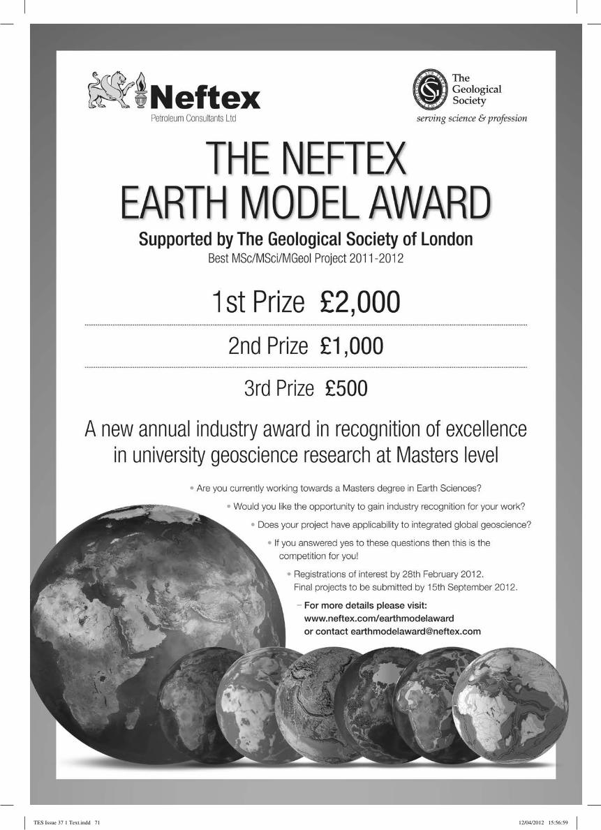
TES Issue 37 1 Text.indd 71 12/04/2012 15:56:59
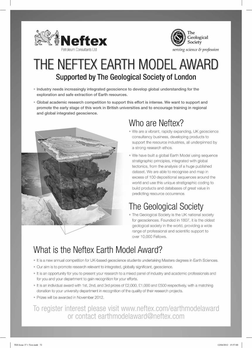
TES Issue 37 1 Text.indd 72 12/04/2012 15:57:00