Embed Size (px)
Citation preview

Isle of Wight Local Flood Risk
Management Strategy
Final Report July 2016
Isle of Wight Council
Isle of Wight Council, Seaclose Offices, Fairlee Road, Newport, Isle of Wight, PO30 2QS
Tel. 01983 821000. Web: www.iwight.com

DOCUMENT CONTROL
General information
Title Isle of Wight Local Flood Risk Management Strategy
Owner Wendy Perera, Head of Planning and Housing Services – Isle of Wight Council
Version Final Report
File status Active
Revision history
Summary of changes
Completed by
Date
Current version?
First Draft EA/IWC 28/11/2013 No
Second Draft EA/IWC 02/05/2014 No
Third Draft EA/IWC 05/02/2015 No
Consultation Draft IWC 31/03/2016 No
Final Draft Report IWC 14/06/2016 No
Final Report IWC Executive
Committee 14/07/2016 Yes
Programmed Review IWC 31/07/2021
Final report - LFRMS, July 2016
iii
FOREWORD
The Isle of Wight Council is pleased to introduce the Isle of Wight Local Flood Risk
Management Strategy. The flooding experienced on the Island during the winter of 2013/14
highlighted many of the planning and emergency response challenges we face. The
unprecedented rainfall as well as the exceptionally high tides was a real test on all risk
management authority resources and further underlined the need for responsibilities to be
identified and acted on, and that we, the authorities should be investing in flood risk projects
wherever possible to reduce the impact to the people who live, work and visit the Island.
What this unprecedented rainfall has shown us, is that while traditionally flooding is
attributed to rivers and the sea, surface water flooding is causing just as much impact to
local communities.
This is the first Local Flood Risk Management Strategy for the Island since receiving new
duties and powers for flood management under the Flood and Water Management Act 2010.
The council sees the document enabling the Isle of Wight Council to highlight the need and
to prioritise and invest money in flood risk management for local benefit. This local strategy
sets out how we as a Lead Local Flood Authority will work alongside other risk management
authorities to work together to achieve this.
There are tough challenges ahead because we must accept that flooding cannot simply be
stopped. There will always be a risk present in flood prone areas.
We must also accept that we cannot undertake a flood risk management project in all flood
prone locations, but it is important to have risks and projects highlighted so that when we are
able to progress a project, it can be prioritised and delivered accordingly. This is also
important so that people can protect themselves and prepare for flooding to reduce the
impacts to them.
This strategy will answer common questions such as:
Who and what is at risk?
Who has the responsibility and authority?
What and where do you invest funds?
How do you prioritise one area over another?
This strategy will help enable the Isle of Wight Council as Lead Local Flood Authority to
deliver the new responsibility of local flood risk management with our partners.
This strategy identifies actions that can be taken over the coming years to reduce the risk of
flooding on the Island and will help us to plan for the likely impacts of climate change. We
look forward to using this strategy to help us target our efforts and resources more efficiently
to reduce flood risk to the residents of the Isle of Wight.
Cllr Paul Fuller, Executive Member for Environment (Sustainability) and Local Engagement
Cllr Phil Jordan, Executive Member for Public Health, Public Protection and PFI

Final report - LFRMS, July 2016
iv
Contents
FOREWORD .............................................................................................................. iii
Appendices: ............................................................................................................... v
Glossary of terms and acronyms ................................................................................ vi
1. Introduction ............................................................................................................ 1
1.1 What is the purpose of the Local Flood Risk Management Strategy? ........... 1
1.2 What does the Strategy cover? ..................................................................... 1
1.3 Format of the Strategy .................................................................................. 1
1.4 Other documents linked to the Strategy ........................................................ 1
1.5 Consultation on the LFRMS .......................................................................... 2
2. Strategy objectives ................................................................................................. 3
2.1 Strategy objectives and aims ........................................................................ 3
2.2 Guiding principles .......................................................................................... 4
3. Flood Risk on the Island ...................................................................................... 5
3.1 What is Flood Risk ........................................................................................ 5
3.2 What is classed as a flood?........................................................................... 6
3.3 Types of flood risk ......................................................................................... 6
3.4 Significant historic flood events on the Island ............................................. 12
3.5 Flood risk to the Island in the future ............................................................ 14
4. Roles and Responsibilities ................................................................................ 19
4.1 Who is responsible for managing flood risk? ............................................... 19
4.2 What is the Isle of Wight Council’s role? ..................................................... 19
4.3 What is the Environment Agency’s role? ..................................................... 19
4.4 What is Southern Water’s role? ................................................................... 20
4.5 What is Island Roads’ role?......................................................................... 20
4.6 What is the Landowner’s role? .................................................................... 20
5. Actions to Address Flood Risk on the Island ..................................................... 22
5.1 Ways of managing flood risk ....................................................................... 22
5.2 Existing actions ........................................................................................... 23
5.3 Isle of Wight Council actions ....................................................................... 25
5.4 Island-wide actions ...................................................................................... 25
5.5 Island Roads actions ................................................................................... 25
5.6 Local actions ............................................................................................... 25

Final report - LFRMS, July 2016
v
6. Environmental Impacts of Actions ..................................................................... 27
6.1 Strategic Environmental Assessment .......................................................... 27
6.2 Habitats Regulation Assessment ................................................................ 27
6.3 Water Framework Directive Assessment .................................................... 27
7. Funding ............................................................................................................. 28
8. Flood Events ..................................................................................................... 30
8.1 How to prepare for a flood event ................................................................. 30
8.2 What should I do during a flood event? ....................................................... 31
8.3 What do the authorities do during a flood event? ........................................ 31
8.4 What will the LLFA do following a flood event? ........................................... 33
9. Monitoring and Review ...................................................................................... 35
Appendices:
Appendix A Guiding principles of the National Flood and Coastal Erosion Risk
Management Strategy
Appendix B Recorded incidents of historic flooding on the Island
Appendix C Tidal Climate Change Predictions
Appendix D Blackwater
Appendix E West Wight
Appendix F Yarmouth
Appendix G Brighstone
Appendix H Ventnor
Appendix I Wroxall
Appendix J The Bay
Appendix K Brading
Appendix L Bembridge
Appendix M St Helens
Appendix N Ryde
Appendix O Wootton
Appendix P Newport
Appendix Q Cowes & East Cowes
Appendix R Arreton
Appendix S Niton
Appendix T Chale
Appendix U Rookley
Appendix V Godshill
Appendix W Action Plan
Final report - LFRMS, July 2016
vi
Glossary of terms and acronyms
Term / Acronym Definition / Description
Category 1 responder
In accordance with the Civil Contingencies Act 2004, Category 1 responders are organisations at the core of the response to most emergencies (the emergency services, Environment Agency, local authorities, NHS bodies). Category 1 responders are subject to the full set of civil protection duties.
CFMP Catchment Flood Management Plans (CFMPs) give an overview of the flood risk across each river catchment. They recommend ways of managing those risks now and over the next 50-100 years.
CLG Department for Communities and Local Government
CLG was established in May 2006 (replacing the Office of the Deputy Prime Minister) and is responsible for building regulations, community cohesion, decentralisation, fire services and resilience, housing, local government, planning, race equality & urban regeneration. The Department works to move decision making power from central Government to local councils, helping put communities in charge of planning, increasing accountability, and enabling citizens to see how their money is being spent.
Culvert A culvert is a watercourse that has been enclosed in a structure such as a pipe.
Combined Sewer A separate underground pipe system designed specifically for transporting sewage, excess rain and surface water from houses, commercial buildings and roads for treatment or disposal.
Defra Department for Environment, Food and Rural Affairs.
Epoch A term used to define a set period of time.
Flashy river/ catchment
Flashy is a term used to describe a river or catchment that responds quickly (i.e. rising river levels) following a rainfall event. This term is linked to the more commonly used term “flash flooding”.
Flood and Coastal Erosion Risk Management (FCERM) Grant in Aid (GiA)
Flood and Coastal Erosion Risk Management Grant in Aid is the central funding pot of Defra that is available to be spent each year on flood risk reduction measures. The amount of funding available is determined each year by Government.
Flood Map The Flood Map is a multi-layered map which provides information on flooding from rivers and the sea for England and Wales. The Flood Map also has information on flood defences and the areas benefiting from those flood defences. The flood zones do not take into account flood defences.
Fluvial flooding (River flooding)
Flooding resulting from water levels exceeding the bank level of a river or stream.
Flood and Water Management Act 2010 (FWMA)
The FWMA implements the recommendations from Sir Michel Pitt’s Review of the floods in 2007 and places a series of responsibilities on the council. The main aim of the Act is to improve flood risk management.
Groundwater flooding
Flooding that occurs when water levels in the ground rise above surface levels. Most likely to occur in areas underlain by permeable geology.
Lead Local Flood Authority (LLFA)
Lead Local Flood Authority – Local Authority (upper or unitary council) responsible for taking the lead on local flood risk management.
Local Levy Local level is a funding pot governed by the Southern Regional Flood and Coastal Committees for flood alleviation schemes.

Final report - LFRMS, July 2016
vii
Main river The Environment Agency is the lead authority on main rivers. Main rivers are a Defra statutory designation and are identified on the Environment Agency’s “Main River Map”. The Environment Agency has permissive powers to carry out work on main rivers.
National Flood Risk Assessment (NaFRA)
The Environment Agency’s NaFRA includes flooding from all rivers with a catchment size greater than 3 km2, and all flooding from the sea (both along the open coast and tidal estuaries). Smaller rivers are included in the assessment where they fall within the area that could be affected by an extreme flood (0.1% chance in any year). It does not include other forms of flooding such as from highway drains, sewers, overland flow or rising groundwater. The assessment takes into account the type, location and condition of flood defences.
National Flood and Coastal Erosion Risk Management Strategy (NFCERMS)
The Flood and Water Management Act 2010 required the Environment Agency to develop, maintain, apply and monitor a strategy for flood and coastal erosion risk management in England. The strategy describes what needs to be done by all organizations involved in flood and coastal erosion risk management.
Ordinary Watercourse
The Lead Local Flood Authority is the lead authority on ordinary watercourse, they have permissive powers to carry out flood defence works. All watercourses that are not designated Main River are considered to be ordinary watercourses and are the responsibility of landowners. Note, ordinary watercourse does not imply a “small” river, although it is often the case that Ordinary Watercourses are smaller than Main Rivers.
Preliminary Flood Risk Assessment. (PFRA)
The PFRA provides a high-level summary of significant flood risk, based on available information, describing both the probability and consequences of past and future flooding. A PFRA must consider flooding from surface runoff, groundwater and ordinary watercourses, and any interaction these sources may have with main rivers.
Pitt Review Comprehensive independent review of the 2007 summer floods by Sir Michael Pitt, which provided recommendations to improve flood risk management in England.
Property level protection (PLP)
PLP is a term used to refer to resistance measures that slow down or stop the ingress of water to a property. Examples include door-boards, airbrick covers and one-way valves.
Return Period A measure of the rarity of an event: the longer the return period, the rarer the event. It is the average length of time (usually in years) separating flood events of a similar magnitude. Sometimes referred to as the recurrence interval.
River Basin Management Plan (RBMP)
River basin management plans have been developed by the Environment Agency in consultation with organisations and individuals. They contain the main issues affecting the water environment and the actions we all need to take to deal with those issues.
Riparian landowner
Anyone who owns land or property next to a watercourse i.e. a river, stream, culvert or ditch, then you are a “riparian landowner” and have riparian responsibilities.
Riparian responsibilities
The responsibilities of a landowner in relation to watercourses passing through their land.
Risk In flood risk management, risk is defined as a product of the probability or likelihood of a flood occurring, and the consequence of the flood.
Regional Flood and Coastal Committee (RFCC )
Southern Regional Flood and Coastal Committee and Thames Regional Flood and Coastal Committee are groups of elected members responsible for scrutinising and signing off the work programme.

Final report - LFRMS, July 2016
viii
Sewer flooding Flooding caused by a blockage or overflow in a sewer or urban drainage system.
Shoreline Management Plan (SMP)
SMPs provide a long-term framework for dealing with coastal flooding and erosion over a large area. SMPs take into account risks to people and the developed, historic and natural environment. They also take climate change into account in planning long-term coastal management.
Sustainable Drainage System (SuDS)
A drainage system designed to control surface water runoff close to where it falls and mimic natural drainage as closely as possible.
Surface Water Rainwater (including snow and other precipitation) which is on the surface of the ground (whether or not it is moving), and has not entered a watercourse, drainage system or public sewer.
Surface Water Management Plan (SWMP)
Surface water management plans are projects to investigate local flooding issues such as flooding from sewers, drains, groundwater, and runoff from land, small watercourses and ditches that occurs as a result of heavy rainfall.
Tidal Flooding Flooding caused from the sea, through high tides or wave action
Tide locking A term used to describe what happens when fluvial (river) water is unable to discharge to the sea as a result of a high tide/sea level.
The council Isle of Wight Council
The Strategy This document, the Local Flood Risk Management Strategy for the Isle of Wight Council.

Final report - LFRMS, July 2016
1
1. Introduction
1.1 What is the purpose of the Local Flood Risk Management Strategy?
The Isle of Wight Council is Lead Local Flood Authority (LLFA) under the Flood and Water
Management Act 2010 (FWMA). The FWMA places a statutory duty on the Isle of Wight
Council to develop, maintain, implement and monitor a Local Flood Risk Management
Strategy (hereafter referred to as ‘the Strategy’) to manage local flood risk1 in its area. As a
Unitary Authority, this area is defined as the Isle of Wight in its entirety.
The purpose of this strategy is to help local communities and businesses to better
understand and manage flood risk on the Island. It is a local flood risk management strategy
which means that flood risk and management measures are set in the context of being
locally significant to the Island.
1.2 What does the Strategy cover? The Strategy as a minimum must consider local sources of flood risk1; however as an Island
we have decided to include all sources of flood risk, i.e. to include tidal risk and Main River.
By including all sources of flooding within the Strategy we aim to provide a clear overview of
flood risk on the Island and set out a co-ordinated approach to managing these risks.
The Strategy covers the whole of the Isle of Wight and whilst it has been developed to
consider the next 5 years, it will be regularly reviewed and updated if deemed necessary.
1.3 Format of the Strategy
The Strategy has been designed to replicate the format of the Isle of Wight Strategic Flood
Risk Assessment MkII (SFRA). In this way, each flood risk area will be looked at individually
within an appendix. The lettering system for the appendix of the Strategy is identical to that
of the SFRA allowing for ease of comparison between the documents.
1.4 Other documents linked to the Strategy Isle of Wight Core Strategy
The Island Plan Core Strategy sets out how, in spatial planning terms, the Island will develop
to 2027. In principle, the Plan is about “place shaping” and delivery. The strategy and
policies set out what will be delivered. When it is appropriate, they will also set out where,
when and how it will be delivered.
The Core Strategy includes specific policies covering flood risk and development and the
policy approach taken is supported by a Strategic Flood Risk Assessment (see below) that
amongst other things, indicates when a development proposal should undertake a flood risk
assessment.
1 Local sources of flood risk as defined by the FWMA include surface water, groundwater and ordinary water courses.

Final report - LFRMS, July 2016
2
Strategic Flood Risk Assessment Mk II
The Isle of Wight Council has replaced the first SFRA (published in November 2007) with an
updated assessment, the SFRA Mk II published in June 2010. This document is intended to
aid decision-making where flood risk is a consideration with regard to development.
The SFRA Mk II can be found on the Council’s website at:
http://www.iwight.com/Residents/Environment-Planning-and-Waste/Planning-Policy-
new/Island-Plan-Documents/Key-Background-Documents
Shoreline Management Plan
The Shoreline Management Plan is a strategic document that sets out policies for the
management of the coastline and the response to coastal flooding and erosion risks over the
next 20, 50 and 100 years.
It provides a large-scale assessment of the risks to people and to the developed, historic and
natural environment. It addresses the risk in a way that does not tie future generations to
costly unsustainable management, and attempts to balance potential conflicting interests
along the coastline.
The SMP can be found on the Isle of Wight Council’s website at:
www.coastalwight.gov.uk/smp
Multi Agency Flood Response Plan
The Multi Agency Flood Response Plan details the procedures and actions to be considered
in response to the impacts of severe weather, in the form of flooding, rather than seek to
address the causes of climate change that results in flooding.
It aims to provide a framework for the Island Resilience Forum to respond to the risk or
situation of a flood emergency, as defined by the Civil Contingencies Act (2004), occurring
on the Isle of Wight.
A copy of the Multi Agency Flood Response Plan can be found at:
http://documents.hants.gov.uk/flood-water-
management/EPUHIOWLRFMultiAgencyFloodPlanResponseandRecoveryPARTONE.pdf
1.5 Consultation on the LFRMS
The draft Strategy was subject to a formal consultation period from 31st March until 13th May
2016. The draft Strategy was circulated to Elected Members, Town and Parish Councils, the
Environment Agency, Natural England, Historic England and Southern Water.
Of the 11 responses received during consultation none raised any significant issues. Some
amendments have been made, generally relating to technical corrections or advised revised
approach. None of the amendments made have led to a change in the nature or aims of the
plan and all are at a detailed level rather than influencing the overall strategic intentions of
the plan.
Final report - LFRMS, July 2016
3
2. Strategy objectives
2.1 Strategy objectives and aims
Identify, understand and periodically refine the areas designated at risk of flooding.
A thorough understanding of the risks from flooding is vital for effective management of flooding. This requires an understanding of where flooding may occur, how often these areas may flood and what the impacts of this flooding could be.
Develop a detailed understanding of the flooding mechanisms in each flood risk area, and; identify possible activities to manage those risks. By using all of the available information, we will be able to better understand the flood risks and be better prepared to manage them.
Identify a set of actions that could be undertaken to manage flood risks in identified areas. By creating a set of possible actions, if opportunities or funding becomes available, there are projects on standby that could be delivered to reduce flood risk on the Island.
Encourage flood risk management activities by Riparian Landowners as well as limit the development of constrictions on watercourses. By making landowners aware of their rights and responsibilities and showing their importance and how this can contribute to the management of flood risk, including the responsibility for, and importance of, appropriate maintenance.
Improve and support community level flood response and recovery. Through proactive actions, activities and education programmes that enhance preparedness and resilience to local flood risk, and contribute to minimising community disruption, we will reduce the harmful consequences of local flooding to communities and human health.
To reduce the risk of flooding to people and their property whilst delivering the greatest environmental, social and economic benefit, consistent with the Government’s sustainable development principles. Through the identification of flood risks, mitigation measures and/or projects will be recommended to reduce the risks identified whilst providing benefit to the environment and the economy.
Further develop the local flood risk database through recording of future flood event information.
This should include where possible recording the spatial extent of the flood (where the water got to), as well as duration and the mechanism of flooding.
Identify all available national, regional and local funding mechanisms to deliver flood risk management on the Island.

Final report - LFRMS, July 2016
4
The Strategy needs to ensure that measures selected to reduce flood risk are economically viable. To achieve this, the Strategy will identify potential funding mechanisms which can help deliver the flood risk management actions identified.
Adopt a collaborative approach to managing local flood risk. By working in partnership with other agencies and interested parties, including Town and Parish Councils and their communities, to help ensure these objectives are delivered.
2.2 Guiding principles
The Flood and Water Management Act states that Local Strategies must be consistent with
the National Flood and Coastal Erosion Risk Management Strategy (NFCERMS). Principally,
this refers to consistency with the overall aims and objectives of the NFCERMS, and with the
six “guiding principles”.
The six guiding principles of the National Strategy are included in Appendix A.
The aims and objectives of the Strategy, detailed in section 2.1, have been developed based
on the objectives of the National Strategy, interpreting them specifically for the Island.
Therefore we believe that the objectives we have chosen, which have been used as our
guiding principles throughout the risk assessment process, and the development of the
Strategy, will ensure that the Strategy will be consistent with the National Strategy.

Final report - LFRMS, July 2016
5
3. Flood Risk on the Island
3.1 What is Flood Risk
Flooding is a process which occurs when specific environmental factors, or a combination of
factors occur (e.g. intense rainfall events, high tides, prolonged periods of wet weather).
However, flooding only becomes an issue when it adversely affects people, property,
infrastructure or the environment. Flood risk, by definition, is the combination of the
probability of a flood occurring and the potential consequences should that flood occur. In
essence;
= X
The probability (or likelihood) of flooding is described as the chance that a location will flood
in any given year. These are often expressed as a percentage and/or return period.
An example of this would be to use the Environment Agency’s current National Flood Risk
Assessment (NaFRA) bandings as shown below.
Probability Percentage range Return Period
High Greater than or equal to 3.3%
Greater than or equal to 1 in 30
Medium Less than 3.3% but greater than or equal to 1%
Less than 1 in 30 but greater than or equal to 1 in 100
Low Less than 1% but greater than or equal to 0.1%
Less than 1 in 100 but greater than or equal to 1 in 1000
Very Low Less than 0.1% Less than 1 in 1000
The lower the percentage is, the less chance there is of flooding in any one year; the higher
the percentage the greater the chance of flooding in any one year.
Although rare, floods with a low probability are likely to have greater impacts that are often
far more severe compared to the high probability, more frequent, events.
The consequences of flooding depend on the nature of the flood and the vulnerability of the
area. The nature of the flood determines the potential for it to cause damage and will be
influenced by the following factors:
Depth of flood water.
Velocity of flood water.
Rate (speed) of onset.
Poorly maintained watercourses, and debris carried by flood water.
Duration of flooding.
Wave action effects (if applicable – including those caused by the movement of traffic
through flood water).
RISK PROBABILITY IMPACT
Final report - LFRMS, July 2016
6
Water quality (whether the flood water contains contaminants).
The vulnerability of the area affected by flooding determines the potential for damage to be
caused and will be influenced by the following factors:
The number of properties and/or the size of the area affected.
The type of development.
The nature of the population at risk.
The presence and reliability of mitigation measures to manage flood risk.
The combined influence of these factors will determine flood risk in any area.
3.2 What is classed as a flood?
A flood includes any occasion where water covers land which is not normally covered by
water and it can result from one, or a combination of sources and influencing factors as
mentioned above. Under the FWMA, the following are not considered as a “flood”:
Water from any part of the sewerage system (unless an increase in the volume of
rainwater entering or affecting the system is a contributing factor); or
Water from a burst water main.
Therefore, for the purposes of the Strategy, flooding refers to inundation by water; whether
this is caused by breaches, overtopping of banks or defences (tidal or fluvial), inadequate or
slow drainage of rainfall, high underlying ground water levels or blocked drains and sewers.
3.3 Types of flood risk
There are several different types of flood risk. These will be defined and explained below.
An overview of flood risk on the Isle of Wight is provided here, supported by the more
detailed information for each area provided in the Appendices.
Final report - LFRMS, July 2016
7
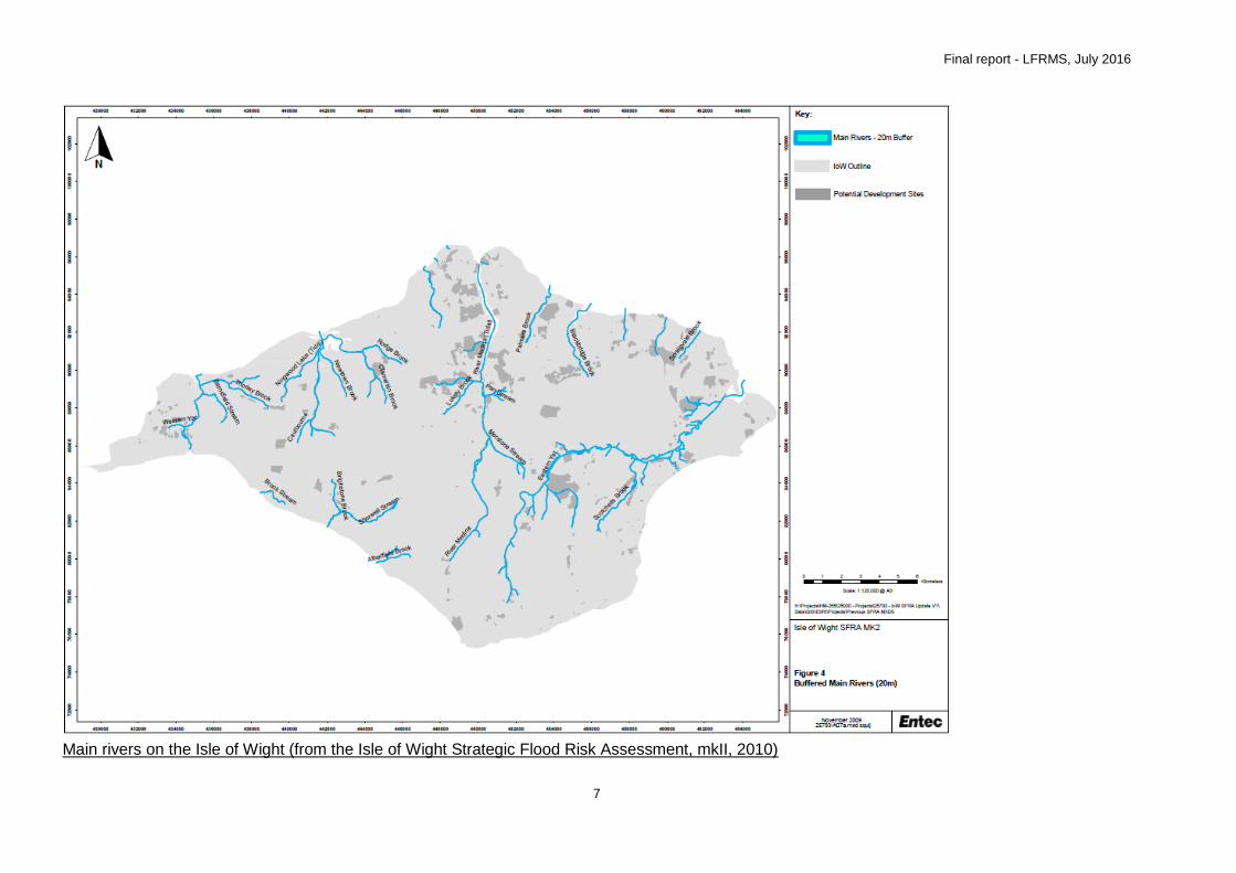
Main rivers on the Isle of Wight (from the Isle of Wight Strategic Flood Risk Assessment, mkII, 2010)

Final report - LFRMS, July 2016
8
Summary of tidal flood risk (1 in 200 year extents) on the Isle of Wight (from the Isle of Wight Strategic Flood Risk Assessment, mkII, 2010)
Final report - LFRMS, July 2016
9
Fluvial
Fluvial flooding (flooding from rivers) will occur when the watercourse is unable to contain
the volume of water which is draining into it from the surrounding area. The area that a
watercourse drains is called its catchment. Fluvial flooding can occur from both Main River
and Ordinary Watercourses.
Main Rivers are those that have been designated by the Environment Agency as they are
considered to perform a critical, strategic function in flood risk management. The definition of
a Main River is also related to the administrative responsibility; if a watercourse is
designated as a Main River, the Environment Agency is responsible for managing flooding
from that watercourse.
Ordinary Watercourses are defined as any watercourse (river, stream, ditch, cut, sluice, dyke
or non-public sewer) that is not designated as a Main River. Ordinary Watercourses can play
an important part in flood risk management and can cause significant (usually localised)
flooding issues if not managed properly. The LLFA is responsible for managing flooding from
these watercourses.
The majority of watercourses are in the northern half of the Island and discharge into the
Solent. The Isle of Wight’s largest river is the Eastern Yar (a Main River) and this discharges
into the Solent at Bembridge. A history of flooding is well documented along the lower
reaches of this watercourse. The majority of the Main Rivers on the Island flow in a northerly
direction and as a result of this drainage pattern, which is a function of the underlying
geology, the main estuarine environments are on the northern shores of the Island.
Tidal (or coastal)
Flooding from the sea (tidal flooding) tends to occur as a result of high tides, surges in sea
water and strong winds which raise the sea level above the ground level of the coast or the
defences that protect it.
Tidal flooding also brings challenges in respect of combined flood risks.
For example, watercourses can be affected by the action of tide-locking. This is where
drainage outfalls discharging by gravity at the coast become blocked for a period of time by
high tides and the surface water system backs up. If there is insufficient capacity within the
watercourse/drainage network, it may lead to surface flooding when it coincides with an
extreme rainfall event. This is an issue which does occur on the Island fairly regularly at
present, and it is likely that, with the predicted effects of sea level rise, this form of flooding
would increase in the future.
The majority of tidal flood risk is on the more low-lying northern shores of the Isle of Wight.
This includes existing and future tidal flood risk in the towns and villages of Yarmouth,
Gurnard Luck, Cowes and East Cowes. Additionally, the two low lying valleys of the
Western Yar (from Freshwater to Yarmouth) and the Eastern Yar (from Yaverland, Sandown
to Bembridge) are both at tidal flood risk and are currently protected by defences preventing
tidal flooding. Isolated marginal properties bordering the Media and Newtown Estuaries may
also be affected by future tidal flooding (including Newport Harbour). Tide-locking is an
issue affecting the river outfalls at Monktonmead Brook in Ryde and the Eastern Yar at

Final report - LFRMS, July 2016
10
Bembridge Harbour. At Seaview Duver, the 2004 coast protection scheme also involved the
creation of the Hersey Nature Reserve behind, where tidal flows are regulated. Further
information can be found in the Isle of Wight Shoreline Management Plan (2010), Eastern
Yar Flood and Erosion Risk Management Strategy (2010) and the West Wight Coastal Flood
and Erosion Risk Management Strategy (due for publication in 2016).
Groundwater
The ability of surface water to be absorbed into the ground is a function of the permeability of
the soils and superficial geology deposits and of the porosity of the solid geology. Chalk and
limestone are generally considered to be highly permeable and no flooding is reported to
have occurred in the chalk areas, except along the spring line at the boundary between the
chalk base and clay formations.
As such, groundwater flooding will generally occur in low-lying areas after prolonged periods
of wet weather, when the water levels in the ground (‘the water table’) rise to a level higher
to that of the ground itself. This water will then flow out of the ground in the form of a spring
or an ephemeral (groundwater fed) watercourse.
Groundwater flooding, although not usually deep, will often last for long periods of time, in
some cases months.
On the Isle of Wight the risk from groundwater is considered to be less significant and more
localised than fluvial flooding. There is a degree of overlap between groundwater and fluvial
flooding as high river levels in the winter months are often a product of high groundwater
levels. ‘Clear water flooding’ where ground water issues at the surface independently of a
fluvial water body is rare. In areas where the bedrock has lower permeability, this can restrict
the infiltration of rain leading to high rates of surface run-off.
The Environment Agency Isle of Wight Catchment Flood Management Plan (2009) notes a
very limited amount of groundwater flooding has occurred in the Lower Eastern Yar. The Isle
of Wight Strategic Flood Risk Assessment (mk II, 2010) records that groundwater flooding
was reported as a contributing factor in the flooding experienced in the winter of 2000 and
2001 (including in Ryde area), when it coincided with and in many cases caused the river
levels to be unusually high.
Surface water
Surface water flooding (sometimes referred to as ‘pluvial’ flooding) results from excessive
rainfall being unable to enter the local drainage system, due to blockages or capacity being
exceeded, or because the rainfall intensity is greater than the infiltration rate of the soils.
Surface water generation is more likely in heavily urbanised catchments and in areas with
low infiltration potential. Following intense rainfall events, water can flow over the surface
from surrounding areas and cause localised flooding. As surface water flooding is often quite
localised it is much more difficult to predict than river or coastal flooding. This means there is
often limited advanced notice of this type of flooding.

Final report - LFRMS, July 2016
11
The occurrence of flooding caused by insufficient capacity of the drainage system is related
to the probability of a given rainfall event over a given area. The likelihood of flooding is
dependent on the condition of the surface drainage network, as well as the rates of surface
water run-off generation. The likelihood of flooding may change over time; due to increases
in development, changes in impermeable area, increased frequency of blockages and
climate change. As a result, flooding related to surface water drainage may become more
frequent in the future.
The Environment Agency Catchment Flood Management Plan (2009) identifies that surface
water flooding occurs in some urbanised areas of the Island due to the capacity of drains
being exceeded, including in the West Wight, the Eastern Yar and Upper River Medina. The
Isle of Wight Strategic Flood Risk Assessment (mkII, 2010) notes that Environment Agency
records link surface water flooding to some of the flooded properties on the Island during the
floods of the year 2000. A recurring theme has been drains not being able to discharge
because of raised river levels and thus the capacity of the drains was soon exceeded
resulting in surface water flooding. The Isle of Wight Council published a Surface Water
Management Plan for Ryde in 2015.
Sewer
In some areas, rainwater is drained into surface water sewers or combined sewers
containing both surface and waste water. Surface water sewers are generally designed to
manage runoff from rainfall events up to a 1 in 30 year rainfall event. Flooding from sewers
occurs when rainfall exceeds the capacity of the network (that is a rainfall which is greater
than a 1 in 30 year rainfall event, such as 1 in 100 year rainfall event) or when the
infrastructure doesn’t function normally (for example, a blocked or collapsed sewer pipe). It
can also occur when land drainage flows enter the sewer due to surface water flooding
upstream.
Sewer flooding can impact on other types of flooding as when sewers overflow, this may be
to a watercourse or across the surface thus exacerbating flooding in some areas, as well as
leading to contamination of flood water which can increase the impact that flooding has on
people, property and public health.
Reservoir
Reservoirs can hold large volumes of water above ground level, contained by
embankments/dams. Although the safety record for reservoirs is excellent, it is still possible
that an embankment/dam could fail which would result in a large volume of water being
released very quickly. It may also be the case that a reservoir could overflow and cause a
surface water flood risk.
There are currently no known reservoirs on the Island that meet the requirements of the
Reservoirs Act 1975, which are reservoirs that hold at least 25,000 cubic metres of water
above ground level. However, there are proposed changes to the Act that will bring the limit
down to 10,000 cubic metres. If this is the case, this may need to be re-assessed. More
information on the Reservoirs Act can be found at; https://www.gov.uk/reservoirs-a-guide-
for-owners-and-operators.

Final report - LFRMS, July 2016
12
Residual risk
Even with flood management or mitigation measures put in place to reduce one (or a
number of) sources of flooding, a residual risk will still remain. Examples of residual flood
risk include:
Failure of flood management infrastructure such as a breach of a raised flood
defence, blockage of a surface water conveyance system, failure of a flap-valve,
overtopping of an upstream storage area, or failure of a pumped drainage system; or
A severe flood event that exceeds a flood management design standard, such as a
flood that overtops a raised flood defence, or an intense rainfall event which the
piped drainage cannot cope with.
Residual risk can also be reduced through various mitigation measures, pre-existing factors
or techniques including:
Types of measures in place (temporary or permanent).
Level of protection provided.
Condition of the existing infrastructure.
Topography of the area.
Capability of the emergency planning response.
It is important to realise that flood risk to people and property can be managed but it
can never be removed completely.
3.4 Significant historic flood events on the Island
Prior to the year 2000 there are a limited number of records of fluvial flooding on the Island.
Events affecting more than 10 properties appear to be fairly low, with the exception of Ryde
which has a long history of flooding dating back over 100 years.
Autumn 2000 flood event
The main cause of flooding was prolonged rainfall in the months of September to November
2000. This had the effect of raising and maintaining groundwater and river levels. Once
saturated, the watercourses responded quickly to intense rainfall events with levels and flow
rates rising and falling quickly. The result was short term flooding at times of peak rainfall.
Other factors which were identified as being significant in the autumn 2000 floods included:
The geomorphology and geology resulting in high groundwater levels and high levels
of ground saturation;
Inappropriate historic development in the floodplains;
Insufficient drainage capacity and maintenance causing water to back up and flood
property;
Highway drains being blocked or where flows were in excess of drainage capacity;
and
A history of changes in water resource management and budgetary constraints
Tide locking of Monktonmead Brook in Ryde caused some of the worst flooding on the
Island during the 2000 flooding event.

Final report - LFRMS, July 2016
13
Gurnard
Gurnard Luck became tide locked and the increased river levels caused five properties to
flood. The tidal high water coincided with the rising river levels and when the two levels
matched the tidal flaps closed and thus tide locked the river. This caused the river levels to
rapidly rise a further 300mm. Marsh Road was reported to have been covered by about
400mm of water.
Cowes
Cowes experienced some tidal flooding during December 1999, one property was reported
as being flooded inside and a further six were flooded outside. Tidal flooding was abated by
a sand bag wall constructed by Environment Agency contractors and by a change in the
wind direction which reduced wave action.
Newport
An engineering team had been deployed since early in the morning of the 24th December
1999 to ensure that the three trash screens on the Lukely Brook were regularly cleared
during the day. Lukely Brook responded rapidly to the heavy rainfall and levels soon rose to
a dangerous level for workmen to clear the trash screens. Consequently, four properties
were flooded from the main river and one was flooded from an ordinary watercourse.
Ryde
Ryde was identified as being the settlement which sustained the most severe damage during
the 2000 floods. Investigations on Monktonmead Brook have previously been carried out as
there has been a history of regular flooding problems. Many of the properties were flooded
from sewers being overwhelmed as high water levels in the Brook prevented free discharge
of storm drains. The high river flow coincided with the high tide locking the Brook. One of the
pumps which are designed to help alleviate the tide locking suffered a brief failure but was
quickly returned to operation. Around seventy houses were flooded by the high groundwater
and combined sewers overflowing. Basement flooding was a key issue.
Seaview
Flooding started around midnight on 24th December 1999 and lasted for around three to four
days. The flooding was the product of two factors: high tide waters flooding over the sea
wall; and flooding of the salt lake to the rear of the town due to poor drainage.
Winter 2013/14 event
2013 to 2014 saw the wettest winter for 250 years in the south of England. The extreme
weather tested the country's resilience to adverse weather and its consequences, causing
flooding and disruption to energy supply and travel.
The stand out rainfall events were, although not limited to, those around Christmas 2013,
New Year’s Eve/Day and 12th to 14th February 2014. Although these single events led to
large amounts of rainfall, it was not necessarily the individual events that caused flooding,
but the persistent, cumulative rainfall.

Final report - LFRMS, July 2016
14
Recorded rainfall in January 2014 at Knighton and Carisbrooke rain gauges was the highest
on their respective records. January’s rainfall at Knighton was 213mm with the annual
average being 814mm, equating to a quarter of a year’s rainfall in a month.
December and January’s combined rainfall roughly equated to half a year’s rainfall in two
months. This incredibly wet period coincided with a series of record spring high tides around
the Island. The tidal event of 14th February 2014 was the highest recorded in recent history.
Port Highest recent event Previous Highest Start of record
Yarmouth* 2.146 14th Feb 2014 N/A N/A 1993
Cowes 2.734 14th Feb 2014 2.638 10/03/2008 1990
Ryde 3.060 14th Feb 2014 2.909 17/10/2012 2004
Note: All levels are to metres above ordnance datum (m AOD). More information on
conversions between Ordnance Datum and Chart Datum can be found on the
following websites: http://www.ntslf.org/tides/datum (National Tidal and Sea Level
Facility) and http://www.ukho.gov.uk/Easytide/easytide/Support/faq.aspx (UK
Hydrographic Office FAQ).
*Please note: A level of 4.1m above Chart Datum was also recorded in Yarmouth in
20082.
Reported incidents of flooding at the time of writing equates to approximately 50 properties
flooding across the Island, although it is likely that this number is actually higher.
Risk management authorities are working closely together to try and collate all recorded data
over this event and improve the evidence base to enable future risk management projects to
be identified and justified.
Appendix B shows an overview map of recorded incidents of historic flooding on the Island. Individual areas and specific flood risk issues will be discussed on an area by area basis within the various appendices.
3.5 Flood risk to the Island in the future
The risk of flooding to the Isle of Wight into the future is likely to increase. This is mainly as a
result of climate change; however other factors such as new development or works
to/mismanagement of watercourses, if uncontrolled, have the potential to negatively impact
on flood risk.
Climate change
Climate change has the ability to increase flood risk to the Island by five main factors:
Increased sea levels.
Increased wave heights.
2 Ref. ‘2014 update to the 2010 report ‘Adapting to Coastal Flooding in the Yarmouth Area in the 21
st Century’, Report by
Yarmouth Coastal Defence Working Group.

Final report - LFRMS, July 2016
15
Increased rainfall intensities.
Increased river flows.
And as a result of the above, an increased frequency of flood events.
Sea levels Sea level rise is predicted to add up to one metre to average sea levels by the year 2105
with the baseline average sea level being taken from 1990.
Sea level rise of this magnitude could impact greatly on the entire Isle of Wight coastline.
The current trend for sea level rise which is based on the long-term record from Newlyn
(1916 – present) is just under 2mm per year.
Guidance on future sea level rise predictions was released by Defra in October 20063.
Table 1 below sets out the allowances provided in the 2006 guidance. These values were
used in calculating the future flood extents for 2025, 2055 and 2105 used in the Isle of Wight
Strategic Flood Risk Assessment (SFRA Mk2, 2010) and the Isle of Wight Shoreline
Management Plan (SMP2, 2010).
Table 1: Sea Level Rise Predictions, Defra 2006
South East England Net Sea Level Rise in
mm/yr
1990-2025 4.0
2025-2055 8.5
2055-2085 12.0
2085-2115 15.0
Based on the above values, sea level rise for the Island was calculated using a coastal cell
approach. This data can be found in Appendix C.
Increases in sea levels could result in sea defences overtopping and also increased
regularity in tide locking issues; in potential number of occurrences as well as increased
duration of events.
The Isle of Wight SFRA Mk2 shows maps of climate change tidal extents, although it should
be noted that these maps do not take into account defences and are only based on land
levels.
At the time of publishing the SFRA, no coastal defences had been identified offering
protection from the 1 in 200 year tide level. Therefore guidance at the time (PPS25)
considered there to be no areas of defended Flood Zone 3. Nonetheless any area behind an
existing flood defence structure of any standard is in a zone of residual risk in the event of
failure. Failure of flood defences can either be structural or by exceedance of the design
standard.
3 Flood and Coastal Defence Appraisal Guidance; FCDPAG3 Economic Appraisal; Supplementary Note to Operating
Authorities – Climate Change Impacts; Defra (October 2006).
Final report - LFRMS, July 2016
16
Updated climate change advice for Risk Management Authorities was issued by the
Environment Agency in September 2011 (Adapting to Climate Change: Advice for Flood and
Coastal Erosion Risk Management Authorities4). This guidance replaces the previous advice
and includes updated sea level rise allowances, based on the Intergovernmental Panel on
Climate Change (IPCC) fourth assessment report ‘UKCP09’. Based on this latest guidance,
the upper confidence bound (95th percentile) medium emissions scenario has been adopted
as the ‘change factor’ in the upcoming West Wight Coastal Flood and Erosion Risk
Management Strategy being produced by the IWC and EA (due to be published in 2016).
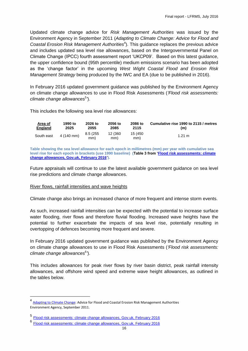
In February 2016 updated government guidance was published by the Environment Agency
on climate change allowances to use in Flood Risk Assessments (‘Flood risk assessments:
climate change allowances5’).
This includes the following sea level rise allowances:
Area of England
1990 to 2025
2026 to 2055
2056 to 2085
2086 to 2115
Cumulative rise 1990 to 2115 / metres (m)
South east 4 (140 mm) 8.5 (255
mm) 12 (360
mm) 15 (450
mm) 1.21 m
Table showing the sea level allowance for each epoch in millimetres (mm) per year with cumulative sea level rise for each epoch in brackets (use 1990 baseline) (Table 3 from ‘Flood risk assessments: climate change allowances, Gov.uk, February 2016’).
Future appraisals will continue to use the latest available government guidance on sea level
rise predictions and climate change allowances.
River flows, rainfall intensities and wave heights
Climate change also brings an increased chance of more frequent and intense storm events.
As such, increased rainfall intensities can be expected with the potential to increase surface
water flooding, river flows and therefore fluvial flooding. Increased wave heights have the
potential to further exacerbate the impacts of sea level rise, potentially resulting in
overtopping of defences becoming more frequent and severe.
In February 2016 updated government guidance was published by the Environment Agency
on climate change allowances to use in Flood Risk Assessments (‘Flood risk assessments:
climate change allowances6’).
This includes allowances for peak river flows by river basin district, peak rainfall intensity
allowances, and offshore wind speed and extreme wave height allowances, as outlined in
the tables below.
4 Adapting to Climate Change: Advice for Flood and Coastal Erosion Risk Management Authorities
Environment Agency, September 2011.
5 Flood risk assessments: climate change allowances, Gov.uk, February 2016 6 Flood risk assessments: climate change allowances, Gov.uk, February 2016
Final report - LFRMS, July 2016
17
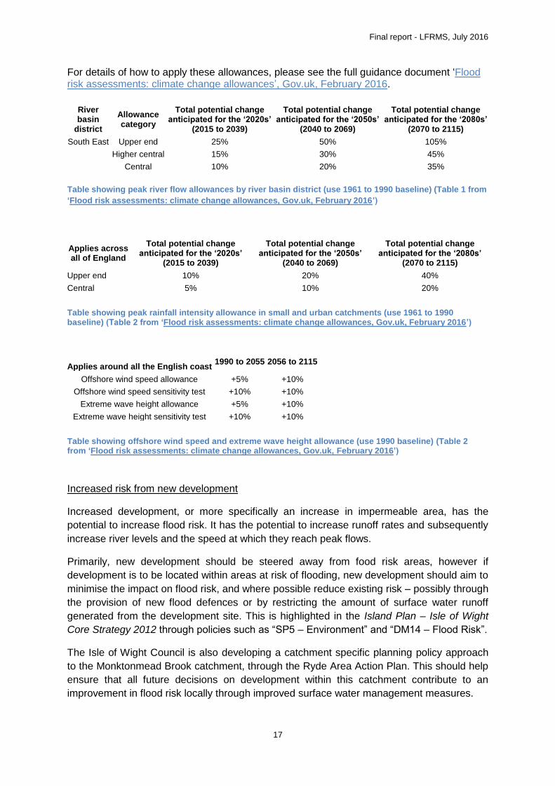
For details of how to apply these allowances, please see the full guidance document ‘Flood risk assessments: climate change allowances’, Gov.uk, February 2016.
River basin
district
Allowance category
Total potential change anticipated for the ‘2020s’
(2015 to 2039)
Total potential change anticipated for the ‘2050s’
(2040 to 2069)
Total potential change anticipated for the ‘2080s’
(2070 to 2115)
South East Upper end 25% 50% 105%
Higher central 15% 30% 45%
Central 10% 20% 35%
Table showing peak river flow allowances by river basin district (use 1961 to 1990 baseline) (Table 1 from
‘Flood risk assessments: climate change allowances, Gov.uk, February 2016’)
Applies across all of England
Total potential change anticipated for the ‘2020s’
(2015 to 2039)
Total potential change anticipated for the ‘2050s’
(2040 to 2069)
Total potential change anticipated for the ‘2080s’
(2070 to 2115)
Upper end 10% 20% 40%
Central 5% 10% 20%
Table showing peak rainfall intensity allowance in small and urban catchments (use 1961 to 1990 baseline) (Table 2 from ‘Flood risk assessments: climate change allowances, Gov.uk, February 2016’)
Applies around all the English coast
1990 to 2055 2056 to 2115
Offshore wind speed allowance +5% +10%
Offshore wind speed sensitivity test +10% +10%
Extreme wave height allowance +5% +10%
Extreme wave height sensitivity test +10% +10%
Table showing offshore wind speed and extreme wave height allowance (use 1990 baseline) (Table 2 from ‘Flood risk assessments: climate change allowances, Gov.uk, February 2016’)
Increased risk from new development
Increased development, or more specifically an increase in impermeable area, has the
potential to increase flood risk. It has the potential to increase runoff rates and subsequently
increase river levels and the speed at which they reach peak flows.
Primarily, new development should be steered away from food risk areas, however if
development is to be located within areas at risk of flooding, new development should aim to
minimise the impact on flood risk, and where possible reduce existing risk – possibly through
the provision of new flood defences or by restricting the amount of surface water runoff
generated from the development site. This is highlighted in the Island Plan – Isle of Wight
Core Strategy 2012 through policies such as “SP5 – Environment” and “DM14 – Flood Risk”.
The Isle of Wight Council is also developing a catchment specific planning policy approach
to the Monktonmead Brook catchment, through the Ryde Area Action Plan. This should help
ensure that all future decisions on development within this catchment contribute to an
improvement in flood risk locally through improved surface water management measures.
Final report - LFRMS, July 2016
18
Works to or mismanagement of watercourses
Different risk management authorities, including land/homeowners (riparian landowners)
have roles and responsibilities for watercourses.
Ensuring that all watercourses are properly maintained is essential for flood risk
management. It is also imperative that works that may affect a watercourse are given
consideration as to how they may impact on flood risk. Works to/within a watercourse would
usually require the permission of a consenting authority – dependant on the classification of
the watercourse. These roles and responsibilities are discussed further in section 4.
Essentially, the number of flood events is expected to increase in the future as a result of
climate change. It is how the events are managed, by risk management authorities as well
as land/homeowners, which will dictate the impact of these events into the future.

Final report - LFRMS, July 2016
19
4. Roles and Responsibilities
4.1 Who is responsible for managing flood risk?
The following authorities/persons are specifically named as risk management authorities
within the Flood and Water Management Act 2010:
Lead Local Flood Authority – Isle of Wight Council.
Environment Agency.
Water company – Southern Water.
Highway Authority – Isle of Wight Council/Island Roads.
Riparian landowners.
4.2 What is the Isle of Wight Council’s role?
Development, maintenance, application and monitoring of Local Flood Risk
Management Strategy.
Duty to prepare for, respond to and recover from flood incidents (emergency
management).
Powers to request information in connection with flood risk management.
Duty to investigate and publish reports on flooding incidents in its area (where
appropriate or necessary) to identify which authorities have relevant FRM functions
and what they have done or intend to do.
Duty to maintain a register of assets which have a significant effect on flood risk, in
the view of the lead local flood authority.
Power to undertake works to manage flood risk from surface water runoff or
groundwater.
Power to designate structures and features that affect flooding.
Please contact the Isle of Wight Council if you:
Wish to report a flooding incident;
Want to obtain a Land Drainage Consent for works in an ordinary watercourse;
Have a query on maintenance of an ordinary watercourse;
Wish to report a problem with an adopted highway;
See flood water on an adopted highway; or
Wish to report a blocked or damaged culvert under an adopted highway.
4.3 What is the Environment Agency’s role?
Strategic overview for all forms of flooding.
Development of National Strategy for Flood and Coastal Erosion Risk Management
(FCERM) to cover all forms of flooding.
Conversion of Regional Flood Defence Committees into Regional Flood and Coastal
Committees with new remit to include coastal erosion issues.
Powers to request information in connection with FCERM functions.
Final report - LFRMS, July 2016
20
Power to designate structures and features that affect flooding or coastal erosion.
Duty to exercise FCERM consistently with the national and local strategies.
Duty to report to Ministers on FCERM including implementation of the strategies.
Statutory consultee to the Local Planning Authority on certain planning applications.
Duty to contribute to sustainable development in discharging their FCERM functions.
Ability to issue levies to lead local flood authorities; levies can now also apply to
coastal erosion issues as well as flooding.
Duty to have regard to lead local flood authority scrutiny processes.
Updated provisions for the regulation of reservoirs.
Please contact the Environment Agency if you:
Wish to obtain a Flood Defence Consent for works in, under, over or within 8 metres
of a Main River or within 15 metres of a tidal/sea defence;
Wish to speak to someone regarding maintenance on a Main River;
Wish to report a flooding incident; or
Wish to find out if you are eligible to receive a flood warning and register for the
service you can call Floodline on 0845 988 1188.
4.4 What is Southern Water’s role?
Provide water supply.
Remove and treat foul water.
Drain surface water from properties where areas of roof and yard are connected to
public surface water sewer.
Duty to have regard to national and local strategies.
Duty to have regard to lead local flood authority scrutiny processes.
Adoption of private sewers.
4.5 What is Island Roads’ role?
Island Roads are providing a highway maintenance service for the Isle of Wight
Council from April 2013 to 2038 (under a PFI contract).
Drainage of roads on the local road network, in so far as ensuring that drains,
including gullies, which are their responsibility, are maintained.
Emergencies and Winter Service includes emergency call outs to highway flooding.
4.6 What is the Landowner’s role?
Under common law, you are the riparian owner of any watercourse within or adjacent to the
boundaries of your property. Where a watercourse is sited between two or more property
boundaries each owner may be equally responsible.
You have the right to protect your property against flooding from the watercourse and
also to prevent erosion of the watercourse banks or any structures.

Final report - LFRMS, July 2016
21
Your responsibilities include the maintenance of the bank and bed of your section of
watercourse, in order to avoid any obstruction of flow.You and your neighbouring
land owner are responsible for the maintenance and water flow within the
watercourse where it borders your land.
If you do not maintain the watercourse or any asset within it, the Isle of Wight Council
can request that you do so. Should you fail to do so the council may maintain them
for you and take legal action to seek to recover costs.
If you do not carry out your legal responsibilities you could face legal action.
It is NOT the responsibility of the Isle of Wight Council to carry out maintenance or
improvement works in these situations.
Further advice on Riparian ownership and responsibilities can be found on our website.
In addition, you may also be interested to read ‘Living on the Edge’, an Environment Agency
publication available online via the Environment Agency at:
https://www.gov.uk/government/publications/riverside-ownership-rights-and-responsibilities.
Final report - LFRMS, July 2016
22
5. Actions to Address Flood Risk on the Island
5.1 Ways of managing flood risk
Mapping, data and information
To be able to effectively manage flood risk, we must first identify where is at risk. There is a
wide range of flood risk information available, from the Environment Agency’s flood maps,
climate change flood maps within the Isle of Wight SFRA and surface water flood mapping
both by the Environment Agency and the Isle of Wight Council as part of the Preliminary
Flood Risk assessment (PFRA).
Mapping will continue to be reviewed and updated when possible.
Information from flood events is an invaluable source of data. Whilst there is data available
for the larger scale events, such as the Autumn 2000 event, smaller scale, localised flooding
is not necessarily always reported.
Capital schemes
Capital schemes involve the construction, improvement or reinstatement of flood and coastal
erosion assets that risk management authorities own or manage. These tend to be larger
schemes that have high costs. The amount of flood and coastal erosion risk management
Grant in Aid (FDGiA) available to each capital scheme depends on the number of houses
protected, the damages prevented and other benefits a project would deliver. Where there is
a shortfall in funding, contributions can be sought to increase the viability of the scheme.
Schemes through development
New development can present opportunities to reduce pre-existing risks of flooding. For
example, the development of East Cowes has seen large scale land raising as part of the
development, protecting not only the new development itself, but also, land behind the
development. Flood risk can also be reduced through increasing a river’s capacity; for
example the Old Dairy Crest site in Newport has seen a large section of the Lukely Brook
de-culverted, and as a result, the capacity for flood water has been dramatically increased,
helping to reduce risk up and down stream. It is also possible for new development to reduce
the risk of surface water flooding by attenuating surface water runoff by more than the
undeveloped site, thus slowing down the rate at which water leaves the site.
Flood proofing within development and Property Level Protection (PLP)
In areas at risk of flooding, consideration should be given to the incorporation into the design
and construction of the development of flood proofing measures. These can include barriers
on ground floor doors, windows and access points and bringing in electrical services into the
building at a high level so that plugs are located above possible flood levels. Any new
development in flood risk areas should automatically take account of this; however, there are
opportunities to retrofit such measures into existing properties. Reactive measures, such as
the use of sandbags to protect property, are one method of PLP; however, in some cases it
may be possible to use more permanent measures to protect property.
Final report - LFRMS, July 2016
23
Maintenance
Maintenance can play an essential part of managing flood risk. If watercourses, drains, road
gullies and similar infrastructure are not properly maintained, it is likely that flood risk will
increase as a result due to the drainage network not being able to operate at its maximum
capacity. As described in section 4, it is usually the responsibility of the landowner to ensure
that watercourses are maintained, although certain risk management authorities do have
certain responsibilities (e.g. Highways Authority for drains and gullies under their
responsibility).
Flood warning
Flood warning gives people time to prepare for flooding. Whether this is in terms of physical
measures to protect property (e.g. sandbags) or damage limitation in terms of moving
valuables to higher areas within the property. Information on how to sign up to receive flood
warnings, as well as how to prepare and what to do in the event of a flood, can be found in
section 8.
Knowledge and vigilance
Increasing public knowledge and awareness to the risks of flooding can help to reduce the
risks. If people understand what can increase risk, and be more aware of this, potential
problems can be identified and rectified before flooding occurs. Things such as illegal waste
dumping (fly tipping) or un-consented works that could increase flood risk should be reported
to the appropriate risk management authority.
5.2 Existing actions
Environment Agency capital schemes
Embankment Road, Bembridge, Tidal Flood Defence
Embankment Road is a flood defence structure in the Eastern Yar catchment and is
managed by the Environment Agency. At the moment the defence has a 1 in 25 chance of
being overtopped in any year.
The Environment Agency are planning to sustain the defence to ensure Embankment Road
continues to provide this standard of protection for the next 100 years. This will protect
around 450 properties that are currently at risk of flooding if the road was not there. The
option will also protect Brading Marshes, a wildlife rich open space which the local
community values highly. Most people responding to our consultation supported this option.
Embankment Road does not have any funding within the 6yr Capital Programme. Indicative
funding does not appear until 2022/23, although this will be liable to change. The
Partnership Funding score associated with the project is 36%, indicating that further
contributions would be needed to enable the project to secure the amount of Flood and
Coastal Erosion Risk Management Grant in Aid for which it is eligible. Without contributions,
it is likely to remain outside of the 6 year programme.

Final report - LFRMS, July 2016
24
Monktonmead Brook pumping station and outfall improvements, Ryde
The Environment Agency have secured Flood Defence Grant in Aid funding that will allow
them to look in more detail at what measures could realistically be implemented to manage
flood risk in the Strand area of Ryde. Flooding of property in this area is from a number of
sources; the Monktonmead Brook, surface water and the sewage network and is primarily
caused when high rainfall events coincide with a high tide. All parties, such as the Isle of
Wight Council, Southern Water and the Environment Agency will need to work closely
together to develop a scheme to reduce the risk of flooding in this area.
Gunville Stream (Isle of Wight) Flood Alleviation Scheme
Initial assessments are indicating that there may be the possibility of a small scheme here
such as property level measures or minor improvements to flood risk management assets.
The exact nature of feasible measures is, however, yet to be confirmed.
Lukely Brook (Isle of Wight) Flood Alleviation Scheme
Initial assessments are indicating that there is likely to be a viable scheme here, though any
scheme will need contributions to progress to the appraisal stage.
Isle of Wight Council capital schemes
West Wight Coastal Flood and Erosion Risk Management Strategy
A Coastal Strategy for the West Wight coastline is being developed by the risk management
authorities, considering the coastline from Freshwater Bay to East Cowes. This Strategy
builds on the work of the approved Isle of Wight Shoreline Management Plan (SMP) in
defining coastal flooding and erosion risks to people and the developed, historic and natural
environments and identifying the preferred technically, economically and environmentally
sound and sustainable strategic options for managing those risks over 100 years. It
examines the consequences of implementing the preferred policies from the SMP, considers
when future defence improvements will be needed and which works are achievable. It
identifies priority schemes, examines how they could be funded, and sets the context for
future planning policy. Future risk reduction schemes will require a combination of public
and private funding, under the government’s new ‘partnership funding’ framework. . Issues
for consideration in the West Wight Coastal Strategy include coastal flood risk to the towns
of Yarmouth, Cowes and East Cowes.
It is expected that this Coastal Strategy will be completed in 2016.
Following on from the West Wight Coastal Strategy, the Isle of Wight Council and the
Environment Agency will seek opportunities to obtain Flood Defence Grant in Aid funding
towards developing the priority schemes to reduce future coastal flood and erosion risks in
the area.
South Wight Coastal Flood and Erosion Risk Management Strategy
Following on from the West Wight Coastal Flood and Erosion Risk Management Strategy,
the risk Isle of Wight Council aim to undertake a similar Coastal Strategy for the South Wight
coastline from Freshwater Bay to Culver Cliff, including the Ventnor Undercliff and Sandown

Final report - LFRMS, July 2016
25
Bay. This Strategy would also build on the work of the approved Isle of Wight Shoreline
Management Plan (SMP) in defining coastal flooding and erosion risks to people and the
developed, historic and natural environments and identifying the preferred technically,
economically and environmentally sound and sustainable strategic options for managing
those risks over 100 years. It will examine the consequences of implementing the preferred
policies from the SMP, examine when future defence improvements would be needed and
identify potential schemes. Future risk reduction schemes are likely to require a combination
of public and private funding, under the government’s new ‘partnership funding’ framework.
Issues for consideration in the South Wight Coastal Strategy include coastal landside risk to
the town of Ventnor and surrounding villages, and coastal erosion risk in Sandown Bay.
Following on from the South Wight Coastal Strategy, the Isle of Wight Council and the
Environment Agency will seek opportunities to obtain Flood Defence Grant in Aid funding
towards developing schemes to reduce future coastal erosion, flood and landslide risks in
this area.
5.3 Isle of Wight Council actions
The Isle of Wight Council Emergency Management department have completed, hold and
maintain a Multi-Agency Flood Response Plan. This can be found at the following web
address:http://documents.hants.gov.uk/flood-water-
management/EPUHIOWLRFMultiAgencyFloodPlanResponseandRecoveryPARTONE.pdf.
The purpose of this plan is to describe the multi-agency management and response
arrangements in preparation for, and in response to, a flood event in Hampshire and the Isle
of Wight.
5.4 Island-wide actions
Island-wide Grounds Maintenance are (at the time of writing), the contractors used by
Environment Agency. They provide 24 hours standby for emergency flood response. This
includes clearing 13 key river grills, maintenance of flood risk assets and operating four
emergency mobile pumps. They also complete key annual maintenance work.
5.5 Island Roads actions
Island Roads, on behalf of the Council, has an annual programme of drain/gulley cleansing
for roads on a defined project network. This programme reflects areas known to be at risk
from flooding. Additionally, Island Roads have undertaken a programme of major drainage
schemes ahead of its resurfacing programme. The programme similarly prioritises areas of
known highway drainage flooding.
Island Roads operates on a 24 hour basis and is responsible for maintaining a stock of
sandbags at strategic locations and providing traffic management during flooding events
which may include closing sections of roads.
5.6 Local actions
Local actions include anything and everything that an individual community are able do to
help themselves. The community may consist of a Town or Parish Council which covers a
large geographical area or a few streets which are impacted by frequent flooding issues.
Final report - LFRMS, July 2016
26
Some community flood plans have been created by Town and Parish councils alongside
community emergency plans. It is up to the community group how they want to develop their
community flood plan and what areas it may cover but we would suggest liaising with your
Town or Parish clerk to see if anything has already been or is under development.
A good starting point for assisting local action is through the creation of a Flood Action
Group. Flood Action Groups are a representative voice for their community and their aim is
to work in partnership with the Agencies and Authorities whose work involves flood risk.
Through these ‘grass-root’ groups, communities are able to:
Take ownership of flood risk issues within a community.
Address their concerns over malfunctioning assets/and other issues.
Be constantly in touch with what is intended for their community.
Utilise local knowledge to suggest new and innovative ways of managing flood risk.
Know procedures that are already in place regarding routine maintenance.
Undertake both pro-active and reactive mitigation works to reduce risk in the
community.
Have a voice as to the future flood risk of their community through consultation.
Instigate ‘flood watchers’.
Create awareness of flood risk to the wider community.
Prepare to reduce the impact on the community should a flood event occur.
The National Flood Forum is able to support communities in the formation of Flood Action
Groups.
More information can be found here; http://nationalfloodforum.org.uk/flood-risk-community-
groups/how-to-form-a-flood-action-group/.
There are already several Flood Action Groups across the Island (including in Ryde and
Binstead), which are proving themselves as an excellent tool in aiding the management of
flood risk at a community level.
_______
Further information can be found in Appendix W - Action Plan.

Final report - LFRMS, July 2016
27
6. Environmental Impacts of Actions
6.1 Strategic Environmental Assessment
Strategic Environmental Assessment is undertaken to identify significant effects that plans,
programmes and strategies may have on the existing environment, and therefore increase
the consideration of environmental issues in the decision making process. The aim of a SEA
is to identify “the likely significant effects on the environment, including on issues such as
biodiversity, population, human health, fauna, flora, soil, water, air, climatic factors, material
assets, cultural heritage including architectural and archaeological heritage, landscape and
the interrelationship between the above factors” (SEA Directive, 2001).
Screening in accordance with the regulations has assessed that the LFRMS is not a strategy
that requires a Strategic Environmental Assessment. The LFRMS is not likely to have a
significant effect on the environment as its objectives are procedural and set at a high level.
6.2 Habitats Regulation Assessment
The Habitats Regulations Assessment (HRA) is an assessment of the impacts of
implementing a plan or policy on a Natura 2000 site. Its purpose is to consider the impacts of
a land-use plan against conservation objectives of the site and to ascertain whether it would
adversely affect the integrity of the site. Where significant negative effects are identified,
alternative options should be examined to avoid any potential damaging effects. An
accompanying HRA report has been prepared to support this LFRMS.
6.3 Water Framework Directive Assessment
The Water Framework Directive (WFD) was passed into UK law in 2003. The general
purpose of the Directive is to ensure all river basins achieve “good ecological status” by
2015 unless there are grounds for derogation. It also requires that Environmental Objectives
be set for all waterbodies. River Basin Management Plans (RBMPs) set out the objectives
for individual waterbodies.
The WFD contains five Environmental Objectives, which aim to prevent detrimental change
to the status of water bodies, which could be caused by a deterioration of any of the
biological, physico-chemical or hydromorphological quality elements. Actions/measures
which can physically affect waterbodies need to be assessed against WFD objectives to
ensure that they a) cause no deterioration of water body status, and b) do not prevent the
water body from reaching Good Ecological Potential (GEP) or Good Ecological Status
(GES).
Provision has been made for the Environmental Objectives of the Water Framework
Directive through the strategic objective of considering the greatest environmental (as well
as social and economic) benefits when considering measures to reduce the risk of flooding.
Identified mitigation measures will be recommended to reduce the (flood) risks identified
whilst providing benefit to the environment.

Final report - LFRMS, July 2016
28
7. Funding
Funding is generally required for two areas relating to risk reduction works, these being
capital and maintenance. Capital funding for the delivery of schemes is generally made up of
a suite of funding streams including FCERM Grant in Aid, LLFA funding, development
funding, other Risk Management Agencies (Southern Water), any beneficiary of a flood risk
scheme, LEP funding, European funding etc. Maintenance of structures and schemes then
requires ongoing revenue funding.
Flood and Coastal Erosion Risk Management Grant in Aid (FCERM GiA)
This funding is made available by Defra to flood risk management authorities - that is, the
Environment Agency, Lead Local Flood Authorities, English local authorities and internal
drainage boards (IDBs). It can be used to pay for a range of activities including schemes that
help reduce the risk of flooding and coastal erosion.
The Environment Agency allocates FCERM GiA to flood risk management authorities in line
with government policy and guidelines set out by Defra. There are always more schemes
proposed than there is government funding available in any one year. As a result, not all
projects will gain funding initially and may need to be planned for the future when funding
becomes available. Dependent on the characteristics of each scheme, many schemes will
be partially-funded rather than fully-funded by GiA. Further information can be found in the
section on ‘Partnership funding’ below.
Local Levy
The Regional Flood and Coastal Committees (RFCCs) play an important role in agreeing
programmes of work. Extra funding is sometimes raised from local authorities, known as
local levy.
The RFCC brings together members appointed by Lead Local Flood Authorities (LLFAs) and
independent members with relevant experience:
to ensure there are coherent plans for identifying, communicating and managing
flood and coastal erosion risks across catchments and shorelines;
to promote efficient, targeted and risk-based investment in flood and coastal erosion
risk management that optimises value for money and benefits for local communities;
and;
to provide a link between the Environment Agency, LLFAs, other risk management
authorities, and other relevant bodies to bring about mutual understanding of flood
and coastal erosion risks in its area.
Partnership funding and contributions
The current approach adopted by Defra and used by the Environment Agency to allocate
funding is known as partnership funding. Simplistically, this determines what proportion of
the cost of a scheme is eligible for central government FCERM GiA. Some schemes will be
fully funded, others only partly funded by FCERM GiA, according to how much public benefit
they provide such as reducing flood risk to homes or creating habitat for wildlife.
Final report - LFRMS, July 2016
29
Contributions from local levy, local businesses or other parties who will benefit from the
scheme can make up shortfalls in the funding which can increase the likelihood of a project
or bring a project forward so that it is delivered sooner than originally proposed. Further
information with regard to partnership funding and the allocation of FCERM GiA can be
found on the Environment Agency website: https://www.gov.uk/government/collections/flood-
and-coastal-defence-funding-for-risk-management-authorities.
How this affects the proposed actions
Expectations will need to be managed with regard to which of the identified actions can be
implemented. Since it is unlikely that all identified actions will be able to be delivered within
existing resources or funding streams, the Isle of Wight Council expects to have to seek
additional funding.
Successful delivery of the identified actions will require innovative ways of working and
funding, utilising collaborative working and joint funding across partner organisations, local
businesses and residents will be key to maximising the return on investment in flood risk
management.

Final report - LFRMS, July 2016
30
8. Flood Events
8.1 How to prepare for a flood event
Know your risk
Understand whether or not you are at risk of flooding. You are able to find out if you are at
risk of flooding from the Environment Agency free of charge. You can do this by contacting
them directly via the National Customer Contact Centre on 03708 506 506, or from their
website https://www.gov.uk/prepare-for-a-flood.
Remember, flooding can occur from rivers, the sea, surface water, sewers, groundwater and
reservoirs. The source of flood risk is not always obvious.
Sign up to receive flood warnings
Where flood risk is associated with tidal and/or river sources you can sign up to the
Environment Agency’s flood warning service to receive free flood warnings direct via
telephone, mobile, email, text message or fax. This can be done via the Environment
Agency website; https://fwd.environment-agency.gov.uk/app/olr/home.
Insure your property against flooding
Make sure that your property is insured against flooding. The likelihood of flooding may have
an effect on home insurance in your area. An insurance company may ask you for more
information about flood likelihood by asking you for an Insurance Related Request Letter.
This can also be obtained free of charge to members of the public from the Environment
Agency; https://www.gov.uk/prepare-for-a-flood/get-insurance.
Make a personal flood plan
Make sure you know who to contact and how. Where will you go if you need to leave your
property?
Think about what you are able to move within your property prior to flooding occurring
(irreplaceable items such as photo albums/family films and sentimental items) and also how
you will move them. Think about who may be able to help, neighbours, family, friends etc.
Make sure you know how to turn off gas, electricity and water supplies to your property. You
may be able to do this yourself, but in some circumstances, you may need to contact your
supplier to do this.
Prepare a flood kit of essential items that would be easy to pick up if you needed to leave the
property. Useful items may include:
Copies of insurance documents.
Torch with spare batteries.
A wind up or battery operated radio.
Warm, waterproof clothing.
Bottled water and non-perishable food.
Baby food and care items if necessary.

Final report - LFRMS, July 2016
31
A template for preparing a personal floodplan is available online here:
https://www.gov.uk/government/publications/personal-flood-
plan?utm_source=gov.uk&utm_medium=campaign&utm_campaign=floodsdestroy15
8.2 What should I do during a flood event?
Implement your flood plan.
Attempt to protect your property from flood water by using any flood protection products if
you have them, e.g. flood boards, airbrick covers, sandbags, and toilet bungs on downstairs
toilets.
Stay out of flood water. It can be extremely dangerous and can contain hidden dangers such
as exposed manhole covers and pollution or contamination.
Take emergency action. Inform the relevant authorities, call 999 if you are in danger or
injured and check on neighbours and relatives – especially if they are vulnerable.
Evacuate when told. Adhere to the advice of the emergency services. If they believe it is
safer for you to evacuate, it is for good reasons. Please don’t put yourself at unnecessary
risk.
For more information on what to do before, during and after a flood please visit the website
https://www.gov.uk/floodsdestroy.
8.3 What do the authorities do during a flood event?
The response to a major flood event will involve a number of organisations working together
at a local level, including the emergency services, local authority, the Environment Agency
and utility companies. The Hampshire and Isle of Wight Local Resilience Forum (HIOW LRF)
Multi Agency Flood Plan has been produced to provide relevant information and outline the
response arrangements in place for a coordinated multi agency response.
The general roles of the main bodies in relation to a major flood event on the Isle of Wight
are summarised below. It should be noted that this is a general list, and specific duties may
vary between different bodies.
Hampshire Constabulary (Police):
Overall coordination of the multi-agency response at a major flood event.
Coordinate any multi agency decision to evacuate in consultation with key partner
agencies.
Save life in cooperation with the other emergency services.
Isle of Wight Fire and Rescue Service:
Assist with evacuation and search and rescue operations.
Provide and/or obtain specialist advice and assistance where hazardous materials
are involved.
Obtain New Dimensions specialist equipment such as High Volume Pumps.

Final report - LFRMS, July 2016
32
Assist other relevant agencies, particularly the local authority, to minimise the effects
of major flooding on the community.
Isle of Wight Council as the Local Authority:
Provide a Temporary Place of Shelter capability for flood risk affected communities
and activate staff and voluntary sector to support this.
Provide emergency transport for people, equipment and materials, and if necessary
evacuation.
Provide advice and information to the public (websites, customer service centres,
and social media) in accordance with the information provided in the HIOW LRF Multi
Agency Flood Plan.
Flood alleviation – for flood prevention, such as the placement of demountable flood
barriers, clearing blocked culverts, for dealing with flooded roads and diversions (as
carried out by Island Roads, the PFI Contractor) and for other assistance to the
public such as drying-out facilities.
Environmental health advice for action relating to environmental problems caused by
flooding.
Coordination of the voluntary sector during a response.
The Environment Agency:
Issue flood alerts/ warnings and/or Operational Messages using their Flood Warning
services to warn and inform the public and partners.
Responsibility for maintenance and operation of Environment Agency owned flood
defences. Checking defences and undertaking essential repairs and maintenance on
Environment Agency owned flood defences and advise other owners on their
maintenance responsibilities.
Monitor water levels and flows, assessing the risk, clearing obstructions from known
pinch points and advising the emergency services and the local authority.
Along with partners, deploy temporary flood defences (where available) where
impacts can be mitigated.
Support the police and local authority by providing materials, equipment and
manpower as far as resources and other duties permit, once own systems and flood
defences are secure.
Utility Companies:
Maintain the safety and integrity of the electricity/ gas/ water supply system.
Liaise with partner agencies and obtain pumps to maintain the supply at key
locations.
Repair services and seek alternative means of supply during any disruption and
restore supplies as soon as possible.
Implement Business Continuity Plans.

Final report - LFRMS, July 2016
33
Points of contact
Contact the Environment Agency Floodline for information about flooding and to sign up to
receive free flood warnings.
Floodline
Telephone: 0345 988 1188
Telephone: 0845 988 1188
[24-hour service]
Contact the Environment Agency to report flooding from ‘Main River’ or the sea via the 24
hour Incident Hotline on 0800 80 70 60.
To report flooding from and Ordinary Watercourses or surface water contact the Isle of Wight
Council on 01983 823316 (Emergency Management) or 01983 821000.
To report flooding from the sewer network contact Southern Water on 0330 303 0368.
To report flooding to a public highway contact Island Roads on 01983 822440 (or email:
[email protected], website www.islandroads.com).
For more information after an automated alert/warning, call Floodline on 0845 988 1188,
then in some areas a ‘quickdial’ number is available to access local information -Please
consult your local Community Flood Plan for details. For example, in the Yarmouth area,
call Floodline on 0845 988 1188, then the menu sequence given – press 1 – you are asked
for the Quickdial number for your area: Yarmouth is 012 114.
8.4 What will the LLFA do following a flood event?
Isle of Wight Council, in its role as Lead Local Flood Authority, has a responsibility to record
and investigate “significant” flood events, as detailed in Section 19 of the Flood and Water
Management Act 2010.
As there is no set definition that constitutes a “significant” flood event, it is for each LLFA to
decide what classes as a significant event in their authority.
Due to the nature of the Island, the Council has decided to review each flood event on its
own merit.
Following any flood incident, The Council’s Emergency Management team will summarise
any known flooding impacts as reported to them and/or through Isle of Wight Fire and
Rescue Service. A flood group would then consider whether the incident is ‘significant’ and
thus warrant further investigation based upon (but not limited to) the following
considerations:

Final report - LFRMS, July 2016
34
Extent of property flooding (i.e. number of domestic and commercial, any
evacuations carried out and number of persons seeking local authority housing
assistance from the homelessness team).
Extent/type of key infrastructure affected (schools, public buildings, community
facilities, utilities, etc).
Extent of road network affected (to be informed by Island Roads).
Flooding within areas that show no flood risk in modelling.
Flood history of area(s).
Environmental impacts (contamination/pollution/wildlife etc).
Economic impacts.
It is important to note that one flooded area could be significantly affected in isolation,
however multiple areas may experience small scale flooding impacts and therefore both may
be the subject to an investigation taking into account the other factors.
Once the investigations into a flood event have been completed, it may be possible to
identify the cause of the issues, and therefore, potentially lead to resolving them.

Final report - LFRMS, July 2016
35
9. Monitoring and Review
The Isle of Wight Council, as the LLFA, will be responsible for ensuring that this strategy is
monitored on an annual basis and reviews are undertaken as required. It is expected that
the partnership as a whole will contribute to the review of the Strategy.
The action plan (as set out in Appendix W) will be reviewed annually, and the Strategy as a
whole will be subject to a five yearly review process, including full public involvement, to
ensure it is kept up-to-date; takes account of objectives achieved, and continues to maintain
a focused forward programme at strategic and operational levels across all risk management
authorities on the Island.