Embed Size (px)
Citation preview

1
Bridge Investigation Team Report for the August 24, 2014 South Napa Earthquake Introduction:OnSunday,August24,2014at3:20AMPDT,aM6.0earthquakestrucksouthofthecityofNapa(38.22N,122.31W),inNapaCounty,atadepth(hypocenter)of11km.Thisisthethirdsignificantearthquaketoimpacttheareaoverthelast25years.OnOctober17,1989theM6.9LomaPrietaearthquakeoccurred100kmtothesouthwest,anddamagedseveralbridgesintheregionduetoamplificationoflongperiodmotionsintheunconsolidatedsoftsediments.TheSeptember3,2000M5.2NapaEarthquakecausedagreatdealofdamagetowaterlines,powerlines,andhouses,butlittlesignificantdamagetobridges.Experiencewithpreviousseismiceventshasshownbridgedamageseldomoccursforearthquakeswithmagnitudeslessthan6.0.However,itwasunexpectedtoseesuchlargerecordedgroundmotionduringthisearthquake,especiallybytheCarquinezBridge,15milesfromthefaultrupture.Additionalstudywillberequiredtounderstandhowsuchlargerecordingsoccurred.
Inthisreportofthebridgeinvestigationteam,wewillstudytheperformanceofthebridgesintheareaanddiscusswhatitmeanstocurrentbridgeseismicdesigncriteria,toeffortstoretrofitandscreenbridges,andtocurrenteffortstoaddressseismichazardssuchasgroundshaking,nearfaulteffects,liquefaction,andlateralspreading.
Tectonics:TheSouthNapaearthquakeoccurredinaseismicallyactiveregionwithintheSanAndreasfaultsystem.TheSanAndreassystemcontainsmanyright‐lateralstrike‐slipfaultsthatformtheboundarybetweenthePacificplateandNorthAmericanplates.InFigure1,thelocationandextentofthefaultruptureisshowninred.TheinsertshowsthelocationoftheepicenterinrelationtotheSanAndreasfaultsystem.
Figure1.AerialviewshowingepicenteroftheSouthNapaearthquakeandlocationofnearbyfaults.

2
ThenorthernendofSanPabloBayistectonicallyconstrainedonthewestbythe(orange)Hayward‐RogersCreekFaultSystemandontheeastbythe(orange)Concord‐GreenValleyFaultSystem.ThefaultwiththemostrecentmovementclosetotheearthquakeepicenteristheWestNapaFault.The2000M5.2NapaearthquakewasalsothoughttohavebeencausedbytheWestNapaFaultbutisnowthoughttohavebeenlocatedthreemilestothewestofthenorthernextentoftheWestNapafault1.Themostrecentearthquakeruptured11kmbelowthegroundandcausedasurfacerupturefromtheepicentertothenorthwestforaboutsixmilesalongapreviouslymappedstrandoftheWestNapaFault:theBrownsValleysection.Atthispointthesurfacerupturejumped½miletotheeastandcontinuedonanunmappedstrandoftheWestNapaFaultforseveralmoremiles.Groundmotionrecordingsindicatethatthefaultrupture,propagatingtothenorthwest,releasedastrongpulsetowardstheCityofNapa.
Figure2.FaultoffsetacrossStateRoute121duringtheSouthNapaearthquake.
PerformanceofStateBridges:ThereareseveralreasonswhyverylittlebridgedamageoccurredduringtheSouthNapaEarthquake.Amagnitude6.0earthquakeusuallydoesn’thaveenoughenergytocausesignificantbridgedamage.Also,themostvulnerablebridgeshadbeenretrofitted.Outof412bridgesinSolano,Napa,andSonomaCounties54bridgeshadbeenretrofittedandtheotherswerescreenedinthe1USGSEarthquakeHazardsProgram:http://www.strongmotioncenter.org/NCESMD/data/yountville_03sep2000/eqinfo.htm

3
1990sandfoundnottobesignificantlyvulnerable.Figure3showstheareathatexperiencedsignificantgroundshakingduringtheearthquake.
Figure3.USGSShakeMapShowingOneSecondSpectralAccelerationforSouthNapaEarthquake2.
TheearthquakeoccurredonSundayat3:20AM.CaltransStructureConstructionandStructureMaintenanceteamsdroveintotheareaaftertheearthquakeandreportedthattherewasonlyminorbridgedamage.ThenextmorningabridgeinvestigationteamconsistingofMarkMahan,DonLee,MarkYashinsky,andRonBromenschenkelfromCaltransOfficeofEarthquakeEngineeringandRobertZezofffromCaltransOfficeofStructuresLocalAssistancedrovetotheareatoevaluatehowthebridgesperformed.ThebridgesinvestigatedareshowninFigure4.
NapaRiverBr
NapaRiverBOH
NapaRiver(Imola)
ImolaAveSep.
OldSonomaRdOC
FirstStreetOC
LincolnAveOC
SonomaCreekBr
PetalumaRiverBr
NapaSloughBr
GreenwoodAveBr
ClintonStPOC
ThirdSt(NapaR)Br
230064
210049
210108LR
210086L
210087
210088
210089
230063
270013
21C0117
21C0042
21C0094
21C0012
Figure4.BridgesinvestigatedaftertheSouthNapaEarthquake.
2http://earthquake.usgs.gov/earthquakes/shakemap/nc/shake/72282711/#download

4
1:NapaRiverBridgeonRoute37Br.#230064(38.1203,‐122.2800)Thisisa33spanprecastgirderbridgeonflexibletwocolumnpiersandstifffourcolumnpiersthatwasbuiltin1963.Likemanyrivercrossingsitstartsatgroundlevelandthenquicklyrisestoprovideclearanceovertheriver(Figure5).
Figure5.NapaRiverBridge.
Aproblemwithmanyolderprecastgirderbridgesisthattheconnectionswerenotwelldesignedforearthquakes.Thegirdersneedtobecontinuoustoprotectthesuperstructureandforceplastichingingintoductilecolumns.ThegirdersontheNapaRiverBridgewereinadequatelydevelopedandmanyofthempulledontheenddiaphragmsduringthe1989LomaPrietaearthquake(Figure6).
Figure6.DamagetotheNapaRiverBridgeduringthe1989LomaPrietaEQ.
Thebridgewasrepairedaftertheearthquakeandwasextensivelyretrofittedin1996.Theretrofitincludedbolstersandtransverseprestressingtotheenddiaphragmstoincreasegirdercontinuity.Additionalseatwidthandpipeseatrestrainerswereinstalledatlocationswithexpansionjoints.The

5
foundationswereretrofitwithadditionalpilesandlargerpilecaps.Allofthecolumnswereencasedinsteeljackets(seeFigure7).
Figure7.RetrofittedNapaRiverBridgewithsteelcolumncasingsandenlargedfootings.
Astrongmotioninstrumentdownholearray3wasinstalledatthebridge,whichrecorded0.2gacceleration,19cm/svelocity,and2cmdisplacementatthegroundsurface.Thebridgewasalsoinstrumented(seeFigure8)withaccelerometersbetweenpiers13and14atthecrestofthebridge,whichrecorded0.53gaccelerationand14.7cm(about6intransverse)ofdisplacement(Figures9and10).
Figure8.LocationofinstrumentsonNapaRiverBridgeonRoute37.
3http://www.strongmotioncenter.org/cgi‐bin/CESMD/iqrStationMap.pl?ID=AmericanCanyon_24Aug2014_72282711

6
Figure9.AccelerationrecordsonNapaRiverBridgeonRoute37.
Figure10.DisplacementrecordsonNapaRiverBridgeonRoute37.

7
TheonlydamagetotheNapaRiverBridgewasthattheexpansionjointsopenedandclosedenoughtodamageafewofthetypeBjointsealswhicharetobereplaced.Thehandrailingattheexpansionjointsopenedupenough(Figure11)tocausethefirstresponderstoclosethebridgeasaprecautionarymeasure.WhenCaltransbridgeengineersarrivedatthebridge,aquickinspectionshowedthemthattherewasnoseriousdamageandtheyre‐openedittotraffic.ResearchersfromthePacificEarthquakeEngineeringResearch(PEER)CenterperformedtheirownreconnaissanceonthebridgeandobservedthatPier19seemedtobetiltedtothenorth(right)relativetotheotherpiers(seeFigure12).However,therearenocracksordeformationstoindicatethatthiswasrelatedtotheearthquake.
Figure11.DamagetotheNapaRiverBridgewaspermanentlongitudinaldisplacementattheexpansion
joints.
Figure12.PhotoofPier19(2ndpierfromright)takenbythePEERTeam.

8
2:NapaRiverBridge&OverheadonRte29Br.#210049(38.245,‐122.285)Thisisa13spanprestressedconcretecontinuousboxgirderbridgeonsinglecolumnbentsthatwasbuiltin1977.It’s2,230ftlongwitha250ftlongspanovertheNapaRiver(seeFigure13).
Figure13.NapaRiverBridgeandOverhead.
Thisbridgewasbuiltafterthe1971SanFernandoEarthquakeandconsequentlyitwasbetterdesignedforearthquakes.Thecolumnshadgoodconfinementandthein‐spanhingeswerewelldesigned(seeFigure14).Moreover,thefoundationswereretrofittedwithadditionalpilesin1994.
Figure14.Unusualin‐spanhingesontheNapaRiverBOH.
Thiswastheclosestbridgetotheearthquakeepicenter(about2miles).Althoughthebridgewasn’tinstrumentedtherewasastationnearbyatNapaCollege(reddot)thatrecordedpeakgroundmotionof0.375g(Figure15).

9
Figure15.Mapshowingepicenter,bridge,andinstrumentlocations.
TheonlydamagetothebridgestructureduringtheearthquakewasatAbutment14onthewestsideoftheriver.Wheretheabutmentwasincontactwiththewingwallithadaconcretespallofsixinchesbysixfeetwithexposedreinforcement(seeFigure16).
Figure16.Abutment14concretespallontheNapaRiverBridgeandOverhead.

10
3:NapaRiver(W.ImolaAve)BridgesBr.#210108L/R(38.2814,‐122.2842)Thenextstructureweinvestigatedisapairofbridgesthatwerebuiltin2007.Theyare13span(2143ftlong)prestressedconcretecontinuousboxgirderbridgesonsinglecolumnbents.Thesenearlynewbridgeshavenotbeenretrofitted.
Figure17.NapaRiver(WestImolaAvenue)Bridges
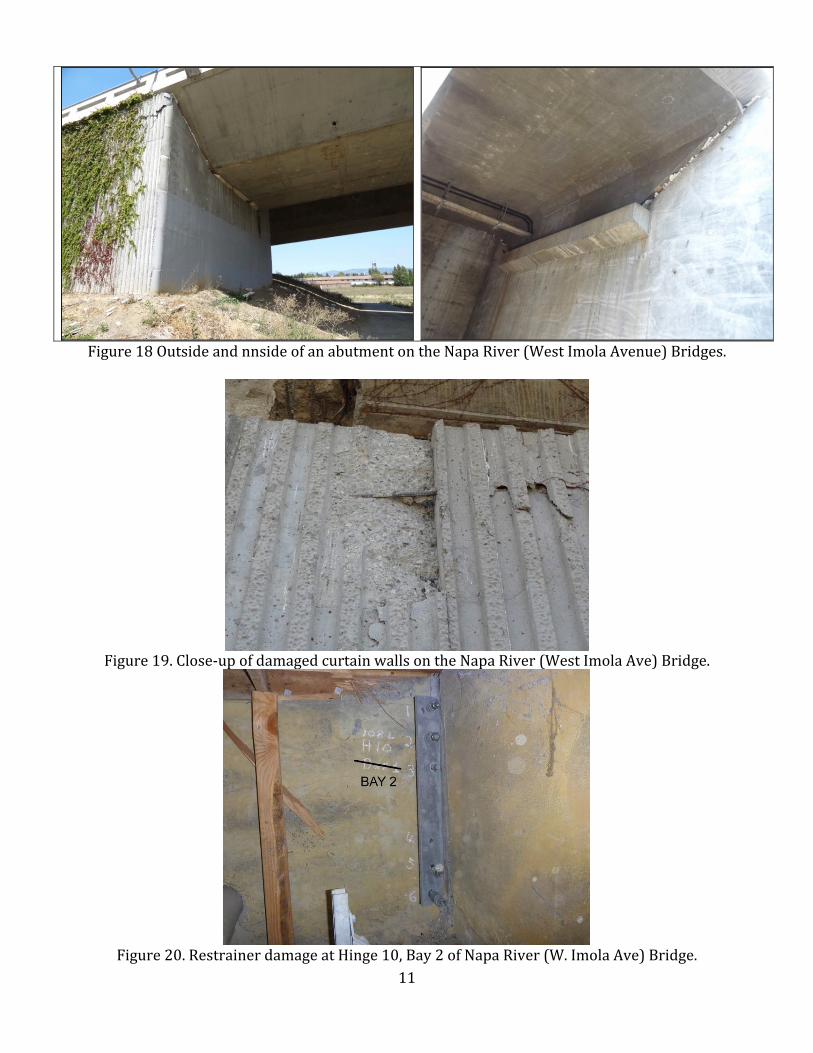
WhentheinvestigationteamfirstsawtheabutmentsontheWestImolaAvenueBridgestheyassumedtherewassoilbehindthemthatwasheldinplacewithmechanicallystabilizedearth(MSE)retainingwalls.However,whentheylookedbehindtheabutmenttheysawtheapproacheswereactuallyslabbridgesonstandardconcretepileextensions.WhattheyhadthoughtwereMSEWallsturnedouttobeprecastcurtainwalls.Caltranspreferstohavesoilbehindtheabutmenttoprovidestiffnessanddampingduringanearthquake.However,onsuchalongbridgeastiffabutmentplaysamuchsmallerrole.ThisbridgeisalsoveryclosetotheNapaCollegestationthatrecordedpeakaccelerationof0.375gduringtheearthquake.Thedamagethatoccurredduringtheearthquake,cracksandspallsofthecurtainwallsatalltheabutments,wastheresultoftheendsofthesuperstructurebangingagainsttheslendercurtainwalls(Figures18and19).Moresubstantialabutmentscouldhaveheldthesuperstructuremoresecurelyinplace.However,itisunlikelythatthesuperstructurecouldunseatsincetheapproachslabissecurelyattachedtotheendofthesuperstructure.Also,whenCaltransOfficeofStructuresMaintenanceandInvestigations(OSMI)wentinsidethesuperstructure,theyfoundthehingerestrainershadbeenpoorlyinstalledandweredamagedattheswageconnectionsoratthetensionindicators(Figure20).Restrainersmustbecarefullyinstalled,whichrequirestighteningthemuntilthespiralwasherscloseandthenbackingofftoaccountforthevariationintemperature.However,restrainersareasecondarysystemforearthquakeprotectionandthehingesallhad36inchseats.Thisbridgehadthemostexpensivecostestimateforrepairofallthestatebridges(SeeAppendix).
11
Figure18OutsideandnnsideofanabutmentontheNapaRiver(WestImolaAvenue)Bridges.
Figure19.Close‐upofdamagedcurtainwallsontheNapaRiver(WestImolaAve)Bridge.
Figure20.RestrainerdamageatHinge10,Bay2ofNapaRiver(W.ImolaAve)Bridge.

12
4:ImolaAvenue(SR121)Separation‐Br.#210086L/R(38.2819,‐122.3000)TheImolaAvenueSeparationiscomposedofparallelbridgesthatcarrySR29overSR121.Theyaresinglespan(88ftlong)bridgesonstruttedabutments(Figure21).Thisisnotaparticularlygoodseismicdetailandexplainswhytheenddiaphragmontheleftbridgebangedagainstthewingwallandcracked(Figure22).ThesebridgesareclosetothepreviouslystudiedNapaRiver(WestImolaAvenue)Bridgeandsawlessthan0.4gpeakgroundaccelerationduringtheearthquake.
Figure21.StruttedabutmentsonImolaAvenueSeparation.
Figure22.Damagetoleftbridgefrombangingagainstwingwall.

13
5:OldSonomaRdOConSR29Br.#210087(38.2819,‐122.3000)ThenexttwobridgescrossSR29nearstrongmotionstationN016(Figure23).Thisstationrecordedpeakgroundaccelerationof0.611gduringtheSouthNapaearthquake.StationN016wasfurtherfromtheepicenterbutitrecordedlargergroundmotionbecausenearfaulteffectsincreasedshakinginthedirectionofthefaultrupture.
Figure23.OldSonomaRdandFirstStreetOvercrossingsnearNCSNStationN016
TheOldSonomaRoadOvercrossingisafourspan307ftlongprecastconcretegirderbridgeontwocolumnbentsbuiltin1961acrossSR29intheCityofNapa(Figure24).Thebridgewasretrofittedwithcablerestrainersinthe1980sandithadanadditionalretrofitinthe1990s.ExistingdamagesuchasbangingbetweentherailingandthecurbandsettlementofthebridgeapproacheswasmadeworsebytheSouthNapaEarthquake(Figure25).

14
Figure24.PhotoofOldSonomaRoadBridgeaftertheSouthNapaEarthquake.
Figure25.Earthquakedamage(bangingbetweenthecurbandthebarrier)attheOldSonomaRoad
Bridge.

15
6:FirstStreetOConSR29Br.#210088(38.2997,‐122.3025)TheFirstStreetOCisa296ftlong(4span)steelgirderbridgeonacurvebuiltin1964(Figure26).Thebridgewasretrofittedwithcablerestrainersinthe1980s.Earthquakedamageincludedspallingofthedeckoverhangduetobangingoftheexpansionjoint(Figure27)aswellasapproachsettlementsimilartowhatoccurredontheOldSonomaRoadOC.
Figure26.PhotoofFirstStreetBridgetakenaftertheSouthNapaEarthquake.
Figure27.Spallingofthedeckoverhangatexpansionjoint(rubbleonbentcap).

16
7:NapaSloughBridgeBr.#21C0117(38.1601,‐122.3806)Althoughstate‐ownedbridgesperformedwellduringtheearthquakeafewofthelocally‐ownedbridgeshadseriousdamage.TheNapaSloughBridgeisa13spanprecastgirderbridgesupportedonbatteredpileextensionsthatwasbuiltin1966.Thisbridgeisnowaprivately‐ownedbridgeandclosedtopublictraffic.Duringtheearthquakethepilesweredamagedasaconsequenceofthebatter(whichattractedmoreload)andbecauseofthelargemotionthatcanoccurinaslough(seeFigures28through30).Althoughsomepilesweredamagedtheearthquakewasnotoflongenoughdurationtocauseseriousdamage.The#4hoopsat12inchespreventedexcessivebucklingofthemainreinforcementandthepilescontinuedtosupportthesuperstructure.
Figure28.Topsandbottomsofthepileextensionsspalledduringtheearthquake.
Figure29.Closerviewofdamageattopofpileextensions.

17
Figure30.DamageatthebottomofpileextensionsonNapaSloughBridge.
ThisbridgewasretrofittedaspartoftheLocalAgencyBridgeRetrofitProgramin1994.Theretrofitincludedpedestals,strengtheneddiaphragmswithbolsters,andcablerestrainersattheeightexpansionjointlocationsonthebridge(Figure31and32).However,nothingwasdonetostrengthenorincreasetheductilityofthepileextensions.
Figure31.Locationswherethebridgewasretrofittedtopreventunseating.
Figure32.RetrofitatexpansionjointlocationonNapaSloughBridge.

18
8:StateRoute37BridgeacrossSonomaCreek#23006338.1559,‐122.4082TheSonomaCreekBridgeisatwenty‐twospanprecastgirderbridgeonprecastpileextensions.ItwasseismicallyretrofittedwithCISSPilessupportingthebentcapwhenitwaswidenedin1999(Figure33).ThebridgeistwomilesfromthepreviouslystudiedNapaSloughBridgeandhadasimilarsubstructureandsimilarsoil.Theretrofitprotectedthisbridgefromseriousdamageduringtheearthquake.
Figure33.SonomaCreekBridgewithseismicallyretrofittedsubstructure.
9:GreenwoodAveBracrossGarnetCreek#21C004238.5927,‐122.5908TheGreenwoodAvenueBridgeisasinglespanmasonryarchthatwasbuiltin1904.Itappearsthatexistingdamagewasexacerbatedbytheearthquakeresultinginthebridgebeingclosedtotrafficaftertheearthquake(Figure34).
Figure34.PhotosofGreenwoodAve.Br.takenaftertheearthquake.

19
OTHERBRIDGESSTUDIED:10:ClintonStreetPOCacrossNapaCreek#21C009438.3006,‐122.2882TheClintonStreetPedestrianOvercrossingisarecentlybuiltsteeltrussbridge.Duringtheearthquaketheanchorboltsatthebottomofthetrusswerebrokenandtheapproachessettledsomuchthatthebridgewasclosed(Figure35).NCSNStationN016nearthebridgerecordedPGA=0.61g
Figure35.ApproachsettlementonClintonStreetPOC.
11:Route37/29Separation#23021838.1377,‐122.2560TheRoute37/29Separationis6‐spanprestressedconcretecontinuousboxgirderbridgethatwasbuiltin2005.Damagetointeriorshearkeyatabutmentanddamagetoexpansionjoints(Figure36).CGSStation68294nearthebridgerecordedPGA=0.47gand1secSA=0.11g.
Figure36.DamagedexpansionjointatAbutment7onRoute37/29Separation.

20
12:ThirdStreet(NapaRiver)Bridge#21C001238.2980,‐122.2833TheThirdStreetBridgewasrecentlybuilttoreplaceanexistingarchbridgeaspartofafloodcontrolprojectontheNapaRiver.Itisathreespanhaunchedboxgirderbridgeonpierwalls.Therewasevidenceofbangingbetweentheabutmentbackwall,thewingwalls,andthebarrierrailduringtheearthquake.Therewasalsoevidenceofsandboilsunderthebridgesuggestingthattheshakingmayhavebeenexacerbatedbysoilliquefaction.NCSNStationN016nearthebridgerecordedPGA=0.61g
13:StateRoute37BridgeacrossPetalumaRiver#27001338.1559,‐122.40822183ftlongprecastgirderandsteelstringerbridgeonflexibleandstiffpiersSeismicretrofitwithsteelcasingsaroundlinkbeams(andsomecolumns)in1994CGSStation68778atbridgePGA=0.024g,PGV=1.67cm/s,1secSA=0.01gNoDamage
14.Carquinez(I‐80)BridgesacrossCarquinezStrait#230015R38.0625,‐122.2284Cantilever5spantrussbridgebuiltin1958Veryextensiveseismicretrofitin1997CGSStation68206atbridgePGA=0.995g,PGV=22.2cm/s,1secSA=0.12gNoDamage.Ongoingstudiestounderstandwhysuchlargeaccelerationsoccurred.
15.Carquinez(I‐80)BridgesacrossCarquinezStrait#280352L38.0625,‐122.2284SuspensionBridgebuiltin2003withpeer‐reviewedstate‐of‐the‐practiceseismicdesign.CGSStation68206atbridgePGA=0.995g,PGV=22.2cm/s,1secSA=0.12gNoDamage
16.MareIslandCausewayacrosstheNapaRiver#23C0248#38.1109,‐122.2747Steelliftbridgewithsteelgirderandconcretetrestleapproaches.Abasculebridgewasbuiltin1934andreplacedbytheliftbridgein1980.BridgeisneartheVallejoFireStation(PGA=0.329g,PGV=21.11cm/s,1secSA=0.18g)andtheNapaRiverBridge(PGA=0.198g,PGV=19.00cm/s,1secSA=0.14g)Existingdamagetothesteelrockerbearingsandconcretetrestleswasexacerbatedbytheearthquake(Figure37).Therewasalsoconcernaboutthepilesandthelocalagency(CityofVallejo)wasgoingtowriteacontractfordiverstolookfordamage.
Figure37.MareIslandCausewayanddamagetobatteredpilesoftheconcretetrestle.

21
Conclusion:Lackofsignificantbridgedamageisconsideredasuccessduringearthquakes.However,notmuchbridgedamageisexpectedfromaM6.0earthquake.InFigure38belowwecancomparegroundshakingintensityfromtheM6.9LomaPrietaandM6.0SouthNapaEQs.WecanseetheareaofhighshakingwasmanytimeslargerduringLomaPrieta.
Figure38.ComparisonofM6.9LomaPrietaandM6.0NapaEQs.
Thelargeefforttoscreentheexistingbridgeinventoryandretrofitthemostvulnerablebridgescontributedtothelackofbridgedamageduringthisearthquake.Stilltheearthquakeposesmorequestionsthanitanswers.ThedistributionofstronggroundmotionandthelackofdamagenearstationsthatrecordedPGAof0.6gandeven1.0grequiresanexplanation.Also,theverylargegroundshakingrecordswereoftenrightnexttoverysmallrecords.WhywasthereverystrongshakingattheCarquinezStraitsofarfromtheWestNapaFault?Ifaccelerationsarenotagoodindicatorofdamagemaybealternativeinstrumentsshouldbeused.Therecordingstookalongtimetobecollected.CaltransneedstoworkmorecloselywiththeCaliforniaGeologicalSurvey(CGS)StrongMotionInstrumentationProgram(SMIP)toimprovethecollectionofstrongmotioninformationtoaidinpostearthquakeevaluationandresponse.Thethresholdthatturnsonstrongmotionrecordersneedstobesetatvaluesreflectingthetypeandimportanceofthebridge.RawdatashouldbeimmediatelysenttoCaltransforevaluatingbridgeperformance.Caltransandthepubliccannotaffordtowaitseveraldayswhilestrongmotiondataiscollectedbyhandfrombridgesites.
TheseismicityoftheNapaValley/AmericanCanyonneedstobebetterunderstood.ThefaultsarepoorlydefinedsouthofNapaandunknownunderSanPabloBay.Also,whatcanthisearthquaketellusaboutthelargeearthquakesweareexpectingontheHayward,GreenValley,Concord,andotherlargemagnitudefaultsinNorthernCalifornia?
Thegeologyoftheareaalsoneedsmorestudy.Theareaiscoveredinunconsolidatedsoftsediments,whichamplifiedlongperiodgroundshakingduringthe1989LomaPrietaearthquake.WhatwastheirroleduringtheSouthNapaearthquake?Therewaslittleevidenceofliquefactionandlateralspreadingaftertheearthquake.Canthisearthquakeimproveourabilitytodeterminewhenliquefactionandlateralspreadingwilloccur?Ofroughly40bridgesthatwerestudiedintheareaofstrongshaking,2bridges(LincolnAveOC(21‐0089)andNapaCreek(21‐0022))hadfactorsofsafetyforliquefactionlessthan1.Theteaminvestigatedbothbridges.ThesidewalksontheLincolnAveOChadpreviouslysettledandhad

22
settledsomemoreduringtheSouthNapaearthquake.TherewasnosignofsoilmovementatthenearbyNapaCreekBridge.However,thecurrentwatertablemaybelowbecauseofthedrought.Caltransisplanningtoperformdrillingatthesebridgelocationstoseeifthewatertablewasatalevelwhereliquefactionisexpectedtooccur.Ifthewatertableisatthatlevel,thenthissuggeststhecalculationforliquefactionmaybeoverlyconservative.Overtenmilesofsurfacefaultingwasobservedduringtheearthquake.Geologistsreturningtothesamesitesoverthenextfewdaysfoundthefaultoffsetcontinuedtogrowovertime.InFigure39wecanseethefaultoffsetcontinuedtocreepfor48hoursaftertheearthquake.Thissuggeststhatbridgesoverfaultsneedtobecarefullymonitoredandpossiblyshoreduptopreventapossiblecollapseasthefaultcontinuestoslip.Thisalsosuggestitmaynotbenecessarytodesignforthelargestgroundshakingdisplacementplusthelargestfaultoffsetdisplacementiftheshakingendsbeforethefulloffsetoccurs.Finally,thefaultwasobservedtoruptureonseveraltracesandtostepbetweenfaults.Thissuggestsitmaybeprudenttodesignfortheoffsetateveryspansincewecan’tbecertainwhereitwilloccur.
Figure39.FaultoffsetacrossStateRoute12continuedtoslipfor48hoursaftertheearthquake.TheSouthNapaearthquakeprovidedanumberofopportunitiestolearnmoreaboutearthquakesandhowtheyimpactbridges.Wecanincorporatestrongmotionrecordstovalidatethelatestgroundmotionpredictionequations(GMPE).WecanusetheverticalarraydataattheCarquinezBridgetovalidateour1Dand2Dsiteresponsemodels.Wecanusetheresponseofbridgesonliquefiablesoiltoimproveourequationsfordeterminingdemandsonbridgesduetoliquefactionandlateralspreading.Caltransbridgescreeningprogramperformedwell.All412state‐ownedbridgesintheareawereabletocarrytrafficaftertheearthquake.Bridgeretrofitsperformedwell.TheSonomaCreekBridgewithlargediameterpilesprotectingvulnerablebatteredpileextensionshadnodamagewhilethenearbyNapaSloughBridge(asimilarbridgewithoutasubstructureretrofit)hadseriousdamagetothepileextensions.Newbridgesalsoperformedwell.Therecently‐builtCarquinezSuspensionBridgehadnodamagedespitethelargegroundmotionrecordednearby.However,Caltransmustcontinuetoadvancetheseismicperformanceofbridgesinanticipationofthenext‘bigone.’

23
AppendixA:CaltransOSMIreportforstateownedbridges.Bridge # Bridge Name Dist-Co-Rte-PM 1 SA
(g) Damage Observed Recommended
Repair Date Inspected
20 0022 SONOMA CREEK 04‐SON‐121‐R7.3 0.11 9/27/021420 0023 ARROYO SECO 04‐SON‐121‐8.43 0.12 9/27/021420 0090 TOLAY CREEK 04‐SON‐037‐4.04 0.11 9/27/021420 0121 BRANCH ARROYO
SECO 04‐SON‐121‐8.51 0.12 9/27/0214
20 0135 GRIZZLY CATTLEPASS
04‐SON‐121‐4.91 0.10 9/27/0214
21 0001 HUICHICA CREEK 04‐NAP‐121‐.75 0.13 8/24/201421 0002 CARNEROS CREEK 04‐NAP‐121‐2.4 0.18 8/24/201421 0003 TULUCAY CREEK 04‐NAP‐121‐6.42‐NAP 0.17 8/24/201421 0022L NAPA CREEK 04‐NAP‐029‐11.65‐NAP 0.16 9/27/021421 0022R NAPA CREEK 04‐NAP‐029‐11.65‐NAP 0.16 9/27/021421 0039 BASALT ROAD UC 04‐NAP‐221‐1.5‐NAP 0.18 8/24/201421 0040 AMERICAN CANYON
CREEK 04‐NAP‐029‐.56 0.19 9/27/0214
21 0043L LOMBARD OH 04‐NAP‐029‐R2.37 0.19 8/24/201421 0043R LOMBARD OH 04‐NAP‐029‐R2.37 0.19 8/24/201421 0048 CRAIG CREEK 04‐NAP‐029‐14.11‐NAP 0.11 9/27/021421 0049 NAPA RIVER BOH 04‐NAP‐029‐R6.99 0.31 Abutment 14, left side wingwall settled one
inch and rotated outward 2 inches; abutment is spalled 6 inches x 6 feet with exposed rebar at abutment/wingwall joint
Replace wingwall and patch spall by saw cutting and recasting
8/24/2014
21 0071L SUSCOL CREEK 04‐NAP‐029‐R6.08 0.16 9/27/021421 0071R SUSCOL CREEK 04‐NAP‐029‐R6.08 0.16 9/27/021421 0077 TULUCAY CREEK
(CAYETANO CREEK) 04‐NAP‐121‐R5.71 0.18 8/24/2014
21 0086L IMOLA AVENUE SEPARATION (29‐121)
04‐NAP‐029‐R10.38‐NAP
0.15 Abutment 1, crack and delaminated concrete at corner
Remove unsound concrete and recast damaged area
8/24/2014
21 0086R IMOLA AVENUE SEPARATION (29‐121)
04‐NAP‐029‐R10.38‐NAP
0.15 8/24/2014
21 0087 OLD SONOMA ROAD OC
04‐NAP‐029‐10.7‐NAP 0.16 Existing rail and curb spalls on a rail in fair condition made worse by the EQ
Repair the bridge rail approach rail and curb spalls
8/24/2014
21 0088 FIRST STREET OC 04‐NAP‐029‐11.55‐NAP 0.16 4 inch wide x 24 inch long x 4 inch deep deck soffit spall in the deck overhang on the
right side of the Bent 2 expansion joint
Patch the spall in the deck overhang
8/24/2014
21 0089 LINCOLN AVENUE OC
04‐NAP‐029‐12.04‐NAP 0.14 Damage was determined to be an existing condition
no action required 9/27/0214
21 0094L FIFTH AVENUE UC 04‐NAP‐029‐R6.63 0.20 8/24/201421 0094R FIFTH AVENUE UC 04‐NAP‐029‐R6.64 0.20 8/24/201421 0098 STANLEY CREEK 04‐NAP‐029‐R8.33 0.25 8/24/201421 0101 TRANCAS STREET
OC 04‐NAP‐029‐13‐NAP 0.12 9/27/0214
21 0102 NORTH NAPA UP 04‐NAP‐029‐12.91‐NAP 0.12 8/25/201421 0107 NORTH NAPA POC 04‐NAP‐029‐12.9‐NAP 0.12 9/27/021421 0108L/R NAPA RIVER (W
IMOLA AVE) 04‐NAP‐121‐R5.3‐NAP 0.19 Evidence of large movements at all four
abutments (bin abutments) of these parallel bridges due to foam forming material on the ground in front of the abutments; 4 ft x 6 ft concrete spall at top corner of Abutment shear keys, typical at 6 of 8 locations. Abutment 1 external shear keys broken. Type A seals at both abutments and strip seals at bin abutments are torn from transverse movement. Ends of bridge rail damaged at joints. Restrainers damaged.
Repair shear keys on each side of each of 5 abutments. Replace 4 joint seals per bridge. Rebuild bridge rail. Replace broken restrainers.
8/24/2014
23 0004 GREEN VALLEY CRK 04‐SOL‐080‐12.91‐FRFD 0.12 9/27/021423 0004G N680‐E80
CONNECTOR 04‐SOL‐680‐13.12‐FRFD 0.12 9/28/2014
23 0014L LYNCH ROAD UC 04‐SOL‐080‐R9.65 0.10 9/27/0214

24
Bridge # Bridge Name Dist-Co-Rte-PM 1 SA
(g) Damage Observed Recommended
Repair Date Inspected
23 0014R LYNCH ROAD UC 04‐SOL‐080‐R9.65 0.10 9/27/021423 0063 SONOMA CREEK 04‐SOL‐037‐R.01 0.20 9/27/021423 0064 NAPA RIVER 04‐SOL‐037‐R7.39‐VAL 0.15 Rail tube separation, joint seal damage, UBIT
Inspection Pending Repair spalled bridge rail ‐ $2600; Replace compression seals ‐ $15,000; Reconnect Aluminum rail tube ‐ $2600
8/24/2014
23 0066 MAGAZINE STREET OC 04‐SOL‐080‐1.78‐VAL 0.11 9/27/021423 0081 ROUTE 80‐37
SEPARATION 04‐SOL‐080‐5.63‐VAL 0.11 8/24/2014
23 0088 BENICIA ROAD OC 04‐SOL‐080‐2.44 0.11 9/27/021423 0089 SPRINGS ROAD OC 04‐SOL‐080‐3.23‐VAL 0.12 9/27/021423 0094L SAGE STREET UC 04‐SOL‐037‐R11.22‐VAL 0.13 9/27/021423 0094R SAGE STREET UC 04‐SOL‐037‐R11.22‐VAL 0.13 9/27/021423 0098 TENNESSEE STREET
OC 04‐SOL‐080‐3.49‐VAL 0.12 9/27/0214
23 0108 GEORGIA STREET OC 04‐SOL‐080‐2.88‐VAL 0.11 9/27/021423 0109 WALNUT STREET OC 04‐SOL‐037‐R7.21‐VAL 0.15 8/28/201423 0114 REDWOOD STREET OC 04‐SOL‐080‐4.43‐VAL 0.10 9/27/021423 0117 ROUTE 80‐780
SEPARATION 04‐SOL‐080‐2.22 0.10 9/27/0214
23 0119 LAUREL STREET OC 04‐SOL‐780‐7.07‐BEN 0.10 9/28/201423 0127 RINDLER CREEK 04‐SOL‐080‐5.5 0.11 9/27/021423 0127L WEST ARSENAL UC 04‐SOL‐780‐1.21‐BEN 0.10 9/28/201423 0127R WEST ARSENAL UC 04‐SOL‐780‐1.21‐BEN 0.10 9/28/201423 0135E GREEN VALLEY CRK 04‐SOL‐080‐12.9‐FRFD 0.12 9/27/021423 0138 GREEN VALLEY ROAD
OC 04‐SOL‐080‐12.75 0.12 9/27/0214
23 0139E ROUTE 680‐80 SEPARATION
04‐SOL‐680‐13.09‐FRFD 0.12 9/27/2014
23 0142L CORDELIA OH 04‐SOL‐680‐12.63‐FRFD 0.12 9/27/201423 0142R CORDELIA OH 04‐SOL‐680‐12.63‐FRFD 0.12 9/27/201423 0143L BENICIA VIADUCT 04‐SOL‐680‐R1.33‐BEN 0.11 9/27/201423 0143R BENICIA VIADUCT 04‐SOL‐680‐R1.33‐BEN 0.11 9/27/201423 0150 AMERICAN CANYON
ROAD OC 04‐SOL‐080‐8.1 0.11 9/27/0214
23 0161 PARISH ROAD OC 04‐SOL‐680‐R5.02 0.12 9/27/201423 0162 MARSHVIEW ROAD OC 04‐SOL‐680‐R7.32 0.11 9/27/201423 0163 GOLDHILL ROAD OC 04‐SOL‐680‐R10.02‐FRFD 0.12 9/27/201423 0166 AMERICAN CANYON
CREEK 04‐SOL‐680‐R10.67‐FRFD 0.12 9/27/2014
23 0173G EB 80‐WB 37 CONNECTOR SEP
04‐SOL‐080‐5.65‐VAL 0.11 8/24/2014
23 0173K WB COLUMBUS PKWY WB 80 RAMP OC
04‐SOL‐080‐5.68‐VAL 0.11 8/24/2014
23 0174G E37‐E80 CONNECTOR OC
04‐SOL‐037‐R11.54‐VAL 0.11 8/24/2014
23 0175G E37‐E80 CONNECTOR OC
04‐SOL‐037‐R11.65‐VAL 0.11 8/24/2014
23 0176K WB COLUMBUS PKWY WB 80 RAMP UC
04‐SOL‐080‐5.81‐VAL 0.11 8/24/2014
23 0201K COLUMBUS‐WB 37 ON RAMP OC
04‐SOL‐037‐R11.72‐VAL 0.11 8/24/2014
23 0205L FAIRGROUNDS UC 04‐SOL‐037‐10.94‐VAL 0.13 8/28/201423 0205R FAIRGROUNDS UC 04‐SOL‐037‐10.94‐VAL 0.13 8/28/2014

25
Bridge # Bridge Name Dist-Co-Rte-PM 1 SA (g)
Damage Observed Recommended Repair
Date Inspected
23 0212G N680‐W780 CONNECTOR and OH
04‐SOL‐780‐R.48‐BEN 0.13 9/28/2014
23 0214G N680‐W780‐S680 CONNECTOR & SEP
04‐SOL‐680‐M.8‐BEN 0.13 9/28/2014
23 0215R BENICIA‐MARTINEZ APPROACH
04‐SOL‐680‐M.9‐BEN 0.12 9/28/2014
23 0217 SACRAMENTO STREET OC
04‐SOL‐037‐8.46‐VAL 0.15 9/27/0214
23 0218 ROUTE 37‐29 SEPARATION
04‐SOL‐037‐R9.52‐VAL 0.15 Damage to interior shear key at abutment and damage to expansion joints
make all needed repairs
9/25/2014
23 0219 BROADWAY OH 04‐SOL‐037‐R9.82‐VAL 0.15 Shear key spalls with exposed rebar at Abutment 1, right exterior key and interior shear keys. Minor spalls at rail joints; bridge shifted toward Abut 1 but may be an old condition
Patch shear keys as needed
8/26/2014
23 0220 MINI DRIVE UC 04‐SOL‐037‐R9.98‐VAL 0.15 9/27/021423 0221G N29‐E37 CONNECTOR 04‐SOL‐029‐4.83‐VAL 0.00 Damage to interior shear key at
abutment and damage to expansion joints
make all needed repairs
9/27/0214
23 0222F W37‐N and S29 CONNECTOR OH
04‐SOL‐037‐R9.84‐VAL 0.15 One inch deep spalls along joint armor at Abutment 1. up to 3/4 inch vertical offset across joint on right side; left shear key spalled at Abutment 1.
Replace strip seal at Abutment 1; patch spalled shear key
8/26/2014
23 0223F S29‐W37 CONNECTOR 04‐SOL‐029‐4.92‐VAL 0.15 Spalls around Abutment 1 Patch the spalled and delaminated areas at the Abutment 1 exterior edges of deck: Estimated cost $2600
9/27/0214
23 0237 CHABOT CREEK 04‐SOL‐029‐4.9‐VAL 0.15 9/27/021423 0238 WHITE SLOUGH 04‐SOL‐037‐8.91‐VAL 0.21 9/27/021428 0153L BENICIA‐MARTINEZ
BOH 04‐CC‐680‐25.04‐MTZ 0.12 8/24/2014
28 0153R BENICIA‐MARTINEZ BRIDGE and OH
04‐CC‐680‐25.04‐MTZ 0.12 8/24/2014
AppendixB:CaltransOSMIreportforlocally‐ownedbridges.
Bridge # Bridge Name Road Agency Damage Observed Recommended Repair
21C0010 Napa Creek Jefferson Street City of Napa
21C0011 Napa River Lincoln Avenue City of Napa
Damaged keeper plates @ both abutments.
Replace bearings $181,250
21C0012 Napa River Third Street City of Napa
21C0017 Carneros Creek Old Sonoma Rd County of Napa
21C0038 American Canyon Creek American Canyon Rd City of American Canyon
21C0039 Napa River Soscol Ave City of Napa
21C0041 Redwood Creek Redwood Road City of Napa
21C0044 Napa Creek Main Street City of Napa
Cracking and spall @ A2 approach curb. Left sidewalk.
Minor concrete patch $3,625
21C0045 American Canyon Creek Broadway City of American Canyon
21C0047 Fagan Creek Airport Rd County of Napa
21C0053 Soscol Creek Devlin Road County of Napa

26
Bridge # Bridge Name Road Agency Damage Observed Recommended Repair
21C0078 Huichicha Creek Duhig Road County of Napa
21C0081 Carneros Creek Las Amigas Rd County of Napa
21C0086 Tulocay Cr (Cayetano Cr) Shurtleff Ave City of Napa
21C0092 Napa Creek Seminary St City of Napa
21C0097 Napa Creek Pearl St City of Napa
Left rail damage to the masonry pilasters. All 4 are loose. Sidewalk is fenced off. Left sidewalk is closed.
Repoint masonry $181,250
21C0099 Redwood Creek West Pueblo Ave City of Napa
21C0117 Napa Slough Skaggs Island Rd County of Napa
21C0122 Napa Creek California Blvd City of Napa
21C0123 Murphy Creek Fourth Ave County of Napa
21C0126 Napa River Bypass Soscol Ave City of Napa
21C0127 Napa Cr & River Overflow
First Street City of Napa
Left shear key damage @ Abut 4. Approx. 10 sqft of delaminated concrete
Repalce Shear Key $72,500
21C0130 Napa River First Street City of Napa
21C0132 Napa Valley RR Devlin Road City of American Canyon
Approach AC settlement at one abutment
Overlay approach $72,500
21C0003 Napa River Trancas St City of Napa
Cracks in internal shear keys Epoxy injection $54,375
21C0006 Soda Springs Creek Silverado Trail County of Napa
21C0015 Napa River Overflow Silverado Trail County of Napa
21C0016 Napa River Overflow Silverado Trail County of Napa
21C0020 Dry Creek Solano Ave County of Napa
21C0021 Dry Creek Washington St County of Napa
21C0022 Napa River Overflow Hardman Avenue County of Napa
21C0026 Milliken Creek Trancas St County of Napa
21C0032 Milliken Creek Atlas Peak Road County of Napa
21C0043 Redwood Creek Redwood Road County of Napa
21C0050 Salvador Overflow Big Ranch Road County of Napa
21C0051 Milliken Creek Trancas St County of Napa
21C0055 Dry Creek Dry Creek Rd County of Napa
21C0059 Milliken Creek Hedgeside Avenue County of Napa
21C0067 Napa River Oak Knoll Ave County of Napa
21C0068 Napa River Overflow Oak Knoll Ave County of Napa
21C0073 Redwood Creek Redwood Road County of Napa
21C0080 Soda Creek Loma Vista Dr County of Napa
21C0084 Napa River Overflow Ragatz Lane County of Napa
21C0085 Yountville Overflow Ragatz Lane County of Napa

27
Bridge # Bridge Name Road Agency Damage Observed Recommended Repair
21C0104 Napa River Overflow Oak Knoll Ave County of Napa
21C0111 Napa Drain Wine Country Ave City of Napa
21C0125 Silverado Creek Villa Lane City of Napa
21C0028 Napa Drain Jefferson St City of Napa
21C0029 Napa Drain Trower Ave City of Napa
21C0001 Bell Canyon Creek Silverado Trail County of Napa
21C0002 Napa River Zinfandel Lane County of Napa
21C0004 Napa River Cook Road County of Napa
21C0019 Rector Creek Silverado Trail County of Napa
21C0023 Napa River Deer Park Road County of Napa
21C0028 No Name Creek Silverado Trail County of Napa
21C0033 Wooden Valley Creek Wooden Valley Rd County of Napa
21C0055 Dry Creek Dry Cr Rd County of Napa
21C0064 Napa River Lodi Lane County of Napa
21C0065 Dry Creek Mt Veeder Rd County of Napa
21C0069 Napa River Oakville Cross Rd County of Napa
21C0072 Napa River Pratt Avenue City of Saint Helena
21C0075 Chiles Creek Chiles-Pope Vly Rd County of Napa
21C0077 Conn Creek Conn Valley Rd County of Napa
21C0082 Conn Creek Overflow Oakville Cross Rd County of Napa
21C0083 Conn Creek Oakville Cross Rd County of Napa
21C0087 Conn Creek Skellenger Lane County of Napa
Cracking in abutment wingwall Replace Wingwall $108,750
21C0088 Soda Creek Soda Cyn Rd County of Napa
21C0100 Hopper Creek Mulberry St Town of Yountville
21C0101 Capell Creek Capell Cross Rd County of Napa
21C0102 Suisun Creek Wooden Vly Cros Rd County of Napa
21C0105 Chiles Creek Chiles Pope Vly Rd County of Napa
21C0109 Napa River Pope St City of Saint Helena
21C0110 Sulphur Creek Pope St City of Saint Helena
21C0112 Sulphur Creek Valleyview St City of Saint Helena
21C0113 York Creek Spring Mountain Rd City of Saint Helena
21C0116 Napa River Yountville Cross R County of Napa
Cracks in external shear keys and approach AC settlement
Remove and replace $217,400

28
Bridge # Bridge Name Road Agency Damage Observed Recommended Repair
21C0025 Napa River Dunaweal Lane County of Napa
21C0030 Dutch Henry Creek Silverado Trail County of Napa
21C0031 Simmons Canyon Crk Silverado Trail County of Napa
21C0042 Garnett Creek Greenwood Ave County of Napa
Bridge was closed by Napa County after the earthquake. Please see BIR dated 9/4/2014. There is permanent barrier in place. K-rail @ Abut 1 approach. Please see photos.
Replace Bridge $1,812,500
21C0048 Napa River Bale Lane County of Napa
21C0054 Bell Creek Crystal Springs Rd County of Napa
21C0057 Napa River Evey Rd County of Napa
21C0061 Napa River Larkmead Lane County of Napa
21C0062 Troutdale Creek Livermore Rd County of Napa
21C0063 Vanness Creek Livermore Rd County of Napa
21C0066 Napa River Myrtledale Rd City of Calistoga
21C0103 Garnett Creek Grant St City of Calistoga
21C0108 Dutch Henry Creek Larkmead Lane County of Napa
21C0115 Napa River Berry St City of Calistoga
21C0119 Cyrus Creek Petrified Forst Rd County of Napa
21C0013 Pope Creek Knoxv-Berryessa Rd County of Napa
21C0014 Putah Creek Knoxv-Berryessa Rd County of Napa
21C0034 Fp Creek Butts Canyon Rd County of Napa
21C0035 James Creek Butts Canyon Rd County of Napa
21C0036 Duvall Creek Pope Valley Rd County of Napa
21C0046 Swartz Creek Aetna Springs Rd County of Napa
21C0049 Burton Creek Barnett Rd County of Napa
21C0058 Maxwell Creek Hardin Rd County of Napa
21C0074 Eticuera Creek Berryessa-Knoxvlle County of Napa
21C0089 Butts Creek Stage Coach Cyn Rd County of Napa
21C0090 Butts Creek Stage Coach Cyn Rd County of Napa
21C0106 Yokel Creek Pope Canyon Rd County of Napa
21C0118 Pope Creek Pope Canyon Rd County of Napa