Embed Size (px)
Citation preview

Three Rivers Local Plan 1996-2011Word Version following Adoption of the Core Strategy in October 2011
Updates to the Adopted Local Plan
Policies which were not saved beyond September 2007 are shown struck through in black.
Policies which have been replaced by the Core Strategy are shown struck through in red and are annotated with the relevant Core Strategy policy in green underline.
- -

INTRODUCTION
0.1 The Title and Period of the Local Plan
0.2 The Three Rivers Local Plan is the framework for guiding, controlling and facilitating development within Three Rivers District, for the period 1996 to 2011.
0.3 This is the adopted version of the Local Plan and was adopted by Three Rivers District Council at Full Council on the 10 July 2001.
0.4 The Function of the Local Plan
0.5 This Local Plan is designed to integrate with the Hertfordshire Structure Plan Review, which sets the strategic planning context. The Hertfordshire Structure Plan Review 1991-2011 was adopted on 30 April 1998. With this Local Plan now adopted, the two Plans together with the adopted Minerals and Waste Local Plans (also prepared by the County Council) form the Development Plan for Three Rivers District. The functions of the Local Plan are:
(a) To update the policies contained in the Three Rivers District Plan Review 1991 (incorporating the Alterations 1993);
(b) To develop the policies of the Structure Plan Review and relate them to this District at a detailed level;
(c) To provide a detailed basis for development control and advice and to co-ordinate development; and
(d) To bring planning issues to public notice.
0.6 The Importance and Weight of the Local Plan
0.7 The Development Plan is an important policy document, based on national legislation. Section 54A of the Town and Country Planning Act 1990 states that “Where, in making any determination under the planning Acts, regard is to be had to the development plan, the determination shall be made in accordance with the plan unless material considerations indicate otherwise.” The Development Plan is therefore the principal consideration in the plan-led system.
0.8 Following adoption, the Local Plan’s policies will be afforded greater weight by the Council, and by the Planning Inspectorate when determining appeals.
- 1 -

0.9 Using the Local Plan
0.10 This Local Plan comprises a written statement (this document) and a Proposals Map. The written statement is divided into three main parts; environment policies, development policies, and technical appendices. There is a glossary, containing all terms and abbreviations which require explanation, and a full bibliography containing details of all documents referred to in the text.
0.11 In the written statement, policies are printed within boxes, in bold, with a policy reference number and a short heading. All other text is in numbered paragraphs, and it provides the justification for and explanation of the policies within that section.
0.12 The Proposals Map comprises four sheets (A-D) based on Ordnance Survey maps at 1:10,000 scale. There is also an Inset for Rickmansworth Town Centre, contained on Proposals Map A. These show where policies apply in the District. Figure 1 shows the main settlements and communications.
0.13 The policies set out in the Local Plan apply to the whole District, unless modified or added to by a specific local policy, or there is a specific area shown on the Proposals Map.
0.14 Sustainable Development, the Strategy and Aims of the Local Plan
The strategy of this Local Plan is to make provision for the needs of those living and working in the District, to protect and enhance the District’s towns and countryside, and to provide for development whilst taking into account local and wider impacts.
0.15 This broad strategy is consistent with the concept of “sustainable development”. A useful definition of sustainable development is given in the Brundtland Report; “Sustainable development is development that meets the needs of the present without compromising the ability of future generations to meet their own needs”. The Brundtland Report goes on to define two key concepts; the concept of needs to which over-riding priority has to be given, and the concept of limitations on the environment’s ability to meet present and future needs, given the state of technology and social organisation.
0.16 At the ‘Earth Summit’ in Rio de Janeiro in June 1992, the participating nations produced a new convention on the need to integrate the environment into social and economic decision-making. This convention, entitled ‘Agenda 21’, defined sustainable development in detail, and set objectives and targets for achieving it. Gradually, the principles and methods behind sustainable development have been refined and filtered down to the levels of regional, strategic, and now local planning.
- 2 -
0.17 Policy 1 of the Structure Plan Review sets out the over-arching sustainable development framework for the development plan, which as stated in paragraph 0.5 above, is comprised of the Structure Plan and this Local Plan. The following fourteen aims interpret this broad over-arching sustainable development policy in a way relevant to this District. Together with Structure Plan policy 1, they form the sustainable development strategy for Three Rivers:
Spatial Aims:
(a) Maintain the existing settlement pattern and the Green Belt.
(b) Concentrate development in the main towns (in so far as the quality of the urban environment can be maintained and improved).
General Aims for Development:
(c) Ensure that development does not adversely affect the environment.
(d) Discourage use of the private car.
(e) Encourage a high standard of design.
Environmental Aims:
(f) Maintain and enhance the natural environment and avoid depletion and pollution of resources.
(g) Protect critical natural habitats and wildlife.
(h) Protect and provide open space within urban areas.
(i) Protect and enhance critical elements of the historic environment, such as Listed Buildings, historic landscapes and archaeological remains.
Meeting Community Needs:
(j) Make provision for the new homes needed, and associated community and leisure facilities.
(k) Ensure the provision of land for employment uses.
(l) Seek enhancement of town and village centres.
(m) Increase accessibility by means other than the motor car.
(n) Maintain the character of the different settlements of the District.
- 3 -

0.18 The policies have been developed directly from these aims, but each chapter is not intended to address an individual aim. The intention is to produce a structured, comprehensive Local Plan that has full regard for the complex interaction of different policy areas.
0.19 The Local Plan is to be subject to a monitoring framework which will be published as supplementary planning guidance. This will help inform the review of Local Plan policies.
0.20 Assessing the Environmental Impact of the Local Plan
0.21 At every stage of producing this Local Plan, the Council has tried to ensure that the aims and policies it contains will not harm, and wherever possible, benefit the environment, and that policies in different parts of the plan are mutually consistent.
0.22 To do this, the Council has carried out a three stage Environmental Appraisal of the Local Plan, as follows:
(a) Defining environmental stock (making an up-to-date assessment of the assets of the District).
(b) Checking the Plan to ensure that all the relevant issues have been covered (Scoping).
(c) Policy appraisal (ie testing the impact of the policies on the environment and their compatibility with each other).
0.23 Full details of each of these stages are contained in the supplementary document “Report of Appraisal”. The Environmental Appraisal forms part of the justification of the policies. The remaining part of this chapter is a summary of the policy appraisal and explains why policies are included and the possible effects of their implementation.
0.24 Every policy has been assessed against a list of environmental criteria, each of which has a number of indicators linked to it. These allow an assessment of the positive (or negative) impacts of each policy on the environment.
0.25 To give one example, Policy GEN.2 of this Local Plan specifies that major developments should be located close to passenger transport and other services. This has a positive impact on the criteria “transport energy efficiency - modes”, indicators for which are increasing passenger transport share and increasing the attraction of walking and cycling as opposed to car use.
0.26 There is not sufficient space in these pages to present the detailed findings of the Environmental Appraisal. However, Table 1 is a summary table of the environmental criteria, indicators of positive impact, and the policies which are considered to be important in each case.
- 4 -

0.27 In general, the policies were found to be compatible with the environmental criteria. Particularly important relationships between policy areas and certain criteria are as follows.
0.28 The General Development policies (Chapter 1) are of particular importance and relate beneficially to almost all the criteria against which they were assessed. The wide range of policies contained in Natural Environment and Resources (Chapter 2) are specifically aimed at many of the criteria, such as wildlife, countryside, trees (and therefore carbon dioxide fixing, and air, soil and water quality) and natural resources of various kinds.
0.29 Chapters 3 and 4 (Conservation of the Built Heritage and Green Belt) have important beneficial implications for the historic built environment, and retention of countryside and open land respectively.
0.30 In the remaining “development” chapters on Design, Housing, Employment, Shopping and Transport, the emphasis of the policies on reducing car use and encouraging modal shift is clear, as are the related benefits for air quality and the reduced use of fossil fuels (under mineral conservation). The benefits for “liveability” are also obvious.
0.31 Finally, Chapter 10 (Sport and Leisure) encourages switching to environmentally friendly modes of transport, and benefits most of the “local environmental quality” criteria.
0.32 Very few adverse impacts were discovered. An exception however is the unfavourable impact of golf courses on conservation of water resources.
- 5 -

Table 1 - Summary of Environmental Appraisal
General Criteria: Indicators: Relevant Policies:1 Transport energy
efficiency (trips)Average trip length,Number of motorised trips.
GEN.1-2, N.8, GB.4, D.4, H.2-4/8/9/11/12/17, E.1-3/6, S.1-7, T.1-4/6-8/10/11. L.3/4/6
2 Transport energy efficiency (modes)
Levels of public transport use, walking and cycling.
GEN.1-3,7, N.19, GB.4, D.4/5/8, H.2-4/8/11-12/17, E.1-3, S.5-7, T.1-5/6-11, L.3/4/8/10/13/14
3 Built environment energy efficiency
Reduce heat loss from buildings, reduced energy requirements, increase combined heat/power potential.
GEN.3, N.9/12-15, D.2/3, H.2/9/12
4 Renewable energy potential
Safeguard wind, water, wave and biomass potential, and increase direct solar gain.
N.16, D.3
5 Rate of CO2 fixing Increase tree cover, especially broad-leaf woodland.
GEN.3, N.1/2/8/9/12,15-17/19, GB.2/4, D.6, H.3/14, E.5, L.5/9-11/16
6 Wildlife conservation Safeguard important sites and species, and increase general wildlife potential.
GEN.1A/3/6,7, N.1-8/10-19, GB.2-4/8, D.6/7, H.3/17, T.6, L.5/7-11/15/16
7 Air quality Reduce levels of pollutants, including carbon dioxide, ozone, dust, etc.
GEN.1A/2,4,7, N.1/9/12-16/19, GB.4, D.3/4/6/8, H.3/4/8/9/11/12/17, E.1-3/6, S.5-7, T.1-3,5/6-11, L.3/4/6/8/13/14
8 Water conservation and quality
Maintain ground water and surface water supplies and purity.
GEN.4-7 , N.1/2/4-7/12-19, D.6/7, H.3, L.5/6/8/9/11/16
9 Land and soil quality Safeguard soil quality and retention, and reduce contamination and dereliction.
GEN.1A/4-7, N.4/5/7/8/12-19, GB.4, L.5/6
10
Minerals conservation(including fossil fuels)
Reduce consumption of fossil fuels and minerals, and increase reuse and recycling of materials.
GEN.1A/2, GB.4, N.8, D.3-5/8, H.2/4/8/9/11/12/17, E.1-3/6, S.5-7, T.1-3,5/6-11, L.3/4/6/8/13/14
11
Landscape and open land
Safeguard important landscapes, enhance landscape quality, and retain countryside and open land
GEN.1A/5-7, N.1/2/5/7/8,12,16-23, C.7/9/13, GB.1/3-10, 11,D.6/7, H.1/2/15/16, T.6, L.5-11/13/15/16
- 6 -

12
Urban environment -"liveability"
Enhance townscape quality, increase safety and sense of security, increase vitality and viability.
GEN.2-6, N.1/6/8/12-14,20-22, C.1-10/12/14, GB.4/10, D.1/2/4-8/12, H.1-4/7-17, E.1-6, S.1-7, T.1-11, L.1-4/6/8-12/14/16
13
Cultural and historic heritage
Safeguard historic buildings and Conservation Areas, and areas of archaeological or geological value.
GEN.7,N. 20 C.1-14, GB.9/10, D.1, H.3/10, E.1, S.5/7, T.6/11, L.13/15
14
Public access and open space
Maintain and increase the quality and availability of open space.
GEN.1A/3, N.8/11/19, C.1/9, GB.2/4, D.6/8/9, H.3, T.14, L.1-3/5/8-16
15
Building quality Maintain and improve the maintenance and continuous renewal of buildings.
GEN.3/4, C.1-3/6/8/10, GB.5/6/9/10, D.1, H.10-13/15, E.4/5/7
Policy GEN.1 potentially addresses all the column 1 General Criteria.Source: adapted from "Environmental Appraisal of Development Plans - A Good Practice Guide", published by the Department of the Environment, 1993.
- 7 -

GENERAL DEVELOPMENT POLICIES
1.1 The main part of this Local Plan is divided up into chapters which deal with separate development issues and types, such as housing, transport, employment and conservation. However, there are several fundamental policies which apply to most forms of development, whatever their nature.
1.2 Making Development More Sustainable
1.3 The introduction to this Local Plan recognises the fundamental role which the Plan plays in contributing to the aim of making development in Three Rivers more sustainable. The location, design, construction and future use of all development, regardless of scale, can contribute towards this aim and many of the policies in the Plan have been developed to achieve this. Policy GEN.1 is an overarching policy, the purpose of which is to seek to enable all aspects of development to make as full a contribution to sustainable development principles as possible.
1.4 Applicants will be required (except in the case of “householder” development) to submit a statement to demonstrate how sustainability principles have been incorporated into the location, design, construction and future use of their proposals. To provide a basis for this statement, appendix 1 contains a sustainability checklist against which applicants should prepare their statements. Advice may be sought from the local planning authority on the range of issues which should be covered, and in what detail.
GEN.1
MAKING DEVELOPMENT MORE SUSTAINABLE
As part of their applications for development, applicants should submit an assessment of their proposals against the sustainable checklist in Appendix 1. Development will be permitted where it is demonstrated that sustainable development principles are satisfied to the extent of compliance with the policies of this Local Plan and Government statements of planning policy.
Core Strategy Policy CP1
- 8 -

1.5 Location of Development
1.6 Structure Plan Review policies 6 and 7 advocate a development strategy for the main towns, where full use is to be made of opportunities for planned regeneration within the settlements, and peripheral development will only be acceptable where such opportunities have been fully explored, where the development provides demonstrable sustainability benefits to the town, and where the development has been planned within the context of the town as a whole.
1.7 Under this strategic policy, this Council has further refined the main settlements in policy GEN.1a, and based the development strategy on the fact that (a) adequate opportunities for development are identified within the settlements such that peripheral development is not justifiable, and (b) the fact that by definition, such peripheral development would occur in highly sensitive areas of the Green Belt, which this Council is committed to protecting in accordance with advice in PPG2 (Green Belts).
1.8 Therefore, in order to maintain and enhance the facilities and functions of the main urban centres of the District and to protect the surrounding countryside from inappropriate development, the Council will apply policy GEN.1a.
1.9 Maple Cross is a small urban area that has always been excluded from the Green Belt but is not specifically identified in Structure Plan policy 6 as a general location for development. Limited development or regeneration proposals may be appropriate but will be required to demonstrate how they will lead to a more sustainable pattern of development through improved passenger transport links, community facilities, local employment opportunities and other factors affecting the local environment and quality of life for local residents and the locally employed.
GEN.1a
GENERAL LOCATION OF DEVELOPMENT:
Development in the District will be concentrated in the urban areas outside the Green Belt as shown on the Proposals Map. These settlements are Rickmansworth, Chorleywood, Abbots Langley and part of Kings Langley, part of Garston, Croxley Green, Oxhey Hall, Carpenders Park, South Oxhey, Eastbury and part of Northwood, and Moor Park.
Any proposals for development within Maple Cross and the adjacent employment area will be required to demonstrate that the proposals will lead to a more sustainable pattern of development and enhance local quality of life and environment.
Core Strategy Policies PSP1, PSP2, PSP3, PSP4, CP1, CP2
- 9 -

1.10 PPG13 (Transport) urges local authorities to adopt policies which will reduce the need to travel by car. One of the principal ways of doing this is to guide development to locations where the employees, residents or visitors have convenient access to a range of local facilities and a choice of means of transport including walking, cycling and passenger transport modes.
1.11 Accessible locations can be broadly defined as those where a high proportion of the trips generated by new development can be conveniently made by passenger transport, on foot or by bicycle. Most people are willing to walk distances of up to 500 metres, but as distances approach 1 kilometre, most car users rely on their vehicles, even though walking time is still only about ten to fifteen minutes (Sustainable Settlements, UWE, 1995). County Council standards indicate maximum walking distances of 400m to bus stops in urban areas generally, and 200m in town centres.
1.12 Figure 2 overleaf illustrates those urban areas of the District which meet a range of accessibility criteria. These are:
(a) Within walking distance (up to 400m) of daily destinations such as convenience shops, post office, etc.
(b) Within walking distance of railway stations, or main bus corridors with approximately 15 minute service frequency and convenient journey times to major destinations (e.g. town and village centres).
1.13 The existence of just one factor contributing to accessibility (e.g. a bus stop or one local newsagent) would not usually be enough to justify major development, and while bus services may extend for some distance beyond the zones illustrated in figure 2, journey times also affect people’s perceptions of the convenience of bus travel. The Council will also take into consideration obstacles such as main roads and steep hills when evaluating the accessibility of a major proposal for pedestrian and cyclist access to passenger transport and local services.
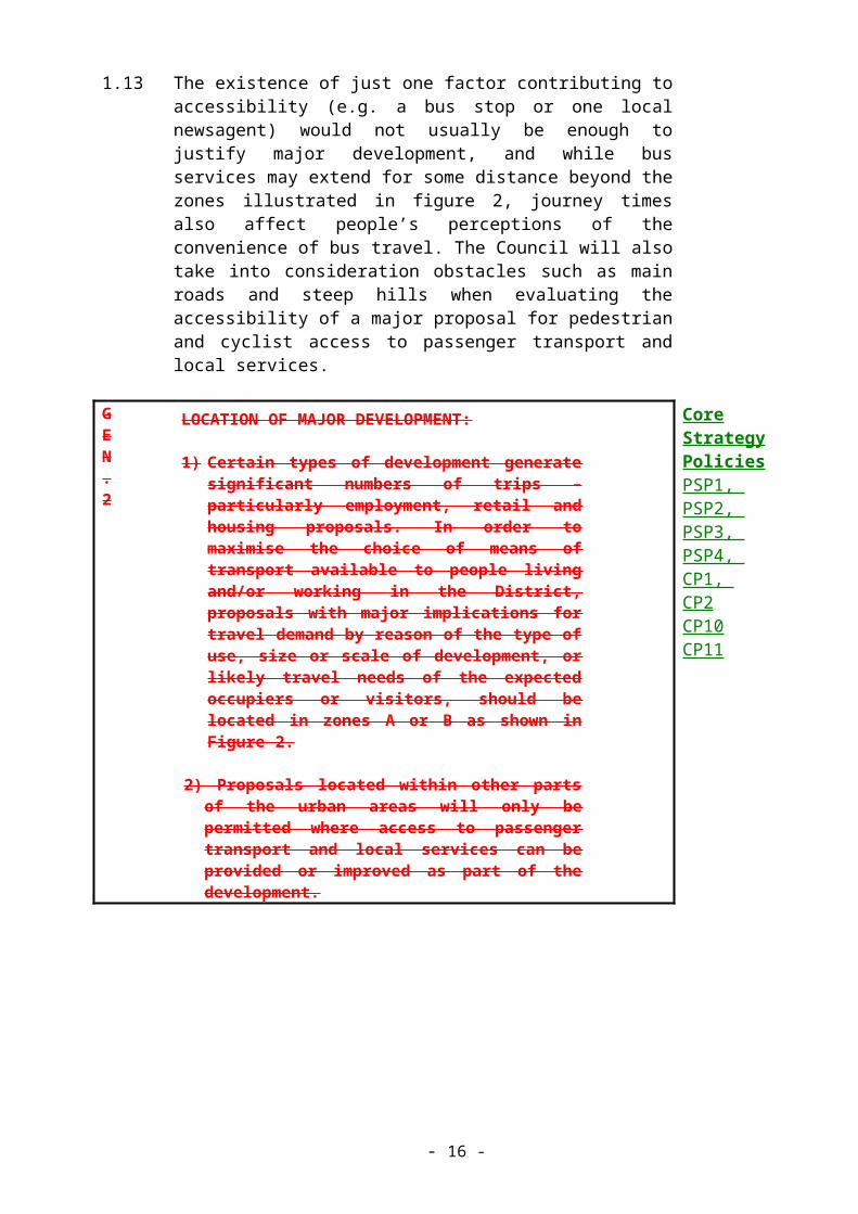
GEN.2
LOCATION OF MAJOR DEVELOPMENT:
1) Certain types of development generate significant numbers of trips – particularly employment, retail and housing proposals. In order to maximise the choice of means of transport available to people living and/or working in the District, proposals with major implications for travel demand by reason of the type of use, size or scale of development, or likely travel needs of the expected occupiers or visitors, should be located in zones A or B as shown in Figure 2.
2) Proposals located within other parts of the urban
Core Strategy Policies PSP1, PSP2, PSP3, PSP4, CP1, CP2CP10CP11
- 10 -

areas will only be permitted where access to passenger transport and local services can be provided or improved as part of the development.
1.14 Comprehensive Settlement Appraisals
1.15 The Structure Plan Review encourages the preparation of Comprehensive Settlements Appraisals (CSAs) as a means of providing positive opportunities for public involvement and to assist in the preparation and review of the Local Plan. Five settlements in Three Rivers are identified as suitable for the preparation of CSAs (Abbots Langley, Chorleywood, Croxley Green, Rickmansworth and the grouped settlements of Watford Rural Parish). This Council welcomes the principles of community involvement and informed decision-making behind the preparation of CSAs but the resources and time needed for such a study are considerable.
1.16 Given the large number of ‘eligible’ settlements in Three Rivers, and the length of the Local Plan period, it is more appropriate to treat CSA preparation as a gradual and informal process, strictly ancillary to the Local Plan but able to influence future policy reviews. As CSAs are a community-based venture, this Council also advocates a corporate-led approach, rather than one limited to the scope of land use planning.
- 11 -

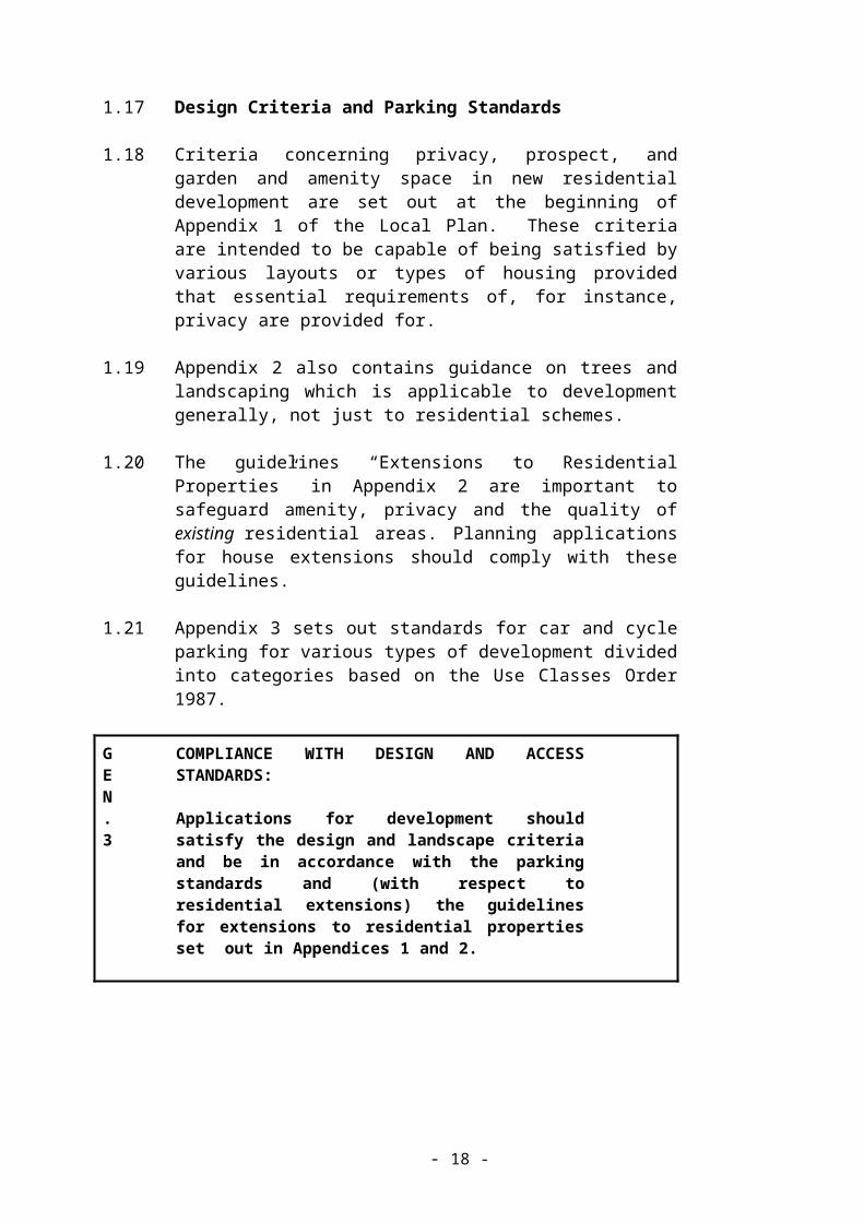
1.17 Design Criteria and Parking Standards
1.18 Criteria concerning privacy, prospect, and garden and amenity space in new residential development are set out at the beginning of Appendix 1 of the Local Plan. These criteria are intended to be capable of being satisfied by various layouts or types of housing provided that essential requirements of, for instance, privacy are provided for.
1.19 Appendix 2 also contains guidance on trees and landscaping which is applicable to development generally, not just to residential schemes.
1.20 The guidelines “Extensions to Residential Properties” in Appendix 2 are important to safeguard amenity, privacy and the quality of existing residential areas. Planning applications for house extensions should comply with these guidelines.
1.21 Appendix 3 sets out standards for car and cycle parking for various types of development divided into categories based on the Use Classes Order 1987.
GEN.3
COMPLIANCE WITH DESIGN AND ACCESS STANDARDS:
Applications for development should satisfy the design and landscape criteria and be in accordance with the parking standards and (with respect to residential extensions) the guidelines for extensions to residential properties set out in Appendices 1 and 2.
- 12 -

1.22 Potentially Hazardous or Polluting Development
1.23 PPG23 (Planning and Pollution Control) and Circular 11/92 (Planning Controls for Hazardous Substances) both offer guidance on the consideration of proposals for potentially hazardous or polluting development, and other pollution-sensitive proposals located near to existing installations. The planning authority will consult with appropriate expert authorities such as the Environment Agency and the Health and Safety Executive (HSE) and have regard to their views in appropriate cases. Under the Planning (Hazardous Substances) Act 1990, the Council is required to consult with the HSE on applications close to hazardous installations. Therefore, planning applications within 60 metres of the gas holders at Wharf Lane, Rickmansworth (which is the only currently notified hazardous installation in the District), will be referred to the HSE for comments.
GEN.4
POTENTIALLY HAZARDOUS OR POLLUTING DEVELOPMENT
1) Proposals for potentially hazardous or polluting development will only be permitted where the Council is fully satisfied that there will be no risk to public health or the environment, and no significant adverse effects on general amenity, resulting from releases to water, air or land, or from noise, dust, vibration, heat or light. Proposals should be accompanied by an Environmental Impact Statement addressing all relevant issues when a planning application is submitted.
2) The Council will also have regard to the following criteria when determining planning applications:
i. The need for development in connection with existing industrial or waste management facilities in order to comply with statutory environmental quality standards or objectives;
ii. Wider economic and social need for the proposed development;
iii. The practicality of securing pollution or nuisance controls during the lifetime of the use and, where relevant, restoration of the land to a standard which is capable of an acceptable after-use.
iiv. The need to keep housing and other pollution-
- 13 -

sensitive land uses well apart from any potentially harmful installation. Any proposal which would lead to potentially hazardous or polluting development and pollution-sensitive uses such as housing being located close together will be rigorously tested for acceptability. The Council will take into account the presence of existing uses, and areas of land allocated for housing or other sensitive uses in the Local Plan.
- 14 -

1.24 Development, Unstable Land and Contamination
1.25 Some areas of the District may be subject to contamination, or natural conditions or human activity (past or present) which can give rise to problems of subsidence or other ground movement which can affect development. This Plan cannot define areas where specific consideration of instability or contamination will be required, because local ground conditions can vary considerably and evidence of contamination is sometimes only found on close examination of a site. However, applicants for planning permission are advised to seek expert advice on the possibility of instability affecting their proposals, particularly in areas close to natural or artificial steep slopes, landfill sites, and on certain soil types (highly shrinkable clays and some river valley deposits). Applicants should also take into account evidence of previous uses of land on or adjacent to the development site when considering whether contamination might be present. Regardless of whether or not there is previous evidence of instability in an area, it is important to consider that a development may itself be a triggering factor of instability problems. Therefore, the Council will apply policy GEN.5 and Gen.5a in appropriate cases;
GEN.5
DEVELOPMENT AND UNSTABLE LAND
1) Where there is potential for, or reasons to suspect ground instability, applicants for planning permission may be required to satisfy the Council that the site is stable, or any actual or potential instability affecting or resulting from the development can be reasonably overcome by appropriate measures prior to the commencement of development.
2) The Council may consult with appropriate organisations in order to properly assess the information provided by applicants, and will have regard to expert advice offered when determining applications for development.
- 15 -
GEN.5a
CONTAMINATED LAND
1) The Council expects all applicants for planning permission to disclose information regarding possible contamination of a site, and where appropriate, carry out further site investigations and take remedial action as necessary before planning permission will be granted.
2) Where a site investigation shows contamination to be present and mobile, the site should be thoroughly decontaminated or otherwise made safe. Where contamination is not mobile, applicants should submit proposals for the safe development of the site, including proposals for the maintenance of pollution prevention measures.
3) If decontamination or maintenance cannot be guaranteed to have no adverse effect, permission for development on contaminated land will be refused.
- 16 -

1.26 Utilities and Related Services
1.27 Adequate provision of utility infrastructure is important. The Council will have regard to the operational requirements and investment plans of utility providers, including those for land and buildings, as well as environmental considerations. Development proposals will be considered in the light of the capacity of utilities and services, particularly sewers and sewage treatment, the potential impact on surface and waste water discharge, and the quality of surface and groundwater. In some situations, improved infrastructure may be needed in association with new development. The Council will consult Thames Water, the Environment Agency as appropriate when considering development proposals and preparing development briefs.
GEN.6
PROVISION OF UTILITIES AND SERVICES
(1) When considering proposals for development the Council will take into account the availability and capacity of utilities and services infrastructure, and the impact of the proposals on them. Where necessary the Council will seek improvements to utilities and services related and appropriate to the development.
(2) Proposals for the provision of utilities or services infrastructure will generally be favourably considered, provided that:
(i) There are no significant adverse impacts on local amenity, including visual impact and the quality of the surrounding environment generally, or an adverse impact on public safety;
(ii) There are adequate access and servicing arrangements;
(iii) There would not be an unacceptable impact on traffic conditions.
Core Strategy Policies CP8CP12
- 17 -
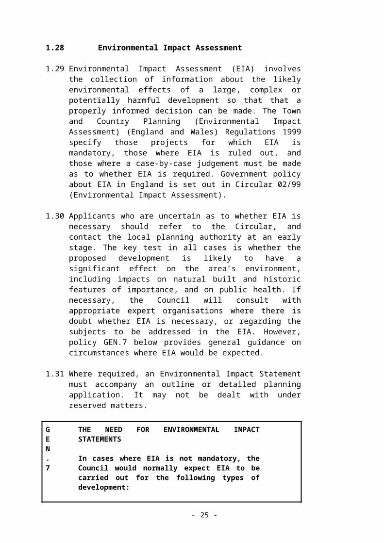
1.28 Environmental Impact Assessment
1.29 Environmental Impact Assessment (EIA) involves the collection of information about the likely environmental effects of a large, complex or potentially harmful development so that that a properly informed decision can be made. The Town and Country Planning (Environmental Impact Assessment) (England and Wales) Regulations 1999 specify those projects for which EIA is mandatory, those where EIA is ruled out, and those where a case-by-case judgement must be made as to whether EIA is required. Government policy about EIA in England is set out in Circular 02/99 (Environmental Impact Assessment).
1.30 Applicants who are uncertain as to whether EIA is necessary should refer to the Circular, and contact the local planning authority at an early stage. The key test in all cases is whether the proposed development is likely to have a significant effect on the area’s environment, including impacts on natural built and historic features of importance, and on public health. If necessary, the Council will consult with appropriate expert organisations where there is doubt whether EIA is necessary, or regarding the subjects to be addressed in the EIA. However, policy GEN.7 below provides general guidance on circumstances where EIA would be expected.
1.31 Where required, an Environmental Impact Statement must accompany an outline or detailed planning application. It may not be dealt with under reserved matters.
GEN.7
THE NEED FOR ENVIRONMENTAL IMPACT STATEMENTS
In cases where EIA is not mandatory, the Council would normally expect EIA to be carried out for the following types of development:
i. For major projects of more than local importance which are likely to have significant environmental effects by reason of their size or scale.
ii. For projects in particularly sensitive locations, including the Chilterns Area of Outstanding Natural Beauty, Sites of Special Scientific Interest, Scheduled Ancient Monuments and Listed Buildings of grades I and II*.
iii. For projects with particularly complex and potentially harmful effects on the natural environment or public health.
- 18 -

1.32 Planning Obligations and Conditions
1.33 PPG1 (General Policy and Principles) and Circular 1/97 (Planning Obligations) provide guidance on the use of planning obligations and conditions on planning permissions. The guiding principle is that they should only be used when there is a clear land use planning justification for doing so, and where planning permission would otherwise have to be refused. Many policies in this Local Plan specify instances where planning obligations or conditions may be appropriate to overcome problems which would otherwise justify refusal of planning permission. When giving evidence at appeal inquiries or hearings the Council may also suggest conditions to be imposed if the Inspector is minded to allow the appeal.
1.34 Planning obligations are used, to obtain financial contributions from developers to improve local community facilities or the general local environment, when adverse consequences of development are likely.
GEN.8
PLANNING OBLIGATIONS
(1) In accordance with the terms of Circular 1/97 (Planning Obligations) and Structure Plan Policy 2, the Council may require developers to enter into a planning obligation to provide environmental works, infrastructure, community facilities and services that directly relate in scale and kind to a proposed development.
(2) Where appropriate, the Council will consult with the County Council, other service providers and regulatory authorities to establish the precise needs related to a proposed development.
Core Strategy Policy CP8
- 19 -

NATURAL ENVIRONMENT AND RESOURCES
2.1 Aims
2.2 To ensure that development minimises its impact on the environment; protects critical natural habitats; protects and increases tree and plant cover; and maintains and enhances the natural environment and resources.
2.3 Introduction and General Principles
2.4 Fundamental shifts in land use and related human behaviour are continuing to alter the natural environment for the worse. International agreements and undertakings recognise this problem and in particular the “Agenda 21” agreement of the 1992 Rio “Earth Summit” stressed the importance of promoting sustainable development and conserving biodiversity. However, global agreements can only work if those directly responsible at a local level use their influence to prevent further environmental deterioration - this is the principle of Local Agenda 21. In practice, this means that while acknowledging that development which meets the needs of those who live and work in the District is necessary, the Council is not willing to allow this to take place at the expense of irreplaceable natural assets. The Council has an obligation to protect our fine landscapes, trees, wildlife and the finite resources of water, air and soil.
2.5 The Council is also committed to increasing and enhancing those assets and where appropriate, replacing lost features of the landscape. Likewise it is considered important to diversify and increase the range, numbers and types of animals, plants and habitats throughout the District.
2.6 On a practical level, this means that development which directly or indirectly harms the most important assets will be resisted. It is intended to protect the countryside, the commons, the woodlands, the lakes, the villages, the fauna, flora and the landscape of the District. Where development is permitted, all reasonable measures should be taken to minimise the impact. Developers should recognise that, when submitting planning applications, the responsibility is their’s to demonstrate that the proposals will not harm natural assets or resources, or show that measures taken before, during and after development can mitigate the effects.
2.7 These broad aims translate into four key areas of concern, which define the structure of this chapter - nature conservation, natural resources, trees and woodlands, and landscapes. In each case specific objectives have been set out. It is emphasised that although these subjects are separated here for the sake of clarity, in practice no one area can be considered in isolation.
2.8 NATURE CONSERVATION
- 20 -

2.9 Objectives
(a) To minimise the impact of development on wildlife and natural habitats, and geological and geomorphological features.
(b) To identify, protect and enhance critical wildlife habitats and rare species.
(c) To contribute to biodiversity targets in the Hertfordshire Local Biodiversity Action Plan.
2.10 Government advice set out in PPG9 (Nature Conservation) states that nature conservation can be a significant material consideration in determining planning applications. Structure Plan policy 38 identifies existing wildlife habitats, designated sites and protected species as part of the “Critical Capital” of Hertfordshire, to be protected from loss, permanent damage or irreversible change. If development is proposed which is likely to cause harm, then applicants must expect to have to provide clear justification why their proposals should be permitted. Policy N.1 indicates the weight which the Council attaches to issues of nature conservation interest, which may vary according to the criteria given below.
2.11 The Hertfordshire Biological Records Centre (HBRC) is the primary source of information and advice on the ecology of the District. When considering applications that may affect sites or species of nature conservation interest, the Council will consult the HBRC. Developers and landowners are also advised to contact the HBRC at the earliest opportunity to establish whether the proposals are likely to have implications for nature conservation, and for guidance on appropriate management techniques.
N.1
NATURE CONSERVATION
(1) When determining applications for planning permission the Council will take the likely effects on nature conservation into full account. The weight given to nature conservation interests will be judged according to the following factors:
(i) The likelihood that there will be significant adverse impacts from the proposed development;
(ii) The national, regional or local status, importance, and sensitivity of a site or species which may be adversely affected; The possibility that planning permission can be granted subject to conditions or a planning obligation to
- 21 -

fully mitigate or compensate for any actual or potential harm.
(iii) The submission of clear reasons why the proposal cannot be located where no harm would be caused to nature conservation interests.
(2) Where the effects of a proposed development are unclear or uncertain, or where there may be a significant adverse impact on nature conservation interests, the Council will require applicants to provide comprehensive information before determining the application. This may include the submission of an Environmental Impact Statement in accordance with policy GEN.7.
- 22 -

2.12 The District falls within two of the “Natural Areas” agreed by the English Nature/Countryside Commission Joint Character Map Programme. More information on these areas (the Chilterns, and the London Basin) can be found in “A 50 Year Vision for the Wildlife and Natural Habitats of Hertfordshire”. This is the Local Biodiversity Action Plan (BAP) for Hertfordshire. The BAP sets out action plans for the conservation of certain species and habitats and summarises the current state of knowledge of the biodiversity resource in the County. The Local Plan has a key role to play in helping to achieve the targets for species and habitat conservation set out in the BAP by developing policies for site and species protection and positive management, and the creation of new habitats where appropriate. In particular, the development control process can secure management of conservation features through planning conditions and agreements.
2.13 Policy N.2 below sets out the Council’s stance on the protection of statutory sites of nature conservation interest (such as SSSIs and LNRs) and locally important, non-statutory Wildlife Sites. Policy N.3 relates to specially protected species and their habitats, wherever they may occur.
2.14 Designated Sites
2.15 There are a large number of sites across the District noted for their nature conservation value, being of national, regional or local importance. These include Sites of Special Scientific Interest (SSSIs), Local Nature Reserves (LNRs) and Wildlife Sites.
2.16 SSSIs are notified (in England) by English Nature under the Wildlife and Countryside Act 1981. They are sites of national or possibly international importance for wildlife habitats, geological features or landforms.
2.17 There are five currently notified SSSIs in this District of which one (Westwood Quarry) is designated for its geological interest rather than for wildlife:
(a) Sarratt Bottom (see Proposals Map A)
(b) Frogmore Meadows (as above)
(c) Croxley Common Moor (see Proposals Map D)
(d) Whippendell Wood (see Proposals Maps B and D)
(e) Westwood Quarry (see Proposals Map B)
- 23 -

2.18 The National Parks and Access to the Countryside Act 1949 gives local authorities the power to acquire, declare and manage Local Nature Reserves in consultation with English Nature. LNRs would generally be expected to be of high natural interest in the local context (SSSI or near equivalent), containing the best representative examples of the main local habitat types. There are currently three LNRs in the District (Croxley Common Moor, Oxhey Woods, and Stockers Lake). The Council may exercise its powers under the 1949 Act to designate additional LNRs during the Local Plan period.
2.19 The Wildlife Sites have been designated following the Habitat Survey for Three Rivers District, carried out by the HBRC in 1997 using the new Wildlife Site Assessment Criteria developed with the assistance of the Hertfordshire and Middlesex Wildlife Trust. Wildlife Sites are identified as being of substantive nature conservation importance in accordance with PPG9 (Nature Conservation) and are given a level of protection in policy N.2 consistent with their non-statutory, local status. More information about the Wildlife Sites can be found in the Habitat Survey.
2.20 These sites contain the best wildlife habitats in the area and often fulfil an important educational role as well. The Council will support, and where possible participate in, the preparation of Management Plans that will increase the wildlife value of the sites.
N.2
SITES OF NATURE CONSERVATION IMPORTANCE
(1) Proposals for development in or likely to affect Sites of Special Scientific Interest (SSSIs) will be subject to special scrutiny. Where such development may have an adverse impact, directly or indirectly, on the SSSI it will not be permitted unless the need for the development clearly outweighs the nature conservation value of the site itself and the national policy to safeguard the national network of such sites.
(2) Proposals for development likely to have an adverse effect on a Local Nature Reserve, Wildlife Site or Regionally Important Geological Site as shown on the Proposals Map will not be permitted unless the need for the proposal clearly outweighs the nature conservation value of the site.
(3) Where such development is permitted, damage should be kept to a minimum. The Council will impose conditions and/or in appropriate cases, expect developers to enter into planning agreements to ensure the implementation of
- 24 -
works to mitigate or compensate for any harm caused.
(4) The Council will encourage the positive management and enhancement of all sites of nature conservation interest, and may seek to enter into a management agreement with the owner of a site whenever appropriate.
(5) The Council will support proposals which will increase the number, size and diversity of nature conservation sites. Wherever possible, new developments should provide for the retention of existing habitats and wildlife features and for the creation of appropriate new habitats.
(6) Proposal Map C to record the amendment to the boundary of the Wildlife Site – Rickmansworth Park.
- 25 -

2.21 Policy N.2 applies to all sites of nature conservation importance identified prior to the adoption of the Local Plan. It will also apply to any other new sites (SSSIs, LNRs, RIGs or Wildlife Sites) identified as being of nature conservation or geological importance after the adoption of the Local Plan. If the designation of an existing site is upgraded (e.g. from Wildlife Site to SSSI) following adoption of the Local Plan, the relevant part of policy N.2 will apply as appropriate.
2.22 The Council will consider the use of Article 4 Directions under the General Permitted Development Order 1995 to control inappropriate types of permitted development which might threaten the nature conservation interest of a site.
2.23 Protected Species
2.24 Very few rare species (especially animals) are confined exclusively to nature reserves and so it is important that they are protected wherever they occur. Bats, for example, can lose important roost sites by simple loft conversions. The main legislation which details protected species is included in the bibliography (Appendix 5).
N.3
PROTECTED SPECIES
(1) The Council will not permit development which is likely to have a significant adverse effect on any species afforded special protection under UK or European Community law, or identified in the UK Biodiversity Action Plan as in need of particular conservation action.
(2) Where development is permitted which may affect a specially protected species, the Council may impose conditions and may seek to enter into planning obligations to mitigate the effects wherever appropriate.
2.25 RESOURCES
2.26 Objective
(a) To minimise the impact of development on water, air and soil.
(b) To encourage the sustainable use of resources
2.27 Water
2.28 The protection of water resources in terms of quality and quantity, the need to protect the environment from flooding, and the availability of
- 26 -

water and sewerage infrastructure to serve new development are important considerations for the Local Plan (PPG12: Development Plans & Regional Planning Guidance). Policy D.7 in the Design Chapter gives advice on design for water conservation in new developments.
2.29 In addition to the many surface water resources of rivers, lakes and ponds, and the canal, the District is entirely underlain by a pervious aquifer (high quality water-table) which is the main drinking water resource for the area. These surface and groundwater resources may be threatened by developments which increase the amount of water extracted, or which restrict the amount of recharge or divert flows. A lowered water table, which can result from reduced effective rainfall, reduced recharge, and possibly over-extraction, can have an adverse effect on wetland wildlife habitats. Surface and groundwater contamination may occur from pollutants entering or filtering down from a variety of sources, from simple urban run-off to seriously polluting land uses. Once groundwater has been contaminated it is virtually impossible to reverse the situation.
N.4
PROTECTION OF WATER RESOURCES
1) The Council will only grant permission for development which is unlikely to significantly adversely affect the quantity and quality of surface and groundwater resources, or wetland wildlife habitats.
2) Applicants for planning permission will be required to demonstrate that the proposal:
i. will not produce run-off which will adversely affect the quality of surface or groundwater;
ii. has sufficient capacity to accept, and where necessary treat, run-off which would otherwise have an adverse effect on the quality of surface or groundwater;
3) The Council will consult with the Environment Agency, and British Waterways as appropriate, and have regard to their views when determining applications.
2.30 River valleys and floodplains are important wildlife corridors and floodwater storage areas which need to be kept open and continuous, and where the rivers should be left to follow their natural course so far as possible. The objectives of floodplain protection as expressed in “Policy and Practice for the Protection of Floodplains” published by the Environment Agency are interpreted in policy N.5 below.
- 27 -

2.31 The Council must control development which may be at risk from flooding or which will increase the risk elsewhere. Flood protection measures might be technically feasible, but this is not the only consideration if there would be a loss of natural floodplain, an adverse effect on wildlife habitats or an increase in the risk of flooding upstream or downstream of the development as a result. Where the opportunity arises, such as during redevelopment, the Council will seek the restoration of floodplains to their natural state and function. If there are particular reasons why development must be located in the floodplains, the developer will be expected to provide suitable mitigation measures in agreement with the Council and the Environment Agency.
2.32 Areas at risk from flooding have been defined by the Environment Agency and are shown on the Proposals Maps. The Council will advise the Agency of any matters of accuracy of the boundaries of these areas that it becomes aware of and changes will be included in any revision of the Plan. Additionally, any development that increases surface water run-off may cause flood risk where none existed before. The Council has a statutory duty to consult the Environment Agency, and British Waterways in some cases, on proposals that may affect water resources and will have regard to their views on such proposals.
- 28 -

N.5
FLOOD PREVENTION AND RIVER CORRIDORS
(1) In areas at risk from flooding as defined on the Proposals Map, or where a proposed development may itself be the cause of risk, applicants for planning permission will be expected to demonstrate that the proposal:
(i) includes appropriate flood protection measures that mitigate the risk of flooding of the development itself, and will not create or exacerbate the risk of flooding elsewhere;
(ii) does not involve the loss of natural floodplain or damage to wetland wildlife habitats, or prejudice the open and continuous character of river corridors;
(iii) does not prejudice other proposed or existing flood control or protection measures;
(2) When proposals involving redevelopment occur within floodplains, the Council will encourage measures to retain and restore areas of the floodplain to their natural state and function.
(3) Any proposals for development near or adjacent to a watercourse will be expected to avoid the use of culverts or artificial channels, and should incorporate a reasonable natural “buffer zone” between the watercourse and the edge of built development and any hard landscaping.
2.33 As water use and population increases, existing water supply and sewerage infrastructure may not be able to cover the increase in demand. Development beyond the capacity of existing systems may lead to pollution incidents unless additional infrastructure is provided.
2.34 The utility companies have a statutory duty to receive and treat sewerage. Developers should contact the appropriate organisations at the earliest opportunity to determine whether there is capacity for new development. If there is not, water supply, foul sewers and sewerage treatment works of adequate capacity must be provided in time to serve the development. The proliferation of small, private treatment works will be discouraged. The use of septic tanks will only be considered if connection to the mains sewerage is not feasible and the Council is fully satisfied that the location and ground conditions are suitable. The
- 29 -
Council will consult with the Environment Agency, British Waterways and the utility companies wherever appropriate and have regard to their views when considering development proposals. Developers will be expected to fund a substantial part of any new infrastructure required as part of their development.
2.35 Under the Water Act 1989 and following the introduction of water and sewerage infrastructure fees for new residential development, the local planning authority is not able to refuse planning permission for residential development solely on the grounds of inadequate water or sewerage infrastructure. However, the Council still has a statutory obligation to consult the Environment Agency, water companies, and other relevant organisations when determining proposals.
- 30 -

N.6
WATER SUPPLY AND SEWERAGE INFRASTRUCTURE
The Council will only grant planning permission for new development where the capacity and condition of the existing infrastructure is adequate to meet the anticipated demand, or where any necessary improvements can be carried out prior to the operation of the development. The Council may grant consent subject to conditions, or seek to enter into a planning obligation with the developer to ensure that adequate infrastructure is provided.
Core Strategy Policy CP8
- 31 -

2.36 Agricultural Land
2.37 Recent years have seen an increasing amount of agricultural land being set aside or reverting to other uses, for example, woodland. However, food production is still the primary function of the countryside, and it is important that the best and most versatile agricultural land within the District is retained, or at least is not subject to development which entails irreversible loss of the agricultural use. Government advice on safeguarding the best quality agricultural land is found in PPG7 (The Countryside).
2.38 Professional and technical advice on planning and agriculture issues is available from the Regional Planning Adviser in the Farming and Rural Conservation Agency (FRCA), which operates on behalf of the Ministry of Agriculture, Fisheries and Food (MAFF). FRCA provides the Council with the views of MAFF on the implications of major planning applications which would involve or may lead to the loss of 20 hectares or more of the best and most versatile agricultural land (grades 1, 2 and 3A in the MAFF Agricultural Land Classification).
N.7
AGRICULTURAL LAND
(1) Proposals for development that could involve or lead to the loss of the best and most versatile agricultural land, and which are otherwise acceptable in the Green Belt, will only be permitted if the applicant can demonstrate that:
(i) There is an overriding need for the development, and there is not sufficient lower grade land with no other protective designation available, or land of grades 3a or 3b that is of no significant wildlife or landscape interest, or ;
(ii) There is a reliable prospect of the land being restored to its original quality following cessation of the use.
(iii) In the event that the above criteria are met and there is a variety of grades of land within the site, development should as far as possible be directed to the lowest grade of land available.
(2) The Council will consult with the Farming and Rural Conservation Agency in appropriate cases and will have regard to its views when determining applications.
- 32 -
2.39 There is no Grade 1 agricultural land in Three Rivers District. Small areas of Grade 2 land are located near Croxley Green and Maple Cross. No survey of Grade 3A land has been carried out in this District and a site by site assessment will be required where necessary. Further advice on agricultural land classifications can be obtained from FRCA.
2.40 Minerals and Waste Management
2.41 Under the Planning and Compensation Act 1991, this Local Plan may not contain policies in respect of minerals or waste disposal. These matters are the responsibility of the County Council. However, the District Council is consulted on the contents of the Hertfordshire Minerals and Waste Local Plans, and is able to determine certain related matters such as access to sites. The Council considers it important that it should be consulted on all matters affecting mineral extraction and waste disposal and that its views should be fully taken into account before any decisions are reached. Policy N.8 indicates the approach the Council will take when consulted on minerals and waste applications.
N.8
CONSULTATION ON MINERALS AND WASTE MANAGEMENT ISSUES
1) When consulted by the County Council on issues relating to minerals and waste management issues, and when determining related applications such as access to sites, the Council will have regard to the likely traffic generation on surrounding roads, the need for construction of new accesses and the possible impact of all of these factors on residential amenity and the natural environment of the areas affected.
2) Where mineral extraction is coming to an end, the Council will press for full restoration of the site, but not necessarily by backfilling to the original contours. The potential for naturalisation of the site, and its use for leisure or conservation interests compatible with the Green Belt should be investigated.
3) When considering proposals for development which are likely to unnecessarily sterilise or prejudice the future extraction of known mineral supplies, the Council will have regard to the views of the County Council.
- 33 -

2.42 Minerals Local Plan
2.43 As the minerals planning authority, the County Council has prepared a Minerals Local Plan, which was adopted in July 1998. The Minerals Local Plan carries forward and develops in greater detail the strategic minerals planning policies of the County Structure Plan Review. The Plan includes policies for ensuring the supply of minerals, identifies areas where provision is made for mineral working and those areas where mineral resources are to be safeguarded for future working, and sets out the development control criteria which will be applied in considering applications for mineral workings and the restoration requirements for such sites. In general, the Council is concerned about the exploitation of further minerals because they are non-renewable resources
2.44 Waste Local Plan
2.45 The Hertfordshire Waste Local Plan was adopted in January 1999. The emphasis of the Waste Local Plan is on ‘waste management’, and includes detailed policies in respect of development required for waste minimisation, re-use, recycling, composting, processing and transfer, the recovery of energy from waste, and disposal. ‘Waste’ includes household or domestic waste, demolition and construction waste, agricultural and forestry wastes, clinical, difficult or special wastes, waste water (sewage) and scrap vehicles or metal.
2.46 The Waste Local Plan (WLP) encourages the District Councils to have regard to the policies of the WLP, and to include Local Plan policies relating to the reclamation and re-use of excavation material and recycled materials in new development (WLP policies 7 and 8) and the provision of recycling facilities to serve major new developments (WLP policy 11).
- 34 -

N.9
USE OF RECYCLED AND RECLAIMED MATERIALS IN NEW DEVELOPMENT
1) In considering proposals for development, the Council will have regard to the extent to which clean, excavated material arising from construction projects is to be re-used in the project itself as a first objective, or otherwise used as preparation for development, for land restoration, or for site landscaping.
2) The Council will also encourage the use of recycled materials in new development where appropriate, and in particular will seek and support the use of recycled waste in place of natural aggregates.
2.47 Some new developments will, by reason of their size, use or level of activity generate significant amounts of waste and will have scope to incorporate special provision for waste recycling. Residential developments should be designed so as to allow the easy operation of kerbside collection schemes. The County Council is publishing supplementary planning guidance on the areas of land and other requirements needed for source separation and waste storage facilities.
N.10
PROVISION FOR WASTE RECOVERY AND RECYCLING FACILITIES IN NEW DEVELOPMENT
1) In considering proposals for commercial, industrial or residential development which, by reason of their size or type of activity, are likely to generate significant amounts of waste, the Council will have regard to the extent to which provision is made for waste collection, source separation, recovery and recycling facilities within the development.
2) The Council will have regard to the type and capacity of existing local facilities and policy 11 of the Hertfordshire Waste Local Plan when assessing the requirement for the provision of additional facilities.
3) The Council will consult with the Herts County Development Unit where appropriate, and may grant permission subject to conditions or seek to enter into a planning obligation with the developer to provide facilities.
- 35 -

2.48 The Waste Local Plan adopts a waste management hierarchy, and in principle, facilities further up the hierarchy will receive more favourable consideration. The hierarchy consists of:
(a) Minimisation - those processes which minimise waste at source, such as reduced packaging.
(b) Re-use - facilities which enable re-use of materials without further processing, such as architectural salvage.
(c) Recovery - facilities designed to make use of waste through recycling of materials or energy generation.
(d) Disposal - safe disposal, without energy generation, as a last resort.
2.49 The Council is a participant in the County-wide ‘WasteAware’ campaign, which aims to publicise the problems the County faces with waste disposal and provide ways in which everybody can help make a difference, and contribute to a solution.
2.50 Air Quality
2.51 Air quality can be a material consideration where it relates to the use or development of land. Air quality may be affected by the operational characteristics of the proposed development (industrial, commercial or domestic uses, for example). Also, even if the proposed use has no direct impact on air quality, air pollution from traffic generated by the development may be a significant consideration.
2.52 In considering the impact of proposed development on air quality, the Council will liaise with the pollution control authorities (the local environmental health authority or Environment Agency) and will have regard to the National Air Quality Strategy’s objectives and results of any air quality review/assessment or action plan prepared under The Environment Act 1995.
2.53 If the operational characteristics of a development (or the traffic generated by it) seem likely to worsen local air quality in an area already identified by the pollution control authorities as being at risk, and the potential problem is incapable of being overcome by a condition or a planning obligation, then this may be cause for refusal of planning permission.
N.1
AIR QUALITY
1) Where there is likely to be a significant adverse
- 36 -

2 impact on air quality resulting from the operational characteristics of, or traffic generated by a proposed development, the Council will consult with the appropriate pollution control authorities and have regard to their views.
2) The Council will take into account the potential for the proposals to adversely affect the health and amenity of users of the development, nearby residential and other existing uses, and the potential for the proposals to prejudice the future development of surrounding sites with prior allocations or planning permission.
3) The Council may grant permission subject to conditions, or seek to enter into a planning obligation with the developer in order to mitigate the impact of a development.
- 37 -

2.54 Light Pollution
2.55 Light pollution can affect all areas but it is a particular problem in the countryside where night skies are one of the special qualities of the rural landscape. Artificial lighting can obscure views of the stars, damage local character by introducing a suburban feel to rural areas, intrude on residential amenity and have an impact on the wildlife of an area. Light pollution also represents a waste of energy, resources and money.
N.13
LIGHT POLLUTION
1) The Council will seek to minimise light pollution. Where external lighting is likely to be required as part of a development, full details will be required, to demonstrate that the proposals are the minimum required to undertake the task and that light pollution from glare and spillage is minimised.
2) Where the impact on residential uses, historic buildings, drivers using nearby highways, areas of importance for nature conservation or open or remote landscape areas is considered unacceptable, permission will be refused.
3) Methods of minimising the impact of external lighting on the safety and amenity of surrounding areas will be encouraged, and may include better technology, controlling the times of operation, or the design of landscaping. The Council may grant permission subject to conditions where appropriate.
- 38 -

2.56 Noise Pollution
2.57 It can be difficult to reconcile some land uses with proposals likely to generate significant levels of noise. Noise measurement is a highly technical area and this Plan is not the appropriate place to specify what noise levels will constitute a ‘nuisance’. However, the Council will have regard to the potential for conflict arising from noise-generating or noise-sensitive proposals. In particular, the Council will have regard to the advice given by PPG24 (Planning and Noise) regarding the use of Noise Exposure Categories (NECs) when considering proposals for housing close to transport-related noise sources. Noise-sensitive uses would particularly include hospitals and other healthcare uses, educational establishments, and residential uses.
2.58 When assessing the likelihood of conflict arising between noise-generating and noise-sensitive uses, the Council will take into account the levels and type of noise, the duration and frequency of ‘noisy’ periods, and have particular regard for the level of noise during the night (between 23.00 and 07.00). It is recognised that many development operations unavoidably generate noise (i.e. during demolition and construction) for relatively short periods, and the Council has limited control over this type of operation. However, sympathetic working practices will be encouraged.
N.14
NOISE POLLUTION
(1) Applications for noise-sensitive uses such as residential uses, schools, and health facilities should not be sited close to existing sources of significant noise.
(2) Applications for noise-generating uses should not be sited where they are likely to cause significant disturbance to nearby noise-sensitive uses, or in areas such as the AONB or other open countryside which have remained relatively undisturbed by noise nuisance.
(3) Where noise-sensitive uses cannot be separated from noise-generating uses, the Council may grant consent subject to conditions, or seek to enter into a planning obligation to mitigate the effects of noise nuisance by reduction at source, by design and layout, or by limiting times of operation.
- 39 -
2.59 TREES, WOODS AND HEDGEROWS
2.60 Objectives
(a) To protect and conserve trees, woodlands and hedgerows;
(b) To encourage the management of trees, woodlands and hedgerows; and
(c) To promote tree, woodland and hedgerow planting.
2.61 In order to maintain continued tree cover and ensure that trees continue to fulfil their crucial role in our local environment, the Council has produced a Tree Plan. The Tree Plan and this Local Plan are intended to complement one another.
2.62 Protection of Trees and Woodlands
2.63 A large number of trees and woods within the District are already protected by Tree Preservation Orders (TPO’s), by virtue of being situated in a Conservation Area or through the imposition of landscape conditions when planning permission was granted. In order to protect trees considered to be at risk, the Council will continue to serve Tree Preservation Orders, particularly where they make a positive contribution to the amenity of local areas. Contravention of such orders is taken very seriously and the Council will prosecute offenders when appropriate.
2.64 Protection of Hedgerows
2.65 Under the Hedgerows Regulations 1997, the removal of some hedges in the countryside requires permission from the Council and it is intended to protect those hedgerows defined as being “important” under the terms of the Regulations. In cases where hedgerows are removed without permission, the Council will investigate and will prosecute offenders when appropriate.
2.66 Trees, Hedgerows and New Development
2.67 Mature trees growing on a development site can make major contribution to the quality of the finished development provided that they are given the space and protection they need. Unfortunately, many developments treat existing trees and landscape features simply as obstacles around which the design has to be fitted as closely as possible. Even if the trees survive the hazards of the construction period, the occupiers of the new development are left to contend with problems such as shade and the possibility of storm damage or subsidence, and their natural reaction is to have the trees felled or lopped. The requirements of the Council concerning trees and development are set out in greater detail in Chapter 5 (Design) and Appendix 1 (Design Guidelines). In general:
- 40 -

N.15
TREES, HEDGEROWS AND NEW DEVELOPMENT
1) Proposals for development on sites which contain existing trees and hedgerows will be expected to show that as many trees and hedgerows as possible are retained, particularly those of local amenity or nature conservation value. There will be a particular presumption in favour of retaining any hedgerows considered to meet the criteria of the Hedgerow Regulations 1997.
2) The development should be designed in such a way as to allow trees and hedgerows to grow to maturity without causing undue problems of visibility, shading or damage. Developments that are likely to result in future requests for significant topping, lopping or felling will be refused.
- 41 -

N.16
PROTECTION OF TREES AND HEDGEROWS DURING DEVELOPMENT
Before planning permission is granted, developers will be required to demonstrate that existing trees and hedgerows to be retained will be properly protected at all stages of development, in accordance with the relevant British Standards and the requirements of Section 5 of Appendix 2 of this Local Plan, except where it is considered trees should be removed under the terms of BS5827:1991.
- 42 -

2.68 New and Replacement Planting on Development Sites
2.69 Generally a net loss of tree cover due to new developments is not acceptable. If trees are lost as a result of development the Council will seek replacement planting. Policy N.17 requires replacement planting at a minimum ratio of two for one if the replanting cannot be carried out on the development site. In all cases however, the ultimate result of replanting must be that the contribution which any trees to be removed currently make to the environment is fully compensated for, and preferably enhanced. In this context, the replacement of, for example, large oaks or other native forest species with small ornamentals is not acceptable.
N.17
REPLACEMENT PLANTING
1) When considering proposals for development which involve the loss of existing tree and shrub cover, the Council will expect replacement planting to be included as part of an overall landscaping and aftercare scheme for the development. The Council will have regard to the type and extent of tree cover lost when assessing the suitability of replacement planting proposals.
2) Equivalent and appropriate replacement planting will be sought on the development site as a first objective. If this is not possible the Council may designate a suitable alternative site and will seek to enter into a planning obligation with the developer to achieve adequate replacement planting at a ratio of two for one. Where suitable, species appropriate to the local ecology and landscape will be specified.
3) All replacement planting proposals will be expected to make provision for an appropriate period of maintenance and aftercare, and the Council will grant permission subject to conditions where appropriate.
- 43 -

2.70 LANDSCAPE
2.71 Objectives
(a) To maintain and conserve the existing landscape quality.
(b) To identify and enhance the key landscapes of the District.
2.72 Landscape Management
2.73 The landscape of the District is a complex and distinctive mix of rural and urban areas, woodlands, wildlife habitats, farmland, water features and land forms. The landscape has been heavily altered by human activity, so many of its distinctive features, such as field boundaries, are of historical interest as well as visual and ecological merit. Wildlife habitats such as meadows, woodlands, hedgerows and wetlands are valued components of the landscape and have their own special management requirements. Issues which often merit particular attention include:
(a) Details of aftercare for newly-established features such as young trees and other planting schemes, and water features;
(b) Appropriate management regimes for particular habitats such as woodlands, water features and grasslands, including clear management objectives relating to the use of an area (e.g. for recreation, wildlife, or purely visual interest);
(c) The positive management and restoration of hedgerows, both in connection with development proposals and by land owners in the wider countryside.
2.74 The Council works with many organisations to achieve sensitive management of the landscape of the District, such as the Groundwork Trusts, Countryside Management Service (CMS), Chilterns Conference and volunteer groups. Where resources permit, the Council currently contributes to the funding of some of these organisations. The Council also owns many important sites, including the Aquadrome and several woodlands, and will aim to manage these in such a way as to protect and enhance the contribution that these areas make to the wider landscape.
2.75 The Council will also work with private landowners and applicants for planning permission to enhance the landscape, by seeking to enter into voluntary management agreements, acting as a point of contact between interested organisations, disseminating best practice information, and including landscape management measures in planning agreements where appropriate. Advice and even grants for some projects are available from a wide variety of sources; advice can be obtained from the Council, the CMS, or the Groundwork Trusts.
- 44 -

N.18
LANDSCAPE MANAGEMENT
1) When considering proposals for development which may affect the management of an area or particular feature of the landscape, the Council will require details of management proposals to be submitted prior to granting planning permission. Such proposals should seek to protect or enhance the contribution that the site makes to the wider landscape.
2) Areas forming part of development proposals which are to be transferred to the local authority for maintenance should be designed for ease of access, and low cost maintenance overheads and management regimes. The attention of applicants is also drawn to policy D.7 (design for water conservation) and Appendix 2.
- 45 -

2.76 The Council is consulted by the Forestry Authority on a number of its Woodland Grant Schemes or felling licences within the District. The Council fully supports proposals to plant trees, subject to the preservation of archaeological remains, existing semi-natural woodland cover or open wildlife habitats (e.g. grasslands) which could be damaged by tree planting. In 1997 the Countryside Management Service published a revised “Hertfordshire Woodland Strategy”, which sets out policies and proposals relating to sustainable woodland management, new planting, education and community involvement. The Council endorses the aims of the Strategy and as resources and opportunities permit, will endeavour to implement the aims in managing its own woodlands, and in negotiation with other land owners.
N.19
WOODLAND PLANTING AND MANAGEMENT
(1) In commenting on applications made to the Forestry Authority, the Council will support the planting of new native broadleaf woodlands where appropriate. The Council will also support the sustainable management of existing woodlands for multi-purpose use e.g. nature conservation, recreation, visual amenity and timber production. Proposals to clear fell areas of trees in prominent or sensitive locations should be based on sound conservation or economic management.
(2) In areas of ancient semi-natural woodland, nature conservation will be afforded a high priority. The Council will carry out such appropriate and sympathetic management of trees and woodlands within its control, and undertake new planting, as resources allow.
(3) Where the planting of new woodland, particularly large areas of conifers, would be considered to have significant environmental effects the Council will ask that an Environmental Impact Assessment be submitted as part of the proposals.
- 46 -

2.77 Watling Chase Community Forest
The Watling Chase Community Forest borders on the extreme south-east of the District. Although the decision has been taken not to extend the Forest into this District, this Council supports the concept and principles of the Community Forest, and will encourage the development of pedestrian and cyclist links to the Forest.
2.78 Chilterns Area of Outstanding Natural Beauty (AONB)
2.79 The Chilterns AONB is an area of national landscape importance. The Proposals Map shows those parts of the AONB which are within this District. The primary aim of this designation is to conserve and enhance the natural beauty of the Chilterns landscape. The greater part of the area is covered by a direction under Article 4 of the General Permitted Development Order 1995, which requires that planning permission is needed for the erection of agricultural buildings. (See Figure 3).
2.80 A “Chilterns Design Summary and Guide” intended to provide advice to those involved in erecting new buildings, extending and converting older ones has been published by the Chilterns Conference.
N.20
PROTECTION OF THE CHILTERNS AONB
Within the Chilterns AONB the Council will give priority to conservation and enhancement of the existing landscape. Major development proposals affecting the Chilterns AONB will be regarded as inconsistent with the aims of the designation, except where it is proven that the development is in the national interest and no alternative site outside the AONB is available. To be acceptable, development must also accord with the Green Belt policies of this Plan and be of the highest standard of design and siting, reflecting the landscape, traditional character of buildings in the area and using local materials. Development will only be permitted within the Chilterns AONB where there is no harm to the natural beauty of the landscape, the conservation of which .
- 47 -

2.81 The Council is a member of the Chilterns Conference, made up of Local Authorities and other bodies and formed to encourage consistent decision making on policies, development control and management action throughout the AONB. The Council will have regard to the aims and priorities for the Chilterns AONB as set out in the Chiltern Conference publication “The Framework for Action” and Structure Plan policy 42.
N.21
CHILTERNS CONFERENCE
The Council will continue to support the objectives of the Chilterns Conference and will have regard to the contents of “The Framework for Action” published by the Chilterns Conference in determining applications for planning permission within the AONB.
- 48 -

2.82 Colne Valley Regional Park
2.83 The Colne Valley Regional Park measures approximately 22km long and 5km wide, stretching between Staines in the south, to Rickmansworth and Chorleywood in the north. The Park is subject to many pressures, including leisure use, transport corridors and urban expansion. Careful management and improvement to previously derelict or neglected sites is taking place with the objective of creating a regional park where recreation can take place within an attractive countryside setting. (See Figure 3).
2.84 The Council is a member authority of the Colne Valley Park Standing Conference, and participates in various projects in that part of the Park which falls within the District.
N22
COLNE VALLEY REGIONAL PARK
Within the Colne Valley Regional Park, the Council will have regard to the following aims as set down in the Colne Valley Regional Park Strategy and carried forward by the Annual Action Plans:
(i) Maintenance and enhancement of the landscape in terms of its scenic and conservation value and public amenity;
(ii) Resistance to urbanisation and inappropriate development of the Park;
(iii) To protect and manage the diverse nature conservation resources of the Park;
(iv) To provide facilities and access to the countryside for recreation which do not compromise the above aims.
- 49 -

2.85 Landscape Regions
2.86 As the Structure Plan Review explains, landscape conservation has previously been based on designation of Landscape Conservation Areas (LCAs). These were areas which deserved conservation because of their landscape value, but which were not part of other designations such as the AONB. In the District Plan Review 1991, LCAs were counter-balanced by Landscape Development Areas (LDAs), which were areas of degraded landscape where the aim was regeneration and enhancement as well as conservation. LCAs and LDAs have not been brought forward into this Local Plan.
2.87 Policies 43 and 44 of the Structure Plan Review make it clear that the future of the Landscape Conservation Areas is to be rigorously reviewed as part of the Local Plan process, to be superseded by Landscape Regions. Landscape policy in this Local Plan is therefore based on a new approach – landscape character assessment. The Countryside Commission and English Nature have published a map of National Character Areas in England. This work has been extended by the County Council, in consultation with the District Councils and other interested organisations with the publication of a “Landscape Strategy for Hertfordshire” in 1998. The Strategy develops the national work and identifies six Landscape Regions within Hertfordshire (see Figure 3). One of the main objectives of the Strategy is for a more detailed assessment of these areas to be carried out through the local plan process, making it possible to refine the schematic diagram from the Landscape Strategy reproduced in Figure 3, and to identify boundaries with greater accuracy.
2.88 Figure 3 provides an overview of the various landscape designations falling within the District. The District includes parts of three of the six Hertfordshire Landscape Regions. Although the Landscape Regions and policy N.23 cover the entire District, they do not amount to a “special” or restrictive landscape designation, but instead provide a more holistic and comprehensive way of considering landscape as part of land use planning. The Landscape Regions also include the urban areas, as does the Hertfordshire Landscape Strategy. Policy N.23 will not normally be relevant to small-scale or domestic development that occurs within the urban areas, but large-scale proposals or development on the urban fringe could have an impact on the character of the wider landscape, and so the urban areas are not excluded from the designation.
- 50 -

2.89 Until further work can be done to refine the Landscape Regions at a District level, which may include identifying local landscape areas, the boundaries of the three landscape regions will be as shown on the Proposals Map and referred to by policy N.23. The Council will work with the County Council, its neighbouring authorities, and other interested organisations to refine the broad Landscape Regions and formulate detailed policies and proposals to protect and enhance the character of each of them. In the interim, the Landscape Strategy for Hertfordshire provides the most useful background, and will be used by the Council as supplementary planning guidance.
2.90 The following characteristics of the three Landscape Regions are largely taken from “A Landscape Strategy for Hertfordshire” and provide a limited frame of reference for consideration of landscape character in Three Rivers. Further advice is available from the Council’s Landscape Officers, or the County Landscape Officer. The Landscape strategy summarises features of each landscpe region and illustrates desirable actions for typical tracts of land. It also includes draft landscape guidelines. These are relevant for Landscape Character Assessment and Local Plan policy N.23.
2.91 The Chilterns– This is a landscape of high scenic quality, a small portion of which is also within the Chilterns AONB. In a regional sense, the most notable feature of the Chilterns landscape is the steep chalk scarp beyond the District boundary to the north and west. Within this District, which lies entirely on the reverse slope (“dip slope”) of the Chilterns, the landscape is characterised by the following:
139- Steep slopes and rolling hills, affording wide and distant views of
high visual quality.- Well wooded, with many small to medium sized woods and
copses.- Many small sites of wildlife interest; unimproved grassland,
heathland commons, semi-natural ancient woodland and wetland habitats associated with the River Chess.
- Small fields and many hedgerows.- Some small ponds but otherwise a lack of standing water; some
minor streams and the River Chess, a chalk watercourse within a valley of high scenic quality, wildlife and archaeological interest.
- Small villages, many centred around greens and common land of historic importance, scattered farms and isolated dwellings.
2.92 The Central River Valleys - This Landscape Area mainly encompasses the lower reaches of the River Colne and River Lee in Hertfordshire, having been formed by the course of the proto-Thames prior to the last Ice Age. It is characterised in this District by:
- A low lying, broad, shallow valley with many tree-fringed lakes resulting from past and continuing sand and gravel extraction.
- 51 -

- Small woods, and hedgerows often degraded or missing, leaving wide views across large open fields in some areas. There is great visitor pressure on many urban fringe sites.
- Corridors of communications and urbanisation from prehistoric times onwards. Important features include the Colne and Gade Rivers (not the Chess), the Grand Union Canal, main roads and railways. Other infrastructure and utilities (e.g. high voltage lines, water works) are commonly found.
- Urban areas, industrial estates and some visually poor areas.
2.93 The South Hertfordshire Plateau - Forming generally high ground on the edge of the London Basin. In this District this area is fragmented by settlements and is characterised by:
- A steep sided plateau with otherwise gradual changes in elevation.
- Some large woodland blocks and small remnants. Many hedges are degraded.
- Many ‘urban fringe’ leisure uses (golf courses, country parks, public woodland, playing fields).
- Large urban areas, mainly residential. There are examples of ribbon development along some main roads, and some farms but few isolated dwellings.
- 52 -
N.23
LANDSCAPE REGIONS
Until a finer-grained analysis and more detailed policies can be provided in supplementary planning guidance.
1) In considering proposals likely to have an impact on the visual or scenic quality of the Landscape Regions as defined on the Proposals Map, the Council will take into account the degree to which proposals protect and enhance the visual quality of the landscape by retaining, reinstating or managing desirable elements of the landscape;
2) Within the Chilterns, the Council will expect the setting, siting, design and external appearance of such development as is permitted within the area to make a positive contribution to the protection and enhancement of the existing high quality landscape;
3) Within the Central River Valleys and South Herts Plateau Landscape Regions, the Council will encourage proposals which lead to the removal or a reduction in the impact of existing structures and land uses detrimental to the visual quality of the landscape. Measures to enhance public access and recreation opportunities without detriment to the landscape or wildlife will be supported.
4) The Council endorses the objectives of the “Landscape Strategy for Hertfordshire v.2” 2000 and will use the Strategy as supplementary planning guidance when considering proposals for development.
2.94 Telecommunications Apparatus
2.95 Government guidance on telecommunications is set out in PPG8 (Telecommunications) and Circular 9/95 (Appendix E). Telecommunications includes all forms of communication by electrical or optical wire and cable and radio signals. Development associated with telecommunications includes masts and antennas, equipment cabins and ancillary structures, satellite dishes, and fixed link fibre optics and other forms of cabling.
2.96 PPG8 and Circular 9/95 advise Councils to respond positively to proposals for telecommunications development, taking into account issues such as:
- 53 -

(a) Constraints on siting and design imposed by technical considerations, and the obligations on operators to provide a service;
(b) The potential wider benefits of telecommunications in reducing the need to travel, enabling home working, improving quality of life and achieving economic development aims;
(c) The need to protect the best and most sensitive parts of the built and natural environment, and residential amenity.
2.97 The Council’s approach to proposed telecommunications development will be to encourage the use of technology which has the least visual impact, and to discourage the establishment of a large number of sites in favour of a co-ordinated approach. This will involve encouraging operators to use existing sites where possible. Where no such sites are available or suitable, applications for new sites will be favoured where it can be shown that the location meets the needs of a number of operators. Where the establishment of a new site makes possible the removal of other sites, this will be taken into account.
2.98 The Council needs to be able to make a reasoned judgement about the relative merits of single or multiple sites, different structure designs and dimensions and the provision of excess capacity to cater for possible future network expansion. To help achieve this, telecommunications operators are encouraged to come forward at an early stage to discuss their technical and operational requirements, and should be prepared to co-operate with other companies to implement a network which has the least possible impact on the environment.
2.99 The General Development Order 1988 sets out the prior approval procedure, which enables local authorities to exercise some control over certain kinds of telecommunications development (particularly masts up to 15 metres in height). The main circumstances where the Council would normally require prior approval are where the proposed development is likely to have a significant effect on residential or public amenity, the surrounding landscape, a prominent skyline or horizon, historic buildings, or wildlife habitats. In cases where the siting or design of telecommunications development would be likely to have a significant impact on residential or public amenity, the Council will normally require a full planning application to be submitted in order to allow local public consultation to take place.
2.100 The Council notes that in some parts of the region, telecommunications companies have sited masts where they can only be reached by using motor vehicles on public rights of way. The Council will resist proposals for masts in such locations as they are likely to result in inappropriate use of footpaths and bridleways and the subsequent erosion of a form of public amenity.
N.
TELECOMMUNICATIONS APPARATUS
- 54 -

24
1) When considering proposals for telecommunications development, the Council will encourage applicants to investigate alternatives to the erection of new masts, including the use of microcellular technology in urban areas, and mounting antennae on existing structures such as existing masts, buildings, or electricity pylons.
2) When mounted on buildings, telecommunications antennae or microcellular equipment should so far as practicable be sited and painted so as to minimise the effect on the external appearance of the building.
3) Where the erection of new masts is the most suitable form of development the Council will discourage or refuse planning applications for masts by individual operators on separate sites, in favour of joint applications involving a single site, capable of use by additional operators and therefore reducing the demand for other new sites in the area.
4) The number, siting, design and painting of telecommunications structures should seek to minimise the overall visual impact of the development on the surrounding landscape, public and residential amenity, historic buildings and wildlife habitats. Where appropriate, a landscaping scheme to minimise the visual impact of telecommunications structures should accompany proposals.
5) When assessing the potential visual impact of proposals, the Council will take into consideration the prominence of the site and number of people who may be affected, likely impact of various alternatives, and the possibility of designing the structures to accommodate future network expansion.
6) Within the Chilterns AONB or Conservation Areas, particular attention should be paid to siting and design, and investigation of alternative low-impact technologies. Proposals within the AONB or Conservation Areas will be assessed against policies N.17 and C.1 of the Local Plan respectively.
7) Telecommunications development in the Green Belt may be permitted where the applicant can demonstrate the very special circumstances which exist to overcome the presumption against inappropriate development in the Green Belt, as set out in PPG2 (Green Belts) and policy GB.1 of this Local Plan.
- 55 -

- 56 -

CONSERVATION OF THE BUILT HERITAGE
3.1 Aims
3.2 To protect important elements of the built environment and contribute to the enhancement of town centres and other parts of the District.
3.3 Objectives
(a) To preserve or enhance the character and appearance of Conservation Areas.
(b) To protect the character and settings of historic buildings or structures and where appropriate, to seek their enhancement.
(c) To protect important archaeological remains and their settings from adverse impact from development, and secure their enhancement where appropriate.
3.4 Introduction
3.5 The built heritage is part of the wider environment. It is an important factor in the quality of that environment.
3.6 As part of taking a more sustainable approach to our environment, historic buildings and areas represent a critical resource to be safeguarded for the future (for example, of some 32,000 dwellings in the District, only some 270 are statutorily Listed Buildings).
3.7 Also, key areas and their history and heritage are of vital importance in the attractiveness of our towns as commercial and employment centres. The Council recognises this and has invested resources in enhancement schemes such as the upgrading of Rickmansworth High Street.
3.8 The most significant elements of the built heritage are buildings of special architectural or historic interest, (Listed Buildings), details of which can be examined at the Council offices, and Conservation Areas, the boundaries of which appear on the Local Plan Proposals Map. Locally important buildings, which do not merit statutory Listed Building status, have also been identified (see paragraph 3.48 below). There are three scheduled ancient monuments and several areas of archaeological importance in the District, which represent the most important archaeological remains found to date.
3.9 Conservation Areas
3.10 Conservation Areas are “Areas of Special Architectural or Historic Interest, the character or appearance of which it is desirable to preserve or enhance”.
- 57 -

3.11 In Three Rivers District, the historic cores of towns, village greens, canal locks and other groups of buildings such as model settlements have been the basis for Conservation Areas. A list of the Conservation Areas is set out in paragraph 3.28 below and their boundaries are shown on the Proposals Map. A programme of producing Conservation Area character appraisals for some of them is being carried out. These are intended to help identify the character and appearance of each Conservation Area. The Council will have regard to these appraisals when considering proposals affecting Conservation Areas. For some Conservation Areas full appraisals have not been carried out as descriptions of the special qualities of these areas were made upon designation of the respective Conservation Areas.
3.12 Proposals for preservation and enhancement will be formulated from time to time as available resources allow. Such proposals will be considered at a local public meeting before being finalised.
3.13 Conservation Area designation introduces a general control over the demolition of buildings (Conservation Area Consent); a requirement that the District Council be given six weeks’ notice of the cutting down, lopping or topping of trees; and provides the basis for policies to preserve or enhance the aspects of character or appearance that define an area’s special interest. Before carrying out works or finalising proposals affecting a Conservation Area discussions should be held with the Council’s Planning Department.
3.14 Conservation Area Policies
3.15 In order to preserve or enhance the character or appearance of Conservation Areas:-
C.1
DEVELOPMENT WITHIN CONSERVATION AREAS
Within Conservation Areas, development (including new shop fronts, or other alterations which are considered by the Council to have a material affect on the appearance of a building) should preserve or enhance the Conservation Area and in particular:-
i. Be sympathetic to the architectural features of the building, adjacent buildings, and wider Conservation Area in terms of siting, proportion, bulk, scale, form, height, colour, materials, elevational design, vertical or horizontal emphasis, and detailing.
ii. Respect existing landscape features (including characteristic plot boundary treatments) and the relationship of buildings to plot boundaries.
iii. Be acceptable in terms of the impact on traffic generation (having regard to existing and past traffic generation where information is available)
- 58 -

and parking provision on townscape and the character of the Conservation Area.
iv. Not adversely affect important spaces in the Conservation Area.
v. Not adversely affect features of archaeological and historic significance, including historic boundaries.
- 59 -

C.2
SETTING OF CONSERVATION AREAS
Development proposals outside the boundary of a Conservation Area should not adversely affect the setting, character, or appearance of that Conservation Area (including views into or out of the area).
- 60 -

3.16 Development which has already taken place in a manner which is unsympathetic to a Conservation Area will not be accepted as a precedent.
3.17 Shop Fronts and Advertisements in Conservation Areas
3.18 The Rickmansworth and Abbots Langley Conservation Areas contain many shops and commercial buildings, whereas other Conservation Areas contain few commercial buildings. Conservation Area status should not inhibit commercial activities but at the same time it is important that advertising displays and shop front design should not detract from the appearance of areas of architectural or historic interest. New or replacement shop fronts must be acceptable in terms of the criteria contained in the Three Rivers Shop Front Design Guide, which is available from the Council.
C.3
SHOP FRONT DESIGN
The Council will only permit the use of standardised shop front designs, fascias or advertisement displays in a Conservation Area if such designs or displays are sympathetic to the Conservation Area. New shop fronts should respect the scale, proportions, character and materials of construction of the upper part of the building and adjoining buildings and the street scene in general. Traditional materials should be used where the age and character of the building makes this appropriate.
- 61 -
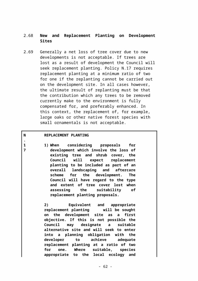
3.19 Furthermore, in the interests of the visual amenities of Conservation Areas:-
C.4
SIGNAGE IN CONSERVATION AREAS
The Council will not permit totally internally illuminated fascia or projecting signs in Conservation Areas. Consent will also be refused where the display of additional signs would result in a proliferation of, and excessive amount of, advertisement material on any individual building or group of buildings.
- 62 -

3.20 The use of individually illuminated lettering or indirect illumination and the use of hand-painted advertising will be encouraged.
3.21 Roller shutters and external roller grilles are likely to transform shopping streets into unattractive dead areas outside normal shopping hours. They adversely affect the appearance of Conservation Areas and the host buildings. Also, when added to an existing shop front, guide rails and bulky projecting box housings affecting the shop front’s appearance are required. Alternative means of providing shop front security such as internal lattice grilles are available. The base (stall riser) of a shop front may be reinforced against ram-raiding. Therefore:-
C.5
SHOP SECURITY
Within Conservation Areas, development proposals involving solutions to shop front security will be permitted provided that they are sympathetic to the character and appearance of the Conservation Area.
- 63 -

3.22 Demolition in Conservation Areas
3.23 The prime consideration in determining applications for Conservation Area Consent for the demolition of buildings will be the requirement of the Council to pay special attention to the desirability of preserving or enhancing the character or appearance of a Conservation Area.
3.24 The general presumption will be in favour of retaining buildings and structures which make a positive contribution to the character or appearance of a Conservation Area.
3.25 In assessing whether a building makes such a contribution, the following factors will be taken into account:-
(a) Has the building qualities of age, style, materials, or any other characteristics which reflect those of at least a substantial number of buildings in the Conservation Area?
(b) Does it relate by age, materials, or in any other historically significant way to adjacent listed buildings and contribute positively to their setting?
(c) Does it, individually or as part of a group, serve as a reminder of the gradual development of the settlement in which it stands, or of an earlier phase of growth?
(d) Does it have a significant historic association with established features such as the road layout, “burgage” plots, or landscape feature?
(e) Does the building have landmark quality, or contribute to the quality of recognisable spaces?
(f) Does it reflect the traditional functional character of, or former uses within, the area?
(g) Has it significant historic associations with local people or past events, or a noted architect?
(h) If a public building, does its use and internal public space contribute to the character or appearance of the Conservation Area?
(i) Its contribution to the building’s surroundings and the Conservation Area as a whole.
Any one of these characteristics may provide the basis for considering that a building makes a positive contribution to a Conservation Area, provided that its historic form and qualities have not been seriously eroded by unsympathetic alterations.
- 64 -

C.6
DEMOLITION IN CONSERVATION AREAS
1. The council will give high priority to retaining buildings which make a positive contribution to the character or appearance of a Conservation Area.
Proposals to demolish such buildings will only be permitted if the following criteria are met:
(i) The condition and cost of repairing the building outweigh the building’s importance and the value derived from its continued use (less weight will be given to the cost of repair where a building has been deliberately neglected).
(ii) Adequate efforts have been made to retain the building in its present use or a compatible alternative use, including freehold sale at a realistic price on the open market.
(iii) Exceptionally a proposed scheme brings substantial benefits for the community which outweighs preservation.
(iv) Any replacement building would preserve or enhance the Conservation Area.
2. Consent for demolition (including demolition of a building which makes little or no contribution to a Conservation Area) will not be given unless there are detailed and acceptable plans for redevelopment.
- 65 -

3.26 Further detail regarding (i) - (iii) Policy C6 is set out at paras 3.19 and 4.27 of PPG15 (Planning and the Historic Environment) which are relevant insofar as they apply to the contribution which the building makes to the character or appearance of the Conservation Area.
3.27 The final paragraph of Policy C.6 aims to ensure that planning applications and Conservation Area consent applications are submitted and considered together. Where it is important to avoid a site being left empty Conservation Area consent will be conditional upon the making of a contract for redevelopment.
3.28 The Conservation Areas
3.29 There are 17 Conservation Areas in the District each of which is shown on the Proposals Map. These are as follows:-
Abbots Langley Conservation Area - (The historic core and the commercial area. Appraisal available).
Batchworth Heath Conservation Area - (The historic heath and surrounding buildings. Information leaflet available).
Chorleywood Common Conservation Area - (The ancient common, surrounding buildings and area north of the station. Appraisal available).
Chorleywood Station Estate Conservation Area - (The “Metroland” residential area south west of the station).
Coppermill Lock Conservation Area - (19th Century canal-side buildings. Extends into London Borough of Hillingdon).
Croxley Green Conservation Area - (The Green and surrounding buildings. Appraisal available).
Dickinson Square Conservation Area - (Close knit group of planned 19th Century cottages and a garden square).
Grove Mill Lane Conservation Area - (Historic mill and nearby canal-side buildings. Extends into Watford Borough).
Heronsgate Conservation Area - (1846 planned Chartist settlement. Information leaflet available).
Hunton Bridge Conservation Area - (Canal-side buildings and canal bridge).
Loudwater Estate Conservation Area – (Residential Estate of a particular character, centred on Loudwater House and lying along the Chess Valley).
- 66 -
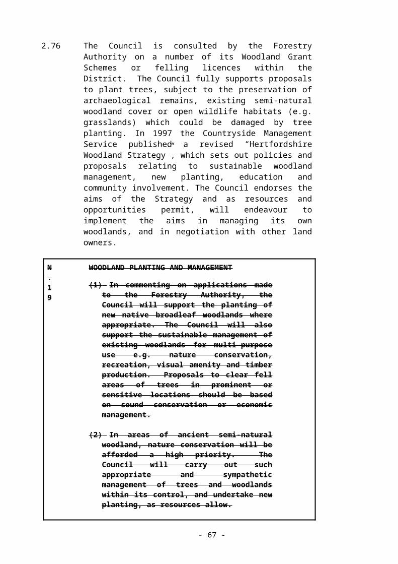
Moor Park Residential Estate Conservation Area - (”Metroland” planned estate. Covered by Supplementary Planning Guidance. Information leaflet available).
Nightingale Road Conservation Area – (An area of Victorian houses close to Rickmansworth Town Centre).
Rickmansworth Town Centre Conservation Area - (The historic and commercial core of Rickmansworth. Appraisal available).
Sarratt (The Green) Conservation Area - (Sarratt Green and surrounding buildings. Appraisal available).
Sarratt (Church End) Conservation Area - (Sarratt Church and nearby buildings. Appraisal available).
Stockers Lock and Farm Conservation Area - (Canal lock and nearby canal buildings and historic farm).
3.30 Listed Buildings
3.31 These are buildings of special architectural or historic interest listed by the Government following area or building-themed surveys by English Heritage or occasionally, following recommendations from Local Authorities or others.
3.32 Once a building is listed, consent from the local planning authority is required for its demolition or for any alteration or extension which could affect its character. This applies to the whole of the building (interiors as well as exteriors), to any fixtures and to buildings or structures within the curtilage of the building regardless of the grade of Listed Building (I, II* or II).
3.33 Control over changes to Listed Buildings is not intended to prevent all alterations but to protect the buildings from unnecessary demolition and from unsuitable and insensitive alteration.
3.34 It is strongly recommended that anyone who wishes to alter or extend a Listed Building or carry out any alterations or development within the curtilage of a Listed Building, should seek advice from the Planning Section of the Council prior to submitting an application. Central Government Guidance in PPG15 stresses that in order to assess an application for change to a Listed Building it is necessary to understand what makes up the special interest of the building concerned. Thus the Council may require applicants to produce a detailed archaeological evaluation of their building as part of their application and advice can be given on how this can be achieved. PPG15 also states that applicants for Listed Building Consent must be able to justify their proposals and must demonstrate why the works are “desirable or necessary”.
- 67 -

3.35 The Council has limited funds available for grants to owners towards the cost of repairs of Listed Buildings. (Details available on request).
3.36 Change of Use of Listed Buildings
3.37 In considering a new use for a Listed Building, its physical impact upon the building must be taken into account. Proposed uses must be compatible with the building without the need for damaging alterations.
3.38 An application for planning permission for change of use would not in itself show details necessary to allow the effect upon the Listed Building to be assessed. Therefore the Council will require that for any proposed change of use of a Listed Building, concurrent detailed planning applications and Listed Building Consent applications should be submitted.
3.39 The conversion of historic timber framed barns to dwellings is likely to result in the loss of key building features such as non-partitioned interiors, exposed structural elements, and extensive roof and wall surfaces with few openings. The external settings and character of these buildings is also likely to be drastically altered by such conversions. These barns may be more suitable for agricultural, commercial, leisure or community uses where such uses have an acceptable impact on a historic barns character. In cases where protected species may be present, (e.g. bats and owls) applicants are referred to Policy N.3 (Protected Species).
C.7
CHANGE OF USE OF LISTED BUILDINGS
(1) Change of use of a Listed Building will be granted only where the Council is satisfied that the historic and architectural characteristics of the building both external and internal will not be adversely affected.
And, In the case of residential conversion of barns,(2) it can be demonstrated that the applicant has
made every reasonable effort to secure other uses without success.
- 68 -

3.40 Alterations or extensions must take account of the special interest of the building concerned, which for example may include the internal layout, surviving surfaces, and staircases.
3.41 As in the case of change of use, outline planning applications involving the alteration or extension of a Listed Building would not provide sufficient information to enable proper consideration of the effect on the Listed Building. Drawings of the building as existing, together with full information on the proposal, including layout, elevations, plans and materials, are required with any application affecting a Listed Building. A full structural survey may be required in some cases.
C.8
ALTERATIONS OR EXTENSIONS OF LISTED BUILDINGS
Alterations or extensions must be appropriate to the character, scale, form, materials and special interest of the Listed Building. In determining applications the Council will take into account the cumulative affect of previous extensions or alterations to the building.
- 69 -

3.42 The Setting of Listed Buildings
3.43 The space around buildings can make an important contribution to their appearance and character. In some cases the setting of the buildings may have an historic function in its own right, or form part of the layout of an overall development in conjunction with the building itself. The setting of Listed Buildings may be adversely affected by development such as new buildings close to or within the grounds of Listed Buildings, sub-division of the grounds to create smaller gardens, or other small scale development in the curtilage affecting the character of the Listed Building.
C.9
THE SETTING OF LISTED BUILDINGS
Planning permission will not be granted for development which adversely affects the character of a Listed Building.
- 70 -
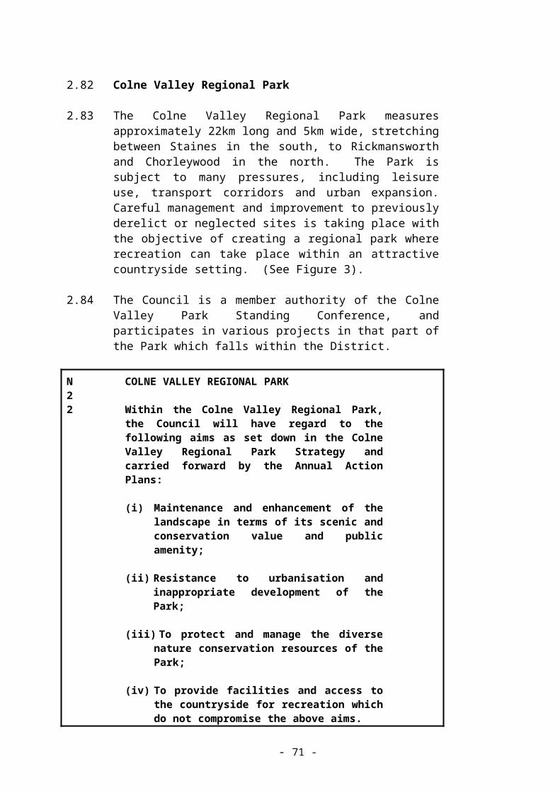
3.44 Demolition of Listed Buildings
3.45 Though there is considerable variety in the types of statutory Listed Buildings in the District (eg coal duty markers, barns, public houses and locks) their numbers are very limited, and once lost these historic buildings cannot be replaced. Accordingly there will be a presumption in favour of the retention of Listed Buildings.
C.10
DEMOLITION OF LISTED BUILDINGS
Listed Building consent for total or substantial demolition will be refused unless it is clear that all reasonable efforts to continue existing uses or find viable new uses or new owners have failed.
- 71 -

3.46 Further detail of the considerations to be taken into account regarding demolition of a Listed Building is at paragraphs 3.5 and 3.17-3.19 of PPG15 (Planning and the Historic Environment). It is most unlikely that the Council will agree to the demolition of a Listed Building that has been deliberately allowed to deteriorate.
3.47 Recording
Proposals which are acceptable in terms of Policies C.8 (Alterations of Listed Buildings), C.10 (Demolition of Listed Buildings), or C.12 (Locally Important Buildings) may nevertheless involve some loss or covering-up of features of a building. In these circumstances the need for a programme to record any such features will be considered. Where there is a likelihood of hidden features being revealed during the demolition or alteration of a historic building, a condition will be imposed to ensure the retention or proper recording of such features. The Council may require “opening-up” works (with Listed Building Consent as necessary) before granting consent in such instances.
C.11
RECORDING OF HISTORIC BUILDINGS
In all cases of demolition or alteration of a Listed or other historic building, the Council will consider the need to secure the proper specialist recording (and archiving/ publishing) of features of the building to be demolished or altered before development take place.
- 72 -

3.48 Locally Important Buildings
There are many other old or architecturally important buildings in the District which are of some architectural or local historic interest but do not qualify as statutory Listed Buildings. A list of such buildings has been compiled by the Council and from time to time may be added to.
3.49 The purpose of including buildings in a list of locally important buildings (Locally Important Buildings) is to safeguard the contribution they have made to the local scene for many years by encouraging their retention and ensuring that alterations or extensions do not detract from the buildings’ particular qualities. However, unlike provisions for statutory Listed Buildings, there is no requirement for express consent for demolition (unless the building is in a Conservation Area) or for internal alteration of Locally Important buildings.
C.12
LOCALLY IMPORTANT BUILDINGS
The Council will encourage the preservation of buildings on the list of locally important buildings and planning permission for development affecting Locally Important Buildings will only be granted provided the character or appearance of the existing building is not adversely affected.
- 73 -
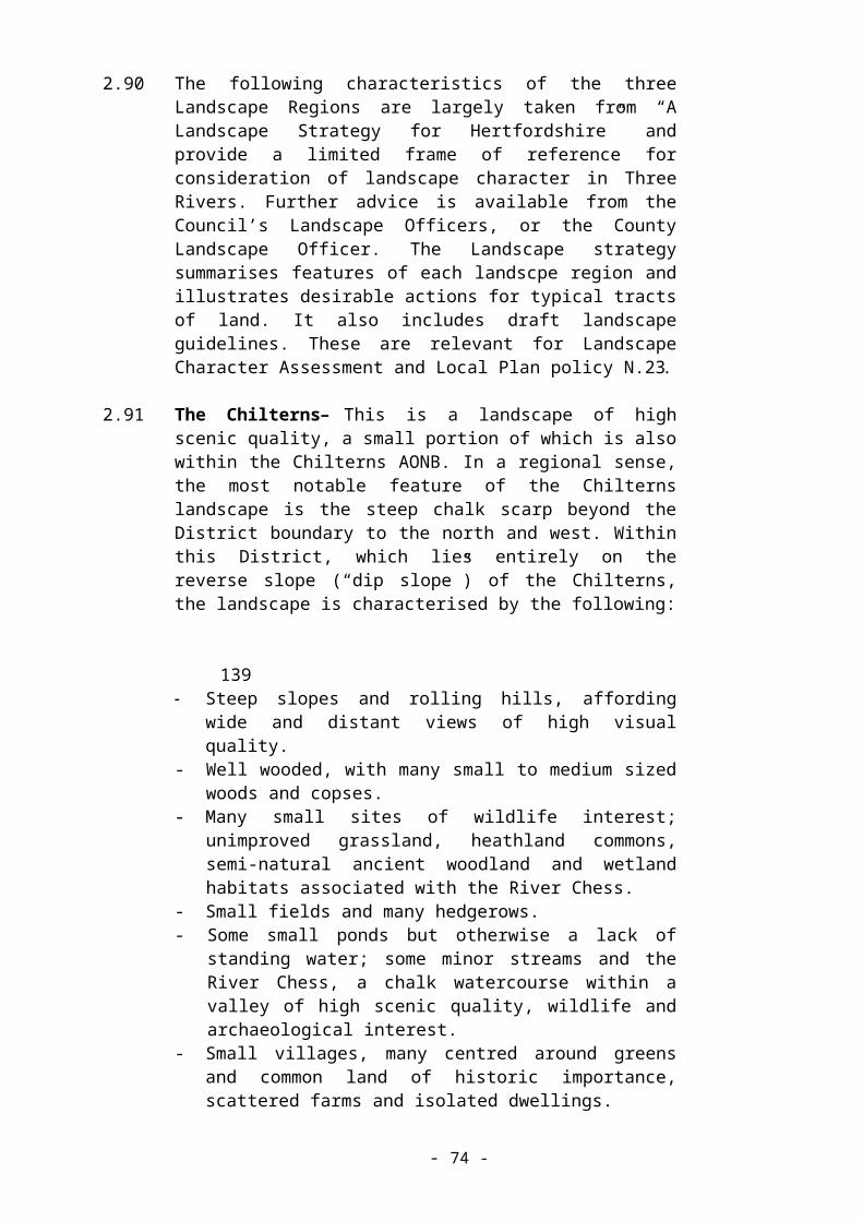
3.50 Where the local list includes buildings within a Conservation Area, these are considered to make a positive contribution to the Conservation Area. Conservation Area Consent for the demolition of a Locally Important Building will be considered against Policy C.6 (demolition in Conservation Areas).
3.51 Historic Parks and Gardens
3.52 The District contains a number of gardens or parks associated with historic buildings and which comprise a landscape and cultural resource. The effect of proposed development on a registered park or garden or its setting is a material consideration in determining planning applications. Moor Park Mansion is set in grounds which are registered Grade II* in the English Heritage “Register of Parks and Gardens of Special Historic Interest in England”. The site is an important component of the historical landscape, is a site of nature conservation interest, and is also used for golf and other recreation. It lies entirely within the Green Belt. Policy 38 of the Structure Plan also seeks to protect unregistered historic parks and gardens and their settings. Unregistered parks and gardens with the District include Rickmansworth Park, The Grove, Oxhey Grange, Sandy Lodge, Redheath, Micklefield Green and Chorleywood House.
C.13
HISTORIC PARKS AND GARDENS
Development affecting registered and unregistered historic parks and gardens will only be permitted provided that it does not adversely affect the character or appearance of the historic park or garden or its setting. Development that is permitted will be expected to address restoration of features of these grounds in those areas affected by the development.
3.53 Archaeology and Development
3.54 There are extensive records of known archaeological sites and finds in the District. These are held on the County Sites and Monuments Record. On the Local Plan Proposals Map, there are three Scheduled Ancient Monuments and 19 areas have been designated “Areas of Archaeological Significance” where there is evidence to indicate that significant archaeological remains exist. Also allowance has to be made for currently unknown or imperfectly known sites when determining planning applications.
- 74 -

3.55 From the 18th Century onwards improvements in transport and communications led to significant growth in several industries. Many early water corn mills were converted to paper production, and other industries include silk throwing, malting and brewing. The construction of the Grand Union Canal (in the 1790s) contributed to this growth, as did the 19th Century development of the railways (the London and Birmingham and Metropolitan Railways). The 19th and early 20th Centuries saw the development of public water supply and the gas and electric power generation industries. In the 20th Century the range of industries has widened enormously, and buildings of significance include examples such as the Ovaltine factory at Kings Langley and its associated model farms.
3.56 Surviving buildings and structures, including those associated with the Grand Union and the railways, are now rare and where the opportunity arises the Council will encourage the recording and preservation of buildings, structures or items of industrial archaeological interest.
3.57 Archaeological sites can be at risk from many developments. Development is unlikely to be acceptable on the most important sites and on others there is a need to ensure the identification and conservation or recording of their features.
3.58 This section outlines the procedure and policy for ensuring that development proposals and Council decisions upon them allow for the protection, enhancement and preservation of archaeological sites and remains.
3.59 Initially a developer should seek information on the likelihood of a site having an archaeological interest. The County Archaeological Officer can advise on this from the Sites and Monuments Record. Where this information suggests an archaeologically sensitive site, a developer should commission a “desk-top” assessment from an archaeological organisation or consultant as part of researching the site and to submit with the planning application.
3.60 Where the indication is that important archaeological remains may exist, the Council will request a field evaluation (normally a rapid and inexpensive operation involving ground survey and limited trial trenches) before any decision on the planning application is taken. This evaluation will help indicate to the developer whether proposals need to be modified to avoid or minimise damage to archaeological remains and will also inform the planning decision.
3.61 If no information has been submitted with a planning application the Council will assess the archaeological implications and if remains are likely to be affected, will require further information or an evaluation from the developer.
3.62 The following policy which will apply across the District, sets out the criteria upon which decisions will be based:
- 75 -

C.14
ARCHAEOLOGY AND DEVELOPMENT
1) The Council will not permit development which is likely to adversely affect Scheduled Ancient Monuments, and other nationally important archaeological sites and monuments, and their settings.
2) Where the Council considers that a proposed development will affect remains of archaeological significance, or areas of archaeological potential, developers will be required to provide the results of an archaeological evaluation before the planning application can be determined thus enabling an informed planning decision to be made.
3) On the basis of the evaluation and/or professional advice sought by the Council, planning applications affecting sites with archaeological potential or containing archaeological remains will be determined in the following ways:-
(i) Where archaeological sites or monuments of less than national importance, and their settings, are likely to be significantly adversely affected by development, physical preservation in situ will be the preferred option.
(ii) Where the Council considers that physical preservation of archaeological remains in situ is not merited, planning permission will be subject to conditions or a planning obligation requiring the developer to secure appropriate provisions for the investigation and recording of the archaeological remains and the publication of the results.
3.63 The Council will maintain supplementary guidance to further develop and explain the application of policies in this Plan in relation to development proposals in the historic towns of Rickmansworth and Abbots Langley. This guidance will be a material consideration in the determination of applications and will be subject to public consultation before it becomes operative.
- 76 -

GREEN BELT
4.1 Aims
4.2 To maintain the existing settlement pattern and the Green Belt, and to concentrate development in the main settlements insofar as the quality of the urban environment can be maintained or improved.
4.3 Objectives
(a) To maintain the Green Belt boundary.
(b) To permit only appropriate development in the Green Belt.
4.4 Introduction
4.5 Apart from the main urban areas shown on the Proposals Map, the whole of Three Rivers District lies within the Green Belt around London. This Local Plan makes no alterations to the Green Belt boundary.
4.6 The purposes of including land in Green Belts are set out in PPG2 (Green Belts) ie:-
- to check the unrestricted sprawl of large built-up areas;
- to prevent neighbouring towns from merging;
- to safeguard the countryside from encroachment;
- to preserve the setting and special character of historic towns; and
- to assist in urban regeneration by encouraging the recycling of derelict and other urban land.
4.7 In order to achieve the purposes of including land in Green Belt and the objectives set out above:
- 77 -

GB.1
DEVELOPMENT WITHIN THE GREEN BELT
(1) Within the Green Belt, except in very special circumstances, approval will not be given for new buildings other than:-
(i) Buildings needed for agriculture and forestry;
(ii) Essential facilities for outdoor sport and outdoor recreation; for cemeteries, and for other uses of land which preserve the openness of the Green Belt and which do not conflict with the purposes of including land in it;
(iii) Limited extension, alteration or replacement of existing dwellings; (see Policies GB.5, GB.6);
(iv) Limited infilling, or redevelopment of the major existing developed sites identified in this plan. (See Policies GB.2 and GB.3).
(v) Mineral working and subsequent restoration of the land, in accordance with the policies in the Hertfordshire Minerals Local Plan.
(2) Approval will not be given for engineering and other operations and the making of any material change in the use of land except where these do not conflict with the purposes of including land in the Green Belt and the openness of the Green Belt is maintained. Engineering and other operations that are within the Town & Country Planning (General Permitted Development) Orders, including the consolidated general development orders, as these apply to Canal Management and Operations, will not be affected by this provision.
(3) Within the village cores of Bedmond and Sarratt as defined on the Proposals Map (which lie within the Green Belt) new buildings will be restricted to limited affordable housing for local community needs (see policy H.7) and limited infilling only. Infilling must be in accordance with the following criteria:
(i) The site is a gap in an otherwise built-up frontage, having the same or similar dimensions as existing curtilages in the vicinity.
- 78 -

(ii) The site is located along the same frontage as existing adjoining development (i.e. the development must not be “tandem” development, or be located on an open site opposite existing development).
(iii) Any new development is designed to respect the scale and character of the village.
- 79 -

4.8 'Essential facilities' in Policy GB.1 above is defined in PPG2 (Green Belts).
4.9 Major Developed Sites in the Green Belt
4.10 These are developed sites which already exist in the Green Belt. They often predate current planning controls and Green Belt designation.
4.11 Prior to the issue in 1995 of the revised PPG2 (Green Belts), buildings used for institutional purposes standing in extensive grounds could be granted planning permission for extensions or new structures as a category of appropriate development in the Green Belt. Now however, development by such institutions is subject to the same controls as other development in the Green Belt, but local planning authorities may identify major developed sites where either redevelopment or limited infilling, which meets criteria listed in Annexe C of PPG2 would not be inappropriate development. In this context, infilling means the filling of small gaps between built development on such sites. The boundaries within which infilling may be acceptable are shown on the Proposals Map.
4.12 The following criteria are those under which major developed sites have been identified:
(a) They must be substantial sites. Examples are civil airfields, sewage treatment works, hospitals, research establishments and institutes of higher education.
(b) The amount and scale of built development.
(c) The number of employees or level of activity.
(d) Ability to accommodate further development without prejudicing Green Belt objectives or the settings of historic buildings.
(e) Planning history of the site.
The identification of these sites does not imply that development or redevelopment across the wider site ownership would be in any way acceptable.
4.13 Leavesden Studios Site
4.14 The boundary of this site is identified on the proposals map. The airfield remained open until March 1994. Since 1994 some of the former Rolls Royce factory buildings and adjacent land have been used as film studios, backlot and production facilities. A Planning Brief for the redevelopment of the site was approved in 1993 and outline planning permissions were granted in November 1995 to use the No 1 factory as film studios and for a studio tour, a family leisure centre, housing ,offices, sports and
- 80 -

playing fields, and a spine road. The spine road was completed in late 1999 and development of the residential land was also begun then.
In October 1999, MEPC UK Ltd acquired about half of the Leavesden Aerodrome site including some 88% of the developable area of the 1995 outline planning permission. MEPC has indicated that it does not intend to implement in full the outline planning permission – in particular, the studio tour and family leisure centre. MEPC is preparing a new masterplan for the Leavesden Aerodrome site which envisages a landscaped business park and redevelopment of the film studios.
The site is a Major Developed Site in the Green Belt as referred to by Planning Policy Guidance note 2 (Green Belt
GB.2
LEAVESDEN STUDIOS SITE
The Leavesden Aerodrome Site will remain in the Green Belt and is shown on the Proposals Map B. Redevelopment will conform to the criteria in PPG2 C4 (a) (b) (c). C4 (d) should be interpreted to indicate that redevelopment will not exceed 32 hectares as stated in condition (4) of the 1995 Outline Permission.
Core Strategy Policy CP11
4.15 Maple Lodge Sewage Treatment Works
4.16 Thames Water owns a substantial area of land to the east of Maple Cross, which includes a major sewage treatment works. This part of the site forms a substantial developed feature in the local landscape and has an industrial character.
4.17 The site of the works is identified on the Proposals Map as a major developed site where redevelopment or limited infilling for its continued use would not be inappropriate development in the Green Belt subject to the criteria in paragraph C3, Annexe C of PPG2 (Green Belts) and the following policy:
- 81 -

GB.3
MAPLE LODGE SEWAGE TREATMENT WORKS
(1) The landscaped setting provided by mature vegetation on the site boundaries and area surrounding the site should be retained in proposals for infilling or redevelopment.
(2) Any further buildings should be of comparable height to other nearby structures on the site.
4.18 The remainder of the Thames Water land at Maple Lodge is open in character. It includes a nature reserve, old landfill, small depot, the of the former sludge drying beds and several meadows, parts of which are of some wildlife interest. This land does not constitute a ‘major developed site’ in the context of PPG2 and is now surplus to the operational requirements of Thames Water. The Council is in the process of preparing a planning brief for this land, with the objective of managing it for the benefit of wildlife, local people and the landscape of the Colne Valley. When it is formally approved, the implications of the planning brief will be incorporated into the Local Plan:
GB.4
MAPLE LODGE PLANNING BRIEFThe Council is committed to the preparation of a comprehensive planning brief for land at Maple Lodge which will be subject to full consultation with the public and relevant organisations. It is considered that development of the site may be acceptable to enable environmental, landscape, passsenger transport and other benefits to be provided. The area will remain in the Green Belt until formal amendment of the Local Plan arising from implementation of development which is in accordance with the planning brief.
- 82 -
4.19 Building Research Establishment (BRE), Garston
4.20 St Albans District Council has prepared a planning brief for this Green Belt site, following BRE’s decision to consolidate their use of the site. The site is adjacent to (and partly within) this District, including the principal current access via Bucknalls Lane. This Council is concerned that redevelopment on this site should not adversely affect the amenity of residents in the District, or result in the loss of any part of the semi-natural ancient woodland on that part of the site in Three Rivers District.
4.21 Existing Dwellings in The Green Belt
4.22 The limited extension, alteration or replacement of existing dwellings in the Green Belt will be acceptable subject to the following policies which are intended to ensure that additions are not disproportionate to the size of the original building and that the appearance of the open countryside is maintained.
4.23 A building to be replaced must be a genuine dwelling house which is occupied, or has recently been occupied as a dwelling, and is not merely a dilapidated ruin.
4.24 Replacement of Dwellings in the Green Belt
GB.5
REPLACEMENT DWELLINGS IN THE GREEN BELT
The replacement of a dwelling (other than a caravan or mobile home) in the Metropolitan Green Belt will only be permitted where the following criteria are complied with:-
(i) The replacement does not materially exceed the size of the original.
(ii) Or, where the original dwelling has a floor area (measured externally) of less than 110 square metres then the replacement dwelling may be of a total floorspace (excluding garage) of 110 square metres.
(iii) The replacement would not be more harmful to the visual amenity of the Green Belt by reason of its siting, than the original dwelling.
- 83 -
4.25 Listed buildings or buildings in Conservation Areas require separate statutory consent for demolition.
4.26 Policy GB.5 (ii) is intended to allow the replacement of small dwellings which need to be rebuilt because they were originally built in materials such as timber and asbestos but which have now become defective or inadequate. Similar provision existed in the previous District Plan.
4.27 Extensions to Dwellings in the Green Belt
4.28 The purpose of controlling extensions in the Green Belt is to protect its openness from built development and to avoid proposals which would be visually intrusive. Extensions of scale or character which would cause undue prominence in the landscape will be resisted, as will a series of extensions which incrementally lead to such an intrusion. Extensions should not be disproportionate in size compared to the original dwelling. Proposals will therefore be assessed on a case by case basis taking into account the relationship of a house to its setting and to other nearby houses.
4.29 In circumstances such as an isolated dwelling in a prominent position, it may well be appropriate to restrict extensions to a very small size or indeed completely prohibit them.
4.30 Where there is a ribbon of houses in the Green Belt extensions will be carefully controlled to ensure that a proliferation of small extensions do not close the gaps between houses and thus create a closely packed line of development.
GB.6
EXTENSIONS TO DWELLINGS IN THE GREEN BELT
In order to preserve the openness of the Green Belt, the Council will not permit extensions to dwellings that are disproportionate in size (individually or cumulatively) to the original dwelling. The Council will also take into account the dwelling’s proximity and relationship to other buildings, and whether it is already, or would become, prominent in the landscape.
- 84 -

4.31 Ancillary Buildings
4.32 Proposals for new buildings such as garages or stables intended for use ancillary to an existing dwelling may affect the openness or visual amenity of the Green Belt. Such buildings may even have the character and size of a self-contained dwelling. Where ancillary buildings require planning permission:
GB.7
ANCILLARY BUILDINGS IN THE GREEN BELT
(1) Buildings ancillary to a dwelling in the Green Belt should be of a scale and design clearly subordinate to the dwelling and of a height and bulk such that the building would not be prominent within the landscape.
(2) Features normally associated with the use of a building as a dwelling (such as dormer windows) should be avoided.
- 85 -

4.33 The Extension of Residential Curtilages in the Green Belt
GB.8
EXTENSIONS TO RESIDENTIAL CURTILAGES IN THE GREEN BELT
To safeguard the countryside from encroachment, the extension of the curtilage of a residential property within the Green Belt which involves an incursion into the countryside will not be permitted.
- 86 -

4.34 Re-Use of Buildings in the Green Belt
4.35 Three Rivers District is not a rural area in the sense of being largely dependent on a rural economy. The economic benefits that changes of use of rural buildings could contribute to the local economy are accordingly limited (although helping diversification of a farming unit would in itself be of value). Nor, in the case of residential conversions, is there a requirement for rural buildings to contribute to identified housing needs in the District.
4.36 The Council accepts that in some circumstances change of use of buildings in the Green Belt may well be appropriate. The acceptability of a change of use of a building in the countryside will be dependent upon the building's nature and appearance in the landscape and the impact of the proposed use on the Green Belt. Also, where there are specific planning objections, such as impact on the environment or unacceptable traffic generation, a proposal will not be considered acceptable unless these objections can be overcome by applying conditions to a planning permission.
GB.9
RE-USE AND CONVERSION OF BUILDINGS IN THE GREEN BELT
(1) Proposals for the change of use of a building in the Green Belt may be permitted where:-
(i) The form, bulk and general design of the building is in keeping with its surroundings.
(ii) Any proposed adaptation of the building is sympathetic to the character and appearance of the building or group of buildings.
(iii) Any proposal, by way of eg alterations, extension, parking/turning area, modifications to access or landscaping, does not have a significant adverse effect on the appearance of the landscape.
(iv) The scale of the proposed use is not likely to have a detrimental effect on the locality (e.g. by noise, smell or by bringing heavy traffic to narrow lanes or involving associated uses not appropriate to the Green Belt of areas of open land).
(2) (ii) The building is suitable for re-use/conversion without extensive alteration, rebuilding and/or extension.
- 87 -

4.37 Residential Conversion of Groups of Farm Buildings
4.38 A number of farmsteads (ie groups of traditional agricultural buildings typically in courtyard layouts or otherwise in close proximity to each other) exist throughout the District’s countryside. Often the group of buildings will include a farmhouse or more than one existing dwelling.
4.39 Where such farmsteads are no longer required for agriculture, proposals are sometimes made for conversion of the buildings to general residential use. Experience has shown that such proposals are intensive in nature in that they typically entail conversion to dwellings of all the buildings in the group. Apart from the physical changes to the buildings themselves, this also involves establishment of a residential curtilage for each (often outside the building group and taking-in agricultural land) and can lead to demand for ancillary buildings such as stables or sheds outside the group. Together with fencing and planting, the consequent change in the appearance of the farmstead in its countryside setting is considerable and may make an unacceptable impact on the openness or visual amenity of the Green Belt.
4.40 The Council will therefore seek to minimise the impact of conversions of such groups of buildings by encouraging less intensive conversion i.e. by considering how many or what parts of the existing group can be changed to residential use without the problems mentioned above. This approach may have the additional benefit of providing for workspace/ancillary uses within the existing buildings.
GB.10
RESIDENTIAL CONVERSION OF GROUPS OF FARM BUILDINGS
1) The District Council will not grant permission for proposals likely to adversely affect the openness or visual amenity of the Green Belt.
2) The number of new dwellings shall be determined by the capacity of the existing yards or spaces delineated by the existing buildings to provide satisfactory amenity area for each dwelling.
3) Proposals which include open or agricultural land to provide new gardens/amenity space or include doors giving access from buildings directly onto such land will not be acceptable.
- 88 -

4.41 Development of Existing Schools in the Green Belt
4.42 Many of the District’s schools (particularly secondary schools) are located in the Green Belt. The District Council acknowledges that these are likely to have development needs over the plan period. Proposals for development will need to demonstrate as part of a planning application that the requirement for the development constitutes “very special circumstances” such that an exception should be made to the presumption against inappropriate development (see para 4.11) in the Green Belt.
4.43 Replacement of an existing building however, may not be contrary to Green Belt policy on new buildings provided that there is no additional impact on the Green Belt.
4.44 Schools or the Local Education Authority are advised to discuss development proposals at as early stage as possible in order to avoid delays in their building programme.
4.45 Agricultural and Forestry Dwellings in the Green Belt
4.46 PPG7 (Countryside) states that one of the few circumstances in which isolated residential development in the countryside may be justified is when accommodation is required to enable farm or forestry workers to live at or in the immediate vicinity of their place of work. Within this District, isolated countryside locations fall within the Green Belt and are subject to the relevant policies restricting built development (see policy GB.1).
4.47 In most cases, agricultural and forestry workers will be expected to be able to live in nearby towns and villages. However, the Council recognises that in certain circumstances the demands of the farming or forestry work concerned may make it essential for one or more of the people employed to live at or very close to the site of their work. In accordance with the advice in PPG7, the Council will apply a series of tests to applications for new agricultural or forestry dwellings. The tests differ slightly, according to whether the proposed dwelling relates to an established agricultural unit, or a new or proposed unit. The functional and financial tests governing the provision of a permanent agricultural dwelling are set out in Annex I of PPG7, and will be applied by the Council when considering applications of this kind. The tests are:
(a) There must be a clearly established existing functional need, i.e. it must be essential for the proper functioning of the enterprise for one or more workers to be readily available at most times.
(b) The need must relate to a full-time worker, or one who is primarily employed in agriculture, and not relate to a part-time requirement.
- 89 -

(c) The functional need can not be met by an existing dwelling on the unit, or any other existing dwelling in the area which is suitable and available.
(d) The agricultural unit and use to which the proposal relates, must have been established for a minimum of three years; have been profitable for at least one of them; be currently financially sound; and have a clear prospect of remaining so.
4.48 If the proposal is for a dwelling to support a new farming activity (on a newly-created agricultural unit or an established one), then in addition to criteria (a-c) above, the following criteria must also be satisfied:
(e) Clear evidence of commitment and ability to develop the enterprise concerned (for example, a significant level of investment in the enterprise to date).
(f) Clear evidence that the proposed enterprise has been planned on a sound financial basis.
GB.11
AGRICULTURAL AND FORESTRY DWELLINGS IN THE GREEN BELT
1) Planning permission will only be granted for agricultural and forestry dwellings in the Green Belt where:
(i) The functional and financial tests set out in Annex I of PPG7 (Countryside) are completely met;
(ii) The functional need cannot be met by an existing dwelling on the site, or any other existing accommodation in the area which is suitable and available.
2) If a new dwelling is proven to be essential to support an established farming activity on an existing agricultural unit, the dwelling will only be permitted if it is of a size appropriate to the established functional requirement and the expected financial income of the agricultural use. The dwelling should be designed and sited so as to have the minimum impact on the openness of the Green Belt, and be well related to existing dwellings or farm buildings.
3) If a new dwelling is proven to be essential to support a new farming activity, whether on a newly-created agricultural unit or an established one, the Council will only grant permission for temporary accommodation, for a period of three years.
- 90 -

4) If permission for temporary accommodation is granted under (3) above, permission for a permanent dwelling will not subsequently be granted unless the criteria in (1) and (2) above are met.
4.49 If the Council decides to grant permission for a new agricultural or forestry dwelling, the Council will normally apply an agricultural occupancy condition. This may apply not only to the new dwelling, but to other existing dwellings on the site that are under the control of the applicant, do not have occupancy conditions, and need at the time of the application to be used in connection with the farming or forestry use. In accordance with advice given in Circular 1/97, the Council will also consider using planning obligations to tie a farmhouse to adjacent farm buildings or to the land of the agricultural unit to, prevent them being sold separately without further application to the planning authority.
GB.12
USE OF AGRICULTURAL OCCUPANCY CONDITIONS
(1) The Council will monitor the operation of occupancy conditions and will consider taking enforcement action where a condition is breached.
(2) Before agreeing to remove an occupancy condition, the Council will require evidence that there is no need for agricultural dwellings either on the original agricultural unit, or in the area as a whole.
- 91 -

DESIGN
5.1 Aims
5.2 To ensure that development minimises its impact upon the natural environment and makes a positive contribution to the built environment.
5.3 Objectives
(a) To minimise impact on natural resources (water/air/soil).
(b) To achieve a positive relationship (eg in visual, landscape and access terms) between a development and its surroundings.
(c) To preserve or enhance the character and appearance of semi-natural or man-made features of importance in the landscape.
5.4 Introduction
5.5 Good design is vital. The Council expects a high standard of design to encourage everybody’s satisfaction with their built environment to help attract business and investment, and to promote sustainable development.
5.6 Policies in this Chapter are intended to act with the locational criteria for new development, and with policies to reduce the negative impacts of the motor vehicle. Some sources of design guidance (particularly in respect of design for access, and design to minimise opportunities for crime) are also referred to.
5.7 Design Awards
5.8 Three Rivers District Council promotes good design by its annual Civic Award Scheme. Awards are made in the following categories:
(a) Sustainable design.(b) New buildings.(c) Works to a historic building.(d) Landscaping schemes.
All approved planning permissions/Listed Building consents will be considered for these awards and the successful schemes notified to the winners, press and professional bodies.
5.9 Design Statements
5.10 In order to demonstrate how applicants have taken account of the need for good design in their development proposals and had regard to the policies in the “Design” section of this plan:
- 92 -

D.1
DESIGN STATEMENTS
Applicants for planning permission for complex or large scale proposals will be expected to submit a statement setting out the design principles adopted and how the policies of the “design” chapter of this Local Plan have been addressed.
- 93 -

5.11 The design statement should include consideration of the wider context beyond the development site and immediately adjacent buildings. It should comprise a written statement and may include illustrative material such as diagrams and perspective views including adjacent buildings.
5.12 A planning application for complex or large-scale projects will not be accepted as a complete application without a design statement. A design statement will not be required for “householder” applications (e.g. extensions), or minor development.
5.13 Factors Affecting Housing Layouts
5.14 Information submitted in support of applications for full planning permission or for approval of matters reserved under an outline permission (see Policy D.1 - Design Statements) for development, should demonstrate that the layout has responded to the following considerations each of which is likely to require some adjustment in the others as the layout evolves. It is important however, that vehicle routes do not determine the layout to the detriment of the other factors below:
(a) site characteristics and features (landscape, flora and fauna, etc) and the landscaping scheme (see for example, policies D.6 and D.7).
(b) pedestrian and cycle routes (see for example policy D.4) access to the site and to off-site networks and local facilities.
(c) form and orientation of buildings (see policies D.2 and D.3).
(d) vehicle access, routes and parking (see for example policy D.5 and the reference to car-free housing development in Paragraph 9.37a).
5.15 Policies regarding cycle/pedestrian routes, landscape schemes, and residential roads are included in this chapter in order to emphasise the need for these (along with the other considerations specified here) to influence the initial formulation of housing layouts. The sections on pedestrian and cyclist facilities, landscape/water conservation, safety and security, and access to buildings apply to development generally, not only to housing. Development adjacent to the canal should respect its waterside location and be oriented to face the canal, unless design considerations indicate otherwise.
5.16 Building Form and Orientation - Energy Conservation
- 94 -

5.17 The conservation of energy is one key issue Local Authorities are to have regard to. This is stressed in PPG12 (Development Plans and Regional Planning Guidance) as it contributes to a range of environmental objectives such as reducing emissions of greenhouse gases. Buildings account for a very significant percentage of energy consumption and of harmful carbon dioxide emissions.
5.18 The Council has produced an Energy Conservation Strategy in respect of its duties under the Home Energy Conservation Act 1996. This sets targets and provides information in respect of existing housing stock. The energy consumption of new buildings can be influenced by factors including building type and orientation.
5.19 Energy consumption varies with building form or type. Energy efficient buildings will be encouraged in all areas. However, forms such as terraced or courtyard layouts and flats are inherently energy efficient. These building forms also allow densities which are appropriate for those areas specified in the policy below but may not be elsewhere. Therefore:
D.2
ENERGY EFFICIENT BUILDING FORMS
Housing development within those parts of the main settlements where there is good access to passenger transport or community facilities and services should consist of energy efficient forms such as flats, town houses, terraces or courtyard forms or a mixture of these.
Core Strategy Policies CP1CP3CP12
- 95 -

5.20 Policy D.2 is not intended to apply to infill sites where it is proposed to build one or two single dwellings of a size comparable to adjoining dwellings. In relation to this policy, attention is drawn to Policy H.14 (Infilling and Development on Garden Land) which addresses “tandem” or “backland” development and the effect of development on the character of an area.
5.21 “Solar gain” (from orientation toward the sun) can help to reduce the heating requirement and hence energy consumption of buildings. To take advantage of solar gain, living rooms should be on one side of houses and facing within at least 45o (and preferably 30o) of south. Energy efficiency is assisted by large windows facing south and smaller windows facing north.
5.22 Other influencing factors to be taken into account in designing the layout for energy conservation include height, shelter from wind and extent of overshadowing.
D.3
ENERGY EFFICIENT LAYOUT
New housing layouts should ensure that the maximum possible numbers of living room windows are oriented to the south, (i.e. within at least 45o and preferably 30o of south) and avoid overshadowing of or from other buildings.
Core Strategy Policy CP12
- 96 -

5.23 Pedestrian Priority and Cycle Routes
5.24 Walking and cycling are two of the most available forms of transport, yet the pedestrian and cycling environment is increasingly hostile in many places. To contribute to addressing this and to ensure new development is integrated with footpath and cycle route networks and local facilities, by routes that are comfortable, wide, well-lit and without blind corners, the Council will apply policy D.4 when considering proposals for new development. For the purposes of considering the standards to which cycle facilities should be designed and built, the Council will use the following publications as supplementary planning guidance: “Cycle-friendly Infrastructure, Guidelines for Planning and Design” (IHT/CTC, 1996) and the latest issue of “The National Cycle Network, Guidelines and Practical Details” (Ove Arup/Sustrans, 1997).
D.4
PEDESTRIAN AND CYCLE ROUTES
1) New developments should provide pedestrian and cycle routes through a site linked to the path network outside the site and to local community facilities. Routes should have signs, good lighting and prominent access points. Routes should be as wide as possible and designed to provide safety, convenience, coherence, directness, attractiveness and comfort.
2) Often, several design options can be used in one cycle route. Where there is a choice, design options should be prioritised according to the principles set down in “Cycle-friendly Infrastructure, Guidelines for Planning and Design”.
3) Whatever design option is chosen, routes for cyclists should be designed and built, for use by a sensible unaccompanied twelve year old, according to the standards set down in “Cycle-friendly Infrastructure, Guidelines for Planning and Design” and the latest issue of “The National Cycle Network, Guidelines and Practical Details”.
- 97 -

5.25 Vehicle Segregation and Traffic Calming
5.26 To improve walking conditions and for pedestrians’ safety, footpaths should be direct whereas vehicular routes should wind but not be excessively circuitous. The design of roads in residential areas should be such as to ensure that vehicle speeds are low. However, consistent with policy T.7(3), careful planning and implementation is needed to avoid introducing traffic calming features (especially “vertical” features such as road humps) that may make cycling dangerous and cause problems for buses.
D.5
DESIGN OF RESIDENTIAL ROADS
Residential areas should be designed to give priority to pedestrians and cyclists. New residential roads must include neighbourhood-wide 20mph zones or other design features to achieve low vehicle speeds (20 mph maximum). The design of residential roads should avoid those traffic calming features that tend to make cycling dangerous.
Where appropriate, new housing developments will provide for safe and direct operation of buses, including the provision of bus stop facilities as required to ensure all dwellings are within 400 metres of a bus stop.
- 98 -

5.27 Landscaping
5.28 External space should be treated as an intrinsic part of any scheme from the outset, not as an addendum to the built development. Design of the necessary combination of hard and soft landscaping and parking areas should be resolved in close association with the buildings.
5.29 The level of landscaping provision (in terms of structure, quantity and diversity) must be in keeping with the scale of the development.
5.30 The structure of landscaping proposals should address:
(a) incorporation of visually obtrusive elements such as car parks, blank elevations, electricity sub-stations etc;
(b) the setting of buildings within the site, and the setting of the whole site within its locality;
(c) the creation of views into and out of buildings and the site as a whole, and the creation and enhancement of visual focal points.
(d) design for water conservation (see paragraph 5.34).
(e) the conservation of existing local landscape character, as identified through a Landscape Character Assessment conforming to the latest government agency guidance.
5.31 Landscaping schemes should aim for diversity in terms of plant species, size, structure, growth rate and season and where possible and appropriate the use of native species.
5.32 Trees of amenity value and other landscape features should be retained and protected during all stages of development in accordance with British Standards recommendations.
5.33 Materials proposed and design of hard landscaping and “street furniture” will be considered in relation to paragraph 5.30 and any other relevant factors.
D.6
LANDSCAPING
(1) Where appropriate, the District Council will require full landscaping proposals to be submitted in support of an application for planning permission. This must include a full survey of existing features.
(2) Landscape and nature conservation features should be retained and protected during development (see also policies N.12 & N.13).
- 99 -

(3) Landscape design and choice of materials should contribute to water conservation.
5.34 Design for Water Conservation
5.35 Development increases water run-off from hard surfaces and reduces filtration into the ground. This can lead to greater likelihood of flooding elsewhere and reduction in the amount and quality of water available (via the aquifer) for use.
5.36 Landscaping can be designed to reduce run-off from a site and increase infiltration. The consumption of water by households and other building users can also be influenced by recycling water for certain uses and this can also be provided for within a landscaping scheme.
D.7
DESIGN FOR WATER CONSERVATION
Applicants for development will be expected to show that they have had regard for water conservation in the design for their proposals, using for example the following means:
(i) External hard surfaces should be permeable and cover the minimum necessary area;
(ii) Water run-off should be channelled over absorbent ground to increase filtration using designed landscape features such as holding ponds and watercourses. Alterations to ground levels or drainage patterns should not aim to increase the rate of drainage or be likely to pollute the water environment.
(iii) Consideration should be given to storing and recycling run-off for WC operation, irrigation, car washing etc
(iv) For major developments, on-site or near-site reed bed treatment of foul or grey water will be encouraged.
5.37 When assessing proposals for development, the Council will have regard to the views of the Environmental Agency and British Waterways as appropriate. Discharge of surface water into the Canal is likely to require consent from British Waterways. Applicants should contact the Regional office at Hemel Hempstead. Thames Water can offer advice to developers on design for water conservation.
5.38 Design for Safety and Security
- 100 -

5.39 The main opportunity to ensure that design helps reduce opportunities for crime is at the beginning of the design process. The reduction of opportunities for crime can be achieved by careful design of layout, lighting and landscaping. There should be natural surveillance from buildings of streets, footpaths, car parks, communal areas and entrances to buildings. Areas of defensible space should be created wherever possible.
5.40 Crime prevention measures should not entail the loss of important landscape features, pre-existing footpaths, or adversely affect the character of historic areas or structures.
5.41 Advice can be obtained from the Police Architectural Liaison Officer at Hertfordshire Constabulary Headquarters, Stanborough Road, Welwyn Garden City, Herts, AL8 6XF.
5.42 Developers should consider using the “Secured by Design” scheme which applies to new housing, the rehabilitation of existing housing and to new developments.
D.8
DESIGN FOR SAFETY AND SECURITY
The Council will require all development to be designed to take account of personal safety and security by:
(i) Ensuring that paths, play areas and open spaces are overlooked by inhabited buildings, while maintaining the privacy of the inhabitants;
(ii) Avoiding the creation of spaces with ill-defined ownership and ensuring there is clear distinction between public and private space;
(iii) Ensuring the development is well integrated into the existing pattern of pedestrian and vehicle movement;
(iv) Ensuring that landscaping, planting and building does not create dark or secluded areas;
(v) Ensuring that good quality lighting is provided for streets and paths, where appropriate.
Core Strategy Policies CP1CP12
- 101 -

5.43 Access
5.44 Good access benefits everyone, particularly people with disabilities, elderly people and those with children in prams and pushchairs. The Building Regulations set out requirements for the design of non-domestic buildings to improve accessibility for disabled people. Planning controls, however, can help to ensure the provision of good access to buildings and land used by the public. There should be careful attention to the relationship between buildings, the location of parking areas and the location of other public access points so that there is maximum accessibility to all buildings and other areas of land that the public would be expected to use. These aspects will be taken into account in considering planning applications.
5.45 Measures to improve access should be considered at an early stage in the design process. Such measures may include:
- Suitable access to building entrance from adjoining streets and setting down points (eg dropped kerbs, level or ramped approaches).
- Signposting to suitable parking spaces for disabled people.
- Signposting to an entrance suitable for disabled people.
- Provision of car parking space for disabled people close to the entrance of a public building.
5.46 Relevant guidance material includes “Designing for Accessibility” published by the Centre for Accessible Environments.
5.47 Provision for disabled access will be expected where it can be reasonably achieved. It is acknowledged that in some circumstances, opportunities for improving access may be limited. Circular 8/98 states that in considering planning applications for new dwellings, proper account should be taken of modified Part M, Schedule 1 of the Building Regulations 1991 (and Approved Document). This planning requirement is with particular respect to the location and arrangement of the dwellings on the site to allow a disabled person to approach and gain access to the dwelling from within the plot.
D.9
ACCESS FOR THE DISABLED
Applications for the development of (and where reasonable and practicable, the change of use or alteration of) land and buildings open to the public, dwellings, and buildings used for employment and education purposes, should provide suitable access and facilities for people with disabilities. Spaces and paths within an application site should also be designed so as not to present barriers to
Core Strategy Policies CP1CP12
- 102 -
people with disabilities.
5.48 “Buildings open to the public” in the above policy includes for example, shops, restaurants, hotels, places of entertainment, leisure and community buildings.
- 103 -

HOUSING
6.1 Aims
6.2 To provide a sufficient supply of housing land during the plan period; to ensure that the type of housing built meets the needs of the population in terms of location, size and affordability; and to ensure that housing development is not detrimental to the natural or built environment, or other land uses.
6.3 Objectives
(a) To ensure a five year land supply and longer term provision in accordance with the County Structure Plan and PPG3 (Housing).
(b) To ensure that an appropriate amount of housing is affordable.
(c) To ensure that provision is made for housing to suit people with special needs.
(d) To ensure that the overall mix of housing is appropriate for the local population.
(e) To ensure that large sites contain a diversity of types of housing.
(f) To locate as much housing as possible near to town centres, transport nodes and existing local services.
(g) To increase densities at appropriate locations and particularly near to town centres, transport nodes and existing local services.
(h) To protect the quality of life of the District’s residents.
6.4 Introduction
6.5 Housing is a basic human need. One of the most important functions of the Council is to provide for this need, both through the management of its own housing stock and by allocating an appropriate amount of land for development to take place. At the same time, the Council aims to protect the environment from any adverse effects of housing development.
- 104 -

6.6 The determining factor in the numbers and types of new dwellings required is the population and household composition of an area. At present, the District is experiencing a steady increase in population, and in addition the number of new households is rising rapidly due to declining family size. The proportion of small households is higher than ever before. In 1991, 58% of households were composed of one or two persons. This is not the place to carry out a detailed assessment of demands and trends, which in any case will alter over the Local Plan period. Background information is contained in the Housing Land Availability Statement (published annually), and the Housing Needs Survey 1999. Hertfordshire County Council Information Section also publishes statistics on housing.
6.7 The Requirement for Housing Land, Period 1991 to 2011
6.8 PPG3 (Housing) states that Local Authorities should aim to ensure the availability of five years supply of housing land. This supply is to be made up of sites which are likely to be readily available during the plan period, and which can be economically developed.
6.9 Policy 8 of the Hertfordshire County Structure Plan Review 1991 - 2011 prescribes for Three Rivers District a net total of 4,000 new dwellings, for the period 1991 to 2011. Table 2 and tables 3a, 3b and 3c show the expected composition of the housing land supply over the whole of the Local Plan period.
Table 2 - Housing Supply for the Local Plan Period 1991 - 2011
(All figures are net)
1Completions from 1/4/91 to 31/3/98:
2,015
2Allowance for small sites and windfalls,1998 – 2011, @ 30 per year (see table 3a):
390
3Five-year land supply agreed with HBF and HCC,(1/4/98 – 31/3/03) (see table 3a):
968
4Other sites available pre-2006(1/4/98 - 31/3/06) (see table 3b):
590
5Long term sites identified (1/4/06 - 31/3/11)(see table 3c):
287
Total: 4,250
- 105 -

6.10 Explanation of Table 2
6.11 The figures entered in table 2 above have been arrived at as follows:
(1) Completions from 1/4/91 to 31/3/98 (which is the time since the beginning of the Structure Plan period so far) are monitored annually by Hertfordshire County Council and checked by Three Rivers District Council.
(2) An annual allowance of 30 dwelling for the contribution from small sites and windfalls was agreed with the House Builders Federation in April 1999, based on monitoring data supplied by Hertfordshire County Council.
(3) The five-year land supply as required by PPG3, is comprised of sites agreed by the District and County Councils, and the House Builders Federation in April 1999 under the terms of a joint housing land availability study.
(4) Besides the agreed five-year supply in (3), other sites have been identified as being available before 2006.
(5) The long term supply of housing land is mainly comprised of sites that are currently in use, but which are considered to be suitable for housing if and when the current use ceases.
6.12 Although the total supply of housing land is slightly in excess of the Structure Plan allocation, it is not possible to precisely forecast the source and timing of every housing development. All of the sites identified in Tables 3a, 3b and 3c have a good chance of being developed during the Plan period, but Table 2 should be interpreted with a margin of flexibility.
6.13 A small additional number of dwellings may become available through use of existing dwellings that are vacant. The Council pursues an Empty Homes Strategy to help bring these back into use. The Council also ensures rapid turnaround of council house “voids”.
- 106 -

6.14 Definition of Large/Small Sites and “Windfalls”
6.15 Two separate thresholds are set for defining large or small sites for two purposes: firstly for calculating residential land supply, and secondly for the purposes of applying policies such as H.6 (affordable housing). For the purposes of calculating residential land supply, the Council makes an allowance for the contribution that small sites make each year. For the purposes of this calculation, “small” sites are those of nine or fewer dwellings. “Large” sites, which are individually identified wherever possible, are those containing ten or more dwellings. Large sites which come forward but were not previously identified are “windfall” sites, and the annual allowance in Tables 2 and 3a also takes these into account.
6.16 For the purposes of applying policies in the Local Plan (i.e. “large” sites as referred to in Policy H.3 and elsewhere) large sites are those of 25 or more dwellings or 0.6 hectares or over. Where large sites have been split into phases or sub-sites of less than 25 dwellings or 0.6 hectares, policies will be applied to the whole site.
H.1
RESIDENTIAL LAND SUPPLY:
An adequate residential land supply to meet the requirements of the County Structure Plan Review 1991 - 2011 will be provided by the following means and as set out in Tables 2, 3a, 3b and 3c:
(i) Identified housing sites as listed by Policy H.2, Tables 3a, 3b and 3c and shown on the Proposals Map;
(ii) Dwellings permitted in accordance with Policies H.8, H.11, H.12, H.13, H.15, H.16 and H.17.
(iii) Dwellings permitted in the Green Belt in accordance with Policies H.7 and GB.2.
Core Strategy Policies PSP1PSP2PSP3PSP4CP2
- 107 -

6.17 The protection of the Green Belt is considered to be extremely important in this area of the County. The housing sites in Tables 3a, 3b and 3c are almost entirely within the urban areas of the District, with the exception of Leavesden Studios (see paragraph 6.19a). The Council considers that there is no need to identify any ‘green field’ site for residential development.
6.18 Tables 3a, 3b and 3c list those sites which have been identified as being suitable for housing development and which are currently available or likely to be available during the Local Plan period. These sites are shown on the Proposals Map. The contribution of these sites is assessed on the basis of their size, location and site constraints. It is important that when these sites are developed the number of units actually provided accords closely with the figure shown for that site in the tables. Several sites are adjacent to the canal and therefore British Waterways will be consulted on any applications for redevelopment.
H.2
DEVELOPMENT OF IDENTIFIED HOUSING SITES:
Subject to Policy H.4 (dwelling mix), applications for the development of housing sites listed in Tables 3a, 3b and 3c should be developed at an overall capacity which accords closely with the figure given for that site. Applications for significantly lower capacities will be refused.
- 108 -

- 109 -

Table 3a – Five Year housing land availability, April 1998 – March 2003:
Proposals Map Ref:
Status: Site: 1991-1998
1998-1999
1999/2000
2000/2001
2001/2002
2002/2003
2003-2006
2006-2011
Sub-Totals
1 PP Leavesden Studios Site 0 50 100 100 502 PP Leavesden Hospital, phase 8 0 0 20 0 03 E Hurstleigh, Shire Lane, Chorleywood 0 0 0 10 04 U/C Chorleywood House/former Equestrian Centre 6 19 0 0 05 U/C Abbiss & Hale site (335-337 Uxbridge Road),
Rickmansworth0 52 0 0 0
6 PP 47 High Street, Rickmansworth (formely PCL, Waterside House)
0 49 0 0 0
7 U/C Marconi site, Croxley Green 66 134 83 0 08 U/C Former Brookside Caravan Park, Oxhey Hall (-44) 52 0 0 0 09 U/C Land between 209-211 Prestwick Road, South
Oxhey10 0 0 0 0
10 U/C Sir James Altham School site, phase 1 (Cherry Hills)
(+72) 1 0 0 0 0
11 PP Sir James Altham School site, phase 2 0 18 0 0 012 U/C Married Quarters, Carpenders Park (-70) 66 66 6 0 013 U/C Land at junction of WaterLane/Station Road,
Kings Langley10 0 0 0 0
Sub-totals: 211 388 209 110 50 968
Annual small sites/windfalls allowance 30 30 30 30 30 90 150 390
Residual Calculation:Structure Plan requirement: 4,000Net completions 1991-1998 2,015Residual control total: 1,985Projected annual requirement: 153Five-year supply requirement: 765Actual Supply: 1,118(equal to 7.3 years supply)
Table 3b – Other Sites, pre-2006:

Proposals Map Ref:
Status: Site: 1991-1998
1998-1999
1999/2000
2000/2001
2001/2002
2002/2003
2003-2006
2006-2011
Sub-Totals
1 PA Leavesden Studios site (post-2003 balance) 0 0 0 0 0 2014 PA/PB Penn Place and Northway car park,
Rickmasworth0 20 140 0 0 0
15 U/C High Street South Side, Bury Lane/Ebury Road, Rickmansworth
0 7 4 0 0 10
16 PA 17-23 High Street (former Boby Building), Rickmasworth
0 24 0 0 0 0
17 E Napier House, Wharf Lane, Rickmansworth 0 0 0 0 0 3018 E Three Valleys Water site, London Road,
Rickmansworth0 0 0 0 0 40
19 E Harefield Road depot, Rickmansworth 0 0 0 0 0 2120 PA Chilwell Gardens site, South Oxhey 0 0 20 92 0 021 E Old Merchant Taylors site (phase 1), Croxley
Green0 0 0 70 0 0
22 E Durrants Club, Old Merchants Taylors site, Croxley Green
0 0 20 0 0 0
24 E Highlands Estate and depot, Oxhey Hall 0 0 19 0 0 026 U/C Bedmond Green (phase 6), Bedmond 9 0 0 0 0 027 E Land adjacent to Lytham Avenue, South Oxhey 0 0 0 0 30 028 PP 31 and land rear of 33-65 New Road, Croxley
Green0 0 0 0 0 14
Sub-totals: 9 51 203 162 30 135 590
Table 3c-Long term housing sites, April 2006-March 2011
Proposals Map Ref:
Status: Site: 1991-1998
1998-1999
1999/2000
2000/2001
2001/2002
2002/2003
2003-2006
2006-2011
Sub-Totals
28 E Three Valleys Water reservoir site, the Swillet, Chorleywood
30
21 E Old Merchant Taylors site (phase 2), Croxley Green
60
29 E Scots Hill “terrapin” site, Croxley Green 2530 PB IMC Works, Harvey Road, Croxley Green 4031 E 143-149 Watford Road, Croxley Green 2532 E Talbot Road car park (High Street junction) 1033 E Bridge Motors, Church Street, Rickmansworth 1034 E Mill End dairy site (Shepherds Fm, Meddleton Rd) 1635 PB 10 High Street (showroom site), Rickmansworth 2136 E Gas works, Wharf Lane, Rickmansworth 50
Sub totals: 287 287
Note: Where capacity in the above tables relates to an estimated site, although its is related to net site area and is not a maximum or minimum figure, it provides the number of units to which the development should closely accord.
Key to status (on 1 April 1998):
E Estimated sitePB Planning Brief preparedPA Planning application pending determinationPP Planning permission granted (may be outline, reserved matters or detailed)U/C Under construction

6.19 Footnotes to Tables 3a, 3b and 3c:
(1) Leavesden Studios Site: A Planning Brief was approved in 1993 and outline planning permission was granted in 1995 for development including not less than 300 dwellings on this former airfield and Rolls Royce factory site. A reserved matters application for 320 houses is pending determination. Affordable housing provision on this site is set at 25 per cent in accordance with the outline approval.
(2) Phase 8, Leavesden/Abbots Langley Hospitals: Proposals for development are awaited for conversion of the former hospital buildings in accordance with the approved 1989 Planning Brief and outline planning permission granted in 1989. The site capacity is based on conversion of the existing hospital administration block and the building to the east.
(14) Penn Place/Northway car park, Rickmansworth: Penn Place has planning permission for redevelopment for offices. However, the site has now been purchased by a house builder and a planning application for high density flats is expected in the near future.
A planning brief was approved in 1999 for the redevelopment of the Northway car park. A mixed use development for residential and retail will be encouraged, subject to retaining the 152 free short-term parking spaces currently available on the site. During development, arrangements will be made to maintain the same total number of parking spaces within the town centre.
(15) High Street “South Side” Area, Rickmansworth: The complexity of land ownership and other site constraints in this area may preclude major development. The total of 20 dwellings includes planning consent for seven flats granted in 1997. (See also Chapter 8, para 8.26).
(16) Boby Building, High Street, Rickmansworth: Various planning permissions and Conservation Area consents have been granted for demolition of the existing building and redevelopment of the site for housing, or for offices. The Council’s preferred use is residential. This is a prominent site, fronting a busy part of the High Street, and any replacement buildings will be expected to be designed to a high standard.
(17) Napier House, Wharf Lane, Rickmansworth: This site is a remnant of the industrial uses that formerly occupied the whole of the Town Wharf area. It is now located between two areas of new residential development and applications for redevelopment for housing will be welcomed.
(18) Three Valleys Water Site, London Road, Rickmansworth: This public utilities site is likely to become vacant during the Local Plan period. A planning brief will be prepared, identifying buildings and other features that should be retained and converted. Subject to the terms of a planning brief, the redevelopment of the site for housing will be encouraged.
(19) Harefield Road Depot, Rickmansworth: A Planning Brief for the redevelopment of this site was approved in 1995. The number of houses that can be constructed is limited by a sewage pumping station on site.
(20) Chilwell Gardens, South Oxhey: Detailed plans for redevelopment of the school buildings and open land are being drawn up under the Single Regeneration Budget proposals for South Oxhey. Any development on the open land will be subject to relocation of the playing fields at a convenient location nearby. Outline planning permission was granted in 1999 following the decision of the Secretary of State not to call in the application. The capacity of 112 dwellings is based on the illustrative plan supplied with the application rather than being an indicative housing scheme target.
(21) Old Merchant Taylors site, Croxley Green: The OMT Society has stated its intention to vacate the site and move to new premises. The site is not in the Green Belt, and the existing sports facilities (which are not generally available to the public) must be replaced prior to any development taking place on site in accordance with Policy L.1. The developer would be required to provide or make financial contribution to the provision of the replacement sports facilities. The area occupied by the Durrants Club (see below) is 1.52 hectares. Of the remaining part of the site, at least 2 hectares will be expected to be retained for open space for the use of all residents, including children’s play space. This leaves 4.27 hectares, capable of accommodating up to130 dwellings (subject to other site constraints such as mature trees).
(22) Durrants Club, OMT site, Croxley Green: As part of the overall scheme for the OMT site, it is anticipated that the conversion of the existing club buildings on the northern part of the site will provide about 20 dwellings prior to 2006.
(24) Highlands & depot, Oxhey Hall: Proposals for the redevelopment and refurbishment of the poor quality, high rise Council stock at the Highlands are in preparation. In order to facilitate the regeneration proposals, alleviate the problems of Council tenants currently living in poor quality housing, and maintain a high standard of design within the overall development, the Council proposes to allow a small amount of development on the adjacent depot, not exceeding the total footprint of existing structures on the site. The capacity given in table 3 is based on a small net increase in the total number of dwellings, taking into account the demolitions and redevelopment at the same overall density, but at a reduced number of storeys.
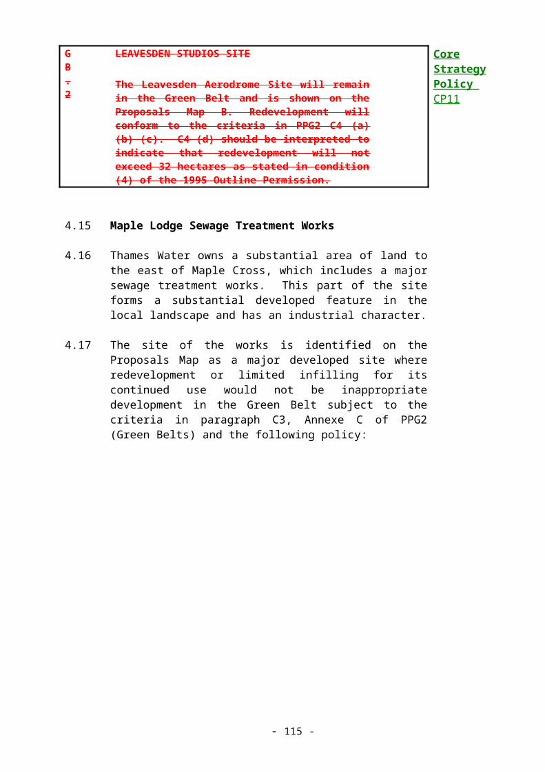
(27) Lytham Avenue site, South Oxhey: This site is not in the Green Belt, and is included in the current HIPs programme for development for affordable housing. To minimise the impact of development on mature trees, the public footpaths bounding the site, and the visual intrusion on the adjacent areas of Green Belt in Harrow, development will be kept away from the southern and western edges of the site. The southern margins of the site should be planted up as woodland, with the maximum possible wildlife habitat area left around the mature trees (which will be protected by a Tree Preservation Order).
(28) Swillett Reservoir, Chorleywood: This site is likely to become surplus to requirements of present owners and is viewed as a long-term source of housing land.
(30) IMC works, Harvey Road, Croxley Green: The industrial use originated in the 1940s, pre-dating the current Green Belt designation. If, in the long term, the existing use ceased and the site became available for development, employment uses would be discouraged in favour of medium-density housing because the only means of access to the site is through the adjacent residential streets. A planning brief was prepared for this site in 1987, which the Council will review and update following full public consultation, as soon as possible.
(32) Talbot Road Car Parks - Rickmansworth: As part of the long term review of town centre car parking provision, it may be possible to relocate the long-stay parking area in Talbot Road and provide a small amount of housing in its place.
(33) Bridge Motors, 42-44 Church Street, Rickmansworth: This site consists of a small petrol station, car showroom, workshop and adjacent house used as an office. If, in the long term, the site became available for redevelopment, the Council will encourage the demolition of all the existing structures and redevelopment for flats.
(35) 10 High Street (showroom site), Rickmansworth: This site is included in the list of long-term sites on the basis that development of this site for housing and/or retail use would be encouraged, should the existing showroom and office uses cease.
(36) Gas works, Wharf Lane, Rickmansworth: If, in the long term, the existing utilities works become surplus to requirements, the Council will encourage the development of this site for housing.

6.20 Phasing of Housing Land Supply
6.21 PPG3 (Housing) and PPG12 (Development Plans and Regional Planning Guidance) both acknowledge that in areas where the housing land supply is in conformity with the County Structure Plan and there is strong pressure for further development, some means of phasing the housing land supply may be necessary.
6.22 The amount of housing land becoming available for development varies widely year to year, as a result of changing economic fortunes and the kinds of site being developed. The annual completions rate from the beginning of the Structure Plan period onwards is shown in Table 4:
Table 4 - Housing Completions, 1991 - 1998:
YearNet
completions:1991/92 891992/93 1591993/94 3471994/95 2551995/96 4271996/97 4311997/98 307Total: 2,015
6.23 In 1990/91, only 28 dwellings were built. Since then, completion rates have climbed steadily, mainly because several very large sites have become available during recent years. However, sites such as the Leavesden/Abbots Langley Hospitals are now largely complete, and although house construction rates are expected to remain high for the early part of the Local Plan period until these sites are finished, this trend cannot continue. The County Structure Plan allocations were discussed in detail at the Examination In Public in March 1997. The Structure Plan Panel then concluded that in South West Hertfordshire there is a need for considerable constraints on new house building. This is because of the vulnerability of the Green Belt in this area of the County, the intensity of existing urbanisation, and the difficulty of achieving a proper balance between employment and housing.
6.24 Clearly, Three Rivers District is under great pressure for housing development. If the current rates of housing completions were to continue, on identified and windfall sites, the Structure Plan allocation of 4,000 dwellings could be reached as early as 2005. At that point, either the Council would have to place severe restraint on further residential development, or accept that the number of dwellings built will exceed the planned provision by a large margin. Therefore, in the interests of a steady and sustainable level of development activity, and to avoid rapid growth in housing and employment needs at the expense of the environment, a measure of phased release of land for new housing is desirable. The recommended form of control in PPG12 (Development Plans and Regional Planning Guidance) is through the phased release of main areas or identified sites. This method cannot be applied in this District because most of the main sites identified in Table 3(a) already have planning permission. Phasing the few remaining sites will have no marked effect. Instead, Policy H.3 is intended to safeguard the long term housing sites until the latter part of the Local Plan period, and to regulate the supply of unidentified sites. Control over “windfall” sites is necessary, and justifiable because the Council has been rigorous in identifying housing sites which constitute an adequate supply of land, and more importantly, will result in a sustainable pattern of development.
6.25 In addition to the terms of Policy H.3, an additional measure of control is expected to be provided by Policies 8 and 9 of the Structure Plan Review which identify suitable locations for strategic housing and land allocations elsewhere in Hertfordshire. Because the District is already congested and contains very sensitive Green Belt areas, the general principles for guiding the strategic land allocations effectively preclude Three Rivers District from accommodating more than 4000 new dwellings during the years 1991 to 2011. It is the view of this Council that when the housing provision required of this area has been met, further major development should be considered on a County-wide basis and directed to the areas of strategic allocation already identified in the County Structure Plan.

H.3
CONTROL OVER HOUSING LAND SUPPLY AND IDENTIFICATION OF ADDITIONAL HOUSING SITES:
(1) In order to make provision for as close as possible to 4,000 dwellings during the period 1991-2011 and to ensure that the supply of housing land is not exhausted well before 2011, restraint will be applied as follows:
(i) The long-term sites as identified in Table 3c will not be released for development before April 2006 unless they are needed to maintain an adequate five year supply of housing land. The Council will monitor the availability of housing land and if a deficiency is apparent (measured against the five year supply requirement) will bring forward sufficient long term sites to maintain the supply.
(ii) Proposals for residential development on sites of 0.6 hectares or 25 dwellings or more not identified in Table 3a, 3b or 3c, will only be permitted if the development is needed to ensure a five year supply of housing land, or consists entirely of housing to meet affordable housing needs as set out in Policy H.6.
(iii) Proposals for residential development on small sites not identified in Table 3a, 3b or 3c will only be permitted provided the development would not result in a significant over supply of housing as measured by the annual Housing Land and Needs Statement or consists entirely of housing to meet affordable housing needs as set out in policies H.6 and H.7.
(2) Large sites which are split into parts or phases of less than 0.6 hectares or 25 dwellings will be assessed under 1(ii) above.
(3) A significant over supply will be judged having regard to development activity and dwelling completion rates and will be taken to be anything over a six year supply based on the Structure Plan housing requirement.
(4) In addition to the sites already identified in Tables 3a, 3b or 3c, the Council will encourage the identification of other suitable opportunities for housing provision through planned

regeneration within the existing built-up areas of the settlements listed in policy GEN.1, in accordance with Structure Plan policy 6. The housing potential of such identified sites (which it would be premature to release for development in terms of housing land supply, but which are otherwise acceptable in principle) will be monitored and taken into account in planning for housing provision beyond 2011.
(5) Re-assessment of the housing land supply will be contingent on new housing provision figures that will be set out in the approved review of the Hertfordshire County Structure Plan for the period to 2016.

6.26 Location and Mix of Development
6.27 PPG13 (Transport) makes it clear that local authorities should aim to reduce the need to travel by locating associated uses close to one another, and to reduce reliance on the private car by guiding development to locations which are highly accessible by passenger transport, walking and cycling.
6.28 Policy GEN.1 of this Plan establishes the urban areas as being the main areas for built development. Within those areas, Policy GEN.2 requires major development to be located close to town centres, local centres, transport nodes and corridors.
6.29 Housing sites which lie close to good passenger transport and local services will be only a part of the total available housing land supply. Therefore, when these sites come forward for development, the Council will expect the form of housing to make the most efficient use of the available land in terms of layout, built form and density. Figure 2 shows district centres and access to passenger transport.
6.30 Overall, a varied mix of dwelling types and sizes is often desirable, both on individual sites and across neighbourhoods as a whole. This approach has a number of benefits. It creates a more varied and visually interesting urban environment, it fosters a more varied and integrated society, benefits security and it increases the flexibility of the housing stock for different and changing households at a local level.
6.31 Data on dwelling size requirements is developed from several census and survey sources. This information is continually subject to change and will be contained in the annual Housing Land and Needs Statement as supplementary planning guidance.
H.4
DWELLING MIX AND DENSITY:
(1) Within those parts of the main urban areas where there is good access to passenger transport or community facilities and services, applications for residential development will be expected to be at the highest density compatible with maintaining any natural or historic features of the site, providing a range of dwelling sizes, and avoiding any significant adverse impact on the amenities of the surrounding area.
(2) Outside of these areas, or on particularly large urban sites, residential developments should
Core Strategy Policies CP3CP12

contain a range of, dwelling types and sizes except where site, design or other relevant constraints dictate otherwise.

6.32 Affordable and Special Needs Housing
6.34 PPG3 (Housing) states that a community’s need for affordable housing is a material planning consideration which the local planning authority may reasonably take into account when negotiating with developers. The Government has issued circulars advising on the circumstances where the planning system can be used to ensure that a proportion of affordable housing is provided in housing developments.
6.35 Terms tend to be used interchangeably when referring to housing for those whose access to the market is limited. For the purposes of this District, the term “Affordable Housing” is used universally, and will be interpreted as meaning: “Any housing, for sale or rent or other form of tenure, which is intended to be available to those households which are not able to afford the equivalent property on the open market”. This definition includes subsidised housing on private developments, and housing association or local authority developments.
6.36 Circular 06/98 (Planning and Affordable Housing) includes within its definition of affordable housing, “low-cost market housing”. However, in this District it is clear that the need is for affordable housing at below even “low cost” market prices because these prices would still be too high to be affordable. A discount off the market price would still not bring the cost within reach of many people in housing need. On sites that meet the criteria set out in policy H.6, and where the County Council Social Services has identified a local requirement for special needs housing for the disabled or people with learning difficulties, some or all of the proportion of affordable housing to be provided may also need to be designed for residents with special needs.
6.37 In accordance with the advice in Circular 06/98, policy H.5 defines what the Council considers to be “affordable” in financial terms, without referring to a particular price or rent.
H.5
DEFINITION OF FINANCIALLY AFFORDABLE LEVELS
For the purposes of Local Plan affordable housing policy, “affordable” means housing available at or below the rent-capped level for this District as identified by the Housing Corporation for the annual Housing Investment Programme bidding rounds (or equivalent mortgage).

6.38 The Council carried out the first assessment of housing need in the District in 1993. This was repeated in 1999. Both surveys showed a considerable need for affordable housing, and future reassessments are likely to indicate continuing need. The results of the surveys will be contained in Housing Needs Statements published annually. It is clear that there is a high level of need which cannot be addressed only by Council and Housing Association schemes. It is therefore proposed that the affordable housing element on suitable sites should be about 30%, in accordance with the findings of the 1999 Housing Needs Survey and similar thresholds set by several of Three Rivers’ neighbouring local authorities. This may vary depending on site conditions. Provision at Leavesden Studios site is already set at 25% in accordance with the outline planning permission granted jointly by this Council and Watford Council.
H.6
DWELLING MIX AND DENSITY:
(1) On sites which are acceptable for housing in accordance with other policies of this plan and which are capable of accommodating 25 dwellings or more, or are sites of 1 hectare or more (or part thereof), the Council will seek, by negotiation with developers, the provision of an element of affordable or special needs housing of a type in accordance with the Council’s latest Housing Needs Statement or the advice of the Social Services department of the County Council.
(2) Affordable or special needs housing should remain indefinitely available for those in housing need. The Council will require developers to enter into a planning obligation to ensure that a registered social landlord is made responsible for the ongoing management or marketing of the dwellings.
(3) Affordable or special needs housing so provided will be restricted to the following groups:
(i) A household registered with the Council’s Housing and Environment Department or a Housing Association as being homeless, on the Housing Register or the Transfer List, or with Herts County Council Social Services as having special housing needs;
(ii) A household not able or willing to register as above, but whose need can be determined by the criteria set out in the annual Housing Land and Needs Statement.
(4) The operation and outputs of the Local Plan’s
Core Strategy Policies PSP1PSP2PSP3PSP4CP1CP3CP4

affordable housing policies will be monitored and fed back into reviews of provision.

6.39 Rural Affordable Housing
6.40 Within the Green Belt, planning permission for new houses will normally be refused. However, many people live in the villages of Sarratt and Bedmond and new households will form within those communities. Housing in the rural areas of the District is relatively expensive and there is a problem of ensuring that new, often young households with modest incomes, are not excluded from their own communities by the high cost of local housing. Other needs can arise from people retiring from “tied” accommodation. Therefore, the Council has set out an exceptions policy, which defines strict criteria under which new housing may be permitted within these two Green Belt villages. Such schemes should be promoted by the District or Parish Council, a Housing Association, Village Trust or similar organisation.
6.41 Annex A of PPG3 (Housing) sets out the context for considering affordable housing for local needs in rural areas. The main points arising from the advice are:
(a) Rural affordable housing sites will only be released as exceptions to the normal housing policies which make provision for general housing demand;
(b) Any housing provision which arises in this way will be regarded as additional to the supply for general housing demand as set out in tables 2, 3(a) and 3(b), and will only count towards the Structure Plan figure on completion of the site and roll-forward of the development plan. This is because these sites would not normally be released for general housing development, and it is not practical to forecast in advance the contribution such exceptional sites will make.
(c) For the same reason, the Local Plan should not seek to identify in advance sites that may be released for affordable housing for local needs. It is for developers and land owners to come forward with proposals which are fully justified.
H.7
RURAL AFFORDABLE HOUSING:
(1) Within the core areas of the villages of Sarratt and Bedmond as defined on the Proposals Map, small scale schemes for residential development promoted by the District Council, Parish Council, Housing Trusts or other similar organisations may be permitted as exceptions to the normal provisions of Green Belt policy provided that the following criteria are met:
(i) The housing is necessary to meet an
Core Strategy Policies PSP4CP4

identified local need, based on a survey at village or parish level, which cannot be provided for in any other way.
(ii) The housing development is compatible with the character of the village.
(iii) Arrangements are made to ensure that the dwellings are retained indefinitely for local housing needs.
(2) Applications for affordable housing development on sites outside the core areas of Sarratt and Bedmond as defined on the Proposals Map will only be permitted if the proposals are fully justified in terms of part (1) of this policy, and where the applicant has convincingly demonstrated that there is no site available or more suitable firstly within, and secondly adjacent to, the core area of the village.
(3) The operation and outputs of the Local Plan’s affordable housing policies will be monitored and fed back into reviews of provision.

6.42 Specialist Residential Accommodation
6.43 As the population ages, there is an increasing demand for specialist housing for elderly and disabled people. Such housing may take a variety of forms, and are referred to in the context of this Local Plan as follows:
Category 1: Self-contained dwellings for active elderly people (may be subject to occasional visits by care workers).
Category 2: Grouped units (usually flats) for less active elderly, with a warden unit for every thirty flats.
Category 3: Accommodation for the dependant elderly and disabled with full time residential care.
6.44 Categories 1 and 2 are normally referred to as sheltered accommodation by the Social Services Department. Category 3 is referred to as a residential care home. The three categories correspond with the parts 1, 2 and 3 type accommodation referred to by the National Assistance Act 1948, though these terms are no longer in general use. Nursing homes form a fourth type of housing, which provide short, medium or long term nursing care for any age group.
6.45 All of these uses are essentially residential in character and therefore should be located within residential areas. As most occupants will be elderly or infirm they should also be located within easy walking distance of local services and public transport within a level and safe pedestrian environment. The parking and other amenity standards associated with specialist residential accommodation may vary considerably, depending on the mobility and independence of the residents.
H.8
SPECIALIST RESIDENTIAL ACCOMMODATION:
(1) Applications for specialist residential accommodation should:
(i) Be located within residential areas, preferably within easy walking distance of local services and public transport facilities.
(ii) Have adequate parking provision in accordance with the Council’s standards set out in Appendix 3.
(2) Planning permission will normally be subject to a condition restricting the type of occupancy, and the Council may also require developers to enter into a planning obligation to control the level of parking (see Appendix 3).
Core Strategy Policy CP3


6.46 The Joseph Rowntree Foundation has published ‘Foundations – Building Lifetime Homes’ which describes sixteen design standards necessary to ensure that a new home will be flexible, adaptable and accessible. ‘Lifetime Homes’ are not full wheelchair or mobility standard housing, but designed to accommodate the majority of adaptations with maximum ease. ‘Lifetime Homes’ can meet the varying needs of occupiers in the same house over many years, and can be as useful to families with young children as to the elderly with limited mobility. Three Rivers District Council supports the concept of ‘Lifetime Homes’ and will encourage developers to adopt the design standards in a proportion of all new housing.
6.47 Home Working
6.48 Developments in modern communications and computer systems allow many previously office-based employees to work at home for at least some of the time. In principle, the Council supports home working as a measure to reduce the number of car trips. In practice, the impact of business activity within residential areas must be carefully controlled.
H.9
HOME WORKING:
The Council will encourage home working as a factor in reducing the need to travel, subject to the space within and use of the building to conduct business remaining ancillary to the residential use. Applications for business uses within dwellings or residential areas will be refused where residential amenity would be adversely affected.
Core Strategy Policies CP1CP6

6.49 Loss or Conversion of Dwellings
6.50 In view of the considerable need for new housing, the Council is concerned to ensure that existing dwellings are not lost through development (including conversion to other uses). Also, when conversions occur in predominantly residential areas, conflicts can arise between the new use and residential amenity.
H.10
LOSS OR CONVERSION OF DWELLINGS:
Developments resulting in net loss of dwellings will be resisted and conversion of dwellings to other uses will only be permitted where necessary to provide a small-scale facility (such as a surgery or corner shop) and provided the surrounding residential area is not significantly adversely affected.
6.51 Conversion of Space above Shops
6.52 Many of the shops in the District have unused spaces on their upper floors. In some cases, the conversion of space over retail units to a single flat may be permitted development. In cases where planning permission is required, in order to bring these spaces back into useful residential use, the Council will sympathetically consider proposals for conversion:
H.11
CONVERSION OF SPACE ABOVE SHOPS:
The Council will support applications to bring space above shops into residential use provided that access to the upper floors can be satisfactorily achieved.
6.53 Conversion of Offices to Residential Use
6.54 Within Rickmansworth and most of the other local centres of the District, there is a considerable amount of unoccupied office space:
H.12
CONVERSION OF OFFICE SPACE TO RESIDENTIAL USE:
The Council will support applications to convert office space to residential use provided that the criteria regarding the location of residential developments in Policy H.4 are met.
6.55 Subdivision of Dwellings

6.56 One way of providing for the increasing need for smaller dwellings is to subdivide existing larger properties, to form maisonettes or flats. Subject to the criteria in Policy H.13, applications of this kind can be a satisfactory way of raising densities in low density areas close to transport nodes and local services. However, this does not imply that the Council accepts the multiple occupation of houses. Any new dwelling units formed as a result of this policy must be self-contained and comply with approved environmental health standards.
H.13
SUBDIVISION OF DWELLINGS:
Subject to other policies in this Plan, proposals for the conversion of single dwellings into two or more units will be encouraged where:
(i) The building is suitable for conversion by reason of its size, shape and number of rooms. Normally, only dwellings with three or more bedrooms will be considered suitable for conversion.
(ii) The dwellings created are completely self-contained, with separate front doors either giving direct access to the dwelling, or a secure communal lobby or stairwell which itself has a secure entrance.
(iii) Adequate car parking, services and amenity space can be provided for each new unit in compliance with the Council’s standards.
(iv) The character of the area and the residential amenity of immediate neighbours is protected.
(v) Where conversion of semi-detached dwellings is proposed, this should take place in pairs in order that privacy and the amenities of the occupants of the adjoining dwelling are maintained.

6.57 Tandem and Backland Development
6.58 Many areas of the District consist of relatively low density housing with very large (or long) rear gardens. These areas still experience pressure for development on garden land and for infill development, which if not carefully controlled can erode the character of the area and the residential amenity of both existing and new occupants. In particular, proposals which result in tandem development (two or more houses directly behind one another on the same plot and sharing an access) or backland development hemmed in by houses and accessible only by a long drive, are not acceptable. For the purpose of the following policy, infill development means the filling of a small gap which having regard to the width of neighbouring residential curtilages and the general character of the site and surrounding area, is capable of accommodating a single dwelling, pair of dwellings, or short terrace of dwellings in an otherwise built-up frontage. Backland development often involves the assembly and collective development of parts of adjacent long rear garden. Whatever the precise makeup of the site, it can take a very long time for a developer to assemble a coherent site from a multitude of ownerships, introducing uncertainty about the future of an area among local residents, and problems for the Council when trying to assess the supply of housing land which is available in a particular period.
H.14
INFILLING AND DEVELOPMENT ON GARDEN LAND:
(1) The Council will seek to protect the character and residential amenity of existing areas of housing with long or extensive gardens from forms of “backland” or infill development which the Council considers to be inappropriate for the area. Proposals for new residential or other development on the garden land of existing houses and flats will not be permitted where the proposal involves:
(i) Tandem development or,
(ii) Servicing by an awkward access drive which cannot easily be used by service vehicles or,
(iv) The generation of excessive levels of traffic or,
(v) Loss of residential amenity or,
(vi) Layouts unable to maintain the particular

character of the area in the vicinity of the application site in terms of plot size, building footprint, plot frontage width, frontage building line, height, gaps between buildings, and streetscape features (e.g. hedges, walls, grass verges).
(2) Proposals for development on sites with trees or other landscape features of amenity or nature conservation value will also be assessed against policies N.1, N.15, N.16 and N.17.
(3) The Council will take into account the individual and cumulative effect of applications for development on the character of the area, and will resist piecemeal development in favour of comprehensive proposals that properly address the criteria above.

6.55 Design Guidelines for Residential Developments
6.56 The Council is concerned that proper attention should be paid to issues of design when new dwellings are built or existing dwellings converted. Applicants are referred to the policies set out in Chapter 5 (Design) and in Appendices 2 (Design Guidelines) and 3(Parking Standards).
6.57 Residential Caravan Parks
6.58 There are three residential caravan parks in the District: Long Pightle Caravan Park, Chandlers Cross; High View Mobile Home Park, Kings Langley; and Newlands Mobile Home Park, Bedmond. They are located in the Green Belt and their expansion or redevelopment for conventional housing is incompatible with Green Belt Policy (GB.1).
H.15
CARAVAN PARKS:
The existing residential caravan parks will be retained. Applications to expand the boundaries of the caravan parks or to redevelop them for conventional housing will be refused as being inappropriate development in the Green Belt.

6.59 Gypsy Sites
6.60 Gypsies form a small percentage of the population, with specialised land use requirements which the Council is obliged to consider. Department of Environment Circular 1/94 “Gypsy Sites and Planning” announced the repeal of the duty on local authorities to provide gypsy sites, but there remains a duty on local authorities to indicate what regard they have had for the needs of gypsies, either by identifying sites or by policies which give clear and realistic criteria for the development of private gypsy sites. Circular 1/94 states that gypsy sites are not regarded as being among those land uses which are normally appropriate in the Green Belt, and that Green Belt land should not be allocated for gypsy sites in the development plan.
H.16
GYPSY SITES:
Proposals for the development of gypsy sites should:
(i) Not be located in the Metropolitan Green Belt.
(ii) Have access to the major road network and to shops, social and health facilities.
(iii) Be fully landscaped and be designed to blend into the local landscape.
(iv) Not have an adverse effect on local residential amenity.
(v) Be free of public rights of way.
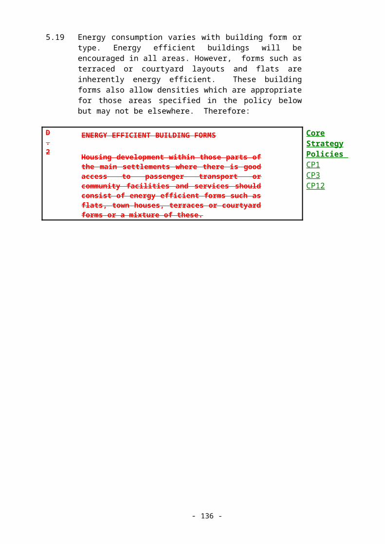
6.61 Residential Moorings
6.62 The Grand Union Canal runs the length of the District and is used by many houseboats and leisure craft. Concentrations of houseboats exist at Batchworth Lock, Rickmansworth and to a lesser extent at Cassiobury, in Croxley Green. Unauthorised long term residential moorings can give rise to problems of sanitation, parking and refuse disposal, leading to a decline in the quality of the canal side environment.
6.63 Despite the problems associated with long term moorings, houseboats do provide low-cost accommodation and are counted for the purposes of housing land supply. The Council will work with British Waterways to find a long term solution to the issues, which may involve the provision of residential moorings in a basin or other suitable location. Such a proposal will require planning permission, and the Council is concerned to ensure that any such facility makes provision strictly in accordance with existing need in the District. Residential moorings are not included as appropriate development in the Green Belt by PPG2 (Green Belts), therefore applications for moorings on any part of the canal outside the urban areas will have to be supported by ‘very special circumstances’
H.17
RESIDENTIAL MOORINGS:
(1) Proposals for new residential moorings (whether in a basin or along the canal) should:
(i) Be located with good access to local services and public transport, and where there is suitable infrastructure for water supply and proper disposal of waste water.
(ii) Be accessible by bicycle wherever possible, and have satisfactory arrangements for parking, access and servicing.
(iii) Not be located in or adjacent to areas of importance for nature conservation unless satisfactory measures to mitigate their effects on the species and habitats affected are included.
(iv) Not result in a net increase in the number of boats using the residential moorings in the District.
(2) The effect of residential moorings on the canal side environment through the erection of temporary structures, loss of trees, rubbish dumping, etc will be carefully monitored and where possible, controlled.
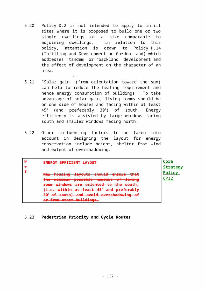

EMPLOYMENT AND ECONOMIC DEVELOPMENT
7.1 Aims
7.2 To assist economic development and regeneration whilst also working to protect and enhance the environment, and to maintain provision of land for employment use.
7.3 Objectives
(a) To achieve a balance between employment and housing levels in the District.
(b) To focus employment in locations which are well served by public transport and which are easily accessible from local housing, by public transport, cycle or walking.
(c) To encourage and enable development which allows for flexible working practices such as teleworking, working from home, and small local business initiatives.
7.4 Introduction
7.5 The Local Plan must allocate sufficient land for employment purposes to allow for a balanced and sustainable economy and full employment.
7.6 Approximately 22,000 people work in the District. There is considerable movement of people across administrative boundaries as people travel to and from work. Overall more people leave the District every day to work elsewhere (mainly in Watford and Greater London) than travel to work in the District.
7.7 During the past ten years there has been a considerable decline in manufacturing employment within this District and indeed throughout South East England. The decline in manufacturing has been offset by growth in the service and retailing sectors.
7.8 Unemployment in the District is below the Hertfordshire average and is currently falling. There are, however, local areas with significant unemployment such as South Oxhey (notably Hayling Ward and Northwick Ward) and Mill End. These areas also have high levels of youth and long-term unemployment. The Council is participating in initiatives to reduce unemployment in these areas.
7.9 The Council's Economic Development Strategy
7.10 The Council prepares an annual Economic Development Strategy in order:-
(a) to co-ordinate all economic development initiatives in the District; and

(b) to make sure that development takes place within the framework of the Council's planning policies.
7.11 Hertfordshire Structure Plan 1996-2011 - Employment Strategy
7.12 The County Structure Plan stresses that a healthy economy is an essential element of the strategy for sustainability. The Structure Plan examines likely employment trends to the year 2011 and concludes that there is sufficient land in employment use in Hertfordshire to allow both for full employment and for economic growth. Therefore there is no quantitative need for further land allocations for employment purposes. Hence, no additional land has been allocated for employment use in this District and proposals for the development of new employment sites would only be allowed exceptionally (for example, to rectify a qualitative deficiency in provision). Policy 14 of the Structure Plan and policy E.1 below set out the basis on which proposals for new employment development will be considered.
7.13 Employment Land
7.14 The Demand for Employment Sites
7.15 In Three Rivers District several well-located employment sites have been developed or redeveloped with modern industrial or business premises. It is important that these are retained for employment purposes in order to provide local job opportunities. Other employment sites have potential for redevelopment for industrial or business uses and should be retained for such. There are, however, sites formerly in employment use which could now be beneficially re-used for housing purposes without undermining the local economy and these are identified in Chapter 6 (Housing).
7.16 The Location of Employment
7.17 It is important that employment is located so that there is easy access from residential areas, reduced dependence on the car, and opportunities to travel to work by alternative forms of travel such as rail, bus, cycle and on foot. New development must respect the local environment taking into account traffic levels, the need to provide car parking spaces, noise levels, the appearance of buildings and the effect on neighbours. This applies particularly to proposals for employment within or adjacent to established residential areas.
E.1
NEW DEVELOPMENT FOR EMPLOYMENT
Proposals for the renewal or redevelopment of existing employment uses, and proposals for employment development in new locations will be assessed against Structure Plan policy 14 and the following criteria:
Core Strategy Policies PSP1PSP2PSP3PSP4CP1CP6

(i) The need for employment to be in locations which are close to public transport facilities and are easily reached from local housing by public transport, bicycle or on foot.
(ii) The need to avoid high levels of traffic and congestion and meet relevant standards for access.
(iii) The need to protect the environment of existing urban centres, Conservation Areas, residential areas and the natural and manmade landscape.
(iv) Opportunities for improving the local environment.

7.18 Leavesden Studios Site
7.19 The former Leavesden Airfield and Rolls Royce factory site is one of the most important employment and mixed development sites in the County. It is a very important site in the economy of this part of Hertfordshire. 90% of the site is within Three Rivers District and 10% is in Watford Borough. The Council has co-operated closely with the County Council and with Watford Borough in formulating proposals for the redevelopment of this site. A Planning Brief was approved in 1993 and in 1995 outline planning approval was given for comprehensive redevelopment with film studios, housing (including social housing) and substantial leisure facilities.
7.20 Policy GB.2 sets down the framework within which any development should take place on the Leavesden Studios site.
7.21 South Oxhey/Carpenders Park
7.22 Unemployment in South Oxhey is well above the County average. In 1996 a grant was awarded under the Government’s Single Regeneration Budget Challenge Fund. Part of this award will be used to provide training opportunities for unemployed people. Local job opportunities are required as South Oxhey does not have good access to employment centres. There is scope to redevelop land immediately to the east of Carpenders Park station, to include small employment units. This land is identified on the Proposals Map.
7.23 Industrial Land - Current Situation
7.24 Further development on employment sites already designated will take the form of infill of small vacant areas and the replacement of older industrial buildings by economically planned modern structures. Re-use of employment sites for other uses, including housing, will need to be considered as part of planned regeneration in accordance with Structure Plan policy 14.
E.3
SAFEGUARDING OF EMPLOYMENT AREAS
The employment areas identified on the Proposals Map will be safeguarded for business, industrial and storage or distribution development subject to compliance with Policy E.1 and Structure Plan policy 14.

7.25 Small Business
7.26 Small businesses play an important role in the local economy. They provide a diverse range of employment opportunities and potential for future growth.
E.4
SMALL BUSINESS UNITS
Proposals for small industrial and business units and for the conversion of buildings to small businesses will be considered sympathetically provided that proposals are environmentally acceptable and do not cause traffic or parking problems. The form, bulk and general design of new buildings should be in keeping with their surroundings.
Core Strategy Policies CP6CP10CP12

7.27 Storage and Distribution
7.28 Storage and distribution (Use Class B8) are normally acceptable in principle in employment areas. However, storage and distribution uses generally provide a lower number of jobs for a given area than other employment uses. Therefore whilst expansion of existing firms may be acceptable, further provision is not encouraged in employment areas located away from trunk routes and which can better serve higher employment generating uses. In addition such uses often cause vehicular congestion and a loss of environmental amenity. It is therefore essential that such uses have good access to the trunk road network.
7.29 Northwood - Headquarters (HMS Warrior)
7.30 The military establishment at Northwood comprises a mixture of land uses. Development proposals within the site are subject to the consultation process set out in DOE Circular 18/84 (Crown Land and Crown Development). Local planning authorities are requested to treat the Notice of Proposed Development in the same way as they would a statutory planning application. In terms of the Circular the District Council may comment on development proposals but is not empowered to refuse or grant planning permission. The Council is concerned to ensure that local residents are consulted on development proposals for this site.
E.5
NORTHWOOD HEADQUARTERS (HMS WARRIOR)
In considering proposals for this site, the Council will have regard to the following:-
(i) The impact of development on the amenities of the surrounding area.
(ii) The retention and management of mature trees and shrubs and encouragement of new landscaping.
(iii) The provision of adequate on-site car parking.

7.31 Provision of Creche and Day Nursery Facilities
7.32 The Council recognises the importance of adequate provision of childcare facilities for parents who wish to shop or take up employment opportunities. The Council will therefore encourage the provision of creches and day nurseries in suitable locations as follows:
E.6
PROVISION OF CRECHES AND DAY NURSERIES
The Council will permit proposals for creches or day nurseries which serve the staff and customers of the main town and local shopping centres, or ancillary facilities in places of work for employees with children where such proposals comply with appropriate Local Plan policies.

TOWN AND LOCAL SHOPPING CENTRES
8.1 Aims
8.2 To sustain and enhance the vitality and viability of town and local centres.
8.3 Objectives
(a) To regenerate town, village and local centres in partnership with business, property owners and the local community.
(b) To develop an integrated access strategy for centres. This to include comprehensive parking policies.
(c) To secure high environmental standards through town centre management or other means.
(d) To concentrate development of retail, leisure and services in town centres in preference to the provision of out-of-centre facilities.
(e) To maintain an efficient, competitive and innovative retail sector.
8.4 Introduction
8.5 The retail centres in the District are important service centres whose vitality and viability are important for the local economy. The largest shopping centre in the District is Rickmansworth Town Centre which has recently benefited from a regeneration scheme to upgrade the quality of the shopping environment. Similar regeneration schemes are being prepared for Abbots Langley, Chorleywood and South Oxhey. These centres serve their local communities and contain limited parking provision. There are other shopping parades serving local communities.
8.6 Shopping Hierarchy
8.7 The various shopping centres, parades and individual shops in the District perform differing and important roles according to their size and location.

8.8 In the main shopping centres of Rickmansworth, Abbots Langley, Chorleywood, and South Oxhey, Primary and Secondary Shopping Frontages have been identified as set out in Table 5 and Figures 4, 5, 6 and 7. The Primary Frontages are the retail cores of these centres where the Council’s policy is to retain shop units in retail (A1) use. A number of non-retail uses (banks, building societies, restaurants, pubs, doctors surgeries, etc) already exist in the Primary Frontages. The Council considers that to avoid affecting the vitality and viability of the Primary Frontages, any additional uses of this type should be located in the complementary Secondary Frontages.
Table 5 - Shopping Hierarchy
Primary Frontages (cores of main centres) Refer to:
Abbots Langley
High Street except for Nos 12-20, 39-43.
Policy S.1 and Figure 4
Chorleywood Main Parade, New Parade,Lower Road south to Budgens/Post Office.
Policy S.1 and Figure 5
Rickmanswth High Street between Station Road and Church Street.
Policy S.1 and Rickmansworth inset (see Proposals Map A)
South Oxhey St Andrews Parade, Bridlington Road Parades.
Policy S.1 and Figure 6
Secondary Frontages (parts of main centres)Abbots Langley
High Street (Nos 12-20, 39-43 only) Langley Road parade.
Policy S.2 and Figure 4
Chorleywood Lower Road south of Budgens/Post Office.
Policy S.2 and Figure 5
Rickmanswth High Street west of Station Road to the junction with Wensum Way,High Street east of Church Street,Station Road, Church Street.
Policy S.2 and Rickmanswth inset (see Proposals Map A)
South Oxhey The Parade, Prestwick Road,Station Approach.
Policy S.2 and Figure 6
Local Shopping CentresCroxley Watford Road Policy S.3

Green parades east andwest of Croxley Station.
and Figure 7
Rickmanswth Money Hill Parade, Uxbridge Road.
Policy S.3 and Figure 7
Local ShopsApplies to all shops not covered by Policies S.1, S.2 orS.3. Includes all parades, groups of shops or individual shops.
Policy S.4
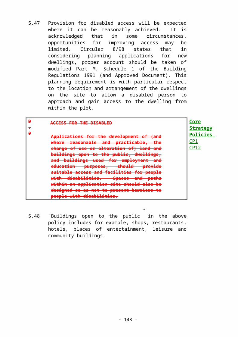
S.1
PRIMARY SHOPPING FRONTAGES
In Primary Shopping Frontages changes of use from retail (Use Class A1) will be resisted. Exceptionally, changes of use may be permitted if:
i. The proposed use will enhance the vitality and viability of the town centre as a whole;
ii. The proposed use will have no significant adverse impact on the amenity enjoyed by nearby residents, and;
iii. It can be demonstrated that no retailers are likely to require the premises within a reasonable period of time.

S.2
SECONDARY SHOPPING FRONTAGES
In Secondary Shopping Frontages the retention of retail (Class A1) uses will be encouraged. Other uses found in a shopping area and those falling within Classes A2 and A3 will normally be permitted. Shop fronts and displays appropriate to the shopping area should be maintained.

S.3
LOCAL SHOPPING CENTRES
In the local shopping centres the retention of retail (Class A1) uses will be encouraged. Other uses found in a shopping parade and those falling within Classes A2 and A3 will normally be permitted provided the function and character of the shopping area is not affected in terms of its vitality and viability. Shop fronts and displays appropriate to the shopping area should be maintained.
S.4
LOCAL SHOPS
For local shopping parades, groups, or individual shops not included in Policies S.1, S.2 or S.3 the retention of retail (Class A1) uses will be encouraged. Other uses normally found in a shopping parade and those falling within Classes A2 and A3 will be permitted providing the Council is satisfied that adequate shopping provision would remain to cater for the daily needs of the local population. Shop fronts and displays appropriate to a shopping area will be maintained.
8.9 New Shopping Development
8.10 The town centres of the District are relatively small, but well established and important to their local communities. An assessment of retail capacity undertaken for the Local Plan suggests that there will be a need for additional convenience retail floorspace in the Rickmansworth area during the Plan period. A maximum of 3000 sq m of floorspace is likely to be required in the Plan period. The Council places great importance on the continued vitality and viability of the existing centres, and several regeneration schemes have been prepared and are in various stages of progress. Therefore:
S.5
RETAIL DEVELOPMENT IN EXISTING SHOPPING AREAS
Retail development in existing shopping centres will be encouraged if it:-
(i) Is located within existing main shopping centres of Rickmansworth (as a “Minor Town Centre”), South Oxhey, Chorleywood or Abbots Langley.
(ii) Is appropriate to the character and function of these centres.
(iii) Protects historic buildings and townscapes.

8.11 The Council recognises the need for a large foodstore which will help to sustain and enhance the town centre. The Rickmansworth Station Car Park site is regarded by the Council as a suitable edge of centre site with the potential for linked trips to the town centre, encouraging competition and access by all modes of transport. The Council has approved a development brief for the Rickmansworth Station Car Park for retail purposes. The Brief has been subject to public consultation and approved by the Planning Committee. The Brief remains a material consideration, but for the avoidance of doubt, this Local Plan takes precedence. Any application for planning permission will need to be accompanied by a detailed Transport Impact Assessment and to satisfy the Council that the proposal does not conflict with the CrossRail project. The Council is keen to ensure the maintenance of the existing amenity value of the wooded embankment, which is subject to a Tree Preservation Order (This will allow appropriate tree management, thinning and removal of lesser quality trees). The Council may consider some modification to the western part of the embankment, if this is necessary in order to achieve a satisfactory public transport interchange. Any application for development on the site will require the submission of a retail impact assessment, to ensure that any impact upon the town centre is acceptable.
8.12 The capacity figures set out in paragraph 8.10 would indicate that a maximum figure of convenience retail floorspace of up to 3,000 sq m could be accommodated during the Plan period.
S.5a
RICKMANSWORTH STATION CAR PARK
Land at Rickmansworth Station Car Park is allocated for convenience retail development as indicated on the Proposals Map. A development brief has been approved for the site which sets down guidelines for development, which are meant to be reflected and required by this policy. Any development of this site must satisfy the following criteria:
(i) Full allowance must be made for the provision of a new station to serve the Metropolitan, Chiltern and proposed Cross Rail lines, and an appropriate area of land safeguarded;
(ii) A high standard of provision shall be made for bus, train, pedestrian and cycling interchange facilities;
(iii) Provision for 300 spaces shall be made for commuter parking;
(iv) Linkage to Rickmansworth town centre and the existing station must be enhanced;
(v) Any proposal must be supported by a transport

impact assessment which ensures that the proposal is acceptable in terms of road network and safety considerations;
(vi) A retail impact assessment will be required which establishes that the effects on the vitality and viability of the town centre will be acceptable;
(vii) Detailed proposals will be required for landscaping along the north-western boundary of the site to provide an effective tree screen from Park Road, including the retention of the majority of trees protected by the Tree Preservation Order.

8.13 PPG6 (Town Centres and Retail Development) sets out the sequential approach where first preference should be given for town centre sites, where suitable sites or buildings suitable for conversion are available, followed by edge-of-centre sites, district and local centres, and only then out-of-centre sites in locations that are accessible by a choice of means of transport. Proposals which would be located in an edge-of-centre or out-of-centre location and are not in accord with the Local Plan strategy will also be required to demonstrate the need for additional facilities. The sequential test will also be applied to developments for leisure and entertainment uses (including restaurants, pubs and cinemas) which can harm the vitality of the ‘evening economy’. The Secondary Shopping Frontage in Rickmansworth High Street has been extended to the junction with Wensum Way to incorporate the Marks & Spencer store and the Western Public House.
S.6
RETAIL DEVELOPMENT OUTSIDE EXISTING SHOPPING CENTRES
(1) Applications for new retail development outside the existing town and local shopping centres will only be considered if the applicant has established that there is a need for the development, and that there is no suitable and viable site likely to become available within a reasonable period of time firstly within, or secondly at the edge of the existing town or local shopping centre which can satisfactorily accommodate the development.
(2) Where (1) above has been established, permission will only be granted for development on an out-of-town site where the applicant can demonstrate that all of the following criteria will be achieved:
(i) the proposal will have no significant adverse impact, when considered cumulatively with other development allowed, on nearby town and local centres, (including the evening economy where out-of-town leisure or entertainment uses are proposed);
(ii) the proposal is accessible by modes other than the car, enabling a high proportion of staff and customers to reach the development by passenger transport, on foot or by bicycle;
Core Strategy Policies CP6CP10CP12

(iii) the proposal will not cause a significant overall increase in journeys by car, or create significant traffic problems contrary to Policy T.7;
(iv) and the proposal is neither sited in the Green Belt, nor on land allocated for some other purpose in the Local Plan.
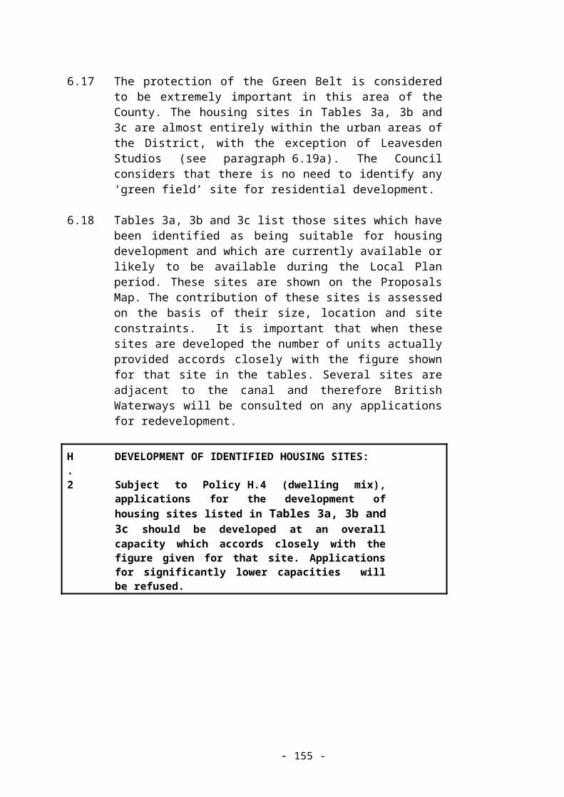
8.12 Conditions on Restaurants, Takeaways and Other Similar Uses
8.13 The amenity of local residents can be adversely affected when cafes, restaurants, hot food takeaways etc. remain open late into the night and on Sundays and Bank Holidays. Therefore the Council will impose planning conditions restricting opening hours in appropriate cases and particularly outside the shopping areas listed in Table 5.
8.14 Abbots Langley, Chorleywood and South Oxhey Regeneration Schemes
8.15 Regeneration schemes to ensure the vitality and viability of the centres of these three settlements will be implemented during the Plan period, subject to funding being available from the Council and its public and private sector partners. The main purposes of these schemes are to:
(a) Enhance the character and status of the centres;
(b) Improve road safety and slow down traffic;
(c) Consider the parking needs of all centre users;
(d) Improve footways, making them safer, and;
(e) Improve facilities for passenger transport and cyclists.
Schemes may also be considered for other local centres in the District during the Plan period.
8.16 Rickmansworth Regeneration and Town Centre Enhancement
8.17 A Town Centre Management Group has been established in Rickmansworth and an Action Plan has been prepared, in accordance with procedures recommended in PPG6 (Retail Development and Town Centres). The aim of the Action Plan is to ensure that Rickmansworth remains a vibrant shopping centre. The town centre should be accessible to all, well signposted, safe, clean, attractive, vibrant and colourful. It should also be well served by passenger transport and have sufficient car parks. The Action Plan provides the framework for regeneration and the criteria against which development proposals will be considered. It will be reviewed annually.
8.18 Rickmansworth Town Centre - Development Opportunities

8.19 The viability of Rickmansworth town centre can be assisted by business, commercial, leisure and residential opportunities. These will be encouraged where they comply with the policies of this Plan. Any proposal for such uses must have particular regard to Policy C.1 (Development in Conservation Areas). The Council will seek to encourage proposals which facilitate the regeneration of Rickmansworth Town Centre, are sympathetic in scale and character to the Conservation Area and do not give rise to traffic and parking difficulties.
8.20 Major Office Development in Rickmansworth
8.21 One result of the shift from manufacturing employment to the service sector has been the increase in the amount of office space in the District. Redevelopment for offices (classed as either A2 - financial and professional services, or B1(a) - business use) has taken place in all of the employment centres of the District. The Council accepts the reasons for this shift, and the need for new office development. However, some proposals for large-scale office development have given rise to concern, particularly with regard to the physical impact on central Rickmansworth. The town centre is characterised by narrow curved streets and a close-grained pattern of small to medium sized buildings, plot boundaries and mixed uses. Therefore, proposals for further large office developments will be considered in terms of their impact on the character of the town centre through their bulk, height and massing, and traffic generation. Proposals within, or which may affect the character of the Conservation Area will be particularly carefully assessed (see policies C.1 to C.6)
8.22 Conversion and Redevelopment of Business Premises in Rickmansworth
8.23 Several sites formerly used for offices and other business uses in Rickmansworth town centre have come forward for housing development in the last few years. Further changes of use of this kind are anticipated during the Plan period, particularly involving some of the older office buildings and obsolete uses in the town centre. Although some sites may already have planning permission for redevelopment for business use, the Council will encourage alternative proposals for mixed or residential use where such permissions remain unimplemented. The Council welcomes good quality new development which increases the amount and range of residential and business accommodation in the town centre, sustaining local vitality and viability.
S.7
CONVERSION AND REDEVELOPMENT OF BUSINESS PREMISES IN RICKMANSWORTH
1) Within the Rickmansworth town centre inset area

marked on the Proposals Map, the Council will encourage proposals for new mixed, residential or business use, particularly on sites occupied by buildings which detract from the character of the town or where earlier redevelopment proposals remain unimplemented.
2) When considering such proposals, the Council will seek to maintain an overall balance of uses within the town centre, and take into account the effect of the proposals on local vitality and viability, compatibility with the scale and character of the town centre and Conservation Area, and accessibility by foot, bicycle and passenger transport.
8.24 Rickmansworth Town Centre - Penn Place
8.25 Planning permission exists for the redevelopment of Penn Place for offices. This has not yet been implemented and consideration is being given to proposals for alternative design schemes. The Council will welcome a well designed scheme for the redevelopment of this site and will particularly encourage mixed use incorporating residential and retail elements. The comprehensive redevelopment of the Penn Place and Northway car park sites as an integrated town centre scheme would be welcomed. This would accord with Government policies on mixed uses in town centres as set out in PPG6 (Town Centres and Retail Developments).
8.26 Rickmansworth High Street South Side
8.27 This area consists mainly of public and private parking serving the High Street shops and offices, plus several small buildings of various uses. The Council will seek to guide and co-ordinate proposals for small scale, mixed use development compatible with the character of the area and the access via Ebury Road, which is predominantly residential.
8.28 In order to secure the continued success of the pedestrian priority area in the High Street and Station Road in the long term, it is essential that satisfactory service access to both the rear of the existing High Street premises and any development on the site should be retained.
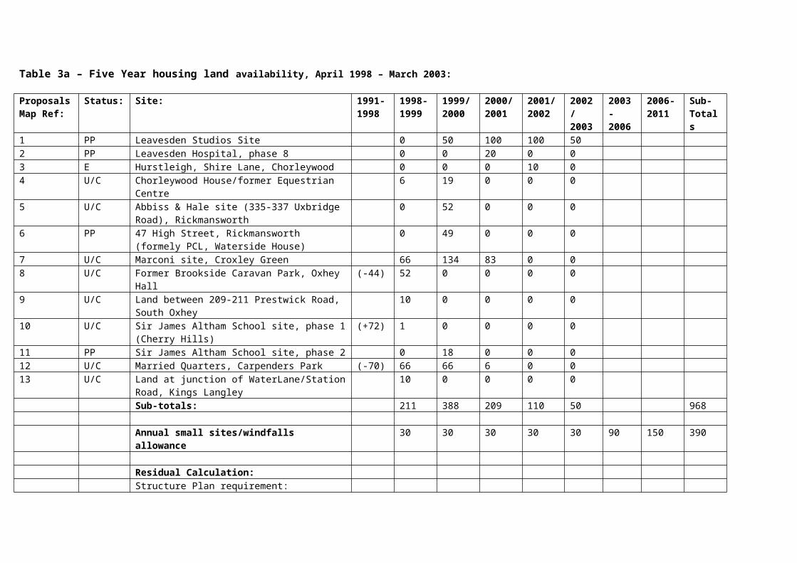
TRANSPORT AND MOVEMENT
9.1 Aims
9.2 To discourage the use of the car and to increase accessibility by alternative modes of transport.
9.3 Objectives
(a) To support new and improved passenger transport initiatives.
(b) To encourage proposals which will allow easy transfer between different modes of transport, such as passenger transport interchanges.
(c) To improve facilities for cyclists, pedestrians, equestrians and the disabled.
(d) To discourage proposals which will lead to increased traffic.
(e) To encourage the transfer of freight to more sustainable transport modes such as rail and water.
9.4 Introduction
9.5 The Council is concerned about the ever-worsening effects of road traffic on the environment and the quality of life of the residents of the District. It is a principal aim of the Local Plan to discourage the use of the private motor car as a method of transport by increasing the effectiveness of the passenger transport system and the cyclist and pedestrian networks.
9.6 Land use patterns have major implications for transport, and every proposal for development will be assessed for its transport implications at an early stage. It is the developer’s responsibility to carry out the initial assessment for major schemes. Such transport impact assessments will be expected to cover not only the expected changes to road traffic volumes and flows, but be a more rounded study which takes account of all modes and makes proposals to minimise the amount of vehicular transport generated by the development. All development proposals, whatever their size, will be assessed by the Council for their transport implications. Issues taken into account include traffic generation, the extent to which journeys could be made by alternatives to the private car, and also road safety.

9.7 The County Council is the Highway Authority for all roads in the District, except motorways and trunk roads which are the responsibility of the Department of Environment, Transport and the Regions and a few private estate roads. The County Council also has a passenger transport role, to encourage the provision and maintenance of a pattern of bus services which meets local travel needs. Further information is contained in the County Council “Passenger Transport Policies” (November 1998). To ensure comprehensive service delivery, the District and County Council work together as the Three Rivers Highways Partnership which is the first point of contact for all highways related matters in the District. The County Council retains overall responsibility, including preparation of the Transport Policies and Programmes (TPP) bid, and for budgetary issues in particular.
9.8 The Council is working closely with Hertfordshire County Council, Watford Borough Council and Hertsmere Borough Council to implement policies contained in the South West Hertfordshire Transportation Study (SWHTS) which was published in November 1995. This is an important policy document that sets out strategies for reducing dependence upon the private motor car as a means of transport and for improving the passenger transport system. Within this District, some of the key proposals are:
(a) A review of parking policy for local residents, shoppers and commuters, particularly around local town centres and railway stations;
(b) Park and Ride services to Watford town centre;
(c) Improvements to passenger transport services – new bus routes, “smart card”systems, etc
(d) Improvements to pedestrian and cyclist facilities;
(e) Completion of the Croxley Rail Link and provision of anAmersham/Chesham to Watford Junction rail service;
(f) Improvements to passenger transport information services, (including new technology) on buses, and at bus stops and railway stations.
9.9 The Council supports these proposals and will work with other authorities and organisations to achieve the aims of the South West Hertfordshire Transportation Strategy. Where a clear and relevant link can be identified between a proposed development and a proposal in the SWHTS, the Council may seek a financial contribution from the developer towards implementation of the SWHTS objectives. Such contributions will be subject to Government guidance about the use of planning obligations.
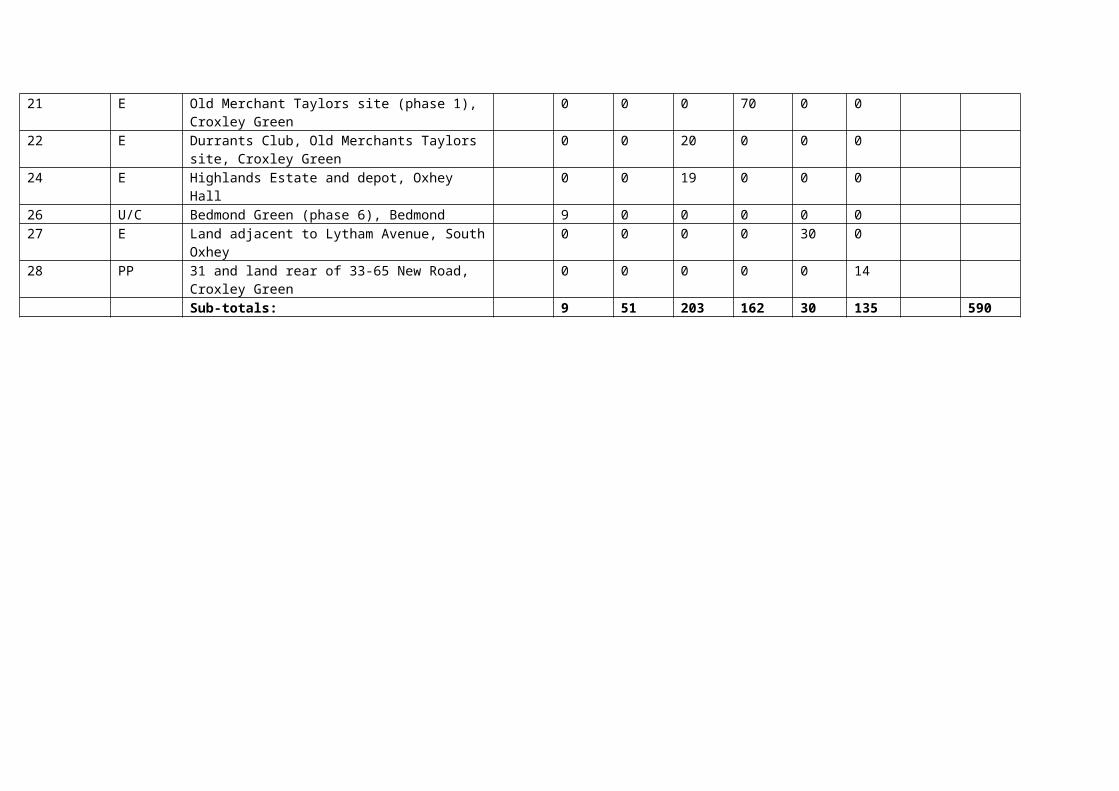
9.10 Hertfordshire County Council is developing “Travelwise” initiatives designed to encourage the greater use of environmentally friendly modes of travel and discourage the use of cars. The Council supports their initiatives.
9.11 Passenger Transport
9.12 Most of the main settlements in the District are served by a rail system which provides good connections to central London. In addition, recent investment in bus services has increased the frequency and geographical coverage such that it is easier to reach the town centres and railway stations in and around the District. However, some areas still do not have good access to passenger transport and despite the network of local railway stations, there is no direct rail service between Rickmansworth and Watford. Railtrack is carrying out a modernisation of the West Coast Mainline.
9.13 The Council is concerned that passenger transport services should be widely available and easy to use. Major new development should either be located with easy access to existing services, or where this is not feasible, include proposals to improve accessibility. Major development is defined in policy GEN.2.
9.14 As one means of implementing the Council’s aims for reducing reliance on the private car, major employment generating developments will be expected to draw up and operate a “Green Commuter Plan” - a package of measures to encourage employees to use alternative modes of transport to the car, for journeys to and from work. Advice on commuter plans is available from the County Council as part of the “Business Travelwise” initiative.
T.1
TRANSPORTATION INTERCHANGES
The Council will encourage the development of transport interchanges at or close to the railway stations where it is operationally and technically acceptable and viable. In particular, the Council supports improved access to the stations for buses, cyclists and pedestrians, will encourage the closer integration of bus and rail services, and supports other improvements to services and facilities which encourages more frequent use.
Core Strategy Policy CP10

T.2
PASSENGER TRANSPORT AND NEW DEVELOPMENT
(1) Major developments which occur outside zones A or B defined by Policy GEN.2 will be expected to demonstrate what measures are being undertaken to minimise the use of cars by occupants and employees. In cases where the development proposals would lead to increased traffic flows and congestion, or where it is desirable to increase the relative attractiveness of passenger transport over the private car for trips to/from the development, the Council may seek to enter into a planning obligation with the developer to provide improved passenger transport facilities and/or services at a level appropriate to the development.
(2) All major employment generating developments will be expected to submit and operate a “Green Commuter Plan” to reduce the number of motor vehicle trips generated. The Council may seek to enter into a planning obligation, or may impose conditions on a planning permission, to ensure long term benefits are maintained.
Core Strategy Policy CP10

9.15 CrossRail and Croxley Link Rail Improvements
9.16 The Council welcomes the proposed CrossRail scheme with improvements to stations at Moor Park, Rickmansworth and Chorleywood. The Council will liaise closely with the rail authorities on the redesign of this station to ensure that it includes a full transport interchange and facilities to permit the later provision of a direct rail service between Rickmansworth and Watford.
9.17 The proposed Croxley Rail Link, which will join the Metropolitan and North London Railway lines at Croxley by means of a viaduct, is also supported. The construction of the Croxley Rail Link will permit the later provision of a direct rail link between Rickmansworth and Watford stations. The Council’s support is specifically for the route selected by the rail authorities, known as the northern alignment, as detailed in rail authority documents and shown upon the Proposals Map.
9.18 The Council will assess the environmental implications of both the CrossRail and Croxley Rail Link schemes and is concerned to ensure that they do not have adverse effects upon nearby residents.
T.3
CROXLEY LINK AND CROSSRAIL
(1) The Council supports the CrossRail scheme with improvements to stations at Moor Park, Rickmansworth and Chorleywood.
(2) The Council supports the northern alignment of the Croxley Rail Link as shown on the Proposals Map.
(3) The Council will lobby for the early implementation of both these proposals.
Core Strategy Policy CP10

9.19 Road Transport
9.20 There is now acknowledgement that new road construction does not solve problems of traffic congestion in the medium to long term. The Council will not support the construction of any major new roads, and therefore supports the decision of the County Council to abandon the construction of the West Watford Relief Road within this District. This proposal would have led to increased road congestion in Rickmansworth, Croxley Green and Oxhey Hall and eroded the sensitive environment of part of the Green Belt in the Colne Valley. The Council is in favour of well planned schemes for traffic management and calming. In order to encourage modal shift, road improvement schemes should give greater priority and safety to pedestrians, cyclists, bus users and horse riders.
T.4
NEW ROAD SCHEMES
(1) The Council will not support any major new road schemes which are designed to increase capacity or reduce journey times, or are likely to have a significant adverse impact on the environment of the District.
(2) Works intended to reduce accidents on existing roads are welcomed provided that a net increase in traffic levels is not likely to result, and the scheme is designed in a way compatible with the character of the surrounding area.
(3) The design of all new road schemes should provide for the needs of buses, pedestrians, cyclists, equestrians and the disabled including priority rights over private cars where feasible.

9.21 The use of rail and water to transport freight is less environmentally disruptive than the use of roads. Subject to the other aims and policies of this Plan the Council will support the use of rail and water for freight transport. Companies will be encouraged to apply for grants under sections 139 and 140, respectively, of the Railways Act 1993. Existing rail yards are an important resource for any future transfer of freight to the railways and any development adjoining such sites should not prejudice the implementation of this aim.
T.5
TRANSFER OF ROAD FREIGHT TO RAIL AND WATER
The Council will encourage existing or proposed industrial and business uses to take full advantage of opportunities for the transfer of freight from road to the railways or the canal, subject to the terms of Structure Plan policy 30 and the following considerations:
(i) The protection of the character of the landscape, Green Belt, and wildlife habitats of the District.
(ii) The protection of the amenity of residents near or adjacent to railways used for freight.
(iii) The residential or recreational amenity and safety of other canal users.
(iv) The proposal should not require major highway infrastructure development or improvements, or give rise to a significant increase in local road freight traffic levels, particularly on local roads off the strategic highway network.
(v) Proposals should be accompanied by an Environmental Impact Statement where appropriate (as defined by GEN.7). This should include an assessment of the suitability of alternative sites and the availability of water for lock use on the canal, and a full Transport Impact Assessment where appropriate.
Core Strategy Policy CP10

9.22 The Government has withdrawn proposals to widen the M25 motorway between junctions 16 to 19 (M40 to Watford). Traffic on the motorway has increased at a rate substantially greater than was anticipated when it was constructed, and is forecast to increase further. The environmental problems caused by the motorway are already considerable and appear to be getting worse. Many people living near to the motorway are already badly affected by noise and fumes from the motorway. The Council considers that the situation should not be allowed to deteriorate further and that there is an urgent need for measures to be taken to reduce noise and pollution levels.
T.6
M25 MOTORWAY
(1) The Council is opposed to any proposal to widen the M25 motorway or construct feeder roads.
(2) The Council will press for measures to reduce the environmental impact of the M25, including:
(i) the use of noise-reducing surfacing and sensitively designed and sited acoustic screening;
(ii) the continued monitoring of air and water pollution levels around the motorway, with remedial measures to be taken where necessary;
(iii) improved landscaping adjacent to the motorway including screening tree belts of locally native species.
9.23 New development will often affect the road network surrounding it, and the Council is concerned to ensure that any significant adverse effects from development in terms of traffic flows, safety and access are avoided. In addition to the policies in this Plan relating to the reduction of car use, Policy T.7 states the basis on which development proposals will be assessed in relation to the surrounding road network. (See also policy D.5).
9.24 The design of traffic calming schemes is often not within the control of the planning authority. However, proposals in rural areas, particularly villages, can have a negative impact and should be designed to respect the character of such areas.

T.7
HIGHWAYS AND NEW DEVELOPMENT
(1) Development proposals likely to generate additional traffic, or which involve the creation or improvement of an access on to the public highway will only be permitted where the development will:
(i) not encourage the use of primary routes for local journeys through direct access on to such routes;
(ii) not compromise the safe movement and
free flow of other highway users, particularly pedestrians, cyclists, equestrians and the disabled.
(iii) not lead to the movement of freight or other heavy vehicles through residential areas, town and village centres or narrow rural roads;
(2) The Council may impose conditions when granting planning permission, or seek to enter into a planning obligation with the developer in order to achieve these aims. However, the willingness of a developer to provide infrastructure to overcome problems associated with a proposed development will not necessarily justify the granting of permission if other material considerations apply.
(3) Traffic calming proposals should reflect the relative importance of the particular route for different modes of transport, incorporating vertical features only when they are in accordance with Hertfordshire County Council’s current traffic calming design guidelines. All traffic calming proposals should avoid those features that tend to make cycling dangerous.

9.25 Parking
9.26 The parking strategy must integrate with other transport aims and objectives concerning car use and alternative means of transport. Current Government policy indicates that free long-term commuter parking should be discouraged. Such a policy is supported locally by both the County Council’s Travelwise policy, to which this Council is committed, and the South West Herts Transportation Study (SWHTS) also adopted by this Council. Where the Council considers measures to control long-term commuter parking, the Council will take into account the likelihood of the problems being displaced to other areas, or that commuters will be encouraged to use private cars for their entire journey.
9.27 As a pathfinder scheme, in Chorleywood charging is being introduced for the long-term car park and a Controlled Parking Zone scheme is being progressed.
9.28 It is recognised that there are a number of parking problems in Rickmansworth town centre and its environs caused primarily by commuters. However, it would be inappropriate to deal with the issues in a piecemeal manner. Therefore, following assessment of the pathfinder scheme, charging for long-term parking in town centre car parks and the implementation of a Controlled Parking Zone in Rickmansworth are to be considered together.
9.29 Priority in public parking provision will be for short-term (two hours) parking rather than long-term parking.
9.30 To increase short-term parking space for shoppers and short-term visitors, there may be opportunities for private car parks to provide extra public spaces for use on Saturdays as part of redevelopment of sites such as Penn Place and Northway car park.
9.31 In the interests of reducing traffic generation and congestion and to encourage increased use of means of transport other than the private car, the Council will sympathetically consider redevelopment of existing town centre private car parks (non-residential) for other uses.
9.32 Parking and New Development
9.33 Local Plan parking policy incorporates reduced requirements for car parking provision in areas with good access to means of transport other than the car (or where improved access can be provided as part of a development proposal) i.e. areas within approximately 1 kilometre (15 minutes walk) of rail stations or good bus services (See Figure 2) and the Council may seek commuted payments to support public transport provision. (See Appendix 2). The Council will review the parking standards and the extent of zones A, B and C set out in Appendix 2 to take account of changing Government guidance and best practice advice.

9.34 Outside these areas car parking provision for office, retail or similar developments will be controlled in order to ensure that there is not over provision of parking facilities. If there was over provision of parking in such locations then sites with good access to public transport could well be perceived as unattractive in comparison. (See also policies E.1 and S.6 which direct employment and retail development towards accessible locations).

T.8
CAR PARKING PROVISION
Development proposals will be required to comply with the parking standards set out at Appendix 3, or such supplementary planning guidance as may be adopted by the Council in replacement of these standards.
(1) Within zones A and B referred to in Appendix 3 (Parking Standards), car parking provision for new non-residential development will be restricted to the maximum standards set out in Appendix 3. Where appropriate, the Council will seek to enter into a planning obligation with the developer for the payment of a commuted sum equivalent to the difference between the actual provision made according to the the zone A or B standard, and the zone C standard. These contributions will be directed to the improvement and enhancement of passenger transport facilities and/or for the implementation of proposals in an approved transportation strategy or local transport plan for the area.
(2) Appropriate re-use or redevelopment of existing private car parks at such locations which brings parking provision down to these reduced levels will be encouraged.
(3) Developers may be required to provide more car parking spaces than a scheme proposes if significant road safety or traffic management implications are indicated by the relevant highways authority.
(4) At locations beyond approximately 1 kilometre (15 minutes walk) of rail stations or good bus services parking provision should be in accordance with, but should not exceed, the Council’s parking standards. In some circumstances on-site parking standards may be reduced where appropriate contributions are made to improved passenger transport, or bus services are improved as part of the development proposals.
9.35 Car Parking Provision for Residential Development
9.36 The parking provision required for new residential development will vary according to location, type of development and number of bedrooms. Car parking standards for housing development are set out at Appendix 3.
9.37 The parking standards seek to encourage the use of alternative methods of transport in appropriate locations. This aim would be negated if householders subsequently install additional car parking spaces. Consequently, for Rickmansworth town centre and in other built-up areas within 1 kilometre of railway stations:
T.9
REDUCED LEVELS OF PARKING PROVISION
For housing developments where parking provision is at a reduced level to reflect good accessibility to a choice of modes of transport, planning permission will be subject to a condition removing permitted development rights for the installation of hard standings (Class F, Part 1, Schedule 2 of the Town and Country Planning (General Permitted Development) Order 1995).
9.38 Hard standings which will not be used for car parking will normally be permitted, but may be subject to conditions controlling their use.
9.39 The Council supports innovative schemes that reduce the number of cars on the roads. Such schemes may include car-free housing developments. These developments need to be in close proximity to local services and good passenger transport facilities. In such developments, a condition will be placed on the planning permission which will mean that residents will be unable to own a car. There may be a pool car scheme in operation so that a group of residents has access to a car if they need it.
9.40 Cycling
9.41 The District and County Councils in consultation with cycling groups and other interested parties are working together to encourage cycling. A Cycle Strategy for the District was approved in November 1994. It states the broad aims for cycle planning in the District and defines a strategic network of routes. The Cycle Strategy is being updated in parallel with this Local Plan and following public consultation, will be adopted by the Council and the highways authorities as supplementary planning guidance.
9.42 The Cycle Strategy will continue to be updated regularly as new facilities are put in place, new policy guidance comes forward and new opportunities become available. The National Cycle Strategy requires local authorities to set targets to double cycle use by 2002, and double it again by 2012 (based on 1996 figures). These targets will be incorporated into the new cycle strategy. Some of the routes considered to be feasible within the Plan period are identified on the proposals map, but may be subject to amendment when detailed feasibility studies are carried out. As extra routes are recognised and changes are made, they will be identified in updated versions of the Cycle Strategy. Policy T.10 will apply to these additional routes as well as those on the Proposals Map.
9.43 The target for increasing cycle use in policy T.10 is derived from the national target set down by the Government in the National Cycle Strategy (1996). The principal way of achieving this is to provide a safe and convenient network of cycle routes throughout the District. The different routes shown on the Proposals Maps and in the Cycle Strategy can be viewed as a hierarchy, consisting of:
(a) A section of National Cycle Route 6 passing through the district on its way from Slough to St. Albans;
(b) Strategic main routes between the urban areas and links to National Route 6;

(c) Local networks within urban areas, serving schools, railway stations and bus interchanges, town and village centres, and employment, health and recreational centres;
(d) Recreational routes.
9.44 The canal towpath is not included in Figure 8 or on the Proposals Maps. However, the Council and British Waterways will work together to identify opportunities for cycling beside the canal where there is sufficient width to minimise conflict between users, and where partnership funding for construction and maintenance can be secured.
9.45 The Council considers that safe routes for school children, and measures to increase commuting by bicycle are the most urgent priorities, and will target resources on these issues as opportunities arise. The Council also recognises the importance of providing opportunities for recreational cycling. Such facilities can help to encourage people to start cycling, promote health and fitness, reduce the impact of cars in the countryside at weekends, and, if off-road, provide a safe environment for very young children and novice cyclists. The Council will support measures that encourage the dual use of cycle routes by pedestrians and cyclists without compromising the amenity or safety of either party.
9.46 Opportunities for the creation of cycle routes are often recognised well in advance of resources being available for implementation. Physical aspects of even minor developments can prejudice later implementation. The Council will take such concerns into account when negotiating with developers. When cycle routes are being constructed they should be built according to the guidelines of the Department of Transport as laid down in the publication “Cycle Friendly Infrastructure Guidelines for Planning and Design” (January 1996).
9.47 Cyclists can use bridleways as of right under the Countryside Act 1968. When the Council is considering creating a new route for cyclists, it will consider whether it is appropriate to designate the route as a bridleway so as to allow equestrian use as well .This may be particularly relevant in rural areas and for long distance cycle paths.
T.10
CYCLING
The Council will encourage cycling by:
(i) Seeking to provide a network of cycle routes throughout the District which is safe and convenient for all users, including the provision of safe cycle routes to and from schools, town and local centres, stations, health centres and
major employment and recreational centres. The Council will wherever possible secure arrangements for the ongoing repair, cleaning and maintenance of the cycle network.
(ii) Seeking to ensure that those responsible for the design of new roads or road improvements take the safety and needs of cyclists into account. The Council will support measures to reallocate road space to cyclists. For off-road cycle routes, the Council will support the dual use of cycle routes by pedestrians and cyclists without compromising the amenity or safety of either party.
(iii) Seeking the provision of secure and convenient cycle parking facilities at key public locations.
(iv) Requiring all major developments to provide safe cycle access linking to any cycle network outside the site and secure cycle parking in accordance with the standards set out in Appendix 3 and recognised County and national design standards. The Council may also exercise its powers to enter into planning obligations with developers to improve local cycle facilities when approval is given for new developments that increases local cycling activity or adversely affect existing cycling routes.
(v) Large-scale uses or major developments, especially places of employment, will be required to provide secure cycle parking and shower/changing facilities as set out in Appendix 3.
(vi) Where the Council has identified a potential cycle route, it will not give consent for development which will permanently obstruct the route or prejudice its safety. The Council may give consent for temporary development subject to a planning obligation allowing implementation of the cycle route when resources permit.
(vii) Co-operating with neighbouring councils to provide cycle links across administrative boundaries.

9.48 Walking
9.49 The number of journeys walked per person has declined significantly since the mid-1980s (National Travel Survey – Department of Transport, 1996). However, it still accounts for 82% of journeys of less than a mile and 29% of all journeys.
9.50 This Plan contributes to reversing the decline in journeys walked by ensuring development is appropriately located and promoting policies which encourage choices of transport other than the car.
9.51 Policy D.4 and paragraph 5.13 seek to ensure that the need for pedestrian routes is given priority in new housing layouts. It is essential that existing pedestrians’ routes and rights of way are retained as integral parts of development in general.
9.52 The Council has also sought to improve pedestrian facilities in town centres by widening pavements in High Streets in the District.
T.11
WALKING
In order to encourage walking as a mode of transport;
(i) All developments should incorporate secure, lit and signed convenient and prominent access points and pedestrian routes, which recognise likely desire lines within and beyond the development site.
(ii) Pedestrian routes should be as direct as possible, if necessary having priority over cycle and road traffic routes.
(iii) Pedestrian environments must be designed with appropriate attention to detail in terms of functional and aesthetic design.
(iv) The Council may seek to enter into planning obligations with developers to improve the local pedestrian environment when approval is given for new developments that increase local pedestrian activity or adversely affect existing pedestrian routes.
Core Strategy Policy CP1CP10
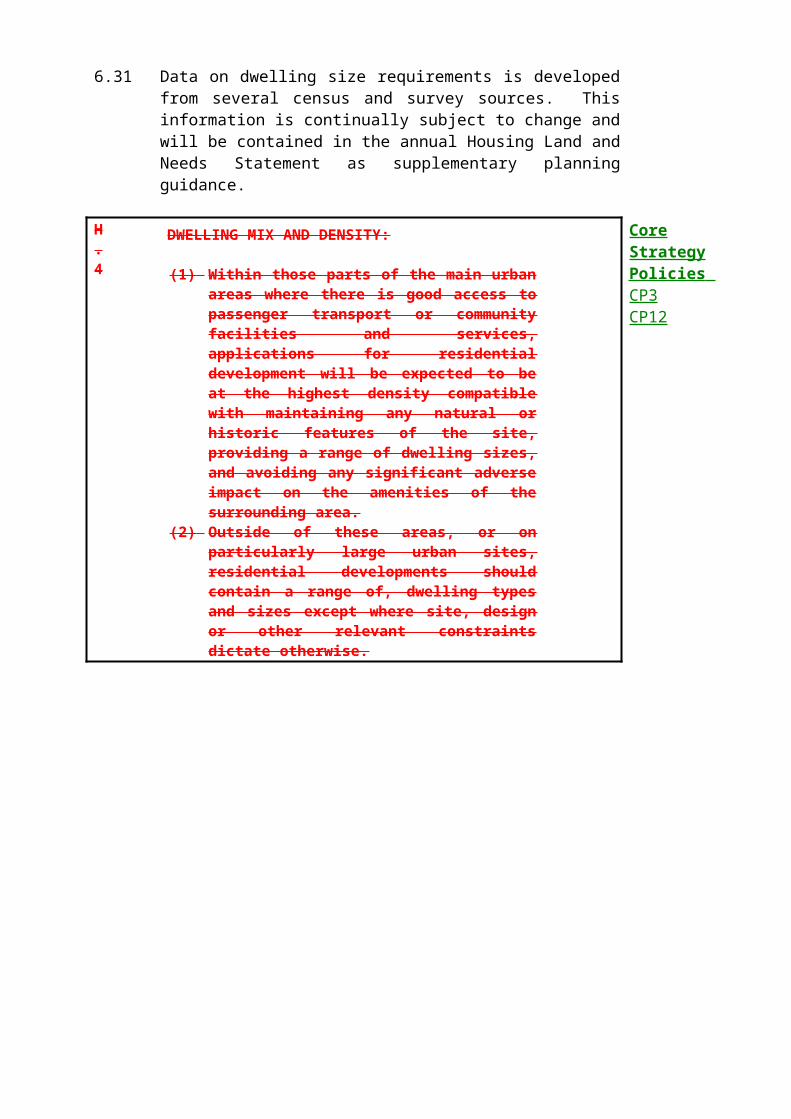
9.53 Greenways
9.54 Greenways are a network of largely car-free off-road routes allowing people to reach facilities and open spaces in and around towns, and the countryside. They are designed for shared use by people of all abilities on foot, bicycle or horseback, for commuting, play or leisure. The Council will support and implement measures where appropriate to assist in the creation and maintenance of Greenways. The Council supports the implementation of a stretch of Greenway linking Mutton Wood, Oxhey Lane to the Merry Hill Woodland Trust land where appropriate land lies within the District boundary.

SPORT AND LEISURE
10.1 Aims
10.2 To provide sport and leisure facilities for the District's population, while protecting the local environment and residential amenity.
10.3 Objectives
(a) To provide, so far as possible, sport and leisure opportunities to meet the needs of the local community.
(b) To promote the increased multi-purpose use of existing facilities wherever possible.
(c) To protect the environment from the adverse effects of leisure activities.
10.4 Introduction
10.5 Leisure includes any activity which people pursue outside work and their domestic commitments, ranging from sports to less formal forms of exercise, as well as cultural and social activities like arts and tourism. Providing the proper facilities and opportunities for people to participate in sport and leisure activities is a vital element in health and quality of life.
10.6 There are diverse opportunities for sport and leisure activities in the District. However, although the District generally has a reasonably affluent population which has good access to facilities, there are some areas of less well-off residents whose needs must be recognised. There is under-provision for some popular sport and leisure activities and at some sites a conflict of interests between different activities, the amenity of local residents and the best interests of the natural environment can arise.
10.7 In 1995 the Council approved a Leisure Strategy for the District which defines the Council's role in sport and leisure provision, identifies needs and sets targets. The policies in this Plan are intended to complement the Leisure Strategy.
10.8 In addition, an Arts Policy and a Strategy for Tourism for the District are being developed which may have some land use implications. These issues are dealt with in the latter part of the chapter.
10.9 Sports Facilities
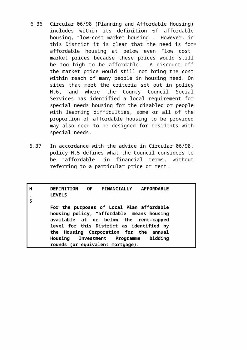
10.10 Sport is active (though not necessarily competitive) physical recreation. Most sports activities require some sort of specialised equipment and facilities, or at least free access to open space and areas of the countryside, and some activities can attract considerable numbers of people to a site. The Council's general approach to sports proposals will be a positive one, seeking to deal with demands in a sustainable way which balances the community's varied needs with the protection of local amenity and conservation of the natural and built environment. As a basic principle, the Council will seek to retain and optimise the use of any existing facility in the District. Proposals for development (of whatever use) should not lead to a net loss of any existing public sport or leisure facility, and the Council will also seek the retention of other facilities in private or educational use. When determining applications for development on sports pitches, the Council will consult with the English Sports Council and take its views into account.
L.1
PROTECTION OF EXISTING SPORTS FACILITIES:
In considering proposals for development which would lead to the loss, or prejudice the use of all or any part of an existing sports facility, the Council will only consider granting consent in the following specific circumstances:
(i) Where a carefully quantified and documented assessment of current and future needs demonstrates that there is an excess of the particular type of facility in the local catchment, or the site has no special significance to the interests of sport;
(ii) Where the proposed development is ancillary to the principal use of the site and does not affect the quality, quantity, use or availability of the facility;
(iii) Where the facility which would be lost would be replaced by a facility of equivalent or better quality and quantity, and subject to equivalent or better management arrangements, prior to commencement of the development;
(iv) Where the renovation of the facility, to improve the quality or range of the services offered on the site or to facilitate better management, would lead to a higher quality of use. Where demolition of a facility is proposed to facilitate such improvements, this should only be considered if retaining and renovating the existing facility is not an option.
(v) Where the proposed development is for a sports facility of sufficient benefit to the development of sport as to outweigh the detriment caused by the loss of the original facility.

The Council may impose conditions or seek to enter into a planning obligation with developers when granting consent, to ensure replacement provision.

10.11 There are many opportunities for multiple use of existing sports facilities, to expand the range of uses, or accessibility by the general public. These may involve use of school sports facilities out-of-hours, dual use of empty car parks or even simply overlaying different pitch markings onto a single playing surface. The National Lottery Sports Fund has opened up new opportunities for providing sports facilities in the voluntary and public sectors, and the Council gives advice and support to suitable bids for funding, particularly if the proposals will provide benefits for the Council's own leisure programme.
L.2
DUAL AND MULTIPLE USE OF SPORTS FACILITIES:
Dual and multiple use of sports facilities will be encouraged, particularly involving public use, subject to there being no significant adverse impact on residential amenity or the environment. In appropriate cases the Council may grant permission subject to conditions or seek to enter into a planning obligation with the developer to ensure dual or multiple use.

10.12 Built Sports Development
10.13 In the context of this Plan, built sports development includes any proposal which generally involves extensive hard surfacing or takes place within a sports hall or other building, or involves ancillary built development or other structures. This includes, for example, facilities for most racquet sports, sports halls, swimming pools, indoor bowling greens, basketball and other all-weather pitches, etc. Built sports facilities of this kind will not normally be acceptable in the Green Belt other than small scale proposals within the cores of the villages of Bedmond or Sarratt, in order to serve essential local needs (see Policy GB.1). Golf courses are dealt with separately (see Policies L.5 and L.6) as a sport which naturally has to be sited in the Green Belt. However, it must be noted that golf driving ranges are treated as a form of sports development not generally appropriate in the Green Belt. Facilities which involve floodlighting will be expected to comply with Policy N.13 (light pollution). The English Sports Council publishes guidelines on the level of lighting required for certain activities, and applicants are advised to refer to these standards before submitting proposals.
10.14 The District lacks indoor sports facilities for general public use, and does not yet comply with the Sports Council recommended minimum standard for sports hall provision. The William Penn Leisure Centre opened in Mill End in 1996, and another new facility recently opened at Parmiters School, Abbots Langley. At least one further scheme is considered desirable, in South Oxhey, and proposals are being developed as part of the Single Regeneration Budget award for South Oxhey (see chapter 7).
L.3
BUILT SPORTS DEVELOPMENT
(1) Proposals for new sports development which add to the variety of provision in Three Rivers will be encouraged if located in the main urban areas, subject to the protection of residential amenity and the character of the area.
(2) In the village cores of Sarratt and Bedmond as defined on the Proposals Map, small-scale sports development to serve the essential needs of the local population may be permitted. All proposals for new sports development in the Green Belt will be considered in the context of Policy GB.1.
10.15 Sports pitch and play space provision
10.16 A playing field is the whole of an open space which encompasses at least one playing pitch used for football, rugby, cricket, hockey or other outdoor team sport. Because of the vital contribution that these facilities make to local sports activity, the Council will seek to protect
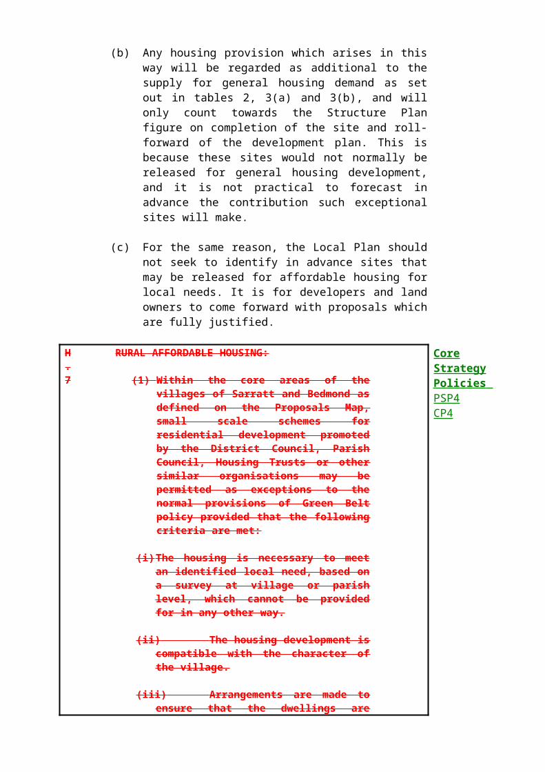
playing fields from development whether the playing fields are in public, private or educational use. When determining applications for development affecting playing fields, the Council is required to consult with the English Sports Council and will take its views into account (see Policy L.1).
10.17 Advice about the type and amount of sports pitch and play space required for a given population is provided in PPG17 (Sport and Recreation). This includes the National Playing Fields Association recommendation of a minimum standard for outdoor playing space of 2.43 hectares per thousand population (commonly referred to as the 'NPFA 6 acre standard'). This standard is acceptable as an overall indication of a proper level of provision, but it is not sufficiently detailed to reflect local circumstances. Therefore, the indication of need provided by the NPFA '6 acre standard' set out in tables 6a and b will be adopted as an interim measure only, to form the first stage of a more detailed assessment based on the preferred method of the English Sports Council (ESC) which is based on the numbers of pitches available compared with the number of teams and home games expected. The implications of this more detailed study will be incorporated into the Local Plan at the earliest opportunity.
Table 6a - National Playing Fields Association '6 Acre Standard'
Depending on the total population profile of the area, the total standard should be met by an aggregation of space within the ranges given below:
Table 6a – National Playing Fields Association ‘6 Acre Standard’
Type of use: Hectares per 1000 population*
Required provision**
A1 Youth & Adult Use(sports pitches: football, hockey, cricket etc)
1.2 Ha 102 Ha
A2 Youth & Adult Use(other sports facilities: greens, courts etc)
0.4-0.6Ha 34 – 51Ha
B1 Children’s Use(outdoor playgrounds for children of whatever age)
0.2-0.3 Ha 17-25.5 Ha
B2 Children’s Use(casual or informal play space within housing areas)
0.4-0.5Ha 34-42.5 Ha
Total: 2.2–2.6 Ha 187–220 Ha
* NPFA ‘6 acre standard’ in PPG17** based on Three River’s population of 84,860 in 1996

For each settlement and type of open space, Table 6b shows:
(top): The amount of space required according to the NPFA standard.(centre):The actual amount of open space existing within or adjacent to that settlement.(bottom):The deficit or surplus in supply.
The variation in the proportion of children to adults in each area is insignificant, so in all cases a mid-range figure from the NPFA standard in table 6a has been used to calculate the requirement for open space.
Table 6b – Assessment of open space provision by settlement
Settlement Sports Pitches
Courts & Greens
Equipped Play Areas
Casual Play space
Total
Abbots Langley, Kings Langley,Bedmond
21.1614.74-6.42
8.821.58-7.24
4.410.4-4.01
7.9329.3421.41
42.3246.063.74
Croxley Green 14.098.4-5.69
5.871.1-4.77
2.930.38-2.55
5.281.7-3.58
28.1711.58-16.59
Chorleywood 13.84.1-9.70
5.760.7-5.06
2.880.2-2.68
5.1825.1519.97
27.6230.152.53
Moor Park/Eastbury 6.010-6.01
2.510.44-2.07
1.250-1.25
2.251.31-0.94
12.021.75-10.27
Rickmansworth 14.3812.43-1.95
6.02.03-3.97
3.00.77-2.23
5.413.45+8.05
28.7828.68-0.1
South Oxhey, Oxhey Hall, Carpenders Park
26.1113.0
10.880.25
5.440.71
9.7944.35
52.2258.31
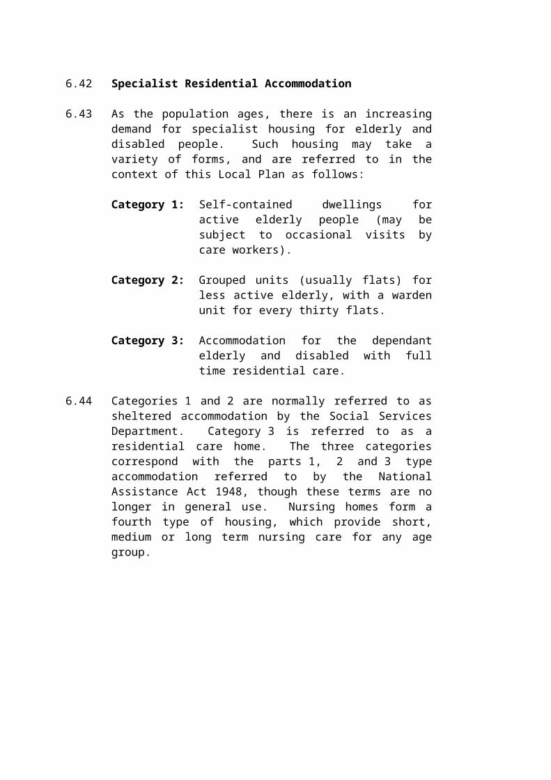
-13.11 -10.63 -4.73 34.56 6.09Total 95.55
52.67-42.88
39.846.1-33.74
19.912.46-17.45
35.83115.379.47
191.13176.53-14.6

10.18 Clearly, there is a significant shortfall in sports pitch and play space provision in the District as assessed against the NPFA standards. In addition, the favourable amount of informal and amenity play space for children is not equally distributed around the District, most of the supply being located in a few large areas such as South Oxhey Playing Fields, and Abbots Langley Country Park. As well as assessing the level of overall provision, the distribution of facilities is also important. On a settlement by settlement basis, Carpenders Park, Eastbury, Moor Park, Chorleywood, Loudwater and some parts of Rickmansworth are particularly poorly provided with open space of all kinds. However, this assessment is rather simplistic - the conclusions must be tempered by the fact that some areas most 'deficient' in open space are low density areas, comprising large houses with extensive gardens, and children are not necessarily dependant on public areas for their play opportunities.
10.19 Policy L.1 defines the criteria against which proposals that might lead to the loss of any sports or play facility will be assessed. Beyond this, the Council will seek to reduce the local deficiencies identified in table 6b wherever resources and opportunities allow. However, to be effective the Council must ensure that new development, particularly those forms of housing which will give rise to an additional need for sports or play facilities, makes due provision for sports facilities so that the pressure on existing sites is not increased.
10.20 The Council’s Leisure Services department has a sports development programme that includes the development of new facilities, improvements to existing ones, and identifies opportunities for partnership with several organisations such as schools, clubs and the private sector. Applications for planning permission for projects under this programme will be assessed against the policies of this Local Plan, particularly L.1, L.2 and L.3. Key needs and opportunities identified to date include :
The need for and further development of three indoor leisure centres, at Mill End (William Penn Leisure Centre), Abbots Langley (Parmiters School), and South Oxhey;
Promotion of public use of sports halls at Parmiters and Rickmansworth Schools;
Provision of all-weather floodlit pitches in Abbots Langley and Rickmansworth/Chorleywood;
Provision of indoor bowls and tennis facilities by the voluntary/private sector;
Provision of outdoor sports facilities at Abbots Langley Country Park;
10.21 In addition, the Council supports proposals by businesses and schools in developing sporting and leisure opportunities for their staff and students, especially if opportunities for community use can be achieved.
L.4
PROVISION FOR SPORTS FACILITIES BY NEW DEVELOPMENT
(1) Subject to the other policies of this Local Plan, where major new commercial developments include sports and leisure facilities for staff, or where schools plan to upgrade or expand their existing sports facilities, the Council will encourage proposals which incorporate plans for community use.
(2) When granting planning permission for new residential developments of 25 or more dwellings or 0.6 hectares (whichever is the greater), the Council will seek to enter into a planning obligation with the developer to contribute to the provision or enhancement of local sports facilities provided a need is demonstrated to have arisen from the development concerned, there are inadequate local sport facilities, and the contribution is reasonably related in scale and kind to the proposed development.

10.22 Golf
10.23 Golf is increasingly popular, and there is pressure for additional courses, particularly those available on a 'pay-and-play' basis to the general public. Facilities in the District serve not only Three Rivers' own population but also that of neighbouring urban areas such as Watford, Hemel Hempstead and adjacent London Boroughs. The Council will continue to seek to optimise the use of existing courses, especially for public use.
10.24 A golf course requires a substantial area of land and can have an adverse impact on the landscape by imposing an incongruous 'manicured' appearance onto a rural area and by substantial alterations to land forms. In considering applications for new golf courses and driving ranges, the Council will have regard to advice on their siting, layout and design published by the former Eastern Council for Sport and Recreation (ECSR) and the Countryside Commission. Because of the range and complexity of environmental issues associated with golf courses, developers are encouraged to consider at an early stage whether an environmental assessment should be prepared in support of their application, and if necessary obtain a ruling on this issue from the Council in advance of making a planning application.
10.25 Applications for golf courses will be considered against a wide range of issues. In addition to the criteria in Policy L.5, the attention of applicants is particularly drawn to Policy C.9 (setting of Listed Buildings) and D.7 (design for water conservation).

L.5
GOLF COURSES:
Applications for new golf courses or extensions to existing golf courses should:
(i) Be located, close to the main urban areas and only be located within the Chilterns AONB where there is no harm to the acknowledged importance of the conservation of the natural beauty of the landscape.
(ii) Retain and reflect the existing local landscape and topography as closely as possible in design, and not involve extensive earth-moving operations, or importing of soil or waste to create course features.
(iii) Retain and re-use existing buildings wherever possible, and not include other buildings or uses, including leisure uses, that are not essential to golf courses. Adequate car parking must be provided, sensitively located and with a good standard of design.
(iv) Not adversely affect sites of nature conservation value and wherever possible, include measures to enhance the wildlife value of the site. Biodiversity Management Plans should be submitted by developers to ensure the protection and enhancement of the ecological interest of the site.
(v) Not involve the closure or unnecessary diversion of a public right-of-way, or endanger the public when a course is being played. Measures to increase public access should be incorporated whenever possible.
(vi) Not rely for access on narrow rural lanes or involve highway works which adversely affect the character of the area.
(viii) Ensure that there is no significant adverse effect on nearby residents.
(ix) Ensure that pollution prevention, water conservation and storage measures are incorporated into the design to reduce the impact upon the water environment as required by policies N.4, N.5 and D.7.
When granting consent, the Council will impose conditions and may seek to enter into a planning obligation with the developer to ensure that these issues are addressed.
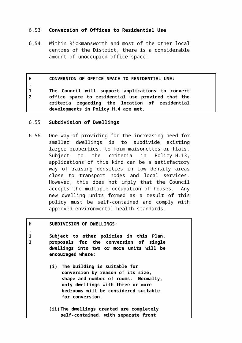
10.26 Golf driving ranges may or may not be associated with a golf course, but are of a quite different nature in terms of their impact on the environment. The cluster of buildings, fencing, floodlighting and parking often associated with driving ranges can lead to problems of light pollution and can be visually intrusive in both rural and urban areas. For these reasons, the Council considers that golf driving ranges are generally inappropriate developments in the Green Belt, particularly in rural locations away from the urban areas.
L.6
GOLF DRIVING RANGES:
Proposals for golf driving ranges will generally be considered inappropriate development in the Green Belt, especially those which are floodlit, particularly in areas of open or rural character, or where light pollution levels are low. Applicants for golf driving ranges in the Green Belt will be expected to demonstrate very special circumstances, including evidence that the facility can not be located elsewhere. The Council will only permit golf driving ranges where it can be demonstrated that the proposal will not significantly adversely affect local residential amenity, the character of the local landscape or the natural or historic environment.

10.27 Sport in the Countryside
10.28 The countryside is often the only reasonable location for sports (besides golf) which require extensive areas of land or which would cause disturbance to local residents if they took place in or near residential areas. Examples include equestrian or motor sports (including powered watersports), clay-pigeon shooting or war-games. None of these necessarily involve structures which require planning permission, and the Town and Country Planning General Development Order 1995 gives a general grant of planning permission for the use of land for certain activities for up to 28 days in any calendar year. In the case of motorcar and motorcycle sports this is reduced to 14 days in any calendar year, and no such activity is permitted within SSSIs. Proposals which exceed these restrictions require planning permission. When considering planning applications, the Council recognises that there is a demand for such activities, and will seek to accommodate these needs subject to protection of the amenity of the District's residents and the natural environment.
L.7
SPORT IN THE COUNTRYSIDE
(1) Proposals for sport in the countryside will only be permitted where they:
(i) DDo not cause disturbance to areas of the countryside which are considered to be quiet, or involve the loss of residential amenity, through traffic or noise generation;
(ii) DDo not adversely affect any site of nature conservation interest. In particular, applications for motor sports or war-game activities will only be permitted on land which is of no nature conservation interest.
(iii) PProvide adequate off-road parking, which does not involve hard surfacing, excessive signage or other structures, or otherwise have a significant visual impact on the area.
(2) If appropriate, applicants will be expected to demonstrate that they have considered all locations away from residential areas, on degraded land or in areas of high ambient noise levels as a first course of action. Particularly disturbing activities such as gun and motor sports will be subject to this requirement.

10.29 Water-based Sport and Leisure
10.30 Three Rivers contains many surface water resources used for a variety of formal and informal sport and leisure activities. The Grand Union Canal is a major recreation facility in the District. Angling, boating and walking complement each other in an environment which contains much scenic, historical and wildlife interest. The canal is owned and maintained by British Waterways. Proposals for improved recreational mooring and boating facilities will be supported, subject to Policies N.4 (protection of water resources and Policy H.17 (residential moorings).
10.31 The Council is working in partnership with British Waterways and other bodies to produce a Canal Corridor Study to ensure that the historic character of the canal, the activities associated with it, and the design of new development continue to complement each other in a sustainable and co-ordinated way.
10.32 In addition to the canal, there are approximately thirty flooded gravel pits in the District, concentrated to the east and south of Rickmansworth in the Colne Valley. Collectively, these lakes are a leisure resources of regional importance and are also of national importance for wildlife. Water sports take place on a few lakes - the others are reserved for wildlife, walkers or anglers. Proposals for new or expanded sport and leisure uses on the lakes (which are otherwise compatible with the Green Belt) will be considered against the protection of the lakes as areas of wildlife interest. Sites that require this kind of consideration include Sabey’s Pool, Rickmansworth Aquadrome, and Cassiobury Park.
10.33 The Eastern Council for Sport and Recreation has published a Regional Strategy for Water Recreation. This District is covered by Zone 4 (which includes the River Colne and associated waterways). The Zone 4 report relates principally to the Colne Valley Regional Park (see Policy N.22), the Grand Union Canal, and the Rivers Chess, Colne and Gade. The rivers are important in terms of wildlife, landscape value and informal recreation such as angling and walking, but except for some limited canoeing have little potential for active recreational use.
10.34 Groundwork Thames Valley has prepared a Colne Valley Water Use Strategy which identifies levels of existing and potential water-based sport and leisure activity within the Colne Valley Park. The conclusions of this Strategy are in accordance with Policy L.8.

L.8
WATER-BASED SPORT AND LEISURE:
(1) The Council will encourage and participate in schemes to enhance the recreational use and potential of the Grand Union Canal, including improvements to recreational mooring and boating facilities, better links between towpaths and public rights of way, the use of towpaths for cycling and where possible, horse riding and other environmental improvements.
(2) When considering proposals for sport and leisure development related to the lakes and waterways of the District, the Council will take into account the Green Belt, the availability of water for lock usage, the safeguarding of natural resources and wildlife, and the desire to increase public access where this will not conflict with the above. The Council expects any new developments adjacent to waterways to respect, and not detract from the character and appearance of the District’s historic waterways.

10.35 Amenity and Children's Play Space
10.36 Amenity space (and particularly informal or equipped areas for children to play) is an important element in providing a varied and accessible leisure resource, particularly in urban areas. The National Children's Play and Research Unit recommends that children's play spaces be provided within 400m of the home for children over 5, and within 200m for children under 5, without having to cross a main road. The NPFA recommends that the minimum standard for children's space be met at all times and in all circumstances.
10.37 Open spaces can vary widely in character, size and use, ranging from formal, open grassed areas with little planting to wilder, less intensively managed 'green' space such as remnant woodlands. They may include equipped children's play areas, or form part of much larger areas which include playing fields. Table 6b provides a settlement by settlement assessment of the provision of such space against the NPFA standard, from which it is clear that although many settlements are well supplied with casual or informal play space, the number of equipped playgrounds is generally well below the required standard.
10.38 Key facilities such as Rickmansworth Aquadrome and the large woodlands serve extensive populations, and many people make special journeys to these areas. Most such sites are close to the urban areas, but within urban areas the Council is concerned that residents (and particularly children) should have easy access to open space without needing to travel to it by car. The Council will seek both to maintain the existing stock of open space, and ensure that where needed, new development makes provision for adequate open space to serve the new occupants and also be available to other residents. The Council recognises the diverse nature of the settlements of the District and the varying needs of different groups of residents. For these reasons, a universal standard of open space is not considered appropriate. The following policies account for site constraints and local characteristics, while ensuring that new development does not add to the pressure on existing amenity open space and children's play areas.
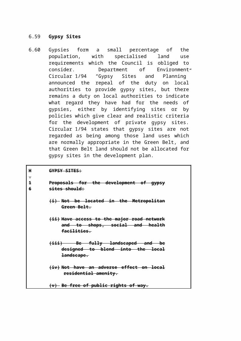
L.9
PROTECTION OF EXISTING AMENITY AND CHILDREN'S PLAY SPACE:
(1) Proposals for development which would lead to the loss, or prejudice the use or appearance of all or any part of an existing area of amenity space, will only be permitted in the following circumstances:
(i) Where a carefully quantified and documented assessment of current and future needs demonstrates that there is an excess of the particular type of amenity space in the local catchment;
(ii) Where the proposed development is ancillary to the principal use of the site and does not affect the quality, quantity, use or availability of the amenity space;
(iii) Where the amenity space which would be lost would be replaced by a facility of equivalent or better usefulness and quantity, and subject to equivalent or better management arrangements, prior to the commencement of the development.
(2) The Council may impose conditions or seek to enter into a planning obligation with developers when granting consent, to ensure replacement provision.
(3) Development which would lead to the loss, or prejudice the use of any existing children's play space will be refused.
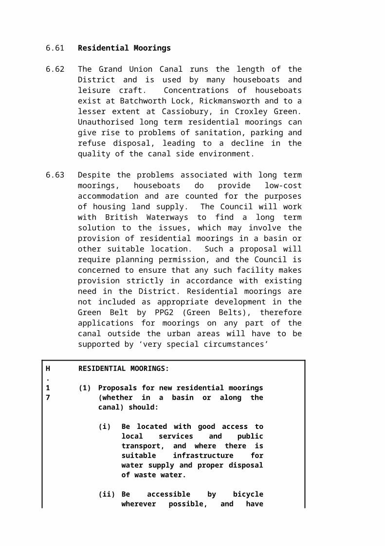
L.10
AMENITY AND CHILDREN'S PLAY SPACE PROVISION IN NEW RESIDENTIAL DEVELOPMENT:
In order to ensure that new residential developments do not exacerbate the deficiencies in amenity open space and equipped children’s play space set out in table 6b, new residential developments will be required to provide amenity and children's play space as follows:
(i) In developments of 25 or more dwellings or 0.6 hectares (whichever is the greater), a minimum of 10% of the site area should be set aside as amenity open space. Where a development is likely to be occupied by families with children, formal equipped play facilities should form part of this provision at a minimum of 2% of the site area. Appropriate equipment should be provided by the developer directly or by a funding agreement with the Council. The 10% standard should form coherent areas but may consist partly of incidental or visual amenity space which serves the setting of the development.
(ii) In developments of less than 25 dwellings or under 0.6 hectares which cannot provide sufficient open space within the site, the Council will seek to enter into a planning obligation with the developer to contribute to improving access to or the standards of amenity space or children's play space which serves the locality. The formulae used to calculate an appropriate sum will be based on the expected population of the development, at a minimum ratio of 0.4 hectares of open amenity space and 0.2 hectares of equipped playgrounds per 1000 population.
(iii) Some variation of the above standards may be appropriate where the Council considers:
(a) TThat the development is already fully served by existing amenity space or children's play space within a maximum of 400m of the proposed development without needing to cross a main road,
(b) That retaining 10% of the site area for open space would not be an appropriate use of the land taking into account local needs and the character of the locality (for example in town centres or low density areas)

(c) In new residential development comprising specialised accommodation for the elderly such as sheltered housing, the Council will only require the provision of adequate amenity space as part of the scheme.
(iv) Where amenity space is provided in accordance with (i) above, the Council will seek to ensure the proper maintenance of the space. Where the Council is requested to adopt open space of any kind, acceptance will be conditional on the agreement of a commuted sum for maintenance;

10.39 The Council is concerned to maintain a variety of different kinds of open spaces which are well designed and laid out with regard to the particular needs of the surrounding communities. Open space may range from being purely visual in function, to incorporating play areas, paths and seating, or be more natural 'green space' to maintain local wildlife interest. Overall variety in general areas and where possible within individual spaces is important. Whatever the design form chosen, it should reflect the character of the area and needs of the residents, employees or casual visitors likely to make use of the space.
L.11
DESIGN OF OPEN SPACE
The Council expects proposals involving new or existing open space to be designed to a high standard. Large areas of open grass with neither planting or dedicated areas for specific uses (e.g. children's play areas) should not form part of new developments. The Council will expect the design of open space to have regard to the following factors:
(i) The relationship between the open space and its physical surroundings, including buildings and other areas of open land, (for example, through the choice of planting and layout of paths);
(ii) The level and kinds of use likely to be required of the open space, given the nature of the nearby uses and occupants;
(iii) The need to maintain a variety and balance of different forms of open space, such as visual amenity, areas for more active use including informal play space, and natural areas for wildlife;
(iv) The need to maintain and enhance any existing nature conservation interest, and, where appropriate, the benefits of creating new habitats;
(v) The proposed arrangements and responsibilities for management and maintenance, which may have implications for design and must be resolved before consent will be granted.
10.40 Some settlements in the District were designed with extensive roadside verges and other grassed areas whose main purpose is to enhance visual amenity and contribute to the character of the settlement. As well as providing an important visual amenity, roadside verges are often important for nature conservation value and should be protected where appropriate for ecological reasons. New vehicle cross-overs tend to fragment these areas and lead to a general deterioration in the quality of the visual and ecological environment. Many developments of this kind can be carried out as permitted development under the General Permitted Development Order 1995, and so the Council has limited control although separate permission may be required from the Council's housing department, and from the highways authorities.
10.41 In addition, grass verges flank many roads in more rural areas, from narrow lanes to major highways. Some are used by walkers or horse riders as a refuge from the highway itself and so serve a specific recreational need. Where the planning authority has control over development or is consulted (e.g. by the highways authority) in respect of proposals which may reduce, destroy or fragment such areas, the authority will encourage the retention and protection of these features.
L.12
PROTECTION OF GRASS VERGES AND MINOR OPEN SPACES:
Unco-ordinated and ad-hoc proposals for vehicle crossovers which involve fragmentation and loss of grassed verges and other spaces will be discouraged. The Council will seek a co-ordinated approach involving the planning, highways and housing authorities, in order to persuade applicants to adopt an approach which safeguards these features.
10.42 Access to the Countryside
10.43 The countryside of the District accommodates large numbers of people seeking active forms of recreation such as walking, horse riding, cycling and fishing. Being close to large urban area means that the rural areas of the District act as a 'green lung' for many residents of neighbouring authorities as well as the District's own population. The Council has participated in several schemes to promote countryside access. Such projects provide links between neighbouring areas and a foundation on which other routes can be built. In order to improve access to the countryside the Council will introduce public path agreements and orders where necessary, and will define public access requirements in planning briefs, management agreements and planning approvals as appropriate. To assist in increasing access and promotion of the countryside the Council will work with outside bodies such as the Countryside Management Service to promote and increase access to the countryside.

10.44 The London Orbital Bridleroute ("H25") and part of the National Cycle Network cross this District. The Council supports these schemes as set out by the British Horse Society and Sustrans respectively. The generally anticipated route of the "H25" is shown on figure 8.
L.13
ACCESS TO THE COUNTRYSIDE
The Council will support and promote increased public access to the countryside, subject to protection of the environment. In particular, the Council will support the establishment of recreational facilities for walking, cycling and horse riding such as the London Orbital Bridleroute ("H25") and National Cycle Network, and will seek to provide local links to them. The Council will seek to enter into planning obligations with developers and work with appropriate organisations to implement these routes as resources and opportunities permit. Where there are physical obstacles to access, for example stiles, non-pushchair-friendly kissing gates, rough or unstable ground or steep slopes, the Council will work in conjunction with other organisations to reduce the number and severity of these obstacles.
10.45 Rights of Way
10.46 The County Council is responsible for maintaining the Definitive Map of Public Rights of Way. This map shows most public rights of way. Applications for development adjacent to or which affect a public right of way are advertised, and the Council will consult with the County Council and user groups as appropriate. In suitable situations the Council will exercise its powers set out in the relevant legislation to create and improve rights of way.
L.14
RIGHTS OF WAY
All existing public rights of way will be protected. Development involving the closure or the diversion of a public right of way will be resisted. Any diversion should be as direct as possible. In all cases, the right of way must be kept open and safe during all stages of development, if necessary by a temporary diversion or through phasing of development. The Council may grant consent subject to conditions in order to achieve these objectives.

10.47 Commons
10.48 The District contains several fine commons, each with its distinctive character. These are Penman's Green, Commonwood Common, Dawes Common, Sarratt Green, Chorleywood Common, Croxley Green, Croxley Common Moor, Fortunes Common and Batchworth Heath. Many are enclosed greens fringed with historic buildings. Several are grasslands or woodlands of ecological interest and all serve their local communities as public open space. Pressures for apparently minor works such as playgrounds, parking, tracks and street furniture can erode the informal countryside setting and rural character, and sense of public ownership of such areas.
L.15
COMMONS:
The Council intends to protect the commons of the District for their nature conservation interest and as informal, semi-rural open spaces for the local community. Wherever possible, new vehicle tracks or additional car parking will not be permitted on the commons. Exceptionally, works may be permitted where a net reduction in the area or number of such features would result. Essential highway works or other engineering proposals will be required to adopt a low-impact design approach. Creation of play spaces on common land (for example games pitches) will only be allowed if the character and natural ecology of the common land will not be adversely affected.
10.49 Allotments
10.50 Allotments are a valuable outdoor recreational facility for local residents. They are often located in areas where garden sizes are limited. In the built-up areas, allotments also benefit people other than tenants because they provide an open area - a ‘breathing space’ in otherwise urbanised surroundings. Such sites are often contemporary with the layout and development of the locality and form part of its established character. They can also be valuable urban wildlife habitats.
10.51 Given the importance of allotments, the Council will oppose change of use unless there is clear evidence of continued lack of demand for the allotments concerned, significant efforts have made to tenant the allotments, and the land would continue to be essentially open in character and would provide for wildlife.
10.52 Where appropriate sites can be identified the Council will seek to establish new allotment sites where there is excess demand, or where there is a shortfall of allotment provision below guideline levels. The guidelines for allotment provision are set out in the Thorpe Committee

recommendation of 1969, which is for 0.2 hectares per 1,000 population.
L.16
PROTECTION OF ALLOTMENTS:
(1) The Council will only permit a change of use of allotments provided it is satisfied that:
(i) there has been a history of continuing lack of demand for the allotment site and positive initiatives to encourage tenancy of the allotments have been unsuccessful, or existing occupants can be offered a convenient alternative location, provided that demand is proven;
(ii) and positive initiatives to encourage tenancy of the allotments have been unsuccessful, and demand is proven;
(2) Where there is proven to be a continuing demand for allotments development proposals involving the loss of any part of an allotment must make suitable alternative provision on a site which is of equivalent size and cultivable quality, and is locally accessible.
(3) The Council will seek to establish new allotments where there is a proven demand that cannot be met through promotion of existing allotment space.

10.53 Tourism
10.54 Tourism can be identified as all visitor activity in an area for the purposes of leisure and entertainment. Structure Plan Policy 20, the policies elsewhere in this Local Plan, and advice in PPG21 (Tourism) provide the basis for consideration of tourism-related development proposals. However, it is appropriate to explain the Council's general approach to tourism.
10.55 The Council welcomes tourism but is concerned that development proposals and the tourism activity generated by them should not harm the feature or environment which forms the initial attraction. The Council is preparing a strategy - 'Tourism in Three Rivers' - which explains the importance of tourism to the local economy and sets out the key attractions of the District. The principle land use issues are set out below. These issues will be taken into account when the Council considers relevant applications for planning permission, management plans, etc but do not merit specific policies in their own right.
(a) Leavesden Studios development. The proposed family entertainment centre and studio backlot tour are expected to attract 1.2 million visitors per year, and will generate considerable local economic activity as a result. Issues of traffic generation and visitor management will be addressed as detailed applications relating to the site come forward.
(b) Hotel and conference centre development. The tourism strategy and local businesses identify a deficiency in such facilities in this part of Hertfordshire. The need for hotel and conference facilities is acknowledged, and one such development will be provided at the Grove, a Grade II* Listed Building near Hunton Bridge. Proposals for new facilities serving a range of needs will be encouraged, and considered in the context of the normal policies of this Local Plan.
(c) Visitor management. Visitor numbers are increasing the pressure on some sites and areas of the countryside, such as the Chess Valley, rural villages, Rickmansworth Aquadrome, the Grand Union Canal and Whippendell Woods SSSI. Applications for further tourism-related development in such areas will have to be carefully weighed against the cumulative stress of visitor pressure.
(d) Historic buildings. Some historic buildings around the District are at risk of neglect. The most frequently proposed change of use is to residential, but this may be impractical or not welcome for certain types of buildings (e.g. for barns). The conversion of derelict or obsolete historic buildings into tourist venues may secure their continued preservation by a sympathetic design solution, and will be considered subject to the policies in Chapter 3 (Conservation of the Built Heritage).

10.56 Arts Policy
10.57 The Council adopted an Arts Policy in 1996, in order to support the local economy, develop and strengthen community spirit, health and well-being, and offer opportunities for self-expression and personal development. The Arts Policy includes proposals to develop and enhance Watersmeet Theatre and The Centre (South Oxhey) as focal arts venues in the District, to support the use of the Aquadrome for arts, and to identify suitable venues for public art. Such elements of the Arts Policy may have land use implications and proposals brought forward by the Council or public or private sector partners will be assessed against the policies in this Plan.

APPENDIX 1 - MAKING DEVELOPMENT MORE SUSTAINABLE
Policy GEN. 1 Making Development More Sustainable is an overarching policy in the Local Plan having the objective of ensuring that the location, design, construction and future use of development in Three Rivers is as sustainable as possible. To help to achieve this, applicants will be required to submit sustainability assessment statements with their applications demonstrating how they have taken into account a range of sustainability issues. Applicants in preparing their statements should use the sustainability checklist contained in this Appendix. Please contact the local planning authority if you are in any doubt as to whether a statement is required, the range of issues it should cover and in what detail. The following text is based on advice issued nationally by the Local Government Association and the Local Government Management Board (now the Improvement and Development Agency for local government) contained in 'Sustainability in Development Control - a research report’ by CAG Consultants. 1997.. For the avoidance of doubt, should there be any conflict between the text below and the policies of the Local Plan, the latter will prevail for the purposes of the Local Planning Authority's determining applications.
What is sustainability?
Sustainable development is defined and described in the introduction to the Local Plan. It can be viewed as encompassing the following :
protect and enhance the environment:
- use energy, water and other natural resources efficiently and with care. - minimise waste, then re-use or recover it through recycling, composting
or energy recovery, and finally dispose of what is left in as sustainable way as possible.
- limit pollution to levels which do not damage natural systems. - value and protect and where possible enhance the diversity of nature and
quality of landscapes for wildlife.
meet social needs:
- create or enhance places, spaces and buildings that work well, wear well and look well;
- make settlements 'human' in scale and form.- value and protect local character and distinctiveness and strengthen local
community and cultural identity.
protect human health and amenity through safe, clean, pleasant environments:
- as well as health care, place a greater emphasis on a preventative approach to ill health.

- create public confidence and satisfaction in communities which are safer and more secure.
- ensure access to good food, water, housing and fuel at reasonable cost.- meet needs locally wherever possible.- maximise everyone's access to the skills and knowledge needed to play a
full part in society.- empower all sections of the community to participate in decision-making
and consider the social and community impacts of decisions.
promote economic success:
- create a vibrant local economy that gives access to satisfying and rewarding work without damaging the local, national or global environment.
- value unpaid work in the form of carers and voluntary workers.- encourage necessary access to facilities, services, goods and other people
in ways which make less use of the car and minimise impacts on the environment.
- make opportunities for culture, leisure and recreation readily available to all.
- promote a green economy through the use of green purchasing/supply chain practice.
Adapted from “Sustainable Local Communities for the 21st Century” (The Local Government Association, the Local Government Management Board and the Department of the Environment, Transport and the Regions) by the Hertfordshire Public Sector Environmental Pledge.
How does sustainability affect how development is planned?
The planning system plays a major part in making our living environment and our lifestyles more sustainable. For instance, placing developments which generate many jobs near public transport allows car travel to be reduced. Ensuring that developments are located so that they make optimal use of sunshine and so that they are sheltered from wind reduces energy consumption. The provision of works of art as part of new developments makes our living environment more beautiful. Often, sustainable practices help to save money, for instance from utility bills. They can also make developments more attractive to future users, thus raising their value.
When planning development, applicants will need to take account of:
- the policies in the Hertfordshire Structure Plan, the Three Rivers Local Plan and the Hertfordshire Minerals and Waste Local Plans (where appropriate) and any Supplementary Planning Guidance;- Building Regulations;- the requirements of the Environment Agency, the local environmental health department, and possibly other organisations.
These deal with many sustainability issues like nature conservation, land use, and energy efficiency.
Applicants should discuss proposed development with the local planning authority, who can give valuable advice on what is expected from developments in the area. The local planning authority is responsible for setting planning conditions for developments: these are conditions that must be fulfilled. Planning obligations may also be sought with applicants which restrict what can be undertaken with land/development or which involves paying for certain amenities. Examples of sustainability-oriented planning obligations include carrying out archaeological investigations on a site if there may be important archaeological material there, or paying for traffic management near the site of the development if it is likely to generate considerable extra traffic. Development can be refused on sustainability-related grounds, particularly on grounds of unacceptable traffic increase and incompatible land use. As such, it is important to discuss these issues with the local planning authority at an early stage.
How can a proposed development be made more sustainable?
The checklist below gives an idea of many of the issues that should be considered when planning development. It also gives some ideas for how development might be adapted to make it more sustainable. It should not be treated as a complete list of sustainability issues and appropriate additions to the list by applicants will be welcomed. Not all of the questions apply to all developments and some indicative thresholds are identified below. Developments will however, be encouraged to maximise opportunities in all areas where possible.
· if the development does not involve any buildings (if, for instance, it is a car park or landscaping), then consider only questions marked "n";
· if the development is a conversion of an existing building, then consider only questions marked "c";
· if the development is for 9 houses or less, or less than 300 square metres, consider only questions marked "s";
if the development is for 10 or more houses, or more than 300 square metres, then consider only questions marked “1”.
In each case, an applicant should consider "does my proposal.... ?”
The Sustainability Checklist:
1. Land use1s provide local facilities or favour the central town over green field sites?cl site high traffic-generating uses near good public transport?nls avoid loss of open land or urban open space?nls use derelict/under-used/vacant land or buildings? (including upper stories)1 avoid adding to housing pressure?ncls encourage a long period of use? (eg. durable construction, accommodating
changing patterns of use)
2. Minerals and soilsnl minimise the need for aggregates both in construction and operation, and
safeguard longterm local resources of sand and gravel?nl avoid areas of high quality agricultural land?,nls include a proper site investigation to identify areas of soil contamination
where necessary, and take correct measures for decontamination?

3. Wastencls reduce the size of the waste stream, including toxic and contaminated
waste, and ensure that what is produced and used is safely handled? (eg. reuse/recycling, composting, proper safety procedures)
ncls encourage the use and purchase of recycled, recyclable, and durable products? (eg. use recycled, reused, renewable and durable building materials, salvage material for reuse/ recycling, use demolition materials for hardcore and aggregate)
nl promote recycling and waste sorting as a normal activity? (eg. provide recycling facilities)
n reduce litter and dog mess? (eg. dog bins in parks, fencing to reduce windblown litter)
4. Energy1 reduce the requirements for transport fuel? (eg. more attractive public
transport, development layouts favouring non-motorised transport, self-contained settlements)
cls maximise energy efficiency in buildings? (eg. orientation, spacing and grouping of buildings, size and orientation of windows, natural ventilation, earth sheltering, insulation, lobbies and conservatories as buffer zones, draught proofing, localised temperature controls, weather-breaking plantings)
Is avoid overshadowing other buildings?cls generate energy sustainably (eg combined heat and power, heat/methane
recovery from waste, solar panels, other forms of renewable energy) or opt for supply generated from such sources when there is a choice from energy companies.
nls consider the full energy costs of extraction, manufacture, transport, use, and disposal both in construction and operation? (eg. minimise changes made to site levels during construction, avoid the use of aluminium, renew/repair/refurbish)?
5. Air, water, noise, lightnl reduce air pollution and dust both in construction and operation? (eg. low
NOx boilers, reduction in traffic volumes, damping and wheel cleaning to avoid dust)
nl reduce greenhouse gas emissions? (eg. condensing boilers, combined heat and power systems)
nl improve water quality and protect groundwater from contamination? (eg. sewer renewal, waterway maintenance, dredging, reedbeds for wastewater treatment)
cls reduce the need for water? (eg. water meters, storage and use of 'grey' water)
nls protect the hydrology of the site and surrounding area and prevent flooding? (eg. permeable surfaces for car parks/spaces/driveways, minimise road length, avoid water run-off into watercourses, avoid building on floodplains)
cls reduce noise levels? (eg. traffic reduction, meeting noise standards, noise insulation, use of quieter technology, hours of operation)
nl reduce levels of pollutants which are not statutorily controlled? (eg. provide litter bins, minimise night time lighting whilst maintaining safety, minimise odour)

1 provide information on pollution levels and sources to allow effective action to be taken? (eg. pollutant monitoring schemes)
6. Naturencls protect designated sites and other sites/features of nature conservation
importance? (SSS1s, green corridors, other sites of nature conservation importance, important trees, hedgerows and verges, drainage ditches)
nls conserve and make positive provision for nature conservation? (eg. nature reserves, naturally shaped watercourses, green corridors between sites, plantings to encourage wildlife and biodiversity, gardens and allotments, use native Hertfordshire or British species)
ncls ensure that waste products do not harm wildlife?cls avoid the use of tropical hardwoods
7. Local needsncls meet local needs? (eg. gardens and allotments) 1 make local facilities (shops, post office, chemist, youth club, bus service
etc.) and centres more viable and reduce travel needs?1 link local production with local consumption, keep money in the local
economy? (eg. local supplier/labour agreements)1 mainly benefit small and/or locally based businesses?
8. Basic needsncls work towards the eradication of poverty and a decent quality of life for
all? (eg. start-up business units, gardens and allotments)cl reduce homelessness and unfit housing? (affordable housing, commuted
payment for affordable/social housing)1 target improvements to where fuel poverty or waste is greatest? (eg.
thermal efficiency of renewal housing)
9. Satisfying workcl increase employment opportunities for local people? (eg. training courses,
inward investment, small business units)1 encourage creativity, diversity and innovation in the local economy?1 support economic life, without incurring hidden environmental costs? (eg.
life cycle costing, environmental impact assessments)cl promote socially and environmentally responsible business practice? (eg.
waste minimisation, office recycling, energy saving schemes, noise reduction)
10. Healthcls avoid unsafe building materials? (eg. asbestos, lead paints, organochlorides)1 improve health provision in the local area?
11. Access1 minimise distances to main employment centres, retail centres, recreation
and community facilities, and schools?nl make walking safer and easier? (eg. provision of controlled crossings,
pedestrian preference zones, adequate lighting, traffic calming)nls improve access to buildings for all? (wheelchair users, people with young
children/prams, blind and disabled people)ncl improve facilities and conditions for cycling, particularly safety aspects?
(secure cycle storage, cycle paths, signals and lanes)

1 make public transport more attractive or a more viable alternative? (eg. more frequent buses, bus preference measures, increased population density in transport corridors)
1 discourage the use of single occupant cars or large lorries? (eg. car sharing, teleworking, pooled bicycles or cars, load splitting, home delivery, bulk breaking)
nl improve facilities for those without a car? (eg. local shopping, kerbside recycling, neighbourhood service delivery)
nl make appropriate provisions for parking? (appropriate levels/standards of parking, car-free neighbourhoods, park-and-ride facilities, parking enforcement)
1 contribute to road construction/maintenance where appropriate?
12 Safetynl ensure safety for open space users? (eg. lighting, play equipment checks)ncls reduce crime and increase the public's perception of safety? (eg. window
locks, well-lit bus stops, increased community activity)
13. Education1 improve educational facilities in the local area including training and adult education?
14. Participationncls benefit the community as a whole?ncls involve building/development users and the local community at an early
stage? (local meetings, regular local fora and user groups, publicity, consensus building)
ncls ensure that the needs of underrepresented groups are fully considered? (consultation)
ncls allow disadvantaged people to take part on equal terms? (ramped access, Braille, plain language, training, mobility aids, childcare)
1 offer opportunities to heighten environmental awareness and interest by local people? (eg. publicity, public participation schemes)
1 have an exit strategy which transfers ownership to the local community?
15. Leisure, cultural and social activitiesnl make positive provisions for open spaces? (eg. provide parks and village
greens, commuted sums for future maintenance)nl improve and maintain public access to open space?nl improve leisure and recreational facilities? (eg. recreation grounds,
children's play areas, playing fields)1 improve community, cultural, and social facilities? (eg. community
centres, works of art)nl form strong diverse neighbourhoods which encourage vibrant local
communities?ncls protect and improve the settings and features of archaeological and
historical interest? (eg. conservation areas, listed buildings, features of archaeological significance)
16. Aestheticsnls protect designated landscape sites?ncls integrate well into its surroundings? (shape, size and materials
complement those of existing buildings and surroundings)

nls include good standards of screening and landscaping? (eg. "soft" boundary treatment such as hedges and shrubs, use of native species, landscape management plans)
nls take opportunities to improve the street scene or appearance of the area?

APPENDIX 2 - DESIGN GUIDELINES
DESIGN CRITERIA - RESIDENTIAL DEVELOPMENT
In addition to the policies of the Design Chapter and other sections of the Local Plan, development proposals should satisfy the following more detailed criteria. These aim to ensure that alterations and extensions do not lead to a gradual deterioration in the quality of the built environment, and that new development takes account of landscaping and the need for privacy and amenity space and the creation of identity in housing layouts.
1.Privacy
(a) All developments are expected to maintain acceptable standards of privacy for both new and existing residential buildings. The degree of overlooking and privacy inherent in a development will depend on density, layout, distances and angles between buildings, internal layout, positioning of windows, relative levels and the presence of trees, hedges or other landscape features. Reliance should not be placed in high screening fences or walls (2 metres and above) where these would form a dominant and oppressive feature.
(b) In the interests of privacy and to prevent overlooking, the following criteria are set out:
(i) Distances between buildings should be sufficient so as to prevent overlooking, particularly from upper floors. As an indicative figure, 28 metres should be achieved between the faces of single or two storey buildings backing onto each other (see 3(a) below). Distances should be greater between buildings in excess of two storeys (especially dwellings) with elevations which directly face one another. Mitigating circumstances such as careful layout and orientation, screening and window positions will allow a reduction of distances between elevations.
A proportion of each garden should be a private zone abutting or close to the dwelling that is not visible from the gardens or ground floor habitable rooms of adjoining properties. This should be of a minimum distance of 3 metres from a wall of the dwelling and be permanently screened by walls or fences.
(ii) The development should not incorporate balconies, or first floor conservatories which overlook neighbouring properties to any degree.
(iii) Trees and hedges (either existing or planted as part of the development) can provide an effective screen but should not be solely relied upon due to the loss of leaves in winter or the possibility of storm damage, disease etc.

(iv) Windows of habitable rooms at first floor level should not generally be located in flank elevations. Windows of other rooms should be non-opening and obscure glazed (eg in a rear elevation) high level windows with a sill height of 1.7 metres or more may be acceptable where a secondary light source is necessary.
(v) Ground floor windows should be located away from flank boundaries. Where flank windows to ground floor habitable rooms have to be incorporated, the boundary must be satisfactorily screened by a fence, wall or evergreen hedge.
2. Prospect
(a) Developments which rely on outlook over garage courts, extensive parking areas, railway lines etc will be discouraged. All residential units should have an outlook over a public or private highway, garden or other open space.
(b) Rear to flank distances. Where the rear of a dwelling looks onto the side of another (for instance at a corner in a housing layout) the distance between them must be sufficient to avoid the flank wall having an overbearing effect.
3. Amenity Space/Garden Space
This section refers to space related to an individual dwelling which normally forms the curtilage of the dwelling and contributes to the occupants privacy. This is not therefore the same requirement as covered by policy L.10.
(a) Where privacy is achieved by means such as careful layout,
screening, or differing levels, rear gardens may be of varied lengths. However, where rear garden length alone is relied on to provide privacy the minimum length should be 14 metres.
(b) For each dwelling the following amount of amenity space should be attained as either individual gardens or in part, as space forming settings for the buildings.
(c) Indicative levels:1 bed dwelling -- 42 square metres2 bed dwelling -- 63 square metres3 bed dwelling -- 84 square metres
4 bed dwelling -- 105 square metres additional bedrooms: - 21 square metres each
(d) FlatsOne bedroom 21 square metres

Additional bedrooms 10 square metres each space can be allocated specifically to each flat or communally.
(e) Residential Care Homes & Warden Controlled Sheltered Housing.At least 15 square metres per bed space (to be provided communally)
(f) Disposition of Amenity Space
Amenity space must be provided within the curtilage of all new residential developments. Depending on the character of the development, the space provided may be in the form of private gardens or in part, may contribute to formal spaces/settings for groups of buildings or existing mature trees. In the latter case this can help avoid problems which can arise from the proximity of large trees to houses. Communal space for flats should be well screened from highways and casual passers-by. Purely visual amenity space plays a different role; it should be prominent and may well include mature trees and key areas of planting, and serves as a visual asset to the development without necessarily being heavily used by the occupants.
Where space in the front of a house is assigned to that particular property, it should be defensible space in the sense of being enclosed as part of the original layout.
(g) Amenity Space/Play Space
Areas of open space or children's play spaces must be located to enable natural surveillance from as many dwellings as possible.
4. Extensions To Residential Properties
Most dwellings in the District are either terraced, semi-detached or detached. Limited enlargements or alterations to these types of properties may be 'permitted development' under the provisions of the Town and Country Planning General Permitted Development Order 1995. The local planning authority has no control over these works unless there are restrictions imposed by a planning condition, there is an Article 4 under the General Development Order 1995, or the permitted development allowance has been taken up by previous works.
Few dwellings are designed to incorporate future extensions, therefore any additions built need to take into consideration their effect on neighbouring properties and their visual impact generally. Oversized, unattractive and poorly sited additions can result in loss of light and outlook for neighbours and detract from the appearance of the original dwelling and the general street scene.
(a) General Criteria: Extensions
In addition to the relevant criteria stated in Chapters 1 and 6 and any other policies of the Local Plan which may apply, extensions to dwellings must conform to the following:

(i) The extension shall not be excessively prominent in relation to adjacent properties or to the general street scene.
(ii) The appropriate number of car parking spaces and/or garages for the dwelling (as extended) must be maintained in accordance with the Council's residential parking standards.
(iii) Extensions shall respect the existing character of the dwelling particularly with regard to the roof form, positioning and style of windows and doors, and materials.
(iv) Extensions should not result in loss of light to the windows of neighbouring properties nor allow overlooking.
(b) Single Storey Extensions
Side extensions: proximity to the flank boundary will be individually assessed.
Rear extensions: generally, the maximum depth should be 3.6m. This distance may be reduced if the extension would adversely affect adjoining properties or is unduly prominent.
Front extensions: applications will be assessed on their individual merits but should not result in loss of light to windows of a neighbouring dwelling nor be excessively prominent in the street scene.
(c) Two Storey Extensions
Side extensions: in order to prevent a terracing effect and maintain an appropriate spacing between dwellings in character with the locality:
First floor extensions (i.e. over a garage or previous ground floor extension) shall be a minimum of 1.2 metres from the flank boundary.
Two storey extensions may be positioned on the flank boundary provided that the first floor element is set back by a minimum of 1.2 metres.
This distance must be increased in low density areas or where the extension would have an adverse effect on an adjoining property. In high density areas an absolute minimum of 1 metre will be considered. See figure 9.
Rear extensions: in terms of size and volume, each application will be assessed on its individual merits according to the characteristics of the particular dwelling.
Rear extensions should not intrude into a 45 degree splay line drawn across the rear garden from a point on the joint boundary, level with the rear wall of the adjacent property. This principle is dependent on the spacing and relative positions of the dwellings. See figure 9 for illustrative examples.
Front extensions: applications will be assessed on their individual merits but should not result in loss of light to windows of a neighbouring dwelling nor be excessively prominent in the street scene.
(d) Dormers
Dormer windows should always be subordinate to the main roof. They should be set below the existing ridge level, set in from either end of the roof and set back from the plane of the front or rear wall. The roof form should respect the character of the house if possible.
5. Trees and Landscaping
(a) As good practice, the landscaping scheme should be considered as an integral part of the design process from the outset. Landscaping refers not merely to the planting of trees and shrubs, but also to the design of the relationship between buildings, surrounding spaces, the relationship with the wider environment and design for water conservation. It includes hard landscaping (paths, walls, seats, planters, kerbing etc) and soft landscaping (the planting and/or retention of trees, shrubs and other plants and earth contouring).
(b). Landscaping schemes must be to scale, including appropriate topographical information, and where appropriate, they will need to:
(i) Accurately indicate all existing vegetation and landscape features including trees, hedges, shrubs, water features etc.
(ii) Indicate where new planting is proposed with full details as to species, size, numbers and spacing.
(iii) Indicate existing and proposed levels in metres above a datum, particularly where this relates to existing features and trees to be retained.
(iv) Indicate any new hard landscaping areas with adequate construction details.
(v) Include full details of planting, seeding or turfing .
(vi) Include full details of support and maintenance proposals for an appropriate period of aftercare (normally between 2 and 5 years depending on the nature of the scheme).

(vii) Include longer-term management proposals (beyond the initial period of aftercare) for sites, areas or features which are more sensitive or require a higher level of management.
(viii) Laying of services should be carried out outside the canopy area of trees in order to prevent root damage through trenching and compaction. Where this is not possible details of excavating methods must be approved in advance by the local authority.
(ix) Existing trees may need to be supplemented by new planting to ensure continuous tree cover in the future.
(x) Existing and new landscape features such as hedges and water features should be incorporated as appropriate in order to enhance the landscape of the site, and its surroundings.
(xi) Landscaping proposals should take into account statutory undertaker's services and avoid planting trees and shrubs where roots may adversely affect the services.
(c) Throughout the construction period of any development full consideration must be given to the adequate protection of all existing trees to be retained, particularly in respect of the site access, locations of site huts, materials and plant storage areas, space for scaffolding and working areas, foundations and associated excavations. The Council considers the contents of BS 5837: "Trees in relation to construction" to be a minimum requirement.
(d) New Landscaping
(i) Species should be chosen to provide diversity of form, texture and year round appearance.
(ii) In replacing trees lost to development, fast growing ornamentals will not be considered appropriate substitutes for native species.
(iii) Quick-growing coniferous species such as Lawson and Leyland cypress should not be used as hedges. They dominate many urban areas, cast dense shade and easily become overgrown.
(iv) Species should be chosen which are appropriate to the character of the area. In particular there should be good reasons before species are chosen other than those that are locally native or beneficial to wildlife.

(v) The use of species that will conserve or enhance local biodiversity, and/or have low water and energy input requirements, will be encouraged.
(vi) The use of environmentally sustainable materials for composting, planting, and mulching will be encouraged. In particular, the use of peat should be avoided.
(vii) In replacing lost or damaged landscape features, the character of the area and local landscape assessments (where available) will be used to guide the choice of replacements.
(e) Landscaping in Car Parks
It is vital to provide adequate planting on the boundary of a car park to soften views of stationary vehicles and/or large areas of hard surfacing. Similarly, it is important to break up views from within the car park. However, be aware of problems of visibility for security and driving safety.
Planting in car parks should be undertaken in the following situations:
- between two rows of bays which would otherwise be back-to-back.- when a row of bays is adjacent to a boundary.- at the end of a row of bays.- to break up rows where more than 10 bays occur in a line.
Planting beds should be a minimum of 2 metres deep where back-to-back parking bays occur and a minimum of 1.5 metres elsewhere.
Careful consideration must be given to protecting the landscaped area from opening doors and badly parked cars projecting into the planted area. Protection can be achieved by, for example, knee rails.

APPENDIX 3 - PARKING STANDARDS
1. APPROACH
1.1 The Parking standards are linked to Local Plan policies seeking to avoid problems of traffic generation, congestion, and on-street parking pressure likely to arise from the parking demand generated by new development, by providing better access to modes of transport other than the car. In areas where such alternatives exist or can be provided as part of the development, the reduced levels of car parking specified will be required rather than making provision for the full parking demand generated by a non-residential development. These areas are Rickmansworth town centre which is the most accessible town centre within the District, and to a lesser extent, other parts of the main settlements within 1 km of rail stations or good bus services (see policy GEN.2).
1.2 In all cases, the potential car parking demand arising from new development will be assessed on the basis of full, unrestricted demand. However, the actual provision by a development would normally be at a level somewhere below this. To the extent of the difference between the hypothetical provision based on full, unrestricted demand and the standard specified here for the accessible areas referred to above, commuted payments may be sought to improve the capacity or extend the provision of other means of travel. For major employment generating developments, a "green commuter plan" may also be required (see Policy T.2).
1.3 References in the following tables to "zones" A, B and C relate to zones of accessibility. These are:
Zone A: Built-up Area within 1 kilometre of Rickmansworth rail station. Zone B: Built-up Area (except zone A) within 1 kilometre of rail stations or good bus services (see policy GEN.2).Zone C: Area of low public transport accessibility outside zones A & B.
This also relates to policy GEN 2 (Location of Major Development) of the Local Plan and to figure 2 (District centres and access to public transport).
1.4 The standards represent the maximum car parking provision that will normally be permitted by the Council.
1.5 The Local Plan does not envisage major development occurring outside the accessible areas referred to above, but such development as is permitted outside those areas should meet (but not exceed) the standards set out below, which are based on provision for full car parking demand.
1.6 The parking standards would compliment an emphasis on short-term parking in town centre public car parks and controlled on-street parking in adjacent residential areas.

1.7 Development is also required to make provision for cycle parking according to the standards set out here (see policy T.10).
1.8 For residential developments, the standards provide for adequate off-street car parking. In Rickmansworth town centre reduced provision is specified reflecting better accessibility.
2. DERIVATION OF THE STANDARDS
2.1 Car Parking
2.2 The Local Plan car parking standards are the February 1994 standards formulated by the Herts Technical Chief Officers' Association (HTCOA) modified in respect of requirements for accessible locations in Three Rivers District (indicated by the differing requirements for different zones as set out in the standards) and to conform to changes to the Use Classes Order.
2.3 The HTCOA standards were based on full, unrestricted car parking demand and were finalised after consultation involving Hertfordshire Local Authorities, statutory bodies and other bodies.
2.4 The HTCOA standards which follow are modified where asterisks are inserted. The residential (General Needs) standards are modified to accord with Three Rivers District Council 1991 District Plan standards for 2, 3 and 4 bed dwellings, and with the parking provision required for smaller units in recent town centre developments.
2.4a HTCOA is currently undertaking a review of its 1994 car parking standards, with the purpose of formulating new supplementary planning guidance for the County Council and the ten districts in Hertfordshire. It is the Council's intention to review the car parking standards set out in this Appendix in the light of the HTCOA guidance (when published) in accordance with the principles of demand management and restraint. The Council will publish its own revised supplementary planning guidance as soon as possible thereafter. Further reviews of County and District car parking standards may be necessary when the revised RPG9 (Regional Planning Guidance for the South East) is issued.
2.5 The cycle parking standards are taken from those operating elsewhere.
CYCLE PARKING STANDARDS
This table sets out the provision that will normally be expected for new developments.
USE CLASS SPACES REQUIRED
AI RETAIL Zones A & B Inside town centre one cycle space per 200 sq metres
Zone C One cycle space per 400 sq metres
A2 OFFICES Zone A & B One cycle space per 200 sq metres
Zone C One cycle space per 400 sq metres
A3 FOOD AND DRINK Zones A & B One cycle space per 1 00 sq metres
Zone C One cycle space per 200 sq metres
Bl AND B2 BUSINESS AND Zones A & B One cycle space per 200 sq metresGENERAL INDUSTRIAL
Zone C One cycle space per 400 sq metres
B8 WAREHOUSING Zone C One cycle space per 1000 sq metres
Cl HOTELS One cycle space per 14 bedrooms
C2 RESIDENTIAL Hostel. Hospital or nursing home - one cycle space per 4 staff
INSTITUTIONS Residential. school or training centre - one cycle space per 4 children
C2 DWELLINGS Flats - one space per 2 units
Dl NON-RESIDENTIAL Education(except primary schools): INSTITUTIONS One cycle space per 4 staff + 1 space per 4 pupils.
Education (primary schools)One cycle space per 4 staff + one space per 14 pupils (for use by staff and by parents waiting to collect children) + cycle spaces for 80% of pupils in their final year (year 6).
Others: One cycle space per 14 car spaces required

D2 ASSEMBLY AND LEISURE One cycle space per 14 car spaces required
OTHERS On merits of application
Note: Floorspace figures given are Gross Floor Areas
Shower and Changing Facilities for CyclistsFor commercial and institutional uses, shower and changing facilities should be provided at the minimum rate of 1 locker per 10 persons and 1 shower cubicle per 50 persons. However, a reasonable level of provision will be assessed pro rata, according to the location, use and personnel characteristics.

CAR PARKING STANDARDS
Contents
1 PARKING STANDARDS
Class Al RetailClass A2 Financial and Professional ServicesClass A3 Food and DrinkClass Bl BusinessClass B2 General IndustrialClass B4-B7 Special IndustrialClass B8 Storage or DistributionClass Cl Hotels and HostelsClass C2 Residential InstitutionsClass C3 Residential
Elderly Persons Accommodation
Class Dl Non-Residential InstitutionsClass D2 Assembly and Leisure
Sui Generis
Parking for Disabled People

Within the retail frontages of zones A and B specific parking provision will not be required for existing buildings given the availability of public parking and physical constraints on space around buildings in these locations.
CLASS A1 (RETAIL)
TYPE PARKING REQUIREMENT
HYPERMARKETS/SUPERSTORES 1 space per 12 sqm (in town)1 space per 10 sqm (out of town)
LARGE SUPERMARKETS 1space per 12 sqm (in town)1space per 10 sqm (out of town)
RETAIL WAREHOUSES 1 space per 20 sqm
GARDEN CENTRES 1 space per 20 sqin (covered) 1 space per 30 sqm (open)
OTHER SHOPS 1 space per 30 sqm (in town centres) 1 space per 40 sqm (neighbourhood or local centres)
For garden centres attached to retail Warehouses this standard does not apply - the retail Warehouse standard is to be used for all such floorspace.
The car parking standards for retail developments are based on:-
1. a comparison of standards applying in all Hertfordshire districts and recently reviewed standards of other counties in the South East, particularly those with high car ownership rates;
2. Bernard Thorpe and Partners' report "Retail Warehouse Parks" discussed in the Estates Gazette Professional Guide "Planning for Shops" by Keith Thomas;
3. Or Steven Burt and Or Leigh Sparks' report " Setting Standards for car parking provision : the case of retailing', in Traffic Engineering and Control Magazine, May 1991;
4. replies received from Hertfordshire local authorities and other bodies associated with the Use Class to the consultation carried out on draft parking standards November 1992.

Within the retail frontages of zones A (Rickmansworth town centre) and B specific parking provision will not be required given the availability of public parking and physical constraints
CLASS A2 (FINANCIAL AND PROFESSIONALSERVICES)
TYPE PARKING REQUIREMENT
TOWN CENTRES 1 space per 30 sqm zone A
NEIGHBOURHOOD OR LOCAL 1 space per 40 sqm B
CENTRES
The car parking standards for financial and professional services are based on:-
1. the research applicable to the standards for Al Class retail development:
2. a comparison of standards applying in all Hertfordshire districts and recently reviewed standards of other counties in the South East, particularly those with high car ownership rates.
NB No responses regarding this use class were received from any source following the consultation carried out on draft standards November 1992.
CLASS A3 (FOOD AND DRINK)
TYPE PARKING REQUIREMENT
RESTAURANTS/CAFES **1 space per 5 sqm dining area
PUBLIC HOUSES/BARS **1 space per 3 sqm bar area
HOT FOOD TAKE-AWAYS **1 space per 3 sqm public area
TRANSPORT CAFES 1 lorry space per 3.5 sqm dining
area
ROADSIDE RESTAURANTS 1 space per 4 sqm dining area
STAFF **3 spaces per 4 employees
The car parking standards for food and drink developments are based on:-
1. a comparison of standards applying in all Hertfordshire districts and recently reviewed
standards of other counties in the South East,
2. particularly those with high car ownership rates; replies received from Hertfordshire local
authorities to the consultation carried out on draft parking standards November 1992

on space around buildings in these locations. A reduced provision for staff parking may be permitted in cases where there is potential parking space CLASS A3 (FOOD AND DRINK).
* Commuted payments will be sought as referred to under, "Parking Standards - A-Droach" above
CLASS B1 (BUSINESS)
TYPE PARKING REQUIREMENTALL CATEGORIES Zone A 1 space per 75 sqm *
B 50 sqm * C 25 sqm *
The car parking standards for Bl uses are based on:-
1. a comparison of standards applying in all Hertfordshire districts and recently reviewed standards in other south east counties, especially in areas of high car ownership;
2. Hertfordshire County Structure Plan Review, Proposed Alterations 1991, Technical Reports;
3. Hertfordshire County Council's Statistical Analysis of the Economic Activity Survey carried out 1988/89;
4. North Herts District Council Bl and B2 - B8 Parking Standards - Survey Report 1990;
5. St Albans District Council office car parking standards : Technical Notes, July 1987;
6. Three Rivers District Council - District Plan Working Party 27 October 1989 report on Car Parking Standards;
CLASS B2 (GENERAL INDUSTRIAL)
CLASS B8 (STORAGE OR DISTRIBUTION)
TYPE PARKING REQUIREMENT
ALL CATEGORIES As B.1
The car parking standards for B2, B4 - B7 and B8 uses are based on:-
1. a comparison of standards applying in all Hertfordshire districts and recently reviewed standards in other south east counties, especially in areas of high car ownership;
2. Hertfordshire County Structure Plan Review, Proposed Alterations 1991, Technical Reports;
3. Hertfordshire County Council's Statistical Analysis of the Economic Activity Survey carried out 1988/89;
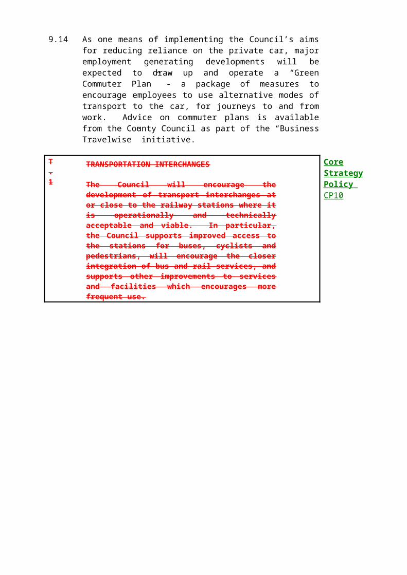
CLASS Cl (HOTELS AND HOSTELS)
TYPE PARKING REQUIREMENT
HOTELS AND MOTELS**
BEDROOMS 1 space per bedroom (including staff accommodation).
STAFF 1 space per manager plus 2 spaces per 3 employees minus the number of spaces provided for staff bedrooms.
RESTAURANT/DINING AREA 1 space per 5 sqm public floorspace
BAR AREA 1 space per 3 sqm public floorspace
CONFERENCE FACILITIES 1 space per 5 sqm public floorspace
COACHES 1 space per 100 bedrooms
EXHIBITION HALLS 1 space per 6 sqm public floorspace
The car parking standards for hotels are based on:-
1. a comparison of standards applying in all Hertfordshire districts and recently reviewed standards of other south east counties, especially those with high car ownership;
2. replies received from Hertfordshire local authorities to the consultation carried out on draft parking standards November 1992.
** For a hotel within zones A and B only a lower provision (to be determined according to each particular case) than that in this table will be permitted.

CLASS C2 (RESIDENTIAL INSTITUTIONS)TYPE PARKING REQUIREMENT
RESIDENTIAL INSTITUTIONS ANDRESIDENTIAL HOMES/HOSTELS WITH CARE STAFF ON PREMISES AT ALL TIMES(excluding Nursing Homes, Hospitals and Residential Schools, Colleges or Training Centres)
BEDSPACES 1 space per 5 resident bedspaces plus
STAFF 1 space per 2 staff (non-resident). Resident staff to be assessed at general needs housing standard.
ELDERLY PERSONS RESIDENTIALAND NURSING HOMES (CATEGORY 3)
RESIDENT BEDSPACES 0.25 including provision for non-resident staff, visitors and casual callers. Resident staff to be assessed at general needs housing standard.
EDUCATION - HALLS OF RESIDENCE
STAFF 1 space per 2 staff (or full time equivalent)
STUDENTS 1 space per 6 students
HOSPITALSBEDS 2 spaces per 3 beds
STAFF 1 space per 2 staff
ACCIDENT PROVISION minimum of 5 spaces plus 1 additional space for every (planned for) 5,000 attendance pa
OUTPATIENTS 5 spaces per suite
OFFICES 1 space per 25sqm
The car parking standards for Residential Institutions are based on:-1. a comparison of standards applying in all Hertfordshire districts and recently reviewed standards of other south east counties, especially those with high car ownership;2. replies received from Hertfordshire local authorities and other bodies associated with the Use Class to the consultation carried out on draft parking standards November 1992.

CLASS C3 (RESIDENTIAL)GENERAL NEEDSTYPE PARKING REQUIREMENT
TOTAL SPACES PER DWELLING
ASSIGNED SPACES UNASSIGNED SPACES
MINIMUM WITHIN CURTILAGE
Zone C A&B1 BEDROOM FLATS AND HOUSES
1.75 1.5 1 0 0.75 / 0.5
2 BEDROOM FLATS AND HOUSES
2 1.75 1 0 1 / 0.75
3 BEDROOM FLATS AND TERACCED HOUSES
2.25 2 2 0 0.25
3 BEDROOM SEMI & DETACHED HOUSES
2.25 2 0 2 0.25
4+ BEDROOM HOUSES
3 0 3 0

1.Total spaces per dwelling includes provision of 0.25 spaces per unit for visitors and casual parking.2.Assigned spaces are off-street parking spaces, allocated to individual dwellings, in the form of grouped garages; allocated grouped hardstandings; or garages or hardstandings within the curtilage of a dwelling and should be clearly marked for such a purpose.3.Unassigned spaces are parking spaces not allocated to any dwellings, but available for general public use, principally for visitors and casual callers. They should be clearly identified as available for such purposes and be located just off the carriageway but still part of the highway, or in small grouped parking areas.4.Maisonettes are to be treated in the same way as flats and assessed on the number of bedrooms accordingly. Bungalows are to be treated in the same way as flats and assessed on the number of bedroom and whether they are terraced, semi or detached dwellings.5.To arrive at an appropriate total requirement for a development, it will normally be necessary to consider each part of the layout separately, as recommended in paragraph 4.28 of Design Bulletin 32 – Residential Roads and Footpaths (HMSO – April 1992) To this end the above standards are to be applied to small groups of dwellings as follows:-
DWELLING TYPE GROUP SIZE
Flats - 16 DwellingsTerraced Houses - 8 DwellingsSemi & Detached Houses - 4 Dwellings
The car parking standards for general needs housing are based on:-1. a comparison of standards applying in all Hertfordshire Districts and recently reviewed
standards in other South East counties, particularly in areas of high car ownership;2. the Housing Research Foundation Report 1987 entitled : “Roads and Parking in Private
Sector Housing Schemes”.3. The principles outlined in Planning Policy Guidance Note (PPG13): Highway Considerations
in Development Control – and Design Bulletin 32 – Residential Roads and Footpaths – Second Edition – April1992;
4. Replies received from Hertfordshire local authorities and other bodies associated with the Use Class to the consultation carried out on draft parking standards November 1992.
ELDERLY PERSONS ACCOMMODATION
TYPE PARKING REQUIREMFNT
CATEGORY 1 – NO WARDEN CONTROL, 1 OR 2 BEDROOM*RETIREMENT DWELLINGS 1. For schemes close to shops and
services and within easy access to public transport:
1.0 (including visitor allocation)
2. For schemes not satisfying 1. above:-
1.5 (including 0.25 visitor space)
Retirement dwellings over 2 bedrooms and resident caretaker to be at general needs housing standard
CATEGORY 2 - WARDEN CONTROL, 1 OR 2 BEDROOM*
1. For schemes close to shops and services and within easy access to public transport:-
0.33 spaces per apartment (including visitor allocation)
2. For schemes not satisfying 1. above:-
0.75 (including 0.25 visitor space)
*Sheltered dwellings over 2 bedrooms and warden/resident staff to be at general needs housing standard
The car parking standards for elderly persons accommodation are based on:-
1. a comparison of standards applying in all Hertfordshire Districts and recently reviewed standards in other South East counties, particularly in areas of high car ownership;
2. the Housing Research Foundation Report 1987 entitled: Roads and Parking in Private Sector Housing Schemes Chapter 12 - Sheltered Housing;
3. the findings of the Hertfordshire Study of Elderly Persons Accommodation 1991;
4. replies received from Hertfordshire local authorities and other bodies associated with the Use Class to the consultation carried out on draft parking standards November 1992.

CLASS D1 (NON-RESIDENTIAL INSTITUTIONS)
TYPE ** PARKING REQUIREMENT
PUBLIC HALLS/PLACES OFASSEMBLY (NOT D2)
FLOORSPACE 1 space per 9 sqm or1 space per 3 fixed seats
STAFF 3 spaces per 4 members of staff.
COMMUNITY/FAMILY CENTRESFLOORSPACE 1 space per 9 sqmSTAFF 1 space per full~time member of staff or equivalent.
DAY CENTRES
OPTION 1 1 space per 2 members of staff plus 1 space
per 4 persons attending or
OPTION 2 1 space per 9 sqm
PLACES OF WORSHIP 1 space per 10 sqm
SURGERIES AND CLINICS(including doctors, dentists and vets)
CONSULTING ROOM 3 spaces per consulting roomSTAFF 1 space per employee other than consulting doctors
LIBRARIES 1 space per 30 sqm for free standing development (if not free standing than assessed on individual merits)
MISCELLANEOUS CULTURAL minimum 2 spaces plus 1 space per 30 sqmBUILDINGS public floorspace
EDUCATIONAL ESTABLISHMENTS(including residential)STAFF 1 space per full-time member of staff or equivalent based on maximum
use at any one time
VISITORS 1 space per 100 pupils/students
STUDENTS – SCHOOLS 1 space per 8 students over 17 years of age
STUDENTS - FURTHER EDUCATION 1 space per 5 full-time students
PARENTS (SCHOOLS) 1 space per 20 pupils under 17 years of age.

**For facilities within zones A and B only a lower provision (to be determined according to each particular case) than that in this table will be permitted (excepting surgeries / clinics)
The car parking standards for non-residential institutions are based on--
1. a comparison of standards applying in all Hertfordshire Districts and recently reviewed standards of other East counties, especially those with high car ownership
2. replies received from Hertfordshire local authorities to the consultation carried out on draft parking standards November 1992.

CLASS D2 (ASSEMBLY AND LEISURE)
TYPE ** PARKING REQUIRMENT
PLACES OF ENTERTAINMENTFLOORSPACE 1 space per 5 sqm floorspace STAFF 3 spaces per 4 employees
MULTI-SCREEN CINEMAS 1 space per 3 seats for free standing developments (if not free standing, then assessed on individual merits).
SWIMMING POOLS 1 space per 10sqmPUBLIC AREA 1 space per 2 staffSTAFF 2 spacesBUSES/COACHES 2 spaces
TENNIS COURTS 4 spaces per court
BADMINTON COURTS 4 spaces per court
SOUASH COURTS 3 spaces per court
TEN PIN BOWLING 4 spaces per lane
INDOOR BOWLING 4 spaces per rink
ICE RINKS 1 space per 12 sqm of rink
area
OUTDOOR SPORTS GROUNDS
FOOTBALL PITCIIES PROVIDED 20 spaces per pitch
NO FOOTBALL PITCHES PROVIDED 1 space per 2 people to use the playing area at
any one time (based on maximum potential usage.)
HEALTH CLUBS/GYMNASIA 1 space per 7 sqm useable space
GOLF18 HOLE COURSES 100 permanent spaces plus 50
overflow/occasional spaces
9 HOLE COURSES 60 permanent spaces plus 30 overflow/occasional spaces
DRIVING RANGES 1.5 spaces per tee

**For facilities within zones A and B only a lower provision (to be determined according to each particular case) than that in this table will be permitted.
The car parking standards for assembly and leisure are based on:-
1. a comparison of standards applying in all Hertfordshire Districts and recently reviewed standards of other South East counties, especially those with high car ownership rates;
2. the Eastern Council for Sport and Recreation's report "Sport in the East - A Strategy for the Nineties - The Future of Golf".
3. replies received from Hertfordshire local authorities and other bodies associated with the Use Class to the consultation carried out on draft parking standards November 1992.
SUI GENERIS
TYPE PARKING REQUIREMENT
HOSTELSSMALL (single parent or couple with no 3 spaces per 4 units children)FAMILY (two adults and two children) 1 space per unit
MOTOR TRADE RELATED
EMPLOYMENT 3 spaces per 4 employeesSHOWROON AND CAR SALES 1 space per 10 cars (2 spaces minimum)VEHICLE STORAGE 2 spaces per 1 showroom
space or provision at rate of 1/10 annual turnover
HIRE CARS 1 space per 2 hire cars based on site
CAR WASH/PETROL FILLING 3 waiting spaces per bay or run in to row of bays (additional parking is required where a shop is provided)
ANCILLARY VEHICLE STORAGE Minimum 3 spaces and in cases where the number is known to exceed 3, ¾ of the total must be provided
WORKSHOPS 3 spaces per bay (for waiting and finished vehicles) in addition to the actual repair bays
TYRE/EXHAUST CENTRES 2 spaces per bay
PARTS STORE/SALES 3 spaces for
customers
The car parking standards for the motor trade are based on:-1. a comparison of standards applying in all Hertfordshire Districts and recently
reviewed standards of other South East counties, especially those with high car ownership.
2. replies received from Hertfordshire local authorities and other bodies associated with the Use Class to 1 e consultation carried out on draft parking standards November 1992.

PARKING FOR DISABLED PEOPLE
TYPE PARKING REQUIREMENT
EMPLOYMENT GENERATINGDEVELOPMENT
UP TO 25 PARKING SPACES 2 disabled spaces
26 TO 50 PARKING SPACES 3 disabled spaces
51 TO 75 PARKING SPACES 4 disabled spaces
76 TO 100 PARKING SPACES 5 disabled spaces
THEREAFTER 1 disabled space for every 50 spaces or part thereof
SHOPS, BUILDINGS TO WHICH THE PUBLIC HAVE ACCESS AND PUBLIC CAR PARKS
UP TO 25 PARKING SPACES 3 disabled spaces
26 TO 50 PARKING SPACES 4 disabled spaces
51 TO 75 PARKING SPACES 5 disabled spaces
76 TO 100 PARKING SPACES 6 disabled spaces
THEREAFTER 3 disabled spaces for every 100 spaces of part thereof
HOTELS As for employment generating developments or 1 disabled space per room built to mobility standards
RESIDENTIAL
GENERAL 1 disabled space for every dwelling built to mobility standards
ELDERLY PERSONS DWELLINGS:-
UP TO 10 PARKING SPACES 3 disabled spacesTHEREAFTER 1 disabled space for every 4
spaces or part thereof

Parking for disabled people will be required in all zones (where space can be provided on the application site) as set out above and will be based upon the whole of the full demand (zone C.) non-disabled parking standard notwithstanding that part of the latter may take the form of commuted payments.
1. The provision of spaces for disabled people should be included in the total parking
requirement for a development rather than be additional to it. The car parking
standards for the use of disabled people are based on:-
1. A comparison of standards applying in all Hertfordshire Districts and recently reviewed standards of other South East counties, especially those with high car ownership
2. Replies received from Hertfordshire local authorities and other bodies associated with the Use Class to the consultation carried out on draft parking standards November 1992.
APPENDIX 4 – GLOSSARY
While every effort has been made to avoid the use of jargon and to explain technical terms where and when they are used, some terms will inevitably be unfamiliar to some users of this Local Plan. The glossary entries below provide explanation and definitions of these terms, but no definition provided here is intended to alter or add to information provided in the relevant Acts, Circulars and Orders.
Accessibility (“good access” to passenger transport, etc.) – the degree of convenience with which residents and other people in the District can reach a variety of local community facilities (see separate entry below), either directly on foot, or by using modes of transport other than the private car. Further information, including a definition of “good access” to passenger transport, is given in Chapter 1 (paragraph 1.6).
Affordable Housing – Any housing, for sale or rent or other form of tenure, which is intended to be available to those households who are not able to afford the equivalent property on the open market. Sometimes also referred to as “social housing”.
Article 4 Direction – A direction under Article 4 of the Town and Country Planning (General Permitted Development) Order 1995 whereby permitted development rights (see separate entry) may be withdrawn in relation to a particular area, with reference to one or more forms of development specified in the Order.
Backland – land (often garden land) surrounded by existing development or separated by it from the nearest highway. Backland development is development of this type of land and is often unsatisfactory because of difficulties of access and the effect on the character of the area, and adverse effects on the amenity of residents of the existing and new development.
Biodiversity – literally, the “variety of life” – biodiversity is a measure of the number of different ecologies, species, races, and individual animals and plants. Protecting biodiversity is a key element of sustainable development.
Building line – A line related (often parallel) to the carriageway alignment of the street, identified by the Council as the forward limit beyond which development will not normally be permitted.
Burgage plots – Building plots of ancient tenure often still traceable in more recent layouts through the location of boundaries within, for example, town and village centres.

Character – Often used in terms of landscapes, or historic buildings, Conservation Areas, or just with reference to the general locality. Primarily, the appearance of a place or area, having regard to those characteristics which make it identifiably different from other places or areas. However, other issues besides appearance can affect character – the perceptions of local people, traditional place names, a known history, physical patterns of development not readily identifiable “at street level” such as the pattern of burgage plots (see separate entry above). A place need not be specially designated or “Listed” in order to have a particular character.
Guidance on the process of landscape character assessment is available from the Countryside Agency, and Planning Policy Guidance refers to the need to pay attention to character in order to help accommodate change and development in ways which are “sustainable”. A useful reference may be “Landscape Character Assessment Guidance”, Countryside Agency and Scottish Natural Heritage, 1999.
Community Forest – An area of woodland enhancement and public access projects extending through much of southern Hertfordshire and adjacent areas.
Critical resources – Assets which once lost or damaged, cannot be replaced or compensated for. Usually natural in origin and form, such as wildlife sites and species, or air, water or soil resources, but also including historic buildings or archaeological remains.
Curtilage (residential, or of a Listed Building) – the precise definition of a curtilage is still open to debate, but for most purposes, it will be taken as the area of land that is ancillary to the primary use of a dwelling or other building. In many cases (particularly dwellings) the boundary of the curtilage is also the boundary of the planning unit, i.e. the garden or land associated with the dwelling. However, the curtilage does not necessarily include all land associated with a property through ownership, and it may not be physically enclosed by walls, hedgerows, etc. For further information, refer to the General Permitted Development Order 1995.
Dwelling – for the purposes of this Local Plan, any permanent residential unit (e.g. house, flat, bungalow, maisonette, permanent caravan, houseboat).
Evening economy – the range of uses operating in a town or local centre outside normal office and shopping hours, such as pubs, clubs, cinemas and restaurants, which in the right mix can ensure that a town centre remains lively and attractive throughout the day.
Infilling – Infill development means the filling of a small gap which, having regard to the width of neighbouring residential curtilages and the general character of the site and surrounding area, is capable of accommodating a single dwelling, pair of dwellings, or short terrace of dwellings in an otherwise built-up frontage. Infilling does not include demolition and redevelopment; development at the edge of a town or village which effectively extends the developed area; or development of open land opposite existing development.

Green Belt – a policy area forming a ring some 30 to 40 kilometres wide around London (and other major cities) designed to prevent urban sprawl and the merging of settlements. Three Rivers District lies entirely within the Green Belt – only existing urban areas are excluded.
Groundwater – underground water supply. Around London, groundwater is the main source of drinking water, pumped out of the chalk rock via boreholes. A finite natural resource which is at risk from pollution from surface sources.
General Permitted Development Order 1995 – The full title is “The Town and Country Planning (General Permitted Development) Order 1995”. An Order made by the Secretary of State for the Environment which grants planning permission for certain forms of development as prescribed in detail by the Order. See also Article 4 Directions.
Local community facilities – any use or facility that allows day-to-day life to carry on without residents, employees, etc. having to make special trips to inconveniently distant destinations, such as out-of-town superstores and leisure complexes. For the purposes of this Local Plan (for example, policy GEN.2) a range and mix of such uses should be on offer, including shops and other “High Street” services such as post offices and banks; health, leisure and entertainment facilities; passenger transport services; and educational institutions.
Local Nature Reserve – Land managed for the purpose of protecting flora and fauna. They are established by the local authority in consultation with English Nature and are subject to management plans.
Microcellular technology – A type of telecommunications apparatus designed to supplement signal coverage within urban areas. The antenna and associated equipment are extremely small and can be sited unobtrusively on and inside an existing building.
Modal shift – An expression of the aim to encourage car drivers to use alternative modes of transport; the amount of “shift” between modes can be measured and used to assess the effectiveness of policies.
Public Path Agreements – Arrangements entered into with private land owners allowing public footpaths and bridleways over private land, under s.25 of the Highways Act 1980.
Permitted development – See General Permitted Development Order 1995, above.
Planning Obligation – An agreement or obligation made between the Council and a developer or unilaterally, at the time of granting planning permission, made under the terms of Section 106 of the Town and Country Planning Act 1990.
Planning Briefs – Documents prepared by the Council to guide development on important sites.
Solar gain – the use of natural heat and light (either direct or as stored energy) to reduce the energy consumption of a building via the conventional mains supply.

Sustainable development – the most frequently used definition (from the Brundtland Commission) is given in the Introduction to the Local Plan (paragraph 0.15). An alternative, which specifically takes environmental issues into account, is “improving the quality of life while living within the carrying capacity of supporting ecosystems”. Perceptions of what sustainable development actually involves vary, but the SERPLAN Sustainability Panel has drawn up five general principles:
Environment: take the true environmental costs of any human activity into full account.
Futurity: take the effects of human activity on future generations into account.
Development: not just physical development, but promoting change, improvement, and progression.
Social equity: ensuring that access to and control over resources and opportunities is more fairly distributed within and between communities.
Participation: helping people to share in the decision-making process about the objectives of development, and the means of achieving them.(Source: adapted from “Sustainability Principles”, a report by the SERPLAN Sustainability Panel, (RPC 2867R), 13 December 1995).
Tandem development – a form of backland development (see separate entry), usually consisting of one house being erected directly behind another and sharing the same access to the highway. Usually unsatisfactory because of the difficulties of access to the house at the rear and the disturbance and lack of privacy experienced by the front house.

Teleworking – the concept of the “office in the home”, allowing people to conduct business almost anywhere using modern telecommunications technology such as mobile phones, lap-top computers and e-mail. Has the potential to reduce the need to travel to work.
Use Class – A type of land use which falls into one of the classes and sub-classes set down in the Use Classes Order 1987. Changes between classes usually require planning permission. The Use Classes are denoted by letters: retail = A, employment = B, etc. Subclasses are numbered: A1 = shops, A2 = banks, building societies etc, A3 = restaurants, pubs, bars, etc.
Scheduled Ancient Monument – A monument or site of great archaeological significance which is protected under the Ancient Monuments and Archaeological Areas Act 1979.
Vitality and viability – Used with reference to town and local centres, a subjective or qualitative measure of the prosperity and “life” which a place enjoys. Takes into account issues such as the range of services (different types and range of opening hours), pedestrian flows, rent levels, customer perceptions, amount of vacant floorspace. A key feature of the Government advice in PPG6 (town centres and retail developments).
Wildlife Site – a non-statutory designation for sites of substantive nature conservation, geological or geomorphological value, as identified in the “Habitat Survey for Three Rivers” carried out by the Herts and Middlesex Wildlife Trust and the Herts Biological Records Centre and published in 1997.
520

APPENDIX 5 - REFERENCES AND BIBLIOGRAPHY
Note - This appendix covers only the principal documents referred to in the maintext.
1. Acts of Parliament
1979 - Ancient Monuments and Archaeological Areas Act
1981 - Wildlife and Countryside Act as amended 1985
1990 - Town and Country Planning Act
1990 - Planning (Listed Buildings and Conservation Areas) Act
1990 - Planning (Consequential Provisions) Act
1991 - Planning and Compensation Act
1992 - Transport and Works Act
1992 - Protection of Badgers Act
1995 - Environment Act
2. Supplementary Statutory Instruments, Circulars Etc

1984 - Crown Land and Crown Development. (Circular 18/84)
1987 - Town and Country Planning (Use Classes) Order (As amended)
1991 - Building Regulations (As amended)
1992 - Publicity for Planning Applications (Circular 15/92)
1995 - Town and Country Planning (General Permitted Development) Order
1995 - Town and Country Planning (General Development Procedures) Order
1996 - Planning and Affordable Housing (Circular 13/96) (Note - A draft revisedCircular was issued in July 1997)
1997 - Hedgerow Regulations
3, Planning Policy Guidance Notes (PPGS)
21 PPGs have been issued by the DOE. They are all available for consultation at the Council's Department of Planning and Leisure. In the text the PPGS are referred to with the subject stated in brackets - e.g. PPG2 (Green Belts).
4. Other Government Policy Guidance
The main documents issued by the DOE and referred to are:
1992 - Residential Road and Footpaths - layout considerations. Design Bulletin 32, 2nd Edition DOE/DOT
1993 - Environmental Appraisal of Development Plans. A Good Practice Guide
1994 - Regional Planning Guidance for the South East. (RPG9)
1994 - Quality in Town and Country
1994 - Gypsy Sites and Planning (Circular 18/94)
1995 - Rural England
1995 - Planning Controls over Demolition (Circular 10/95) 1996 - Transport - The Way
Forward1996 - Planning and Affordable Housing (Circular 13/96). (Note - A draft revised version was issued in 1997)
1996 - Household Growth - Where Shall We Live? 1997 - Developing an Integrated
Transport Policy.
5. Hertfordshire County Council Documents

1995 - South West Hertfordshire Transportation Study. (Published jointly withThree Rivers District Council, Watford Borough Council and Hertsmere DistrictCouncil)
1996 - Hertfordshire Structure Plan Review 1991-2011. Deposit Version. (Note The final version of the Structure Plan should be available in 1998).
1996 - Landscape Strategy for Hertfordshire
1996 - Roads in Hertfordshire - A Design Guide1997 - Hertfordshire Structure Plan Review 1991 - 201 1. Examination in Public (EIP). Report of the Panel.1997 - Hertfordshire's Transport Policies and Programmes 1998/99 (TPP).1998 - Hertfordshire County Council Passenger Transport Policies
Hertfordshire County Council has issued many other documents relevant to the planning process. In particular, detailed information about demography, employment, and industry is available from the Information Section of the County Environment Department.
6. Three Rivers District Council Documents
1993 - Three Rivers District Plan Review. 1991.
1994 - Cycle Strategy for Three Rivers District
1995 - Leisure Strategy for Three Rivers District
1996 - District Trends. (This information document is republished annually).
1996 - Tree Plan1997 - Housing Land and Needs in Three Rivers District 1996 - 201 1.
1997 - Economic Development Strategy for Three Rivers District
1997 - Three Rivers Local Plan - Report of Appraisal
Note - The District Council has issued many other relevant documents all of which are available from the Council. These include Conservation Area Appraisals, leaflets on policy and grants regarding historic buildings and Conservation Areas, economic planning documents, advice on assorted arboricultural matters, approved Planning Briefs, Supplementary Planning Guidance, and leaflets about footpaths, design of shop fronts, the M25 motorway, cycle paths, and the Croxley Rail Link.
7. Other Principal Publications Cited
"Designing for Accessibility". Published by Centre for Accessible Environments, 60 Gainsford Street, London SEI 2NY. 1994
"National Cycle Network". Published by SUSTRANS. 1995.

"Register of Parks and Gardens of Special Historic Interest in England". Published by English Heritage.
"Sustainable Settlements - A Guide for Planners, Designers and Developers".Published by the Local Government Management Board. 1995