Embed Size (px)
Citation preview
INTRODUCTION
The purpose of this report is to describe Phase I and II
archaeological investigations of the proposed Route 7 North
corridor The project drea is located in northern New Castle
County Delaware (Figure 1) and includes approximately 53
mi 1 e s 0 f rig h t 0 f d a (F i 9 u r e 2) The field work and report
preparation took place between October 1984 and November 1985
The survey worK was undertaken by the University of Delaware
Center for Archaeological Research for the Delaware Department of
Transportation and the Federal Highway Administration under
section 106 of the National Historic Preservation Act to evaluate
the effects of the proposed relocation of Delaware Route 7 on
significant or potentially significant cultural resources as
defined by the National Register of Historic Places (36 CFR 60)
The built environment ot standing structures is not considered in
this report
Appreciation for their help information interest and
support is extended to all of the residents of Limestone Road
Special thanks and recognition is offered to the following
residents
Merritt K Armor Lewis Colmery Sr Lewis Colmery Jr Iva M Dennison Joseph Eastburn Sara Pennington Evans Alexander Jarnell Mr and Mrs Jeffery Kane Marvin Klair Joseph R Lake Mr and Mrs Thomas R McVaugh Edward A Naudain Warner Naudain Mrs Gifford A Nowland
1
Appreciation for their support administration research and
services is also extended to all the involved individuals
Division of Highways Raymond M Harbeson Jr Asst Director Preconstruction Joseph T Wutka Jr Location Studies and Environmental
Engineer Kevin W Cunningham DelDOT Archaeologist Nicholas S Blendy Environmental Planner Hugo Dreibelbis Project Engineer Carol L Kates Secretary Cecilia M Long Project Scheduling and Support
Federal Highway Administration A George Ostensen Field Operations Engineer Michael J Otto Area Engineer
Bureau of Archaeology and Historic Preservation Daniel R Griffith Bureau Chief Faye L Stocum Archaeologist Alice H Guerrant Archaeologist Steve Delsordo Historian
University of Delaware Juan Villamarin Chairman Department of Anthropology James Pizzuto Assistant Professor Department of Geology
Division of Graphics and Printing Ray Moore Shop Supervisor William Yerkes Pressman John Bordley Pressman Dorothy Hutchins Machine Person Charles Pritchard Pressman Joan Pillsbury Bindary Clerk Bob Farley Pressman Grace Steele Graphics Spec Jeff Faulkner Pressman
Hockessin Public Library Sharon Hall Librarian
Overviews of the regional environmental setting of the
project area and the regional prehistory and history are
presented below
Environmental Setting
The Route 7 North project area is located in the Delaware
Piedmont Uplands The summary of the local environmental setting
presented below is abstracted from the work of Custer (198423shy
25) and Custer and DeSantis (1985a)
2
The Piedmont Uplands of Delaware represent the northernmost
portion of the Delmarva Peninsula and are characterized by a
diversified relief dissected by narrow and deep stream valleys
with isolated knolls rising above the general upland level
(Spoljaric 19673) Thornbury (196588) notes that within the
Piedmont Uplands there are no large tributaries of the older
incised river systems the Susquehanna and the Delaware Rather
there are a number of smaller lower order drainage systems
Some large floodplains can be found along some of the higher
order streams such as the White Clay Creek and the Brandywine
Elk and Northeast Rivers However these settings are uncommon
Elevation differences of up to 82 meters (270 feet) can be found
between small floodplains of the numerous drainages and the tops
of the adjacent knolls and these elevation differences are
sufficient to cause changes in tree community distribution (Braun
1967192-194) Soils of the Piedmont Uplands can generally be
characterized as well-drained with some poorly-drained areas in
floodplains and upland flats
The Route 7 project area represents a transect of the
Piedmont Uplands running north from the Fall Line Figure 3
shows a cross-section of the study area topography For the most
part the study area consists of rolling hills and ephemeral
stream channels The study area also crosses the larger Mill
Creek drainage in two places including a floodplain location
along the lower reaches near its Fall Line confluence with the
White Clay Creek and a section of its headwaters in the Hockessin
Valley The Hockessin Valley is especially interesting because
it is an isolated yet extensive limestone valley with
4
~
NORTH SOUTH (fall line)
PA State Line Mlltown Road
Hockessin Valey Mill Creek
middot_~-- ____bull~ w_bullbull _____
environments which contri~ J(arledly with the surrounding
Piedmont Uplands (Custer cnd lE5irLS 1985a) Analysis of pollen
d a t a fro m the are a (C u s t eran d G r l f fit h 1 9 8 4) and 1 0 cal e d a phi c
factors allows the reconstruction of changing past environments
and these environments are summarIzed in Table 1 As can be seen
from Table 1 th rol1Ji u lt)y rphy of the Piedmont Uplands
allows for a wide VJi ~middot ()j =i1vironments through time
Furthermore the nearbY~iiL LL -one which is the transition
to the Coastal Plain and Lhc ~ddl marshes of the lower White
Clay Creek (Custer 1982) 1tid La lhe local environmental
diversity This high envir0nment~i diversity made the study area
desirable for human hdLiLatlon for both prehistoric and
histor ic groups
TABLE 1
PAST ENVIRORllEIITS OF lBE STUDY AREA
Cliaatic Episode Uplands Lowlands
Late Glacial PineSpruce forest Deciduous forests with (10000 BC - 8000 BC) interspersed swamps
and grasslands
Pre-BorealBoreal SprucePine Forest Mixed deciduous and (8000 BC - 6500 BC) coniferous forests
Atlantic Oak-Hemlock Forest Oak-Hemlock forest (6500 BC - 3000 BC) with many swampy
areas
Sub-Boreal Oak-Hickory Forest Grasslands with (3000 BC - 1000 BC) interspersed oakshy
hickory forests and a few poorly-drained areas
Sub-Atlantic (1000 BC - Present) Mixed Mesophytic Interspersed mixed
Forest deciduous forest (Oak-Chestnut) swampy areas and a
few grasslands
Regional Prehistory
The prehistoric archaeological record of northern New Castle
County area can be divided into four blocks of time The Paleoshy
Indian Period (ca 12000 BC - 6500 BC) The Archaic Period
(6500 BC - 3000 BC) the Woodland I Period (3000 BC - AD
1000) and the Woodland II Period (AD 1000 - AD 1650) A
fifth time period the Contact Period may also be considered and
includes the time period from AD 1650 to AD 1750 the
approximate date of the final Indian habitation of northern
Delaware in anything resembling their pre-European Contact form
Each of these periods is described below and the descriptions are
summarized from Custer (1984) and Custer and DeSantis (1985a)
6
Paleo-Indian Period 1200 BC -shy 6500 BC) - The Paleoshy
Indian Period encompasJci3 Dmiddotmiddot tn(~ period of the final
disappearance of Pleistocene ~l~Claj conditions from Eastern
North America and the establishment of more modern Holocene
environments The disti tclive feature 0f the Paleo-Indian Period
is an adaptation to thp ~8]d a~J alternately wet and dry
conditions at the end of rhe Plelstoctne and the beginning of the
Holocene This adaptati0n was primarily based on hunting and
gathering with hunt~ng providing a large portion of the diet
Hunted animals may have included now extinct megafauna and moose
A mosaic of deciduous boreal and grassland environments would
have provided a large number of pr~ductive habitats for these
game animals throughout northern Delaware and watering areas
such as the Mill Creek floodplain and the Hockessin Valley swamps
in the study area would have been particularly good hunting
settings
Tool kits of Paleo-lndiRD qroups were oriented toward the
procurement and processirq of hunted animal resources A
preference for high quality lithic materials has been noted and
careful resharpening and maintenance of tools was common A
lifestyle of movement among the game attractive environments has
been hypothesized with the social organizations being based upon
single and multiple family bands Throughout the 5500 year time
span of the period the basic settlement structure remained
relatively constant with some modifications being seen as
Holocene environments appeared at the end of the Paleo-Indian
Period
7
Numerous Paleo-Indian sites are noted for northern Delaware
including hunting and processing sites adjacent to the study area
near Hockessin (Custer and DeSantis 1985b) and adjacent to the
Wilmington Medical Center (Custer Catts and Bachman 1982)
possible quarry sites near Iron Hill and isolated point finds
Archaic Period (6500 BC - 3000 BC) - The Archaic Period
is characterized by a series of adaptations to the newly emerged
full Holocene environments These environments differed from
earlier ones and were dominated by mesic forests of oak and
hemlock A reduction in open grasslands in the face of warm and
wet conditions caused the extinction of many of the grazing
animals hunted during Paleo-Indian times however browsing
species such as deer flourished Sea level rise was also
associated with the beginning of the Holocene Period in northern
Delaware The major effect of the sea level rise was to raise
the local water table which helped to create a number of large
swamps such as Churchmans Marsh which is located approximately
5km south of the study area Adaptations changed from the
hunting focus of the Paleo-Indians to a more generalized foraging
pattern in which plant food resources would have played a more
important role Large swamp settings such as Churchmans Marsh
supported large base camps as indicated by the remains at the
Clyde Farm Site A number of small procurement sites at
favorable hunting and gathering locales are also known in
northern Delaware
Tool kits were more generalized than earlier Paleo-Indian
tool kits and showed a wider array of plant processing tools such
as grinding stones mortars and pestles A mobile lifestyle was
8
probably common with a wide range of resources and settings
utilized on a seasonal basis A shifting band-level organization
which saw the waxing and waning of group sizE in relation to
resource availability is evident
Woodland I Period (3000 BC - AD 1000) - The Woodland I
Period can be correlated with a dramatic change in local climates
and environments that seems to have been a part of events
occurring throughout the Middle Atlantic region A pronounced
warm and dry period set in and lasted from ca 3000 BC to 1000
BC Mesic forests were replaced by xeric forests of oak and
hickory and grasslands again became common Some interior
streams dried up but the overall effect of the environmental
changes was an alteration of the environment not a degradation
Continued sea level rise also made many areas of the Delaware
River and Bay shore the sites of large brackish water marshes
which were especially high in productivity The major changes in
environment and resource distributions caused a radical shift in
adaptations for prehistoric groups Important areas for
settlements included the major river floodplains and estuarine
swampmarsh areas Large base camps with fairly large numbers of
people are evident in many areas of northern New Castle County
such as the Delaware Park Site the Clyde Farm Site the Crane
Hook Site and the Naamans Creek Site These sites supported
many more people than previous base camp sites and may have been
occupied on nearly a year-round basis The overall tendency was
toward a more sedentary lifestyle
Woodland I tool kits show some minor variations as well as
some major additions from previous Archaic tool kits Plant
9
processing tools became increasingly common and seem to indicate
an intensive harvesting of wild plant foods that may have
approached the efficiency of horticulture by the end of the
Woodland I Period Chipped stone tools changed little from the
preceding Archaic Period however more broad-bladed knife-like
processing tools became prevalent Also the presence of a
number of non-local lithic raw materials indicates that trade and
exchange systems with other groups were beginning to develop
The addition of stone and then ceramic containers is also seen
These items allowed more efficient cooking of certain types of
food and may also have functioned as storage for surplus food
resources Storage pits and house features during this period
are also known from the Delaware Park Site and the Clyde Farm
Site Social organizations also seem to have undergone radical
changes during this period With the onset of relatively
sedentary lifestyles and intensified food production which might
have produced occasional surpluses incipient ranked societies
may have begun to develop as indicated by the presence of
extensive trade and exchange and some caching of special artifact
forms By the end of the Woodland I Period a relatively
sedentary lifestyle existed in northern Delaware
Woodland II Period (AD 1000 - AD 1650) - In many areas
of the Middle Atlantic the Woodland II Period is marked by the
appearance of agricultural food production systems however
settlements of the Woodland I Period especially the large base
camps were also occupied during the Woodland II Period and very
few changes in basic lifestyles and artifact assemblages are
10
evident (Stewart Hummer and Custer 1986) Intensive plant
utilization and hunting remained the major subsistence activities
up to European Contact Similarly no major changes are seen in
social organization for the Woodland II Period of northern
Delaware
Contact Period (AD 1650 - AD 1750) - The Contact Period
is an enigmatic period of the archaeological record of northern
Delaware which began with the arrival of the first substantial
numbers of Europeans in Delaware The time period is enigmatic
because few Native American archaeological sites that clearly
date to this period have yet been discovered in Delaware
although numerous Contact Period sites are evident in
southeastern Pennsylvania It seems clear that Native American
groups of Delaware did not paricipate in much interaction with
Europeans and were under the virtual domination of the
Susquehannock Indians of southern Lancaster County Pennsylvania
The Contact Period ended with the virtual extinction of Native
American lifeways in the Middle Atlantic area except for a few remnant groups
Sites from all time periods are expected to occur within the
Route 7 North study area The lower elevation Mill Creek
floodplain and Hockessin Lowlands are likely locations for base
camps of all time periods However earlier research (Custer
1980) has shown that some Piedmont floodplains are heavily
scoured by natural erosion and such erosion may have destroyed
any sites in the Mill Creek floodplain Procurement sites from
all time periods are expected on all upland slopes and knolls
within the project area Although the study area is located in a
11
section of Delaware with a high to medium potential for
significant prehistoric archaeological sites (Custer 1983Fig
41) not all of the sites expected to be found in the study area
are likely to be significant to warrant listing in the National
Register of Historic Places Procurement sites located on upland
slopes would be significant onl~ if they are unplowed even
though the study area is subjected to a high degree of
development pressure (Custer and DeSantis 1985bFigs 26 and 27)
Any buried or intact sites found in the Mill Creek floodplain or
the Hockessin Lowlands may be significant because such sites are
rare in the Piedmont Uplands (Custer and Wallace 1982 Custer and
DeSantis 1985b Figs 24 and 25) The high development pressure
wi thin the Route 7 Cor r idor only enhances the importance of any
floodplain or lowland sites
Regional History
The following regional history is abstracted from two
previous DelDOT reports (Coleman et al 1984 Coleman et al
1985) Other sources consulted for this project are found in the
attached bibliography More detailed histories of specific
sites and segments of the Limestone Road area are contained in
the discussion of each project area segment (Figure 2)
The first historic settlement in what is now Delaware was
a whaling station established by the Dutch West India Company in
1630 near the presellt town of Lewes However this post was
destroyed by Indians in 1631 and no settlement in that area was
attempted again until 1659 A Swedish colony was established in
1638 at Fort Christina near the present site of Wilmington by the
12
New Sweden Company Although the land was claimed by the Dutch
it was little used and was unsettled when the Swedes arrived By
1654 a small village Christinahamm existed behind the fort and
approximately 400 Swedish Finnish and Dutch settlers resided in
the area
In 1655 the uneasy coexistence between the Swedes and Dutch
was abruptly ended when the Dutch seized control of New Sweden
Dutch Fort Casimir established in 1651 and the town of New
Amstel (modern New Castle) became the economic and commercial
center for the lower Delaware Valley Ownership of the Delaware
region changed hands again in 1664 when the English took control
of all Dutch possessions in the New World In 1682 the granting
of proprietary rights to William Penn and his representatives
gave economic and political control of the Delaware region to
Philadelphia the new seat of government (Munroe 1978)
The settlement pattern for this early period was one of
dispersed farmsteads located along the Delaware and its
tributaries such as the Christina Appoquinimink Brandywine
Mill Creek White Clay and Red Clay Creeks where the land
possessed good agricultural qualities The Swedish and Dutch
settlers had pushed their settlement far up the valley of the
Christina toward the Elk River The town of Christina Bridge
(modern Christiana) so named because it was the crossing place
of that river was established by about 1660 at the head of
navigation of the Christina
With the arrival of Penn in the 1680s settlers pursued an
individualistic system of land settlement with the proprietors
granting tracts or parcels of land Penn usually granted land to
13
families the standard size being about 500 acres In the study
area between the confluences of Mill Creek and Balls Run
extending northward property sizes at the end of the seventeenth
century ranged between 100 and 700 acres but there were also
nearby tracts of over 1000 acres These large grants belonged to
land speculation companies such as the London Company or to the
friends and relatives of the Proprietors such as Letitia Penns
Manor of Stenning Based on contemporary deeds land warrants
and surveys there were only about a dozen land owners in the
study area at the turn of the eighteenth century
By 1683 the cultivated areas of the region consisted of the
three lower counties New Castle Kent and Sussex and three
Pennsylvania counties Philadelphia Buckingham (Bucks) and
Chester The total population of all six of these counties in
1683 has been estimated to have been about four thousand people
In New Castle County five tax districts called Hundreds had
already been established by 1687 With the growth of the
population four more hundreds were created in 1710 with Mill
Creek Hundred which includes the study area being one of these
(Conrad 1908287)
With the exception of the port towns of Philadelphia and New
Castle there were no other major commercial or social centers in
the area during the seventeenth century The small hamlets that
were established were situated on the major transportation routes
of the period almost always on a navigable watercourse Few
were located inland for the road network was almost nonexistent
An exception to this was nOgles Town- which was located along
14
the road to the Elk River as early as 1679 The villages of
Christina Bridge and Cantwells Bridge (present-day Odessa) were
the only hamlets of any size in the area and both were located on
major rivers and roads
In the New Castle County region water transportation was
the major mode of travel and commerce in the late seventeenth
century Most of the farmstead tracts and land grants had
frontage on a water course to ensure that communication and the
moving of produce to local markets could be accomplished
(Hoffecker 1977) In a country that was heavily wooded with a
mixture of oaks walnut hickory chestnut and maple water
travel was the easiest safest and most effective means of
transport Overland travel was extremely difficult because
roads were few in number and very poor Even the road from New
Castle to Christina Bridge probably the areas major overland
transportation route was in horrible condition A 1702 survey
map of the study area has no indication of the location of
Limestone Road Generally the roads in the area were simply
intra-regional connectors to the coastal towns
Swedish settlers in the region grew rye and barley on their
farms but later immigrants quickly replaced these grains with
wheat when it was found that it could be grown more easily More
importantly it was realized that wheat was a marketable
commodity and the farmers and settlers in the area soon shifted
from a subsistence-oriented to market-oriented agriculture
Wheat and to a lesser extent corn were grown and then shipped
by water to local milling sites The transportation of grains to
milling sites supported an extensive coastwide trade employing
15
shallops or other similar boats Milling sites were among the
earliest manufacturing complexes in the region There was a mill
in New Castle by 1658 and one on Red Clay Creek by 1679 (Purcell
1958) Villages such as Christiana Bridge Newport and
Appoquinimink grew larger as a result of this shipping trade and
became market places for the surrounding country By the start
of the eighteenth century the region was beginning to be
recognized as a wheat and grain producing area
Unsuccessful attempts at the mining and smelting of iron ore
were tried in the Delaware region during the seventeenth century
In Delaware the Iron Hill area in western Pencader Hundred was
an area known to contain iron deposits by 1673 the date of
pUblication of Augustine Hermanns map which labels the spot
RYron hill Rbull The manufacture of iron became more widespread with
the start of the eighteenth century By 1716 iron production
was well established in Pennsylvania In Delaware Sir William
Keith had started a blast furnace on the slopes of Iron Hill by
1725 and a bloomary furnace was known to be in operation near
St James Church in Mill Creek Hundred operated by John Ball
(Swank 1884 142 179) From documentary sources it appears
that Ball purchased the land in 1706 and erected the bloomary
soon thereafter Deed records indicate that he was a blacksmith
by trade
Mill Creek Hundred and New Castle County were part of a
broader regional economy that was centered in Philadelphia This
city in the last quarter of the seventeenth century quickly
began to dominate the economic scene in the lower Delaware
16
Valley New Castle County was part of Philadelphias
agricultural and commercial hinterland along with western New
Jersey northeast Maryland southeastern and northeastLrn
Pennsylvania and Kent and Sussex Counties in Delaware Farmers
in the region sent their grains to the local milling centers
where the wheat flour was then shipped to Philadelphia for export
to the West Indies other North American colonies and southern
European countries The farmers in New Castle County quickly
adapted to this market system of agriculture and it is estimated
that over one-half of the farmers in the area were situated
within eight miles (or a half-days journey) of a mill or
shipping wharf (Walzer 1972163)
Settlement in New Castle County during the 18th century
continued much as it had in the previous century In the
Philadelphia region there was a large influx of immigrants
between 1725 and 1755 particularly Scotch-Irish most of whom
were indentured servants As the transportation network
improved colonists began to move inland away from the navigable
rivers and streams Good productive land was settled first but
as the population began to grow marginal property was also
occupied The size of farms in New Castle County ranged between
100 and 200 acres indicating a decline in size from the
seventeenth century This was due to a tendency for the large
grants and tracts to be divided and subdivided by sale and
inheritance (Munroe 195419) By mid-century improved land
along Limestone Road was selling for a little over one
Pennsylvania pound per acre In the study area settlement began
in earnest in the first quarter of the eighteenth century Deed
17
records become more common during this period and several extant
houses in the vicinity of Limestone Road were constructed at this
time The Simon Hadley house (1717) located near the Chester
County line and the Mermaid Tavern (1720s) both contain
sections that date to this period The Armor house which also
dates to the 1720s was probably erected by the blacksmith noted
above John Ball
In regards to urbanization Lemon (1967 1972) has divided
the eighteenth century in the Philadelphia region into three
periods of growth The first period (1700 to 1729) was one of
urban stagnancy after the initial rapid growth of the seventeenth
century However hamlets - unplanned towns that sprang up at
crossroads and around taverns ferries churches and mills - did
begin to appear at this time Ogletown in White Clay Creek
Hundred and the Mermaid - Stoney Batter Road intersection on
Limestone Road are examples of eighteenth century hamlets in New
Castle County Both were located at crossroads on major
transportation routes The second period of urbanization that
Lemon recognizes (1730 to 1765) saw a renewal of town growth
based on internal trade Towns such as Newport Cuckholdstown
(modern Stanton) Milltown Hockessin (then known as ftOckesson ft )
and Newark were established and prospered during this period
Christina Bridge which had stagnated since the 1680s saw
growth and prosperity as a major grain trans-shipment port for
produce coming from the Upper Chesapeake Bay area
The town of Stanton known as Cuckoldstown as early as 1746
became an important milling and grain center in the late
18
eighteenth century A grist mill is known to have been in the
vicinty of Stanton by 1679 and by 1800 the town rivaled Newport
as a local grain processing center Ships of moderate draft were
able to navigate up the Red Clay Creek and take on local as well
as southeastern Pennsylvania farm produce most of which had been
transported overland down the Limestone Road Located at the
confluence of Red and White Clay Creeks Stanton was never a
large town A map of the New Castle County region drawn in
1777 did not include the location of Stanton and a travelers
guide published in 1789 showed only a mill and ten houses in
the vicinty of the town (Colles 1961170) Hockessin or
Ockesson grew around the location of the Hockessin Friends
Meeting House constructed in 1738 Nearby were a school and a
blacksmith shop the only structures in the hamlet until the
1820s
Wilmington was by far the largest urban center in New Castle
County that developed in this period Chartered in 1739
Wilmington soon became a port of entry and a post town and was
an important link in the Philadelphia trading network Of
special significance to the citys location was its proximity to
the Brandywine Mills Wilmington was thus a receiving center for
local and regional farm produce brought by water from Christina
Stanton and Newport and shipped up the Delaware to Philadelphia
(Lindstrom 1978 Wa 1 zer 1972)
Lemons third period of urban development (1766-1800) was
marked by less noticeable town growth which paralleled more
erratic economic patterns Little growth in the towns of New
Castle County took place during this period However increases
19
in population and land tenancy were noted (Lemon 1972216)
The conditions of roads in New Castle County improved
considerably over the course of the eighteenth century but in
some locations they were unsatisfactory even by contemporary
standards Most improvement was due to both population growth
and interregional trade By 1750 the roadbeds of many of the
areas present-day state roads (Routes 4 7and 273 portions of
Pennsylvanias Route 896) were already established Prior to the
Revolutionary War there were probably four main thoroughfares in
the study area The Old Wilmington Road the road from Ockesson
Meeting House to Cuckoldstown (established in the 1730s) the
Kemblesv ille Road running from Chester County to Corner Ketch
and the Limestone Road All sources consulted agreed that
Limestone Road was never formally laid out by either the New
Castle County or Chester County legislatures at least the Court
records that would have established the road do not exist (Futhey
and Cope 1881354 Cooch 1936 80 Ward 1968 l14) Throughout
the eighteenth century the road was known by a number of
different titles -- -the Newport Road- -the Great Limestone
Road- -the Limerock Road- and -the Road from Stanton to
Lancaster- -- but by the beginning of the nineteenth century it
was known as the Limestone Road
The first reference to the road by name that research for
this project was able to locate dated to 1726 when it was called
the -Limekiln Road- Limestone was used as a flux in eighteenth
century blast furnaces a large number of which were in operation
in Chester County by the second decade of the eighteenth century
20
(Swank 1884142) By about this same time as noted previously
Sir William Keith had established an iron furnace at Iron Hill
(Heite 1983155) The use of limestone as a fertilizer was not
yet realized in the eighteenth century
Based on these dates and events and the known influx of
colonists to the area which resulted in the formation of Mill
Creek Hundred in 1710 it is probablE~ that the Limestone Road was
initially laid out in the first quarter of the eighteenth
century In addition to its use as a major agricultural produce
transportation route extending from the Pennsylvania farmlands
to the transhipment centers on the streams the road may also
have functioned as a overland route for the transport of burned
and unburned limestone which was quarried in the vicinty It is
conceivable that the roads major orientation was from south to
north or from the limestone quarries to the Chester County
furnaces and not southwards towards the navigable streams
The roadbed of the Limestone Road followed a course of easy
grades and few fording places the deepest being at Mill Creek
just north of Milltown This crossing was bridged in 1836
Throughout the eighteenth and nineteenth centuries the road was
utilized by teamsters because of its easy grades and because
unlike the Newport and Gap Turnpike located to the east it was
not a toll road
Farming in the eighteenth century in New Castle County
continued to be a system of mixed husbandry combining the
cultivation of grains with the raising of livestock Farming was
the most important occupation for between 80 and 90 percent of
the areas population (Egnal 1975) Wheat remained as the
21
primary grain produced followed by rye corn barley oats and
garden vegetables In many areas generations of repeated
tillage had begun to exhaust the soil Agricultural practices in
New Castle County followed an extensive rather than an
intensive use of the land (Lemon 1972179)
Delawares manufacturing capacity in this century began to
become realized During the 18th century the iron industry
lumber products and grain milling enterprises continued to grow
and prosper New industries were started that engaged in the
preparation of snuff from tobacco the production of salt from
brines in lower Delaware and the rudimentary beginnings of the
textile industry By the end of the century Delaware was one of
the leading manufacturing states and Wilmington and its environs
constituted one of Americas leading industrial areas
In the northern Delaware area the nineteenth century was
marked by rapid industrial and urban growth and population
expansion and was accompanied by a noticeable decline in the
number of people engaged in agriculture The rapid growth of the
population dur ing the ear ly decades of the century forced many
new farmers in the Middle Atlantic area to clear and farm lands
of poor or marginal quality Many of these farmers were hard
pressed to turn a profit from their farmsteads and this resulted
in an outmigration of a large portion of the population during
the l820s and l830s CO better lands to the west particularly in
the Ohio River Valley (Hancock 1947) The loss of jobs related
to agriculture was partly offset by the development of new
sources of income and employment particularly in urban and
22
industrial contexts Thus much of the surplus population that
had in previous centuries been farm laborers tenants or
unemployed moved into urban and industrial centers where jobs
were more plentiful These trends occurred over the first half
of the nineteenth century and by 1860 were well established
(Lindstr om 1979)
Urbanization in New Castle County during the first quarter
of the century was closely tied to transportation routes and
agricultural and industrial production However most of the
towns of importance in the eighteenth century which were settled
because of their location on major transportation arteries
remained major marketing milling and shipping centers for only a
brief period into the nineteenth century
In the first half of the nineteenth century methods and
routes of transportation underwent substantial changes in New
Castle County as first turnpikes then canals and finally
railroads were introduced Throughout the century improved
transportation was the key to urban agricultural and industrial
development The first successful turnpike in Delaware and the
one that is most important to the history and development of the
study area was the Newport and Gap Turnpike begun in 1808
Although the pike was a more direct route to the wharves of
Newport it was a toll road had numerous grades and crossed
several watercourses all of which made the Limestone Road an
important and well-traveled transportation route for teamsters
throughout most the nineteenth century By 1820 Mill Creek
Hundred had 745 miles of roads rating it number two out of the
23
nine hundreds in the County second only to Appoquinimink Hundred
(Figure 4)
The most significant canal built in Delaware was the
Chesapeake and Delaware Canal completed in 1829 Originally
planned to connect the Elk and Christina Rivers it was later
constructed across the peninsula below New Castle just north of
Reedy Island The canal was expected to bring wealth and
prosperity to the communities of northern Delaware and in fact
two new towns were constructed Delaware City and Chesapeake
City at the termini of the Canal Instead of widespread
prosperity however the canal contributed to the economic
decline of Christina Newport Stanton and New Castle as goods
previously shipped overland across the peninsula could now be
sent more cheaply by water Even Chesapeake City and Delaware
City were disappointed in their expected economic boom and
growth in these towns was slow Only Wilmington fast becoming
an important regional industrial town benefited from the Canal
Although not the original purpose of its construction the Canal
also came to serve as a border between two distinct socioshy
cultural sections of Delaware the industrialcommercial area of
northern New Castle County and the agrarian communities of
southern New Castle Kent and Sussex Counties The Canal would
continue to function as a borderline throughout the remainder of
the century and does so today
Railroads came to New Castle County in the 1830s The first
line the New Castle and French Town Railroad was constructed in
1832 as a direct result of the opening of the Chesapeake and
Delaware Canal and was an effort to compete with that
24
Philadelphia Wilmington and Baltimore Railroad was completed
and quickly became the major transportation route across the
peninsula Throughout the remainder of the century rai 1 1 ines
continued to be built in northern New Castle County such as the
Baltimore and Ohio the Wilmington and New Castle and the
Wilmington and Western railroads This last named line
intersected the Limestone Road a few hundred feet south of the
State line at Southwood Station The towns of Newark Stanton
Hockessin and Newport benefited from their proximity to these
railroads staving off the economic stagnation and decline that
were experienced by Christina Ogletown and Glasgow Locally
the advent of the railroad and with it cheaper and more
efficient means of transporting goods and produce marked the end
of the prevalence of taverns on Limestone Road The Mermaid
Tavern lost its license in 1869 and Tweeds Tavern located at
the intersection of Valley Road and the Limestone Road was
probably closed prior to that date
New Castle County continued to be predominately agricultural
throughout the nineteenth century_ In Mill Creek Hundred in
1804 there were 475 taxables the overwhelming majority of whom
were farmers or worked in some related field such as
blacksmithing coopering or carpentry At that time there were
99 log houses 48 stone houses and 21 brick houses in the
Hundred (New Castle County Tax Lists 1803-04)
At the start of the l800s however agriculture in New
Castle County was in a dismal situation Farming practices
continued much as they had dur ing the prev ious century wi th the
26
use of the four field system of cropping Wheat was the dominant
crop and the use of fertilizers was infrequent A large number
of tenant farmers worked the land Production was on the whole
quite low during the first quarter of the century The revival
of the New Castle County Agricultural Society in 1818 one of the
first such organizations in the nation encouraged farmers in the
use of improved drainage techniques fertilizers and machinery
With these developments New Castle County was on its way to
becoming one of the finest agricultural counties in the United
States by 1860 Fertilization farm machinery and improved
drainage were helpful in this agricultural success but the
countys rich natural resources its fine transportation network
and the proximity of cities were advantages with which other
areas particularly Kent and Sussex Counties found it difficult
to compete
Mill Creek Hundred contributed to this agricultural success
through the quarrying and transporting of limestone for
fertilizer Many of the families in the study area maintained
quarries and kilns such as the Eastburns Blacks and Jeanes
By 1850 there were at least twenty limestone kilns in the
vicinity of Limestone Road (Cooch 193643)
Tenant farming which had been qui te common in the
eighteenth century became even more prevalent during the
nineteenth century Large land owners having acquired much of
their holdings during the hard times of the 1820s and 1830s
leased their lands to tenants Most land owners were white
farmers while some tenants and farm laborers particularly in
27
Kent and Sussex Counties were black In other cases the tenant
was a member of the land owners family as was the situation
with the Robert Ferguson farm (Coleman et ale 1983) By 1900
over 50 of all the farmers in Delaware were tenants or share
croppers Tenancy remained a dominant farming practice into the
twentieth century (Bausman 1933165)
Regional development during the nineteenth century was much
more complex than in the previous decades primarily due to the
great strides in industrialization urbanization and
transportation that were part of the Industrial Revolution The
first half of the century witnesses a noticeable decline in
Philadelphias economic influence over the region caused by
Baltimores rise the competition for markets between the two
cities and a drop in the consumption by foreign markets of
Philadelphias agricultural produce The area responded by
diversifying its agricultural production but primarily it
devoted increasingly more of its resources to manufacturing
(Lindstrom 1978122)
Much of the reemergence and success of both industry and
agriculture in Delaware can be attributed to improved
transportation facilities beginning in the 1830s The linking
of Wilmington by railroad with Baltimore and Philadelphia in 1837
provided not only Wilmington but also its hinterland with
excellent markets both for the purchase of raw materials and the
sale of finished products Contained within this hinterland was
also a sizable population of skilled mechanics and machinists who
were able to perform the skilled labor required by the new
technologies This combination of good transportation a large
28
PLATE 1
Limestone Road circa 1923 showing the rural nature of the project area at the beginning of the 20th century
and early DelDOT improvements
tv ~
Delaware state Archives
trained labor pool and a ready supply of raw materials allowed
industry in northern New Castle County to grow and diversify very
rapidly into the 20th century (Hoffecker 1977)
In the 1920s the newly formed Delaware Department of
Transportation conducted several road projects on Limestone Road
(Plate 1 cover photo) These projects followed the route of the
existing highway and did not materially alter the roads course
or width In 1964 DelDOT undertook a major realignment and
widening project on Limestone Road which altered and changed the
grade width and course of the road notably at the ~illtown
intersection from Mill Creek to New Linden Hill Road at
Chambers Hill and between Route 72 and Mendenhall Road (see
Figures 8 11 22 41 and 46) Due to this construction many
of the structures and dwellings in the Limestone Road project
area that had survived into the twentieth century were demolished
and removed
Modern Environment
Until recently the modern env ironment of the project area
had been overwhelmingly rural in nature consisting of dispersed
homes agricultural fields or pasturage and woodlots and some
limited commerical facilities such as the mushroom houses
located north of Valley Road Within the last three decades
however considerable residential and commercial development has
been completed and the area has assumed the appearance of a
suburban environment with housing subdivisions business and
commercial complexes and professional centers dominating the
landscape This change is most readily apparent in the southern
end of the project area up to the Valley Road intersection
30
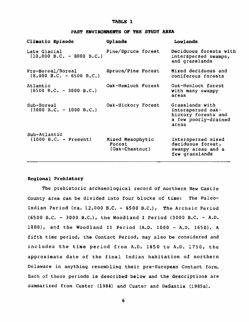
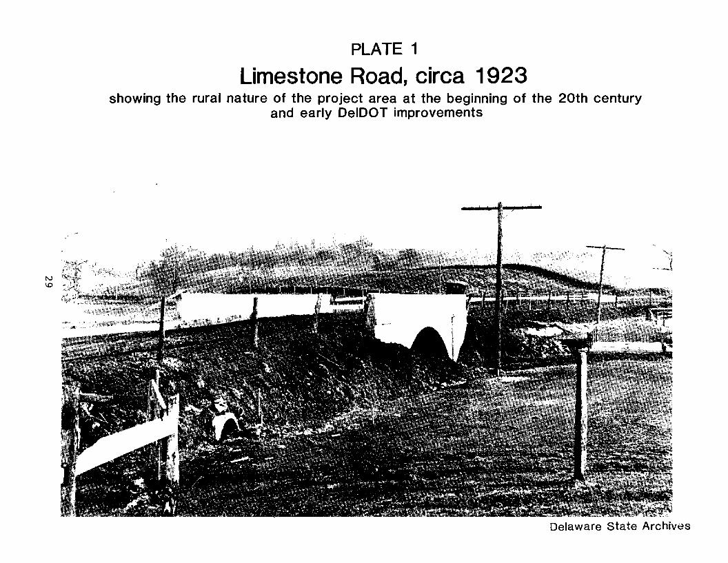