Embed Size (px)
Citation preview
1
14th South East Asia Survey Congress 15-17 August 2017 Brunei Darussalam
Introduction of Positioning Augmentation Center for High Precision Application
in Brunei Darussalam
Muhammad Aisamuddin HJ ABD RAZAK*, Adam Leslie On ABDULLAH*, Yasushi SAKURAI**, and Naohiro UKAI***
* Soartech Systems, Brunei Darussalam ** Satellite Positioning Research and Application Center, Japan
***JENOBA CO.,LTD, Japan
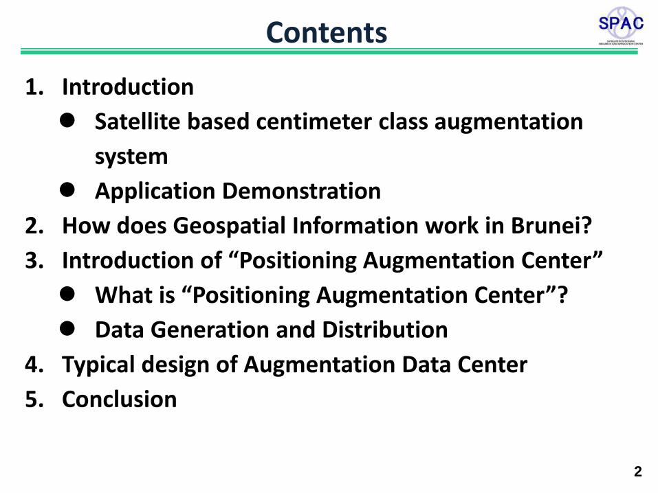
Contents
2
1. Introduction
Satellite based centimeter class augmentation
system
Application Demonstration
2. How does Geospatial Information work in Brunei?
3. Introduction of “Positioning Augmentation Center”
What is “Positioning Augmentation Center”?
Data Generation and Distribution
4. Typical design of Augmentation Data Center
5. Conclusion
3
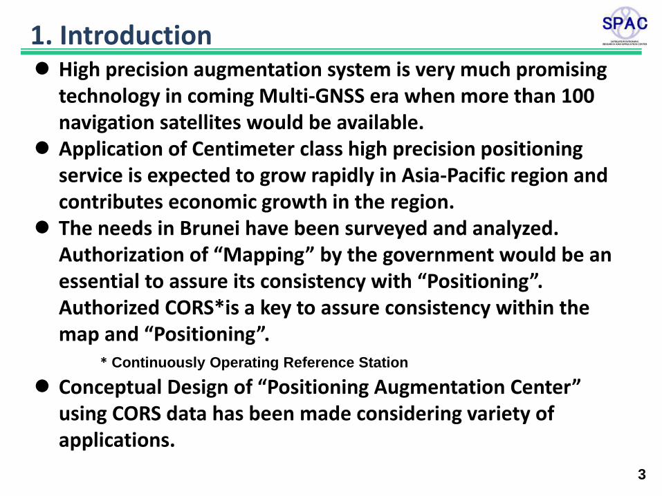
1. Introduction High precision augmentation system is very much promising
technology in coming Multi-GNSS era when more than 100 navigation satellites would be available.
Application of Centimeter class high precision positioning service is expected to grow rapidly in Asia-Pacific region and contributes economic growth in the region.
The needs in Brunei have been surveyed and analyzed. Authorization of “Mapping” by the government would be an essential to assure its consistency with “Positioning”. Authorized CORS*is a key to assure consistency within the map and “Positioning”.
* Continuously Operating Reference Station
Conceptual Design of “Positioning Augmentation Center” using CORS data has been made considering variety of applications.
4
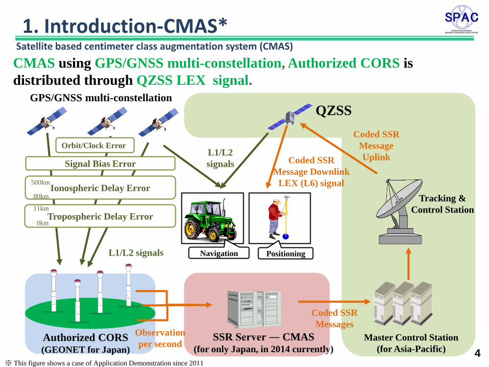
CMAS using GPS/GNSS multi-constellation, Authorized CORS is
distributed through QZSS LEX signal.
※ This figure shows a case of Application Demonstration since 2011
Tracking &
Control Station
Master Control Station
(for Asia-Pacific)
QZSS
Positioning Navigation
GPS/GNSS multi-constellation
SSR Server ― CMAS (for only Japan, in 2014 currently)
Authorized CORS (GEONET for Japan)
L1/L2 signals
Tropospheric Delay Error
Orbit/Clock Error
Signal Bias Error
L1/L2
signals
Ionospheric Delay Error 500km
80km
11km
0km
Observation
per second
Coded SSR
Message
Uplink Coded SSR
Message Downlink
LEX (L6) signal
Coded SSR
Messages
Satellite based centimeter class augmentation system (CMAS)
1. Introduction-CMAS*
5
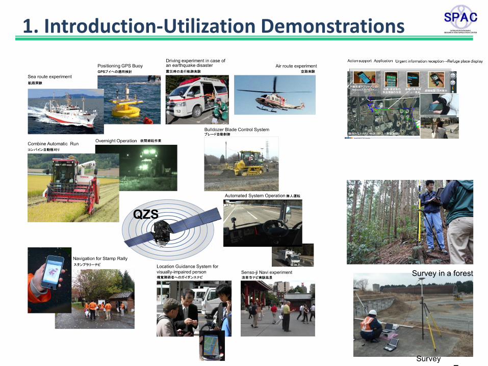
1. Introduction-Utilization Demonstrations
6
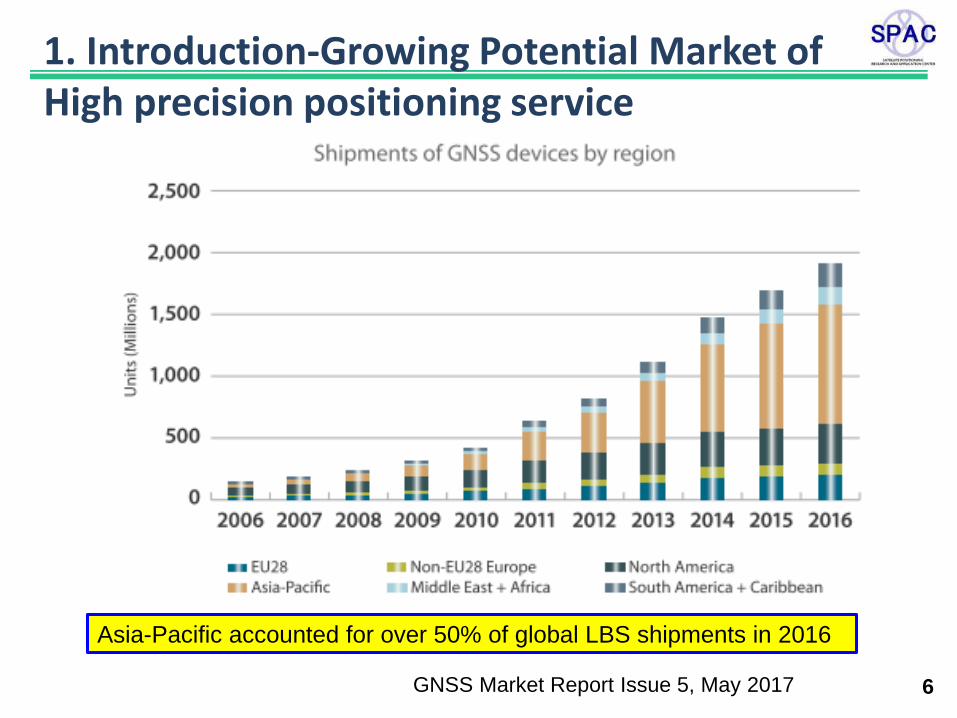
1. Introduction-Growing Potential Market of High precision positioning service
Asia-Pacific accounted for over 50% of global LBS shipments in 2016
GNSS Market Report Issue 5, May 2017
7
2. How does Geospatial Information work in Brunei?
Why Geospatial Information is so important? -Geospatial Information is social infrastructure to support daily life of the people
Land Development of the nation and local areas Development and Maintenance of Infrastructure Water Environment, Biological System Urban Problems Disaster Mitigation, ….
How Geospatial Information to be established, maintained, efficiently?
standardization Integration on the same basis Information Sharing
“Positioning ”and “Mapping” should be based on the same
accuracy and get together for installation and control!
8
2. How does Geospatial Information work in Brunei?
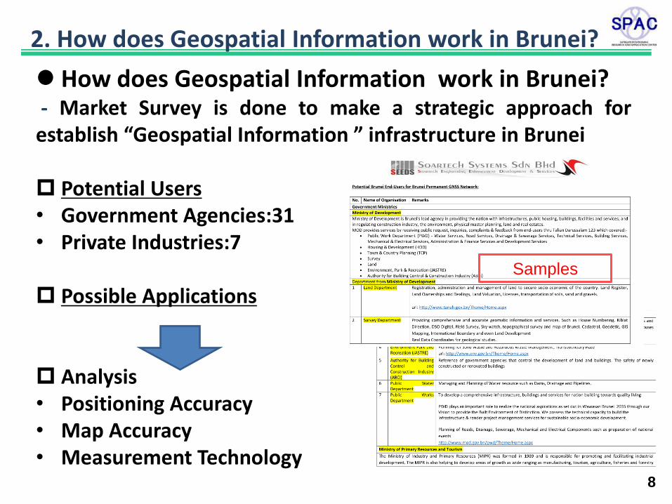
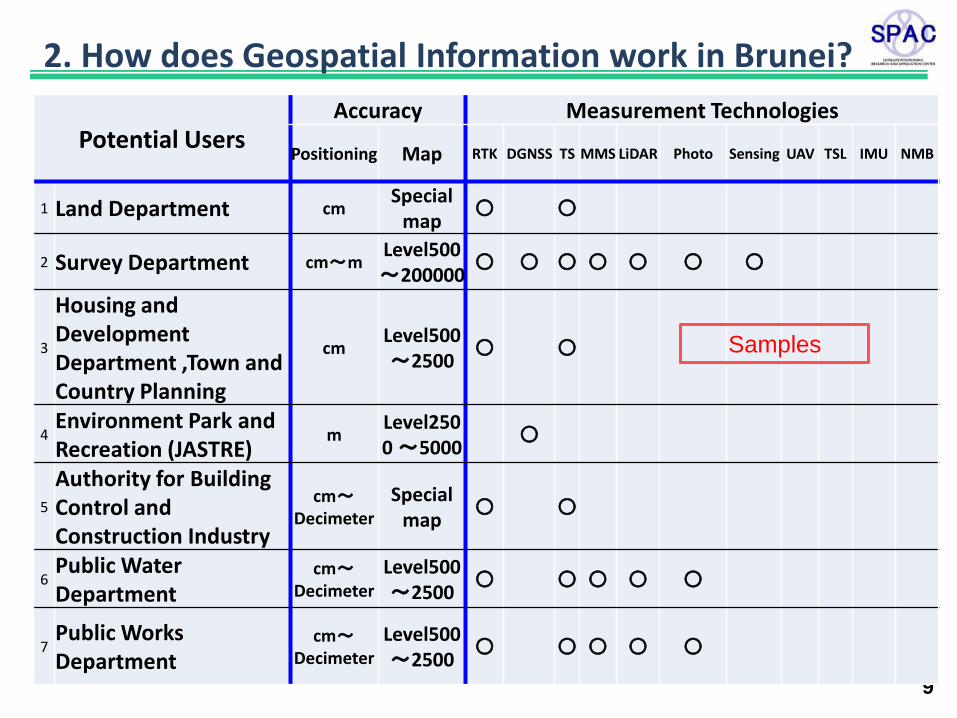
How does Geospatial Information work in Brunei? - Market Survey is done to make a strategic approach for establish “Geospatial Information ” infrastructure in Brunei Potential Users • Government Agencies:31 • Private Industries:7
Possible Applications Analysis • Positioning Accuracy • Map Accuracy • Measurement Technology
Samples
9
2. How does Geospatial Information work in Brunei?
Potential Users Accuracy Measurement Technologies
Positioning Map RTK DGNSS TS MMS LiDAR Photo Sensing UAV TSL IMU NMB
1 Land Department cm Special
map 〇 〇
2 Survey Department cm~m Level500 ~200000
〇 〇 〇 〇 〇 〇 〇
3
Housing and Development Department ,Town and Country Planning
cm Level500 ~2500
〇 〇
4 Environment Park and Recreation (JASTRE)
m Level2500 ~5000
〇
5
Authority for Building Control and Construction Industry
cm~Decimeter
Special map
〇 〇
6 Public Water Department
cm~Decimeter
Level500 ~2500
〇 〇 〇 〇 〇
7 Public Works Department
cm~Decimeter
Level500 ~2500
〇 〇 〇 〇 〇
Samples
10
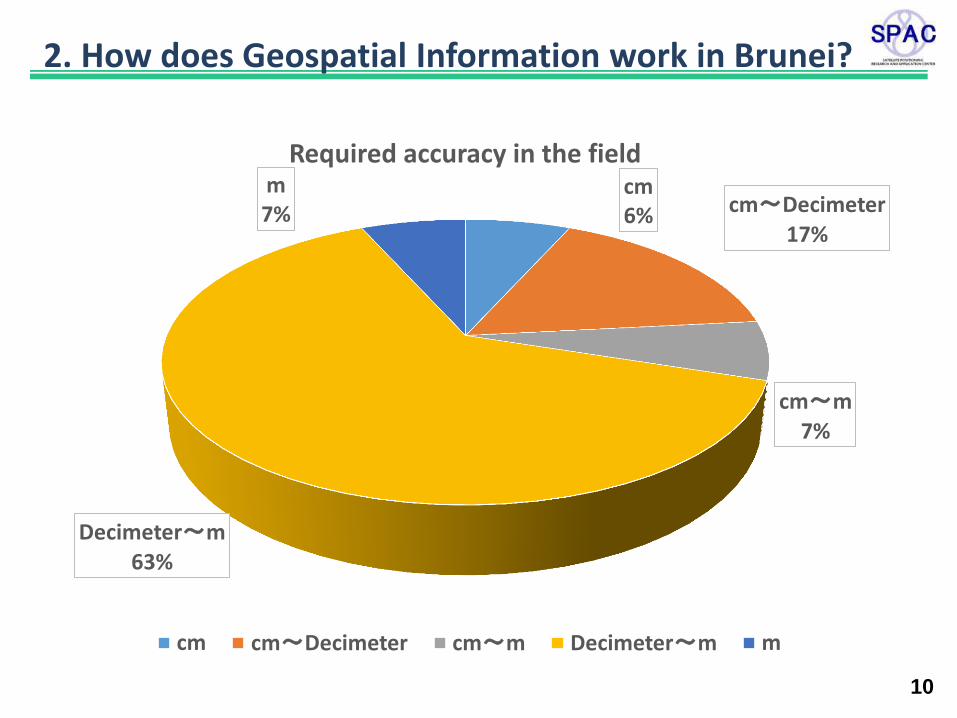
2. How does Geospatial Information work in Brunei?
cm 6% cm~Decimeter
17%
cm~m 7%
Decimeter~m 63%
m 7%
Required accuracy in the field
cm cm~Decimeter cm~m Decimeter~m m
11
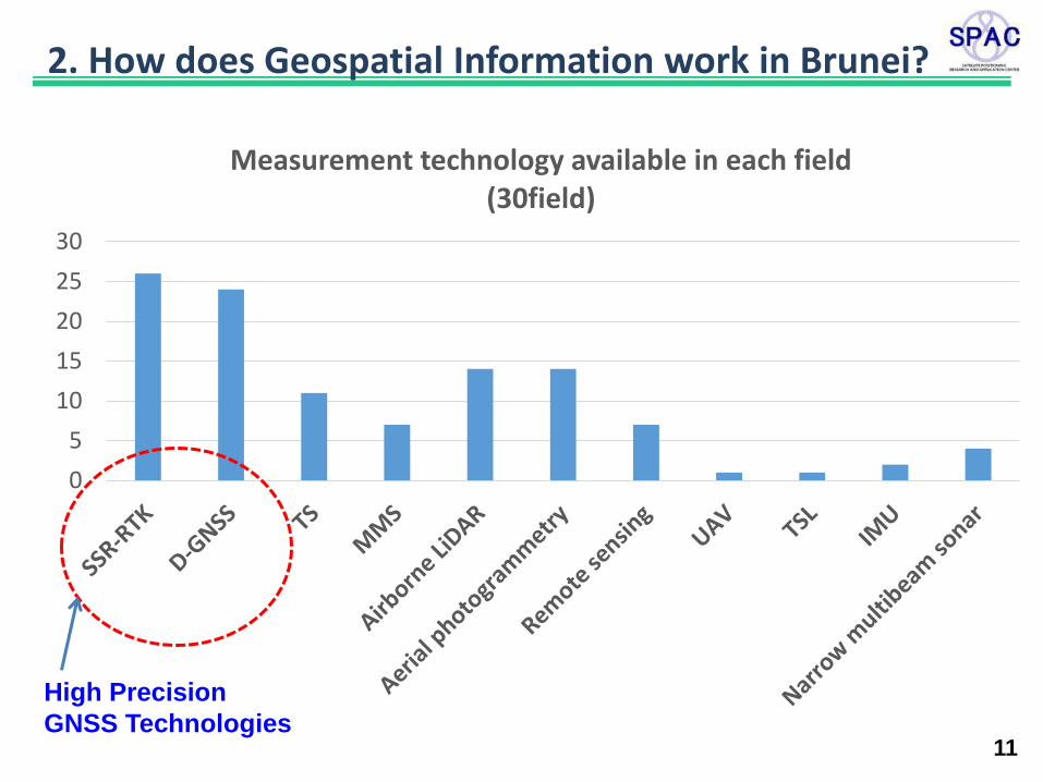
2. How does Geospatial Information work in Brunei?
0
5
10
15
20
25
30
Measurement technology available in each field (30field)
High Precision
GNSS Technologies
12
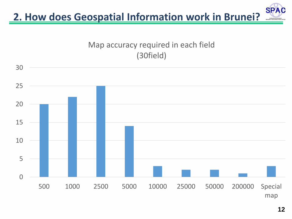
2. How does Geospatial Information work in Brunei?
0
5
10
15
20
25
30
500 1000 2500 5000 10000 25000 50000 200000 Specialmap
Map accuracy required in each field (30field)
13
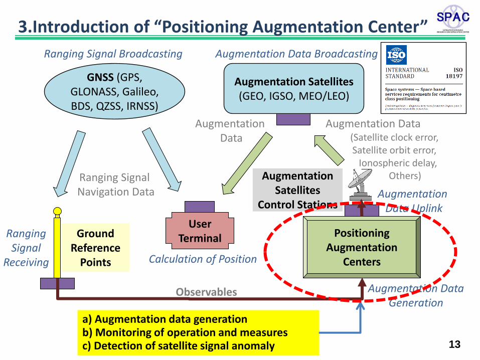
a) Augmentation data generation b) Monitoring of operation and measures c) Detection of satellite signal anomaly
Augmentation Data (Satellite clock error, Satellite orbit error, Ionospheric delay,
Others)
GNSS (GPS, GLONASS, Galileo, BDS, QZSS, IRNSS)
Augmentation Satellites (GEO, IGSO, MEO/LEO)
User Terminal Positioning
Augmentation Centers
Ranging Signal Broadcasting Augmentation Data Broadcasting
Observables
Augmentation Data
Calculation of Position
Ground Reference
Points
Ranging Signal Navigation Data
Augmentation Data Generation
Ranging Signal
Receiving
Augmentation Satellites
Control Stations Augmentation
Data Uplink
3.Introduction of “Positioning Augmentation Center”
Civil Architecture Maintenance Mapping Oil Plants Gas Plants Docking Vehicles Robots Drones Maritime Agriculture Construction Real-estate Surveying
14
Networked Reference Stations (CORS)
State Space Representation
(SSR)
Observation Space
Representation (OSR)
Correction
References
Correction
Representation
Method
Position
Computing
Method
RTK-PPP
Dual Freq. PPP
Single Freq. PPP
FKP
VRS
RTK
The latest satellite positioning methods had better be classified in following 3 steps.
Applications
1 2 3
Single Reference
Station
3.Introduction of “Positioning Augmentation Center”
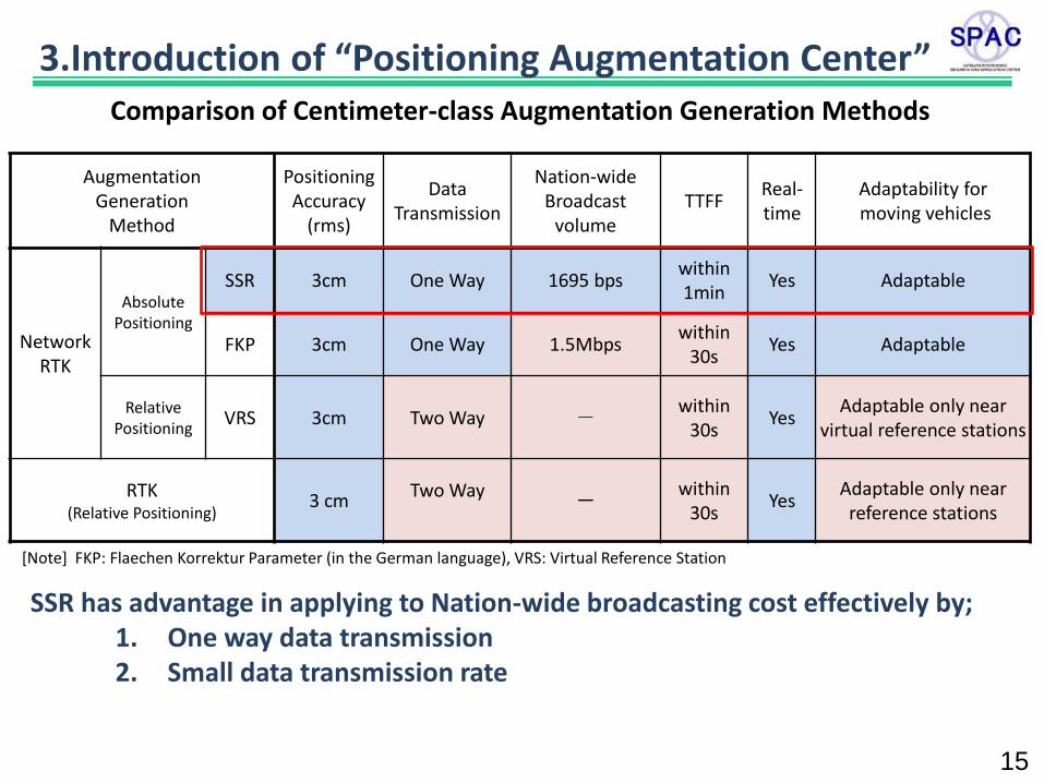
SSR has advantage in applying to Nation-wide broadcasting cost effectively by; 1. One way data transmission 2. Small data transmission rate
Augmentation Generation
Method
Positioning Accuracy
(rms)
Data Transmission
Nation-wide Broadcast
volume TTFF
Real-time
Adaptability for moving vehicles
Network RTK
Absolute Positioning
SSR 3cm One Way 1695 bps within 1min
Yes Adaptable
FKP 3cm One Way 1.5Mbps within
30s Yes Adaptable
Relative Positioning
VRS 3cm Two Way - within
30s Yes
Adaptable only near virtual reference stations
RTK (Relative Positioning)
3 cm Two Way
-
within 30s
Yes Adaptable only near
reference stations
Comparison of Centimeter-class Augmentation Generation Methods
[Note] FKP: Flaechen Korrektur Parameter (in the German language), VRS: Virtual Reference Station
15
3.Introduction of “Positioning Augmentation Center”
16
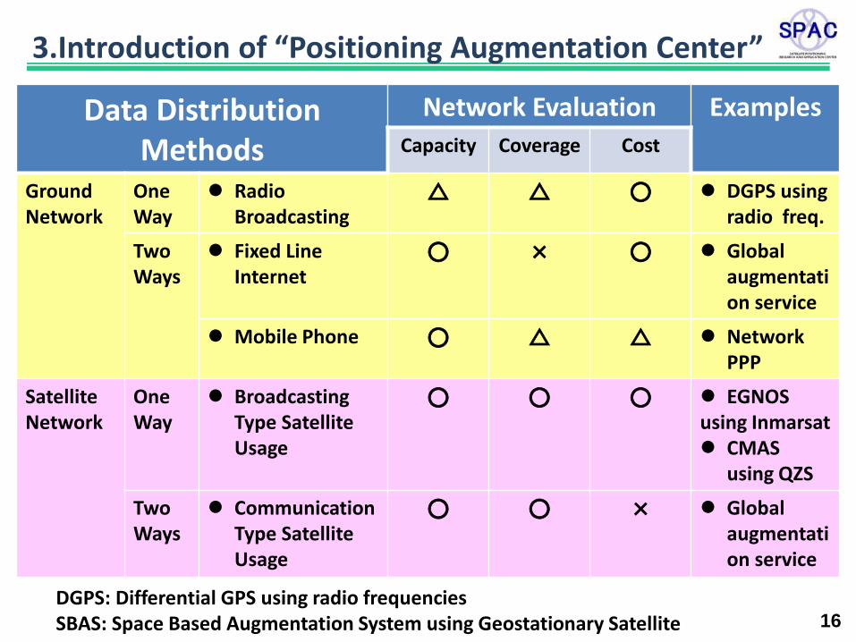
Data Distribution Methods
Network Evaluation Examples
Capacity Coverage Cost
Ground Network
One Way
Radio Broadcasting
△ △ ○ DGPS using radio freq.
Two Ways
Fixed Line Internet
○ × ○ Global augmentation service
Mobile Phone
○ △ △ Network PPP
Satellite Network
One Way
Broadcasting Type Satellite Usage
○ ○ ○ EGNOS using Inmarsat CMAS
using QZS
Two Ways
Communication Type Satellite Usage
○ ○ × Global augmentation service
DGPS: Differential GPS using radio frequencies SBAS: Space Based Augmentation System using Geostationary Satellite
3.Introduction of “Positioning Augmentation Center”
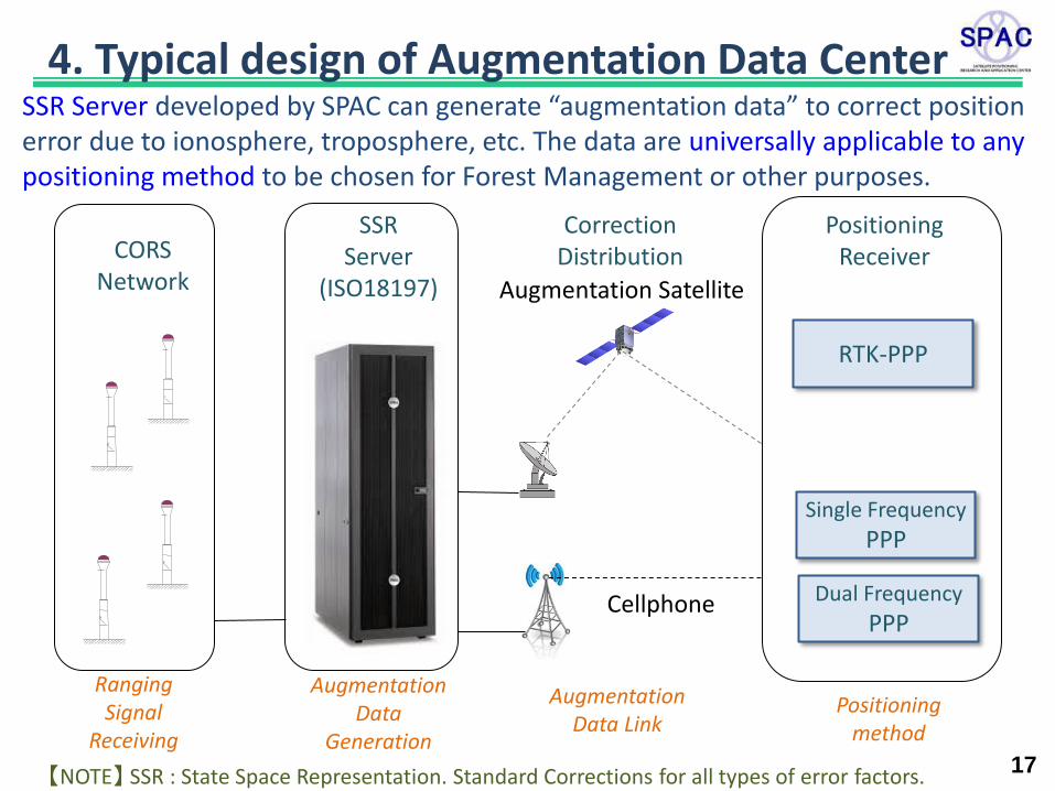
17
CORS Network
Correction Distribution
SSR Server developed by SPAC can generate “augmentation data” to correct position error due to ionosphere, troposphere, etc. The data are universally applicable to any positioning method to be chosen for Forest Management or other purposes.
SSR Server
(ISO18197)
Positioning Receiver
RTK-PPP
Single Frequency
PPP
Dual Frequency
PPP
Augmentation Satellite
【NOTE】 SSR : State Space Representation. Standard Corrections for all types of error factors.
Ranging Signal
Receiving
Augmentation Data
Generation
Augmentation Data Link
Positioning method
Cellphone
4. Typical design of Augmentation Data Center
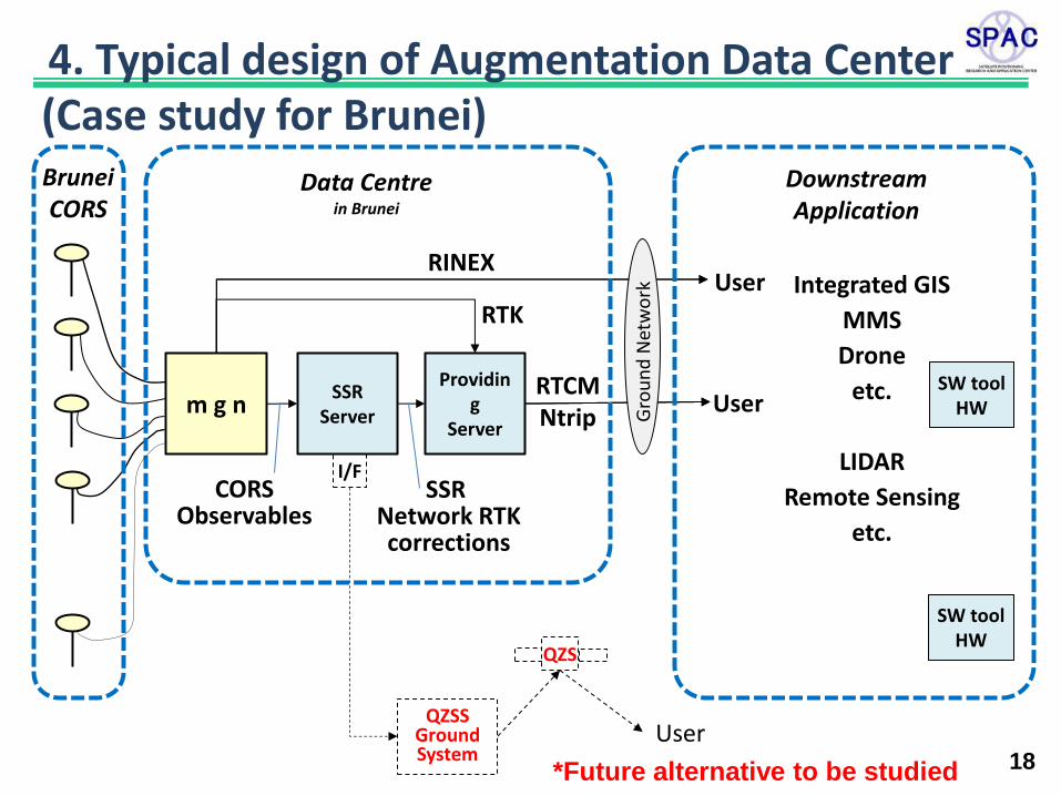
18
(Case study for Brunei)
User
Brunei CORS
m g n Providin
g Server
I/F
SSR Server
QZSS Ground System
QZS
User
CORS Observables
SSR Network RTK corrections
RINEX
RTCM Ntrip
RTK
Downstream Application
Integrated GIS
MMS
Drone
etc.
LIDAR
Remote Sensing
etc.
Data Centre in Brunei
SW tool HW
SW tool HW
User
Gro
un
d N
etw
ork
*Future alternative to be studied
4. Typical design of Augmentation Data Center
©SPAC,2013 All rights reserved
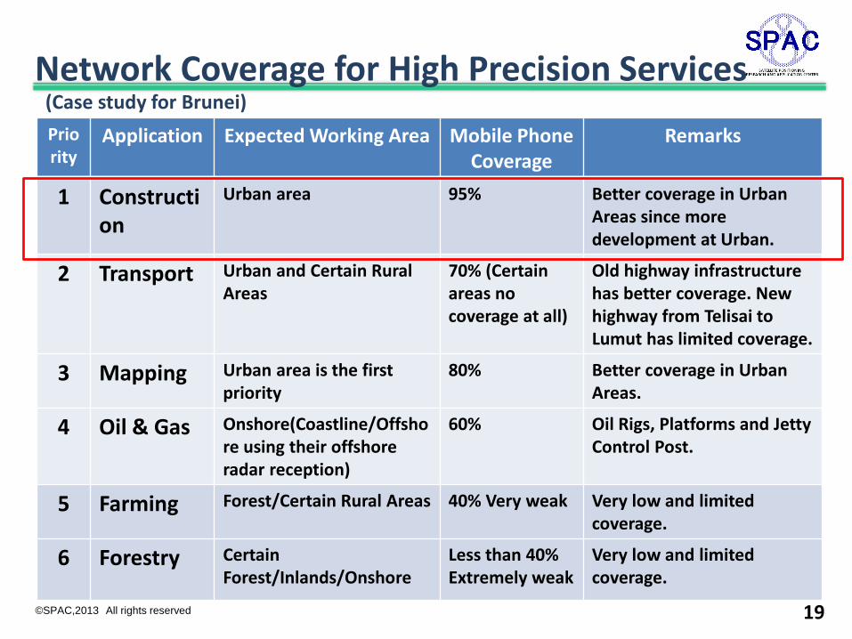
Network Coverage for High Precision Services
Priority
Application Expected Working Area Mobile Phone Coverage
Remarks
1 Construction
Urban area 95% Better coverage in Urban Areas since more development at Urban.
2 Transport Urban and Certain Rural Areas
70% (Certain areas no coverage at all)
Old highway infrastructure has better coverage. New highway from Telisai to Lumut has limited coverage.
3 Mapping Urban area is the first priority
80% Better coverage in Urban Areas.
4 Oil & Gas Onshore(Coastline/Offshore using their offshore radar reception)
60% Oil Rigs, Platforms and Jetty Control Post.
5 Farming Forest/Certain Rural Areas 40% Very weak Very low and limited coverage.
6 Forestry Certain Forest/Inlands/Onshore
Less than 40% Extremely weak
Very low and limited coverage.
(Case study for Brunei)
19
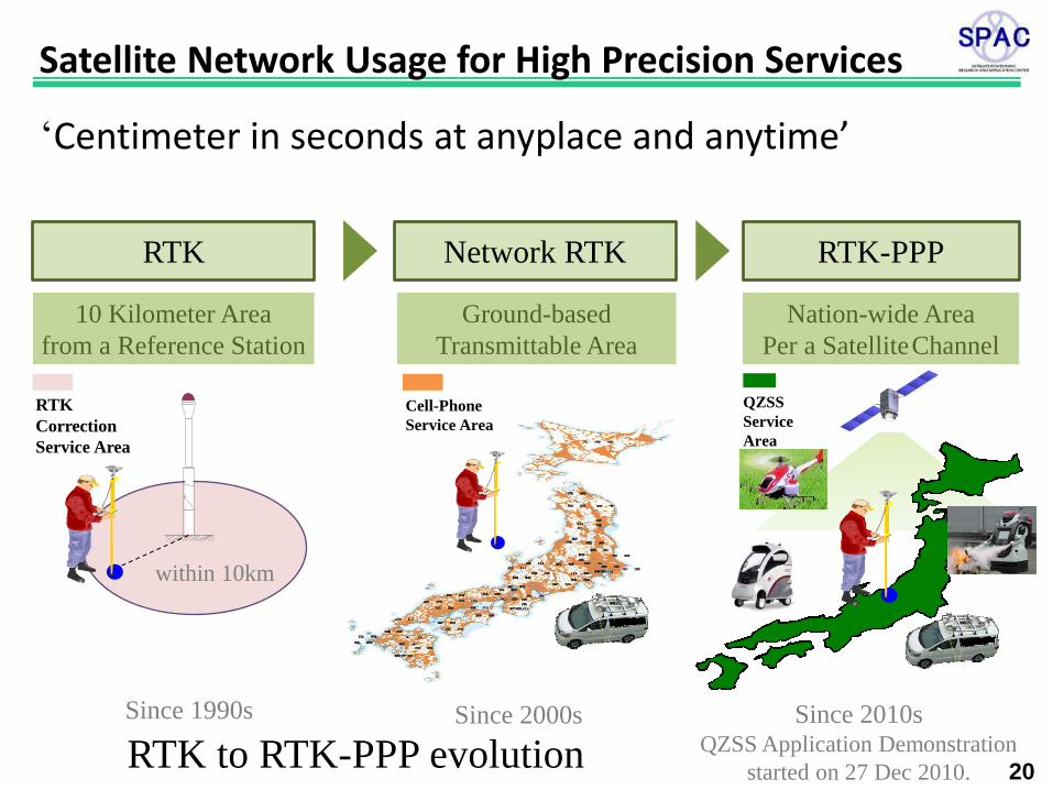
‘Centimeter in seconds at anyplace and anytime’
20
Network RTK
Ground-based
Transmittable Area
Cell-Phone
Service Area
Since 2000s
RTK-PPP
Nation-wide Area
Per a Satellite Channel
QZSS
Service
Area
Since 2010s
QZSS Application Demonstration
started on 27 Dec 2010.
RTK
10 Kilometer Area
from a Reference Station
within 10km
Since 1990s
RTK
Correction
Service Area
RTK to RTK-PPP evolution
Satellite Network Usage for High Precision Services
21
6. Conclusion High precision augmentation system is very much
promising technology in coming Multi-GNSS era. Surveyed results the needs of Geospatial Information
in Brunei have suggested that authorization of “Mapping” and “Positioning” is very much important.
Authorized CORS* is a key to assure consistency between Map and Positioning.
Conceptual Design of “Positioning Augmentation Center” using CORS has been made considering variety of applications. SSR method has been focused.
Geospatial Information should be stored, exploited and shared as “Treasure” of commodity.
• CORS : Continuously Operating Reference Station
• SSR : State Space Representation
Thank you for your kind attention.
22
Presenter : Yasushi SAKURAI Satellite Positioning Research and Application Center (SPAC)
KikaiShinko-Kaikan Bldg 4th Floor 3-5-8 Shibakoen Minato-ku, Tokyo, Japan E-mail sakurai.yasushi @ eiseisokui.or.jp
23
Complementary Slides
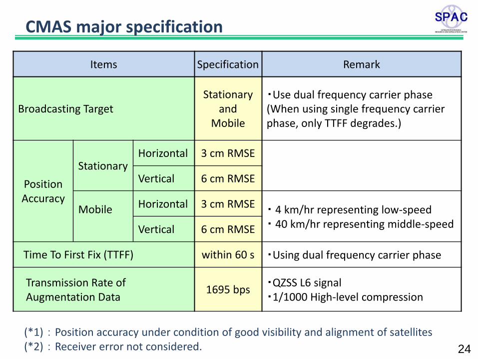
Items Specification Remark
Broadcasting Target Stationary
and Mobile
・Use dual frequency carrier phase (When using single frequency carrier phase, only TTFF degrades.)
Position Accuracy
Stationary Horizontal 3 cm RMSE
Vertical 6 cm RMSE
Mobile
Horizontal 3 cm RMSE ・ 4 km/hr representing low-speed ・ 40 km/hr representing middle-speed Vertical 6 cm RMSE
Time To First Fix (TTFF) within 60 s ・Using dual frequency carrier phase
Transmission Rate of Augmentation Data
1695 bps ・QZSS L6 signal ・1/1000 High-level compression
(*1) : Position accuracy under condition of good visibility and alignment of satellites (*2) : Receiver error not considered. 24
CMAS major specification
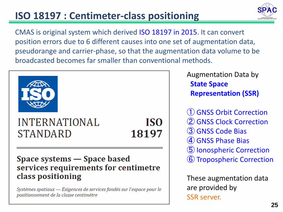
25
CMAS is original system which derived ISO 18197 in 2015. It can convert position errors due to 6 different causes into one set of augmentation data, pseudorange and carrier-phase, so that the augmentation data volume to be broadcasted becomes far smaller than conventional methods.
ISO 18197 : Centimeter-class positioning
Augmentation Data by State Space Representation (SSR) ① GNSS Orbit Correction ② GNSS Clock Correction ③ GNSS Code Bias ④ GNSS Phase Bias ⑤ Ionospheric Correction ⑥ Tropospheric Correction These augmentation data are provided by SSR server.
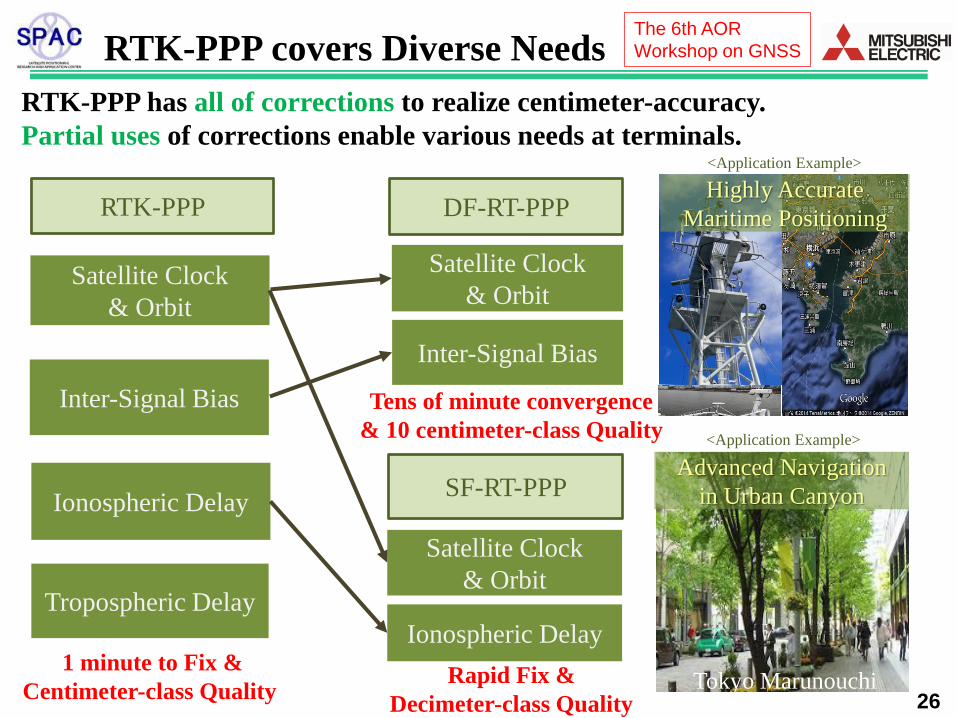
RTK-PPP covers Diverse Needs
26
RTK-PPP has all of corrections to realize centimeter-accuracy.
Partial uses of corrections enable various needs at terminals.
RTK-PPP
Satellite Clock
& Orbit
Ionospheric Delay
Tropospheric Delay
Inter-Signal Bias
Highly Accurate
Maritime Positioning
<Application Example>
Advanced Navigation
in Urban Canyon
<Application Example>
Tokyo Marunouchi
DF-RT-PPP
Rapid Fix &
Decimeter-class Quality
Tens of minute convergence
& 10 centimeter-class Quality
1 minute to Fix &
Centimeter-class Quality
SF-RT-PPP
Ionospheric Delay
Satellite Clock
& Orbit
Inter-Signal Bias
Satellite Clock
& Orbit
The 6th AOR
Workshop on GNSS
CORS G. GIS GNSS HW I/F LIDAR Ntrip mgn MMS QZS QZSS RINEX RTCM RTK SSR SW
Continuously Operating Reference Station Government Geographical Information System Global Navigation Satellite System HardWare InterFace Laser Imaging Detecting And Ranging Networked Transport of RTCM via Internet Protocol (RTCM 10410.1) Managing GNSS Network (SEGAL) Mobile Mapping System Quasi-Zenith Satellite (G. of Japan) Quasi-Zenith Satellite System (G. of Japan) Receiver INdependent EXchange Format (RTCM SC-104) Radio Technical Commission for Maritime services Real-Time Kinematic GNSS data (RTCM 10402.3 and 10403.2) State Space Representation (RTCM 10403.2) SoftWare
Glossary


![ARIADNE: A Dynamic Indoor Signal Map Construction and ...ronments, satellite positioning systems (e.g., the Global Positioning System [1]) offer scalable, efficient, and cost-effective](https://img.dokumen.tips/doc/110x75/5ed5854129851c5413653694/ariadne-a-dynamic-indoor-signal-map-construction-and-ronments-satellite-positioning.jpg)