Embed Size (px)
Citation preview

Interstate 10 — Phoenix to California Border,Multimodal Corridor Profi le Study
Task Assignment MPD 09-11
Working Paper #2
Plan for ImprovementsNovember 2012
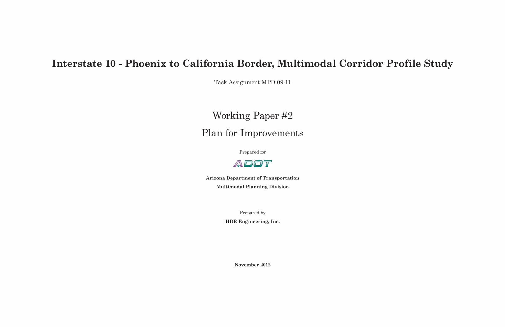
Interstate 10 - Phoenix to California Border, Multimodal Corridor Profile StudyTask Assignment MPD 09-11
Working Paper #2Plan for Improvements
Prepared for
Arizona Department of Transportation
Multimodal Planning Division
Prepared by
HDR Engineering, Inc.
November 2012

This page is intentionally left blank.

Task Assignment MPD 09-11 | Working Paper #2 Plan for Improvements| November 2012Interstate 10 – Phoenix to California Border, Multimodal Corridor Profile Study i
AppendixesAppendix A: Planning and Environmental Linkages Questionnaire and Checklist
Appendix B: Stakeholder Interviews
Appendix C: Stakeholder E-newsletter
Contents
List of Figures i
List of Tables i
Abbreviations and Acronyms iii
1. Study Description 1-11.1 Corridor overview 1-1
1.2 I-10 Corridor Agency Roles 1-1
1.3 Purpose and need 1-3
1.4 Goals and objectives 1-3
1.5 Planning and Environmental Linkages 1-3
1.6 Stakeholder and public outreach 1-4
1.7 Organization of the report 1-4
2. Stakeholder Input 2-12.1 Interviews 2-1
2.2 Newsletter 2-1
3. Evaluation Criteria 3-1
4. Projects in the I-10 Corridor 4-14.1 Programmed projects 4-1
4.2 Planned projects 4-4
4.3 Other deficiencies and needs 4-8
5. References 5-1
List of Figures
Figure 1.1 | Project location 1-1Figure 1.2 | I-10 Corridor 1-2Figure 4.1 | Projects under construction or programmed for construction in the next five years 4-3Figure 4.2 | Projects planned for the I-10 Corridor 4-7
List of Tables
Table 2.1 | Stakeholder interview results 2-1Table 3.1 | Evaluation criteria 3-1Table 4.1 | Projects under construction or programmed for construction in the next five years 4-2Table 4.2 | Planned projects in the I-10 Corridor 4-6Table 4.3 | Bridges eligible for rehabilitation 4-8

Interstate 10 – Phoenix to California Border, Multimodal Corridor Profile StudyTask Assignment MPD 09-11 | Working Paper #2 Plan for Improvements| November 2012ii
Abbreviations and Acronyms
101L Loop 101202L Loop 202303L Loop 303AADT annual average daily traffic
ADEQ Arizona Department of Environmental QualityAMA active management areaADOT Arizona Department of TransportationADWR Arizona Department of Water ResourcesAGFD Arizona Game and Fish DepartmentAPE area of potential effectsA.R.S. Arizona Revised StatutesAZ ArizonaBLM Bureau of Land ManagementBNSF Burlington Northern Santa Fe Railway CompanyCAA Clean Air ActCAP Central Arizona ProjectC.F.R. Code of Federal RegulationsCRIT Colorado River Indian TribesCWA Clean Water ActEB eastboundEIS environmental impact statementEPA U.S. Environmental Protection AgencyFEMA Federal Emergency Management AgencyFHWA Federal Highway AdministrationFIRM Flood Insurance Rate MapFPPA Farmland Protection Policy ActGIS geographic information systemGWSI Groundwater Site InventoryHAP hazardous air pollutantHDMS Heritage Data Management SystemHOV high-occupancy vehicleHPMS Highway Performance Monitoring SystemI InterstateI-8 Interstate 8I-10 Interstate 10I-17 Interstate 17I-40 Interstate 40
INA Irrigation Non-Expansion AreaIRI International Roughness IndexISA Initial Site AssessmentITS intelligent transportation systemsL Loop LESA Land Evaluation and Site AssessmentLOS level of serviceMAG Maricopa Association of GovernmentsMBTA Migratory Bird Treaty Act
MCDOT Maricopa County Department of Transportation
METRO Valley Metro Rail Inc.mg/l milligrams per literMP milepostMPO metropolitan planning organizationMVMT million vehicle miles traveledNAAQS National Ambient Air Quality StandardsNAC noise abatement criteriaNAP Noise Abatement PolicyNational Register National Register of Historic Places
NB northboundNEPA National Environmental Policy Act of 1969NHPA National Historic Preservation ActNPS National Park ServiceNRCS Natural Resource Conservation ServiceOHV off-highway vehicleOP overpassPAG Pima Association of GovernmentsPEL Planning and Environmental LinkagesPSR Present Serviceability RatingPVNGS Palo Verde Nuclear Generating StationPVVTA Palo Verde Valley Transit AuthorityRCBC reinforced concrete box culvertRID Roosevelt Irrigation DistrictRMP Resource Management PlanRPTA Regional Public Transportation AuthorityRTP Regional Transportation Plan
SAFETEA-LU Safe, Accountable, Flexible, Efficient Transportation Equity Act: A Legacy for Users
SB southboundSHPO State Historic Preservation Office(r)SR State RouteSRP Salt River ProjectTAC Technical Advisory CommitteeTCP traditional cultural propertyTDS total dissolved solidsTI traffic interchangeTitle VI Title VI of the Civil Rights Act of 1964TNW traditional navigable watersUP underpassUPRR Union Pacific RailroadUSACE U.S. Army Corps of EngineersU.S.C United States CodeUSDA U.S. Department of AgricultureUSDOT U.S. Department of TransportationUSFWS U.S. Fish and Wildlife ServiceWACOG Western Arizona Council of GovernmentsWB westboundWSC Wildlife of Special Concern

Task Assignment MPD 09-11 | Working Paper #2 Plan for Improvements| November 2012Interstate 10 – Phoenix to California Border, Multimodal Corridor Profile Study 1-1
1. Study Description
The Arizona Department of Transportation (ADOT) is the lead agency for this multimodal study of Interstate 10 (I-10) between the California border and downtown Phoenix (I-10 Corridor). Past corridor profile studies of I-10 have primarily focused on vehicular travel. This study employs a more holistic approach and serves as a benchmark for future studies. The intent is to assess the I-10 Corridor as a highway and as a travelshed; evaluating vehicular issues as well as issues relating to transit, rail, and air service in the corridor.
1.1 Corridor overviewI-10 and Interstate 40 are the only Interstate highways that cross the entire state of Arizona. As a continuous coast-to-coast route, I-10 is a principal freight route connecting the southern California ports with the Phoenix metropolitan area and major metropolitan areas in Texas and Florida. In Arizona, I-10 extends 391 miles from Ehrenberg in the west to San Simon in the east. I-10 serves multiple functions: it provides an important east–west route through the state; it connects Phoenix and Tucson, the state’s two largest cities; and it is a critical component of the Phoenix metropolitan area’s regional freeway system.
The corridor location, shown in Figure 1.1 and referred to as the “I-10 Corridor” in this report, runs from the California border to downtown Phoenix (at Central Avenue, deck park tunnel, milepost 146). The analysis corridor has been defined as up to 1 mile on either side of I-10, with consideration of greater distance for key roads, populations, and multimodal opportunities.
The I-10 Corridor is located within La Paz and Maricopa Counties. The boundary between the two counties is located at approximately milepost 71 along I-10. La Paz County is part of the planning area of the Western Area Council of Governments (WACOG) and the metropolitan planning organization (MPO) for Maricopa County is the Maricopa Association of Governments (MAG). The boundary between WACOG and MAG is the same as the county boundaries. The I-10 Corridor is also located within the ADOT Yuma and Phoenix Construction and
Maintenance Districts. The boundary between the two ADOT Districts is just west of State Route (SR) 85 at approximately milepost 112 (see Figure 1.2).
The functional classification of I-10 within the corridor is “Interstate.” The area between the California border and SR 85 is classified as rural, while the area between SR 85 and downtown Phoenix is classified as urban.
1.2 I-10 Corridor Agency RolesThe primary agencies with active roles in the funding, planning, approving, constructing, and maintaining of projects along the I-10 Corridor are the Federal Highway Administration (FHWA), ADOT, WACOG, and MAG. The following sections provide a brief description of each agency’s role.
FHWAFHWA is the lead federal agency on transportation projects that require a federal action such as approving funding or approving new or modified access points along the Interstate system. FHWA serves primarily in an oversight role during the preliminary design and environmental clearance process ensuring that the National Environmental Policy Act (NEPA) is followed in developing environmental clearance documents (categorical exclusions, environmental assessments, or environmental impact statements) for a project.
ADOTADOT implements projects within the state highway system (Interstates, U.S. highways, and state highways). Project implementation includes planning, environmental clearance, right-of-way acquisition, design, construction, and maintenance. The types of projects range from pavement preservation and shoulder improvements to new freeway or highway corridors. ADOT is the primary statewide long-range transportation planning agency. Within Maricopa County, ADOT defers to MAG for long-range planning efforts, but is still the lead agency in implementing the freeway and highway program.
Figure 1.1 | Project location
§̈¦8
§̈¦40 §̈¦40
§̈¦17
§̈¦10
§̈¦19
§̈¦10
§̈¦10
§̈¦15
§̈¦40
§̈¦10
§̈¦10
§̈¦40
§̈¦8
SANTA CRUZ
GR
EEN
LEE
GRAHAM
LA PAZ
COCHISE
MARICOPA
PINALYUMA
YAVAPAI
NAVAJO APACHE
MOHAVE
COCONINO
PIMATUCSON
DOUGLAS
Phoenix/
Tucson/
Flagstaff/
Path
: E:\P
roje
cts\
AZ\A
DO
T\A
DO
T_M
PD
_FY
11_I
10\m
ap_d
ocs\
mxd
\I10_
Phx
Cal
i_St
ate_
Area
.mxd
*Study area extends 1 mile north and south of I-10
Interstate 10: Phoenix to California Border Multimodal Corridor Profile Study
0 20 40 60 8010
miles N1 in = 52 miles
Project location*
!!
!!
! ! ! !
!!
!!
!!!!
Counties
Interstate
Highways

Interstate 10 – Phoenix to California Border, Multimodal Corridor Profile StudyTask Assignment MPD 09-11 | Working Paper #2 Plan for Improvements| November 20121-2
#*
#*
#*#*
#*#* #*#*
#*
#*
#*
#*
#*
#*#*
#*#* §̈¦10
£¤60
£¤60
£¤93Éx89
Éx74
§̈¦17
Éx101
Éx303
Éx51
Éx95
£¤95
Éx85 Éx347
CALIFO
RNIAARIZ
ONA
Color
ado
Éx71
Salome Road
Vick
sbur
g R
oad
£¤95
¬«78
River
Win
ters
burg
Roa
d
Palo VerdeNuclear
GeneratingStation
120 140
§̈¦10
Éx202
Carefree
Prescott District
Kingman District
Yuma District
Phoenix District
Tucson District
Maricopa
Buckeye
Wintersburg Goodyear AvondalePhoenixTolleson
LitchfieldParkTonopah
GlendaleCentennial
PeoriaYoungtownEl MirageSurprise
EhrenbergBlytheMorgantown
Quartzsite
Vicksburg
CaveCreek
Wickenburg
160
150110
130100
80
70
60
5040
10 3020
Colorado RiverIndian
Reservation
Gila RiverIndian
Community
MARICOPACOUNTY
PINALCOUNTY
YAVAPAICOUNTY
LA PAZCOUNTY
YUMACOUNTY
City
#* Milepost
Project location*
Lake
County boundary
ADOT Districts
Path
: E:\P
roje
cts\
AZ\A
DO
T\A
DO
T_M
PD
_FY
11_I
10\m
ap_d
ocs\
mxd
\I10_
Phx
Cal
i_St
udyA
rea.
mxd
0 5 10 15 202.5
miles N1 in = 10 miles
*Study area extends 1 mile north and south of I-10 Interstate 10: Phoenix to California Border Multimodal Corridor Profile Study
Figure 1.2 | I-10 Corridor

Task Assignment MPD 09-11 | Working Paper #2 Plan for Improvements| November 2012Interstate 10 – Phoenix to California Border, Multimodal Corridor Profile Study 1-3
MPO/COG With respect to transportation projects, WACOG and MAG serve as planning agencies that set priorities for scheduling and funding of projects. As mentioned above, ADOT takes a larger role in long-range planning outside of Maricopa County because the resources available to COGs are limited. Within Maricopa County, MAG is responsible for preparation of the regional transportation improvement program, long-range transportation planning, traffic forecasting, and air quality conformity analysis. Based on this, the purpose, need, goals, and objectives for this study will be different for the I-10 Corridor within the WACOG region and the MAG region.
1.3 Purpose and needThe primary purpose and need for this study is to consolidate the myriad of planning documents for the I-10 Corridor (primarily in the MAG region) and develop a clear vision for future transportation needs along the I-10 Corridor.
Within La Paz County (WACOG region), this study will result in:
● Formulation of a multimodal transportation plan that incorporates highway and transit travel modes and complements the area’s current and future development patterns.
● Analysis of the physical layout and number of general purpose and special-use travel lanes needed to serve the future I-10 Corridor travel demand.
● A plan to address freight needs within and through the I-10 Corridor.
● Consideration of community character and potential impacts throughout the planning process.
● A determination of changes in access patterns within the I-10 Corridor that could encourage better multimodal cohesion and connectivity and improve safety.
Within Maricopa County, MAG member agencies have adopted the Regional Transportation Plan (RTP) and accepted the Interstate 10 – Hassayampa Valley Roadway Framework Study which identify a vision and needs for
the I-10 Corridor. Therefore, this study will concentrate on compiling the recommendations from previous studies into a single resource focused on the I-10 Corridor. This study will not make recommendations for new alternatives and improvements within the MAG region.
The framework approach developed for the I-10 Corridor can be applied to other Statewide corridor studies in the future.
1.4 Goals and objectivesAlthough the purpose and need differs between the WACOG and MAG region, the overall goals and objectives for the I-10 Corridor remain the same:
● Compile planned and potential projects to assist ADOT and regional and local agencies in the preservation of transportation right-of-way.
● Document planned and potential improvements to assist local governments in identifying compatible land use and zoning for adjacent development.
● Identify environmental issues and concerns. ● Compile planned and potential projects for consideration in the priority programming process.
● Evaluate the appropriateness of current and emerging intelligent transportation systems (ITS) technologies.
● Forecast future travel demand within the I-10 Corridor. Travel forecasts from ADOT’s statewide model will be used within La Paz County and MAG’s travel forecasts will be used within Maricopa County.
● Document alternative transportation opportunities that are being considered and studied.
This study will result in a coordinated multimodal transportation plan for the I-10 Corridor that addresses these objectives.
1.5 Planning and Environmental LinkagesThe Safe, Accountable, Flexible, Efficient Transportation Equity Act: A Legacy for Users (SAFETEA-LU), includes several provisions intended to enhance the consideration of environmental issues and impacts within the transportation planning process. It encourages the
use of planning documents as outlined in the National Environmental Policy Act of 1969 (NEPA) process. In the past year, one such program—Planning and Environmental Linkages (PEL)—has been promoted by the Federal Highway Administration (FHWA) as a way for states and local agencies to more efficiently deliver transportation projects.
The PEL process seeks to result in subarea and corridor studies that can be used more directly in implementing NEPA. Effective, conceptual-level transportation planning studies that follow the PEL process provide opportunities to identify important issues early and to build the agency, stakeholder, and public understanding necessary to successfully address those issues. Such early, integrated planning is not driven solely by regulatory requirements and the quest for more efficient and effective processes, although those are desirable results. Transportation and environmental professionals—as well as those in MPOs, state and federal resource agencies, and nongovernmental organizations—are finding that early collaboration helps achieve broader transportation and environmental stewardship goals through better decisions regarding programs, planning, and projects.
ADOT PEL processThe ADOT PEL process is being applied to the I-10 Corridor study and, thus, this study serves as a test case for future use of the PEL process. The PEL document has three components:
● Questionnaire for Transportation Planners – Part 1 (completed at the beginning of the transportation planning study)
● Questionnaire for Transportation Planners – Part 2 (completed at the end of the transportation planning study)
● Checklist for Environmental Planners – Part 3 (completed after Part 1 and 2 at the end of the transportation planning study)
Interstate 10 – Phoenix to California Border, Multimodal Corridor Profile StudyTask Assignment MPD 09-11 | Working Paper #2 Plan for Improvements| November 20121-4
Completion of the questionnaire and checklist serves dual objectives:
● Provides guidance to transportation planners on the level of detail needed to ensure that information collected and decisions made during the transportation planning study can be used during the NEPA process for a proposed transportation project.
● Provides the future NEPA study team with documentation on the outcomes of the transportation planning process, including the history of decisions made and the level of detailed analysis undertaken.
When conducting a transportation planning study that links to future NEPA process, major issues include:
● identifying the appropriate level of environmental analysis for the study
● identifying the appropriate level of agency, stakeholder, and public involvement
● identifying unique study concurrence points for seeking agreement from relevant resource agencies, stakeholders, and the public
● developing a process to ensure that the study will be recognized as valid within the NEPA process
● identifying when to involve resource agencies in the study, and to what extent they influence decision making
● achieving concurrence with ADOT and U.S. Department of Transportation managers and regulators on use of these studies in the NEPA process
The ADOT PEL Questionnaire and Checklist is included in Appendix A. Part 1 of the questionnaire and checklist is completed and Part 2 will be completed at the conclusion of the study.
1.6 Stakeholder and public outreachGiven the length of the corridor and the importance of the I-10 Corridor, numerous groups may be interested in the outcomes of this study. Implementation of an effective stakeholder and public outreach program facilitates the identification of community issues early in the process.
Typically, an outreach program that informs and educates governmental agencies, Tribal entities, private businesses, and the public greatly reduces the probability of study delays by resolving and addressing community concerns. In addition, the outreach program is consistent with the PEL requirements to obtain meaningful stakeholder and public participation, helping to produce widely supported and sustainable results.
Stakeholder outreachThe approach to stakeholder outreach will evolve throughout the study to ensure that stakeholders are informed and interests are served while feedback reaches the study team. At the onset, study information will be distributed to a broad audience that includes federal, state, and local agencies; tribal entities, community and business leaders; and other transportation-related groups using a database developed for stakeholder outreach (see the sidebar on the following page for a list of stakeholders). A number of approaches will facilitate the information sharing:
● Technical Advisory Committee (TAC): The TAC is comprised of agency representatives who have agreed to participate in the study development and who will meet at key milestones throughout the study (see sidebar on the following page for a list of agencies represented on the TAC). The TAC meetings will allow input from agencies with a significant interest in the study progress.
● Stakeholder meetings: stakeholder meetings will be scheduled during the first alternatives development phase of the study. Subsequent meetings will be scheduled on an as-needed basis. These meetings will provide important background information for the study team and are an opportunity for stakeholders to learn about study impacts.
● Elected official briefings: Providing proactive, informative, and timely briefings to elected officials is important to preserving the integrity of the public involvement and government outreach efforts. Effective communication with government officials prioritizes personal, face-to-face contact. The briefings will provide credible, reliable messages on behalf of ADOT.
Public outreachThe public involvement program was designed to encourage public input and comment and provide opportunities for meaningful communication between the study team and the public. A number of approaches will be used to engage the public:
● Public meeting: A public meeting will be held in La Paz County during the alternatives development phase of the study to inform, discuss, and seek information about concerns and issues related to the study. No public meetings will be held in Maricopa County because this study will not recommend any new alternatives or improvements within Maricopa County.
● Website: A study web page is currently hosted on the ADOT Multimodal Planning Division website. The study web page is user-friendly and interactive to allow for efficient communication of study information and gathering of public comments.
● Telephone contact: A toll-free study information line provides the public and stakeholders with details about the study status, upcoming meetings, and ways to request/review materials.
● Media outreach: The media outreach effort will include development of study-related press releases. The overall goal is to use multiple media sources, as well as other advertising methods, to distribute study information and details about the public meeting to communities along the corridor and to the overall region.
● Online outreach: In addition to traditional media, e-mail and social media such as Facebook and Twitter will be used to communicate study information and drive traffic to the study web page.

Task Assignment MPD 09-11 | Working Paper #2 Plan for Improvements| November 2012Interstate 10 – Phoenix to California Border, Multimodal Corridor Profile Study 1-5
These stakeholders have been identified as having an interest in this study and will be invited to participate in the public and agency involvement process:
I-10 Corridor Stakeholders
FederalBureau of Land ManagementBureau of ReclamationDepartment of Homeland SecurityFederal Highway Administration*Federal Transit AdministrationU.S. Army Corps of EngineersU.S. Customs and Border ProtectionU.S. Department of AgricultureU.S. Environmental Protection AgencyU.S. Fish and Wildlife ServiceTribal NationsColorado River Indian TribesGila River Indian CommunityHopi TribePascua Yaqui TribeState AgenciesArizona Army National Guard Arizona Department of Environmental QualityArizona Department of Public SafetyArizona Department of Transportation*Arizona Game and Fish DepartmentArizona State Land DepartmentCalifornia Department of TransportationCalifornia Highway PatrolRegional AgenciesFlood Control District of Maricopa CountyLa Paz County*Maricopa Association of Governments*Maricopa County*Western Arizona Council of Governments*LocalCity of AvondaleCity of Blythe
City of GoodyearCity of Litchfield ParkCity of PhoenixCity of TollesonEhrenbergTonopahTown of BuckeyeTown of QuartzsiteBusinessesChambers of commerceMajor employersPhoenix International RacewayTourist and visitor information centersRecreational vehicle and mobile home parksPrivate Transportation EntitiesAmtrakArizona and California RailroadArizona Trucking AssociationBuckeye Municipal AirportBurlington Northern Santa Fe RailroadNorthern Arizona Intergovernmental Public Transportation AuthorityPhoenix Airport Authority (Phoenix Sky Harbor International Airport and Phoenix Goodyear Airport)Union Pacific RailroadValley Metro/METROOther organizationsArizona Public ServiceCentral Arizona ProjectColleges, schools, and school districtsMajor hospitals and medical centersPalo Verde Nuclear Generating StationSalt River ProjectPublic
* members of the TAC
1.7 Organization of the reportThis Working Paper #2 presents an overview of the first phase of stakeholder outreach, discussion of evaluation criteria, and a list of projects anticipated for the I-10 Corridor.
The stakeholder outreach included agency interviews and the distribution of an electronic newsletter.
The list of projects were developed from a number of sources and includes those that are funded in the next five years, planned for construction, and others that address long-term deficiencies or needs in the I-10 Corridor.

This page is intentionally left blank.

Task Assignment MPD 09-11 | Working Paper #2 Plan for Improvements| November 2012Interstate 10 – Phoenix to California Border, Multimodal Corridor Profile Study 2-1
Agency - Key issuesADOT Yuma Engineering District• Traffic congestion at the Quartzsite interchanges during the winter is a
problem• Development to fill out from Maricopa County line to Buckeye area (mile
post 112), several planned near mile post 100• LaPaz County, Quartzsite, and Buckeye should be engaged in project
discussionsArizona Public Service (APS)• ADOT abandonment rule should allow more flexibility to utility relocation
and should allow utilities to be within ADOT right-of-way• Frost Zero, a California-based frozen foods business near the Loop 303 and
Camelback Road area will bring more traffic to the study area• New residential and commercial center at Verrado Way• Century Link, Southwest Gas, Cox Communications, First One
Communications, and Westcor should all be engaged in the project discussions.
• Study the I-17 corridor from Northern Avenue to Durango curve to access impact to the rest of the transportation network
Arizona State Land Department (ASLD)• Butler and Harquahala Valley are water-rich areas that will see
development in the future• Significant amount of clean-energy development in the region surrounding
the Palo Verde Nuclear Generating StationBureau of Land Management (BLM)• Congestion during high-peak hours need to be alleviated• Additional modes of transportation should be key factors; it is important to
change the choice of a 1-person commuter• Solar development in certain pockets of I-10 are being built on public,
private, federal and state lands, and will likely affect the shape of growth in the future
2. Stakeholder Input
The first phase of the stakeholder and public outreach process included:
● establishing a project web site: www.azdot.gov/i10corridorstudy
● conducting in-person and telephone interviews of key stakeholders
● distributing an e-newsletters to members of the public and other stakeholders with interests in the I-10 Corridor
The followings sections provide additional details related to the outcomes of this outreach.
2.1 InterviewsThe stakeholder interview questions included:
1. In your opinion what are some of the local and regional issues this study must address? What improvements are needed to existing roads and transportation services as they relate to I-10?
2. How would the area be affected by improved transportation facilities in the I-10 Corridor (e.g., growth, economic development)?
3. What growth/developments and socio-economic changes do you see occurring over the next 20 years in your particular locality or region?
4. Are there any “fatal flaws” such as economic, physical, environmental constraints, specific preservation areas, or community concerns that would be an obstacle to the development of transportation facilities in the I-10 Corridor?
5. Is integration of new technologies within the corridor important (e.g., intelligent transportation systems)? If so, what kind of technologies?
6. Are there any recent data sources, or other information about future development projects, such as residential and/or commercial, schools, or others that we should know about? Any current discussions with private or public sector that you are able to share with us?
Agency - Key issuesArizona Department of Public Safety (DPS)• Consider locations where accidents and/or roadway incidents can be
taken off the freeway (including the shoulder)• Add signage related to vehicle removal law – “Minor crashes move off the
roadway”; note: “roadway” includes the shoulder as well• Rural areas should provide turn-around opportunities along the median for
officers and/or emergency crews• A possible solution might include improving the parallel roads along I-10 to
handle larger volumes and detours during construction, accidents, events, etc.
• Traffic signal coordination is important• HOV variable speeds are difficult for law enforcement to calibrate the
speeds at which vehicles are driving• Consider law enforcement traffic incident management in planning for the
I-10 corridorArizona Game and Fish Department (AGFD)• Major concern has to do with fragmentation of wildlife habitat. • Other indirect issues include invasive species and pollution of waterways. • Mitigation, especially when considered in advance can address many of
the concerns.• Future freeways, parkways and Interchanges will need to be designed to
allow for habitat connectivity through the region.• NEPA corridor studies should disclose effects, and/or conduct a thorough
evaluation of broader impacts, including induced development. .ADOT Phoenix Engineering District• Truck traffic should be limited to the right lane, except when passing• Buckeye, Loop 303 area, SR 85 area, Goodyear, and Litchfield are areas with
high potential growth• Real-time communication is important• Amazon moved their distribution warehouse to Goodyear• Include ADOT Valley Project Management in project discussions
7. What other groups, agencies, organizations, or individuals do you recommended we include in our outreach efforts? How would you like to be involved as this study unfolds?
8. Are there any other issues you would like to express?
A list of the stakeholder interviewees and their key issues or concerns are presented in Table 2.1. The interview notes for each interviewee are provided in Appendix B.
2.2 NewsletterSeparate study newsletters were developed for stakeholders in La Paz County and Maricopa County to
(continued on next page)
Table 2.1 | Stakeholder interview results
reflect the different goals and objectives for the study in each county. The newsletters are very similar to the text and graphics presented for the project web site. The newsletters were distributed electronically using ADOT CCP e-mail lists from previous planning studies in the I-10 Corridor. A copy of the newsletter is presented in Appendix C.

Interstate 10 – Phoenix to California Border, Multimodal Corridor Profile StudyTask Assignment MPD 09-11 | Working Paper #2 Plan for Improvements| November 20122-2
Agency - Key issuesBureau of Reclamation (BOR)• Look out beyond typical 20-year planning horizon (for example, BOR
operates on a 50-year planning horizon)• Others you should speak with include CAP, ASLD, BLM, CAP, and other
irrigation districtsCalifornia Department of Transportation• Additional growth is planned in Palm Springs which will likely produce
additional traffic in the area and along nearby on- and off-ramps• Desert tortoises should be an important consideration for development; they
have proven to be an issue for some projects• Alternative routes to California ensure seamless connections• Suggest installing cameras on poles along I-10 to California border• Real-time communication is importantCentral Arizona Project (CAP)• Improved facilities in the west valley would help business• CAP is looking into establishing a permit from BLM to transfer bridge and
crossing rights to the BOR• Ongoing discussions to establish the CAP corridor as a recreational trail• Clearances for the CAP canal should be an important consideration for
developing transportation facilities• Power lines from Palo Verde will be crossing freeway, from Palo Verde to the
Sun Valley substation, and then to the Morgan substation• The Liberty Parker Line power line at Buckeye should be considered as part
of the study effortColorado River Indian Tribes (CRIT)• Significant traffic is traveling north from I-10 towards destinations along the
Colorado River• Coordination with neighbors in California is the practice for agencies in the
region and should be continued• The region needs improved transit service• Industry is beginning to locate in the area – will require careful coordination
of infrastructure to support• Floodplain between Exit 1 and Exit 5 (Tyson Wash and others), with drainage
coming off the Dome Rock Mountains (to the north) is a concern in the region of I-10
• The Colorado River Indian Tribes are considering developing their lands north of and in the vicinity of I-10
• The region has a rich history which should be consideredLa Paz County• Build a roundabout at Exit #1 on south side, similar to roundabout on north
side• Address oversized load movement currently unable to travel on some areas
of I-10 due to weight and clearance problems• Plans to build a landfill in La Paz county will bring solid waste from California
and add traffic to the region and corridor• Others to speak with include the La Paz County Manager
Agency - Key issuesMaricopa Association of Governments (MAG)• Local and regional issues in the MAG region have been addressed through
other plans and studies• Must consider the developing warehousing facilities along I-10 and the need
to access the transportation network (primarily west valley)• Expansion of the Freeway Management System and coordination between
transportation agencies is critical for efficient operation of the freeway system
Maricopa County Department of Transportation (MCDOT)• A comprehensive drainage plan is needed for the area west of the White
Tanks• The Avondale Boulevard bridge over the Gila River needs to be widened to
accommodate PIR traffic (add one lane)• Consider the improvements planned for Buckeye airport• Others to speak with include: Arizona Motor Transport Association, Maricopa
County Development Services, Tonopah Community Association, Desert Creek homeowners association (vicinity of Hassayampa Freeway), WESTMARC, and Rock Products Association
METRO• We lose sight of the fact that Phoenix is just a stop along an important east-
west route (I-10)• Need to determine how to get freight through• Within the region, must consider the multimodal needs of the corridor• Additional lanes are not an answer to congestionPalo Valley Verde Transit Authority• Additional emergency call box systems are needed to provide safety
precautions along the west corridor• Electric charging stations should be planned for in the future; Eastern
Riverside has a plan underway to push electric vehicles in western California• A new Visitor Center just west of the Arizona/California border will provide a
rest area and break point for travelers between Arizona and California• Include Board of Supervisors (4th, 80th, and 45th district), Hayday Farms,
Mark Fisher (Farm representative), Conway Trucking, State prisons, and Palo Verde Hospital in project discussions
Phoenix International Raceway (PIR)• There is significant congestion when there are simultaneous events at
Westgate and PIR• PIR will become more of the “center of town” and will certainly create traffic
problems as additional development occurs• PIR intends to grow and expand existing facilities.Salt River Project (SRP)• Congestion at major interchanges cause serious problems• Improvements to the corridor would encourage additional industrial
business west of Phoenix• Growth potential near the Hassayampa water aquifer site• Real-time communication is important
Table 2.1 | Stakeholder interview results (continued)

Task Assignment MPD 09-11 | Working Paper #2 Plan for Improvements| November 2012Interstate 10 – Phoenix to California Border, Multimodal Corridor Profile Study 3-1
3. Evaluation Criteria
This section presents criteria that can be used to evaluate potential improvement projects in the I-10 Corridor. Ultimately, the prioritization of projects in the I-10 Corridor is a multi-agency effort among FHWA, ADOT, MAG, and WACOG. The criteria measures were developed in relation to the goals for each category presented in Working Paper #1:
● Preservation ● Community character ● Movement of people, goods, and services ● Safety and security ● Environment and natural resources
The criteria for each category are presented in Table 3.1 General overarching criteria are included at the bottom of the table.
Table 3.1 | Evaluation criteriaCriteriaPreservationDoes the project address a deficiency related to the quality of service (pavement roughness, structure suitabilitiy, geometry)?
Community characterDoes the project improve connectivity and access to important educational, medical, major employment, or recreational facilities?Is the project compatible and consistent with local and regional transportation plan goals and priorities?Is the project supported by local and regional agencies?Movement of people, goods, and servicesDoes the project improve level of service of I-10 or adjacent roads?Does the project adversely affect businesses (displacements, alteration of access to I-10, etc.)?Does the project adversely affect residential neighborhoods (displacements, alteration of access to I-10, noise, etc.)?Does the project include alternative modes of travel or links among modes of travel?Safety and securityDoes the project improve safety?Does the project address any design criteria deficiencies?Environment and natural resourcesDoes the project impact any protected wetlands or cultural or biological resources? Would the project likely receive required permits and approvals? Has application of the Cumulative Effects Assessment and Alternatives Processa been considered to identify impacts?GeneralHave project costs been minimized?Does the cost/benefit ratio of the project equate to an efficient use of the agencie’s limited funds? Is the project constructable and does it meet current engineering criteria?Note: a Transposition Research Board. An Ecological Approach to Integrating Conservation and Highway Planning Volume 2

This page is intentionally left blank.
Task Assignment MPD 09-11 | Working Paper #2 Plan for Improvements| November 2012Interstate 10 – Phoenix to California Border, Multimodal Corridor Profile Study 4-1
4. Projects in the I-10 Corridor
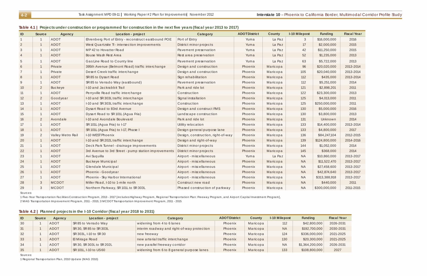
4.1 Programmed projectsThis section presents projects that are programmed for construction in the next five years (fiscal year 2013 to 2017) or are included in the MAG RTP. These projects have an identified construction timeframe and funding source and are included in Transportation Improvement Programs (TIPs) for the state, county, MPO, COG, or local government.
The list of programmed projects in the five-year construction programs is presented in Table 4.1 and displayed on a map in Figure 4.1. The table includes the budgeted funding as well as the anticipated construction timeframe. The additional projects that are included in the MAG RTP are presented in Table 4.2 and displayed in Figure 4.1.
The following sections provide additional descriptions of the I-10 Corridor projects as categorized by the need or mode served by the project.
PreservationMuch of the I-10 Corridor was constructed over 40 years ago, therefore maintaining the existing infrastructure is a high priority for ADOT. This is reflected in the five-year construction program.
PavementPavement along a total of 28 miles of I-10 in eastern La Paz County will be removed and replaced in the next five years. The projects include a rubberized asphalt overlay.
StructuresThere are no programmed projects for rehabilitation or replacement of existing bridge structures.
DrainageImprovements to the drainage and pump stations within and around the Deck Park Tunnel are planned in 2014.
InterchangesSpot improvements at the intersections of the ramps, crossroad, and frontage road at the West Quartzsite
traffic interchange are programmed in 2015 to keep it functioning at an acceptable level. The improvements also focus on improving access for commercial trucks to the new truck stops being constructed as well as the proposed industrial park in Quartzsite.SignsADOT recently adopted the latest version of the Manual on Uniform Traffic Control Devices and are upgrading signs as needed through the corridor. This project includes rehabilitation of the signs between SR 85 and Dysart Road.
Intelligent Transportation SystemsThe funding within the MAG RTP includes the continued expansion of ITS in the region. In 2016, funding is allocated to design and construct freeway management systems between Dysart Road and 83rd Avenue.
Rest areasMajor infrastructure improvements are planned for the Bouse Wash Rest Area at milepost 52. The improvements include replacing two pond liners, improvements to the booster pump system and control, and some structural, mechanical and electrical systems upgrades.
Vehicular trafficThis section outlines projects programmed to add vehicular capacity or improve access to the I-10 Corridor.
RoadWithin the next five years, two major new freeways are programmed for construction: SR 303L, which is already under construction and SR 202L, which is anticipated to begin construction in 2014. Both corridors represent significant transportation investments and will be constructed over a number of years.
Multiple projects are included in the MCDOT TIP for the Northern Parkway. The overall project includes construction of a six or more lane parkway along the east-to-west Northern Avenue alignment between SR 101L and SR 303L (see number 29 in Figure 4.1).
The purpose of the Miller Road project is to pave Miller Road from I-10 (milepost 114) to the Army National Guard Facility (see number 28 in Figure 4.1). The estimated cost is $440,000.
The RTP includes funding for the following planned projects in the I-10 Corridor:
● widening of I-10 between SR 85 and Verrado Way (funding included in the RTP)
● SR 30 freeway between SR 303L and SR 202L (parallels I-10)
● SR 303L south of I-10 to SR 30 ● extension of SR 30 west of SR 303L to SR 85 as an interim facility including right-of-way acquisition
InterchangesA number of new service traffic interchanges are planned to be constructed in the next five years, including:
● 395th Avenue (Belmont Road), a privately funded interchange near milepost 96
● Desert Creek, a privately funded interchange near milepost 105
● Perryville Road, and interchange funded by the RTP and located near milepost 122
The privately funded interchanges would provide access to planned residential master-planned communities. The Perryville Road traffic interchange would provide additional access to Goodyear and Buckeye and would be the connection point for a future Arizona Parkway corridor.
Both major freeway corridors, SR 303L and SR 202L, will connect to I-10 with freeway-to-freeway system traffic interchanges. The SR 303L interchange, located near milepost 125 is under construction and planned to be completed by the end of 2014. The SR 202L interchange, located near milepost 139, may begin construction as early as 2014. Both interchanges include major reconstruction along I-10 and adjacent service traffic interchanges.
Interstate 10 – Phoenix to California Border, Multimodal Corridor Profile StudyTask Assignment MPD 09-11 | Working Paper #2 Plan for Improvements| November 20124-2
Table 4.1 | Projects under construction or programmed for construction in the next five years (fiscal year 2013 to 2017)ID Source Agency Location - project Category ADOT District County I-10 Milepost Funding Fiscal Year1 1 ADOT Ehrenberg Port of Entry - reconstruct eastbound POE Port of Entry Yuma La Paz 3 $16,000,000 20162 1 ADOT West Quartzsite TI - intersection improvements District minor projects Yuma La Paz 17 $2,000,000 20153 1 ADOT MP 42 to Hovatter Road Pavement preservation Yuma La Paz 42 $11,250,000 20154 1 ADOT Bouse Wash Rest Area Rest area preservation Yuma La Paz 52 $1,235,000 2013
5 1 ADOT Gas Line Road to County line Pavement preservation Yuma La Paz 63 $5,722,000 20136 1 Private 395th Avenue (Belmont Road) traffic interchange Design and construction Phoenix Maricopa 96 $20,020,000 2013-20147 1 Private Desert Creek traffic interchange Design and construction Phoenix Maricopa 105 $20,040,000 2013-20148 1 ADOT SR 85 to Dysart Road Sign rehabilitation Phoenix Maricopa 112 $435,000 2013-20149 1 ADOT SR 85 to Verrado Way (eastbound) Pavement preservation Phoenix Maricopa 112 $5,251,000 201410 2 Buckeye I-10 and Jackrabbit Trail Park and ride lot Phoenix Maricopa 121 $2,898,201 201111 1 ADOT Perryville Road traffic interchange Construction Phoenix Maricopa 122 $23,300,000 201312 2 Goodyear I-10 and SR 303L traffic interchange Signal installation Phoenix Maricopa 125 $4,013,000 201113 1 ADOT I-10 and SR 303L traffic interchange Construction Phoenix Maricopa 125 $250,000,000 201114 1 ADOT Dysart Road to 83rd Avenue Design and construct FMS Phoenix Maricopa 130 $5,000,000 201615 1 ADOT Dysart Road to SR 101L (Agua Fria) Landscape construction Phoenix Maricopa 130 $3,800,000 201316 2 Avondale I-10 and Avondale Boulevard Park and ride lot Phoenix Maricopa 131 Unknown 201417 1 ADOT SR 101L (Agua Fria) to I-17 Utility relocation Phoenix Maricopa 133 $14,400,000 2013-201418 1 ADOT SR 101L (Agua Fria) to I-17, Phase I Design general purpose lane Phoenix Maricopa 133 $4,800,000 201719 2 Valley Metro Rail I-10 WEST Phoenix Design, construction, right-of-way Phoenix Maricopa 136 $84,247,104 2012-201520 1 ADOT I-10 and SR 202L traffic interchange Design and right-of-way Phoenix Maricopa 139 $124,800,000 2014-201621 1 ADOT Deck Park Tunnel - drainage improvements District minor projects Phoenix Maricopa 144 $1,052,000 201422 1 ADOT 3rd Avenue to 3rd Street - pump station improvements District minor projects Phoenix Maricopa 145 $368,000 201423 1 ADOT Avi Suquilla Airport - miscellaneous Yuma La Paz NA $10,860,000 2013-201724 1 ADOT Buckeye Municipal Airport - miscellaneous Phoenix Maricopa NA $11,522,470 2013-201725 1 ADOT Glendale Municipal Airport - miscellaneous Phoenix Maricopa NA $27,458,600 2013-201726 1 ADOT Phoenix - Goodyear Airport - miscellaneous Phoenix Maricopa NA $42,874,640 2013-201727 1 ADOT Phoenix - Sky Harbor International Airport - miscellaneous Phoenix Maricopa NA $313,388,918 2013-201728 3 MCDOT Miller Road, I-10 to 1-mile north Construct new road Phoenix Maricopa NA $440,000 201129 3 MCDOT Northern Parkway, SR 101L to SR 303L Phased construction of parkway Phoenix Maricopa NA $300,000,000 2011-2015Sources: 1 Five-Year Transportation Facilities Construction Program, 2013 - 2017 [includes Highway Program, Regional Transportation Plan: Freeway Program, and Airport Capital Investment Program], 2 MAG Transportation Improvement Program, 2011 - 2015; 3 MCDOT Transportation Improvement Program, 2011 - 2015
Table 4.2 | Planned projects in the I-10 Corridor (fiscal year 2018 to 2031)ID Source Agency Location - project Category ADOT District County I-10 Milepost Funding Fiscal Year30 1 ADOT SR 85 to Verrado Way widening from 4 to 6 lanes Phoenix Maricopa 112 $42,800,000 2026-203131 1 ADOT SR 30, SR 85 to SR 303L interim roadway and right-of-way protection Phoenix Maricopa NA $192,700,000 2030-203132 1 ADOT SR 303L, I-10 to SR 30 new freeway Phoenix Maricopa 124 $336,000,000 2021-202533 1 ADOT El Mirage Road new arterial traffic interchange Phoenix Maricopa 130 $20,300,000 2021-202534 1 ADOT SR 30, SR 303L to SR 202L new parallel freeway corridor Phoenix Maricopa NA $1,364,200,000 2026-203135 1 ADOT SR 101L, I-10 to US 60 widening from 6 to 8 general purpose lanes Phoenix Maricopa 133 $108,800,000 2027Sources: 1 Regional Transportation Plan, 2010 Update (MAG 2010)

Task Assignment MPD 09-11 | Working Paper #2 Plan for Improvements| November 2012Interstate 10 – Phoenix to California Border, Multimodal Corridor Profile Study 4-3
§̈¦10Éx95
Salome Road
Vick
sbur
g R
oad
River
Colo
rado
CA
£¤95
AZ
£¤60
£¤95
to A
vi S
uqui
llaA
irpor
t
Blythe
¬«1
¬«2
¬«3
¬«4
¬«5Centennial
Morgantown
Quartzsite
Vicksburg
70
60
50
40
103020
MARICOPACOUNTY
LA PAZCOUNTY Bouse
Wash
Ehrenberg
Interstate 10: Phoenix to California Border Multimodal Corridor Profile Study
Path
: E:\P
roje
cts\
AZ\A
DO
T\A
DO
T_M
PD
_FY
11_I
10\m
ap_d
ocs\
mxd
\I10_
Phx
Cal
i_Pr
ogP
roje
cts.
mxd
Date: 10/11/2012
o
o
oóóóóóóóóóóóóóó
óóóóóóóóóó ! ! !! !! ! ! !! !! ! ! !! !! ! ! !! !! ! ! !!
óóóó
!!!!!!!!!!!!!!!!!!
! ! ! ! ! ! ! ! ! ! ! ! ! ! ! ! ! !
V V V V V V V Vkk kk k
k
k kIAIA
#*
#*
#*#* #*
#*
#*
#*
#*
Éx101
Éx303 Éx51
Win
ters
burg
Roa
d120 140
90
£¤60
Éx85
§̈¦10
§̈¦17
Salome Road
Rai l road
Burlington Northern Santa Fe Railroad¬«6
¬«7 ¬«8¬«9
¬«10
¬«11
¬«12
¬«13
¬«14
¬«15
¬«16
¬«17
¬«18
¬«20
¬«21 ¬«22
¬«24
¬«25
¬«26
¬«28
¬«29
Éx202
¬«19
¬«31
¬«34¬«32
¬«30
¬«35
¬«33
Buckeye
WintersburgGoodyear
Avondale
PhoenixTolleson
Tonopah
Glendale
110
130
100
80
Sal t Rive r
Has
saya
mpa
Riv
er
G i la River
Union Pac i f ic
MARICOPACOUNTY
BuckeyeMunicipalAirport
GlendaleMunicipal Airport
Phoenix Goodyear Airport
La Paz County
Maricopa County
Éx101 Éx51
£¤60
Éx303
Éx85
Éx95
£¤60
§̈¦10
§̈¦17
Éx74CA AZLa Paz County
Maricopa County
Note: Items #23 and #27 are located outside map limits.
N 0 2 4 6 8 101
miles
N 0 2 4 6 8 101
miles
City#* Milepost
StreamLakeCounty boundary
¬«# Project ID, refer to Table 4.1
Port of entry improvementsRest area improvements
k New or improved service traffic interchange
k New system traffic interchange
o Airport improvements
IA Park and ride lot
Drainage
!!!!!!! ! ! ! ! ! FMS
V V V Landscaping
Light rail
óóóóóó Pavement preservation
Signs
!! !! ! ! Utilities
Widening
New freeway
New parkway
Interim road and right-of-way
Figure 4.1 | Projects under construction or programmed for construction in the next five years

Interstate 10 – Phoenix to California Border, Multimodal Corridor Profile StudyTask Assignment MPD 09-11 | Working Paper #2 Plan for Improvements| November 20124-4
The Phoenix West extension will extend light rail 11 miles from downtown Phoenix, through the State Capitol area, to approximately 79th Avenue and I-10 freeway.
I-10 WEST Phoenix light rail line
To prepare for the SR 202L system traffic interchange, utilities along I-10 between SR 101L and I-17 will need to be relocated. Funds have been programmed to advance this effort due to the lead time necessary.
The RTP also includes funding for:
● El Mirage Road and I-10 service traffic interchange ● SR 303L and I-10 system traffic interchange (south half)
TransitThis section outlines capital investments programmed to add bus or high-capacity transit capacity or improve access to transit options in the I-10 Corridor.
Bus New park and ride lots are planned at Jackrabbit Trail and I-10 in Buckeye and at Avondale Boulevard and I-10 in Avondale. The lot in Buckeye is funded through the RTP while the Avondale lot is locally funded. Both areas would be served by existing express bus routes along I-10.
Light railThe initial phases (environmental clearance, preliminary design, and right-of-way acquisition) of the new I-10 WEST Phoenix light rail corridor are programmed to begin in 2012. A map of the proposed alignment and stations are presented in the sidebar on this page.
Passenger railNo capital improvements are programmed, however coordination and other activities are ongoing.
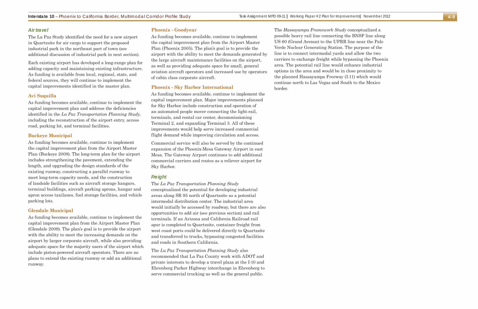
Air travelThe tentative five-year Airport Capital Improvement Program includes a total of $1.21 billion. The following sections provide a brief overview of the improvements programmed at the airports accessed from the I-10 Corridor.
Avi SuquillaAvi Suquilla Airport is located outside of the study are, approximately 40 miles north of I-10 along SR 95 in Parker, Arizona. The airport is one of the only airports serving communities in western Arizona. Almost $11 million is programmed for the airport. The major projects are to improve site drainage, rehabilitate the runway pavement, construct a new taxiway, and expand the paved apron.
Buckeye MunicipalAlmost $12 million is programmed for the airport. The major projects are to acquire land or easements for approaches, rehabilitation of runway pavement, and constructing fire suppression system and domestic water system.
Glendale MunicipalOver $27 million is programmed for the airport. The major projects are to acquire land or easements for approaches and construction of new taxiways and runway extensions.
Phoenix - GoodyearAlmost $43 million is programmed for the airport. The major projects are to preserve apron and runway

Task Assignment MPD 09-11 | Working Paper #2 Plan for Improvements| November 2012Interstate 10 – Phoenix to California Border, Multimodal Corridor Profile Study 4-5
pavement and construction of new taxiways and runway extensions.
Phoenix - Sky Harbor InternationalOver $313 million is programmed for the airport. The major projects are to reconstruct the apron around Terminal 3 and 4 as well as the acquisition of adjacent land to mitigate noise impacts.
FreightThere are no known projects specifically related to the movement of freight through trucks and rail. Roadway improvements will facilitate truck traffic and the movement of freight. Also, private companies continue to implement enhancements to make their services more efficient and cost-effective. A number of large distribution warehouses, including companies like Amazon, have been constructed recently in the vicinity of I-10 and SR 303L.
Port of entryThe eastbound port of entry near the California border will be completely reconstructed and modernized in 2016 including upgrading the building and communications system to provide sufficient staging area and storage for trucks being processed. The port of entry ensures that large trucks are in good working condition and not overweight. It needs to be expanded with the latest technology to efficiently accommodate increasing truck volumes entering Arizona on I-10.
4.2 Potential projectsThis section lists and describes potential projects in the I-10 Corridor. Sources for the projects include:
● deficiencies identified in Working Paper #1 ● needs identified in long-range planning studies ● recommendations from stakeholders that have been identified in planning documents
A list of the potential projects are presented in Table 4.2. The projects are listed by general location in the I-10 Corridor from west to east. This study does not include recommendations related to prioritization of the projects. Projects would be prioritized by the resource agencies
(such as ADOT, WACOG, and MAG) depending on the location or jurisdiction of the project.
Additional descriptions and information are provided by element in the following sections.
PreservationPavementPavement preservation is a high priority for ADOT. ADOT allocates annually a percentage of their total funding for pavement preservation projects around the state. The I-10 Corridor will continue to compete for these funds.
As improvements are made to I-10, it may be appropriate to replace the asphalt concrete with Portland cement concrete pavement to better handle the high truck and vehicular traffic volumes. The cement concrete is more rigid and is more able to withstand the loading from large trucks.
StructuresWorking Paper #1 presented the sufficiency rating for all of the bridges in the I-10 Corridor. In total, 20 bridges are eligible for rehabilitation based on their sufficiency rating. Bridges eligible for rehabilitation are listed in Table 4.3.
There were also 39 culverts eligible for rehabilitation. ADOT should continue to monitor and inspect the bridges structures along I-10 to identify measures for extending the life of the structures.
During the evaluation of improvements to bridge structures or culverts, consideration should be given for incuding wildlife-related enhancements. I-10 passes through a number of wildlife linkage corridors identified by the Arizona Game and Fish Department.
DrainageRunoff in the I-10 Corridor is typically north to south and the I-10 Corridor presents a barrier to this flow. As additional development occurs upstream and downstream of I-10 it will be important to participate in area drainage master planning efforts to ensure that I-10 is not adversely impacted.
The ADOT Yuma District has observed issues at the Centennial Wash and Bouse Wash with each overtopping during heavy storms.
InterchangesThe Yuma District has initiated the environmental clearance and final design for a roundabout project at the Poston Road traffic interchange. The roundabout would be located at the intersection just south of I-10 that includes the on- and off-ramps and frontage road. Funding for the project has not been identified at this time, but it should be ready for construction in 2013.
Additionally, the La Paz Transportation Planning Study identified the need to improve the intersections between the ramps and crossroads at all of the interchanges in La Paz County along I-10. These interchanges were built to rural standards and as development occurs they are not able to meet the traffic demand. The focus of the improvements would include:
● increased turning radii to allow large trucks to better navigate the intersections
● better lighting ● signalized intersections as warranted by traffic demand
InterchangesImprovements at ramp and crossroad intersections will continue to be needed throughout the I-10 Corridor to provide efficient traffic operations and maintain access opportunities as growth and development occurs. Developers should conduct traffic studies as warranted to identify needs for additional turn lanes, through lanes, and signalization.
Rest areasMany of the rest areas in the I-10 Corridor are beyond their original design life and need major repairs or reconstruction. ADOT is currently evaluating rest area operations and maintenance. Based on the outcome from the analysis, improements would be recommended and programmed. In other areas of the state, ADOT is useing public-private partnership to fund the maintenance and operation of rest areas.

Interstate 10 – Phoenix to California Border, Multimodal Corridor Profile StudyTask Assignment MPD 09-11 | Working Paper #2 Plan for Improvements| November 20124-6
Table 4.3 | Potential projects in the I-10 Corridor
ID Source Agency Location - project CategoryADOT
District County I-10 Milepost Funding
1 1 ADOT Miscellaneous Pavement preservation Yuma La Pax 0-71 None2 4 ADOT California border to Maricopa County border Widen from 4 to 6 lanes Yuma La Paz 0 None3 1 ADOT Ehrenberg Bridge Bridge rehabilitation Yuma La Paz 0 None4 3 Travel plaza at Ehrenberg interchange Freight Yuma La Paz 1 None5 5 ADOT Poston Road TI roundabout at south ramp intersection Yuma La Paz 1 None6 3 ADOT Tom Wells Road interchange improvements Yuma La Paz 5 None7 3 ADOT Dome Rock Road interchange improvements Yuma La Paz 11 None8 3 ADOT West Quartzsite Road interchange improvements Yuma La Paz 17 None9 1 ADOT West Quartzsite TI UP Bridge rehabilitation Yuma La Paz 17 None10 3 Quartzsite local transit circulator Transit Yuma La Paz None11 3 La Paz County regional bus service Transit Yuma La Paz None12 3 Quartzsite airport New airport and air cargo facilities Yuma La Paz None13 3 Arizona and California rail spur to Quartzsite Freight Yuma La Paz None14 3 ADOT Riggles Avenue interchange improvements Yuma La Paz 19 None15 3 ADOT Gold Nugget Road interchange improvements Yuma La Paz 26 None16 3 ADOT US 60 interchange improvements Yuma La Paz 31 None17 3 ADOT Vicksburg Road interchange improvements Yuma La Paz 45 None18 3 ADOT Hovatter Road interchange improvements Yuma La Paz 53 None19 3 ADOT Avenue 75 E interchange improvements Yuma La Paz 69 None20 4 ADOT Maricopa County border to 459th Avenue Widen from 4 to 6 lanes Yuma Maricopa 71 None21 3 ADOT Salome Road interchange improvements Yuma Maricopa 81 None22 2 ADOT 459th Avenue to Hassayampa Freeway widen to 8 lanes plus 2 HOV lanes Yuma Maricopa 88 None23 2 ADOT 459th Avenue new arterial traffic interchange Yuma Maricopa 88 None24 2 ADOT 443rd Avenue new arterial traffic interchange Yuma Maricopa 90 None25 2 ADOT 427th Avenue new arterial traffic interchange Yuma Maricopa 92 None26 2 ADOT 411th Avenue improve to freeway-parkway interchange Yuma Maricopa 94 None27 2 ADOT 395th Avenue new arterial traffic interchange Yuma Maricopa 96 None28 2 ADOT Wintersburg Road improve to freeway-parkway interchange Yuma Maricopa 98 None29 2 ADOT Hassayampa Freeway to SR 85 widen to 8 lanes plus 2 HOV lanes Yuma Maricopa 100 None30 2 ADOT Hassayampa Freeway new system traffic interchange Yuma Maricopa 100 None31 2 ADOT 347th Avenue new arterial traffic interchange Yuma Maricopa 102 None32 2 ADOT 323rd Avenue new arterial traffic interchange Yuma Maricopa 105 None33 2 ADOT Johnson Road new arterial traffic interchange Yuma Maricopa 107 None34 2 ADOT Palo Verde Road improve to freeway-parkway interchange Yuma Maricopa 109 None35 2 ADOT Wilson Road new arterial traffic interchange Yuma Maricopa 110 None36 2 ADOT SR 85 improve to fully directional system interchange Phoenix Maricopa 112 None37 2 ADOT SR 85 to SR 303L widen to 8 lanes plus 2 HOV lanes Phoenix Maricopa 112 None38 2 ADOT Watson Road improve to freeway-parkway interchange Phoenix Maricopa 116 None39 2 ADOT Dean Road new arterial traffic interchange Phoenix Maricopa 119 None
(continued on next page)

Task Assignment MPD 09-11 | Working Paper #2 Plan for Improvements| November 2012Interstate 10 – Phoenix to California Border, Multimodal Corridor Profile Study 4-7
Table 4.3 | Potential projects in the I-10 Corridor
ID Source Agency Location - project CategoryADOT
District County I-10 Milepost Funding
40 2 ADOT Perryville Road improve to freeway-parkway interchange Phoenix Maricopa 122 None41 4 ADOT Papago West Drain Bridge 107th Avenue Bridge rehabilitation Phoenix Maricopa 132 None42 4 ADOT 99th Avenue TI OP Bridge rehabilitation Phoenix Maricopa 133 None43 4 ADOT Papago West Drain Bridge 99th Avenue Bridge rehabilitation Phoenix Maricopa 133 None44 4 ADOT 91st Avenue TI UP Bridge rehabilitation Phoenix Maricopa 134 None45 4 ADOT 83rd Avenue TI UP Bridge rehabilitation Phoenix Maricopa 135 None46 4 ADOT 75th Avenue TI UP Bridge rehabilitation Phoenix Maricopa 136 None47 4 ADOT 67th Avenue TI UP Bridge rehabilitation Phoenix Maricopa 137 None48 4 ADOT 59th Avenue TI UP Bridge rehabilitation Phoenix Maricopa 138 None49 4 ADOT 51st Avenue TI UP Bridge rehabilitation Phoenix Maricopa 139 None50 4 ADOT 51st Avenue Papago Drain Bridge Bridge rehabilitation Phoenix Maricopa 139 None51 4 ADOT 43rd Avenue TI UP Bridge rehabilitation Phoenix Maricopa 140 None52 4 ADOT 35th Avenue TI UP Bridge rehabilitation Phoenix Maricopa 141 None53 4 ADOT 27th Avenue OP EB Bridge rehabilitation Phoenix Maricopa 142 None54 4 ADOT 5th Avenue UP and pedestrian UP Bridge rehabilitation Phoenix Maricopa 144 None55 4 ADOT 3rd Avenue UP and pedestrian UP Bridge rehabilitation Phoenix Maricopa 144 None56 4 ADOT Central Avenue Bridge NB Bridge rehabilitation Phoenix Maricopa 145 None57 4 ADOT Central Avenue Bridge SB Bridge rehabilitation Phoenix Maricopa 145 None58 4 ADOT Deck At Central Avenue Bridge rehabilitation Phoenix Maricopa 145 None59 2 Yuma West Corridor Commuter rail Phoenix Maricopa None60 2 BNSF to UPRR heavy rail line Freight Phoenix Maricopa None61 2 Bus rapid transit along I-10, SR 30, SR 303L Transit Phoenix Maricopa NoneSources: 1 Regional Transportation Plan, 2010 Update (MAG 2010)2 Interstate 10 - Hassayampa Valley Roadway Framework Study (MAG 2007)3 La Paz Transportation Planning Study (ADOT 2010)4 I-10 - Phoenix to California Border, Multimodal Corridor Profile Study, Working Paper #15 Stakeholder interviews

Interstate 10 – Phoenix to California Border, Multimodal Corridor Profile StudyTask Assignment MPD 09-11 | Working Paper #2 Plan for Improvements| November 20124-8
Vehicular trafficThis section outlines projects planned to add vehicular capacity or improve access to the I-10 Corridor.
RoadTo improve safety and meet the travel demand of the future, I-10 will need to be widened to six lanes from the California border to 459th Avenue (western edge of the build-out Phoenix metropolitan area). Based on the traffic forecasts for 2035 presented in Working Paper #1, these additional lanes are not needed until after 2035.
In La Paz County, the widening may be constructed in phases near more developed areas such as Quartzsite. Coordination with the California Department of Transportation will be important to ensure the six-lane concept can be extended into California and the Blythe area.
In Maricopa County, the Hassayampa Framework Study recommended:
● additional general purpose and HOV lanes to the RTP-planned lanes between 459th Avenue and SR 303L (recommended in the Hassayampa Framework Study)
● extension of SR 303L south of SR 30 and the Gila River
● extension of SR 30 west of SR 303L to SR 85 and the Hassayampa Freeway
● construction of the new Hassayampa Freeway (potentially as I-11)
InterchangesNo additional interchanges beyond the existing locations in La Paz County have been proposed.
New or enhanced service and system traffic interchanges will be needed in the future to support the additional travel demand and development along the I-10 Corridor in western Maricopa County.
To support the planned road network west of SR 303L proposed in the Hassayampa Framework Study, a number of new service traffic interchanges would be needed. Additionally, a number of existing interchanges
Rail System Study (MAG 2010) included the Yuma West Corridor on the Union Pacific Railroad tracks that parallel I-10 from downtown Buckeye to downtown Phoenix. No specific projects have been identified to advance the Yuma West Corridor, however, the System Study identified near- and long-term implementation steps for commuter rail in general.
Near-term implementation steps
● periodic ridership forecast updates ● coordination with Union Pacific Railroad ● address enabling legislation regarding liability and indemnification
● coordination of infrastructure improvements with the railroads, ADOT, and local jurisdictions
● identify funding commitments ● initiate process for Federal funding ● develop and implement governance plan ● preserve future options ● local planning efforts
Long-term implementation steps
● formalize partnership with the railroads ● secure sources of funding including federal, state, regional and local public funding, as well as private sector participation
● design, construct, and operate initial commuter rail system
● continue planning to develop seamless transportation system and meet regional sustainability goals
In 2010, Phoenix joined the cities of Los Angeles and Las Vegas in the study of the feasibility of high-speed rail connecting the major metropolitan areas. The long-range vision is to establish a system of high-speed rail corridors with trains operating faster than 125 miles per hour to compete with air travel. The implementation of a high-speed rail network connecting Arizona with destinations in California and Nevada would be accomplished over several decades. Required studies and environmental clearances can take a decade or longer, and should be a priority for the near future (ADOT 2011).
would need to be upgraded to “freeway-to-parkway” interchanges.
A major system traffic interchange would be needed for the intersection of I-10 and the future Hassayampa Freeway and the SR 85 system traffic interchange would need upgrades to allow for a connection north of I-10 to Turner Parkway.
TransitThis section outlines capital investment needs to add bus or high-capacity transit capacity or improve access to transit options in the I-10 Corridor.
Bus The La Paz Study identified the need for expanded bus service including local circulators and rural/regional connections. A local circulator would be needed in Quartzsite while I-10 would be the primary route for regional service to Blythe or the Phoenix Area.
The Hassayampa Framework Study identified the need for extending high-capacity transit corridors, such as Bus Rapid Transit, along I-10 and other planned freeways such as SR 30 and SR 303L west to the Hassayampa Freeway.
Light railThere are no current plans to extend the light rail corridor west of 79th Avenue. However, there are a number of proposed projects to improve the efficiency of the route, including:
● construction of direct access ramps from I-10 to I-17 ● expanding the 79th Avenue park and ride station ● identifying and developing a new park and ride station at 59th Avenue and I-10
● construction of direct connection HOV ramps to and from I-10 on the west side of 79th Avenue providing access to the existing park and ride station
Passenger railMAG began studying commuter rail as a potential high capacity transit option in 2003. Since then, MAG has continued to refine and evaluate commuter rail options to serve the metropolitan Phoenix area. The Commuter
Task Assignment MPD 09-11 | Working Paper #2 Plan for Improvements| November 2012Interstate 10 – Phoenix to California Border, Multimodal Corridor Profile Study 4-9
Air travelThe La Paz Study identified the need for a new airport in Quartzsite for air cargo to support the proposed industrial park in the northeast part of town (see additional discussion of industrial park in next section).
Each existing airport has developed a long-range plan for adding capacity and maintaining existing infrastructure. As funding is available from local, regional, state, and federal sources, they will continue to implement the capital improvements identified in the master plan.
Avi SuquillaAs funding becomes available, continue to implement the capital improvement plan and address the deficiencies identified in the La Paz Transportation Planning Study, including the reconstruction of the airport entry, access road, parking lot, and terminal facilities.
Buckeye MunicipalAs funding becomes available, continue to implement the capital improvement plan from the Airport Master Plan (Buckeye 2009). The long-term plan for the airport includes strengthening the pavement, extending the length, and upgrading the design standards of the existing runway, constructing a parallel runway to meet long-term capacity needs, and the construction of landside facilities such as aircraft storage hangars, terminal buildings, aircraft parking aprons, hangar and apron access taxilanes, fuel storage facilities, and vehicle parking lots.
Glendale MunicipalAs funding becomes available, continue to implement the capital improvement plan from the Airport Master Plan (Glendale 2009). The plan’s goal is to provide the airport with the ability to meet the increasing demands on the airport by larger corporate aircraft, while also providing adequate space for the majority users of the airport which include piston-powered aircraft operators. There are no plans to extend the existing runway or add an additional runway.
Phoenix - GoodyearAs funding becomes available, continue to implement the capital improvement plan from the Airport Master Plan (Phoenix 2005). The plan’s goal is to provide the airport with the ability to meet the demands generated by the large aircraft maintenance facilities on the airport, as well as providing adequate space for small, general aviation aircraft operators and increased use by operators of cabin class corporate aircraft.
Phoenix - Sky Harbor InternationalAs funding becomes available, continue to implement the capital improvement plan. Major improvements planned for Sky Harbor include construction and operation of an automated people mover connecting the light-rail, terminals, and rental car center, decommissioning Terminal 2, and expanding Terminal 3. All of these improvements would help serve increased commercial flight demand while improving circulation and access.
Commercial service will also be served by the continued expansion of the Phoenix-Mesa Gateway Airport in east Mesa. The Gateway Airport continues to add additional commercial carriers and routes as a reliever airport for Sky Harbor.
FreightThe La Paz Transportation Planning Study conceptualized the potential for developing industrial areas along SR 95 north of Quartzsite as a potential intermodal distribution center. The industrial area would initially be accessed by roadway, but there are also opportunities to add air (see previous section) and rail terminals. If an Arizona and California Railroad rail spur is completed to Quartzsite, container freight from west coast ports could be delivered directly to Quartzsite and transferred to trucks, bypassing congested facilities and roads in Southern California.
The La Paz Transportation Planning Study also recommended that La Paz County work with ADOT and private interests to develop a travel plaza at the I-10 and Ehrenberg Parker Highway interchange in Ehrenberg to serve commercial trucking as well as the general public.
The Hassayampa Framework Study conceptualized a possible heavy rail line connecting the BNSF line along US 60 (Grand Avenue) to the UPRR line near the Palo Verde Nuclear Generating Station. The purpose of the line is to connect intermodal yards and allow the two carriers to exchange freight while bypassing the Phoenix area. The potential rail line would enhance industrial options in the area and would be in close proximity to the planned Hassayampa Freeway (I-11) which would continue north to Las Vegas and South to the Mexico border.

This page is intentionally left blank.

Task Assignment MPD 09-11 | Working Paper #2 Plan for Improvements| November 2012Interstate 10 – Phoenix to California Border, Multimodal Corridor Profile Study 5-1
5. References
Arizona Department of Transportation. 2003. Statewide Bicycle and Pedestrian Plan.
———. 2007. Arizona Multimodal Freight Analysis Study.
———. 2008. Arizona Rural Transit Needs Study.———. 2010. La Paz Transportation Planning Study.———. 2011. Arizona State Rail Plan. March.———. 2011. State Transportation Improvement Program
Fiscal Year 2011 to 2014. June.———. 2012. Five-Year Transportation Facilities
Construction Program 2013 to 2017. March.La Paz County. 2005. La Paz County Comprehensive
Plan.Maricopa Association of Governments (MAG). 2007.
Interstate 10 - Hassayampa Valley Roadway Framework Study.
———. 2010. Transportation Improvement Program FY 2011-2015. July.
———. 2010. Regional Transportation Plan 2010 Update. July.
———. 2010. Regional Transit Framework Study.Maricopa County Trail Commission. 2004. Maricopa
County Regional Trail System Plan.METRO. 2012. Corridor Advanced Transit Opportunities
Program, Phoenix West Extension AA. Draft July.

This page is intentionally left blank.

Task Assignment MPD 09-11 | Working Paper #2 Plan for Improvements| November 2012Interstate 10 – Phoenix to California Border, Multimodal Corridor Profile Study A-1
Appendix A: Planning and Environmental Linkages Questionnaire and Checklist

Interstate 10 – Phoenix to California Border, Multimodal Corridor Profile StudyTask Assignment MPD 09-11 | Working Paper #2 Plan for Improvements| November 2012A-2
Interstate 10 – Phoenix to California Border, Multimodal Corridor Profile Study
4 ADOT Planning and Environmental Linkages Questionnaire and Checklist
Questionnaire for Transportation Planners – Part 1
This part of the questionnaire should be completed by transportation planners at the beginning of the transportation planning study. Please note that planners should also review the second part of the questionnaire to understand what additional issues will need to be considered and documented as the study progresses.
Project identification
What is the name of the study? What cities and region does it cover? What major streets are covered? For corridor studies, what are the intended termini? The study is called the I-10, Phoenix to California Border, Multimodal Corridor Profile Study. The study focuses on the “I-10 Corridor” between the California border near Ehrenberg, Arizona, and Central Avenue in downtown Phoenix. The study area is defined as a two-mile wide corridor centered about I-10 and includes portions of La Paz and Maricopa County, Arizona, and the cities and towns of Ehrenberg, Quartzsite, Tonopah, Buckeye, Goodyear, Avondale, Tolleson, and Phoenix. The major highways that intersect the I-10 Corridor include US 95, SR 95, US 60, SR 85, SR 303L, SR 101L, and I-17.
Who is the study sponsor? The Arizona Department of Transportation, Multimodal Planning Division
Briefly describe the study and its purpose. The primary purpose and need for this study is to consolidate the myriad planning documents for the I-10 Corridor and develop a clear vision of the transportation roles of the I-10 Corridor. Within La Paz County (WACOG region), the study will also:
Formulate a multimodal transportation plan that incorporates highway and transit travel modes and complements the area’s current and future development patterns.
Analyze the physical layout and number of general purpose and special-use travel lanes needed to serve the future I-10 Corridor travel demand.
Plan for and address freight needs within and through the I-10 Corridor. Consider community character and potential impacts throughout the planning process. Determine changes in access patterns within the I-10 Corridor that could encourage better multimodal cohesion and connectivity and
improve safety. Within Maricopa County, MAG member agencies have adopted the Regional Transportation Plan (RTP) and Interstate 10 – Hassayampa Valley Roadway Framework Study which serve similar purposes for the I-10 Corridor within the MAG region. Therefore, this study will focus on compiling the recommendations from these studies and others into a single resource focused on the I-10 Corridor. New alternatives and improvements will not be recommended within the MAG region. The report document will be developed in a framework approach that can be applied to other corridor studies.
Who are the primary study team members (include name, title, organization name, and contact information)? See roster at end of Part 1.
Does the team include advisory groups such as a technical advisory committee, steering committee, or other? If so, include roster(s) as attachment(s).Yes, see roster at end of Part 1.
Have previous transportation planning studies been conducted for this region? If so, provide a brief chronology, including the years the studies were completed. Provide contact names and locations of the studies and study websites. Yes. An extensive list is attached at the end of Part 1. The major drivers include: What Moves you Arizona (ADOT 2011 LRTP); Statewide Transportation Planning Framework (bqAZ) (ADOT 2010); La Paz Transportation Plan (ADOT 2010); Interstate 10 – Hassayampa Roadway Framework Study (MAG 2007); I-10 Profile Study (ADOT 2005), Regional Transportation Plan (MAG 2004),
Interstate 10 – Phoenix to California Border, Multimodal Corridor Profile Study
ADOT Planning and Environmental Linkages Questionnaire and Checklist 5
What current or near-future planning (or other) studies in the vicinity are underway or will be undertaken? What is the relationship of this study to those studies? Provide contact names and locations of the studies and study websites. METRO I-10 High-capacity Transit Study; MAG Southwest Transit Study, ADOT Perryville Road TI Study; MCDOT Parkway Studies; MAG Gila Bend SATS; South Mountain Freeway EIS; SR 30 EA; SR 303L (south of I-10) EA;
Study objectives
What are your desired outcomes for this study? (Mark all that apply.) Stakeholder identification Stakeholder roles/responsibilities definition Travel study area definition Performance measures development Development of purpose and need goals and other objectives Alternative evaluation and screening Alternative travel modes definition
Scheduling of infrastructure improvements over short-, mid-, and long-range time frames
Environmental impacts Mitigation identification Don't know Other ____________________________________
Have system improvements and additions that address your transportation need been identified in a fiscally constrained regional transportation plan? No. The RTP identified system improvements to address needs through 2026; this study incorporates other recommendations beyond the 2026 timeframe from studies such as ADOT Long-Range Transportation Plan and the I-10/Hassayampa Roadway Framework Study which were not fiscally constrained.
Will a purpose and need statement5 be prepared as part of this effort? If so, what steps will need to be taken during the NEPA process to make this a project-level purpose and need statement? Yes, however the statement will be relatively broad; Project specific statements will need to consider the latest travel demand and socioeconomic data and evaluate purpose and need for the specific demand being served.
Establishment of organizational relationships
Is a partnering agreement in place? If so, who are signatories (for example, affected agencies, stakeholders, organizations)? Attach the partnering agreement(s). Yes, the major stakeholders (PMT) are represented. No formal agreement is in place.
What are the key coordination points in the decision-making process? The review and comment on key deliverables (Working Paper #1, #2, and the Final Report) as well as public outreach.
Planning assumptions and analytical methods
Is the time horizon of the study sufficiently long to consider long-term (20 years or more from completion of the study) effects of potential scenarios? Yes, the study will evaluate existing, short-range (2015-2020), and long-range (2030-2035) conditions.
What method will be used for forecasting traffic volumes (for example, traffic modeling or growth projections)? What are the sources of data being used? Has USDOT validated their use? Traffic forecasts from the ADOT Statewide Travel Demand Model will be used outside the MAG region. The ADOT model is in development and will be reviewed by USDOT in the future. The MAG Travel Demand Model will be used within its extents which includes most of Maricopa County. The MAG model has been validated by USDOT.
5 For an explanation of purpose and need in environmental documents, please see the Federal Highway Administration’s (FHWA’s) “NEPA and Transportation Decisionmaking: The Importance of Purpose and Need in Environmental Documents,” <Purpose and Need>. This website provides links to five additional resources and guidance from FHWA that should be helpful in understanding the relationship between goals and objectives in transportation planning studies and purpose and need statements of NEPA documents.
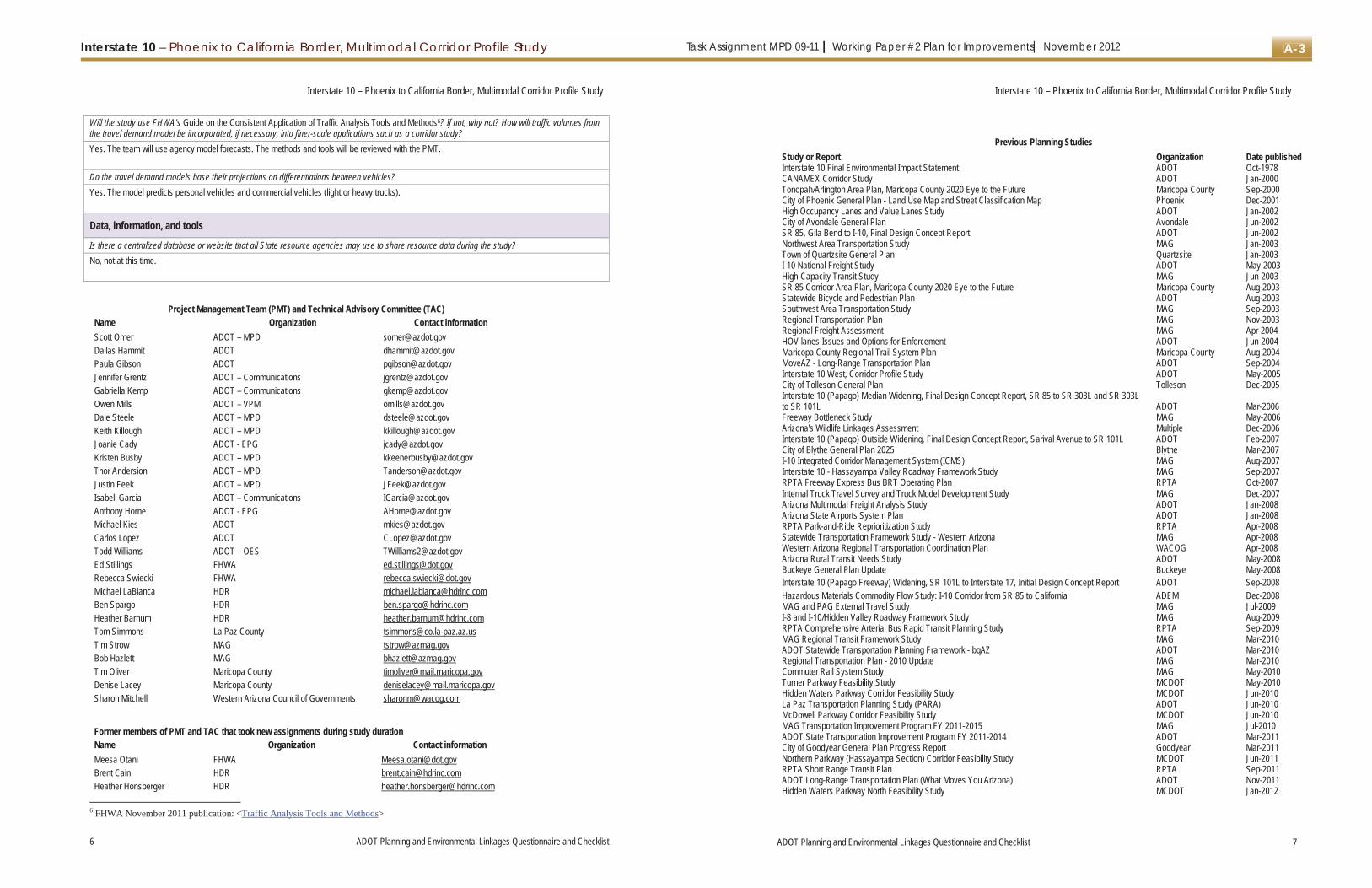
Task Assignment MPD 09-11 | Working Paper #2 Plan for Improvements| November 2012Interstate 10 – Phoenix to California Border, Multimodal Corridor Profile Study A-3
Interstate 10 – Phoenix to California Border, Multimodal Corridor Profile Study
6 ADOT Planning and Environmental Linkages Questionnaire and Checklist
Will the study use FHWA’s Guide on the Consistent Application of Traffic Analysis Tools and Methods6? If not, why not? How will traffic volumes from the travel demand model be incorporated, if necessary, into finer-scale applications such as a corridor study? Yes. The team will use agency model forecasts. The methods and tools will be reviewed with the PMT.
Do the travel demand models base their projections on differentiations between vehicles? Yes. The model predicts personal vehicles and commercial vehicles (light or heavy trucks).
Data, information, and tools
Is there a centralized database or website that all State resource agencies may use to share resource data during the study? No, not at this time.
Project Management Team (PMT) and Technical Advisory Committee (TAC) Name Organization Contact information Scott Omer ADOT – MPD [email protected] Hammit ADOT [email protected] Gibson ADOT [email protected] Grentz ADOT – Communications [email protected] Kemp ADOT – Communications [email protected] Mills ADOT – VPM [email protected] Steele ADOT – MPD [email protected] Killough ADOT – MPD [email protected] Cady ADOT - EPG [email protected] Busby ADOT – MPD [email protected] Andersion ADOT – MPD [email protected] Feek ADOT – MPD [email protected] Garcia ADOT – Communications [email protected] Horne ADOT - EPG [email protected] Kies ADOT [email protected] Lopez ADOT [email protected] Williams ADOT – OES [email protected] Stillings FHWA [email protected] Swiecki FHWA [email protected] LaBianca HDR [email protected] Spargo HDR [email protected] Barnum HDR [email protected] Simmons La Paz County [email protected] Strow MAG [email protected] Hazlett MAG [email protected] Oliver Maricopa County [email protected] Lacey Maricopa County [email protected] Mitchell Western Arizona Council of Governments [email protected]
Former members of PMT and TAC that took new assignments during study duration Name Organization Contact information Meesa Otani FHWA [email protected] Cain HDR [email protected] Honsberger HDR [email protected]
6 FHWA November 2011 publication: <Traffic Analysis Tools and Methods>
Interstate 10 – Phoenix to California Border, Multimodal Corridor Profile Study
ADOT Planning and Environmental Linkages Questionnaire and Checklist 7
Previous Planning Studies Study or Report Organization Date published Interstate 10 Final Environmental Impact Statement ADOT Oct-1978CANAMEX Corridor Study ADOT Jan-2000Tonopah/Arlington Area Plan, Maricopa County 2020 Eye to the Future Maricopa County Sep-2000City of Phoenix General Plan - Land Use Map and Street Classification Map Phoenix Dec-2001High Occupancy Lanes and Value Lanes Study ADOT Jan-2002City of Avondale General Plan Avondale Jun-2002SR 85, Gila Bend to I-10, Final Design Concept Report ADOT Jun-2002Northwest Area Transportation Study MAG Jan-2003Town of Quartzsite General Plan Quartzsite Jan-2003I-10 National Freight Study ADOT May-2003High-Capacity Transit Study MAG Jun-2003SR 85 Corridor Area Plan, Maricopa County 2020 Eye to the Future Maricopa County Aug-2003Statewide Bicycle and Pedestrian Plan ADOT Aug-2003Southwest Area Transportation Study MAG Sep-2003Regional Transportation Plan MAG Nov-2003Regional Freight Assessment MAG Apr-2004HOV lanes-Issues and Options for Enforcement ADOT Jun-2004Maricopa County Regional Trail System Plan Maricopa County Aug-2004MoveAZ - Long-Range Transportation Plan ADOT Sep-2004Interstate 10 West, Corridor Profile Study ADOT May-2005City of Tolleson General Plan Tolleson Dec-2005Interstate 10 (Papago) Median Widening, Final Design Concept Report, SR 85 to SR 303L and SR 303L to SR 101L ADOT Mar-2006 Freeway Bottleneck Study MAG May-2006Arizona's Wildlife Linkages Assessment Multiple Dec-2006Interstate 10 (Papago) Outside Widening, Final Design Concept Report, Sarival Avenue to SR 101L ADOT Feb-2007City of Blythe General Plan 2025 Blythe Mar-2007I-10 Integrated Corridor Management System (ICMS) MAG Aug-2007Interstate 10 - Hassayampa Valley Roadway Framework Study MAG Sep-2007RPTA Freeway Express Bus BRT Operating Plan RPTA Oct-2007Internal Truck Travel Survey and Truck Model Development Study MAG Dec-2007 Arizona Multimodal Freight Analysis Study ADOT Jan-2008Arizona State Airports System Plan ADOT Jan-2008RPTA Park-and-Ride Reprioritization Study RPTA Apr-2008Statewide Transportation Framework Study - Western Arizona MAG Apr-2008Western Arizona Regional Transportation Coordination Plan WACOG Apr-2008Arizona Rural Transit Needs Study ADOT May-2008Buckeye General Plan Update Buckeye May-2008Interstate 10 (Papago Freeway) Widening, SR 101L to Interstate 17, Initial Design Concept Report ADOT Sep-2008 Hazardous Materials Commodity Flow Study: I-10 Corridor from SR 85 to California ADEM Dec-2008 MAG and PAG External Travel Study MAG Jul-2009I-8 and I-10/Hidden Valley Roadway Framework Study MAG Aug-2009RPTA Comprehensive Arterial Bus Rapid Transit Planning Study RPTA Sep-2009MAG Regional Transit Framework Study MAG Mar-2010ADOT Statewide Transportation Planning Framework - bqAZ ADOT Mar-2010Regional Transportation Plan - 2010 Update MAG Mar-2010Commuter Rail System Study MAG May-2010Turner Parkway Feasibility Study MCDOT May-2010Hidden Waters Parkway Corridor Feasibility Study MCDOT Jun-2010La Paz Transportation Planning Study (PARA) ADOT Jun-2010McDowell Parkway Corridor Feasibility Study MCDOT Jun-2010MAG Transportation Improvement Program FY 2011-2015 MAG Jul-2010ADOT State Transportation Improvement Program FY 2011-2014 ADOT Mar-2011City of Goodyear General Plan Progress Report Goodyear Mar-2011Northern Parkway (Hassayampa Section) Corridor Feasibility Study MCDOT Jun-2011RPTA Short Range Transit Plan RPTA Sep-2011ADOT Long-Range Transportation Plan (What Moves You Arizona) ADOT Nov-2011Hidden Waters Parkway North Feasibility Study MCDOT Jan-2012

Interstate 10 – Phoenix to California Border, Multimodal Corridor Profile StudyTask Assignment MPD 09-11 | Working Paper #2 Plan for Improvements| November 2012A-4
Interstate 10 – Phoenix to California Border, Multimodal Corridor Profile Study
8 ADOT Planning and Environmental Linkages Questionnaire and Checklist
Questionnaire for Transportation Planners – Part 2
This part of the questionnaire should be completed by transportation planners at the end of the transportation planning study. This completed document should become an appendix to the study’s final report to document how the study meets the requirements of 23 Code of Federal Regulations § 450.212 or § 450.318.
Purpose and need for this study
How did the study process define and clarify corridor-level or subarea-level goals (if applicable) that influenced modal infrastructure improvements and/or the range of reasonable alternatives?
What were the key steps and coordination points in the decision-making process? Who were the decision-makers and who else participated in those key steps?
How should this study information be presented in future NEPA document(s), if applicable? Are relevant findings documented in a format and at a level of detail that will facilitate reference to and/or inclusion in subsequent NEPA document(s)?7
Were the study’s findings and recommendations documented in such a way as to facilitate an FHWA or Federal Transit Administration decision regarding acceptability for application in the NEPA process? Does the study have logical points where decisions were made and where concurrence from resource or regulatory agencies, stakeholders, and the public was sought? If so, provide a list of those points.
Establishment of organizational relationships – tribes and agencies8
Tribe or agency Date(s) contacted Describe level
of participation Describe the agency’s primary concerns
and the steps needed to coordinate with the agency during NEPA scoping.9
Tribal (name of tribe) (name of tribe) Federal Bureau of Indian Affairs Bureau of Land
Management
Bureau of Reclamation Federal Highway
Administration
National Park Service
7 For an explanation of the types of documents needed under the NEPA process and the nature of the content of those documents, please see “NEPA Documentation: Improving the Quality of Environmental Documents,”<Documentation>.
8 Users may add rows to this table to accommodate additional tribes and agencies. Unused rows may be deleted. 9 If the transportation planning study final report does not adequately document interactions (for example, meeting minutes, resolutions,
letters) with the relevant agencies, append such information to the end of this questionnaire and checklist.
Interstate 10 – Phoenix to California Border, Multimodal Corridor Profile Study
ADOT Planning and Environmental Linkages Questionnaire and Checklist 9
Establishment of organizational relationships – tribes and agencies8
Tribe or agency Date(s) contacted Describe level
of participation Describe the agency’s primary concerns
and the steps needed to coordinate with the agency during NEPA scoping.9
U.S. Army Corps of Engineers
U.S. Department of Agriculture Forest Service
U.S. Environmental Protection Agency
U.S. Department of Defense
U.S. Fish and Wildlife Service
Other StateArizona Department of
Environmental Quality
Arizona Department of Public Safety
Arizona Game and Fish Department
Arizona State Land Department
Other County(name of county
and department)
(name of county and department)
Local (name of municipality
and department)
(name of municipality and department)
Transportation agencies (name of agency) (name of agency

Task Assignment MPD 09-11 | Working Paper #2 Plan for Improvements| November 2012Interstate 10 – Phoenix to California Border, Multimodal Corridor Profile Study A-5
Interstate 10 – Phoenix to California Border, Multimodal Corridor Profile Study
10 ADOT Planning and Environmental Linkages Questionnaire and Checklist
Establishment of organizational relationships – stakeholders and members of the public10
Public and stakeholders Date(s) contacted Describe level
of participation Describe the primary concerns expressed
by members of the public and stakeholders. Public Members of the public Stakeholders Other (for example,
Audubon Society, Center for Biological Diversity, citizens groups, homeowners associations, Sierra Club, private mining or energy interests, railroad companies)
Planning assumptions and analytical methods
Did the study provide regional development and growth assumptions and analyses? If so, what were the sources of the demographic and employment trends and forecasts?
What were the future-year policy and/or data assumptions used in the transportation planning process related to land use, economic development, transportation costs, and network expansion?
Were the planning assumptions and the corridor vision/purpose and need statement consistent with each other and with the long-range transportation plan? Are the assumptions still valid?
Data, information, and tools
Are the relevant data used in the study available in a compatible format that is readily usable? Are they available through a centralized web portal?
Are the completeness and quality of the data consistent with the quality (not scale or detail) of inputs needed for a NEPA project-level analysis11?
Are the data used in the study regularly updated and augmented? If regularly updated, provide schedule and accessibility information.
10 Users may add rows to this table to accommodate additional stakeholders. 11 For an explanation of the types of information needed to evaluate impacts in environmental documents, please see FHWA’s “NEPA
and Transportation Decisionmaking: Impacts,”<Analysis of Impacts>. This website provides links to six additional resources and guidance that should be helpful in understanding the types of impacts that need to be assessed, their context, and their intensity.
Interstate 10 – Phoenix to California Border, Multimodal Corridor Profile Study
ADOT Planning and Environmental Linkages Questionnaire and Checklist 11
Have the environmental data been mapped at scales that facilitate comparison of effects across different resources and at sufficient resolution to guide initial NEPA issue definition? If not, what data collection and/or manipulation would likely be needed for application to the NEPA scoping process?
Examine the Checklist for Environmental Planners, at the back of this document, for more detail about potential impacts that could be mapped. Below is an abbreviated list of resources that could occur in the study area and may be knowable at this time and at the study’s various analytical scales:
Resource or issue
Is the resource or issue present in
the area?
Would any future transportation
policies or projects involve
the issue? Would there be impacts on the resource? Resource or issue
Is the resource or issue present in
the area?
Would any future transportation
policies or projects involve
the issue? Would there be impacts on the resource?
Sensitive biological resources
Yes No Unknown Not applicable
Yes No Unknown Not applicable
Section 4(f)12 wildlife and/or waterfowl refuge, historic site, recreational site, park
Yes No Unknown Not applicable
Yes No Unknown Not applicable
Wildlife corridors Yes No Unknown Not applicable
Yes No Unknown Not applicable
Section 6(f)13
resource
Yes No Unknown Not applicable
Yes No Unknown Not applicable
Wetland areas Yes No Unknown Not applicable
Yes No Unknown Not applicable
Existing development Yes No Unknown Not applicable
Yes No Unknown Not applicable
Riparian areas Yes No Unknown Not applicable
Yes No Unknown Not applicable
Planned development
Yes No Unknown Not applicable
Yes No Unknown Not applicable
100-year floodplain Yes No Unknown Not applicable
Yes No Unknown Not applicable
Title VI/ Environmental justice populations14
Yes No Unknown Not applicable
Yes No Unknown Not applicable
Prime or unique farmland or farmland of statewide or local importance
Yes No Unknown Not applicable
Yes No Unknown Not applicable
Utilities Yes No Unknown Not applicable
Yes No Unknown Not applicable
Visual resources Yes No Unknown Not applicable
Yes No Unknown Not applicable
Hazardous materials Yes No Unknown Not applicable
Yes No Unknown Not applicable
Designated scenic road/byway
Yes No Unknown Not applicable
Yes No Unknown Not applicable
Sensitive noise receivers15
Yes No Unknown Not applicable
Yes No Unknown Not applicable
Archaeological resources
Yes No Unknown Not applicable
Yes No Unknown Not applicable
Air quality Yes No Unknown Not applicable
Yes No Unknown Not applicable
Historical resources Yes No Unknown Not applicable
Yes No Unknown Not applicable
Other (list) _______________
Yes No Unknown Not applicable
Yes No Unknown Not applicable
12 Section 4(f) of the U.S. Department of Transportation Act of 1966 (49 U.S. Code § 303, as amended); see <Section 4(f)>.

Interstate 10 – Phoenix to California Border, Multimodal Corridor Profile StudyTask Assignment MPD 09-11 | Working Paper #2 Plan for Improvements| November 2012A-6
Interstate 10 – Phoenix to California Border, Multimodal Corridor Profile Study
12 ADOT Planning and Environmental Linkages Questionnaire and Checklist
Did the study incorporate models of, for example, species/habitat locations (predictive range maps), future land use, population dynamics, stormwater runoff, or travel demand? What models were used? Did the study adequately document what models were used, who was responsible for their use, and how they were used (with respect to, for example, calibration, replicability, contingencies, and exogenous factors)?
In scoping, conducting, and documenting the planning study, participants have come across documents and leads from agency staff and other sources that the environmental planners may be able to use in conducting their studies. List any applicable memoranda of understanding, cost-share arrangements, programmatic agreements, or technical studies that are underway but whose findings are not yet published, etc.
Development of alternatives
Were resource agencies, stakeholders, and members of the public engaged in the process of identifying, evaluating, and screening out modes, corridors, a range of alternatives,16 or a preferred alternative (if one was identified—the latter two refer to corridor plans)? If so, how? Did these groups review the recommendation of a preferred mode(s), corridor(s), range of alternatives (including the no-build alternative), or an alternative? Were the participation and inputs of these groups at a level acceptable for use in purpose and need statements or alternatives development sections in NEPA documents? If not, why not?
Describe the process of outreach to resource agencies, the public, and other stakeholders. Describe the documentation of this process and of the responses to their comments. Is this documentation adequate in breadth and detail for use in NEPA documents?
If the study was a corridor study, describe the range of alternatives considered (if any), screening process, and screening criteria. Include what types of alternatives were considered (including the no-build alternative) and how the screening criteria were selected. Was a preferred alternative selected as best addressing the identified transportation issue? Are alternatives’ locations and design features specified?
Also regarding whether the study was a corridor study, for alternatives that were screened out, summarize the reasons for their rejection. Are defensible, credible rationale articulated for their being screened out? Did the study team take into account legal standards17 needed in the NEPA process for such decisions? Did the study team have adequate information for screening out the alternatives?
What issues, if any, remain unresolved with the public, stakeholders, and/or resource agencies?
13 Section 6(f) of the Land and Water Conservation Fund Act 14 refers to Title VI of the 1964 Civil Rights Act and 1994 Executive Order 12898 on environmental justice 15 under FHWA’s Noise Abatement Criterion B: picnic areas, recreation areas, playgrounds, active sports areas, parks, residences,
motels, hotels, schools, churches, libraries, and hospitals 16 For an explanation of the development of alternatives in environmental documents, please see FHWA’s “NEPA and Transportation
Decisionmaking: Development and Evaluation of Alternatives,”<Alternatives>.17 23 Code of Federal Regulations (CFR) § 771.123(c), 23 CFR § 771.111(d), 40 CFR § 1502.14(a), 40 CFR § 1502.14(b) and (d),
23 CFR § 771.125(a)(1); see FHWA Technical Advisory T 6640.8A, October 30, 1987, <FHWA Technical Advisory T 6640.8A>.
Interstate 10 – Phoenix to California Border, Multimodal Corridor Profile Study
ADOT Planning and Environmental Linkages Questionnaire and Checklist 13
Formally joining PEL with the NEPA process
Lead federal agencies proposing a project that will undergo the NEPA process will want to most effectively leverage the transportation planning study’s efforts and results. How could a Notice of Intent (for an environmental impact statement18) refer to the study’s findings with respect to preliminary purpose and need and/or the range of alternatives to be studied?
Could a Notice of Intent in the NEPA process clearly state that the lead federal agency or agencies will use analyses from prior, specific planning studies that are referenced in the transportation planning study final report? Does the report provide the name and source of the planning studies and explain where the studies are publicly available? If not, how could such relevant information come to the environmental planners’ attention and be made available to them in a timely way?
List how the study’s proposed transportation system would support adopted land use plans and growth objectives.
What modifications are needed in the goals and objectives as defined in the transportation study process to increase their efficient and timely application in the NEPA process?
Jurisdictional delineations of waters of the United States frequently change. Housing and commercial developments can alter landscapes dramatically and can be constructed quickly. Noise and air quality regulations can change relatively rapidly. Resource agencies frequently alter habitat delineations to protect sensitive species. Will the study data’s currency, relevance, and quality still be acceptable to agencies, stakeholders, and members of the public for use in the NEPA process? If not, what will be done to rectify this problem? Who will be responsible for any needed updating?
Other issues
Are there any other issues a future NEPA study team should be aware of (mark all that apply)? In the space below the check boxes, explain the nature and location of any issue(s) checked.
Public and/or stakeholders have expressed specific concerns Utility problems Access or right-of-way issues Encroachments into right-of-way Need to engage—and be perceived as engaging—specific landowners, citizens, citizen groups, or other stakeholders
Contact information for stakeholders Special or unique resources in the area Federal regulations that are undergoing initial promulgation or revision
Other ____________________________________
18 While Notices of Intent are required by some federal agencies for environmental assessments, they are optional for FHWA. Pleasesee “3.3.2 Using the Notice of Intent to Link Planning and NEPA,” in Guidance on Using Corridor and Subarea Planning to Inform NEPA (Federal Highway Administration, April 5, 2011), <Notice of Intent>.

Task Assignment MPD 09-11 | Working Paper #2 Plan for Improvements| November 2012Interstate 10 – Phoenix to California Border, Multimodal Corridor Profile Study A-7
Interstate 10 – Phoenix to California Border, Multimodal Corridor Profile Study
14 ADOT Planning and Environmental Linkages Questionnaire and Checklist
Concurrence
By signature, we concur that the transportation planning document meets or exceeds the following criteria in terms of acceptability for application in NEPA projects:
Public involvement (outreach and level of participation)
Stakeholder involvement (outreach and level of participation)
Resource agencies’ involvement and participation
Documentation of the above efforts
Applicability of the general findings and conclusions for use, by reference, in NEPA documents
Approved by: _________________________________ Date: ______________
JENNIFER TOTH
State Engineer Arizona Department of Transportation
Approved by: _________________________________ Date: ______________
SCOTT OMER
Director Multimodal Planning Division, Arizona Department of Transportation
Approved by: _________________________________ Date: _______________
KARLA PETTY
Division Administrator Federal Highway Administration
Interstate 10 – Phoenix to California Border, Multimodal Corridor Profile Study
ADOT Planning and Environmental Linkages Questionnaire and Checklist 15
Checklist for Environmental Planners – Part 3
By completing this checklist, environmental planners will be able to systematically evaluate the transportation planning study with regard to environmental resources and issues. It provides a framework for future NEPA studies by identifying those resources and issues that have already been evaluated, and those that have not. The role of environmental planners during the study’s various stages is laid out in the flowchart on page 3. This role includes timely advocacy for resources and issues that will later be integral to NEPA processes.
Checklist for environmental planners
Resource or issue
Is the resource or issue present in
the area?
Are impacts to theresource or issue
involvement possible?
Are the impacts mitigable?
Discuss the level of review and method of review for this resource or issue and provide the name and location of any study or other information
cited in the planning document where it is described in detail. Describe how the planning
data may need to be supplemented during NEPA. Natural environment
Sensitive biological resources
Yes No Unknown Not applicable
Yes No Unknown Not applicable
Yes No Unknown Not applicable
Wildlife corridors Yes No Unknown Not applicable
Yes No Unknown Not applicable
Yes No Unknown Not applicable
Invasive species Yes No Unknown Not applicable
Yes No Unknown Not applicable
Yes No Unknown Not applicable
Wetland areas Yes No Unknown Not applicable
Yes No Unknown Not applicable
Yes No Unknown Not applicable
Riparian areas Yes No Unknown Not applicable
Yes No Unknown Not applicable
Yes No Unknown Not applicable
100-year floodplain Yes No Unknown Not applicable
Yes No Unknown Not applicable
Yes No Unknown Not applicable
Clean Water Act Sections 404/401 waters of the United States
Yes No Unknown Not applicable
Yes No Unknown Not applicable
Yes No Unknown Not applicable
Prime or unique farmland
Yes No Unknown Not applicable
Yes No Unknown Not applicable
Yes No Unknown Not applicable
Farmland of statewide or local importance
Yes No Unknown Not applicable
Yes No Unknown Not applicable
Yes No Unknown Not applicable
Interstate 10 – Phoenix to California Border, Multimodal Corridor Profile StudyTask Assignment MPD 09-11 | Working Paper #2 Plan for Improvements| November 2012A-8
Interstate 10 – Phoenix to California Border, Multimodal Corridor Profile Study
16 ADOT Planning and Environmental Linkages Questionnaire and Checklist
Checklist for environmental planners
Resource or issue
Is the resource or issue present in
the area?
Are impacts to theresource or issue
involvement possible?
Are the impacts mitigable?
Discuss the level of review and method of review for this resource or issue and provide the name and location of any study or other information
cited in the planning document where it is described in detail. Describe how the planning
data may need to be supplemented during NEPA.
Sole-source aquifers Yes No Unknown Not applicable
Yes No Unknown Not applicable
Yes No Unknown Not applicable
Wild and scenic rivers Yes No Unknown Not applicable
Yes No Unknown Not applicable
Yes No Unknown Not applicable
Visual resources Yes No Unknown Not applicable
Yes No Unknown Not applicable
Yes No Unknown Not applicable
Designated scenic road/byway
Yes No Unknown Not applicable
Yes No Unknown Not applicable
Yes No Unknown Not applicable
Cultural resources
Archaeological resources
Yes No Unknown Not applicable
Yes No Unknown Not applicable
Yes No Unknown Not applicable
Historical resources Yes No Unknown Not applicable
Yes No Unknown Not applicable
Yes No Unknown Not applicable
Section 4(f) and Section 6(f) resources
Section 4(f) wildlife and/or waterfowl refuge
Yes No Unknown Not applicable
Yes No Unknown Not applicable
Yes No Unknown Not applicable
Section 4(f) historic site
Yes No Unknown Not applicable
Yes No Unknown Not applicable
Yes No Unknown Not applicable
Section 4(f) recreational site
Yes No Unknown Not applicable
Yes No Unknown Not applicable
Yes No Unknown Not applicable
Section 4(f) park Yes No Unknown Not applicable
Yes No Unknown Not applicable
Yes No Unknown Not applicable
Section 6(f) resource Yes No Unknown Not applicable
Yes No Unknown Not applicable
Yes No Unknown Not applicable
Interstate 10 – Phoenix to California Border, Multimodal Corridor Profile Study
ADOT Planning and Environmental Linkages Questionnaire and Checklist 17
Checklist for environmental planners
Resource or issue
Is the resource or issue present in
the area?
Are impacts to theresource or issue
involvement possible?
Are the impacts mitigable?
Discuss the level of review and method of review for this resource or issue and provide the name and location of any study or other information
cited in the planning document where it is described in detail. Describe how the planning
data may need to be supplemented during NEPA. Human environment
Existing development Yes No Unknown Not applicable
Yes No Unknown Not applicable
Yes No Unknown Not applicable
Planned development Yes No Unknown Not applicable
Yes No Unknown Not applicable
Yes No Unknown Not applicable
Displacements Yes No Unknown Not applicable
Yes No Unknown Not applicable
Yes No Unknown Not applicable
Access restriction Yes No Unknown Not applicable
Yes No Unknown Not applicable
Yes No Unknown Not applicable
Neighborhood continuity
Yes No Unknown Not applicable
Yes No Unknown Not applicable
Yes No Unknown Not applicable
Community cohesion Yes No Unknown Not applicable
Yes No Unknown Not applicable
Yes No Unknown Not applicable
Title VI/Environmental justice populations
Yes No Unknown Not applicable
Yes No Unknown Not applicable
Yes No Unknown Not applicable
Physical environment
Utilities Yes No Unknown Not applicable
Yes No Unknown Not applicable
Yes No Unknown Not applicable
Hazardous materials Yes No Unknown Not applicable
Yes No Unknown Not applicable
Yes No Unknown Not applicable
Sensitive noise receivers
Yes No Unknown Not applicable
Yes No Unknown Not applicable
Yes No Unknown Not applicable
Air quality Yes No Unknown Not applicable
Yes No Unknown Not applicable
Yes No Unknown Not applicable
Other (list)
Yes No Unknown Not applicable
Yes No Unknown Not applicable
Yes No Unknown Not applicable

Task Assignment MPD 09-11 | Working Paper #2 Plan for Improvements| November 2012Interstate 10 – Phoenix to California Border, Multimodal Corridor Profile Study A-9
Interstate 10 – Phoenix to California Border, Multimodal Corridor Profile Study
18 ADOT Planning and Environmental Linkages Questionnaire and Checklist
Identification of potential environmental mitigation activities
Could the transportation planning process be integrated with other planning activities, such as land use or resource management plans? If so, could this integrated planning effort be used to develop a more strategic approach to environmental mitigation measures?
With respect to potential environmental mitigation opportunities at the PEL level, who should ADOT consult with among federal, State, and local agencies and tribes and how formally and frequently should such consultation be undertaken?
Off-site and compensatory mitigation areas are often creatively negotiated to advance multiagency objectives or multiple objectives within one agency. Who determined what specific geographic areas or types of areas were appropriate for environmental mitigation activities? How were these determinations made?
To address potential impacts on the human environment, what mitigation measures or activities were considered and how were they developed and documented?
Prepared by: _________________________________ Date: ______________
________________________
Environmental Planning Group, Arizona Department of Transportation

This page is intentionally left blank.

Task Assignment MPD 09-11 | Working Paper #2 Plan for Improvements| November 2012Interstate 10 – Phoenix to California Border, Multimodal Corridor Profile Study B-1
Appendix B: Stakeholder Interviews
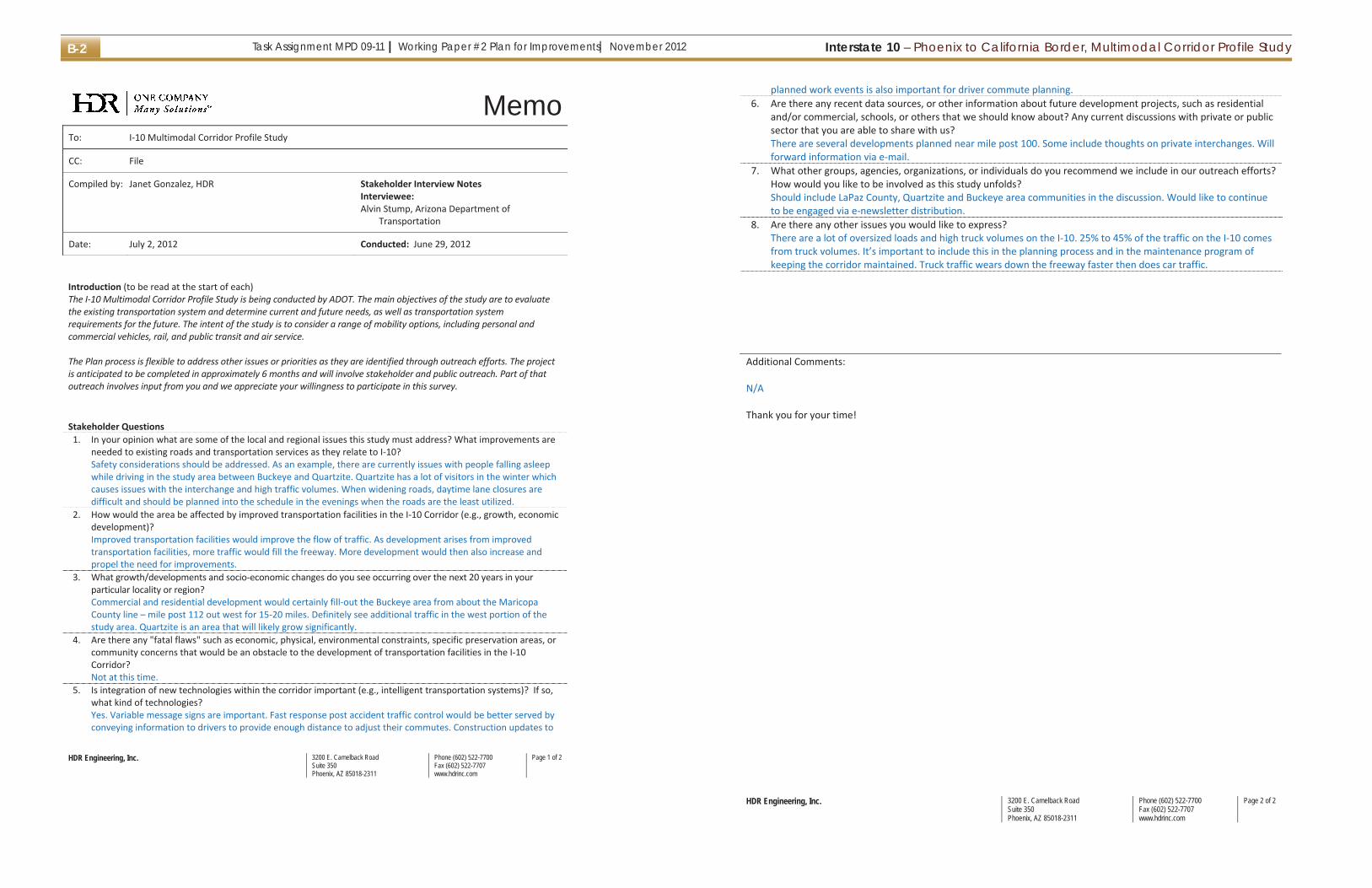
Interstate 10 – Phoenix to California Border, Multimodal Corridor Profile StudyTask Assignment MPD 09-11 | Working Paper #2 Plan for Improvements| November 2012B-2
HDR Engineering, Inc. 3200 E. Camelback Road Suite 350 Phoenix, AZ 85018-2311
Phone (602) 522-7700 Fax (602) 522-7707 www.hdrinc.com
Page 1 of 2
MemoTo: I 10 Multimodal Corridor Profile Study
CC: File
Compiled by: Janet Gonzalez, HDR Stakeholder Interview NotesInterviewee:Alvin Stump, Arizona Department of
Transportation
Date: July 2, 2012 Conducted: June 29, 2012
Introduction (to be read at the start of each)The I 10 Multimodal Corridor Profile Study is being conducted by ADOT. The main objectives of the study are to evaluatethe existing transportation system and determine current and future needs, as well as transportation systemrequirements for the future. The intent of the study is to consider a range of mobility options, including personal andcommercial vehicles, rail, and public transit and air service.
The Plan process is flexible to address other issues or priorities as they are identified through outreach efforts. The projectis anticipated to be completed in approximately 6 months and will involve stakeholder and public outreach. Part of thatoutreach involves input from you and we appreciate your willingness to participate in this survey.
Stakeholder Questions1. In your opinion what are some of the local and regional issues this study must address? What improvements are
needed to existing roads and transportation services as they relate to I 10?Safety considerations should be addressed. As an example, there are currently issues with people falling asleepwhile driving in the study area between Buckeye and Quartzite. Quartzite has a lot of visitors in the winter whichcauses issues with the interchange and high traffic volumes. When widening roads, daytime lane closures aredifficult and should be planned into the schedule in the evenings when the roads are the least utilized.
2. How would the area be affected by improved transportation facilities in the I 10 Corridor (e.g., growth, economicdevelopment)?Improved transportation facilities would improve the flow of traffic. As development arises from improvedtransportation facilities, more traffic would fill the freeway. More development would then also increase andpropel the need for improvements.
3. What growth/developments and socio economic changes do you see occurring over the next 20 years in yourparticular locality or region?Commercial and residential development would certainly fill out the Buckeye area from about the MaricopaCounty line – mile post 112 out west for 15 20 miles. Definitely see additional traffic in the west portion of thestudy area. Quartzite is an area that will likely grow significantly.
4. Are there any "fatal flaws" such as economic, physical, environmental constraints, specific preservation areas, orcommunity concerns that would be an obstacle to the development of transportation facilities in the I 10Corridor?Not at this time.
5. Is integration of new technologies within the corridor important (e.g., intelligent transportation systems)? If so,what kind of technologies?Yes. Variable message signs are important. Fast response post accident traffic control would be better served byconveying information to drivers to provide enough distance to adjust their commutes. Construction updates to
HDR Engineering, Inc. 3200 E. Camelback Road Suite 350 Phoenix, AZ 85018-2311
Phone (602) 522-7700 Fax (602) 522-7707 www.hdrinc.com
Page 2 of 2
planned work events is also important for driver commute planning.6. Are there any recent data sources, or other information about future development projects, such as residential
and/or commercial, schools, or others that we should know about? Any current discussions with private or publicsector that you are able to share with us?There are several developments planned near mile post 100. Some include thoughts on private interchanges. Willforward information via e mail.
7. What other groups, agencies, organizations, or individuals do you recommend we include in our outreach efforts?How would you like to be involved as this study unfolds?Should include LaPaz County, Quartzite and Buckeye area communities in the discussion. Would like to continueto be engaged via e newsletter distribution.
8. Are there any other issues you would like to express?There are a lot of oversized loads and high truck volumes on the I 10. 25% to 45% of the traffic on the I 10 comesfrom truck volumes. It’s important to include this in the planning process and in the maintenance program ofkeeping the corridor maintained. Truck traffic wears down the freeway faster then does car traffic.
Additional Comments:
N/A
Thank you for your time!

Task Assignment MPD 09-11 | Working Paper #2 Plan for Improvements| November 2012Interstate 10 – Phoenix to California Border, Multimodal Corridor Profile Study B-3
HDR Engineering, Inc. 3200 E. Camelback RoadSuite 350Phoenix, AZ 85018-2311
Phone (602) 522-7700Fax (602) 522-7707www.hdrinc.com
Page 1 of 2
MemoTo: I-10 Multimodal Corridor Profile Study
CC: File
Compiled by: Janet Gonzalez, HDR
Stakeholder Interview Notes Interviewee: Angelita Bulletts, Bureau of Land Management
Date: July 27, 2012 Conducted: July 24, 2012
Introduction (to be read at the start of each) The I-10 Multimodal Corridor Profile Study is being conducted by ADOT. The main objectives of the study are to evaluate the existing transportation system and determine current and future needs, as well as transportation system requirements for the future. The intent of the study is to consider a range of mobility options, including personal and commercial vehicles, rail, and public transit and air service. The Plan process is flexible to address other issues or priorities as they are identified through outreach efforts. The project is anticipated to be completed in approximately 6 months and will involve stakeholder and public outreach. Part of that outreach involves input from you and we appreciate your willingness to participate in this survey.
Stakeholder Questions
1. In your opinion what are some of the local and regional issues this study must address? What improvements are needed to existing roads and transportation services as they relate to I-10? I-10 constructed to meet traffic congestion from 20 years ago. The corridor is very much in need of expansion during high-peak hours. Relieving congestion should be the first priority. The study should certainly consider additional modes of transportation to be just as important as automobile movement. It’s important to change the choice of a 1-person commuter.
2. How would the area be affected by improved transportation facilities in the I-10 Corridor (e.g., growth, economic development)? Positively impacted. Growth would be expanded because of the additional areas for people to stop and shop, eat, and/or dine.
3. What growth/developments and socio-economic changes do you see occurring over the next 20 years in your particular locality or region? Growth will likely continue along the outer reaches of the I-10 – south of Phoenix to Tucson. Sees more growth from Phoenix to Tucson, then Phoenix to California.
4. Are there any "fatal flaws" such as economic, physical, environmental constraints, specific preservation areas, or community concerns that would be an obstacle to the development of transportation facilities in the I-10 Corridor? There is solar development in certain pockets of the I-10 that are being built on public, private, federal and state lands. This will impact the shape and way the city grows in the future.
5. Is integration of new technologies within the corridor important (e.g., intelligent transportation systems)? If so, what kind of technologies? Yes. Real-time messaging is important. Satellite and real-time video feeds are great to show traffic in key areas of the valley.
6. Are there any recent data sources, or other information about future development projects, such as residential and/or commercial, schools, or others that we should know about? Any current discussions with private or public
HDR Engineering, Inc. 3200 E. Camelback RoadSuite 350Phoenix, AZ 85018-2311
Phone (602) 522-7700Fax (602) 522-7707www.hdrinc.com
Page 2 of 2
sector that you are able to share with us? Same as answer to #4. Solar development will likely shape the growth of the valley in areas with growth opportunities.
7. What other groups, agencies, organizations, or individuals do you recommend we include in our outreach efforts? How would you like to be involved as this study unfolds? None at this time. Contact by e-mail distribution.
8. Are there any other issues you would like to express? None at this time.
Additional Comments: N/A Thank you for your time!

Interstate 10 – Phoenix to California Border, Multimodal Corridor Profile StudyTask Assignment MPD 09-11 | Working Paper #2 Plan for Improvements| November 2012B-4
HDR Engineering, Inc. 3200 E. Camelback RoadSuite 350Phoenix, AZ 85018-2311
Phone (602) 522-7700Fax (602) 522-7707www.hdrinc.com
Page 1 of 2
MemoTo: I-10 Multimodal Corridor Profile Study
CC: File
Compiled by: Michael LaBianca Stakeholder Interview Notes Interviewee: Ben Limmer, METRO Abhishek Dayal, METRO
Date: July 6, 2012 Conducted: June 20, 2012
Introduction (to be read at the start of each) The I-10 Multimodal Corridor Profile Study is being conducted by ADOT. The main objectives of the study are to evaluate the existing transportation system and determine current and future needs, as well as transportation system requirements for the future. The intent of the study is to consider a range of mobility options, including personal and commercial vehicles, rail, and public transit and air service. The Plan process is flexible to address other issues or priorities as they are identified through outreach efforts. The project is anticipated to be completed in approximately 6 months and will involve stakeholder and public outreach. Part of that outreach involves input from you and we appreciate your willingness to participate in this survey.
Stakeholder Questions
1. In your opinion what are some of the local and regional issues this study must address? What improvements are needed to existing roads and transportation services as they relate to I-10? We lose sight of the fact that Phoenix is just a stop along an important east-west route (I-10), a huge freight corridor for the nation. Need to determine how to get freight through. Within the region, must consider the multimodal needs of the corridor. Additional lanes are not an answer to congestion; think of alternatives to improve mobility (examples include HOT lanes, tolls, whatever options are available to address needs). Tolls are a challenge, given the neeed for local service.
2. How would the area be affected by improved transportation facilities in the I-10 Corridor (e.g., growth, economic development)? Multimodal enhancements would facilitate more focused growth. View I-10 as critical to the regions economic development, downtown Phoenix, warehousing to the west will continue to expand westward.
3. What growth/developments and socio-economic changes do you see occurring over the next 20 years in your particular locality or region? West Valley development is occurring more slowly than anticipated. There is a lot of potential within the SR 101. South Mountain (transportation corridor) will hasten development south of I-10. The central Phoenix area is changing demographically as affluent households are moving in to the central corridor.
4. Are there any "fatal flaws" such as economic, physical, environmental constraints, specific preservation areas, or community concerns that would be an obstacle to the development of transportation facilities in the I-10 Corridor? Not observed. Economics is driving everything. Luke Air Force Base may be a (growth) factor in the West Valley, an area which lacks major employment. Capacity of I-10 is a limiting factor.
5. Is integration of new technologies within the corridor important (e.g., intelligent transportation systems)? If so,
HDR Engineering, Inc. 3200 E. Camelback RoadSuite 350Phoenix, AZ 85018-2311
Phone (602) 522-7700Fax (602) 522-7707www.hdrinc.com
Page 2 of 2
what kind of technologies? Various lane configurations, HOT, HOV+3, toll, transit only lane, express lanes – all options should be on the table.
6. Are there any recent data sources, or other information about future development projects, such as residential and/or commercial, schools, or others that we should know about? Any current discussions with private or public sector that you are able to share with us? See specific development plans; 101 Corridor, Maryvale Core Plan (contact Jacob Zonn, City of Phoenix Planning Department).
7. What other groups, agencies, organizations, or individuals do you recommend we include in our outreach efforts? How would you like to be involved as this study unfolds? Maricopa Association of Governments. Email updates are sufficient.
8. Are there any other issues you would like to express? Consider development of high-capacity transit, in particular in the West Valley.
Additional Comments: Thank you for your time!

Task Assignment MPD 09-11 | Working Paper #2 Plan for Improvements| November 2012Interstate 10 – Phoenix to California Border, Multimodal Corridor Profile Study B-5
HDR Engineering, Inc. 3200 E. Camelback RoadSuite 350Phoenix, AZ 85018-2311
Phone (602) 522-7700Fax (602) 522-7707www.hdrinc.com
Page 1 of 2
MemoTo: I-10 Multimodal Corridor Profile Study
CC: File
Compiled by: Janet Gonzalez, HDR
Stakeholder Interview Notes Interviewee: Bob Garza, Arizona Public Service
Date: June 19, 2012 Conducted: June 18, 2012
Introduction (to be read at the start of each) The I-10 Multimodal Corridor Profile Study is being conducted by ADOT. The main objectives of the study are to evaluate the existing transportation system and determine current and future needs, as well as transportation system requirements for the future. The intent of the study is to consider a range of mobility options, including personal and commercial vehicles, rail, and public transit and air service. The Plan process is flexible to address other issues or priorities as they are identified through outreach efforts. The project is anticipated to be completed in approximately 6 months and will involve stakeholder and public outreach. Part of that outreach involves input from you and we appreciate your willingness to participate in this survey.
Stakeholder Questions
1. In your opinion what are some of the local and regional issues this study must address? What improvements are needed to existing roads and transportation services as they relate to I-10? Consideration should be made for future growth of utilities. ADOT abandonment rule – flexibility should be given to allow utilities more leeway. Allow utilities to be within the ADOT ROW. There should be a partnership between the groups and contractors should be a part of the discussion to avoid unnecessary claims during construction sequencing before growth and widening efforts are started.
2. How would the area be affected by improved transportation facilities in the I-10 Corridor (e.g., growth, economic development)? Commercial growth will be back. As the economy picks up, commercial business will pick-up in the downtown and surrounding areas. Cooperation is needed between ADOT and APS. On the west end of the study area, businesses from California are coming in to set up their shops. Frost Zero, a frozen foods business is a California-based business near the Loop 303 / Camelback area.
3. What growth/developments and socio-economic changes do you see occurring over the next 20 years in your particular locality or region? Massive growth with malls, strip malls, commercial businesses and residential. Estrella Falls Mall is a large development near the corridor. Verrado has a new residential and commercial area currently under development. The ability to get in and get out of the study area fast will be the key to successful growth. The Loop 303 and I-10 will likely be a huge hot spot, as it is at the center of various connections.
4. Are there any "fatal flaws" such as economic, physical, environmental constraints, specific preservation areas, or community concerns that would be an obstacle to the development of transportation facilities in the I-10 Corridor? 401 permits are important and key to growth. The area west of Verrado (with the exception of the power plant area) may be easier to implement then the other denser areas east of that. SRP serves 35th Avenue to 101. Establishing a corridor within the median for future rail or transit opportunities would be smart to plan for.
5. Is integration of new technologies within the corridor important (e.g., intelligent transportation systems)? If so,
HDR Engineering, Inc. 3200 E. Camelback RoadSuite 350Phoenix, AZ 85018-2311
Phone (602) 522-7700Fax (602) 522-7707www.hdrinc.com
Page 2 of 2
what kind of technologies? Yes. Should join trench with fiber optics networks as construction is being completed. It’s important for the utility companies to know when upcoming projects are going to affect the system and vice versa.
6. Are there any recent data sources, or other information about future development projects, such as residential and/or commercial, schools, or others that we should know about? Any current discussions with private or public sector that you are able to share with us? The Verrado area has started projects on their development site. There has been a lot of discussion about commercial activity. Any existing / future developments will be positively affected by I-10 improvements. More commercial activity will also lead to residential growth.
7. What other groups, agencies, organizations, or individuals do you recommend we include in our outreach efforts? How would you like to be involved as this study unfolds? Century Link, Southwest Gas, Cox Communications, First One Communications (west-valley focused), Westcor. Sue Maybee (APS) from the Asset Team should be added to the discussion. Miguel Bravo (APS) from the Economics Development should also be added to the discussion – [email protected]. E-newsletter.
8. Are there any other issues you would like to express? ADOT should look at studying the I-17 corridor. It is the one piece of freeway that is being ignored – from Northern to the Durango Curve. The speed changes, then bottlenecks, then the curve opens back up near the airport. Should be developed and upgraded to the level of standard of the I-10.
Additional Comments: N/A Thank you for your time!

Interstate 10 – Phoenix to California Border, Multimodal Corridor Profile StudyTask Assignment MPD 09-11 | Working Paper #2 Plan for Improvements| November 2012B-6
HDR Engineering, Inc. 3200 E. Camelback RoadSuite 350Phoenix, AZ 85018-2311
Phone (602) 522-7700Fax (602) 522-7707www.hdrinc.com
Page 1 of 2
MemoTo: I-10 Multimodal Corridor Profile Study
CC: File
Compiled by: Michael LaBianca Stakeholder Interview Notes Interviewee: Brent Espin, Bureau of Reclamation Pete Castaneda, Bureau of Reclamation
Date: July 6, 2012 Conducted: June 19, 2012
Introduction (to be read at the start of each) The I-10 Multimodal Corridor Profile Study is being conducted by ADOT. The main objectives of the study are to evaluate the existing transportation system and determine current and future needs, as well as transportation system requirements for the future. The intent of the study is to consider a range of mobility options, including personal and commercial vehicles, rail, and public transit and air service. The Plan process is flexible to address other issues or priorities as they are identified through outreach efforts. The project is anticipated to be completed in approximately 6 months and will involve stakeholder and public outreach. Part of that outreach involves input from you and we appreciate your willingness to participate in this survey.
Stakeholder Questions
1. In your opinion what are some of the local and regional issues this study must address? What improvements are needed to existing roads and transportation services as they relate to I-10? Modernizing infrastructure, ensuring the capacity to handle anticipated growth. Look out beyond typical 20 year planning horizon (for example, BOR operates on a 50-year planning horizon).
2. How would the area be affected by improved transportation facilities in the I-10 Corridor (e.g., growth, economic development)? Areas that may impact BOR include:
1. SRP facilities, approximately every ½ mile in the West Valley 2. Central Arizona Project crossings (2 exist with in the corridor) 3. Various irrigation districts in the Tonopah area 4. Transmission line crossings
3. What growth/developments and socio-economic changes do you see occurring over the next 20 years in your
particular locality or region? Additional (electrical) transmission capacity added to system.
4. Are there any "fatal flaws" such as economic, physical, environmental constraints, specific preservation areas, or community concerns that would be an obstacle to the development of transportation facilities in the I-10 Corridor? (New) endangered species habitat. Need to stay abreast of regulatory changes. Bureau of Land Management Resource Management Plans – bible for accessing federal lands.
5. Is integration of new technologies within the corridor important (e.g., intelligent transportation systems)? If so, what kind of technologies? Role of BOR limited to power and water.
HDR Engineering, Inc. 3200 E. Camelback RoadSuite 350Phoenix, AZ 85018-2311
Phone (602) 522-7700Fax (602) 522-7707www.hdrinc.com
Page 2 of 2
6. Are there any recent data sources, or other information about future development projects, such as residential and/or commercial, schools, or others that we should know about? Any current discussions with private or public sector that you are able to share with us? n/a
7. What other groups, agencies, organizations, or individuals do you recommend we include in our outreach efforts? How would you like to be involved as this study unfolds? Central Arizona Project; ASLD; BLM; CAP; other irrigation districts. Email is fine – appreciate the project awareness and a seat at the table ([email protected].)
Additional Comments: Thank you for your time!

Task Assignment MPD 09-11 | Working Paper #2 Plan for Improvements| November 2012Interstate 10 – Phoenix to California Border, Multimodal Corridor Profile Study B-7
HDR Engineering, Inc. 3200 E. Camelback RoadSuite 350Phoenix, AZ 85018-2311
Phone (602) 522-7700Fax (602) 522-7707www.hdrinc.com
Page 1 of 2
MemoTo: I-10 Multimodal Corridor Profile Study
CC: File
Compiled by: Janet Gonzalez, HDR
Stakeholder Interview Notes Interviewee: David Lane, Palo Valley Verde Transit Authority
Date: June 8, 2012 Conducted: June 8, 2012
Introduction (to be read at the start of each) The I-10 Multimodal Corridor Profile Study is being conducted by ADOT. The main objectives of the study are to evaluate the existing transportation system and determine current and future needs, as well as transportation system requirements for the future. The intent of the study is to consider a range of mobility options, including personal and commercial vehicles, rail, and public transit and air service. The Plan process is flexible to address other issues or priorities as they are identified through outreach efforts. The project is anticipated to be completed in approximately 6 months and will involve stakeholder and public outreach. Part of that outreach involves input from you and we appreciate your willingness to participate in this survey.
Stakeholder Questions
1. In your opinion what are some of the local and regional issues this study must address? What improvements are needed to existing roads and transportation services as they relate to I-10? Gas costs a lot less in Arizona then in California. A lot of California residents cross over to Arizona (Flying J) to get gas. This is a problem for the border cities when it comes to tax revenue. Additional call box systems are needed to provide safety precautions.
2. How would the area be affected by improved transportation facilities in the I-10 Corridor (e.g., growth, economic development)? Not applicable.
3. What growth/developments and socio-economic changes do you see occurring over the next 20 years in your particular locality or region? Significant commercial growth near and mid-term. Goals are to draw more people off the I-10, with numbers currently at 10.2 million people.
4. Are there any "fatal flaws" such as economic, physical, environmental constraints, specific preservation areas, or community concerns that would be an obstacle to the development of transportation facilities in the I-10 Corridor? Not applicable.
5. Is integration of new technologies within the corridor important (e.g., intelligent transportation systems)? If so, what kind of technologies? Yes. This is very important. Especially for all the visitors and truck drivers that travel between Arizona and California. Emergency notification systems are important. Eastern Riverside will be pushing electric vehicles forward. Pads along the I-10 with charging stations for those vehicles that require charging would be beneficial to encourage “greener” infrastructure improvements.
6. Are there any recent data sources, or other information about future development projects, such as residential and/or commercial, schools, or others that we should know about? Any current discussions with private or public sector that you are able to share with us?
HDR Engineering, Inc. 3200 E. Camelback RoadSuite 350Phoenix, AZ 85018-2311
Phone (602) 522-7700Fax (602) 522-7707www.hdrinc.com
Page 2 of 2
Brewing is designing a new off and on ramp 300-feet west from the California/Arizona border. A new Visitor Center at this location will include a park, information kiosks, dog run area, restrooms, farmers market, and demonstration farm. This Visitor Center will be advertised via billboards, etc., and will encourage people to stop and enjoy the area before heading to their destination.
7. What other groups, agencies, organizations, or individuals do you recommend we include in our outreach efforts? How would you like to be involved as this study unfolds? Riverside County Board of Supervisor (BOS) – 4th District (John Benoit), BOS 80th District (Manual Perez), BOS 45th District (Mary Bonomect – Governor), Farming Industry – Hayday Farms (Dale Tyson – [email protected]), Mark Fisher (other farmer – don’t have contact information), Conway Trucking, State Prisons – two within City limits, Palo Verde Hospital (Peter Klune – [email protected]). E-newsletter.
8. Are there any other issues you would like to express? California is usually adversely impacted by improvements in Arizona. It’s hard to compete for labor and fuel because it is cheaper in Arizona. Farmers in California are precluded from buying fuel in Arizona.
Additional Comments: N/A Thank you for your time!
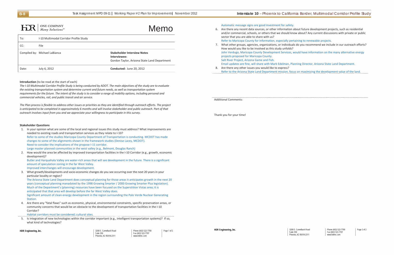
Interstate 10 – Phoenix to California Border, Multimodal Corridor Profile StudyTask Assignment MPD 09-11 | Working Paper #2 Plan for Improvements| November 2012B-8
HDR Engineering, Inc. 3200 E. Camelback RoadSuite 350Phoenix, AZ 85018-2311
Phone (602) 522-7700Fax (602) 522-7707www.hdrinc.com
Page 1 of 2
MemoTo: I-10 Multimodal Corridor Profile Study
CC: File
Compiled by: Michael LaBianca Stakeholder Interview Notes Interviewee: Gordon Taylor, Arizona State Land Department
Date: July 6, 2012 Conducted: June 20, 2012
Introduction (to be read at the start of each) The I-10 Multimodal Corridor Profile Study is being conducted by ADOT. The main objectives of the study are to evaluate the existing transportation system and determine current and future needs, as well as transportation system requirements for the future. The intent of the study is to consider a range of mobility options, including personal and commercial vehicles, rail, and public transit and air service. The Plan process is flexible to address other issues or priorities as they are identified through outreach efforts. The project is anticipated to be completed in approximately 6 months and will involve stakeholder and public outreach. Part of that outreach involves input from you and we appreciate your willingness to participate in this survey.
Stakeholder Questions
1. In your opinion what are some of the local and regional issues this study must address? What improvements are needed to existing roads and transportation services as they relate to I-10? Refer to some of the studies Maricopa County Department of Transportation is conducting. MCDOT has made changes to some of the alignments shown in the framework studies (Denise Lacey, MCDOT). Need to consider the implications of the propose I-11 corridor. Large master planned communities in the west valley (e.g., Belmont, Douglas Ranch)
2. How would the area be affected by improved transportation facilities in the I-10 Corridor (e.g., growth, economic development)? Butler and Harquahala Valley are water-rich areas that will see development in the future. There is a significant amount of speculation zoning in the far West Valley. Improved interchanges will encourage development.
3. What growth/developments and socio-economic changes do you see occurring over the next 20 years in your particular locality or region? The Arizona State Land Department does conceptual planning for those areas it anticipates growth in the next 20 years (conceptual planning manadated by the 1998 Growing Smarter / 2000 Growing Smarter Plus legislation). Much of the Department’s (planning) resources have been focused on the Superstition Vistas area; it is anticipated that that area will develop before the far West Valley does. Significant amount of clean-energy development in the region surrounding the Palo Verde Nuclear Generating Station.
4. Are there any "fatal flaws" such as economic, physical, environmental constraints, specific preservation areas, or community concerns that would be an obstacle to the development of transportation facilities in the I-10 Corridor? Habitat corridors must be considered; cultural sites.
5. Is integration of new technologies within the corridor important (e.g., intelligent transportation systems)? If so, what kind of technologies?
HDR Engineering, Inc. 3200 E. Camelback RoadSuite 350Phoenix, AZ 85018-2311
Phone (602) 522-7700Fax (602) 522-7707www.hdrinc.com
Page 2 of 2
Automatic message signs are good investment for safety. 6. Are there any recent data sources, or other information about future development projects, such as residential
and/or commercial, schools, or others that we should know about? Any current discussions with private or public sector that you are able to share with us? Refer to Maricopa County for information, especially pertaining to renewable projects.
7. What other groups, agencies, organizations, or individuals do you recommend we include in our outreach efforts? How would you like to be involved as this study unfolds? John Verdugo, Maricopa County Development Services, would have information on the many alternative energy projects proposed for Maricopa County. Salt River Project, Arizona Game and Fish. Email updates are fine, will share with Mark Edelman, Planning Director, Arizona State Land Department.
8. Are there any other issues you would like to express? Refer to the Arizona State Land Department mission, focus on maximizing the development value of the land.
Additional Comments: Thank you for your time!
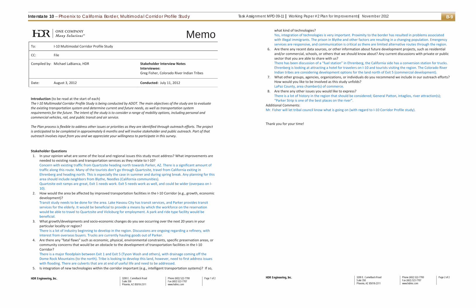
Task Assignment MPD 09-11 | Working Paper #2 Plan for Improvements| November 2012Interstate 10 – Phoenix to California Border, Multimodal Corridor Profile Study B-9
HDR Engineering, Inc. 3200 E. Camelback RoadSuite 350Phoenix, AZ 85018-2311
Phone (602) 522-7700Fax (602) 522-7707www.hdrinc.com
Page 1 of 2
MemoTo: I-10 Multimodal Corridor Profile Study
CC: File
Compiled by: Michael LaBianca, HDR Stakeholder Interview Notes Interviewee: Greg Fisher, Colorado River Indian Tribes
Date: August 3, 2012 Conducted: July 11, 2012
Introduction (to be read at the start of each) The I-10 Multimodal Corridor Profile Study is being conducted by ADOT. The main objectives of the study are to evaluate the existing transportation system and determine current and future needs, as well as transportation system requirements for the future. The intent of the study is to consider a range of mobility options, including personal and commercial vehicles, rail, and public transit and air service. The Plan process is flexible to address other issues or priorities as they are identified through outreach efforts. The project is anticipated to be completed in approximately 6 months and will involve stakeholder and public outreach. Part of that outreach involves input from you and we appreciate your willingness to participate in this survey.
Stakeholder Questions
1. In your opinion what are some of the local and regional issues this study must address? What improvements are needed to existing roads and transportation services as they relate to I-10? Concern with existing traffic from Quartzsite heading north towards Parker, AZ. There is a significant amount of traffic along this route. Many of the tourists don’t go through Quartzsite, travel from California exiting in Ehrenberg and heading north. This is especially the case in summer and during spring break. Any planning for this area should include neighbors from Blythe, Needles (California communities). Quartzsite exit ramps are great, Exit 1 needs work. Exit 5 needs work as well, and could be wider (overpass on I-10).
2. How would the area be affected by improved transportation facilities in the I-10 Corridor (e.g., growth, economic development)? Transit study needs to be done for the area. Lake Havasu City has transit services, and Parker provides transit services for the elderly. It would be beneficial to provide a means by which the workforce on the reservation would be able to travel to Quartzsite and Vicksburg for employment. A park and ride type facility would be beneficial.
3. What growth/developments and socio-economic changes do you see occurring over the next 20 years in your particular locality or region? There is a lot of industry beginning to develop in the region. Discussions are ongoing regarding a refinery, with interest from overseas buyers. Trucks are currently hauling goods out of Parker.
4. Are there any "fatal flaws" such as economic, physical, environmental constraints, specific preservation areas, or community concerns that would be an obstacle to the development of transportation facilities in the I-10 Corridor? There is a major floodplain between Exit 1 and Exit 5 (Tyson Wash and others), with drainage coming off the Dome Rock Mountains (to the north). Tribe is looking to develop this land, however, need to first address issues with flooding. There are culverts that are at end of useful life and need to be addressed.
5. Is integration of new technologies within the corridor important (e.g., intelligent transportation systems)? If so,
HDR Engineering, Inc. 3200 E. Camelback RoadSuite 350Phoenix, AZ 85018-2311
Phone (602) 522-7700Fax (602) 522-7707www.hdrinc.com
Page 2 of 2
what kind of technologies? Yes, integration of technologies is very important. Proximity to the border has resulted in problems associated with illegal immigrants. The prison in Blythe and other factors are resulting in a changing population. Emergency services are responsive, and communication is critical as there are limited alternative routes through the region.
6. Are there any recent data sources, or other information about future development projects, such as residential and/or commercial, schools, or others that we should know about? Any current discussions with private or public sector that you are able to share with us? There has been discussion of a “fuel station” in Ehrenberg, the California side has a conversion station for trucks. Ehrenberg is looking at attracting a hotel for travelers on I-10 and tourists visiting the region. The Colorado River Indian tribes are considering development options for the land north of Exit 5 (commercial development).
7. What other groups, agencies, organizations, or individuals do you recommend we include in our outreach efforts? How would you like to be involved as this study unfolds? LaPaz County, area chamber(s) of commerce.
8. Are there any other issues you would like to express? There is a lot of history in the region that should be considered; General Patton, intaglios, river attraction(s); “Parker Strip is one of the best places on the river”.
Additional Comments: Mr. Fisher will let tribal council know what is going on (with regard to I-10 Corridor Profile study). Thank you for your time!

Interstate 10 – Phoenix to California Border, Multimodal Corridor Profile StudyTask Assignment MPD 09-11 | Working Paper #2 Plan for Improvements| November 2012B-10
HDR Engineering, Inc. 3200 E. Camelback RoadSuite 350Phoenix, AZ 85018-2311
Phone (602) 522-7700Fax (602) 522-7707www.hdrinc.com
Page 1 of 2
MemoTo: I-10 Multimodal Corridor Profile Study
CC: File
Compiled by: Janet Gonzalez, HDR
Stakeholder Interview Notes Interviewee: Captain Jeff King, Arizona Department of Public
Safety
Date: August 2, 2012 Conducted: August 2, 2012
Introduction (to be read at the start of each) The I-10 Multimodal Corridor Profile Study is being conducted by ADOT. The main objectives of the study are to evaluate the existing transportation system and determine current and future needs, as well as transportation system requirements for the future. The intent of the study is to consider a range of mobility options, including personal and commercial vehicles, rail, and public transit and air service. The Plan process is flexible to address other issues or priorities as they are identified through outreach efforts. The project is anticipated to be completed in approximately 6 months and will involve stakeholder and public outreach. Part of that outreach involves input from you and we appreciate your willingness to participate in this survey.
Stakeholder Questions
1. In your opinion what are some of the local and regional issues this study must address? What improvements are needed to existing roads and transportation services as they relate to I-10? Study must look into locations where we can take accidents and/or roadway incidents off the freeway (including the shoulder). Accidents without a place to go cause traffic backup, and sometimes secondary accidents. A space for accidents / wreckage would be beneficial at regular intervals and/or on off-ramps. Officers are currently required to push, pull, and/or drag cars off the roadway (which includes the shoulder) to a clear area of safety. Signage, related to the removal law is important – “Minor crashes move off the roadway.” “Roadway,” includes the shoulder as well. In rural areas, there should be places along the median to allow turn-around opportunities for officers and/or emergency crews.
2. How would the area be affected by improved transportation facilities in the I-10 Corridor (e.g., growth, economic development)? Ideally, improved facilities would improve mobility and improve commerce. In areas with bad sight lines, such as the Sun Valley Parkway area with a flood berm, and in areas with sound walls, signage can help businesses thrive and attract customers from the freeway.
3. What growth/developments and socio-economic changes do you see occurring over the next 20 years in your particular locality or region? Growth will likely continue along the outer reaches of the I-10 – west of Phoenix.
4. Are there any "fatal flaws" such as economic, physical, environmental constraints, specific preservation areas, or community concerns that would be an obstacle to the development of transportation facilities in the I-10 Corridor? Many businesses would need to be moved from the central Phoenix region to the west (99th Avenue) if considerable expansion were to be deemed necessary. This would present some economic issues. A better solution might be to improve the parallel roads along the I-10 to handle larger volumes and detours during construction, accidents, events, etc. Light rail expansion would help to absorb some travelers. The bus stop at
HDR Engineering, Inc. 3200 E. Camelback RoadSuite 350Phoenix, AZ 85018-2311
Phone (602) 522-7700Fax (602) 522-7707www.hdrinc.com
Page 2 of 2
Verrado is good, but likely needs to be more frequent; examples like this help to alleviate traffic on the freeway. 5. Is integration of new technologies within the corridor important (e.g., intelligent transportation systems)? If so,
what kind of technologies? Yes. We need to rely on technology for short-term and more permanent improvements. DMS boards, real-time traffic counting, and meter ramps are very important. Coordination with traffic signals within the study area and beyond are important to accept on main line and coordinate with events, incidents, construction, etc. Electronic reporting on the field is a new technology in law enforcement. Some insurance companies are including bar codes on their cards to make reporting more efficient for clients and law enforcement personnel. Some newer cars now have better crash protection, including impact sensors, etc. The use of roundabouts is a nice strategy in traffic control. HOV variable speeds are sometimes difficult for law enforcement to calibrate the speeds at which vehicles are driving. They also sometimes cause accidents with vehicles trying to get on/off the lanes onto either slower or faster moving traffic.
6. Are there any recent data sources, or other information about future development projects, such as residential and/or commercial, schools, or others that we should know about? Any current discussions with private or public sector that you are able to share with us? Fairly connected to ADOT/MAG websites, housing and commercial news. There is a new Navajo Nation Casino planned 12 miles west of Twin Arrows which will increase traffic to and from that area, likely coming from Phoenix. On the AZTEC Committee (via MAG) to stay updated on activities.
7. What other groups, agencies, organizations, or individuals do you recommend we include in our outreach efforts? How would you like to be involved as this study unfolds? Contact by e-mail distribution. [email protected]. City of Buckeye Development Group. All Chambers of Commerce in study area. Municipalities in study area, especially the ones west of Buckeye.
8. Are there any other issues you would like to express? Consider law enforcement and traffic incident management in planning for the future of the I-10 corridor.
Additional Comments: N/A Thank you for your time!

Task Assignment MPD 09-11 | Working Paper #2 Plan for Improvements| November 2012Interstate 10 – Phoenix to California Border, Multimodal Corridor Profile Study B-11
HDR Engineering, Inc. 3200 E. Camelback RoadSuite 350Phoenix, AZ 85018-2311
Phone (602) 522-7700Fax (602) 522-7707www.hdrinc.com
Page 1 of 2
MemoTo: I-10 Multimodal Corridor Profile Study
CC: File
Compiled by: Janet Gonzalez, HDR
Stakeholder Interview Notes Interviewee: Julie Kliewer, ADOT Phoenix Engineering District
Date: June 7, 2012 Conducted: June 7, 2012
Introduction (to be read at the start of each) The I-10 Multimodal Corridor Profile Study is being conducted by ADOT. The main objectives of the study are to evaluate the existing transportation system and determine current and future needs, as well as transportation system requirements for the future. The intent of the study is to consider a range of mobility options, including personal and commercial vehicles, rail, and public transit and air service. The Plan process is flexible to address other issues or priorities as they are identified through outreach efforts. The project is anticipated to be completed in approximately 6 months and will involve stakeholder and public outreach. Part of that outreach involves input from you and we appreciate your willingness to participate in this survey.
Stakeholder Questions
1. In your opinion what are some of the local and regional issues this study must address? What improvements are needed to existing roads and transportation services as they relate to I-10? Need to look at ways to increase capacity, especially east of the 101. Need to maximize what we have. There is a large amount of truck traffic, and that should be limited to the right lane only, except when passing. There may be a need for additional lanes west of Verrado. On and off ramp traffic flows need to be kept clear.
2. How would the area be affected by improved transportation facilities in the I-10 Corridor (e.g., growth, economic development)? Buckeye area seems to have a lot of potential for economic growth – i.e., warehousing, larger commercial uses. The area around the 303 shows a lot of potential as well – i.e., warehousing and economic development. There may be potential around the 85 with opportunities for additional residential growth in Goodyear and Litchfield, which will then also attract businesses. The future program needs to make it easier for those residents in outlying areas to get to work.
3. What growth/developments and socio-economic changes do you see occurring over the next 20 years in your particular locality or region? South Mountain will have business growth on the reservation. There will be more growth between Phoenix and Tucson (via I-10 east), which will then tie into the California route (via I-10 west), and also into Phoenix/Las Vegas routes (via 85). There will be more development and warehousing needs. Casa Grande will likely house a lot of new development as well.
4. Are there any "fatal flaws" such as economic, physical, environmental constraints, specific preservation areas, or community concerns that would be an obstacle to the development of transportation facilities in the I-10 Corridor? If future projects need to take a lot of right-of-way land, homeowners that are upside down on their homes will likely be in financial strain if their homes are only bought at market value, considering our current home values. Funding will also certainly be an issue. We need to think of new ways to approach the funding of projects.
HDR Engineering, Inc. 3200 E. Camelback RoadSuite 350Phoenix, AZ 85018-2311
Phone (602) 522-7700Fax (602) 522-7707www.hdrinc.com
Page 2 of 2
5. Is integration of new technologies within the corridor important (e.g., intelligent transportation systems)? If so, what kind of technologies? This is very important. Technologies can help to increase capacity, and can help to allow for better traffic flow with real-time information. More real-time information and alternative route suggestions will be good to spread traffic and avoid heavy concentrations.
6. Are there any recent data sources, or other information about future development projects, such as residential and/or commercial, schools, or others that we should know about? Any current discussions with private or public sector that you are able to share with us? Heard Amazon is talking about moving to Goodyear. Certain more warehousing-type of operations will likely be attracted to the study area’s infrastructure. There are likely individuals that own land on the corridor that will want to sell at the “right time.”
7. What other groups, agencies, organizations, or individuals do you recommend we include in our outreach efforts? How would you like to be involved as this study unfolds? Chaun Hill with the State Engineering Valley Project Management Group - 602.712.6268. E-newsletter.
8. Are there any other issues you would like to express? Not at the moment.
Additional Comments: N/A Thank you for your time!

Interstate 10 – Phoenix to California Border, Multimodal Corridor Profile StudyTask Assignment MPD 09-11 | Working Paper #2 Plan for Improvements| November 2012B-12
HDR Engineering, Inc. 3200 E. Camelback RoadSuite 350Phoenix, AZ 85018-2311
Phone (602) 522-7700Fax (602) 522-7707www.hdrinc.com
Page 1 of 2
MemoTo: I-10 Multimodal Corridor Profile Study
CC: File
Compiled by: Janet Gonzalez, HDR
Stakeholder Interview Notes Interviewee: Lee Baumgarten, Phoenix International Raceway
Date: June 13, 2012 Conducted: June 11, 2012
Introduction (to be read at the start of each) The I-10 Multimodal Corridor Profile Study is being conducted by ADOT. The main objectives of the study are to evaluate the existing transportation system and determine current and future needs, as well as transportation system requirements for the future. The intent of the study is to consider a range of mobility options, including personal and commercial vehicles, rail, and public transit and air service. The Plan process is flexible to address other issues or priorities as they are identified through outreach efforts. The project is anticipated to be completed in approximately 6 months and will involve stakeholder and public outreach. Part of that outreach involves input from you and we appreciate your willingness to participate in this survey.
Stakeholder Questions
1. In your opinion what are some of the local and regional issues this study must address? What improvements are needed to existing roads and transportation services as they relate to I-10? The more Phoenix grows outward, the more the Phoenix International Raceway (PIR) is becoming the “center of town.” There is significant congestion when there are simultaneous events at Westgate and PIR. At capacity, there could be 60,000 football and 70,000 race fans on the freeway before and after a game. There is a major facility located 5 miles off the interstate on Avondale and Litchfield and Estrella Parkway.
2. How would the area be affected by improved transportation facilities in the I-10 Corridor (e.g., growth, economic development)? The southwest valley will continue to grow. The City and State need to work together to plan appropriately. PIR intends to grow and expand its existing facilities. They are planning capital improvements to add to the visitor experience.
3. What growth/developments and socio-economic changes do you see occurring over the next 20 years in your particular locality or region? The PIR used to be more rural, and is slowly starting to become the center of town. With additional growth, it will become more urbanized which will certainly create traffic problems as more home are developed.
4. Are there any "fatal flaws" such as economic, physical, environmental constraints, specific preservation areas, or community concerns that would be an obstacle to the development of transportation facilities in the I-10 Corridor? The Tres Rios Project is an example of significant environmental impacts. This project will likely have environmental challenges to overcome.
5. Is integration of new technologies within the corridor important (e.g., intelligent transportation systems)? If so, what kind of technologies? Finding alternative opportunities will be important. Rail can certainly be an added benefit, and should be explored further. Real-time overhead VMS boards work great. Additional boards should be installed.
6. Are there any recent data sources, or other information about future development projects, such as residential
HDR Engineering, Inc. 3200 E. Camelback RoadSuite 350Phoenix, AZ 85018-2311
Phone (602) 522-7700Fax (602) 522-7707www.hdrinc.com
Page 2 of 2
and/or commercial, schools, or others that we should know about? Any current discussions with private or public sector that you are able to share with us? N/A
7. What other groups, agencies, organizations, or individuals do you recommend we include in our outreach efforts? How would you like to be involved as this study unfolds? E-newsletter.
8. Are there any other issues you would like to express? Not at this time.
Additional Comments: N/A Thank you for your time!

Task Assignment MPD 09-11 | Working Paper #2 Plan for Improvements| November 2012Interstate 10 – Phoenix to California Border, Multimodal Corridor Profile Study B-13
HDR Engineering, Inc. 3200 E. Camelback RoadSuite 350Phoenix, AZ 85018-2311
Phone (602) 522-7700Fax (602) 522-7707www.hdrinc.com
Page 1 of 2
MemoTo: I-10 Multimodal Corridor Profile Study
CC: File
Compiled by: Janet Gonzalez, HDR
Stakeholder Interview Notes Interviewee: Steven Lopez, Salt River Project
Date: June 11, 2012 Conducted: June 8, 2012
Introduction (to be read at the start of each) The I-10 Multimodal Corridor Profile Study is being conducted by ADOT. The main objectives of the study are to evaluate the existing transportation system and determine current and future needs, as well as transportation system requirements for the future. The intent of the study is to consider a range of mobility options, including personal and commercial vehicles, rail, and public transit and air service. The Plan process is flexible to address other issues or priorities as they are identified through outreach efforts. The project is anticipated to be completed in approximately 6 months and will involve stakeholder and public outreach. Part of that outreach involves input from you and we appreciate your willingness to participate in this survey.
Stakeholder Questions
1. In your opinion what are some of the local and regional issues this study must address? What improvements are needed to existing roads and transportation services as they relate to I-10? Congestion at major interchanges: US 60, Interchange 143, 202, 17, and 101. There are several on/off ramps outside of these interchange zones that have congestion problems. One example that comes to mind is the Dysart Road, off the I-10. Happy Valley and the 303 and 85 interchanges would benefit from improvements.
2. How would the area be affected by improved transportation facilities in the I-10 Corridor (e.g., growth, economic development)? The area would become more attractive to existing and future businesses along the I-10. Improvements to the I-10 corridor would encourage additional industrial business west of Phoenix. Intersections outside of the I-10, but within the study area and adjacent to the on/off ramps would benefit from improvements. The nicer we make the I-10 facilities and overall trip experience, the more tourism we will draw in from California etc., which benefits the Arizona bottom line.
3. What growth/developments and socio-economic changes do you see occurring over the next 20 years in your particular locality or region? The amount of available land from Tonopah to Central Phoenix is phenomenal. The I-10 is a huge growth corridor, and will only continue to fill in as the economy starts to turn around.
4. Are there any "fatal flaws" such as economic, physical, environmental constraints, specific preservation areas, or community concerns that would be an obstacle to the development of transportation facilities in the I-10 Corridor? Certainly environmental. Development and/or changes to areas that haven’t already been influenced will need to be approached sensitively.
5. Is integration of new technologies within the corridor important (e.g., intelligent transportation systems)? If so, what kind of technologies? Providing additional traffic monitoring signs is important as they provide information that is more effective for travelers to plan for their trips.
HDR Engineering, Inc. 3200 E. Camelback RoadSuite 350Phoenix, AZ 85018-2311
Phone (602) 522-7700Fax (602) 522-7707www.hdrinc.com
Page 2 of 2
6. Are there any recent data sources, or other information about future development projects, such as residential and/or commercial, schools, or others that we should know about? Any current discussions with private or public sector that you are able to share with us? There is growth potential near the Hassayampa water aquifer site. If the aquifer is as large as has been speculated, it will certainly be a catalyst for development.
7. What other groups, agencies, organizations, or individuals do you recommend we include in our outreach efforts? How would you like to be involved as this study unfolds? Environmental Groups. E-newsletter.
8. Are there any other issues you would like to express? Real-time accident and weather data on the corridor would be beneficial for traveler communication and to avoid accidents. For example, dust storms happen unexpectedly and if there was a way to communicate that to travelers, it would certainly make a difference.
Additional Comments: N/A Thank you for your time!
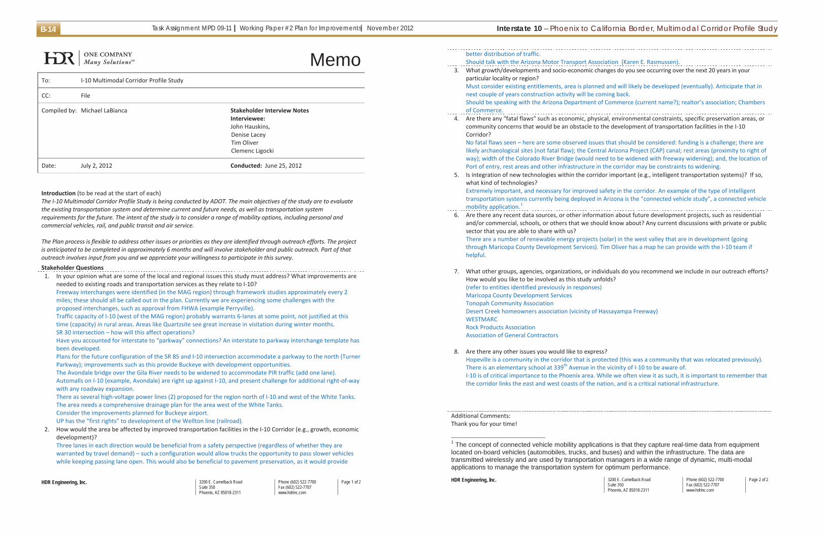
Interstate 10 – Phoenix to California Border, Multimodal Corridor Profile StudyTask Assignment MPD 09-11 | Working Paper #2 Plan for Improvements| November 2012B-14
HDR Engineering, Inc. 3200 E. Camelback RoadSuite 350Phoenix, AZ 85018-2311
Phone (602) 522-7700Fax (602) 522-7707www.hdrinc.com
Page 1 of 2
MemoTo: I-10 Multimodal Corridor Profile Study
CC: File
Compiled by: Michael LaBianca Stakeholder Interview Notes Interviewee: John Hauskins, Denise Lacey Tim Oliver Clemenc Ligocki
Date: July 2, 2012 Conducted: June 25, 2012
Introduction (to be read at the start of each) The I-10 Multimodal Corridor Profile Study is being conducted by ADOT. The main objectives of the study are to evaluate the existing transportation system and determine current and future needs, as well as transportation system requirements for the future. The intent of the study is to consider a range of mobility options, including personal and commercial vehicles, rail, and public transit and air service. The Plan process is flexible to address other issues or priorities as they are identified through outreach efforts. The project is anticipated to be completed in approximately 6 months and will involve stakeholder and public outreach. Part of that outreach involves input from you and we appreciate your willingness to participate in this survey.
Stakeholder Questions 1. In your opinion what are some of the local and regional issues this study must address? What improvements are
needed to existing roads and transportation services as they relate to I-10? Freeway interchanges were identified (in the MAG region) through framework studies approximately every 2 miles; these should all be called out in the plan. Currently we are experiencing some challenges with the proposed interchanges, such as approval from FHWA (example Perryville). Traffic capacity of I-10 (west of the MAG region) probably warrants 6-lanes at some point, not justified at this time (capacity) in rural areas. Areas like Quartzsite see great increase in visitation during winter months. SR 30 intersection – how will this affect operations? Have you accounted for interstate to “parkway” connections? An interstate to parkway interchange template has been developed. Plans for the future configuration of the SR 85 and I-10 intersection accommodate a parkway to the north (Turner Parkway); improvements such as this provide Buckeye with development opportunities. The Avondale bridge over the Gila River needs to be widened to accommodate PIR traffic (add one lane). Automalls on I-10 (example, Avondale) are right up against I-10, and present challenge for additional right-of-way with any roadway expansion. There as several high-voltage power lines (2) proposed for the region north of I-10 and west of the White Tanks. The area needs a comprehensive drainage plan for the area west of the White Tanks. Consider the improvements planned for Buckeye airport. UP has the “first rights” to development of the Wellton line (railroad).
2. How would the area be affected by improved transportation facilities in the I-10 Corridor (e.g., growth, economic development)? Three lanes in each direction would be beneficial from a safety perspective (regardless of whether they are warranted by travel demand) – such a configuration would allow trucks the opportunity to pass slower vehicles while keeping passing lane open. This would also be beneficial to pavement preservation, as it would provide
HDR Engineering, Inc. 3200 E. Camelback RoadSuite 350Phoenix, AZ 85018-2311
Phone (602) 522-7700Fax (602) 522-7707www.hdrinc.com
Page 2 of 2
better distribution of traffic. Should talk with the Arizona Motor Transport Association (Karen E. Rasmussen).
3. What growth/developments and socio-economic changes do you see occurring over the next 20 years in your particular locality or region? Must consider existing entitlements, area is planned and will likely be developed (eventually). Anticipate that in next couple of years construction activity will be coming back. Should be speaking with the Arizona Department of Commerce (current name?); realtor’s association; Chambers of Commerce.
4. Are there any "fatal flaws" such as economic, physical, environmental constraints, specific preservation areas, or community concerns that would be an obstacle to the development of transportation facilities in the I-10 Corridor? No fatal flaws seen – here are some observed issues that should be considered: funding is a challenge; there are likely archaeological sites (not fatal flaw); the Central Arizona Project (CAP) canal; rest areas (proximity to right of way); width of the Colorado River Bridge (would need to be widened with freeway widening); and, the location of Port of entry, rest areas and other infrastructure in the corridor may be constraints to widening.
5. Is integration of new technologies within the corridor important (e.g., intelligent transportation systems)? If so, what kind of technologies? Extremely important, and necessary for improved safety in the corridor. An example of the type of intelligent transportation systems currently being deployed in Arizona is the “connected vehicle study”, a connected vehicle mobility application.1
6. Are there any recent data sources, or other information about future development projects, such as residential and/or commercial, schools, or others that we should know about? Any current discussions with private or public sector that you are able to share with us?
There are a number of renewable energy projects (solar) in the west valley that are in development (going through Maricopa County Development Services). Tim Oliver has a map he can provide with the I-10 team if helpful.
7. What other groups, agencies, organizations, or individuals do you recommend we include in our outreach efforts? How would you like to be involved as this study unfolds? (refer to entities identified previously in responses) Maricopa County Development Services Tonopah Community Association Desert Creek homeowners association (vicinity of Hassayampa Freeway) WESTMARC Rock Products Association Association of General Contractors
8. Are there any other issues you would like to express? Hopeville is a community in the corridor that is protected (this was a community that was relocated previously). There is an elementary school at 339th Avenue in the vicinity of I-10 to be aware of. I-10 is of critical importance to the Phoenix area. While we often view it as such, it is important to remember that the corridor links the east and west coasts of the nation, and is a critical national infrastructure.
Additional Comments: Thank you for your time!
1 The concept of connected vehicle mobility applications is that they capture real-time data from equipment located on-board vehicles (automobiles, trucks, and buses) and within the infrastructure. The data are transmitted wirelessly and are used by transportation managers in a wide range of dynamic, multi-modal applications to manage the transportation system for optimum performance.
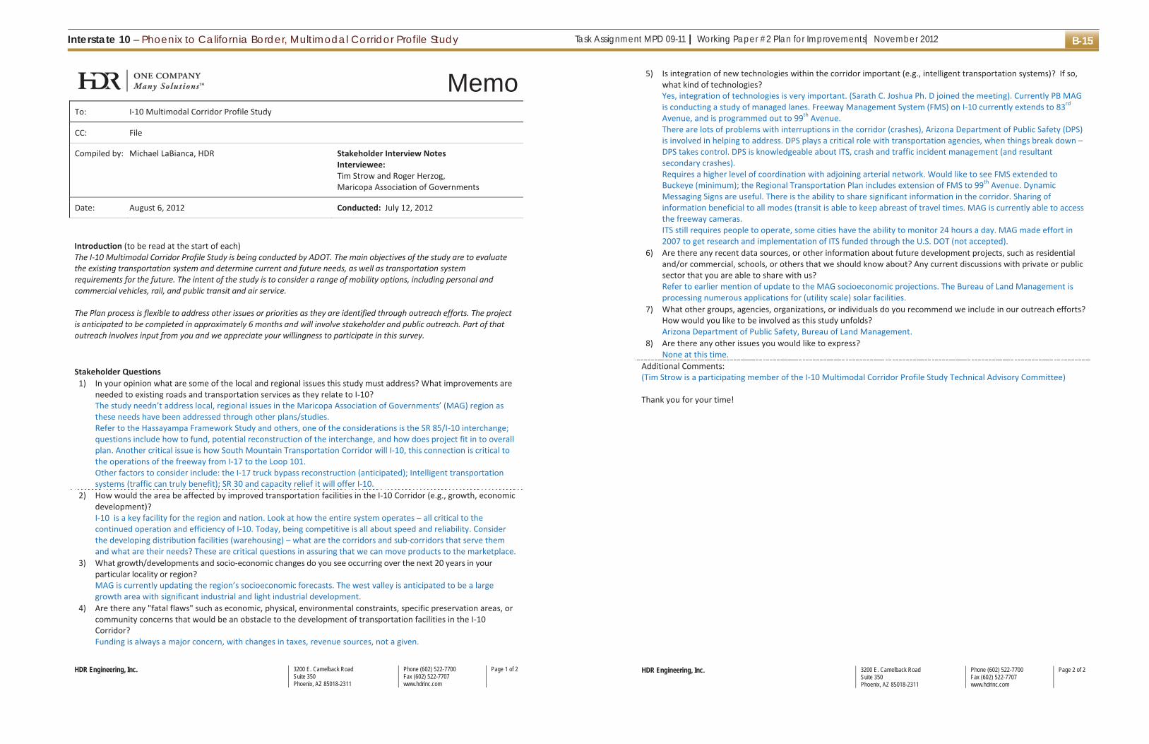
Task Assignment MPD 09-11 | Working Paper #2 Plan for Improvements| November 2012Interstate 10 – Phoenix to California Border, Multimodal Corridor Profile Study B-15
HDR Engineering, Inc. 3200 E. Camelback RoadSuite 350Phoenix, AZ 85018-2311
Phone (602) 522-7700Fax (602) 522-7707www.hdrinc.com
Page 1 of 2
MemoTo: I-10 Multimodal Corridor Profile Study
CC: File
Compiled by: Michael LaBianca, HDR Stakeholder Interview Notes Interviewee: Tim Strow and Roger Herzog, Maricopa Association of Governments
Date: August 6, 2012 Conducted: July 12, 2012
Introduction (to be read at the start of each) The I-10 Multimodal Corridor Profile Study is being conducted by ADOT. The main objectives of the study are to evaluate the existing transportation system and determine current and future needs, as well as transportation system requirements for the future. The intent of the study is to consider a range of mobility options, including personal and commercial vehicles, rail, and public transit and air service. The Plan process is flexible to address other issues or priorities as they are identified through outreach efforts. The project is anticipated to be completed in approximately 6 months and will involve stakeholder and public outreach. Part of that outreach involves input from you and we appreciate your willingness to participate in this survey.
Stakeholder Questions
1) In your opinion what are some of the local and regional issues this study must address? What improvements are needed to existing roads and transportation services as they relate to I-10? The study needn’t address local, regional issues in the Maricopa Association of Governments’ (MAG) region as these needs have been addressed through other plans/studies. Refer to the Hassayampa Framework Study and others, one of the considerations is the SR 85/I-10 interchange; questions include how to fund, potential reconstruction of the interchange, and how does project fit in to overall plan. Another critical issue is how South Mountain Transportation Corridor will I-10, this connection is critical to the operations of the freeway from I-17 to the Loop 101. Other factors to consider include: the I-17 truck bypass reconstruction (anticipated); Intelligent transportation systems (traffic can truly benefit); SR 30 and capacity relief it will offer I-10.
2) How would the area be affected by improved transportation facilities in the I-10 Corridor (e.g., growth, economic development)? I-10 is a key facility for the region and nation. Look at how the entire system operates – all critical to the continued operation and efficiency of I-10. Today, being competitive is all about speed and reliability. Consider the developing distribution facilities (warehousing) – what are the corridors and sub-corridors that serve them and what are their needs? These are critical questions in assuring that we can move products to the marketplace.
3) What growth/developments and socio-economic changes do you see occurring over the next 20 years in your particular locality or region? MAG is currently updating the region’s socioeconomic forecasts. The west valley is anticipated to be a large growth area with significant industrial and light industrial development.
4) Are there any "fatal flaws" such as economic, physical, environmental constraints, specific preservation areas, or community concerns that would be an obstacle to the development of transportation facilities in the I-10 Corridor? Funding is always a major concern, with changes in taxes, revenue sources, not a given.
HDR Engineering, Inc. 3200 E. Camelback RoadSuite 350Phoenix, AZ 85018-2311
Phone (602) 522-7700Fax (602) 522-7707www.hdrinc.com
Page 2 of 2
5) Is integration of new technologies within the corridor important (e.g., intelligent transportation systems)? If so, what kind of technologies? Yes, integration of technologies is very important. (Sarath C. Joshua Ph. D joined the meeting). Currently PB MAG is conducting a study of managed lanes. Freeway Management System (FMS) on I-10 currently extends to 83rd Avenue, and is programmed out to 99th Avenue. There are lots of problems with interruptions in the corridor (crashes), Arizona Department of Public Safety (DPS) is involved in helping to address. DPS plays a critical role with transportation agencies, when things break down – DPS takes control. DPS is knowledgeable about ITS, crash and traffic incident management (and resultant secondary crashes). Requires a higher level of coordination with adjoining arterial network. Would like to see FMS extended to Buckeye (minimum); the Regional Transportation Plan includes extension of FMS to 99th Avenue. Dynamic Messaging Signs are useful. There is the ability to share significant information in the corridor. Sharing of information beneficial to all modes (transit is able to keep abreast of travel times. MAG is currently able to access the freeway cameras. ITS still requires people to operate, some cities have the ability to monitor 24 hours a day. MAG made effort in 2007 to get research and implementation of ITS funded through the U.S. DOT (not accepted).
6) Are there any recent data sources, or other information about future development projects, such as residential and/or commercial, schools, or others that we should know about? Any current discussions with private or public sector that you are able to share with us? Refer to earlier mention of update to the MAG socioeconomic projections. The Bureau of Land Management is processing numerous applications for (utility scale) solar facilities.
7) What other groups, agencies, organizations, or individuals do you recommend we include in our outreach efforts? How would you like to be involved as this study unfolds? Arizona Department of Public Safety, Bureau of Land Management.
8) Are there any other issues you would like to express? None at this time.
Additional Comments: (Tim Strow is a participating member of the I-10 Multimodal Corridor Profile Study Technical Advisory Committee) Thank you for your time!

Interstate 10 – Phoenix to California Border, Multimodal Corridor Profile StudyTask Assignment MPD 09-11 | Working Paper #2 Plan for Improvements| November 2012B-16
HDR Engineering, Inc. 3200 E. Camelback RoadSuite 350Phoenix, AZ 85018-2311
Phone (602) 522-7700Fax (602) 522-7707www.hdrinc.com
Page 1 of 2
MemoTo: I-10 Multimodal Corridor Profile Study
CC: File
Compiled by: Janet Gonzalez, HDR
Stakeholder Interview Notes Interviewee: Aaron Ashcroft, Central Arizona Project Tom Fitzgerald, Central Arizona Project
Date: July 9, 2012 Conducted: July 2, 2012 and July 9, 2012
Introduction (to be read at the start of each) The I-10 Multimodal Corridor Profile Study is being conducted by ADOT. The main objectives of the study are to evaluate the existing transportation system and determine current and future needs, as well as transportation system requirements for the future. The intent of the study is to consider a range of mobility options, including personal and commercial vehicles, rail, and public transit and air service. The Plan process is flexible to address other issues or priorities as they are identified through outreach efforts. The project is anticipated to be completed in approximately 6 months and will involve stakeholder and public outreach. Part of that outreach involves input from you and we appreciate your willingness to participate in this survey.
Stakeholder Questions
1. In your opinion what are some of the local and regional issues this study must address? What improvements are needed to existing roads and transportation services as they relate to I-10? There is an existing agreement with the Bureau of Reclamation (BOR) for existing CAP canal crossings. Agreement establishes bridges and may need to establish additional ROW as the valley continues to grow. Looking into establishing a permit from Bureau of Land Management to transfer the rights to the BOR. There is currently really no reason for the BLM to manage land that the BOR maintains, and adds a layer to the process as requests must currently go through BLM for permits. There are ongoing discussions to establish the CAP corridor as a recreational trail. This has received support from trail plans for Maricopa County, Scottsdale and others. The CAP corridor has also been identified as a national recreational trail. For a recreational trail, a continuous trail running along the outside of the fence would be needed. Access to canal is most important. Drainage from runoff on freeway corridor needs to be controlled for water quality concerns at the canal. (TF)
2. How would the area be affected by improved transportation facilities in the I-10 Corridor (e.g., growth, economic development)? Improved transportation facilities would facilitate economic growth and development in the area. CAP staff regularly travels to the west valley and encounters considerable traffic. Another travel lane and/or improved connectivity would ease the flow of traffic. (AA)
3. What growth/developments and socio-economic changes do you see occurring over the next 20 years in your particular locality or region? The canal system used to be in the middle of nowhere, and is now in an urban area. Projections for growth to go through Tonopah. Working on recharging basins, acquiring water and ensuring 100-year supplies. There will be more growth, capacity increase and crossings required in the future. Will need to decide how that impacts operations and maintenance, access to the canal, and the overall well-being of the community. (TF)
4. Are there any "fatal flaws" such as economic, physical, environmental constraints, specific preservation areas, or community concerns that would be an obstacle to the development of transportation facilities in the I-10
HDR Engineering, Inc. 3200 E. Camelback RoadSuite 350Phoenix, AZ 85018-2311
Phone (602) 522-7700Fax (602) 522-7707www.hdrinc.com
Page 2 of 2
Corridor? CAP clearance requirements are an important consideration of the development of transportation facilities in the I-10 corridor. Bridges that cross the CAP canal are expensive and must meet specific clearance requirements. Cost will be important when considering improvements and/or physical constraints of crossing canals in the study area. (AA)
5. Is integration of new technologies within the corridor important (e.g., intelligent transportation systems)? If so, what kind of technologies? Yes. Real-time message signs are important for drivers. The faster the information is shared, the easier it is to plan for alternative routes. (AA)
6. Are there any recent data sources, or other information about future development projects, such as residential and/or commercial, schools, or others that we should know about? Any current discussions with private or public sector that you are able to share with us? 303 linking, Turner Parker. Douglas Ranch is a development. 500 – 230 KV lines from Palo Verde will be crossing freeway, from Palo Verde to the Sun Valley substation, and then to the Morgan substation, formerly the T55. There is a smaller substation on the south side of the I-10. The Bidler Water Company has been recharging water for years into the aquifer and would like to take water out of the well sites and sell to the canals. (TF)
7. What other groups, agencies, organizations, or individuals do you recommend we include in our outreach efforts? How would you like to be involved as this study unfolds? Tom Fitzgerald with CAP runs the Land group. Phone number is 623.869.2209. Add Tom to the e-mail list – [email protected]. Contact by e-mail distribution. (AA)
8. Are there any other issues you would like to express? The Liberty Parker Line power line at Buckeye will need to be considered as part of this study effort. New Mexico solar farms are looking at getting energy over to California. There may be a need to a number 2 line in the near future along the corridor to leverage the connection between the two states. (TF)
Additional Comments: N/A Thank you for your time!

Task Assignment MPD 09-11 | Working Paper #2 Plan for Improvements| November 2012Interstate 10 – Phoenix to California Border, Multimodal Corridor Profile Study B-17
HDR Engineering, Inc. 3200 E. Camelback RoadSuite 350Phoenix, AZ 85018-2311
Phone (602) 522-7700Fax (602) 522-7707www.hdrinc.com
Page 1 of 2
MemoTo: I-10 Multimodal Corridor Profile Study
CC: File
Compiled by: Janet Gonzalez, HDR
Stakeholder Interview Notes Interviewee: Tom Simmons, La Paz County
Date: July 26, 2012 Conducted: July 19, 2012
Introduction (to be read at the start of each) The I-10 Multimodal Corridor Profile Study is being conducted by ADOT. The main objectives of the study are to evaluate the existing transportation system and determine current and future needs, as well as transportation system requirements for the future. The intent of the study is to consider a range of mobility options, including personal and commercial vehicles, rail, and public transit and air service. The Plan process is flexible to address other issues or priorities as they are identified through outreach efforts. The project is anticipated to be completed in approximately 6 months and will involve stakeholder and public outreach. Part of that outreach involves input from you and we appreciate your willingness to participate in this survey.
Stakeholder Questions
1. In your opinion what are some of the local and regional issues this study must address? What improvements are needed to existing roads and transportation services as they relate to I-10? ADOT needs to build a roundabout at Exit #1 on the south side just as what has been built on the north side of the freeway. Intersections at Quartzite should be addressed. The area is a ghost town in the summer, but attracts 200,000 people in the winter. Should look into studying the on/off ramps to ease the gridlock during the high-peak season. Study should also look at the oversized loads that are unable to go through the I-10 because of weight and/or height. This creates problems for frontage roads.
2. How would the area be affected by improved transportation facilities in the I-10 Corridor (e.g., growth, economic development)? Improved facilities would help a lot. Economic development is good, and people spending money is great for the local economy.
3. What growth/developments and socio-economic changes do you see occurring over the next 20 years in your particular locality or region? La Paz County completed a PARA study in 2009. The study showed a population of 22,347 in 2009, and an anticipated population of 28,000 in 2030 at a moderate growth scale, and 42,734 at an aggressive growth scale.
4. Are there any "fatal flaws" such as economic, physical, environmental constraints, specific preservation areas, or community concerns that would be an obstacle to the development of transportation facilities in the I-10 Corridor? None come to mind.
5. Is integration of new technologies within the corridor important (e.g., intelligent transportation systems)? If so, what kind of technologies? Real-time message sharing is important.
6. Are there any recent data sources, or other information about future development projects, such as residential and/or commercial, schools, or others that we should know about? Any current discussions with private or public sector that you are able to share with us?
HDR Engineering, Inc. 3200 E. Camelback RoadSuite 350Phoenix, AZ 85018-2311
Phone (602) 522-7700Fax (602) 522-7707www.hdrinc.com
Page 2 of 2
Yes. Landfill in the La Paz area. There are plans to expand and bring solid waste from California. This would certainly add traffic to the region and to the corridor.
7. What other groups, agencies, organizations, or individuals do you recommend we include in our outreach efforts? How would you like to be involved as this study unfolds? Dan Field, County Manager should be included. Contact by e-mail distribution.
8. Are there any other issues you would like to express? None at this time.
Additional Comments: N/A Thank you for your time!

Interstate 10 – Phoenix to California Border, Multimodal Corridor Profile StudyTask Assignment MPD 09-11 | Working Paper #2 Plan for Improvements| November 2012B-18
HDR Engineering, Inc. 3200 E. Camelback RoadSuite 350Phoenix, AZ 85018-2311
Phone (602) 522-7700Fax (602) 522-7707www.hdrinc.com
Page 1 of 2
MemoTo: I-10 Multimodal Corridor Profile Study
CC: File
Compiled by: Janet Gonzalez, HDR
Stakeholder Interview Notes Interviewee: Tom Ainsworth, California Department of
Transportation
Date: June 11, 2012 Conducted: June 8, 2012
Introduction (to be read at the start of each) The I-10 Multimodal Corridor Profile Study is being conducted by ADOT. The main objectives of the study are to evaluate the existing transportation system and determine current and future needs, as well as transportation system requirements for the future. The intent of the study is to consider a range of mobility options, including personal and commercial vehicles, rail, and public transit and air service. The Plan process is flexible to address other issues or priorities as they are identified through outreach efforts. The project is anticipated to be completed in approximately 6 months and will involve stakeholder and public outreach. Part of that outreach involves input from you and we appreciate your willingness to participate in this survey.
Stakeholder Questions
1. In your opinion what are some of the local and regional issues this study must address? What improvements are needed to existing roads and transportation services as they relate to I-10? There are no alternate routes outside of the I-10 into California. Establishing alternate routes is key to ensuring connections are made seamlessly, while paying special attention to maintaining the flow of traffic while clearing accidents, road construction or other circumstances that may prevent the clear flow of traffic.
2. How would the area be affected by improved transportation facilities in the I-10 Corridor (e.g., growth, economic development)? Traffic may be increased by overall economic activity, which may adversely impact improved facilities. New facilities should plan for the growth of activity along the corridor.
3. What growth/developments and socio-economic changes do you see occurring over the next 20 years in your particular locality or region? Additional growth is planned in Palm Springs. Housing will likely produce more traffic and backup traffic throughout that area and on the on-ramps and off-ramps.
4. Are there any "fatal flaws" such as economic, physical, environmental constraints, specific preservation areas, or community concerns that would be an obstacle to the development of transportation facilities in the I-10 Corridor? Any improvements to the corridor will certainly need to consider environmental concerns. Desert tortoises have proven to be an issue for some projects. Funding is certainly a concern, especially for operations and maintenance. Projects are more and more considering private funding in order to get projects off the ground.
5. Is integration of new technologies within the corridor important (e.g., intelligent transportation systems)? If so, what kind of technologies? Cameras should be installed on poles all the way to the Arizona / California border. This is important for safety. Real-time communication is great and should continue to the border as well; truckers especially benefit when transporting goods to know what times to leave a warehouse.
HDR Engineering, Inc. 3200 E. Camelback RoadSuite 350Phoenix, AZ 85018-2311
Phone (602) 522-7700Fax (602) 522-7707www.hdrinc.com
Page 2 of 2
6. Are there any recent data sources, or other information about future development projects, such as residential and/or commercial, schools, or others that we should know about? Any current discussions with private or public sector that you are able to share with us? N/A
7. What other groups, agencies, organizations, or individuals do you recommend we include in our outreach efforts? How would you like to be involved as this study unfolds? E-newsletter.
8. Are there any other issues you would like to express? Not at the moment.
Additional Comments: N/A Thank you for your time!

Task Assignment MPD 09-11 | Working Paper #2 Plan for Improvements| November 2012Interstate 10 – Phoenix to California Border, Multimodal Corridor Profile Study B-19
HDR Engineering, Inc. 3200 E. Camelback Road Suite 350 Phoenix, AZ 85018-2311
Phone (602) 522-7700 Fax (602) 522-7707 www.hdrinc.com
Page 1 of 2
MemoTo: Client, ADOT
CC: Michael LaBianca (HDR), and Mike Book (HDR)
Compiled by: Michael LaBianca Stakeholder Interview NotesInterviewee: Scott Sprague; Chip Young; RaySchweinsburg; Dana Warnecke; Bill Knowles; JeffGagnon; Justin Feek
Date: November 20, 2012 Conducted: November 19, 2012
Introduction (to be read at the start of each)The I 10 Multimodal Corridor Profile Study is being conducted by ADOT. The main objectives of the study are to evaluatethe existing transportation system and determine current and future needs, as well as transportation systemrequirements for the future. The intent of the study is to consider a range of mobility options, including personal andcommercial vehicles, rail, and public transit and air service.
The Plan process is flexible to address other issues or priorities as they are identified through outreach efforts. The projectis anticipated to be completed in approximately 6 months and will involve stakeholder and public outreach. Part of thatoutreach involves input from you and we appreciate your willingness to participate in this survey.
Stakeholder Questions1. In your opinion what are some of the local and regional issues this study must address? What improvements are
needed to existing roads and transportation services as they relate to I 10?
It is recognized that even with additional lanes, habitat loss as a result of roadway footprint is relatively small.Major concern has to do with fragmentation of wildlife habitat. Wildlife crossings represent several concerns, (1)direct mortality with vehicles, and (2) animals ability to cross the highway (i.e., permeability). I 10 crossesPlomosa Mountains (approximately 10 miles east of Quartzsite), prime Bighorn sheep habitat. For Bighorn sheep,need overpass to maintain full permeability, often designed with exclusion fencing to ‘funnel’ wildlife to crossing.
Research is necessary to identify where the best locations are for designing crossing. These should be done inadvance to incorporate outcomes into design (although it was noted that they may also be done concurrentlywith NEPA environmental process to save time). It may be difficult to find funding for research, best to get upfront with this issue and address as early as possible – cost effective means of getting to an acceptable solution.
There are specific species that they (AZ G&F) are concerned about. There are county (specific) environmentallinkages information In addition to the state wide assessment that was done some years ago. This information isavailable on the Arizona Game and Fish website, refer to “Maricopa County Wildlife Connectivity Assessment”(note: the La Paz County data is forthcoming).
There are also other indirect issues that have an impact, such as invasive species, pollution of waterways.Mitigation, especially when considered in advance can address many of the concerns. Issues that come up withcorridor projects include impacts to riparian areas, use of groundwater resources, riparian crossings and design(habitat linkages typically tied to washes).
While Construction projects represent risk to habitat and special status species, there is always an opportunity tomitigate past problems and address issues with any project.
Another concern of the agency is access to public lands. Oftentimes culverts are used to cross roadway and this
HDR Engineering, Inc. 3200 E. Camelback Road Suite 350 Phoenix, AZ 85018-2311
Phone (602) 522-7700 Fax (602) 522-7707 www.hdrinc.com
Page 2 of 2
activity competes with wildlife looking for crossings. In addition, ROW fencing often presents problems inproximity to culverts as it often narrows down collecting trash and debris that further limits wildlife access.Arizona Game and Fish advocates pushing back fencing around culverts, and maintaining culvert crossings. It wasalso noted that some energy dissipating designs are not wildlife friendly (for example ‘rip wrap’).
2. How would the area be affected by improved transportation facilities in the I 10 Corridor (e.g., growth, economicdevelopment)?
NEPA corridor studies often do not disclose effects, and/or conduct a thorough evaluation of broader impacts,including induced development. These indirect and cumulative impacts can have significant environmental effects.
Railroads corridors along the interstate can have significant impact to wildlife, especially freight. High frequencyfreight corridors act as a ‘moving fence’. [Note: follow up with Mike Keis, ADOT, for additional information on theLos Angeles, California to Phoenix ‘bullet train’)
3. What growth/developments and socio economic changes do you see occurring over the next 20 years in yourparticular locality or region?
Concerns with widening in the vicinity of the White Tank Mountains. The Buckeye Flood Retention Dam is inproximity to I 10 here. Interchanges planned to connect to future freeways (as identified in the HassayampaFramework Study) will need to be designed to allow for habitat connectivity through the region.
There are a number of solar projects being considered for the area north of the I 10 Corridor. One project that ismoving forward is the Saddle Mountain project. MCDOT is currently planning several parkway projects in theBuckeye area; the interchanges with I 10 will require design for wildlife crossing.
4. Are there any "fatal flaws" such as economic, physical, environmental constraints, specific preservation areas, orcommunity concerns that would be an obstacle to the development of transportation facilities in the I 10Corridor?
No fatal flaws to speak of need to keep aware of the changes in species status which would have a significantimpact (ex. Desert tortoise). Can mitigate around most any issues, however, where possible avoid, then minimize,and finally mitigate; wildlife concerns need to be addressed.
5. Is integration of new technologies within the corridor important (e.g., intelligent transportation systems)? If so,what kind of technologies?There is a much better understanding today of wildlife crossings that should be applied to corridor plans.
6. Are there any recent data sources, or other information about future development projects, such as residentialand/or commercial, schools, or others that we should know about? Any current discussions with private or publicsector that you are able to share with us?
Refer to discussion on the recent databases and habitat information available through the Arizona Game and FishDepartment website.
7. What other groups, agencies, organizations, or individuals do you recommend we include in our outreach efforts?How would you like to be involved as this study unfolds?
Reach out to non governmental organizations such as the Nature Conservancy, Sonoran Institute, Arizona DesertBighorn Sheep Society.
Justin Feek, ADOT project manager, extended review of the Technical Advisory Committee draft Plan to theArizona Game and Fish (Chip Young, point of contact).
8. Are there any other issues you would like to express? See above.
Additional Comments:
Thank you for your time!

This page is intentionally left blank.

Task Assignment MPD 09-11 | Working Paper #2 Plan for Improvements| November 2012Interstate 10 – Phoenix to California Border, Multimodal Corridor Profile Study C-1
Appendix C: Stakeholder Newsletter

Interstate 10 – Phoenix to California Border, Multimodal Corridor Profile StudyTask Assignment MPD 09-11 | Working Paper #2 Plan for Improvements| November 2012C-2
The Arizona Department of Transportation (ADOT) is conducting a long range planning study forInterstate 10 called the I 10 Multimodal Corridor Profile Study. The study area for this projectextends from downtown Phoenix (Central Avenue) to the Arizona/California border. Interstate10 and Interstate 40 are the only interstate highways that cross the entire state of Arizona. As acontinuous coast to coast national transportation route, I 10 is a principal freight route thatconnects the southern California deep sea ports with major metropolitan areas inArizona, Texas, and Florida. The intent of the study is to take a comprehensive look at theplanning studies that have been completed for this corridor and create a document thatillustrates the projects and possible planning needs in the study area.
The goal of the study is different for the different segments of I 10 in Maricopa and La Pazcounties. Each county has its own primary goal.
Maricopa County• Consolidate multiple planning documents into one document. Within Maricopa County,there are two studies that serve as the primary guide for the I 10 corridor: the MAG RegionalTransportation Plan and the Interstate 10 Hassayampa Valley Transportation FrameworkStudy. The I 10 Corridor Study will focus on compiling the recommendations from thesestudies and others into a single planning resource focused on the I 10corridor. New alternatives and improvements will not be recommended within MaricopaCounty.
La Paz County• Consolidate multiple planning documents into one document.• Develop a clear vision for future transportation needs along the I 10 corridor. The segmentof I 10 that traverses La Paz County has not had the same level of planning when compared to
the Maricopa County segment; therefore, ADOT staff analyzed the I 10 corridor through La PazCounty for transportation needs that included a range of mobility options, including personaland commercial vehicles, rail, air service and public transit.
The I 10 Corridor Study began in summer 2011 and is scheduled for completion in winter 2012.
Given the length of the corridor, a wide variety of interests will be affected, making publicparticipation in the study process essential. The study team will meet with agencyrepresentatives to gather information about the study area.
Visit azdot.gov/i10corridorstudy for more information about the study, or contact the studyteam.• Email: [email protected]• Mail: ADOT c/o I 10 Multimodal Corridor Profile Study, 3200 E. Camelback Rd., Suite350, Phoenix, AZ 85018• Project Hotline: 888.968.3617
This email list will not be shared for non ADOT purposes. If you would like to share this with others, feel freeto forward this email. If you have received this update as a forward and you would like to receive theseupdates automatically, please send your email address to [email protected].

Task Assignment MPD 09-11 | Working Paper #2 Plan for Improvements| November 2012Interstate 10 – Phoenix to California Border, Multimodal Corridor Profile Study C-3
The Arizona Department of Transportation (ADOT) is conducting a long range planning study forInterstate 10 called the I 10 Multimodal Corridor Profile Study. The study area for this project extendsfrom downtown Phoenix (Central Avenue) to the Arizona/California border. Interstate 10 and Interstate40 are the only interstate highways that cross the entire state of Arizona. As a continuous coast to coastnational transportation route, I 10 is a principal freight route that connects the southern California deepsea ports with major metropolitan areas in Arizona, Texas, and Florida. The intent of the study is to takea comprehensive look at the planning studies that have been completed for this corridor and create adocument that illustrates the projects and possible planning needs in the study area.
The goal of the study is different for the different segments of I 10 in Maricopa and La Paz counties.Each county has its own primary goal.
Maricopa County• Consolidate multiple planning documents into one document. Within Maricopa County, there aretwo studies that serve as the primary guide for the I 10 corridor: the MAG Regional TransportationPlan and the Interstate 10 Hassayampa Valley Transportation Framework Study. The I 10 CorridorStudy will focus on compiling the recommendations from these studies and others into asingle planning resource focused on the I 10 corridor. New alternatives and improvements, beyondthose identified in the MAG Plan, will not be recommended within Maricopa County.
La Paz County• Consolidate multiple planning documents into one document.• Develop a clear vision for future transportation needs along the I 10 corridor. The segment of I10 that traverses La Paz County has not had the same level of planning when compared tothe Maricopa County segment; therefore, ADOT staff analyzed the I 10 corridor through La Paz Countyfor transportation needs that included a range of mobility options, including personal and commercialvehicles, rail, air service and public transit.
The I 10 Corridor Study began in summer 2011 and is scheduled for completion in winter 2012.
Given the length of the corridor, a wide variety of interests will be affected, making publicparticipation in the study process essential. The study team will meet with agency representatives togather information about the study area.
Visit azdot.gov/i10corridorstudy for more information about the study, or contact the study team.• Email: [email protected]• Mail: ADOT c/o I 10 Multimodal Corridor Profile Study, 3200 E. Camelback Rd., Suite 350,Phoenix, AZ 85018• Project Hotline: 888.968.3617
This email list will not be shared for non ADOT purposes. If you would like to share this with others, feel freeto forward this email. If you have received this update as a forward and you would like to receive theseupdates automatically, please send your email address to [email protected].