Embed Size (px)
Citation preview

75
Integrating the Goler Matrix Method and the List of Indicators to Specify an Efficient Alternative on Elevating the Quality of
Ecological Functions of the River Borders (Case Study: Abshooran River in Kermanshah, Iran)
Shima Homaeea*, Esmaeel Salehi
b a
M.U.D., Faculty of Architecture and Urban Planning , Qazvin Branch, Islamic Azad ,University , Qazvin , Iran .
bAssociate Professor of Urban Planning, Faculty of Environment , University of Tehran, Tehran , Iran. Received: 28 June 2016 - Accepted:15 March 2017
Abstract
The purpose behind this research, which is done on the Abshooran river in Kermanshah and in the area between Delgosha bridge and wooden bridge is to develop lively and active urban centers and to elevate the quality functions of the region and the ecological conditions of the river’s border. To reach for this goal, ecological and aesthetic criteria were in use in a way that proposed alternatives are first edited according to the criteria, regulations and compiled standards for the design and were chosen after analysis on the criteria and the design fundamentals in order to reach for the research goals; 12 indicators were regarded to find an efficient alternative. Based on the Goler matrix method and integration of it with the list of criteria, each criterion is given a specific weight according to its significance/ importance. And then the scores were analysed and were multiplied by the weight of each topic, finally the optimal alternative would be resulted regarding the high score among others. Findings of the research indicates that the fulfillment of fundamentals and design criteria has the more impact in relation to the other choices. So, the strategic plan is presented according to this point.
Keywords: Efficient Alternative, Analysis of criteria, Ecological Design, Elevating Quality
1. Introduction
Natural borders of the city like the riverside boundaries which was always a part of the city carry a specific spatial capacities which forms the identity of the city (YarAhmadi, 2011:32). Considering the ecological role of the water sides in the formation of city continents and conditioning the environment by managing them for green urban zones is nowadays an over expanding solution. Waterside, is one of the rare urban opportunities which embodies a capacity to revive the urban environment (Mansouri, 2011: 7). Regardless of different limitations, city rivers are precious resources to develop ecological approaches in the urban field without the elimination of human presence in this approach (Laghai and Eradati, 2015: 7). Developing the river corridor and designing dynamic and active borders, regulates a sense of monotony of the texture and will create a lively and dynamic environment which paves the way for breathing life into a half alive body of the city. Nowadays, the human is aware of the fact that, reducing the harmful effects of whatever type of change in the course of natural rivers or reducing their current then trying to make another balance in the river should figure about the physical governing rules of the processes and to be ready to predict whatever subsequent adjustment, revision activity on the river. Concepts of sustainable development should be considered because the surface waters are one of the largest supplies of water (Laghaei and Eradati, 2015: 7).
Right now, the border and boundary of the Abshooran river have changed from the organic type into a channeled one, it have lost the natural (ecological) structures within and have changed into haunted and abandoned city spaces which has several security, social and environmental issues which by applying a proper management by changing the approach for the case of urban rivers from channeling and managing them into reviving them according to the ecology, great results can be achieved along with the approaches from other advanced countries. Thus, the necessity of such article is that the border of this river includes one of the most fragile urban capacities, to help the survival of natural environments for it to be able to find its own position needs a proper revival and design according to the ecological facts. In fact, the most important thing is the inseparability of the ecology from the viewpoint of landscape design and sustainable development. This is the reason for elimination of borders between the ecological design of vulnerable natural arenas and the landscape design from these spaces. According to these facts, on the overall approach of the plan, achieving environmental sustainable development by using the maximum amount of existing facilities in the region and then to arrive for a number of solutions in order to enhance the environment by elevating the life quality, was and will be the basis; thus, considering the environmental, functional and aesthetic is always considered in the fundamental basis of the ecologic plan.
* Corresponding Author Email: [email protected]
Space Ontology International Journal, Vol.6, Issue 2, Spring 2017, 75 - 84
Now, the main question of the research is that how the elevation of the ecological functionality of the riverside is defied? The main achievement of the research is to defy an efficient alternative from the probable planning choices based on the integration of Goler matrix method and the list of criteria in a way that fundamentals and criteria of ecological design which causes an elevation in the quality of ecological function, is more evident in that alternative.
2. Theoretical Framework 2.1 Definition of Ecology
2.2 Urban Ecology
Urban ecology is a precondition for the cities to provide an environment proportional to the lives of it’s citizens and the progresses in technology can only be at the service for the city when they are implemented aligned with the ecology. This point is also implemented after a long series of experimentations in the big and rich cities of the world who afford the expenses of it (HashemPour, 2001). In the field of urban ecology, the urban planner should pay attention to the following points: ● Preserving the natural and cultural impacts ● Defying the form of city by natural disasters, hills ● Taking for granted the elevation of city development, environmental health. ● Dense and diverse development ● Preserving the village traditions ● Compatibility with the nature
Being aware of the aquifers (Piri and Rezaei Rad, 2016: 2)
The ecological city which is recommended by a large number of groups, is a city which includes these four specifications: ● There is a least amount of intervention with the nature ● The most diversity (in regard to the land usage and activities) ● Preferably as a closed system ● Enhanced balance between population and resources. (Bahreini, 2002: 155).
2.3 Ecological city (Eco City)
Ecocity or the sustainable ecological cities were first mentioned by Richard Register in 1987 in his book with the title of “Building Cities for a Healthy Future”. Ecocity is a type of city which is designed based on the environmental effects for increasing the demanding energy, water and foods, wasted heat, weather pollution, carbon dioxides and Metan (Register, 1987). Ecological city, or the sustainable city is a type of city in which the reuse of resources, recycling are considered while planning its different areas of it, the purpose of implementing such processes is to reach for the sustainable development in the urban environments (Wong, et al, 2011). Ecocity is a stable city which can provide a meaningful life for its citizens without eliminating the ecologic that it relies on (Crombie, 1992: 18).
2.4 Planning using the ecologic approach
The ecological concerns in representing the decided criteria for the design are categorized into three categories: 1. Environmental 2. Functional 3. Aesthetic In the following table, a number of regulations and recommendations were considered for the design on the border sides for each dimension which is the criterion for offering design solutions that are resulted from the maxims and criteria of design in the ecological point of view along the both sides of the river. It is pertinent to mention that the extracted criteria in this section are resulted from the discussion topics in the researches of (MoeiniFar and AminZadeh, 2012), (Razaghian, et al, 2012), Hashemi Dizaj and Khatami, 2012), (PourJafar and Rastandeh, 2010), (PourJafar and Sadeghi, 2011), (Safar Khanlou, 2011), (Watson et al, 2008) which is inscribed in the table 1 Table. 1 Criterion for design with an ecological approach (Source: (MoeiniFar and AminZadeh, 2012), (Razaghian, et al, 2012), Hashemi Dizaj and Khatami, 2012), (PourJafar and Rastandeh, 2010), (PourJafar and Sadeghi, 2011), (Safar Khanlou, 2011), (Watson et al, 2008))
76
The dictionary definition of ecology is the study of mutual relationship between the living animals and their environment (Lincoln, et al, 1982). Ecology with the definition of “environmentology” is the study of environments or settlements and the quality of land occupation with living creatures and connecting them in spaces and the quality of action and reaction of these creatures with each other”. (According to the quotation from Razaghian: 2013: 158). “Ecology is the study of relationship between the of life forms and the natural environments” (ibid). Ecology equals the science of studying the mutual relations of the organisms with the outside word, which in a broader definition includes all the conditions of the nature. The title of ecology explains more expanded ideas in different fields. This title was first used for the “dependence of plants and animals to the natural environments”. The concept of ecology became more interesting for the scientists across other fields of science by the late 19th century and the early 20th century, urban studies have been greatly impacted by this movement (Piri and Rezaei Rad, 2016: 2).

Shima Homaee, Esmaeel Salehi
77
Table 1 Criteria for design with an ecological approach
Design recommendations Design regulations and criteria Dimensions of
Ecological Plan Ecological
Considerations
Reduction in the production of greenhouse gases and to supply the demanding energies from solar cells or wind power generators, supplying the water by recycling surfaces watters and the waterfalls on the roofs and other surfaces, Association of infrastructures with suitable energy, using the effect of tree shadows on using the chilling energies.
Preservation of natural environment against the energy usage, using upgradable energies.
Energy
Environmental
Developing protected green spaces; preserving the life cycles, developing a systematic way of plantings according to aboriginal patterns, preserving the wildlife, least amount of planting foreign samples, avoiding the cut in trees and green fields, providing enhanced conditions for the presence of migrating birds, insects and impactful creatures in the ecosystem.
Preserving the natural resources (Wildlife habitats and the vegetative fields) and developing diverse living places for the birds and other significant animals of a healthy environment.
Plants and Animals
Collecting the rainfall water by new techniques, collecting the surfaces waters from the parking and other roads, irrigation with the resources of local river, using the water collecting facilities for urban uses, re-using the recycled waters.
Controlling the water quality and avoiding a change in its matter.
Water
Increasing the penetration rate of waterfalls in the soil, green roofs, impenetrable and spongy vegetative surfaces, planted lands, suspensive facilities to postpone the reaching time of the floods to the urban areas, facilities for collecting water for different urban uses, like constructing water pools and small lakes, using the absorbed water in the irrigation of urban green spaces, avoiding permanent constructions in the boundary of drainages and to specify the river border.
Control and management of Floods and streams, reducing the flood-protecting shield of the river to the least extent.
Floods
Using masses of trees in order to elevate the weather quality and reduction of contaminations which are caused by dust and floating germs and to control the wind, production of oxygen, balancing the subcontinents and absorbing the heat by using green walls in order to reduce and absorb the environmental contaminations, adjusting the unconventional channel
Self-refining and reduction of air pollution, noises and reduction of disorders which are cause of environmental contaminators in the river margins, control of waste waters.
Contaminations in the natural
environment
Space Ontology International Journal, Vol. 6, Issue 2, Spring 2017, 75 - 84
streams. Collecting and controlling the surface waters.
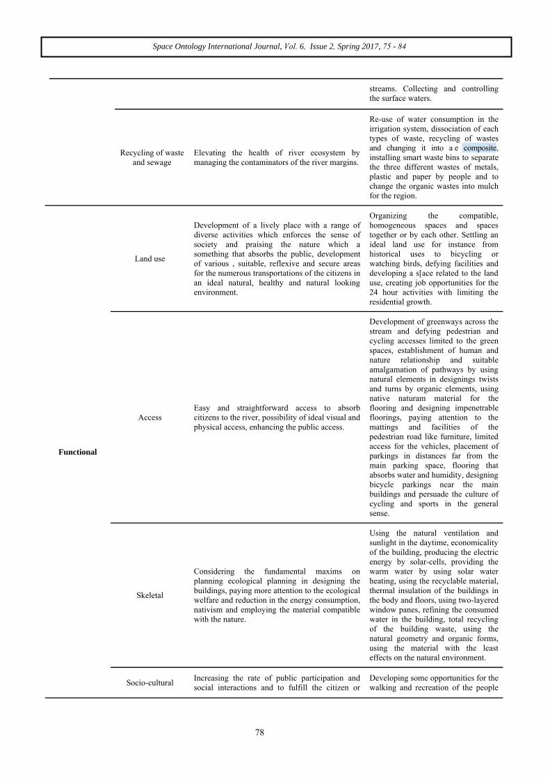
Re-use of water consumption in the irrigation system, dissociation of each types of waste, recycling of wastes and changing it into a e composite, installing smart waste bins to separate the three different wastes of metals, plastic and paper by people and to change the organic wastes into mulch for the region.
Elevating the health of river ecosystem by managing the contaminators of the river margins.
Recycling of waste and sewage
Organizing the compatible, homogeneous spaces and spaces together or by each other. Settling an ideal land use for instance from historical uses to bicycling or watching birds, defying facilities and developing a s[ace related to the land use, creating job opportunities for the 24 hour activities with limiting the residential growth.
Development of a lively place with a range of diverse activities which enforces the sense of society and praising the nature which a something that absorbs the public, development of various , suitable, reflexive and secure areas for the numerous transportations of the citizens in an ideal natural, healthy and natural looking environment.
Land use
Functional
Development of greenways across the stream and defying pedestrian and cycling accesses limited to the green spaces, establishment of human and nature relationship and suitable amalgamation of pathways by using natural elements in designings twists and turns by organic elements, using native naturam material for the flooring and designing impenetrable floorings, paying attention to the mattings and facilities of the pedestrian road like furniture, limited access for the vehicles, placement of parkings in distances far from the main parking space, flooring that absorbs water and humidity, designing bicycle parkings near the main buildings and persuade the culture of cycling and sports in the general sense.
Easy and straightforward access to absorb citizens to the river, possibility of ideal visual and physical access, enhancing the public access.
Access
Using the natural ventilation and sunlight in the daytime, economicality of the building, producing the electric energy by solar-cells, providing the warm water by using solar water heating, using the recyclable material, thermal insulation of the buildings in the body and floors, using two-layered window panes, refining the consumed water in the building, total recycling of the building waste, using the natural geometry and organic forms, using the material with the least effects on the natural environment.
Considering the fundamental maxims on planning ecological planning in designing the buildings, paying more attention to the ecological welfare and reduction in the energy consumption, nativism and employing the material compatible with the nature.
Skeletal
Developing some opportunities for the walking and recreation of the people
Increasing the rate of public participation and social interactions and to fulfill the citizen or
Socio-cultural
78

Shima Homaee, Esmaeel Salehi
across the river’s margin; developing opportunities for the conversation between the citizens and establishment of social relations, developing facilities and new equipments to aid the citizens needs, instructing the ecological role of the proximity with the stream of rivers and participating the citizens in the sense of belonging and to relate with the history of the river, considering human proportions in the resources, flooring with shock absorbing material, placing the children's playground around the trees, suitable lighting over nights and negotiating a bond between the kids and green spaces and water by placing their playground near them.
social rights by developing public arenas for activities across the organic border of the river, reviving the sense of identity and mental belonging of the region in the inhabitants, empowering the environment by paying attention to the demands and needs of the people.
Implementing the margins of this natural landscape and designing resting resorts in order to stop people to ponder about the natural attractions of it and developing arenas for performing different social and cultural programs for spending the leisure time in the economic fulfillment (execute parties, theater and live music concerts on the margins of the river( economic activities like complex uses of the land, including houses, restaurants, cafes and opens paces.
Self-sufficiency and empowering the society by developing diverse arenas for economical activities that are proportional with the environment without bringing any harm for the natural specifications of the river to answer the demands of citizens (agriculture, services, cultural and recreational)
Economical
Reviving the fruit gardens, defying a way for the presence of people in the spaces around the stream in a good way for the local and passersby; designing some spots for pauses and walking in the landscape making pedestrian roads, proper lighting over nights.
Preservation and elevation of the signs that hold identity values and create the landscape on the border of the river to reach for a recognition of the environment in the mind of the inhabitants and the passersby about the history and background of the environment, need for developing skeletal and social security for the welfare of citizens
Recognitional - Environmental
Aesthetic
Developing panels, bridges, and equipments based on the natural resources in colors that are compatible with the environment; using trees to make shade and visual enchantment, covering the bottom of the river’s floodgate with the natural material, increase the use of flood controlling including the construction of sidewalls and canals considering the role in damaging the river values, developing a diversity in vision according to the organic route of the river and its curves and turns.
Facilities for elevating the visual quality of the river environment with the existing natural elements and factors.
Landscape Ecology
3. Research methodology
In the following research, according to the essence of the fact that elevating the ecological function quality of the
riversides, on the first step, according to the fundamentals and indexes that are considered in ecologic planning, a number of 3 alternatives were proposed and on the next step, an effort was made to reach for the best
79
Space Ontology International Journal, Vol.6, Issue 2, Spring 2017, 75 - 84
choice by making a comparison between the proposed choices; which specified 12 criteria for quality and each indicator is given a weight by using the Goler matrix method and merging it with the criteria list method according to the importance of each indicator which was appointed by the ideas of professors and experts, each score is then multiplied by the weight of each topic and the alternative was specified regarding the sum of resulted scores by applying wight for the criteria and results of the judgement from experts.
Goler matrix method
This method functions in a similar way to the method of criteria lists with a slight difference which we can assign an importance coefficient. Goler matrix method considers the effects and impacts of alternatives or choices in units of natural, monetary, temporal or skeletal indexes. Criteria and choices, alike the criteria list method data is offered respectively in rows and columns. In other words, each row of the matrix represents an effect (which is measured by a criteria) and each column represents a choice (alternative plan). Different choices are evaluated based on the selected criteria. So, by using the Goler matrix method, we can consider and use all of the qualitative and quantitative impacts. This matrix also help the decision taker to assign a weight on different criteria as he/ she finds it correct (Patton and Sawichi, 186: 276, 279).
List of criteria
In this method, choices are categories in relation with a specific number of criteria according to their expenses and advantages and then an average in each choice will be defined, so the best choice will be decided by the average of the scores for each source (Zebardast,2010:10).
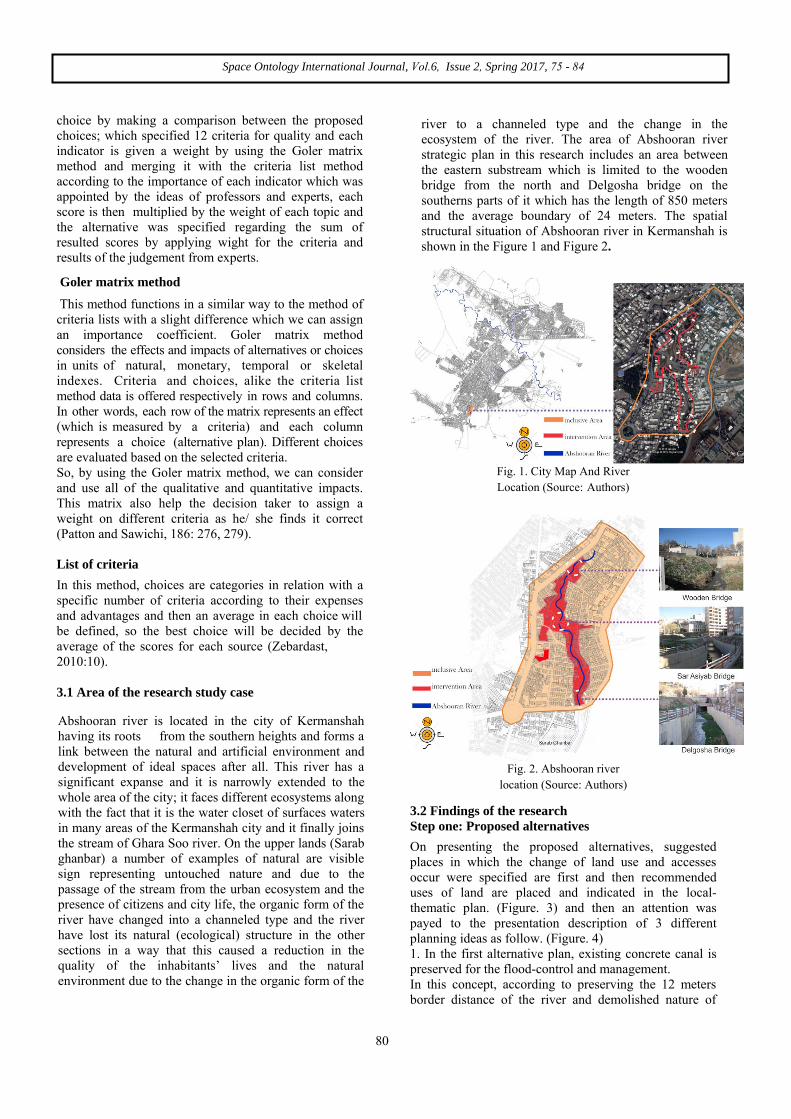
3.1 Area of the research study case
reduction in the quality of the i n h ab i t an t s ’ l i v e s an d the natural environment due to the change in the organic form of
Fig. 1. City Map And River Location (Source: Authors)
Fig. 2. Abshooran river location (Source: Authors)
3.2 Findings of the research Step one: Proposed alternatives
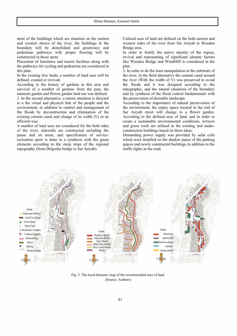
On presenting the proposed alternatives, suggested places in which the change of land use and accesses occur were specified are first and then recommended uses of land are placed and indicated in the local-thematic plan. (Figure. 3) and then an attention was payed to the presentation description of 3 different planning ideas as follow. (Figure. 4) 1. In the first alternative plan, existing concrete canal is preserved for the flood-control and management. In this concept, according to preserving the 12 meters border distance of the river and demolished nature of
80
Abshooran river is located in the city of Kermanshah having its roots from the southern heights and forms a link between the natural and artificial environment and development of ideal spaces after all. This river has a significant expanse and it is narrowly extended to the whole area of the city; it faces different ecosystems along with the fact that it is the water closet of surfaces waters in many areas of the Kermanshah city and it finally joins the stream of Ghara Soo river. On the upper lands (Sarab ghanbar) a number of examples of natural are visible sign representing untouched nature and due to the passage of the stream from the urban ecosystem and the presence of citizens and city life, the organic form of the river have changed into a channeled type and the river have lost its natural (ecological) structure in the other sections in a way that this caused a reduction in the quality of the inhabitants’ lives and the natural environment due to the change in the organic form of the
river to a channeled type and the change in the ecosystem of the river. The area of Abshooran river strategic plan in this research includes an area between the eastern substream which is limited to the wooden bridge from the north and Delgosha bridge on the southerns parts of it which has the length of 850 meters and the average boundary of 24 meters. The spatial structural situation of Abshooran river in Kermanshah is shown in the Figure 1 and Figure 2.
Shima Homaee, Esmaeel Salehi
most of the buildings which are situation on the eastern and western shores of the river, the buildings in the boundary will be demolished and greenways and pedestrian pathways with proper flooring will be constructed in those spots. Placement of furnitures and tourist facilities along with the pathways for cycling and pedestrian are considered in this plan. In the existing free lands, a number of land uses will be defined, created or revived. According to the history of gardens in this area and survival of a number of gardens from the past, the museum garden
and flower
garden
land use was defined.
2. In the second alternative, a amore attention is directed to a the visual and physical link of the people and the environment, in addition to control and management of the floods by deconstruction and elimination of the existing cement canal and change of its width (V) in an efficient way. A number of land uses are considered for the both sides of the river; sidewalls are constructed including the pause and sit areas, and specification of service-recreation spots is done in a synthesis with the green elements according to the steep slope of the regional topography (from Delgosha bridge to Sar Asiyab).
Cultural uses of land are defined on the both eastern and western sides of the river from Sar Asiyab to Wooden Bridge area. In order to fortify the native identity of the region, revival and representing of significant identity factors like Wooden Bridge and WindMill is considered in the plan. 3. In order to do the least manipulation in the substrate of the river, in the third alternative the cement canal around the river (With the width of V) was preserved to avoid the floods and it was designed according to the topographic, and the natural situations of the boundary and by synthesis of the flood control fundamentals with the preservation of desirable landscape. According to the importance of natural preservation of the environment, the empty space located in the end of Sar Asiyab street will change to a flower garden. According to the defined uses of land, and in order to create a sustainable environmental conditions, terraces and green roofs are utilised in the existing and under-construction buildings based on these ideas. Demanding power supply was provided by solar cells which were installed on the shadow panes of the parking spaces and newly constructed buildings in addition to the traffic lights in the road.
Fig. 3. The local-thematic map of the recommended uses of land. (Source: Authors)
81

Space Ontology International Journal, Vol.6, Issue 2, Spring 2017, 75 - 84
Fig. 4. Specifications of presenting 3 different planning ideas. (Source: Authors)
Second stage: Appointing the efficient choice According to the main issue if the research and the topics which were covered during the recognition and analysis section, and after the evaluation of criteria and and the maxims of design, 12 criteria were selected in order to reach for the research goals. The resulting qualities were given a weight between 1 - 4 (1 weak choice, 4 the most
perfect choice) based on a Goler matrix method and its integration with the list of criteria, according to its significance (regarding the notions of professors and experts) and then the scores are calculated and then will be multiplied on each factor. Finally, according to the mentioned method it was evident that the third alternative would be the efficient alternative.
.
Table 2
Defining the efficient choice (Source: Authors)
Alternative Number 3 Alternative
Alternative Number 2 Number 1
Significance Coefficient
Indicators Considerations
Score with the
coefficient
Score without
the coefficient
Score with the
coefficient
Score without
the coefficient
Score with the
coefficient
Score without
the coefficient
Score with the
coefficient
Score without the coefficient
Environmental
12 4 6 2 3 1 3 Amount of energy saving
6 3 6 3 4 2 2 Preserving the natural
resources
12 4 9 3 6 2 3 Control and management
of floods, streams
4 2 4 2 4 2 2 Recycling, and reduction
of environmental contaminations
16 4 8 2 8 2 4 Preparation for upgrading
natural environmental qualities
16 4 16 4 12 3 4 Development of active and healthy urban uses
Functional
82

Shima Homaee, Esmaeel Salehi
9 3 9 3 9 3 3 Upgrade in the quality of
vehicle and pedestrian access
2 2 2 2 2 2 1 Preparations for enforcing
skeletal structures
16 4 16 4 12 3 4
Developing capacities for increasing public
participations and social interactions of the
individuals
9 3 9 3 6 2 3
Empowering the society with the creation and
development of diverse economic activities
4 2 4 2 2 1 2 Preserving and upgrading
the identity signs
Aesthetic
8 4 4 2 2 1 2 Preparations for upgrade the visual environment
quality
114 39 93 32 70 24 33 Total
4. Conclusion
The research results show that the integrated matrix method of Goler with the list of criteria was fruitful and the alternative no.3 is chosen as the best choice because of its highest score regarding the environmental, functional and aesthetic ideas and the strategic plan is presented according to this point. According to the fact that the related programs with the urban development has a focus on the organization of the urban visage and landscape for reviving the green space in urban areas and consider the urban landscapes and its visage as the most landscape shaper factor, so during the presentation and selection of alternative choices, it is prioritised after the ecological and environmental plans, and the plan and development of green spaces across the river we the supposed factor in the mentioned plans. Thus, by implementing the basis and indexes for the ecological design we can achieve a desirable region. The major fundamental maxims of ecological design is suggested as the following 10 rules: 1. Reduction in the Carbon Dioxide emission and development of self-supporting devices with reproducible energies. 2. Development of a healthy and clean environment and a variety of eco-environments with the management of water. 3. Enjoying an ecosystem with a closed cycle with a control on the recycling and reproduction in it. 4. Reduction of the eco-environment contaminators using green spaces, masses of trees and jungle-roofs and green walls.
5. Provide the conditions and conditions and easy access with the minor environmental impacts. 6. Considering the fundamental of ecological design in the buildings and making increase in this considerations. 7. Creation of a sense of “lively place” and rich “cultural identity” by increasing the public participations and social interactions. 8. Elevating the visual quality of the environment with the existing natural factors and material compatible with the nature. 9. Creating a sense of self-sufficiency by expanding diverse economic activities. 10. Paying attention to the needs and demands of the public and forming a sense of skeletal and social security for the wellbeing of citizens.
Fig. 5. The strategic plan (Source: Authors)
83

Space Ontology International Journal, Vol.6, Issue 2, Spring 2017, 75 - 84
References 1) Bahraini, S. H. (2002) Urban design
process. University of Tehran.(In persian) 2) Crombie. D. (1992). Regeneration Toronto's
waterfront and the sustainable city , final report ottawa ministry of supply and services.
3) Hashempour, F. (2001). Urban Ecology. Magazine of Architecture and Urban design. Issue: 64, 65. Pp. 68-72. (In persian)
4) Laghaei, H.; Eradati, E. (2015). Role and impact of intercity streams on the formation of an ecological city. International Architecture, civil engineering and development of modern cities Festival, Tabriz, March 2015. (In persian)
5) Lincoln, R. J. and Boxshall, G. A. and Clark, P.F. (1982). A Dictionary of Ecology, Evolution, and Systematics. Cambridge University Press, Cambridge. New York
6) Mansouri, S. A. (2011). Beach, an unknown opportunity to elevate the environment quality. Professional magazine of landscape design, Vol. 2, Issue 9, pp. 4-5. (In persian)
7) MoeiniFar, M. and Amin Zadeh, B. (2011). Offering a new method on developing the ecological aspects of urban green landscapes (Case Study: Kish Island). Hoviat-e Shahr publication, Vol. 6, issue 10. pp. 26-27. (In persian)
8) Mosadeghi Far, S. (2010). Designing linear park on the borders of a stream according to the structural patterns of Landscape Ecology. (Case Study: Kan River). Master degree proposal. Natural environment faculty, University of Tehran. (In persian)
9) Patton,Carl V. , Sawicki, D. S.(1986) . Basic Methods of Policy Analysis and Planning. Prentice-Hall
10) Piri, J.. ; Rezaei Rad, H. (2006). EcoPark. First international festival of better cities, better plans. Civil engineering section of Hamedan municipality. (In persian)
11) PourJafar, M.. ;Sadeghi, A. Ahmadi, F. (2010) Development of sustainable landscape design criteria in renovating the natural view of Ahwaz Masil-e Khoshk. Natural environment magazine, vol 5, issue 4. (In persian)
12) PourJafar, M..and Rastandeh, A.. (2010). Pattern of landscape design across the intercity rivers (Case study: Masil Al-vasjerd, Hamedan City). Urban identity magazine, vol 3, issue 4. (In persian).
13) Razaghian, F. and et al. (2013). Ecological analysis of urban parks (Case study: Mashhad city). Environmentology magazine. Vol 38, issue 4, pp 166-168. (In persian)
14) Register,R.. (1987). Ecocity Berkeley: building cities for a healthy future. North Atlantic books,berkeley.California
15) Safer Khanloo, M. (2011). Science of Ecological Design Fundamentals. Center for the scientific information of urban management www.umic.ir, retrieved on Feb 5th, 2013. (In persian)
16) Watson, D.and J. Platus, A. and Shibley, R. J. (2008). A collection of urban design standards. Trans. Zaker Haghighi, Kianoosh. (2011). Tehran: research and study center for architecture and urban design. (In persian)
17) Wong, T. and Belinda.,Y.(2011). Eco-City Planning, Springer, Singapore, pp 50- 151.
18) Yar Ahmadi. S. (2011). Urban Borders (A research about the question if the impact of borders on the achievement of landscape goals). Manzar Magazine, Issue 10, pp. 30-38. (In persian)
19) Zebardast, E. ;(2010). Academic pamphlet of Analysis methods in urban design. University of Tehran. (In persian)
Online References
1) Hashemi, D. and Y.. and Khatami, S. Y. Ecological fundamentals of designing streams. www.ardabilcity.ir/_shahrsazi/documents Last retrieved at December 29th, 2013. (In persian)
84