Embed Size (px)
Citation preview

INTEGRATING COMMUNITY PARTICIPATION FOR URBAN REDEVELOPMENT PLANNING IN ZANZIBAR TOWN
SHAREEN L.A. AUMA March, 2012
SUPERVISORS: Drs. J.J. Verplanke Dr. J.A. Martinez
Thesis submitted to the Faculty of Geo-Information Science and Earth Observation of the University of Twente in partial fulfilment of the requirements for the degree of Master of Science in Geo-information Science and Earth Observation. Specialization: Urban Planning Management SUPERVISORS: Drs. J.J. Verplanke Dr. J.A. Martinez THESIS ASSESSMENT BOARD: Dr. R.V. Sliuzas: Chairman Dr. K.S. Buchanan: External Examiner (WUR) Drs. J.J. Verplanke: 1st Supervisor Dr. J.A. Martinez: 2nd Supervisor
INTEGRATING COMMUNITY PARTICIPATION FOR URBAN REDEVELOPMENT PLANNING IN ZANZIBAR TOWN
SHAREEN L.A. AUMA Enschede, The Netherlands, March, 2012

DISCLAIMER This document describes work undertaken as part of a programme of study at the Faculty of Geo-Information Science and Earth Observation of the University of Twente. All views and opinions expressed therein remain the sole responsibility of the author, and do not necessarily represent those of the Faculty.

Dedicated to my beloved parents

i
ABSTRACT Past urban redevelopment planning initiatives in the developing countries have largely been criticised due to; (i) top-down planning frameworks, and (ii) lack of involvement of the targeted beneficiaries which have led to misplaced interventions contrary to the perceived needs of the populace. Moreover, post-implementation of many urban redevelopment initiatives, have culminated to gentrification soon after their conclusion. These failures have led to numerous authors and researchers advocating for a new paradigm shift focusing on participatory approaches in redevelopment strategies. The study focussed on evaluating Zanzibar’s planning structure, comparison of community and experts/policy makers’ perspectives on qualitative perceptions of an informal neighbourhood and the participation component in an anticipated neighbourhood redevelopment initiative. The study identified that Zanzibar’s planning has no participation component and is sector-based and lacks coherent co-ordinated efforts. It was also revealed that significant differences exist between experts and local residents’ perceptions of quality of the neighbourhood earmarked for redevelopment. Employing a case study approach, the study’s aim was to determine and concurrently employ a Participatory Geographic Information Systems (PGIS)-based methodology redevelopment framework. Focus group discussions, geo-coded textual narratives and photographs, participatory mapping are some of the PGIS tools that were used to illustrate the integration of community participation in urban redevelopment planning process. The emerging framework was found to be effective in creating awareness, eliciting and ascertaining local spatial knowledge, reconciling different perceptions held on neighbourhood variables, visioning redevelopment constructs, policy formulation, and data retention for an anticipated informal neighbourhood redevelopment initiative. Keywords: neighbourhood, participation, PGIS, redevelopment, urban informality
ii
ACKNOWLEDGEMENTS To The Almighty, I say ‘Ahsante’. You have been my source of refuge and strength all through. The completion of this thesis has been made possible through enormous support- material, moral or otherwise- from a number of individuals and organizations. First and foremost, I am indebted to the Government of Netherlands under The Netherlands Fellowship Programme (NFP) for awarding me a scholarship in pursuit of my further studies. I owe my deepest gratitude to my two supervisors: Drs. J.J. Verplanke and Dr. J.A. Martinez whose detailed and constructive comments gave me a good basis for the thesis. Their diligent supervision and mentorship in the course of writing this thesis, has influenced my quest and passion in community-driven approaches to urban development. I would also like to sincerely thank the entire staff at Urban Planning and Management Department for their valuable support and ardent commitment throughout my academic life here. They have contributed to my personal and professional development. It is an honour for me to thank the Director, Department of Urban and Rural Planning, Dr. Muhammad Juma, Muhammad who made available his support in a number of ways. Out of his busy schedule, he ensured that all was running smoothly during fieldwork. Special thanks also go to Mr. Ghullib (Senior Planning Officer) and Mr. Abdalla Rashid and other officials in the Planning Department who provided me with the necessary background data on Zanzibar’s planning. Similar sentiments are extended to Mr. Mzee Khamisi (Zanzibar Municipal council); Mr. Abdalla S. Mchenga (Assistant Director, Department of Construction); and to Mr. Muchi and my research assistants for their unrelenting support during fieldwork. It is also a pleasure to thank those who made this study possible, the residents of Kisiwandui-Kisima Majongoo Shehias in Zanzibar who gladly shared with me their valuable time and information. To my colleagues in the UPM (2010-2012) programme, the whole time spent in ITC would not have been enjoyable without the friendship, support and the weekend parties. To my mentors Emmanuel Midheme and Mathenge Mwehe, thank you for your consistent advice. To Amani, Al Amin, Dong, Said and Wairimu, thank you for the smiles and constant encouragement and to Peter and the Kokkeler family, thank you for the encouragement to believe ‘I can do it’. Finally, my family deserves special mention for their constant inspiration, inseparable support and prayers which kept me motivated. Shareen L. A. Auma March, 2012, Enschede, The Netherlands.

iii
TABLE OF CONTENTS 1. Dilemma of informal urbanization .................................................................................................................... 7
1.1. Urban informality dilemma ........................................................................................................................................7 1.2. Urban Redevelopment efforts in Zanzibar .............................................................................................................8 1.3. Problem Statement and Justification ........................................................................................................................9 1.4. Research aim and objective..................................................................................................................................... 10 1.5. Thesis structure ......................................................................................................................................................... 11
2. Urban redevelopment in an informal environment ..................................................................................... 12 2.1. Intricacy of Urban Redevelopment in an Informal Environment .................................................................. 12 2.2. Past Planning Approaches to Urban Informality ............................................................................................... 12 2.3. Inadequacies and Failures of past planning approaches to Urban Informality ............................................ 14 2.4. New Paradigm Shift: Participatory Redevelopement Planning efforts ........................................................... 15 2.5. Local Knowledge in Neighborhood Redevelopment Planning ....................................................................... 17 2.6. Adopting PGIS to improve Participatory Urban Redevelopment efforts ..................................................... 18
3. Urban planning and management in Zanzibar ............................................................................................. 20 3.1. History of urbanization in Zanzibar ..................................................................................................................... 20 3.2. Existing policy and legislations related to urban planning in Zanzibar .......................................................... 21 3.3. Principles guiding urban planning in Zanzibar Town ....................................................................................... 21 3.4. Towards participatory redevelopment planning in Zanzibar .......................................................................... 23
4. Background to study area ................................................................................................................................. 24 4.1. Location ..................................................................................................................................................................... 24 4.2. Demographic Characteristics ................................................................................................................................. 25 4.3. Land use in Zanzibar ............................................................................................................................................... 25
5. Methodological framework for community participation in urban redevelopment planning ............... 26 5.1. Conceptual Framework ........................................................................................................................................... 26 5.2. Research Design ....................................................................................................................................................... 26 5.3. Field Survey Preparation ......................................................................................................................................... 27 5.4. Data Collection Methods ........................................................................................................................................ 31 5.5. Secondary Data ......................................................................................................................................................... 35 5.6. Data Processing and Analysis ................................................................................................................................. 35 5.7. Limitations to the study ........................................................................................................................................... 35
6. Local spatial Knowledge for Neighbourhood Redevelopment Planning ................................................. 37 6.1. Demographic Characterisitics ................................................................................................................................ 37 6.2. Housing in the informal area .................................................................................................................................. 37 6.3. Employment .............................................................................................................................................................. 39 6.4. Community participation ........................................................................................................................................ 39 6.5. Identification and Visualization of Perceived Neighbourhood Quality ......................................................... 39 6.6. Participatory Mapping of Perceived Redevelopment Needs ............................................................................ 44
7. Intergrating community participation for A neighbourhood redevelopment strategy in Zanzibar ..... 48 7.1. Step 1: Initiation Stage: Local Knowledge Identification (Perceived Needs Identification) ....................... 48 7.2. Step 2: Initiation Stage: Integrating Community’s Participation with GIS .................................................... 49 7.3. Step 3: Visioning Stage ............................................................................................................................................ 50 7.4. Step 4: Policy Formulation Stage ........................................................................................................................... 51 7.5. Step 5: Towards a Collaborative Redevelopment Planning Process ............................................................... 52
8. Conclusion and Recommendation .................................................................................................................. 53 8.1. Conclusion ................................................................................................................................................................. 53 8.2. Recommendations for further research ................................................................................................................ 56

iv
LIST OF FIGURES Figure 3-1: Guideline for urban planning process in Zanzibar ........................................................................... 22 Figure 5-1: Conceptual Framework ......................................................................................................................... 27 Figure 5-2: Research design ...................................................................................................................................... 28 Figure 6-1: Age of the respondents interviewed .................................................................................................... 37 Figure 6-2: Housing ownership status in the neighborhood ............................................................................... 38 Figure 6-3: Employment situation in the neighbourhood ................................................................................... 39 Figure 7-1: Steps of integrating community participation for a neighborhood redevelopment planning process .......................................................................................................................................................................... 49 Figure 7-2: Integrated Community defined Redevelopment Plan ...................................................................... 52

v
LIST OF TABLES Table 1-1: Research sub-objectives and questions ................................................................................................ 10 Table 2-1: Summary of impacts of gentrification on redeveloped neighborhoods ......................................... 15 Table 4-1: Land use categories in Zanzibar Town ................................................................................................ 25 Table 5-1: List of experts interviewed ..................................................................................................................... 32 Table 6-1: Type of housing in the neighborhood.................................................................................................. 38 Table 6-2: Type of housing preference ................................................................................................................... 38 Table 6-3: Difference in perceptions of neighborhood qualities of the community and expert respondents: (M, SD, p-value and effect size) ............................................................................................................................... 40

vi
LIST OF MAPS Map 5-1: Location of the study area within Zanzibar Town ............................................................................... 29 Map 5-2: Characteristics of the study area .............................................................................................................. 30 Map 6-1: Community perception to the neighborhood’s main .......................................................................... 42 Map 6-2: Community's perception to the neighborhood’s access path ............................................................. 42 Map 6-3: Community level of satisfaction to housing congestion ..................................................................... 42 Map 6-4: Community perception to the neighborhood's pride and appearance.............................................. 43 Map 6-5: Community perception to the neighborhood's level of interaction .................................................. 43 Map 6-6: Community evaluation to the neighborhood's provision of water services ..................................... 43 Map 6-7: Community-defined redevelopment map .............................................................................................. 44 Map 6-8: Walking interview route showing community's identified location points of neighborhood-defined spatial strengths and weaknesses ............................................................................................................... 47


INTEGRATING COMMUNITY PARTICIPATION FOR URBAN REDVELOPEMNT PLANNING, ZANZIBAR TOWN
7
1. DILEMMA OF INFORMAL URBANIZATION
This chapter presents the background information on the dilemma of informal urbanization and evaluates the efforts that have been directed at improving the condition. It is on this underlying principle that the research problem and aim are defined.
1.1. Urban informality dilemma The spread of urban informality is the most significant trend shaping the space and time of our 21st century world. It has been recognised as a predominant “mode of urbanisation” (Roy, 2005) in many developing countries. The discourse of informality has shifted from a formal-informal dichotomy (Hall and Pfeiffer 2000) to a formal-informal continuum (Roy and Alsayyad, 2004 cited by Hill & Lindner, 2006). This is clearly manifested by many slums and informal settlement that continue to proliferate at an alarming rate. The derelict neighbourhoods have become symbolic of the malformations that characterize the urbanization process currently underway in Sub-Saharan Africa. However, authorities charged with urban development and planning seem incapacitated in dealing with this challenge. A major resultant challenge is that many cities in the region are undergoing a widespread dysfunctional urban land supply system. Government authorities have invariably failed to supply developable land in locations and at prices that cannot be easily afforded by majority of urban poor (Fekade, 2000). The informal mode of (re) producing urban space is steadily growing in many cities of the region despite facilitation and support by concerned authorities In these informally developing areas, there has emerged an alternative mode of appropriating and (re) producing urban space, as people seek ways of accessing land for shelter and livelihood opportunities (Fekade, 2000). As may be expected, the resulting spaces produced are varied, not just in their spatial scale and function, but also in their degree of formality, and therefore level of acceptance by the authorities concerned. Government authorities in the region had initially sought after wiping out these ‘unsightly development’ from the surface of the city (Fekade, 2000; UNDP, 2005) but attitudes have since changed towards accommodation. A number of informal neighbourhoods have since undergone redevelopment (Abbott, 2002a, 2002b; Huchzermeyer, 2008) albeit reports of achievements with various limitations. Zanzibar Island, located off the eastern coast of East Africa is also not an exception to the informality dilemma. It has experienced tremendous growth especially in the urban fringe of the city to a point that the formal planning system of the state is unable to cope with the demand for building land and plots making informal neighbourhoods the major factor of urban growth (Scholz, 2008). In this study, urban informality is understood as, ‘neighbourhoods characterised by informal building activity with no government control/influence hence increasing the informal development process’. It has mainly been attributed to the weak statutory urban planning framework in the Government (Mwehe, 2011, p. 31) necessitating for a solution to formalize the neighbourhoods through urban redevelopment initiatives. Urban redevelopment is quiet a complex term to define since its meaning transform depending on the era it was/is conducted, stakeholders involved, objective(s), mean(s) and extent of redevelopment.

INTEGRATING COMMUNITY PARTICIPATION FOR URBAN REDVELOPEMNT PLANNING, ZANZIBAR TOWN
8
In general terms though, it can be seen as a concept to imply ‘a comprehensive and integrated vision and action which leads to the resolution of urban problems. It therefore seeks to bring about a lasting progress in the economic, physical, social and environmental conditions of an area that has been subject to change’ -(Roberts, 2000 cited by Tallon, 2010, p. 5).
1.2. Urban Redevelopment efforts in Zanzibar Previous attempts at urban redevelopment of some of the informal neighbourhoods in Zanzibar seem to have started with the revolutionary government ambitious urban redevelopment of Ng’ambo neighbourhoods’ after the revolution of 1964. Even at that time, Ng’ambo was already an impoverished neighbourhood and faced long-entrenched problem of poor accessibility of public utilities(H. Haji, Rashid, & Said, 2006), overcrowding and the housing shortage in the city overall (G. Myers, 1996). The reconstruction program at the time, aimed at improvement of the standard of living in Ng’ambo area, was largely ignored by the colonials whose urban planning strategy had concentrated development on the Stone Town side often at the expense of poor dilapidated neighbourhoods of Ng’ambo. The government sought at providing decent houses to its inhabitants whom were living in poor houses (H. Haji, et al., 2006; H. A. Haji, Azzan, & Ufuzo, 2006; Garth A. Myers, 1994; Sulaiman & Ali, 2006). Thus, new multi-storeyed buildings were constructed in various areas on the isles. The pilot project involved the construction of 150 apartments at Kikwajuni Juu and later Michenzani. However, the government of the time embodied and micromanaged the whole process and as Myers (1994, p. 451) puts it, “the revolutionary government excluded residents from the process”. Ultimately, the regime implemented very little of the plan. The post revolution remedy to increasing informality development and pertinent land problems are seen in the government attempt in regularizing landownership. Government repossessed all the land and was then redistributed to peasants. However, its sole retention of land rights and failure to accord them full legal ownership of land was perceived as a retrogressive step to its urban redevelopment endeavours and a cause as well as consequence to the informal growth proliferation of the landless peasants where each peasant was given three acre plots (Sulaiman & Ali, 2006). In addition various policies and legislation were formulated to control urban development. These included; the Zanzibar Town Master Plan of 1982 that aimed at addressing for example the problem of squatter development. This was to be done through formulation of the urban physical planning guidelines, establishment of town boundaries for urban development control and reorganisation of urban land use. In 1995, the national land use policy plan was formulated that was to coordinate land use development of the whole of Zanzibar. As Haji, et al., (2006) states, among the most pertinent issues the plan was to address was the uncontrolled settlement development and persistent growth of informal areas. In 1998, a proposition paper on “the redevelopment of Ng’ambo areas in the Zanzibar municipality” was prepared by Zanzibar city programme in conjunction with Zanzibar Sustainable Programme in an attempt to improve the infrastructural service provision of Ng’ambo area. Issues addressed included; the insufficient and inefficient public services, inadequate clean and safe water supply, improper collection and disposal of solid wastes and high population density in urban areas among other issues. The town and country planning decree of 1955 (Cap. 85) according to Haji, et al., (2006) is the only existing land use planning statute and has been enforced since 1958 when the town scheme was prepared. Within this decree was the Joint Building Authority (JBA) that controlled the spatial development in the towns, the decree listed the guideline for the physical planning development control and land use development procedure, however

INTEGRATING COMMUNITY PARTICIPATION FOR URBAN REDVELOPEMNT PLANNING, ZANZIBAR TOWN
9
the decree has been considered old and outdated and JBA has since been replaced by the Urban Development Control Authority (UDCA). The present response to informal settlement growth has seen government formulating various policies and planning initiatives to address informal neighbourhoods’ growth. It has also collaborated with other NGO and international organizations in order to address the informality. This has also led to rolling out of wide scale poverty alleviation strategies not only in the urban areas but in the country as a whole. Among these policies include; the UDCA, The National Land Use Plan, The Zanzibar Sustainable Project, and the recently joint effort between Land and Registration and Survey and Urban Planning departments of reviewing lands and spatial planning through the support of SMOLE- “Sustainable Management of Land and Environment Programme” (GoZ, 2007; H. A. Haji, et al., 2006; Sulaiman & Ali, 2006). However, the operationalization of all these urban development mechanism is characterised by overlapping of responsibilities which create loopholes for illegal development to take place and encroachment of way leaves, and open spaces. Sulaiman and Ali (2006a), note that since the enactment of Town Country Planning Decree of 1955, there has been no further development of legislation of institutional framework to guide the implementation and coordination of urban management efforts. The challenge is even with all these efforts, Zanzibar town continues to grow largely through the informal neighbourhoods. The deterioration and expansion of old informal neighbourhoods in the earlier planned areas now poses a major challenge especially in the redevelopment efforts.
1.3. Problem Statement and Justification Abbott (2002b) notes that informal neighbourhoods house a significant percentage of the population of developing cities, yet there is no common planning framework for redevelopment of these neighbourhoods. The unprecedented increased number of urban populations has made urbanization inadvertent which has contributed to urban sprawl in areas that are devoid of affordable quality neighbourhoods and related services including basic amenities. In Zanzibar, the dynamics of urban growth, lack of effective leadership, weak land administration and planning policies with regard to settlement development by the public sector, impedes the sustainable development of urban areas. Most of the urban agglomerations grow without any official planning (Ali & Sulaiman, 2006b; H. Haji, et al., 2006; Scholz, 2008) leading to city expansion mainly based on informal processes. In essence, this trend has led to urban settlements influenced by new and powerful forces of informality that have come to the attention of governments to reconsider how they manage the future of urban development. As a reform mechanism, planning authorities in Zanzibar have made efforts of improving the situation through urban redevelopment programmes discussed in 1.2 above albeit few successes indicative of a problem. Sheng (1990) observes that, in neighbourhood redevelopment projects, the authorities regularize the legal land tenure of squatters and provide basic infrastructure in the neighbourhoods; in sites-and services schemes, the authorities provide serviced plots to residents in informal neighbourhood and expect them to produce their own houses, through individual or mutual self-help or the employment of small contractors. These interventions have always been expected to be sufficient incentives for the residents to start improving their houses. More often than not, these interventions have to a certain extent failed. Communities in such neighbourhoods have always tried to organize themselves in such a way to address their most important problems, though informally. An attempt indicating that, communities have a common point of view, which aids them in perceiving their own problems and finding solutions.

INTEGRATING COMMUNITY PARTICIPATION FOR URBAN REDVELOPEMNT PLANNING, ZANZIBAR TOWN
10
Redevelopment should in essence be holistic in improving the livelihoods in informal neighbourhoods. Once people have been involved in planning and decision making for their entire neighbourhood, they are more likely to be interested in the maintenance and management of their neighbourhood, its infrastructure and services. Sheng (1990) concur that, if people participate in planning and decision-making with regard to their house and its direct environment, they can also decide how much they can and want to contribute to their neighbourhood redevelopment. Where possible therefore, development and planning policies should be designed in a way that would help identify established communities through a bottom-up participatory approach, and strengthen them through redevelopment assistance (El-Shakhs, 1997). According to a draft report on Zanzibar Policy Review (2004) and the Department of Urban and Rural Planning (DoURP), attempts are underway to revise planning legislation accordingly and adopt participatory approaches tailored to respond to settlement-specific spatial problems that address the rapid demand of planned and serviced urban land to decrease the intensification of informal neighbourhoods. Numerous authors are highlighting the adoption of participatory approaches that seek collaboration rather than interaction which takes into account the perspectives of all actors involved in community development. Adoption of a Participatory Geographic Information Systems (PGIS) practice is considered an effective approach in integrating community’s knowledge and participation in such initiatives. Rambaldi et al. (2006), emphasise that documented realizations and insights of the community are significant inputs into the development plan that integrates the social and economic fundamentals into the quality of their place. While PGIS has been applied in urban and rural contexts, little research has been done on its potential use in informal neighbourhoods’ redevelopment. Few studies have practically developed a PGIS framework in redevelopment initiatives. It is on this basis that the study wants to contribute to these research gaps by determining use of a participatory methodology framework in defining community needs and aims in a redevelopment initiative.
1.4. Research aim and objective This study aims to determine use of a participatory methodology for a neighbourhood redevelopment planning emphasising on community local spatial knowledge in Zanzibar Town.
1.4.1. Research sub-objectives To achieve this broad objective, the study sought to the following sub-objectives outlined in Table 1-1:
Table 1-1: Research sub-objectives and questions
Research Sub-Objectives:
Research Questions:
Sub-objective 1:
To find out to what extent is community involved by planning authorities in neighbourhood redevelopment planning
a) To what extent is the community involved in neighbourhood redevelopment planning?
b) How can the community be more involved in neighbourhood redevelopment planning?
c) Which stakeholders should be involved in planning for neighbourhood spatial redevelopment?

INTEGRATING COMMUNITY PARTICIPATION FOR URBAN REDVELOPEMNT PLANNING, ZANZIBAR TOWN
11
1.5. Thesis structure Chapter 1: This chapter presents the background information on the dilemma of informal urbanization and evaluates previous efforts that have been engaged to improve the circumstances. It is on this rationale that the research problem and objective are defined. Chapter 2: This chapter looks at the theoretical framework that typifies urban studies and planning research through literature review on the traditional and contemporary planning approaches. It mainly focuses on adopting spatial local knowledge on a community perspective in redevelopment initiatives. Chapter 3: This chapter explores the discourse of urban informality in Zanzibar through evaluating the existing urban planning and management policy and institution frameworks. Chapter 4: This chapter describes the study area. It presents a brief overview of the demographic and spatial characteristics of the informal study area which was also used as criteria for an anticipated redevelopment initiative. Chapter 5: This chapter conceptualizes the GIS and society framework by developing a participatory methodology in identifying local spatial knowledge for redevelopment. It also outlines the approach and tools employed during fieldwork of the study. Chapter 6: This chapter looks at the results from different methods applied, namely; household and expert survey/discussions, key-informant interviews, focus group discussion and walking interview. Chapter 7: This section discusses the integration of community participation framework developed and employed emphasising on local knowledge. A review of the framework is done in a five-step outline to aid in facilitating the anticipated redevelopment planning process in Zanzibar. Chapter 8: This chapter gives conclusions and highlights on the limitations, recommendations and the potentials in carrying out further research.
1 Local spatial knowledge in this study refers to the perceptions, opinions and aims of urban dwellers that live in or near the neighbourhood of concern that is largely informal to be redeveloped.
Sub-objective 2:
To identify the local spatial knowledge 1 on perceptions and aims of the community regarding redevelopment using GIS
d) What are the spatial issues, perceptions and aims in the neighbourhood in regard to redevelopment?
e) To what extent do the perceptions and priorities of the neighbourhood match those of the policy makers?
f) What is the role of GIS in eliciting and recording the perceptions and aims of community?
Sub-objective 3:
To determine how local knowledge can be useful to planning authorities in neighbourhood redevelopment planning
g) How can PGIS technology be used to integrate local
knowledge when planning for a redevelopment strategy?
INTEGRATING COMMUNITY PARTICIPATION FOR URBAN REDVELOPEMNT PLANNING, ZANZIBAR TOWN
12
2. URBAN REDEVELOPMENT IN AN INFORMAL ENVIRONMENT
This chapter looks at the theoretical framework that typifies urban studies and planning research through literature review on the traditional and contemporary planning approaches. It mainly focuses on adopting spatial local knowledge in a community perspective of redevelopment initiatives.
2.1. Intricacy of Urban Redevelopment in an Informal Environment In this study, urban redevelopment, also used in conjunction with urban regeneration, urban
(neighbourhood) renewal is understood as an initiative designed by the state to help local communities
improve areas that are deteriorating, unsafe or poorly planned. Urban redevelopment strategies pose many
challenges that urban planners and local authorities must contend with when planning. As Magigi and
Majani (2006), postulates, within informal neighbourhoods are complex, dynamic spatial, social-cultural,
economic and political systems that continually undergo changes. These complexities have made it
difficult to gather sufficient, relevant and reliable data that is a prerequisite in planning for redevelopment
interventions. This leads Watson (2009) to argue that any consideration of the future of urban planning
needs to take place within an understanding of the factors shaping the socio-spatial aspects of cities.
Moreover, the heterogeneous nature of population within these informal neighbourhoods also makes it
difficult in choosing who to include and who to leave out in the redevelopment process. As earlier
discussed, a sub-objective (section 1.4.1) of the study focused on identifying the extent to which
community is involved in redevelopment initiatives and at what stage of planning. A big challenge facing
local authorities lies in devising an appropriate method that can address all these challenges when
designing redevelopment interventions (Lemma, 2005; Otiso, 2003). Without adoption of a good multi-
dimensional approach in data collection, it becomes more difficult to develop viable plans in a data scarce
environment that characterize these neighbourhoods.
2.2. Past Planning Approaches to Urban Informality According to UNDP (2005), official response to urban informality the world over and especially in the
developing countries, has been characterized either by inaction, inappropriate action, or insufficient action.
When the phenomenon of informal urbanization first attracted the attention of the authorities in the
developing world, the responses were mixed at best, and ranged from ‘active hostility’ to ‘benign neglect’
(Fekade, 2000, p. 128). In many cities, the most common line of action at the beginning was to ignore
informal settlements, when they posed no threats to the powerful élite, or to bulldoze them whenever they
stood on a piece of valuable real estate (UNDP, 2005). With time, a policy of informal settlement
clearance was slowly adopted by many cities around the world. Spontaneous settlements were simply razed
down and in its place new public housing erected to accommodate the sufferers of such demolitions
(Fekade, 2000). The policy was however paradoxical to the extent of such demolitions often outstripping
any new constructions, leading some observers such as Werlin (1999) to remark that governments were in

INTEGRATING COMMUNITY PARTICIPATION FOR URBAN REDVELOPEMNT PLANNING, ZANZIBAR TOWN
13
fact destroying more low-income housing than they were actually building and accommodating new
constructions causing harm to the present community by destroying their livelihoods and encouraging
gentrification.
With this sort of realization, government authorities were gradually persuaded to acknowledge that
informal settlements did in fact, occur as a result of, or in response to their own inappropriate public
policies, for instance, lack of affordable land and housing. In effect, this fomented a change of heart –
from viewing low-income groups as constituting an infuriating aberration on the urban landscape, to
acknowledging the poor as resourceful partners who in deed presented part of the solution to the
informality problem that the authorities themselves had been unable to effectively address (Abbott, 2002a;
Fekade, 2000; UNDP, 2005). In this regard, many literature works have been published advocating for the
application of redevelopment interventions to address this problem (Abbott, 2002a; Mukhija, 2002;
Turkstra & Raithelhuber, 2004). One such intervention widely advocated for is informal settlement
redevelopment. Abbott (2002a), defines it as any sector-based intervention in the settlement that results in
a quantifiable improvement in the quality of life of the residents affected.
Cities Alliance views informal settlement redevelopment as an integrated approach to investing in physical,
social, economic, organizational and environmental improvements. World Bank (2010), lay emphasis of
settlement redevelopment on legalizing and ‘regularizing’ the properties in situations of insecure or unclear
tenure. There are many reasons as to why urban redevelopment as a form of redevelopment intervention
is undertaken. Some of the most common issues addressed by redevelopment programs include:
1. Legalization of tenure status for sites and houses, including regularization of rental agreements to ensure improved tenure (Sliuzas, 2003).
2. Provision or improvement of technical services and physical infrastructure e.g., water, waste and waste water management, sanitation, electricity, road pavement, street lighting, etc (UN-Habitat, 2006).
3. Provision or improvement of social infrastructure such as schools, clinics, community centres, playgrounds, green areas, etc.
4. Physical improvement of the built environment, including rehabilitation/improvement of existing housing stock.
5. Construction of new housing units (Housing construction can but doesn’t necessarily form part of redevelopment schemes. Often enhancing and rehabilitating the existing housing stock is much more sensible and effective and can be achieved at little cost through legalization of tenure status or regularization of rental agreements) (UN-Habitat, 2006).
6. Design of urban development plans (Sanoff, 2000), (including, for example, the rearrangement of sites and street patterns according to infrastructure needs, although working within existing settlement patterns is generally less disruptive to community networks. This measure might entail resettlement of some residents).
7. Changes in regulatory framework to better suit the needs and opportunities available to the poor, as far as possible keeping to existing settlement patterns.
8. Densification measures (e.g. multi-storeyed houses) for example in order to protect agricultural land from being occupied for settlement. Also possible: de-densification due to partial resettlement.

INTEGRATING COMMUNITY PARTICIPATION FOR URBAN REDVELOPEMNT PLANNING, ZANZIBAR TOWN
14
2.3. Inadequacies and Failures of past planning approaches to Urban Informality Major weaknesses of redevelopment efforts have been documented in various literatures.2 Among the
critical failings in the design and implementation of various informal neighbourhoods have been indicated
to have been as a result of;
2.3.1. Insufficient focus on target communities There is inadequate involvement of targeted communities where, urban planning is constructed to be an
area of public policy to be carried out by centralised planning machinery. Fischer (2003) notes that experts
views in such processes are highly complex and only science can provide an authoritative base for policy-
making. This explains why most often, professional experts define problems and their solutions,
dominating decision-making and manipulating, instead of facilitating development processes3 (Botes &
Rensburg, 2000). As a result, spatial redevelopments are typically dealt with as routine planning tasks, with
experts single-handedly assuming the entire extent of project initiation, design and implementation (Otiso,
2002). Seldom have community been engaged. If so, it has been at the request of external institutions such
as bilateral donor agencies. Nevertheless, where community engagement has been practical, it has been
constrained by the extent to which external agendas entwine with local residents needs and social contract
between the state and diverse class interests. This implies that genuine participation never really takes
place (Abbott, 2002a).
In another perspective, many countries in the sub-Saharan region has majority of residents in informal
neighbourhoods as poor renters, as opposed to house owners. In Kenya, for example, a study revealed
that Nairobi’s informal settlements had 92% of the households as renters as opposed to home owners
(Gulyani & Talukdar, 2008). These revelations constitute a challenge to conventional redevelopment
policy efforts implying that experts/ policy makers ought to also think about the plight of tenants as a
target group in redevelopment initiatives (Gulyani & Talukdar, 2008; Jørgen, 1996).
2.3.2. Gentrification and attempts to stem its recurrence Another critique of redevelopment is gentrification. Gentrification has for long been associated with
urban redevelopment efforts where ‘the working class residential neighbourhoods are redeveloped by
professional private developers and landlords then later invaded by the middle-classes displacing the
working-class occupiers and the social class of the neighbourhood is altered.’- (Davidson & Lees, 2005)
The process is often seen as having both winners and losers.4 This means that the targeted beneficiaries
often do not benefit from the process obligation thereby lessening the impact of its purpose. Table 2-1
gives a summary of the general positive and negative impacts of gentrification.
2 Some of the sample sources include; Slater (2009), Abbott (2002a), Mukhija (2002), UNDP (2005), Roy (2005) among others. 3 Element of ‘facipulation’- facilitation and manipulation, is inevitable in community organization and development (Constantino-David, 1982 cited by Botes & Rensburg, 2000). 4 Overwhelming majority of literatures point to negative impact of gentrification but fewer studies focus on its positives (Doucet, 2009).

INTEGRATING COMMUNITY PARTICIPATION FOR URBAN REDVELOPEMNT PLANNING, ZANZIBAR TOWN
15
Table 2-1: Summary of impacts of gentrification on redeveloped neighborhoods
Positive Negative Displacement through rent/ price increase Secondary psychological costs of displacement Stabilisation of declining areas Community resentment and conflict Increased property values Loss of affordable housing Reduced vacancy rates Unsustainable speculative property price increases Homelessness Encouragement and increased viability of further development
Commercial/ Industrial displacement
Reduction of suburban sprawl Increased cost and changes to local services Displacement and housing demand pressures on
surrounding poor areas Increase social mix Loss of social diversity Rehabilitation of property both with and without state sponsorship
Under-occupancy and population loss to gentrified areas
Source: Adapted from (Atkinson & Bridge, 2005) The negative consequences of gentrification are non-reversible. As such, different strategies have been
employed in the design of the past redevelopment initiatives to curb gentrification processes. Example of
one such strategy in a developing country has been the restrictions on sale, intended to impede
conveyance in new property. It is argued that such initiatives may only last for a specified duration
(Fernandes & Smolka, 2004). The strategy has also been faulted on the basis that such restrictions
undermine the land market consequently restraining the flow of resources to productive users (Deininger,
2003).
Another strategy used to control the sale of redeveloped property has been to integrate on-site income-
generating opportunities into project design, for instance, encouraging the development of business-cum-
residential houses within the redeveloped property. Planners argue that increased income streams from
such add-ons would reinforce the ability of the targeted beneficiaries thereby lessening the impact of
involuntary sales. However, Basset (2002) notes that whether such on-site income-generating
opportunities bear any correlation with decreased land sales has not been established as yet.
2.4. New Paradigm Shift: Participatory Redevelopement Planning efforts The past three decades has seen an increase in support for community participation in processes of
housing and general neighbourhood development from both the academics and development
professionals. The rationale for community participation is that, it: (1) increases efficiency, to lower cost of
projects; (2) increases effectiveness, to achieve greater reach for development and (3) empowers the
communities, to increase their influence in decisions that affect their living conditions (Miraftab, 2003).
Abbott (2002b) points out that, success in urban redevelopment strategies like redevelopment
interventions can best be achieved if the local communities are actively involved. This should be
INTEGRATING COMMUNITY PARTICIPATION FOR URBAN REDVELOPEMNT PLANNING, ZANZIBAR TOWN
16
undertaken cooperatively and locally among citizens, community groups and local authorities (Ha, 2001;
Okpala, 1999; Sanoff, 2000; UN-Habitat, 2006; World Bank, 2010). The aim is to improve living and
general economic condition of the informal neighbourhoods. Sanoff (2000), views the solution as the
incorporation of the local communities to be part of the interventions during redevelopment projects. He
continues to describe the purpose of participation to generally include exchange of information, conflict
resolution and supplementation of planning and design. Where possible therefore, community based
organizations should be supported and allowed to play an active role in preparing and executing plans for
informal neighbourhoods redevelopment initiatives (UN-Millennium-Project, 2005). The ideal conditions
considered by Choguill and Chowdhury (1996) when analysing participatory issues are: Is community
participation practised? What kind of participation is under consideration? Who participates in it? And,
how does participation occur?
There are many literatures that have been written advocating for the adoption of neighbourhood
redevelopment as a form of urban redevelopment strategy5. Neighbourhood as a distinctive, significant
planning component of larger metropolitan area was first strengthened by the works of Ebenezer
Howard in 1898 as a sub unit that builds the physical and social fabric of a city (Talen & Shah,
2007).While many of these literatures acknowledge the existing challenges of any redevelopment work
they call for more involvement of the targeted communities if better results are to be achieved. Manzo and
Perkins (2006, p. 339) contribute to the discussion stating that, “residents’ identification and articulation of
place meanings mark the beginning of community participation in the planning process. Importance of
place attachment and sense of community equally plays a significant role in neighbourhood redevelopment
efforts. Researches that examine community-level place attachment have noted that bonds to places can
be connected to community participation in planning and design efforts which can be done through
surveys and focus group discussions”. Such redevelopment initiatives- rooted in careful explorations of
place meanings, attachments, and perceptions- are still uncommon. The use of participatory approach
intentions in this study is to achieve the following as outlined by McCall (2004):
1. Facilitation: Identifying local spatial knowledge through participatory mapping and use of GPS. 2. Empowerment: Emphasise on community defined purpose in redevelopment initiatives to
empower local people and reinforce local decision making. 3. Collaboration: Establish good link between the joint efforts in planning of neighbourhood
redevelopment by both experts and community.
2.4.1. Pitfall to Community Participatory Redevelopment Efforts Whereas many authors and researchers stress the adoption of participatory approaches in redevelopment
interventions, challenges still exist in devising a participatory method that facilitates a multi-disciplinary
approach in meaningful participation. Conventional methods of participation have been criticised
(Kingston, 2007) and UN-HABITAT (2009) observes that a worrying trend continues to arise. Adoption
of such approaches seems to yield little success as the informal neighbourhoods continue to increase 5(Refer to Abbott, 2002b; Marcus & Asmorowati, 2006; Mukhija, 2002; Turkstra & Raithelhuber, 2004)

INTEGRATING COMMUNITY PARTICIPATION FOR URBAN REDVELOPEMNT PLANNING, ZANZIBAR TOWN
17
unabated in many cities of developing countries. Botes and Rensburg (2000) illustrates participatory
development to be a complex and difficult, though essential and challenging venture. Myers (2010)
contend that, two contrasting sets of concepts and practices clash in the work of planning urban places –
both in the building and managing of environments through land subdivision and its regulation, housing
construction, infrastructure and service provision, and in the attachment of socio-cultural meaning and
value to such places.
Yli-Pelkonen and Kohl (2005) mention that one of the principal criticism in community participation is
the relationship of local knowledge and expert knowledge. Local knowledge cannot be totally detached
from the community who not only claim stake but also have full right to it. The authors continue to argue
that as much as local knowledge lacks verification and status of expert knowledge, it is imperative to
advocate for a meaningful participation by local residents and policy makers, in a socially inclusive way.
Community participation is said to facilitate consensus building efforts since many different interests are
represented as well as producing innovative ideas and solutions for spatial planning. While consensus
building efforts yield positive outcome, it has been criticised to produce poorly worded proposals with
little substance (Margerum, 2000) as well as being problematic since not all interests are represented in the
planning process.
2.5. Local Knowledge in Neighborhood Redevelopment Planning Local knowledge has been used and termed in different ways by different authors6. Different terms are
used concurrently to refer to this knowledge. These include; indigenous knowledge, traditional knowledge,
ethnoscience and ethnobiology (Mwehe, 2011). Concisely, all these definitions have one thematic view,
that of community providing particular information they posses. As already indicated, in this study, local
knowledge is referred to as the perceptions, opinions and aims of urban dwellers that live in or near the
neighbourhood that is largely informal in need of redevelopment.
Manzo and Perkins (2006) note that peoples’ local knowledge, in form of thoughts, feelings, and beliefs
about their local community places also known as ‘intra-physic’ phenomena, impact their behaviours
toward their living environment, hence influencing whether and how they might participate in their
neighbourhood redevelopment planning efforts. They note that, the unique qualities and meanings of
detailed physical locale where planning and development take place, plays a critical role in the
development planning process. With the current trend focus now shifting to community participation,
Local Knowledge is taking centre-stage as a valid source of information to base decisions that have already
been applied especially in the natural resource management field7. Focus in community planning for
development is both within the community and between the community and public/ governmental
agencies. Laurian (2003), highlights that as much as land-use planners contend that many different types of
6 Refer to Dunn (2007) 7 See also Quan et al., (2001), Brown & Weber (2011), Parrotta & Trosper (2012), Rambaldi et al., (2006)
INTEGRATING COMMUNITY PARTICIPATION FOR URBAN REDVELOPEMNT PLANNING, ZANZIBAR TOWN
18
information improve the effectiveness of community planning, the two sources of information
(newspaper articles and public meetings), that have been commonly used to inform the public about
critical land-use issues in the community are not sufficient enough. Sandercock (2003) argues that the role
of ‘story’ and the process of ‘storytelling’ to planning practitioners is central particularly in community
development initiatives. She further elaborates that “the story-gathering is likely to be followed by an
attempt to find common threads that will help to draw up priorities”-(p. 186).
2.6. Adopting PGIS to improve Participatory Urban Redevelopment efforts Geographic Information Systems (GIS) in general terms is known as computer based system for analysing
and mapping spatially referenced data. Numerous GIS researchers have identified the potential of GIS to
collect various forms of spatially referenced data that can be used in engaging residents in neighbourhood
redevelopment planning. According to Talen (2000), using GIS in participatory planning initiative
provides spatial complexity, spatial context, interactivity and interconnection in articulation of viewpoints.
This therefore makes it an effective tool to aid planners in deepening their understanding of community’s
local knowledge thereby facilitating decision making in redevelopment planning process. Abbott(2002a)
and Hordijk & Baud (2006), explain that GIS tool complement the weakness of traditional planning
approaches which lack the capability of integrating spatial local knowledge of the community. Local
knowledge and public participation are deem important aspects in planning more so at a neighbourhood
level which has largely been ignored. Al-Kodmany (2000, p. 5), concur that while the use of GIS has been
applied widely in large-scale urban and regional planning, it has been applied far less frequently in
neighbourhood planning. He ascertains the situation to availability of GIS data at a much broader scale
and not at the local level. Value of a local GIS and land-use maps become relevant when an immediate
event like rezoning or proposed development threatens a neighbourhood.
PGIS is defined as the integration of local knowledge and stakeholders’ perspectives in GIS (Quan, et al.,
2001). Laituri (2003), describes PGIS in the planning context as a confluence of social activity, such as the
integration of input from grassroots organizations with government decision making and technology in
specific places or grounded geographies. Rambaldi et.al (2005 cited in 2006, p. 13), describes PGIS as a
tool that ‘often relies on the combination of expert skills with local knowledge'. They further explain that,
it facilitates representation of local community spatial knowledge using community maps. The map is an
instrument that let people talk and clarify situations. It contributes to the diagnosis of a situation using the
words of the actors themselves (Hill & Lindner, 2006). The community maps are made by the community
members because they have the best knowledge of their neighbourhood as well as its local assets,
opportunities and limitations.
Rambaldi et al.(2006) and McCall (2003) assert that PGIS practice promote interactive participation of
stakeholders in generating and mapping spatial information by fostering accountability, transparency and

INTEGRATING COMMUNITY PARTICIPATION FOR URBAN REDVELOPEMNT PLANNING, ZANZIBAR TOWN
19
legitimacy. Therefore, to improve planning in an urban context, local communities ought to be given
opportunities for participation and their spatial local knowledge given prominent role in redevelopment
activities. Talen (2000), uses PGIS approaches for land use planning describing it as “Bottom-up GIS”
(BUGIS), a tool used to communicate how a resident would describe, evaluate, or prescribe a course for
development for a particular area. It helps communicate and visualize residents’ perceptions of their
neighbourhoods. She remarks that “GIS is placed in the realm of expression and used as a means of
expression”. As such, it is considered an effective tool to deepen understanding of community’s
perceptions of local issues and preferences. Al-Kodmany (2000), describes the application of a
community-based GIS in a smaller-scale urban landscape of communities and neighbourhoods to enhance
communication between planners, community groups and local residents.
More GIS users, researchers and community groups conversant with PGIS propose use of techniques to
integrate local knowledge with the formal, technical data already represented in GIS (Craig, Harris, &
Weiner, 2002). The local knowledge is often derived by use of traditional approaches like; oral histories,
public gatherings, focus group discussions, in-depth key informant interviews, walking interviews in form
of geo-coded transect walks complimented by geo-coded photos, household surveys, 3-D modelling &
visualization techniques, and community mapping exercises. These traditional approaches are
implemented to provide GIS with rich, valuable, qualitative information possessed by the communities
that is hardly incorporated using the traditional GIS planning approach. According to Craig et al (2002),
community’s knowledge is heavily qualitative in nature and invariably based on oral history as well as the
experience of having lived in a place for a longer duration of time.
As much as several authors have highlighted the relevance of PGIS in planning, McCall (2003), argues that
while PGIS is not an essential component of participatory spatial planning, if used with an adequate regard
and sensitivity for issues of ownership, legitimacy and local knowledge, it can contribute to the
empowerment of communities in solving spatial planning problems.

INTEGRATING COMMUNITY PARTICIPATION FOR URBAN REDVELOPEMNT PLANNING, ZANZIBAR TOWN
20
3. URBAN PLANNING AND MANAGEMENT IN ZANZIBAR
This chapter explores the discourse of urban informality in Zanzibar through evaluating the existing urban
planning and management policy and institution frameworks.
3.1. History of urbanization in Zanzibar Urban planning development practice in Zanzibar is rooted on its political divide ideology namely; (1) the
administratively controlled planning heritage, (2) the revolutionary socialist heritage, and (3)the
contemporary polarize mix of the first two. It is from these three streams, that the existing disconnections
between formal and informal processes exist.
Zanzibar’s urban planning has been unable to keep pace with the rapidly growing demands for housing
and other urban services. The last master plan was prepared in 1982. But this was of course not
implemented accordingly. Its failure is attributed to various reasons ranging from social, economic,
political and institutional setbacks. (See section 1.2)
Zanzibar is a semi-autonomous polity within the United Republic of Tanzania, consisting of two main
islands, Pemba and Unguja, and 52 other islets. Unguja is the home to the polity’s capital city, known as
Zanzibar. The city’s origin can be traced back during the establishment of the Omani seat of power in
1690s. The settlement expanded dramatically when the Sultan of Oman moved to Zanzibar early in the
nineteenth century which gave rise to a building boom and urban expansion. A significant Arab and
Indian commercial elite resided mostly in the western area of the city, Stone Town, and an African and
Swahili majority lived mostly across a tidal basin from them, in Ng’ambo (the other side). Still, the city’s
population only climbed above 30,000 towards the nineteenth century’s end, and it stagnated through
most of the British colonial era (1890–1963). By 1931, the city had 45,276 people, while the 1948 count
increased by only a few dozen (Garth Andrew Myers, 2010).
The 1950s saw a new wave of urbanization, with the population of the city and its suburbs growing to
nearly 70,000 by 1958. Independence created freedom of movement that allowed for greater urban
population expansion, such that the urban and peri-urban settings combined held 142,041 people by 1978,
and 208,137 by 1988 (Garth Andrew Myers, 2005). Thereafter, there came into existence the socialist
regime in 1964 that focused on urban development projects which drew more people into the city. Since
then, there has been unprecedented growth in the urban district which has besides doubled in areal
extent (Garth Andrew Myers, 2010). One critical challenge to planning policy makers is how to respond
to the rapid demand of planned and serviced urban land and decrease the intensification of informal
settlements.

INTEGRATING COMMUNITY PARTICIPATION FOR URBAN REDVELOPEMNT PLANNING, ZANZIBAR TOWN
21
3.2. Existing policy and legislations related to urban planning in Zanzibar Zanzibar has not had a defined National land policy since its colonial times, although there have been
many land legislations that govern land administration which include;
i. The Land Tenure Act No. 12 of 1992 ii. The Land Adjudication Act No.8 of 1990 iii. The Registered Land Act of 1990 iv. The Land Tribunal Act No. 7 of 1994 v. The Land Transfer Act No. 8 of 1994 vi. The Land survey Act No. 9 of 1989 vii. The Town and Country Planning Decree Cap. 85 of 1955, and viii. The Land Acquisition Decree No. 95 of 1909
It has been realised that most of these legislations are incompatible and have resulted in complex land
management and administration system. This too has compounded into incompatible social, economic,
political and environmental urban development.
3.3. Principles guiding urban planning in Zanzibar Town The overall responsibility for urban planning, design, implementation and management lies with the
Ministry of land, water and energy, granted through the Town and Country Planning Decree Cap.85 of
1955. It is a comprehensive piece of legislation and many of its provisions are still valid. Based on the
discussion had by the planning expert, it was noted that, the planning decree has provisions for the
preparation of planning schemes (development plans) including development control but no provisions
for local participation in the process other than in the integrated rural development schemes, a limitation
factor to integrating community participation in the current planning framework. Other stakeholders
mainly, the Local Authority and Department of Construction noted with a dotted line in Figure 3-1, also
contribute in the planning process but only as reviewers. The same decree has also provided the formation
of UDCA whose functions and responsibilities include: provision of building permits for new buildings,
issuing permits for maintenance, conducting audits and monitoring progress of construction and issue
legal notice on illegal constructions that don’t follow procedures.
Realisation of the limitation in the current planning framework of a rigid planning approach where the
government assume the role of provider and controller has necessitated a shift to a collaborative planning
approach, laying emphasis on an enabling approach with a wide range of public, private and community
partners in the pursuit of sustainable development. For instance, the ministry’s current draft of land policy
(2009) focuses on decentralization, private-public partnership, commercialization, and stakeholder
participation. According to experts interviewed, they were all in agreement that there has not been any
form of community participations in their operations. They also responded by saying that they are in the
process of developing a framework which involves community participation that includes; identification of
felt needs, project designing and consultations in planning and management.

INTEGRATING COMMUNITY PARTICIPATION FOR URBAN REDVELOPEMNT PLANNING, ZANZIBAR TOWN
22
3.3.1. Challenges and constraints in urban planning development According to an interview respondent, ‘despite the numerous legislations and presence of institutions meant to guide
development in Zanzibar, challenges incapacitate efforts in urban planning. The government has a low capacity to acquire
land, service it and allocate it for urban development. Similarly, due to limited resources, government cannot be able to
compensate residents in order to acquire land for urban development and that is why we wallow in informality’. It was
realized that the planning and management of urban development is split under different not so well
coordinated institutions. In the case of Zanzibar Municipal Council (ZMC), management is split among
the municipal council and Stone Town Authority. Other ministries are also involved in the provision of
infrastructure as well as other services none of which are coordinated. One key expert described the
planning in Zanzibar as ‘sector-based’. Due to the increased demand for building lots, an informal land
market is in force, giving rise to spontaneous development.
Figure 3-1: Guideline for urban planning process in Zanzibar

INTEGRATING COMMUNITY PARTICIPATION FOR URBAN REDVELOPEMNT PLANNING, ZANZIBAR TOWN
23
Other challenges identified are; a low resource base in finance, manpower and equipment. For instance,
according to an interview by ZMC official, ‘there is no planning officer in the municipality office making it difficult to
implement the existing policies’. The main provider of plots and services in the urban development area is the
central government; however funds, manpower and equipment for urban development are not sufficient.
The expert official at ZMC also stated, ‘the ZMC, like any other local authority in the world is supposed to provide
and maintain access paths and garbage collection but we don’t have the mandate or enough funds for such activities’.
However, a potential lies in acquiring money by making use of some untapped sources, mainly service
charge through UDCA and land tax.
General physical plans to guide development are lacking for the majority of Zanzibar Municipality which
uses the now outdated 1982 Master Plan. As a result of unclear urban management machinery and a poor
resource base, development control is inadequate. Worth noting in the Planning Decree stipulations is that
when a new development is replacing an existing building or collapsed building, it should generally follow
the existing building line (a line defined by the frontages of existing plots and buildings). This is an
indication of the continuum of informality, if the new development has to follow the pre-existing building
line that is already amorphous.
3.4. Towards participatory redevelopment planning in Zanzibar As earlier described by Sanoff (2000) on the purpose of participation, it is clear from the urban planning
guideline process framework in Figure 3-1, that land use planning in Zanzibar has been characterized by a
centrally control planning system based on the interaction among and contribution from a section of
group of experts. Planning in Zanzibar is described as ‘sector-based planning strategy’. It emerged from
the experts’ interview that each government department sector has its own planning agenda which lacks
coordination leading to duplication of efforts and preventing policy makers from achieving shared goals to
facilitate formal planning. Similarly, there is no indication of the traditional community participation in
the planning process in form of public meetings. Land use planning system is only founded on expert
knowledge which takes form of planning maps and surveys that few local residents can identify and
comprehend.
The result of a development process mainly depends on the involvement of people at the grassroots level
and their choices. This is where residents in a neighbourhood to be redeveloped play key role in their
advocacy too. According to the household survey carried out in the study, the community responded to
not having participated in any planning process by the government. In general, community responses
highlighted that ‘Planners usually prepare plans and guidelines for different uses without consulting the
local people affected by the plan’. Although, there is a community organization that focuses on social
issues, there is no coherent community organization to spearhead local development initiatives with legal
backing. This is likely to translate into weak forms of community mobilisation hence limited
representation of residents in community participation process.

INTEGRATING COMMUNITY PARTICIPATION FOR URBAN REDVELOPEMNT PLANNING, ZANZIBAR TOWN
24
4. BACKGROUND TO STUDY AREA
This chapter describes the study area. It presents a brief overview of the demographic and spatial
characteristics of the informal study area which was also used as criteria for an anticipated redevelopment
initiative.
4.1. Location Zanzibar Island is a low-lying Island in the Indian Ocean with an area of about 2,654 square kilometres
situated some 30 kilometres from the mainland of East Africa, (GoZ, 2010). Zanzibar forms part of the
United Republic of Tanzania and consists of two islands Unguja and Pemba Islands with about other 52
smaller islets. Unguja is the main island with the urbanized areas covering approximately 1,600 hectares
approximated to be three times bigger than the official town boundary (Murage 2008 as cited by Mwehe,
2011).Pemba has an area of about 988 square kilometres (GOZ, 2003).
The main centre of the population is Zanzibar Town where the study was carried out. It lies on the western
side of the Unguja Island. It is also the administrative and commercial centre of the islands.
Map 3-1: Location of Zanzibar Town in the national context

INTEGRATING COMMUNITY PARTICIPATION FOR URBAN REDVELOPEMNT PLANNING, ZANZIBAR TOWN
25
4.2. Demographic Characteristics According to the Zanzibar Statistical Abstract (2010), the population census carried out in 2002, Zanzibar
had a population of 984,625 with Unguja being the most populated with approximately 620,957 persons.
Its population density was 400 persons per square kilometre in 2002 making it a country with the highest
population density in Africa.
4.2.1. Settlement Pattern The settlement pattern in Zanzibar does not have a balanced settlement system. It consists of patterns
developed in different decades; old and new unplanned areas, old semi planned and new planned areas.
The development in the unplanned areas is still growing rapidly compared to the planned areas. There is
poor development control mechanism by the Municipal and District Council (GOZ, 1995). The dominant
features in these areas are characterized by:
Highly congested buildings and relatively high density and haphazard housing pattern Limited accessibility to internal part of the neighbourhood. The existing access paths are passable
mostly by cycles and pedestrians. Limited control on the environmental hygiene. Storm water drainage system neither exists nor maintained. Very narrow spaces between houses. Limited access of social services such as play grounds and open spaces.
The informal settlements that continue to mushroom are vivid signs that public policy has not yet reached
the urban dwellers. Their only option is to settle in informal areas, which lack basic infrastructure and
poor environmental conditions.
4.3. Land use in Zanzibar Zanzibar municipal area covers an area of 4,424 hectares of which the total built-area is 1,945 hectares.
Table 4-1 gives a summary of the land use categories in Zanzibar town. Residential area coverage is 43.5%
of which 73% is informal.
Table 4-1: Land use categories in Zanzibar Town
Land use Category Area (hectares) Area (%)
Residential 846 43.5
Public open spaces 108 5.5
Public utilities 59 3.0
industry 55 2.8
Agriculture 33 1.7
Commercial 18 0.9
Other areas 247 12.7
Source: Adapted from (Khatib, Mmochi, Mpatane, & Kombo, 2009)

INTEGRATING COMMUNITY PARTICIPATION FOR URBAN REDVELOPEMNT PLANNING, ZANZIBAR TOWN
26
5. METHODOLOGICAL FRAMEWORK FOR COMMUNITY PARTICIPATION IN URBAN REDEVELOPMENT PLANNING
This chapter conceptualizes the GIS and society framework by developing a participatory methodology in
identifying local spatial knowledge for redevelopment. It also outlines the methods and approach
employed during fieldwork of the study.
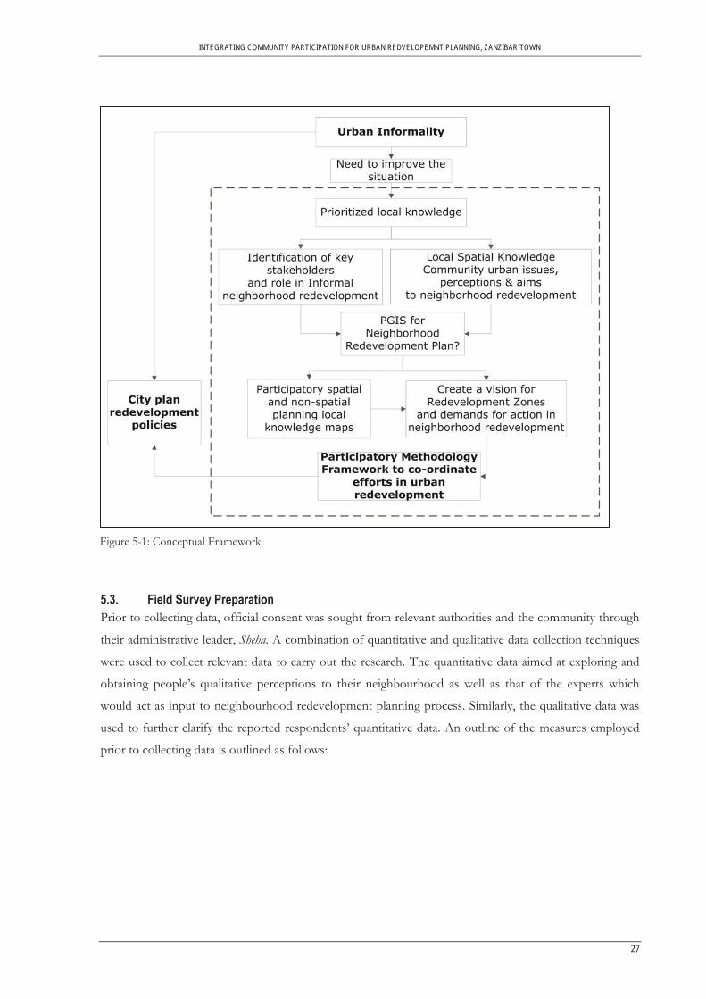
5.1. Conceptual Framework This research is based on the GIS and Society conceptual framework that has formed a body of literature
on PGIS which explores issues related to GIS implementation (See: Abbot et al., 1998; Al-Kodmany,
2000; Asare, 2008; Craig, et al., 2002; McCall, 2003; Talen, 2000).
Urban informality and urban redevelopment responses calls for a realm of participatory approaches in
understanding the perceptions and needs of those in informal neighbourhoods and allowing them to
define their aims. This more often than not lack in many conventional urban planning approaches and
redevelopment planning initiatives, where the intervening planning authorities make board room solutions
(see section 2.2) to improve the informality situation without recognising the local knowledge on issues,
perception and aims of community.
Noting that PGIS research ought to be driven by specific community need priorities, PGIS methodology
can be used in conjunction with the planning policy makers’ to identify the local community priorities and
defined needs in improving their neighbourhoods. Similarly, local community are allowed to share their
expert knowledge of their areas and map their issues unlike traditional board room approaches. Products
developed such as knowledge maps help in representing, communicating and visualizing these
perceptions, needs and aims to urban policy makers. Figure 5-1 gives a summary of the conceptual
framework foundation to this research:
5.2. Research Design The research comprised of three phases outlined in Figure 5-2. The study sought to determine the process
of a participatory methodology in neighbourhood redevelopment planning in Zanzibar. This called for a
nuanced understanding of the complex procedures and institutions that shape the planning process.
INTEGRATING COMMUNITY PARTICIPATION FOR URBAN REDVELOPEMNT PLANNING, ZANZIBAR TOWN
27
5.3. Field Survey Preparation Prior to collecting data, official consent was sought from relevant authorities and the community through
their administrative leader, Sheha. A combination of quantitative and qualitative data collection techniques
were used to collect relevant data to carry out the research. The quantitative data aimed at exploring and
obtaining people’s qualitative perceptions to their neighbourhood as well as that of the experts which
would act as input to neighbourhood redevelopment planning process. Similarly, the qualitative data was
used to further clarify the reported respondents’ quantitative data. An outline of the measures employed
prior to collecting data is outlined as follows:
Figure 5-1: Conceptual Framework
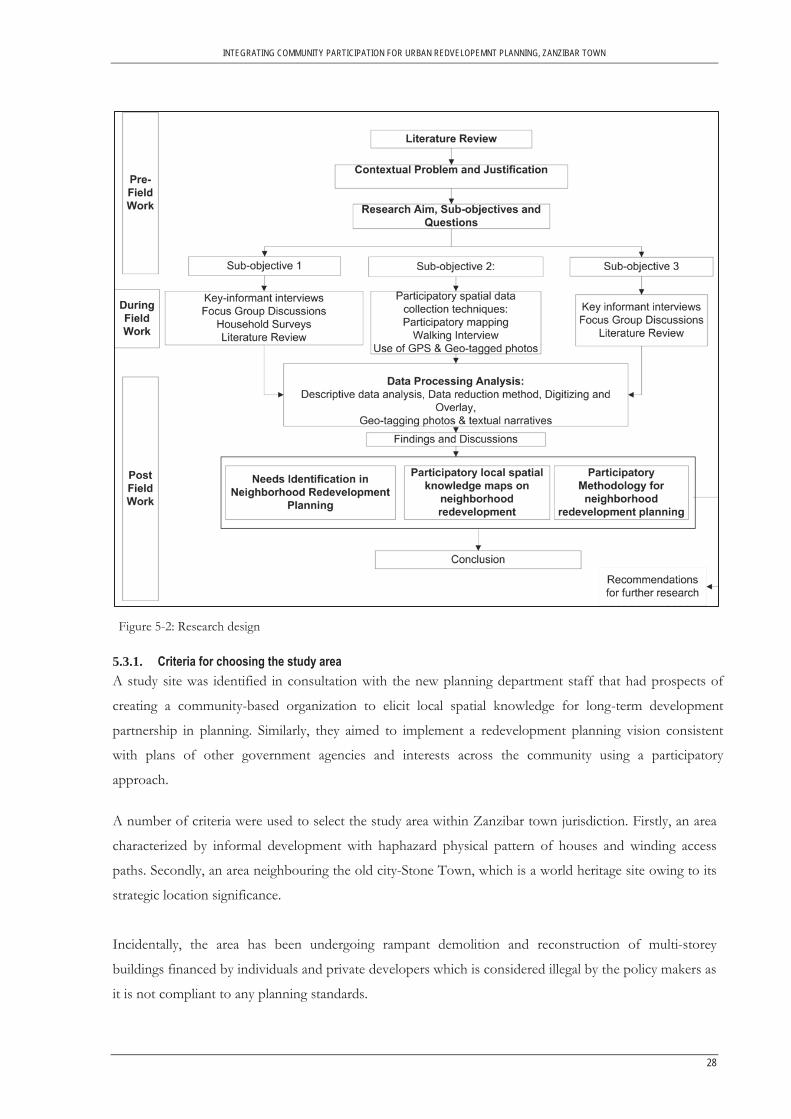
INTEGRATING COMMUNITY PARTICIPATION FOR URBAN REDVELOPEMNT PLANNING, ZANZIBAR TOWN
28
5.3.1. Criteria for choosing the study area A study site was identified in consultation with the new planning department staff that had prospects of
creating a community-based organization to elicit local spatial knowledge for long-term development
partnership in planning. Similarly, they aimed to implement a redevelopment planning vision consistent
with plans of other government agencies and interests across the community using a participatory
approach.
A number of criteria were used to select the study area within Zanzibar town jurisdiction. Firstly, an area
characterized by informal development with haphazard physical pattern of houses and winding access
paths. Secondly, an area neighbouring the old city-Stone Town, which is a world heritage site owing to its
strategic location significance.
Incidentally, the area has been undergoing rampant demolition and reconstruction of multi-storey
buildings financed by individuals and private developers which is considered illegal by the policy makers as
it is not compliant to any planning standards.
Figure 5-2: Research design

INTEGRATING COMMUNITY PARTICIPATION FOR URBAN REDVELOPEMNT PLANNING, ZANZIBAR TOWN
29
A high- resolution satellite image (Map 5-1) was used to identify the study area that indicates the criteria
outlined. The selected Shehia, Kisiwandui included part of a neighbouring Shehia, Kisima Majongoo as it was
recognized that there is a likelihood of some interventions having direct impact as a consequence of its
adjacency to other neighbouring Shehias, for instance expansion of road, laying way leaves for water pipes
and storm water drains.
Subsequent discussions with the planning staff revealed that as a new planning department, there had been
a considerable increase of redevelopment applications for change of use (single-use to multi-use storey
buildings) on the existing informal development which the government seem not to have any influence to
control. Currently, the department has issued a directive to stop all ongoing building activities until a
proper guideline is put in place. One key informant remarked ‘Development is happening so fast. If not careful, we
will have another extension of ‘New’ Stone Town development (and I think part of it has to be with the multi-storey
buildings coming up) due to overbuilding. Some order is needed here.
5.3.2. Reconnaissance Survey A preliminary survey was carried out in order to confirm the delineated study area boundary as well as
familiarising with the area prior to data collection. The following characteristics of the area were noted;
There is an irregular layout of houses in the neighbourhood as illustrated in Map 5-2; the area has mixed
development use with both single-storey and multi-storey buildings in a highly densified fabric. Existing
Map 5-1: Location of the study area within Zanzibar Town

INTEGRATING COMMUNITY PARTICIPATION FOR URBAN REDVELOPEMNT PLANNING, ZANZIBAR TOWN
30
new multi-dwellings are mostly business-cum-residential uses; Most of the houses are in good physical
condition; only one access path-three-meters wide, that goes round the neighbourhood is accessible by
motorised traffic, the rest have been encroached by protrusion of buildings blocking the passages.
Map 5-2: Characteristics of the study area
5.3.3. Neighbourhood quality variables Neighbourhood spatial concerns were first identified using in-depth key informants’ interviews. Ritchie
and Lewis (2003) describe in-depth interviews as content focused discussions with key informants who
have lived in an area for a long period of time and have rich knowledge about particular subject of
interests (such as subjective informal neighbourhood spatial issues in this case study). Two informants,
one from the community and the other one an expert/policy maker, were interviewed. The aim was to
gather inclusive and elaborate list of variables on the neighbourhood spatial strengths and weaknesses of
the area to be used in the questionnaire survey for all respondents.
A satellite image was used as a complement to the conversation with the informants. This was meant to
stimulate expression of perceptions in a spatial dimension and to obtain a representation of the
significance of respective places. A list of characteristics of the neighbourhood variables was derived from
this exercise. Some of the variables definition was derived from the Town and Planning Decree, Cap 85
regulations subjective to the existing situation in the study area: This list was later reviewed during
reconnaissance survey and pilot testing of questionnaires for validation.
Main road- the road that leads from the old Stone Town to other areas in Zanzibar that has more traffic and is adjacent to the neighbourhood.
Access path- the road that branches from the main road allowing entry to the neighbourhood. Housing congestion- overcrowding build-up of houses in a small surface area of residential land. Housing pattern- configuration layout plan/pattern in the housing arrangement.

INTEGRATING COMMUNITY PARTICIPATION FOR URBAN REDVELOPEMNT PLANNING, ZANZIBAR TOWN
31
Neighbourhood pride and appearance- a function of satisfaction in the neighbourhood characteristic
Interaction- the social ties and relation between dwellers in the neighbourhood unit. Provision of water services- ability to use and benefit from improved water sources e.g. piped
water, public tap and borehole or protected well. Storm water drainage- drains system to collect and convey water runoff to the ocean in order to
prevent flooding. Open space/ recreational facility- describe public squares, parks and recreation grounds. Access to public social amenities- ability to use and benefit from public educational, health and
other social facilities like library.
5.3.4. Pilot testing of questionnaires Questionnaire administration was aimed at gathering the community’s knowledge, views and responses on
the qualities of their neighbourhood8. Prior to actual questionnaire administration, household survey was
pre-tested with ten residents from the community. This exercise was aimed at:
(1) Reviewing the list of variables to ensure that the conditions indeed exist in the neighbourhood. (2) Test the questions which provided the opportunity to garner community feedback on the content and general direction of the questionnaire in ensuring that the delivery of the questions is;
(a) Relevant, understood and acceptable to the respondents (b) Questions capture sufficiently what the survey is seeking to find, and (c) Time duration of administering the questions is acceptable.
(3) Familiarize the team with an entry strategy to be employed in the field during actual sample survey, and (4) Test the capability of the research assistants in administering the questions and make necessary adjustments before deploying them to the field. Part of the questionnaire (qualitative perceptions to neighbourhood) was administered to the experts in
order to identify their perception of the neighbourhood intended for redevelopment process. This
facilitated identification of the different perceptions of the two groups, experts and local residents for later
comparison to recognize possible mismatch in perceptions.
It was realized that the community respondents were not fully aware what entails urban redevelopment.
Therefore, the entry strategy was changed by explaining briefly what urban redevelopment entails. It
started by pointing out an example of a well planned neighbourhood environment in the area then
comparing it to the resident’s neighbourhood. The questionnaire administration was used as a first-step of
a consultation planning process as well as introducing the community to an intended neighbourhood
redevelopment.
5.4. Data Collection Methods
5.4.1. Key informant interview Key informants from government authorities were identified using snow-balling technique. 10 experts
relevant in the urban planning and management administration were identified. The interviews were
8 Refer to Table 6-3 for the spatial issues and perceptions in regard to neighbourhood redevelopment which are also the variables measured.

INTEGRATING COMMUNITY PARTICIPATION FOR URBAN REDVELOPEMNT PLANNING, ZANZIBAR TOWN
32
structured in both close and open-ended questions oriented along a list of topics. This approach offered
flexibility in emerging new topics and more discussions with the experts. The interviews were conducted
in both English and Swahili language. Interviews were audio-recorded and transcribed to enhance
reliability. Table 5-1 shows a list of key informants from different departments who participated in the
survey. Table 5-1: List of experts interviewed
Department No. of respondents Department of Urban and Rural Planning Director, Urban and rural planning Chief Physical Planner Senior Planner Planning Officer
4
Department of Construction Assistant Director Engineer Chief Engineer Engineer officers
5
Zanzibar Municipal Council Deputy Director- Sanitary Engineer
1
5.4.2. Household Survey The actual primary data collection took place on the 5th -17th October, 2011. A total of 200 local resident
respondents were interviewed. The survey was targeted to persons above the age of 18 years and
preferably household head. The average age of the local residents in the survey was approximately 41 years
ranging between the ages of 18 and 77 years.
Prior to the survey, the sampling frame was drawn from the overlay of a geo-referenced satellite image and
building footprints spatial layer. The assumption made was that one building footprint represents a
rooftop of one household. Random sampling technique was applied using SPSS and later joined in
ArcGIS to visualize the households selected to participate in the survey. As for the households in the
multi-storey buildings, a systematic sampling technique was applied. If selected house earmarked for
questionnaire administration had no respondent, strategy put in place for replacement was to pick any
house in the vicinity which had not been selected. This was reckoned to be imperative not only in
orientation of the study area but in marking the houses interviewed in the study to avoid repetition.
Research assistants were engaged in the study and were trained on map reading and given A4 sized
oriented satellite image and a copy of the randomly selected households to be interviewed.
The four research assistants were selected with the help of a contact person who had a database of youth
workers and a pool of university students that had been engaged in previous projects. The research
assistants consisted of students from the tertiary institutions in Zanzibar. Each research assistant was
given an A4 size print-out copy of the satellite image showing the study area and its building footprints
that were randomly selected. The questionnaire was designed in such a way, to give it a spatial context. For

INTEGRATING COMMUNITY PARTICIPATION FOR URBAN REDVELOPEMNT PLANNING, ZANZIBAR TOWN
33
each questionnaire administered in a household, a unique number was given to the questionnaire and the
corresponding rooftop on a geo referenced satellite image with the building footprints. Statistical analyses
were carried out and the different perceptions on each neighbourhood quality variable determined. The
unique number later facilitated integration and visualisation of the local knowledge within an existing GIS
database.
Demographic information of the local residents was collected. In addition, views on community spatial
concerns in the neighbourhood were discussed and rated on a six point-Likert scale. Focus group
discussion schedule was arranged with the community respondents at this time.
5.4.3. Focus Group Discussion FGD with the community was held on 20th October, 2011 in Kisiwandui Primary School organized with the
help of the Sheha and facilitated by the researcher (Picture 5-1). As stated by Goss and Leinbach (1996, p.
115), “ ‘stories’ produced in a collaborative performance of a focus group better reflect the social nature of
knowledge than a summation of individual narratives extracted in interviews”. Therefore, as illustrated in
Picture 5-1, FGD was used to enrich and expand the first hand data collected through in-depth key
informant interview and household survey. Present were few of the experts who felt the need to attend
the meeting to familiarize with the community aims in implementing their intended redevelopment
planning and consultation activities.
The purpose of the meeting was first explained to the participants who were later asked to explore issues
by focusing on broad discussion theme areas broken down from perceived neighbourhood quality in the
household survey. Five redevelopment constructs identified were: accessibility, housing
development/economic development, service provision, and recreation, which provided a frame for
discussing: 1) existing spatial issues, 2) the different perceptions of the locals on their neighbourhood 3)
aims on improving the situation and, 4) mapping the knowledge. This was done to get an in-depth
understanding and determine the reasons for the local residents’ perceptions, priorities and aims including
but not limited to neighbourhood redevelopment.
5.4.4. Participatory Mapping This is an exercise which allows tacit knowledge embedded in people’s spatial memory to be converted
into explicit and externally-usable knowledge (Corbett et al., 2009). The participatory mapping exercise,
which was used during focus group discussion, had two groups; men and women, although the number of
women was insufficient to ensure proper participation. The mapping was done on a tracing paper overlaid
on a 1: 4,000 metres scaled map of the study area. Participants with both positive and negative perceptions
to the neighbourhood explored and exchanged general ideas. In the same map, areas indicated as strengths
and weaknesses of the neighbourhood were identified and participants later explored possible solutions to
their neighbourhood issues. Picture 5-1 shows the participatory mapping exercise where the community

INTEGRATING COMMUNITY PARTICIPATION FOR URBAN REDVELOPEMNT PLANNING, ZANZIBAR TOWN
34
recorded their knowledge using felt-tipped markers. Other miscellaneous content were also written
directly on the map.
Picture 5-1: Focus group discussion (left) and participatory mapping exercise (right) sessions at Kisiwandui Primary School, Zanzibar Source: Fieldwork, 2011
The strength of participatory mapping lies in the integration of contrasting views in an interactive setting
as the locals identify areas of potential accord and conflict while retaining individual’s perspective. As
noted by Rambaldi et al (2006), spatial data and maps generated at this stage are intermediate products of a
long-lasting and articulated process, making them a means and not an end. These maps become resources
for suggesting to planners the aims of the community in neighbourhood redevelopment to guide in policy
making and redevelopment planning process. They also create a platform to communicate how residents
prescribe course for the redevelopment of their neighbourhood.
Practical ethics of mapping exercise require that physical output of the maps generated from the
participatory mapping exercise stays with those who generated it. But because this study needed to process
and analyse the maps, the maps were not left to the custodians, who are the residents in the
neighbourhood.
5.4.5. Walking Interview To verify the perceived neighbourhood qualities discussed and later mapped as redevelopment constructs
by the local residents, a walking interview was carried out. Walking interview is a form of interview
conducted ‘on the move’ to produce narratives both in terms of quantity and spatial specificity of the
study area (Evans & Jones, 2011, p. 849). A number of participants took part in the exercise where, they
physically identified the locations that were discussed in the room-based setting discussion. The exercise
was aimed at the community identifying the described key characteristics of the neighbourhood both
positive and negative while taking photographs and picking the geographic positions using a GPS. This
was used to complement and verify geo-referenced textual narratives of specific determined locations
highlighted from the survey and FGD along with. The exercise elicited additional significant discussions

INTEGRATING COMMUNITY PARTICIPATION FOR URBAN REDVELOPEMNT PLANNING, ZANZIBAR TOWN
35
and impressions of specific locations that arose ‘on the move’ which were otherwise not mentioned in the
previous exercises already mentioned.
Prior to this exercise, participants were trained on how to pick GPS positions as they took photos and at
the same time recording their narratives using a digital recorder. Time was synchronised for the three
gadgets for easy categorization during analysis. These photographic data and narrative further illustrated
the local community perspectives on their neighbourhood environment reflecting on their strengths,
concerns and aims for redevelopment.
5.5. Secondary Data The secondary data on urban planning and management in form of reports and policy documents were
acquired from government departments already mentioned. They included; UDCA document outlining its
legal mandate in planning for Zanzibar Town, draft policy documents on land use planning, national land
policy and hosing policy framework, feasibility study report on human settlement development and
Zanzibar Statistical Abstract.
5.6. Data Processing and Analysis The respondents’ questionnaire on their perceived neighbourhood qualities was analyzed using SPSS to
compute frequencies, means and standard deviations. T-test was computed to find out whether significant
differences existed regarding the perceptions between community and expert of the neighbourhood.
Effect size was calculated using Cohen’s d9 to find out the extent of the differences(Cohen, 1988).
Key informant interviews and focus group discussions were transcribed and analyzed qualitatively using
data reduction technique (Miles & Huberman, 1994). To analyze the data descriptive statistics, paired
samples t-tests and effect size were calculated to ascertain the perceived neighbourhood qualities by both
the community and the experts. Effect size was calculated using Cohen’s d (Cohen, 1988). Cohen
provided tentative benchmarks for the interpretation of effect sizes. He considers d=0.2 a small, d=0.5 a
medium, and 0.8 a large effect size. This effect size is used to measure the magnitude of the perceived
differences of the different groups’ perceptions. Community spatial perceptions and aims were processed
using ArcGIS and results displayed as local knowledge maps including geo-coded photos and textual
narratives of redevelopment constructs mapped by the local community.
5.7. Limitations to the study Zanzibar has no redevelopment framework in place yet but the proposed participatory framework process
was guided by the limitation in the current guideline of the planning process which would otherwise be
adopted for the redevelopment initiative.
9 Cohen defined d as the difference between the means, M1 –M2, divided by the standard deviation, σ, of either group.

INTEGRATING COMMUNITY PARTICIPATION FOR URBAN REDVELOPEMNT PLANNING, ZANZIBAR TOWN
36
As is required of any participatory approach, the visioning process output was not validated by ‘co-
owners’ -the target community to ensure that the reproduction of the map by experts captured the
condition and needs of the community.
To comprehensively understand the ‘sectoral based’ planning in Zanzibar, all sectors concerned in the
development of Zanzibar ought to have participated in the study to identify their mandate. However, due
to the complex nature of the study coupled with limited time frame during fieldwork, this was not tackled.
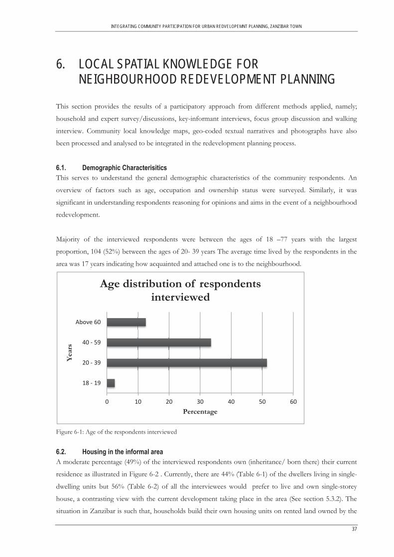
INTEGRATING COMMUNITY PARTICIPATION FOR URBAN REDVELOPEMNT PLANNING, ZANZIBAR TOWN
37
6. LOCAL SPATIAL KNOWLEDGE FOR NEIGHBOURHOOD REDEVELOPMENT PLANNING
This section provides the results of a participatory approach from different methods applied, namely;
household and expert survey/discussions, key-informant interviews, focus group discussion and walking
interview. Community local knowledge maps, geo-coded textual narratives and photographs have also
been processed and analysed to be integrated in the redevelopment planning process.
6.1. Demographic Characterisitics This serves to understand the general demographic characteristics of the community respondents. An
overview of factors such as age, occupation and ownership status were surveyed. Similarly, it was
significant in understanding respondents reasoning for opinions and aims in the event of a neighbourhood
redevelopment.
Majority of the interviewed respondents were between the ages of 18 –77 years with the largest
proportion, 104 (52%) between the ages of 20- 39 years The average time lived by the respondents in the
area was 17 years indicating how acquainted and attached one is to the neighbourhood.
Figure 6-1: Age of the respondents interviewed
6.2. Housing in the informal area A moderate percentage (49%) of the interviewed respondents own (inheritance/ born there) their current
residence as illustrated in Figure 6-2 . Currently, there are 44% (Table 6-1) of the dwellers living in single-
dwelling units but 56% (Table 6-2) of all the interviewees would prefer to live and own single-storey
house, a contrasting view with the current development taking place in the area (See section 5.3.2). The
situation in Zanzibar is such that, households build their own housing units on rented land owned by the
0 10 20 30 40 50 60
18 - 19
20 - 39
40 - 59
Above 60
Percentage
Year
s
Age distribution of respondents interviewed

INTEGRATING COMMUNITY PARTICIPATION FOR URBAN REDVELOPEMNT PLANNING, ZANZIBAR TOWN
38
government. Majority of the houses are permanent (96%) made up of cement blocks and corrugated
galvanized iron sheets.
Figure 6-2: Housing ownership status in the neighborhood
Table 6-1: Type of housing in the neighborhood
Current Housing Type Respondents (n=200)
Frequency Percent
Apartment/flat under 4 storey's 56 28.0
Apartment/flat over 4 storey's 55 27.5
Typical Swahili House 2 1.0
Single- Dwelling unit 87 43.5
Total 200 100.0
Table 6-2: Type of housing preference
Preferred Housing Type Respondents (n=200)
Frequency Percent
Single dwelling unit 112 56.0
Multi-storey building 88 44.0
Total 200 100.0
0 10 20 30 40 50 60
Owner
Tenant
Household member
Others
Percentage
Stat
us
Housing Ownership Status

INTEGRATING COMMUNITY PARTICIPATION FOR URBAN REDVELOPEMNT PLANNING, ZANZIBAR TOWN
39
6.3. Employment A Moderate percentage of the respondents (32%) are unemployed as illustrated in Figure 6-3, partially
reflecting the affordability challenge of owning ‘single- dwelling houses with large compounds for children to play’ as
described by one of the community respondent. This poses a challenge to an impending relocation and
resettlement intervention where majority of the residents cannot afford. One of the policy makers
responded by saying ‘redevelopment initiatives are by no means easy to organise, finance or implement especially where
there is limited inter-agency co-ordination among actors. Residents must be effectively protected from unnecessary evictions, if
the redevelopment premise is to remain meaningful’.
However, a significant percent (30%) of the respondents were employed both in semi-skilled and skilled
occupations and 29% were self-employed but largely in unsustainably small subsistence trading activities.
This as valuable resource ought to be considered too in the redevelopment process of the neighbourhood
to encourage local economic development.
Figure 6-3: Employment situation in the neighbourhood
6.4. Community participation To determine participation goodwill in sense of community cohesion, the community was consulted on
participating to redevelop their neighbourhood. Almost all of the interviewed respondents 95% (190)
indicated interest of participating citing reasons how they would want to participate; like giving opinions
and designing their neighbourhood (for instance, housing layout and locating access paths).Only a few, 5%
(10) who did not want to participate cited reasons such as; lack of time to take part in such initiatives
owing to other responsibilities and doubts if their input will be relevant to the planning authorities.
6.5. Identification and Visualization of Perceived Neighbourhood Quality One of the aims of this study was to find out to what extent the priorities of the neighbourhoods match
those of the policy makers. The comparison and shared insights of perceptions amongst the community
and experts bring about the different ways of interpretation and meaning to an informal neighbourhood
0 5 10 15 20 25 30 35
Unemployed
Employed
Self-employed
Others
Percentage
Cate
gory
Employment Status
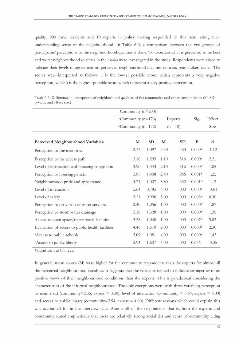
INTEGRATING COMMUNITY PARTICIPATION FOR URBAN REDVELOPEMNT PLANNING, ZANZIBAR TOWN
40
quality. 200 local residents and 10 experts in policy making responded to this item, citing their
understanding sense of the neighbourhood. In Table 6-3, a comparison between the two groups of
participants’ perceptions to the neighbourhood qualities is done. To ascertain what is perceived to be best
and worst neighbourhood qualities in the Shehia were investigated in the study. Respondents were asked to
indicate their levels of agreement on perceived neighbourhood qualities on a six-point Likert scale. The
scores were interpreted as follows: 1 is the lowest possible score, which represents a very negative
perception, while 6 is the highest possible score which represent a very positive perception.
Table 6-3: Difference in perceptions of neighborhood qualities of the community and expert respondents: (M, SD, p-value and effect size)
Community (n=200) aCommunity (n=176) bCommunity (n=172)
Experts
(n= 10)
Sig.
Effect
Size
Perceived Neighbourhood Variables
M
SD
M
SD
P
d
Perception to the main road 2.35 1.097 3.30 .483 0.000* -1.12
Perception to the access path 3.18 1.295 1.10 .316 0.000* 2.21
Level of satisfaction with housing congestion 3.90 1.343 2.10 .316 0.000* 1.85
Perception to housing pattern 3.87 1.408 2.40 .966 0.001* 1.22
Neighbourhood pride and appearance 4.74 1.007 3.80 .632 0.001* 1.12
Level of interaction 5.64 0.795 6.00 .000 0.000* -0.64
Level of safety 5.21 0.990 5.00 .000 0.003* 0.30
Perception to provision of water services 2.40 1.056 1.00 .000 0.000* 1.87
Perception to storm water drainage 2.18 1.328 1.00 .000 0.000* 1.26
Access to open space/recreational facilities 5.28 1.040 1.00 .000 0.007* 5.82
Evaluation of access to public health facilities 4.46 1.510 2.00 .000 0.000* 2.30 aAccess to public schools 5.09 1.081 4.00 .000 0.000* 1.43 bAccess to public library 3.94 1.607 4.00 .000 0.636 -0.05
*Significant at 0.5 level
In general, mean scores (M) were higher for the community respondents than the experts for almost all
the perceived neighbourhood variables. It suggests that the residents tended to indicate stronger or more
positive views of their neighbourhood conditions than the experts. This is paradoxical considering the
characteristics of the informal neighbourhood. The only exceptions were with three variables; perception
to main road (community=2.35, expert = 3.30), level of interaction (community = 5.64, expert = 6.00)
and access to public library (community=3.94, expert = 4.00). Different reasons which could explain this
was accounted for in the interview data. Almost all of the respondents that is, both the experts and
community stated emphatically that there are relatively strong social ties and sense of community citing

INTEGRATING COMMUNITY PARTICIPATION FOR URBAN REDVELOPEMNT PLANNING, ZANZIBAR TOWN
41
cultural and religious reasons relenting people to interact well with each other. Although, a few of the
residents especially those on the ground floor of flats over 4 storey’s, rated low interaction citing reasons
like neighbours littering and pouring dirty water on their backyards creating strained ties amongst them.
The main road was rated more negative by the community as they are directly affected with the unsafe use
of the road (See section 6.6.1).
With respect to access to public library, (28) respondents from the local community did not respond to
this item. The communities in the study neighbourhood indicated that barely do they use the library
facility and services. Though the experts emphasize that the public library is an essential social institution,
their view seem misplaced. This is based on the communities who are the users of such a service who
report they never use this facility. However, households with school-going children reported that schools
provide the facility so they do not interact with the public library.
The T-test results shown in Table 6-3 further indicated the significance difference in the means of
variables of the groups’ perceptions, with large effect sizes confirming a marked difference in views
between the community and experts participants.
Perception on access to open space/recreational facilities recorded the most perceived mismatch (d=
5.82) between the local community and the experts (community =5.28, Experts =1.04). Although
responses from the experts indicated negative perception to open space/recreational facilities it was
subject –specific referring to aesthetics and functional attributes of landscaping of private open spaces
such as private gardens. The public recreational park, Jamhuri Gardens is currently divided into two
sections; public and private with the latter having the above mentioned facilities that can only be accessed
at a fee. On the contrary, the community prides in the park as a strong quality of its neighbourhood since
it is located in their Shehia hence the positive perception.
As previously discussed in section 5.4.2, GIS was used to record community’s local knowledge. It was also
used to authenticate and visualise the local knowledge maps, as illustrated in Map 6-1 - Map 6-6. Inferring
from the maps, aid the planners in understanding the spatial complexity, spatial context, interactivity and
interconnection in articulation of viewpoints as described in the literature (See section 2.6). The
visualisation ascertains the perceived needs identification from each household that participated in the
study.

INTEGRATING COMMUNITY PARTICIPATION FOR URBAN REDVELOPEMNT PLANNING, ZANZIBAR TOWN
42
Map 6-1: Community perception to the neighborhood’s main
Map 6-2: Community's perception to the neighborhood’s access path
Map 6-3: Community level of satisfaction to housing congestion

INTEGRATING COMMUNITY PARTICIPATION FOR URBAN REDVELOPEMNT PLANNING, ZANZIBAR TOWN
43
Map 6-4: Community perception to the neighborhood's pride and appearance
Map 6-5: Community perception to the neighborhood's level of interaction
Map 6-6: Community evaluation to the neighborhood's provision of water services

INTEGRATING COMMUNITY PARTICIPATION FOR URBAN REDVELOPEMNT PLANNING, ZANZIBAR TOWN
44
6.6. Participatory Mapping of Perceived Redevelopment Needs The community consultation process using collaborative participatory mapping exercise and a walking
interview facilitated further detailed view and insight to a variety of community perspectives about the
neighbourhood. The importance of land-use planning was discussed at length by the experts to the
community that yielded results in form of a sketch concept-design plan of redevelopment constructs
defined by the residents, namely; access, housing/economic development, provision of services and
recreation. Satellite imagery was used to aid in the discussions. Both members of the community and
experts were in attendance and participated but only the community carried out the mapping exercise. The
result of this exercise is illustrated in Map 6-7 below. Some of the key highlights of the redevelopment
constructs in the participatory map are:
Map 6-7: Community-defined redevelopment map Source: Fieldwork, 2011
6.6.1. Access The local community mapped unsafe intersection on the main road and access paths traversing their
neighbourhoods as illustrated by Picture 6-1 and marked as weakness locations in Map 6-8 below. It was
stated during the mapping and discussion exercises that: ‘Most children come from far and they have to cross the
main road to school. They are exposed to the danger of the busy road with speeding vehicles. It’s only 2 days ago that a young
man was hit by a speeding car and he was tossed to the other side of the road. That shows how our school going children are
exposed to the dangers of this road. So, it will be a relief to see a freshly paint zebra crossing, sign post showing children
crossing or a fly-over built for safety use of the road.’ Another participant reacted by suggesting, ‘As a community, if

INTEGRATING COMMUNITY PARTICIPATION FOR URBAN REDVELOPEMNT PLANNING, ZANZIBAR TOWN
45
approached, we can also participate in planting more trees along pedestrian paths to give a pleasant walking environment and
provide shade.’
In the neighbourhoods that formed the study area, it was observed that most of the access paths have
since been partially blocked whereas in other sections of the neighbourhood, others have been completely
blocked. This issue was affirmed by one of the resident who highlighted that, ‘As long as I can remember in my
childhood days as this is where I was born, there were access paths and you could see one end of the street if you stood at my
doorstep. But now, people build and extend to the access paths. If an accident were to occur like fire outbreak, or if someone
were to fall sick in my house, I would be forced to climb with them on my neighbour’s rooftop to get to safer grounds to gain
speedy access to take them to hospital’. Picture 6-1 was taken to complement the narratives described in the
discussions.
Picture 6-1: Access; Main road (right) and one of the access paths (left) in the neighborhood Source: Fieldwork, 2011.
6.6.2. Housing/ Economic Development Within the neighbourhood, there is mushrooming of new housing development that does not follow
zoning regulations, which has lead to haphazard development. The urban planning experts reported that
there lacks a proper zoning regulation and people adopt existing informal plan layout when building As
already indicated by the experts (See section 5.3.1) in the planning department, new housing development
has been spreading throughout the neighbourhood, building on the existing informal plan layout with lack
of zoning regulations enhancing haphazard housing pattern. Picture 6-2 shows the nature of
redevelopment going on. Here, discussions were focussed on the impressions of housing issues such as
congestion, layout pattern of the house, housing needs such as promoting vertical development10 in the
area.
Participation in planning is to a larger extent non-existence. As such, the community was inquisitive on the
government’s intent in redevelopment. Only when asked what the government intended to do did an
expert from the planning department responded by explaining, ‘This is a community planning exercise to empower
10 According to the policy makers in the planning department, Zanzibar is rapidly growing and soon running out of space hence ideal for vertical development.
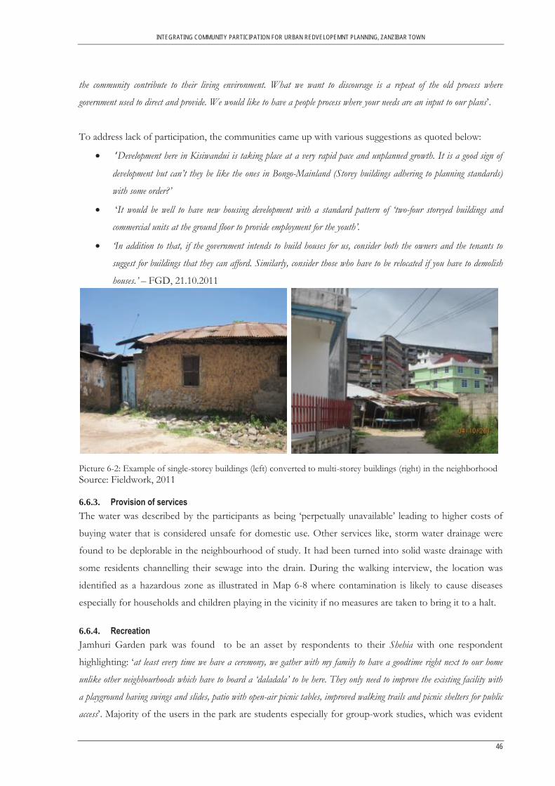
INTEGRATING COMMUNITY PARTICIPATION FOR URBAN REDVELOPEMNT PLANNING, ZANZIBAR TOWN
46
the community contribute to their living environment. What we want to discourage is a repeat of the old process where
government used to direct and provide. We would like to have a people process where your needs are an input to our plans’.
To address lack of participation, the communities came up with various suggestions as quoted below:
‘Development here in Kisiwandui is taking place at a very rapid pace and unplanned growth. It is a good sign of
development but can’t they be like the ones in Bongo-Mainland (Storey buildings adhering to planning standards)
with some order?’
‘It would be well to have new housing development with a standard pattern of ‘two-four storeyed buildings and
commercial units at the ground floor to provide employment for the youth’.
‘In addition to that, if the government intends to build houses for us, consider both the owners and the tenants to
suggest for buildings that they can afford. Similarly, consider those who have to be relocated if you have to demolish
houses.’ – FGD, 21.10.2011
Picture 6-2: Example of single-storey buildings (left) converted to multi-storey buildings (right) in the neighborhood Source: Fieldwork, 2011
6.6.3. Provision of servicesThe water was described by the participants as being ‘perpetually unavailable’ leading to higher costs of
buying water that is considered unsafe for domestic use. Other services like, storm water drainage were
found to be deplorable in the neighbourhood of study. It had been turned into solid waste drainage with
some residents channelling their sewage into the drain. During the walking interview, the location was
identified as a hazardous zone as illustrated in Map 6-8 where contamination is likely to cause diseases
especially for households and children playing in the vicinity if no measures are taken to bring it to a halt.
6.6.4. Recreation Jamhuri Garden park was found to be an asset by respondents to their Shehia with one respondent
highlighting: ‘at least every time we have a ceremony, we gather with my family to have a goodtime right next to our home
unlike other neighbourhoods which have to board a ‘daladala’ to be here. They only need to improve the existing facility with
a playground having swings and slides, patio with open-air picnic tables, improved walking trails and picnic shelters for public
access’. Majority of the users in the park are students especially for group-work studies, which was evident

INTEGRATING COMMUNITY PARTICIPATION FOR URBAN REDVELOPEMNT PLANNING, ZANZIBAR TOWN
47
from the activities observed taking place at the time of the walking interview, illustrated in Picture 6-3 and
Map 6-8 as one of the strengths in the neighbourhood.
Picture 6-3: Public section (left) and private section of the recreation park (right) in Jamhuri Gardens Source: Fieldwork, 2011 Other significant locations identified as strengths (refer to Map 6-8) in the neighbourhood during the
walking interview not mentioned in the mapping exercise included; the former president’s house,
Kisiwandui primary school which is among the best performing schools in Zanzibar Town, bank services
and a police station whose presence was said to attribute to the positive perception of level of safety.
Map 6-8: Walking interview route showing community's identified location points of neighborhood-defined spatial strengths and weaknesses

INTEGRATING COMMUNITY PARTICIPATION FOR URBAN REDVELOPEMNT PLANNING, ZANZIBAR TOWN
48
7. INTERGRATING COMMUNITY PARTICIPATION FOR A NEIGHBOURHOOD REDEVELOPMENT STRATEGY IN ZANZIBAR
This section discusses the integration of community participation framework developed and employed
emphasising on local knowledge. A review of the framework is done in a five-step outline to aid in
facilitating the anticipated redevelopment planning process in Zanzibar.
7.1. Step 1: Initiation Stage: Local Knowledge Identification (Perceived Needs Identification) In reference to the main aim of the study, the first step towards integrating community participation in
neighbourhood redevelopment as illustrated in Figure 7-1 starts with needs identification of the local
residents in form of perceptions. As reviewed in the literature, community participation is often more
successful when it starts from the needs of the community. In this context, the questionnaire
administration was used to introduce the community to an intended neighbourhood redevelopment. It
was also used as a first-step in consultation process to assess the demographic profile of the residents as
well as their local knowledge in the neighbourhood in regard to specific neighbourhood qualities.
As already discussed in section 5.4.2, the questionnaire was designed in such a way as to give it a spatial
dimension. For each questionnaire administered in a household, a unique number was given to the
questionnaire and the corresponding structure on a geo referenced satellite image for easy integration
within an existing GIS database.
In traditional planning approaches, (just as is the case in Zanzibar), experts have single-handedly assumed
the entire extent of development initiation, design and implementation as illustrated in Figure 3-1.
Consequently, this has lead to misplaced interventions which are ineffective, contrary to the perceived
needs of the populace. To determine if that was the situation in the anticipated redevelopment initiative in
Zanzibar, experts’ knowledge of the neighbourhood with regard to specific neighbourhood qualities was
also determined.
Statistical analyses as illustrated in section 6.5 were carried out to identify and investigate data by
comparing perceived neighbourhood qualities for residents and experts. The differences in perceived
neighbourhood qualities between community and experts provide an understanding of the magnitude of
differences that occur between the community and the experts in redevelopment initiatives. It further
indicates the risk of having inappropriate state interventions generated by experts without consulting the
community in redeveloping their neighbourhood. The target beneficiaries are likely not to accept, own or
identify with the redevelopment hence the cycled debate on inadequacies of planning approaches to urban
informality. Therefore, it is paramount for planning experts to understand the neighbourhood qualities

INTEGRATING COMMUNITY PARTICIPATION FOR URBAN REDVELOPEMNT PLANNING, ZANZIBAR TOWN
49
and meanings of specific physical setting in which redevelopment planning is to take place. It is on this
note that the participatory methodology framework started with local knowledge identification. As
recommended in the literature review (See section 2.4), experts/policy makers ought to emphasise on
residents, their neighbourhood and the spatial local knowledge as the object of redevelopment.
7.2. Step 2: Initiation Stage: Integrating Community’s Participation with GIS Once the perceived needs had been identified, the next step was to integrate the local knowledge into GIS.
The local knowledge collected from household survey was converted into a GIS compatible file format,
‘.dbf extension’ which was integrated to existing GIS database with the following geo-referenced spatial
dataset, namely; satellite image of Zanzibar, shapefile of building footprints of the neighbourhood,
shapefile of main road, shapefile of access paths and shapefile of the study area boundary. GIS aided in
Figure 7-1: Steps of integrating community participation for a neighborhood redevelopment planning process

INTEGRATING COMMUNITY PARTICIPATION FOR URBAN REDVELOPEMNT PLANNING, ZANZIBAR TOWN
50
visualizing the quantified neighbourhood quality ratings of the perceptions that represents the community
viewpoints with spatial information as illustrated in Map 6-1- Map 6-6.
A summary of how community participation was integrated in GIS is shown in Figure 7-1. Use of the
dotted line marked ‘a’ in the framework is to convey emphasis on planning experts adopting GIS
technology to counter the weaknesses of traditional planning approaches that lack the capability of
integrating community’s spatial local knowledge in redevelopment planning(i.e. use of newspapers and
public notices). As reviewed from the literature GIS in participatory planning initiative provides a platform
to comprehensively understand the spatial complexity, spatial context, interactivity and interconnection in
articulation of viewpoints.
Local knowledge maps generated as shown in Map 6-1- Map 6-6 are visual communication tools from
community perspectives capable of aiding planners in analysing local knowledge perception of felt needs,
reflecting on the mismatch of neighbourhood qualities perceptions between them and the community.
The results and insights learned served as necessary inputs for the experts in revising their approach to
redevelopment planning geared towards adopting community local knowledge. This is aimed at countering
the effects of traditional planning approaches outlined in section 2.3.1 where the experts in overall assume
the entire extent of the redevelopment planning which is also replicated in Zanzibar’s planning framework
as illustrated in Figure 3-1.
Practically, identifying the residents’ perceptions can also enhance toleration of differences between the
experts and the community. Besides, the community learn from experts on the significance of planned
formal environment while sensitizing and creating awareness to the community on the procedures that
need to be followed in approving development that adhere to planning standards.
Additionally, identifying community viewpoints on neighbourhood quality facilitates transparency
amongst the stakeholders’ during project initiation especially on qualities that need immediate attention.
More attention ought to be focused by experts on the neighbourhood qualities with larger effect sizes
(Refer to section 6.5). This is likely to curtail the misplacement of interventions by experts which are
ineffective and contrary to the perceived needs of the residents translating to legitimacy.
7.3. Step 3: Visioning Stage Other than experts depending on quantitative results from the previous steps (See sections: 7.1 and 7.2),
qualitative methods of data collection were used to further consult the community in order to understand
residents’ experiences with their living space. The visioning process comprised participatory tools like
FGD, participatory mapping, walking interview using GPS and taking photographs (Refer to sections:
5.4.3, 5.4.4 and 5.4.5) that provided a broad framework for mapping location of places and ideas in
relation to each other showing the neighbourhood strengths and weaknesses. It is through this interaction

INTEGRATING COMMUNITY PARTICIPATION FOR URBAN REDVELOPEMNT PLANNING, ZANZIBAR TOWN
51
that planners ascertain the local knowledge and potential redevelopment anchors in specific locations.
FGD and participatory mapping exercise offer a bottom-up approach where the local spatial knowledge
mapped by the community, dictates how the redeveloped neighbourhood will look like. This is in itself, an
attempt to integrate more meaningful community participation in the designing phase of the
neighbourhood redevelopment planning process through dialogue and deliberations that resulted in the
redevelopment plan. The purpose of dialogue is to seek the mapping of the neighbourhood plan and
understanding of issues, ideas and perceptions. Deliberation purpose is to reflect on every participant
views, making choices and reaching planning decisions. It is through deliberations that ideas are tried,
tested and redefined before approval in a collective manner that translates to cross-sectoral and co-
ordination among stakeholders with diverse interests. However, given the complementary feature of
participatory mapping for its ability to elicit residents’ perceptions and redevelopment aims to their
neighbourhood, it was noted that the process is time-consuming. Similarly, the ensuing information
provided was difficult to combine given the areal extent of the neighbourhood.
A walking interview as illustrated in was carried out to authenticate (step marked ‘c’ in Figure 7-1) local
knowledge data collected from fieldwork as well as to complement geo-referenced textual narratives from
the household survey, FGD and participatory mapping exercise. This tool elicited significant discussions
and additional impressions on specific locations of salient features of the neighbourhood, like the former
president’s house, the primary school which was otherwise not mentioned in the room-based setting
discussions. Geo-coded photographs and geographic positions of the neighbourhood perceived spatial
strengths and weaknesses were taken to be linked in a GIS database for data retention and verification
purposes.
The visioning process derived from the participatory mapping exercise output (See Map 6-7), ultimately
resulted to a neighbourhood physical redevelopment plan shown in Figure 7-2 that was later reproduced
by the planning experts using GIS. In PGIS ethics, it is required of a participatory mapping exercise, the
visioning process output to be taken back to the community for validation (step marked as‘d’) but this did
not materialise in the study due to time constraint. Here, it is subject to further discussion if indeed it
reflects what had been deliberated on. If there is no consensus reached, then adjustments can be made.
As illustrated in step 3 of the framework in Figure 7-1, once the output is deliberated on and consensus
reached, then it becomes a resource for suggesting to policy makers/experts the aim of the community in
redeveloping their neighbourhood as already outlined in section 6.6.
7.4. Step 4: Policy Formulation Stage Once the local knowledge is collected and visioning process defined then community members and
experts concurrently formulate (step marked ‘e’) some of the detailed policies for the implementation of
the neighbourhood redevelopment. It is through the community visioning process that policy makers can

INTEGRATING COMMUNITY PARTICIPATION FOR URBAN REDVELOPEMNT PLANNING, ZANZIBAR TOWN
52
translate some of the community’s local knowledge and concept design plan into policy statements which
are dependent on the needs at the time they are made. This way, policy redevelopment statements may be
adjusted as needs change. For instance the study revealed probable policy statements from the local
residents to be adopted in the redevelopment plan as; The neighbourhood should feature mix of land
uses, with a high degree of business-cum-residential use ‘to enhance local economic development’ or ‘both
tenants and house owners to be consulted in preparing the neighbourhood redevelopment plan’.
7.5. Step 5: Towards a Collaborative Redevelopment Planning Process The final step of the participatory methodology embarks on the planning implementation process where
the perceptions of the neighbourhood have been identified, spatial local knowledge of the residents
ascertained and policies defined to guide the vision of an integrated community redevelopment
neighbourhood plan. It marks the onset of the implementation of an integrated community participation
in the redevelopment planning process advocated (see section 2.4) for in redevelopment efforts.
Redevelopment planning premise in this context, is identified based on community participation by the
state through dialogue, deliberations, amendments and consensus building. As such, the emerging
framework’s core as illustrated in Figure 7-1 is on spatial local knowledge derived from integrating
community participation in proposed stages of the redevelopment planning process.
Figure 7-2: Integrated Community defined Redevelopment Plan Source: DoRP, 2011
PROPOSED REDEVELOPMENT PLAN, KISIWANDUI-KISIMA MAJONGOO SHEHIA, 2011.
Proposed 4-5 storey buildings
Legend
Open space / Recreation Park
Existing access paths proposed for improvement
Existing storey buildings
Proposed access paths
Proposed improvements on main road

INTEGRATING COMMUNITY PARTICIPATION FOR URBAN REDVELOPEMNT PLANNING, ZANZIBAR TOWN
53
8. CONCLUSION AND RECOMMENDATION
This chapter gives conclusions and highlights on the recommendations and the potentials in carrying out
further research.
8.1. Conclusion The major conclusions of this study are;
8.1.1. Community participation in the planning framework of the study area The intent of the first objective of the study was to find out the extent of community participation in
development planning. A mixed method approach was used to assess the planning framework of the case
study area. The study showed that, planning and management of urban development is split under
different not so well coordinated institutions. The responsibility of planning in Zanzibar is ‘sectoral based’
with no linkages with each other, except for the members of UDCA which includes the Local Authority
and Department of Construction. For instance, in the case of ZMC, management is split among the
municipal council and Stone Town Authority. Other ministries are also involved in provision of
infrastructure as well as other services, none of which are coordinated. There is also a network of NGOs
that directly channel their resources to the local level through single-entity development projects like water
service provision. Because actors in each of these sectors draw their mandate from different sources,
development planning in Zanzibar is characterised by lack of co-ordination between government sectors
and coordination between government and other agencies.
It was realized that, community participation has not been part of the planning process in Zanzibar Town.
Moreover, the general spatial planning development framework is predominantly co-ordinated by the state
and lacks a formal mechanism for a community participation approach. It also emerged that there is no
institutionalized or coherent community based organization to partner /spearhead local development
initiatives. This is likely to translate into weak forms of community mobilisation hence limited
representation of residents in community participation process. On inquiry whether the community
wanted to participate in the redevelopment planning of their neighbourhood, majority agreed citing how
they would want to participate, for instance; giving opinions, designing the neighbourhood plan,
workmanship and monetary contribution, if need arises. The minority who did not want to participate
cited reasons such as; lack of time to take part in such initiatives owing to other responsibilities as well as
sense of powerlessness and distrust in that their input will be irrelevant to the planning authorities
8.1.2. Spatial local knowledge on neighbourhood redevelopment planning The second objective sought to identify the local spatial knowledge on perceptions and aims of the
community regarding redevelopment. A mixed-method approach was used to identify the local knowledge
of the neighbourhood.

INTEGRATING COMMUNITY PARTICIPATION FOR URBAN REDVELOPEMNT PLANNING, ZANZIBAR TOWN
54
Non-spatial and spatial local knowledge collected included; demographic characteristics, household and
expert views and opinions on the neighbourhood quality and community involvement approach. As noted
in section 2.3.1, some of the past failures of past redevelopment initiatives have had to do with the fact
that planners failed to recognise perceptions and visions of the target beneficiaries. Traditionally,
redevelopment initiatives in the past have been determined only by experts and it emerges that their
visions have considerably differed with that of the community. It is for this reason that the study sought
to investigate the extent of the differences that might exist between the community and the experts.
Part of the household questionnaire (qualitative perceptions to neighbourhood) was administered to the
experts to identify perceptions of both the residents and the experts. In general, the study results revealed
the mean scores for the community respondents to be higher than the experts for almost all the perceived
neighbourhood quality variables. This meant that community respondents tended to indicate stronger or
more positive perception of their neighbourhood conditions than the experts, an acknowledgement of the
residents acceptance and adaptation to the quality of their neighbourhood conditions.
This view therefore, necessitates a shift from a bureaucratic-controlled planning process to consultative,
direct, meaningful and sustained community participation. As such, any changes to be introduced in form
of redevelopment ought to be made in consultation with the community, building upon local aspirations.
For this reason, the study employed and implemented a participatory methodology framework in
determining its purpose in defining community needs and aims in redevelopment initiatives.
GIS was used in eliciting, recording and visualising the perceptions and aims of the community. The
household questionnaire was used as a first-step in the consultation process. This local knowledge serves
as an instrument to help planning experts identify and understand the local residents, perceived needs and
potential redevelopment anchors in the neighbourhood.
The results further revealed how traditional redevelopment planning approaches with no community
participation component often fail to deliver due to misplacement of interventions amid policy
implications that contradict the perceived needs of the residents. It was duly noted that, as much as
participatory approaches have been termed as costly affairs in comparison to centralised driven initiatives,
if done appropriately (Section 2.6) it allows for awareness, dialogue, deliberations, adjustments and
consensus building before implementation enhancing sustainability.
8.1.3. Integration of community participation in neighbourhood redevelopment planning The final objective of the study was to determine how local knowledge can be useful to planning
authorities in a redevelopment planning strategy. In a nutshell, it was realized that of participation in urban
redevelopment can be enhanced using a PGIS methodology to go beyond being only a symbolic nature. A
five-step participatory methodological framework was employed and partly implemented.

INTEGRATING COMMUNITY PARTICIPATION FOR URBAN REDVELOPEMNT PLANNING, ZANZIBAR TOWN
55
The first step was to identify the perceptions of the local residents. It was aimed at helping planners
identify local perceived needs in an informal neighbourhood. Here, experts gain more insight to the ‘intra-
physic’ of the target beneficiaries thereby allowing proper needs identification to later adopt responsive
measures that are acceptable and beneficial to the populace
In the second step, the local knowledge was integrated with existing spatial data and visualised to give it a
spatial dimension for a comprehensive understanding of community’s viewpoints. Local knowledge maps
generated are visual communication tools that allow spatial identification of the viewpoints held by local
residents about their neighbourhood. It facilitated experts’ deeper understanding to the ‘object of
redevelopment’ which is the neighbourhood and it’s spatial local knowledge.
To facilitate compatibility of perceptions held by the experts and community, participatory mapping
exercise was conducted in the third step. Here, the residents’ spatial local knowledge from diverse group
was elicited and again integrated into the participatory planning process. This was aimed at seeking
community local spatial knowledge on potential redevelopment anchors in the neighbourhood. It was, in
itself an attempt to integrate more meaningful community participation in the visioning stage of the
neighbourhood redevelopment planning process by creating awareness on importance of planned living
environment through dialogue and deliberations. The tool showed the potential of building relationship
between the experts and the community enhancing collaboration in decision making. It offered a bottom-
up approach where elicitation of the local knowledge by the planning experts motivated the community to
give information regarding redeveloping their neighbourhood. In essence, redevelopment ought to be
holistic in improving the state of informal neighbourhoods.
In addition, the participatory mapping exercise was seen to empower local residents by enabling them to
map their local spatial knowledge dictating how their redeveloped neighbourhood would look like in the
event of a redevelopment, giving it a sense of ownership. The mapping experience illustrated that if the
community is empowered, they are able to select options that are affordable to the majority with
possibilities of minimising misplaced and unresponsive measures, like beneficiary displacement, as they
develop physical redevelopment plans that reflect their real needs and aims in the community. The walking
interview provided concrete evidence on the individual and community local knowledge. Spatial local
knowledge generated, created a database highlighting on the neighbourhood strengths and weaknesses as
discussed by the residents.
The fourth step of the framework provided a platform for a collaborative policy formulation tailor-made
for the planning and implementation of the redevelopment plan. This fosters transparency and legitimacy
in the planning process. The final step shift focus from the traditional planning approach that is
centralised to an integrated community participation approach using a PGIS methodology. This approach

INTEGRATING COMMUNITY PARTICIPATION FOR URBAN REDVELOPEMNT PLANNING, ZANZIBAR TOWN
56
proved to be effective in that residents are given meaningful opportunity for participation to elicit spatial
local knowledge of their neighbourhood, textual narratives are given prominence in redevelopment
planning needs identification and deliberations, and the target community as well as the experts build
consensus on the redevelopment anchors.
8.2. Recommendations for further research From the study results and conclusions, it has been acknowledged that redevelopment initiatives are not
easy to implement, take time to deliver and are likely to face disapproval, particularly so under conditions
of poor inter-sectoral co-ordination among actors. The study therefore, recommends further research on
how to co-ordinate efforts amongst the government sectors and other actors involved in redevelopment
planning as well as institutionalising collaborative planning.
It has also been demonstrated that mapping local knowledge can play a fundamental role in a
neighbourhood redevelopment planning process. The participatory mapping process not only creates
awareness to the community on the significance of a planned environment, it also leads to identification of
subject-specific needs and aims of target beneficiaries in neighbourhood redevelopment. This counters the
risk of ineffective misplaced interventions by centralised planning approaches hence sustainability in
redevelopment. As such, it is imperative to have community participation right from inception of the
redevelopment initiative, through design stage, policy formulation and implementation.
Therefore, further research may focus on a more advanced and comprehensive PGIS framework that
takes into account, a more elaborate and detailed stages in redevelopment planning process up to
monitoring and evaluation stage. Alternatively, stakeholders involved in redevelopment programmes may
identify and agree with the community in which phase of the redevelopment planning process and at what
stage of participation they may expect the community to participate.
The study has also demonstrated that local knowledge on neighbourhood redevelopment can be
integrated using PGIS tools like participatory mapping exercise which allows spatial issues and priorities to
be defined appropriately. This is conveyed to experts/policy makers for responsive measures in
implementing the redevelopment plan. Therefore, experts/ policy makers can implement the developed
participatory planning framework, wholly or in part in the anticipated neighbourhood redevelopment
initiative. Further research can also focus on adoption of other PGIS tools and techniques as a
mechanism to accommodate all varied interests and power relations in redevelopment planning strategies.

57
LIST OF REFERENCES Abbot, J., Chambers, R., Dunn, C., Harris, T., Merode, E. d., Porter, G., et al. (1998). Participatory GIS:
Opportunity or Oxymoron PLA Notes (Vol. 33, pp. 27-34). Abbott, J. (2002a). An analysis of informal settlement upgrading and critique of existing methodological
approaches. [Article]. Habitat International, 26(3), 303-315. Abbott, J. (2002b). A method-based planning framework for informal settlement upgrading. [Article].
Habitat International, 26(3), 317-333. Al-Kodmany, K. (2000). GIS in the Urban Landscape: Reconfiguring neighbourhood planning and design
processes. Landscape Research, 25(1), 5 - 28. Al-Kodmany, K. (2009). Planning for the Hajj: Political Power, Pragmatism, and Participatory GIS. Journal
of Urban Technology, 16(1), 5-45. Ali, M. H., & Sulaiman, M. S. (2006a). The Causes and Consequences of the Informal Settlements in Zanzibar. Paper
presented at the Shaping the Change XXIII FIG Congress. Asare, K. D. (2008). Can participatory geographioc information systems PGIS enhance knowledge of customary land
rights and boundaries ? : a case study of Gbawe, Greater Accra, Ghana. ITC, Enschede. Atkinson, R., & Bridge, G. (Eds.). (2005). Gentrification in a Global Context: The new urban colonialism. New
York: Routledge. Bassett, E. M. (2002). Informal Settlement Upgrading in Sub-Saharan Africa: Retrospective and Lessons Learned:
World Bank / Norwegian Trust Fund. Botes, L., & Rensburg, D. V. (2000). Community participation in development: Nine plagues and twelve
commandments. Community Development, 35(1), 41-58. Brown, G., & Weber, D. (2011). Public Participation GIS: A new method for national park planning.
Landscape and Urban Planning, 102(1), 1-15. Choguill, M. B. G. (1996). A ladder of community participation for underdeveloped countries. Habitat
International, 20(3), 431-444. Cohen, J. (1988). Statistical power analysis for the behavioral sciences (2nd Edition ed.). New Jersey: Lawrence
Erlbaum. Corbett, J., Devos, S., Gessa, S. D., Rambaldi, G., Samii, R., Sarr, L., et al. (2009). Good practices in
particpatory mapping. Craig, W. J., Harris, T. M., & Weiner, D. (2002). Community Participation and Geographic Information
Systems. In W. J. Craig, T. M. Harris & D. Weiner (Eds.) Davidson, M., & Lees, L. (2005). New-build `gentrification' and London's riverside renaissance.
Environment and Planning A, 37, 1165-1190. Deininger, K. (2003). Land Policies for Growth and Poverty Reduction Washington DC and Oxford: World Bank Doucet, B. (2009). Living through gentrification: subjective experiences of local, non-gentrifying residents
in Leith, Edinburgh. Housing and Built Environment, 24, 299-315. Dunn, C. E. (2007). Participatory GIS — a people's GIS? Progress in Human Geography, 31(5), 616-637. El-Shakhs, S. (1997). The urban challenge in Africa: Growth and management of its large cities. In C.
Rakodi (Ed.), Towards appropriate urban development policy in emerging mega-cities in Africa. TOKYO - NEW YORK - PARIS: United Nations University Press.
Evans, J., & Jones, P. (2011). The Walking Interview: Methodology, mobility and place. Applied Geography(31), 849-858.
Fekade, W. (2000). Deficits of formal urban land management and informal responses under rapid urban growth, an international perspective. Habitat International, 24(2), 127-150.
Fernandes, E., & Smolka, M. O. (2004). Land Regularization and Upgrading Programs Revisited. Land Lines 16(3), 12- 16.
Fischer, F. (2003). Beyond empericism: Policy analysis as deliberative practice. In M. A. Hajer & H. Wagenaar (Eds.), Deliberative Policy Analysis : Understanding Governance in the Network Society Cambridge: Cambridge University Press.
Goss, J. D., & Leinbach, T. R. (1996). Focus groups as alternative research practice (Vol. 28, pp. 115-123). GOZ. (1995). National Land Use Plan. GOZ. (2003). The Pre-Feasibility Study for the Improvement of Informal Urban Development in Zanzibar. GoZ. (2007). Zanzibar Strategy for Growth and Reduction of Poverty (ZSGRP), The Revolutionary Governement of
Zanzibar..

58
GoZ. (2010). Zanzibar Statistical Abstract. Gulyani, S., & Talukdar, D. (2008). Slum Real Estate: The Low-Quality High-Price Puzzle in Nairobi’s
Slum Rental Market and its Implications for Theory and Practice. World Development, 36(10), 1916-1937.
Ha, S.-K. (2001). Developing a community-based approach to urban redevelopment. GeoJournal, 53(1), 39-45.
Haji, H., Rashid, A., & Said, U. (2006). Evolution of Spatial Planning in Zanzibar and its Influence. Paper presented at the Shaping the Change XXIII FIG Congress.
Haji, H. A., Azzan, R. M., & Ufuzo, S. S. (2006). Evolution of Spatial Planning in Zanzibar and its Influence. Paper presented at the Shaping the Change XXIII FIG Congress, Munich, German; October 8-13, 2006, .
Hill, A., & Lindner, C. (Eds.). (2006). Modelling and Simulating Urban Processes. New brunswick and London: Transaction Publishers.
Hordijk, M., & Baud, I. (2006). The role of research and knowledge generation in collective action and urban governance: How can researchers act as catalysts? Habitat International, 30(3), 668-689.
Huchzermeyer, M. (2008). Slum Upgrading in Nairobi within the Housing and Basic Services Market. Journal of Asian and African Studies, 43(1), 19-39.
Jørgen, A. (1996). Urban tenants and community involvement. Habitat International, 20(3), 359-365. Khatib, A., Mmochi, A. J., Mpatane, & Kombo, M. (2009). COUNTRY REPORT, TANZANIA -
ZANZIBAR. Kingston, R. (2007). Public Participation in Local Policy Decision-making: The Role of Web-based
Mapping. Cartographic Journal, The, 44(2), 138-144. Laurian, L. (2003). A Prerequisite for Participation. Journal of Planning Education and Research, 22(3), 257-269. Lemma, T. (2005). A comparison of methodologies for monitoring slum conditions within millennium development goals:
The case study of Addis Ababa, Ethiopia. ITC, Enschede. Magigi, W., & Majani, B. B. K. (2006). Community involvement in land regularization for informal
settlements in Tanzania: A strategy for enhancing security of tenure in residential neighborhoods. Habitat International, 30(4), 1066-1081.
Manzo, L. C., & Perkins, D. D. (2006). Finding Common Ground: The Importance of Place Attachment to Community Participation and Planning. Journal of Planning Literature, 20(4), 335-350.
Marcus, A., & Asmorowati, S. (2006). Urban Poverty and the Rural Development Bias. Journal of Developing Societies, 22(2), 145-168.
Margerum, R. (2000). Evaluating Collaborative Planning: Implications from an emperical analysis of growth management American Journal of Community Psychology, 68(2), 179-193.
McCall, M. K. (2003). Seeking good governance in participatory-GIS: a review of processes and governance dimensions in applying GIS to participatory spatial planning. Habitat International, 27(4), 549-573.
McCall, M. K. (2004). Can Participatory-GIS Strengthen Local-level Spatial Planning? Suggestions for Better Practice. Paper presented at the GISDECO.
Miles, M. B., & Huberman, A. M. (1994). Qualitative Data Analysis: Sage Publications Limited. Miraftab, F. (2003). The Perils of Participatory Discourse:Housing Policy in Postapartheid South Africa.
Journal of Planning Education and Research(22), 226-239. Mukhija, V. (2002). An Analytical Framework for Urban Upgrading: Property Rights, Property Values and
Physical Attributes Habitat International, 26(4), 553-570. Mwehe, M. (2011). Integrating Local Knowledge in Planning for Water Supply Provision in the Informal Settlement of
Stone Town, Zanzibar. University of Twente, Enschede. Myers, G. (1996). Incorporating Indigenous Knowledge into African Planning: a Case Study with Chinese
Connections. Myers, G. A. (1994). Making the Socialist City of Zanzibar. Geographical Review, 84(4), 451-464. Myers, G. A. (2005). Disposable Cities: Garbage, Gorvenance and Sustainable development in Urban Africa: Ashagate
Publishing Limited. Myers, G. A. (2010). Social construction of peri-urban places and alternative planning in Zanzibar. African
Affairs, 109(437), 575-595. Okpala, D. C. I. (1999). Upgrading slum and squatter settlements in developing countries - Is there a cost-
effective alternative? Third World Planning Review, 21(1), 1-17.

59
Otiso, K. M. (2002). Forced Evictions in Kenyan Cities. Singapore Journal of Tropical Geography, 23(3), 252-267.
Otiso, K. M. (2003). State, voluntary and private sector partnerships for slum upgrading and basic service delivery in Nairobi City, Kenya. Cities, 20(4), 221-229.
Parrotta, J. A., & Trosper, R. L. (Eds.). (2012). Traditional Forest-Related Knowledge: Sustaining Communities, Ecosystems and Biocultural Diversity (Vol. 1). New York: Springer.
Quan, J., Oudwater, N., Pender, J., & Martin, A. (2001). GIS and Participatory Approaches in Natural Resources Research. Socio-economic Methodologies for Natural Resources Research. Best Practice Guidelines.
RambaIdi, G., Tuivanuovuo, S., Namata, P., VanualiIa, P., Rupeni, S., & Rupeni, E. (2006). Resource use, development planning, and safeguarding intangible cultural heritage: Lessons from Fiji Islands (pp. 28-35): iied, UK and CTA,The Netherlands
Rambaldi, G., Chambers, R., McCall, M., & Fox, J. (2006). Practical ethics for PGIS practitioners, facilitators, technology intermediaries and researchers. Participatory learning and Action 54: Mapping for change: practice, technologies and communication (pp. 106-113): iied, UK and CTA,The Netherlands.
Rambaldi, G., Kyem, P. A. K., McCall, M., & Weiner, D. (2006). Participatory Spatial Information Management and Communication in Developing Countries. The Electronic Journal on Information Systems in Developing Countries, 25(1), 1-9.
Ritchie, J., & Lewis, J. (Eds.). (2003). Qualitative Research Practice: A Guide for Social Science Students and Researchers: Sage Publicatins Limited.
Roy, A. (2005). Urban Infromality: Toward an Epistemology of Planning. Journal of American Planning Association, 71(2), 147-158.
Sandercock, L. (Ed.). (2003). Cosmopolis II: Mongrel Cities of the 21st Century (Vol. 2). London. New York: Continuum.
Sanoff, H. (2000). Community Participation Methods in Design and Planning (Vol. 50, pp. 306). Scholz, W. (2008). Challenges of informal Urbanisation. The Case of Zanzibar Town. University of
Dortmund. Sheng, Y. K. (1990). Community participation in low-income housing projects: problems and prospects.
Community Development Journal, 25(1), 56-65. Slater, T. (2009). Missing Marcuse: On gentrification and displacement. City, 13(2-3), 292-311. Sliuzas, R. (2003). Opportunities for enhancing communication in settlement upgrading with geographic
information technology-based support tools. Habitat International, 27(4), 613-628. Sulaiman, M. S., & Ali, M. H. (2006). The Causes and Consequences of the Informal Settlements in Zanzibar. Paper
presented at the Shaping the Change, XXIII FIG Congress, Munich, Germany. Talen, E. (2000). Bottom-Up GIS. Journal of the American Planning Association, 66(3), 279-294. Talen, E., & Shah, S. (2007). Neighborhood Evaluation Using GIS. Environment and Behavior, 39(5), 583-
615. Tallon, A. (2010). Urban Regeneration in the UK. Milton Park: Routledge. Turkstra, J., & Raithelhuber, M. (2004). Urban slum monitoring. UN-Habitat. (2006). Upgrading of urban Slums and Squatter Areas. Retrieved from
http://www.unhabitat.org/ UN-Millennium-Project. (2005). Investing in Development: A Practical Plan to Achieve the Millennium
Development Goals. New York UN Habitat. (2009). Governance and planning for slum upgrading in African, Caribbean and Pacific countries: lessons
learned from global experience. Paper presented at the International tripartite conference. Retrieved from http://www.unchs.org/downloads/docs/6809_63149_K0951900%20HSP-EC-ACP-1-1%20Governance%20and%20Planning.pdf
UNDP. (2005). A Home in the City: Report of the Millenium Project Task Force on Improving the Lives of Slum Dwellers. London.
Werlin, H. (1999). The Slum Upgrading Myth. Urban Studies, 36(9), 1523-1534. World Bank. (2010). Upgrading urban communities. A resource Framework. 2001. Yli-Pelkonen, V., & Kohl, J. (2005). The role of local ecological knowledge in sustainable urban planning:
Perspectives from Finland. Sustainability: Science, Practice, & Policy, 1(1), 3-14.