Embed Size (px)
Citation preview

EBCI Integrated Geographic Information System (IGIS)
Integrated GISEDMS
GEMS
GIS
WORKFLOW

Project Details – Integrated GIS Vision
Enterprise IGIS Data, Input into IGIS, and Data Users
• Everyone within the Tribe, and working with the Tribe, looking at one master set of Tribal geo-spatial assets (data)
Enterprise GIS for EBCI
Enterprise IGIS Data Input & Data UsersExisting Tribal Departmental Data Silos
Enterprise GIS for EBCI

Enterprise GIS for EBCI
Integrating Enterprise SystemsEnrich and improve workflows to increase organizational efficiency
ERP/Finance
EDMS CAD/E911
GIS
Enterprise Infrastructure
ServicesServicesServicesServices
People & Workflows

EBCI IGISGeodatabase Design/Prototype Presentation
DESIGN PHASES

•Comprehensive data model with attribution–Feature classes–Tables–Relationship classes–Domains–Feature datasets (no feature datasets were
created for EBCI)•Addresses the business rules of the Site Plan Review process
Logical Database Design

Enterprise GIS for EBCI
Economic Development
Engineering Design
Land Records Property Management
Statistical Demographic & Data
Analysis
Building Inspection
Site Selection
Project Management Workflow
EnvironmentalManagement
Executive DashboardReporting
EmergencyPreparedness& Response
PermittingCompliance
Cultural Site Preservation & Protection
EDMS
GEMS
GIS
WORKFLOW
Tribal Integrated Geographic Information SystemTurning Data and Information into Business-Relevant Knowledge
Infrastructure & Utilities Inventory
Management
Centralized HousingServices

•The data model provides a solid foundation upon which to build–Parcel data - Possessory Holdings–Environmental data – Environmental Impact
studies–Historical data – Tribal Historic Preservation
Office site protection–Transportation data – Integration of 9-1-1 and
highway maintenance data–Utilities – Identification of services and pipeline
locations
Foundation for all EBCI Spatial Data

EBCI IGISGeodatabase Design/Prototype Presentation
DATA MODEL

Conceptual Model

Logical Model

Logical Model

Logical Model

Logical Model

Logical Model
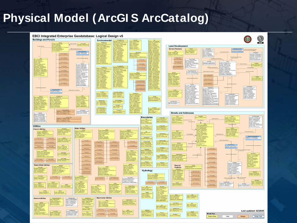
Physical Model (ArcGIS ArcCatalog)

EBCI IGISGeodatabase Design/Prototype Presentation
Land Development
SITE PLAN REVIEW PROCESS

•The IGIS Enterprise Model was built around the Site Plan Review Process–Identified by EBCI as a primary target for
process improvement–Integral part of any construction project to be
implemented by EBCI–Engages majority of departments that use GIS–Encompasses majority of GIS layers currently in
use at EBCI–Includes many layers not currently captured but
targeted for IGIS enhancement (e.g. parcels)
Site Plan Review Process
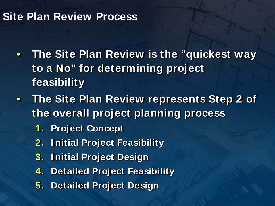
• The Site Plan Review is the “quickest way to a No” for determining project feasibility
• The Site Plan Review represents Step 2 of the overall project planning process1. Project Concept2. Initial Project Feasibility3. Initial Project Design4. Detailed Project Feasibility5. Detailed Project Design
Site Plan Review Process

• What is the project?• Who has the authority to approve the
project?• Who is going to fund the project?• Who is going to manage the project?
Project Concept

• Where is the project located?• Who owns the land?• What structures are located on the project site?• What facilities are available?• Are there any environmental factors?• Does the project involve land clearing?• Is erosion control required?• Is the project in a flood plain?• Will any threatened or endangered species be
impacted?• Will any historical sites be impacted?
Initial Project Feasibility

• Slope• Elevation• Flood data• Parcel• Aerial photography• Site boundary• Soils
• Archeological Assessment
• Detailed Environmental Review
• Engineering Approval
• Feasibility for:– Roads
– Houses
– Houses with basements
– Utilities
– Septic Systems
– Farming
Detailed Project Feasibility

Project Review Management Application (PRMA)
• 1. Overview • The Project Review Management Application (PRMA) is a
web based solution designed to allow EBCI staff to review and manage projects.
• The application was developed using Microsoft Silverlight 4 and the Esri ArcGIS API for Microsoft Silverlight / WPF. The following additional technologies are used to support and deploy PRMA:
• 1. Microsoft Windows Server 2008 • 2. Microsoft SQL Server 2008 • 3. Microsoft IIS 7 • 4. Esri ArcGIS Server 10 SP1 • 5. Esri ArcSDE 10 SP1

The application has three functional areas, the header, map, and footer.

2. Authentication
•The PRMA is designed to work with Windows Authentication (Active Directory).
•The application administrator has assigned users to either an Editor or Viewer group.
•When a user accesses the application the user is prompted to enter a User Name and Password.

3. Map

Footer Create New Project
GeoProcessing
Document Management
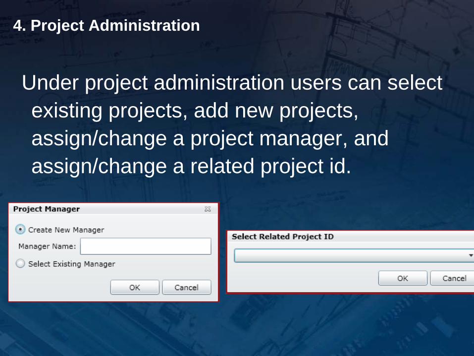
4. Project Administration
Under project administration users can select existing projects, add new projects, assign/change a project manager, and assign/change a related project id.
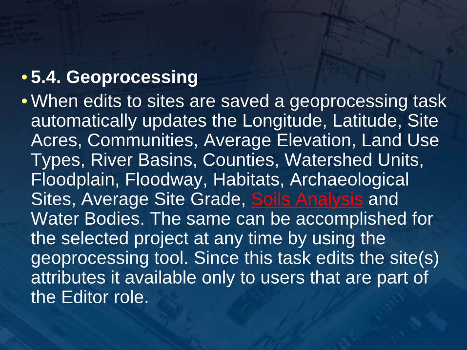
• 5.4. Geoprocessing • When edits to sites are saved a geoprocessing task automatically updates the Longitude, Latitude, Site Acres, Communities, Average Elevation, Land Use Types, River Basins, Counties, Watershed Units, Floodplain, Floodway, Habitats, Archaeological Sites, Average Site Grade, Soils Analysis and Water Bodies. The same can be accomplished for the selected project at any time by using the geoprocessing tool. Since this task edits the site(s) attributes it available only to users that are part of the Editor role.

Python Geoprocessing Script• ''• import arcpy, os, math, datetime, urllib2
• #Constants• acre_constant = 43560• ShapeFldName = "SHAPE"• ProjectIDFieldName = "ProjectID"• OIDFieldName = "OBJECTID"
• #Path where the script is stored• path = str(os.path.dirname(os.path.realpath( __file__ ))).replace('\\','/') + '/'
• #ArcSDE connection file must be located in the same path as the script• sde = path + "prma.sde/"
• #Feature Classes used by script• TribalCommunity = sde + "ebci.dbo.TribalCommunity"• Contours = sde + "ebci.dbo.Contours"• LandUse = sde + "ebci.dbo.LandUse"• RiverBasin = sde + "ebci.dbo.RiverBasin"• County = sde + "ebci.dbo.County"• WaterShedUnit = sde + "ebci.dbo.WaterShedUnit"• MapFldHasAr = sde + "ebci.dbo.MapFldHazAr"• Stream = sde + "ebci.dbo.Stream"• Lake = sde + "ebci.dbo.Lake"• Wetland = sde + "ebci.dbo.Wetland"• EndangeredSpecies = sde + "ebci.dbo.Env_Areas_Grid"• HistoricSite = sde + "ebci.dbo.HistoricGrid"• ProjectSites = sde + "ebci.dbo.ProjectPoly"
• #Layers used by script• FloodPlain100Yr = "Flood100Yr"• FloodWay = "FldWay"• arcpy.MakeFeatureLayer_management(MapFldHasAr, FloodPlain100Yr, "Zone_LID = '1005'", "", "")• arcpy.MakeFeatureLayer_management(MapFldHasAr, FloodWay, "Fldway_LID = '1000'", "", "")
• ProjectSitesLayer = "prjSitesLyr"• IntersectLayer = "intLyr"• StreamsLayer = "streamLyr"• LakesLayer = "lakeLyr"• WetlandsLayer = "wetlandLyr"

Project Poly Table Stores Geoprocessing Results

Use of Soils Data in PRMAInterpretive Feature Classes and Interpretive Reports
•Depth to restrictive layer
•Depth to water table
•Dwellings with/without basements
•Septic Tank Absorption Fields
•Local roads and streets
•Farmland Classification
•Small commercial buildings

Integrated Document ManagementThe ImageNow section defines the values that are used by PRMA to read and write documents from the ImageNow document management system using the WebNow technology. • The ImageNow read and write operations are dependent on specific attributes: • name – the valid options are DocRead and DocWrite. • action – the valid options are document and capture. • Drawer – the drawer where documents are stored
• The ImageNowRead and ImageNowWrite nodes require a URL which is defined in the inner text of the node. • In addition to the above items a document type is also required for the integration with ImageNow. • <ImageNow> • <ImageNowRead name="DocRead" action="document" • drawer="GIS-STAGING">http://s-image:8001/webnow/index.jsp?</ImageNowRead> • <ImageNowWrite name="DocWrite" action="capture" • drawer="GIS-STAGING">http://s-image:8001/webnow/index.jsp?</ImageNowWrite> • <DocumentTypes> • <DocumentType>Conceptual Document</DocumentType> • <DocumentType>Construction Document</DocumentType> • <DocumentType>Site Review Permit</DocumentType> • <DocumentType>Right of Way</DocumentType> • <DocumentType>Contract</DocumentType> • <DocumentType>Resolution</DocumentType> • <DocumentType>Environmental Permit</DocumentType> • <DocumentType>Dot Permit</DocumentType> • <DocumentType>Building Permit</DocumentType> • <DocumentType>Inspection</DocumentType> • <DocumentType>Invoice</DocumentType> • <DocumentType>Grant Reporting</DocumentType> • <DocumentType>Owner’s Manual</DocumentType> • <DocumentType>Closeout Document</DocumentType> • <DocumentType>Meeting Minutes</DocumentType> • </DocumentTypes> • </ImageNow>

EBCI IGISGeodatabase Design/Prototype Presentation
QUESTIONS