Embed Size (px)
Citation preview
A PROPOSAL TO IMPLEMENT INTEGRATED GIS SYSTEM IN DISSEMINATING
SPATIAL INFORMATION FOR MALAYSIA DEVELOPMENT APPROVAL
(STAKEHOLDERS AND APPLICANTS) – A CONCEPT PAPER
Hairi Karim1, Dato Abdul Latif Abu Seman 2, Mohamad Azrol Mohamad Dali 2, Siti Zurianah Othman 2, and Siew Chengxi Bernad 3
1 I Net Spatial Sdn Bhd,
Taman Pulai Utama, 81300 Skudai, Johor, Malaysia.
2 Malaysia Productivity Corporation (MPC),
Peti Surat 64, Jalan Sultan,
46904 Petaling Jaya, Selangor, Malaysia.
[email protected] and [email protected]
3 Geotech Solutions Sdn Bhd
27, Jalan 7/40, Taman Pusat Kepong, 52000, Kuala Lumpur
KEY WORDS: Development approval, GIS collaborative solution, stakeholders and users, cost-time-procedure, Geomap solution.
ABSTRACT
Every year, World Bank Group (WBG) is conducting assessment for 190 countries and produces a ranking report based on Doing
Business performance – an initiative to measure benchmark efficiency on business regulation and their enforcement by a sample
study (e.g. for Malaysia is Kuala Lumpur City Hall - DBKL). One of the ranking categories is based on Dealing with Construction
Permits (DCP) which made us proud as announce Malaysia ranks for 2019 is #3 (based on 2018 assessment). This achievement was
based on continues efforts and studies from the last bottom of #137 (since, 2007), #113 (2012) and continues with positive results
(straight improvement) respectively till this year. Maintaining the top three ranks is not an easy task; however, is not impossible
either. Lots of study in innovations, suggestions and implementation should be carried out to maintain and improve Malaysian DCP
ranks. As per DCP of this year assessment, Work Bank has suggested all countries with 5 new suggestions (new additional marking
schema). One of them is to engage Geographic Information System (GIS) for land use, cadastre, water, electricity and sewage related
datasets. This paper propose an initial study (concept paper) towards engaging GIS in DCP activity as a response (first action)
suggested by World Bank Group; crucial in maintaining DCP rank for 2020 as well as to provide better business regulations and
enforcements for DBKL or other local authority. Later, an impact study will be conducted, utilizing new integrated GIS system
publishing service (GeoMap) and the output of the study will indicate whether Malaysia Productive Corporation (MPC) should
engage or ignore the 5th suggestion by World Bank Group, or to enhance with other initiatives.
1. INTRODUCTION
Since 2002, a yearly list of country ranks will be given by
World Bank group (WBG) to indicate a comparative and
statistical report on business regulation for domestic firms
(small and medium companies). The rank and marks are
different based on 11 groups of categories starting from a
business regulation, dealing with construction permits (DCP),
getting electricity, up to labour market regulations. The
objective of this Doing Business project is to measure business
regulations and their enforcement across 190 economies and
selected cities at the subnational and regional level.
The ranking report is an initiative to measure benchmark
efficiency on business regulation and their enforcement by a
sample study (e.g. for Malaysia is Kuala Lumpur City Hall -
DBKL). For 2018 DCP ranking (based on 2018 assessments),
Malaysia is ranked as number 3 out of 190 countries. This
achievement was based on continues efforts and studies from
the last bottom of #137 (since, 2007), #113 (2012) and
continues with positive results (straight improvement)
respectively till now. Maintaining the top three ranks is not an
easy task; however, is not impossible either. Lot of study in
innovations, suggestions and implementation should be carried
out to maintain or improve our DCP ranks. Different
parameters are used for each category in scoring processes;
e.g. DCP - procedures, time and cost to complete all
formalities to build a warehouse and the quality control and
safety mechanisms in the construction permitting system
(WBG, 2019). As per DCP of this year assessment, WBG has
suggested all countries with 5 new suggestions (new
additional marking schema). One of them is to engage with
Geographic Information System (GIS) for land use, cadastre,
water, electricity and sewage related datasets. GIS technology
hopefully gives significant impact on minimizing procedure of
acquiring preliminary geospatial data and reduce the cost with
a good quality index performance.
GIS is a term refers to a digital system designed to capture,
store, manipulate, analyse, manage, present and disseminate
spatial or geographic data (Cantwell and Milem, 2010) for
public or decision makers. The system utilises spatial data and
attributes (related tabular information/characteristic of its
spatial data) for decision making process of particular the area
for example for development, environment protection,
security, businesses development, taxation, and other
inventory tasks.
The International Archives of the Photogrammetry, Remote Sensing and Spatial Information Sciences, Volume XLII-4/W16, 2019 6th International Conference on Geomatics and Geospatial Technology (GGT 2019), 1–3 October 2019, Kuala Lumpur, Malaysia
This contribution has been peer-reviewed. https://doi.org/10.5194/isprs-archives-XLII-4-W16-347-2019 | © Authors 2019. CC BY 4.0 License.
347

Figure 1: Applied GIS around the world across disciplines,
professions and organizations (ESRI, 2007).
Most of the authorities either in local, state, federal / national,
regional or international (global) levels have fully utilize GIS in
order to have better understanding, information, control and
good planning for their respective jurisdiction area (as
illustrated in Figure 2). Each and every authority may have the
same spatial database standard (for data viewing and retrieval),
but normally having different purpose (specific task) or for
respective application/system as their operation is concerned
(e.g. approval for construction permit).
In general, Malaysian administrative system is divided into
three major levels; Federal Government, State Government and
Local Government. The planning powers of local authorities
(Local Government Act 1976 (Act 171)) were stipulated in the
allied Town and Country Planning Act (Yaakup et al., 1998).
The act stated that the local authority shall be the local planning
authority for the area of the local authority (a right to grant or
refuse any planning application as well as to monitor the
progress quality). Thus, local authority shall engage and
collaborate with other stakeholders such as utility providers
(water, electricity, gas etc), infrastructures (e.g.
road/transportation, drainage), and the development applicants
(e.g. developer) for any development application request.
Figure 2: GIS spatial modelling for better management
especially for authorized body.
Figure 3: DBKL jurisdiction boundary
2. BACKGROUND OF THE STUDY
This section discusses brief summary on current
implementation approaches. Previously before 2007 (One
Stop Centre - OSC was fully implemented in all local
authorities on June 2007), local authority has their own set of
procedures in dealing and controlling construction approval
permit. For example, DBKL uses its own set of procedures
assisted with GIS in Figure 4. As for current practice, all local
authorities have engaged with OSC model (will be discussed
in section 2.1) for their development approval process.
Figure 4: Example of self-procedure and GIS function at
DBKL for DCP before 2007 (Foziah et al., 2006).
While for DCP scoring (DCP world ranking) by WBG, a
concerned basically is given to tracks the efficiency of
procedures, minimum time and cost for a new development
design including obtaining necessary the licenses and permits,
submitting all required notifications, requesting and receiving
all necessary inspections and obtaining utility connections at
the proposed area. In addition, it also measures the building
quality control index, evaluating the quality of building
regulations, the strength of quality control and safety
mechanisms, liability and insurance regimes, and professional
certification requirements.
The International Archives of the Photogrammetry, Remote Sensing and Spatial Information Sciences, Volume XLII-4/W16, 2019 6th International Conference on Geomatics and Geospatial Technology (GGT 2019), 1–3 October 2019, Kuala Lumpur, Malaysia
This contribution has been peer-reviewed. https://doi.org/10.5194/isprs-archives-XLII-4-W16-347-2019 | © Authors 2019. CC BY 4.0 License.
348

Some indications/scores to be measured by WBG are but not
limited to:
1. Procedures to legally build a warehouse/building
(number)
a. Submitting all relevant documents and obtaining all
necessary clearances, licenses, permits and
certificates.
b. Submitting all required notifications and receiving all
necessary inspections
c. Obtaining utility connections for water and sewerage
d. Registering and selling the warehouse/building after
its completion
2. Time required to complete each procedure (calendar
days):
a. Does not include time spent gathering information
b. Each procedure starts on a separate day - though
procedures that can be fully completed online are an
exception to this rule
c. Procedure is considered completed once final
document is received
d. No prior contact with officials
3. Cost required to complete each procedure (% of
income per capita):
a. Official costs only, no bribes
b. Building quality control index (0-15)
c. Quality of building regulations (0-2)
d. Quality control before construction (0-1)
e. Quality control during construction (0-3)
f. Quality control after construction (0-3)
g. Liability and insurance regimes (0-2)
h. Professional certifications (0-4)
Figure 5: 2018 DCP ranking score for Malaysia and other highlighted countries.
Note: The ranking of economies on the ease of dealing with construction permits is determined by sorting their scores for dealing
with construction permits. These scores are average scores.
2.1 Current Procedures
New Model of OSC 3.0
Start end
Pre-
negotiations
Approval of
proposed design
Notice to start the
construction work
Interim
Inspection
Inspection 1
& II (final)
CCC deposit
and Form G
Process 1 Process 2 Process 3 Process 4 Process 5 Process 6
Figure 6: New OSC model (3.0) for planning approval.
The International Archives of the Photogrammetry, Remote Sensing and Spatial Information Sciences, Volume XLII-4/W16, 2019 6th International Conference on Geomatics and Geospatial Technology (GGT 2019), 1–3 October 2019, Kuala Lumpur, Malaysia
This contribution has been peer-reviewed. https://doi.org/10.5194/isprs-archives-XLII-4-W16-347-2019 | © Authors 2019. CC BY 4.0 License.
349

Table 1: Number of procedures, involvement from related agencies, and time/cost involve for a development project at RM2 million.
No Procedure Agency Days Charge
1 Obtain technical conditions from the Water Authority
SYABAS
SYABAS 2 days no charge
2 Submit and obtain development approval through OSC OSC 30 days RM 3,600
3 Submit pre-construction notifications to OSC OSC 1 day no charge
4 Request final utilities inspections through OSC OSC 1 day 2,163
5 Receive road and drainage inspection Eng. DBKL 1 day no charge
6 Receive final inspection from water utility SYABAS 1 day no charge
7 Obtain sewerage connection IWK 12 days RM 20,821
8 Receive fire safety inspection Fire & Rescue
Dept.
1 day no charge
9 Obtain clearance letters from OSC - single window OSC 1 day no charge
10 Builder’s principal submitting person files certificate of
completion and compliance (CCC)
OSC 1 day no charge
11 Obtain water connection SYABAS 3 days RM 1,600
Total : Procedure 11 54 days RM 28,184
Phase 1 (P1):
• Pre-negotiation is COMPULSORY for MCMC, SYABAS,
TNB, PTD, LPHS (residential development> 5 acres and
above) and KSAS (development in Class III and above).
• Pre-negotiation reviews (LPHS review letter and letter of
approval of environment Sensitive Area Committee (KSAS)
it is compulsory) while the application for process may be
submitted together with pre-negotiated notification letters
have been made.
Phase 2 (P2):
Land matters must be completed at the Planning Permission
Application stage. The land premium must be settled before
submitting an Application Plan for Infrastructure and Building
Plan simultaneously or separately.
• Simultaneous Application (KM + INF + BGN) is only
allowed if the land deal has been resolved.
• Planning Planner provides KM compliance reviews at the
Building Plan level for development that has been approved
by KM. For additional applications and temporary building
permits, JPP reviews are subject to certain cases only.
• Solid Waste Management and Public Cleansing Department
(JPSPPA) provide comments on the Planning Permission
application stage involving strata development only.
In general there are two project categories (small and medium)
which fall under this procedure. These two categories also
subdivided by the source of the project as follow:
• Project categories based on Ministry of Housing and Local
Government
• Special OSC Category Projects
2.2 Category of Projects
2.2.1 Small Scale
Small scale projects involve concurrent applications for
proposed development for residential buildings as follows:
i. Proposed addition and change to an existing house and;
ii. A new proposal for a single residential unit;
iii. Proposal to demolish and rebuild a single house.
The International Archives of the Photogrammetry, Remote Sensing and Spatial Information Sciences, Volume XLII-4/W16, 2019 6th International Conference on Geomatics and Geospatial Technology (GGT 2019), 1–3 October 2019, Kuala Lumpur, Malaysia
This contribution has been peer-reviewed. https://doi.org/10.5194/isprs-archives-XLII-4-W16-347-2019 | © Authors 2019. CC BY 4.0 License.
350
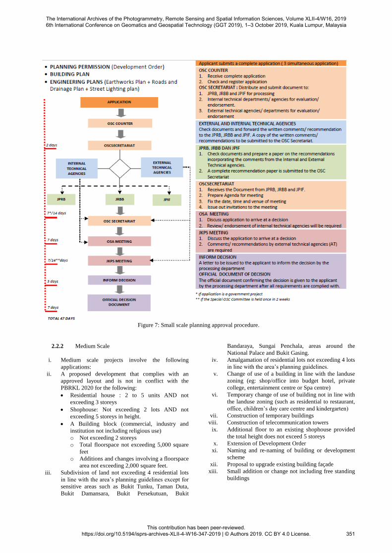
Figure 7: Small scale planning approval procedure.
2.2.2 Medium Scale
i. Medium scale projects involve the following
applications:
ii. A proposed development that complies with an
approved layout and is not in conflict with the
PBRKL 2020 for the following:
Residential house : 2 to 5 units AND not
exceeding 3 storeys
Shophouse: Not exceeding 2 lots AND not
exceeding 5 storeys in height.
A Building block (commercial, industry and
institution not including religious use)
o Not exceeding 2 storeys
o Total floorspace not exceeding 5,000 square
feet
o Additions and changes involving a floorspace
area not exceeding 2,000 square feet.
iii. Subdivision of land not exceeding 4 residential lots
in line with the area’s planning guidelines except for
sensitive areas such as Bukit Tunku, Taman Duta,
Bukit Damansara, Bukit Persekutuan, Bukit
Bandaraya, Sungai Penchala, areas around the
National Palace and Bukit Gasing.
iv. Amalgamation of residential lots not exceeding 4 lots
in line with the area’s planning guidelines.
v. Change of use of a building in line with the landuse
zoning (eg: shop/office into budget hotel, private
college, entertainment centre or Spa centre)
vi. Temporary change of use of building not in line with
the landuse zoning (such as residential to restaurant,
office, children’s day care centre and kindergarten)
vii. Construction of temporary buildings
viii. Construction of telecommunication towers
ix. Additional floor to an existing shophouse provided
the total height does not exceed 5 storeys
x. Extension of Development Order
xi. Naming and re-naming of building or development
scheme
xii. Proposal to upgrade existing building façade
xiii. Small addition or change not including free standing
buildings
The International Archives of the Photogrammetry, Remote Sensing and Spatial Information Sciences, Volume XLII-4/W16, 2019 6th International Conference on Geomatics and Geospatial Technology (GGT 2019), 1–3 October 2019, Kuala Lumpur, Malaysia
This contribution has been peer-reviewed. https://doi.org/10.5194/isprs-archives-XLII-4-W16-347-2019 | © Authors 2019. CC BY 4.0 License.
351

Figure 8: Medium scale planning approval procedure.
2.3 Availability of Online Mapping Platform
Advanced technology recent years has support complex
development on mapping system / platform; especially for data
sharing and security across multiple users and data sources.
Various mapping related applications newly developed to
emerge the platform from basic / simple approach such as
utilizing single geo-database with multiple applications to the
most complex systems (e.g. multiple users, data sources and
payment gateway for purchasing online data).
Three current main architecture categories in GIS system
implementation are; Stand-alone (working with only a
machine), Enterprise (organization own GIS unit) and
Integrated architecture (where users can have benefits from
combined data of various stakeholders/data providers).
Figure 9: Example of web-map infrastructure revolution from
single organization uses to collaborated system (ESRI, 2007).
The International Archives of the Photogrammetry, Remote Sensing and Spatial Information Sciences, Volume XLII-4/W16, 2019 6th International Conference on Geomatics and Geospatial Technology (GGT 2019), 1–3 October 2019, Kuala Lumpur, Malaysia
This contribution has been peer-reviewed. https://doi.org/10.5194/isprs-archives-XLII-4-W16-347-2019 | © Authors 2019. CC BY 4.0 License.
352
3. THE STUDY CONCERN
This section will be divided into three sub-section;
aim/objective, target stakeholders, data/study area.
3.1 Aim and Objectives
The aim of this paper is to conduct and present the initial study
(impact) of the 5th World Bank Group’s suggestion for DCP;
to link the Geographic Information System (GIS) for land use,
cadastre, water, electricity and sewage dataset.
While the objectives of this concept paper are:
i. To provide working solution engaging GIS system for
DCP (assist PSP/SP gather initial information and data
before submitting plan.
ii. To assess impacts on facilitating preliminary data
gathering using integrated GIS architecture.
iii. To assess the satisfactory and user friendly of this
solution, comments among stakeholders and submitting
entity (developers/agent -PSP/SP).
iv. To recommend improvement of future GIS system
(requirements) and promotion strategies to attract more
participating stakeholders.
3.2 Targeted Stakeholders
The main stakeholder involve in this study is DBKL personnel
which involve directly with DCP/planning approval procedures
(1st and 2nd phases). Other stakeholders are from infrastructure
and utility providers such as:
CIDB
Jabatan Kerja Raya JKR
SYABAS Berhad (fresh water)
Indah Water Konsortium, IWK (Sewage)
Tenaga National Berhad, TNB (electric)
Gas Malaysia
The targeted users are submitting person / agent / developer /
planning approver applicant of DBKL.
3.3 Data and Study Area
The data involve with DCP Malaysia is (but not limited to)
within sample of DBKL boundaries:
• Land Use
• Cadastre
• Water
• Electricity
• Sewage Dataset
• Other GIS dataset
Optional data such road network, topo map (rivers, land
covers, man-made features e.g. buldings are also included).
Proposed drawing layout and as-built progress also could be
used later in the proposed system.
Proposed study area is Kuala Lumpur Commercial Centre
(KLCCC).
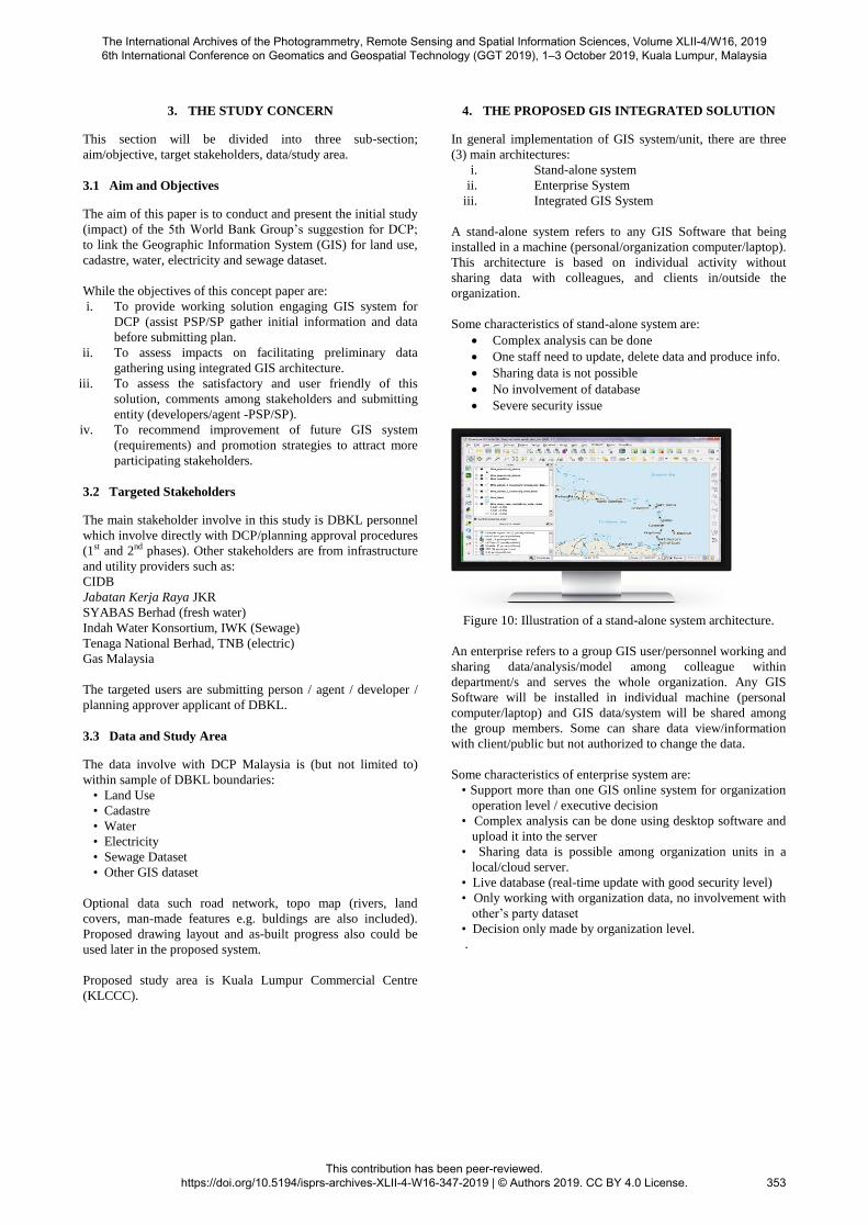
4. THE PROPOSED GIS INTEGRATED SOLUTION
In general implementation of GIS system/unit, there are three
(3) main architectures:
i. Stand-alone system
ii. Enterprise System
iii. Integrated GIS System
A stand-alone system refers to any GIS Software that being
installed in a machine (personal/organization computer/laptop).
This architecture is based on individual activity without
sharing data with colleagues, and clients in/outside the
organization.
Some characteristics of stand-alone system are:
Complex analysis can be done
One staff need to update, delete data and produce info.
Sharing data is not possible
No involvement of database
Severe security issue
Figure 10: Illustration of a stand-alone system architecture.
An enterprise refers to a group GIS user/personnel working and
sharing data/analysis/model among colleague within
department/s and serves the whole organization. Any GIS
Software will be installed in individual machine (personal
computer/laptop) and GIS data/system will be shared among
the group members. Some can share data view/information
with client/public but not authorized to change the data.
Some characteristics of enterprise system are:
• Support more than one GIS online system for organization
operation level / executive decision
• Complex analysis can be done using desktop software and
upload it into the server
• Sharing data is possible among organization units in a
local/cloud server.
• Live database (real-time update with good security level)
• Only working with organization data, no involvement with
other’s party dataset
• Decision only made by organization level.
.
The International Archives of the Photogrammetry, Remote Sensing and Spatial Information Sciences, Volume XLII-4/W16, 2019 6th International Conference on Geomatics and Geospatial Technology (GGT 2019), 1–3 October 2019, Kuala Lumpur, Malaysia
This contribution has been peer-reviewed. https://doi.org/10.5194/isprs-archives-XLII-4-W16-347-2019 | © Authors 2019. CC BY 4.0 License.
353

Figure 11: Example of an Enterprise GIS system for an
organization
An integrated GIS system refers to groups GIS users from
various organizations which can share and link their
dataset/system together and create a pool of integrated user and
information from various GIS datasets. They also can view and
extract information from other organization dataset as the
mutual agreement/common policies/aims of the organizations
group (stakeholders). It is also known as a collaborative
network in sharing GIS information.
Figure 12: Illustration of an integrated GIS system architecture.
Some characteristics of integrated GIS system are:
Support more than one GIS online system for
organization operation level / executive decision
Complex analysis can be done using desktop
software and upload it into the server
Sharing data becomes necessary among organization
units in a local/cloud server.
Live database (real-time update with good security
level)
Sharing/Editing data to stakeholders other than the
designated pool is not possible.
Figure 13: Another example of Integrated system,
data/stakeholders/community contributing the spatial
information.
4.1 Proposed Architecture (Integrated/Collaborative
Network)
This solution enables not only the sharing of geospatial
information within an organization but also within a common
group/platform, as well as state/national level.
With the framework of technologies, policies, and institutional
arrangements, together facilitate the creation, exchange, and
use of geospatial data and related information resources across
an information-sharing community. GeoMap allows data
sharing within designated groups and only sharing within that
social circle. This gains flexibility in data accessibility as well
as enabling highly scalable system integration. Besides that,
integrated GIS architecture enables environment that supports
easy access to and utilization of geospatial data. SDIs are more
than just data repositories:
Discovery catalogues, search engine
Visualization interactive maps, infographics, real time
data, etc.
Evaluation quality, metadata
Access to geospatial data and information web-based,
apps, services, GIS
Figure 14 and Figure 15 depicted scenarios where GIS can be
collaborated through network via most frontier technology,
such as Web API and related frameworks. Data security and
accessibility can be both taken care working with a common
platform. Vendor specific accessibility is also available in
GeoMap. Figure 16 depicted a scenario where data sharing is
only available in a closed group, such as a specific initiative or
collaboration, GeoMap provides such flexibility and
customizability to allow data provider share within only
groups.
Besides, Figure 17 shows the typical system architecture that
allows system integrators and different components to connect
and collaborate through a common API standard. Figure 18
and Figure 19 show how the proposed Geomap publisher
provides a solution for integration of different stakeholders
dataset within a specific groups and managing the projects as
per development request by applicants. Lastly, Figure 20 and
Figure 21 show example of map viewer using vector and
imagery dataset supported in the geomap publisher service
(proposed solution for integrated DCP).
Stakeholder A, B, C, D, E, …
The International Archives of the Photogrammetry, Remote Sensing and Spatial Information Sciences, Volume XLII-4/W16, 2019 6th International Conference on Geomatics and Geospatial Technology (GGT 2019), 1–3 October 2019, Kuala Lumpur, Malaysia
This contribution has been peer-reviewed. https://doi.org/10.5194/isprs-archives-XLII-4-W16-347-2019 | © Authors 2019. CC BY 4.0 License.
354

Figure 14: Requirement and flow for initiating integrated system with multiple stakeholders. (Rahabifard et al., 2002)
Figure 15: Example of a general integrated/collaborative architecture sharing design.
Figure 16: Example stakeholder hierarchy in sharing the aim/collaborative system in the proposed DBKL DCP group.
The International Archives of the Photogrammetry, Remote Sensing and Spatial Information Sciences, Volume XLII-4/W16, 2019 6th International Conference on Geomatics and Geospatial Technology (GGT 2019), 1–3 October 2019, Kuala Lumpur, Malaysia
This contribution has been peer-reviewed. https://doi.org/10.5194/isprs-archives-XLII-4-W16-347-2019 | © Authors 2019. CC BY 4.0 License.
355

Figure 17: The typical GeoMap architecture over the web utilizing frontier API technology.
Figure 18: Example of joining a particular/private user group shared dataset from other group members (View My group-the
account as Parent; View Other Group-the account as child/members – refers to Figure 16).
Figure 19: Proposed GIS integrated solution provides Project Management as for local authority and stakeholders to manage
different location or development application from developers.
GeoMap Publisher
GeoMap Client
GeoMap Server
WEB
A
P
I
Database
Server
Other data sources
INTERNET
The International Archives of the Photogrammetry, Remote Sensing and Spatial Information Sciences, Volume XLII-4/W16, 2019 6th International Conference on Geomatics and Geospatial Technology (GGT 2019), 1–3 October 2019, Kuala Lumpur, Malaysia
This contribution has been peer-reviewed. https://doi.org/10.5194/isprs-archives-XLII-4-W16-347-2019 | © Authors 2019. CC BY 4.0 License.
356

Figure 20: Example of GeoMap online viewer (vector dataset shared in a potential local authority DCP group) based on SDI
concepts and enabling collaborative GIS architecture system (Figure 14 and 15).
Figure 21: Example of GeoMap client viewer for shared imagery (e.g. from UAV drone) for other stakeholders and
developer/applicant account.
The proposed solution (integrated solution, using Geomap
service) will be discussed in details as the study progress of
this initiative go further as well as for testing the dataset,
security and functionality of the system. Some input from
potential stakeholders and applicants will be discussed in the
next publication.
5. CONCLUSION
The proposed concept/idea ultimately provides great benefits
for local authority such as DBKL and other especially by
simplifying the work, procedure and time taken for completing
the requested development approval (kebenaran merancang –
KM). This proposed solution directly will minimize the time
taken for process 1 and process 2 (P1 and P2) in OSM v3.0
model. It will help a lot in acquiring and validating
stakeholders GIS dataset (utility, infrastructure and
topography) such as pipeline from SYABAS/IWK, cable and
PE of TNB (Tenaga National Berhad), proposed design from
developer/applicant, road and drainage from JKR (Public
Works Department) and JPS (Department of Irrigation and
Drainage) and topographic dataset. By providing all necessary
dataset from each involved stakeholders (security is well
secured), there is no need to make appointment and site visit
for each stakeholders with applicant and local authority
personnel. Some cost also could be reduced since the time
taken and mobilization are reduced greatly.
An impact study using this proposed solution is in progress
when this paper is accepted. The proposed solution utilizes the
available integrated GIS solution - GeoMap service (trial
version). Involvement and suggestion from stakeholders will be
acquired to assess the impact and related policies involving
stakeholders, especially in dataset sharing. The result from this
study determines whether we should engage or ignore the 5th
suggestion by World Bank Group, or to enhance with other
initiatives.
The International Archives of the Photogrammetry, Remote Sensing and Spatial Information Sciences, Volume XLII-4/W16, 2019 6th International Conference on Geomatics and Geospatial Technology (GGT 2019), 1–3 October 2019, Kuala Lumpur, Malaysia
This contribution has been peer-reviewed. https://doi.org/10.5194/isprs-archives-XLII-4-W16-347-2019 | © Authors 2019. CC BY 4.0 License.
357

REFERENCES
B. Cantwell, J.F. Milem, 2010. International Encyclopedia of
Education (Third Edition)
ESRI, 2007. A Framework for Understanding, Managing, and
Improving Our World. In ArcNews Online 2007.
https://www.esri.com/news/arcnews/fall07articles/gis-the-
geographic-approach.html
Foziah Johar, Ahris Yaakup, Noordini Che’Man, Susilawati
Sulaiman, and Mahadi Che Ngah., 2006. GIS in Development
Control Process: The Case of Development Control System for
City Hall of Kuala Lumpur. 6th ASIAGIS Conference,
Malaysia March 9 – 10 ,2006.
Manual Submission of Development Proposals Through the
One Stop Center (OSC), City Hall Kuala Lumpur
Rajabifard, A., Feeney, M.-E.F. and I.P. Williamson (2002).
Directions for the Future of SDI Development, International
Journal of Applied Earth Observation and Geoinformation,
4(2002): 11-22
WBG, 2019. A World Bank Group Flagship Report, 16th
Edition, 2019. Doing Business (Training for Reform).
Yaakup, A., F. Johar, and I.M. Yusof. Development Control
System and GIS for Local Authority in Malaysia: A Case of
Kuala Lumpur City Hall. In Design and Decision Support
Systems in Architecture and Urban Planning. DDSS.
Maastricht, The Netherlands: Eindhoven University of
Technology, 1998. http://papers.cumincad.org/data/works/att/ddss9863.content.pdf
Revised August 2019
The International Archives of the Photogrammetry, Remote Sensing and Spatial Information Sciences, Volume XLII-4/W16, 2019 6th International Conference on Geomatics and Geospatial Technology (GGT 2019), 1–3 October 2019, Kuala Lumpur, Malaysia
This contribution has been peer-reviewed. https://doi.org/10.5194/isprs-archives-XLII-4-W16-347-2019 | © Authors 2019. CC BY 4.0 License.
358