Embed Size (px)
Citation preview

I N T - 0 1 5 1 / ^
DESEHTIFICATIOIÍ IN LATIN AMERICA FROM AN ECOLOGICAL AND AGRICULTURAL VIEWPOINT
Fernando Suárez de Castro
This docxunent vas preisented at the Regional Preparatory Meeting for the Americas held at Santiago, Chile, from 23 to 26 February 1977 in preparation for the United Nations Conference on Desertification to be held at Nairobi, Kenya, from 29 August to 7 September 1977»
77-2-411


t 1
DESEKTIFICATION IN LATIN AMERICA FHOM AN ECOLOGICAL AND ; AGRICULTUSAL VIEV/POINT
by Fernando Suárez de Castro ^
Ao GENERAL CONSIDERATIONS
1. It might be as well, before entering into a discussion of this subject» to attempt to define the meaning of some terms connected with it so as to ensure that wherever they are used the sane phenomenon or situation is being described» Only with cleai-ly defined terminology is it possible to avoid confusion v;hich gives rise to misunderstandings, divergences and even conflicts, or even more serious, to apparent agreement which conceals marked differences in the understanding and evaluation of the situations described. 2. The first term that must be defined is the recently coined word desertification. We understand that it is intended to identify the process of degradation of arid or semi-arid zones, which culminates in the transformation of such zones into unproductive deserts. Desertification would therefore be a form of deterioration of a specific ecosystem, taking place over fairly long periods and for different reasons, which we shall try to give later in this study. The term is intended to have a geographic scope reaching only to the borders of the zones with scarce rainfall, which excludes the extensive humid regions, or areas with sufficient rainfall for the continuous production of agricultural crops. 3- The discussion of desertification thus deliberately omits the problem of the deterioration of large areas situated outside the arid zones, as a result of the improper use of agricultural land which
^ Director of Operation Analysis, Inter-American Institute of Agricultural Sciences, San Joss, Cesta Kira.
The author would like to express his gratitude for the co-operation of Dr. Peter Duisberg, who reviewed the study and contributed some interesting suggestions.
/causes or

» »
- 2 -
causes or favours water erosion or the destruction of thé-soil's productive potential by rain. /f, .In,Latin America-, this deterioration of humid regions is of great significance since it affects extensive and densely populated areas and threatens territories with a vast productive potential. We refer, in the first case, to regions such as those located within the boundaries of Haiti, and in the second case to areas of such importance,for the future of the continent as the Amazon region. Therefore, the desertification referred to in this study does not cover the complete range of phenomena causing the destruction of land in Latin America, but is confined to arid and semi-arid regions, which present very special features and require treatment accordingly. 5« The terms extremely arid, arid, and semi-arid are used to designate regions in which rainfall is either non-existent or very scarce, so that ecosystems develop with special characteristics. Under such conditions, agricultural and livestock activities range from "impossible" to "very difficult and limited" or merely "difficult and requiring special care". Rainfall, when it occurs in arid zones, is infrequent and irregular; it covers small areas and is often very heavy, so that not infrequently almost the whole of the annual rainfall occurs in the form of one or two showers. 6. Several indexes have been developed for the classification of climates, and these can be used to establish the climatic characteristics of arid ^ones. Among them may be mentioned Martone's equation which relates rainfall with temperature, and Thornthwaite's index which relates rainfall with potential evapotranspiration (or the evaporation from a surface completely covered with vegetation, when there is moisture permanently available), taking into account the length of the day and the temperature.l/ Professor Meigs was commissioned by UNESCO
1/ It is worth noting that there is much discussion regarding the accuracy or usefulness of the various indexes developed for the climatological classification of geographical regions. From a practical point of view, however, the predominating factor for distinguishing deserts (or extremely arid zones) arid zones and semi-arid zones, all other factors being equal, should be the extent to which they can be used by man according to the climatic conditions, especially those related to the availability of water for plants and animals. ^̂ ^̂ work
• -
- 3 -
to work on this basis on the preparation of a map showing the distribution of arid land in the world, from which the map of Latin America included here (with some modifications) has been extracted. 7. Needless to say, although the essential characteristic factor of arid zones is the small quantity and irregularity of the rainfall, there are many other factors involved such as temperature, insolation, relative humidity, evaporation, vegetation, and composition of the soilo^ 8« With the purpose of differentiating zones with varying degrees of aridity on an ecological and agricultural basis, it'might be said that, according to the criteria applied in Argentina,3/ for extensive or common agriculture to be successful in a semi-arid region it would have to be practised with the aid of special techniques for the storage, conservation and use of rain-water; arid regions, for their part, receive so little rain that even if dry farming techniques are used there is not enough precipitation to cover the needs of such common crops as cereals and cotton,while in extremely arid regions there is insufficient rainfall for the needs of any kind of natural vegetation except, in some cases, a few widely-scattered specialized plants, such regions often suffering from a complete lack of rainfall f-or continuous periods of as much as 12 monthso2/ Some authors add that a feature of these desert zones
2/ A sound discussion of the hydrometereological factors used in the classification of arid zones may be found in the study by C.C. Walter, "Climatologyand hydrometeorology v/ith special regard to the arid lands" in The problems of the arid zones. Proceedings of the Paris Symposium' UNESCO, 1962,
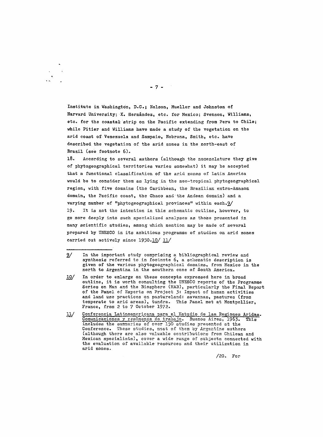
J/ For a full description of arid and semi-arid land in Argentina, the report presented by the delegation of that country at the Latin American Conference for the Study of Arid Regions, held at Buenos Aires in 1963i may be consulted.. (Comité Argentino para el Estudio de las Regiones Aridas y Scmiáridaso Ig^s^tierras áridas y semi-áridas de la Repuhlica Argentina, Informe líacional, Buenos Aires, 1963, pages.)
4/ E.S. Hills, Ed. Arid lands. A geographical appraisal. Methuen and Co. and UNESCO, London, 19697^61 pages.
/is that

J
- 4 -
is that it has never been possible to use them for permement pasture, even after the surrounding areas have been occupied for over 50 years, which is-a clear sign of their absolute inhospitability even for the most extensive-and iHeágré agricultural use.
. B. ARID AND SEMI-AEID ZONES OF LATIN AMERICA
9., . These data can be used to characterize the dry, arid or semi-arid regions of Latin America, the distribution of which is shown in the attached map prepared by Professor Meigs for UNESCOo It will be seen that these regions are located for the most part in Argentina, Chile, Brazil, Peru, Venezuela and Mexico. 10. In Argentina it is estimated that the semi-arid region covers an area of million hectares (or 15 per cent of the whole area of the country), while the arid region covers 170 million hectares, or .60 per cent of the whole territory, so that more than 75 per cent of the continental area of Argentina is affected by "arid conditions" (see footnote 3)« The semi-arid region is divided into two sub-regionsi • t the Pampa and the Chaco; and the arid region includes five sub-regions: .the.€haco, pre-punp, Andean puno, monte and Patagonia (see footnote 3)« The, economic importance of the semi-arid region of Argentina may be gauged not only from the extensive area it covers, but also from the existence in it of over 10 million head of cattle, over 5 million hectares sown to cereals and industrial crops and a similar area sown to forage cropis.
In the arid region, it is worth noting that there are over 5 million head of cattle and about 20 million sheep (see footnote 5)-11. Over half the territory of Chile may be considered extremely arid, arid or semi-arid. This huge region includes the Norte Grande,wwith the provinces of Tarapacá and Antofagasta in which the Atacama Desert is situated; the Norte Chico, with the provinces of Atacaraa and Coquimbo; and the Central Zone (semi-arid). There is important mining ?ictivity, especially in the north, while the Central Zone is the heart of the country, because of the concentration of population there and its agricultural and industrial production.
/12. In

- 5 -
l2o In. Peru the arid zone comprises a narrow coastal strip which extends.the length of the Pacific coast; although it receives less rainfall than the Sahara, it is the centre of the country's economic and cultural life, since the rivers that rise in the Andean foothills and flow into the Pacific have created some 50 oases which constitute as many rich centres of irrigated agriculture« In the highlands, the semi-arid Altiplano with its extensive plains of natural grasses of low subsistence capacity provides sustenance for a sizable population of animals of the Camelidae family and sheep which, together v/ith mining, constitute the main wealth of this depressed region populated mainly by the original Indian inhabitants and extending up to Bolivia, where it is the most densely populated area of the country.. 13. In Brazil, the arid and semi-arid areas are found in the north-east, vihose worst feature is the exceedingly irregular rainfall which causes severe droughts in the region; the problems of poverty due to over-population and the aridity of the soil are very serious and, although large-scale irrigation projects have been carried out in this region over the past years and there has been mass migration to more humid areas, the basic ecological and social problems have not yet been completely solved. 1^0 In Venezuela the dry zones comprise Guajira (the dry zone also extends to that part of Guajira which is in Colombia), the land in the northern part of the Maracaibo depression, the west coast of Falcon, the Paraguaná Peninsula, the Barquisimeto highlands, the lands bordering on the Gulf of Cariaco, and various parts of Margarita Islando_^ 7/ 15* In Mexico, about 57 million hectares inhabited by approximately 8 million persons are classified as arid; this huge territory covers part of the States of Baja California, Sonora, Chihuahua, Coahuila,
^ An excellent study vjhich was v/idely consulted in preparing this article is that by AoL» Cabrera, "Latin America" in UNESCO, Plant ecologyo Review of research, Paris, 1955j PP- 77-113= The attached bibliography includes 2Si publications which represent a very v;ide collection of studies on this subject published up to 1955-
2/ Marco Aurelio Vila, Las sequías en Venezuela. Fondo Editorial Común, S.C., Caracas, 1975> 176 pages-
/Durango, Zacatecas,

- 6 -
DurangOt ZacatecaSf San Luis Potosit Nuevo León, Tamaulipas, QuerétarOt Hidalgo, Puebla, Oaxaca, and-Territorio de Baja California. The semi-arid zones cover about a'f million hectares, mostly bordering on the ^^rid-zone.^ 16. , Owing to the lack of moisture and consequent absence of vegetation in the a,rid zones, the soil is generally undeveloped, the degree of immaturity being such that it frequently consists of simple accumulations of partially decomposed rock material. There is no vegetable mould and therie may be quite a high accumulation of minerals that are not dissolved in water and so cannot be assimilated by the plants. The organic material content of the surface horizon is generally less than 1 per cent, and the neighbouring horizons show calcium accumulations which may become consolidated in the form of saline crusts. This type of soil tends to accumulate sodium salts if there is contact with water and poor drainage, and it is commonly found to contain materials that are carried by the wind and deposited on the surface (see footnotes 3t 6 and 8). Sometimes the removal by erosion of the,surface horizon, which consists of a very few centemetres of useful soil, uncovers a deserty-type paving with a great quantity of pebbles and ruts which show the brilliant burnished surface of the desert (see footnote 5)» It may be added that since no mineral elements are lost through léaching, the soil in arid zones is often rich in minerals and capable of producing abundant crops when irrigated, 17. The vegetation has been studied in the various phytogeographical regions, domains, and provinces. Some studies which may usefully be consulted are those by MacDougal and his colleagues of the Carnegie
8/ For a description of the arid and semi-arid zones of Mexico, see Comité Mexicano de Zonas Aridas, Informe Nacional, México» Conferencia, Latinoamericana para el Estudio de las Rst^iones Aridas. Mexico City, 19Sf, 52 pages. On the utilization of these areas, it is worthi.Arhile consulting the following study: M. Lorenzo Martinez and L,J. Maldonado, Iieportancia de las zonas áridas en el desarrollo general del país. Productora Nacional de Semillas, Mexico City, 1973, 29 pages.
/Institute in
- 7 -
Institute in Washington, DsG.j Nelson, Mueller and Johnston of Harvard University; X, Hernández, etc= for Mexico; Svenson, Williams, etco for the coastal strip on the Pacific extending from Peru to Chile; while Pitier and Williams have made a study of the vegetation on the arid coast of Venezuela and Ssunpaio, Nobrona, Smith, etc» have described the vegetation of the arid zones in the north-east of Brazil (see footnote 6)0 180 According to several authors (although the nomenclature they give of phytogeographical territories varies somewhat) it may be accepted that a functional classification of the arid zones of Latin America would be to consider them as lying in the neo-tropical phytogeographical region, v;ith five domains (the Caribbean, the Brazilian extra-Amazon domain, the Pacific coast, the Chaco and'the Andean domain) and a varying number of "phytogeographical provinces" within each.9/ 19. It is not the intention in this schematic outline, hov;ever, to go more deeply into such specialized analyses as those presented in many scientific studies, among which mention may be made of several prepared by UNESCO in its ambitious programme of studies on arid zones carried out actively since 19^0«10/ 11/
2/ In the important study comprising a bibliographical review and synthesis referred to in footnote 6, a schematic description is given of the various phytogeographical domains, from Mexico in the north to Argentina in the southern cone of South America.
10/ In order to enlarge on these concepts expressed here in broad outline, it is iirorth consulting the UNESCO reports of the Programme Series on Man and the Biosphere (MAB), particularly the Final Report of the Panel of Experts on Project 3'- Impact of human activities and land use practices on pastureland: savannas, pastures (from temperate to arid areas), tundra» This Panel met at Montpellier, France, from 2 to 7 October 1972»
11/ Conferencia Latinoamericana para el Estudio de las Regiones Aridas. Comunicaciones y resúmenes de trabajo. Buenos Aires, I963. This includes the summaries of over I50 studies presented at the Conference. These studies, most of them by Argentine authors (although there are also valuable contributions from Chilean and Mexican specialists), cover a wide range of subjects connected with the evaluation of available resources and their utilization in arid zones.
/20. For

- 8 -
20. For the puíposes of this study, s;uf,fice it to say that in the .arid zones of Latin America there are various natural communities of low forest species which grow in the rainy season, among which grásses predominate.,(such as some species of the Agrostis, Eragrostis, Panicum^ Paspalum, Festuca, Setaria and Bronus genera); in some cases, there are also leguminous bushes (Cassia, Prosopis) and succulent plants (Cactaceae) all of which are of some value for animal feed and in a few cases for industrial use. The fact that the annual plants used as forage dry up and die if the dry season is prolonged., and that there are many species of plsints and bushes which are of little or no value as forage, greatly reduces the "subsistence capacity" ,of arid zones» the maximum use to which they could be put, under natural conditions, being no doubt for extensive grazing, combined in a few cases with the exploitation of plants of some commercial value (Prosopis, Opuntia, Parthenium, Agave, etc). Some indigenous tribes which still exist and other which have been exterminated by the white man subsisted or subsist at very low levels of living by exploiting several of these products of commercial value (Candelilla, Guayule, Sisal, etc.). It should also be noted that the arid and semi-arid zones of the continent have generally been utilized on the basis of permanent occupation and that nomadism is not a common practice.
C. DEGRADATION OF ECOSYSTEMS
21. The growth of vegetation as a result of rainfall gives the false impression during a short period of the year that the land in arid zones may have a greater subsistence or productive capacity than it actually has, resulting in too many animals being.put on the land. As the drought continues these animals have less and less forage and, consequently, the vegetation is destroyed by over-grazing. A similar but even more serious situation arises in years with more than average rainfall, which are frequently followed by several years of severe drought. If to this is added the effect of being
/extensively trodden

- 9 -
extensively trodden by cattle, which hardens the surface layers of the soil and hampers the renewal of the plant cover, it is ea,sy to assess the cumulative effect of the exploitation of arid zones by over-grazingo The soil, denudéd of all vegetation, is then an easy victim first of wind erosion, and later of water erosion with the rains, and a cumulative process of degradation is set in motion which culminates in the desertification of the affected area, 22» Wind erosion, especially the "suspension" type lihich removes and carries the lighter particles of the soil, often over considerable distances, in a direction parallel to the air currents, is very frequent in the arid zones and its effects are particularly harmful as it carries precisely the most valuable part of the soil, which is that formed by the lighter particles.12/ 23o An extreme case of ecological deterioration caused by wind is the massive drifting of sand in the form of dunes or loose deposits v;hich invade agriculturally usable land and literally convert it into desert by covering it with thick layers of fine sand which inexorably follow their course in the direction of the prevailing winds» This phenomenon is significant in the arid zone of Argentina and the Pacific coast strip of Peru and Chile, and in many arid areas of Latin America the stabilization of the dunes is one of the most urgent needs in the fight against desertification» The process of the deterioration of arid and semi-arid pastureland already described is shown schematically in figure 1, adapted from a UNESCO publication (see footnote 10)» 2k„ Another serious form of deterioration is that caused by ploughing and the sowing of crops which require weeding in arid areas, taking advantage of the short period of humidity produced by the sporadic and irregular rainfall» Misled by the possibility of cultivating annual food crops, populations which live at subsistence
12/ Suárez de Castro, Fernando. Conservación de suelos. Colección Agrícola Salvat. Salvat Editores, SoA», 2nd edition, Barcelona, 1965, 319 pages»
/level, in

.'•ro- • • •••i » „ . V- '
^ 10 :Í
levfel, in virtually arid areas generally Ipcated on the limite between arid and semi-arid regions ploutgh and sow this type of land. The torrential downpours which are the characteristic of rainfall in very arid areas then hit soil which is bare and cleared and thus in a state of extreme vulnerability for the waters to wash away the upper layers, causing damage which in some cases is irreversible and contributing to the deterioration of the fragile ecological system of the- type of area concerned and the consequent merciless advance of ., the desert (see footnote 12). > ; .-'i ̂
25» Among the effects deriving from, decertificationwhich can be termed reversible, but nevertheless serious, mention may be made of the loss of livestock through lack of fodder, which is an intermediate link in the chain of events béginning with the poor use of land and ending with the deterioration of. the' economic situation, health and general standard of living of Í the popülátion affected. Even the death of human beings through starvation, especially children and old people, is not;unknown in some arid areas of the continent where the process of ecological deterioration has reached its greatest extremes. 26. The tree cover of the arid areas generally consists of high thickets or slow-growing drought-resistant arboreal plants which in many cases form patches within areas covered by herbaceous vegetation and in others constitute vegetal areas of varying extent which are sometimes developed commercially (for example, thickets of izote and mesquite). These have ¿uffered continuous and intense destruction because they are used for firewood in the homes of the families which inhabit the region or for raw material to make charcoal; because of excessive grazing (especially when the herbaceous cover has been dried out by prolonged drought and goats have been reared)
/which causes

- 11 -
which causes the p'rogressive weakening and death of the trees; because of the burning of pastureland, a practice which is widely used on á periodic basis as a means of destroying weeds and encouraging the reemergence of natural pastureland and which, while advantageous in that respect, in many cases destroys the trees; and, lastly, because of direct cutting in order to extend pastureland or soií fresh crops, especially in the short periods of rainfall and above all in the years when the rainfall is more abundant» In such cases the destruction of the forests through the generally combined action of these factors represents a serious damage to the ecological system, since it destroys the tree cover and breaks a delicate balance, thus unleashing the multiple action of high temperatures and the active-agents of erosion» 27» In their natural state, semi-arid areas can be more-intensely utilized since the conditions of drought are not so extreme. The supportive capacity of the land is greater, so that it is possible to cultivate forests of economic value by choosing the species with care and to rear livestock permanently with a much higher density per unit of area than that possible in the arid stretches» Harvests of annual crops can be produced with precautions which could be termed of medium intensiveness related to the prolongation of the period during which the vegetation can utilize the available quahtities of water» In some countries a large proportion of the most productive agriculture is found in this area: Argentina, for example, produces over i+O per cent of all its cereals and forage crops in the semi-arid Pampa subregion and about 50 per cent of the total area of cotton is sown in the semi-arid Chaco subregion (see footnote 3)» This ecosystem is also very fragile, however, and needs careful management to protect it from water and v/ind erosion.
/Do UTILIZATION

- 12 -
D. UTILIZATION AND MANAGEMENT OF ARID AND SEMI-ARID AREAS
2 8 . As may be' gathered from the foregoing, there are three objectives which should be sought in designing systems for the utilization and, control of arid and semi-arid areas. In the first place, vigorous action to protect the existing prbduction capacity is essential; secondly, there is a need for careful work to increase that production capacity in order to seek a higher stable ratio (or perhaps a better dynamic balance) between the available resources and the society which lives from them, at a much higher or more intensive level of utilization than the natural level; thirdly, it is important to design systems of land management in keeping with this level or dynamic balance which will make possible the intensive and permanent use of the resources without decreasing or damaging them. 2 9 . Since water is the main limiting factor in the utilization of arid areas, it is not surprising that in the search for a much higher and more intensive level of utilization than the natural level the task of providing this element in order to complemént the quantities which are supplied by the scarce and sporadic rainfall has had very high priority since the most distant times. Irrigation is the system which has been most used in the past, and will assuredly continue to be used, to • increase the production potential of the arid and semi-arid areas.
When man became sedentary he began to carry out works designed to capture available or excess quantities of water at one point and convey it to an arid area for application to the soil so as to provide for the needs of the vegetables he wished to cultivate and produce. Run-off, which during the rainy months originates in the arid regions themselves (and can constitute high volumes since, as has already been pointed out, the rainfall in arid areas is intense and largely falls during the periods of a few days or v/eeks); ground water originating from the vertical and lateral movements of this element under the surface of the land, and the deposits or currents existing in areas some distance from the place where the water is to be used are all sources v;hich can be used to irrigate land, although obviously the use of each of the three
/sources mentioned

T I
*
- 13 -
sources mentioned requires a diffei'ent mechanism and gives rise to very different ecological problems. It could however be said that in general the. supply of irrigation v;ater is costly and that in more cases than one justifiable resources of capital, technology and labour (which are scarce in the region) have been invested in constructions which have often subsequently operated at a much lovjer level of efficiency than that for v;hich they were designed, while in other cases serious ecological problems have originated in adjoining areas, or even in the areas which were to be assisted, and this has sometimes led ta the abandonment .of the-work with heavy economic and social costs, the utilization of the system at a very loii? level 'Of efficiency, or serious deterioration in.some areas as a result of erosion, salination, the fall of the phreatic level, etc. It has also been found that in many of the current irrigation systems in Latin America only a fairly small percentage (as little as 30 per cent) of the v;ater captured reaches the irrigable land because of losses by evaporation and seepage which could be avoided; furthermore, a large amount of the remaining water is then lost because of inadequate application to the iand. It is therefore easy to see the need tO' study, all the effects which irrigation has or may have in particular regions until they are fully understood; this provides a basis for seeking the most appropriate ways of using this important method of improving arid areas, v;hile avoiding as far as possible any danger of provoking serious deterioration which could represent a major contribution to desertification and ensuring the most efficient utilization of the available waterol¿/
13/ The impact of irrigation on various constituent elements of the ecosystems of arid and semi-arid areas and possible topics for research in this field are présented in the "Final Report of the Export Panel on Project Impact of human activities on the dynamics of arid and semi-arid zone ecosystems, with particular attention to the effects of irrigation", UKESCO, 1976,
/E. INTEGRAL

I
i "l
- líf -
E. INTEGRAL RESEARCH
30, ihe three objectives mentioned in paragraph 28 as parameters for the design of systems for dryland utilization and management (i¿ two of which irrigation has a predominant influence) must be sought on the basis of integral fundamental research, on the one hand, and integral adaptative and applied research on the other. This does not mean that extensive research has not already been carried out on the most varied aspects of the situation and utilization of arid and semi-arid areas. On the contrary, the research projects carried out are literally innumerable (see footnotes 6 and 11). The application of the knovfledge gained and the innovations developed, however, has been carried out at a very local level, in very partial terras, and theré is no sign that the valuable new knowledge which is being accumulatéd in each sphere has been applied in a broad, organic and integral way. 31« It is obvious that the central aim of the research, in its first stages, is and must continue to be on the one hand, that of discovering the components of the ecosystems, including factors related to the people who inhabit the area, the social structure within which it has been organized and the economic motivations of that society, and on the other, that of understanding the interrelations between those com^ponents, so as to have firm bases for determining what measures can be taken for the rational and long-term utilization of natural resources. The part which could be termed "taking stock" includes study of the situation and current use of the resources involved: vegetable, animal, the human population and its socio-cultural environment, and it also includes a look into the past so as to try and explain, through an analysis of the geographical-ecological and historical background, how and why the current situation has arisen, and consideration of the aspirations of the population as regards the use of resources. All thi^ integíátéd material, after clarification of the functional relations between the components» makes possible a joint evaluation of the ecological and technological potential of the system and an assessment of the gap
/which separates
%

- 15 -
which separates thé current and potential situations. Finally, action is taken to fill' this gap and proceed to a new dynamic level of interrelation between the population and its needs on the one hand, and the available resources on the other (see footnote 10), 32. This simple explanation of such ambitious projects naturally ignores the complexities which have to be faced in each phase, but it has the advantage of schematically outlining the main features of some of the. programmes already in operation and others which it will be necessary to initiate. On reaching this point, it is necessary to select alternatives v/hich are not only viable but are also the most suitable from the economic, ecological and social point of view to provide for the growing needs of the population, and these alternatives must be channelled into control programmes covering specific goals and objectives, means of attaining them, and the logistic labour, finance and institutional resources available for attaining the objectives. 33. It should perhaps be stressed that the studies carried put must have physical, biological, economic and social dimensions, which means that instead of carrying out isolated studies in these spheres and. then linking them, studies must be planned in an integral way, linking together the set of circumstances of the four categories mentioned which typify each problem or situation and thus studying them as indivisible wholes with individual characteristics different from those of each of the components. 3^0 The application of this criterion inevitably leads to the selection of a methodology of "systems analysis and development of models", vrhich makes it necessary to formalize the relations between the components of the ecosystem (through mathematical equations and logical analyses) in the construction of a functional model which is tested
/against real

1 • ' »
- 16 -
against real situatioíis; until it is validated and. can then be. applied. All this is part of a .(stochastic) process of successive approximations to reality.Ij^
F. CO-ORDINATION MACHINERY
35. With an apprpa,ch of this nature» the bases are created for ensuring broader utilization than at present of rese&rch resources, since it has already been pointed out that one of thé serious current ' problems is the very limited use made of locally-discovered innovations, even in cases where there could be broad application of them. The systems approach and the establishment of machinery for the co-ordination of work and the exchange, assembly and dissemination of information on arid areas of the continental level would also be very beneficial for Latin America. The establishment of a (Latin American) regional center for the integral protection and development of arid areas (including not only agricultural aspects but also the industrial sector and the exploitation of non-renewable natural resources), supported by international bodies and working in close co-operation with national institutions, within an approach based on systems and models, would be a good way of channelling towards the region technological innovations and knowledge developed and accutaulated"in other latitudes, while at the same time taking advantage of the experience and professional exper^tise of foreign scientists and technicians of recognized authority in problems of the arid regions.
Ik/ With regard- to production systems it is useful to consult the work submitted at the International Seminar on Research into Production Systems in Agriculture, held from 28 September to 3 October 1975 Brasilia, under the auspices of the Empresa Brasileira de Pesquisas Agrícolas (EMBRAPA) and the Instituto Interamericaño de Ciencias Agrícolas (IICA). Tho papers presented by John L, Dillon "Guidelines systems research priorities", J.R. Anderson "Implications of risk for systems research" and H.A. Nix "Models of crop production systems and their usefulness" are of particular interest.
/The same

* * >
- 17 -
The same could be said of the establishment of documentation and information machinery which would be closely connected with the Regional Centre mentioned and could take advantage of the netv/ork of the AGRIS and AGRIWTER systems;13/ such machinery would deal primarily with the collection, processing and dissemination of the relevant information as it appears. It tiould also not be difficult, and very useful to envisage the operation of a training programme for Latin American technicians and scientists working in arid areas, on the basis of the activities of the Regional Centre and the information and documentation programme. Thus common conceptual bases and procedures would be created in all the countries with arid regions, while at the same time raising the level of training of the national technical teams and providing effective co-ordination at the continental level. 3 6 . As an initial step to implement the above suggestions it might be worth taking advantage of the time remaining before the Nairobi meeting to make a situation study at the regional level and evaluate as a whole the many research projects carried out in recent years in Latin America on various aspects connected with the definition and management of the ecological complex included in the dry regions of the continent. On this basis, and with the assistance of the national technicians who work in these regions, a proposal enjoying the approval of the countries involved could be worked out for consideration at the Nairobi meeting.
15/ On the subject of the organization and operation of AGRIS (International Information System for Agricultural Sciences and Technology) and AGRIKTER (Sistema Interamericano de Información para las Ciencias Agrícolas) mention may be made of the following papers: IICA» Sistema Interarner^inano de Información para las Ciencias Agrícolas-AGRINTEB; Bar.es para s.u estableciffliento, Turrialba, Costa Rica, lÍGA-CÍRA, 1973, I8 pp. and Malugani, M.D., AGRINTER. The Latin American and Caribbean information network; a contribution, to the AGHIS level one. San José, Costa Rica, IICA-CIDIA, 1975, 16 pp.

't < »

« . *
lío- ira- I«1- IKT IMT 130- lai- no- no- «P sr iv m- nr »• sb" ip


* ^ *
Figure I Schejiísíie diagram of condliions, events and perobims in arid aná semiarid pasture issds. (Adapted from UNESCO. Reference in fmi teofe !0) .
Native communities of xeromorphic grasses and shrubs; water as a limiting factor
Pasture lands with lower real and potential production
Largely under physical pressure
^ c V '3>'°',
j Cver-grazir.g ca,used by ves-y iii,g]i k'/els of !i;iinan and bo'/ine populations
Reduction of the vegetabis cover
Erosion
f I Rsduction of fertility and
productive capacity of the soil
Invasion of non-palatable i and/or unstable species
DESERTIFICATION ! 1
Ü
Extreme detertora< O'.i of tlie ñcosystem

V