Embed Size (px)
Citation preview
INSTREAM PROJECT DESIGN CHECKLIST
For Design and Construction of Flood and Erosion Protection
Facilities and Habitat Restoration Projects that May Include
Large Wood Placement or Natural Wood Recruitment
Project Name Fall City Floodplain Restoration Project Project Manager Fauna Nopp
River/River Mile/Bank Snoqualmie River / RM 33.5 / both banks Date 3/12/2021
Check one or both:
Project includes placement of large wood elements.
Project may influence the recruitment, mobility and accumulation of natural large wood.
Note: If the project is comprised of emergency work, then fill out and file this form within 30 days of
completion of emergency work.
I. Project Background and Preliminary Design (30-40 Percent) Information
(Provide general information at a conceptual level)
1. Describe the overall river management context, strategy and objectives for the river reach. Refer to
pertinent plans, policies or documents pertaining to flood hazards, salmon recovery, etc.
The project is located within a reach of the river that has been identified by restoration planners as one of the
highest value restoration reaches on the Snoqualmie river. The project will address four of the Snohomish
River Basin Salmon Conservation Plan’s (2005) highest priority ecological actions in the Upper-Mainstem
Snoqualmie River sub-basin: reconnection of off-channel habitats; restoration of shoreline conditions;
restoration of hydrologic and sediment processes; and riparian enhancement. The proposed project will
benefit ESA-listed Chinook salmon and steelhead trout by restoring the habitat-forming processes that create
and sustain the river and floodplain ecosystems. The project is part of the “Snoqualmie Fall City Reach
Reconnection” (Project ID# 07-MPR-305) work identified in the 2012 Snohomish Basin 3-year work plan.
2. Describe the goals and objectives of the project and its relative importance to the success of DNRP
program goals and mandates. Identify funding source(s) and describe any applicable requirements
or constraints.
The primary goal of the Fall City Floodplain Restoration Project is to restore floodplain functions and
processes that create and sustain riverine habitat and aid salmon recovery. The project will reconnect 145
acres of Snoqualmie River floodplain by removing approximately 1,300 feet of left bank levee and 1,400 feet
of right bank revetment, allowing the river to expand, migrate and reconnect with former channels within this
reach. The project will also excavate 3,300 feet of side channel in the right bank floodplain to initiate the
creation of off-channel rearing and refuge habitats. In order to reduce flood risks, the project will realign about
1,600 feet of Neal Road away from channel migration hazards and construct 900 feet of setback revetment
along the realigned road.
The project addresses high priority salmon habitat restoration needs for the threatened Snoqualmie Chinook
stock identified in the federal Puget Sound Salmon Recovery Plan (2007). According to the Snohomish River
Basin Salmon Conservation Plan (2005) this project reach is located in a “first priority restoration” mainstem
sub-basin. Eventual implementation of projects in this reach, including the Fall City Floodplain Restoration
Project, will be a significant step toward achieving the Plan goal of restoring 80 acres of off-channel habitat
and five miles of restored edge habitat in the highest priority areas of the Snoqualmie watershed.
The primary objective of this project is to restore natural river processes, such as floodplain inundation,
side channel reconnection, gravel bar formation, improved edge habitat, and channel migration along
the Snoqualmie River. This will improve rearing and spawning habitat conditions for numerous native
species including ESA-listed Chinook salmon and steelhead trout and reduce flood and erosion risks.
Other important project objectives include:
• Maintain or improve current levels of flood hazard protection of private property and public
infrastructure;
• Address potential impacts the project may have on recreational boater safety as a result of
restoring the natural processes of channel migration and wood recruitment and retention.
• Avoid unnecessary impacts to agriculture and provide benefits where possible
• Reduce risks to flood protection infrastructure and reduce flood facility maintenance costs.
• Reduce the need for maintenance of Neal Road and meet King County Road Standards
requirements for re-alignment of Neal Rd.
The project will be primarily funded by the following sources:
• Washington State Recreation and Conservation Office (Salmon Recovery Funding Board and
Puget Sound Acquisition and Restoration funds)
• King County Flood Control District (King County Cooperative Watershed Management Grant)
• King County (Surface Water Management Fees)
• Washington State Department of Ecology (Floodplains by Design grant)
3. Describe the existing (and historic, if relevant) site and reach conditions, including structural
features, channel form, and the presence of naturally-deposited large wood. Describe known
utilization by salmonids and any important or unique biological or ecological attributes.
The Snoqualmie at Fall City (SAFC) reach is defined as the 6-mile-long segment of the Snoqualmie
River downstream of the Raging River confluence at Fall City. The reach here has a low-gradient and
historically meandered widely across the valley bottom. The SAFC reach has been heavily modified by
river straightening, road construction, farming activities and flood and erosion control measures such as
levee and revetment construction (Figure 1). In the 1930’s, more than 100,000 cubic yards of gravel
were dredged from the mouth of the Raging River. An existing side channel of the Snoqualmie River
was dredged across the “Carlson” meander bend and levees were constructed along both banks to
protect public and private property from flood and erosion damage, effectively straightening the river
(Figure 2). The Barfuse Levee was constructed in the 1960s to further constrain channel migration.
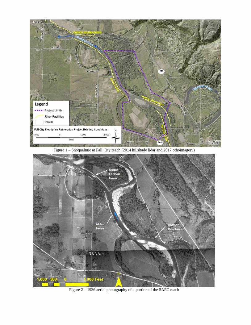
Figure 1 – Snoqualmie at Fall City reach (2014 hillshade lidar and 2017 othoimagery)
Figure 2 – 1936 aerial photography of a portion of the SAFC reach
The Barfuse Levee on the left bank (the left bank is the bank on the left when facing downstream) is
approximately 1,800 feet in length, and ranges in height from 1 foot above the surrounding floodplain at
its upstream end to a height of 10 feet further downstream. The Barfuse levee does not prevent
inundation of the site because water flows around the downstream end of the facility and backwaters a
disconnected side channel. The rock armor along the face of the levee is effective at preventing lateral
channel migration into the forested floodplain despite being in a state of disrepair. The 2,200-foot long
Haffner revetment on the right bank does not provide any flood protection but arrests channel migration
into the right bank floodplain and protects Neal Road. Both the levee and revetment have been
damaged and repaired, most recently in 1997.
Downstream of the project area are the Aldair levee on the left bank and the Upper Carlson restoration
site on the right bank. The Aldair levee is 3,000 feet long and provides substantial flood and channel
migration protection to the left bank floodplain. A 1,400-foot long levee was removed in 2014 in the
Upper Carlson area. The right bank has retreated since levee removal, allowing the formation of a left
bank gravel bar and the recruitment of large wood.
Artificial confinement has inhibited lateral migration and floodplain wetland formation, severely
limiting available salmonid habitat for rearing, refuge, and spawning. The constraints posed by the
levees reduce recruitment and retention of sediment and wood in the river or floodplain in the project
area. Trees from upstream of the site are transported through this reach due to the depth and velocity of
the mainstem river during moderate to large floods. Large trees growing on top of and landward of the
armored banks have been protected from erosion and recruitment to the river for over 60 years. A large
mid-channel bar is located in the unarmored segment between the Haffner and Aldair flood protection
facilities. The mid-channel bar splits flow through two shallow riffles and erodes the left bank, resulting
in the recruitment of trees from the forested floodplain. This naturally occurring instream wood
typically swings parallel to flow and may persist for several flood seasons before being transported
downstream. Since the removal of the Upper Carlson levee in 2014, a relatively small amount of
instream wood has accumulated along the right bank downstream of the project area. Naturally
occurring instream wood can be found sporadically further downstream, typically in the form of older
snags embedded in the sandy riverbed or more recently recruited logs along the edge of eroding forested
banks.
Existing hazards to boaters are relatively minor in the project area during moderate to low flows (<2500
CFS), but more significant risks exist between the project area and the downstream takeout in wider
portions of the channel where natural wood has accumulated in the channel over the last 20-30 years.
The mainstem river through the project area has a gentle gradient, low sinuosity, steep banks along
outside bends, and flat bank-attached gravel bars on inside bends.
The area downstream of the Raging River that includes the project reach provides one of the best
mainstem Chinook salmon spawning areas in the Snoqualmie watershed. Chinook, steelhead trout, pink
and chum salmon all spawn in this reach. Steelhead and resident trout (cutthroat and rainbow), Chinook,
and coho all rear in this reach.
4. Describe what is known about adjacent land uses and the type, frequency, and seasonality of
recreational uses in the project area. Are there nearby trail corridors, schools or parks? What is
the source(s) of your information?
Most of the adjacent land is privately owned and used for agricultural and residential purposes. The
King County Department of Natural Resources and Parks owns two adjoining properties on the right
bank: the Fall City Natural Area encompasses the downstream extent of the project area and continues
downstream and the Fall City Community Park is immediately upstream. On the left bank, King County
owns several parcels associated with the former Rainier Wood Recycling business. These parcels will
be planted and converted to open space as part of this project.
Floating the Snoqualmie River, particularly on inner tubes and small rafts, is a popular recreational
activity in the summer. The number of floaters on the Snoqualmie River tends to be largely driven by
weather, with limited use when air temperatures are below 70 degrees and much higher use when
temperatures reach 80 degrees. This typically corresponds with the months of June to mid-September.
King County conducted a survey of aquatic recreational use in the Snoqualmie River during the summer
of 2013 in order to have a better understanding of the amount and type of in-water use in the SAFC
reach and to inform future salmon restoration and flood risk reduction project design. Results from the
recreational use study indicate that there is very high recreational use above the SR 202 bridge in Fall
City during the summer months, with up to several hundred users per day (Herrera 2014). A very high
percentage (>~85%) of these users above the bridge were in less maneuverable boats (inner tubes or
rafts) and most (>~80%) did not have any paddles. Less than 5% of users were observed to be wearing
life vests.
In the reach downstream of the bridge (which coincides with the Fall City Floodplain Restoration
project area), there were typically fewer than 10 users per day who either put in at the SR202 bridge or
who bypassed the take-out at the bridge and continued downstream to the Neal Road WDFW boat ramp
to take-out. In general, the users in this lower reach were in more maneuverable boats (kayaks, canoes,
drift boats, etc.), with only ~50% in inner tubes or rafts and most (>~60%) of the boats did have
paddles. Life jacket use is also greater downstream of the bridge, with ~25% of users observed wearing
life vests.
Jet boats, drift boats, and rafts are common in the reaches upstream and downstream of the SR 202
bridge during salmon and steelhead runs in fall, winter, and spring. Jet boats and jet skis are common
downstream of the project reach during the summer months, but rarely enter the project area during low
flow conditions due to shallow riffles immediately downstream.
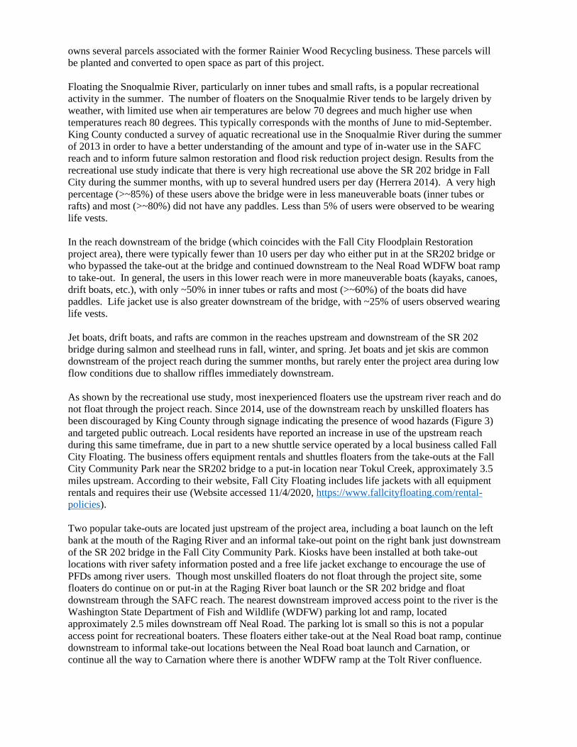
As shown by the recreational use study, most inexperienced floaters use the upstream river reach and do
not float through the project reach. Since 2014, use of the downstream reach by unskilled floaters has
been discouraged by King County through signage indicating the presence of wood hazards (Figure 3)
and targeted public outreach. Local residents have reported an increase in use of the upstream reach
during this same timeframe, due in part to a new shuttle service operated by a local business called Fall
City Floating. The business offers equipment rentals and shuttles floaters from the take-outs at the Fall
City Community Park near the SR202 bridge to a put-in location near Tokul Creek, approximately 3.5
miles upstream. According to their website, Fall City Floating includes life jackets with all equipment
rentals and requires their use (Website accessed 11/4/2020, https://www.fallcityfloating.com/rental-
policies).
Two popular take-outs are located just upstream of the project area, including a boat launch on the left
bank at the mouth of the Raging River and an informal take-out point on the right bank just downstream
of the SR 202 bridge in the Fall City Community Park. Kiosks have been installed at both take-out
locations with river safety information posted and a free life jacket exchange to encourage the use of
PFDs among river users. Though most unskilled floaters do not float through the project site, some
floaters do continue on or put-in at the Raging River boat launch or the SR 202 bridge and float
downstream through the SAFC reach. The nearest downstream improved access point to the river is the
Washington State Department of Fish and Wildlife (WDFW) parking lot and ramp, located
approximately 2.5 miles downstream off Neal Road. The parking lot is small so this is not a popular
access point for recreational boaters. These floaters either take-out at the Neal Road boat ramp, continue
downstream to informal take-out locations between the Neal Road boat launch and Carnation, or
continue all the way to Carnation where there is another WDFW ramp at the Tolt River confluence.
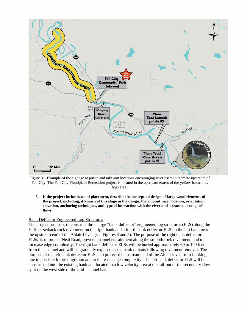
Figure 3 – Example of the signage at put-in and take-out locations encouraging river users to recreate upstream of
Fall City. The Fall City Floodplain Recreation project is located in the upstream extent of the yellow hazardous
logs area.
5. If the project includes wood placement, describe the conceptual design of large wood elements of
the project, including, if known at this stage in the design, the amount, size, location, orientation,
elevation, anchoring techniques, and type of interaction with the river and stream at a range of
flows.
Bank Deflector Engineered Log Structures
The project proposes to construct three large “bank deflector” engineered log structures (ELS) along the
Haffner setback rock revetment on the right bank and a fourth bank deflector ELS on the left bank near
the upstream end of the Aldair Levee (see Figures 4 and 5). The purpose of the right bank deflector
ELSs is to protect Neal Road, prevent channel entrainment along the smooth rock revetment, and to
increase edge complexity. The right bank deflector ELSs will be buried approximately 60 to 100 feet
from the channel and will be gradually exposed as the bank retreats following revetment removal. The
purpose of the left bank deflector ELS is to protect the upstream end of the Aldair levee from flanking
due to possible future migration and to increase edge complexity. The left bank deflector ELS will be
constructed into the existing bank and located in a low velocity area at the tail-out of the secondary flow
split on the west side of the mid-channel bar.
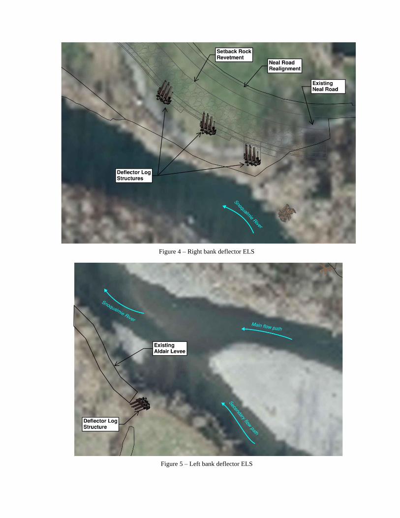
Figure 4 – Right bank deflector ELS
Figure 5 – Left bank deflector ELS
Logs in the deflector jams will be pile-supported, connected with chain, ballasted with riprap and
excavation spoils, and embedded into the bank. Horizontal logs will be placed between elevations 68
and 84, which is approximately ten feet below the summer low water level to the ordinary highwater
line (Figure 6). Each jam will be composed of approximately 40 imported logs and 10 deeply embedded
timber piles. Log diameter will be between 18 and 30 inches and most will have an intact rootwad to
maximize flow obstruction and habitat enhancement. The ELSs will incorporate racking logs, slash
material, and rock backfill to minimize flow through the structure that could otherwise be a recreational
user hazard and reduce functional performance of the structure.
Figure 6 – Cross-section of Bank Deflector ELS once exposed due to channel migration
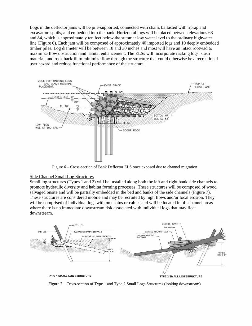
Side Channel Small Log Structures
Small log structures (Types 1 and 2) will be installed along both the left and right bank side channels to
promote hydraulic diversity and habitat forming processes. These structures will be composed of wood
salvaged onsite and will be partially embedded in the bed and banks of the side channels (Figure 7).
These structures are considered mobile and may be recruited by high flows and/or local erosion. They
will be comprised of individual logs with no chains or cables and will be located in off-channel areas
where there is no immediate downstream risk associated with individual logs that may float
downstream.
Figure 7 – Cross-section of Type 1 and Type 2 Small Logs Structures (looking downstream)
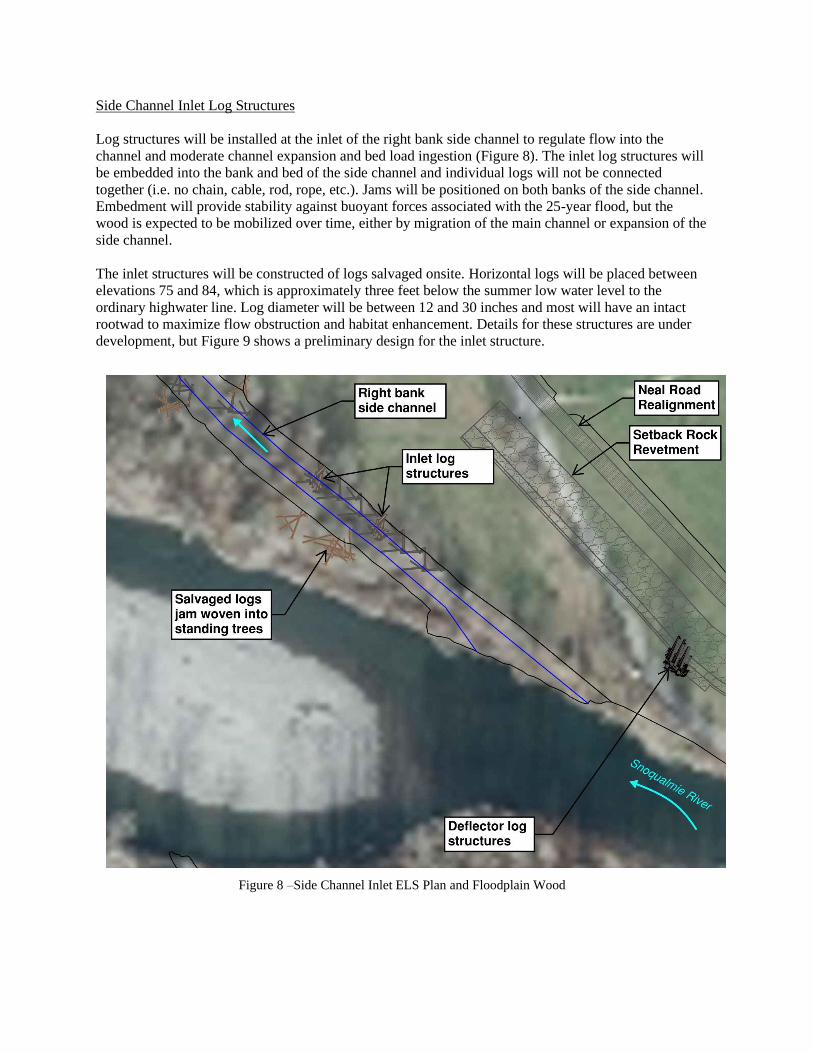
Side Channel Inlet Log Structures
Log structures will be installed at the inlet of the right bank side channel to regulate flow into the
channel and moderate channel expansion and bed load ingestion (Figure 8). The inlet log structures will
be embedded into the bank and bed of the side channel and individual logs will not be connected
together (i.e. no chain, cable, rod, rope, etc.). Jams will be positioned on both banks of the side channel.
Embedment will provide stability against buoyant forces associated with the 25-year flood, but the
wood is expected to be mobilized over time, either by migration of the main channel or expansion of the
side channel.
The inlet structures will be constructed of logs salvaged onsite. Horizontal logs will be placed between
elevations 75 and 84, which is approximately three feet below the summer low water level to the
ordinary highwater line. Log diameter will be between 12 and 30 inches and most will have an intact
rootwad to maximize flow obstruction and habitat enhancement. Details for these structures are under
development, but Figure 9 shows a preliminary design for the inlet structure.
Figure 8 –Side Channel Inlet ELS Plan and Floodplain Wood
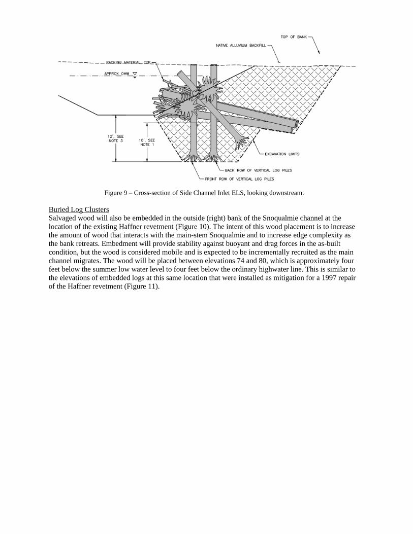
Figure 9 – Cross-section of Side Channel Inlet ELS, looking downstream.
Buried Log Clusters
Salvaged wood will also be embedded in the outside (right) bank of the Snoqualmie channel at the
location of the existing Haffner revetment (Figure 10). The intent of this wood placement is to increase
the amount of wood that interacts with the main-stem Snoqualmie and to increase edge complexity as
the bank retreats. Embedment will provide stability against buoyant and drag forces in the as-built
condition, but the wood is considered mobile and is expected to be incrementally recruited as the main
channel migrates. The wood will be placed between elevations 74 and 80, which is approximately four
feet below the summer low water level to four feet below the ordinary highwater line. This is similar to
the elevations of embedded logs at this same location that were installed as mitigation for a 1997 repair
of the Haffner revetment (Figure 11).
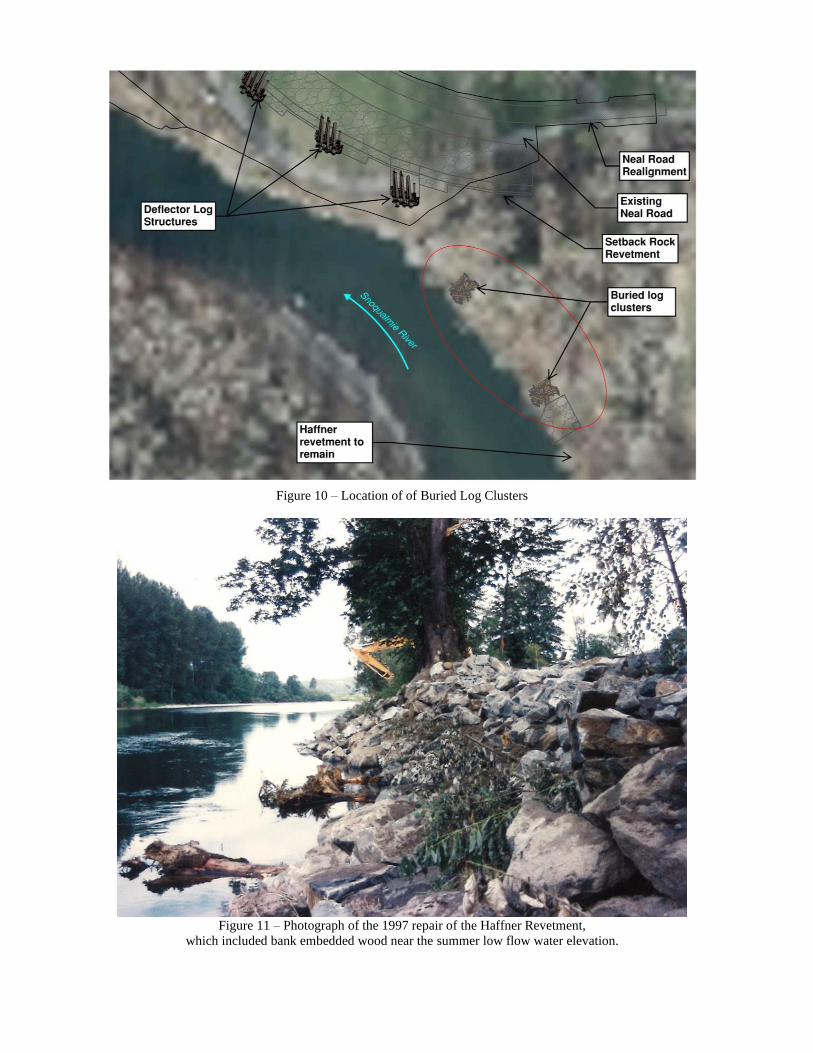
Figure 10 – Location of of Buried Log Clusters
Figure 11 – Photograph of the 1997 repair of the Haffner Revetment,
which included bank embedded wood near the summer low flow water elevation.
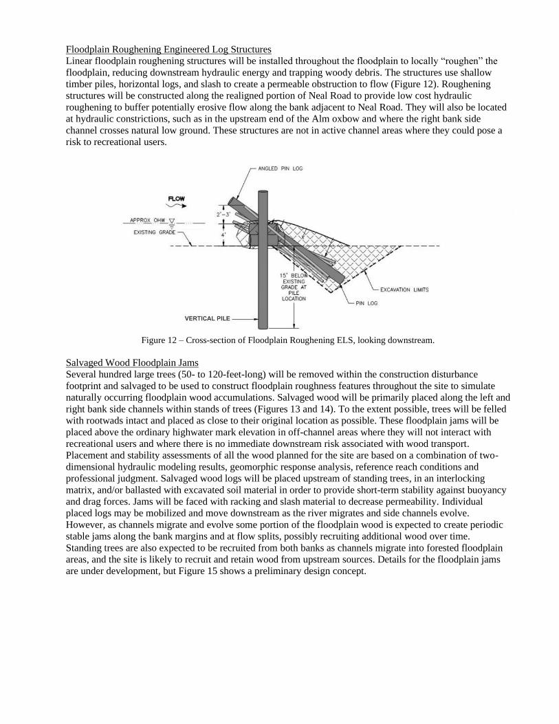
Floodplain Roughening Engineered Log Structures
Linear floodplain roughening structures will be installed throughout the floodplain to locally “roughen” the
floodplain, reducing downstream hydraulic energy and trapping woody debris. The structures use shallow
timber piles, horizontal logs, and slash to create a permeable obstruction to flow (Figure 12). Roughening
structures will be constructed along the realigned portion of Neal Road to provide low cost hydraulic
roughening to buffer potentially erosive flow along the bank adjacent to Neal Road. They will also be located
at hydraulic constrictions, such as in the upstream end of the Alm oxbow and where the right bank side
channel crosses natural low ground. These structures are not in active channel areas where they could pose a
risk to recreational users.
Figure 12 – Cross-section of Floodplain Roughening ELS, looking downstream.
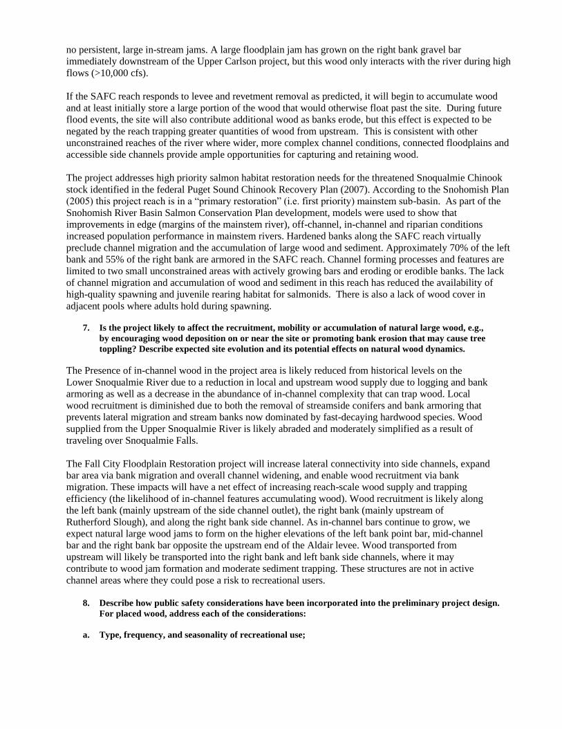
Salvaged Wood Floodplain Jams
Several hundred large trees (50- to 120-feet-long) will be removed within the construction disturbance
footprint and salvaged to be used to construct floodplain roughness features throughout the site to simulate
naturally occurring floodplain wood accumulations. Salvaged wood will be primarily placed along the left and
right bank side channels within stands of trees (Figures 13 and 14). To the extent possible, trees will be felled
with rootwads intact and placed as close to their original location as possible. These floodplain jams will be
placed above the ordinary highwater mark elevation in off-channel areas where they will not interact with
recreational users and where there is no immediate downstream risk associated with wood transport.
Placement and stability assessments of all the wood planned for the site are based on a combination of two-
dimensional hydraulic modeling results, geomorphic response analysis, reference reach conditions and
professional judgment. Salvaged wood logs will be placed upstream of standing trees, in an interlocking
matrix, and/or ballasted with excavated soil material in order to provide short-term stability against buoyancy
and drag forces. Jams will be faced with racking and slash material to decrease permeability. Individual
placed logs may be mobilized and move downstream as the river migrates and side channels evolve.
However, as channels migrate and evolve some portion of the floodplain wood is expected to create periodic
stable jams along the bank margins and at flow splits, possibly recruiting additional wood over time.
Standing trees are also expected to be recruited from both banks as channels migrate into forested floodplain
areas, and the site is likely to recruit and retain wood from upstream sources. Details for the floodplain jams
are under development, but Figure 15 shows a preliminary design concept.
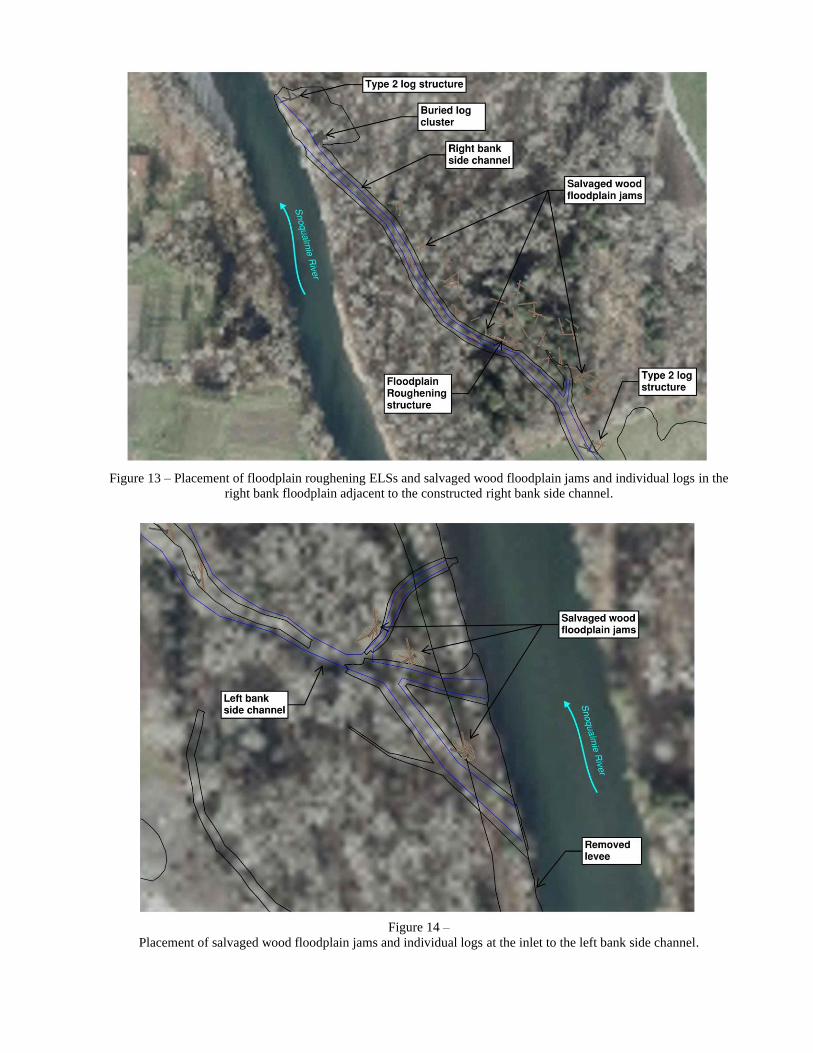
Figure 13 – Placement of floodplain roughening ELSs and salvaged wood floodplain jams and individual logs in the
right bank floodplain adjacent to the constructed right bank side channel.
Figure 14 –
Placement of salvaged wood floodplain jams and individual logs at the inlet to the left bank side channel.
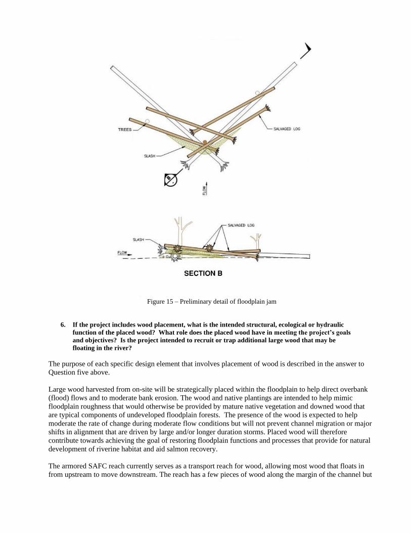
Figure 15 – Preliminary detail of floodplain jam
6. If the project includes wood placement, what is the intended structural, ecological or hydraulic
function of the placed wood? What role does the placed wood have in meeting the project’s goals
and objectives? Is the project intended to recruit or trap additional large wood that may be
floating in the river?
The purpose of each specific design element that involves placement of wood is described in the answer to
Question five above.
Large wood harvested from on-site will be strategically placed within the floodplain to help direct overbank
(flood) flows and to moderate bank erosion. The wood and native plantings are intended to help mimic
floodplain roughness that would otherwise be provided by mature native vegetation and downed wood that
are typical components of undeveloped floodplain forests. The presence of the wood is expected to help
moderate the rate of change during moderate flow conditions but will not prevent channel migration or major
shifts in alignment that are driven by large and/or longer duration storms. Placed wood will therefore
contribute towards achieving the goal of restoring floodplain functions and processes that provide for natural
development of riverine habitat and aid salmon recovery.
The armored SAFC reach currently serves as a transport reach for wood, allowing most wood that floats in
from upstream to move downstream. The reach has a few pieces of wood along the margin of the channel but
no persistent, large in-stream jams. A large floodplain jam has grown on the right bank gravel bar
immediately downstream of the Upper Carlson project, but this wood only interacts with the river during high
flows (>10,000 cfs).
If the SAFC reach responds to levee and revetment removal as predicted, it will begin to accumulate wood
and at least initially store a large portion of the wood that would otherwise float past the site. During future
flood events, the site will also contribute additional wood as banks erode, but this effect is expected to be
negated by the reach trapping greater quantities of wood from upstream. This is consistent with other
unconstrained reaches of the river where wider, more complex channel conditions, connected floodplains and
accessible side channels provide ample opportunities for capturing and retaining wood.
The project addresses high priority salmon habitat restoration needs for the threatened Snoqualmie Chinook
stock identified in the federal Puget Sound Chinook Recovery Plan (2007). According to the Snohomish Plan
(2005) this project reach is in a “primary restoration” (i.e. first priority) mainstem sub-basin. As part of the
Snohomish River Basin Salmon Conservation Plan development, models were used to show that
improvements in edge (margins of the mainstem river), off-channel, in-channel and riparian conditions
increased population performance in mainstem rivers. Hardened banks along the SAFC reach virtually
preclude channel migration and the accumulation of large wood and sediment. Approximately 70% of the left
bank and 55% of the right bank are armored in the SAFC reach. Channel forming processes and features are
limited to two small unconstrained areas with actively growing bars and eroding or erodible banks. The lack
of channel migration and accumulation of wood and sediment in this reach has reduced the availability of
high-quality spawning and juvenile rearing habitat for salmonids. There is also a lack of wood cover in
adjacent pools where adults hold during spawning.
7. Is the project likely to affect the recruitment, mobility or accumulation of natural large wood, e.g.,
by encouraging wood deposition on or near the site or promoting bank erosion that may cause tree
toppling? Describe expected site evolution and its potential effects on natural wood dynamics.
The Presence of in-channel wood in the project area is likely reduced from historical levels on the
Lower Snoqualmie River due to a reduction in local and upstream wood supply due to logging and bank
armoring as well as a decrease in the abundance of in-channel complexity that can trap wood. Local
wood recruitment is diminished due to both the removal of streamside conifers and bank armoring that
prevents lateral migration and stream banks now dominated by fast-decaying hardwood species. Wood
supplied from the Upper Snoqualmie River is likely abraded and moderately simplified as a result of
traveling over Snoqualmie Falls.
The Fall City Floodplain Restoration project will increase lateral connectivity into side channels, expand
bar area via bank migration and overall channel widening, and enable wood recruitment via bank
migration. These impacts will have a net effect of increasing reach-scale wood supply and trapping
efficiency (the likelihood of in-channel features accumulating wood). Wood recruitment is likely along
the left bank (mainly upstream of the side channel outlet), the right bank (mainly upstream of
Rutherford Slough), and along the right bank side channel. As in-channel bars continue to grow, we
expect natural large wood jams to form on the higher elevations of the left bank point bar, mid-channel
bar and the right bank bar opposite the upstream end of the Aldair levee. Wood transported from
upstream will likely be transported into the right bank and left bank side channels, where it may
contribute to wood jam formation and moderate sediment trapping. These structures are not in active
channel areas where they could pose a risk to recreational users.
8. Describe how public safety considerations have been incorporated into the preliminary project design.
For placed wood, address each of the considerations:
a. Type, frequency, and seasonality of recreational use;
As shown in the recreational use study on the Snoqualmie River, there is a wide range of skill and ability
among Snoqualmie River users, but skilled users tend to be more common in the project area and unskilled
floaters tend to be far more numerous immediately upstream of the project (Herrera 2014). Refer to the
response to Question 4 above and the study for more detailed information.
Unskilled users tend to use the river during the warm summer months that also coincide with the low flow
period (June to mid-September) when the river flow typically ranges between 600 and 4,000 cfs. Skilled
boaters use the river from spring through fall, and particularly during salmon fishing season (September
through December) when the river flow ranges between 600 and 10,000 cfs.
Given this, placed wood has been designed assuming occasional unskilled users during low to moderate flows
(600 and 4,000 cfs) and more frequent skilled users during higher flows (up to 10,000 cfs).
b. Wood location, positioning, and anchoring techniques;
The majority of placed wood will be located relatively high in the floodplain (above the 10,000 cfs water
level) or will be set back into the floodplain or within side channels such that it does not create immediate
boating hazards for main-stem users. The only instances where large wood will be placed in the main channel
is in the deflector ELS at the upstream end of the Aldair levee and the bank embedded jams on the right bank
near the Rutherford slough outlet. The ELS will be mostly embedded in the existing bank and is in a location
where it is separated from the primary flowpath by a large mid-channel gravel bar. The bank embedded jams
will be installed in approximately the same location as embedded rootwads from a 1997 repair. Those
rootwads have not posed a hazard due to the relatively low velocities at this location during low and moderate
flow conditions and the unobstructed visibility from upstream.
Engineered structures such as the bank deflectors and floodplain roughening structures will be stabilized by
timber pilings, embedment into riprap and soil, and limited use of chain. Stability calculations will consider
buoyant, drag, and impact forces associated with the 100-year flood hydraulic conditions. Engineered
structures are designed to be fixed and essentially impermeable and have been located where they will be
easily visible from upstream.
Habitat jams will be passively anchored by placing logs upstream of standing trees or by partial embedment,
to mimic naturally occurring wood features. Long logs with large rootballs may also be used to stabilize
habitat jams due to their large mass and ability to rack on standing vegetation.
c. Maximizing achievement of project goals and objectives while minimizing potential public safety risks;
Wood along the Lower Snoqualmie River induces local geomorphic change, such as creating transient pool
habitat, stabilizing bar-tops, and inducing or reducing bank toe erosion, as well as local hydraulic effects like
roughening bar-tops, regulating flow into side channels, and enhancing overbank flow. The absence of large
wood in the project reach is a key contributor to the simplified channel and degraded aquatic habitat
conditions. The design team has been mindful of recreational users throughout the design process and has
modified the preliminary design accordingly to protect public safety and minimize impacts to recreational
uses. Consideration of potential hazards has progressed through a series of steps including early identification
of risks, data collection to understand specific site conditions that affect those risks, and evaluation and
assessment using available tools. However, the design team must also ensure that the project meets its
primary goal of restoring dynamic river processes, including the restoration of large wood as an integral
element of floodplain structure and function, enhancing floodplain connectivity, and restoring river processes
that create and sustain a complex, connected network of spawning, rearing, and refuge habitat for salmonids.
The project design incorporates many elements to avoid or reduce potential impacts to a broad range of
recreational users, while still achieving the primary habitat goals of the project. It is important to note that
regardless of these efforts, rivers are by their nature dangerous places. Dynamic natural processes will

promote changes in the character of the river in this reach, including changes in flow characteristics,
formation of more natural banks and bars, and transport and recruitment of wood from onsite and upriver.
These conditions will continue to evolve and change, particularly during and after high flow events.
d. Use of established and recognized engineering, geological, and ecological expertise.
The design team consists of a multidisciplinary team of engineers, ecologists, and geologists with extensive
knowledge of Northwest rivers and many years of experience designing stream and river restoration projects.
A consultant team supports King County, with technical experts from Herrera Environmental Consultants,
Watershed Science and Engineering, and Shannon and Wilson, who bring extensive expertise in large wood
design, hydraulic modeling, ecology, and geomorphology. The consultant team has a combined experience of
more than 100 years designing projects in Northwest river systems.
9. Has the project been reviewed and approved by a Licensed Professional Civil Engineer? Please list
other licensed technical staff who have reviewed and provided input on the design (e.g., Licensed
Geologist and Licensed Engineering Geologist). Specify the Engineer of Record for the design and
any other Licensed Professionals who have sealed their portion of the design plans. Were all
reviews and approvals completed?
The multidisciplinary team noted above includes several licensed professional engineers and is overseen
by a licensed professional engineer, Ian Mostrenko of Herrera Environmental Consultants. Ian is a river
engineer with approximately 30 years of experience who will be stamping the final plans. The King
County team managing the project includes two professional engineers as well as a licensed engineering
geologist. An independent technical review of the preliminary design was conducted by Vaughn
Collins, PE, of Northwest Hydraulic Consultants.
10. Has the project been reviewed and approved by a King County Professional Ecologist (e.g., person
with an advanced degree in aquatic and/or biological sciences from an accredited university or
equivalent level of experience) if ecological benefits are an intended project objective, to evaluate
the consistency of the design with project goals, existing environmental policies and regulations,
and expected or known permit conditions? Specify the Reviewing Ecologist for the project. Was
this review and approval completed? What is the anticipated schedule for completing project
milestones (30-40% design, final design, major construction/earthmoving) and for soliciting public
input)?
The team includes several ecologists meeting those criteria. The senior ecologist on the team is an aquatic
ecologist with both an advanced degree and more than five years of experience planning, designing, and
implementing river restoration projects and more than ten years monitoring such projects. The project plans
are also being reviewed by the Unit Manager, Jon Hansen, who has over 30 years of experience in the field of
ecological restoration.
Project Schedule:
Preliminary design including public meetings: Completed November 2020
SEPA comment period: January 22, 2021 to February 5, 2021
Final design: Expected completion in November 2021
Construction: Expected summer of 2022
Project Manager Date
Supervising Engineer, Project Supervisor or Unit Manager Date
3/16/2021
II. Pre-Construction Information (70% or 100% design with permits) These questions relate to the designed
and permitted project. Information should include input resulting from permit review process, SEPA, boater
safety meetings and any other stakeholders.
1. Have any answers provided in Section I at the Preliminary Design Phase changed in the interim? If so,
provide the new answers and the rationale for the change.
2. What regulatory review or permits are required for the project (e.g. HPA, Clearing and Grading permit, COE
permits)? List any conditions or requirements included in the permit approvals relevant to placement of large
wood in the project.
3. What specific actions or project elements were employed to address public safety in the final, permit-
approved design?
4. Describe how the project team solicited public input on the preliminary design. Describe the input received
from the public and how, if appropriate, the project team has responded to this input.
5. Describe any additional design modifications or mitigating actions that were or will be taken in response to
the public comments.
6. Will further educational or informational materials be made available to the public to heighten awareness of
the project (e.g., public meeting, press release, informational website, or temporary or permanent signage
posted in the vicinity of the project)? If so, explain.
7. If the project is expected to influence the recruitment, mobility or accumulation of natural wood, has a Public
Safety Management Plan been completed?
Project Manager Date
Supervising Engineer, Project Supervisor or Unit Manager Date
III. Post-Construction Actions or Project Modifications
8. Have any answers provided in Sections I and II at the Preliminary design and Pre-Construction phases
changed in the interim? If so, provide the new answers and the rationale for the change.
9. Briefly describe the scope and timing of post-construction monitoring and inspection activities planned for the
project as they relate to large wood. If a Public Safety Management Plan or Monitoring Plan has been
developed for the project, you may simply reference and attach that document.
10. If post construction monitoring or inspections result in modifications to the project, please describe the action
taken and the rationale and consistency with the Public Safety Management Plan, if applicable.
Project Manager Date
Supervising Engineer, Project Supervisor or Unit Manager Date