Embed Size (px)
Citation preview

Reconnaissance Investigation of Sand, Gravel, and
Quarried Bedrocl< Resources in the Snoqualmie Pass 1: 100,000 Quadrangle,
Washington
by William S. Lingley, Jr., David A. Knoblach, and Celia K. B. Nightingale
WASHINGTON DIVISION OF GEOLOGY
AND EARTH RESOURCES
Information Circular 96 June 2002
Doug Sutherland- Commissioner of Public Lands

DISCLAIMER Neither the State of Washington, nor any agency thereof, nor any of their employees, makes any warranty, express or implied, or assumes any legal liability or responsibility for the accuracy, completeness, or usefulness of any information, apparatus, product, or process disclosed, or represents that its use would not infringe privately owned rights. Reference herein to any specific commercial product, process, or service by trade name, trademark, manufacturer, or otherwise, does not necessarily constitute or imply its endorsement, recommendation, or favoring by the State of Washington or any agency thereof. The views and opinions of authors expressed herein do not necessarily state or reflect those of the State of Washington or any agency thereof.
WASHINGTON DEPARTMENT OF NATURAL RESOURCES Doug Sutherland-Commissioner of Public Lands
DIVISION OF GEOLOGY AND EARTH RESOURCES Ron Teissere---State Geologist David K. Norman-Assistant State Geologist
This report is available from:
Publications Washington Division of Geology and Earth Resources PO Box 47007 Olympia, WA 98504-7007 Phone: (360) 902-1450 Fax: (360) 902-1785 E-mail: [email protected] Website: http://www.wa.gov/dnr/htdocs/ger/
..,.,. Printed on recycled paper. ~.,. Printed in the United States of America
ii

Contents
Introduction. . . . . . . Background . . . . . Intended readership . Primary products . . Accuracy of estimates. Threshold of significant resources . Scope of deposits inventoried . . . Previous aggregate reserve studies.
Geology of construction aggregates in the Snoqualmie Pass quadrangle Sand and gravel geology
Outwash deposits . Kame deposits. . Alluvial deposits
Bedrock geology .. Volcanic rocks . Intrusive igneous rocks.
Aggregate mining and significant deposits. Sand and gravel resources . . . . . .
North Bend-Cumberland complex Bullfrog complex .
Bedrock resources . Volume of aggregate. Market assessment . Discussion . . . . . Acknowledgments . References cited
APPENDICES
l 1 1 1 2 2 2 2 3 3 4 5 5 6 6 6 6 6 6 7 7 7 8 8 9 9
Appendix 1. Glossary of mining-related terms 11 Appendix 2. Methods . . . . . . . . . 13
Inventory philosophy . . . . . . . . . . . . . 13 Definition of significant resources . . . . . . 13 Threshold criteria used in preparing this inventory. 13 Sources of data . . . . . . . . . . . . . . 14
Appendix 3. Mine and outcrop database. . . . . . . . 15
Appendix 4. Well database . . . . . . . . . . . . . . . 51
Appendix 5. Geologic description of significant and ( or) historically mined units. 60
FIGURES Figure 1. Index map of the Snoqualmie Pass quadrangle
Figure 2. Paleo geographic map of part of the Snoqualmie Pass quadrangle .
Figure 3. Large gravel mines and the possible distribution and thickness of some hypothetical undiscovered gravel resources .
Figure 4. View northeast into the Palmer Junction pit .
TABLES Table 1. Some specifications for construction aggregate products
Table 2. Large sand and gravel pits in the Snoqualmie Pass quadrangle .
Table 3. Large quarries in the Snoqualmie Pass quadrangle ....... .
. 1
4
5
5
2
3
3
Table 4. Classification of gravel and bedrock resources . . . . . . . . . . . . . . . . . . . 13
iii

PLATE Plate 1. Location of some sand, gravel, and quarried bedrock resources in the Snoqualmie
Pass 1: 100,000 quadrangle, Washington
iv

Reconnaissance Investigation of Sand, Gravel, and Quarried Bedrock Resources in the Snoqualmie Pass 1:100,000 Quadrangle, Washington
David A. Knoblach Celia K. B. Nightingale William S. Lingley, Jr. Washington Division of Geology
and Earth Resources Outcrop Geological Services 56 Hylebos Avenue
South Puget Sound Community College 2011 Mottman Road SW
PO Box 47007; Olympia, WA 98504-7007
INTRODUCTION
Background
Milton, WA 98354
During its 1998 session, the Washington State Legislature, acting on a recommendation from the Governor's Land Use Study Commission, asked the Washington Department of Natural Resources (W ADNR) to map gravel and bedrock resources that are used for maintenance and construction of homes and infrastructure. The Study Commission sought information to assess the need to protect these resources from urban sprawl and other intensive land uses. These data would, in tum, result in better long-range planning and possible legislation to aid in designating mineral resource lands under the Growth Management Act (Revised Code of Washington [RCW] 36.70A; Lingley and Jazdzewski, 1994).
Although the data are presented here in the traditional text and map format, this report is part of a project to prepare a geographic informa-
122· tion systems (GIS) database that delin- 4r 30,
eates the locations of some of the signif-icant construction aggregate resources (sand, gravel, and quarried bedrock) of Washington State. The digital version of this report, including Arclnfo© cover-ages, is available through the Washing-ton Division of Geology and Earth Re-sources (see back of title page for ad-dress).
The Snoqualmie Pass 1: 100,000-scale quadrangle straddles the Cascade crest in west-central Washington from 47 to 47.5 degrees north latitude and 121 to 122 degrees west longitude (Fig. 1). Approximately one-half of the quadrangle is in King County, the remainder in Kittitas, Pierce, and Yakima Counties. As of the 2000 federal census, the population of the quadrangle was approximately 50,000, with the largest population centers at Enumclaw (population -11, 100) and North Bend (population 47•
Olympia, WA 98512
renewable sand, gravel, and quarried bedrock resources. The study should also benefit engineers, transportation departments, and industry.
Primary Products
This inventory consists of the following products:
I A map showing the probable extent ofbedrock and gravel resources (in pink and yellow, respectively, on Plate 1 ). Thickness contours (isopachs) are shown within those sand and gravel deposits for which we have sufficient data.
I A map showing the location of active mines, borrow pits, some depleted mines, and large proposed mines (Plate 1).
I A glossary of terms used in this report (Appendix 1 ).
I A complete discussion of the methods used in this study (Appendix 2).
121·
-4,746) (Dwyer and Dwyer, 2001).
Intended Readership
This inventory was created primarily for use by local government planners to help refine comprehensive plans and other zoning determinations. It will also aid legislators and other policy makers to assess the importance of largely non-
Figure 1. Index map of the Snoqualmie Pass quadrangle showing selected geographic locations and some important sand and gravel pits (pick and shovel) and quarries (pick and dynamite). Mines shown: WR, White River pit and quarry; EC, Enumclaw quarry; 410, 41 O quarry; FS, eastern portions of the Flintstone pit; PJ, Palmer Junction pit; KK, Kangley pit; and CP, Cresto pit. The arrow indicates the direction of flow in a late Pleistocene outwash channel, which reversed the flow of Taylor Creek (dotted portion), crossed the pass at its headwaters, and flowed down the Green River drainage (dashed portion) to a proglacial lake near the Palmer Junction pit. The lake formed as a result of ice-damming by the Puget lobe of the Cordilleran ice sheet. Today, Taylor Creek flows northwestward. Shaded relief is derived from a U.S. Geological Survey 30-meter digital elevation model (DEM).

2 INFORMATION CIRCULAR 96
I Databases containing the location, thickness, quality, and volume of some sand, gravel, and bedrock resources (Appendices 3-4).
I Brief descriptions of geologic units known to contain aggregate resources (Appendix 5).
I A description of the geology and mining history of construction aggregates in the Snoqualmie Pass quadrangle (see text).
Accuracy of Estimates
We emphasize that this report almost certainly overestimates the volume of construction aggregate within the Snoqualmie Pass quadrangle that is available under current market conditions. Overestimation results from factors such as shallow bedrock under surficial gravels, diminishing rock quality with depth, unmapped areas of thick overburden, and lateral geologic variation. Furthermore, history indicates that future drilling and mining are more likely to yield disappointing results than to add significantly to hypothetical aggregate reserves.
Threshold of Significant Resources
Because this study is primarily designed ·as an aid to land-use planning, we inventoried only those resources deemed as significant to the long-term economic health of the region. Therefore, we restricted our investigation to those resources that exceed the following threshold criteria:
I The thickness of the sand and gravel or bedrock deposit appears to be in excess of25 feet (7.5 m).
I The 'stripping ratio' (ratio of overburden to gravel or overburden to bedrock) is less than one to three (1:3).
I The strength and durability of the rock meet the Washington State Department of Transportation (1999) (WSDOT) minimum specifications for asphalt-treated base, a rock product used to construct some lower layers of asphalt roads (Table 1).
I The area of the deposit exposed at the surface exceeds 160 acres and measures at least 1,500 feet across the minimum dimension of the deposit.
I Estimated reserves within the deposit exceed 10 million cubic yards.
A few unusually thick deposits or resources of special local importance are in-
Scope of Deposits Inventoried
In order to produce an objective analysis, we have inventoried all deposits meeting the threshold criteria, without consideration of environmental impacts or land-use conflicts that may be involved in permitting or extracting these resources. The only exceptions are those deposits that lie within the Clearwater, Norse Peak, and Alpine Lakes Wilderness areas. For example, the Yakima River flood plain has historically been a major gravel resource, and numerous mines are still operating beside the river. Future mining operations in flood plains will likely have more difficulty obtaining permits because alluvial mining can cause adverse impacts to aquatic and riparian habitat (Norman and others, 1998). Nevertheless, all Yakima River sand and gravel deposits meeting the threshold criteria are depicted in this report. Therefore, this inventory must be used with maps of environmentally sensitive areas and land-use status in order to obtain a complete picture of available aggregate within the quadrangle.
Previous Aggregate Reserve Studies
Gence (1934) and Kroft (1972) mapped gravel reserves exposed at the surface in parts of King and Pierce Counties, but did not assess the engineering properties of the rock or the subsurface extent of these deposits. General aspects of the sand and gravel industry in the Puget Sound region were discussed by Huntting (1982), who listed reserves of major sand and gravel producers. White and others (1990) presented the results of a regional market study of the western Washington sand and gravel industry. The geology and hydrogeology of the Snoqualmie Pass quadrangle have been mapped by Vine (1962), Rosengreen (1965), Richardson and others (1968), Luzier (1969), Fischer (1970), Evans and Jensen (1996), Hellwig (1997), and Tabor and others (2000).
The locations of most commercial mines in Washington are given in Lingley and Manson (1992), who also summarized the market conditions at that time, and McKay and others (2001). Specific data for most active and some terminated mines are archived in Washington Division of Geology and Earth Resources Reclamation Permit files, Washington State Department of Transportation records, and U.S. Forest Service files and reports (Cook, 1992, 1993 ). Environmental assessments of larger mines, for example Huckell/Weinman Associates (1996), Huckell/Weinman Associates and others (1995, 1996), King
cluded although they do not meet the threshold criteria. More information on the threshold criteria can be found in Appendix 2.
In some markets, a lack of high-quality gravel and bedrock has forced producers to mine lower-quality deposits. Homes and infrastructure constructed with weak gravel or bedrock generally have relatively short life cycles. We have not inventoried these lowerquality deposits because they do not meet the criteria of this study. However, Appendices 3 and 4 will serve as guides to the locations of some of the poorer-quality deposits as well as resources buried under thick overburden layers that may become more attractive under future market conditions.
Table 1. Some specifications for construction aggregate products (after Washington Department of Transportation, 1999). Los Angeles Abrasion and Percent Passing U.S. No. 200 Sieve measurements are in weight percent. Los Angeles Abrasion and Degradation specifications for coarse portland cement concrete aggregate are not rigorous because the gravel is rarely exposed on the outside of concrete structures such as foundations or sidewalks
Product
Crushed Coarse aggregate Ballast Asphalt- (road) surfacing, for portland (road
Laboratory test treated base top course cement concrete subgrade)
Los Angeles Abrasion s30% s35% s35% s40%
Washington Degradation :2'.15 :2'.25 not used :2'.15
Sand Equivalent :2'.30% :2'.35% not used :2'.30%
Percent Passing U.S. 2-9% 0-7.5% 0-0.5% 0-9% No. 200 Sieve (<0.0025 in.)

SNOQUALMIE PASS 1:100,000 QUADRANGLE, WASHINGTON 3
County (1987, 1996, 1997), and Mc Lucas and Associates ( 1986) provide details of stratigraphy and reserve estimates. Hydrologic information is included in various types of environmental documentation, wellhead-protection studies, and water-resource reports. Water-well logs and some logs of geotechnical boreholes are archived by the Washington Departments of Ecology and Transportation, respectively and the Weyerhaeuser Company.
Table 2. Large sand and gravel pits in the Snoqualmie Pass quadrangle
Other reports in this series of reconnaissance investigations of sand, gravel, and bedrock resources include Loen and others (2001 ), Weber ling and others (2001), Dunn (2001), and Norman and others (2001).
GEOLOGY OF CONSTRUCTION AGGREGATES IN THE SNOQUALMIE PASS QUADRANGLE
Numerous igneous intrusions, volcanic activity, and glacial processes resulted
Mine name
Western Washington:
Flintstone pit
Palmer Junction pit
Kangley pit
Enumclaw pit
Eastern Washington:
Cresto pit
Bullfrog pit
Ellison pit
in remarkably large volumes of sand, gravel, and bedrock in the Snoqualmie Pass quadrangle. Much of this material has good to excellent characteristics for construction aggregate. Large gravel mines in the quadrangle were developed to supply aggregate to the eastern Puget Sound area for portland cement concrete or asphaltic cement concrete. Most small mines in the quadrangle were developed for forestry purposes in the Cascade Range and produce from the andesitic or basaltic volcanic rocks that are common in the mountainous areas. Table 2 lists larger sand and gravel mines in the quadrangle, and Table 3 lists larger bedrock quarries. Intrusive igneous rocks such as granodiorite have not been extensively developed, but they have potential to yield enormous volumes of aggregate.
Sand and Gravel Geology
Sand and gravel deposits cover less than 20 percent of the Snoqualmie Pass quadrangle. Large areas of the lowlands are covered with fine sediments (clay, silt, very fine sand) that are unsuitable for construction aggregate because they tend to flow under pressure and will not support weight. In the flat areas at the edge of the foothills, landslide deposits and soil wedges commonly cover or interfinger with otherwise commercial gravel resources. About 5,700 years ago, the giant Osceola Mudflow from Mount Rainier inundated the entire lowland near Enumclaw to depths in excess of 40 feet (Dragovich and others, 1994), covering other-
Current operator
Cadman, Inc.
Watson Asphalt, Inc.
Stoneway Rock & Recycling
Tim Corliss and Son, Inc.
Location
Black Diamond (1.5 mi southeast)
Kanaskat (0.3 mi east)
Kangley (1.0 mi west)
Enumclaw
Approximate reserves
remaining (million tons)
10
24
38
14
Total 86
Ellensburg Cement Easton Products, Inc. (5.0 mi northwest)
Trendwest Resorts, Inc.
Ellensburg Cement Products, Inc.
Cle Elum (3.0 mi northwest)
Easton (5.0 mi northwest)
Total
5
3
0.6
8.6
Approximate annual
production rate (million tons)
-1.5
0.5
0.5
-0.S
3.0
0.10
0.00
0.04
0.14
shaped glacial valleys do not provide sufficient flat area for large gravel deposits to accumulate.
In general, the quality of gravel in the Snoqualmie Pass quadrangle is a function of the bedrock geology and distance of sediment transport. West of the Cascade crest, accumulations of exceptionally strong and durable gravel formed because only stronger clasts survived the long transport from the northern Cascade Range or Canada. These strong clasts are mostly composed of granitic rocks and metamorphosed volcanic rocks. These clasts were carried by the Puget lobe of the late Pleistocene Cordilleran ice sheet or by meltwater streams that formed at the snout or margins of the lobe (Fig. 2). Some of the highquality gravel between North Bend and Cumberland (Fig. 3) has been reworked by ice-marginal streams that winnowed the remaining weak fragments. East of the Cascade crest, the Cle Elum River drainage contains strong and durable gravel mostly derived from granitic or metamorphosed volcanic bedrock in the central Cascade Range. Farther south, gravels in the main stems of the Naches and Yakima Rivers are derived from the Miocene Columbia River Basalt Group and Quaternary volcanic units and have varied quality. Gravel that consistently meets the threshold criteria is present only in the lower reaches of these rivers because miles of fluvial transport pulverized the weaker clasts.
wise commercial gravel deposits with a thick overburden of ash and mud. Table 3. Large quarries in the Snoqualmie Pass quadrangle
Large gravel deposits are present only at Approximate lower elevations. Gravel does not accumulate Reserves annual production in mountains and their foothills because cur- _M_i_n_e_n_am_e ____ c_u_r_r_en_t_o_p_er_a_to_r __ L_o_c_a_ti_on ___ (m_i_n_io_n_t_on_s_) __ r_a_te_(_m_n_Ii_on_t_o_n_s)
rents in steep-gradient streams are too rapid to allow permanent deposition; gravel in moun-
White River quarry Glacier Northwest, Inc. Enumclaw
Enumclaw quarry tainous streams can be thought of as being temporarily delayed in its inevitable transport 410 quarry
to low elevation. Moreover, the bottoms of most V-shaped mountain stream valleys or U-
Richard Pierotti
Laramie Joubert
(2.0 mi southeast) Enumclaw
(1.0 mi northeast) Enumclaw
(2.5 mi southeast)
Total
25 0.4
10 0.2
5 0.1
40 0.7

4 INFORMATION CIRCULAR 96
Gravel eroded from weak volcanic rocks of the southern Cascade Range commonly fails to meet our threshold criteria for strength and durability. Gravel derived from certain volcanic rocks of the Cascade Range is chemically reactive, resulting in less-durable portland cement concrete. Tributary channels of the Naches and Yakima Rivers contain some of these chemically reactive gravels.
Three major types of sand and gravel deposits are exposed in the lowlands of the study area: outwash deposits, kame deposits, and alluvial deposits. In each type, the gravel was deposited directly from streams and rivers that slowed abruptly beyond the snouts of glaciers or as they reached flat ground at lower elevations.
OUTWASH DEPOSITS
Outwash deposits are the braided-stream sedoments laid down next to the continental ice sheet on the margins of the Puget Lowland (Fig. 2) or by streams associated with younger alpine glaciers that issued from both sides of the Cascade Range. These deposits are characterized by groups of concave-upward layering (trough cross-bedding); each layer is typically 20 feet wide and 3 feet high.
Sediment in the Snoqualmie Pass quadrangle is dominated by outwash composed of coarse gravel, cobbles, and boulders
SNOQUALMIE PASS QUADRANGLE
deposited by streams close to the snouts of the ice-age glaciers. Close to the ice, streams had swifter currents and therefore could carry larger clasts. For example, sediment in the giant Kangley pit ranges from coarse gravel to boulders, with no sand or clay. The large size of the trough cross-beds in this pit indicate that torrential rivers issued from the nearby ice. This deposit also contains numerous large boulders, some of which are more than 25 feet in diameter, that must have rolled directly off the front of the ice and dropped into the adjacent outwash plain. In contrast, miles downstream from the glacier, current slowed and braided channels coalesced to form rivers that could transport only finer gravel and sand.
Most commercial gravel pits in western Washington produce from outwash associated with ice recession (melting back) following the most recent glacial advance (the Vashon Stade of the Fraser Glaciation). Recessional outwash is generally separated from underlying advance outwash by a layer of till, which was laid down directly by the ice. Till is an unsorted mixture of clay, gravel, and boulders that cannot be used as construction aggregate and is typically about 35 feet thick in the Snoqualmie Pass quadrangle.
Outwash deposited during the advancing phase of the Fraser Glaciation and outwash from earlier glaciations are rarely exposed at the surface, so few Washington mines produce from
Figure 2. Paleogeographic map of part of the Snoqualmie Pass quadrangle as it appeared near the end of the last advance of Cordilleran ice about 15,000 years ago (modified from Cary, 1966, and Mackin, 1941). (Note that alpine glacial ice from the Cascade Range did not extend far enough down valley to coalesce with the Puget lobe of the continental ice sheet.) As the Puget lobe flowed southeastward, meltwater streams from the continental ice were trapped against the foothills of the Cascade Range. At the same time, rivers flowing westward out of the mountains were dammed by the continental ice forming glacial lakes along the Middle and South Forks of the Snoqualmie River and the Cedar River. Meltwater and entrained sediment from the continental ice poured into these lakes forming thick gravel deltas, such as the Grouse Ridge deposit. Overflow channels from these lakes coalesced and deposited outwash gravel in intervening areas. Together the outwash and deltaic deposits form a remarkably large sand and gravel resource. Also shown is the western portion of the Snoqualmie batholith, a large granitic body that contains large reserves of hard and durable bedrock.

these deposits. Large volumes of gravel are probably contained in these deeply buried outwash deposits. Although the stripping ratio for these deposits generally exceeds 1 to 3, increases in the price of aggregate might make some older outwash deposits commercially attractive. However, we believe that, in the future, quarried bedrock generally will prove to be a more profitable source of aggregate than older outwash deposits. In addition, bedrock generally can be quarried with fewer adverse environmental impacts than mining most advance outwash gravel deposits.
KAME DEPOSITS
Karnes in the Snoqualmie Pass quadrangle are sand and gravel ridges or hummocks that formed on or beside the Cordilleran ice sheet. Most of these kames were deposited in trough-like hollows between the sides of the continental ice sheet and adjacent foothills when the ice sheet impinged on the foothills of the Cascade Range during the late Vashon Stade about 13,000 years ago (Mackin, 1941; Cary, 1966).
At the time the Puget lobe impinged on the foothills, the valleys of the Middle Fork Snoqualmie, South Fork Snoqualmie, Cedar, and Green Rivers and Taylor Creek were not occupied by ice flowing downvalley from local alpine glaciers. When the Cordilleran ice sheet flowed into the ends of these valleys, rivers flowing in the valleys were blocked, creating lakes (Fig. 2). In the Snoqualmie Pass quadrangle, the thickest kame deposits were laid down as gravel deltas and outwash plains that grew out into these glacial lakes.
Kame deposits in the study area, such as in the Palmer Junction pit (Fig. 4), are among the largest gravel deposits in Washington. Similar kames form a series of exceptionally thick gravel deposits along the mountain front northwest of the Snoqualmie Pass quadrangle (Booth, 1990).
ALLUVIAL DEPOSITS
Alluvial gravels were laid down relatively recently along the flood plains of major rivers. Currently, alluvium is mined only on the upper flood plain of the Yakima River southwest of the town of Ronald (Plate 1). Older alluvial gravels are also present in the Snoqualmie Pass quadrangle. These range from high-quality gravel in the ancestral Green River channel north of Cumberland to cemented gravel in the Yakima
SNOQUALMIE PASS 1:100,000 QUADRANGLE, WASHINGTON 5
122'00'
,---~\ :... Flintstone pit
Cumberland
121'38'
Grouse Ridge deposit
Chester Morris deposit
2miles
EXPLANATION
: ....... : Major gravel pit
• Possible thickness (in feet) of hypothetical undiscovered gravel reserves
Town
47'30'
L.....L.-------4.--------------------------' 47'17'
Figure 3. Large gravel mines and the possible distribution and thickness of some hypothetical undiscovered gravel resources in the northwestern Snoqualmie Pass quadrangle. The contours are based on discontinuous outcrop data and poor-quality borehole information. Compare this figure with present-day topography shown on Figure 1 and paleogeography shown on Figure 2.
NW SE
topset beds
Figure 4. View northeast into the Palmer Junction pit. Product stockpiles and an asphalt batch plant are in the foreground. The white spots are snow. The working face is more than 120 feet high and composed of kame delta gravels deposited in a late Pleistocene glacial lake that formed where the valley of the Green River was dammed by continental ice. The paleo-Green River together with water and sediment from the Taylor Creek drainage (see Fig. 1) flowed across the top of the delta, depositing topset beds. Foreset beds were laid down deeper in the lake as gravel rolled down the face of the delta.

6 INFORMATION CIRCULAR 96
Rive_r valley. The cemented gravels can be costly to excavate and m some places contain oxides that diminish the quality of the gravel.
Bedrock Geology
In the Snoqualmie Pass quadrangle, abundant hard and durable bedrock is the result of two types of igneous processes: lava flows that formed volcanic rocks and underground intrusions of magma that formed intrusive igneous rocks.
VOLCANIC ROCKS
During the last 50 million years, lava flows from eruptions in the central Cascade Range spread over large areas of the ground surface and cooled quickly to form finely crystalline volcanic rocks. Unlike in southwestern Washington, where most lava erupted on the sea floor and was rapidly altered to weaker materials, volcanic rocks in the Snoqualmie Pass quadrangle were extruded on land, preserving their natural hardness. Each flow formed a distinct layer that is generally less than 150 feet thick except where the lava ponded in topographic lows. The stron~est and mo~t durab~e flows commonly contain columnar jointmg, or v~rtical pahsades that have characteristic hexagonal cross sections. Hard and durable volcanic flows commonly crop out as flat-topped cliffs, hence the term 'ledge rock'.
Ho~eve~, lava flows constitute a minor percentage of most volcamc umts. Layers of fragmented volcanic rock or ash-rich strata (~ong~omerates, breccias, and tuffs, collectively known as volcamclasbc rock) generally separate the flows. Commercial operators attempt to locate ancient lava flows that are not covered by a thick overburden of weaker volcaniclastic rock. However, lower-quality volcaniclastic rocks are occasionally used for l~gging road surfacing, even though these rarely meet specifications for strength and durability.
The 410, Enumclaw, and White River quarries, all near Enumclaw, are important mines producing construction aggregate from flows of the Fifes Peak Formation of Miocene age. However, most of the Fifes Peak Formation consists of soft rock typ~s that are unsuitable for construction aggregate. Older volcame rocks of t~e Tukwila Formation are locally acceptable sources of quamed bedrock. Both of these units and rocks of similar age and composition, crop out throughdut the central Casc~de Range, w~ere large q~arries might be developed with relatively low environmental impact. These hypothetical resources are not commercial at the present time due to the long mine-to-market distance.
Exceptionally strong and durable flows of the Grande Ronde Basalt of the Columbia River Basalt Group are present in the ~outheastern part of the quadrangle. These flows, which are typically 140 feet thick, are the most important quarried rock resource in eastern_ Washington (Weber ling and others, 2001; ~unn, 2001), but m the Snoqualmie Pass quadrangle, long haul distances currently preclude development of this basalt.
INTRUSIVE IGNEOUS ROCKS
Intrusive units, composed mostly of coarsely crystalline igneous rock, formed from magma that cooled slowly at great depth and are generally exposed as areally extensive units. Intrusive units have more uniform quality and are much thicker than volcanic units. Most of these bodies are hundreds to thousands of feet thick, s~ the depth of aggregate mining is primarily limited by excavat10n technology and slope stability at the working face.
In the Snoqualmie Pass quadrangle, intrusive igneous rocks used for construction aggregates are generally granitic rocks (granodiorite, quartz monzonite, or tonalite), but intrusive dacite and andesite are used for forest road construction. Although no large mines currently produce aggregate from intrusive igneous rocks in the study area, these rock types are likely to become a major source of construction aggregate after lowland gravel deposits have been depleted. Rocks of the Snoqualmie batholith, which crop out east of North Bend (Fig. 2), may become an especially important resource.
AGGREGATE MINING AND SIGNIFICANT DEPOSITS
As of May 2001, there were at least 657 pits, quarries, and designated borrow sites, including 51 known abandoned mines, in the Snoqualmie Pass quadrangle (Appendix 3). (The number of mines cannot be precisely determined because government and timber industry records seldom discriminate between small mines and sites that have been designated for mining but are not yet developed. Moreover, the records do not indicate whether a mine is active or abandoned.) At least 80 large construction aggregate mines have been developed in the quadrangle, but at least 30 of these are depleted and others are almost exhausted. An additional 577 small mines, generally less than 3 acres are used intermittently for forest road construction or borrow. '
Because hard and durable bedrock and gravel are abundant in the study area, most mines have been located solely on the basis of proximity to the end use. This practice reduces the expense of transporting the rock. (Transporting aggregate generally costs about $0.25 per ton-mile of haul radius.) Many larger mines opened prior to 1970 were developed to support construction of Interstate Highway 90 (I-90). (See Plate 1.) Highway construction and repair continue to consume enormous amounts of aggregate.
More recently, emphasis has shifted toward the urban market i~ eastern King County. During the past decade, several giant pits west of the study area, including those near Issaquah, Redmond, and Auburn, have been largely depleted, and suburban development has covered other deposits nearer to the market than those in the Snoqualmie Pass quadrangle. These factors have resulted in development or expansion of several giant deposits in the Snoqualmie Pass quadrangle during the past 15 years. . ~nother trend is the diminishing role of small-scale mining m Kmg County. Borrow pits and smaller commercial mines have difficulty competing in the current market because they do n~t enjoy the ~~onomies of volume that characterize most large mmes. In addit10n, many small operations do not generate sufficient cash flow to maintain appropriate permits.
Sand and Gravel Resources
Many gravel-producing areas in the state can be grouped into mining complexes that share common geologic and geographic characteristics. In the Snoqualmie Pass quadrangle, two such complexes are present: the North Bend-Cumberland complex and the Bullfrog complex.
NORTH BEND-CUMBERLAND COMPLEX
Most undeveloped gravel resources in the Snoqualmie Pass quadrangle are contained in six giant deposits trending from the Middle Fork Snoqualmie River near North Bend southwestward to the village of Cumberland (Fig. 3). These six kame terraces or

SNOQUALMIE PASS 1:100,000 QUADRANGLE, WASHINGTON 7
deltas form the North Bend-Cumberland complex and consist of the Mount Teneriffe ( or Salal), Grouse Ridge, Chester Morris, Cedar Falls, and Taylor Creek deposits and parts of the Georgetown-Kangley deposits. Each appears to contain several million tons ofhigh-quality sand and gravel, although the Cedar Falls and Taylor Creek deposits have large percentages of sand and other fine aggregate. Glacial sediments in the North BendCumberland complex were deposited in two environments: (1) deltas that built out eastward into lakes dammed by the continental ice and (2) west-to-east sequences of till that grades laterally into kame terrace gravels that in tum grade eastward into lacustrine and alluvial deposits of ancestral river drainages. During deposition, the Mount Teneriffe and Grouse Ridge deposits were parts of a continuous delta that has eastward-dipping foreset beds and a flat upper surface formed oftopset beds at the paleo-lake level. (Typical foreset and topset beds are shown on Figure 4.) This upper surface is currently preserved on both deposits at an elevation of 1,600 feet. Following deglaciation, the Middle Fork Snoqualmie River cut down through the delta, isolating the two deposits from each other (George Bennett, Sub Terra, Inc., oral commun., 2002). Farther southwest, ice-damming forced the Cedar River to reverse its flow direction; water moved southeastward into the Cascade Range through Taylor Creek, across a small pass to the south, and then westward through the Green River drainage (Fig. 1 ). Sediments in this system were ultimately deposited as westward-dipping, deltaic foreset beds in a glacial lake beside the Palmer Junction deposit (Fig. 4).
Gravel in the North Bend-Cumberland complex is produced from the giant Kangley, Flintstone, and Palmer Junction pits. The Palmer Junction pit currently manufactures much of the asphalt aggregate for south-central King County. Farther northwest, gravel has been produced from a small pit on the southern end of Grouse Ridge near 1-90. A much larger mine at Grouse Ridge has been proposed in the same deposit.
The kame terraces of the North Bend-Cumberland complex were connected by overflow and outwash channels that carried melt water southwest along the margins of the continental ice sheet (Fig. 2). A major outwash chamiel flowed along the present-day course of the Cedar River westward past Georgetown and a second followed the ancestral Green River valley (Rosengreen, 1965). These outwash channels contain the Kangley pit and several depleted mines near North Bend.
BULLFROG COMPLEX
East of the Cascades, post-ice-age alpine glaciers periodically advanced down the Yakima and Cle Elum Rivers, depositing outwash that was subsequently incised and formed terraces south and west of Ronald in Kittitas County. A thicker, genetically linked kame terrace is developed against an alpine terminal moraine directly east of the village of Nelson on the northeast side of the Yakima River. These deposits, which compose the Bullfrog complex and are typically in excess of 50 feet thick, constitute the only major gravel resource east of the Cascade crest within the Snoqualmie Pass quadrangle.
Bedrock Resources
Quarried bedrock is becoming more competitive with gravel in some parts of Washington, but only three quarries currently produce large volumes of construction aggregate in the Snoqualmie Pass quadrangle (Table 3). These quarries are located within a four-mile radius of Enumclaw, where topography and proximity to market favor development. Because gravel is not deposited in
hilly or mountainous areas, most of the aggregate for forest road construction and repair comes from numerous small bedrock quarries.
VOLUME OF AGGREGATE
Table 2 lists major existing sand and gravel pits in the study area and the proposed mine at Grouse Ridge. The total volume of construction aggregate that has been extracted or is contained in existing mines is approximately 177 million tons from at least 657 mines (Appendix 3). Of these, 60 small mines ultimately will produce about 3 million tons of pit run, 141 mines and small pits will ultimately produce about 104 million tons of gravel, and 456 quarries will produce 70 million tons of bedrock products (Table 2, 3; Appendix 3). The Kangley, Palmer Junction, Flintstone, and Enumclaw pits together have remaining reserves of about 86 million tons of high-quality sand and gravel, forming one of the largest permitted reserves in Washington. Approximate production rates for these giant gravel pits is about 3 million tons per year (Table 2). During late 2001, however, production rates dropped well below those shown on Table 2 (Grant Newport, Weyerhaeuser Co., oral commun., 2002). The total remaining reserves for all gravel mines are 104 million tons (Appendix 3). The Grouse Ridge deposit is entering the final stages of environmental review. If permitted, this mine would add about 60 million tons ofhigh-quality sand and gravel to the market as planned. Note that total reserves at the site may be as much as 200 million tons (Grant Newport, Weyerhaeuser Co., oral commun., 2002).
No mines with high production rates are currently operating east of the Cascade crest owing to the small size of the local market. Only 14 million tons of gravel has been permitted, and the cumulative annual production rate is approximately 0.27 million tons per year.
The volume of undeveloped sand and gravel in the study area can be estimated using formline contours that show thickness of hypothetical undiscovered reserves (Plate 1 ). These contours were generated using data from water wells and geotechnical boreholes (Appendix 4) and a few measured sections (Plate 1), but they have low reliability owing to the poor quality of the water-well information. Perusal of these contours suggests that many millions of tons of hypothetical sand and gravel are present in the Snoqualmie Pass quadrangle. These large volumes of sand and gravel compare favorably with reserves elsewhere in Washington and much of the conterminous United States. In Washington, only outburst-flood deposits that now form the Spokane-Rathdrum Prairie aquifer (Spokane County) and glacial deltaic or outwash-channel deposits of the south Puget Sound-Hood Canal region contain comparable hypothetical undiscovered reserves.
Effective undeveloped sand and gravel reserves, however, are much less. For reasons discussed in Appendix 2, our inventory methods result in overestimation of reserves. Calculation of effective reserves must include factors for sand and gravel lost in the excavation and processing operations and the percentage of any given deposit that is subcommercial owing to inherent clast weakness or clay-size material. Typically, the recovery factor is about 80 percent of the total volume of any given deposit. Meaningful estimation of effective reserves must also take into account resources that cannot be excavated owing to environmental and land-use considerations. Key considerations in the Snoqualmie Pass quadrangle include the municipal watersheds, the Mountains to Sound Greenway reserve, salmonid/riparian habitat, and high-density residential development.

8 INFORMATION CIRCULAR 96
The average area of the 20 largest quarries in the quadrangle is 17.4 acres, but the average area of the remaining 436 quarries is only 0.4 acres, and none of these is larger than 3 acres.
Table 3 lists major existing bedrock quarries in the study area. The total bedrock production to date and remaining permitted resources from all large and small quarries are 70 million tons. The approximate quarried bedrock reserves and production rates for the three largest quarries in the quadrangle are 40 million tons and 0.7 million tons per year, respectively. Again note that late 2001 production rates are substantially lower.
Undiscovered bedrock reserves suitable for quarrying are more difficult to quantify than sand and gravel reserves Overburden and topography commonly render some deposits inaccessible, and the thickness of individual deposits is rarely known. Unlike gravel-bearing units, which are commonly penetrated by water wells, ancient lava flows and intrusive igneous units are almost never drilled. However, speculative undiscovered bedrock reserves within igneous intrusive rocks such as the Snoqualmie batholith may be essentially inexhaustible, because these bodies are likely to be very thick ( on the order of miles) and of uniform quality.
MARKET ASSESSMENT
At the present time, the construction aggregate industry in the study area is intensely competitive owing to a large volume of high-quality sand and gravel under permit. As of the 2000 federal census, the population of the Snoqualmie Pass quadrangle was only 50,000 persons (Dwyer and Dwyer, 2001 ), but demand is high because produced rock is shipped west to serve markets in north-central Pierce and west-central King Counties. The population of the west-central King County market ( east of Lake Washington and the Green River) is approximately 750,000 persons, who typically consume about 9 million tons (8 million metric tons) of sand, gravel, and crushed stone per year. Current reserves of sand, gravel, and bedrock suitable for construction aggregate will provide consumers with relatively low-cost construction aggregates for about 20 years. Addition of the Grouse Ridge deposit would prolong this period at least five years. In addition to these reserves, several large gravel mines located north and west of the Snoqualmie Pass quadrangle service the same market. Efforts to alleviate traffic congestion in and around Seattle will likely require enormous volumes of aggregate and many new mines.
East of the Cascade crest, gravel resources are not abundant, and most lie within flood plains of major rivers. Urban sprawl and concern for salmonid habitat limit the area available for gravel extraction in these areas. A proposed project to rebuild 1-90 east of Snoqualmie Pass would consume essentially all permitted gravel resources in western Kittitas County (Dexter Derain, consulting engineer, Pasco, Wash., oral commun., 2000). However, abundant hard and durable bedrock is readily available directly east of the quadrangle.
During the last 20 years, demand has increased significantly in response to increasing population, low-density housing, and better construction standards. Low-density zoning (that is, rural five-acre or RS zoning) results in greater per-capita consumption than concentrated development. Improving construction standards generally increases short-term consumption (e.g., better roads are thicker), but ultimately it reduces total aggregate consumption because the life cycle of bridges, roads, and buildings increases substantially. In the past, mines in the Snoqualmie Pass quadrangle served to maintain infrastructure, support new construction (especially 1-90), and build forest
roads for the timber industry. Over time, this mix has shifted, and new construction in north-central Pierce and west-central King Counties dominates demand, while forestry uses have been reduced to negligible levels. Because demand correlates closely with population, increased usage has been spurred by rapid growth in Bellevue, Issaquah, North Bend, Kent, Bonney Lake, and Puyallup.
Most companies currently replace depleted mines by acquiring existing mines instead of developing new deposits. Up-front costs of the environmental impact statements necessary to permit new deposits or to expand existing mines are commonly on the order of several million dollars per mine. These permitting costs cannot be recovered in a competitive market unless the deposit contains gigantic reserves and the proponent is well capitalized. A trend in ownership has evolved partly as a result of permitting costs-multinational companies, including Irish, German, and Japanese firms, now own much of Washington's construction aggregate resources. When considering the process of opening a new mine, proponents must weigh the considerable risk that, following costly environmental review, a determination will be made that land-use conflicts are too great to allow mining to proceed.
Sand and gravel are finite, nomenewable resources. Eventually, gravel mining will cease when the remaining resources cannot be tapped because of environmental damage, suburban expansion, and other factors. We anticipate that two major changes will then occur. First, the supply will shift to more reliance on abundant quarried bedrock reserves. This trend would mimic that in Europe and the eastern United States where the construction industry is mainly supplied by quarried bedrock, chiefly crushed granite or limestone. Mining bedrock resources has the advantage of low environmental impact relative to gravel mining because a unit area ofland at the surface disturbed by quarrying yields a far greater volume of aggregate than gravel mining. (A cubic yard ofbedrock in outcrop yields almost two cubic yards of crushed aggregate due to fluffing.) However, the construction industry will have to undertake an expensive retooling effort in order to substitute abrasive crushed bedrock for smooth gravel in applications such as portland cement concrete. Second, the aggregate itself will become more expensive for consumers as haul radii increase and the number of mining companies decreases. This situation could be modified if rail transport costs were reduced. Currently rail transport, which is characterized by low real cost and low environmental impact, is regulated and operated so that costs are several times greater than those for truck transport.
DISCUSSION
Our work indicates that the northwest part of the Snoqualmie Pass quadrangle contains remarkably large volumes of highquality sand and gravel and hard and durable bedrock. However, much of this resource-rich area may be unavailable for development. For example, parts of this area lie within the Seattle and Tacoma municipal watersheds, and some is adjacent to salmonbearing waters, in restricted view corridors, or under residential developments. Farther south, near Enumclaw, gravel deposits are covered by thick volcanic mudflows from Mount Rainier that are too costly to strip from the underlying gravel under current market conditions.
Exceptionally large sand and gravel deposits accumulated in the area between North Bend and Cumberland when ice-age continental glaciers impinged against the Cascade Range. These accumulations, in places more than 300 feet thick, were depos-

SNOQUALMIE PASS 1:100,000 QUADRANGLE, WASHINGTON 9
ited where southeast flowing ice trapped sand and gravel from glacial meltwater streams against the foothills of the Cascade Range. For the most part, these resources have not been exploited. Sand and gravel are relatively scarce east of the Cascade crest. The best gravel resources east of the Cascade Range are within outwash terraces deposited from alpine glaciers that flowed down the valleys of the Yakima River and its tributaries, especially in the area south and southwest of the town of Ronald.
Undeveloped bedrock resources suitable for crushed stone and larger rock products are also abundant in the Snoqualmie Pass quadrangle. The Snoqualmie batholith and other igneous intrusive units within the quadrangle contain enormous volumes of hard and durable bedrock, far in excess of the volume of available gravel. Ancient subaerial lava flows are also excellent sources of crushed stone in the central parts of the study area. However, these flows are commonly separated by thick sequences of weak volcanic conglomerates and ash-rich layers that are unsuitable for aggregate use.
More than 80 large construction aggregate mines have been developed in the quadrangle, but 30 of these are depleted and others are nearly depleted. Many of the active larger mines are located along the 1-90 corridor where highway construction and repair serve as a reliable large-scale market. Government, the timber industry, and mining companies have developed or identified an additional 577 small pits, quarries, and potential barrow sites. This large number of small mines results from an abundance of quality gravel and rock resources throughout the quadrangle, which allowed operators to minimize haul distances to low-volume end uses, chiefly logging road construction.
Currently about 177 million tons of construction aggregate have been extracted or are contained in larger permitted mines, borrow pits, and small quarries in the Snoqualmie Pass quadrangle. This large volume of high-quality construction aggregate available will mitigate eventual shortages elsewhere in King, Pierce, and Kittitas Counties.
ACKNOWLEDGMENTS
Charles G. Caruthers developed the digital mapping system employed in this study. Special thanks are extended to Phung Ho, who digitized the data. Randy Sandin of the King County Department of Development and Environmental Services, Ron Summers of Glacier Northwest Inc., and Grant Newport of Weyerhaeuser provided thoughtful reviews. Cadman, Inc., Ellensburg Cement Products, Inc., the U.S. Forest Service, Glacier Northwest, Inc., Tim Corliss and Son, Inc., Stoneway Rock & Recycling, Watson Asphalt, Inc., and Weyerhaeuser Company all provided important data. The project benefitted greatly from discussions with Jack E. Powell and David K. Norman of the Washington Department of Natural Resources; Leslie L. Lingley of Leslie Geological Services; John Dunton of Dunton Geological Services; and especially Andrew B. Dunn, now of the Washington Department of Ecology, and Jeffrey S. Loen of Loen Geological. Catherine Kenner and Mary Ann Shawver provided excellent technical support. Katherine Reed, Karen D. Meyers, and J ari Roloff edited the report. Initial editing of this document was funded by a generous grant from Glacier Northwest, Inc.
REFERENCES CITED
American Geological Institute, compiler, 1997, Dictionary of mining, mineral, and related terms; 2nd ed.: American Geological Institute, 646 p.
Bentley, R. D.; Anderson, J. L.; Campbell, N. P.; Swanson, D. A., 1980, Stratigraphy and structure of the Yakima Indian Reservation, with emphasis on the Columbia River Basalt Group: U.S. Geological Survey Open-File Report 80-200, 85 p., I plate.
Bentley, R. D.; Campbell, N. P.; Powell, J.E., 1993, Geologic maps of part of the Yakima fold belt, northeastern Yakima County, Washington: Washington Division of Geology and Earth Resources Open File Report 93-3, 13 p., 5 plates.
Brown and Caldwell, 1978, Cedar River well field study, final report: Seattle Water Department, 1 v.
Booth, D. B., 1990, Surficial geologic map of the Skykomish and Snoqualmie Rivers area, Snohomish and King Counties, Washington: U.S. Geological Survey Miscellaneous Investigations Series Map 1-1745, 2 sheets, scale 1 :50,000, with 22 p. text.
Cary, A. S., 1966, Puget Sound basin planning-Vashon stade maximum in the Puget Lowland; Glacial Lake Russell in the Puget Lowland; Marginal drainage and lakes between Vashon ice and mountain front; Ice invades the Puget Lowland: U.S. Army Corps of Engineers [Seattle], 4 sheets, scale 1:250,000.
Cook, K. B., 1992, Material source reconnaissance, Mather Memorial Parkway, WA FH 12, WA SR 410-Mt. Baker-Snoqualmie National Forest, Mount Rainier National Park, Pierce County, Washington: U.S. Federal Highway Administration Geotechnical Report 19-92, 1 v.
Cook, K. B., 1993, Geotechnical investigation, Cow Flat pit, FHWA material source no. 45-27-0018-Mather Memorial Parkway, WA SR 410, WA FH 12, Mt. Baker-Snoqualmie National Forest, Pierce County, Washington: U.S. Federal Highway Administration Geotechnical Report 18-93, 1 v.
Dragovich, J. D.; Pringle, P. T.; Walsh, T. J., 1994, Extent and geometry of the mid-Holocene Osceola mudflow in the Puget Lowland-Implications for Holocene sedimentation and paleogeography: Washington Geology, v. 22, no. 3, p. 3-26.
Dunn, A. B., 200 I, Reconnaissance investigation of sand, gravel, and quarried bedrock resources in the Toppenish 1: 100,000 quadrangle, Washington: Washington Division of Geology and Earth Resources Information Circular 93, 23 p., 1 plate.
Dwyer, S. D.; Dwyer, M. B., editors, 2001, Washington State yearbook-The Evergreen State government directory, 2001: Electronic Handbook Publishers, 320 p.
Evans, S. H.; Jensen, R. E., 1996, Geohydrologic review of the Cedar River ground-water basin: Washington Geology, v. 24, no. 4, p. 3-13.
Fischer, J. F., 1970, The geology of the White River-Carbon Ridge area, Cedar Lake quadrangle, Cascade mountains, Washington: University of California at Santa Barbara Doctor of Philosophy thesis, 200 p., 2 plates.
Frizzell, V. A., Jr.; Tabor, R. W.; Booth, D. B.; Ort, K. M.; Waitt, R. B., Jr., 1984, Preliminary geologic map of the Snoqualmie Pass 1:100,000 quadrangle, Washington: U.S. Geological Survey Open-File Report 84-693, 43 p., I plate, scale 1:100,000.
Gence, Louis, 1934, The sand and gravel deposits of King and Pierce Counties, Washington: University of Washington Bachelor of Science thesis, 55 p.
Hellwig, Raymond, 1997, Clarification of information in "Geohydrologic review of the Cedar River ground-water basin": Washington Geology, v. 25, no. I, p. 16.
Huckell/Weinman Associates, Inc., 1996, Cadman Black Diamond mine pit expansion, file no. L93RZ009-Final environmental impact statement: King County Department of Development and Environmental Studies, I v.

10 INFORMATION CIRCULAR 96
Huckell/Weinman Associates, Inc.; and others, 1995, Cadman Black Diamond mine pit expansion-Draft environmental impact statement: King County Department of Development and Environmental Services, I v.
Huckell/Weinman Associates, Inc.; Michael R. Yantis Associates, Inc.; Associated Earth Sciences, Inc.; Beak Consultants, Inc.; and others, 1996, Expanded environmental checklist for Northwest Aggregates White River aggregates quarry operation: Northwest Aggregates, 1 v.
Huntting, M. T., 1982, Major sand and gravel producers in the Puget Sound region-Reserves and pit lives: Marshall T. Huntting, 38 p., 13 plates.
Jackson, J. A., editor, 1997, Glossary of geology; 4th ed.: American Geological Institute, 769 p.
King County Department of Development and Environmental Services, 1996, Palmer Junction gravel pit expansion-Draft environmental impact statement: King County Department of Development and Environmental Services, 2 v.
King County Department of Development and Environmental Services, 1997, Palmer Junction gravel pit expansion, final environmental impact statement: King County Department of Development and Environmental Services, I v.
King County Department of Planning and Community Development, 1987, Draft environmental impact statement technical appendices-Kangley site sand and gravel operation proposed rezone: King County Department of Planning and Community Development, Iv.
Kroft, D. J., 1972, Sand and gravel deposits in western King County, Washington: University of Washington Master of Science thesis, 62p.
Lingley, W. S., Jr.; Jazdzewski, S. P., 1994, Aspects of growth management planning for mineral resource lands: Washington Geology, v. 22, no. 2, p. 36-45.
Lingley, W. S., Jr.; Manson, C. J., 1992, Directory of Washington mining operations, 1992: Washington Division of Geology and Earth Resources Information Circular 87, 76 p.
Loen, J. S.; Lingley, W. S., Jr.; Anderson, Garth; Lapen, T. J., 2001, Reconnaissance investigation of sand, gravel, and quarried bedrock resources in the Bellingham 1 :100,000 quadrangle, Washington: Washington Division of Geology and Earth Resources Information Circular 91, 45 p., 1 plate.
Luzier, J. E., 1969, Geology and ground-water resources of southwestern King County, Washington: Washington Department of Water Resources Water-Supply Bulletin 28, 260 p., 3 plates.
Mackin, J. H., 1941, A geologic interpretation of the failure of the Cedar Reservoir, Washington: University of Washington Engineering Experiment Station Bulletin 107, 30 p.
McKay, D. T., Jr.; Norman, D. K.; Shawver, M. A.; Teissere, R. F., compilers, 200 I, Directory of Washington mines, 2001: Washington Division of Geology and Earth Resources Information Circular 94, 104 p.
McLucas and Associates, Inc., 1986, Evaluation of regional and Kangley site geohydrology and water resources. In King County Department of Planning and Community Development, Draft environmental impact statement technical appendices-Kangley site sand and gravel operation proposed rezone: King County Department of Planning and Community Development, 1 v.
Norman, D. K.; Cederholm, C. J.; Lingley, W. S., Jr., 1998, Flood plains, salmon habitat, and sand and gravel mining: Washington Geology, v. 26, no. 2/3, p. 3-20.
Norman, D. K.; Dunn, A. B.; Kenner, C. M., 2001, Reconnaissance investigation of sand, gravel, and quarried bedrock resources in the Mount St. Helens 1: 100,000 quadrangle, Washington: Washington Division of Geology and Earth Resources Information Circular 95, 52 p., 1 plate.
Norman, D. K.; Lingley, W. S., Jr., 1992, Reclamation of sand and gravel mines: Washington Geology, v. 20, no. 3, p. 20-31.
Phillips, W. M., 1984, Compilation geologic map of the Green River coal district, King County, Washington: Washington Division of Geology and Earth Resources Open File Report 84-4, 4 p., 3 plates.
Richardson, Donald; Bingham, J. W.; Madison, R. J., 1968, Water resources of King County, Washington: U.S. Geological Survey Water-Supply Paper 1852, 74 p., 2 plates.
Rosengreen, T. E., 1965, Surficial geology of the Maple Valley and Hobart quadrangles, Washington: University of Washington Master of Science thesis, 71 p., 1 plate.
Tabor, R. W.; Frizzell, V. A., Jr.; Booth, D. B.; Waitt, R. B., 2000, Geologic map of the Snoqualmie Pass 30 x 60 minute quadrangle, Washington: U.S. Geological Survey Geologic Investigations Series I-2538, 1 sheet, scale 1: 100,000, with 57 p. text.
U.S. Bureau of Mines; U.S. Geological Survey, 1976, Principles of the mineral resource classification system of the U.S. Bureau of Mines and U.S. Geological Survey: U.S. Geological Survey Bulletin 1450-A, 5 p.
Vine, J. D., 1962, Preliminary geologic map of the Hobart and Maple Valley quadrangles, King County, Washington: Washington Division of Mines and Geology Geologic Map GM-1, 1 sheet, scale 1:24,000.
Walsh, T. J., 1984, Geology and coal resources of central King County, Washington: Washington Division of Geology and Earth Resources Open-File Report 84-3, 24 p., 2 plates.
Washington State Department of Transportation, 1999, Standard specifications for road, bridge, and municipal construction, 2000-English units: Washington Department of Transportation, 1 v.
Washington Division of Geology and Earth Resources, 2001, 1:100,000-scale digital geology of Washington State: Washington Division of Geology and Earth Resources, I compact disk.
Weberling, K. D.; Dunn, A. B.; Powell, J.E., 2001, Reconnaissance investigation of sand, gravel, and quarried bedrock resources in the Yakima I :100,000 quadrangle, Washington: Washington Division of Geology and Earth Resources Information Circular 92, 34 p., 1 plate.
White, W. W., III; Stebbins, S. A.; Hillman, Thomas, 1990, Puget Sound region sand and gravel market study: U.S. Bureau of Mines Report BIA 64-III, 149 p. •

Appendix 1. Glossary of mining-related terms
The terms defined below are modified from Jackson (1997), American Geological Institute (1997), and Washington State Department ofTransportation (1999).
Aggregate, construction aggregate - A mixture of sand and gravel or sand and crushed rock used in portland cement concrete, asphaltic concrete, mortar, plaster, or graded fill. Gravel and crushed stone that are in grain-to-grain contact in the aggregate are strong enough to support the weight of roads, buildings, or other infrastructure. The sand keeps the coarse aggregate in grain-to-grain contact by limiting the ability of the larger particles to shift laterally.
Alluvium - Unconsolidated boulders, cobbles, pebbles, sand, silt, and ( or) clay deposited relatively recently from a stream or river and sorted by the current velocity.
Andesite - Gray volcanic rock composed of a finely crystalline groundmass, commonly surrounding a few visible crystals (phenocrysts) of feldspar and one or more black minerals such as biotite, amphibole, or pyroxene. Andesite forms much of the Cascade Range and forms most of the edifices of Mount Rainier, Baker, St. Helens, and Adams. Most andesitic lava results from subduction processes. If andesitic magma cools deep underground, the resultant rock type is granodiorite, a coarsely crystalline igneous rock.
Asphalt- Heavy oil (tar) produced from oil wells that is used to make asphalt roads.
Asphaltic concrete - Concrete made of asphalt and crushed aggregate.
Asphalt-treated base - A specific construction aggregate used to prepare the base of an asphaltic concrete road.
Basalt - A black volcanic rock that is finely crystalline. Basalt is the most common rock in the earth's crust and forms the floor of almost all of the oceans. In Washington, basalt covers the entire Columbia Basin and much of the Cascade Range and high Olympic Mountains. Basalt that erupted on land (for example, the Columbia River Basalt Group) is hard and makes excellent crushed aggregate, whereas basalt that erupted on the sea floor is commonly weak (for example, much of the Crescent Formation basalts).
Batching, batch plant- A concrete manufacturing process or plant that mixes aggregate and portland cement or aggregate and asphaltic cement to manufacture concrete. Basically, a batch plant functions like a gigantic eggbeater and bowl.
Blend(ing) sand - Sand that is combined with coarse aggregate in order to achieve the appropriate grading for an end product. The sand must be clean and hard with a Sand Equivalent of at least 27.
Boulder- A rock fragment larger than 10 inches (256 mm) in diameter that has been somewhat rounded by abrasion in the course of transport.
Cement- ( 1) baked limestone dust and water that glues aggregate particles together to form concrete; (2) minerals, usually precipitated from hydrothermal fluids, that naturally glue the grains of a rock together creating a hard sediment or harder rock.
Clast- A rock fragment of any size, initially broken off bedrock by the force of water freezing in cracks or by impact from another rock. Clasts become smaller as they roll off a hillside and ( or) down a stream.
Clay - Sediment composed of particles that are plastic, consolidated when dry, and are smaller than 0.000079 inch (0.002 mm) in diameter. Clay will not support weight (it behaves as a paste) because it is composed primarily of platy clay minerals. Clay is unsuitable for use in construction aggregates, and even small amounts must be washed off coarser aggregate.
Coarse aggregate - Gravel or crushed stone that is larger than V. inch (4.76 mm) in diameter. All clasts in coarse aggregate are larger than pea gravel (pebbles, cobbles, and boulders).
Cobble - A rock fragment larger than a pebble, but smaller than a boulder, having a diameter in the range of2Y, to 10 inches (64-256 mm) that has been somewhat rounded by abrasion in the course of transport.
11
Construction aggregate - see Aggregate
Cross-bed - A bed inclined at an angle to the main plane of stratification. Usually indicates deposition in a delta.
Crushed stone - Bedrock, cobbles, or boulders that have been crushed with a mechanical crusher to gravel-size rock fragments with at least three freshly broken faces. Crushed stone makes an excellent base course for road construction because the rock fragments tend to form an interlocking matrix. It is the only material suitable for asphaltic concrete because asphalt sticks only to freshly broken surfaces.
Dacite - Light gray igneous rock composed of a finely crystalline groundmass, commonly surrounding a few visible crystals (phenocrysts) offeldspar, quartz, and one or more black minerals such as biotite or amphibole.
Degradation Test - A laboratory test designed to test the durability of rock under wet conditions. The degradation number indicates the percentage of rock remaining intact after tumbling with steel balls in a wet chamber. Large numbers indicate favorable rock.
Dike - A tabular intrusive rock that cuts across the bedding or foliation of the country rock.
Fine aggregate - Sand and gravel or crushed stone that will pass through a V.-inch (4.76 mm) sieve, but will be trapped in a 200 mesh (ultrafine) sieve.
Granite - A light gray or pink, coarsely crystalline (typically 1/s-inch crystals) intrusive igneous rock composed of the hard minerals quartz and feldspar with minor amounts of black mica and black iron-magnesium-rich minerals. Granite and closely related rocks can make excellent construction aggregate.
Gravel - An unconsolidated natural accumulation of typically rounded rock fragments resulting from erosion and consisting predominantly ?f particles larger than sand, such as boulders, cobbles, and pebbles, m any combination.
Intrusive rock- Igneous rock that was emplaced below the earth's surface as a magma that cooled very slowly to form a coarsely crystalline rock. Kame - A hummock, terrace, or short ridge composed of stratified sand and gravel deposited at the margin of a glacier as a delta or fan. In Washington, the term is generally applied to landforms created by deposition in the low area between the margin of a glacial ice sheet and the confining hills. After the ice has melted away, a high-quality sand and gravel deposit frequently remains.
Limestone -A rock composed of the mineral calcite. Normally, these are rocks deposited in the ocean from materials that are by-products or remnants of shells. Limestone is an important source of construction aggregate in much of the nation.
Loess - Silt and fine sand that is produced by the erosion of glacial outwash and transported by wind.
Los Angeles Abrasion Test-A laboratory test to assess the strength of aggregate under dry conditions. A 100-pound sample is placed in a ~mbler resembling a washing machine with a tungsten carbide ball weighing about five pounds. The tumbler is revolved 500 times and then the sample is passed through a U.S. Standard No. 4 sieve. The larger the percent of the sample that passes through the sieve, the weaker the sample. The Los Angeles Abrasion number indicates the percent of the sample that has passed through the sieve.
Outwash - Sand, gravel, and coarser round rock deposited from streams and rivers issuing from alpine or continental (ice-age) glaciers. Proximal outwash was deposited relatively close to the snout of a glacier and is poorly sorted and has a large fraction of cobbles and boulders. Distal outwash was deposited miles from the edge of the glacier and is relatively well sorted and dominated by sand.

12 INFORMATION CIRCULAR 96
Overburden - The material that overlies an aggregate or mineral resource and must be removed before mining the underlying material.
Pebble-A stone, usually rounded by water transport, 1/6 to 2'h inches in diameter-the size of a small pea to that of a tennis ball.
Pebble imbrication - A sedimentary fabric characterized by diskshaped or elongate pebbles dipping in a preferred direction at an angle to the bedding. It is commonly displayed by pebbles on a stream bed, where flowing water tips the pebbles so that their flat surfaces dip upstream.
Pit- This term is restricted herein to sand and gravel mines, regardless of size. A borrow pit is a small (<3 acre) mine that periodically produces unprocessed gravel and other sediment, generally for use as fill.
Pit run - Unprocessed material taken directly from the undisturbed geologic formation.
Plug- A vertical, pipe-like body of magma that represents the conduit to a former volcanic vent.
Portland cement- Cement made by heating limestone to about 2, 700°F (calcining) to form lime. This lime is mixed with small amounts of water and dries to a hard adhesive that can glue aggregate together to form portland cement concrete. Portland cement by itself does not have great compressive strength, and it is costly because of the heat used in its manufacture. For these reasons, aggregate is added to form concrete. The gravel in portland cement concrete has great compressive strength and adds inexpensive filler to the mix.
Quarry- Used exclusively herein for mines that produce aggregate by blasting bedrock.
Round rock, round rock aggregate - Coarse aggregate that has been rounded by the process of stream or glacial transport. It generally has greater value than crushed aggregate because it is less expensive to mine, easy to mix in batch plants, and easy to finish to a smooth surface with trowels or other tools when used in concrete. Asphalt does not adhere effectively to round rock aggregate.
Sand Equivalent Test-A laboratory test that measures the cleanness of a sample in terms of the relative proportion of fine-grained dust or clay. High numbers indicate less dust and ( or) clay, whereas low numbers indicate greater plasticity. Favorable samples have values greater than 30. Sill - A tabular intrusion that parallels the bedding or foliation of the sedimentary or metamorphic country rock and is substantially wider than it is thick. Sills form within a few miles of the Earth's surface.
Silt- Sediment composed of particles that are unconsolidated or poorly consolidated when dry and will pass a U.S. Standard No. 200 sieve (0.0025 in.) but are larger than clay (0.000079 in.). Silt has little or no cohesive strength because it contains a small proportion of clay minerals. Abundant silt can render a gravel deposit unsuitable for use in construction aggregates.
Specific gravity- The specific gravity of a sample is the weight of the substance relative to the weight of an equal volume of water. The specific gravities of water, weak aggregate, granite, limestone, and basalt are 1.0, 1.95, 2.65, 2. 72, and 3.2 grams per cubic centimeter, respectively.
Stabilometer R Value Test-A laboratory test that measures horizontal deformation when a vertical weight is applied. High numbers indicate stronger materials. Favorable samples have values greater than 70.
Till- Very poorly sorted clay, silt, sand, gravel, cobbles, and boulders deposited directly from glacial ice in the form of a moraine or a compact blanket of sediment under the ice. Generally, till is unsuitable for construction aggregate.

Appendix 2. Methods
INVENTORY PHILOSOPHY
Two end-member philosophies for resource inventory have been employed in Washington: (1) strictly factual reporting showing only those sand, gravel, and bedrock resources that have been proven to exist because they are part of active mines, and (2) a speculative approach that reports all of the potential aggregate deposits that might exist, as determined from surficial geologic or soils mapping. Both approaches have shortcomings. The first philosophy results in underestimation of available aggregate in any given area by ignoring high-quality deposits that have not been mined. The second philosophy results in overestimation of the resource because this method cannot adequately account for the heterogeneous nature of aggregate-bearing geologic units. In this study, we attempt to achieve a balance between these two philosophies using a method that includes the geologic and engineering criteria described below.
The accuracy of any assessment of undiscovered gravel or bedrock resources, whether performed as a proprietary exploration project or as a governmental or academic research study, is largely controlled by the quantity and quality of available subsurface data. As a general rule, subsurface information is not readily available for undeveloped deposits. Consequently, mineral economists categorize resources based on degree of certainty that any given deposit actually exists, mainly as determined from subsurface and other data.
The most commonly used categories are identified and undiscovered reserves, which are further subdivided as shown on Table 4. In order to demonstrate that an identified (or commercially viable) resource exists, the geology of the deposit must be very well known and ( or) the deposit must have been defined by closely spaced exploratory drilling. Such costly work is beyond the scope of this study. Conversely, studies that rely solely on surficial information in order to delineate speculative undiscovered reserves are oflittle value to industry and have led to poor land-use decisions.
In this study, we mapped hypothetical ( and some speculative) undiscovered reserves throughout the state as defined in Table 4 and shown on Plate 1. The most widely available source of subsurface geological data for mapping hypothetical reserves is water-well logs, but the accuracy of information on these logs is generally very poor or even misleading. To reduce the inherent uncertainty introduced by use of these logs, we depict hypothetical reserves only where the average of data from several water wells, together with other information such as landform analysis (geomorphology), geotechnical bores, outcrop descriptions, hydrologic data, and mine data allow reasonable extrapolation of surficial data into the subsurface. These hypothetical reserves are shown on Plate 1 with isopachs ( thickness contours)
for the gravel deposits. Elsewhere, speculative undiscovered reserves are mapped, but only where several data sets strongly suggest the presence of a deposit meeting the threshold criteria. These speculative reserves are shown on Plate 1 as simple polygons showing the extent of high-quality sand, gravel, or bedrock at the surface.
DEFINITION OF SIGNIFICANT RESOURCES
This study is limited to assessing significant aggregate resources. Significant aggregate resources are defined herein as those hard and durable sand and gravel or bedrock deposits that are likely to yield at least 10 million cubic yards of recoverable aggregate. Ten million cubic yards is the approximate volume necessary to maintain existing infrastructure in a 100,000-person market during the 20-year period mandated by the Growth Management Act, calculated as follows. Lingley and Manson (1992) estimated that the total annual per capita demand for sand, gravel, and crushed rock products in Washington is a.rproximately 12 cubic yards. An informal rule of thumb used m industry and government is that about half of the demand for construction aggregates in any market will be used to repave roads, rebuild bridges, and remodel existing buildings, and half is used for new construction. Therefore, a hypothetical maintenance level of production for a 100,000-person market can be approximated as follows:
100,000 persons x 12 cubic yards/year x 20 years x 50% = -10 million cubic yards
Local governments might want to designate at least double this volume for every 100,000 people in order to ensure adequate resources to implement a 20-year comprehensive plan and to meet other goals of the Growth Management Act (Lingley and Jazdzewski, 1994).
THRESHOLD CRITERIA USED IN PREPARING THIS INVENTORY
Inherent weaknesses in many common rock types in the earth's crust, such as claystone or layered sedimen_tary and metam_orphic rocks, coupled with unfavorable alterat10n and weathenng processes render much of the outcropping bedrock and gra~el unsuitable for construction aggregates. Furthermore, extraction or development costs may exceed expected return under current market conditions. In order to reduce the probability of including weak or insignificant resources, we have developed the following threshold criteria to determine which resources should be included in our inventory.
Table 4 Classification of gravel and bedrock resources (modified from US Bureau of Mines and U.S. Geological Survey, 1976)
IDENTIFIED RESERVES UNDISCOVERED RESERVES
Measured Indicated Inferred Hypothetical Speculative
Deposit whose engineering Deposit whose measure- Reasonable extension of Undiscovered resources that Unexplored surficial deposit properties, reserves in tons or ments, together with reason- indicated or measured deposit may reasonably be expected with no subsurface data cubic yards, and grain sizes able geologic projections, can (generally <0.50 miles); to exist; applicable where are measured with a margin be used to compute reserves thickness contours can be landforms, water wells, prox-of error <20% (that is, a mine in tons or cubic yards drawn with confidence imal mines, or geophysical or a well-drilled prospect) data justify such extension
Active mine Densely drilled deposit Deposit with good subsurface Possible deposit defined only Possible deposit; surficial control by poor subsurface control data only
13

14 INFORMATION CIRCULAR 96
THICKNESS-Only those deposits that are known or likely to exceed 25 feet in the thickest portions are depicted. Thin gravel deposits rarely contain significant reserves. For example, a 20-foot-thick deposit covering 20 acres would yield only about 500,000 cubic yards of sand and gravel, and the value of the gravel might not exceed proceeds from selling the land in its undisturbed state for its real estate value. Moreover, current mining technology does not allow efficient excavation of thin veneers of sediment or bedrock. Thin deposits must spread over a large area in order to contain a significant volume of gravel, but relatively inexpensive excavating equipment (that is, front-end wheel loaders) cannot be used to carry pit run long distances within the mine. Finally, thinner deposits require greater surface disturbance per unit of aggregate produced, and damage to the plant/soil ecosystem increases in proportion to the surface area of mining. Therefore, permitting costs per unit of resource generally increase as a function of decreasing thickness.
SURFACE AREA AND DIMENSIONS OF THE DEPOSIT-Few gravel deposits are more than 100 feet thick and, consequently, the deposit must cover a large area to contain significant volumes of construction aggregate. The smallest geologic polygons inventoried as significant gravel resources cover at least 0.25 square mile (160 acres). The volume of a 50-footthick gravel unit of this size would be about 10 million cubic yards. Additionally, we map only those deposits that have minimum widths of 1,500 feet. As noted above, deposits with long, narrow map patterns are generally inefficient to operate. Although environmental issues are not considered herein, long narrow deposits are generally associated with rivers or streams where mining cannot take place owing to environmental considerations.
The surface area of each deposit was initially estimated using 1: 100,000-scale geologic maps compiled by the Washington Division of Geology and Earth Resources (Washington Division of Geology and Earth Resources, 2001) and other geologic maps (Bentley and others, 1980, 1993). The resulting polygons were modified where the portion of the deposit meeting the threshold criteria is less extensive than the mapped surface area of the deposit. Most of the geologic polygons depicted on this compilation contain mines or outcrops with engineering tests that prove at least some of the rock or sediment meets the threshold criteria. This approach, taken to expedite the inventory process, probably results in omission of a few significant resources.
OVERBURDEN-Only those deposits that have stripping ratios (ratios of overburden to gravel or overburden to rock) ofless than 1 to 3 are included in this inventory. Overburden can cost from $0.35 to more than $1.50 per ton to remove. Typically, miners try to achieve a net profit of$ l .OO per ton, and landowner royalties are typically $0.50 to $1.00 per ton. Therefore, the overburden volume must be much less than the volume of underlying aggregate if the mine is to be commercially viable. The stripping ratio can be larger where supply restrictions, favorable topography, or other considerations allow the overburden to be removed profitably. The largest known stripping ratio for a profitable mine in Washington was 1 to 2, or 0.50.
The practice of topsoil sales and ( or) synthesis is one method of profitably disposing of thicker organic or clay-rich overburden, but as a general rule, most overburden must be saved for reclamation (Norman and others, 1998; Norman and Lingley, 1992). Historically, few gravel deposits with more than 10 feet of overburden have been mined.
STRENGTH AND DURABILITY-In order to perform adequately as construction aggregate, gravel or bedrock must have
high compressive strength and resist degradation when wet. Without these characteristics, the aggregate cannot support the weight of roads or buildings. Much of the vertical compressive strength, or load-bearing capacity, comes from grain-to-grain contact among individual pebbles that are effectively stacked up and prevented from shifting by cement and fine aggregate. Stronger aggregate commands a higher price, but weak rock is of no use. Minimum specifications for strength and durability of various rock products are published by the Washington State Department of Transportation in the Standard Specifications for Road, Bridge, and Municipal Construction, 2000 (Washington State Department of Transportation, 1999), a key reference book for the industry that is updated periodically. Specifications for gravel and bedrock are determined with laboratory tests including Los Angeles Abrasion, Degradation, Sand Equivalent, Specific Gravity, and Stabilometer tests (Appendix 1). Table 1 identifies some of the specifications required for certain uses of aggregate.
For this study, we inventory gravel and bedrock that meet WSDOT specifications for asphalt-treated base (Table 1 ). Asphalt-treated base is a compacted layer of aggregate treated with asphalt for stability and weatherproofing and placed directly on bulldozed earth or rock of the sub grade. The minimum acceptable test results are: Los Angeles Abrasion ~30%, Degradation ::::15, Sand Equivalent ::::30%, specific gravity >1.95 grams per cubic centimeter, and weight percent passing a U.S. Standard No. 200 sieve <9%. If most of the deposit appears to meet these specifications, then we depict the entire deposit as meeting the strength and durability threshold criteria (Plate 1; Appendices 3 and 4).
OTHER CONSIDERATIONS-Typically, sand and gravel deposits should have a sand-to-gravel ratio of 40:60 and be free of weak or deleterious materials such as foliated metamorphic rock, poorly indurated clasts, clay, iron oxides, sulfides, glassy volcanic rock, and organic matter (Kroft, 1972; Washington State Department of Transportation, 1999).
SOURCES OF DATA
The locations of most mines in Washington are given in McKay and others (2001 ). Data for existing and terminated mines are archived in Washington Department of Natural Resources permit files, Washington State Department of Transportation pit site files, and U.S. Forest Service mine files. The thicknesses of mined units, for example, are taken from Washington Department of Natural Resources Form SM-2 or from other permit-related documentation such as Environmental Impact Statements. The surface extent of geologic units is depicted on Washington Division of Geology and Earth Resources geologic maps (Washington Division of Geology and Earth Resources, 2001; Phillips, 1984; Walsh, 1984) and U.S. Geological Survey maps (Booth, 1990; Tabor and others, 2000). Hydrology studies are particularly useful in assessing the stratigraphy of gravel deposits. Such reports are included in various types of environmental documentation, wellhead protection studies, and water-resource reports. Many logs of geotechnical bores ( for example, bores for foundation engineering studies) are useful. Water-well logs and some logs of geotechnical borings are archived by the Washington Department of Ecology and the Washington State Department of Transportation, respectively.

Appendix 3. Mine and outcrop database
This database contains information about most small active and terminated borrow pits or quarries and large active, terminated, and proposed mines in the Snoqualmie Pass 1: 100,000 quadrangle. It also includes data from important outcrops, such as sites that have been identified as probable aggregate resources on the basis of laboratory tests and geologic work. All of the borrow pits, quarries, gravel pits, and outcrops in this database are plotted on Plate 1. The information contained herein is available digitally as part of the geographic information system (GIS) files for the Snoqualmie Pass quadrangle. References to "notes" mean that the data were taken from field notes generated by the authors during this study. The columns that are not self-explanatory are defined as follows:
WADNR unique number- The Washington Department ofN atural Resources (W ADNR) unique number used by the geographic information system (GIS) to relate a feature on Plate 1 to a row in the database. The first four digits of the number identify the 7.5-minute quadrangle map in which the mine is located. The last four digits are a unique number in each 7.5-minute quadrangle.
WADNR data type code - The code number that indicates the type and size of the mine, as follows: 13= outcrop; 15 = small borrow pit or quarry (point); 16 = small terminated/depleted borrow pit or quarry (point); 18 = large active mine (polygon); 21 = large terminated/depleted mine (polygon); 22 = large proposed mine (polygon).
WADNR permit number -The five-digit number on Washington Department of Natural Resources form SM-2, Application for Surface Mining Reclamation Permit (for a permitted mine).
WSDOTIUSFS site number - A pit or quarry number assigned by the Washington State Department of Transportation (WSDOT) or a number that has been arbitrarily assigned by the authors for mines owned by the U.S. Forest Service (USFS). These numbers link results of strength and durability testing or other data to a particular mine. WSDOT numbers consist of a letter that identifies the county the site is in, followed by a sequentially assigned number; USFS numbers begin with 'FS'.
* * section, ~ section, Section, Township, Range, Meridian -Legal description of the mine with reference to the Government Land Office grid. Townships and ranges are shown on Plate 1.
Product - The material being mined: rock, sand, or gravel.
Rock type - The type of rock that is being quarried at the site, if the mine is a quarry.
Geologic unit - The short label that identifies a particular unit on a geologic map. This field indicates the unit in which the mine is located. See Appendix 5 for some geologic unit descriptions; descriptions of geologic units not in Appendix S can be found in Tabor and others (2000). (OB) refers to a geologic unit mapped as bedrock but producing sand and gravel from the overburden, whereas (BR) indicates a unit mapped as unconsolidated sediment, such as glacial outwash, that is producing quarry in an unmapped, mis-mapped, or small bedrock exposure.
15
Qualifier- Indicates either that the thickness shown in the adjacent column is exact because the mine penetrates all the way through the resource (blank) or that the actual resource thickness is greater than the thickness reported because the bottom of the resource was not identified(>).
Resource thickness (feet) - The thickness, in feet, of the sand, gravel, or bedrock that is being mined.
Million cubic yards - The estimated volume (in millions of cubic yards) of aggregate resource present within the permitted boundary of a mine as of May 2000.
Million tons - Reserve weight calculation based on reserve volume estimates. Conversion factors are 1.5 yd3 /ton for sand and gravel; 2.4 yd3 /ton for basalt and gab bro; and 2.2 yd3 /ton for siliceous igneous rock.
Acres - Typically the number of acres permitted on the Washington Department of Natural Resources form SM-2, Application for Surface Mining Reclamation Permit. For unpermitted mines, indicates the estimated area of the mine. Includes not only areas of aggregate extraction, but also all operations associated with the mine (stockpiling, crushing, screening, scales, etc.).
Percent depletion - The percentage by which the resource within the mine boundary has been depleted by mining, determined by communication with the mine operators or by field investigations.
Overburden thickness (feet) - The thickness, in feet, of soil, clay, or non-commercial aggregate that must be removed in order to reach the aggregate resource.
Stripping ratio - The overburden thickness divided by the resource thickness. A value ofless than 0.33 (ratio ofless than 1 :3) is preferred.
Los Angeles Abrasion, Degradation, Specific Gravity, Sand Equivalent, and Stabilometer R Value tests- Results oflaboratory tests, conducted mainly by the WSDOT, that reflect the quality of the deposit. See the glossary (Appendix 1) for explanation of tests.
Percent >2% inches, Percent ~-2% inches, Percent<~ inch, Percent <U.S. No. 200 sieve - Results of laboratory grain-size analysis of samples. Values are given in weight percent. The first three fields divide the whole sample, and the fourth field refers to the amount of silt and clay in the entire sample.

IDENTIFIER LOCATION
.. .. .. .. ,Q .. .. .. 6 ,Q .,, ,Q = 6 c:, 6 "' = = .. = ~ = i:,. = .. .e, .... "' = ·a rr., er Ol ~ ~ ·= .... ..
Ol .. rr., = = .,, i:,.
~ c:,
.5' .. ~ ~ ~ .: = = i:,.
"' c:, ..c: Ol .... .... z z z 0 .. ;: = "'
.... "' .... i::::i i::::i i::::i "' "'
c:, = .. .,, = = i::::i l>ll ·;:: .,, ~
< < < Operator or ~ .. .... ~ = = c:, "' rr., "' "' .. ~ ~ ~ ~
.. c:, Ol :;: c:, .. c:, Mine name permit holder ~ ~ rr.,
""' ~ u ~ ~
16270028 18 FS-35 Flip-0-Way SW SW 7 18 7 E Pierce crushed breccia quarry rock
16250011 15 FS-1 Pit 3, U.S. Forest NE NE 8 18 7 E Pierce rock volcanic South Prairie Service rock
16250014 15 FS-2 U.S. Forest SW NE 10 18 7 E Pierce crushed andesite Service rock
16250013 15 FS-3 SE SE 10 18 7 E Pierce rock volcanic rock
16250012 15 FS-4 Weyerhaeuser NW NE 15 18 7 E Pierce crushed volcanic rock rock
16250009 15 FS-5 WSDOT E/2 SW 17 18 7 E Pierce rock granitic rock
16250010 15 FS-6 NW NW 18 18 7 E Pierce crushed andesite rock
16250008 15 FS-7 Carbon River NE NE 20 18 7 E Pierce crushed volcanic Blow Down rock rock
pit
16250007 15 FS-8 SW SW 20 18 7 E Pierce rock volcanic rock
16260005 15 FS-9 SW SW 25 18 7 E Pierce rock granitic rock
16250005 15 FS-10 NE NE 30 18 7 E Pierce pit run andesite
16250001 15 11265 FS-11 SW SE 33 18 7 E Pierce rock andesite
16250002 15 FS-12 NW SE 34 18 7 E Pierce rock granitic rock
16260001 15 FS-13 NE SW 36 18 7 E Pierce crushed granitic rock rock
16260010 15 FS-14 NW SE 14 18 8 E Pierce rock andesite
16250011 15 FS-15 SE NE 14 18 8 E Pierce rock talus
16260007 15 FS-16 SE NE 19 18 8 E Pierce rock grano-diorite
16260008 15 FS-17 SW NW 20 18 8 E Pierce rock grano-diorite
16260009 15 FS-18 SW NW 20 18 8 E Pierce rock grano-diorite
16270012 15 FS-22 NE SW 24 18 8 E Pierce gravel
16270008 15 FS-20 Viola Ridge SE SE 24 18 8 E Pierce rock dacite pit
16270013 15 FS-21 Pit 18 SE NE 24 18 8 E Piere, rock rhyolite
16270017 13 FS-19 Viola Creek NW NE 24 18 8 E Pierce rock andesite pit
16270007 15 FS-23 NW NE 25 18 8 E Pierce rock rhyolite
RESERVES
Z' .. Z' ~ .. ~ "' "' .. ~ "' = .,, .. .. = ~ = Ol c:, "' ~ .... .: :c ~ :;:: "' "' .. .... :c Q, Ol = :c = = .. .. = .... .. .. = c:, .,, .,,
l>ll "' .. "' .... .. = '6b .. "' .... = i: .. = = = ·a .s .• = a .:a "' .. ,Q
"; c:, .. "' .. i:,.
c:, "' ~
.. .. .. ·;:: .. = .. :g "' .. ~ ~ C 0 ~ < ~ 0
Tfci
Tf
Tf > 15 0.2 2 0.13
Tf
Tf
Tf
Tfcr 0.10 0.160 0.2 10
Tfcr > 20 0.04 0.064 0.1
Tfcr
Tcr > 160 0.006 0.1 2 0.01
Tfcr 0.002
Tcr > 100 O.ot 0.010 0.03 5 0.05
Tcr > 50 0.003 0.1 8 0.16
Tcr 10 0.01 0.016 0.05 0 0.00
Tfci 20 O.oJ 0.016 0.8 0 0.00
Tfci
Tcr > 25 0.002 0 0.00
Tcr 400 0.05 0 0.00
Tf > 25 0.005 0 0.00
Tfci > 30 0.01 0.010 0.3 3 0.10 (OB)
Tfci
Tfci
Tfci > 100 4 0.04
Tfci
QUALITY
= .. .:a = "' "; Ol > .. .e, ....
,Q = ~ < ·;: .. "; = Ol ..
"' .. .. c:, .. ~ .... .: ·.c C ·; .. l>ll Ol er 6 "' =
.,, i: i;.i .s < Ol ·o .. .,, :c
"' l>ll .. = Ol c:, .. i:,. Ol ~ ..:i i::::i rr., rr.,
37 20.9
19
38 2.51
20.2
17.1 36 2.54
33.8
19.6 21 2.52
20 29 2.36
16 77 2.67
77.5
15.3 70 2.4
15.9
14
17.1
14
18.1
19.2
"' .. "' ..c: ..
..c: "' "' = .s .. ~
~ M I M
A ~ .... .... = = .. .. "' "' .. .. .. .. ~ ~
97
..c: "' = .. ~ V .... = .. "' .. .. ~
3
.. ~ .~ "' = = M
i, z <ll ;;;i V
= .. "' .. .. ~
-O"I
~ 0 :::0 ~ > ""'3 0 z (")
~ (") e t'"" > :::0 I.O O"I

IDENTIFIER LOCATION
.. ... .. ... .. -= ... ... e -= .,, -= e C, e :, .. = :, :, ... ~ = c:i. = ... ,ea .... "' :, ·e .S' " 00. ... g .... ..
= " ... 00. = = .,, c:i. 2 C, .. = c:i.
~ ~ ~ .... ; :a = .... c:i. .. C, ..... z z z 0 ... ; = "' " ..... .. .... .s ... .,, .... = i:::i i:::i i:::i "' .. = CJ) = i:::i Operator or ... ~ ~ ·;:: .,, ~
< < < 00. ~ "' = .. = C, .. ~ ~ ~ ~
... C, " ~ C, .. C,
Mine name permit holder ~ ~ 00. .... ~ u =- ~
16260006 15 FS-24 NE SW 30 18 8 E Pierce crushed talus rock
16260002 15 FS-25 NW SW 33 18 8 E Pierce rock talus
16260004 15 FS-27 SE NE 34 18 8 E Pierce crushed andesite rock
16260003 15 FS-26 NW NE 34 18 8 E Pierce pit run andesite
16280047 13 FS-28 SW NE 1 18 9 E Pierce rock talus
16270038 18 FS-29 Dickman E/2 NE 2 18 9 E Pierce crushed andesite Slope quarry rock
16280046 18 FS-29 Dickman E/2 NE 2 18 9 E Pierce crushed andesite Slope quarry rock
16270037 15 FS-30 W/2 NW 2 18 9 E Pierce rock talus
16270036 15 FS-32 SE NW 3 18 9 E Pierce crushed andesite rock
16270031 15 FS-31 Thirsty SW SW 3 18 9 E Pierce rock andesite Creek pit
16270035 15 FS-33 SW SE 5 18 9 E Pierce rock andesite
16270034 15 FS-34 E/2 6 18 9 E Pierce crushed andesite rock
16270030 15 FS-36 Hank SE NE 9 18 9 E Pierce rock andesite Creek pit
16270032 15 FS-38 NW NW 11 18 9 E Pierce crushed andesite rock
16270033 15 FS-37 NE NE 11 18 9 E Pierce rock volcani-elastic rock
16280033 15 FS-43 U.S. Forest NW SW 12 18 9 E Pierce crushed andesite Service rock
16280034 15 FS-44 NE SW 12 18 9 E Pierce crushed andesite rock
16280039 15 FS-42 U.S. Forest NE NE 12 18 9 E Pierce crushed andesite Service rock
16280036 15 FS-41 U.S. Forest SW NE 12 18 9 E Pierce crushed volcani-Service rock elastic
rock
16280037 15 FS-40 SE NE 12 18 9 E Pierce crushed volcani-rock elastic
rock
16280035 13 FS-39 NW SE 12 18 9 E Pierce sand alluvium
16280025 13 FS-45 SE SW 13 18 9 E Pierce rock andesite
16270021 15 FS-46 U.S. Forest NW SE 14 18 9 E Pierce gravel Service
16280024 15 FS-47 U.S. Forest SE SE 14 18 9 E Pierce rock andesite Service
RESERVES
Z" ... Z" ~ ... '-'
~ "' "' '-' ... "' "' = "'
.,, = ~ ... .. .. = " C,
~ ~ ..... ; .. ... .... .. ·a :a -a :c = = = .... ... ... :, .,, .. ... .s .,, .. ... .. .. .. '6b ....
C .. = = = = C, :, .s C, "' -= :; .. Q C,
~ .. .. ..
"' ~ .. .. ... ... = .. .. .. ...
C O' ~ < =- 0 Tcr > 50 0.10 0.160 0
Tf > 45 0.002 0.07 0
Tfci > 30 O.ot 0.016 2.3 0
Tfci > 10 0.008 0.1 10
To Tf > 200 0.50 0.800 3 2
Tf > 200 0.50 0.800 3 2
To To 0.008 0.2 2
Tf > 50 O.Q3 O.Q48 0.2 0
To > 30 0.005 O.o? 3
Tfst > 15 0.25 2
Tf
Tip
To
To
To
To 0.005 1.3 4
To I
To
Qa
To To 0.7 3
(OB)
To 6 0.006 0.1
QUALITY
= ... C, :, '"" -; "' " .. > ~
.e, = C, ~ ; ·;: ... -;
" = " ..
"' ... ... .. ... C, .. ·; .... 'Z ; C .. CJ)
= CJ) " C' e .. ·a = .,, 5 ~ C,
< " -c:i. .. .. .,, :c ·;:: "' CJ) ... = .a .... C, ... c:i. " 00. "" i:::i 00. 00. 00.
0.00
0.00
0.00
1.00
21.5
0.01 20.2 2.51
0.01 20.2 2.51
20.2
20
0.00
0.10 42.6
0.13 17.4 33 2.41
2.38
73
40.4
21 74 2.39
36.4
20.7
19.6
16 2.46
"' ... "' -= ... .. -= .!: .. = '"" ~ ~ M M I
~ A
= .... = ... .. .. .. .. .. .. ...
=- =-
47 33
0 70
-= .. .!: ~ V .... = ... .. .. .. =-
17
26
... ... -~ "' = = M Q z 00 .i V .... = ... .. .. ...
=-
3
4
rJJ z 0
~
~ ...... tI1 .,, > rJJ rJJ
-0 0 0 0 0
!O e ~ ~ a r'
~tI1
~ rJJ :I: z a ...:i
~
--.I

IDENTIFIER LOCATION
.. .. .. .. ,l!I .. .. .. e ,l!I .,, ,l!I = e Q e " = = = = .. = ..
Q. :;:: .. >, .. "' = .. ·s rr., C" .. ... g ·a .. .. .. .. rr., = .,, Q. ~ = Q .:: ..
c:i:: c:i:: c:i:: ~ :c = = Q.
" Q -= .. >, z z z 0 :;: = .. >, " .. Q "' .. .,, = = ...
Q Q Q "' " = Q Operator or .. .. ~ CJ) ·.: .,, .>d
< < < rr., ~ "' " = .. = Q " ~ ~ ~ ~ .. Q ..
~ Q .. Q
Mine name permit holder ~ ~ rr., ... c:i:: u ~ c:i::
16280029 15 FS-48 U.S. Forest NE NE 14 18 9 E Pierce rock volcanic Service rock
16270019 15 FS-50 U.S. Forest SW SE 16 18 9 E Pierce rock andesite Service
16270026 15 FS-51 U.S. Forest SE NW 16 18 9 E Pierce rock andesite Service
16270025 18 FS-49 Sell's Knob U.S. Forest NW NW 16 18 9 E Pierce rock andesite Service
16270024 15 FS-52 U.S. Forest SE NE 17 18 9 E Pierce rock volcani-Service elastic
rock
16270027 15 FS-54 U.S. Forest NE NE 18 18 9 E Pierce crushed andesite Service rock
16270022 18 FS-55 Pinochle SE NW 18 18 9 E Pierce rock andesite Creek quarry
16270023 15 FS-53 NE SW 18 18 9 E Pierce rock dacite
16270010 15 FS-57 U.S. Forest NW SW 19 18 9 E Pierce rock andesite Service
16270014 15 FS-59 NW SE 19 18 9 E Pierce rock andesite
16270009 15 FS-58 U.S. Forest SW SW 19 18 9 E Pierce rock rhyolite Service
16270018 15 FS-56 NW NE 19 18 9 E Pierce rock rhyolite
16270011 15 FS-60 Mule Creek U.S. Forest NE SW 21 18 9 E Pierce gravel Service
16270015 18 FS-62 U.S. Forest SE SE 21 18 9 E Pierce rock andesite Service
16270020 15 FS-61 NW NE 22 18 9 E Pierce rock voJcanic rock
16270016 15 FS-63 U.S. Forest SE SW 23 18 9 E Pierce rock grano-Service diorite
16280022 15 FS-65 U.S. Forest NE NE 24 18 9 E Pierce ballast volcani-Service elastic
rock
16280021 15 FS-64 U.S. Forest NW SE 24 18 9 E Pierce gravel Service
16280011 15 FS-67 U.S. Forest SW SW 25 18 9 E Pierce riprap andesite Service
16280019 15 FS-66 U.S. Forest NE NW 25 18 9 E Pierce rock volcani-Service elastic
rock
16280018 15 FS-68 U.S. Forest SE NE 26 18 9 E Pierce crushed volcani-Service rock elastic
rock
16270005 15 FS-71 NE SW 27 18 9 E Pierce crushed andesite rock
RESERVES
Z' .. Z' :;, .. :;, "' "' .. "' "' = "'
.,, .>d .. .. = = .. .s: " .>d >, ;§ ... .. " "
.. ·a :a -a. :c "' = = ... = .. .. = .s .,, .,, "
.. .. " .. "6'Ji .. " = = C .. = = =
~ Q "'
,l!I ..s :; .. Q = .. "
.. Q "' .. .. .. .. = .. i " .. .. " O' c:i:: < ~ 0
To
To 0.02 0.024 0.2 4
To > 15 O.Q2 0.032 0.25 3
To > 150 0.25 0.400 14.6 3
Qag < 20 0.003 0 (BR)
To 0.008 3
Tfci > 40 0.04 0.064 2 3
Tfci 1.8
Tfci > 40 0.02 0.032 0.2 3
Tfci
Tfci > 20 0.005 O.Q2 3
Tfci
To > 20 O.o! 0.010 0.7 0 (OB) To > 25 0.01 0.016 1
To
Qra 0.002 2
Tfst > 40 0.01 0.016 2
Tfst > 15 0.002 (OB) To > 50 0.01 0.013 1
To > 60 0.003 0.3 3
To > 60 0.01 0.013 2
Qra 0.07 0.112 1
QUALITY
= .. Q = -; "' .. > ..
~ ..
Q ,l!I = c:i:: < ·;:;: -; :c .. .. = .. "' .. .. .. .. Q .. ·; ... CJ) ii ·.c " .. = .. C" e " ·a = .,,
C !ail ..s < .. ·;:. Q. .. .,, :c ·.: "' CJ) .. = !! .. Q .. Q. .. rr., '"' Q rr., rr., rr.,
21 44 2.34
0.20
0.02 14.6 56 2.62
0.00 26 32 2.43
0.08 15.5 49 2.42
19.7
0.08 23
33
0.15
61 2.52 57
0.00 23.6 38 2.35
16.8 66 2.44
14 78 2.51 56
0.05 33.9 33 2.35
0.02
0.05
0.03
"' "'
.. .. -= -= " " = = ·-·- ~ ~ N N I A ~
= .. = .. ..
" " .. .. .. .. ~ ~
0 88
-= " = ·-~ V ... = .. " .. .. ~
11
.. .. -~ "' = = N
= z 00 ;;;i V ... = .. " .. .. ~
I
-00
z >Tj
0
~ ;i:,. ""3
@ n ~ C r' ;i:,. :,;,
'° °'

IDENTIFIER LOCATION
.. .. .. .. 'e .. .. .. ,&:,. "Cl ,&:,. = e = e " = = .. = i = =>. = .. ... .... = .... ·s 00 .S' ,: .... g .... ... = ,: .. 00 = = "Cl =>. ;:, = ~
.. ci:: ci:: ci:: ~ ; = = =>.
" = .... ... z z z 0 .. ; = "' ,: c " .... = .. "Cl = i:l i:l i:l "' " = Ci) = i:l Operator or .. ~ ii:: ·;:: "Cl ..:.=
< < < 00 ~ .. = .. = = " ~ ~ ~ ~ .. = ,: ::;: = ... = Mine name permit holder ~ ~ 00 '"' ci:: u i:i.. ci::
16270004 15 FS-70 U.S. Forest SE SE 27 18 9 E Pierce crushed luff Service rock
16270006 15 FS-72 Lonesome SW NE 28 18 9 E Pierce crushed andesite Slide Road rock
16270001 15 FS-73 Clearwest pit U.S. Forest NW SW 29 18 9 E Pierce crushed andesite Service rock
]6270002 15 FS-74 U.S. Forest NE SW 29 18 9 E Pierce crushed landslide Service rock
16270003 15 FS-75 U.S. Forest NE NE 34 18 9 E Pierce riprap andesite Service
16280001 15 FS-77 U.S. Forest SW NE 36 18 9 E Pierce crushed andesite Service rock
16280010 15 FS-76 U.S. Forest NE NW 36 18 9 E Pierce crushed granitic Service rock rock
16290006 15 FS-78 U.S. Forest NE SE I 18 10 E Pierce crushed volcani-Service rock elastic
rock
16280052 15 FS-79 U.S. Forest NW NW 2 18 10 E Pierce crushed rhyolite Service rock
16280045 15 FS-80 Upper 28 Mile U.S. Forest SE SE 3 18 10 E Pierce rock andesite Creek pit Service
16280051 15 FS-81 U.S. Forest NE NE 4 18 10 E Pierce riprap andesite Service
16280050 15 FS-82 NE SE 4 18 10 E Pierce rock andesite
16280043 15 FS-87 U.S. Forest SW SW 5 18 10 E Pierce crushed volcani-Service rock elastic
rock
16280044 15 FS-86 U.S. Forest SW SE 5 18 10 E Pierce crushed volcani-Service rock elastic
rock
16280048 15 FS-85 U.S. Forest NE SW 5 18 10 E Pierce crushed volcani-Service rock elastic
rock
16280049 15 FS-84 U.S. Forest SE NW 5 18 10 E Pierce crushed volcani-Service rock elastic
rock
16280040 18 FS-88 Cow Flat pit U.S. Forest SE SE 6 18 10 E Pierce gravel alluvium Service
16280038 15 FS-89 U.S. Forest SW SE 7 18 10 E Pierce rock volcani-Service elastic
rock
16280032 13 B-44 SW SW 8 18 10 E Pierce quarried andesite rock
16280042 15 FS-90 U.S. Forest NE SW 10 18 10 E Pierce rock andesite Service
RESERVES
Z' .. ,..._ ~ .... ..
~ "' "' .. "' "' = "' "Cl
= ..:.= .. ... " = ,: = ..:.= ... ; ~ ;:: " -~ ..
= :a "' -a. = ,&:,. = .. = ... .. = .E "Cl "Cl
" ... ..
" ... .. " .... "Qi .;: ... = = = = = ,&:,. = :a = = "' .. Q = = ~
.. " ... ..
:§ .. .. .. .. = .. " .. ..
c;,:, O' ci:: < i:i.. 0 Qra > 6 0.008 0.4 0
To 40 0.01 0.021 3
Tfci > 100 0.50 0.800 4 I
QI > 30 0.05 0.080 3
Qra > 45 0.02 0.032 I
To > 10 0.02 0.032 0
To > 27 0.006 0.15 6
Tf
Tf
Tf 0.50 0.800 5 I
Tbd > 36 0.006 0
Tf
Tfst > 100 0.01 0.016 2
Tfst > 35 0.01 0.016 0.16 I
Tfst > 40 0.01 0.016 1
Tfst > 35 O.Dl 0.016 I
Qa > 50 0.50 0.800 2.9 3
Tfst 0.9 0
Tfst > 70 0
Tf > 50 O.D2 0.032 0
QUALITY
= .. .s .E! "' ,: ~ ... = c = ,&:,. ci:: < ·;:: .. ; -; ... ,: .. = ,: .. .. ~ = ... .. ·; ....
Ci) ; c;,:, .. ,: e = Ci)
" O" ·a = "Cl 5 '"1 .s ,: < =>. ... " "Cl :E ·;:: .. Ci) .. = ,:
in = .. =>. ,: in ..i i:l 00 00
0.00 20.1
0.08 16 46 2.69
O.Dl 13.6 2.47
0.10 14 93 2.53
0.02
0.00
0.22
19.1
21.5
16.6 6 2.58
0.00
0.02 36.8
0.03
0.02
0.03
0.06 24.4 51 2.65
0.00 15.7
0.00 19.1 2.48
"' .. "' -= ..
" -= .5 " .5 ::.t:. ::.t:. .....
I ..... A ~ .... = = .. .. " " .. ... .. ..
=- =-
39 43
-= " .5 ~ V
= .. " ... ..
i:i..
17
.. .. -~ "' = = ..... 0 z
00 :::i V
= .. " ... ..
i:i..
I
C/l z 0 /0 e > t""' ~ ...... tTl '"d > C/l C/l
-0 0 0 0 0
/0
~ ~ C) t""' .m ~ > C/l ::i:: z C) '""3 0 z
-\0

IDENTIFIER LOCATION
... .. ... ... ,.Q .. .. .. e ,.Q "Cl ,.Q = e = e ... = = .. = = = s:,,. = .. c .... "' = ·s rr., er .. "" g ·a .... ... .. .. rr.,
= "Cl s:,,.
~ = = .. = s:,,.
~ ~ ~ ·.;: :a = s:,,. ... = .... ... z z 0 ·- = .. ... ... .. .... "' .. "Cl .... .... Q Q Q "' = = = Q ... '.C ""° ·- = "Cl ..::.= < < < Operator or ~
.. ~ = ... = ... rr., "' ... .. = ~ ~ ~ ~ .. = ..
~ = ... = Mine name permit holder ~ ~ rr., e"' ~ u =-, ~
16280031 18 B-45 U.S. Forest NW NW 17 18 10 E Pierce gravel alluvium Service
16280030 15 FS-91 NE NW 17 18 10 E Pierce quarried volcanic rock rock
16280027 13 B-259 NE SW 17 18 10 E Pierce gravel alluvium
16280026 13 B-250 SW SW 17 18 10 E Pierce gravel lahar
16280028 15 FS-92 U.S. Forest SW NE 18 18 10 E Pierce rock volcani-Service elastic
rock
16280023 13 B-251 NE SW 21 18 10 E Pierce rock andesite
16290005 15 FS-94 U.S. Forest SE SE 25 18 10 E Pierce crushed andesite Service rock
16290004 15 FS-93 U.S. Forest SW SE 25 18 10 E Pierce pit run landslide Service
16280020 13 B-47 NW SW 27 18 10 E Pierce gravel alluvium
16280013 15 FS-98 U.S. Forest SE SW 28 18 10 E Pierce crushed andesite Service rock
16280014 15 FS-96 U.S. Forest SW SE 28 18 10 E Pierce crushed andesite Service rock
16280015 15 FS-95 Buck Creek U.S. Forest SW NE 28 18 10 E Pierce crushed andesite rip rap Service rock
16280016 15 FS-97 Pinochie U.S. Forest SW SW 28 18 10 E Pierce crushed andesite Creek Service rock
16280017 13 B-46 SE NW 28 18 10 E Pierce gravel dacite
16280012 15 FS-99 U.S. Forest NE NW 32 18 10 E Pierce crushed andesite Service rock
16280006 15 FS-100 U.S. Forest NE SW 34 18 10 E Pierce gravel alluvium Service
16280002 13 B297? Weyerhaeuser SE NW 34 18 10 E Pierce quarried andesite rock
16280003 13 B-297 U.S. Forest SW SW 34 18 10 E Pierce gravel alluvium Service
16280004 13 Weyerhaeuser SW SW 34 18 10 E Pierce sand alluvium
16280005 13 B-296 SE NW 34 18 10 E Pierce quarried andesite rock
16280008 13 B-16 NW NW 34 18 10 E Pierce gravel lahar
16280007 15 FS-101 U.S. Forest SE NW 35 18 10 E Pierce crushed volcani-Service rock elastic
rock
16290001 15 FS-102 U.S. Forest NE NE 35 18 10 E Pierce crushed volcani-Service rock elastic
rock
16290002 15 FS-103 U.S. Forest SW NW 36 18 10 E Pierce crushed andesite Service rock
RESERVES
Z' .. Z' ~ .. ~ "' "' .. "' "' = "' "Cl ..::.= .. ... = = .. = ... ... '.C ! = ..::.= .... ... ... .. '.C ·a :a :c "' -a = .. .... = .. .. ... = = ... .. .s "Cl "Cl
""° ... ... ... = "Qi .. ... = = i: ... = = ·a ,.Q = :; = = .s "' .. = = ~
.. ... ... s:,,. "' = ... .. ·;:: ... .. = .. i ... .. ..
00 " O' ~ < =-, 0 Qa
Tfst
Qa 10 0 0.00
Qlh
Tfst > 20 0.002 0.06 5 0.25
To Tf > 31 O.D2 0.032 I 0.03
QI > 5 0.008 4 0.80
Qa
To 6
To > 31 0.01 0.011 I O.o3
Qlh > 20 0.10 0.160 3 2 0.10
Qlh 12 2 0.17
Qlh
To 3.6 0
Qa 0.002 0
To 0
Qa 0
Qa > 10 6 0.60
To
Qlh
To > 15 0.002 3 0.20
Tf > II 0.005 3 0.27
Tf > II 0.008 I I 0.09
QUALITY
= .. = = "' "; e > c ....
,.Q = ~ < "i= .. "; ...
"' = .. .. .. .. = ... .... al '.C " ·s .. ""°
.. er e ... = "Cl i: fail .s .. < ... ·;;: "Cl :c "' ""° .. = .. = .. s:,,. .. 00 ""
Q rr., rr.,
13
17 2.71
27.8 67 2.59 96 72
17.4
20.1
15 2.72
18.4 2.59
24.7
35 2.68
39.8 82 2.59
"' .. "' -= .. ... -= ... .$ = ·- ~ ~ ..... ..... I
~ A
= .... = .. .. ... ... ... ... .. ..
=-, =-,
41 45
36 38
0 67
12 51.5
28 58
0 0
-= ... = ·-~ V
= .. ... ... .. =-,
14
6
33
35.5
14
0
.. .. -~ "' = = ..... Q z r,:i ;:i V .... = .. ... ... ..
=-,
2
I
3
N 0
~ 0
~ --3 ..... 0 z n ~ n ~ > :::z::; I.O 0\

IDENTIFIER LOCATION
.. .. .. .. ,:,. .. .. .. e ,:,. "Cl ,:,. = e Q e "' = = .. = .. = = .... "' .. c .... "' = ·s "1 ... .. ... g ·= .... ..
"1 .. .. = = "Cl "' .;, Q
;::; .: = ,S, ~ ~ ~ = .... "' Q -= z z z 0 .. .: = "'
.. .... "' "' Q = .. "Cl .... = Q Q Q Q "' l>Jl ·.: = "Cl Operator or .. ti ~ < < < "1 ~ = = Q "' .. Q .. .. Q .. ~ ~ ~ ~ Mine name permit holder ~ ~ 00.
""' ~ ~ u =-16290003 15 FS-104 U.S. Forest NE NW 36 18 10 E Pierce rock
Service
16290007 15 FS-105 Try Again pit U.S. Forest SW NE 6 18 11 E Pierce rock Service
16320007 15 FS-510 South Mole U.S. Forest SW NW l 18 14 E Kittitas rock alternate Service
16320006 15 FS-509 South Mole U.S. Forest NW NE 2 18 14 E Kittitas rock rock pit Service
16320008 15 FS-511 South Mole U.S. Forest SE NE 2 18 14 E Kittitas rock alternate Service
16310002 15 E-342 U.S. Forest NE NW 30 18 14 E Yakima gravel Service
16320009 15 FS-512 South Mole U.S. Forest NW SE 6 18 15 E Kittitas rock alternate Service
16320005 15 FS-536 NW SE 7 18 15 E Kittitas pit run
16320004 15 FS-537 Frosty U.S. Forest NE SE 18 18 15 E Kittitas rock Service
15250008 13 A-92 Pete Bl~schick SW NE I 19 6 E King quarried rock
15250005 13 B-73 M. W.Klink NW NE 11 19 6 E Pierce gravel
16250003 13 B-341 SE SW 26 19 6 E Pierce gravel
16250004 13 B-342 Plum Creek- SW NE 26 19 6 E Pierce quarried Truax pit rock
15260002 15 FS-106 Denny-Renton Weyerhaeuser SE NW I 19 7 E King riprap quarry
15250012 18 11269 Nelson pit Jensen's Sand and NE NE 6 19 7 E King gravel Gravel, Inc.
15250006 13 A-88 Griffith SE SW 6 19 7 E King gravel Hughes pit
15250009 13 A-93 L. F. Lowe SW NW 6 19 7 E King gravel and
quarried rock
15250010 13 A-94 Weyerhaeuser SE NW 6 19 7 E King quarried rock
15250011 13 A-483 Bart Jensen, SE NE 6 19 7 E King gravel Enumclaw
16250015 15 FS-107 Weyerhaeuser SW SW 35 19 7 E Pierce rock
15270005 13 B-301 Weyerhaeuser SW SW 1 19 8 E Pierce gravel
15260006 13 A-485 King NE NW 2 19 8 E King gravel
15260005 18 A-419 NE NE 3 19 8 E King gravel
15260001 13 A-50 NW NW 7 19 8 E King quarried rock
RESERVES
Z' .. Z' ~ .. ~ "' "' .. "' "' = "' "Cl .:,: .. .. = "' = .. Q
.:,: .... .: :a i "' "' .. ....
:a :E "' -a = .... = .. .. .. = = "Cl
"' .. .. "' .s "Cl "' .. .... '6',i .. "' .... .... 5 .. = = = = ..s = Q Q "' .. ,:,.
.:,: ';j Q
~ ~ .. ..
"' .. "' Q "' .. .. Q .. = .. "' .. ... ~ " 0 ~ < =- 0
andesite Tf > 12 0.02 0.024 0.2 3
diorite Tf > 15 0.50 0.800 27.5 0
basalt Tbfb 0.03 0.048
basalt Tbf 50 0.02 0.028
basalt Tbf 0.02 0.040
alluvium Qa 45.9 0
basalt Tbf 0.05 0.080
landslide QI 6 0.01 0.016 0.7
basalt Tia 0.005
Qa I (BR)
lahar Qlh 30 6
Vashon Qvu drift
Qvu (BR)
andesite Tfce
landslide QI 100 0.20 0.320 26
alluvium Qa 5 0
basalt Qa (BR)
basalt Tf 7 2
landslide QI > 12
andesite Tf
alluvium Qa 10 0
alluvium Qa alluvium Qa 5 6.9
rhyolite Tfce
QUALITY
= .. Q .s "' .. .. .. .... > ....
Q ~ ~ = ~ .: -; .. "' = .. .. .. ... ~ .. .. Q "al "
·; .. l>Jl .... e = l>Jl .. ... "' ·a ~ "Cl = f,a Q ..
"' .. "' "Cl :a "' l>Jl .. = -= Q .. "' .. ..
"1 ... Q 00. "1 00 0.25 20.6 78 2.42
0.00 19 2.69
17 66 2.69
17 66 73
0.20 18.4 80 65
17 66 2.69
0.00 23.3
36.7
0.29 33.5
41.6
0.00 33.8 54 2.59 75
38.8 2.59
"' .. "' -= ..
"' -= ·= "' = -~ ~ ~ M M I
~ I\ .... = = .. .. "' "' .. .. .. ..
=- =-
15 34
62 19
31 39
2 63
13 34
23 43
-= "' = -~ ~ V .... = .. "' .. ..
=-
51
19
30
35
53
34
.. ... ·= Q Q M
= z rl.i ::i V
= .. "' .. ..
=-
6
6.7
13
2
Cl.l z 0 ,0 e > t""' a:: ...... tr1 "cl > Cl.l Cl.l
-0 .o 0 0 0
,0
~ ~ Cl t""'
.t:I'.1
~ Cl.l ::I: z Cl ..., ~
N -

IDENTIFIER LOCATION
.. .. .. .. :, .. .. " s :, "Cl :, = s Q s ... = = .. = ~ = =- = .. .c ... "' = ·s r/.l C' OS ~ ~ ·a ... ..
OS .. r/.l = = "Cl =- ~ Q .. =: =: ~
,: = .S, =-= ... Q -= OS ... ;>, z z 0 .. ,: = "'
;>, ... ... "' ~ = " "Cl ... = ~ ~ ~ ~ ... ell ·;:: = "Cl ~ Operator or .. ~ < < ; r/.l ~ "' ... = " = Q ...
~ ~ ~ " Q OS ~
Q .. Q Mine name permit holder ~ ~ r/.l ... =: u ~ =:
15270004 18 B-260 Weyerhaeuser N/2 12 19 8 E Pierce gravel
15270009 18 A-405 SW SW 3 19 9 E King gravel alluvium
15270010 15 FS-108 Weyerhaeuser SW SW 3 19 9 E King rock andesite
15270007 15 A-48 W. S. Stout, et al. SW SE 4 19 9 E King quarried diorite rock
15270012 15 FS-110 Weyerhaeuser SW SE 5 19 9 E King crushed andesite rock
15270016 15 FS-111 Weyerhaeuser NW NE 5 19 9 E King crushed andesite rock
15270017 15 FS-113 East Twin Weyerhaeuser NE NE 5 19 9 E King crushed andesite Ridge pit rock
15270013 15 FS-109 Weyerhaeuser SW NE 5 19 9 E King pit run andesite
15270011 15 FS-112 Weyerhaeuser NE SW 6 19 9 E King crushed andesite rock
15270006 18 A-47 Washington State NW NW 9 19 9 E King pit run alluvium
15270008 13 B-43 NW NW 10 19 9 E Pierce gravel alluvium
15280002 15 FS-114 Gold Hill Weyerhaeuser NE SW 13 19 9 E King crushed andesite rock
15280001 15 B-42 White River SE SE 14 19 9 E Pierce gravel alluvium Lumber Co.
16280076 18 B-154 WSDOT NW SW 24 19 9 E Pierce gravel lahar
16280070 21 B-166 White River SE NW 25 19 9 E Pierce gravel alluvium Lumber Co.
16280065 13 B-40 White SE SE 25 19 9 E Pierce gravel alluvium River bar
16280071 13 B-41 NW NE 25 19 9 E Pierce gravel alluvium
16270048 15 FS-115 Weyerhaeuser? SE SE 27 19 9 E Pierce crushed andesite rock
16270040 15 FS-116 Road No. 191 Weyerhaeuser SE NE 33 19 9 E Pierce crushed andesite riprap pit rock
16270041 15 FS-117 Weyerhaeuser SW NW 35 19 9 E Pierce crushed andesite rock
15280012 15 FS-118 U.S. Forest SW SW 4 19 10 E King rock andesite Service
15280014 15 FS-120 Burlington NW SE 5 19 10 E King crushed andesite Northern rock
15280011 15 FS-119 Burlington SE SE 5 19 10 E King crushed breccia Northern rock
15280013 15 FS-121 NE SE 6 19 10 E King rock andesite
15280015 15 FS-122 N/2 NE 6 19 10 E King rock andesite
15280010 15 FS-123 U.S. Forest NE NW 8 19 10 E King rock andesite Service
RESERVES -... .. Z' ~ " ~ "' "' '-' .. "' "' = "' "Cl ~ .. .. = ... = OS ~ :8 ~ ;>, Q ... ... ... .. ... ,a ·a :8 -a. :c "' = OS
= .. .. = ... = .. "Cl ... .. .. ... .E "Cl .. ell
= .CJ) .. ... ... = i: .. = = = ·a Q = Q Q "' .. :, :; Q = = .. ... .. =-Q "' :§ .. .. .. ·;:: " = " :§ ... .. ~
ii.i c., O' =: < ~ 0 Tf 10 0 0.00
(OB)
Qa 15 To 45 0.03 0.054 8 0.18
To 65 0.2 2 O.Q3
Tf > 30 0.01 0.014 3 0.10
Tidp > 70 0.04 0.056 0.2 1 0.01
Tidp 0.02 0.o38
To > 45 0.01 0.013 0.03 2 0.04
Tf 20 0.04 0.058 5 0.25
Qa 1 0
Qa To > 70 0.50 0.800 I O.oI
Qa
Qlh 10 5.5 1.5 0.15
Qa 10 3.7 100 1.5 0.15
Qa
Qa To > 20 0.10 0.160 1 0.05
Tit O.oI 0.016
Tip > 100 0.50 0.800 5 0.05
To
To > 40 O.D2 0.024 0.9 0 0.00
To > 45 0.10 0.160 4 0.09
To 0.3 2
To
To > 20 0.02 0.032 1 0.05
QUALITY
= " Q = "' -; OS .. ... > :, ;>,
= ... =: < ·r; .. -; .. = OS "' ~ " .. Q .. - ; c., ·; 't .. s ell OS C'
"Cl ... = i: r-l Q
< OS .. ·.:i "Cl :c "' ell .. = OS Q .. =- OS ... .-l ~ r/.l r/.l r/.l
32.1 78 2.57
30.8 2.49
20.2
40 2.43
2.36
26.6
18.2 21 2.34
26.5 2.45
17 48 2.59
28.1
25.9
20 2.49
24 2.82
33.7 2.4
20.7 71 2.66
42.9 40 2.33
25.8 24
24.4 2.62
"' .. "' -= .. ... -= = ... ·-= ·- ~ ~ N
I N ~ "
= = .. .. ... ... .. .. .. .. ~ ~
72 2
13 58
45 40
44 56
63 24
33 44
24 52
28 48
-= ... = ·-~ V
= .. ... .. .. ~
98
29
15
13
23
24
26
.. ~ .~ "' = = N
C) z <Ii ;;5 V
= " ... .. .. ~
16
6
N N
z "T1 0
~ > i-3
~ n ~ n ~ t""' > :::0 \,Q
°'

IDENTIFIER LOCATION
.. .. .. .. ..c .. .. .. s ..c 'Cl ..c = s = s .. = = = = .. = .. Cl, ;1= .. >, .... "' = .... ·s C'1 =" OS ~ g ·= .... .. OS .. C'1 = = 'Cl Cl,
~ = Cl, .. ci:: ci:: ci:: = Cl, .... :a = .... z z z 0
.. = = OS c .. >, .. .:: "' .. .... i::i i::i i::i "' .. = = t>Jl
'Cl = = i::i Operator or .. .:: 1: ·;: 'Cl ...: < < < C'1 ~ "' .. = .. = = .. ~ ~ ~ ~
.. = OS = .. = Mine name permit holder ~ ~ C'1 E-- ci:: ~ u ~ ci:: 15280009 15 FS-124 Burlington NW NW 9 19 10 E King crushed andesite
Northern rock
15290003 15 FS-125 Weyerhaeuser SW SE II 19 10 E King rock breccia
15290001 15 FS-126 Whistler Weyerhaeuser SW SE 13 19 10 E King rock andesite Creek pit
15280007 15 FS-127 Midnight SW NE 17 19 10 E King crushed volcani-Creek pit rock elastic
rock
15280005 15 FS-129 SE NW 17 19 10 E King pit run andesite
15280006 15 FS-128 SE NW 17 19 10 E King rock andesite
16280075 15 FS-141 Weyerhaeuser SW NW 17 19 10 E Pierce pit run landslide
15280003 15 FS-130 Miller quarry S/2 s 18 19 10 E King rock rhyolite
15280078 15 FS-131 SW NE 19 19 10 E King rock andesite
15280004 15 FS-132 Midnight U.S. Forest NW NW 20 19 10 E King rock andesite Creek pit Service
15280079 15 FS-133 Weyerhaeuser E/2 E 21 19 10 E King pit run landslide
15280080 15 FS-134 Lower 28 Mile U.S. Forest SW NW 22 19 10 E King pit run landslide Creek pit Service
16290015 15 FS-135 Weyerhaeuser SW SE 23 19 10 E Pierce pit run landslide
16290020 15 FS-136 U.S. Forest SE NW 24 19 10 E King crushed andesite Service rock
16290018 15 FS-137 U.S. Forest NE NW 25 19 10 E King crushed andesite Service rock
16290017 15 FS-138 U.S. Forest NW SE 25 19 10 E Pierce crushed volcani-Service rock elastic
rock
16290016 15 FS-139 S/2 NE 26 19 10 E Pierce pit run landslide
16280068 15 FS-140 Weyerhaeuser SE SW 27 19 10 E Pierce crushed landslide rock
16280072 15 FS-142 U.S. Forest NW NW 28 19 10 E Pierce crushed andesite Service rock
16280069 15 FS-145 U.S. Forest NW SW 28 19 10 E Pierce rock volcanic Service rock
16280073 15 FS-144 U.S. Forest NW NW 28 19 10 E Pierce rock volcanic Service rock
16280074 15 FS-143 U.S. Forest SE NE 28 19 10 E Pierce pit run landslide Service
16280061 15 FS-152 Weyerhaeuser SE NE 31 19 10 E Pierce crushed andesite rock
16280062 15 FS-154 Weyerhaeuser NE NE 31 19 10 E Pierce crushed andesite rock
16280063 15 FS-155 Weyerhaeuser NE NE 31 19 10 E Pierce crushed andesite rock
RESERVES
Z' .. ,.., ~ .... ..
~ "' "' .. "' "' = "' 'Cl ...: .. .. = = OS = .. ...: >, .:: :a = .... .. .. .. .... .::
·= :a -a OS :a "' = = .... = .. .. .. = .s 'Cl .. .. .. 'Cl t>Jl .. .. .. .. = "6ii 5 .. = = .... = ·a = .s = = = "' .. ..c
-; = ~ ~ .. .. .. Cl,
= "' .. .. .. -~ .. = .. .. .. > .. c.:, 0 ci:: < ~ 0 00
To I 0
To To 0.04 0.064
To
To To QI > 100 0.10 0.160
To 0.002 0.25 5
To To > 25 0.08 0.120
QI
QI > 40 0.50 0.800 5.6 8 0.20
QI > 20 0 0.00
To > 30 0.01 0.016 I 0.03
Tl 0.04 0.064 0.3
Tl > 100 0.05 0.080 4 0.04
QI
QI > 40 0.50 0.800 0 0.00
Tfst
Tfst
Tfst
QI
To > 20 0.003 0.7 5 0.25
To > 50 0.02 0.040 0.3 2 0.04
To 20 0.02 0.032 0.3 2 0.10
QUALITY
= .. = ..e -~ "' OS OS > ... c = ..c ci:: < ·::: ..
-; = OS .. "' . i: .. .. = .. .... .s ~ c.:, = ..
s t>Jl =" = 'Cl .. ~ = = < OS ·.:: .. 'Cl :E
"' t>Jl .. = OS = .. Cl, OS .a i::i C'1 C'1 00 15 2.6
16.4 2.62
23.6
31.6 34 2.26
17.5 48 2.58
15 61
IS.I 62 2.54
25.5 27 2.49
27.7
33 40 2.33
32 23
28
18 82 2.68
28.6
32 8 1.99
23.l
19
27.3
"' .. "' .. -= -= .. .. .5 .5 ::,: ::,: N N I
~ A
= = .. .. .. .. .. .. .. .. ~ ~
0 51
-= .. .5 ~ V
= .. .. .. .. ~
46
.. > .:,: "' = = N
Q z c,5 ;;5 V
= .. .. .. .. ~
3
C/.l z 0 /0
~ t'"" ~ ...... m "'C > C/.l C/.l
...... 0 0 0 0 0
/0
~ ~ 0 t'"" .m
~ C/.l ::i::: z 0 i-3
~
N V,

IDENTIFIER LOCATION
... .. ... ... .c, .. .. ... e .c, ,:I .c, :I e = e ... = :I ... :I ! = = c,. ... .... .... "' :I .... ·e "' Cl" OI ... z ·a .... ...
OI ... "' :I ,:I c,. ;::i = ._, = c,.
iz i:z: ~ ~ ; = :a = -... = z z z 0 = OI .... ... ... ; "' ... Q Q Q "' = = ,:I = :I
Q ... ; CA) ·.: ,:I Operator or ... ~ < < < "' ~ "' ... = ... :I = ~ ~ ~ ~ .. = OI
~ = ... Mine name permit holder ~ ~ "' E-- i:z: u ~
16280067 15 FS-150 Weyerhaeuser NE SE 31 19 10 E Pierce crushed rock
16280055 15 FS-149 Weyerhaeuser NE SE 31 19 10 E Pierce crushed rock
16280057 15 FS-150 Weyerhaeuser NE SE 31 19 10 E Pierce crushed rock
16280058 15 FS-151 Weyerhaeuser SW NE 31 19 10 E Pierce crushed rock
16280054 15 FS-148 Weyerhaeuser NW SE 31 19 10 E Pierce pit run
16280053 15 FS-147 Weyerhaeuser SE SE 31 19 10 E Pierce rock
16280059 15 FS-157 U.S. Forest NW SW 32 19 10 E Pierce crushed Service rock
16280056 15 FS-156 U.S. Forest NE SW 32 19 10 E Pierce pit run Service
16280060 15 FS-158 Weyerhaeuser SW NW 33 19 10 E Pierce crushed rock
16280064 15 FS-159 U.S. Forest NW NW 34 19 10 E Pierce pit run Service
16290009 15 FS-160 SW NE 35 19 10 E Pierce pit run
15300004 15 FS-161 Burlington NW SW I 19 11 E King rock Northern
15290007 15 FS-162 U.S. Forest SW SW 2 19 11 E King crushed Service rock
15290004 15 FS-163 Sawmill U.S. Forest NE SW 8 19 11 E King crushed Ridge pit Service rock
15290005 15 FS-164 U.S. Forest SW NE 10 19 11 E King crushed Service rock
15290006 15 FS-165 Burlington NW NW 11 19 11 E King rock Northern
15290002 15 FS-167 U.S. Forest NE NE 20 19 II E King rock Service
16290021 15 FS-166 East U.S. Forest NE SW 20 19 11 E King gravel Colquhoun Service
Peak pit
16290022 15 FS-168 Weyerhaeuser NW SW 21 19 11 E King crushed rock
16290019 15 FS-169 Pyramid U.S. Forest NE NW 30 19 11 E King crushed Creek pit Service rock
RESERVES
.-. .... ... :: ._, "' "' "' ,:I ... ... = = OI ~ .:.:: .... .... ... ... ... ·a ;s -a. :a "'
:I = ... ... :I .s ,:I c,. ... ... ... ... .. ... .... .CJ) .... IC ... = = = .... = :I = = "' ... .:.:: -; = ~ = .. ... ~ ... "' ... ...
~ ... :I ... i ... .. C 0 i:z: < ~
volcani- To > 23 0.003 elastic
volcani- To > 15 0.003 elastic rock
volcani- To > 23 0.003 elastic rock
volcani- To > 20 0.002 elastic rock
volcani- To > 10 0.002 elastic rock
andesite To > 18 0.002
volcani- Tfst elastic rock
landslide QI 0.01 0.016
andesite Tfst > 175 0.25 Q.400 0.1
landslide QI
landslide QI > 30 0.02 0.032 0.02
andesite To > 20 0.05 0.080 3.4
andesite To 2.8
andesite Tiap 50 0.02 0.024
volcani- To elastic rock
breccia To > 60 0.02 0.032 0.4
andesite To 3.2
breccia To 20 O.Q2 0.032
volcani- To > 25 0.1 elastic rock
andesite To 0.6
~ .. ~ "' = "' ... = = "' .:.:: OI ... .... ;§ = .c,
< :::: OI = = "' ... ... ... = ,:I CA) .: ; ... = CA) OI
:I ·a = ,:I .c, < OI ... c,. ... .. ·.: "' CA) ... .... = .. 0 "' .. Q
5 0.22
3 0.20
5 0.22
2 0.10
3 0.30
5 0.28
15.3
23.2
0 0.00 27 79
2 22
0 0.00
4 0.20 27.3
17.3
3 0.05
34
I 0.05 19.9 29
0 0.00
2
QUALITY
... :I -; "' ... > .::
.c' .... ... = i:z: = ·;:: ... -; ·-OI ...
~ .::; ... ... .... M
"' :I ... A e Cl" ... = r-i = IC - ... ·o ,:I :a ... .. = OI ... c,. OI ci.i .. "' "' ~
2.47
2.8
2.76
2.31
2.42
2.44
14.4
2.51
22.2
16.5
"' ... .:: ... .5 .:: ... ~ = M ·-I ~ ~ V
= = .. .. ... ... ... ... ... ... ~ ~
.. ... .~ "' = = M
= z rl.i ;;;i V
= ... ... ... ... ~
N -1::>
z "rj
0
~ > i-'.l
~ (")
~ (") ~ t""' > ::-0 'D
°'

IDENTIFIER LOCATION
.. .. .. .. .::, .. .. .. e .::, "Cl .::, = e Q e " = = = .. .. = C. = .... .. .... ] "' = ....
Cl). .S' " ... z .... ... = " .. Cl). = = "Cl C. .:;)
....., ~ i=:. = C.
~ ~ ~ = Q :a .... z z z 0 " = " c " .. .: Q = .. "Cl = i:::i i:::i ~ "' " CJ) = i:::i Operator or .. .... ~ ·;:: "Cl < < Cl). ~ "' " = .. = Q
~ ~ ~ ~ .. Q " ~
Q .. Mine name permit holder ~ ~ Cl).
""' ~ u ~
16290010 15 FS-170 SW NW 31 19 11 E Pierce riprap
16290008 15 FS-171 U.S. Forest SW SW 31 19 11 E Pierce rock Service
16290011 15 FS-172 U.S. Forest NW NW 32 19 11 E King crushed Service rock
16290013 15 FS-174 Weyerhaeuser NE SE 33 19 11 E Pierce crushed rock
16290012 15 FS-173 Weyerhaeuser NE SW 33 19 11 E King pit run
16290014 15 FS-175 U.S. Forest NW SW 34 19 11 E King grid-roll Service
15300008 15 FS-183 Burlington NE SW 1 19 12 E Kittitas crushed Northern rock
15300012 15 FS-180 Windy T.S. SW NE l 19 12 E Kittitas crushed rock pit rock
15300011 15 FS-181 Windy pit Burlington SE NE 1 19 12 E Kittitas crushed Northern rock
15300009 15 FS-179 Burlington NE SE I 19 12 E Kittitas riprap Northern?
15300006 15 FS-178 Log Creek Burlington NE SW 1 19 12 E Kittitas riprap riprap pit Northern
15300007 15 FS-538 Log Creek Burlington NE SW 1 19 12 E Kittitas rock riprap pit Northern
15300010 15 FS-177 Burlington NE SE 1 19 12 E Kittitas rock Northern
15300005 15 FS-176 Burlington NW SW 3 19 12 E King crushed Northern rock
15310005 15 FS-184 Burlington SW SE 3 19 13 E Kittitas crushed Northern rock
15310009 15 FS-186 U.S. Forest NW SE 3 19 13 E Kittitas crushed Service rock
15310004 15 FS-187 U.S. Forest SE SE 4 19 13 E Kittitas crushed Service rock
15310008 15 FS-185 Big Creek U.S. Forest NE SE 4 19 13 E Kittitas rock rhyolite pit Service
15310007 15 FS-539 U.S. Forest NE SW 4 19 13 E Kittitas rock Service
15310003 15 FS-513 SE SW 4 19 13 E Kittitas rock
15310006 15 FS-188 Cole Butte NE SW 5 19 13 E Kittitas pit run rhyolite pit
15300003 15 FS- U.S. Forest SW SW 6 19 13 E Kittitas rock 182A Service
15300002 15 FS-189 U.S. Forest NW NW 8 19 13 E Kittitas crushed Service rock
RESERVES
Z' .. ~ "' "' "' "Cl .. .. = " .:,: .... .... " " ·a :a :a "' .... = .. = = Q .. .. C. " " .... .. " c • CJ) = .. = = = Q Q "' .:,: .Sl =a Q
~ ~ ..
" Q
= "' .. Q .. .. " ~ " O' ~ <
andesite Tf > 20
andesite Tf 0.01 0.016
andesite Tf 0.05 0.080 0.25
andesite Tf > 30 0.02 0.024
landslide QI > 25 0.10 0.160
andesite Tf 0.01 0.016
andesite Tns 0.03 0.045 0.6
andesite Tns 30 0.10 0.160 2.8
diabase Tn 0.08 0.120 1.5
diabase Tn 15 O.Dl 0.016 1.5
volcanic Tns > 9 0.01 0.016 0.7 rock
basalt Tns 9 0.01 0.010 1
volcani- Tn 10 0.01 0.016 0.05 elastic rock
volcani- To > 30 0.02 0.032 elastic rock
rhyolite Tn 30 0.02 0.040 1
rhyolite Tn 0.02 0.040 1.2
volcanic Tn > 25 0.02 0.032 2.3 rock
rhyolite Tnr 0.01 0.016 0.5
rhyolite Tnr 0.02 0.040 1.2
rhyolite Tnr
rhyolite Tnr 0.01 0.016 1.4
andesite Tit
andesite Tns 0.02 O.o35 1.4
Z' .. ~ "' "' = .. Q
= "' .:,: " = Q " .. .: ! ~
.::, .. < -a = " "' = .. .. .. .. Q "Cl al "Cl CJ) .... .. = CJ) " = = ·a = "Cl .::, < " ..
" .. C. .. .. .. :E "' CJ) .. ~ Q ..
~ 0 Cl).
""' i:::i
0 0.00
0
0
2 0.07 18.1 31
0 0.00 22
0 0.00
0 0.00 26.1
26
27.6 70
QUALITY
.. = ol "' .. > -= c = " ~ ·= ·;: .!=
" .. " ~ .. ~ .. .... .... "
·; .. /I e " C' .... r-l Q = :E = ·;;i .. "Cl " .. = " ..
C. " 00 .. Cl). Cl). ~
2.43
2.54
"' .. -= " = -= ·~ " ~ ·= ....
I ~ ~ V .... .... = = .. .. " " .. .. .. .. ~ ~
.. ~ .~ "' = = .... Q z r,_i .;i V
= .. " .. .. ~
C/l z 0 /0 C > t""' ~ til '"'d > C/l C/l
-0 .o 0 0 0
/0 C > ti
~ 0 t""' .tI1
~ C/l ::c: z ~ 0 z
N V,

IDENTIFIER LOCATION
.. .. .. .. .. ,.Q .. .. e ,.Q "Cl ,.Q = e C e CJ = = .. = .. = Cl, = :;:: .. >. ... "' = ... ·a rr, Q" OI la;, g ·a .... .. rr, OI .. = = "Cl Cl, ::i C
~ i::i:: i::i:: i::i:: ~ ·.;:: = = .... z z z 0 CJ ~ = OI t;, CJ .. "' ~ ~ ~ "' ~ =
.. "Cl = ~ CJ bJl ·.: = "Cl < < < rr, Operator or ~ .. ~ = = C "' CJ ..
~ ~ ~ ~ Mine name permit holder .. C OI ::;: C .. ~ ~ rr, ... i::i:: u =-
15310002 15 FS-190 U.S. Forest NE SW 8 19 13 E Kittitas crushed Service rock
15310001 15 FS-191 NW NW 15 19 13 E Kittitas crushed rock
15320005 15 FS-514 Granite Creek Burlington NE SW 3 19 14 E Kittitas rock rock pit Northern
15320004 15 FS-540 U.S. Forest SW NE 10 19 14 E Kittitas rock Service
15320001 15 FS-541 Burlington SE SE 17 19 14 E Kittitas crushed Northern rock
15320002 15 FS-542 Burlington NW NE 21 19 14 E Kittitas crushed Northern rock
16320011 15 FS-543 Burlington SW NE 21 19 14 E Kittitas crushed Northern rock
16320001 15 FS-544 Burlington NW NE 22 19 14 E Kittitas crushed Northern rock
16320003 15 FS-545 U.S. Forest NE 24 19 14 E Kittitas rock Service
16320002 15 FS-546 U.S. Forest SW SW 24 19 14 E Kittitas rock Service
15320006 15 S-117 NW SW 6 19 15 E Kittitas gravel
16320010 15 FS-515 Fishtail U.S. Forest SE SE 30 19 15 E Kittitas rock Rock pit Service
15250035 18 11178 A-322 Enumclaw Kennedy NE NE 13 20 6 E King quarried quarry and Muth rock
15250033 21 A-200 Orval Garner SW SE 14 20 6 E King gravel
15250022 15 A-IOI C.A. Pope, NW NW 36 20 6 E King quarried Enumclaw rock
14250001 18 12506 Veasey quarry Meridian SW NW 5 20 7 E King rock (Fell Hill) Minerals Inc.
15250041 21 10839 Veasey quarry Glacier Park SW SW 5 20 7 E King rock
15250042 15 12506 Fell Hill Meridian SW NW 5 20 7 E King rock quarry Minerals
14250011 13 A-154 SW NW 5 20 7 E King gravel
15250038 18 A-296 Joe Anicich, E/2 NE 8 20 7 E King gravel Enumclaw
15250028 21 10800 A-276 Enumclaw Tyman Fiske SE SE 19 20 7 E King gravel
15250029 21 11542 Corliss NE SE 19 20 7 E King gravel Reddi Mix
15250027 18 10597 A-44 Tim Corliss NW NW 29 20 7 E King gravel, and Sons rock
RESERVES
ZS .. ~ '-'
"' "' "' "Cl .. .. = = OI .s .:al >. ... .... CJ CJ .. ·a :a :a "' iS.. ... = .. .. = = C "Cl Cl, CJ .. .. CJ .... .. CJ >. OJ) C .. = = ... .... = ~ ·- = C .s "' .. .:al -; C = .. CJ CJ "' ~
.. .. = C .. .. i CJ .. i::i:: "' O' i::i:: < =-
volcanic Tnb o.oz 0.032 1.7 rock
basalt Tnb 30 0.02 0.040 0.5
gneiss Qa 15 0.02 0.024 (BR)
gneiss Khb 0.01 O.oI I 2
diabase Tbfb 0.02 0.040 0.8
andesite Tbf 0.02 0.024 0.4
diabase Tbf 0.02 0.029 0.9
luff Tm o.oz 0.024 0.6
gneiss Khb 25 0.02 0.024 0.7
tuff Tta 0.05 0.077 0.6
alpine Qag 15 2 drift
basalt Tta 15 0.10 0.160 4.1
basalt Tip 10.00
lahar Qlh 10 0.5 100
basalt Tf
andesite Tip
gabbro Tip 370 15
gabbro Tip 380
Vashon Qvr3 outwash
Vashon Qvr3 > 40 5 outwash
ice Qvi 1 100 contact
ice Qvi 1 13 100 contact
Vashon Qvr1 50 14.00 outwash
QUALITY
Z' .. ~ '-'
"' "' = .. .. C = = "' -; .:al OI > CJ .. t;, ... ;s ~
,.Q = i::i:: < ·;: .. -;
= OI "' = e .. > .. .. .. .. C ...
"Cl bJl .: ; "' ·; .. .. OI e = bJl Q" = ·a = "Cl CJ i;.i ..s i::: ,.Q < OI .. Cl, .. ·.i "Cl :a .. ·.: "' bJl .. = OI > .... C .. =- OI 00 0 rr,
""' ~ rr, rr,
3 0.20 31 56 2.86
25
25
25
2 0.08
0 0.00 38.7 2.78
9 0.60 24 58 46
21 58 2.67
1.5 0.15
0 20.6
0 0.00
4 0.01
13 76 2.74
16.5 37
14 74 2.7
"' .. "' .::: ..
CJ .::: CJ = =
.• ·- :::: :::: ~ M A ~ ...
= = .. .. CJ CJ .. .. .. .. =- =-
36.3 31.6
0 63
5 65
I 41
0 59
3 53
.::: CJ
·= ~ V ... = .. CJ .. ..
=-
23.1
37
30
58
41
44
.. > .~ "' = = M
ti, z <ll .;i V
= .. CJ .. .. =-
8.52
6
2
4
3
5.1
N
°'
~ 0
~ > >--'l 0 z ()
~ () ~ t""' > :::0 IO
°'

IDENTIFIER LOCATION
... .. ... ... .t:, .. .. .. a .t:, ~ .t:, = a = a .. = = = .. =
.. = IQ, ..... .• .. c ..... "' = ·s 00
O" OI i;.. z ·= ..... ... OI .. 00
= ~ IQ,
~ = ._, = = IQ,
i::i:: i::i:: i::i:: ; :a = ..... .. = z z z 0 .. ; = "' OI c ..
= .. ~ = Q Q Q "' .. = /OJ) = Q Operator or .. fl: ·;:: ~
< < < ~ ti = = = 00 "' = OI .. = ... ~ ~ ~ ~ Mine name permit holder ...
~ ~ ~ 00 ""'
i::i:: u i:i..
15250025 13 A-76 White River SE NW 29 20 7 E King quarried Lumber Co. rock
15250026 13 A-86 SW NE 29 20 7 E King gravel
15250030 13 A-44 Tim Corliss NW NW 29 20 7 E King gravel, and Sons quarried (10597) rock
15250024 13 A-40 King County NW NE 30 20 7 E King gravel
15250014 18 12865 A-487 White River Glacier Northwest W/2 33 20 7 E King gravel, quarry and pit rock
15250021 18 12576 410 quarry Laramie Joubert SW NE 33 20 7 E King quarried rock
15250016 13 A-401 SE SE 33 20 7 E King gravel
15250017 13 A-49 NW SE 33 20 7 E King quarried rock
15250018 13 A-45 410 quarry SW NE 33 20 7 E King quarried rock
15250019 13 A-89 White River W/2 33 20 7 E King quarried quarry (12865) rock,
gravel
15260008 15 FS-192 WSDOT NE NE 36 20 7 E King gravel
15260011 15 FS-193 S/2 SW 22 20 8 E King crushed rock
15260013 18 12120 Canton Creek Weyerhaeuser SW SW 22 20 8 E King rock quarry
15260012 18 12130 S/2 SW 22 20 8 E King rock
15260020 16 FS-194 U.S. Forest NE NW 23 20 8 E King crushed Service rock
15260014 15 FS-195 NW NW 23 20 8 E King rock
15260007 18 11412 Associated Sand NE SE 33 20 8 E King gravel and Gravel, Inc.
15260003 15 FS-196 Bridge Weyerhaeuser SE SE 33 20 8 E Pierce riprap Camp pit
15260018 13 A-473 Weyerhaeuser SE SE 33 20 8 E King gravel
15260004 13 A-46 S/2 SE 34 20 8 E King quarried rock
15290022 15 FS-212 Weyerhaeuser SW SE I 20 9 E King pit run
15270029 15 FS-197 Burlington SW NE 3 20 9 E King crushed Northern rock
15280024 15 FS-199 Burlington NE SW 13 20 9 E King crushed Northern rock
RESERVES
Z' .. Z' ~ .. ~ "' "' .. "' "' = "' ~
= ~ .. ... = OI = .. ~ ..... ; :a ..... .. .. .. .....
·= ~ =-:c "' = = = .. .. .. .. = .s ~ ~ IQ, .. ... .. .. .. ... ..... 'Qi ..... ..... i.: ... = = = = = = = = "' .t:, ~ :; ..
Q = = .. .. ... .. "' ~ ... ... ..
= .. = .. :§ " ... ... i::i:: " O' i::i:: < i:i.. 0
Vashon Tf outwash
Tf (OB)
Vashon Qvr1 50 outwasb
lahar Qlh 30 1.5
andesite, Tf, Qvr 110 25.00 80 gravel
basalt Tf 100 5.000 40
Vashon Qvr6 40 I outwash
basalt Tf
basalt Tf 100
andesite Tf 110 10
alpine Qag 0.002 drift
breccia Teg
volcanic Teg 225 2 rock
volcanic Teg rock
andesite Teg 100
volcanic Teg rock
alluvium Qa 20 3
lahar Qlh
alluvium Qa 3 3
andesite Tfce
landslide QI > 20 0.01 0.016 0
andesite Teg > 40 I
andesite Teg > 120 0.008 3
QUALITY
= .. = "; "' OI > ... c .....
= .t:, = i::i:: < -~ .. ; -; OI ... OI "' = .. ... .. = ... -~ ..... /OJ) .: ..... " = ..
a = /OJ) OI O" .. ·a = ~ i.: ..i = < OI ·-.s- ... .. ~ :c "' /OJ) .. = ... = .. OI
00 IQ, OI 00 ..i Q 00 00
14 74 2.7
0.05
2.73
0.02 24.3 57 2.69
19 61 2.73
0.09 16 57 2.71
23 71 2.45
22.3 31 2.51
O.ot
21 50 2.57
14 40 2.64
1.00 25.3 55 2.6
0.00 30.5 23 2.15
0.02 26.7
0.02
"' "'
.. .. ,,= .. ,,= .. ·= ,,=
= .. ·- ~ ·= ~ "1 "1 I ~
" ~ V ..... ..... ..... = = = .. .. .. .. .. .. ... ... ... ... ... ...
i:i.. i:i.. i:i..
0 68 32
3 53 44
0 53 47
12 55 33
0 52 43
33 33 34
.. ... -~ "' = = "1
Q z r.,5 .i V ..... = .. .. ... ...
i:i..
5.1
8
27
5
4
rJJ z 0 ,0 C > t""' S;:: ...... tTi ""O > rJJ rJJ
...... 0 0 "o 0 0
,0 C > t:I
~ Cl t""' .m
~ rJJ ::c: z Cl ""'3
~
N -..J

IDENTIFIER LOCATION
.. "' ..
"' .. -= "' "' e -= "Cl -= = e Q e u = = = = "' = "' C. :;::
"' ;,.. ... "' = ... ·e 00 C' ,:s fa;, g ·a ... .. ,:s "' 00
= "Cl C.
~ = Q ,e, ~ ~ ~ .... = = ... Q -= z z z 0 .• = ,:s ;,.. u "' ...
~ "' "' "Cl
= = ~ ~ ~ ~ "' u = t>ll ·.: "Cl Operator or "' :i: < < < 00 ~ "' u = "' = Q
~ ~ ~ ~ "' Q ,:s ~
Q .. Mine name permit holder ~ ~ 00 .... ~ u ~
15280025 15 FS-200 City of Tacoma NE SE 13 20 9 E King rock
15270027 15 FS-201 City of Tacoma NW NW 14 20 9 E King rock
15270026 15 FS-202 U.S. Forest NW NE 16 20 9 E King crushed Service rock
15270024 15 FS-203 Burlington NE SW 17 20 9 E King crushed Northern rock
15270021 15 FS-205 Burlington SW SW 21 20 9 E King crushed Northern rock
15270022 15 FS-206 Burlington NE SE 21 20 9 E King crushed Northern rock
15270025 15 FS-207 U.S. Forest NE NE 22 20 9 E King crushed Service rock
15280020 15 FS-208 Burlington NE NE 23 20 9 E King crushed Northern rock
15270020 15 FS-209 Weyerhaeuser NW NE 33 20 9 E King crushed rock
15270019 15 FS-210 SE NE 33 20 9 E King rock
15290021 15 FS-213 Burlington NE SW I 20 10 E King crushed Northern rock
14290001 15 FS-214 NW NE 2 20 10 E King rock
14280006 15 FS-217 Weyerhaeuser SE NW 3 20 10 E King crushed rock
14280007 15 FS-215 Weyerhaeuser NE NW 3 20 10 E King pit run
15280028 15 FS-216 Weyerhaeuser SE SW 3 20 10 E King rock
15280027 15 FS-217 Weyerhaeuser SE SE 5 20 10 E King crushed rock
15280027 16 FS-218 Weyerhaeuser SE SE 5 20 10 E King rock
15280026 15 FS-219 City of Tacoma N/2 SW 18 20 10 E King crushed rock
15280019 15 FS-221 Burlington NE SE 19 20 10 E King crushed Northern rock
15280018 15 FS-220 Burlington SW SW 19 20 10 E King rock Northern
15280021 15 FS-222 City of Tacoma SW NW 21 20 10 E King crushed rock
15280022 15 FS-223 McCain U.S. Forest SW NW 22 20 10 E King rock Creek pit Service
15280023 15 FS-224 City of Tacoma SW NW 23 20 10 E King crushed rock
15280016 15 FS-226 City of Tacoma NW SE 32 20 10 E King crushed rock
RESERVES
Z' "' ~ '-'
"' .. "' "Cl "' .. = = ,:s
~ --= ;,.. ... u u "' ·a :a :c = -a. = ... "' "' .. "' = .s "Cl C. u
"' u u ;,.. 'S'i)
= .: .. = = ... = Q Q
--= Q :; .• "' "' cl Q "' u u "' .. ..
Q "' = "' i i u "' ~ c., O' ~ < ~
andesite Teg > 25 O.o3 0.048 0.1 diorite Teg 0.6
landslide QI > 70 0.01 0.010
basalt Teg > 50 0.10 0.160
andesite To > 5 0.008
andesite To O.o! O.o! 1
andesite Teg > 15 0.008 O.o?
basalt Teg
andesite To 0.01 0.013
andesite To breccia To > 45 0.01 0.010 0.2
volcanic Tf rock
andesite To 0.02 0.032
volcani- To > 45 o.oz 0.032 0.2 elastic rock
andesite To andesite To 0.02 0.032
andesite Tip 100
basalt Teg > 100 0.50 0.800 0.5
green- To > 40 0.02 0.024 stone
andesite To > 40 0.10 0.160 0.2
andesite To 0.05 0.080
grano- To > 20 0.02 0.032 diorite
grano- Qa > 60 0.05 0.080 3.2 diorite (BR)
volcani- To 0.002 elastic rock
Z' "' ~ .. "' = "' Q
= .• --= "' ,:s u .. :a Q -= < ... i = "' = "' .. ~ Q
"Cl t>ll "' ; .. = t>ll ,:s
= ·a = "Cl -= < ,:s .. C. .. "' ·.: "' t>ll ;..
~ Q "' 0 .-l ~
1 0.04 17.1
4 0.06
0 0.00 22 71
6 1.20 45 21
2 55 11
20.9
14.1
18.1 58
3 0.07
24.1
28.3
26.1 33
28.3
21 27
3 O.o3
2 0.05
2 0.05
2 0.10
3 0.05
QUALITY
"' = oi "' "' > -= .e, = u
~ ·= 'i= "' oi .. ,:s "' ::;: ..
·== ... M c., = "' I\
C' e u ... "' Q .: - = ·c:i "Cl :c "' u
"' = ,:s .. C. ,:s ... "' 00 00 00 ~
2.53
2.26
2.05
2.45
2.71
2.5
2.65
2.42
2.65
2.36
"' "' -= u
·= -= u ::;: ·= M
I ~ ~ V
= = "' "' u u .. .. "' "' ~ ~
"' ;.. -~ .. = = M
= z r,3 .:i V
= "' u .. "' ~
N 00
z 'Tj
0
~ >..., 0 z n ~ C &: ~ ',C) O'I

IDENTIFIER LOCATION
.. .. .. .. ..c .. .. .. 6 ..c "'O ..c = 6 Q 6 " = = = .. =
.. = =- ... .. .e, ... "' = ·e r:,i
i::,' "' ... g ·a ... .. "' .. r:,i = = "'O =- .;) Q =- ..
~ ~ ~ ;:. '.C = =-Q :c = ... z z z 0 " = "' ... "
... .. ... Q "' .. "'O .... = ... Q Q Q "' " = IOI) = Q ·;:: "'O .:.:: < < < Operator or ~
.. t: ~ = = " r:,i "' .. Q
~ ~ ~ ~ .. Q .. Q .. Q
Mine name permit holder ~ ~ r:,i
"'"' ~ ~ u =- ~
15280017 15 FS-225 City of Tacoma SW NE 32 20 10 E King crushed volcani-rock elastic
rock
15290019 15 FS-227 U.S. Forest SW SW 2 20 11 E King pit run landslide Service
14290002 15 FS-231 Burlington NW NW 5 20 11 E King crushed rhyolite Northern rock
14290004 15 FS-228 Burlington N/2 SW 5 20 11 E King crushed rhyolite Northern rock
14290003 15 FS-230 Burlington SE NE 5 20 11 E King pit run volcani-Northern elastic
rock
14290005 15 FS-229 Burlington NE NE 5 20 11 E King pit run volcani-Northern elastic
rock
15290016 15 FS-233 SE NE 7 20 II E King rock andesite?
15290015 15 FS-232 NW NE 7 20 II E King rock volcanic rock
15290017 15 FS-236 Burlington SE NE 9 20 11 E King crushed andesite Northern rock
15290012 15 FS-234 Burlington SE SW 9 20 11 E King pit run volcani-Northern elastic
rock
15290013 15 FS-235 Burlington E/2 SE 9 20 11 E King pit run volcani-Northern elastic
rock
15290018 15 FS-237 U.S. Forest NE NE 10 20 11 E King pit run landslide Service
15300042 15 FS-240 Burlington NW NE 11 20 11 E King crushed andesite Northern rock
15300043 15 FS-239 Burlington NE NE 11 20 11 E King crushed andesite Northern rock
15300032 15 FS-238 Burlington SW SE 11 20 11 E King pit run landslide Northern
15300031 15 FS-241 U.S. Forest NE NW 14 20 11 E King rock andesite Service
15290014 15 FS-242 Burlington NW SE 15 20 11 E King rock rhyolite Northern
15290011 15 FS-243 City of SW NW 17 20 II E King rock volcanic Tacoma rock
15290010 15 FS-244 Burlington SW SW 23 20 11 E King rock andesite Northern
15300021 15 FS-245 Burlington NE SW 23 20 11 E King rock grano-Northern diorite
15300023 15 FS-246 U.S. Forest SE SW 24 20 11 E King rock andesite Service
RESERVES
-... .. Z" ~ .. ~ "' "' .. "' "' = "' "'O .. .. = .:.:: = "' Q " :c .:.:: ... '.C Q
;j:; " " ..!.l .... '.C f = :c "' =- = "' = = .. .. ..
= Q "'O "'O IOI)
" .. .. " ... .. "
.. = "S'Ji .:= .. = = ... = ·a ..s = Q Q "' = ..c ~
.. Q
~ ~ .. .. =-Q "' .... " .. ·;:: = .. .. .. " .. ~
C O' ~ < =- 0 00 To > 60 0.02 0.032 0.2
QI > 50 0.02 0.032 2.8 0 0.00
To 0.002 0.3 4
To > 30 0.10 0.160 10.3 0 0.00
To 0.008
To > 40 0.02 0.024 0.28 4 0.10
To To
To > 40 0.002 0.1
To > 60 o.oz 0.040 0.3 0 0.00
To > 30 0.008
QI > 50 o.oz 0.032 0.3
To > 100 o.oz 0.032 0.5 0 0.00
To > 40 O.oI 0.016 0 0.00
QI > 35 0.008 0.1 6 0.17
To > 20 0.01 0.013 3 0.15
To > 150 0.50 0.800 0.4 4 O.Q3
Qa (BR) To > 60 o.oz 0.032 0.2 0 0.00
To > 60 0.05 0.080 0.2 0 0.00
To > 100 0.20 0.320 0.5 4 0.04
QUALITY
= .. .s = -; "' "' > .. ... .... ..c = ~ < ;j:; ..
[; -; .. "' = -~ .. ..
~ .. ...
cl C = .. 6 IOI) "' i::,'
= "'O " r..i .s < "' .:= .. ·.i "'O :c "' IOI) .. = "' Q .. =- .. .. Q r:,i r:,i 00
36.7 2.25
20.5
22.3 2.47
35.3
27 63 2.5
28.5 27 2.5
29.9 41 2.35
23.2
21.7
"' "'
.. .. .::: .::: " " .5 .5 ~ ~ "' "' I A ~
= = .. .. " " .. .. .. ..
=- =-
0 97
.::: " .5 ~ V
= .. " .. .. =-
3
.. ~ .. -~ "' = = "' = z
c,_i
.:i V
= .. " .. ..
=-
r:.ri z 0 IO
~ r' ~ ...... tI:1 '"d > r:.ri r:.ri
-0 0 0 0 0
IO e ~
~ Cl r'
~tI:1
~ r:.ri :::r: z ~ 0 z
N \0

IDENTIFIER LOCATION
.. "' .. .. .. .c .. .. 5 .c "C::I .c
5 = = 5 ... = = .. = ~ = = i:,. .. c .... " = '5 00 O' !? ... z ·a .. OS "' 00
= "C::I i:,. ;;;, = '-' = i:,. ~ ~ ~ ~ ; = :a = .... ... = z z z 0 .. = " .. OS ... ... Q Q Q " ti ~ = "C::I = = Q Operator or .. ~
el) ·;:: "C::I < < < 00 ~ " ... = .. = = ~ ~ ~ ~
.. = OS ~ = .. Mine name permit holder ~ ~ 00 .... ~ u =...
15300026 15 FS-248 U.S. Forest NW NW 24 20 11 E King rock Service
15300022 15 FS-247 U.S. Forest SW SW 24 20 11 E King rock Service
15300017 15 FS-250 Burlington NW SW 25 20 11 E King riprap Northern
15300016 18 FS-249 U.S. Forest NE SW 26 20 11 E King crushed Service rock
15290009 15 FS-251 Burlington SW SW 27 20 11 E King ballast Northern
15290008 15 FS-252 Burlington NE SW 33 20 11 E King rock Northern
15300013 15 FS-253 Burlington NW NE 35 20 11 E King rock Northern
15300039 15 FS-261 Bearpaw U.S. Forest SW SE 10 20 12 E Kittitas crushed Overlook pit Service rock
15300045 15 FS-263 Burlington SW NE 11 20 12 E Kittitas crushed Northern rock
15300046 15 FS-262 Burlington NE NE 11 20 12 E Kittitas pit run Northern
15300047 15 FS-264 U.S. Forest NW NW 12 20 12 E Kittitas pit run Service
15300041 15 FS-265 West Cabin U.S. Forest SE SE 12 20 12 E Kittitas pit run Mountain pit Service
15300036 15 FS-267 Cabin Creek U.S. Forest NE SW 14 20 12 E Kittitas crushed Knob Service rock
15300040 15 FS-266 U.S. Forest NE NE 14 20 12 E Kittitas grid roll Service
15300037 15 FS-547 U.S. Forest SW NW 14 20 12 E Kittitas rock Service
15300035 15 FS-268 U.S. Forest SW NW 14 20 12 E Kittitas pit run Service
15300034 15 FS-256 Burlington NW NE 23 20 12 E Kittitas crushed Northern rock
15300019 15 FS-269 Burlington SW SW 25 20 12 E Kittitas grid roll Northern
15300025 15 FS-270 U.S. Forest NE NE 26 20 12 E Kittitas crushed Service rock
15300024 15 FS-258 Burlington N/2 NW 27 20 12 E Kittitas crushed Northern rock
15300020 15 FS-257 Burlington SE SE 27 20 12 E Kittitas crushed Northern rock
RESERVES
Z' .. ~ " " " "C::I
= .. .. = OS =
--= ... .... .... ... ... .. ·a :a :E = a .... .. ... = = .E "C::I i:,. .. "' ... ... ... ... ... '6b .... .... C .. = = = = :; = a = " ... --= = = ·- ... ... ... " .. .. = .. = .. i i ... .. ~ c., O' ~ < =...
andesite To > 15 0.008 0.1
volcani- To elastic rock
breccia To > 35 0.05 0.080
andesite To > 120 0.20 0.320 2.2
sand- To > 130 0.10 0.160 0.6 stone
andesite? To?
conglom- To 120 0.10 0.160 0.6 erate
basalt, To 20 O.ot 0.016 0.5 tuff
gabbro Tn O.ot 0.011 0.9
tuff Tn 0.002 om
tuff Tn 0.002 om
volcanic Tn 0.005 0.1 rock
andesite Tn 75 0.06 0.096 1.2
basalt Tn 0.002 0.9
tuff, Tn 0.008 0.1 basalt
landslide QI 0.008
tuff Tn O.Q2 0.040 1.8
basalt Tn 0.01 0.014 2.4
gabbro Tn 0.11 0.176 9.2
diorite Tit > 70 0.20 0.320 0.7
gabbro Tit > 80 O.o3 0.048 0.4
Z' .. ~ '-'
" = " .. = = " --= OS ... .. :a .c = .... ; < = OS " = .. .. ~ = "C::I el) ; .. .. = el) OS
= ·a = "C::I .c < OS .. ,e, .. .. " el) ... !: = ..
0 00 ..i Q
2 0.13 18
16 77
0 0.00
2 O.Q2 21.6
4 0.03 35.4 82
50
26.4
2 0.10 23.9 29
0
0
0
0 23.2
0 0.00 13.8 67
0
0
2 49.7
0
2
2 0.03 19.6
3 0.04 26.2 30
QUALITY
.. = -; " .. > -= .... ... = ...
;<:: .. ~ = ... -; ·-.. OS ... ~ .. ... .... .... c., ·; .. I\ 5 O' ... = C i;.i ..s .. ·.: "C::I :E ... .. = OS .. i:,. OS en ..
00 00 =... 2.59
2.55
2.72
2.66
2.47
2.26
35
2.59
2.49
" .. -= ... .s -= ... ~ = ·-....
I ~ ~ V .... = = .. .. ... ... . .. .. ... .. =... =...
.. ... -~ " = = .... = z r,5 .; V .... = ... ... .. ..
=...
v.l 0
z "rj
0
~ > >-3
~ (")
~ (") e t""' > ~ I.O O'\

IDENTIFIER LOCATION
.. .. .. .. 1 .. "' "' .::, -= .::, = e Q e .. = = .. = .. = = ;::: g.
"' ;;., .... "' = .... ·s 00 Q' .. ~ z ·a .... .. .. .. 00 = -= g. .;I = '-'
Q .e- "' i::i:: i::i:: i::i:: ~ ·- = g. .... = .... z z z .. Q
= -= .. ;;., ... ;;., 0 .. ; "' .. ....
"' Q = -= .... = Q Q Q Q .. t,I) ·;::: = -= .:.= < < < Operator or ~
.. ti ~ = = Q .. 00 "' Q .. .. Q .. Q
~ ~ ~ ~ Mine name permit holder ~ ~ .. ... i::i:: ~ u =- i::i:: 00
15300014 15 FS-259 U.S. Forest NE SE 34 20 12 E Kittitas pit run volcani-Service elastic
rock
15300018 15 FS-260 Burlington NW NW 35 20 12 E Kittitas rock tuff Northern
15300015 15 FS-271 U.S. Forest NW SE 36 20 12 E Kittitas crushed tuff Service rock
14310007 15 FS-273 Easton Ridge Burlington NE SW 1 20 13 E Kittitas crushed rhyolite rhyolite pit Northern rock
14310005 18 S-141 Northern Pacific NW SW 1 20 13 E Kittitas quarried dacite Railroad rock
14310006 15 S-40 Swauk Creek/ Burlington SW NW 1 20 13 E Kittitas pit run alluvium Silver Creek Northern
pit
14310004 13 S-4 Easton Lake- SW NE 2 20 13 E Kittitas gravel alpine U.S. Forest drift
Service
14310002 13 S-114 SE NE 3 20 13 E Kittitas gravel alluvium
14310003 13 S-147 SE NE 3 20 13 E Kittitas gravel alpine drift
14310001 13 S-115 E/2 SW 4 20 13 E Kittitas gravel alluvium
14300003 15 S-264 NW NW 5 20 13 E Kittitas quarried rhyolite? rock
15310033 15 FS-274 Hut County U.S. Forest SW NE 10 20 13 E Kittitas crushed tuff Road pit Service rock
15310031 15 FS-275 Burlington SE SW 11 20 13 E Kittitas crushed rhyolite Northern rock
15310026 13 S-8 NW SE 11 20 13 E Kittitas gravel alluvium
15310035 13 S-6 Mr. Jones, NE SE 11 20 13 E Kittitas gravel alpine Easton, WA drift
15310036 13 S-5 SW NE 11 20 13 E Kittitas gravel alpine drift
15310029 18 11260 S-262 Cresto pit Ellensburg SW NE 12 20 13 E Kittitas gravel alluvium Cement Products
15310027 18 S-101 WSDOT SE SW 12 20 13 E Kittitas gravel alluvium
15310028 18 S-295 Cresto and SE SW 12 20 13 E Kittitas gravel alluvium Lanphere Inc.
15310025 21 S-249 Mr. and Mrs. SW SW 12 20 13 E Kittitas gravel alluvium Hages, Easton
15310030 13 Cresto- SE SW 12 20 13 E Kittitas gravel alluvium Lanphere Inc.
15310023 21 S-143 Anthony NE 13 20 13 E Kittitas gravel alluvium Burzenski
15310015 15 FS-276 Boise Cascade SE 16 20 13 E Kittitas gravel alluvium
15310021 13 FS-516 SW NE 16 20 13 E Kittitas gravel alluvium
RESERVES
-.... .. - ~ .... .. ~ "' "' '-' .. "' "' = "' -= .:.= .. ; = = Q .. :a .:.= ;;., ; Q .... .. ... .. .... ; ·a :a :; "' -a. = ..
= .... = .. .. .. = Q -= -= t,I) .. .. "' .. .... .. .. .. = "6'ii C .. = = = = ·a .s = Q Q "' .. .::,
-; Q
~ "' .. .. g. Q "' ~
.. .. .. ·;::: .. = .. .. "' ;;.
" O' i::i:: < =- 0 .... 00
To
To
Tn O.o7 0.112 2.8 0
Tssp 0.05 0.080 1.4 0
Tssp 4.1
Qa 20 2 0 0.00
Qag
Qa 40 0 0.00
Qag 40 0 0.00
Qa > 8 1 0.12
Tnr 0
Tns 0.06 0.096 1.9 0
Tnr 0.04 0.064 0.5 0
Qa Qag > 15 2 0.13
Qag
Qa 45 5.000 98.6 2 0.04
Qa > 10 12.5 2 0.20
Qa 30 5.7 2 0,07
Qa > 5 3.4 100 0.5 0.10
Qa
Qa 12.5 39 100 2 0.16
Qa 0.10 0.160 31 0
Qa
QUALITY
= "' Q = "' -; .. > .. ;;., .... .::, = .... .. i::i:: < ·;:: -; "' = .. ..
;;. .. .. .s .. ·s .... .: .... " .. e t,I) .. Q'
= -= ... lail Q C < .. :8 .. ·.:; -= "' t,I) "' = Q "' g. .. ..
""' Q
.... 00 00 00
30.5 2.16
30 2.46
16 38 2.7
2.66
15.9 2,71
11.8 2.66
19.8 36 2.52
14.4
16 28 2.7
20.5 11 2.7
17.6 40 2.7
17.5 29 2.68
16 28 2.73
16.3 33 2.7
"' .. "' -= .. .. -= .. .!: = ·- ;:,:
;:,: M M I A ~
= = .. "' .. .. .. .. "' "' =- =-
11 51
7 54
51
7 63
7 57
25 43
8 62
8 42
17 59
10 49
4 71
-= .. = ·-~ V .... = .. .. .. "' =-
38
39
49
30
36
32
30
40
24
41
25
.. ;;. -~ "' = = M Q z r,5 .i V
= .. .. .. "' =-
0.1
0.1
12
5
0.1
0.5
0.2
3
2
10
0
C/l z 0 ,0 e > t""' ~ ..... tI:I '"C > C/l C/l
-0 0 0 0 0
,0
~ ~ Cl t""'
~tI:I
~ C/l ::I: z ~ 0 z
w -

IDENTIFIER LOCATION
... "' ... ... .&:I
"' "' 5 "' .&:I "Cl .&:I = = 5 5 (j = = "' = "' = C. = !;::
"' ... !;:: "' = .... 5 00 O" .. ~ z ·a .... ... .. "' 00 = = "Cl C. :::i
....., = C. "' i::i:: i::i:: i::i:: i::. ; = C. ;.; = .... (j = .. ... ... z z z 0 "' ; = "'
(j .... = "' "Cl = = ~ ~ ~ "' " = Cl) ~ Operator or "' .... ~ = ·;:: "Cl .,:: < < < 00 ~ "' (j "' = = (j
~ ~ ~ ~ "' = .. ~ = ... = Mine name permit holder ~ ~ 00
"'"' i::i:: u ~ i::i::
15300029 15 FS-277 Log Creek Burlington NW SW 19 20 13 E Kittitas crushed rhyolite rhyolite pit Northern rock
15300030 15 FS-517 Log Creek Plum Creek NE SE 19 20 13 E Kittitas rock rhyolite rhyolite pit Timber Co.
15310011 13 FS-507 S/2 20 20 13 E King pit run breccia
15310014 15 FS-272 Cabin Burlington NE NW 21 20 13 E Kittitas crushed rhyolite Creek pit Northern rock
15320041 18 12663 Cresto & SW SE 11 20 14 E Kittitas gravel alpine Lanphere Inc. drift
15320044 13 S-65 Northwest Im- NE NE 11 20 14 E Kittitas gravel alpine provement Co. drift
15320042 15 11830 Port Port Quendall SW SW 12 20 14 E Kittitas gravel alpine Quendall pit Development Co. drift
15320043 18 S-281 Alpine Veneer NW SW 12 20 14 E Kittitas pit run alpine drift
15310022 18 S-184 Fred Handley, SW NW 13 20 14 E Kittitas gravel alpine Monroe drift
15320040 13 S-289 Bud Carlson SE SE 13 20 14 E Kittitas gravel alluvium
15310019 13 S-183 H. D. Max- SW SE 18 20 14 E Kittitas gravel alluvium well, Easton
15310020 13 S-181 H. D. Max- NW SW 18 20 14 E Kittitas gravel alluvium well, Easton
15310024 13 S-66 WSDOT SW NE 18 20 14 E Kittitas gravel alluvium
15310016 13 S-49 NW NW 19 20 14 E Kittitas gravel alluvium
15310017 13 S-87 NW NE 19 20 14 E Kittitas gravel alluvium
15320025 18 S-298 Ellensburg SE 20 20 14 E Kittitas gravel alluvium Cement Products
15310018 13 S-50 WSDOT NW NW 20 20 14 E Kittitas gravel alluvium
15320035 13 S-50 WSDOT NW NW 20 20 14 E Kittitas gravel alluvium
15320036 13 S-88 NE 20 20 14 E Kittitas gravel alluvium
15320026 15 FS-506 Cook's N/2 SW 21 20 14 E Kittitas gravel alluvium Gravel pit
15320037 21 S-86 Dom Venera, SW NW 21 20 14 E Kittitas gravel alluvium Cle Elum
15320038 13 S-25 NW NW 21 20 14 E Kittitas gravel alluvium
15320027 21 S-144 WSDOT SE SW 22 20 14 E Kittitas gravel alluvium
15320028 21 S-189 William Hoffner, SW SE 22 20 14 E Kittitas gravel alluvium Seattle
15320029 13 S-51 Branchetto SE SE 22 20 14 E Kittitas gravel alluvium
15320019 13 S-85 Mrs. Huntley SW SW 25 20 14 E Kittitas gravel alluvium
15320022 16 S-162 Mary Huntley, SW NE 26 20 14 E Kittitas gravel alluvium Cle Elum
RESERVES
-.... "' - :;, .... "' :;, "' "' "' "' "' = "' "Cl .,:: "' ... = = .. = (j
.,:: ;,,., ; ;.; = .... (j
" "' .... i ·a ~ :c "' Q. = = "' "' ... = = .s "Cl ... "' (j "Cl Cl) (j
"' (j ... = "Qi = = i:: ... = = ·a = = = .&:I = :; "' "' = = = "' " ... C.
"' ; ... ... "' ·;:: "' = "' :§ " "' ..
<i:i r., 0 i::i:: < ~ 0 Tnr 0.01 0.016 0.7 0
Tnr O.Q2 0.030
QI
Tn 0.08 0.128 0.3 0
Qag 200 0.88 1.400 15 0 0.00
Qag > 10 3 0.30
Qag 75 0.75 1.200 19 2 0.03
Qag 35 4.1
Qag 12 2.5 0.21
Qa 10 2 0.20
Qa > 13 2 0.15
Qa 12 2 0.17
Qa > 10 4 0.40
Qa Qa Qa > 20 151 3 0.15
Qa > 11 2 0.18
Qa > 11 2 0.18
Qa Qa
Qa > 7 18.3 100 1.5 0.21
Qa Qa 10 12.6 100 2 0.20
Qa > 13 1.72 100 1.5 0.12
Qa Qa > 20 0 0.00
Qa 11 28.7 100 5 0.45
QUALITY
= "' = = "' -; .. > ... ... .... .&:I .'l:: = i::i:: < "' .. -; "' = .. ... .. "' "' = ... .... ;s ; r., ·; "' 5 Cl) .. O"
"Cl (j
= i:: i;.i = .. < ... ... "Cl :c "' Cl) "' = .. = "' C. ..
<i:i ..:i ~ 00 "1
17.2 44
19.9 35
18.4 27 2.65
8
16.4 34 2.65
f---
25 43 2.7
12.8 2.66
12.8 2.66
2.66
14.2 69 2.74
15.8 82 2.7
19 59 2.73
"' "' "' .:: "' (j .:: (j ·= = ::,: -~
::,: "' "' I ~ A .... = = "' "' (j " ... ...
"' "' ~ ~
26 43
24 54
20 66
17 57
14 57
13 62
16 59
16 59
II 65
14 53
4 42
18 53
4 76
3 59
0 50
6 55
.:: (j
.5 ~ V .... = "' (j ... "' ~
31
22
12
26
29
25
25
25
24
33
54
29
20
38
50
39
"' .. -~ "'
Q Q
"' = z "3 .;i V
= "' (j ... "' ~
4
0.2
1
0.2
6
4
4
5
9
0.2
3
5
4
0
..,., N
~
~ ::l ~ (j
~ (j
~ >:::0 l,Q
°'

IDENTIFIER LOCATION
.. ... .. .. ,Q ... ... e ... ,Q "Cl ,Q = e Q e .. = = ... = ~ = ~ = ... .... ... "' = ... ·e r::r .. ,,.,
~ g ·= .... .. .. ... ,,., = = "Cl ~ .;, ~ .e, ...
~ ~ ~ i=:. = ~ Q = ... .. .= c z z z 0 ... .• = "'
.. .... .. ... Q ... "Cl .... = ~ ~ ~ "' .. = CJ) = ~ ·;:: "Cl .:.= < < Operator or ~
... ... ~ = = .. ,,., "' .. Q ... Q .. ... Q .. Q
~ ~ ~ ~ ~ Mine name permit holder ~ ~ rr, ... ~ u =-, ~
15320021 21 S-260 Mary Huntley, NW NW 26 20 14 E Kittitas gravel alluvium Cle Elum
15320020 13 S-102 0. C. Spenser, E/2 NW 26 20 14 E Kittitas gravel alluvium Easton
15310010 15 FS-518 Little U.S. Forest SW NW 32 20 14 E Kittitas rock schist Creek pit Service
15320015 13 S-119 WADNR NE SE 36 20 14 E Kittitas sand alluvium
15320016 13 S-145 WADNR NE SW 36 20 14 E Kittitas gravel alluvium
15320031 18 10149 Bullfrog pit Trend west N/2 SW 19 20 15 E Kittitas gravel alpine Resorts, Inc. drift
15320033 13 S-263 Burlington SW SE 19 20 15 E Kittitas gravel alpine Northern drift
15320034 13 S-150 Northern N/2 SW 19 20 15 E Kittitas gravel alpine Pacific drift
Railroad
15320039 13 S-24 NW NW 19 20 15 E Kittitas gravel alluvium
15320018 13 Northwest Im- SW SE 30 20 15 E Kittitas gravel alluvium provement Co.
15320024 13 S-23 SE NW 30 20 15 E Kittitas gravel alluvium
15320032 13 S-44 J. S. Candless NE NW 30 20 15 E Kittitas gravel alpine drift
15320009 18 S-195 WSDOT SE NE 31 20 15 E Kittitas gravel alluvium
15320013 18 S-97 Northwest NE 31 20 15 E Kittitas gravel alluvium Improvement Co.
15320014 18 S-45 Northwest NE SW 31 20 15 E Kittitas gravel alluvium Improvement Co.
15320017 13 S-43 J. S. Candless NE NW 31 20 15 E Kittitas gravel, alpine quarried drift
rock
15320010 18 S-47 Northern Pacific NW SW 32 20 15 E Kittitas gravel alluvium Railroad
15320011 18 S-46 WSDOT NW SW 32 20 15 E Kittitas gravel alluvium
15320012 18 S-160 Heston and SW NW 32 20 15 E Kittitas gravel alluvium Mary Walsh
15290020 15 FS-211 Burlington SW SW I 20 10 E King pit run volcanic Northern rock
15270023 15 FS-204 Burlington NE NE 19 20 9 E King crushed andesite Northern rock
14250005 18 11543 A-511 Black Cadman Sand & S/2 24 21 6 E King gravel Vashon Diamond pit Gravel, Inc. outwash
14250003 13 A-153 Flintstone, SW SW 24 21 6 E King gravel Vashon Cadman outwash (11543)
14250006 13 A-455 Cadman, Inc. NW NE 25 21 6 E King gravel alluvium
RESERVES -... ... - ~ ... ... ~ "' = "' ... Q
"' "' = "' "' "Cl = .:.= .. ... .. .. .. = .. Q .:.= .... .:: :a ~
,Q ... < ;<;:: .. .. ..2:1 :a :a "' = .. "' = ~ ... = ... ... .. ... = = Q "Cl "Cl CJ) ~ .. .. ... .. ... .. ... .. = CJ) '6i, = = i:: .. = = ·a. = = Q Q ,Q .:I "' ... < ol Q
~ ~ ... .. .. ~
Q .. ... "' "' .. E ... = .. .. .. > Q r.., O' ~ < =-, 0 rr, ..l
Qa 100 20.4
Qa 4 1.5 0.38 15.7
Kes 0.10 0.160 0 33
Qa 4 0.7 0.17
Qa 11 2 0.18 19.8
Qag 40 1.000 30
Qag 50 20.7
Qag 200 3 0.02
Qa Qa
Qa Qag > 10 I 0.10
Qa 12 1 0.08 14.3
Qa > 12 114.8 2 0.17 16.2
Qa > 10 l 1.5 0.15 14.5
Qag 150 2 O.ot
Qa 12 0 0.00
Qa > 12
Qa 8 8.3 0 0.00 21
To > 20 0.005 O.o? 0 0.00
To 0.02 0.032
Qvr4 60 10.00 140 3 0.05 16
Qvr4 15 I 0.o?
Qa 16
QUALITY
... = ol "' >
... ... .= c .. = ~ = ·;: ... .• ol .. = .. ;:,:! > ...
Q .. ... N .:: r.., ·; ... A e .. r::r .. = "Cl i:: fiiil .:I .. ·.; :a ... .. "Cl .. CJ) ... = .. .. .. ~ .. .. ...
~ rr, rr, rr, =-,
50 2.69 6
2.64 7
44 2.98
0
33 2.72 15
30 2.66 12
14.5 2.71 1
2.67 13
11
2.66 35
63 2.71 25
48 2.72 21
10
0
78 2.69 17
61 2.7 16
64 2.72
68 2.73 0
"' ... .= .. .:I .= .. ;:,:! = N
.• I ~ ~ V
= = ... ... .. .. .. ... ... ... =-, =-,
60 34
62 31
53 41
0 100
52 33
41 47
32 67
62 25
49 40
44 21
44 31
53 26
58 32
53 47
44 39
53 31
71 29
... > .~ "' = = N
Q z en ;;;i V ... = ... .. .. ... =-,
8
0.1
6
6
0
17.5
2
0
0.2
0
5
10
3
I
10
1.8
2.1
~ 0 /0 C
~ ~ tI'l "ti > Cl'.l Cl'.l --0 0 0 0 0
/0 C
I ~ ~ > Cl'.l ::r: z s ~
v> (.;,,)

IDENTIFIER LOCATION
... .. .. .. ,Q .. .. " Ei ,Q "Cl ,Q = = e e " = = " = ..
= Q, = .... " c .... "' = ·s: er, O' !: ... ~ ·a ..
OS er, .. = = "Cl Q, ~ = .s- " ~ ~ ~ i=, = Q, ti = .... = .c OS .... z z z 0 " = = .... " ....
Q "' ti = " "Cl
= = Q Q Q Operator or .. .:: ~ en ·;: "Cl ..:
< < < er, ~ "' " = " = = " ~ ~ ~ ~ .. = OS
~ = .. = Mine name permit holder ~ ~ er, E-< ~ u =-- ~
14250007 13 A-162 Gladding- NW NW 25 21 6 E King gravel Vashon McBean and outwash
Co.
14250002 13 A-174 WSDOT SW NE 36 21 6 E King gravel Vashon outwash
14250110 14 Lingley notes: NE SE 4 21 7 E King gravel Vashon WSL12-99-4 outwash
14250008 15 A-332 Northern Pacific SE NE 7 21 7 E King gravel Vashon Railroad outwash
14250009 18 11956 A-309 Palmer Shrod-Mar Inc. NE SW 11 21 7 E King gravel Vashon Junction/ outwash
Kanaskat pit
14250192 15 A-309 Northern Pacific NW SE II 21 7 E King gravel Vashon Railroad outwash
14250004 18 12688 Wheeler NE SW 30 21 7 E King gravel Vashon Construction outwash
14270015 15 FS-281 Eagle Weyerhaeuser SE SE 13 21 8 E King gravel Lake pit
14260010 15 FS-282 City of Tacoma NE NE 22 21 8 E King crushed andesite rock
14260005 15 FS-283 Piling City of Tacoma NE SW 26 21 8 E King pit run Vashon Creek pit outwash
14270026 15 FS-284 City of Seattle N/2 NW 3 21 9 E King crushed andesite rock
14270016 15 FS-286 U.S. Forest NE SW 8 21 9 E King crushed andesite Service rock
14270017 15 FS-285 U.S. Forest E/2 SE 8 21 9 E King crushed andesite Service rock
14270018 15 FS-287 City of Seattle SW SW 9 21 9 E King crushed andesite rock
14270019 15 FS-288 U.S. Forest SE SW 10 21 9 E King pit run andesite Service
14280032 15 FS-289 City of Seattle SE SE 11 21 9 E King crushed breccia rock
14270021 15 FS-290 City of Seattle SE SW II 21 9 E King rock breccia
14280022 15 FS-291 City of Seattle SE SW 13 21 9 E King crushed andesite rock
14280031 15 FS-293 City of Seattle NE NW 13 21 9 E King crushed volcanic rock rock
14280023 15 FS-292 City of Seattle SE SE 13 21 9 E King rock andesite
14280030 15 FS-294 U.S. Forest NW SE 14 21 9 E King rock volcanic Service rock
14270020 15 FS-295 City of Seattle? NE NW 15 21 9 E King crushed andesite rock
RESERVES
Z' " - ~ .... ..
~ "' "' ._, .. "' "' = "' "Cl
" ... = ..: " = OS = :a ..: .... .:: = .... " " " .... .:: ·a :a i OS :a "' = = .. .. .... = = = "Cl "Cl en
" .. .. " .... .. "
.. = 'Qi = = C .. = = ·a = :; = = = "' " .::
= = = .. " .. ,S,
"' ~ .. ... .. .. = " i " " > !::
~ O' ~ < =-- 0 er,
Qvr4 50 2 0.04
Qvr4 14 I 0.07
Qvi3 33
Qvr4 30 11.5 I O.o3
Qvr2 > 400 24.00 40 2 0.00
Qvr2
Qvr4 60 0.20 0.320 8
To 0.05 0.080 0.2 (OB)
To
Qvr2 > 30 O.o3 O.o48
Tf > 60 2 0.03
Tf > 60 0.01 0.013 0 0.00
Tf > 75 O.o2 0.032 0.2 1 0.01
Tf > 30 0.008 I 0.03
Tf > 15 0.002 0.06 0 0.00
Teg > 50 0.25 0.400 2 O.o4
Teg > 20 0.04 0.064 0.2 0 0.00
Tf > 40 0.02 0.032 I O.o2
Tf > 20 0.6 0 0.00
Tf > 20 0.05 0.080 0.2 0 0.00
Teg
Tf > 25 0.003
QUALITY
= " = = "' "; OS > ...
= .:: .... .... ~ < '> .. "; = OS ...
"' " " = .. > .... .:; ~ ~ ·; " e en O' " = "Cl C f.:i ..s < OS .. ·.; "Cl :a "' en " = OS = .. Q, OS
~ ... Q er, er,
11.5
11.9
12.4 2.68
16 77 2.82
21.8
20
34.9 20 2.17
19.4 53 2.71
23.1 2.68 73
24.1 22 2.09
27.l
21.5 47 2.61
19 47 2.43
19.6
"' " "' .c " .c " ·= " ·= ~ ~ "' I "' A ~ .... .... = = .. .. " " ... .. .. ..
=-- =--7 72
5 81
5 55
0 58
0 48
14 38
29.5
78
.c " .5 ~ V .... = .. " .. ..
=--21
14
35
42
45
48
37.6
22
.. > -~ "' = = "' 0 z
00 :;;i V .... = .. " ... " =--
IO
5
9
3.8
32.9
(.;J .j::,,.
~ 0
~ > ...,
~ (")
~ (") c:: r > :::0
'° °'

IDENTIFIER LOCATION
.. " .... .... ..c,
" " " 6 ..c, "Cl ..c, = 6 Q 6 "' = = " = " = = i:,.. ;:: " ... ;:: ., = ....
6 "' Q" .. ... z ·a .... .... .. " "' = ...., = "Cl i:,..
~ Q " i:,..
i::i:: i::i:: i::i:: ; = i:,..
"' Q :a = .... c z z z 0 " ; = ., .. ... "' ., ~ " "Cl .... = Q Q Q "' = IOil = ~ Q ·.: "Cl < < < Operator or ~ " ii:: = = Q " "' ., " Q .. " Q
~ ~ ~ ~ ~ " ~ ....
Mine name permit holder ~ ~ "' ... i::i:: u =-,
14270004 15 FS-296 Burlington NE SW 20 21 9 E King crushed andesite Northern rock
14270003 15 FS-297 Burlington SW NW 20 21 9 E King rock andesite Northern
14270007 15 FS-300 SW SE 22 21 9 E King crushed andesite rock
14270005 15 FS-298 SE NW 22 21 9 E King rock volcanic rock
14270006 15 FS-299 NE SW 22 21 9 E King rock volcanic rock
14270012 15 FS-301 NW SW 23 21 9 E King rock volcanic rock
14270011 15 FS-304 U.S. Forest NE NW 26 21 9 E King pit run breccia Service
14280011 15 FS-302 U.S. Forest NE SE 26 21 9 E King rock andesite Service
14270010 15 FS-303 Cougar Mtn./ NW SW 26 21 9 E King rock volcanic Rocky Point rock
pit
14270009 15 FS-306 Switchback Northern Pacific NE SE 27 21 9 E King pit run volcanic pit Railroad rock
14270008 15 FS-305 Burlington NE NE 27 21 9 E King rock diorite Northern
14270002 15 FS-307 U.S. Forest SE NE 30 21 9 E King rock andesite Service
14270001 15 FS-308 Weyerhaeuser NE SE 32 21 9 E King pit run andesite
14290040 15 FS-310 City of Seattle SE SW I 21 10 E King crushed andesite rock
14290041 15 FS-309 City of Seattle SE SW 1 21 10 E King gravel
14280037 15 FS-314 City of Seattle NE NW 3 21 10 E King crushed grano-rock diorite
14280038 15 FS-312 Cedar River City of Seattle NW NW 3 21 10 E King crushed grano-Spur pit rock diorite
14280035 15 FS-313 City of Seattle SE NE 5 21 10 E King crushed andesite rock
14280034 15 FS-311 City of Seattle NW NW 9 21 10 E King crushed andesite rock
14290037 15 FS-315 Weyerhaeuser NW SE 11 21 10 E King crushed dacite rock
14280036 15 FS-316 City of Seattle NW NW 11 21 10 E King pit run collu-vium
14280029 15 FS-317 U.S. Forest SW SW 14 21 10 E King crushed dacite Service rock
RESERVES
ZS " ZS @,
" ~ ., ., ...., " ., ., = ., "Cl ~
" .... = = .. ~ "'
~ ... :a Q .... "' "' " .... ; ·a :a :E ., -a. = ..
= " .... = .... = " "Cl Q "Cl IOil "' .... " "' .... .... ·Qi " "' .... = .!:! r.: .... = = = Q = Q Q ., ..c, i:,.. :; " .... Q Q " "' i:,.. .,
~ .... .... " ·.:
" = " i " .. " ....
C Cl i::i:: < =-, 0 "' Tf 0.03 0.048 0.4
To 0.01 0.013 0.5
Tf > 25 0.01 0.019 0.3 4 0.16
Tf
Tf
Tf
Tf > 40 0.01 0.016 2 0.05
Tf 0
Tf
Tf
Tf 0.01 0.014
To
Tf 0.008
To 30 0.002 4 0.13
To > 20 0.003 0.03 0 0.00 (OB)
Tsgs 0.008 0.1
Tsgs > 50 0.02 0.032 0.5 0 0.00
To 30 0.006 0.7 0 0.00
To > 45 O.oJ 0.016 1 0.02
To > 40 0.008 0.7 0 0.00
To > 20 0.002 0.1 0 0.00
To 0.01 0.016 0.2
QUALITY
= " Q
~ ·~ ., .. > .... c .... ..c, = i::i:: < ·;: " -; ., = .. ....
" ~ .... .:: ~
.i C " = 6 IOil .. "'
Q"
= "Cl r.: ..i Q
< .. ~ ·.; .... "Cl ., IOil " = Q " i:,.. .. 00 .-l Q "' "'
17 2.64
16 68 2.52
76.4
39.8
22
39 14.9 1.66
28.1 2.5
18.6
33.8
26.6 38 2.6
22.2 2.42
18.3 2.61
., " ., -= " -= "' "' .!:
= ·~ ~ ~ M
I M ~ A .... ....
= = " " "' "' .... .... " " =-, =-,
92
90
91
90
97
-= "' = ·~ ~ V
= " "' .... " =-,
8
10
9
10
3
" .. .2 ., = = M
~ z 00 ;;;i V
= " "' .... " =-,
r/.l z 0 IO
~ r' ~ ; '"d > r/.l r/.l
-0 0 0 0 0
IO C
~ ~ 0 r' ~tii
~ r/.l :::c: z 0 '""3
~
w VI

IDENTIFIER LOCATION
.. "' .. .. ,.Q
"' "' "' e ,.Q 'O ,.Q C) = e e "' = = "' = "' = = =- !;::
"' >. .... "' .... = ·s r,:, <:I' OI ~ g .... .. ·a OI "' r,:, = = 'O =- ~ C) =- "' ci:: ci:: ci:: ·.c = =-:a = .... z z z "' C) = OI .0 "' >.
0 "' .... C) "' "' 'O = .... i:i i:i i:i i:i "' "' ; l>ll ·;:: = 'O .:ad Operator or "' .... < < < r,:, ~ "' "' = "' = C) "' ~ ~ ~ ~ "' C) OI ::; C) .. C)
Mine name permit holder ~ ~ r,:, .... ci:: u =-- ci:: 14280028 15 FS-318 Weyerhaeuser SE SW 15 21 10 E King crushed grano-
rock diorite
14280026 15 FS-319 SE SW 15 21 10 E King rock volcanic rock
14280027 15 FS-320 U.S. Forest SE SE 16 21 10 E King crushed rock Service rock
14280033 15 FS-321 NE NW 16 21 10 E King pit run collu-vium
14280025 15 FS-323 City of Seattle NE SE 17 21 10 E King crushed andesite rock
14280024 15 FS-322 West Small S/2 SW 17 21 10 E King rock volcanic Creek pit rock
14280021 15 FS-324 West Smay City of Seattle W/2 NE 19 21 10 E King pit run grano-Creek pit diorite
14280015 15 FS-325 SE SE 19 21 10 E King rock basalt?
14280018 15 FS-326 U.S. Forest NW SE 22 21 10 E King crushed volcanic Service rock rock
14280020 15 FS-329 City of Seattle NE SW 23 21 10 E King crushed andesite rock
14290025 15 FS-328 City of Seattle NE SE 23 21 10 E King crushed dacite rock
14280019 15 FS-327 City of Seattle NW SW 23 21 10 E King crushed grano-rock diorite
14290026 15 FS-331 City of Seattle SE SE 24 21 10 E King rock volcanic rock
14290033 15 FS-330 City of Seattle NW NW 24 21 10 E King rock volcanic rock
14280016 15 FS-333 U.S. Forest NW NW 26 21 10 E King grid roll volcanic Service rock
14280017 15 FS-332 U.S. Forest NE NW 26 21 10 E King rock andesite Service
14280010 15 FS-334 Weyerhaeuser SE SW 29 21 10 E King pit run landslide
14280009 15 FS-335 West Smay Weyerhaeuser SW SE 30 21 10 E King crushed andesite Prime quarry rock
14280014 15 FS-336 Weyerhaeuser NW NE 30 21 10 E King crushed andesite rock
14280001 15 FS-337 SW SE 31 21 10 E King crushed grano-rock diorite
14280005 15 FS-339 SE NE 31 21 10 E King crushed grano-rock diorite
14280003 15 FS-338 Weyerhaeuser NW SE 31 21 10 E King rock diorite
14280002 15 FS-341 Weyerhaeuser SE SW 32 21 10 E King crushed grano-rock diorite
14280004 15 FS-340 SW SW 32 21 10 E King crushed grano-rock diorite
RESERVES
Z' "' Z' .f::
"' ---.f:: "' "' --- "' "' "' = "' 'O .:ad "' .. = = OI C) "' ·~ .:ad >. ~ : .... "' "' ·a :a :s "' -a = = .... = "' "' .. = C) 'O 'O
"' "' "' .... .. "' "' "6'.c C .. = = = =
C) = C) C) "' ,.Q
=a "' .. 0 C) = "' "' = "' .. .. "' "' ... :§ :§ ... "' ;.
c., O' ci:: < =-- 0 Teg > 45 0.02 0.024 2
Teg
Teg > 5 1
Tidp
Teg > 180 0.50 0.800 0.8 2
Teg
Qag > 25 0.002 0.1 1 (BR)
Tf
Tiap? 0.006 0
Qu > 30 0.005 0.1 1 (BR) Qu > 30 0.10 0.160 0.4 2
(BR) To > 40 0.02 0.040 0.1 0
To
To
To 15 0.2 0.5
To > 90 0.02 0.024 0.3 6
QI > 140 0.3 3
Teg > 30
Tf 0.02 0.032 3
Tip > 90 0.05 0.080 2
Tip > 30 0.3 2
Tip > 75 0.10 0.160 1.8 0
Tip > 300 0.50 0.800 6.9 0
Tip > 60 0.20 0.320 0.2 3
QUALITY
= "' C) = -~ -; "' OI > .. >. .... ,.Q = C)
< !;:: "' ci:: .... ;. -; .. OI "' = OI .:: "' .. ~ C) .. .... l>ll "' .: c., = "' e = l>ll OI Cl' ·a = 'O "' ~ .s < OI C =- .. ·c 'O :s ·;:: "' l>ll "' = OI
00 C) "' =- OI .... ""'
i:i r,:, r,:, r,:,
0.04 17.9 29 2.48
0.20
20 66 2.43
0.01 34.9 25 2.44
30.3 24
0.04 31.5
22.6
O.o3 22.2
O.o? 18.8 2.44
0.00 19.1 30 2.44
27.3 30 2.32
0.03 19.3 2.3
0.07 21.5
0.02
33.2 19 2.41
35.1 23 2.32
0.02
0.07
0.00
0.00
0.05
"' "' "' -= "' -= "' "' .5 .5 ~ ~ .... .... I A ~
= = "' "' "' "' .. .. "' "' =-- =--
-= "' .5 ~ V
= "' "' .. "' =--
"' ;. -~ "' = = .... Q z "5 .;;i V
= "' "' .. "' =--
\;.)
9"
~ ; j
@ (")
~ (")
E '° 0\

IDENTIFIER LOCATION
.. "' .. .. ,Q
"' e "' "' ,Q "Cl ,Q = e "' e " = = "' = ~ = = ~
"' ... ... "' = ... ·s "' er ... la;. g ·a ... .. ... "' "' = = "Cl ~ j;;) "' .e, "' ~ ~ ~ ;::: = ~ ~ = ... " "' -= c z z z 0 = ... c " "' ... .s "' "' "Cl = Q Q Q Q "' " = ell = ~ ·;:: "Cl
< < < Operator or ~ "' ti ~ = = "' " "' "' "' ~ ~ ~ ~ "' "' ... ~ "' .. "' Mine name permit holder ~ ~ "' ... ~ u ~ ~
14290006 15 FS-343 U.S. Forest NW SE 36 21 10 E King crushed andesite Service rock
14290009 15 FS-342 Divide Tie U.S. Forest SW NW 36 21 10 E King crushed andesite quarry Service rock
14300035 13 S-148 SE SE I 21 11 E Kittitas gravel
14290046 15 FS-382 U.S. Forest NW SW 2 21 11 E Kittitas crushed tuff Service rock
14300036 16 FS-381 U.S. Forest SE NW 2 21 11 E Kittitas crushed tuff Service rock
14290045 15 FS-380 Power pit U.S. Forest SW SW 2 21 11 E Kittitas crushed volcanic Service rock rock
14300037 13 S-149 WSDOT NE NE 2 21 II E Kittitas rock dacite
14290047 15 FS-383 Burlington SE NE 3 21 11 E Kittitas gravel Northern
14290048 15 FS-384 Lost pit U.S. Forest NW NE 4 21 11 E Kittitas crushed tuff Service rock
14290044 15 FS-344 Burlington SW SE 5 21 11 E King/ crushed rhyolite Northern Kittitas rock
14290049 15 FS-345 U.S. Forest NW NE 6 21 11 E King crushed andesite Service rock
14290038 15 FS-348 City of Seattle NE SE 7 21 11 E King pit run collu-vium
14290042 15 FS-346 City of Seattle NE NW 7 21 11 E King pit run andesite
14290043 15 FS-347 City of Seattle NE NE 7 21 11 E King rock andesite
14290039 15 FS-385 U.S. Forest NW SW 10 21 II E Kittitas crushed volcanic Service rock rock
14300028 15 FS-386 Burlington SW NW 13 21 11 E Kittitas gravel Northern
14290035 15 FS-349 U.S. Forest SW SW 16 21 11 E Kittitas crushed andesite Service rock
14290034 15 FS-388 Meadow SE SE 17 21 11 E Kittitas rip rap andesite Mountain pit
14290036 15 FS-387 Burlington SE NE 17 21 11 E Kittitas rip rap andesite Northern
14290029 15 FS-350 Burlington SW NE 19 21 11 E King crushed grano-Northern rock diorite
14290027 15 FS-351 Upper SE SW 20 21 11 E King crushed andesite Snow pit rock
14290030 15 FS-389 Meadow U.S. Forest SW NW 20 21 11 E King crushed andesite Mtn.pit Service rock
14290031 15 FS-352 NW SE 20 21 11 E King rock volcanic rock
14290032 15 FS-354 Burlington NW SW 21 21 11 E Kittitas pit run collu-Northern vium
RESERVES
Z' "' - ~ ...
"' '-'
; "' "' "' "' "' = "' "Cl ~ "' .. = = ... "' " ~ ... ;::: :a ... " " .2 ...
·a :a :E "' ~ = = "' = ... = "' "' "' "Cl "Cl .. " ... " .. " .. .6'ii = = = .. = = = "' "' ,Q .s :; ·- "' "' .. "' "' " "' "' ~ i
.. .. "' "' = "' " "' ... " 0 ~ < ~ 0
To? > 60 0.50 0.800 0.1 2
To 0.10 0.160 0.6
Tns (OB) To 0.03 0.053 1.4 0
Tolk 0.02 0.024 0.5 100 0
To 0.10 0.160 1.4 0
Tolk 3
To 0.02 0.024 0.7 0 (OB) To 0.10 0.160 8.3 2
To O.oJ 0.018 1.4 I
To
To 20 0.008 0.5 0 (OB)
To > 20 0.002 0.05 4
To 15 0.002 0.09 2
To 0.02 0.032 0.25 1
Tn 0.005 0.5 45 (OB)
Tiap 0.08 0.136 1.7 I
Tiap 0.02 0.024 2 0
Tiap 6 0.006 0.3 0
To > 40 0.10 0.160 0.25 3
To > 35 0,03 0.048 0.09 2
To 0.10 0.160 2 0
To
To 0.008 0.2 0 (OB)
QUALITY
= "' "' = ·; -; ... > .. c ... "' ~ = ~ ·;:: "' ;::: -; .. ... = ... ,,, ... "' .. "' "' .. ...
" ·; ell 'al ;::: "' e = ell ... er " ·a ~
"Cl = !ail ~ ... ~ .. ·.; "Cl ,Q ·;:: "' ell "' = ... in "' "' ~ ... ... .a Q "' "' "'
0.03
22.2 24 2.5
18 13 2.58
0.00
0.20
0.13
16.9
16.4 19
0.00
0.08
0.06 28.4 19.9 2.41
43.6
"' "' "' -= "' -= " " .s = ~ ·-~ N
I N A ~
= = "' "' " " .. .. "' "' ~ ~
65
-= " .5 ~ V
= "' " .. "' ~
26
"' ... .~ "' = = N
Q z 00 ~ V
= "' " .. "' ~
9.3
C/l z 0 /0 C >-1:""' ~ ...... trJ "ti >-r.n C/l
...... 0 0 0 0 0
/0 C
~ ~ Cl I:""'
~trJ
~ r.n ::c: z Cl ..., ~
w -..J

IDENTIFIER LOCATION
.. .. .. .. .= .. .. .. = .= "Cl .= Q = = = " = = = ..
~ = i::,.. = .. .e, ..... "' = ·e "' ,::r OI ... --·= ..... .. ~ OI .. "' = = "Cl i::,..
~ Q i::,.. ..
~ ~ ~ = i::,.. t. :a = ..... z z z Q
= OI ... " ...
0 .. .:: ~ "' .. "Cl
= = ..... Q Q Q Q "' " = CJ) ·.: "' Operator or .. ~ "Cl < < < "' ~ "' " = .. = Q " Q OS Q ... Q
~ ~ ~ ~ .. :::;: Mine name permit holder ~ ~ "' E--< ~ u =... ~
14290028 15 FS-353 Burlington SE SE 21 21 II E King crushed volcani-Northern rock elastic
rock
14300016 15 FS-392 U.S. Forest SW SE 24 21 II E Kittitas crushed basalt Service rock
14300020 15 FS-391 Gnat Skyline U.S. Forest SW NE 24 21 11 E Kittitas crushed basalt rock pit Service rock
14300022 15 FS-390 U.S. Forest NW NW 24 21 11 E Kittitas crushed basalt Service rock
14300015 15 FS-393 U.S. Forest SE SW 24 21 II E Kittitas rock tuff Service
14300013 15 FS-356 Burlington SE NW 25 21 II E King rock volcani-Northern elastic
rock
14300014 15 FS-355 Burlington NE NW 25 21 11 E King rock volcani-Northern elastic
rock
14300010 15 FS-357 Dandy U.S. Forest SE SW 26 21 11 E King crushed breccia Ridge pit Service rock
14300011 15 FS-358 U.S. Forest SW SE 26 21 II E King crushed breccia Service rock
14290019 15 FS-359 Burlington S/2 SW 27 21 11 E King grid roll volcani-Northern elastic
rock
14290021 15 FS-360 Burlington SW SE 27 21 II E King pit run breccia Northern
14290023 15 FS-361 Burlington SW NE 27 21 11 E King pit run breccia Northern
14290020 15 FS-362 U.S. Forest NE SE 28 21 11 E King crushed andesite Service rock
14290018 15 FS-363 U.S. Forest SW SE 28 21 11 E King riprap granitic Service rock
14290022 15 FS-364 Forgotten pit Burlington SE NW 29 21 11 E King crushed breccia Northern rock
14290017 15 FS-367 Upper Snow Burlington SE SE 29 21 II E King rock andesite Creek pit Northern
14290016 15 FS-365 Burlington SE SE 29 21 11 E King rock volcani-Northern elastic
14290015 15 FS-366 Burlington SE SE 29 21 11 E King pit run landslide Northern
14290014 15 FS-369 U.S. Forest SE SE 30 21 II E King gravel alpine Service drift
14290024 15 FS-368 U.S. Forest NE NW 30 21 11 E King gravel Service
14290010 15 FS-372 NW NE 31 21 11 E King crushed breccia rock
RESERVES
C' .. C' ~ .. ~ "' "' .. "' "' = "' "Cl "' .. .. = = OI Q " "' ... :a ..... ..... " " ..s: .....
·= :a :E "' = i::,..
= ..... = .. .. = Q "Cl "Cl .. .. " " .. " ..... ..
'6'ii .. = = = = C = Q Q .c::, Q :; "' .. .. ~ Q .. " "' ~
.. .. .. .. = .. i " .. .. c.., O' ~ < =... 0
To > 20 0.01 0.010 0.05 3
To 150 0.01 0.013 0.5 0
To 0.01 O.Dl 1 2 3
To 60 0.08 0.128 I 0
To O.D3
To
To 0.05
To > 20 0.003 0
To > 15 0.05 0.080 I
To > 35 0.04 0.056 I
To 0.05
To > 25 0.002 O.D7 2
To > 65 0.002 0.09 I
To
To > 35 0.50 0.800 0.3 2
To > 110 0.50 0.800 0.6 3
To
QI > 100 0.06 0.096 0.3 3
Qag > 20 0.002 0.2 2
To > 30 0.05 0.080 0.2 2 (OB)
To > 25 0.002 0.2 8
QUALITY
= .. Q = ';;] .; OI > ... ... .....
Q .c::, ;<:::: = ~ < "; ..... .. OI "' = OI ..
.:= .. .. .. Q .. ..... CJ) .. .:: c.., = ..
= = CJ) OI ,::r
= "Cl " f-1 ·a '" C .s i::,.. < .. ·.i "Cl :E ·- "' CJ) .. = OI .. Q .. i::,.. '" ~
..... ... Q "' "' "' 0.15
0.00
45 27 53
0.00 22 80 73
25.3 22
29.6
26.8
0.00 18 48 2.31
O.D7 24
0.03
0.08
0.02
0.06
0.03
0.03
0.10
O.D7
0.32
"' "'
.. ..= .. " ..=
" ·= = ·- ~ ~ .... .... I A ~ .....
= = .. .. " " .. .. .. ..
=... =...
74
2 42
..= " ·= ~ V
= .. " .. ..
=...
26
50
.. .. .~ "' = = .... Q z 00 :;;; V ..... = .. " .. ..
=...
6
(.;.l
00
z "rj
0
~ ""'3
0 z n ~ n e t""' >-:::0 I.O 0\

IDENTIFIER LOCATION
.. .. .. .. ,.Q .. .. .. El ,.Q "Cl ,.Q = El Q El "' = = .. = ~ = = Cl, .. .... ... "' = ... ·e ell .S' " ... g ... .. = " .. ell
= "Cl Cl, ~ = Q
·=' ..
c:i:: c:i:: c:i:: ~ :;: = = Cl, ... z z :z 0 "' Q
= -= " .e, "' .e, .. :;: Q "' .. "Cl = i:i i:i ~ i:i "' "' = CJ) = ~ Operator or :: ·.: "Cl < < ~
.. ta = = "' ell "' .. Q
~ ~ ~ ~ .. Q " ~
Q .. ~ Mine name permit holder ~ ~ ell ... c:i:: u i:i.
14290011 15 FS-371 Burlington NW NE 31 21 11 E King rock breccia Northern
14290007 15 FS-370 Burlington NE SE 31 21 11 E King soil Northern
14290058 15 FS-374 Sunday pit U.S. Forest SE SE 32 21 II E King crushed basalt Service rock
14290012 15 FS-373 U.S. Forest NE NW 32 21 11 E King crushed gravel Service rock
14290008 15 FS-375 Burlington SW SW 33 21 II E King rock volcani-Northern elastic
rock
14290013 15 FS-376 Last U.S. Forest NW NE 34 21 11 E King pit run gravel Chance pit Service
14300009 15 FS-377 Burlington NE NW 35 21 II E King crushed breccia Northern rock
14300001 15 FS-379 U.S. Forest SW NW 36 21 11 E King crushed andesite Service rock
14300039 15 FS-395 Thetis Burlington w E/2 1 21 12 E Kittitas crushed andesite Creek pit Northern rock
14300034 15 FS-548 Keechelus U.S. Forest W/2 SW 10 21 12 E Kittitas gravel alpine Dam pit Service drift
14300033 21 S-116 Price Creek/ U.S. Forest SE SW 10 21 12 E Kittitas gravel alpine Keechelus Service drift Dam pit
14300029 21 11362 Sultan Crystal Burlington SE SE 15 21 12 E Kittitas gravel alpine Springs pit Northern drift
14300030 18 S-113 Crystal WSDOT SE SE 15 21 12 E Kittitas gravel alpine Springs pit drift
14300031 13 S-54 Waste NE NW 15 21 12 E Kittitas gravel alpine dump pit drift
14300032 13 S-55 SE NE 15 21 12 E Kittitas gravel alluvium
14300008 18 FS-396 Crystal U.S. Forest NE NE 22 21 12 E Kittitas crushed alpine Springs pit Service rock drift
14300024 15 FS-397 U.S. Forest SW NW 22 21 12 E Kittitas crushed tuff Service rock
14300025 15 FS-398 U.S. Forest NE NE 22 21 12 E Kittitas crushed andesite Service rock
14300023 15 FS-519 NE SE 22 21 12 E Kittitas rock volcani-elastic rock
14300021 13 S-52 SE SE 23 21 12 E Kittitas quarried basalt rock
14300026 15 S-140 NW NE 24 21 12 E Kittitas gravel alpine drift
RESERVES
Z' .. Z' ~ .. ~ : .. "' "' = "' "Cl ~ .. .. = = " ~ "' ~ .... ;§ ~ ... "' "'
.. ·= :a -a. " :E "' = = ... = .. .. ..
= Q "Cl "Cl CJ)
"' .. .. "' ... .. .. "' = 'Qi C .. = = = = ·a = Q ,.Q Q :; a "' .. ..
Q Q .. "' Cl,
"' .. .. ·.: .. .. = .. i i "' .. ;> ... c., O' c:i:: < i:i. 0 ell
To > 20 0.002 3 0.15
To 15 0.002 0.05 0 0.00 (OB)
To 0.02 0.029 0.3 5
To > 25 0.002 0.08 (OB)
To 0.05
To > 50 0.10 0.160 0.08 1 0.02 (OB)
To > 60 0.01 0.016 0.2 2 0.03
Tia > 40 0.01 0.013 0.5 0 0.00
Tnbg 0,03 0.044 0.3 0
Qag 30 I 3 0.10
Qag > 12 47.7 1.5 0.12
Qag < 35 34 3 0.09
Qag 20 II 2 0.10
Qag
Qa
Qag 10 0.08 0.120 7.6 1 0.10
To 0.04 0.056 0.9
Qag 0.02 0.040 (BR)
Tnr
Tn
Qag
QUALITY
= .. Q .e "' " " > .. .e, = ,.Q c:i:: < ·;:: ..
-; = "
.. "' .. ~ Q .. .~ ...
:;: c., = .. .. Si CJ) " C"
= "Cl "' r;..i Q
" C < ·.; :E .. "Cl
"' CJ) .. = " Q .. Cl, " ii5 ..:i i:i ell ell
22.8 29 2.44
18.5 30 2.41
27.7
23
18.1 31
12.2 2.68
12.2 32 66
16.3 29 2.72
2.62
21 34 31
41 29
"' .. "' -= .. -= "' "' .5 .5 ~ ~ .... .... I A ~
= ... = .. ..
"' "' .. .. .. .. i:i. i:i.
I 61
0 72
12 48
12 55
-= "' .5 ~ v ... = .. "' .. .. i:i.
97
38
28
40
32
.. ;> .~ "' = = .... Q z <l.i .;;i V ... = .. "' .. .. i:i.
3
0.1
0.9
0
0.1
r/l z 0 IO
~ t""' ~ -tii "'1:::1
> r/l r/l
-0 0 "o 0 0
IO C
~
~ 0 t""' pi
~ r/l ;:i::
z 0 ""'3
~
\,;)
I.O

IDENTIFIER LOCATION
.. ,, .. .. ,Q ,, ,, ,, e ,Q "Cl .c, e Q e = "' = = "' = ,, = =.. = ~ ,, c .... = ·s 00 Q' OS fa;, z ·a .... ..
OS ,, 00 = = "Cl =.. 0 '-' Q =.. ,,
=: =: =: ~ ; = =.. :a = .... z z z "' Q
= OS ... "' ... 0 ,, ; "' ....
Q Q Q "' "' Q =
,, "Cl
= = Q Operator or ,, ; ~ l>I) ·;:: "Cl .:,:
< < < ~ = = Q "' 00 "' "' ,, ~ ~ ~ ~
,, Q OS :;;: Q .. Q
Mine name permit holder ~ ~ 00 .... =: u =-, =: 14300027 15 FS-399 U.S. Forest NE NE 24 21 12 E Kittitas rock volcani-
Service elastic rock
14300019 15 FS-400 U.S. Forest NW NW 26 21 12 E Kittitas rock andesite Service
14300017 15 FS-394 Burlington NW SW 27 21 12 E Kittitas crushed basalt Northern rock
14300002 15 FS-401 U.S. Forest SE SE 34 21 12 E Kittitas rock basalt Service
14300012 15 FS-402 U.S. Forest NE NW 34 21 12 E Kittitas rock tuff, Service basalt
14290053 15 FS-531 SW NE 34 21 12 E Kittitas rock volcani-elastic rock
14300006 15 FS-403 U.S. Forest NW NE 36 21 12 E Kittitas gravel alluvium Service
14300007 15 FS-520 Sky Swamp NW NE 36 21 12 E Kittitas gravel alluvium Cat pit
14300005 18 S-134 Boise Cascade SW NE 36 21 12 E Kittitas gravel alluvium Logging Co.
14300057 18 12833 Ellson Pit Ellensburg Cement SW NE 36 21 12 E Kittitas gravel outwash Products
14300041 15 FS-530 Upper Big NW SE 36 21 12 E Kittitas rock andesite Wolf pit
14300042 15 FS-529 Lower Big SE NW 36 21 12 E Kittitas rock andesite Wolf pit
14300004 13 S-299 Ellensburg E/2 36 21 12 E Kittitas gravel alluvium Cement Products
14310016 15 FS-409 U.S. Forest SW SW 2 21 13 E Kittitas rock dikes Service
14310014 15 FS-408 SW NE 9 21 13 E Kittitas rock basalt, tuff
14310015 15 FS-407 SE NE 9 21 13 E Kittitas rock volcani-elastic rock
14300018 15 FS-406 U.S. Forest NE SW 30 21 13 E Kittitas rock basalt Service
14310008 15 SE SE 32 21 13 E Kittitas gravel
14310009 15 S-53 NE SE 32 21 13 E Kittitas quarried rhyolite rock
14310011 15 FS-405 U.S. Forest SE SE 34 21 13 E Kittitas gravel alluvium Service
14310010 21 S-256 U.S. Bureau of NE SW 34 21 13 E Kittitas gravel alpine Reclamation drift
RESERVES
ZS ,, ZS ~ ,, ~ "' "' '-' ,, "' "' = "' "Cl .:,: ,, .. = "' = OS Q .:,: ... ;s Q .... .... "' "'
,, .• ·a s -a ....
:E "' = OS
= ,, "' .. = = Q "Cl "Cl l>I)
"' .. ,, "' .... ..
"' = "6'Ji ,, .. = =
.... = .:: = ·a Q = Q Q "' ,, .c,
cl ol Q ,, "'
.. • S;< "' = .. .. ,,
= .. !: ,, ,, i :;;: "' ,,
r.:, O' =: < =-, 0 00
Tn 0.002 0.2
Tnr 200 0.10 0.160 0.5
To O.D3 0.048 2.5
To 0.01 0.022 2.3
To 0.03 0.048 1.4
Tolk
Qa 0.08 0.120 1.8
Qa
Qa 13 40.2 2 0.15
Qag 30 0.40 0.640 17 2 0.07
Tngb 1.3
Tngb
Qa 15 5 0.33
Kes
Tssp
Tssp 12 0.01 0.019 0.6
Tn O.o2 0.032 0.5
Tn (OB)
Tnr
Qa > 50 0.08 0.136 5.7
Qag 60 100
QUALITY
= ,, Q ..e "' OS
OS .. > ... = .c, ;1:: =: < ,, .. ol = OS ..
"' .. ,, !l Q .. t: ,, .• r.:, ·; .... e l>I) OS Q'
= "Cl "' fa.l .s: 5 < OS .. "' "Cl :E "' l>I) ,, = OS Q ,, =.. OS .... ... Q 00 00 00
19.8
41.3 9.4
33.6
16.9 31
38
15 39
15 39
14.5 59 2.67
23 56
16 47 2.64
10.8
16 61 2.71
"' ,, "' -= ...
"' -= "' .5 ·= ;$! ::;:: N N I A ~ .... .... = = "'
,, i: "' .. ,, ,,
=-, =-,
0 60
9 32
0 II
-= "' = . . ~ V
= ,, "' .. ,, =-,
40
59
89
,, .. -~ "' = = N
= z <Ii ;;i V
= ,, "' .. ,, =-,
5
20
25
.i,.. 0
~
I ::a ~ n ~ n e r >?:i '° O'I

IDENTIFIER LOCATION
.. ... .. .. ,.Q ... ... ... e ,.Q 'C ,.Q = e = e CJ = = = = ... = ~ "' ... c .... "' = ·s 00 <:I' .. ... ~ .... .. ·= .. ... 00 = = 'C "' .;) = ...
i::. = .e, i:i:: i:i:: i:i:: .: = "' CJ = -= .... ... z z z 0 ... .: = "' .. c CJ .... = ... 'C = Q Q Q "' CJ = Ci) = .al Q Operator or ... .... ~ ·,: 'C
< < < 00 ~ "' CJ = ... = = CJ
~ ~ ~ ~ ... = ..
~ = .. = Mine name permit holder ~ ~ 00 .... i:i:: u ~ i:i:: 14310012 15 FS-404 Burlington SW SW 35 21 13 E Kittitas gravel alluvium
Northern
14320002 16 FS-525 Lake NE NE 5 21 14 E Kittitas gravel alpine Cle Elum pit drift
14320001 15 FS-526 Corral U.S. Forest SW NE 24 21 14 E Kittitas rock basalt? Creek pit Service
13250018 13 A-287 Walsh SE NE 2 22 6 E King gravel outwash
14250010 18 SW SW 23 22 7 E King quarried basalt rock
13260067 17 Lingley notes: NW SW 24 22 7 E King gravel Vashon WSL12-99-5 outwash
13260066 17 Lingley notes: NE NE 24 22 7 E King gravel Vashon WSL12-99-6 outwash
14250013 18 12675 Kangley pit Stoneway Rock 27 22 7 E King gravel Vashon outwash
14250015 18 A-512 Kangley pit Gary Merlino 27 22 7 E King gravel Vashon (Stoneway) outwash
14250012 13 A-355 George Litras, NE NW 32 22 7 E King gravel Vashon Ravensdale outwash
13260051 15 FS-410 City of Seattle SE SE 3 22 8 E King pit run Vashon outwash
13260054 17 Lingley notes: SW SE 8 22 8 E King gravel Vashon WSL12-99-9 outwash
13270005 15 FS-411 City of Seattle NE SW 11 22 8 E King pit run andesite
13270004 15 FS-412 City of Seattle NE NW 13 22 8 E King crushed volcani-rock elastic
rock
13270002 15 FS-413 City of Seattle SE NW 13 22 8 E King pit run volcanic rock
13260064 15 FS-414 City of Seattle SE NW 14 22 8 E King crushed andesite rock
13260065 IS FS-415 City of Seattle NW SW 14 22 8 E King crushed tuff rock
13260061 14 Lingley notes: NW SW 17 22 8 E King gravel Vashon WSL12-99-10 outwash
13260062 14 Lingley notes: SW SW 18 22 8 E King gravel Vashon WSL12-99-7 outwash
13260060 14 Lingley notes: NW NE 18 22 8 E King gravel Vashon WSL12-99-8 outwash
14270027 15 FS-417 City of Seattle SW NW 25 22 8 E King crushed andesite rock
14270030 15 FS-419 211.2 No. 1 City of Seattle NE SW 25 22 8 E King crushed andesite quarry rock
RESERVES
ZS ... ~ ~ .... ... ~ "' "' ... "' "' = "' 'C .al ... .. = = ..
~ CJ
.al ... ~ = .... CJ CJ ... .: ·= :a :c "' -a = .. = .... = ... ... .. = = 'C .. ... 'C Ci) CJ CJ .... .. 'Qi ... CJ .... = = C .. = = = ·a = = = ,.Q = "' ... Q .J = = ·- ... CJ .. "' "' = .. .. ... ·,: ... = ... :§ :§ CJ ... ...
iii (.':I O' i:i:: < ~ 0 Qa > 50 0.10 0.160 69
Qag 0.15 0.240 100
Tt
Qvr 12 2 0.17
Tdg
Qvr3 45 25.00 40.00
Qvr2 151
Qvrs 100 610
Qvrs 60 38.00
Qvra 20
Qvr1 > 50 0.10 0.160 2 0 0.00
Qvr1 260
To > 130 0.04 0.056 0.3 4 0,03
To > 35 0.002 0.1 4 0.11
To > 40 0.008 0.2 I O.o2
To 0.01 0.013
To > 30 0.02 0.032 0.5
Qvr1 32
Qvr2 > ll
Qvr1 > 25
Teg > 20 0.008 2 0.10
Tf > 60 0.01 0.019 0.2 2 0,03
QUALITY
= ... = = .J "' .. > .. ... = ,.Q = ... i:i:: < ... .J .. "' = .. .:: ~ ... = .. ;:; .: (.':I ... = .. e Ci) CJ <:I'
= 'C C r-a .s: .. < ·.; :c .. 'C "' Ci) ... = .. = ... "' .. iii .-l Q 00 00
16 67 2.67
10.9 73 2.64
2.54
21.8 2.38
22
39.5 18 2.26
28 2.32
"' "'
... ... -= -= CJ CJ .!:!
.!:! ~ ~ "1 "1 I
~ A .... .... = = ... ... CJ CJ .. .. ... ... ~ ~
4 57
5 15
2 19
10 52
0 57
20 87
20 65
0 0
3 72
-= CJ
.!:! ~ V .... = ... CJ .. ... ~
39
75
77
38
44
10
15
97
20
... ... -~ "' = = "1 Q z en ;;i V .... = ... CJ .. ... ~
I
5
2
2
9
3
3
3
3
C/.l z 0 ,0 C: > t"" ~ ...... tI1 "'d > C/.l C/.l
...... 0 0 0 0 0
,0 C: >-0
~ 0 t"" .m
~ C/.l ::r: z 0 ..., ~
.i:. ......

IDENTIFIER LOCATION
.. Cl,l .. .. .,Q
Cl,l Cl,l Cl,l e .,Q ,:, .,Q = e = e ... = = = Cl,l
~ = = C. Cl,l .... .... "' = .... ·e r,J C' OI ... z ·= .... ..
OI Cl,l r,J = = ,:, C.
~ '-' -~ Cl,l
= C. ~ ~ ~ t. :a = .... C. = .... z z z 0 Cl,l .• = =
OI .... ... .... "' t. = Cl,l ,:,
= = Q Q Q Q .: c,I) ·;: ,:, ..: < < < Operator or ~
Cl,l ~ = = = ... r,J "' ... = OI Cl,l = .. = ~ ~ ~ ~ Cl,l
~ Mine name permit holder ~ ~ "' .,... ~ u =-- ~
14270029 15 FS-416 City of Seattle NW SE 25 22 8 E King crushed volcani-rock elastic
rock
14270028 15 FS-418 City of Seattle SW NW 25 22 8 E King pit run andesite
14260021 15 FS-420 City of Seattle NE SW 27 22 8 E King crushed andesite rock
14260020 15 FS-421 City of Seattle SE SW 29 22 8 E King crushed Vashon rock outwash
14260018 15 FS-422 City of Seattle NE NE 34 22 8 E King crushed andesite rock
14270031 15 FS-423 City of Seattle NW NE 36 22 8 E King crushed andesite rock
13280023 15 FS-424 Weyerhaeuser SW SW 1 22 9 E King crushed andesite rock
13280027 13 A-349 Weyerhaeuser NW SW l 22 9 E King gravel Vashon outwash
13270011 15 FS-425 Weyerhaeuser N/2 SW 2 22 9 E King crushed andesite rock
13270012 15 FS-427 U.S. Forest W/2 NW 2 22 9 E King crushed andesite Service rock
13280028 15 FS-426 Weyerhaeuser SE NW 2 22 9 E King rock andesite
13280033 13 A-348 NE NE 2 22 9 E King gravel Vashon outwash
13270010 15 FS-429 Weyerhaeuser NW SE 3 22 9 E King crushed andesite rock
13270014 15 FS-428 Weyerhaeuser N/2 NW 3 22 9 E King crushed andesite rock
13270009 15 FS-430 Weyerhaeuser NW SE 3 22 9 E King crushed grano-rock diorite
13270013 15 FS-431 Weyerhaeuser SE NE 3 22 9 E King crushed grano-rock diorite
13270007 15 FS-433 City of Seattle NW NW 8 22 9 E King crushed andesite rock
13270006 15 FS-432 City of Seattle NE SW 8 22 9 E King crushed volcani-rock elastic
rock
13280024 15 FS-434 U.S. Forest NE NW 12 22 9 E King pit run landslide Service
13270003 15 FS-435 City of Seattle NW NW 14 22 9 E King crushed andesite rock
13270001 15 FS-436 City of Seattle NW NW 22 22 9 E King gravel alluvium
14270032 15 FS-437 Little City of Seattle NE NE 28 22 9 E King crushed andesite Mountain pit rock
14270022 15 FS-438 City of Seattle NW SW 31 22 9 E King crushed andesite rock
RESERVES
~ Cl,l
~ ~ Cl,l
~ "' "' Cl,l
"' "' = ,:, "' ..: Cl,l .. = ... = OI = :a ..: .... .: .... ... ... Cl,l ....
·= :a :a "' C. = .... = Cl,l Cl,l = = = ,:, ... Cl,l ,:,
" Cl,l ... ... .... .. "6'.o = = IQ .. = = = ·- = = = "' Cl,l .,Q
cS Cl = = ·- Cl,l ... .. "' ~
.. .. Cl,l Cl,) = Cl,l i ... Cl,)
;..
"' 0, ~ < =-- 0 Teg > 50 0.01 0.016 0.2 l
Teg > 50 0.01 0.013 0.2 3
Tf 25 0.002 0
Qvr1 > 50 0.1 0
Tf > 200 0.01 0.016 10
Tf > 75 0.50 0.800 3
To 15 0.01 0.019 0.3 l
Qvr1 > 25 3
To > 30 0.008 0.01 2
To > 15 0.10 0.160 4.8 0
To > 20 0.01 0.016 O.D7 I
Qvr1
To 25 0.008 0.2 2
To > 30 0.04 0.064 0.3 0
Tsgf 30 0.008 0.1 1
Tsgf 30 0.01 0.016 O.D7 1
To > 30 0.01 0.020 0.1 2
To > 30 0.01 0.014 0.08 2
Qmw > 20 0.005 2 (BR)
To > 3 0.03 0.048 2.8 0
Qa > 100 0.50 0.800 0.4 2
To > 100 0.10 0.160 0.2 4
Tf > 50 0.10 0.160 0.2 l
QUALITY
= Cl,l
.s = -; ; .. .... > .,Q .... = = .1:: ~ < Cl,l
~ ;.. -; .. "' = OI ;.. Cl,l .. Cl,l = .. .... - .: "' ·= Cl,l
c,I) Cl,l
= c,I) OI C' e ... ·a = ,:, IQ lail .s < OI
C. .. ·.i ,:, :a ·;: "' c,I) Cl,l = = Cl,l C. OI OI
en en ... Q "' "' 0.02 37.6
0.06
0.00
0.00 17.9 70 2.67
0.05
0.04
0.07
0.12 18 2.66
0.07
0.00
0.05
0.08
0.00
0.03
O.D3
O.D7
0.07 14.1
0.10
0.00
0.02 22.3
0.04
0.02
"' Cl,l .., Cl,l -= ... -= .s ... = ·- ~ ;:;:: N
N I ~ A .... ....
= = Cl,l Cl,l ... ... .. .. Cl,l Cl,l
=-- =--
67
9 43
-= ... = . . ~ V .... = Cl,l ... .. Cl,l
=--
31.6
48
Cl,l ;.. -~ "' = = N
Q z 00 :;i V .... = Cl,l ... .. Cl,)
=--
1.4
1.5
;e
~ 0
~ > :j 0 z (")
;;a (") c:::: r > ~
'° O'\

IDENTIFIER LOCATION
.. .. .. .. .c .. .. e .. .c "Cl .c e Q e = ., = = .. = ~ = = c,. .. ... - "' = - ·s "' =' OS ... g ·= - .. OS .. "' = = "Cl c,. ;:i .Q c,. ..
~ ; = ci: ci: ci: Q :a = - c,. ... ... z z z 0 .. ·- = "' OS ~ ... -Q Q Q "' - Q =
.. "Cl = Q ... ; IOJ) ·;:: = "Cl .:.: < < : Operator or ~
.. i= = = Q ... "' "' ... ..
~ ~ ~ .. Q OS
~ Q .. Q
Mine name permit holder ~ ~ "' ... ci: u ~ ci: 14270023 15 FS-439 City of Seattle SW NE 31 22 9 E King crushed andesite
rock
14270024 15 FS-440 City of Seattle NE SW 33 22 9 E King crushed volcani-rock elastic
rock
14280025 15 FS-441 City of Seattle SE SW 33 22 9 E King crushed volcani-rock elastic
rock
14280042 15 FS-442 City of Seattle NE NE 35 22 9 E King rock rockslide
14280041 15 FS-443 City of Seattle NE SE 35 22 9 E King rock volcanic rock
13280026 21 A-219 Russell Creighton, SW SW 6 22 10 E King gravel Vashon North Bend outwash
13280031 15 FS-445 IT&T Rainier NE NW 6 22 10 E King rock granitic rock
13280032 15 FS-444 Lewis Co. NE NW 6 22 10 E King rock granitic Timber Co. rock
13280010 15 FS-446 Weyerhaeuser SW SW 7 22 10 E King crushed andesite rock
13280011 15 FS-447 Weyerhaeuser SW SW 7 22 10 E King crushed andesite rock
13280012 15 FS-507 public rock U.S. Forest SE 7 22 10 E King gravel alluvium collection area Service
13280018 15 FS-508 public rock U.S. Forest SW NE 7 22 10 E King gravel alluvium collection area Service
13280017 21 A-301 Forestry SE NE 7 22 10 E King gravel alluvium
13280025 13 A-255 U.S. Forest NE NW 7 22 10 E King gravel Vashon Service outwash
13280020 15 FS-451 U.S. Forest NW NW 8 22 10 E King crushed grano-Service rock diorite
13280022 15 FS-449 IT&T Rainier NW SW 8 22 10 E King crushed grano-rock diorite
13280013 21 A-26 U.S. Forest SW SE 8 22 10 E King gravel alluvium Service
13280021 15 FS-450 U.S. Forest SE NW 8 22 10 E King riprap grano-Service diorite
13290013 15 FS-452 U.S. Forest SE NW 13 22 10 E King crushed andesite Service rock
13290012 15 FS-453 U.S. Forest N/2 NE 14 22 10 E King crushed soil, Service rock sand
13280004 15 FS-455 W eyerbaeuser SE SW 15 22 10 E King riprap grano-diorite
13280003 15 FS-454 Weyerhaeuser SW SE 15 22 10 E King rock granitic rock
RESERVES
~ .. - ~ -.. ._,
~ "' "' .. "' .a = "' .:.: .. .. = = OS ~
., .:.: ... :a
;:: ., ... .. -= :a :Ei "' -a = = - = .. ..
= Q "Cl "Cl .. .. ... ... .. ... - .. 'Sb - = .::: .. = = = ..s =; = Q Q "' .. .c
Q .. .. Q "' .. ... ..
~ .. .. = .. i ... .. ..
" O' ci: < ~ 0 Tf > 60 0.02 0.032 0.4 I
Tf > 25 0,02 0.032 0,03 I
Tf > 65 0.06 0.104 0.2 2
Teg Teg
Qvr1 12 2.7 100
Tsgs 15 0.05 0.080 0.2 l
Tsgs > 20 0.05 0.080 0.3 I
To > 50 0.10 0.160 0.4 I
To 30 0.05 0.080 0.25 l
Qa
Qa
Qa 10 0.3 100 0
Qvr1 > 12 0
Tsgs 50 0.05 0.080 17 0
Tsgs > 40 0.10 0.160 0.5 0
Qa 6 20.6 100 0
Tsgs > 15 0,02 0.032 0.05 0
Qa > 15 0.03 0.048 0.3 l (BR)
Qa 0,02 0.024
Tsgs > 100 0,07
Tsgs 20 0.01 0.016 0.2 l
QUALITY
= .. Q .e ·-"' OS OS > ..
~ = Q .c ci: < ·;:: .. ; -; .. OS "' = OS -~ .. .. .. Q .. -IOJ) -; " = .. 1; = IOJ) ... =' e ·a = "Cl i.: fir;l ..s < OS c,. .. ·;:; "Cl :Ei ·;:: "' IOJ) .. = OS - Q .. c,. OS /ii "' .a Q "' "'
0.02
0.04
0,03
13.3 28 2.51
19.2 52 2.55
11.2 2.74
0.07
0.05 30.4 78 2.55
0.02
0,03
0.00
0.00
0.00
0.00
0.00 22.7
0.00
0.07 24.4 2.7
0.05
"' .. "' -= .. -= ., ., .5 .$ ;:;:. ;:;:. 't "1 A ~ - -= = .. .. ... ... .. .. .. .. ~ ~
2 51
7 62
17 51
24 47
-= ., .$ ~ V -= .. ... .. .. ~
47
31
32
29
.. .. .2 "' = = "1 Q z 00 .i V -= .. ... .. .. ~
I
2
3
3
Cll z 0 /0
~ t""' ~ ..... tii "ti > Cll Cll
-0 0 0 0 0
/0
~ ~ Cl t""' .tii
~ Cll =: z ~ 0 z
""' (,;.j

IDENTIFIER LOCATION
.. .. .. .. ,.c, .. .. e .. ,.c, 'C ,.c, = s = e " Cl = = .. =
.. = i:,.. ;<::: .. c i
., = r,:, Cl' Ol ... g ·a ... ..
Ol .. r,:, = 'C i:,..
~ = = i:,.. .. ~ ~ ~ :c: = = i:,.. = :a ...
" Ol >, >, z z z 0 .. :c: = ., " ... Q Q Q
., " = =
.. 'C
= = Q Operator or .. :c: ~ CJ) ·;:: 'C .:.=
< : < r,:, ~- ., " = .. = = " ~ ~ ~ .. = Ol
~ = .. = Mine name permit holder ~ ~ r,:, E-- ~ u =- ~
13280015 21 A-201 U.S. Forest NW NW 16 22 10 E King gravel alluvium Service
13280036 21 A-233 U.S. Forest SE NE 16 22 10 E King gravel alluvium Service
13280007 15 FS-457 Weyerhaeuser S/2 NW 17 22 10 E King crushed andesite rock
13280014 16 FS-458 U.S. Forest NE NE 17 22 10 E King crushed andesite Service rock
13280005 15 FS-459 Weyerhaeuser NW SW 17 22 10 E King crushed grano-rock diorite
13280006 15 FS-460 Weyerhaeuser NW SW 17 22 10 E King crushed grano-rock diorite
13280008 15 FS-462 Lewis Co. NE NE 18 22 10 E King crushed andesite Timber Co. rock
13280009 15 FS-461 Milwaukee NE NE 18 22 10 E King crushed andesite Land Co. rock
14280061 15 FS-463 Weyerhaeuser SW SE 21 22 10 E King pit run granitic rock
13280001 15 FS-464 Weyerhaeuser SW NE 21 22 10 E King rip rap grano-diorite
13280002 15 FS-465 U.S. Forest NW NE 22 22 10 E King rock grano-Service diorite
14280053 15 FS-471 City of Seattle W/2 SE 27 22 10 E King crushed grano-rock diorite
14280060 15 FS-468 Weyerhaeuser NE NW 27 22 10 E King crushed grano-rock diorite
14280058 15 FS-466 Weyerhaeuser S/2 NE 27 22 10 E King gravel alpine drift
14280052 15 FS-470 Weyerhaeuser NW SW 27 22 10 E King rock granitic rock
14280057 15 FS-469 Weyerhaeuser SW NW 27 22 10 E King rock grano-diorite
14280059 15 FS-467 Weyerhaeuser NE NW 27 22 10 E King rock grano-diorite
14280050 15 FS-472 Hansen U.S. Forest S/2 SW 28 22 10 E King crushed granitic Saddle pit Service? rock rock
14280056 15 FS-473 U.S. Forest SW NE 28 22 10 E King rock granitic Service rock
14280049 15 FS-476 City of Seattle SE SW 29 22 10 E King crushed grano-rock diorite
14280051 15 FS-474 City of Seattle NE SW 29 22 10 E King crushed grano-rock diorite
14280055 15 FS-475 City of Seattle SW NW 29 22 10 E King crushed grano-rock diorite
RESERVES
Z' .. - ~ ... .. ~ "' ., '-' .. ., .,
Cl ., 'C .. .. = .:.= = Ol = " ~ .:.= >, :c: .s
i " " ..
"'; ~ :E ., -a = Cl .. .. .. = = = 'C 'C CJ)
" .. .. " ... .. .. " = ·5"Ji
= = 5 .. = = ·a = = = = ., .. ,.c, Q ol = = = .. "
.. i:,..
= ., .. .. .. ·;:: .. .. :§ :§ " .. > 00 C 0 ~ < =- 0 Qa 0 100 10
Qa > 10 5.5 100 1 0.10
Tsgs > 15 0.10 0.160 0.3 0 0.00
Qa 10 0.05 0.080 100 1 0.10 (BR) Tsgs O.Q2 0.035 0.4 0
Tsgs 43 0.05 0 0.00
Tsgs > 30 0.05 0.080 0.2 0 0.00
To > 30 0.06 0.096 0.08 2 0.07
Tsgs > 40 0.05 0.080 0.1 2 0.05
Tsgs < 20 0.05 0.080 0.2 0 0.00
Tsgs 20 0.008 0.03 1 0.05
Tsgs 25 O.o3 0.048 O.Q3 1 0.04
Tsgs 20 0.04 0.061 0.1 2 0.10
Qag > 20 0.02 0.024 0.3 1 0.05
Tsgs 25 0.05 0.080 0.1 0 0.00
Tsgs 20 0.01 0.016 0.1 1 0.05
Tsgs 25 0.01 0.016 0.3 1 0.04
Tsgs 30 0.10 0.160 1.1 0 0.00
Tsgs > 30 0.05 0.080 1.4 1 0.03
Tsgs > 45 0.005 0.1 0 0.00
Tsgs > 50 0.005 0.1 2 0.04
Tsgs > 150 0.10 0.160 2.3 0 0.00
QUALITY
Cl .. = .: .,
Ol Ol > .. >,
= ,.c, < ~ .. ~
ol .. ., = Ol .. .. = .. > ... .: :c: C ·; .. e CJ) Ol Cl' " = 'C C i;.;i = < Ol :E .. ·c 'C ., CJ) .. = Ol = .. i:,.. Ol ... .a Q r,:, r,:, r,:,
17.4 44 2.75
27 73 2.81
22.7 70 2.62
24 75 2.64
27 35 2.52
39.3 2.71
44.4
25.3
"' ., .. .. -= -= " " .5 .5 ;:,: ;:,: M M I /I ~
= = .. .. " " .. .. .. .. =- =-9 59
39 39
53
-= " .5 ~ V
= .. " .. .. =-
32
22
39.6
.. > .s= "' ~ ~ M .; :z; c,5 ;;;i V ... = .. " .. .. =-0
6
7.4
.j:,.
.j:,.
~ 0
~ > ....,
~ n ~ n e t"'" > ,:::0 l,C) 0\

IDENTIFIER LOCATION
... "' ... ... .c .. .. .. s .c "Cl .c = s Q s " = = = = ..
= ..
i=.. ;:::: .. .... ;:::: "' = .... s "' <:I' ,; ·a .... ... .... ~ ,; .. "' = = "Cl i=..
~ Q ; = ~
.. i:i:: i:i:: i:i:: = i=..
Q .... z z z 0 " = ,; .e, " .... .. ; Q "' .. "Cl = ....
~ ~ ~ ~ "' " = IOJ) = ~ ·;: "Cl ~
-< -< -< "' Operator or ~ ~ "lj = .. = Q " :; :; :; :; .. Q ,; ~
Q ... Q
Mine name permit holder ~ ~ "' ... ci: u =- ci: 14280046 15 FS-477 U.S. Forest SW SE 30 22 10 E King crushed grano-
Service rock diorite
14280047 15 FS-478 U.S. Forest NW SE 30 22 10 E King crushed grano-Service rock diorite
14280054 15 FS-479 U.S. Forest SW NE 30 22 10 E King rock grano-Service diorite
14280043 15 FS-480 City of Seattle SE NW 31 22 10 E King crushed grano-rock diorite
14280044 15 FS-481 City of Seattle NW NE 31 22 10 E King pit run landslide
14280048 15 FS-482 City of Seattle NE NW 31 22 10 E King pit run landslide
14280039 15 FS-483 City of Seattle SE SE 33 22 10 E King grid roll grano-diorite
14280040 15 FS-484 U.S. Forest S/2 SE 34 22 10 E King crushed talus Service rock
13300008 21 S-237 U.S. Forest SE SW 2 22 II E Kittitas gravel alpine Service drift
13290019 16 A-432 King County? NE NW 4 22 II E King quarried phyllite? rock
13290017 16 FS-485 Burlington NW SE 5 22 11 E King riprap andesite Northern
13290018 21 A-54 I-90 Burlington NW SE 5 22 11 E King talus andesite snowshed Northern Railroad
13290015 16 FS-486 U.S. Forest SW NW 8 22 11 E King crushed andesite Service rock
13290010 21 S-156 Gold Northern Pacific SW SW II 22 11 E Kittitas gravel alluvium Creek pit Railroad
13290016 18 S-243 Northern Pacific SW NW II 22 II E Kittitas gravel alpine Railroad drift
13290009 15 FS-549 Gold U.S. Forest SW NW 14 22 II E Kittitas gravel alluvium Creek pit Service?
13300004 21 S-156 Gold Northern Pacific NW NW 14 22 II E Kittitas gravel alluvium Creek pit Railroad
13290007 21 S-57 WSDOT NE SE 15 22 11 E Kittitas gravel alluvium
13290011 18 S205 S300 Real Estate Co. NW NE 15 22 II E Kittitas gravel alpine of America drift
13290006 21 S-112 Bureau of SE SE 15 22 II E Kittitas gravel alpine Reclamation drift
13290008 21 S-204 NW SE 15 22 II E Kittitas gravel alpine drift
13290014 15 A-55 SE NE 18 22 11 E King quarried basalt rock
13290001 15 FS-487 Plum Creek SW NW 19 22 II E King rock granitic Timber Co. blanket rock
13290003 21 S-271 U.S. Forest SW NE 22 22 II E Kittitas gravel alpine Service drift
RESERVES
Z' .. Z' ~ .. ~ "' "' .. "' .a = "' ~ .. ... = = ,;
~ " ~ .... ;a ~ ' ;:::: " " ..
= :a :c "' is. = ,;
= .... = .. .. ... ... .. = Q "Cl "Cl IOJ)
" " .... ... .. " = '6b i:: ... = = = = ·a Q = Q a "' .c :; .. Q Q .. "
... i=.. "' ... ... .. ·;: .. = .. i i " .. ..
00 ~ O' ci: -< =- 0 Tsgs > 50 0.10 0.160 0.2 0 0.00
Tsgs 0.1 0
Tsgs > 25 0.008 0.1 0 0.00
Qa > 10 0.10 0.160 0.6 0 0.00 (BR)
QI > 30 0.10 0.160 0.2 0 0.00
QI > 20 0.002 0.02 0 0.00
Tsgs > 30 0.005 0,07 I 0.03
Tsgs
Qag 12 12.4 100 5 0.42
Tng 4 100
Tng 10 0.003 100 0 0.00
Tng 30 4.8 100 0 0.00
Tng > 45 0.002 0.06 100 0 0.00
Qa 10 15.1 100 0 0.00
Qag 13 7.9 6 0.46
Qa 25 0.10 0.160 4.1 1 0.04
Qa 100
Qa 20 3.4 100 3 0.15
Qag 12 17.9 4 0.33
Qag > 2 6.2 100 1 0.50
Qag 9 16.5 100 2 0.22
Tnmc
Tng > 30 0.09 0 0.00
Qag 12 II 100 1 0.08
QUALITY
= .. .s = -; "' ,; :> ...
f ....
.c = i:i:: -< .. -; ...
"' = ,; -~ .. .. Q ... .... .: -; ~ = .. s IOJ)
" <:I'
= "Cl i:.i Q
-< ,; i:: :s ·.: ... "Cl "' IOJ) .. = ,; Q .. i=.. ,; 00 .a ~ "' "'
35 2.64
13.7 60 2.87
13.1 62 2.78
12.l 61 2.71 9
26.1 24 2.63
12.4 2.68
17.2 40 2.62
10.2 66 2.79
14.9 52 2.75
17.6 17 2.64
"' "'
.. .. -= -= " " = .5 -~ ~
~ 1 "' A ~ .... .... = = .. .. " " ... ... .. .. =- =-
44 33
17 57
33 46
0 60
16 54
30 55
4 47
-= " .5 ~ V .... = .. " ... .. =-
33
26
21
40
30
15
49
.. .. -~ "' = = "' = z r,j ;;i V .... = .. " ... .. =-
9
9
2.3
0
3
10
2
6
1.5
9.5
CZl z 0 ,0 e > t""' ~ -tii '"'d > CZl CZl
-0 0 0 0 0
,0
~ ~ 0 t""'
~l:Ii
~ CZl ::c: z 0 ""'3
~
~ V,

IDENTIFIER LOCATION
.. ... .. .. .c ... ... ... e .c 'Cl .c = e = e " = = = = ... = .; I:. ... ... ... "' = ... ·s er.,
<:>' OS ~ ~ ·a ... .. OS .. er., = = 'Cl I:. ;;;;i = ..
ci:: ci:: ci:: ~ = I:. I:. 'lj = :a = ... z z z = ell ... "' ... 0 ... ; "' ...
Q Q Q "' " ~ = ... 'Cl ... = Q t>I) .• = 'Cl .:.:
< < < Operator or ~ ... ~ = .. = " er., "' " ... =
~ ~ ~ ~ ... = ell
~ = .. = Mine name permit holder ~ ~ er., ""' ci:: u ll,, ci::
13290005 15 FS-489 U.S. Forest NW NW 22 22 11 E Kittitas rip rap tuff Service
13290002 13 U.S. Forest NW SE 22 22 11 E Kittitas gravel alpine Service drift
14290057 16 FS-490 Rocky Run pit U.S. Bureau of SW SW 23 22 11 E Kittitas gravel alluvium Reclamation
14300049 15 FS-527 Rocky Run pit SW SW 23 22 11 E Kittitas gravel
13300001 21 S-255 U.S. Bureau of SW NW 23 22 11 E Kittitas gravel alluvium Reclamation
13300002 15 FS-491 Rocky Run U.S. Forest NW SE 24 22 11 E Kittitas riprap basalt Bridge pit Service
14300044 15 FS-492 Burlington SW SE 25 22 11 E Kittitas rock tuff Northern
14300050 15 FS-528 Big Wolf pit Burlington NE NE 25 22 11 E Kittitas rock tuff Northern
14290056 21 S-272 U.S. Forest N/2 NW 26 22 11 E Kittitas gravel alpine Service drift
14300047 21 S-272 U.S. Forest N/2 NW 26 22 11 E Kittitas gravel alpine Service drift
14300048 13 S-56 U.S. Forest NE NW 26 22 11 E Kittitas gravel alpine Service drift
14290055 15 FS-493 Keechelus Bureau of NE NW 27 22 II E Kittitas gravel alpine rock pit Reclamation drift
14290054 15 FS-488 Chilly U.S. Forest NE NE 28 22 11 E Kittitas gravel till Waster pit Service
14290050 15 FS-494 Burlington NE SE 33 22 II E Kittitas crushed volcanic Northern rock rock
14290051 15 FS-496 U.S. Forest NE SW 34 22 11 E Kittitas crushed volcanic Service rock rock
14290052 15 FS-495 U.S. Forest NW SE 34 22 II E Kittitas crushed volcanic Service rock rock
14300040 15 FS-498 U.S. Forest NW SE 36 22 ll E Kittitas crushed andesite Service rock
14300043 15 FS-497 U.S. Forest SW NE 36 22 11 E Kittitas crushed tuff Service rock
14300038 15 FS-499 U.S. Forest SE SE 36 22 11 E Kittitas rock basalt Service
13300007 15 FS-550 U.S. Forest SW NE 13 22 12 E Kittitas gravel alpine Service drift
!3300003 15 FS-551 U.S. Forest SE SE 24 22 12 E Kittitas gravel alluvium Service
14300051 15 FS-552 Gale Creek U.S. Forest NW SE 26 22 12 E Kittitas gravel alluvium borrow pit Service
RESERVES
Z' ... Z' ~ ... ~ "' "' '-' .. "' "' = "' 'Cl .:.: .. .. = = OS = " .:.: ... ; :a = ... " "' ... ... ; ·a :a :E "' -a. = OS ... = ... .. .. = = .s 'Cl
" .. .. " 'Cl .. t>I) ... " ... = "Qi !,C .. = = = ·a = ..s = = = "' ... .c .; = .• .. "'
.. I:. = ~ i ... "' .. .. ·;:: ... = ... " ... > 00 "' O' ci:: < ll,, 0 Tnmc 0.005 0.7 0
Qag 0
Qa 0.03 0.053 6.9 100 0
Tngb 15 0.10 0.160 4.1 0 0.00 (OB)
Qa 11.5 6.9 100 I 0.09
Tnbg 0.002
Tngb 0.05 0.075 0.6 0
Tngb
Qag 12 12 100 1 0.08
Qag 12 12 100 1 0.08
Qag
Qag 0.05 0.080 4.1 0
Qag 6 0.01 0.021 1.3 0 0.00
To 0.02 0.040 0.7 0
To 21 0.04 0.056 l 0 0.00
Tolk 0.04 0.056 l 0
Tolk 0.02 0.035 0.5 0
Tngb 0.02 0.024 2.3
Tnbg 9 0.01 0.013 0.2 0 0.00
Qag 6 0.01 0.016 1 1 0.17
Tnbg 6 0.02 0.024 1.5 0 0.00 (OB)
Tngb 10 0.002 0.7 0 0.00 (OB)
QUALITY
= ... = = .; .. OS > .. ... ... .c ;1:: = ci:: < > .!:l .. = OS OS ..
> .. ... = .. ... .; ·.c "' ·s ..
e l>l) ell
" 1:1'
= 'Cl fol ..s !,C < ell .. ·;;; 'Cl :E t>I) "' ... = ell = ... I:. ell 00 ..i Q er., er.,
14 48 2.7
13.5 48 2.7
14 53 2.67
14 53 2.67
22 49 2.52 72
14 75
"' "'
... ... -= -= " " .5 .5 ::;: ::;: M M I
~ I\ ... ... = = .. .. "' " .. .. ... ... ll,, ll,,
2 37
8 44
26 43
4 46
4 46
0 47
-= " .5 ~ V ... = ... " .. ..
ll,,
61
48
31
50
50
53
... > ... "' = = M
= z r,3 ~ V
= .. " .. .. ll,,
2
7
10
11.5
11.5
3.5
.is.
°'
z "T1 0 ::-0 ~ ~ >-l
~ ("'J
~ ("'J e r' ~ ::-0
'° °'

IDENTIFIER LOCATION
.. .. .. .. .= .. .. .. e .= 'Cl .= = e 0 e " = = .. = .. = = Q, ;<;:: .. c ] "' = rn o:,' s '-' g ·a .. = .. rn = 'Cl Q, ;;i = 0 .. Q, ~ ~ ~ i=:. .: = :a = .... Q,
" 0 c z z z 0 .. .: = "' = ... " ~ "' 0 =
.. 'Cl .... = Q Q Q " ·- o,J) ·.: = 'Cl .:c < < Operator or ~
.. .... ~ = = " rn "' " .. 0
~ ~ ~ ~ .. 0 = ~
0 .. 0 Mine name permit holder ~ ~ rn .... ~ u =- ~
14300052 15 FS-553 U.S. Forest SW NE 26 22 12 E Kittitas gravel alluvium Service
14300045 15 FS-554 U.S. Forest NW NE 34 22 12 E Kittitas crushed andesite Service rock
13310004 15 FS-532 SW SW 4 22 13 E Kittitas rock volcani-elastic rock
13310005 15 FS-533 Burlington NW SE 5 22 13 E Kittitas gravel alluvium Northern
13310002 15 FS-534 Upper Kachess U.S. Forest NW SE 8 22 13 E Kittitas gravel alluvium rock pit Service
13310003 15 FS-555 U.S. Forest NW 12 22 13 E Kittitas rock sand-Service stone
13300006 15 FS-535 Box U.S. Forest SE SW 18 22 13 E Kittitas rock andesite Canyon pit Service
13300005 15 FS-557 U.S. Forest W/2 NE 19 22 13 E Kittitas rock basalt Service
14300053 15 FS-560 U.S. Forest SE NW 30 22 13 E Kittitas rock basalt Service
14300054 15 FS-558 U.S. Forest NE NE 30 22 13 E Kittitas rock basalt Service
14300046 15 FS-559 U.S. Forest SE SW 30 22 13 E Kittitas rock volcanic Service rock
13320004 15 FS-523 Lulu pit U.S. Forest NE SW 8 22 14 E Kittitas rock sand-(Cooper Service stone
River pit)
13310001 15 FS-556 U.S. Forest SW NE 14 22 14 E Kittitas gravel alpine Service drift
13320003 15 FS-561 Garbage pit U.S. Forest SW SE 16 22 14 E Kittitas gravel alluvium Service
13320001 15 FS-562 Burlington W/2 SW 21 22 14 E Kittitas gravel alluvium Northern
13320002 15 FS-563 Little Salmon Burlington SE SW 21 22 14 E Kittitas gravel alluvium La Sac pit Northern
14320006 15 FS-524 Lower U.S. Forest SE SE 29 22 14 E Kittitas rock volcani-Thorp pit Service elastic
rock
14320003 15 FS-565 U.S. Forest SE SE 30 22 14 E Kittitas rock sand-Service stone
13310018 15 FS-564 U.S. Forest NW SW 30 22 14 E Kittitas rock sand-Service stone
13310013 15 FS-566 Burlington SW NE 31 22 14 E Kittitas rock basalt Northern
13310017 15 FS-567 NW NW 31 22 14 E Kittitas rock volcani-elastic rock
RESERVES
Z' .. Z' ~ .. '-'
~ "' "' '-' .. "' "' = "' 'Cl .:c .. .. = = = ~ " .:c ... :a .... " "
.. .... ·a :a -a :c "' = .... = .. .. = = 'Cl .. .. .s 'Cl " .. " " .. "Q, = = t:: .. = = ..s = 0 0 "' .. .=
-; 0 ·- .. "
.. 0 "' ~
.. .. .. .. = .. i " .. .. " O' ~ < =- 0
Tngb 3 O.D2 0.032 6.8 3 (OB)
Tngb 0.02 0.029 1.1
Tep 0.08 0.128 1.4 0
Ked 0.02 0.027 0.5 0 (OB) Qa 15 0.20 0.320 14.9 1.5
Tss 10 0.01 0.017 0.6 0
Tnbg 0.02 0.040 0.5 0
Tnbg 0.04 0.064 I 0
Tngb 100 O.ot 0.016 6.2 0
Tngb 6 0.008 2 0
Tns 6 O.D2 0.040 2.75 1
Tss 0.20 0.320 2.75 0
Qag 5 0.008 0.3 0
Qa 20 O.ot 0.014 28.7 0
Qa 9 0.12 0.192 8.25 1.5
Qa 30 0.20 0.320 10.2 1.5
Qag 50 0.25 0.400 8.2 1.5 (BR)
Tss 0.04 0.064 1.4 1
Tss 0.03 0.048 1.9 0
Tss 0.008 0.9 0
Qag (BR)
QUALITY
= .. -~ .e "' = = > .. c ....
0 .= = ~ < ·;: .. .... -; = = .. = "' .. .. .. .. 0 .. .... - .:: " ·; .. o,J) ..
= o,J) = " o:,' e ·a = 'Cl t:: r-i 0
< = ·.: :8 -~ .. 'Cl "' o,J) .. = = .... 0 .. Q, = ....
rn ... Q rn rn rn 1.00
36
19 78 2.65
19 80 2.63
0.10 22 27 2.89 14
0.00 19
19 58
0.00
0.00
0.17
23 75
0.00 17 25 2.64 57
0.00 22 2.65 56
0.17
0.05
O.o3 16 2.68
20
"' .. "' -= .. -= " " .5 .5 ~ ~ M M I
~ A .... .... = = .. .. " " .. .. .. .. =- =-
53
53
53
-= " .5 ~ V .... = .. " .. .. =-
41
41
41
.. .. .. ·;;
= = M
= z r,i ;;;i V .... = .. " .. .. =-
6
6
6
C/'J z 0 /0
~ t""' ~ -tI1 ""1::1
> C/'J C/'J
-0 0 0 0 0
/0
~ ~ Cl t""' JI1 ~ > r/l ::i::: z Cl "'"'3
~
.i:,. -..J

IDENTIFIER LOCATION
... .. ... ... .c, .. .. .. s .c, "Cl .c, = = s s " = = = .. ~ = i=. = .. .., .... "' = .... ·a er.,
O' Oil ... g ·a .... ... Oil .. er., = = "Cl i=. .;) = i=. ..
~ ~ ~ ~ ; = i=. :a = .... z z z " = = Oil .., "
.., 0 .. t ~ = .. "Cl .... = ....
I::) I::) I::) "' IOI) = ..:.= I::) .. ·;:: "Cl ; < < er., Operator or ~ "' " ~ = .. = = " ~ ~ ~ Mine name .. = Oil ~ = ... = permit holder ~ ~ er.,
""' ~ u =- ~
14320004 16 FS-568 U.S. Forest NW SE 32 22 14 E Kittitas gravel alluvium Service
14320005 13 S-130 U.S. Forest SE SE 32 22 14 E Kittitas gravel alpine Service drift
13250019 13 A-302 WSDOT SE NE 36 23 6 E King gravel Vashon outwash
13250033 13 A-286 WSDOT SW SE 10 23 7 E King gravel Vashon outwash
13250034 13 A-136 G. E. Erickson NE NW II 23 7 E King sand Vashon outwash
13250029 13 A-358 Weyerhaeuser SW SW 15 23 7 E King gravel till
13250026 18 A-288 NE SE 20 23 7 E King gravel till
13250028 13 WSDOT NE NW 21 23 7 E King gravel till
13250021 21 10857 A-271 Meridian Minerals W/2 NE 31 23 7 E King gravel Vashon outwash
13250020 21 A-271 NE SW 31 23 7 E King gravel Vashon outwash
13260006 21 A-131 State Bank of SW NW 5 23 8 E King crushed andesite? Snoqualmie rock
13260002 13 A-17 NW NE 9 23 8 E King gravel alluvium
13270069 21 10039 A-224 Johnson pit WSDOT SW NW 13 23 8 E King gravel alluvium
13270042 21 11435 A-475 M.A. Segale SW NW 13 23 8 E King gravel alluvium
13270040 21 10873 A-224 PS-A-224 WSDOT NE SE 14 23 8 E King gravel alluvium
13260011 15 FS-501 NE NE 16 23 8 E King gravel alluvium
13260016 21 11417 A-433 Keller pit M.A. Segale SE SE 16 23 8 E King gravel ice contact
13260029 13 A-87 NE NW 23 23 8 E King gravel alluvium
13270037 18 A-222 Lavern Brister NW SE 24 23 8 E King gravel alluvium
13270024 13 A-333 NW SE 25 23 8 E King gravel Vashon outwash
13270035 13 A-43a West NE NE 25 23 8 E King gravel ice Ragnar pit contact
13270036 13 A-59 NE NE 25 23 8 E King gravel alluvium
13260041 18 A-209 W. T. Bachellor, SE SE 27 23 8 E King gravel ice Seattle contact
13260032 18 10869 A-462 WSDOT NE NW 27 23 . 8 E King sand ice contact
13260031 13 A-340 Richard Zemp NE NE 27 23 8 E King gravel ice contact
13270022 13 A-43b East NW NE 36 23 8 E King gravel Vashon Ragnar pit outwash
13270070 15 FS-502 State of NW NW 11 23 9 E King gravel alluvium Washington
RESERVES ,...._ .... ..
ZS ~ "' '-'
~ "' = "' '-' .. = "' "' = "' "' "Cl ..:.= Oil .. ... = " ... = Oil = ..:.= .., .:: :a = .c,
< .... " " .. .... .:: ·a :a :c =- = Oil "' = .... .. .. ... ~ = = = .,, "Cl IOI) ..
" ... .. " .... ...
" = IOI) "6'.ci
.. ... = = = = = i:: = .s = .c, ·a = :; "' .. < = = ~
.. " ... i=.
"' ~ ... ... ..
E "' .. = .. " .. > = ~ O' ~ < =- 0 er., .. Qa 0.10 0.160 5.7 100 0
Qag 20 0.2 o.oi 17
Qvr 20 1 0.05 11.4
Qvrs > 25 2 0.08 11.4
Qvrs > 30 2 O.G7
Qvt 30 4 0.13
Qvt
Qvt 14.1
Qvr 105 10.25 100
Qvr > 20 16.5 100 1.5 0.08
Tkwb 32 4.6 100 3 0.09
Qa
Qa 45 35 100 I 0.02 14.7
Qa 100 13.6
Qa II 13.6 100 1.5 0.14
Qa 4 0.05 0.080 1.4 0 0.00 14
Qvi3 55 5 100 3 0.05
Qa 10 0 0.00 12.2
Qa 2.6
Qvr1
Qvi3 100 0 0.00
Qa
Qvi3 > 30 20.9 I O.o3
Qvi3 75 0.67 1.072 17 1.5 0.02 26
Qvi3
Qvr1
Qa
QUALITY
.. = -; "' .. .... > -= ..,
" ;1: = ~ ·= .. > -; = Oil ...
~ > .. = ... .... .... ; ~ ·; .. A s Oil O' .,, " ~ ....
Oil = .s = ·.; :c .. ... "Cl " IOI) .. = Oil ... .. i=. Oil ti .. I::) er., er., =-
2.64 24
2.71 6
2.64 7
0
0
3
71 2.73 3
4
8
16
60 2.67 2
32 2.7 7
2.65
0
2.69 11
0
7
30
0
25 2.77 0
0
2
"' .. -= " ·= -= " ~ .5 ....
~ I ~ V .... .... = = .. .. " " ... ... .. .. =- =-
48 28
46 48
57 36
0 JOO
18 82
29 68
46 51
41 55
44 36
46 38
43 53
57 36
60 40
60 29
62 38
55 38
70
34 66
2.3 97.7
80 20
36 62
89.1 10.9
.. > .. ., = = .... ~ z
r,j
::i V .... = .. " ... .. =-
3
8
15
5.6
13
5
2
2.7
12
0.5
2
2
2
2
I
0.1
6
6
10
10
0.2
.i,.. 00
z "T1 0
~ > >-3
@ n ~ C t"'"" > :,::I I.O 0\

IDENTIFIER LOCATION
... .. ... ... ,&, .. .. .. e ,&, "Cl ,&, = e Q e " = = .. = .. = = c.. ;::: .. .... ... "' = ... ·a r,:, C' .. ... g ·a ... ... .. .. r,:, = "Cl c.. 2 = Q c.. ..
ci: ci: ci: ... .:: = :a = c.. " Q ... c z z z 0 .. = "'
.. c " "' ... Q = .. "Cl = Q Q Q Q " CJ) = ..:.= Operator or .. ... ii': = ·;: "Cl
< < < r,:, '~ "' " .. = Q " ~ ~ ~ ~ .. Q ..
~ Q ... Q
Mine name permit holder ~ ::::! "' ... ci: u i=. ci: 13270044 15 FS-503 King County? W/2 SW 18 23 9 E Kittitas gravel alluvium
13270045 21 A-225 King County SE SW 18 23 9 E King gravel alluvium
13270038 21 10622 J. J. Welcome & NE NW 19 23 9 E King gravel alluvium Sons
13270039 21 A-460 old Weyer- Cadman Sand & NW NE 19 23 9 E King gravel alluvium haeuser site Gravel
13270032 21 11945 WSDOT SE SW 21 23 9 E King gravel Vashon outwash
13270073 16 A-461 Weyerhaeuser NW NE 28 23 9 E King gravel, grano-rock diorite
13270031 21 A-236 Weyerhaeuser NW SW 28 23 9 E King gravel Vashon outwash
13270033 21 A-456 Grouse Ridge WSDOT N/2 28 23 9 E King gravel Vashon outwash
13270034 13 A-461 King County NE NE 28 23 9 E King gravel Vashon (10771) outwash
13270030 18 12684 A-214 Scott pit Fiorito Brothers NE SE 29 23 9 E King gravel Vashon outwash
13270029 21 12684 Homestead Fiorito Brothers, N/2 SE 29 23 9 E King gravel Vashon Valley Inc. outwash
13270028 21 A-58 WSDOT NE SW 29 23 9 E King gravel Vashon outwash
13270027 21 A-58 Second Site SE NE 30 23 9 E King gravel Vashon outwash
13270025 13 A-362 NW SW 30 23 9 E King gravel Vashon outwash
13270026 13 A-43c Site 3 NE SE 30 23 9 E King gravel Vashon outwash
13270021 13 A-57 SE NE 33 23 9 E King gravel Vashon outwash
13270015 13 A-56 SW SE 34 23 9 E King quarried granitic rock rock
13270016 13 A-470 King County SE SE 34 23 9 E King quarried diorite rock
13270018 13 A-215 Weyerhaeuser NW SE 34 23 9 E King gravel alluvium
13270017 21 A-217 Weyerhaeuser SW SW 35 23 9 E King gravel Vashon outwash
13280029 16 FS-505 Weyerhaeuser SE SE 35 23 9 E King rock grano-diorite
13270019 13 A-216 NW SW 35 23 9 E King quarried diorite rock
13270020 13 A-351 NW SW 35 23 9 E King gravel Vashon outwash
13280030 13 A-297 SW SW 36 23 9 E King gravel Vashon outwash
RESERVES -... .. Z' ~ .. ~ "' = "' .. Q
"' "' = "' "' "Cl ..:.= .. ... = .. = .. Q " ...
..:.= .... .:: :a Q ,&, ... " " .. ... .:: < ·a :a =- .. :a "' = "' ... = .. .. ... .. = = .g "Cl "Cl CJ) .i
" ... .. " ... .5 CJ) .Cl) .. " ... = i:: ... = = = = Q :; = Q Q "' .. ,&, c.. < ... c.. Q Q
~ ~ .. " .. "' ... ... ·;: "' .. = .. " .. ..
czi Q
(.!I O' ci: < i=. 0 ... Qa
Qa 20 100 2 0.10 12.3
Qa 13 100 2 0.15
Qa 15 100 3 0.20 15
Qvr1 40 100 0
Qvr, 21 76 100 1.5 0.07
Qvr1 300 30.3 100 6 0.02
Qvr1 100 14
Qvr1 10
Qvr1 ISO 2 0.01 17.6
Qvr1 300 80 100 1 0.00
Qvr1 ISO 100 0 0.00
Qvr1 100
Qvr1
Qvr1
Qvr1
Tsgf
Qvr3 (BR)
Qa 4 0 0.00 12.8
Qvr1 10 3 100 1.5 0.15
Qvr1 40 0.01 0.016 0.9 100 0 0.00 (BR)
Tkwg 0
Qvr1 2
Qvr1
QUALITY
.. .E! .. "' .. > -= c = " .. ci: .5 ·;: = ... = .. ~ -~ ..
Q ... ... N (.!I = .. A -; C' e " = "Cl i:: ~ ..s .. .. ·;:; "Cl :a ... " CJ) .. = .. ... .. c.. .. czi ..
Q "' "' i=.
2.7 16.
59 2.71 5
0
35 2.69 0
46 2.7 10
0
2.75
13
20
8
"' .. -= " .5 -= " ~ .5 N
I ~ ~ V
= = .. .. " " ... ... .. ..
i=. i=.
42 42
54 41
45 55
65 35
54 36
46 54
58 29
52 28
68 26
.. .. -~ "' = = N
Q z r,_i ;::i V
= .. " ... ..
i=.
5
9
7
2
s
8.9
22.S
2
4
4
6
7
Cl.l z 0 ~
~ t""" s: ...... tI1 "'d > Cl.l Cl.l
-0 0 0 0 0
~ C
~ ~ 0 t"""
~tI'.I
~ > Cl.l ::I: z 0 ""'3
~
.i::,. \0

IDENTIFIER LOCATION
.. .. .. .. ,Q .. .. .. Ei ,Q 'C ,Q = Ei Q Ei y = = .. = ~ = = c:i. .. c .... .., = ·s rJ'.l C' OI ... ~ ·a .... ..
rJ'.l OI .. = = 'C c:i. .;i Q .. 1:11:i 1:11:i 1:11:i ~ .... = ~ = c:i.
y Q .... .... z z z 0 .. = .. OI .... y .... t: Q .. 'C .... = i:::i i:::i i:::i i:::i .. = IOI) = ,..:
Operator or .. .... ~ = ·,: = 'C -< -< -< rJ'.l ~ .., y .. Q y .. Q OI Q .. Q
~ ~ ~ ~ Mine name permit holder ~ ~ rJ'.l ... 1:11:i ~ u =- 1:11:i
13270020 21 A-212 SE NW 33 23 11 E King quarried argillite rock
13310007 16 FS-570 Tired pit U.S. Forest NE SW 27 23 13 E Kittitas gravel alluvium Service
13310006 16 FS-571 Cooper U.S. Forest SW SE 34 23 13 E Kittitas gravel alluvium Pass pit Service
13320008 15 FS-521 Hawkeye/Sil- Plum Creek SW SE II 23 14 E Kittitas gravel alluvium ver Creek pit Timber Co.
13320010 15 FS-572 NE SW 11 23 14 E Kittitas gravel alluvium
13320007 15 FS-574 U.S. Forest NW NE 14 23 14 E Kittitas gravel alluvium Service
13320005 15 FS-575 U.S. Forest SE SE 26 23 14 E Kittitas gravel alluvium Service
13320006 15 FS-522 Camp N/2 SE 26 23 14 E Kittitas gravel alluvium Creek pit
RESERVES
Z" .. Z" ~ .. ~
.., .. .. .. .. = .. 'C ,..: .. .. = = OI Q y
:a ,..: .... .... ~
y y .. .... :a :E .. -a. = = .. = .... = Q
.. 'C y .. .. y .... 'C ..
'Q, .. y .... = C .. = = = Q = Q Q .. ,Q =; .. .. e Q = .. y .. "' .. .. .. = .. i i y .. >
" O' 1:11:i -< =- Q Tgn 35 4.1 100 0
Tss 0.10 0.160 1.3 100 0 (OB)
Qa 0.02 0.040 0.5 100 0
Qa O.DI 0.016 I
Qa 10 0.002 0.2 0
Qa 9 0,02 0.032 2 I
Qa 9 0.02 0.032 2 I
Qa
QUALITY
= .. Q = ·~ -; .. OI > .. .... .... ,Q = 1:11:i ~ -< :;:: ..
> -; .. OI .., = OI .. ~ Q .. > ~ ·.c "
·; .. IOI) ..
OI Ei = IOI) y C' ·a. = 'C C ~ Q
-< OI ·.:: :E Q, .. 'C ·,: "' IOI) .. = OI Q .. c:i. OI 00 ... i:::i rJ'.l rJ'.l 00 0.00 10.5
0.00
0.11
0.11
.. .. .. -= .. -= y y ·= = ·~ ;i:
;i: .... I .... ~ " .... .... = = .. ..
y y .. .. .. .. =- =-
-= y
= ·~ ~ V :... = .. y .. .. =-
.. > .~ .. = = .... Q z il5 ;;; V .... = .. y .. .. =-
Vl 0
z "".I 0
~ > >--,l
5 z (")
~ C t""' > ~ \0 O'I

Appendix 4. Well database
This database contains information about all water wells and geotechnical bores that are plotted on Plate 1. The information contained herein is available digitally as part of the geographic information system (GIS) files for the Snoqualmie Pass 1: 100,000 quadrangle. The columns that are not self-explanatory are defined as follows:
W ADNR unique number - The Washington Department ofN atural Resources (W ADNR) unique number is used by the geographic information system (GIS) to relate a feature on Plate 1 to a row in the database. The first four digits of the number identify the 7 .5-minute quadrangle map in which the well is located. The last four digits are a unique number on each 7 .5-minute quadrangle.
WADNR data type code - The code number that indicates the type of drill hole, as follows: 11 = water well (point); 12 =
geotechnical or other bore (point).
WAD OE well number - One of a variety of numbers found on the Washington Department of Ecology (W ADOE) water-well report forms. The possible types include start card, application, or permit numbers.
Data verified? - Relates to the quality of data. 'Y' indicates that the drill log is from a geotechnical bore or has been verified by a consulting firm; otherwise, the field is blank.
Well location- Gives the street address of the well or the nearest geographical feature. Washington State Department of Transportation bores are referenced to the bridge, intersection, or street location where the bore is drilled.
'l.t 'l.t section, 'l.t section, Section, Township, Range, Meridian -Legal description of the well with reference to the Government Land Office grid. Townships and ranges are shown on Plate 1.
51
Geologic unit - The short label that identifies a particular unit on a geologic map. This field indicates the unit in which the well is located on the surface. See Appendix 5 for some geologic unit descriptions; descriptions of geologic units not in Appendix 5 can be found in Tabor and others (2000).
Qualifier - Applies only to the deepest gravel thickness reported (see following columns) and indicates that either the thickness is exact because the whole layer is penetrated by the well (blank) or that the actual gravel thickness is greater than the thickness reported because the bottom of the gravel was not identified in the well log(>).
Overburden thickness (feet) - The thickness, in feet, of soil, clay, or non-commercial aggregate that must be removed in order to reach the aggregate resource.
1st gravel thickness (feet), 1st interbed thickness (feet), 2nd gravel thickness (feet), 2nd interbed thickness (feet), 3rd gravel thickness (feet) - These fields refer to the interpretation of the well log by the authors, starting at the ground surface. 'Gravel thickness' refers to the thickness of a likely aggregate resource, whereas 'interbeds' are non-commercial materials such as silt and clay.
Depth to water-bearing zone (feet) - Gives depth, in feet, to top of the first water-bearing unit encountered during drilling.
Bedrock penetrated? - This column contains either a Y (yes), N (no), or blank (unknown) indicating whether the well was drilled to the depth of bedrock.
Reference - The source of data for the well log, if other than the Washington Department of Ecology water-well log archives.

IDENTIFIER LOCATION
.. ... ... .c 'Cl .. 5 = ... ... = .c =
... 5 s:i. ... .e, = = = i::,' .. = ... z ·a .... 'Cl .. ... ... ~ = '-' = 'Cl I;: = s:i.
i:i: i:i: ·;:: = = r.:i .... :a ... ... ~ .. z z 0 = ... .. ... "' ... :a
"' = = Q Q Q .. ... ,a = toll ·;:: ... ~ < < < .... ~ "' ... = ... = .. Q .. = ~ ~ ~ Q Well name Original well owner Well location ~ ~ ... .... i::r:: ~ u en
15320083 11 36740 N Dale Lloyd SE NW 1 19 14 E Kittitas
15320084 11 80929 N John Smith NW NW 1 19 14 E Kittitas
15320086 11 28690 N Monty Cline NE NW I 19 14 E Kittitas
15320087 11 46412 N Roger Pearson NW NE I 19 14 E Kittitas
15320196 11 46406 N Donald Sutton NW NE l 19 14 E Kittitas
15320088 11 46407 N Alex Stmard NW NE l 19 14 E Kittitas
15320089 11 W047084 N Cal Cleveland NE NE 1 19 14 E Kittitas
15320194 11 46408 N Dale Lloyd NW NE I 19 14 E Kittitas
15320195 11 N John Smith NW NE I 19 14 E Kittitas
15320094 11 13545 N John Williams SE NE I 19 14 E Kittitas
15320096 11 87868 N John Smith NE NW I 19 14 E Kittitas
15320102 11 W34111 N Don Sutton NE NE I 19 14 E Kittitas
15320103 11 W36977 N JeffEntrop NE NE 1 19 14 E Kittitas
15320104 11 W050362 N Herb Sorenson NE NE 1 19 14 E Kittitas
15320105 11 W34110 N Joseph Henry NE NE 1 19 14 E Kittitas
15320199 11 87869 N John Smith NW NW I 19 14 E Kittitas
15320053 11 52411 N Dan Sturgill SE SE 2 19 14 E Kittitas
15320054 11 A32903 N Mike Hoban NE SW 2 19 14 E Kittitas
15320055 11 W037302 N Mike Hoban NE SW 2 19 14 E Kittitas
15320056 11 A32903 N Mike Hoban NE SW 2 19 14 E Kittitas
15320082 11 36439 N Larry Navarre NE NW 2 19 14 E Kittitas
15320049 11 28718 N Gordon Campbell SW SW 3 19 14 E Kittitas
15320050 11 N William Jones SW SW 3 19 14 E Kittitas
15320051 11 28719 N Gary Perna NW SW 3 19 14 E Kittitas
15320052 11 N Dick Bowman NE SE 3 19 14 E Kittitas
15320076 11 N Patrick Peterson SE NW 3 19 14 E Kittitas
15320077 11 N Richard & Shelly Day SE NW 3 19 14 E Kittitas
15320078 11 W50913 N Pat Deneen SE NW 3 19 14 E Kittitas
15320079 11 N Duane Jolliffe SE NW 3 19 14 E Kittitas
15320080 11 36375 N Gary Perna NW NW 3 19 14 E Kittitas
15320081 11 N Tom Whitaker NE NW 3 19 14 E Kittitas
15320070 11 W048974 N Roth E-l&F-3 SW SW 5 19 15 E Kittitas
15320071 11 W48980 N Roth G-2 SW SW 5 19 15 E Kittitas
15320072 11 W48979 N Roth A-2 SW SW 5 19 15 E Kittitas
15320073 11 W048976 N Roth H-2 SW SW 5 19 15 E Kittitas
15320074 11 10435 N Joseph Moreau NE SW 5 19 15 E Kittitas
15320115 11 43091 N Tom Roth SW NW 5 19 15 E Kittitas
15320116 11 43097 N Roth SW NW 5 19 15 E Kittitas
15320063 11 86972 N Lynda Montgomery SW SW 6 19 15 E Kittitas
ZS ZS ... ... ~ ZS ~ '-' ... "' ~ "' "' ... "' = "' ...
.:.= "' = ... .:.= ... = ... :a .:.= :a .... .... ... .... ·a :a = 'Cl ... .... = 'Cl - ... .. ... .c ... .. .. 'Q, ... = .. ... .: .. .... = .c .. 0 :; .. toll = ·~ ... ... = .. .... ....
" O' 0 "' "' .... .... Qa 32 22 158
Qag > 44 38
Qag 20 80
Qag > 118
Qag > 117
Qag > 80 9
Qa 5 18 23
Qag 100
Qag 13 72 35
Qag 52 6 14
Qag > 80
Qa 7 49 39
Qa 18 60 42
Qa 2 110 8
Qa 8 94 2
Qa 30
Qa 10 20
Ked 35
Ked 30
Ked 35
Ked 10
Qa 55
Qa > 32 25
Qa 55
Ked 20
Qa > 20 18
Qa > 31 19
Qa 47 12 21
Qa > 50 6
Qa > 75
Qa 26
Qag 32 52 27
Qag 28 57 71
Qag > 18 82 12
Qag 17 53 28
Qag 5 23 42
Qag 35 35 330
Qag 20 30 10
Ked 6
WELL LOG ZS ... ... = C ~ ZS = ... ... N
~ ~ toll '-' "' = "' "' ...
"' ·;:: "' = "' .. ... .:.= ... ... = ... = .c .:.= ;a .:.= ... ... .:. :a :a ...
'Cl .... .... .... .. ... ~ ol .c -.. .. ... .. = .. ... .. ....
= .. .. -=-toll ·~ toll ........ 'Cl 'Cl 'Cl s:i. ... ... ~ = = .. .... .... .., Q,_,
140
65
75
0
87
77
48 54 26 149
0
0
29 I 72
65
5 I 95
JOO
109
96
153
180
0
20
36
200
30
2
7
8
18
15 34 56
46
48 73
24 22 69
70
98
18 32 98
C ... ~ '-' ..:: .... s:i. ...
'Cl
'3 = .... .: ~
262
82
120
118
117
89
500
100
129
78
80
100
105
120
100
172
402
170
100
170
62
100
57
500
300
38
50
80
56
75
350
220
240
160
240
160
400
240
1060
.. . 'Cl ... .... .. !: ... = ... s:i.
.:.= ... = ..
'Cl ... =:l
N
N y
N
N
N y
N y
N
N
N
N
N
N y
y
y
y
y
y
y
N y
y
N
N y
N
N y
y
y
N y
y
y
y
y
Reference
V, N
..... ~ 0
~ ...., ..... 0 z n ~ n ~ > :::0 \,D O'I

IDENTIFIER LOCATION
.. ... ... .c "Cl .. Q e ... ., = .c = ... e IO,, ... c = = = .... Q" OS = z ·a .... "Cl
OS ... ... = ......, = "Cl ii: i:: Q IO,, ~ ~ liiil ·;:: ; = = :a ... ., Q OS z z 0 = .. ... ;
Q "' ... :a Q Q Q "' ., = CJ) OS ... ; ii: ·;:: < < < .... ~ "' ., = ... OS Q OS
~ ~ ~ ... ~ Q Well name Original well owner Well location ~ ~ "' .... ~
15320064 11 79595 N R: McCuen & M. Morgavi SW SW 6 19 15 E
15320065 II W06336 N Mike Terry SW SW 6 19 15 E
15320066 11 W048172 N Ted Vigil SW SW 6 19 15 E
15320090 11 W45134 N Don Madsen SW SW 6 19 15 E
15320091 II A33451 N Don Madsen SW SW 6 19 15 E
15320092 II N Robert Paul NW SW 6 19 15 E
15320093 11 83019 N Rodney Dunn NW SW 6 19 15 E
15320098 11 N Larsh Rother! SW NW 6 19 15 E
15320099 II W61183 N Gary Sherrel SE NW 6 19 15 E
15320100 11 10466 N Squirrel-Youngblood NE NW 6 19 15 E
15320101 11 10476 N Don Wilson NE NW 6 19 15 E
15320106 11 N George Fraser NW NE 6 19 15 E
15320107 II W047097 N Glen Parker NW NE 6 19 15 E
15320108 II 22570 N Wayne Newberger SW NE 6 19 15 E
15320109 II A21162 N James Fuller NE NE 6 19 15 E
15320110 II A27163 N James Fuller NE NE 6 19 15 E
15320111 II 43171 N Harvie Choat SE NE 6 19 15 E
15320112 II W41452 N Harvey Ho SE NW 6 19 15 E
15320113 11 34148 N Herb Kile SE NE 6 19 15 E
15320117 II W48!58 N Marilee Kiene N/2 SE 6 19 15 E
15320118 11 W48158 N Marilee Kiene N/2 SE 6 19 15 E
15320119 11 W64316 N George Kukuk SW NE 6 19 15 E
15320120 II 34113 N Larry Dixon SW NE 6 19 15 E
15320121 II 84411 N Robert Deeds SW NE 6 19 15 E
15320057 11 2040 N John Ells NW SE 7 19 15 E
15320067 II 43167 N Phil Miller NE NE 7 19 15 E
15320061 11 34140 N Don Scogings NW SW 8 19 15 E
15320059 11 43099 N Tom Chambers NW SW 8 19 15 E
15320197 11 W043172 N Norman Skeels NW SW 8 19 15 E
15320060 11 87860 N Norman Rowley NW SW 8 19 15 E
15320198 11 W48964 N Norman Skeels NW SW 8 19 15 E
15320062 11 N George Connors SW NW 8 19 15 E
15320068 11 87236 N Richard Roll NW NW 8 19 15 E
15250143 11 20-6E-IM N 43 Ryan Terhune NW SW I 20 6 E
15250142 11 20/7E/33J N 44 Bill Sweeney SE SE 2 20 6 E
15250126 11 ACV761 N 46 KnutHarjo SW NE II 20 6 E
15250132 11 20/06-IIA N 45 Vern Edwards NE NE 11 20 6 E
15250127 11 20/06-12K N 49 Frank Wasicek NW SE 12 20 6 E
15250128 11 31-23246 N 48 Jim Flint SW NE 12 20 6 E
Z' Z' ... ... ~ Z' ~ ... "' ~ "' "' "' ... = "' ...
..:.= "' = ... ..:.= ., = .~ ! ..:.= -= .... ., .... ·a :a = .... "Cl ... ... = "Cl -., .. .. ... .c .. '6'.i ... .. c i:: = ...
.c OS .... = .s :; .. = .. CJ) ·~ = Q ... .... Q ... = .. ....
"' "' u _.:, O' 0 .... .... Kittitas Ked 6
Kittitas Qag 33
Kittitas Qag 32
Kittitas Qag 7 65
Kittitas Qag 7 67
Kittitas Ked 7 65 38
Kittitas Ked 5
Kittitas Qag 8 95 42
Kittitas Qag 5
Kittitas Qag 95
Kittitas Qag 0 15 185
Kittitas Qa > 27 116
Kittitas Qa > 97 19
Kittitas Qag 0 57 75
Kittitas Qa 12 52
Kittitas Qa 14 36
Kittitas Qag > 38 57
Kittitas Qag > 77 23
Kittitas Qag > 72 66
Kittitas Qag I 22 62
Kittitas Qag 72 3
Kittitas Qa 41 18 22
Kittitas Qa > 22 63 27
Kittitas Qa > 10 100 90
Kittitas Qa > 60 3
Kittitas Qa 12 38 5
Kittitas Qa > 75 85
Kittitas Qa 160
Kittitas Qa 235
Kittitas Qa 217
Kittitas Qa 0 40 195
Kittitas Qa > 125
Kittitas Qa > 2 9 172
King Qvr4 > 0 12 18
King Qvt > 0 29
King Qvr4 > 3 5 72
King Qvt 2 36 12
King Qvr4 > 26 44
King Qlh > 80 9
WELL LOG Z' ... ... = Z' ~ Z' Q ... ... "' ~ ~
CJ)
"' = "' ... ·;:: : "' = "' OS ... ..:.= ... ... = ., = -'i' ..:.= ! ..:.= ., ., .. :a :a ~ "Cl .... ... .... OS - ii: ... .c al .. .. ... .. Q OS .... .... OS .. .s .. ;: ,;:-, CJ) CJ)
"Cl "Cl "Cl ==-,.., ...... = = .. N N <') Q~
198
60
0
62
0
40
18
200
100
5
70
84
0
0
76
32
48
22 0
0
32
8 31
10 190
39
61
25
110
220
195
220
50
2 163
26 23
14
18 68
20
38
60
Z' ... ~ ......, -= .... IO,, ...
"Cl
3 ,S -al ~
300
100
100
72
422
125
220
665
200
180
200
143
116
360
70
120
95
100
138
250
105
58
120
210
63
240
160
320
487
245
487
125
185
56
29
98
50
60
89
... "Cl ~ OS l:: ... = ... =-,
.:id ., Q ..
"Cl ... ~
y
y
y
y
y
y
y
y
y
y
N
N
N y
y
y
N
N
N y
y
y
N
N
N y
N y
y
y
y
N
N
N
N
N
N
N
N
Reference
'ZI z 0 ,0 C > t""' ~ ...... tI1 '"d > 'ZI 'ZI
...... 0 0 0 0 0
,0 C > 0
~ 0 t""'
~tI1
~ 'ZI ;i::
z 0 >--3
@
v-, \.;.)

IDENTIFIER LOCATION
.. .. .. ,.Q "Cl .. s Q ... ., = ,.Q Cl .. s =-.. .ea = = = O" OS = ....
~ ·a .... "Cl OS .. .. = = "Cl ~ i;: Q =-~ ~ i:.l ·;:: :.: = :a Q z z 0 .. ... = > .. :.: Q = ..
Q Q Q "' ... IOI) OS .. .... ~ < < < .... ~ "' ... = OS Q OS ~ ~ ~ Q Well name Original well owner Well location ~ ~
.. E-- ~ "'
15250133 11 65389 N 40 Brian Bashaw NW NW 12 20 6
15250134 11 20/06-!2C N 47 Howard Johnson NE NW 12 20 6
15250052 II 20/06-35Q N 50 GeoEngineers Inc. SW SE 35 20 6
15250053 II 20/06-35R N 51A Puget Power SE SE 35 20 6
15250054 11 20/06-35R N SIB Puget Power SE SE 35 20 6
15250070 II ACK093 N 39A Pete Lockwood NE NE 36 20 6
15250071 11 20-6E/36A N 39B Dave Warren NE NE 36 20 6
14250112 11 21/4-4J N 99 L. J. Public Water System NE SE 4 20 7
15250154 11 20-07-0SM N 60 Neil McKee NW SW 5 20 7
15250148 II 56655 N 57 Gary Skinner SW SE 5 20 7
15250118 11 20/07-0!K N 66 Richard Zarbock SE SE 7 20 7
15250129 11 20/7-7/J N 65 Jim Curtiss NE SE 7 20 7
15250130 11 20-7-7} N 64 Wayne Nachtsheim SE NE 7 20 7
15250135 11 12396 N 63 Roger Martin NW NW 7 20 7
15250136 11 N 62A George Nicolai N/2 NE 7 20 7
15250137 II 14466 N 62B R.A. Martin NE NE 7 20 7
15250119 11 75508 N 72 Tom Farabee SW SW 8 20 7
15250120 11 ACG876 N 69 J&J SW SE 8 20 7
15250121 II ABZ077 N Gany Gilara SE SE 8 20 7
15250124 11 20/07E/08-J N 70 C Mtn. Ranch NE SE 8 20 7
15250131 11 20/07-0SL N 71 Lyle Jorgensen NE SW 8 20 7
15250139 11 20/07-0SC N 68 Ed Welch NE NW 8 20 7
15250141 11 N 67B Bob Bracken NE NE 8 20 7
15250152 11 75502 N 67A Mike Runland NE NE 8 20 7
15250123 11 N 73 Dallas Barkubein SW SW 9 20 7
15250151 11 20/01/IOB N 74 Robert Guariwo NW NE 10 20 7
15250!07 11 64755 N 77 John Graham SE NW 16 20 7
15250108 II 20/7E/16D N 75 Bob Bryant NW NW 16 20 7
15250106 11 20-7-17G N 78 Don Young SW NE 17 20 7
15250116 II N 76 Thomas Willi NW NW 17 20 7
15250!03 11 20/07-!SH N soc Bruce Stewert SE NE 18 20 7
15250104 11 20-7E-18H N SOB Don Kessler SE NE 18 20 7
15250!05 11 66249 N 80A Brent Horton SE NE 18 20 7
15250115 11 ACG886 N 79 Alan Haywood NE NE 18 20 7
15250097 11 12119 N 84C Enumclaw Landfill NW SE 19 20 7
15250098 II 12119 N 84A Enumclaw Landfill NW SE 19 20 7
15250065 11 20/07-33J N 83B John Heath NE SE 33 20 7
15250153 II 20/7E/33J N 83A Jeff Hansen NE SE 33 20 7
15250067 11 46483 N 83C Gary Holmvig NE SE 33 20 7
Z' Z' ., .. ~ Z' ~ .. "' ~ "' "' .. "' = "' ..
"' = .:.: .. .:.: ... = ... :a .:.: f .... .... ... ·a f = "Cl = .. ..
"Cl .; = ... .. .. ,.Q OS .. > ..
>. ·Q, = .. ;a .... i;: ,.Q OS = = Q :; .. .. ·;:: e IOI) ·-.. = .. Q .. = > .... ....
~ u ~ O' 0 "' "' ,.... ,.... E King Qvr4 > 30 25 3
E King Qlh > 23 17
E King Qa 2 3 6
E King Qa 0 20 38
E King Qa 4 48 4
E King Qlh > 0 198
E King Qlh > 2 34 5
E King Qvt 25
E King Qvr3 > 0 59
E King Qvr3 29 19 2
E King Qvr3 16 22 21
E King Qvr3 2 52 35
E King Qlh > 41 4 38
E King Qvr4 34 24 6
E King Qlh > 96
E King Qlh 15 30 15
E King Qvr3 > 128 7
E King Qvi 1 > 87 29
E King Qvi1 > 3 6 16
E King Qvi1 > 34 6
E King Qvr3 > 34 6
E King Qvr3 > 32 28
E King Qvr3 > 74 5
E King Qvr3 > 0 4 26
E King Qvr1 9 9 37
E King To > 91
E King Qvi 2 78
E King Qvr1 98
E King Qvi1 > 7 31 10
E King Qvr3 > 22 18
E King Qvr3 > 32 8
E King Qvr3 > 20 5
E King Qvr3 > 80 22
E King Qvr3 40 30
E King Qvr3 0 22 33
E King Qvr3 > 0 IO 2
E King Qvra > 3 45 15
E King Qvra 40
E King Qvra 5 85 5
WELL LOG -.... ., Z' ~ Z' .. .. ~ ~ "' "' "' ..
"' "' = "' .. .:.: ., = ... = .:.: :a .:.: ... ... :a .... :a "Cl .... .. .... - ,.Q .; .. > .. > .. OS .... OS .. = .. IOI) ·- IOI)
"Cl "Cl "Cl = = .. .... .... "' 10
16 110
18
7
17
12
15
15 40 10
8
11 9 7
17
27 255 15
34 146 5
., = Q ... IOI)
= ·;:: OS .. -9 .. .. -;; ~ Q .... fz, =- .. .. ~ Q-...,
15
18
I
7
9
170
17
80
42
23
4
32
51
0
65
40
20
15
27
19
27
30
20
I
64
18
110
24
6
10
8
47
26
55
29
335
245
340
Z' .. ~ '-'
-= .... =-..
"Cl .; .... Q .... ~ ~
68
40
185
58
56
198
59
260
59
50
59
98
68
96
140
135
116
40
40
40
60
79
95
80
89
200
265
75
40
40
40
102
100
58
38
360
494
380
.... "Cl ~ OS !: .. = .. =-.:.: ... Q ..
"Cl .. gQ
N
N y
N
N
N
N y
N
N
N y
N y
N y
N
N
N
N
N
N
N
N y
N y
y
N
N
N
N
N y
N
N
N y
y
Reference
Vi .j:s.
z 'Tj
0
~ >...., 0 z n ~ n C t'"" >:::0 l,C) 0\

IDENTIFIER LOCATION
.. ... ... .c 'C .. e Q .. ... = .c = ... e 1:1. ... ~ = = = .S' .. = .... g ... 'C
= .. ... ... = = 'C ~ = Q
~ ~ ~ r.i ·;:: .: = = ... .. Q .. z z 0 = ~ ... ... .: ! "' ... :a Q "' = Q Q .. .. l>I) ·;:: = < < < ... ~ ... ~ = = "' .. ...
~ ~ ~ .. ... Q .. Q Q Well name Original well owner Well location ~ ~ ,... ~ ~ u "'
15320173 11 W089703 N Ken Mikkelson SW SW 2 20 14 E Kittitas
15320171 11 36378 N James Steckline SW SE 10 20 14 E Kittitas
15320178 11 N LeRoy Crow NW NW 12 20 14 E Kittitas
15320179 11 N Arthur VanMeter NW NW 12 20 14 E Kittitas
15320180 11 34150 N Jerry Mills SW NW 12 20 14 E Kittitas
15320181 11 W048359 N John Thornberry NW SW 12 20 14 E Kittitas
15320182 11 3531 N Matt Chambers SE NW 12 20 14 E Kittitas
15320183 11 G3-21798P N Lycol Veneer Inc. SE NW 12 20 14 E Kittitas
15320184 11 28742 N Lester Engelhart NE NW 12 20 14 E Kittitas
15320185 11 W39181 N Mark Brandt NE SW 12 20 14 E Kittitas
15320186 11 10467 N Al Simpson SE SW 12 20 14 E Kittitas
15320187 11 7907 N J. R. Ford SW SW 12 20 14 E Kittitas
15320188 11 7912 N John Nock SW SW 12 20 14 E Kittitas
15320189 11 79)0 N Bob Durham SW SW 12 20 14 E Kittitas
15320190 II N Ron Gerrard NW SE 12 20 14 E Kittitas
15320191 11 W06343 N J. T. Gourney SE SE 12 20 14 E Kittitas
15320192 11 W092871 N Dave Alfred NE NE 12 20 14 E Kittitas
15320168 11 213564 N Plum Creek NE NE 14 20 14 E Kittitas
15320169 11 213564 N Plum Creek NE NE 14 20 14 E Kittitas
15320160 II 21015 N Bob McKenzie SW SE 17 20 14 E Kittitas
15320161 11 W045294 N Charles Barnes SW SE 17 20 14 E Kittitas
15320162 11 W047160 N Dave Anderson SE SE 17 20 14 E Kittitas
15320163 11 W47756 N Wayne Panter NW SE 17 20 14 E Kittitas
15320122 11 10230 N Eugene Ikola NW SW 27 20 14 E Kittitas
15320124 11 205685 N Edward Bogachas W/2 SW 27 20 14 E Kittitas
15320125 11 N Ed Williams NE SW 27 20 14 E Kittitas
15320126 11 16265 N Eugene Mingo E/2 W/2 27 20 14 E Kittitas
15320127 II W087472 N Rob Hawk NW NW 27 20 14 E Kittitas
15320128 II 80514 N C. W. Christie NW NW 27 20 14 E Kittitas
15320129 II N Howard Cooper SW SE 27 20 14 E Kittitas
15320130 II W48131 N Winton Hungerford W/2 SE 27 20 14 E Kittitas
15320131 II N A.C. Mills, Sr. W/2 SE 27 20 14 E Kittitas
15320132 II W047096 N Glen Parker NE SE 27 20 14 E Kittitas
15320133 II W39175 N Lammers NE SE 27 20 14 E Kittitas
15320134 11 W062860 N Noel Barlament SE SE 27 20 14 E Kittitas
15320135 II W45099 N Noel Barlament SE SE 27 20 14 E Kittitas
15320150 II G4-28804 N Don Stepper SE NE 27 20 14 E Kittitas
15320151 II W050320 N Glen Parker NE NE 27 20 14 E Kittitas
15320152 11 W087957 N Glen Parker NE NE 27 20 14 E Kittitas
""' ... Z' ... ... ~ Z' ~ ... "' ~ "' "' ... "' = "' ...
.:.= "' = ... .:.= .. = .. ;§ .:.= :c
i .. ... :c = 'C = ... ... ...
'C -.. .. .. ... .c '5',, ... = ... ..
= ... .c .. j ..s .• ..
"a .. l>I) Q ... ... = ... ... ...
(.!) O' 0 "' "' ..... ..... Qag 10 7
Qag 3 42 37
Tru 80
Tru 10
Qag 2 62 18
Qag 16 153 I Qa 24
Qa 38
Tru 45
Qa 0 103 8 Qag 0 84 II Qag 65
Qag > 95
Qag 61
Qa 42 18 Qa 20
Tru 5 90 Qa > 0 56 Qa 0 57 189
Qa > 30
Qa > 4 24
Qa > 1 35 Qa > 2 30 Qa > 65 5 Qa > 4 76 Qa > 55 30
Qa 4 11 48 Qa > I 15 279 Qa > 27 5 6 Qa 295
Qa > 2 10 2 Qa > 8 8 3 Qa > 7 21 6 Qa > 400 17 Qa > 2 16 342
Qa 2 14 328
Qa > 8 21 2 Qa > 3 21 4
Qa > 12 12 II
WELL LOG Z' ... ... = Z' ~ Z' Q ... ... N
~ ~ l>I)
"' = "' "' ... "' ·;::
"' = "' .. ... .:.= ... ... = .. = .:.= :c .:.= .c .. .. .:. .... :c :c ... 'C ... ... ... ... ..
.: .c ~ .: ... .. ... .s .. ... .. .... .. .5 .. f:z-l>I) l>I)
'C 'C i:i. ... 'C = = .. ...~ "' "'
..., Q._,
84
120
0
48
130
144
155
50
85
80
15
100
130
50
8
62 12
5
4
5
4
20
24
7
18 14 25 8
5 2
10 35 5 13
I 12 2 30 18
24 11
20 18 6 14
0
20 120
49 74 50
24 9
13 12
Z' ... ~ -= ... 1:1. ... 'C
"a ... Q ... = ... ~
405
260
100
325
175
170
194
500
200
260
160
120
95
149
62
160
120
57
320
30
28
36
32
70
80
85
120
300
88
300
60
43
78
417
380
344
338
52
48
.... 'C ... ... .. .. .... ... = ... 1:1.
.:.= .. Q ..
'C ... = y
y
y
y
y
N y
y
y
y
y
y
N y
y
y
y
N
N
N
N
N
N
N
N
N y
N
N y
N
N
N
N
N
N
N
N
N
Reference
rJ). z 0 ,0 C >r' ~ ...... tii '"C >-r:/l rJ).
...... 0 0 0 0 0
,0
~ ~ 0 r'
~l:Ii
~ rJ).
:I: z 0 >-3
@
Vl Vl

IDENTIFIER LOCATION
.. .. .. .c "Cl .. e 0 ... .. = .c = "' e Q, .. c = = = <:l" OI = ....
~ ·a .... "Cl OI .. "' ~ = = "Cl IQ 0 Q,
~ " r-a ·;:: tJ ,:: :a .. 0 z 0 = .. ... ;: ~ "' A A A OI "' ... = < < < .... ~
.. ~ "' ... OI 0 ~ ~ ~ A Well name Original well owner Well location ~ ~
... ... er.,
15320153 II 36431 N Dan Arnett NW NE 27 20
15320154 II 36431 N Dan Arnett NW NE 27 20
15320166 II 84402 N Rawligh Parks NE NW 19 20
15320165 11 W087421 N Trend west SW NW 29 20
14250017 11 21/6/36Q N 95A Len Bondy SW SE 36 21
14250018 II Gl-21691 N 95B E. J. Ramolif SW SE 36 21
14250019 11 21-6-36R N 96A David Rauschenberg SE SE 36 21
14250020 II 21/D6-36R N 96B Jack LeGrande SE SE 36 21
14250113 II 21-7E-3L N 97 Edd Butler NE SW 3 21
14250092 11 21/07-4R N 98 Dave Sihto SE SE 4 21
14250108 11 121/7E-4M N IOI Carl Clifton NW SW 4 21
14250109 11 N 102 Dayle Wyatt SE SW 4 21
14250117 11 N IOOA Ed Whitmore NE SW 4 21
14250204 II /7E-4L N 100 Roger Lemieux NE SW 4 21
14250118 11 21-7E-4E N 104A Weyerhaeuser Real Estate SW NW 4 21
14250203 II 18693 N 104C Walter Chambers SW NW 4 21
14250119 II 21/7-4/E N 104B Ronald Spencer SW NW 4 21
14250199 II 21/7E/4 N 103 Tom & Lisa Bunce NW NW 4 21
14250107 11 11805 N 105 CWD - Sugarloaf SE NE 5 21
14250195 11 N BOCH 1 Duncan Oil Company SE NE 5 21 (oil and gas well)
14250090 11 21/07-06K N 107 Bill Shimmel SE SE 6 21
14250106 11 W108317 N 106 Jeff Kirkland SE NW 6 21
14250080 11 W42306 N 109A Dale Curtis SW SW 8 21
14250081 11 205399 N 109B Chris Clegg SW SW 8 21
14250206 II W064770 N 109C Russell Trossell SW SW 8 21
14250082 11 21/07-8 N 108 Doug Walthers S/2 SW 8 21
14250083 11 19998 N llOA Richard Ostrowski NW SW 8 21
14250084 11 67249 N llOB Terry Kasberger NW SW 8 21
14250085 11 21/07-lOQ N 116 WA St Parks & Rec. Comm. SW SE 10 21
14250086 II W053797 N 117 Matthew Hawley SE SE 10 21
14250093 II 21/07-lOD N 113B Pietro Gotti NW NW 10 21
14250205 II W098825 N 113A Dani Gatti NW NW 10 21
14250094 11 43446 N 114B Rainbow Trout Club SE NW 10 21
14250095 11 W094353 N 114A David Prator SE NW 10 21
14250096 II N lllA R. Robertson/Grn R Tavern N/2 SE 10 21
14250097 11 21/07-IOJ N ll!B Fred Rice NE SE 10 21
14250098 II 21/07-IOJ N lllC Larry Barrow NE SE IO 21
14250115 11 21/07-IOG N 115 Jon Shoemaker SW NE 10 21
14250116 11 21/07-IOA N 112 Kevin Higgins? NE NE 10 21
Z' Z' .. "' ~ Z' ~ "' "' ~ "' "' "' "' = "' ...
"' = .:,: .. .:,: ... = ... :a .:,: :a .... .... ... .... f ·a = "Cl
"' = "Cl .. "' = ... .... .. .c OI "6',i ... = .. .. .... "' "' :a .... IQ .c OI = l>Al ·- = 0 :; ... ..
= .. = -a "' l>Al ·-"' OI 0 .. = .. .... ....
" ~ u i;, O' 0 "' "' ... ... 14 E Kittitas Qa > 80
14 E Kittitas Qa > 80
15 E Kittitas Qag 5
15 E Kittitas Qag 0 210 26
6 E King Qvr4 > 2 12 II
6 E King Qvr4 40 23 3
6 E King Qvr4 > I 41 48
6 E King Qvr4 16 5
7 E King Ovra > 2 98
7 E King Qvt > 3 30
7 E King Qvr4 4 46 82
7 E King Qvt 53
7 E King Qvr4 105
7 E King Qvr4 30
7 E King Qvr4 0 40 14
7 E King Ovr4 5
7 E King Ovr4 21
7 E King Qvr4 0 42
7 E King Ovr4 > 95 10 30
7 E King Qvi > 50
7 E King Qvt > 55 5
7 E King Qvt 54
7 E King Qvr 2 139
7 E King Qvr 26 73
7 E King Qvr 5 9 9
7 E King Qvr 128
7 E King Qvr > 0 19 27
7 E King Qvr 2 16 5
7 E King Ovra > 10 48
7 E King Ovra 3 3 20
7 E King Qvra 31
7 E King Qvra 22
7 E King Qvra 51
7 E King Qvra 0 13
7 E King Qvra 38
7 E King Qvra > 3 97
7 E King Qvra > I 16 18
7 E King Qvr3 > 49 6 3
7 E King Qvr3 > 55 5
WELL LOG Z' .. Z' ~ Z'
"' .. ~ ~ "' "' "' ..
"' "' = "' ... .:,: .. = .:,: ... = :a .:,: ... ... :a .... :a "Cl .... .... - ... ... .c .: .. .... .. OI "' OI .... .. = .. l>Al ·- l>Al
"Cl "Cl "Cl
= = .. .... .... ..,
29 7 39
10
36 8
21 4
29
9 13 2
12 43 29
42 5
5
.. = 0 ... l>Al
= Z' ·;:: .. OI ~ ... .c .:. -= C. !: "' OI ~
"Cl -; s .... 0
;: Z' ....
Q,"' = ... .. "' A~ ~ 20 80
80
160 320
165 236
18 100
51 66
23 100
40 180
70 100
15 33
74 132
70 330
60 130
71 480
43 105
65 168
60 140
40 137
57 160
60
20 180
147 340
135 340
82 280
140 379
56 72
79 222
13 58
100 185
43 160
40 180
8 56
0 107
85 220
52 100
13 40
37 58
45 60
.... "Cl !: OI !: "' = "' Q, .:,: ... 0 ..
"Cl "' ~
N
N y
N
N
N
N y
N
N
N y
y
y
y
y
y
y
N
N y
y
y
y y
N y
N y
y y
y
y y
N
N
N
N
Reference
Vl O'I
z "r:I 0 :::0 a: > ...,
~ n ~ C I:""' > :::0
'° O'I
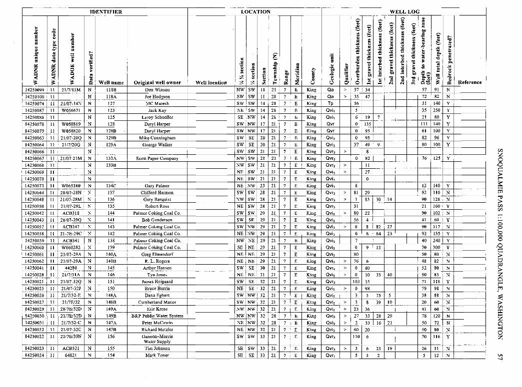
IDENTIFIER LOCATION
.... .. .. .c "Cl .... s Q .. .. = .c =
.. s Po. .. c = = = C" s .... ~ ·= = "Cl .. .. .. = = "Cl ~ = Q
·;:: .: = Po. ~ ~ f-1
~ :a z z 0 .. .. = .. .. ~ "' ..
Q Q Q "' .. = Cl) .. < < < -; ~ .. .. ~ = "' .. ~ ~ ~
.. Q Q Well name Original well owner Well location :,! ~ ... ~ "'
14250099 11 21/7/llM N 118B Don Winson NW SW 11 21 7
14250100 11 N 118A Joe Hodgson SW SW 11 21 7
14250074 11 21/07-14N N 127 MC Maresh SW SW 14 21 7
14250087 11 W056671 N 123 Jack Kay NE SW 14 21 7
14250088 11 N 125 Leroy Schueller SE NW 14 21 7
14250078 11 W058819 N 128 Daryl Harper SW NW 17 21 7
14250079 11 W058820 N 128B Daryl Harper SW NW 17 21 7
14250063 11 21/07-20Q N 129B Mike Cunningham SW SE 20 21 7
14250064 11 21/7/20Q N 129A George Walker SW SE 20 21 7
14250066 11 N SW SW 21 21 7
14250067 11 21/07-21M N 133A Scott Paper Company NW SW 21 21 7
14250068 11 N 133B NW SW 21 21 7
14250069 11 N NE SW 21 21 7
14250070 II N NE SW 21 21 7
14250073 11 W065380 N 134C Gary Palmer NE NW 23 21 7
14250044 11 21/07-28N N 137 Clifford Harmon SW SW 28 21 7
14250048 II 21/07-28M N 136 Gary Barquist NW SW 28 21 7
14250050 II 21/07-28L N 135 Robert Ross NE SW 28 21 7
14250042 II ACB318 N 144 Palmer Coking Coal Co. SW SW 29 21 7
14250043 II 21/07-29Q N 141 Bob Gunderson SW SE 29 21 7
14250057 II ACB347 N 143 Palmer Coking Coal Co. SW NW 29 21 7
14250058 11 21-7E-29C N 142 Palmer Coking Coal Co. NE NW 29 21 7
14250059 11 ACB341 N 138 P~lmer Coking Coal Co. NW NE 29 21 7
14250060 11 W060282 N 139 Palmer Coking Coal Co. SE NE 29 21 7
14250061 11 21/07-29A N 140A Greg Elmendorf NE NE 29 21 7
14250062 II 21/07-29A N 140B R. L. Rogers NE NE 29 21 7
14250041 II 44280 N 145 Arthur Hansen SW SE 30 21 7
14250028 11 21/7/31A N 146 Tye Jones NE NE 31 21 7
14250021 II 21/07-32Q N 151 James Heigaard SW SE 32 21 7
14250025 11 21/07-32} N 150 Bruce Burris NE SE 32 21 7
14250026 11 21/7/32-E N 148A Dana Egbert SW NW 32 21 7
14250027 11 21/7E/32 N 148B Cumberland Manor SW NW 32 21 7
14250029 11 21/7E/32D N 149A Eric Kruse NW NW 32 21 7
14250030 11 21/7E/32D N 149B B&P Public Water System NW NW 32 21 7
14250031 11 21/7/32-C N 147A Peter McCowin NE NW 32 21 7
14250032 11 21/07-32C N 147B Richard Metzler NE NW 32 21 7
14250022 II 21/7E/33N N 156 Gannon-Morris SW SW 33 21 7 Water Supply
14250023 11 ACB321 N 155 Tim Johnson SE SW 33 21 7
14250024 11 64821 N 154 Mark Toner SE SE 33 21 7
C .. ~ C ,_, ..
~ "' "' .. = "'
.:id "' .. .. = :a .:id .... .... .. ·= :a = = .. ....
"Cl = .... .. .. .. .. .... .. c "Q, = = :a Q .c .. = =a .... ·;:: = .... Cl) = .. .. Q .. = .. ....
~ u I;!) O' 0 "' .... E King Qa > 57 34
E King Qa > 35 47
E King Tp 56
E King Qvi1 5
E King Qvi1 6 19
E King Qvr 0 135
E King Qvr 0 95
E King Qvi3 0 95
E King Qvi3 37 49
E King Qvr3 > 8
E King Qvr2 0 82
E King Qvr2 > II E King Qvi1 > 27
E King Qvi1 0
E King Qvi1 8
E King Qvr3 > 81 29
E King Qvr3 > I 83
E King Qvr3 31
E King Qvi3 > 80 22
E King Qvi3 56 4
E King Qvi3 > 0 8
E King Qvi3 0 8
E King Qvi3 7
E King Qvi3 0 9
E King Qvi3 80
E King Qvi3 > 76 6
E King Qvr4 > 0 80
E King Qvi3 > 0 10
E King Qvr3 103 15
E King Qvi3 > 0 98
E King Qvi3 3 s E King Qvi3 > 3 8
E King Qvi3 > 23 36
E King Qvi3 > 27 33
E King Qvi3 > 2 33
E King Qvi3 > 60 20
E King Qvr3 110 6
E King Qvr3 > 3 6
E King Qvr1 5 5
WELL LOG
C C .. .. C ~ C ~ .. .. ,_, ~ ~ "' "'
,_, "' "' "' ..
"' .. "' = "' = .. .:id .. .:id = .. = .. .:id :a .:id :a .. .. :a .... :a ....
"Cl "Cl .... .. .... .. - .c -.. .c .... .. .... .. .. .. .. .. .... .. = .... = ....
Cl) ·- Cl) ·- "Cl "Cl "Cl .... = = .... "' .... ... ... ..,
7
9
30 14
82 27
84 23
13
33 40
75 5
39 10
28 29
16 21
23 19
2
.. = Q
" Cl)
= C ·;:: .. .. ~ .. -9
,_,
-= .... .... .. Po. .... .. .. "Cl ~ -; .s .... .s ;! Z' P,.o, .. ..~ ~ Q,_,
57 91
72 82
31 140
35 250
21 80
111 140
61 100
82 96
80 100
76 125
12 140
92 110
90 128
21 160
90 102
41 60
90 117
92 135
40 240
70 300
so 80
48 82
52 80
so 83
71 118
79 98
38 88
20 60
41 60
78 120
so 72
so 80
70 116
26 51
5 12
... "Cl .. .... .. .l: .. = .. Po.
.:id .. Q ....
"Cl .. =:I
N
N y
y
y
y
y
y
y
y
y
N
N y
N y
N y
y
y
N
N
N
N y
N
N
N
N
N
N
N y
N
N
Reference
Cl.l z 0 tO c:: > t'"' ~ ...... tI1 '"C > Cl.l Cl.l ...... ...... 0 0 ~o 0 0
tO
~ ~ 0 t'"' ~m
~ Cl.l ::i:: z 0 ""'3
@
VI -..J

IDENTIFIER LOCATION
.. .. .. .c:, "Cl e Q .. .. CJ
= .c:,
= .. e ~ .. ... = = .. = O' OI .... ---·= .. .i "Cl ~ OI .. = ~ = "Cl = Q ~ ·;:: ,::: = = ~ ~ r.i Q :a OI z z 0 .. CJ = .. .. .: Q "' .. :;;
Q Q Q "' CJ = l>I) s ·;:: < < < :::t .. .. ~ = OI "' CJ Q OI .. ~ ~ ~
.. ::;: Q Well name Original well owner Well location :::t ~ er, .... ~
14250035 II 21/07-33G N 153 Warren Thompson SW NE 33 21 7 E
14250045 11 N 152B Earl Knickerbocker NW NE 33 21 7 E
14250046 11 21/7E/33B N 152A Ken Hall NW NE 33 21 7 E
14250036 11 41440 N 159 Ken Stowman SW NW 34 21 7 E
14250038 11 219433 N 157 Marco Davis NW SW 34 21 7 E
14250039 II 21/07-34D N 158B Mark Warrender NW NW 34 21 7 E
14250040 11 21/07-34D N 158A Chas Becken NW NW 34 21 7 E
14250149 II N 194 Walter Chambers SW SW 25 22 6 E
14250150 11 N 193 Ron Davis NW SW 25 22 6 E
14250151 II 28177 N 191B John Johnson NE SW 25 22 6 E
14250192 11 N SE SE 25 22 6 E
14250125 II 14581 N 197 L-Bar Products Inc. SW SW 36 22 6 E
14250147 11 22/6-36F N 195 EvorMorgan SE NW 36 22 6 E
14250152 II 22/6-36A N 196A King Co. Water Dist. 105 NE NE 36 22 6 E
14250201 II N 196B Fire District No. 43 NE NE 36 22 6 E
14250178 11 AAJ366 N 218 King Co. CDBG NE NW 26 22 7 E
14250179 11 N NW NE 26 22 7 E
14250180 11 N NW NE 26 22 7 E
1425018] 11 22/07-26 N 24 Bob Brothers SW NE 26 22 7 E
14250194 11 22/07-26D N 223 Steve Brunette NW NW 26 22 7 E
14250166 11 19999 N 227 Richard Stolsig NE SE 27 22 7 E
14250176 11 22/07-27K N 228 Douglas Connolly NW SE 27 22 7 E
14250196 11 6124358F N 226 Stoneway Concrete SW NW 27 22 7 E
14250130 II N SW SE 28 22 7 E
14250131 II ABB727 N 230 Danica Browning SW SE 28 22 7 E
14250133 II N S/2 SE 28 22 7 E
14250134 11 N 3 James Smith SE SE 28 22 7 E
14250165 II 22/07/28 N 19 Ben Olson NW SW 28 22 7 E
14250163 11 17428 N 40 Mike Brown SW NE 29 22 7 E
14250202 11 22/07-30F N 234 Harlon Abraham SE NW 30 22 7 E
14250156 11 22/07/30R N 235 Don Corey SE SE 30 22 7 E
14250158 11 22!07-30C N 233B Loren Mitchell NE NW 30 22 7 E
14250159 11 22/07-30 N 233A Jim Polley E/2 NW 30 22 7 E
14250160 11 14487 N 233C Associated Water System 12 NE NW 30 22 7 E
14250197 II 22/7E/30A N 232 Sam Jones NE NE 30 22 7 E
14250121 II 22-7-32L N 240 Bob Hall NE SW 32 22 7 E
14250122 11 22-7-32K N 239 Ronald Anderson NW SE 32 22 7 E
14250123 II 22-7-32] N 238 Todd Hammerstrom NE SE 32 22 7 E
14250127 II 22-7-32B N 237 Lee James NW NE 32 22 7 E
---.. Z" .. .. :; Z" :; .. :; "' "' "' "' .. .. = "' "' = ..::ti .. ..::ti .;:: = CJ .:,:
~ '5 .. CJ
·= ;§ = "Cl .. = "Cl - .. .. .c:, CJ .. .. .. .. ..
c 'io'Ji = .. !5 .c:, OI
= = ..s .. '; .. l>I) = Q .. ·~
Q .. = .. ~ .. "' u I;!) O' 0 .... ....
King Qvr3 > 3 62 15
King Qvr3 > 23 76
King Qvr3 2 6 6
King Qvr1 > 5 51
King Qvr1 12
King Qvr1 > 6 41
King Qvr1 > 73 8
King Qvra > 56
King Qvra > 18 22
King Qvra 3 4 7
King Qvra > 37
King Qvt 0 9 27
King Qvra 22 15
King Qvra > 0 40 3
King Qvra > 18 22
King Qvr3 > 3 219
King Qvr3 > 25
King Qvr3 > 21
King Qa 65
King Qvr3 > 118 18
King Qvr3 14 84 8
King Qvr3 > 0 12 200
King Qvr4 > 0 137 13
King Qvr4 > I
King Qvr4 0 37
King Qvr4 > 91
King Qvr4 43 49
King Qvi 0 20 64
King Qvis > 5 23 67
King Qvra 18 6 1
King Qvra 23 110 2
King Qvt 31 16 9
King Qvt > 74
King Qvt > 2 23 105
King Qvt > 0 20 10
King Qvi > 30 40
King Qvi I 6 71
King Qvi 22 4
King Qvi > 36 10
WELL LOG
Z" .. Z" :; Z" .. .. ~ :; "' ....,
"' "' .. "' "' = "' .. ..::ti .. = CJ = .:,: f ..::ti
CJ CJ :a :a "Cl .. .. .. .i .c:, -.. .. .. .. .. OI OI ..
= .. l>I) l>I) ·~
"Cl "Cl "Cl = = .. .... .... .., 2 12 5
24 3
6
10 2
8
58 6 64
29
19
20 30 6
5 58 69
.. = Q N l>I)
= ·;:: OI ..
.c:, ,!. .. .. OI ~ Q .. -= ---.... ~ .. .. ~ Q....,
50
62
4
32
70
39
67
6
9
6
27
22
10
96
80
119
96
100
203
35
92
78
59
8
89
18
0
157
120
48
85
4
30
Z" .. ~ ...., -= =-.. "Cl
:E .E =5 ~
99
99
171
56
260
47
81
59
40
40
36
37
43
40
222
160
136
118
220
288
180
300
113
114
25
135
56
150
186
165
70
420
26
46
.... "Cl ~ OI .. .. .. = .. ~
.:,: CJ Q ..
"Cl .. ~
N
N y
N y
N
N y
N y
N y
N
N
N
y
N
N
N
N
y
y
y
N
N
N
N y
N
N
N y
N
N
Reference
Ul 00
z "T1 0
~ 0 z n ~ n e [;: :,;, 'Cl 0\

IDENTIFIER LOCATION
.. .. .. .c, 'Cl .. Q 5 .. CJ
= .c,
= .. 5 Po. .. .... = = .... = Cl' .. = ... ~ ·= .... .. 'Cl .. .. = = 'Cl ~ C Q ·;:: = Po. = ~ ~ ~ .: :a .. CJ Q .. z z 0 .. .. .: = "' :a ....
Q .. .... Q Q Q .. "' CJ = c.o = < < < = ~ .. .: ~ = ·;:: = "' CJ Q .. .. Q
~ ~ ~ Q Well name Original well owner Well location ~ ~ .. ... ~ ~ u "1
14250128 11 22-7-32A N 236 Raymond Mielde NE NE 32 22 7 E King
14250157 11 22-7-32E N 215B Ronald Anderson SW NW 32 22 7 E King
14250135 11 22/07-34C N 4 Patrick Michaelson NE NW 34 22 7 E King
14250136 11 N NE NW 34 22 7 E King
14250137 11 22/07-34B N 242B & 18 James Garrick NW NE 34 22 7 E King
14250138 11 22/7E/34B N 242A Ron Laughlin NW NE 34 22 7 E King
14250139 11 N NW NE 34 22 7 E King
14250140 11 22/7E/34 N 242C Roy Myers NW NE 34 22 7 E King
14250141 11 22/07-34B N 242D Terrance Beirne NW NE 34 22 7 E King
14250142 11 22/07-34A N 241A Thomas Ehlke NE NE 34 22 7 E King
14250143 11 22/07-34A N 241B Gordon Ocha NE NE 34 22 7 E King
14250144 11 N NE NE 34 22 7 E King
14250145 11 N NE NE 34 22 7 E King
14250198 11 22/07-34C N 242E Albert Foss NE NW 34 22 7 E King
14250146 11 N SE NW 35 22 7 E King
13260007 11 N Peter Hammond NW SE 8 23 8 E King
13260009 II N Grant Tolleth SW SE 8 23 8 E King
13260003 11 N SW NW 10 23 8 E King
13260004 II 23/8E/IOK N James Westlake SE NW 10 23 8 E King
13260071 11 23/8E/10Ki N Byron Moore SE NW 10 23 8 E King
13260005 11 N Orr Potebnya NE NE 10 23 8 E King
13260008 11 23/08-10 N Fred Fisher NW SW 10 23 8 E King
13260012 11 23/08/14D N Walt Hills NW NW 14 23 8 E King
13260015 11 23/08-14L N Al Chicklero NE SW 14 23 8 E King
13260010 11 N Vern Tracy NW NW 15 23 8 E King
13260072 II N Carl Cangie NW NW 15 23 8 E King
13260014 11 23/08-15F N Walter Schaefer SE NW 15 23 8 E King
13260017 11 N SE SE 15 23 8 E King
13260018 11 N Cascade Golf Course SE SE 15 23 8 E King
13260013 11 N Dennis Hyltine SE NW 16 23 8 E King
13260071 11 23/8-16/f N H.L. Robinson SE NW 16 23 8 E King
13260030 11 W098958 N Robert Van Winkle SW NW 23 23 8 E King
13260040 II N Telephone Utilities of WA SE SE 27 23 8 E King
13260042 11 23/08-34B N City of Seattle NW NE 34 23 8 E King
13260043 11 N John Boyce NE NE 34 23 8 E King
C C .. .. ~ C ~ .. "' ~ "' "' "' .. = "' ..
.or: "' = .. .or: CJ = CJ :a .or: ;§ .... .... CJ
·= = :a 'Cl
= .. .... .. .. 'Cl - .c, CJ .. .. ..
'6',i .. = .. C .. ..
.c, .... Q =; .. .. = Q .. c.o -~ .. = .. .... .... " O' 0 "' "' .... ....
Qvi > 28 6 21
Qvi 12 6 31
Qvr3 11
Qvr3 > 6
Qvr3 38 19 16
Qvr3 > 7 54
Qvr3 > 18
Qvr3 4 90
Qvr3 23 12 50
Qvr3 2 31
Qvr3 5 84
Qvr3 > 11
Qvr3 > 12
Qvr3 2 29 24
Qvr3 16
Qvt 14 10 7
Qvt > 4 3 9
Qa > 13
Qa > 15 5 20
Qa > 4 6 20
Qa > 6 34
Qa > 20 29
Qa 2 4 38
Qa > 7 5 19
Qa > 41 12
Qa 37 3 I
Qa > 23 32
Qa 0
Qa 9 27 7
Qvt > 64
Qvt > 3 26
Qa 14 2 30
Qvi3 0 2 194
Qvi3 > 0 18 21
Qvi, 18 21
WELL LOG C ..
C ~ C .. .. ~ ~ "' "' "' ..
"' "' = "' .. .or: .. = CJ = .or: :a .or: CJ CJ :a .... :a .... 'Cl .. .... - .c, -.. .. .. .. .. .. .. .. .. .... = .. c.o -~ c.o
'Cl 'Cl 'Cl
= = .. N N .., 5
3 3
6 3
10
6
17 9 20
II 38 2
.. = Q
" c.o = ·;:: .. .. -9 .. .. .... .. ~ Q .... ;! Z" Po.a, ....
Q!::::,
18
110
30
79
220
86
83
67
84
140
14
23
12
16
12
17
21
12
13
9
12
140
9
6
37
10
C .. ~ ._, -= .... Po. ..
'Cl -; .... .s .: ~
60
360
259
285
401
260
160
225
240
240
43
240
40
40
40
49
44
37
53
41
55
160
400
29
46
196
163
42
.. . 'Cl .. .... .. ./: .. = .. Po.
.or: CJ Q ..
'Cl .. =i
N y
y
y
y
y
y
y
y
y
y
y
N
N
N
N
N
N
N
N
N
N y
N
N
N
N y
Reference
C/.l z 0 IO e > t'"' ~ ...... tI:I '"d > C/.l C/.l
-0 0 0 0 0
IO
~ ~ a t'"'
~tI:I
~ > C/.l ::c: z a ...:i 0 z
VI
'°

Appendix 5. Aggregate-producing geologic units
This appendix describes some geologic units that have been mined for construction aggregates and (or) that have potential to produce gravel or rock meeting the threshold criteria. This list is based on a reconnaissance investigation, and therefore some important units may have been overlooked. In order to provide data for engineers and geologists, these unit descriptions incorporate geological terms too numerous to be included in the glossary. The rocks and sediments listed below are described using the unit symbols and nomenclature from the most recent geologic map of the Snoqualmie Pass quadrangle (Tabor and others, 2000). Unit symbols used in DGER's digital geologic database (Washington Division of Geology and Earth Resources, 2001) are provided in parentheses.
Quaternary Sediments
Qa Alluvium-Unconsolidated gravel, boulders, and (Qa) sand deposited on the flood plains of major rivers.
QI (Qls)
Qvr, Qvr1-6 (Qgo)
Clasts are composed of reworked glacial sediment, much of which is hard and durable granitic or volcanic material derived from Canada or the Cascade Range. This unit also includes a variety of weaker volcanogenic clasts derived from the central Cascades. Deposits of unit Qa are generally less than 50 feet (15 m) thick and do not contain significant gravel reserves, except where the unit can be mined together with nearby glacial gravels. Generally, gravel in this unit is discontinuous and interfingers with fine sand or clay. Consequently, it is easy to overestimate the volume of gravel available in any given alluvial deposit.
Alluvium is present throughout the study area. A total of 32 small pits and 20 larger mines produce from alluvium. The average reported Los Angeles Abrasion Test result for this unit is 22 percent.
Landslide deposits-Heterogeneous rubble deposits resulting from down-slope movement of sediment and rock. The size of particles varies greatly from de-posit to deposit, from large boulders to silts and clays. Where mined, this unit is composed largely of talus.
Landslide deposits are present in all steeper parts of the study area. In the Snoqualmie Pass quadrangle, 22 small mines and 1 large mine have produced from this unit. Meaningful test data are not available for this unit, but each landslide contains a unique mixture of rock types.
Ice-age (Fraser Glaciation) glacial outwashSand and gravel that are moderately to well sorted, stratified, and well bedded with silty sand to silty clay. These sediments were deposited in ice-age proglacial and ice-marginal environments. These deposits are made up of hard and durable clasts derived from Canada, the north Cascade Range, and local sources. However, much of the outwash in the Cedar and Green River channels is composed of andesite clasts (Kroft, 1972 ).
Outwash deposits are limited to the northwestern portion of the study area. Typical outwash deposits
60
Qag (Qade)
range from 50 feet (15 m) to more than 150 feet (45 m) in thickness. The large Cedar River outwash channel includes several large deposits and may reach 150 feet (75 m) in thickness (Brown and Caldwell, 1978). However, this great thickness probably includes older units and thin intervening till layers.
For the most part, mines within the outwash lie above the water table and cause relatively little environmental impact, except where they impinge on riparian zones. Preserved ice-age outwash channels are characterized by low elevation and gentle topographic relief. Consequently, potential sites for mining outwash can also be prime farmlands or zoned for rural five-acre tracts. These land uses are generally incompatible with mining. Most of the Cedar River outwash channel lies within the municipal watershed for Seattle.
A total of 26 small pits and 31 larger mines produce from the glacial outwash. It is the main producing interval in the North Bend-Cumberland complex. Los Angeles Abrasion and Washington Degradation Test values are typically less than 20 and 25 percent respectively (Appendix 3)
Alpine glacial drift-Includes sand, gravel, clay, and other sediments derived from outwash or till that were deposited by alpine glaciers and glacial meltwater streams. Alpine glacial drift also includes deposits from alluvial fans, slope wash, talus deposits, small fans, and bogs. For the most part, these deposits are younger than the continental glacial deposits (unit Qvr).
Alpine glacial drift is present in most valleys issuing from the Cascade Range. Nineteen large and 15 small mines in the Snoqualmie Pass quadrangle have extracted aggregate from this unit. It is the main producing unit in the Bullfrog complex. Test data are unavailable for this unit.
Miocene Volcanic Rocks
Tgn, Tgr2 (Mvg)
Grande Ronde Basalt-Fine-grained basalt that is commonly columnar- or hackly-jointed. A few interbeds of tuffaceous fine-grained sandstone, siltstone, and mudstone are present. Some of the flows display localized pillow zones. The flows generally have vesicular or brecciated flow tops, but the interiors of the flows consist of dense basalt, which is ideal for asphalt aggregate. In general, colonnades and entablatures contain the best rock. The flows are middle Miocene in age (16.5 to 15.0 million years).
Grande Ronde Basalt crops out only in the southeastern portion of the Snoqualmie Pass quadrangle and has been quarried in only three locations. However, this unit is the most important bedrock unit in eastern Washington and along the Columbia and Cowlitz Rivers southwest of the Snoqualmie Pass quadrangle. It has been extensively quarried in many other locations, where much of the unit consists of very high quality rock. In 13 quarries in the adjacent

Tf (Mva, Mvatp)
Tfc (Mvtfp, Mvtfpc, Mvtfps)
SNOQUALMIE PASS 1:100,000 QUADRANGLE, WASHINGTON 61
Yakima 1:100,000 quadrangle (Weberling and others, 2001), Los Angeles Abrasion and Washington Degradation Test values average 20 percent and 72 respectively.
Fifes Peak Formation volcanic flows-Heterogeneous volcanic flows, mudflow breccias, and volcaniclastic and sedimentary rocks. Porphyritic andesites, dacites, and basalt flows, which are typically 75 to 150 feet (23 to 46 m) thick and intensely fractured. Poorly developed columns (hexagonal pillars roughly 4 feet [ 1.2 m] in diameter and tens of feet high) are present, and some flows exhibit platy jointing that commonly facilitates excavation. The andesite contains some glass that can be detrimental to aggregate quality. Massive to well-bedded breccias contain andesite clasts similar to the flows. The volcaniclastic sandstones, siltstones and lapilli-tuffs are generally well bedded. Most of this unit consists of weak rock. The age of the Fifes Peak Formation is mainly early Miocene, but some late Oligocene rocks have been dated (Tabor and others, 2000).
This unit also includes the volcanic rocks of Cougar Mountain of Frizzell and others (1984). Thin, well-bedded sandy to silty units are found locally in these Miocene rocks. Feldspar and mafic phenocrysts are very common, and some flows display a glassy texture. Some minerals in the andesite and basalt show alteration to clay that may weaken the rock or create alkali-reactive mixtures that could degrade portland cement concrete.
Fifes Peak Formation flows are found in the south half of the Snoqualmie Pass quadrangle. Because of their proximity to the market, they are currently the most important source of quarried bedrock in the Snoqualmie Pass quadrangle. Scenic bedrock knobs that protrude out of the flat plain of Osceola mudflow deposits surrounding the town of Enumclaw are mostly Fifes Peak Formation. These knobs are particularly well suited to top-down quarry mining. The three biggest bedrock mines in the region, the Enumclaw, White River, and 410 quarries, produce from the Fifes Peak Formation. (See Table 3 and Appendix 3.) Additionally, rock from this unit has been mined in 186 small forest quarries. Los Angeles Abrasion Test data from 23 of these quarries average 25 percent.
Fifes Peak Formation tuffs-Mainly rhyodacite ash-flow tuff and well-bedded volcaniclastic sedimentary rocks. Alteration of this unit is locally so pervasive that original grain types and textures are not discernable. Tuffs are locally welded and exhibit crude columns. The rock in these units has been dated at about early Miocene.
These units are found in the south-central and southwestern part of the Snoqualmie Pass quadrangle. Despite the unfavorable lithologic characteristics, 23 quarries have used rock from these units. Most of the rock is used for forest road construction and maintenance. Data from 12 quarries give Los Angeles Abrasion Test results averaging 22 percent.
Miocene Intrusive Rocks
Tip, Tidp (Mian)
Tsgg, Tsgs (Migds)
Tsgf (Mims)
Tiap (Mims)
Tcr (Migdcr)
Aphanitic intrusive andesite, undifferentiatedGray to green hypersthene and clinopyroxene intrusive andesite with glass and clay alteration, and minor gray hornblende dacite or rhyodacite porphyry, granodiorite, and tonalite. The age is early to middle Miocene.
This unit occurs as small, localized outcrops in the central part of the Snoqualmie Pass quadrangle. This unit has been used for three large quarries and 11 smaller mines. Rock from this unit may be locally of high quality, but in some areas it has been adversely altered by weathering. Only one site had a reported Los Angeles Abrasion Test value, which is 33 percent.
Granodiorite of the Snoqualmie batholith-Granitic rock (granodiorite and tonalite) that crops out in the north-central part of the Snoqualmie Pass quadrangle. This batholith is probably several miles thick in many locations and ofrelatively uniform composition. For these reasons, this unit is probably among the largest construction aggregate resources in the state. The age of the unit is middle Miocene.
At least 27 quarries have used rock from this unit, but mostly for forestry applications or building Interstate Highway 90. Units Tsgg and Tsgs exceed several thousand feet in thickness and cover a large surface area. Los Angeles Abrasion Test results reported from five quarries average 21 percent. Aggregate is mined from talus in this unit, where Los Angeles Abrasion Test values do not meet the threshold criteria.
Monzonite of the Snoqualmie batholith-Finegrained, highly-altered granitic rock (monzonite). The age of this unit is middle Miocene.
Three quarries have used rock from this unit; however, no test data are available.
Intrusive dacite-Dacite porphyry, which includes some highly altered quartz-bearing volcanic rock and some porphyritic rhyolite that grades into mediumgrained tonalite. The age of this unit is early Miocene.
Unit Tiap is exposed as small outcrops in the central part of the Snoqualmie Pass quadrangle, where it is used for forestry applications. Rock from this unit has been produced in at least 10 quarries, with Los Angeles Abrasion Test data for five quarries averaging 21 percent and ranging from 17 to 27 percent. At a sixth quarry, altered andesite and volcaniclastic elastic rocks yielded a Los Angeles Abrasion Test result of 55.
Carbon River stock granodiorite-Massive granodiorite and granodiorite sills, locally with a tonalite border phase. The Carbon River stock is a satellite of the much larger Tatoosh pluton. Both units probably extend to great depth. This unit is middle Miocene in age.
Unit Tcr crops out in the southwestern part of the Snoqualmie Pass quadrangle, and five small quarries have used rock from this unit. Test data are unavailable for this unit.

62 INFORMATION CIRCULAR 96?
Tstn, Tit (Mit)
Tfci, Tfce, Tfrt, Tfst, Tfcr (Mirtp)
Tonalite-Granitic rock (tonalite), a minor portion of which grades into granodiorite or quartz diorite. Some bodies ofunit Tstn are texturally transitional to pyroxene andesite porphyry. Many small tonalite masses may be satellites of the Snoqualmie or Tatoosh batholiths. The age of this unit is late Oligocene to early Miocene.
Unit Tstn is found in small outcrops throughout the northern Snoqualmie Pass quadrangle. Rock from this unit has been quarried in seven locations; Los Angeles Abrasion Test values from four of these average 24 percent.
Intrusive rhyolite of Clear West Peak, Fifes Peak Formation-Chiefly intrusive rhyolite that is mostly gray to purple. In places, the rock is highly altered. This unit is included in the Clear West Peak complex by Fischer (1970). Rocks are conspicuously banded perpendicular to columnar joints, suggesting steep and varied flow layering or multiple dikes, and are locally intruded by andesite dikes. The rhyolite may be mostly intrusive, but it includes some erupted material. The age of this unit is early Miocene.
This unit is present in the southwestern part of the Snoqualmie Pass quadrangle. Seventeen quarries have used rock from this unit, including one large mine. Los Angeles Abrasion Test data have been provided from 10 of these sites and average 17 percent.
Miocene-Oligocene Volcanic Rocks
Teg Volcanics of Eagle Gorge-Dark green to black (M<Dvae9) andesitic and basaltic flows and flow breccias, minor
tuffs, and volcanic sedimentary rocks. Lava flows variously exhibit platy jointing and columnar jointing; some areas exhibit vesicular tops, scoria, and amygdaloidal zones. The unit is late Oligocene to early Miocene in age.
Eagle Gorge volcanic rocks crop out in the central part of the Snoqualmie Pass quadrangle. Twentythree forest quarries and three large mines have produced from this unit. Los Angeles Abrasion Test data for 15 of these quarries average 23 percent and range from 13 to 3 8 percent.
Miocene-Oligocene Intrusive Rocks
Tsm (M<Dian, M<Digb8 )
Intrusive andesite and gabbro of the Snoqualmie batholith-Intrusive andesite (OGER unit M©ian) and gabbro (OGER unit M<Digb) and minor dacite (Frizzell and others, 1984). This unit may be the chilled margin of a high-level cupola of the Snoqualmie batholith. Mapped bodies include closely spaced dike swarms. The rock, which is commonly altered to smectite and zeolite, has been dated as late Oligocene to early Miocene.
Six small quarries have used rock from this unit, but no test data are available.
Oligocene Volcanic Rocks
To, Tolk, Tv (©vc0 h)
Ohanapecosh Formation-Well-bedded, multicolored, volcanic- and crystal-lithic andesitic tuff and breccia, volcaniclastic sedimentary rocks, and minor flows. These flows alternate with massive tuff-breccia and subordinate rhyolite, basalt, and andesite
flows. Numerous fission-track ages from zircon indicate the rocks were erupted 28 to 36 million years ago (late Eocene to Oligocene).
Many (189) small forest quarries and one large mine have used rock from the Ohanapecosh Formation. Los Angeles Abrasion Test results reported from 69 quarries average 25 percent and range from 14 to 45 percent.
Eocene Sedimentary Rocks
Tn, Tns (EC2na,
EC2nas)
Naches Formation-Predominantly sandstone and shale, but includes minor volcanic rocks such as rhyolite, andesite, and basalt flows and tuff; as well as breccia with interbeds of feldspathic subquartzose sandstone, siltstone, and rare coal. Although these rocks are mapped as sedimentary, it is likely that many of the pits and quarries produce from volcanic intercalations. The andesites and basalts are amygdaloidal in part, commonly columnar, and have brecciated, vesicular tops. Rhyolite is found as flowbanded flows or domes and minor ash-flow tuffs. the interbedded sedimentary rocks are coarse-grained micaceous feldspathic sandstone and argillite and laminated siltstone. Both volcanic and sedimentary rocks are thermally metamorphosed adjacent to Miocene plutons.
The Naches Formation crops out in the east-central portion of the quadrangle. One large mine and 31 small quarries have used rock from this unit. Los Angeles Abrasion Test data from 5 of these average 23. The only degradation test in the unit is 67.
Eocene Volcanic Rocks
Tpt, Tmp (Evc1,
Evamp)
Tbf (Evbtm, Evbtmb)
Tukwila and Mount Persis Formations-Fine crystalline volcanic rocks that are mostly very dark gray aphanitic alkalic basalts in poorly defined flows. Also included are andesitic intrusives, heterogeneous volcanic flows, breccias, and sedimentary rocks. Near Tiger Mountain, unit Tpt consists partly of a columnar-jointed sill 60 feet thick (T. J. Walsh, Wash. Divn. of Geology and Earth Resources, oral commun., 1999). The age of the Tukwila and Mount Persis Formations is late Eocene.
These units crop out in the northwestern parts of the quadrangle. Although most of the Tukwila Formation consists of weak, stratified volcaniclastic rock types, it includes local basaltic flows, a few of which are hard and durable. The Tukwila Formation is mapped on Plate 1 as a possible bedrock resource where cliffs or forest borrow pits suggest higher quality deposits. These rocks have been used by the Weyerhaeuser Company and Washington Department of Natural Resources for forest road construction. Quarried bedrock products are produced from 13 small mines used for forest road maintenance. Reserves are limited to those contained in two borrow pits. Quantitative rock quality data are not available.
Basalt of Frost Mountain-Dense black olivine basalt that weathers red and has localized columnar jointing and brown glass. The unit has minor white siliceous alteration. Its age is late Eocene; potassiumargon ages are 32 and 47 million years. The basalt of

Tnmc (Evtna)
Tnr (Evrna)
Tnb, Tnbg (Evbnap)
SNOQUALMIE PASS 1:100,000 QUADRANGLE, WASHINGTON 63
Frost Mountain is correlative with the Teanaway Formation, which crops out farther north.
This unit crops out in the southeastern Snoqualmie Pass quadrangle and has been used locally for logging road construction and maintenance. At least 12 quarries have developed in this unit; however no strength or durability data are available. A railroad report (Newell Campbell, consultant, Yakima, Wash., written commun., 2000) indicates good quality aggregate, but most exposures are too remote to be of value. Strength and durability are not available for the Basalt of Frost Mountain.
Mount Catherine Rhyolite Member of the Naches Formation-Flow-banded rhyolite, welded, crystallithic ash-flow tuff, and feldspathic sandstone and shale interbeds. The unusual hardness of the rhyolite is probably due to recrystallization during intrusion of the Snoqualmie batholith. Basalt flows and breccia are found locally, as well as interbeds of coaly shale, rare volcanic-rich pebble conglomerate, and quartz pebble grit. The age of the unit is middle to late Eocene.
This unit crops out in the east central portion of the quadrangle. Eight small quarries in this unit have provided rock for logging road construction and maintenance. No analyses are available for this unit.
Rhyolite flows of Naches Formation, Cabin Creek block-White to gray, flow-banded, platy jointed flows or domes of rhyolite from a few feet to hundreds offeet thick. Some rhyolite in this unit is probably intrusive. The unit contains minor interbeds of basaltic tuffs and flows and feldspathic sandstone. Fission track ages on zircon yield ages of 40 to 44 million years (middle Eocene).
This unit has been quarried at eight small mines for logging road construction and maintenance. Average Los Angeles abrasion and degradation analyses for four mines in unitTnr are 29 and 22, respectively.
Basalt of Naches Formation, Cabin Creek blockBasalt and glomeroporphyritic basalt with interbeds of andesite and feldspathic sandstone and siltstone. The unit occurs as thick flows, in part with vesicular tops. It occupies a similar stratigraphic position to the Tukwila and Mount Persis volcanic rocks. This unit is middle Eocene to early Oligocene in age.
This unit crops out in the east-central portion of the quadrangle. Twenty small forest quarries have been developed in this unit, with Los Angeles abrasion and degradation analyses from four averaging 24 and 48, respectively.

---------------

............___ "-- \
~:'-,-f-~~ ~-""--''1--------.·=~
,roo· 122"00'
"
• '
'<
JI" I>
-~ C
.?' "
-
J
" -
',/.
(
D -I)---
121 '30'
' "
(] I\. ~
/
• 11~ .~
l:J_ orse--Feak-Wilder~
I ( /1
' .
·~
• .. •
"
.,. . ,-
0
4
~
\
' <
, nxr 121"00'
Wash ington Division of Geology and Earth Resoun:es Ron Teissere, State Geologist
Information Circular 96 June 2002
WASH INGTON STATE DEPARTMENTOF
Natural Resources Doug Slttherland -Commin loner of Public L,nds
PLATE 1
• LOCATION OF SOME SAND, GRAVEL, AND QUARRIED BEDROCK RESOURCES IN THE
SNOQUALMIE PASS 1:100,000 QUADRANGLE, WASHINGTON
EXPLANATION
Potential extent of "hypothetical undiscovered" sand and gravel reserves, most of which meet threshold criteria for strength, durability, thickness, areal extent, and ctest-size distribution, and are not buried under thick layers of overburden (See text for further explanation). Yellow and orange shades Indicate approximate gravel thickness in feet.
- ~ - Contour showing possible thickness of some hypothetical gravel deposits meeting the threshold criteria (50-ft Interval)
D
D
--S:1§1
"
Potential extent of "speculative undiscovered" bedrock reserves, most of which meet threshold criteria for strength, durablUty, thickness, and areal e>rtent, and are not buried under thick layers of overburden. (See text for further explanation)
Potential extent of "speculative undiscovered" bedrock reserves which locally meet the threshold criteria, but are composed mostly of weak lithologies that are unsuitable for construction aggregate
Large active mine. Includes Intermittently operated sites end a few sites that may have been abandoned, but are not reported as such
Large depleted or abandoned mine
Large proposed mine
Small gravel pit , borrow pit, or quarry. Most of these mines are used for forest road maintenance or construction and/or do not significantly Influence the market et this time
Depleted or abandoned small gravel pit, borrow pit, or quarry. Includes mines with term inated state reclamation perm its, reclaimed sites, and mines that cannot be operated owing to changes In land use (for example, the site has been flooded by a reservoir)
P Water well used In this study for subsurface Information
'l!l_ Geotechnlcel or other borehole used in this study
'v Sampling site for laboratory test of strength and dureblllty of gravel or rock. Does not Include analyses from most mines ienatyses from m!nes are described In Appendix 3 )
Geolog ic observations used in this report
Stratigraphic section measured as part of this study
' '
"' "
0
Sect ion Grid N
" w
" " s
2 3 4
MILES
Scale 1:100,000
TOPOGRAPHIC CONTOUR INTERVAL 200 FEET
Lambert Conformal Conic Projection 1927 North American Datum
E
5
Washington State Plane Coordinate System, South Zone Other base map information from the Washington Department of
Natural Resources, Geograph ic Information System Database. 2000 Washington Division of Geo logy end Earth Resources
M•p production by Ch'l'.l!fro..,W"" Ph,eg Ho
DEPT. OF NATURAL RESOURCES GEOLOGY & EARTH RE60UflCE6 orvJSION
Ol YMPlA, WA. 96504-7007
QEl 75 A3 16 96 copy 3 Plate l


![Circular [96] 8 Safar 1443 16 September 2021 THE DEVIATES](https://img.dokumen.tips/doc/110x75/6214f0d058408326b970898f/circular-96-8-safar-1443-16-september-2021-the-deviates-.jpg)


