Embed Size (px)
Citation preview

Improvement of Touristic
Infrastructure in Nukriani and Zemo
Bodbe
Environmental and Social Screening Report
May 2017
SFG3426 V7 P
ublic
Dis
clos
ure
Aut
horiz
edP
ublic
Dis
clos
ure
Aut
horiz
edP
ublic
Dis
clos
ure
Aut
horiz
edP
ublic
Dis
clos
ure
Aut
horiz
ed

Sub-Project Description
Sub-Project sites (picnic spot in village Nukriani and trail, leading to Zemo (Upper) Bodbe) are located
within the Sighnaghi Municipality. The picnic spot is located on 2 hectares of municipal land. The spot is
next to the central road, which many tourists pass during touristic seasons. The trail runs from the picnic
spot, through the Tsikhitviani valley and to the Bodbe Archaepolis.
Nukriani is located within the 5 km distance from the town of Sighnaghi, and Zemo Bodbe - within the 10
km distance. Since the rehabilitation of town Sighaghi in 2007-2010, the number of tourists increased
significantly. However, town Sighnaghi does not have capacity to arrange the camping spots and host large
number of travelers. Thus, usually visitors are forced to go back to Nukriani, stop the vehicles there,
arrange picnic and spend the day in unorganized place.
Picnic spot in Nukriani village was established during the Soviet times, as a memorial of World War II
victims. The coniferous trees were planted there and the area was registered as collective farm, which was
automatically given to Nukriani village council and now is registered as Sighnaghi municipality property.
Due to its location and frequent use by tourists, the area was developed into a picnic spot. Akhaltskali
gorge, where the SP site is located, is the only source of water supplied to the Nukriani village. Due to the
lack of necessary tourist infrastructure, travelers usually throw rubbish on arbitrarily arranged landfills,
which creates the risk for drinking water contamination. In 2012, a little corner was arranged at this place
with table and places for sports and rest, but this infrastructure can’t satisfy travelers’ needs. Vehicle
mainly being parked in the vicinity of the main road, often create emergency situations, because there is no
way to stop vehicles at special areas. SP site lacks lighting that is why tourists are forced to leave the area
earlier, or light a bonfire, which is often the source of the fire. In addition, there is a need for trade
infrastructure arrangement for the population, which sells the village products there.
The SP site of Zemo Bodbe (trail and so called Archaeopolis), that is very interesting spot from the
archaeological point of view, is not used by the tourists at all. From here, it’s easy to visit Bodbe
monastery and the temple of Nasamkhrali. Tourists will pass through the beautiful gorge of Tsikhitviani
that was considered to be a road of Kakheti kings. Through this way, tourists coming from the Bodbe
monastery will get to Zemo Bodbe, which is a resort zone, but the village is almost abandoned presently,
because the village does not have a local product realization opportunity, cultural and entertainment
venues.
Various interventions are necessary to improve the tourist infrastructure in Nukriani and Zemo Bodbe.
These will include:
Arranging four open sheds for picnic;
Arranging four counters for agro-market;
Arranging counters for handicraft exhibition and selling;
Installing 15 lighting posts;
Arranging stairs from the central road to the picnic area;
Gravelling bus stop;
Restoring sports pitch equipment for volleyball and other sports games;
Installing 3 receptacles;
Arranging 4 fire place;
Installing 40 tourist signs on the way from the Bodbe monastery to the village Zemo Bodbe;
Installing 2 information banners, one indicating route to the Bodbe Monastery and another at the
Nukriani picnic area.

Environmental Screening and Classification
(A) Impact Identification
Has sub-project a tangible impact on the
environment?
The SP construction phase covers 3 months’ period. SP will
have a small-scale and short-term impact on the
environment only in the construction phase, while its long-
term impact on the natural and social environment will be
positive.
What are the significant beneficial and adverse
environmental effects of the sub-project?
The SP is expected to have positive long-term
environmental and social impact through arrangement of
the tourist infrastructure within the SP and will improve
touristic attraction.
The expected negative environmental and social impacts are
likely to be short-term. As a result of constructing the open
and counter-sheds, arranging the fire places, lighting posts,
information banners, tourist signs, receptacles, gravelling
the bus stop and renovating the sports pitch, the dust and
emissions from the operation of construction machinery
will be increased, background noise and vibration levels
will rise insignificantly, various types of construction waste
is expected to generate.
During the operation phase, presence of the picnic
infrastructure may result in additional generation of
household waste, and nuisance to households, near the
picnic spot in case of improper behavior of visitors (loud
music, drinking, etc.).
Does the sub-project have any significant
potential impact on the local communities?
The long-term social impact of the SP will be beneficial,
which will cause significant improvement of the social
conditions of local population and tourists. As a result of
the SP implementation, approximately 100 travelers and
visitors per season will be served. In addition, the SP site
will host motorsports fans (approx. 100 persons),
community members who will sell the agro-products
(approx. 45 persons), community population (2800
persons), community youth (approx. 50 persons), etc.
The main impacts of the SP are:
Physical improvement:
Nukriani – after arranging camping site, tourist will be able
to spend time in clean, comfortable environment. First of
all, this place will be cleaned of rubbish, gathered through
years and will be equipped with receptacles, which will be

cleaned on a regular basis by cleaning service. The picnic
spot lighting will make the place more attractive and in the
evenings will attract tourists, heading towards Sighnaghi. A
well-equipped playground will help visitors spend a quality
time. The camping place with camp-fire facilities will make
tourists stay longer. The bus parking will be a good
opportunity to avoid accidents.
Zemo Bodbe – the tourist route designators (with brief
history) board will be installed in the vicinity of the
monastery Bodbe. The surrounding area will be tidied up
and 15 tourist path signs (marking) will be placed. The
receptacle will be installed at the Bodbe Archaeopolis.
Tourist product: The developed infrastructure will serve
tourists. There are no similar spaces in and around
Sighnaghi.
Income generation: Local residents will be able to sell
agricultural and touristic products. Demand on guesthouses
will increase, that will generate income to families.
Significant social impact of SP, such as change of local
demographic structure and influx of new settlers is not
envisaged.
What impact has the sub-project on the human
health?
The dust, vibration and noise originated during the small-
scale construction works will not have impact on the human
health or safety.
(B) Impact Mitigation
What alternatives to the sub-project design have
been considered and what mitigation measures
are proposed?
During the SP design, a no-project alternative was
considered and turned down as the implementation of the
SP will help attract both, the local and foreign visitors that
will have a positive impact on the social condition of the
local population.
Reduction of adverse environmental impact during the
installation/construction works will be possible through
protecting the following key conditions: fencing the
construction site and fixing the relevant signs throughout its
perimeter, proper management of waste and constant

monitoring, ensuring the technical functionality of
machinery used during the construction works, selecting
less sensitive period for construction works.
Planned works will not cause cutting of trees and
preventive measures will be undertaken to avoid any
damage to the nearby standing trees. Large tress on and in
the vicinity of the construction activities shall be marked
and cordoned off with fencing, their root system protected,
and any damage to the trees avoided.
In case of chance finds, works will be taken on hold and
notification be sent to the Ministry of Culture and
Monument Protection of Georgia. Works will resume only
upon written consent of the Ministry.
If before, during or after SP implementation concerned
community members have complaints/ questions/
recommendations, these can be addressed to the sub-
grantee, contractor, or Elkana, whose contact information
will be made available at the SP site.
Have concerned communities been involved
and have their interests and knowledge been
adequately taken into consideration in sub-
project preparation?
During community mobilization, several priorities were
identified`, including rehabilitation of drinking water
system, arrangement of stadium, arrangement of park near
the school in Kvemo bodbe. Improvement of touristic
infrastructure in Nukriani and Zemo Bodbe was selected.

(C) CATEGORIZATION AND CONCLUSION
Conclusion of the environmental screening:
Sub-project is declined □
Sub-project is accepted ■
Sub-project is classified
as environmental Category B
and needs EMP ■
Sub-project is classified
as environmental Category C
and does not need EMP □

Social Screening
Social safeguards screening information Yes No
1 Is the information related to the affiliation, ownership and land use status of
the sub-project site available and verifiable? (The screening cannot be
completed until this is available)
2 Will the sub-project reduce people’s access to their economic resources, such
as land, pasture, water, public services, sites of common public use or other
resources that they depend on?
3 Will the sub-project result in resettlement of individuals or families or
require the acquisition of land (public or private, temporarily or permanently)
for its development?
4 Will the sub-project result in the temporary or permanent loss of crops, fruit
trees and household infrastructure (such as ancillary facilities, fence, canal,
granaries, outside toilets and kitchens, etc.)?
If answer to any above question (except question 1) is “Yes”, then OP/BP 4.12 Involuntary Resettlement is
applicable and mitigation measures should follow this OP/BP 4.12 and the Resettlement Policy Framework
Cultural resources safeguard screening information Yes No
5 Will the sub-project be implemented in the vicinity of a cultural heritage
site?
6 Will the sub-project require excavation near any historical, archaeological
or cultural heritage site?
If answer to question 5 is “yes”, then OP/BP 4.11 Physical Cultural Resources is applicable. In this case,
sub-project proponent must provide evidence that consultation was held with and an agreement on this sub-
project was obtained from an authorized representative of culture and heritage protection authority.
If answer to question 6 is “Yes”, then OP/BP 4.11Physical Cultural Resources is applicable and possible
chance finds must be handled in accordance with OP/BP and relevant procedures provided in this EMF.

Environmental Management Plan
Improvement of Touristic
Infrastructure in Nukriani and Zemo
Bodbe
PART A: GENERAL PROJECT AND SITE INFORMATION
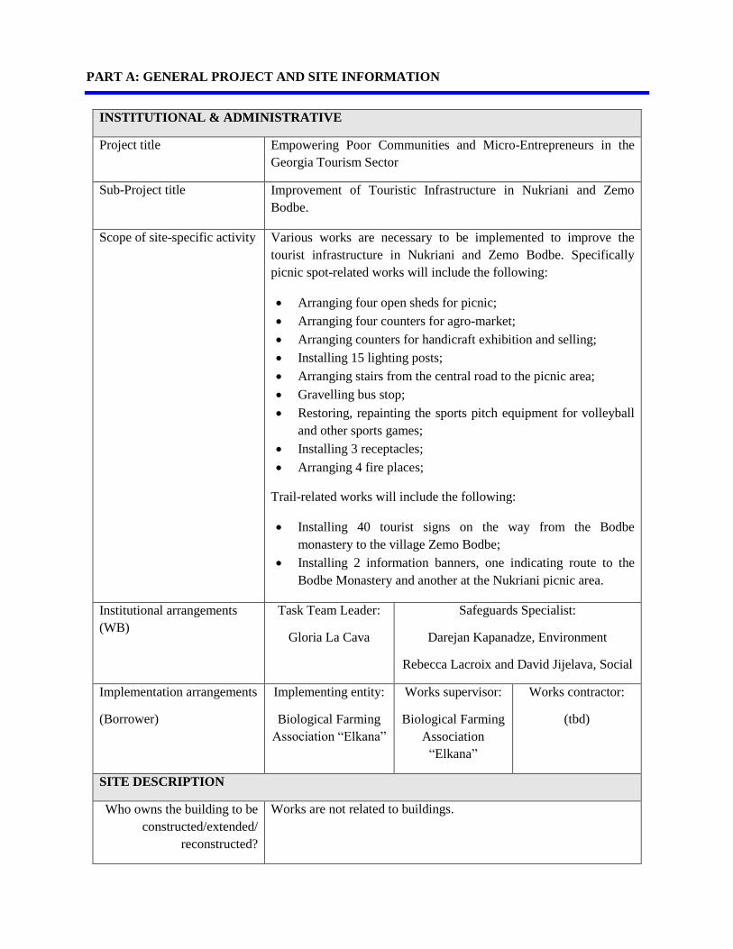
INSTITUTIONAL & ADMINISTRATIVE
Project title Empowering Poor Communities and Micro-Entrepreneurs in the
Georgia Tourism Sector
Sub-Project title Improvement of Touristic Infrastructure in Nukriani and Zemo
Bodbe. Scope of site-specific activity Various works are necessary to be implemented to improve the
tourist infrastructure in Nukriani and Zemo Bodbe. Specifically
picnic spot-related works will include the following:
Arranging four open sheds for picnic;
Arranging four counters for agro-market;
Arranging counters for handicraft exhibition and selling;
Installing 15 lighting posts;
Arranging stairs from the central road to the picnic area;
Gravelling bus stop;
Restoring, repainting the sports pitch equipment for volleyball
and other sports games;
Installing 3 receptacles;
Arranging 4 fire places;
Trail-related works will include the following:
Installing 40 tourist signs on the way from the Bodbe
monastery to the village Zemo Bodbe;
Installing 2 information banners, one indicating route to the
Bodbe Monastery and another at the Nukriani picnic area.
Institutional arrangements
(WB)
Task Team Leader:
Gloria La Cava
Safeguards Specialist:
Darejan Kapanadze, Environment
Rebecca Lacroix and David Jijelava, Social
Implementation arrangements
(Borrower)
Implementing entity:
Biological Farming
Association “Elkana”
Works supervisor:
Biological Farming
Association
“Elkana”
Works contractor:
(tbd)
SITE DESCRIPTION
Who owns the building to be
constructed/extended/
reconstructed?
Works are not related to buildings.

Who owns the land allocated
for sub-project?
Who uses the land
(formal/informal)?
The park area is the property of Sighnaghi municipality.
The area is used by the local residents and tourists/visitors.
Description of physical and
natural environment, and of
the socio-economic context
around the site
The village Nukriani and village Zemo/Upper Bodbe is located in
the Sighnaghi Municipality. The total area of Sighnaghi
municipality is 1 251 km², from which 93 375 ha are agricultural
lands and 5 500 ha - forest area. The territory of the municipality
includes the slopes of Gombori Ridge and Alazani Plain. Sighnagi is
the center of the municipality and is located at the altitude of about
800 meters above sea levels. An important part of the municipal
territory covers Iori Plain, which is located in the southern part of
Gombori Ridge. The municipality covers quite a large territory
stretched from the banks of Iori River to the Alazani River. It covers
4 climate zones. Its southern part belongs to the Iori Plain covered
with arid steppes at the heights of 300-700 m ASL. A relatively
small area covers the slopes of Tsiv-Gombori Ridge at the height of
800-1 000 m, where the villages Nukriani and Zemo/Upper Bodbe
are located.
Sighnaghi's climate is classified as warm and temperate. The
average annual temperature in Sighnaghi is 11.5 °C. About 703 mm
of precipitation falls annually. Average annual wind speed is 2.2
m/sec. north – western and northern winds are usually prevailing on
surrounding territory.
Small and medium-thickness black soils, as well as gray, saline and
alkaline soil complexes are developed on Iiori Plain. Brown forest
soils are dominant in the foothills of the slopes of Gombori Ridge,
which are rich in humus and plant food elements. Brownish,
alluvial-carbonate and meadow carbonate soils are developed at the
transitional strip of forest steppe on Alasani Plain. Mainly brown
soils are developed in the high zone (700-1 600 m), where the
humus layer is 2.5-3.5%. Brown meadow soils are covered with
annual and perennial crops.
The territory of Sighnaghi municipality is poor in hydrographic
networks. Rivers mainly are of periodic nature. The rivers of R.
Alasani and Iori have to be distinguished. Alazani flows in the
eastern part of the municipality near the border with Lagodekhi
municipality and Azerbaijan. R. Iori intersects the Iiori Plain in the
southern part. The length of Iori River within the municipality is 28
km. Dry ravines are located on the south-west slopes of Gombori
Ridge, but they cannot reach R. Iori. Sighnaghi municipality has
temperate limited and surface water resources. Surface waters in
Sighnaghi municipality are mainly used for the irrigation. The water
supply of the population is based on subterranean deposits.
Below the SP site in Nukriani village is Akhaltskali gorge, which is
the only source of water supplied for the Nukriani village.
Which of the project
intervention sites does sub-
project related to and how?
The SP is related to the Bodbe monastery, which is a cultural
heritage site targeted by the Regional Development Project funded
by the World Bank and implemented by the Municipal Development
Fund of Georgia.
LEGISLATION
National & local legislation
& permits that apply to sub-
project activity
According to the law of Georgia on Permit on Environmental
Impact (2008), the SP does not require preparation of EIA and
obtaining of Permit on Environmental Impact.
The SP triggers to the OP/BP 4.01 Environmental Assessment of the
World Bank. According to this safeguard policy and the
Environmental Management Framework of the Project for
Empowering Poor Communities and Micro-Entrepreneurs in the
Georgia Tourism Sector, the SP is classified as environmental
category B and requires preparation of Environmental Management
Plan (EMP).
PUBLIC CONSULTATION
When / where the public
consultation process took /
will take place
SP-specific draft EMP was discussed in a consultation meeting on
May 19, 2017.
ATTACHMENTS
Attachment 1: Cadastral information on the SP site:
a) Extract from public registry
b) Cadastral plan
Attachment 2: Support letters from Sighnaghi Municipality;
Attachment 3: SP location;
Attachment 4: Minutes of Community Meeting
PART B: SAFEGUARDS INFORMATION
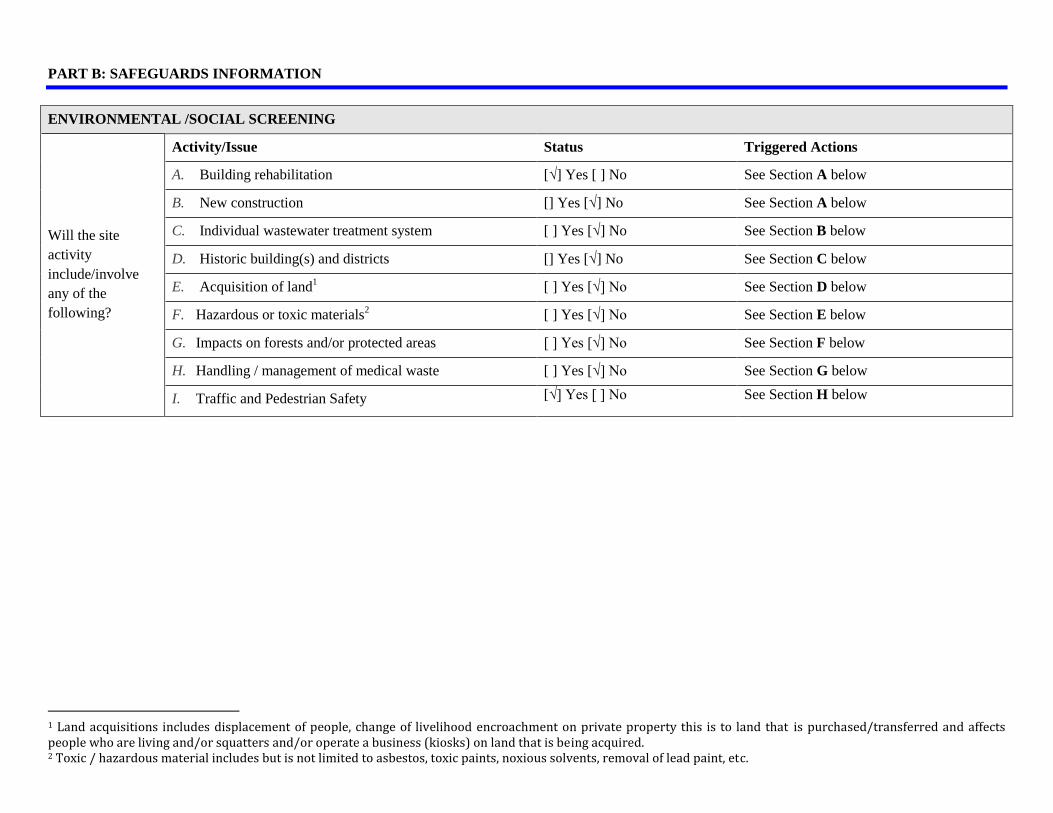
ENVIRONMENTAL /SOCIAL SCREENING
Will the site
activity
include/involve
any of the
following?
Activity/Issue Status Triggered Actions
A. Building rehabilitation [√] Yes [ ] No See Section A below
B. New construction [] Yes [√] No See Section A below
C. Individual wastewater treatment system [ ] Yes [√] No See Section B below
D. Historic building(s) and districts [] Yes [√] No See Section C below
E. Acquisition of land1 [ ] Yes [√] No See Section D below
F. Hazardous or toxic materials2 [ ] Yes [√] No See Section E below
G. Impacts on forests and/or protected areas [ ] Yes [√] No See Section F below
H. Handling / management of medical waste [ ] Yes [√] No See Section G below
I. Traffic and Pedestrian Safety [√] Yes [ ] No See Section H below
1 Land acquisitions includes displacement of people, change of livelihood encroachment on private property this is to land that is purchased/transferred and affects people who are living and/or squatters and/or operate a business (kiosks) on land that is being acquired. 2 Toxic / hazardous material includes but is not limited to asbestos, toxic paints, noxious solvents, removal of lead paint, etc.

PART C: MITIGATION MEASURES
ACTIVITY PARAMETER MITIGATION MEASURES CHECKLIST
0. General Conditions Notification and Worker
Safety
(a) The local construction and environment inspectorates and communities have been notified of
upcoming activities
(b) The public has been notified of the works through appropriate notification in the media and/or at
publicly accessible sites (including the site of the works)
(c) All legally required permits have been acquired for construction and/or rehabilitation
(d) The Contractor formally agrees that all work will be carried out in a safe and disciplined manner
designed to minimize impacts on neighboring residents and environment.
(e) Workers’ PPE will comply with international good practice (always hardhats, as needed masks and
safety glasses, harnesses and safety boots)
(f) Appropriate signposting of the sites will inform workers of key rules and regulations to follow.
A. General Rehabilitation
and /or Construction
Activities
Air Quality (a) During interior demolition debris-chutes shall be used above the first floor
(b) Demolition debris shall be kept in controlled area and sprayed with water mist to reduce debris dust
(c) During pneumatic drilling/wall destruction dust shall be suppressed by ongoing water spraying and/or
installing dust screen enclosures at site
(d) The surrounding environment (sidewalks, roads) shall be kept free of debris to minimize dust
(e) There will be no open burning of construction / waste material at the site
(f) There will be no excessive idling of construction vehicles at sites
Noise (a) Construction noise will be limited to restricted times agreed to in the permit
(b) During operations the engine covers of generators, air compressors and other powered mechanical
equipment shall be closed, and equipment placed as far away from residential areas as possible
Water Quality (a) The site will establish appropriate erosion and sediment control measures such as e.g. hay bales and /
or silt fences to prevent sediment from moving off site and causing excessive turbidity in nearby
streams and rivers.

Waste management (a) Waste collection and disposal pathways and sites will be identified for all major waste types expected
from demolition and construction activities.
(b) Mineral construction and demolition wastes will be separated from general refuse, organic, liquid and
chemical wastes by on-site sorting and stored in appropriate containers.
(c) Construction waste will be collected and disposed properly by licensed collectors
(d) The records of waste disposal will be maintained as proof for proper management as designed.
(e) Whenever feasible the contractor will reuse and recycle appropriate and viable materials (except
asbestos)
B. Individual wastewater
treatment system
Water Quality (a) The approach to handling sanitary wastes and wastewater from building sites (installation or
reconstruction) must be approved by the local authorities
(b) Before being discharged into receiving waters, effluents from individual wastewater systems must be
treated in order to meet the minimal quality criteria set out by national guidelines on effluent quality
and wastewater treatment
(c) Monitoring of new wastewater systems (before/after) will be carried out
(d) Construction vehicles and machinery will be washed only in designated areas where runoff will not
pollute natural surface water bodies.
C. Historic building(s) Cultural Heritage (a) If the building is a designated historic structure, very close to such a structure, or located in a
designated historic district, notification shall be made and approvals/permits be obtained from local
authorities and all construction activities planned and carried out in line with local and national
legislation.
(b) It shall be ensured that provisions are put in place so that artifacts or other possible “chance finds”
encountered in excavation or construction are noted and registered, responsible officials contacted,
and works activities delayed or modified to account for such finds.
D. Acquisition of land Land Acquisition
Plan/Framework
(a) If expropriation of land was not expected but is required, or if loss of access to income of legal or
illegal users of land was not expected but may occur, that the Bank’s Task Team Leader shall be
immediately consulted.
(b) The approved Land Acquisition Plan/Framework (if required by the sub-project) will be implemented
E. Toxic Materials Asbestos management (a) If asbestos is located on the sub-project site, it shall be marked clearly as hazardous material

(b) When possible the asbestos will be appropriately contained and sealed to minimize exposure
(c) The asbestos prior to removal (if removal is necessary) will be treated with a wetting agent to
minimize asbestos dust
(d) Asbestos will be handled and disposed by skilled & experienced professionals
(e) If asbestos material is being stored temporarily, the wastes should be securely enclosed inside closed
containments and marked appropriately. Security measures will be taken against unauthorized
removal from the site.
(f) The removed asbestos will not be reused
Toxic / hazardous waste
management
(a) Temporarily storage on site of all hazardous or toxic substances will be in safe containers labeled
with details of composition, properties and handling information
(b) The containers of hazardous substances shall be placed in an leak-proof container to prevent spillage
and leaching
(c) The wastes shall be transported by specially licensed carriers and disposed in a licensed facility.
(d) Paints with toxic ingredients or solvents or lead-based paints will not be used
F. Affected forests,
wetlands and/or protected
areas
Protection (a) All recognized natural habitats, wetlands and protected areas in the immediate vicinity of the activity
will not be damaged or exploited, all staff will be strictly prohibited from hunting, foraging, logging
or other damaging activities.
(b) A survey and an inventory shall be made of large trees in the vicinity of the construction activity,
large trees shall be marked and cordoned off with fencing, their root system protected, and any
damage to the trees avoided
(c) Adjacent wetlands and streams shall be protected from construction site run-off with appropriate
erosion and sediment control feature to include by not limited to hay bales and silt fences
(d) There will be no unlicensed borrow pits, quarries or waste dumps in adjacent areas, especially not in
protected areas.
G. Disposal of medical
waste
Infrastructure for medical
waste management
(a) In compliance with national regulations the contractor will insure that newly constructed and/or
rehabilitated health care facilities include sufficient infrastructure for medical waste handling and
disposal; this includes and not limited to:
Special facilities for segregated healthcare waste (including soiled instruments “sharps”, and

human tissue or fluids) from other waste disposal; and
Appropriate storage facilities for medical waste are in place; and
If the activity includes facility-based treatment, appropriate disposal options are in place and
operational
H Traffic and Pedestrian
Safety
Direct or indirect hazards
to public traffic and
pedestrians by
construction
activities
(a) In compliance with national regulations the contractor will insure that the construction site is properly
secured and construction related traffic regulated. This includes but is not limited to
Signposting, warning signs, barriers and traffic diversions: site will be clearly visible and the
public warned of all potential hazards
Traffic management system and staff training, especially for site access and near-site heavy
traffic. Provision of safe passages and crossings for pedestrians where construction traffic
interferes.
Adjustment of working hours to local traffic patterns, e.g. avoiding major transport activities
during rush hours or times of livestock movement
Active traffic management by trained and visible staff at the site, if required for safe and
convenient passage for the public.
Ensuring safe and continuous access to office facilities, shops and residences during renovation
activities, if the buildings stay open for the public.

PART D: MONITORING PLAN
Activity What
(Is the parameter to be monitored?)
Where
(Is the parameter to be
monitored?)
How
(Is the parameter to be
monitored?)
When
(Define the frequency /
or continuous?)
Why
(Is the parameter being
monitored?)
Who
(Is responsible for
monitoring?)
Transportation of
construction
materials and waste
movement of
construction
machinery
Technical condition of vehicles and
machinery
Confinement and protection of truck loads
with lining
Respect of the established hours and routes
of transportation
Construction site Inspection Unannounced
inspections during work
hours and beyond
Limit pollution of soil
and air from emissions;
Limit nuisance to local
communities from noise
and vibration;
Minimize traffic
disruption.
Elkana
Earthworks (small
scale)
Temporary storage of excavated material in
the pre-defined and agreed upon locations;
Backfilling of the excavated material and/or
its disposal to the formally designated
locations;
In case of chance finds immediate
suspension of works, notification of the
Ministry of Culture and Monument
Protection, and resumption of works
exclusively upon formal consent of the
Ministry.
Construction site Inspection In the course of earth
works
Prevent pollution of the
construction site and its
surroundings with
construction waste;
Prevent damage and loss
of physical cultural
resources
Elkana
Traffic disruption
and limitation of
pedestrian access
Installation of traffic limitation/diversion
signage;
Storage of construction materials and
temporary placement of construction waste
in a way preventing congestion of access
At and around the
construction site
Inspection In the course of
construction works
Prevent traffic accidents;
Limit nuisance to the
users of the park and
local residents
Elkana

roads
Workers’ health and
safety
Provision of uniforms and safety gear to
workers;
Ensuring use of the personal protective gear
by workers;
Informing of workers and personnel on the
personal safety rules and instructions for
operating machinery/equipment, and strict
compliance with these rules/instructions
Construction site Inspection Unannounced
inspections in the course
of work
Limit occurrence of on-
the-job accidents and
emergencies
Elkana
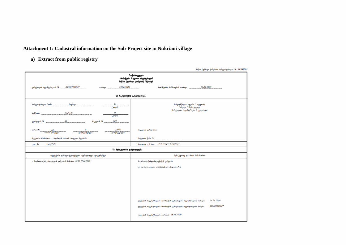
Attachment 1: Cadastral information on the Sub-Project site in Nukriani village
a) Extract from public registry

b) Cadastral plan of the site in Nukriani village

Attachment 2: Support letter from Sighnaghi Municipality
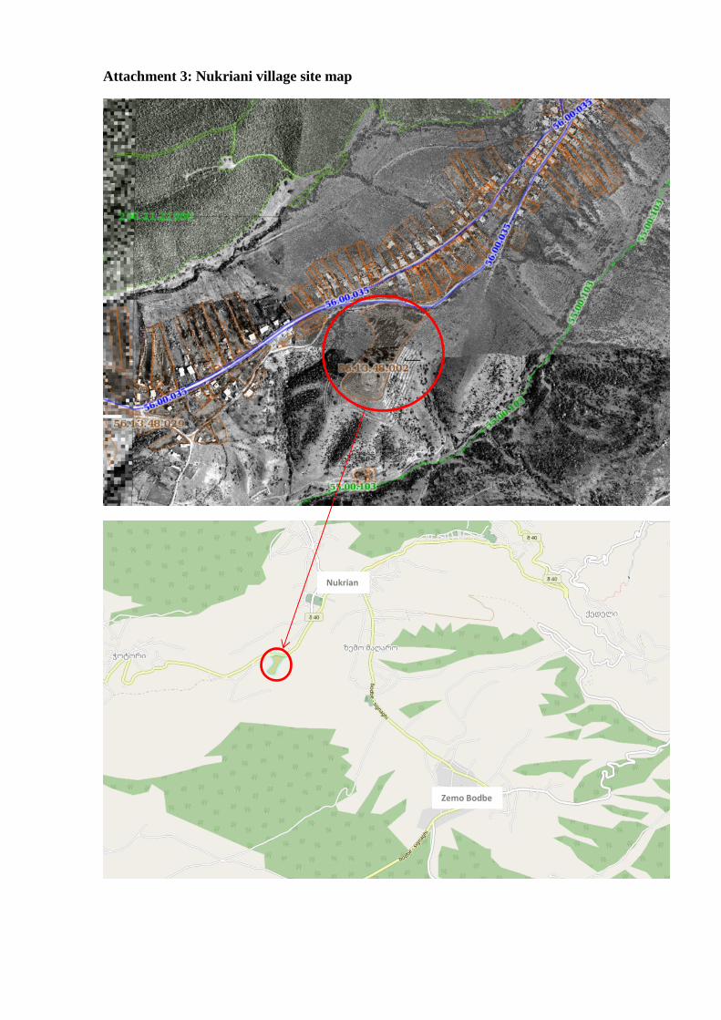
Attachment 3: Nukriani village site map
Nukrian
i
Zemo Bodbe


Attachment 4: Nukriani Community Meeting Minutes
Date: May 19, 2017
Venue: Sighnagi Municipality, Village Nukriani
Donor: Biological Farming Association “Elkana”, through funding from the Japanese Social Development Fund and the World Bank
Aim: Consult with the local community on the Draft Environment and Social Management
Plan for the project ‘’Improvement of Touristic Infrastructure in Nukriani and Zemo
Bodbe” Elkana Assistant Project Manager, representative of NGO ‘’Community Center Nukriani’’, local
authority and local community members attended the meeting. In total 17 people participated in
the gathering, including 10 women.
Elkana Assistant Project Manager presented planned project and activities, as well as the draft
Environment Management Plans prepared to mitigate their possible negative impacts on the
natural and social environment. After the presentation, meeting participants were given the floor
for questions and comments. During the meeting, participants asked the following questions:
Question: For what purposes the rehabilitated infrastructure will be used?
Answer: Improved infrastructure will be used for organizing picnics for tourists.
Question: Who will be responsible for waste management after completion of projects?
Answer: Sighnagi municipality will be responsible for waste management and they have
provided support letter of October 13, 2016.
Question: Who will use counters and sell handcrafts?
Answer: Local population will be able to sell their products to tourists.
Community members were satisfied with the received information and supported implementation of the project.
Signatures of attendees:


Photo illustration