Embed Size (px)
Citation preview
INTERNATIONAL HYDROGRAPHIC ORGANIZATION
IHO GEOSPATIAL STANDARD FOR HYDROGRAPHIC DATA
Edition 1.0 – March 2011
Special Publication No. 102
Bathymetric Surface Product Specification
Published by the International Hydrographic Bureau
MONACO
TSMAD22/DIPWG3‐12.1A
Proposed Revised Bathymetric Surface Product Specification
S-102 Forward
This document describes a proposed revised Bathymetric Surface Product Specification S-102 based on the document S-102 Edition October 2010. This document incorporates recommended modifications and corrections received prior to the IHO Technical Standards Maintenance and Development meeting scheduled for April 2011 (TSMAD 22). It describes S-102 as an S-100 Part 8 Grid Coverage using S-100 Part 11 compliant product specification. As such the encoding specified is based on HDF5, but as content and ecoding are separated, it does not preclude transformation to other encodings such as GeoTIFF and XML.
Bathymetric Surface Product Specification S-102
1 Introduction
With the advent of electronic navigation, the need for high resolution bathymetric data, or a bathymetric model, has become a requirement for fusion of temporal data such as tidal heights. Furthermore, having this model available allows the ECDIS or ECS to make other intelligent adjustments such as contour intervals.
This document serves as an S-100 compliant product specification for Bathymetric Surface Products. Much of this document has been adapted from the Format Specification Document – Description of the Bathymetric Attributed Grid Object (BAG) Version 1.0.0 [2]. Compliance with the S-102 product specification implies logical compliance with the BAG as specified by the Open Navigation Surface Project.
Bathymetric Surface data may be used alone or it may be combined with ENC or other S-100 compatible data. As such the Bathymetric Surface product specification serves as one of a possibility of additional layers that may be integrated with other S-100 products for use with ENC. A single surface is represented as a quadrilateral grid coverage structure as defined in S-100 Part 8. Each grid may be standalone or be a tile within a larger set of data. The metadata defining the tiling scheme will be inherited through the S100_IGCollection.
S-102 Bathymetric Surface Product Specification
1
Bathymetric Surface Product Specification S-102
1 Scope
This document is a product specification for bathymetric surface data which may be used alone or as an auxiliary layer of data with an ENC. It specifies a navigation surface coverage including both depth and uncertainty together with an optional tracking list of depth changes that have been manually made by the hydrographer to override the statistical grid value points on the navigation surface to ensure safety of navigation. The surface must be certified by a hydrographer using a digital signature. This product specification includes a content model and separate encodings.
2 Conformance
This product schema is conformant with IHO S-100 Sections 8-A-1.1 and 8-A-1.4.
3 Normative references
The following normative documents contain provisions that, through reference in this text, constitute provisions of this document.
IHO S.100 IHO Universal Hydrographic Data Model, January 2010 IHO S.44 Standards for Hydrographic Surveys 5th Edition, February 2008 ISO 8601:2004 Data elements and interchange formats _ Information interchange _
Representation of dates and times ISO/TS 19103:2005 Geographic information - Conceptual schema language ISO 19111:2003 Geographic information - Spatial referencing by coordinates ISO 19115:2003 Geographic information - Metadata ISO 19115-2:2009 Geographic information - Metadata: Extensions for imagery and gridded
data ISO 19123:2005 Geographic information - Schema for coverage geometry and functions ISO 19129:2009 Geographic information - Imagery gridded and coverage data framework ISO 19131:2007 Geographic information - Data product specifications ISO/IEC 19501:2005, Information technology — Open Distributed Processing - Unified
Modelling Language Version 1.4.2 Note: a summary of UML is given in S.100 Part 1 Format Specification Document - Description of Bathymetric Attributed Grid Object (BAG) - Version 1.0.0
4 Terms, and definitions
4.1 Terms and definitions
Terms and definitions have been taken from the normative references cited in clause 3. Only those which are specific to this document have been included and modified where necessary. Additional terms are defined in this document.
4.1.1 coordinate one of a sequence of numbers designating the position of a point in N-dimensional space [ISO 19111]
S-102 Bathymetric Surface Product Specification
2
4.1.2 coordinate reference system coordinate system which is related to the real world by a datum [ISO 19111]
4.1.3 coverage feature that acts as a function to return values from its range for any direct position within its spatial, temporal, or spatiotemporal domain [ISO 19123] EXAMPLE Examples include a digital image, polygon overlay, or digital elevation matrix. NOTE In other words, a coverage is a feature that has multiple values for each attribute type, where each direct position within the geometric representation of the feature has a single value for each attribute type.
4.1.4 coverage geometry configuration of the domain of a coverage described in terms of coordinates [ISO 19123]
4.1.5 direct position position described by a single set of coordinates within a coordinate reference system [ISO 19107]
4.1.6 domain well-defined set [ISO 19103]
NOTE Domains are used to define the domain set and range set of operators and functions.
4.1.7 elevation the altitude of the ground level of an object, measured from a specified vertical datum. [IHO:S100 GFM]
Note: Height is distinguished from elevation in that it is a directional measurement. A depth above the reference surface will have a negative value.
4.1.8 feature abstraction of real world phenomena [ISO 19101]
NOTE A feature may occur as a type or an instance. Feature type or feature instance should be used when only one is meant.
4.1.9 feature attribute characteristic of a feature [ISO 19109]
NOTE A feature attribute type has a name, a data type and a domain associated to it. A feature attribute instance has an attribute value taken from the value domain of the feature attribute type.
4.1.10 function rule that associates each element from a domain (source, or domain of the function) to a unique element in another domain (target, co-domain, or range) [ISO 19107]
NOTE The range is defined by another domain.
S-102 Bathymetric Surface Product Specification
3
4.1.11 geometric object spatial object representing a set of direct positions [ISO 19107]
NOTE A geometric object consists of a geometric primitive, a collection of geometric primitives, or a geometric complex treated as a single entity. A geometric object may be the spatial characteristics of an object such as a feature or a significant part of a feature
4.1.12 grid network composed of two or more sets of curves in which the members of each set intersect the members of the other sets in a systematic way [ISO 19123]
NOTE The curves partition a space into grid cells.
4.1.13 grid point point located at the intersection of two or more curves in a grid [ISO 19123]
4.1.14 height distance of a point from a chosen reference surface measured upward along a line perpendicular to that surface [ISO 19111:2006]
NOTE Height is distinguished from elevation in that it is a directional measurement.
4.1.15 LIDAR an optical remote sensing technique that uses a laser pulse to determine distance
NOTE LIDAR may be used to determine depth in shallow water areas.
4.1.16 navigation surface data object representing the bathymetry and associated uncertainty with the methods by which those objects can be manipulated, combined and used for a number of tasks, including products in support of safety of navigation [ONS FSD]
4.1.17 range <coverage> set of values associated by a function with the elements of the spatiotemporal domain of a coverage [ISO 19123]
4.1.18 record finite, named collection of related items (objects or values) [ISO 19107]
NOTE Logically, a record is a set of pairs <name, item >.
4.1.19 rectified grid grid for which there is a linear relationship between the grid coordinates and the coordinates of an external coordinate reference system [ISO 19123]
NOTE If the coordinate reference system is related to the earth by a datum, the grid is a georectified grid.
S-102 Bathymetric Surface Product Specification
4
4.1.20 referenceable grid grid associated with a transformation that can be used to convert grid coordinate values to values of coordinates referenced to an external coordinate reference system [ISO 19123]
4.1.21 SONAR a technique that uses sound propagation through water to determine distance, primarily depth measurement
4.1.22 spatiotemporal domain <coverage> domain composed of geometric objects described in terms of spatial and/or temporal coordinates [ISO 19123]
NOTE The spatiotemporal domain of a continuous coverage consists of a set of direct positions defined in relation to a collection of geometric objects.
4.1.23 surface connected 2-dimensional geometric primitive, representing the continuous image of a region of a plane [ISO 19107]
NOTE The boundary of a surface is the set of oriented, closed curves that delineate the limits of the surface.
4.1.24 tiling scheme a discrete grid coverage that is used to partition data into discrete edge matched sets called tiles
4.1.25 uncertainty The interval (about a given value) that will contain the true value of the measurement at a specific confidence level [IHO S44] NOTE Errors exist and are the differences between the measured value and the true value. Since the true value is never known it follows that the error itself cannot be known. Uncertainty is a statistical assessment of the likely magnitude of this error.
4.1.26 vector quantity having direction as well as magnitude [ISO 19123]
NOTE A directed line segment represents a vector if the length and direction of the line segment are equal to the magnitude and direction of the vector. The term vector data refers to data that represents the spatial configuration of features as a set of directed line segments.
5 Symbols and abbreviated terms
5.1 Abbreviations
This product specification adopts the following convention for presentation purposes:
API Application Programming Interface
BAG Bathymetric Attributed Grid

S-102 Bathymetric Surface Product Specification
5
DS Digital Signature
DSS Digital Signature Scheme
ECDIS Electronic Chart Display Information System
ECS Electronic Chart System
ENC Electronic Navigational Chart
GML Geography Markup Language
IHO International Hydrographic Organization
ISO International Standards Organization
LIDAR Light Detection And Ranging
NS Navigation Surface
ONS Open Navigation Surface
PK Public Key
SA Signature Authority
SK Secret Key
SONAR Sound Navigation And Ranging
UML Universal Modelling Language
5.2 Notation
In this document conceptual schemas are presented in the Unified Modelling Language (UML). Several model elements used in this schema are defined in ISO standards developed by ISO TC 211, or in IHO S-100. In order to ensure that class names in the model are unique ISO TC/211 has adopted a convention of establishing a prefix to the names of classes that define the TC/211 defined UML package in which the UML class is defined. Since the IHO standards and this product specification make use of classes derived directly from the ISO standards this convention is also followed here. In the IHO standards the class names are identified by the name of the standard, such as "S100" as the prefix optionally followed by the bialpha prefix derived from ISO. For the classes defined in this product specification the prefix is "S102". In order to avoid having multiple classes instantiating the same root classes, the ISO classes and S-100 classes have been used where possible; however, a new instantiated class is required if there is a need to alter a class or relationship to prevent a reverse coupling between the model elements introduced in this document and those defined in S-100 or the ISO model.
S-102 Bathymetric Surface Product Specification
6
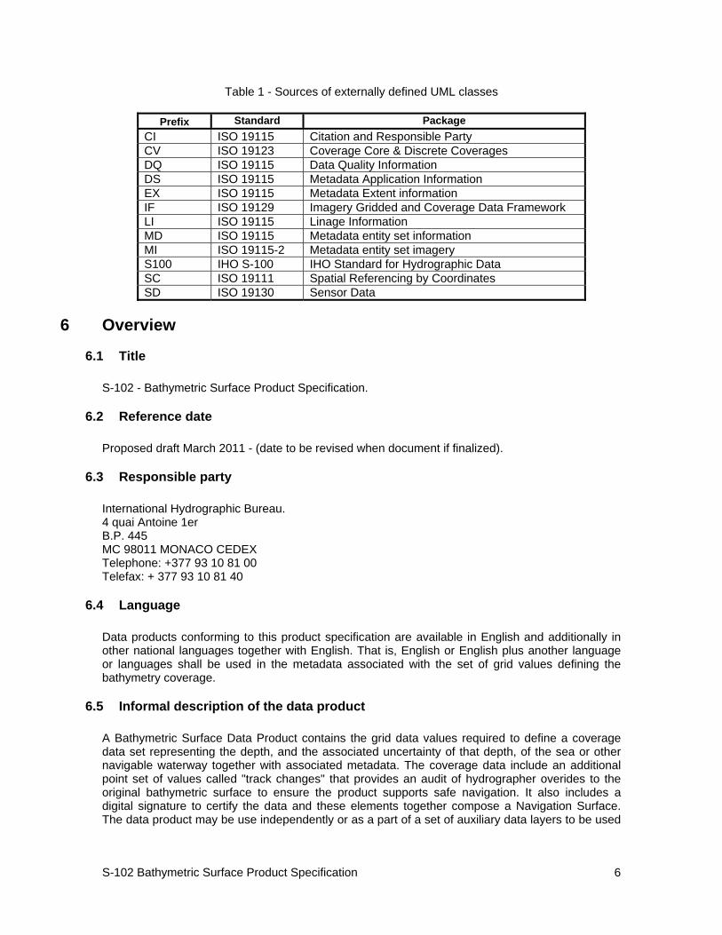
Table 1 - Sources of externally defined UML classes
Prefix Standard PackageCI ISO 19115 Citation and Responsible Party CV ISO 19123 Coverage Core & Discrete Coverages DQ ISO 19115 Data Quality Information DS ISO 19115 Metadata Application Information EX ISO 19115 Metadata Extent information IF ISO 19129 Imagery Gridded and Coverage Data Framework LI ISO 19115 Linage Information MD ISO 19115 Metadata entity set information MI ISO 19115-2 Metadata entity set imagery S100 IHO S-100 IHO Standard for Hydrographic Data SC ISO 19111 Spatial Referencing by Coordinates SD ISO 19130 Sensor Data
6 Overview
6.1 Title
S-102 - Bathymetric Surface Product Specification.
6.2 Reference date
Proposed draft March 2011 - (date to be revised when document if finalized).
6.3 Responsible party
International Hydrographic Bureau. 4 quai Antoine 1er B.P. 445 MC 98011 MONACO CEDEX Telephone: +377 93 10 81 00 Telefax: + 377 93 10 81 40
6.4 Language
Data products conforming to this product specification are available in English and additionally in other national languages together with English. That is, English or English plus another language or languages shall be used in the metadata associated with the set of grid values defining the bathymetry coverage.
6.5 Informal description of the data product
A Bathymetric Surface Data Product contains the grid data values required to define a coverage data set representing the depth, and the associated uncertainty of that depth, of the sea or other navigable waterway together with associated metadata. The coverage data include an additional point set of values called "track changes" that provides an audit of hydrographer overides to the original bathymetric surface to ensure the product supports safe navigation. It also includes a digital signature to certify the data and these elements together compose a Navigation Surface. The data product may be use independently or as a part of a set of auxiliary data layers to be used
S-102 Bathymetric Surface Product Specification
7
with ENC data or other S-100 data. The metadata data and structure required to support the aggregation of a set of auxiliary data layers are described in S-100 Part 8 Section 8.7.
A Bathymetric Surface Data Product may exist anywhere in the maritime domain. There are no limitations to its extent. A particular supplier, such as a national hydrographic office, may establish its own series of ENCs and auxiliary data that can be used together or with other S-100 data. These series may include Bathymetric Surface data. When used together with other data layers the requirement is that the reference system be the same or be directly convertible for all layers and that the tiling schemes align.
7 Specification scopes
7.1 Scope general
The Bathymetric Surface Data Product specification defines a content model and exchange file format for the exchange of bathymetric coverage data. The coverage type is a quadrilateral grid coverage together with attributes known as a Bathymetric Attributed Grid (BAG).
A single BAG coverage object represents one contiguous area of the skin of the Earth at a single resolution, but can represent data at any stage of the process from raw grid to final product. The term Navigation Surface (NS) is reserved for a final product BAG destined specifically for safety of navigation purposes.
An Application Programming Interface (API) exists which provides an abstraction from the underlying technologies as well as providing a set of methods for an application programmer to easily read and write data conforming to the BAG specification.
In order to support the certification of bathymetric data for a Navigation Surface a Digital Certification Block must be included with the BAG data.
Each data supplier, such as a national hydrographic office, may establish its own series of bathymetric data products that may be used independently or in conjunction with other auxiliary data layers.
7.2 Scope identification
Global
Note: "Global" means that this scope refers to all parts of this data product specification.
7.3 Level
This scope refers to the following level according to the ISO 19115 standard:
006 - series.
7.4 Level name
BAG.
7.5 Extent
This section describes the spatial and temporal extent of the scope.
S-102 Bathymetric Surface Product Specification
8
7.5.1 Extent description
BAG data are seamless between datasets and form a continuous coverage.
7.5.2 Geographic Extent
The geographic extent of this product specification is world wide. Producers, in particular national hydrographic offices, will establish the bounding box defining the geographic extent of the data series they produce.
7.5.3 Temporal Extent
The temporal extent of this product specification is unbounded. Producers, in particular national hydrographic offices, will establish the beginning and end dates defining the temporal extent of the data series they produce.
8 Data product identification
8.1 Title
S-102 Bathymetric Surface.
8.2 Alternate Title
BAG - Bathymetric Attributed Grid.
8.3 Abstract
The Bathymetric Surface Data Product consists of a set of grid value matrix values organized to form a quadrilateral grid coverage with associated metadata representing a bathymetric depth model for an area of the sea, river, lake or other navigable water. The data set includes both depth measurement values and accuracy measures associated with the depth values. In addition a discrete point set called a "tracking list" allows a hydrographer to override any particular grid matrix value to deliberately bias the data for safety of navigation. That is, the data set can carry both measured depth information that may be used for scientific purposes as well as corrected depth information that may be used for navigation.
8.4 Purpose
The primary purpose of the Bathymetric Surface Data Product is to support safe navigation as an auxiliary aid to navigation that may be used together with an ENC. The secondary use is as an independent source of depth information that may be used for other purposes.
8.5 Topic category
Main topics for the product, as defined by the ISO 19115 MD_TopicCategoryCode:
006– elevation;
012– oceans;
S-102 Bathymetric Surface Product Specification
9
014– inlandWaters
8.6 Spatial representation type
Type of spatial representation for the product, as defined by the ISO 19115 MD_SpatialRepresentationTypeCode:
002 - grid.
8.7 Spatial resolution
The spatial resolution, or the spatial dimension on the earth covered by the size of a grid matrix cell (nominal ground sample distance), varies according to the producer (hydrographic office).
8.8 Reference to product specification scope
Global
Note: "Global" means that this scope refers to all parts of this data product specification.
9 Data content and structure
9.1 Description
The Navigation Surface concept used in the Bathymetric Surface Data Product requires that in addition to estimation of depth, an estimate of the uncertainty associated with the depth must be computed and preserved. In order to make the system suitable to support safety of navigation applications, there is a means to over-ride any automatically constructed depth estimates with ‘Hydrographer Privilege’, (essentially , a means to specify directly the depth determined by a human observer as being the most significant in the area - irrespective of any statistical evidence to the contrary). The overridden data are maintained in the tracking list.
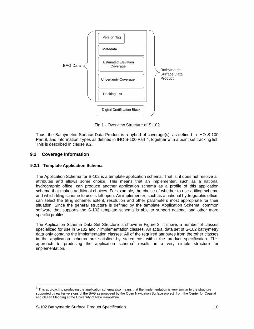
Figure 1 shows a high level overview of the structure of S-102. It shows that the Bathymetric Surface Data Product consists of a set of data comprising the Bathymetric Attributed Grid plus a Digital Certification Block. The Digital Certification Block is mandatory when the data product is produced for navigational purposes so that the user can trace whether the data has been certified. The BAG consists of a version tag plus other metadata, together with coverages consisting of elevation (depth) values and an uncertainty as two colocated coverages as well as the tracking list.
S-102 Bathymetric Surface Product Specification
10
Version Tag
Metadata
Estimated Elevation Coverage
Uncertainty Coverage
Tracking List
BAG Data
Digital Certification Block
Bathymetric Surface Data Product
Fig 1 - Overview Structure of S-102
Thus, the Bathymetric Surface Data Product is a hybrid of coverage(s), as defined in IHO S-100 Part 8, and Information Types as defined in IHO S-100 Part 4, together with a point set tracking list. This is described in clause 9.2.
9.2 Coverage Information
9.2.1 Template Application Schema
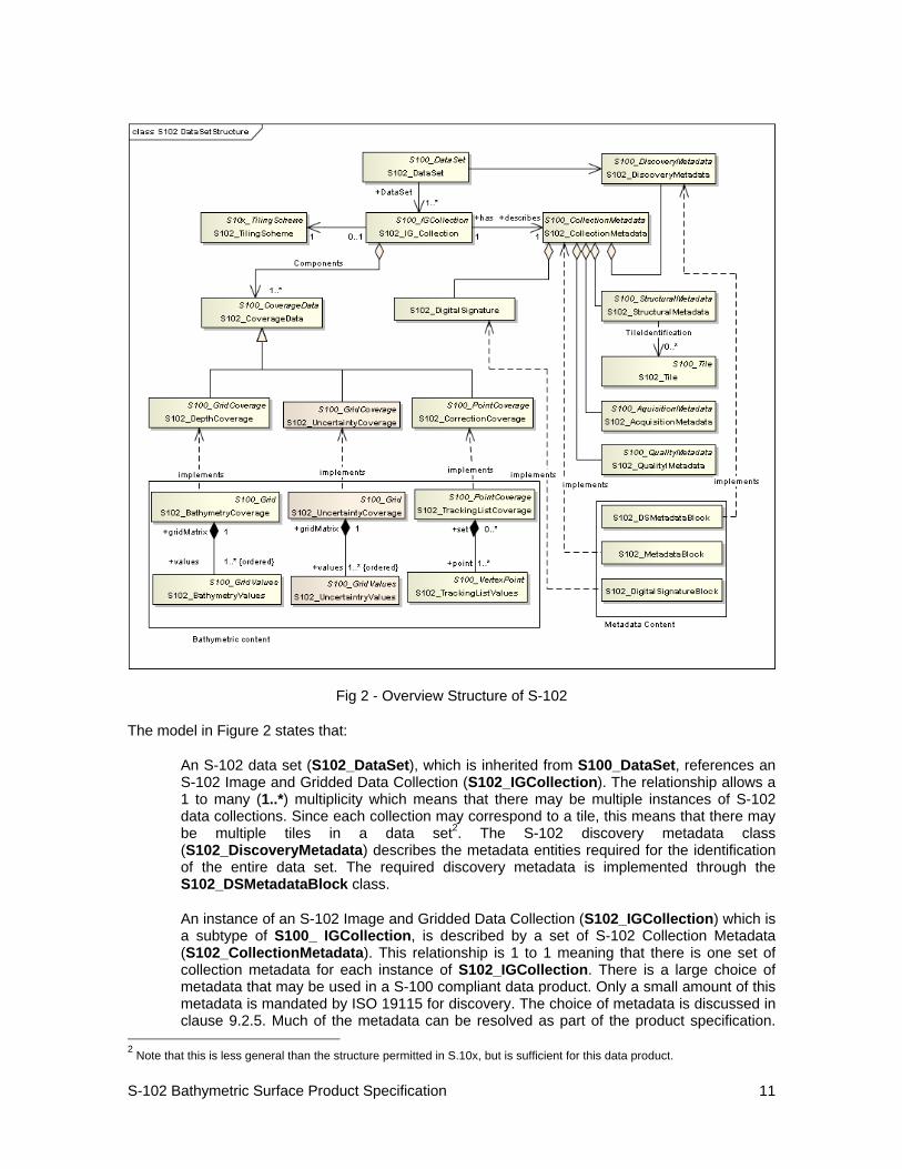
The Application Schema for S-102 is a template application schema. That is, it does not resolve all attributes and allows some choice. This means that an implementer, such as a national hydrographic office, can produce another application schema as a profile of this application schema that makes additional choices. For example, the choice of whether to use a tiling scheme and which tiling scheme to use is left open. An implementer, such as a national hydrographic office, can select the tiling scheme, extent, resolution and other parameters most appropriate for their situation. Since the general structure is defined by the template Application Schema, common software that supports the S-102 template schema is able to support national and other more specific profiles.
The Application Schema Data Set Structure is shown in Figure 2. It shows a number of classes specialized for use in S-102 and 7 implementation classes. An actual data set of S-102 bathymetry data only contains the implementation classes. All of the required attributes from the other classes in the application schema are satisfied by statements within the product specification. This approach to producing the application schema1 results in a very simple structure for implementation.
1 This approach to producing the application schema also means that the implementation is very similar to the structure supported by earlier versions of the BAG as proposed by the Open Navigation Surface project from the Center for Coastal and Ocean Mapping at the University of New Hampshire.
S-102 Bathymetric Surface Product Specification
11
Fig 2 - Overview Structure of S-102
The model in Figure 2 states that:
An S-102 data set (S102_DataSet), which is inherited from S100_DataSet, references an S-102 Image and Gridded Data Collection (S102_IGCollection). The relationship allows a 1 to many (1..*) multiplicity which means that there may be multiple instances of S-102 data collections. Since each collection may correspond to a tile, this means that there may be multiple tiles in a data set2. The S-102 discovery metadata class (S102_DiscoveryMetadata) describes the metadata entities required for the identification of the entire data set. The required discovery metadata is implemented through the S102_DSMetadataBlock class.
An instance of an S-102 Image and Gridded Data Collection (S102_IGCollection) which is a subtype of S100_ IGCollection, is described by a set of S-102 Collection Metadata (S102_CollectionMetadata). This relationship is 1 to 1 meaning that there is one set of collection metadata for each instance of S102_IGCollection. There is a large choice of metadata that may be used in a S-100 compliant data product. Only a small amount of this metadata is mandated by ISO 19115 for discovery. The choice of metadata is discussed in clause 9.2.5. Much of the metadata can be resolved as part of the product specification.
2 Note that this is less general than the structure permitted in S.10x, but is sufficient for this data product.
S-102 Bathymetric Surface Product Specification
12
Only that metadata that varies IG_collection item to item needs be included in the S102_MetadataBlock implementation class.
An S-102 Image and Gridded Data Collection also optionally makes reference to a tiling scheme. The details of the tiling scheme are normally defined in a product specification. This is discussed in clause 9.2.10. The metadata carries an ID that identifies a particular IG_Collection item as being one tile in a tiling scheme.
The class S102_DigitalSignature provides an encryption imformation which may be used to verify the authenticity of the data. The use of a Digital Signature is optional at the S-102 template application schema level, but it is normally mandatory in a specific profile in order to ensure traceability of authenticity for information used for navigation. Data complying with this template application schema could be used for other purposes so the usage of the capability is not mandatory at this level. However, systems that claim to support S-102 are required to support the digital signature capability.
The metadata also refers to the coordinate reference system.
There are two coverage types in this application schema. The first is a set of discrete Quadrilateral Grid Coverages called S102_DepthCoverage and S102_UncertaintyCoverage both of which it inherits from (S100_GridCoverage). Many of the parameters of the coverage are described in the product specification. Implementation classes S102_DepthCoverage and S102_UncertaintyCoverage are defined which inherit from S100_GridCoverage. They are co-registered, co-geospatially located datasets.
The second coverage type is discrete point set coverage called S102_CorrectionCoverage. This coverage consists of a set of discrete points that correspond to locations which had corrective overrides applied (I.E. A hydrographer may explicitly specify depth values at specific points to deliberately ensure safety of navigation.) The S102_CorrectionCcoverage is provided for pedigree. A coverage function to determine depth would operate on the resultant conflated continuous mathematical surface. The conflation function simply replaces specific values from the S102_BathymetryValues grid values matrix with the corresponding overriding values.
9.2.2 Application Schema Implementation Classes
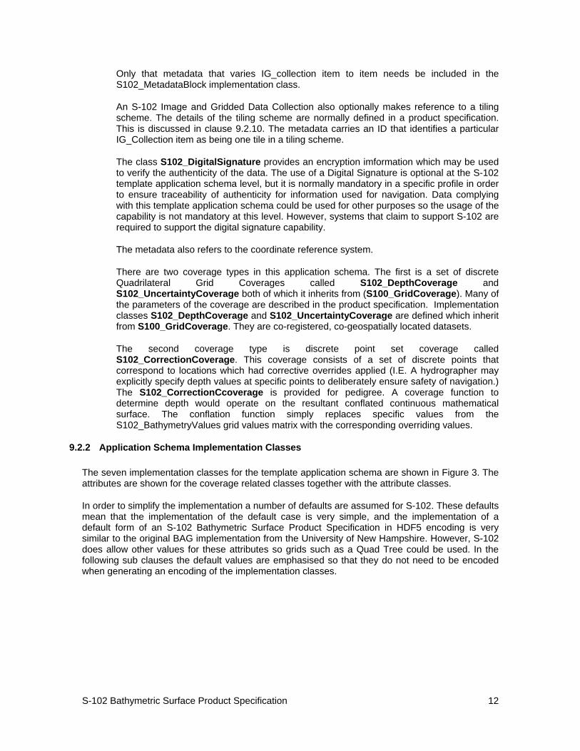
The seven implementation classes for the template application schema are shown in Figure 3. The attributes are shown for the coverage related classes together with the attribute classes.
In order to simplify the implementation a number of defaults are assumed for S-102. These defaults mean that the implementation of the default case is very simple, and the implementation of a default form of an S-102 Bathymetric Surface Product Specification in HDF5 encoding is very similar to the original BAG implementation from the University of New Hampshire. However, S-102 does allow other values for these attributes so grids such as a Quad Tree could be used. In the following sub clauses the default values are emphasised so that they do not need to be encoded when generating an encoding of the implementation classes.
S-102 Bathymetric Surface Product Specification
13
Fig 3 - Implementation Classes of S-102
9.2.3 Implementation Classes Description
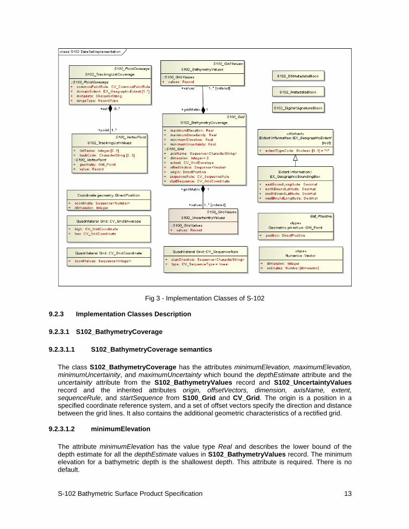
9.2.3.1 S102_BathymetryCoverage
9.2.3.1.1 S102_BathymetryCoverage semantics
The class S102_BathymetryCoverage has the attributes minimumElevation, maximumElevation, minimumUncertainity, and maximumUncertainty which bound the depthEstimate attribute and the uncertainity attribute from the S102_BathymetryValues record and S102_UncertaintyValues record and the inherited attributes origin, offsetVectors, dimension, axisName, extent, sequenceRule, and startSequence from S100_Grid and CV_Grid. The origin is a position in a specified coordinate reference system, and a set of offset vectors specify the direction and distance between the grid lines. It also contains the additional geometric characteristics of a rectified grid.
9.2.3.1.2 minimumElevation
The attribute minimumElevation has the value type Real and describes the lower bound of the depth estimate for all the depthEstimate values in S102_BathymetryValues record. The minimum elevation for a bathymetric depth is the shallowest depth. This attribute is required. There is no default.
S-102 Bathymetric Surface Product Specification
14
9.2.3.1.3 maximumElevation
The attribute maximumElevation has the value type Real and describes the upper bound of the depth estimate for all the depthEstimate values in S102_BathymetryValues record. The maximum elevation for a bathymetric depth is the deepest depth. This attribute is required. There is no default.
9.2.3.1.4 minimumUncertainty
The attribute minimumUncertainty has the value type Real and describes the lower bound of the uncertainty of the depth estimate for all the depthEstimate values in S102_BathymetryValues record. This attribute is required. There is no default.
9.2.3.1.5 maximumUncertainty
The attribute maximumUncertainty has the value type Real and describes the upper bound of the uncertainty of the depth estimate for all the depthEstimate values in S102_BathymetryValues record. This attribute is required. There is no default.
9.2.3.1.6 origin
The attribute origin has the value class DirectPosition which is a position that shall locate the origin of the rectified grid in the coordinate reference system. This attribute is required. There is no default.
9.2.3.1.7 offsetVectors
The attribute offsetVectors has the value class Sequence<Vector> that shall be a sequence of offset vector elements that determine the grid spacing in each direction. The data type Vector is specified in ISO/TS 19103. This attribute is required. There is no default.
9.2.3.1.8 dimension
The attribute dimension has the value class Integer that shall identify the dimensionality of the grid. The value of the grid dimension in this product specification is 2. This value is fixed in this product specification and does not need to be encoded.
9.2.3.1.9 axisName
The attribute axisName has the value class Sequence<CharacterString> that shall be used to assign names to the grid axis. The grid axis names are by default "Latitude" and "Longitude" but may be different if, for example, the grid is at a different orientation.
9.2.3.1.10 extent
The attribute extent has the value class CV_GridEnvelope that shall contain the extent of the spatial domain of the coverage. It uses the value class CV_GridEnvelope which provides the grid coordinate values for the diametrically opposed corners of the grid. The default is that this value is derived from the bounding box for the data set or tile in a multi tile data set.
S-102 Bathymetric Surface Product Specification
15
9.2.3.1.11 sequenceRule
The attribute sequenceRule has the value class CV_SequenceRule that shall describe how the grid points are ordered for association to the elements of the sequence values. The default value is "Linear".
9.2.3.1.12 startSequence
The attribute startSequence has the value class CV_GridCoordinate that shall identify the grid point to be associated with the first record in the values sequence. The default value is the lower left corner of the grid.
9.2.3.2 S102_BathymetryValues
9.2.3.2.1 S102_BathymetryValues semantics
The class S102_BathymetryValues is related to S102_BathymetryCoverage by a composition relationship in which an ordered sequence of depthEstimate values provide data values for each grid cell. The class S102_BathymetryValues inherits from S100_Grid.
9.2.3.2.2 values
The attribute values has the values class Record which is a sequence of value items that shall assign values to the grid points. There is a single value in each record in the S102_BathymetryValues class which provides the depthEstimate for the grid cell. The definition for the depth type is defined by the depthCorrectionType attribute in the S102_BAGDataIdentification class.
9.2.3.3 S102_UncertaintyValues
9.2.3.3.1 S102_UncertaintyValues semantics
The class S102_UncertaintyValues is related to S102_BathymetryCoverage by a composition relationship in which an ordered sequence of uncertainty values provide data values for each grid cell.
9.2.3.3.2 values
The attribute values has the values class Record which is a sequence of value items that shall assign values to the grid point. There is a single value in each record in the S102_UncertaintyValues class which provides the uncertainty for the grid cell. The definition of the type of data in the values record is defined by the verticalUncertaintyType attribute in the S102_BAGDataIdentification class.
S-102 Bathymetric Surface Product Specification
16
9.2.3.4 DirectPosition
9.2.3.4.1 DirectPosition semantics
The class DirectPosition hold the coordinates for a position within some coordinate reference system.
9.2.3.4.2 coordinate
The attribute coordinate is a sequence of Numbers that hold the coordinate of this position in the specified reference system.
9.2.3.4.3 dimension
The attribute dimension is a derived attribute that describes the length of coordinate.
9.2.3.5 Vector
9.2.3.5.1 Vector semantics
The class Vector is an ordered set of numbers called coordinates that represent a position in a coordinate system.
9.2.3.5.2 dimension
The attribute dimension is a derived attribute that describes the length of the sequence of vector ordinates.
9.2.3.5.3 ordinates
The attribute ordinates is a sequence of Numbers that hold the coordinate of this position in the specified reference system.
9.2.3.6 CV_GridEnvelope
9.2.3.6.1 CV_GridEnvelope semantics
The class CV_GridEnvelope provides the grid coordinate values for the diametrically opposed corners of an envelope that bounds a grid. It has two attributes.
9.2.3.6.2 low
The attribute low shall be the minimal coordinate values for all grid points within the envelope. For this specification this represents the Southwestern coordinate.
9.2.3.6.3 high
The attribute high shall be the maximal coordinate values for all grid points within the envelope. For this specification this represents the Northeastern coordinate.
S-102 Bathymetric Surface Product Specification
17
9.2.3.7 CV_GridCoordinate
9.2.3.7.1 CV_GridCoordinate semantics The class CV_GridCoordinate is a data type for holding the grid coordinates of a CV_GridPoint.
9.2.3.7.2 coordValues The attribute coordValues has the value class Sequence <Integer> that shall hold one integer value for each dimension of the grid. The ordering of these coordinate values shall be the same as that of the elements of axisNames. The value of a single coordinate shall be the number of offsets from the origin of the grid in the direction of a specific axis
9.2.3.8 CV_SequenceRule
9.2.3.8.1 CV_SequenceRule semantics
The class CV_SequenceRule contains information for mapping grid coordinates to a position within the sequence of records of feature attribute values. It has two attributes.
9.2.3.8.2 type
The attribute type shall identify the type of sequencing method that shall be used. A code list of scan types is provided in S-100 Part 8. Only the value “linear” shall be used in S-102, which describes scanning row by row by column.
9.2.3.8.3 scanDirection
The attribute scanDirection has the value class Sequence<CharacterString> a list of axis names that indicates the order in which grid points shall be mapped to position within the sequence of records of feature attribute values. The default scan direction for a bathymetry grid in S-102 is "Latitude" and "Longitude".
9.2.3.9 S102_TrackingListCoverage
9.2.3.9.1 S102_ TrackingListCoverage semantics
The class S102_TrackingListCoverage has the attributes domainExtent, rangeType, CommonPointRule and metadata inherited from S100_PointCoverage. The S102_TrackingList Coverage is a discrete point coverage which is used to track overriden nodes in the S102_BathymetryCoverage by allowing a hydrographer to apply a bias for safety of navigation. The attribute metadata provides one method of linking the metadata to the coverage inherited from S-100, however it is not required in S-102 because there is no need for specific metadata at the feature (class) level. The attribute commonPointRule is also not required because the value has been established for the whole of the S-102 data product to be "average". The attribute rangeType takes on the value class RecordType. This is modelled by the composition of multiple instances of S-102_TrackingListValues. Therefore only the attribute domainExtent is required, and it has a default value.
Note: An attribute describing the length of the tracking list is not required in the content model, since this information can be derived from the instantiation of the model. However, such a count may exist within an encoding to support the encoding structure.
S-102 Bathymetric Surface Product Specification
18
9.2.3.9.2 domainExtent
The attribute domainExtent has the value class EX_GeographicExtent which describes the spatial boundaries of the tracking list elements within the bounds established by CV_GridEnvelope for the S102_BathymetryGrid. The default is the bounds established by the attribute CV_GridEnvelope.
9.2.3.10 S102_TrackingListValues
9.2.3.10.1 S102_TrackingListValues semantics
The class S102_TrackingListValues has the attributes trackCode and listSeries and the attributes geometry, and value inherited from S100_VertexPoint and CV_GeometryValuePair. The tracking list is a discrete coverage used to furnish the set of values that were overriden in the S102_BathymetryValues class. In order to assure alignment of tracking list values with the grid cells in the bathymetry coverage grid, the reference system for the tracking list is the bathymetry coverage quadrilateral grid.
The trackCode value and the listSeries value provide context for the override a value from the bathymetry coverage. The trackCode value is a text string that describes the reason for the override.
9.2.3.10.2 trackCode
The optional attribute trackCode has the value type CharacterString which may contain a text string describing the reason for the override of the corresponding depth and uncertainty values in the bathymetry coverage. This is a user definable field with values defined in the lineage metadata.
9.2.3.10.3 listSeries
The optional attribute listSeries has the value type Integer which may contain an index number into a list of metadata elements describing the reason for the override of the corresponding depth and uncertainty values in the bathymetry coverage.
9.2.3.10.4 geometry
The attribute geometry has the value class GM_Point which is a position that shall locate the tracking list value. When the S102_TrackingListCoverage discrete coverage and the S102_BathymetryCoverage are conflated the values that are overridden in the sequence of the attribute S102-BathymetryValues are located by position. The value class is GM_Point which is a coordinate related to the reference system of the bathymetry coverage quadrilateral grid.
9.2.3.10.5 values
The attribute value has the value class Record which is a sequence of value items that shall assign values to the discrete grid point. There are two values in each record in the S102_ TrackingListValues class. These are the depth and the uncertainty values that were overridden in corresponding grid coverages.
S-102 Bathymetric Surface Product Specification
19
9.2.3.10.6 GM_Point semantics
The class GM_Point is taken from ISO 19107 and is the basic data type for a geometric object consisting of one and only one point. It has one attribute.
9.2.3.10.7 position
The attribute position is derived from DirectPosition for the geometry primitive GM_Point. In order to assure alignment of tracking list values with the grid points in the bathymetry coverage grid, the reference system for the tracking list is the bathymetry coverage quadrilateral grid. This means that the position attribute corresponds to a grid point. For a uniform quadrilateral grid this is the row and column of the grid point position.
9.2.3.11 EX_GeographicExtent
9.2.3.11.1 EX_GeographicExtent semantics The class EX_GeographicExtent is a metadata class from ISO 19115. It is a component of the metaclass EX_Extent. The use of EX_Extent is optional. When used it describes the spatial boundaries of the Tracking List elements within the bounds established by CV_GridEnvelope for the S102_BathymetryGrid. That is, the tracking list may carry information corresponding only to a portion of the spatial extent covered by the S102_BathymetryGrid. There is one attribute and one subtype.
9.2.3.11.2 ExtentTypeCode
The attribute extentTypeCode is a Boolean value. It is used to indicate whether the bounding polygon/box encompasses an area covered by the data or an area where data is not present. In S102 it is set to 1.
9.2.3.12 EX_BoundingBox
9.2.3.12.1 EX_GeographicBoundingBox semantics The class EX_GeographicBoundingBox is a metadata class from ISO 19115. It is a subtype of the abstract class EX_GeographicExtent. It defines a bounding box used to indicate the spatial boundaries of the tracking list elements within the bounds established by CV_GridEnvelope for the S102_BathymetryGrid. It has four attributes.
9.2.3.12.2 westBoundLongitude
The attribute westBoundLongitude is a coordinate value providing the west bound longitude for the bound.
9.2.3.12.3 eastBoundLongitude
The attribute eastBoundLongitude is a coordinate value providing the east bound longitude for the bound.
9.2.3.12.4 southBoundLatitude
The attribute southBoundLatitude is a coordinate value providing the south bound longitude for the bound.
S-102 Bathymetric Surface Product Specification
20
9.2.3.12.5 northBoundLatitude
The attribute northBoundLatitude is a coordinate value providing the north bound longitude for the bound.
9.2.4 Digital Signature Block Implementation Class
In a traditional hydrographic processing workflow, there is a strict chain of custody for all data that is to be used for nautical charting. At each stage of the chain, a responsible authority reviews the data, the processes applied to it, and certifies that the data is fit for some intended purpose. This may be that the data are ready for final plotting, that they are ready to be combined with other data in a compilation, or that the compilation is suitable as an aid to safe navigation. Generally, this is done by some physical signature on appropriate archival documentation, which was traditionally the hydrographic smooth sheet or fair sheet.
With an all-digital product, however, there is no opportunity to affix a physical signature to the data object. In addition, with a dense data object such as a Bathymetric Surface product, the opportunity for single-bit errors in transmission to cause navigationally significant changes to the data which are otherwise undetectable is greatly increased. The Digital Signature Scheme (DSS) is designed to provide an equivalent analogue for the physical hydrographer’s signature, and to ensure that any modifications to the data, either by mistake or malicious action, are readily detectable.
The S102_DigitalSignatureBlock is an implementation class corresponding to the class S102_DigitalSignature. It is a component of the S102_CollectionMetadata.
The basic entity of the DSS is the Digital Signature (DS), a multi-byte sequence of digits computed from the contents of the S102_BathymetricCoverage, S102_UncertaintyCoverage and S102_TrakingListCoverage implementation classes and their components, the set of S102_BathymetricValues, S102_UncertaintyValues classes and the set of S102_TrakingListValues. This is indicated as "Bathymetric Content" in Figure 2. The Digital Signature also contains another number, known as the secret key (SK), belonging to the person or entity signing the Bathymetric Surface product, known as the Signature Authority (SA). The SK is known only to the SA, and as the name suggests should be kept confidential since knowledge of the SK would allow anyone to certify Bathymetric Surface products as if they were the SA. The DS value can be shown to be probabilistically unique for the contents of the "Bathymetric Content" and the SK in the sense that, with vanishingly small probability, no two BAGs would generate the same DS with a particular SK, and no two SKs would generate the same DS with the same "Bathymetric Content".
Corresponding to the SK, there is a public key (PK) that can be distributed freely. There is no way to compute the DS using the PK. However, given a "Bathymetric Content" and a DS purported to have been constructed with the SK, it is simple to verify whether the "Bathymetric Content" has changed, or if another SK was used to construct the certification.
In addition to the basic DS required for the DSS, the BAG certification block contains a link to the certification event with an entry in the metadata’s lineage section which describes the reasons for certification. The intent of this is to ensure that the user can provide suitably flexible descriptions of any conditions attached to the certification event, or the intended use of the data so certified. This ‘Signature ID’ shall be a file-unique sequentially constructed identifier so that a certification block can be unambiguously associated with exactly one lineage element.
S-102 Bathymetric Surface Product Specification
21
9.2.5 Metadata
The Metadata elements used in the Bathymetric Surface product are derived from S-100 and from ISO 19115 and ISO 19115-2. Optionally additional metadata may be derived from ISO 19130 and ISO 19130-23 especially metadata relating to the SONAR equipment which may have been used to acquire the bathymetric data.
There are only a few elements in the ISO 19115 metadata standard that are mandatory and these relate only to the use of the metadata for identification and pedigree of the data set. A minimum level of data identification is required for all applications including database applications, web services and data set production. However, S-102 requires certain metadata attributes which are used to geolocate the dataset as well as lineage attribution which define processes used to establish the tracking list and establish a pedigree for the data.
The elements are related in a metadata schema, and include definitions and extension procedures. There exist both mandatory and conditional metadata elements. Only a few metadata elements are mandatory but the inclusion of some of the optional metadata elements establish a situation where other metadata elements are conditionally made mandatory.
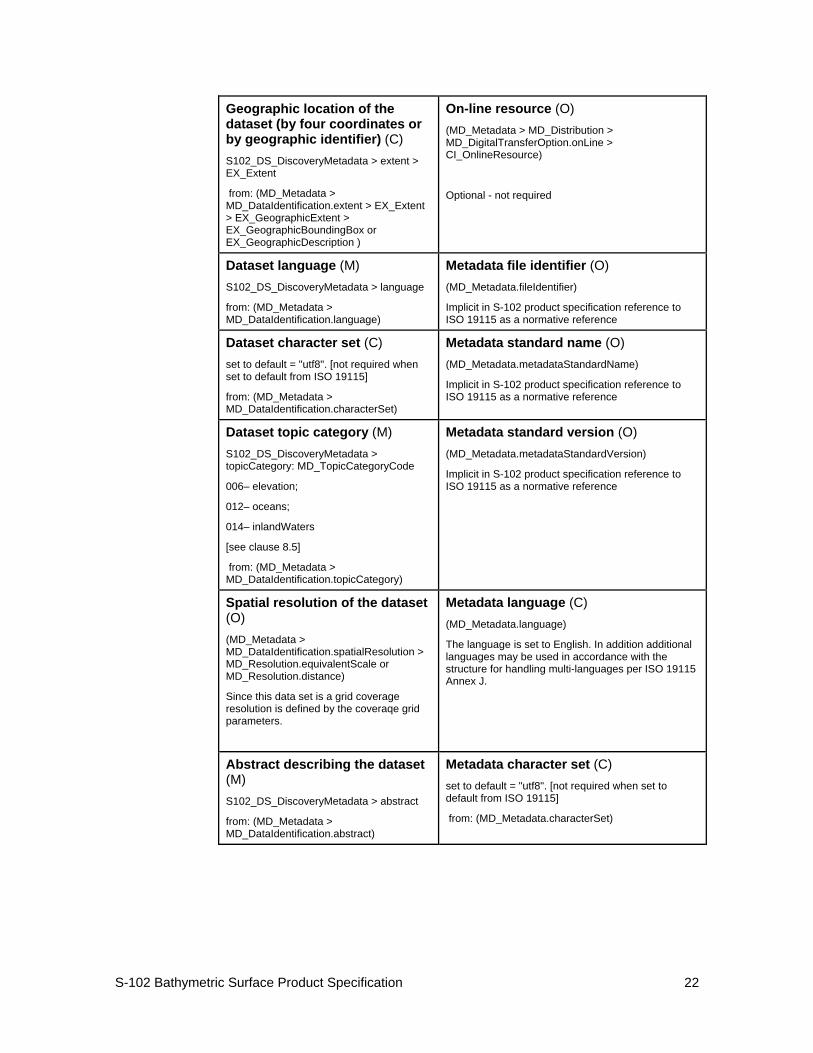
The following table outlines the core metadata elements (mandatory and recommended optional) required for describing a geographic information data set. The codes indicate: "M" mandatory, "O" optional' "C" conditional as defined in ISO 19115. The table indicates how the mandatory and conditional core metadata is handled in S-102.
Table 2 - ISO TC211 Core Metadata as applied in S-102
Dataset title (M) S102_DS_DiscoveryMetadata > citation > CI_Citation.title
from: (MD_Metadata > MD_DataIdentification.citation > CI_Citation.title)
Spatial representation type (O) S102_DS_DiscoveryMetadata > spatialRepresentationType : MD_ SpatialRepresentationType Code
002– Grid; (for quadrilateral grid coverage)
001– Vector; (for tracking list discrete point coverage)
from: (MD_Metadata > MD_DataIdentification.spatialRepresentationType)
Dataset reference date (M) S102_DS_DiscoveryMetadata > citation > CI_Citation.date
from: (MD_Metadata > MD_DataIdentification.citation > CI_Citation.date)
Reference system (O) S102_StructureMetadataBlock > hRefSystem and
S102_StructureMetadataBlock > vRefSystem
from: (MD_Metadata > MD_ReferenceSystem)
Dataset responsible party (O) S102_DS_DiscoveryMetadata > pointOfContact > CI_ ResponsibleParty
from: (MD_Metadata > MD_DataIdentification.pointOfContact > CI_ResponsibleParty)
Lineage (C) S102_QualityMetadataBlock > S102_LI_Source and S102_QualityMetadataBlock > S102_LI_ProcessStep
from: (MD_Metadata > DQ_DataQuality.lineage > LI_Lineage)
3 ISO 19130-2 Sensor Data Models Part 2 is under development in ISO TC211 and will address SONAR sensor metadata.
S-102 Bathymetric Surface Product Specification
22
Geographic location of the dataset (by four coordinates or by geographic identifier) (C) S102_DS_DiscoveryMetadata > extent > EX_Extent
from: (MD_Metadata > MD_DataIdentification.extent > EX_Extent > EX_GeographicExtent > EX_GeographicBoundingBox or EX_GeographicDescription )
On-line resource (O) (MD_Metadata > MD_Distribution > MD_DigitalTransferOption.onLine > CI_OnlineResource)
Optional - not required
Dataset language (M) S102_DS_DiscoveryMetadata > language
from: (MD_Metadata > MD_DataIdentification.language)
Metadata file identifier (O) (MD_Metadata.fileIdentifier)
Implicit in S-102 product specification reference to ISO 19115 as a normative reference
Dataset character set (C) set to default = "utf8". [not required when set to default from ISO 19115]
from: (MD_Metadata > MD_DataIdentification.characterSet)
Metadata standard name (O) (MD_Metadata.metadataStandardName)
Implicit in S-102 product specification reference to ISO 19115 as a normative reference
Dataset topic category (M) S102_DS_DiscoveryMetadata > topicCategory: MD_TopicCategoryCode
006– elevation;
012– oceans;
014– inlandWaters
[see clause 8.5]
from: (MD_Metadata > MD_DataIdentification.topicCategory)
Metadata standard version (O) (MD_Metadata.metadataStandardVersion)
Implicit in S-102 product specification reference to ISO 19115 as a normative reference
Spatial resolution of the dataset (O) (MD_Metadata > MD_DataIdentification.spatialResolution > MD_Resolution.equivalentScale or MD_Resolution.distance)
Since this data set is a grid coverage resolution is defined by the coveraqe grid parameters.
Metadata language (C) (MD_Metadata.language)
The language is set to English. In addition additional languages may be used in accordance with the structure for handling multi-languages per ISO 19115 Annex J.
Abstract describing the dataset (M) S102_DS_DiscoveryMetadata > abstract
from: (MD_Metadata > MD_DataIdentification.abstract)
Metadata character set (C) set to default = "utf8". [not required when set to default from ISO 19115]
from: (MD_Metadata.characterSet)
S-102 Bathymetric Surface Product Specification
23
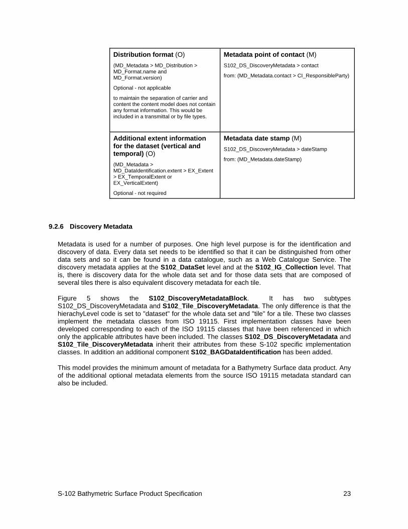
Distribution format (O) (MD_Metadata > MD_Distribution > MD_Format.name and MD_Format.version)
Optional - not applicable
to maintain the separation of carrier and content the content model does not contain any format information. This would be included in a transmittal or by file types.
Metadata point of contact (M) S102_DS_DiscoveryMetadata > contact
from: (MD_Metadata.contact > CI_ResponsibleParty)
Additional extent information for the dataset (vertical and temporal) (O) (MD_Metadata > MD_DataIdentification.extent > EX_Extent > EX_TemporalExtent or EX_VerticalExtent)
Optional - not required
Metadata date stamp (M) S102_DS_DiscoveryMetadata > dateStamp
from: (MD_Metadata.dateStamp)
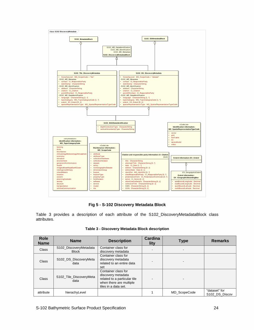
9.2.6 Discovery Metadata
Metadata is used for a number of purposes. One high level purpose is for the identification and discovery of data. Every data set needs to be identified so that it can be distinguished from other data sets and so it can be found in a data catalogue, such as a Web Catalogue Service. The discovery metadata applies at the S102_DataSet level and at the S102_IG_Collection level. That is, there is discovery data for the whole data set and for those data sets that are composed of several tiles there is also equivalent discovery metadata for each tile.
Figure 5 shows the S102_DiscoveryMetadataBlock. It has two subtypes S102_DS_DiscoveryMetadata and S102_Tile_DiscoveryMetadata. The only difference is that the hierachyLevel code is set to "dataset" for the whole data set and "tile" for a tile. These two classes implement the metadata classes from ISO 19115. First implementation classes have been developed corresponding to each of the ISO 19115 classes that have been referenced in which only the applicable attributes have been included. The classes S102_DS_DiscoveryMetadata and S102_Tile_DiscoveryMetadata inherit their attributes from these S-102 specific implementation classes. In addition an additional component S102_BAGDataIdentification has been added.
This model provides the minimum amount of metadata for a Bathymetry Surface data product. Any of the additional optional metadata elements from the source ISO 19115 metadata standard can also be included.
S-102 Bathymetric Surface Product Specification
24
class S102 Discov eryMetadata
Citation and responsible party information::CI_Citation{root}
+ title: CharacterString+ alternateTitle: CharacterString [0..*]+ date: CI_Date [1..*]+ edition: CharacterString [0..1]+ editionDate: Date [0..1]+ identifier: MD_Identifier [0..*]+ citedResponsibleParty: CI_ResponsibleParty [0..*]+ presentationForm: CI_PresentationFormCode [0..*]+ series: CI_Series [0..1]+ otherCitationDetails: CharacterString [0..1]+ collectiveTitle: CharacterString [0..1]+ ISBN: CharacterString [0..1]+ ISSN: CharacterString [0..1]
Extent information::EX_Extent
EX_GeographicExtentExtent information::
EX_GeographicBoundingBox
+ westBoundLongitude: Decimal+ eastBoundLongitude: Decimal+ southBoundLati tude: Decimal+ northBoundLati tude: Decimal
«enumeration»Identification information::MD_TopicCategoryCode
farming biota boundaries climatologyMeteorologyAtmosphere economy elevation environment geoscientificInformation health imageryBaseMapsEarthCover intell igenceMilitary inlandWaters location oceans planningCadastre society structure transportation util itiesCommunication
S102_DS_Discov eryMetadata
+ hierachyLevel: MD_ScopeCode = "dataset"::S102_MD_Metadata+ contact: CI_ResponsibleParty+ dateStamp: CharacterString::S102_MD_Identification+ abstract: CharacterString+ citation: CI_Citation+ pointOfContact: CI_ResponsibleParty::S102_MD_DataIdentification+ language: CharacterString [1..*]+ topicCategory: MD_TopicCategoryCode [1..*]+ extent: EX_Extent [0..1]+ spatialRepresentationType: MD_SpatialRepresentationTypeCode
S102_Tile_Discov eryMetadata
+ hierachyLevel: MD_ScopeCode = "ti le"::S102_MD_Metadata+ contact: CI_ResponsibleParty+ dateStamp: CharacterString::S102_MD_Identification+ abstract: CharacterString+ citation: CI_Citation+ pointOfContact: CI_ResponsibleParty::S102_MD_DataIdentification+ language: CharacterString [1..*]+ topicCategory: MD_TopicCategoryCode [1..*]+ extent: EX_Extent [0..1]+ spatialRepresentationType: MD_SpatialRepresentationTypeCode
«CodeList»Maintenance information::
MD_ScopeCode
+ attribute+ attributeType+ collectionHardware+ collectionSession+ dataset+ series+ nonGeographicDataset+ dimensionGroup+ feature+ featureType+ propertyType+ fieldSession+ software+ service+ model+ ti le
S102_BAGDataIdentification
+ depthCorrectionType: CharacterString+ verticalUncertaintyType: CharacterString
S102_MetadataBlock
S102_MD_DataIdentificationS102_MD_Identification
S102_MD_MetadataS102_Discov eryMetadataBlock
S102_DSMetadataBlock
«CodeList»Identification information::
MD_SpatialRepresentationTypeCode
+ vector+ grid+ textTable+ tin+ stereoModel+ video
Fig 5 - S-102 Discovery Metadata Block
Table 3 provides a description of each attribute of the S102_DiscoveryMetadataBlock class attributes.
Table 3 - Discovery Metadata Block description
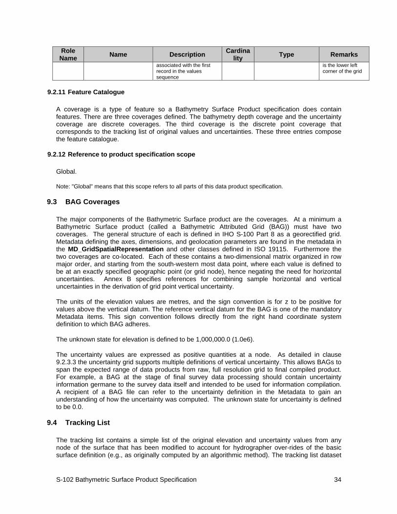
Role Name Name Description Cardina
lity Type Remarks
Class S102_DiscoveryMetadataBlock
Container class for discovery metadata - -
Class S102_DS_DiscoveryMetadata
Container class for discovery metadata related to an entire data set
- -
Class S102_Tile_DiscoveryMetadata
Container class for discovery metadata related to a particular tile when there are multiple tiles in a data set.
- -
attribute hierachyLevel 1 MD_ScopeCode "dataset" for S102_DS_Discov
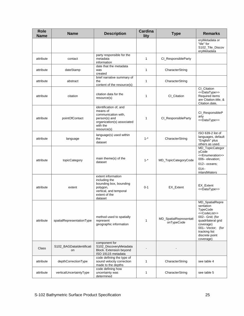
S-102 Bathymetric Surface Product Specification
25
Role Name Name Description Cardina
lity Type Remarks eryMetadata or "tile" for S102_Tile_DiscoveryMetadata
attribute contact party responsible for the metadata information
1 CI_ResponsibleParty
attribute dateStamp date that the metadata was created
1 CharacterString
attribute abstract brief narrative summary of the content of the resource(s)
1 CharacterString
attribute citation citation data for the resource(s) 1 CI_Citation
CI_Citation <<DataType>> Required items are Citation.title, & Citation.date,
attribute pointOfContact
identification of, and means of communication with, person(s) and organization(s) associated with the resource(s)
1 CI_ResponsibleParty
CI_ResponsibleParty <<DataType>>
attribute language language(s) used within the dataset
1-* CharacterString
ISO 639-2 list of languages, default "English" plus others as used.
attribute topicCategory main theme(s) of the dataset 1-* MD_TopicCategoryCode
MD_TopicCategoryCode <<Enumeration>> 006– elevation; 012– oceans; 014– inlandWaters
attribute extent
extent information including the bounding box, bounding polygon, vertical, and temporal extent of the dataset
0-1 EX_Extent EX_Extent <<DataType>>
attribute spatialRepresentationType method used to spatially represent geographic information
1 MD_SpatialRepresentationTypeCode
MD_SpatialRepresentation TypeCode <<CodeList>> 002– Grid; (for quadrilateral grid coverage) 001– Vector; (for tracking list discrete point coverage)
Class S102_BAGDataIdentification
component for S102_DiscoveryMetadataBlock. Extension beyond ISO 19115 metadata
- -
attribute depthCorrectionType code defining the type of sound velocity correction made to the depths
1 CharacterString see table 4
attribute verticalUncertaintyType code defining how uncertainty was determined
1 CharacterString see table 5
S-102 Bathymetric Surface Product Specification
26
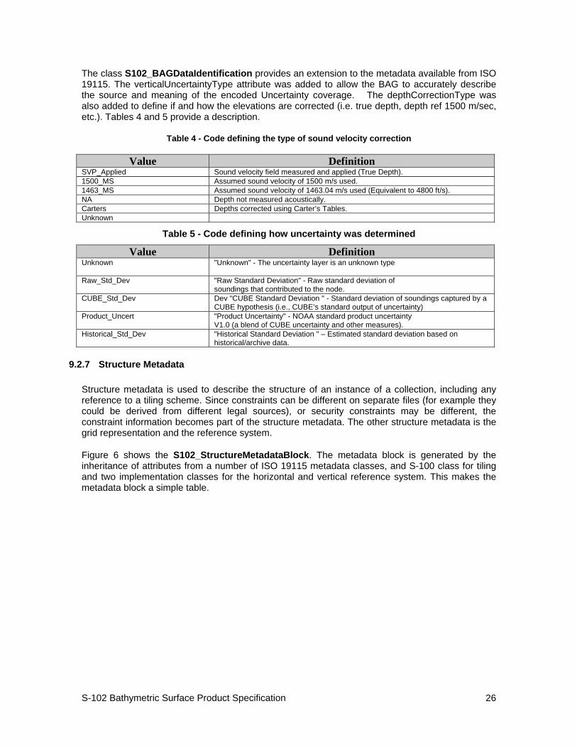
The class S102_BAGDataIdentification provides an extension to the metadata available from ISO 19115. The verticalUncertaintyType attribute was added to allow the BAG to accurately describe the source and meaning of the encoded Uncertainty coverage. The depthCorrectionType was also added to define if and how the elevations are corrected (i.e. true depth, depth ref 1500 m/sec, etc.). Tables 4 and 5 provide a description.
Table 4 - Code defining the type of sound velocity correction
Value Definition SVP_Applied Sound velocity field measured and applied (True Depth). 1500_MS Assumed sound velocity of 1500 m/s used. 1463_MS Assumed sound velocity of 1463.04 m/s used (Equivalent to 4800 ft/s). NA Depth not measured acoustically. Carters Depths corrected using Carter’s Tables. Unknown
Table 5 - Code defining how uncertainty was determined
Value Definition Unknown
"Unknown" - The uncertainty layer is an unknown type
Raw_Std_Dev
"Raw Standard Deviation" - Raw standard deviation of soundings that contributed to the node.
CUBE_Std_Dev
Dev "CUBE Standard Deviation " - Standard deviation of soundings captured by a CUBE hypothesis (i.e., CUBE’s standard output of uncertainty)
Product_Uncert
"Product Uncertainty" - NOAA standard product uncertainty V1.0 (a blend of CUBE uncertainty and other measures).
Historical_Std_Dev "Historical Standard Deviation " – Estimated standard deviation based on historical/archive data.
9.2.7 Structure Metadata
Structure metadata is used to describe the structure of an instance of a collection, including any reference to a tiling scheme. Since constraints can be different on separate files (for example they could be derived from different legal sources), or security constraints may be different, the constraint information becomes part of the structure metadata. The other structure metadata is the grid representation and the reference system.
Figure 6 shows the S102_StructureMetadataBlock. The metadata block is generated by the inheritance of attributes from a number of ISO 19115 metadata classes, and S-100 class for tiling and two implementation classes for the horizontal and vertical reference system. This makes the metadata block a simple table.
S-102 Bathymetric Surface Product Specification
27
class S102 StructureMetadata
S102_MetadataBlock
MD_GridSpatialRepresentationMD_LegalConstraints
MD_SecurityConstraintsS102_HorizRefSystem
S102_TileS102_VerticalRefSystem
S102_StructuralMetadataBlock
::MD_GridSpatialRepresentation+ numberOfDimensions: Integer+ axisDimensionProperties: Sequence<MD_Dimension>+ cellGeometry: MD_CellGeometryCode+ transformationParameterAvailabil ity: Boolean::S102_VerticalRefSystem+ vRefSystem: RS_Identifier::MD_LegalConstraints+ accessConstraints: MD_RestrictionCode [0..*]+ useConstraints: MD_RestrictionCode [0..*]+ otherConstraints: CharacterString [0..*]::MD_SecurityConstraints+ classification: MD_ClassificationCode+ userNote: CharacterString [0..1]+ classificationSystem: CharacterString [0..1]+ handlingDescription: CharacterString [0..1]::S102_HorizRefSystem+ hRefSystem: RS_Identifier::MD_Constraints+ useLimitation: CharacterString [0..*]::S10x_Tile+ tileID: CharacterString+ tileBoundary: GM_Curve [0..1]
«CodeList»Constraint information::
MD_RestrictionCode{root}
+ copyright+ patent+ patentPending+ trademark+ license+ intellectualPropertyRights+ restricted+ otherRestrictions
«CodeList»Constraint information::MD_ClassificationCode
{root}
+ unclassified+ restricted+ confidential+ secret+ topSecret
«CodeList»Spatial representation
information::MD_CellGeometryCode
+ point+ area
Spatial representation information::MD_Dimension
+ dimensionName: MD_DimensionNameTypeCode+ dimensionSize: Integer+ resolution: Measure [0..1]
«CodeList»Spatial representation information::
MD_DimensionNameTypeCode
+ row+ column+ vertical+ track+ crossTrack+ line+ sample+ time
Fig 6 - S-102 Structural Metadata Block
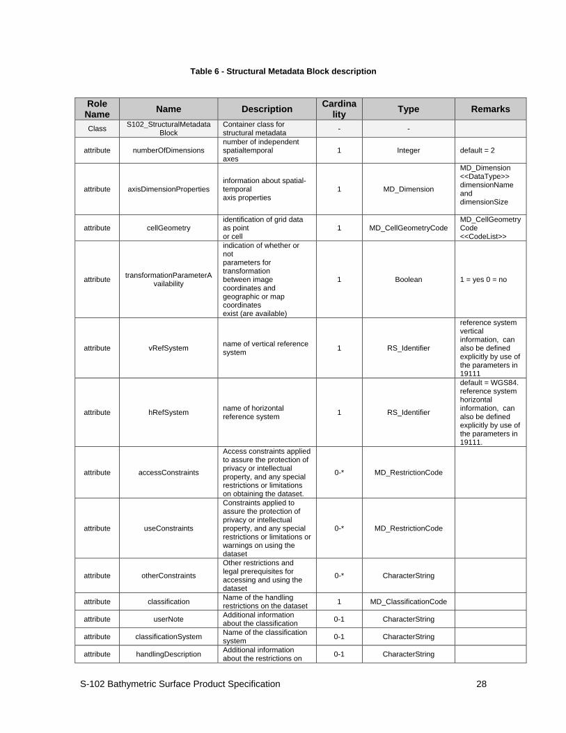
Table 6 provides a description of each attribute of the S102_StructureMetadataBlock class attributes.
S-102 Bathymetric Surface Product Specification
28
Table 6 - Structural Metadata Block description
Role Name Name Description Cardina
lity Type Remarks
Class S102_StructuralMetadataBlock
Container class for structural metadata - -
attribute numberOfDimensions number of independent spatialtemporal axes
1 Integer default = 2
attribute axisDimensionProperties information about spatial-temporal axis properties
1 MD_Dimension
MD_Dimension <<DataType>> dimensionName and dimensionSize
attribute cellGeometry identification of grid data as point or cell
1 MD_CellGeometryCode MD_CellGeometryCode <<CodeList>>
attribute transformationParameterAvailability
indication of whether or not parameters for transformation between image coordinates and geographic or map coordinates exist (are available)
1 Boolean 1 = yes 0 = no
attribute vRefSystem name of vertical reference system 1 RS_Identifier
reference system vertical information, can also be defined explicitly by use of the parameters in 19111
attribute hRefSystem name of horizontal reference system 1 RS_Identifier
default = WGS84. reference system horizontal information, can also be defined explicitly by use of the parameters in 19111.
attribute accessConstraints
Access constraints applied to assure the protection of privacy or intellectual property, and any special restrictions or limitations on obtaining the dataset.
0-* MD_RestrictionCode
attribute useConstraints
Constraints applied to assure the protection of privacy or intellectual property, and any special restrictions or limitations or warnings on using the dataset
0-* MD_RestrictionCode
attribute otherConstraints
Other restrictions and legal prerequisites for accessing and using the dataset
0-* CharacterString
attribute classification Name of the handling restrictions on the dataset 1 MD_ClassificationCode
attribute userNote Additional information about the classification 0-1 CharacterString
attribute classificationSystem Name of the classification system 0-1 CharacterString
attribute handlingDescription Additional information about the restrictions on 0-1 CharacterString
S-102 Bathymetric Surface Product Specification
29
Role Name Name Description Cardina
lity Type Remarks handling the dataset
attribute tileID tile identifier 1 CharacterString
attribute tileBoundary tile boundary 0-1 GM_Curve
When not provided is assumed to be the extent of the collection as defined by EX_Extent
Class MD_Dimension Axis properties - -
attribute dimensionName name of axis 1 MD_DimensionTypeCode
Defaults are "row" and "column"
attribute dimensionSize number of elements along the axis 1 Integer
attribute resolution degree of detail in the grid dataset 0-1 Measure value= number
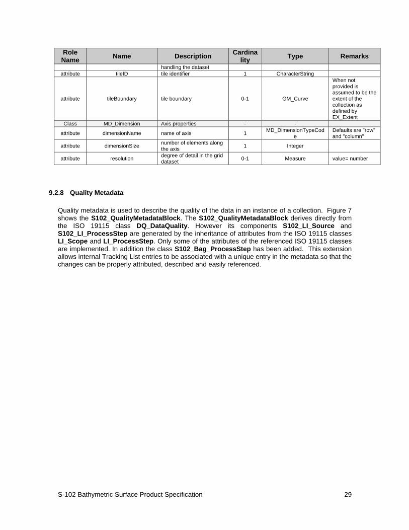
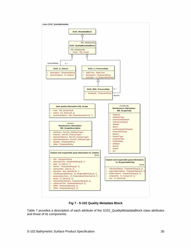
9.2.8 Quality Metadata
Quality metadata is used to describe the quality of the data in an instance of a collection. Figure 7 shows the S102_QualityMetadataBlock. The S102_QualityMetadataBlock derives directly from the ISO 19115 class DQ_DataQuality. However its components S102_LI_Source and S102_LI_ProcessStep are generated by the inheritance of attributes from the ISO 19115 classes LI_Scope and LI_ProcessStep. Only some of the attributes of the referenced ISO 19115 classes are implemented. In addition the class S102_Bag_ProcessStep has been added. This extension allows internal Tracking List entries to be associated with a unique entry in the metadata so that the changes can be properly attributed, described and easily referenced.
S-102 Bathymetric Surface Product Specification
30
class S102_QualityMetadata
S102_MetadataBlock
DQ_DataQualityS102_QualityMetadataBlock
::DQ_DataQuality+ scope: DQ_Scope
S102_LI_Source
+ description: CharacterString+ sourceCitation: CI_Citation
S102_BAG_ProcessStep
+ trackingId: CharacterString
S102_LI_ProcessStep
+ dateTime: DateTime+ description: CharacterString+ processor: CI_ResponsibleParty
Data quality information::DQ_Scope
+ level: MD_ScopeCode+ extent: EX_Extent [0..1]+ levelDescription: MD_ScopeDescription [0..*]
Citation and responsible party information::CI_Citation{root}
+ title: CharacterString+ alternateTitle: CharacterString [0..*]+ date: CI_Date [1..*]+ edition: CharacterString [0..1]+ editionDate: Date [0..1]+ identifier: MD_Identifier [0..*]+ citedResponsibleParty: CI_ResponsibleParty [0..*]+ presentationForm: CI_PresentationFormCode [0..*]+ series: CI_Series [0..1]+ otherCitationDetails: CharacterString [0..1]+ collectiveTitle: CharacterString [0..1]+ ISBN: CharacterString [0..1]+ ISSN: CharacterString [0..1]
Citation and responsible party information::CI_ResponsibleParty
{root}
+ individualName: CharacterString [0..1]+ organisationName: CharacterString [0..1]+ positionName: CharacterString [0..1]+ contactInfo: CI_Contact [0..1]+ role: CI_RoleCode
«CodeList»Maintenance information::
MD_ScopeCode
+ attribute+ attributeType+ collectionHardware+ collectionSession+ dataset+ series+ nonGeographicDataset+ dimensionGroup+ feature+ featureType+ propertyType+ fieldSession+ software+ service+ model+ tile
«Union»Maintenance information::
MD_ScopeDescription
+ attributes: Set<GF_AttributeType>+ features: Set<GF_FeatureType>+ featureInstances: Set<GF_FeatureType>+ attributeInstances: Set<GF_AttributeType>+ dataset: CharacterString+ other: CharacterString
+processStep 0..*
+source
0..*
Fig 7 - S-102 Quality Metadata Block
Table 7 provides a description of each attribute of the S102_QualityMetadataBlock class attributes and those of its components.
S-102 Bathymetric Surface Product Specification
31
Table 7 - Quality Metadata Block description
Role Name Name Description Cardina
lity Type Remarks
Class S102_QualityMetadataBlock
Container class for quality metadata - -
attribute scope
extent of characteristic(s) of the data for which quality information is reported
1 DQ_Scope
Class S102_LI_Source
information about the source data used in creating the data specified by the scope
- -
attribute description detailed description of the level of the source data
1 CharacterString
attribute sourceCitation recommended reference to be used for the source data
1 CI_Citation
Class S102_LI_ProcessStep
information about an event or transformation in the life of a dataset including the process used to maintain the dataset
- -
attribute dateTime
date and time or range of date and time on or over which the process step occurred
1 CharacterString
attribute description
description of the event, including related parameters or tolerances
1 CharacterString
attribute processor
identification of, and means of communication with, person(s) and organization(s) associated with the process step
1 CI_ResponsibleParty
Class S102_BAG_ProcessStep Management of TrackingList references to LI_ProcessStep
- -
attribute trackingId
ID reference used so that Tracking List entries can be associated with a unique entry in the metadata so that the changes can be properly attributed, described and easily referenced
1 CharacterString
Class DQ_Scope Container class for quality metadata - -
attribute level hierarchical level of the data specified by the scope
0-* MD_ScopeCode <<CodeList>>
"dataset" or "tile"
attribute extent
information about the horizontal, vertical and temporal extent of the data specified by the scope
0-* EX_Extent
<<DataType>>
Used only if the extent of the data is different from the EX_Extent given for the collection / tile
attribute levelDescription detailed description about 1 MD_ScopeDescription
S-102 Bathymetric Surface Product Specification
32
Role Name Name Description Cardina
lity Type Remarks the level of the data specified by the scope
<<Union>>
9.2.9 Acquisition Metadata
Acquisition metadata is optional in S-102. A producer or national hydrographic office may add acquisition metadata to a Bathymetric Surface Product Specification profile that they are developing nationally. The classes derive from ISO 19115, 19115-2, 19130 and 19130-2. The later document 19130-2 contains description of SONAR parameters.
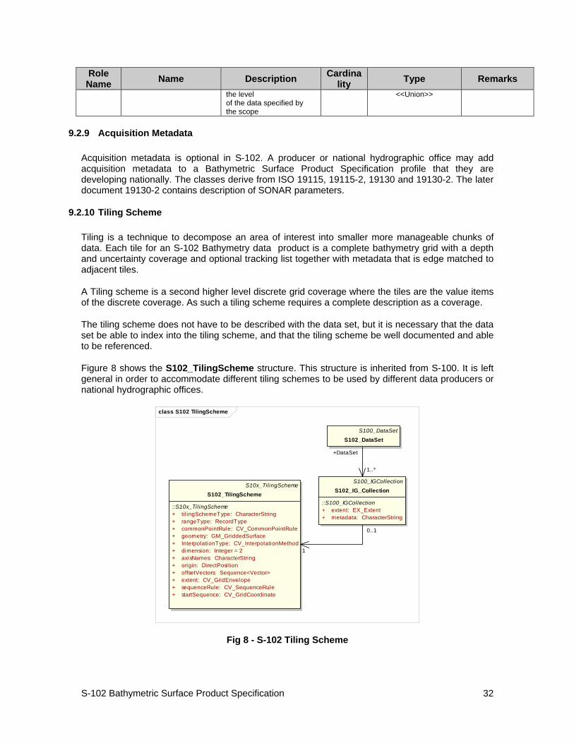
9.2.10 Tiling Scheme
Tiling is a technique to decompose an area of interest into smaller more manageable chunks of data. Each tile for an S-102 Bathymetry data product is a complete bathymetry grid with a depth and uncertainty coverage and optional tracking list together with metadata that is edge matched to adjacent tiles.
A Tiling scheme is a second higher level discrete grid coverage where the tiles are the value items of the discrete coverage. As such a tiling scheme requires a complete description as a coverage.
The tiling scheme does not have to be described with the data set, but it is necessary that the data set be able to index into the tiling scheme, and that the tiling scheme be well documented and able to be referenced.
Figure 8 shows the S102_TilingScheme structure. This structure is inherited from S-100. It is left general in order to accommodate different tiling schemes to be used by different data producers or national hydrographic offices.
class S102 TilingScheme
S100_DataSetS102_DataSet
S100_IGCollectionS102_IG_Collection
::S100_IGCollection+ extent: EX_Extent+ metadata: CharacterString
S10x_TilingSchemeS102_TilingScheme
::S10x_TilingScheme+ ti l ingSchemeType: CharacterString+ rangeType: RecordType+ commonPointRule: CV_CommonPointRule+ geometry: GM_GriddedSurface+ InterpolationType: CV_InterpolationMethod+ dimension: Integer = 2+ axisNames: CharacterString+ origin: DirectPosition+ offsetVectors: Sequence<Vector>+ extent: CV_GridEnvelope+ sequenceRule: CV_SequenceRule+ startSequence: CV_GridCoordinate
+DataSet
1..*
0..1
1
Fig 8 - S-102 Tiling Scheme
S-102 Bathymetric Surface Product Specification
33
Table 8 provides a description of each attribute of the S102_TilingScheme class attributes.
Table 8 - Tiling Scheme description
Role Name Name Description Cardina
lity Type Remarks
Class S102_TilingScheme Container class for tiling scheme description - -
attribute tilingSchemeType description of the type of the tiling scheme 1 CharacterString
"uniform quadrilateral grid", or "Quad Tree" or other
attribute domainExtent description of the extent of the tiling scheme 1 EX_Extent
attribute rangeType description of the range of the coverage 1 RecordType
the record value for each grid cell in a tiling scheme consists of a single entry corresponding to the tile,
attribute commonPointRule
procedure to be used for evaluating the CV_Coverage at a position that falls on a boundary between tiles or within the boundaries of two or more overlapping tiles
1 CV_CommonPointRule
For tiles (not the data within a tile) the result is "all". That is, both tiles apply and are returned by a tiling scheme coverage function. The application will determine which to use.
attribute geometry geometry of the domain object 1 GM_GriddedSurface
attribute interpolationType identification of interpolation method 1 CV_InterpolationMethod
not applicable, Tiles cannot be interpolated
attribute dimension dimensionality of the grid 1 Integer default = 2
attribute axisNames names of the grid axis 1 CharacterString
The grid axis names are by default "Latitude" and "Longitude" but may be different if, for example, the grid is at a different orientation.
attribute origin
position that locates the origin of the rectified grid in the coordinate reference system
1 DirectPosition
attribute offsetVectors
a 2 dimensional vector quantity that determine the grid spacing in each direction
1 Sequence <Vector>
attribute extent description of the extent of the tiling scheme 1 CV_GridEnvelope
attribute sequenceRule
describe how the grid points are ordered for association to the elements of the sequence values.
1 CV_SequenceRule
The default value is "Linear" which is used for a uniform quadrilateral grid tile coverage, or may be "Morton" for a Quad Tree
attribute startSequence the grid point to be 1 CV_GridCoordinate The default value
S-102 Bathymetric Surface Product Specification
34
Role Name Name Description Cardina
lity Type Remarks associated with the first record in the values sequence
is the lower left corner of the grid
9.2.11 Feature Catalogue
A coverage is a type of feature so a Bathymetry Surface Product specification does contain features. There are three coverages defined. The bathymetry depth coverage and the uncertainty coverage are discrete coverages. The third coverage is the discrete point coverage that corresponds to the tracking list of original values and uncertainties. These three entries compose the feature catalogue.
9.2.12 Reference to product specification scope
Global.
Note: "Global" means that this scope refers to all parts of this data product specification.
9.3 BAG Coverages
The major components of the Bathymetric Surface product are the coverages. At a minimum a Bathymetric Surface product (called a Bathymetric Attributed Grid (BAG)) must have two coverages. The general structure of each is defined in IHO S-100 Part 8 as a georectified grid. Metadata defining the axes, dimensions, and geolocation parameters are found in the metadata in the MD_GridSpatialRepresentation and other classes defined in ISO 19115. Furthermore the two coverages are co-located. Each of these contains a two-dimensional matrix organized in row major order, and starting from the south-western most data point, where each value is defined to be at an exactly specified geographic point (or grid node), hence negating the need for horizontal uncertainties. Annex B specifies references for combining sample horizontal and vertical uncertainties in the derivation of grid point vertical uncertainty.
The units of the elevation values are metres, and the sign convention is for z to be positive for values above the vertical datum. The reference vertical datum for the BAG is one of the mandatory Metadata items. This sign convention follows directly from the right hand coordinate system definition to which BAG adheres.
The unknown state for elevation is defined to be 1,000,000.0 (1.0e6).
The uncertainty values are expressed as positive quantities at a node. As detailed in clause 9.2.3.3 the uncertainty grid supports multiple definitions of vertical uncertainty. This allows BAGs to span the expected range of data products from raw, full resolution grid to final compiled product. For example, a BAG at the stage of final survey data processing should contain uncertainty information germane to the survey data itself and intended to be used for information compilation. A recipient of a BAG file can refer to the uncertainty definition in the Metadata to gain an understanding of how the uncertainty was computed. The unknown state for uncertainty is defined to be 0.0.
9.4 Tracking List
The tracking list contains a simple list of the original elevation and uncertainty values from any node of the surface that has been modified to account for hydrographer over-rides of the basic surface definition (e.g., as originally computed by an algorithmic method). The tracking list dataset
S-102 Bathymetric Surface Product Specification
35
and corresponding information contained in the metadata exist to provide an audit trail record of changes made to the data by manual intervention.
9.5 Extensions
The Bathymetric Surface Product Specification is extensible. This includes both extensions to the content model and to the encodings supporting the content model. Extensions are optional coverages and not required for a file to be qualified nor do they invalidate a compliant product. Additional layers of information not related to the bathymetric scope of this product specification should be defined in separate S.100 and S.10x compliant layers.
9.6 Coordinate Reference Systems
9.6.1 Spatial Representation
All coverages in the Bathymetric Surface Product Specification are georectified, simple uniform quadrilateral grids as defined in IHO S-100 Part 8.
All S102 Bathymetric Surface product coverages shall be represented with a right-handed Cartesian coordinate system. This system shall have the x-axis oriented towards positive eastings (for projected grids), or east (for geographic grids), and y-axis oriented towards positive northings (for projected grids), or north (for geographic grids). These definitions imply that the z-axis for the sounding data is positive away from the center of mass of the earth (i.e., is positive up), rather than the usual hydrographic convention of positive down (i.e., deeper depths are larger numbers and negative depths are above datum). User-level code is free to make this reflection if required, but must write the data using the positive-up convention. In order to make this distinction clear, the term “elevation” is used for the vertical component of the BAG, rather than “depth”. The uncertainty component of the BAG shall have the same coordinate system as the elevation component, with the exception that the z-axis is unipolar, and therefore the concept of direction of positive increase is irrelevant.
The grid data in a S102 Bathymetric Surface coverage (either elevation or uncertainty, and any other surfaces that may be added) shall be organized as a uniform quadrilateral grid in row-major order from west to east, and south to north Thus, the first sample of the grid is the node at the southwest corner of the grid with location as specified by the georeferencing parameters, the second is one grid resolution unit to the east of that position and at the same northing or latitude, and the third is two grid resolution units to the east and at the same northing or latitude. For C columns in the grid, the (C+1)th sample in the grid is located one grid resolution unit to the north, but on the same easting, or longitude, as the first sample in the grid.
9.6.2 Coordinate Reference System
The geo-referencing for a S102 Bathymetric Surface product shall be node-based, referenced from the southwestern-most node in a grid. Each sample in a grid represents the value in the grid at a point location at the coordinate specified, rather than an estimate over any area with respect to the coordinate. The reference position included in the metadata shall be given in the coordinates used for the grid, and shall contain sufficient digits of precision to locate the grid with accuracy no worse than a millimeter on the surface of the ellipsoid of rotation of the chosen horizontal datum.
The Coordinate Reference System information is defined in the manner specified in S-100. The coverage can be specified in any projected coordinate system supported in IHO S-100 Part 6. However, no transformation methods are provided. Note the vertical datum is defined through a second association role to a vertical reference system.
S-102 Bathymetric Surface Product Specification
36
9.6.3 Data Quality
As defined in IHO S-100 Part 4c the data quality for the elevation coverage is also defined as a co-located coverage, uncertainty. Uncertainty is defined as the vertical uncertainty at each node location. The uncertainty coverage supports multiple definitions of vertical uncertainty.
10 Data Capture
10.1 Description
There are a number of sounding techniques, including SONAR and LIDAR that are used to capture bathymetric data. It is permitted, but not required to include data acquisition information in the metadata of an S-102 Bathymetric Surface product. The metadata class S102_AcquisitionMetadata has been defined, but the information elements to populate this metadata class should be identified in a national profile of S-102.
10.2 Reference to product specification scope
Global.
Note: "Global" means that this scope refers to all parts of this data product specification.
11 Data Maintenance
11.1 Description
S-102 data sets are maintained by replacement on a tile basis. That is, the entire data product or tile within a data set including its coverages (elevation/depth, uncertainty, and tracking list point set coverage) and the associated metadata are replaced as a unit. This is unlike S-101 vector data that may be updated incrementally. However, coverage data must be considered as a unit at least at the tile level. This is because processing is done on the entire tile to produce the data product. Any replacement tile will include its own tracking list (when a tracking list is used) to deliberately bias the information for safety of navigation. Also each replacement tile or data set must have its own digital signature.
11.2 Reference to product specification scope
Global.
Note: "Global" means that this scope refers to all parts of this data product specification.
12 Encoding
12.1 Encoding Principals
ISO suite of geographic information standards is built on the concept of the separation of the "carrier" from the "content". This is reiterated in S-100 where several encoding approaches are identified. The content is defined in the product specification for any type of data, such as the S-102 Bathymetry Surface Product Specification, in terms of an encoding neutral UML model.
S-102 Bathymetric Surface Product Specification
37
Elements from this model are then used to create and Application Schema that is then encoded. Different layers of other auxiliary data may have different encodings.
The encoding is described in Annex A is the current implementation. The possibility of using JPEG 2000 + XML is considered as a future longer term option, but is not yet viable until software tools become commonplace. It is possible, but probably not practical to develop a coding using ISO 8211 data descriptive file for information interchange standard. Not only are there no tools available to handle coverage data, but the standard is not widely used for this type of information, so there are not likely to be any such tools available.
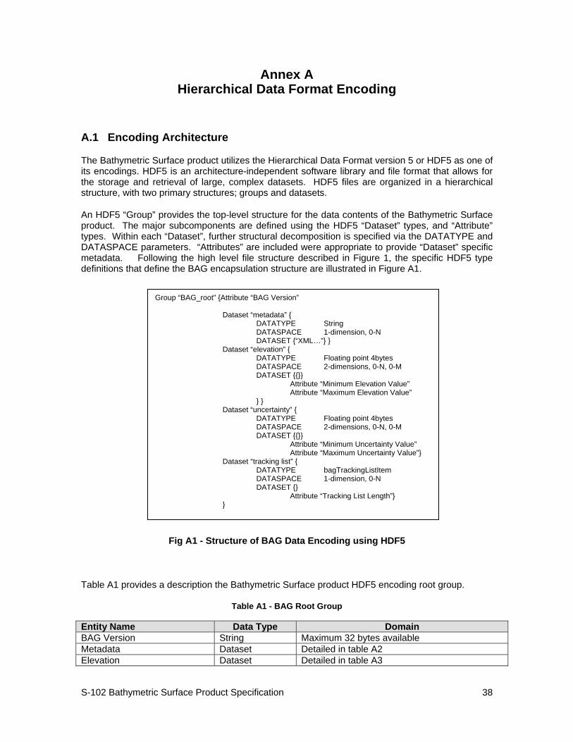
S-102 Bathymetric Surface Product Specification
38
Annex A Hierarchical Data Format Encoding
A.1 Encoding Architecture
The Bathymetric Surface product utilizes the Hierarchical Data Format version 5 or HDF5 as one of its encodings. HDF5 is an architecture-independent software library and file format that allows for the storage and retrieval of large, complex datasets. HDF5 files are organized in a hierarchical structure, with two primary structures; groups and datasets.
An HDF5 “Group” provides the top-level structure for the data contents of the Bathymetric Surface product. The major subcomponents are defined using the HDF5 “Dataset” types, and “Attribute” types. Within each “Dataset”, further structural decomposition is specified via the DATATYPE and DATASPACE parameters. “Attributes” are included were appropriate to provide “Dataset” specific metadata. Following the high level file structure described in Figure 1, the specific HDF5 type definitions that define the BAG encapsulation structure are illustrated in Figure A1.
Fig A1 - Structure of BAG Data Encoding using HDF5
Table A1 provides a description the Bathymetric Surface product HDF5 encoding root group.
Table A1 - BAG Root Group
Entity Name Data Type Domain BAG Version String Maximum 32 bytes available Metadata Dataset Detailed in table A2 Elevation Dataset Detailed in table A3
Group “BAG_root” {Attribute “BAG Version” Dataset “metadata” { DATATYPE String DATASPACE 1-dimension, 0-N DATASET {“XML…”} } Dataset “elevation” { DATATYPE Floating point 4bytes DATASPACE 2-dimensions, 0-N, 0-M DATASET {{}} Attribute “Minimum Elevation Value” Attribute “Maximum Elevation Value” } } Dataset “uncertainty” { DATATYPE Floating point 4bytes DATASPACE 2-dimensions, 0-N, 0-M DATASET {{}} Attribute “Minimum Uncertainty Value” Attribute “Maximum Uncertainty Value”} Dataset “tracking list” { DATATYPE bagTrackingListItem DATASPACE 1-dimension, 0-N DATASET {} Attribute “Tracking List Length”} }
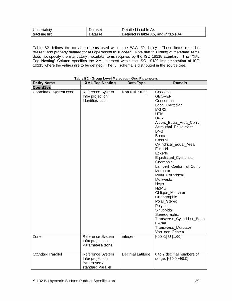
S-102 Bathymetric Surface Product Specification
39
Uncertainty Dataset Detailed in table A4 tracking list Dataset Detailed in table A5, and in table A6
Table B2 defines the metadata items used within the BAG I/O library. These items must be present and properly defined for I/O operations to succeed. Note that this listing of metadata items does not specify the mandatory metadata items required by the ISO 19115 standard. The “XML Tag Nesting” Column specifies the XML element within the ISO 19139 implementation of ISO 19115 where the values are to be defined. The full schema is distributed in the source tree.
Table B2 - Group Level Metadata – Grid Parameters Entity Name XML Tag Nesting Data Type Domain CoordSys Coordinate System code Reference System
Info/ projection/ Identifier/ code
Non Null String Geodetic GEOREF Geocentric Local_Cartesian MGRS UTM UPS Albers_Equal_Area_Conic Azimuthal_Equidistant BNG Bonne Cassini Cylindrical_Equal_Area Eckert4 Eckert6 Equidistant_Cylindrical Gnomonic Lambert_Conformal_Conic Mercator Miller_Cylindrical Mollweide Neys NZMG Oblique_Mercator Orthographic Polar_Stereo Polyconic Sinusoidal Stereographic Transverse_Cylindrical_Equal_Area Transverse_Mercator Van_der_Grinten
Zone Reference System Info/ projection Parameters/ zone
integer [-60,-1] U [1,60]
Standard Parallel Reference System Info/ projection Parameters/ standard Parallel
Decimal Latitude 0 to 2 decimal numbers of range: [-90.0,+90.0]
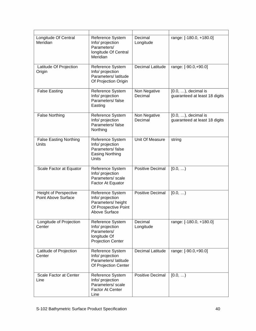
S-102 Bathymetric Surface Product Specification
40
Longitude Of Central Meridian
Reference System Info/ projection Parameters/ longitude Of Central Meridian
Decimal Longitude
range: [-180.0, +180.0]
Latitude Of Projection Origin
Reference System Info/ projection Parameters/ latitude Of Projection Origin
Decimal Latitude range: [-90.0,+90.0]
False Easting Reference System Info/ projection Parameters/ false Easting
Non Negative Decimal
[0.0, …), decimal is guaranteed at least 18 digits
False Northing Reference System Info/ projection Parameters/ false Northing
Non Negative Decimal
[0.0, …), decimal is guaranteed at least 18 digits
False Easting Northing Units
Reference System Info/ projection Parameters/ false Easing Northing Units
Unit Of Measure string
Scale Factor at Equator Reference System Info/ projection Parameters/ scale Factor At Equator
Positive Decimal [0.0, …)
Height of Perspective Point Above Surface
Reference System Info/ projection Parameters/ height Of Prospective Point Above Surface
Positive Decimal [0.0, …)
Longitude of Projection Center
Reference System Info/ projection Parameters/ longitude Of Projection Center
Decimal Longitude
range: [-180.0, +180.0]
Latitude of Projection Center
Reference System Info/ projection Parameters/ latitude Of Projection Center
Decimal Latitude range: [-90.0,+90.0]
Scale Factor at Center Line
Reference System Info/ projection Parameters/ scale Factor At Center Line
Positive Decimal [0.0, …)
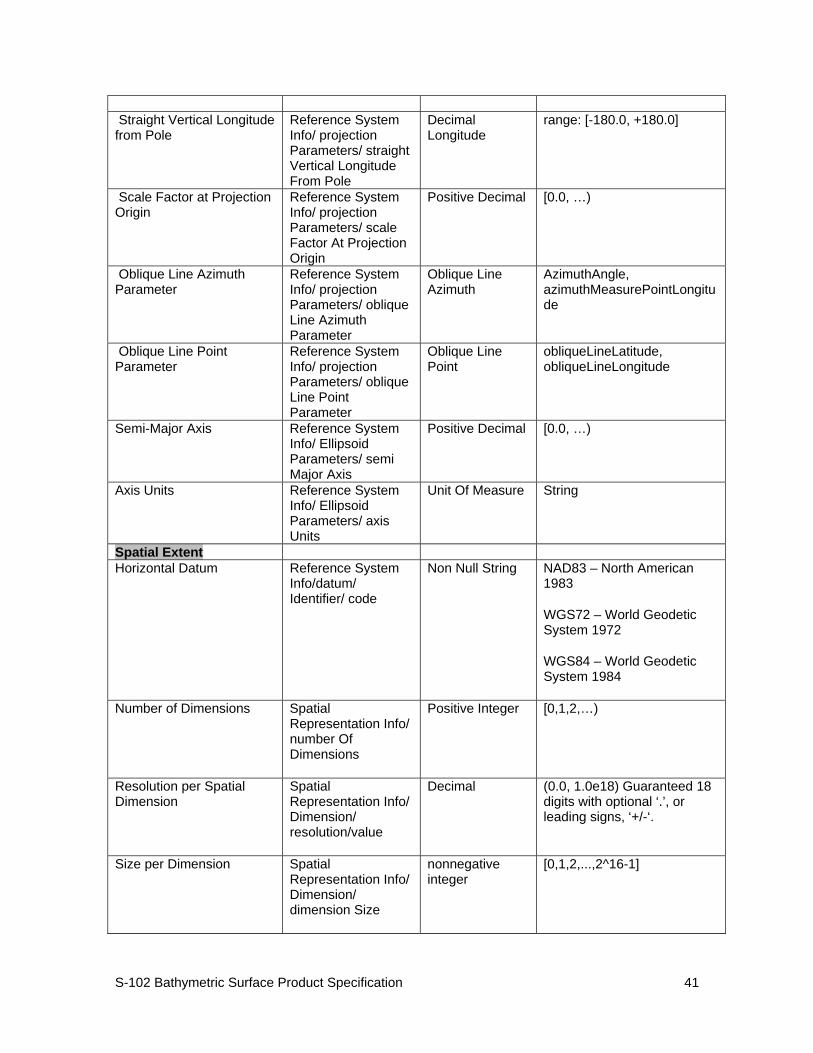
S-102 Bathymetric Surface Product Specification
41
Straight Vertical Longitude from Pole
Reference System Info/ projection Parameters/ straight Vertical Longitude From Pole
Decimal Longitude
range: [-180.0, +180.0]
Scale Factor at Projection Origin
Reference System Info/ projection Parameters/ scale Factor At Projection Origin
Positive Decimal [0.0, …)
Oblique Line Azimuth Parameter
Reference System Info/ projection Parameters/ oblique Line Azimuth Parameter
Oblique Line Azimuth
AzimuthAngle, azimuthMeasurePointLongitude
Oblique Line Point Parameter
Reference System Info/ projection Parameters/ oblique Line Point Parameter
Oblique Line Point
obliqueLineLatitude, obliqueLineLongitude
Semi-Major Axis Reference System Info/ Ellipsoid Parameters/ semi Major Axis
Positive Decimal
[0.0, …)
Axis Units Reference System Info/ Ellipsoid Parameters/ axis Units
Unit Of Measure String
Spatial Extent Horizontal Datum Reference System
Info/datum/ Identifier/ code
Non Null String NAD83 – North American 1983
WGS72 – World Geodetic System 1972
WGS84 – World Geodetic System 1984
Number of Dimensions Spatial Representation Info/ number Of Dimensions
Positive Integer
[0,1,2,…)
Resolution per Spatial Dimension
Spatial Representation Info/ Dimension/ resolution/value
Decimal (0.0, 1.0e18) Guaranteed 18 digits with optional ‘.’, or leading signs, ‘+/-‘.
Size per Dimension Spatial Representation Info/ Dimension/ dimension Size
nonnegative integer
[0,1,2,...,2^16-1]
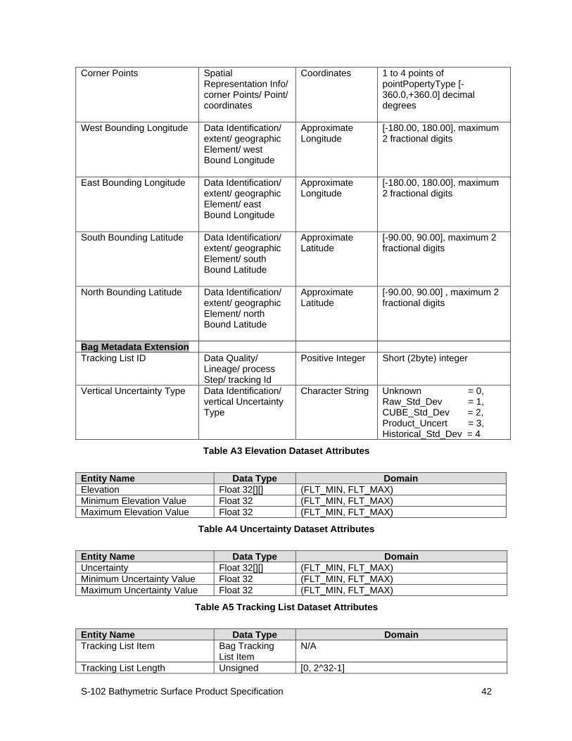
S-102 Bathymetric Surface Product Specification
42
Corner Points Spatial Representation Info/ corner Points/ Point/ coordinates
Coordinates 1 to 4 points of pointPopertyType [-360.0,+360.0] decimal degrees
West Bounding Longitude Data Identification/ extent/ geographic Element/ west Bound Longitude
Approximate Longitude
[-180.00, 180.00], maximum 2 fractional digits
East Bounding Longitude Data Identification/ extent/ geographic Element/ east Bound Longitude
Approximate Longitude
[-180.00, 180.00], maximum 2 fractional digits
South Bounding Latitude Data Identification/ extent/ geographic Element/ south Bound Latitude
Approximate Latitude
[-90.00, 90.00], maximum 2 fractional digits
North Bounding Latitude Data Identification/ extent/ geographic Element/ north Bound Latitude
Approximate Latitude
[-90.00, 90.00] , maximum 2 fractional digits
Bag Metadata Extension Tracking List ID Data Quality/
Lineage/ process Step/ tracking Id
Positive Integer Short (2byte) integer
Vertical Uncertainty Type Data Identification/ vertical Uncertainty Type
Character String Unknown = 0, Raw_Std_Dev = 1, CUBE_Std_Dev = 2, Product_Uncert = 3, Historical_Std_Dev = 4
Table A3 Elevation Dataset Attributes
Entity Name Data Type Domain Elevation Float 32[][] (FLT_MIN, FLT_MAX) Minimum Elevation Value Float 32 (FLT_MIN, FLT_MAX) Maximum Elevation Value Float 32 (FLT_MIN, FLT_MAX)
Table A4 Uncertainty Dataset Attributes
Entity Name Data Type Domain Uncertainty Float 32[][] (FLT_MIN, FLT_MAX) Minimum Uncertainty Value Float 32 (FLT_MIN, FLT_MAX) Maximum Uncertainty Value Float 32 (FLT_MIN, FLT_MAX)
Table A5 Tracking List Dataset Attributes
Entity Name Data Type Domain Tracking List Item Bag Tracking
List Item N/A
Tracking List Length Unsigned [0, 2^32-1]
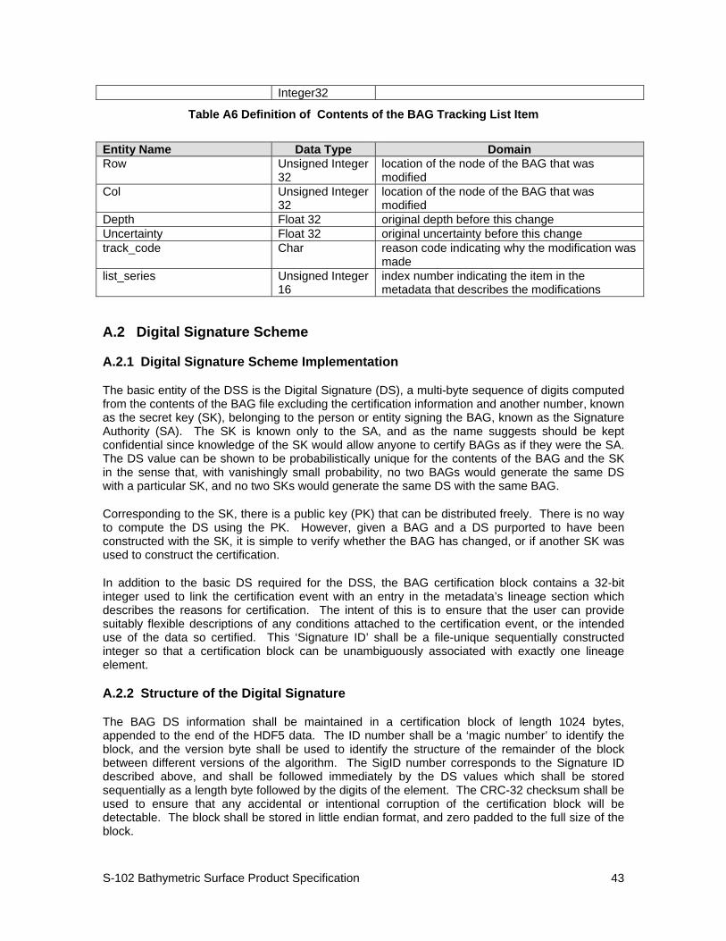
S-102 Bathymetric Surface Product Specification
43
Integer32
Table A6 Definition of Contents of the BAG Tracking List Item
Entity Name Data Type Domain Row Unsigned Integer
32 location of the node of the BAG that was modified
Col Unsigned Integer 32
location of the node of the BAG that was modified
Depth Float 32 original depth before this change Uncertainty Float 32 original uncertainty before this change track_code Char reason code indicating why the modification was
made list_series Unsigned Integer
16 index number indicating the item in the metadata that describes the modifications
A.2 Digital Signature Scheme
A.2.1 Digital Signature Scheme Implementation
The basic entity of the DSS is the Digital Signature (DS), a multi-byte sequence of digits computed from the contents of the BAG file excluding the certification information and another number, known as the secret key (SK), belonging to the person or entity signing the BAG, known as the Signature Authority (SA). The SK is known only to the SA, and as the name suggests should be kept confidential since knowledge of the SK would allow anyone to certify BAGs as if they were the SA. The DS value can be shown to be probabilistically unique for the contents of the BAG and the SK in the sense that, with vanishingly small probability, no two BAGs would generate the same DS with a particular SK, and no two SKs would generate the same DS with the same BAG.
Corresponding to the SK, there is a public key (PK) that can be distributed freely. There is no way to compute the DS using the PK. However, given a BAG and a DS purported to have been constructed with the SK, it is simple to verify whether the BAG has changed, or if another SK was used to construct the certification.
In addition to the basic DS required for the DSS, the BAG certification block contains a 32-bit integer used to link the certification event with an entry in the metadata’s lineage section which describes the reasons for certification. The intent of this is to ensure that the user can provide suitably flexible descriptions of any conditions attached to the certification event, or the intended use of the data so certified. This ‘Signature ID’ shall be a file-unique sequentially constructed integer so that a certification block can be unambiguously associated with exactly one lineage element.
A.2.2 Structure of the Digital Signature
The BAG DS information shall be maintained in a certification block of length 1024 bytes, appended to the end of the HDF5 data. The ID number shall be a ‘magic number’ to identify the block, and the version byte shall be used to identify the structure of the remainder of the block between different versions of the algorithm. The SigID number corresponds to the Signature ID described above, and shall be followed immediately by the DS values which shall be stored sequentially as a length byte followed by the digits of the element. The CRC-32 checksum shall be used to ensure that any accidental or intentional corruption of the certification block will be detectable. The block shall be stored in little endian format, and zero padded to the full size of the block.
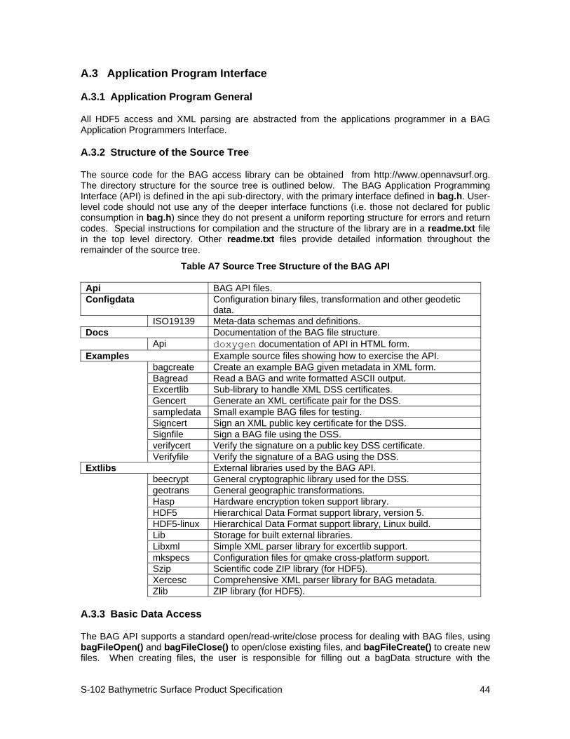
S-102 Bathymetric Surface Product Specification
44
A.3 Application Program Interface
A.3.1 Application Program General
All HDF5 access and XML parsing are abstracted from the applications programmer in a BAG Application Programmers Interface.
A.3.2 Structure of the Source Tree
The source code for the BAG access library can be obtained from http://www.opennavsurf.org. The directory structure for the source tree is outlined below. The BAG Application Programming Interface (API) is defined in the api sub-directory, with the primary interface defined in bag.h. User-level code should not use any of the deeper interface functions (i.e. those not declared for public consumption in bag.h) since they do not present a uniform reporting structure for errors and return codes. Special instructions for compilation and the structure of the library are in a readme.txt file in the top level directory. Other readme.txt files provide detailed information throughout the remainder of the source tree.
Table A7 Source Tree Structure of the BAG API Api BAG API files. Configdata Configuration binary files, transformation and other geodetic
data. ISO19139 Meta-data schemas and definitions. Docs Documentation of the BAG file structure. Api doxygen documentation of API in HTML form. Examples Example source files showing how to exercise the API. bagcreate Create an example BAG given metadata in XML form. Bagread Read a BAG and write formatted ASCII output. Excertlib Sub-library to handle XML DSS certificates. Gencert Generate an XML certificate pair for the DSS. sampledata Small example BAG files for testing. Signcert Sign an XML public key certificate for the DSS. Signfile Sign a BAG file using the DSS. verifycert Verify the signature on a public key DSS certificate. Verifyfile Verify the signature of a BAG using the DSS. Extlibs External libraries used by the BAG API. beecrypt General cryptographic library used for the DSS. geotrans General geographic transformations. Hasp Hardware encryption token support library. HDF5 Hierarchical Data Format support library, version 5. HDF5-linux Hierarchical Data Format support library, Linux build. Lib Storage for built external libraries. Libxml Simple XML parser library for excertlib support. mkspecs Configuration files for qmake cross-platform support. Szip Scientific code ZIP library (for HDF5). Xercesc Comprehensive XML parser library for BAG metadata. Zlib ZIP library (for HDF5).
A.3.3 Basic Data Access
The BAG API supports a standard open/read-write/close process for dealing with BAG files, using bagFileOpen() and bagFileClose() to open/close existing files, and bagFileCreate() to create new files. When creating files, the user is responsible for filling out a bagData structure with the
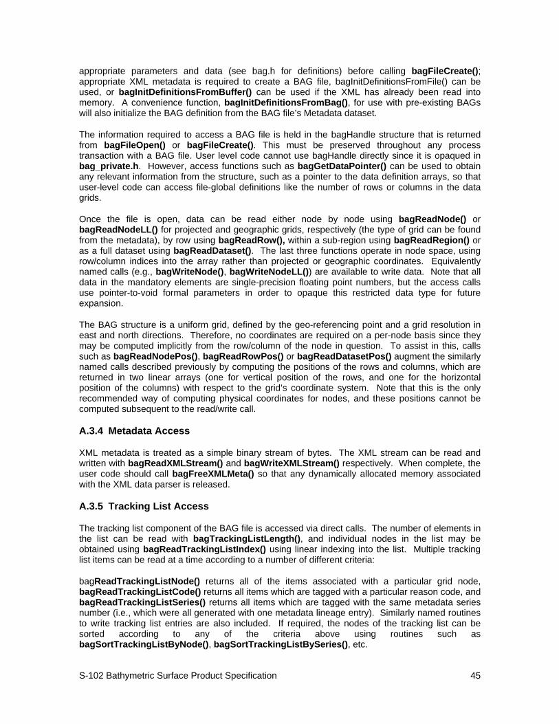
S-102 Bathymetric Surface Product Specification
45
appropriate parameters and data (see bag.h for definitions) before calling bagFileCreate(); appropriate XML metadata is required to create a BAG file, bagInitDefinitionsFromFile() can be used, or bagInitDefinitionsFromBuffer() can be used if the XML has already been read into memory. A convenience function, bagInitDefinitionsFromBag(), for use with pre-existing BAGs will also initialize the BAG definition from the BAG file’s Metadata dataset.
The information required to access a BAG file is held in the bagHandle structure that is returned from bagFileOpen() or bagFileCreate(). This must be preserved throughout any process transaction with a BAG file. User level code cannot use bagHandle directly since it is opaqued in bag_private.h. However, access functions such as bagGetDataPointer() can be used to obtain any relevant information from the structure, such as a pointer to the data definition arrays, so that user-level code can access file-global definitions like the number of rows or columns in the data grids.
Once the file is open, data can be read either node by node using bagReadNode() or bagReadNodeLL() for projected and geographic grids, respectively (the type of grid can be found from the metadata), by row using bagReadRow(), within a sub-region using bagReadRegion() or as a full dataset using bagReadDataset(). The last three functions operate in node space, using row/column indices into the array rather than projected or geographic coordinates. Equivalently named calls (e.g., bagWriteNode(), bagWriteNodeLL()) are available to write data. Note that all data in the mandatory elements are single-precision floating point numbers, but the access calls use pointer-to-void formal parameters in order to opaque this restricted data type for future expansion.
The BAG structure is a uniform grid, defined by the geo-referencing point and a grid resolution in east and north directions. Therefore, no coordinates are required on a per-node basis since they may be computed implicitly from the row/column of the node in question. To assist in this, calls such as bagReadNodePos(), bagReadRowPos() or bagReadDatasetPos() augment the similarly named calls described previously by computing the positions of the rows and columns, which are returned in two linear arrays (one for vertical position of the rows, and one for the horizontal position of the columns) with respect to the grid’s coordinate system. Note that this is the only recommended way of computing physical coordinates for nodes, and these positions cannot be computed subsequent to the read/write call.
A.3.4 Metadata Access
XML metadata is treated as a simple binary stream of bytes. The XML stream can be read and written with bagReadXMLStream() and bagWriteXMLStream() respectively. When complete, the user code should call bagFreeXMLMeta() so that any dynamically allocated memory associated with the XML data parser is released.
A.3.5 Tracking List Access
The tracking list component of the BAG file is accessed via direct calls. The number of elements in the list can be read with bagTrackingListLength(), and individual nodes in the list may be obtained using bagReadTrackingListIndex() using linear indexing into the list. Multiple tracking list items can be read at a time according to a number of different criteria:
bagReadTrackingListNode() returns all of the items associated with a particular grid node, bagReadTrackingListCode() returns all items which are tagged with a particular reason code, and bagReadTrackingListSeries() returns all items which are tagged with the same metadata series number (i.e., which were all generated with one metadata lineage entry). Similarly named routines to write tracking list entries are also included. If required, the nodes of the tracking list can be sorted according to any of the criteria above using routines such as bagSortTrackingListByNode(), bagSortTrackingListBySeries(), etc.
S-102 Bathymetric Surface Product Specification
46
A.3.6 Digital Signatures
Key pairs for a DS block are generated with bagGenerateKeyPair(), message digests are computed and signed with bagComputeMessageDigest() and bagSignMessageDigest() respectively, and file signatures can be computed directly using bagComputeFileSignature() if the message digest is not required separately.
Certification blocks are read, written and verified by bagReadCertification(), bagWriteCertification() and bagVerifyCertification() respectively. These routines are capable of silently creating a new certificate block at the end of the BAG if one is not present on write.
As convenience for the user who does not want to get into the details of the DSS, the bagSignFile() and bagVerifyFile() routines are provided to execute all of the stages required to complete signature and verification of a file, respectively. Similarly, the bagConvertCryptoFormat() routine can be used to convert signatures, digests or keys into ASCII format so that user-level code can write the data to suitable output files as required. It is the user’s responsibility to ensure that secret keys are kept appropriately secret. An example of how to handle this is provided by the excertlib project in directory examples/excertlib/excertlib.c.
A.3.7 Error Codes and Reporting
All routines from bag.h return error codes from the bagError enumerated type, which is split into sections corresponding to the components of the library. Human-readable errors messages are available by passing the error code as an argument to bagGetErrorString().
S-102 Bathymetric Surface Product Specification
47
Annex B Bibliography
(Informative)
[1] Open Navigation Surface (ONS) project, Center for Coastal and Ocean Mapping University of New Hampshire, http://www.opennavsurf.org
[2] Format Specification Document - Description of Bathymetric Attributed Grid Object (BAG) - Version 1.0.0, Center for Coastal and Ocean Mapping University of New Hampshire,