Embed Size (px)
Citation preview

Universities Research Journal 2011, Vol. 4, No. 5
Associate Professor, Department of Geology, University of Mandalay
Igneous Activity and Tectonic Implication of the Twindaung-Silaung Area
Ali Akbar Khan (alias) Tin Maung Htwe
Abstract The Twindaung-Silaung area is situated in Sagaing Region. It lies in the NNW striking section of the Central Volcanic arc of Myanmar. Four distinct volcanic craters exist along the NE-SW trending lineament in the area. East Twindaung and Taungbyauk craters formed as maars and the rest are cinder cones. Igneous sequence commenced probably during Cretaceous with the intrusive rocks. Extrusion took place from Pliocene to Holocene. The volcanics of this area are andesites, basalts and volcaniclastic rocks. Most volcaniclastic rocks are pyroclastic air-fall deposits. The younger volcanic sequence can be subdivided into four volcanic units. The volcanic eruptions are fairly frequent and episodic. Four units represent four major episodes of younger volcanic eruptions. The type of eruption is Vulcanian type phreatomagmatic eruption. It is postulated that the subduction of Indian plate under overriding Myanmar plate caused the volcanism along the Central Volcanic Arc. In this convergent boundary, Central Volcanic Arc, Myanmar plate and Burma arc represent continental volcanic arc, continental plate and subduction boundary respectively. The changes in obliquity and dip of the subduction zone, probably due to the constraints of oblique subduction and northward drifting along the Sagaing Fault together with Myanmar plate of Indian plate and buttressing of Mishmi Thrust of Eastern Himalayan Syntaxis, are probably responsible for the differences of geochemical characteristics with different chronologies of Mt Popa and Twindaung volcanics. The Mt Popa and Twindaung volcanic vents were emplaced along tension gashes and normal faults perpendicular to the thrust faults of the areas.
Key words: maars, Vulcanian type phreatomagmatic eruption, Myanmar Plate, Oblique subduction
Introduction
The area investigated is situated in the Sagaing Region. It lies NNW striking section of the central volcanic arc (Bender, 1983). The location map and geological map of the study area are shown in figure (1). The occurrences of igneous rocks are here bound to two structural zones. The western zone is the continuation of the “Pegu-Mt. Popa” line. The second line runs parallel to the first, east of Monywa (Fig. 2). In the first line, there are distinct volcanic craters existed along the NE-SW trending lineament

2 Universities Research Journal 2011, Vol. 4, No. 5
which appear to pass the normal regional trend of the region obliquely (Fig. 3). Igneous activities in this area produced different forms of igneous manifestations such as volcanic craters, lava flows, intrusive maars and tuff deposits.
The phreatomagmatic cones (maars) and the pyroclastic cones (cinder cones) formed in this area due to the central (vent type) eruptions. East Twindaung crater is a typical maar structure. It shows a small explosive volcanic landform. It is a larger central crater, relative to the deposited ring of pyroclastic rocks. Maar structure results from the phreatomagmatic explosion (explosive interaction of the magma with groundwater). The second sampled maar-type structure is the Taungbyauk phreatomagmatic cone. Le´ She´ crater occurs as cinder cone.
Igneous sequence commenced probably during Cretaceous with the intrusion of quartz diorite, biotite granite and granophyre as basement rock in the area. Intercalated layers of coarse tuff in the uppermost part of the Ayeyarwady Formation suggest, extrusion took place in Pliocene.
There was the central type volcanic eruptions of basalts and andesites, fairly explosive intensity at the major volcanic centers such as East Twindaung crater and Taungbyauk carter of the area is 0.4 Ma (Maury et. al., 2004) in age.
Central type eruption continued as the extrusion of fine tuff which are found overlying the Kangon Formation of the Pleistocene age in this area. Finally, the igneous sequence ended with the fissure-type eruption of picrite basalt and olivine basalt at Silaung Taung, Myetthaungtaung and Chindaung respectively.

Universities Research Journal 2011, Vol. 4, No. 5 3
Figure (1) Location map and geological map of the study area
Figure (2) The occurrences of igneous rocks of Lower Chindwin area.
(Source: Bender, 1983)

4 Universities Research Journal 2011, Vol. 4, No. 5
Figure (3) 3 DEM (Digital Elevation Model) view of the study area
showing the East Twindaung, Taungbyauk, West Twindaung and Le´ She´ craters. (Looking to the north) (http://www.gisdatadepot.com/dem demdownload html)
Volcanic Eruption
Products of Volcanic eruption The volcanics of this area are andesites, basalts and volcaniclastic
rocks. Most volcaniclastic rocks are pyroclastic air – fall deposits in nature. The volcaniclastic rocks in this area are tuff, lapilli tuff, agglomerate and volcanic breccias.
The characteristic features of pyroclastic air- fall deposits in this area are as follow:-
(1) Landscape with low gradient.
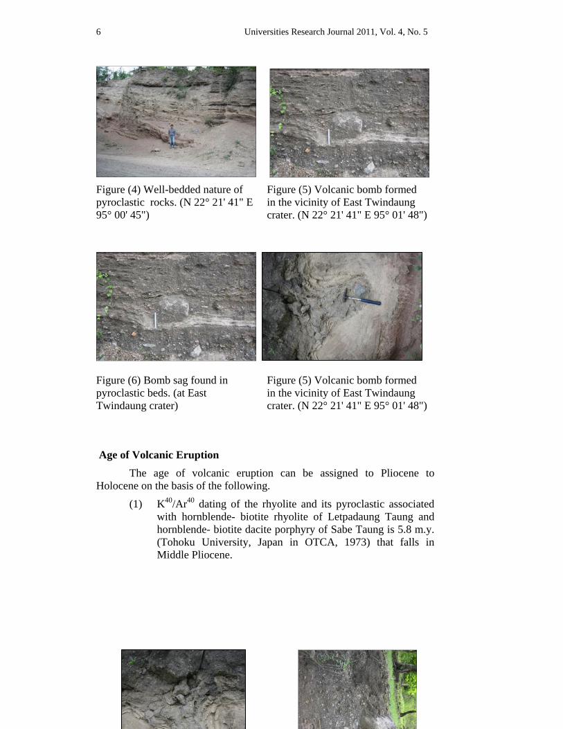
(2) Well- bedded nature (Fig. 4).
(3) Bed thickness decreases away from the site of eruption.
meter
N
East T i d
Chindwin
Le´ She´
Universities Research Journal 2011, Vol. 4, No. 5 5
(4) Individual beds show good to moderate sorting.
(5) Blocks and bombs were deposited relatively close to the site of the eruption. Agglomerate beds, bombs and blocks are therefore found at or near the Twindaung crater (Fig. 5). Similarly, volcanic breccia is found at the crater and near the basalt outcrop at Shwezaye village.
(6) Particle size decreases away from the site of eruption. Lapilli tuff and agglomerate are therefore, not found in lowland area which is away from the central crater (e.g., Twindaung crater).
(7) Development of mantle bedding mantling any original topography.
(8) Presence of bomb- sags, formed by the impact of bombs which depress the bedding in tuff (Fig. 6).
(9) Presence of layering (andesite flow) and lamination in tuff.
(10) The contact between agglomerate bed and underlying tuff is usually sinuous due to the formation of bedding sag (Fig. 7).
(11) Individual beds typically show normal grading of constituent particles.
Andesites of this area are usually porphyritic. They probably formed as plug in Twindaung crater, Shwethamone Hill and Taungbyauk crater. Basalt is usually fine- grained, hard and compact. Presence of columnar joints in basalt outcrops indicates that the volcanic eruption took place on land and subaerial environment.
6 Universities Research Journal 2011, Vol. 4, No. 5
Figure (4) Well-bedded nature of pyroclastic rocks. (N 22° 21' 41" E 95° 00' 45")
Figure (5) Volcanic bomb formed in the vicinity of East Twindaung crater. (N 22° 21' 41" E 95° 01' 48")
Figure (6) Bomb sag found in pyroclastic beds. (at East Twindaung crater)
Figure (5) Volcanic bomb formed in the vicinity of East Twindaung crater. (N 22° 21' 41" E 95° 01' 48")
Age of Volcanic Eruption The age of volcanic eruption can be assigned to Pliocene to
Holocene on the basis of the following.
(1) K40/Ar40 dating of the rhyolite and its pyroclastic associated with hornblende- biotite rhyolite of Letpadaung Taung and hornblende- biotite dacite porphyry of Sabe Taung is 5.8 m.y. (Tohoku University, Japan in OTCA, 1973) that falls in Middle Pliocene.

Universities Research Journal 2011, Vol. 4, No. 5 7
(2) Above mentioned volcanic rocks are to be found associated with the rocks of Ayeyarwady Formation as the older tuff in this area.
(3) K40/Ar40 dating of the basalt from East Twindaung area is 0.44 ± 0.12 Ma (Maury et. al., 2004) that falls at the end of Pleistocene.
Sequence of Younger Volcanics
Section measurements of younger volcanics were done at eastern part of Twindaung crater to obtain the sequence of the volcanic rocks (Fig. 8) and to know the nature of volcanic eruption of this area.
Volcanic eruption which produces the younger volcanics of this area is the younger phase. This younger volcanic sequence can be subdivided into four units on the basis of the following.
(1) Agglomerate beds which usually occur in the vent or close to the vent and deposit first.
(2) Bombs and blocks if present, usually found the top of the flow.
(3) Patterns of volcanic rocks in the sequence measured.
(4) Generally, fining upwards of the beds.
A few tephra events which were isolated but related to volcanic eruptions of earlier phase were being occurred during the deposition of Ayeyarwady Formation. The patterns of younger volcanic eruptions can be obtained from the sequence of younger volcanics (Fig. 8). From this figure, it is known that the volcanic eruptions are fairly frequent. They are episodic. Four units divided have their own patterns. The four units represent four major episodes of younger volcanic eruptions.
The volcanic eruption produced the younger volcanic sequence that can be divided at least four episodes or four major events. Minor events produced different beds in each unit occurred in each episode. In the wanning stage of volcanic eruptions or after the cessation of volcanic eruptions, action of rising hydrothermal fluids caused propilitization and pyrite mineralization attributable to solfataric activity probably continuing well after the cessation of volcanic eruption.

8 Universities Research Journal 2011, Vol. 4, No. 5
Figure (8) Sequence of younger volcanics measured in the study area (at East Twindaung crater)
Type of Volcanic Eruptions Type of volcanic eruptions in this area can be said to be Vulcanian
type phreatomgmatic eruption on the basis of the following.
(1) The volcanic eruptions of the area are volumetrically small, i.e. less than 1 km3. It is known from height and aerial extent of the volcanic rocks in this area.
(2) Most of the lava are crystal rich andesites indicating that magma is relatively fairly high enough in viscosity and volatile content to be explosive.
(3) Andesites and basalts occur as a plug of solidified lava which allows pressure to build up. Explosions result, when gas confined beneath it, is suddenly released. The gas pressure results from exsolution of volatiles from rising fresh magma
1 cm = 160 cm

Universities Research Journal 2011, Vol. 4, No. 5 9
and accumulating beneath the plug. Besides, pressure was produced by steam as a result of interaction of magma and ground water that mixed with optimal ratio.
(4) Ejection of shattered fragments of lava, as a result, andesite and basalt bombs and blocks formed in this area.
(5) The eruptions are fairly frequent.
(6) Evidences (e.g. welded tuff) of nuee ardente type of eruption are not found.
(7) Presence of basalt outcrops with volcanic breccia (e.g. Taungbyauk crater and the small indistinct crater).
(8) Rarity of unsorted pyroclastic rocks.
(9) Absence of scoriaceous materials.
(10) Presence of a fairly large proportion of non-juvenile lithic clasts in lapilli tuff but not more than 50% indicate dry phreatomagmatic eruptions and vulcanian explosion (G. J. Orton, 2001).
(11) Formation of maar structured volcanic cones (e.g, East Twindaung crater, Taungbyauk crater) indicate phreatomagmatic eruption.
Although, most eruptions in this area were vulcanian type, ejecting relatively cold material from earlier eruption of lavas, surrounding rocks and basement rocks, interspersed with outpourings of lava, cinder cones made up of interbedding of coarse tuff and lapilli tuff (Fig. 9) indicate strombolian activity. Absence of agglomerate beds and scanty of blocks and bombs in cinder cones support the above-mentioned fact. Besides, both altered andesites (propilitized andesites) and fresh andesites occurred in the pyroclastic beds as blocks in East Twindaung crater. Altered andesite indicate that there was hydrothermal action after the formation of them by hydrothermal or phreatic explosion that preceded that larger explosion of the East Twindaung crater which produced the pyroclastic beds. Phreatic explosion was caused by small amounts of superheated water coming into contact with that volcanic rock. This explosion is common but not large and may be important for precious metal, particularly gold mineralization.

10 Universities Research Journal 2011, Vol. 4, No. 5
Figure (9) Section measured of Pyroclastic rocks at northwestern slope of Le´ She´ crater
Geodynamic Setting The Twindaung-Silaung area lies in the Central Volcanic Line
(Chhibber, 1934) located within the Burmese Basin (Satyabala, 2003) or the Myanmar Central Basin (MCB) (Rangin et al., 1999) or Central Cenozoic Belt of Myanmar (Maung Thein, 1973). Igneous rocks ranging in age from Jurassic to Holocene occur sporadically in a 1500 km long volcanic arc throughout the Central Myanmar Basin. A southern extension includes the recently-active volcanoes of Narcondam and Barren Islands in the Andaman Sea.
The Myanmar Central Basin with the other two main tectonic provinces of Myanmar i.e Shan-Thanintharyi Block and Western Fold Belt (Maung Thein, 1973, 2000)or Indo-Burman ranges or Indo Myanmar Belt
Coarse tuff Lapilli tuff Sandstone
Unconformity

Universities Research Journal 2011, Vol. 4, No. 5 11
(Suess 1904 in Curray 2004, Brunnshweiler, 1966; Vigny et. al., 2003), all elongated N-S and extending from the East-Himalayan Sytaxis in the north can be identified (Fig. 10). Indo-Myanmar belt is an arcuate sedimentary belt mainly formed by Cenozoic rocks and cored by Triassic metamorphic basement (Socquet et. al., 2002). The Central Myanmar basin, a series of Cenozoic basins such as Chindwin, Minbu, Pathein and the eastern backarc basin, recently affected by active inversion (Pivnik et. al., 1998 and Rangin et al., 1999) is located between Indo Myanmar belt in the west and Shan-Thanintharyi Block (Eastern Highland) in the east. The main sedimentary fill of the basin is a thick sequence of Tertiary sediments which change with time from bathyal through neritic to fluvial and deltic facies (Maung Thein, 1973). The Eastern Highland with an average elevation of 1000 m is the natural boundary for the Myanmar Central Basin and is considered as a part of Sundaland (Hutchison, 2007) or Sino-Burma-Thailand Block (Satyabala, 2003), which in turn parts of Eurasian Plate. Sagaing Fault (Win Swe, 1972) located in the central Myanmar Basin, classically considered as a major tectonic break between the Central Myanmar Basin and the Eastern Highland is actually crosscutting the Myanmar Central Basin with a regular N-S trend and right lateral strike-slip motion (Bertrand et. al., 2001). These three main tectonic provinces of Myanmar terminate northward in the Eastern Himalayan Syntaxis (EHS) (Mitchell, 1993).
The variation form potassic calc-alkaline volcanics in Popa (Stephenson and Marshell, 1984) through shoshonitic in Monywa area and Taungthonelone area (Bender, 1983) to alkali basaltic in Singu area (Maury et. al., 2004) is reminiscent of the classical progression observed in Japan (Kuno, 1966), in Indonesia (Whitford et al., 1979), in the Central Andes (Thorpe et. al., 1982), and in many other area. The presence of an eastward-dipping subduction is thus inferred beneath central Myanmar Basin which was active from at least the Pliocene until relatively recent times. Moreover, due to the facts (rock classification and tectonic environment) obtained from present petrographic and geochemical studies of the volcanic rocks in this area, and two distinct chronologies i.e 0.9 and 0.8 Ma (Popa area) and 0.4 (Monywa area) known so far, the volcanism in this area can be regarded as subduction related. Mt. Popa and Twindaung overlie a well-defined Wadati-Benioff Plane 120-140 km deep (Guzman-Spezials and Ni, 1996;

12 Universities Research Journal 2011, Vol. 4, No. 5
Satyabala, 1998). The depth of the Wadati-Benioff Zone below the calc-alkalic and shoshonitic volcanoes of Mt. Popa and Twindaung is within the typical range for modern arcs (Gill, 1981 in Maury et al., 2004). However, this setting differs from that of modern arcs by its very low magmatic production and lack of well-defined volcanic line. It is postulated that the subduction of Indian Plate under the overriding Myanmar plate (Burma plate of Curray, 1979) caused the volcanism along central volcanic arc, (Mt. Popa, Twindaung, Taungthonlone and Mount Loi Mye) from Pliocene to Holocene. In this convergent boundary, central volcanic arc and Myanmar Plate represent continental volcanic arc and continental plate respectively. In the case of oceanic plate, cold dense, subducted lithosphere (Maury, 2004) is generally considered to be the Cretaceous oceanic lithosphere from the Gulf of Bengal (Guzman-Spezial and Ni, 1996) although its deep portion may alternatively represent a remnant of the Tethys (Socquet et al., 2002). Western boundary of the Indo-Myanmar Belt, known as Burma Arc, (Satyabala, 2003), represents the subduction boundary.
Geodynamically, Myanmar is situated in a complex tectonic zone with a hyper-oblique subduction at its western boundary (Satyabala, 2003), a dextral transform fault (Sagaing Fault) and parts of Sundaland as Shan Plateau in the east, the Mishmi Thrust, the western termination of the Himalayan Main Central Thrust, in the north acting as a buttress and the spreading Andaman ridge in the south. The area has features of active subduction zones such as a Waditi-Benioff Zone of earthquakes, a magmatic arc, thrust and fold belts.

Universities Research Journal 2011, Vol. 4, No. 5 13
Figure (10) Schematic map of the principal tectonic features in and around
the Indo-Myanmar region. (Source: Satyabala, 2003) * - Cenozoic volcanoes; IBR – Indo Burman ranges, Mt T – Mount Taungthonelone volcano, MY - Monywa Volcanic Area, Mt P - Mount Popa volcano.
According to Satyabala (2003), obliquity of the plate velocity vector changes along the Burma arc is a minimum of 58º at 20º N latitude and increase gradually to 70º near 22º N latitude and then rapidly to 90º near 24º N latitude. Subduction boundary is highly oblique to the relative velocity of the Indian tectonic plate with respect to Eurasian plate. The dip of the Burma Wadati-Benioff Zone varies from 50º southeast in the north near EHS to about 30º north-northeast in the Bay of Bengal area (Jame F. Ni et. al., 1989). The India and Eurasian Plates are separated by the wedge-shaped Myanmar plate which is bounded by the Sagaing Fault to the East and either Kabaw fault zone or the foreland thrust to the west. Beginning in the early Miocene the oblique convergence of Indian plate and Eurasian plate probably sheared off the leading edge of Eurasian plate along the Sagaing Fault, forming the Myanmar plate. Further, convergence since late Miocene

14 Universities Research Journal 2011, Vol. 4, No. 5
time has obducted the accretionary prism onto the Indian continental margin and has formed the modern Indo-Myanmar belt. It is suggested that the Myanmar plate was wedged in the Burman subduction zone and mechanically dragged northward with the Indian plate, partly accommodated by the Sagaing Fault. It was suggested that the Myanmar plate was located north of the Indian plate before the collision of India with Eurasia and that extrusion and clockwise rotation of the Myanmar plate in the late Tertiary brought it to its current configuration (Le Dain AYP, Tapornei. P, Molner. P,1984). One result of this rotation was the hyper oblique subduction of the Indian plate beneath Myanmar plate and the Mid-Miocene opening of the Andaman Sea (Curray et al., 1979). Myanmar plate acted as a fore-arc sliver coupled with the Indian plate and moved northward relative to Eurasia along the Sagaing Fault (Pivnik et al., 1998).
The changes in obliquity and dip of the subduction zone are probably responsible for the differences of geochemical characteristics with different chronologies of Mt. Popa and Twindaung volcanics. The subduction related geochemical signature of these volcanics may reflect chemistry of mantle wedge peridotites metasomatized by hydrous fluids originating from the subducted slab (Maury, 2004). The changes in obliquity and the dip of the Wadati-Benioff zone may be due to the constraints of oblique subduction and northward drifting together with Myanmar plate of the Indian plate and buttressing of Mishmi Thrust of EHS.
Emplacement of Volcanic Rocks In figure (11) it can be seen that the Sagaing Fault branches in
various splays north of Shwebo and terminates in Jade Mine belt into a compressive horse tail structure. Further north this fault connects with the Mishmi Thrust. Southward, the fault terminates as horse tail extension system connecting to the Andaman spreading center. According to Pivnik et al., (1998), active deformation observed in central Myanmar basins indicates part of the India/Eurasia motion is observed along thrust faults of the area. The Mt. Popa and Twindaung (Monywa area) volcanic vents were emplaced along tension gashes and normal faults perpendicular to these thrust faults (Vigny et al., 2003). According to Bertrand and Rangin (2003), from reflection seismic profiles interpretation of central Myanmar basin Pre-Miocene NE-SW striking syn-sedimentary normal faults were identified

Universities Research Journal 2011, Vol. 4, No. 5 15
and these fault are inactive, except in the Monywa and Mt. Popa areas where they are activated as open fractures injected by Quaternary volcanic rocks.
Fig. (11) Landsat TM and SPORT image interpretation of the Sagaing Fault and Shan Scarp Fault zone (Source: Vigny et al., 2003).
Conclusion The volcanoes of the central volcanic arc of Myanmar provide
evidence of subduction from Pliocene to Holocene time while only minor volumes of volcanic rocks of Eocene to Miocene are known. It is explained by nonsubduction because of reaching the collision stage at that time at this subduction boundary or slow subduction due to the collision of the Indian Plate and Eurasian Plate, resulting in the Himalayan orogeny at that time that occurred north of the Burma Arc or smothering of Late Tertiary sedimentary rocks.

16 Universities Research Journal 2011, Vol. 4, No. 5
Acknowledgements I would like to tender my sincere thanks to Dr Myint Thein (Former
Professor of Geology of Mandalay University and a Former Rector of Institute of Education, Upper Myanmar) and Dr Than Than Nu (Professor/ Head of Geology of Mandalay University) for their encouragement. I also thank to Dr Zaw Win (Assistant Lecturer, Department of Geology, Defence Services Academy) for help in preparing this manuscript.
References Aye Ko, (1983). Petrology of the igneous rocks of the lower Chindwin Area. Unpub. M.Sc.
Thesis, University of Mandalay. Bender, F., (1983). Geology of Burma. GE Brufer Bountraeger, Berlin. Bertrand, G. and Ragin, C., (2003). Tectonics of the Western Margin of the Shan Plateau
(Central Myanmar): implication for the India –Indochina oblique convergence since the Oligocene. Journal of Asian Earth Sciences, vol. 21, pp 1139-2257.
Brunnschweiler, R. O., (1996). On the Geology of the Indoburman Ranges. Geological Society Australia Journal, vol. 13, pp 127-194.
Chhibber, H. L., (1934 a). Geology of Burma. Macmillan, London. Currey, J. R., Moore. D. G., Lawver, L. A., Emmel, F. G., Raitt, R. W., Henry, M. &
Kieckhefer, R., (1979). Tectonics of Andaman Sea and Burma. In: Geological and geophysical investigations of continental slopes and rises, American Association of Petroleum Geologists Memoirs 29 (ed, J. S Watkins, L. Montadert, and P. W. Dickerson), Mem, Am. Assoc. Pet. Geol. Vol. 39, pp 189-198.
Currey, J. R., (2005). Tectonics and history of the Andaman Sea region. Journal of Asian Earth Sciences, vol. 25, pp 187-232.
Guzman-Speziale, M., & Ni, J. F., (1996). Scismicity and active tectonics of the western Sunda arc. In: Tectonic evoloution of Southeast Asia (ed. R. Hall and D. J. Blundell). Geol. Soc. London. Spec. Pull., vol.117, pp 241-52.
Hutchison, C. S. (2002). Geological Evolution of South-East Asia. Geological Society of Malaysia, Kuala Lumpur.
Kuno, H., (1966). Lateral Variation of basaltic magma across continental margin and island arcs. Geol. Surv. Can. Pap 66-15, pp. 317-361.
Le Dain, A. Y., Tappornier, P. And Molnar, P., (1984). Active faulting and tectonics of Burma and surrounding regions. Jour Geophys Res. ,vol. 89, pp 453-472.
Maung Thein (1973). A preliminary syntaxsis of the geological evolution of Burma with reference to the tectonic development of Southeast Asia. Geological Society of Malaysia Bulletin vol. 6, pp 87-116.

Universities Research Journal 2011, Vol. 4, No. 5 17
Maung Thein (2000). Summary of the geological history of Myanmar. Unpub. Maury, R. C., et at., (2004). Quaternary Calc- alkaline and alkaline volcansim in a hyper-
oblique convergnece setting, central Myanmar and western Yuman. Bull. Soc. Geol. FR, vol. 105, pp 461-472.
Mitchel, A. H. G., (1993). Cretaceous-Cenozoic tectonic events in the western Myanmar (Burma) – Assan regional J. Geol. Soc. London, vol. 150, pp 1089-1102.
Ni, J. F., Guzman-Speziale, M., Holt, M.E, Wallace, T. C., & Seager, W. R., (1989). Accretionary tectonics of Burma and the three dimensional geometry of the Burma Subduction Zone. Geology, vol. 17, pp 68-71.
Orton, G. J., (1996). Volcanic Environments. In: Sedimentary Environments Process, Facies and Stratigraphy, (ed. H.G. Reading) 3rd Edition, pp 485-565.
Pivnike, D. A., Nahm, J., Tucker, R. S., Smith, G. O., Nyein, K., Nyunt, N., & Maury, P. H., (1998). Polyphase deformation in a fore-arc/ back-arc basin, Salin Subbasin, Myanmar (Burma). American Association of Petrolium Geologists, vol.17, pp 373-406.
Rangin, C., Winmaw, San Lwin, Win Naing, Mouret, C., Bertrand, G., & GIAC Scientific Party, (1999 B). Cenozoic pull-apart basins in central Myanmar: the trace of path of India along the western margin of Sundaland, Terra Abstracts 82 C11,59.
Satyabalya, S. P., (1998). Subduction in the Indo-Burman region: is it still active? Geophysical Research Letters, vol. 25, pp 3189-3192.
Satyabala, S. P., (2003). Oboique plate convergence in the Indo-Burma (Myanmar) Subduction region. Pure. Appl. Geophys, vol. 160, pp 1611-1650.
Socquet, A., Goffe, B., Pubellier, M. & Rangin, C., (2002). Late Cretaceous to Eocene metamorphics of the internal zone of the Indo-Burma Range (Western Myanmar): Geo- dynamic implications. C.R. Geosci, vol. 334, pp 573-580.
Stephenson, D., & Marshall, T. R., (1984). The petrology and mineralogy of Mt. Popa, Volcano and the nature of the Late Cenozoic Burma Volcanic arc, J. Geol. Soc. London, vol. 141, pp 747-762.
Thorpe, R. S. (ed), (1982). Andesites: orogenic andesites and related rocks. Wiley. Interscience. Chichester.
Vigny, C., Socquet, H., Rangin, C., Chamot – Rooke, N., Pubellier, M. Bouin, M. N., Bertrand, G., & Becker, M., (2003). Present-day crustal deformation around Sagaing Fault,
Myanmar. J. Geophysics. Res., 108 (B 11), 2533, doi: 10. 1029/2002 JB00 1999. Whitford, D., Nichools, S. A., & Tayler, S. R., (1979). Spatial variations in the
geochemistry of Quaternary lava across the Sundaland Arc in Java and Bali. Contrib. Mineral. Petrol., vol. 70, pp 56-341.
Win Swe, (1981). A major strike-slip fault in Burma. Contributions to Burmese, Geology, vol. 1, no. 1, pp.