Embed Size (px)
Citation preview

1
IGCSE Geography (0460)
Unit 1.2 Settlement
What you need to know and be able to do:
Tick off those you feel confident about:
Describe the patterns of rural settlements – dispersed, linear, nucleated.
Explain how physical factors (relief, soil, water supply) and other factors such as accessibility, agricultural land-use, influence the sites and patterns of rural settlements.
Describe and explain the factors which may influence the size, growth and functions of rural and urban settlements.
Describe and suggest reasons for the hierarchy of settlements and services.
Describe and explain the land-use zones of towns and cities to include the Central Business District (CBD), residential areas, industrial areas, the provision of open spaces and transport routes. Differences in the patterns of urban structures in cities of LEDCs and MEDCs should be identified.
Describe problems associated with the growth of urban areas such as congestion in the CBD, housing shortages, traffic congestion, squatter settlements. Suggested solutions to overcome these problems should be illustrated by reference to selected examples.
Describe the effects of urbanisation on the environment – pollution (air, water, visual and noise), the results of urban sprawl on surrounding areas, the growth of out-of-town urban activities – shopping areas, sports facilities, etc.

2
What is a settlement?
A settlement is a place where people live. A settlement may be as small as a single house in a
remote area or as a large as a mega city (a city with over 10 million residents).
A settlement may be permanent or temporary. However, a temporary settlement may become
permanent over time. This has happened to many refugee camps that have been built in conflict
zones or similarly favelas/shanty towns.
The reason a settlement was developed or built can be thought of as its function. This varies
depending on the location of the settlement. Coastal towns tend to have the original function of
being a port for trade, whilst other settlements can have religious, cultural or administrative
functions.
Settlement site and situation
The piece of land upon which a settlement is built is the settlement site.
There are many reasons why a site might be chosen for the development of a settlement and
some factors will be more important than others. How many features can you spot in the map of
Southampton below?
Some common site factors include:
Wet point sites – these have good water supply. Many settlements grew around wet
point sites, e.g. Vicenza.
Dry point sites – these are away from the risk of flooding, e.g. Bergamo.
Defensive sites – often found on higher ground so that enemies could be seen from a
distance, e.g. Monselice.
Aspect – settlements are often found on the sunny side of a deep valley. This is common
in settlements in the Alps.
Shelter – from cold prevailing winds and rain.
Resources – important for industry, e.g. villages such as Garraf, Barcelona are built to
exploit a local resource.
Bridging point – settlements with 'ford' in their name often grew around a fording point
or bridging point, e.g. Bassano Del Grappa is built on the River Brenta.
Trading centres – often settlements grow where natural route ways and rivers meet,
which helps the development of roads, railways and canals. E.g. Padua, Bologna,
Florence.
.

3
The importance of many of these functions diminish as technological advances enable people to
overcome difficulties. Improved transport links, river management and trading partners all
influence the function and location of settlements.
The situation of a settlement is its position in relation to the surrounding human and physical
features, many of which will have an impact on the settlement's type, size and function.
With modern settlements remember that decisions about location and situation have been
made by planners, but that their priorities may differ from those that determined the location of
a historical settlement like Cittadella. For example, a modern settlement does not need to be
close to a river because drinking water is now piped to our homes and waterways are no longer
important for transport.
Settlement functions
Most large settlements in MEDCs are multifunctional and perform a range of functions such as
retail, education and industry. When settlements first started to grow, most had only one
distinct function, and others developed as the settlement grew.
Examples of functions:
Port – the original function of cities such as Liverpool and Southampton. Both are still
ports, but this function has diminished in importance and they are now multifunctional.
Market town – Watford was originally a market town, and although it still holds a regular
market, it is now a thriving multifunctional centre.
Resort – Southport was a popular Victorian seaside resort, although it now has many
functions and is a commuter settlement for Liverpool.
Natural resources in the area enabled Sheffield to develop as an important centre in the
iron and steel industry. Although steel is still produced, its prominence has declined and
Sheffield is a thriving multifunctional city.

4
Settlement hierarchies
If we group and classify a number of settlements according to their size and shape the result is
settlement hierarchy
Pyramid showing relationship between population and services
As you move up the hierarchy, the size of the settlement and the distance between similar sized
settlements increases. As you can see from the diagram below, there are more cities than
conurbations, more towns than cities and more villages than towns.
The number of services that a settlement provides increases with settlement size.
Small settlements will only provide low order services such as a post offices, doctors and
newsagents. Large towns, cities and conurbations will provide low and high order services such
as leisure centres, chain stores and hospitals.
Larger settlements and conurbations have a much larger sphere of influence than smaller ones.
This means they attract people from a wider area because of the facilities they offer. Cities such
as London have a global sphere of influence, whereas a small hamlet or village may only have a
sphere of influence of a couple of kilometres.
The range of a service or product is the maximum distance people are prepared to travel to
purchase it. The range of a newspaper is much lower than an item of furniture for example.
5
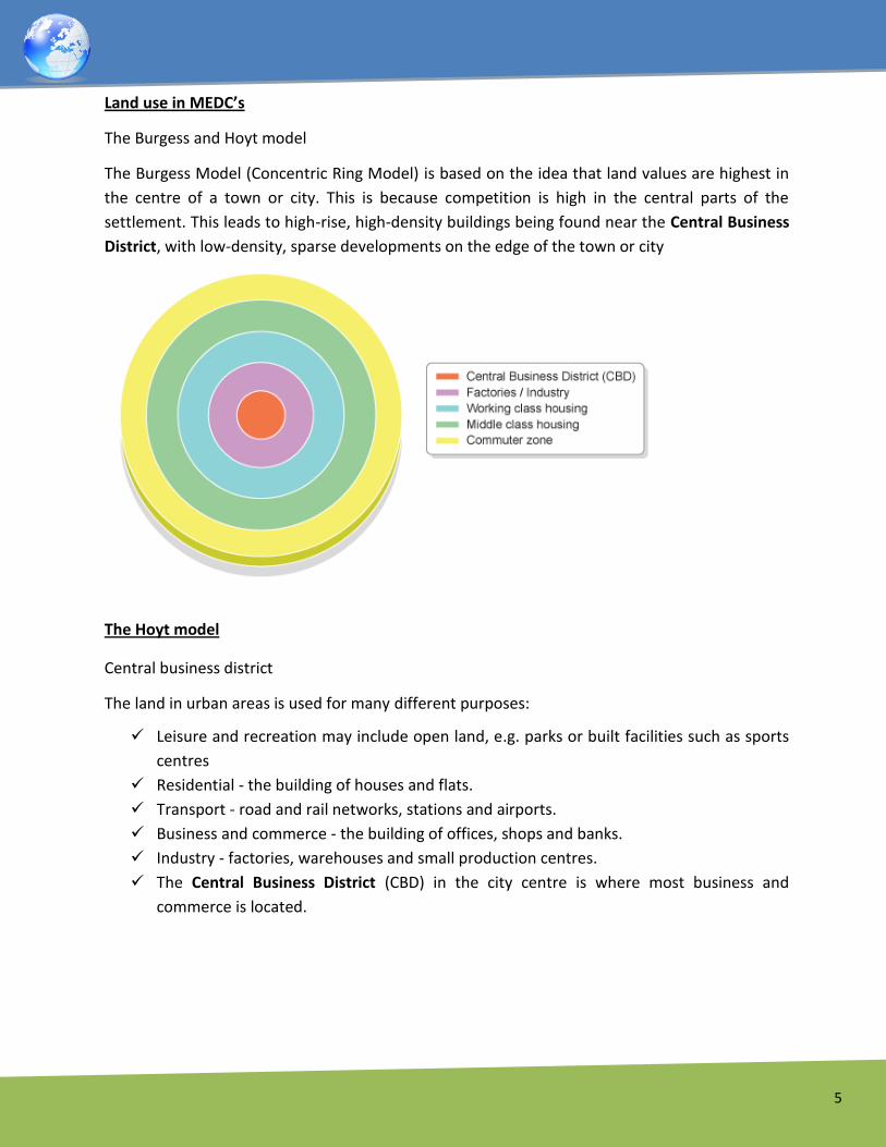
Land use in MEDC’s
The Burgess and Hoyt model
The Burgess Model (Concentric Ring Model) is based on the idea that land values are highest in
the centre of a town or city. This is because competition is high in the central parts of the
settlement. This leads to high-rise, high-density buildings being found near the Central Business
District, with low-density, sparse developments on the edge of the town or city
The Hoyt model
Central business district
The land in urban areas is used for many different purposes:
Leisure and recreation may include open land, e.g. parks or built facilities such as sports
centres
Residential - the building of houses and flats.
Transport - road and rail networks, stations and airports.
Business and commerce - the building of offices, shops and banks.
Industry - factories, warehouses and small production centres.
The Central Business District (CBD) in the city centre is where most business and
commerce is located.

6
The following features easily identify the CBD:
High/multi-storey buildings.
Expensive land values.
Department stores or specialist shops, like jewellers.
Shopping malls and pedestrian precincts.
Cultural/historical buildings, museums and castles.
Offices, finance, banks, administration, town hall (business sector).
Bus and railway stations (transport centres).
Multi-storey car parks.
The CBD is located in the centre because it is:
A central location for road/railways to converge.
The most accessible location for workers.
Accessible to most people for shops and businesses.
To help you remember how to identify a CBD, think of a city you know. In your exam give
named examples for the features listed above.

7
The inner city
Terraced houses
The inner city is also known as the 'twilight zone'. It is typically found next to the CBD and has
mainly terraced houses in a grid like pattern. These were originally built to house factory
workers who worked in the inner city factories. Many of these factories have now closed down.
Unemployment and other socio-economic problems have led to periods of unrest in many inner
city areas. Many inner city areas declined in the late 20th century and have undergone a period
of regeneration in recent years. Run down terraced housing is often bought by investors and
improved to appeal to young professionals who need access to the CBD. This is called
gentrification.
The suburbs
Semi-detached
Suburban houses are usually larger than inner city terraces and most have a garden. Typically,
they are detached or semi detached and the roads around them are arranged in cul-de-sacs and
wide avenues. Land prices are generally cheaper than in the CBD and inner city, although the
desirability of housing can make some areas expensive.
Facilities such as schools, places of worship and parks are often present, and many are served by
a local supermarket.
Suburban areas are often home to commuters who need access to the CBD along main roads
and railways, and they are also within easy reach of the countryside.

8
The urban rural fringe
Allotments in Ripon, North Yorkshire
This is found at the edge of a town or city and is where town meets country. It is common for
this area to have a mixture of land uses such as some housing, golf courses, allotments, business
parks and airports.
The mixture of land use often causes conflict as different groups have different need and
interests. For example, building Terminal 5 at Heathrow on the outskirts of London was a source
of controversy. The need for another runway continues to cause conflicts of interest.
Land use in LEDC’s
LEDCs have similar land-use needs to MEDCs, but the pattern of land use in urban areas is
different.
Although every LEDC city has its own characteristics, models can be used to illustrate a 'typical'
LEDC city.
Model of LEDC city

9
Both MEDC and LEDC cities have a CBD - often the oldest part of the city.
In LEDCs the poorest housing is found on the edge of the city - in contrast to MEDC cities whose
suburban fringe is very often a place of high quality housing. The areas of poor quality housing
found on the edge of cities in LEDCs are called squatter settlements or shanty towns.
Land use in Sao Paulo, Brazil
The below pictures show two very different areas of Sao Paulo in Brazil - the CBD and an
outerlying shanty town.
Sao Paulo - the city centre
The CBD and high-class sector
The CBD in an LEDC looks very similar to a CBD in an MEDC. However, there is likely to be a more
dramatic difference between the height of the buildings in the CBD and the height of the
buildings in other zones.
The CBD contains facilities such as department stores, hotels, offices, schools, theatres and
cinemas.
High-class housing can be found around the edge of the CBD and in a spine radiating out
towards the edge of the urban area. This is likely to be a main transport route and a desirable
street, possibly a former colonial area. People living here will need easy access to the CBD.
Transport networks in LEDCs are not as well developed as MEDCs so the journey to work is a
major consideration when deciding where to live.
The high class housing will be a mixture of old colonial houses and large apartments, both of
which will have space for servants.

10
Shanty towns
The fact that cities in LEDCs are growing rapidly means that conditions can be poor. There are
often great inequalities within LEDC urban areas and they are even more pronounced in LEDCs.
Some of the worst conditions are found in the shanty towns on the edge of the city, near the
CBD or along main transport routes. They tend to be unplanned and are often illegal. Houses are
self-built using basic materials and shanty towns have few services.
Shanty town residents face many problems on a daily basis. Khyalitsha in South Africa is a shanty
town located near the city of Cape Town. Shanty towns are also known as townships in South
Africa. Khyalitsha has a population of over 1.8 million people and is one of the largest townships
in South Africa.
The Alexandra township in Johannesburg, South Africa
Problems:
Overcrowding - the settlement has a high population density.
Fires - fires can spread quickly.
Overpopulation - the area does not have enough resources to support the growing
population.
Competition for jobs - jobs are in short supply.
Disease - poor sanitation and limited health care can lead to the spread of disease.
Lack of space - the newest and poorest arrivals may be forced to live on the worst quality
land.
Infrastructure - services are poor, public transport is limited and connections to the
electricity supply can be limited and sometimes dangerous.

11
Improving shanty towns
Soweto township in Johannesburg, South Africa
Over time the conditions in shanty towns may improve. In many LEDCs, local communities,
charities and government departments are working together to improve conditions in squatter
settlements.
Improving conditions in a squatter settlements can lead to improvements in the residents'
quality of life.
Approaches to improvement
Site and service schemes
These give people the chance to rent or buy a piece of land. The land is connected to the city by transport links and has access to essential services (eg water). People build their own homes using money from a low-interest loan.
Self-help schemes
These give people the tools and training to improve their homes. Low-interest loans may be used to help people fund these changes. People may be given legal ownership of the land.
Rural investment
Improving the quality of life and creating greater opportunities in rural areas may prevent people from migrating to urban areas. Investment in rural areas may therefore help to improve conditions in the city as well.
Urbanisation can cause problems such as transport congestion, lack of sufficient housing, over-
rapid growth and environmental degradation. Many cities display particularly sharp inequalities
in housing provision, health and employment. Some people try to escape these problems by
moving away from the city - a process called counter-urbanisation. Long term, however, the
solution must be to make cities more sustainable.

12
Causes of urbanisation
Urbanisation means an increase in the proportion of people living in urban areas compared to
rural areas. An urban area is a built-up area such as a town or city. A rural area is an area of
countryside.
As a country industrialises, the number of people living in urban areas tends to increase. The UK
and many other MEDCs urbanised during the 18th and 19th centuries. People migrated from
rural areas (due to the mechanisation in farming) to urban areas where there was employment
in the new factories. The area of cities known as the inner city developed during this time as
rows of terraced housing were built for workers.
On a global scale, urbanisation is taking place rapidly, particularly in LEDCs
Problems of urbanisation in the CBD – traffic congestion
As more people move to the edge of towns and cities, traffic congestion may get worse. Many
people will drive their cars into the city centre to get to work.
It is compounded by people being brought into city on large roads or motorways. These roads
then link up with smaller, older, narrower roads in the city centre. This causes a bottleneck and
congestion.
Some cities have tried to manage this problem by introducing traffic management schemes.
These schemes may include:
Park and ride schemes.
Cycle lanes.
Congestion charging schemes, such as those in London.
Car-pooling, as used in the USA, to encourage people to share cars.
Low Emission Zones, as in London.
Encouraging the use of public transport
Cheap bike hire
Alternation of registration plates, like in Padua.
Local councils have also tried to make the roads in urban areas safer by introducing traffic
calming measures, pedestrian zones, vehicle-exclusion zones and permit-only parking schemes.

13
Reducing congestion in cities
Park and Ride scheme operating in Plymouth
The introduction of Park and Ride schemes. People park in car parks on the edge of a settlement and catch regular buses into the centre.
Pedestrian shopping streets, Liverpool
Pedestrianised areas are designated as pedestrian only zones.
Permit holder parking in Westminster
Permit holder parking - certain parts of the city, particularly near the centre, are designated as permit parking only. This means that people must have a permit to park in that area. This reduces the number of people driving in to towns and cities as parking opportunities are restricted.

14
Vehicle exclusion sign
Vehicle exclusion zones - certain types of vehicles are excluded from certain parts of a city, eg large vehicles may not be allowed to enter narrow roads or residential areas.
Taxi cabs on a New York street
Car pooling - people are encouraged to share cars. This has been used in a lot in the USA.
Speed bump in a residential area in London
Traffic calming - roads narrowing and speed bumps make traffic move slower around narrower streets. Narrow roads may restrict the type of vehicle that can enter certain parts of the city.

15
Problems of urbanisation in the inner city – inequalities
Inequalities exist in all urban areas. Inequality means extreme differences between poverty and
wealth, as well as in people's well-being and access to things like jobs, housing, and education.
Inequalities may occur in
Housing provision
Access to services
Access to open land
Safety and security
Often people who live in inner-city areas experience a poor quality of life. This is because the
inner-city is typically a zone with older housing and declining industry.
Unemployment and incidents of long-term illness are higher in the inner-city boroughs, while
households are more likely to have central heating and multiple cars in the outer-city borough.
Governments and planners often step in to help redevelop run-down inner-city areas. Inner-city
redevelopments, such as those in London's Docklands or El Ravel, may improve the physical
environment of the area and improve the quality of housing. However, it can also create even
greater inequalities because the local residents may not be able to afford to live there anymore.
Often the old industrial jobs are replaced by skilled jobs and new people move to the area.
Problems of urbanisation in the urban rural fringe – housing demand
'For Sale' signs outside a house
As a result of increased urbanisation, Cities are spreading outwards. The demand for high
quality, new, affordable homes in urban areas. As a result, land values are very high and land is
in short supply:
Some developers are building on sites that have been built on before in the UK's inner cities.
These are called brown field sites. This has happened in many of the UK’s inner cities.
Other developers are building homes on the edge of the city on green field sites in the urban
rural fringe. Land here is cheaper but green field development can cause conflict with local
people and create environmental problems.