Embed Size (px)
Citation preview
Page 1 of 13
IGas Energy PLC
TEC RP 005
Department Document Type Number Date
TEC.RP.005
PEDL 107 & SPPL 1481 Relinquishment Report
R00
PEDL 107 & SPPL 1481 Relinquishment ReportTEC.RP.005
Date:
Page 2 of 13
Contents
1. Executive Summary: ..............................................................................................................42. Licence Information: ..............................................................................................................43. Licence Synopsis:...................................................................................................................54. Work Programme Summary: .................................................................................................65. Database: ................................................................................................................................66. Prospectivity Update: .............................................................................................................77. Conclusions: ...........................................................................................................................98. Clearance:...............................................................................................................................99. Maps and Figures: ................................................................................................................10

R00
PEDL 107 & SPPL 1481 Relinquishment ReportTEC.RP.005
Date:
Page 3 of 13
Table of Figures
Figure 1. Map of PEDL 107 & SPPL 1481 (& Part of PEDL 184, right) ..............................10Figure 2. Mostyn Quay-1 Stratigraphic Column......................................................................11Figure 3. Cross Section Across Dee Estuary ...........................................................................12Figure 4. Burial and thermal history for main part of East Irish Sea Basin (from DECC 2006). Note that, for the license area, burial depths were likely significantly shallower than those shown here for the main part of the basin ................................................................................12Figure 5. Seismic Cross Section Across Point of Ayr .............................................................13
R00
PEDL 107 & SPPL 1481 Relinquishment ReportTEC.RP.005
Date:
Page 4 of 13
1. Executive Summary:
This document is a combined relinquishment report for Licence PEDL 107 and Seaward Production Licence SPPL 1481 as they are significantly linked from a subsurface perspective and access into Seaward Production Licence SPPL 1481 well was intended to be drilled from onshore Licence PEDL 107.
The licence PEDL 107 was originally awarded to Alkane Energy PLC on 1st February 2002. Nexen Exploration U.K. Limited and Island Gas Limited (IGas) acquired PEDL 107 from Alkane Energy PLC on 23rd January 2007. Then, in February 2011, following several interest assignments, IGas acquired 100% working interest in PEDL 107 in February 2011..
The Initial Term license commitment on PEDL 107 was met by drilling a CBM exploration well (Mostyn Quay-1) in 2007. Mostyn Quay-1 well has been plugged, the site restored and returned to the landowner.
The Seaward Production Licence SPPL 1481 was originally awarded to Nexen Exploration U.K. Limited and IGas on 1st April 2007 after successfully bidding for it in the 24th offshore licensing round. Again, following several working interest assignments, IGas acquired 100% working interest in SPPL 1481 in February 2011.
Firm commitments for the Initial term on SPPL 1481 were met by obtaining and reprocessing >210km of existing 2D seismic data and carrying out a coal geomechanical study for the area based on available data.
IGas requested relinquishment of PEDL 107 and SPPL 1481 in March 2014 with immediate effect. IGas submitted the SPPL 1481 area relinquishment through the Energy Portal on the 31st March 2014 and DECC notified the receipt of this submission on 11th April 2014.
2. Licence Information:
Licence Number: PEDL 107Licence Round: 10th OnshoreLicence Effective date: 1st February 2002 Licence Type: TraditionalBlock: SJ18Operator: Island Gas Limited Licensee: Island Gas Limited (100%)
Licence Number: SPPL 1481Licence Round: 24th Offshore Licence Effective date: 1st April 2007 Licence Type: TraditionalBlocks: 110/18a, 110/19a and 110/23Operator: Island Gas Limited
R00
PEDL 107 & SPPL 1481 Relinquishment ReportTEC.RP.005
Date:
Page 5 of 13
Licensee: Island Gas Limited (100%)
3. Licence Synopsis:
Licence status: A formal request to relinquish PEDL 107 and SPPL 1481 including a request to waive a contingent commitment well on SPPL 1481 was submitted to DECC in March 2014. This was duly acknowledged and agreed.
The licence PEDL 107 was originally awarded on 1st February 2002. and included the following
initial term work obligations:
Drill-or-Drop Commitment- “Notwithstanding Clause 3 above, this license shall expire 3 years after its
commencement unless the licensee has by that date submitted to the Minister applications for the consent to drill a well, together with all supporting documentation necessary for the Minister to consider that application. If consent is granted, the licensee shall drill a well to a depth of 400m or greater before the end of the Initial Term”.
PEDL 107 continued into the second term by virtue of the initial term work obligations being met. The second term of the licence as originally awarded was due to expire January 2013. A Deed of Variation was granted in February 2013 extending the secord term of the licence to January 2015 to allow IGas time to secure land access and DECC to address an area of unlicenced acreage between PEDL 107 and SPPL 1481.
The licence SPPL 1481was originally awarded 1st April 2007 and included the following initial term work obligations:
Firm Commitments- “The Licensee shall:
o Obtain 210km of 2D seismic data; ando Carry out a Coal Geomechanics Study”
Drill-or-Drop Commitment- “The Licensee shall drill one well to evaluate the Westphalian Coal Measures (c.
500m); provided that he shall not be required to do so if the Minister confirms in writing that he agrees that it would not be justified, having regard to the technical information available to him at the time, and in particular the evaluation of the aforementioned data and studies”.
Drilling of the well on SPPL 1481 was frustrated as a result of the delay of the 14th onshore licencing round. It was acknowledged by DECC that there was an area of unlicenced acreage between PEDL 107 and SPPL 1481 that would not allow the well to be drilled from onshore to offshore. Drilling from an offshore location has been ruled out on technical grounds. As a
R00
PEDL 107 & SPPL 1481 Relinquishment ReportTEC.RP.005
Date:
Page 6 of 13
result of the unlicensed acreage, a number of license extensions were applied for and granted by DECC. The last deed of variation extended the end of the first term to April 2015.
Access to SPPL 1481 was always planned to be through an onshore to offshore, long-reach drilling campaign. However, for the duration of this license, there remained an unlicensed area between PEDL 107 and SPPL 1481 that related to difference between the mean high water mark and mean low water mark (onshore and offshore license boundaries respectively). It was anticipated that this unlicensed area could be licensed during the 14th onshore licensing round.
The reason for drilling onshore to offshore was to enable long term dewatering and well tests required in CBM production. This is not something that could have been achieved by drilling a vertical offshore well.
Drilling from onshore to offshore required some specific surface location criteria, specifically the horizontal distance from the target and subsurface considerations such as positions of faults. Despite several commercial negotiations being advanced, a suitable surface location was not secured. Constraints included are, well design, locations of SSSI’s and reluctance of local land owners to agree surface and subsurface access rights.
4. Work Programme Summary:
Seismic:41.5km of existing onshore 2D and 489km of existing offshore 2D seismic was purchased to cover SPPL 1481. No seismic data exists over PEDL 107.
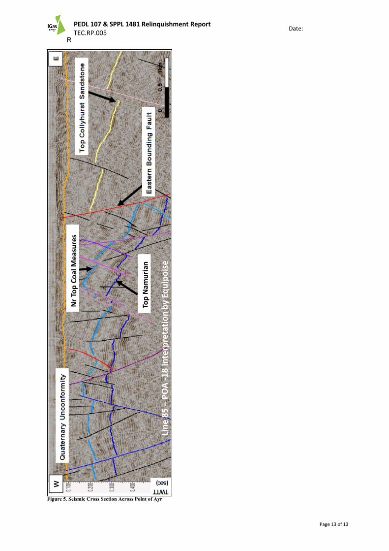
A total of 890km of pre-existing 2D seismic was re-interpreted with a subset being reprocessed. The quality of existing seismic quality in the area is variable with generally moderate to poor resolution, especially for deeper prospects. A number of coal seams were mapped with good well ties from existing Coal Board wells exploring the Point of Ayr Colliery. A number of leads were identified within both the Collyhurst Sandstone and Namurian Sandstone intervals.
Geomechanics Study:Despite numerous boreholes there is limited detailed geomechanical data in the Point of Ayr area. A study was undertaken that utilised mining records, Coal Board borehole log data and offset data from the ‘Four Oaks’ dataset.
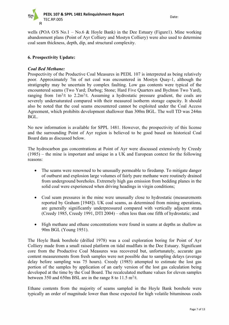
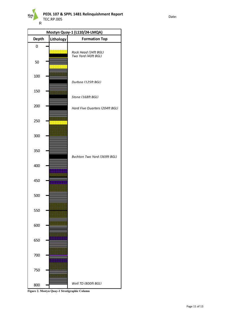
Drilling:A commitment well (Mostyn Quay-1) was drilled in December 2007 to a total depth of 800ft MD (Figure 2). Approximately 7m of net coal was encountered in this well but the stratigraphy is uncertain by faulting and is probably not a representative net thickness of the coal in the Productive Coal Measures.
5. Database:
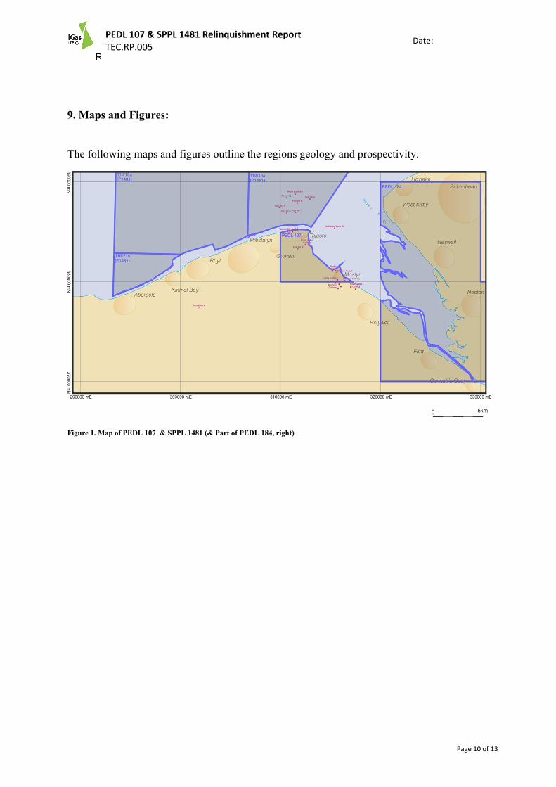
A multi-vintage 2D (offshore and onshore) dataset was amassed over the acreage and used to determine prognosed formation depths in combination with a number of offset Coal Board
R00
PEDL 107 & SPPL 1481 Relinquishment ReportTEC.RP.005
Date:
Page 7 of 13
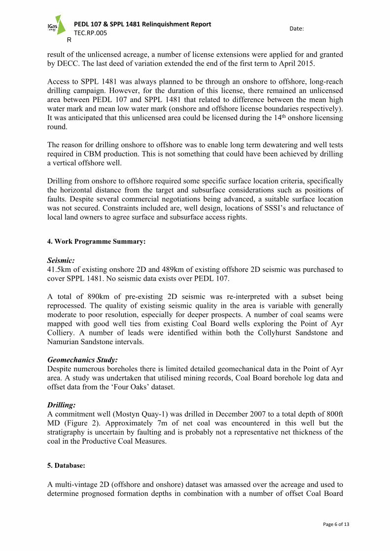
wells (POA O/S No.1 – No.6 & Hoyle Bank) in the Dee Estuary (Figure1). Mine working abandonment plans (Point of Ayr Colliery and Mostyn Colliery) were also used to determine coal seam thickness, depth, dip, and structural complexity.
6. Prospectivity Update:
Coal Bed Methane:Prospectivity of the Productive Coal Measures in PEDL 107 is interpreted as being relatively poor. Approximately 7m of net coal was encountered in Mostyn Quay-1, although the stratigraphy may be uncertain by complex faulting. Low gas contents were typical of the encountered seams (Two Yard; Durbog; Stone; Hard Five Quarters and Bychton Two Yard), ranging from 1m3/t to 2.2m3/t. Assuming a hydrostatic pressure gradient, the coals are severely undersaturated compared with their measured isotherm storage capacity. It should also be noted that the coal seams encountered cannot be exploited under the Coal Access Agreement, which prohibits development shallower than 300m BGL. The well TD was 244m BGL.
No new information is available for SPPL 1481. However, the prospectivity of this license and the surrounding Point of Ayr region is believed to be good based on historical Coal Board data as discussed below.
The hydrocarbon gas concentrations at Point of Ayr were discussed extensively by Creedy (1985) – the mine is important and unique in a UK and European context for the following reasons:
The seams were renowned to be unusually permeable to firedamp. To mitigate danger of outburst and explosion large volumes of fairly pure methane were routinely drained from underground boreholes. Extremely high gas emission from bedding planes in the solid coal were experienced when driving headings in virgin conditions;
Coal seam pressures in the mine were unusually close to hydrostatic (measurements reported by Graham [1948]). UK coal seams, as determined from mining operations, are generally significantly underpressured compared with vertically adjacent strata (Creedy 1985, Creedy 1991, DTI 2004) – often less than one fifth of hydrostatic; and
High methane and ethane concentrations were found in seams at depths as shallow as 90m BGL (Young 1951).
The Hoyle Bank borehole (drilled 1978) was a coal exploration boring for Point of Ayr Colliery made from a small raised platform on tidal mudflats in the Dee Estuary. Significant core from the Productive Coal Measures was recovered but, unfortunately, accurate gas content measurements from fresh samples were not possible due to sampling delays (average delay before sampling was 75 hours). Creedy (1985) attempted to estimate the lost gas portion of the samples by application of an early version of the lost gas calculation being developed at the time by the Coal Board. The recalculated methane values for eleven samples between 350 and 650m BSL are in the range 8 to 11.5 m3/t.
Ethane contents from the majority of seams sampled in the Hoyle Bank borehole were typically an order of magnitude lower than those expected for high volatile bituminous coals
R00
PEDL 107 & SPPL 1481 Relinquishment ReportTEC.RP.005
Date:
Page 8 of 13
(Creedy 1985). Only three of the seams had ethane contents typical for this rank (c.0.6 m3/t). It is not known whether this anomaly occurred as a result of poor sampling procedures or from ethane migration in the geological past within seams of contrasting permeability.
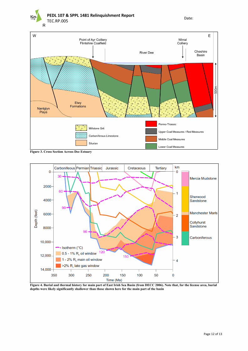
Maximum depth of burial for the coal-bearing Carboniferous has not been established for the Point of Ayr area but, in the conventional gas fields immediately to the northwest, the main parts of the Irish Sea Basin and sub-basins are believed to have undergone maximum burial during mid-Mesozoic times. Being on the northern flank of a Mesozoic high (Ellesmere Saddle), burial depths for the Carboniferous will have been significantly shallower during the Mesozoic (perhaps by 3000-4000 feet) for the Point of Ayr as those to the north in the Irish Sea Basin but otherwise the burial history depicted in figure 4 should be broadly applicable. The lesser maximum depth of burial for the application area is confirmed by coal rank measurements made by the Coal Board for the North Wales Coalfield – predominantly medium or high volatile bituminous (Creedy 1985, DTI 2004).
Although coalification almost certainly took place during initial Carboniferous burial, the main phase of Westphalian coal maturation and gas generation most likely occurred during the Jurassic and Cretaceous. In theory this is an optimal situation for CBM prospectivity since it means that the main gas generating episode post-dated a potentially degassing event associated with Variscan uplift. This is not unusual in a UK context (e.g. East Midlands), but the difference between Palaeozoic and Mesozoic burial appears to be particularly marked here – having some evidence to indicate a post-Variscan age to the main coalification event here on the flank of the East Irish Sea Basin may help to explain the unusual properties of the coals encountered at the Point of Ayr colliery.
Other Hydrocarbon Prospectivity:The proximity of SPPL 1481 to the mature East Irish Sea petroleum (gas) province and the southwards continuity of the important structural features of those fields is noted, it seems unlikely that significant conventional oil and gas potential exists in SPPL 1481. The Mesozoic Sherwood Sandstone play accounts for 99% of currently proven reserves in the East Irish Sea (DECC 2006), and that formation is relatively poorly represented in the subsurface in the license area. However, other deeper plays have been postulated for the East Irish Sea which may be applicable to the current area: Namurian/Westphalian sandstones with intraformational mudstone seals; basal Carboniferous clastic plays (conglomerates sealed by overlying shales or low angle faults); and the dolomistised Lower Carboniferous Limestone play with sources in the Namurian and uppermost Dinantian.
Shale gas potential is also likely in SPPL 1481 with source and reservoir deep basinal mudstones and siltstones located in the Namurian and possibly uppermost Dinantian. The presence of these strata is known from outcrop and postulated from shallow drilling but they have not been evaluated for prospectivity by coring. To the east, in the Vale of Clwyd, the presence of thin (38m) Namurian age strata was proven by the Rhuddlan 1 well. No lithological details are available but the Namurian is too thin to be a viable prospect.
A direct indication that basal Westphalian and deeper strata might host gaseous hydrocarbons other than CBM comes from three main documented sources:
Logs from two of six boreholes drilled for coal exploration in shallow waters of the Dee Estuary in 1985 show that the bores encountered significant flows of gas from non-coal lithologies. Point of Ayr BH 3 encountered “a substantial make of gas”
R00
PEDL 107 & SPPL 1481 Relinquishment ReportTEC.RP.005
Date:
Page 9 of 13
immediately below a postulated fault (throw c.100m) at a depth of 302m BSL at a horizon just above the Durbog Coal. The flow was controlled by increased mud weight but gas continued to flow until the borehole was sealed. Point of Ayr BH 5 was abandoned after a “significant” gas kick was experienced from what is described as a Namurian sandstone below the Stone Coal at 516m BSL. The unmeasured flow from the borehole increased with depth until it was unable to be controlled by addition of barite and the borehole had to be abandoned;
The geological log from Talacre BH5 on the north-facing shore of the Dee Estuary records a strong smell of oil and gas reported by drillers at 87m BGL. The occurrence appears to be associated with very soft mudstone sitting immediately above the Subcrenatum Marine Band at the top of the Namurian sequence;
Thirdly, a flow of methane gas is recorded during the sinking of the No 3 Shaft at Point of Ayr Colliery in 1955. The methane flowed from a 2.1m thick sandstone immediately below the Gastrioceras Cancellatum Marine Band (Millstone Grit Group, Namurian) at 202m BGL. The sandstone showed evidence of faulting. No flow rate was recorded but pressure was measured at 20 psi.
7. Conclusions:
It is difficult at this stage to quantify the remaining prospectivity of PEDL 107 and SPPL 1481 due to the limited subsurface data available for the Productive Coal Measures. Data from Mostyn Quay-1 well is not encouraging and emphasises the issues surrounding structural complexity when developing CBM prospects. It is unlikely that PEDL 107 contains significant hydrocarbon resources but instead, these exist in the adjacent offshore areas.
Historical data from Coal Board wells within the Dee Estuary and knowledge of the gas prone mine workings of the Point of Ayr Colliery suggests that a sizable resource exists within SPPL 1481. However, accessing this resource and producing it economically are two fundamental challenges surrounding this license area.
8. Clearance:
The operator, IGas (Island Gas Limited) confirms that DECC is free to publish this report and that all ownership rights (on any contained data and/or interpretations) have been considered and appropriately cleared for publication purposes.
R00
PEDL 107 & SPPL 1481 Relinquishment ReportTEC.RP.005
Date:
Page 10 of 13
9. Maps and Figures:
The following maps and figures outline the regions geology and prospectivity.
Figure 1. Map of PEDL 107 & SPPL 1481 (& Part of PEDL 184, right)
R00
PEDL 107 & SPPL 1481 Relinquishment ReportTEC.RP.005
Date:
Page 11 of 13
Lithology
Rock Head (34ft BGL)Two Yard (40ft BGL)
Durbog (125ft BGL)
Stone (168ft BGL)
Hard Five Quarters (204ft BGL)
Bychton Two Yard (369ft BGL)
Well TD (800ft BGL)
100
Mostyn Quay-1 (L110/24-LMQA)Depth Formation Top
400
350
300
250
200
150
0
50
800
750
700
650
600
550
500
450
Figure 2. Mostyn Quay-1 Stratigraphic Column
R00
PEDL 107 & SPPL 1481 Relinquishment ReportTEC.RP.005
Date:
Page 12 of 13
Figure 3. Cross Section Across Dee Estuary
Figure 4. Burial and thermal history for main part of East Irish Sea Basin (from DECC 2006). Note that, for the license area, burial depths were likely significantly shallower than those shown here for the main part of the basin
R00
PEDL 107 & SPPL 1481 Relinquishment ReportTEC.RP.005
Date:
Page 13 of 13
Line
85
–PO
A -1
8 In
terp
reta
tion
by E
quip
oise
Top
Nam
uria
n
Nr T
op C
oal M
easu
res
Figure 5. Seismic Cross Section Across Point of Ayr