Embed Size (px)
Citation preview
Ibero-America andThe World Land-Bridgeby Dennis Small
The Eurasian Land-Bridge is the most ambitious infrastruc- Land-Bridge; especially obvious, is the lack of rail infrastruc-ture in Africa and Ibero-America. Shown circled are the prin-ture project that mankind has undertaken to date. Four billion
people in more than 20 European and Asian countries—that cipal bottlenecks that have to be overcome, in order to join thecontinents in a single, integrated, global network. These are:is to say, the majority of humanity—will benefit from this
great project. Its main feature is some 27,000 km of rail lines 1.The Bering Strait: This is perhaps the nodal point ofthe entire world network, since it is here that the world’s twothat connect Chinese and Russian ports on the Pacific, with
European ports on the Atlantic. In the design first presented hemispheres will have to be linked, through a bi-national railproject between the United States and Russia. There are al-by U.S. Presidential pre-candidate Lyndon LaRouche, these
thousands of kilometers of rail lines would actually be the ready studies which show the feasibility of building a tunnelunder the Bering Strait, which would be approximately 85 kmcenter of 100-kilometer-wide development corridors, which
would bring industrialization and advanced technology to the long. Fortunately, there are two islands in the middle of theStrait—Big Diomede and Little Diomede—that can serve asfurthest corners of the planet.
Today, there are already three functioning corridors (see stepping stones, and which would reduce the longest span ofthe tunnel to only 35 km.Figure 1):
A. The Northern Corridor, which connects the Russian For purposes of comparison, consider that the tunnelopened in 1994 under the English Channel between Franceport of Vladivostok in the east, with Moscow, Berlin and
Rotterdam. This route, also known as the Trans-Siberian Rail- and England—known as the Chunnel—is 50 km long; thatis, it is longer than the longest span of the Bering Strait tunnel.road, is already in service.
B. The Central Corridor, which runs from Lianyun- It is estimated that the Bering Strait tunnel would have amaximum depth of 54 meters, while the Chunnel is slightlygang, China to Tashkent, Uzbekistan; from there, a northern
branch runs through Moscow, Berlin, and Rotterdam, and a less, at 45 meters depth. As for the difficulty of construction,engineerswho havestudied thematter, believe that thegroundsouthern one goes to Tehran, Istanbul, Berlin, and Rotterdam.
This route is also open (the southern branch, only since May under the Bering Strait is actually better suited for tunnelconstruction than that under the English Channel.1996).
C.The Southern Corridor, which will connect Shanghai It is true that the weather in the Bering Strait is not veryhospitable, but this is nothing that modern engineering cannotto New Delhi, and extend from there to Tehran, Istanbul,
Berlin, and Rotterdam. This route is not yet open, as two key overcome. With this project, the world would move defini-tively from the era of the U.S.-Russia Cold War, to what weconnecting stretches remain to be constructed, as can be seen
in the map. might dub the era of the U.S.-Russia Cold Railroad.2.The Darien Gap: This is a region of some 100 kilome-
ters length, covering the border region between ColombiaUnbuilt Spans of the Land-BridgeThese infrastructure projects are not only helping to de- and Panama. It is generally considered to be impenetrable
(although, if truth be told, it is today overrun by the FARCvelop the nations of that region; they are also the locomotivefor world economic transformation. They are the alternative narco-terrorists,amongothers).ThePan-AmericanHighway,
for example, extends down through all of Central Americato the dying system of the International Monetary Fund, analternative which all of the nations of Ibero-America, and and Panama, until it reaches the Darien Gap, and goes no
further. Environmentalists and other pessimists have insistedAfrica, in particular, must embrace, both politically and eco-nomically, if they are to survive. that, first of all, it is technically impossible to build a highway
or railway there, because “the jungle will swallow it up.”In Figure 1, one can also see what remains to be con-structed, to turn the Eurasian Land-Bridge into a true World Second, they say, even if it were possible, it should not be
EIR March 1, 2002 Economics 9
Click here for Full Issue of EIR Volume 29, Number 8, March 1, 2002
© 2002 EIR News Service Inc. All Rights Reserved. Reproduction in whole or in part without permission strictly prohibited.

Bering Strait
FIGURE 1
World Land-Bridge
Bering Strait Darien Gap Sakhalin Bridge Strait of Gibraltar Gibraltar Suez Canal
ExistingProposed
5
4
6
3
1
2
Main rail lines
123456
ANorthern Corridor
BCentral
Corridor
CSouthern Corridor
built, because the Gap is a “natural barrier” between North on the Colombian side of the border, which would run north-south: the Atrato-Truando Canal. This canal, some 80 km inand South America, which man should not breach.
Both problems can, and should, be overcome. If not, there length, would use two semi-navigable rivers in the region—the Atrato and the Truando—to create a sea-level canal be-is no way, geo-economically to link South America with the
Eurasian Land-Bridge. The technical problem is that the re- tween the Atlantic and Pacific Oceans, through which shipslarger than 65,000 tons—the current limit on the Panamagion is swampy, with very heavy annual rainfall. Any high-
way built in the ordinary fashion, sinks into the mud with Canal—would be able to travel.In this way, what is today perhaps the most inhospitableeach rainy season—which lasts the better part of the year.
Inhabitants of the region have learned that the only way to region of the Western Hemisphere, would be turned into aunique world crossroads for north-south and east-west trans-build a road there is to first lay down tree trunks, and then
build the road on top of them. The trunks then float when the port and commerce. Another important advantage of thesetwo projects is that they would establish the basis for unitingsolid land turns into marsh. This principle should be applied
to building a semi-floating Pan-American railroad and high- Mexico and Central America with South America, not onlypolitically but geo-economically, enabling a Common Marketway on pontoons, for a span of about 100 km, which would
open up the Darien Gap. Brazil could supply technology it for all of Ibero-America to be forged.In its turn, Ibero-America must join with the Unitedhas developed for building highways through the Amazon
jungle, under very similar conditions. States and Canada around the construction of a railroadnetwork that would connect all of the Americas with theThis new east-west route along the Colombia-Panama
border should be joined to another great infrastructure project Eurasian Land-Bridge, as shown in Figure 1. Does the politi-
10 Economics EIR March 1, 2002
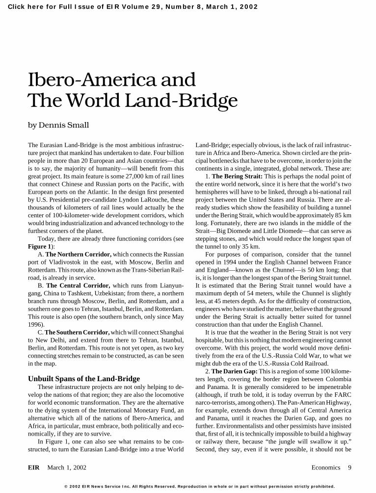
cal basis exist for constructing such economic links? TheTABLE 1
answer is yes. The World Land-BridgeUnlike Great Britain and its colonial system, the United
Double-Track Steel CementStates was founded by Benjamin Franklin, George Washing-Railroads Required Requiredton, and others on the basis of establishing a community of
To Be Built (millions (millionsinterests with the sovereign nations of the South, around the Continent (kilometers) of tons) of tons)industrial development of all nations. In the 19th Century,
Ibero-America 25,800 11.8 8.5Abraham Lincoln revived this orientation; in the 20th Cen-Africa 25,000 11.6 8.3tury, Franklin Delano Roosevelt did the same; and today,Asia 7,750 3.6 2.6Lyndon LaRouche represents that same tradition within theNorth America 5,100 2.4 1.7United States.World total 63,650 29.2 21.03. Sakhalin Bridge: Very soon, Japan—the second-Total worldlargest economy in the world—will be directly linked to the
production 847 1,520Eurasian Land-Bridge. At the end of 2001, the Russian gov-ernment announced that, in a matter of months, they would Source: EIR.begin construction of an 8 km bridge between continentalRussia and the island of Sakhalin. The Japanese island ofHokkaido, at the same time, is only 40 kilometers from thesouthern tip of Sakhalin, and there are already proposals to been fundamentally maritime or riparian, and population and
economic centers have generally been concentrated along thebuild a bridge that would connect them. Hokkaido, in turn, isalready linked with Honshu, Japan’s largest island, through coasts or in river valleys. But with the World Land-Bridge,
the inner space of the different continents would become thethe 54 km Seikan tunnel, the longest underwater tunnel inthe world. new frontiers of development.
Apart from the main bottlenecks we have indicated, thereIt is estimated that, once these projects are finished, railtransport from Tokyo to Rotterdam would take only nine days are many thousands of kilometers of rail that will have to be
laid, to establish a true World Land-Bridge. In Table 1, weto cover a distance of 13,600 km. Today, the maritime routebetween these same two cities is 20,000 km, and takes some can see in quantitative terms what is otherwise evident from
Figure 1: that the two continents most lacking in railroad26 days. The implications of this for the economic productiv-ity of all the nations along the route, are clear. infrastructure are Africa and Ibero-America. If we consider
only the main trunk lines we have indicated—which will4. The English Channel: The Channel Tunnel connect-ing France and England was opened to both car and rail traffic function like a kind of “skeleton” of the World Land-
Bridge—we have the results as seen in Table 1.in 1994, and it is an engineering marvel that gives us an ideaof what can be achieved in the rest of the world, once the Many will immediately wonder where the “money” to
finance such enormous projects will come from. This is thepolitical obstacles to such enterprises are overcome.5. The Strait of Gibraltar: Here only 14 kilometers sepa- wrong question to ask, at least in the form that the great major-
ity of people would ask it. Credit, whether national or interna-rate Europe from Africa. It is crucial to build a tunnel here,so that Africa can become a part of the World Land-Bridge. tional, is an instrument created by sovereign governments,
and with sufficient political will, it can be generated.This is technically feasible, although the depth of the water atthis point is such (some 300 meters) that the length of the The more important question is: Does the physical-eco-
nomic capacity exist to build these projects? Where is thetunnel would have to be 50 km or more, in order to achievesuch depths. steel, the cement, and so forth, that will be needed, going to
come from?6. The Suez Canal: In November 2001, two 1 km-longbridges crossing the Suez Canal were inaugurated, providing In Table 1 we have applied parameters developed by engi-
neers to break down the steel and cement requirements, forAfrica a rail link with the Middle East and Africa.constructing the 63,650 km of rail that will make up the “skel-eton” of the World Land-Bridge. These totals are then com-Physical-Economic Requirements
Figure 1 gives us a clear idea of how the continents of the pared with current world production. In the case of steel,the 29.4 million tons required for double-tracked corridors,planet will form a single continuous continental land-mass,
connected by a great spiral of railroads, a spiral consisting of would represent about 3.4% of world annual production (847million tons). In the case of cement, the 21 million tons re-development corridors some 100 kilometers wide along each
of the routes. As Lyndon LaRouche has explained, such an quired are 1.4% of world annual production (1,520 milliontons). In Table 2, we present annual production of steel andapproach would inaugurate a new era in the history of human-
ity. Until the present time, the great civilizations have all cement in a number of major producing nations.
EIR March 1, 2002 Economics 11

Main rail lines
ExistingProposed
FIGURE 2
Schematic Representation of Main Rail Lines in the Americas
12 Economics EIR March 1, 2002

FIGURE 3
South America: Great Rail Projects
Grandes obras ferroviariasExistentes Propuestas a mediano plazoPropuestas a corto plazo
Zona productiva industrial de mayor densidad
Grandes obras hidráulicasRíos navegables
Canales propuestos
Zona productiva industrial de mayor densidad
1,05
Santa Cruz
Paita
Eten
Cuiabá
São Paulo
Salvador
Santa Cruz
AricaIlo
Buenos Aires
Córdoba
Santarém
Puerto Maldonado
Santa Fédo Sul
Saramirisa
PANAMÁCaracas
Bogotá
Grandes obras ferroviariases
diano plazoPropuestas a corto plazo
Zona productiva industrial de mayor densidad
BelénQuito
Río Amazonas
Pucallpa
Callao
Huancayo
Conete
Mataran
Lima
Desaguadero Brasilia
Antofagasta
Santiago
Río Madeira
Buama
Iñapari
Santa Cruz
Paita
Etén
Cuiabá
São Paulo
Salvador
Santa Cruz
AricaIlo
Buenos Aires
Córdoba
Santarém
Santa Fédo Sul
Saramirisa
Panamá
Puerto Maldonado
Caracas
Bogotá
Quito
Pucallpa
Mollendo
Lima
Desaguadero
Antofagasta
Santiago
Iñapari
Main rail lines
Porto Velho
ExistingProposed
EIR March 1, 2002 Economics 13

Bridge. Due to the circumstances of its unique geographicalTABLE 2
location, it is from Colombia that the various main rail corri-Production of Steel and Cementdors will extend (see Figure 3):
Steel Cement • The western corridor, which will run parallel to the(million of tons) (million of tons) Pacific Coast;
• The central corridor, which will connect Bogota, Co-China 141 520lombia; Saramirisa, Peru; Santa Cruz, Bolivia; and thence, byJapan 103 80two branches, Sao Paulo, Brazil, and Buenos Aires, Ar-U.S. 90 87gentina;Russia 58 27
• The western corridor, which will unite Colombia,Brazil 27 43Venezuela, Guyana, Surinam, and French Guiana, and willMexico 13 30extend down the Atlantic Coast, crossing Brazil until arrivingArgentina 4 7at Buenos Aires.Colombia 1 9
Once this rail network is built, a train could be boarded inWorld total 847 1,520Sao Paulo, Brazil, for example, and ridden over 20,000 km
Sources: www.worldsteel.org and www.global-cement.dk. of continuous travel to Berlin! This is the distance of present-day maritime travel between Japan and Berlin.
Besides the Darien Gap, the other major technical diffi-culty in achieving the physical integration of the continent,This addresses the skeleton of the World Land-Bridge.
But in Ibero-America, as in the other continents, it will be will be that of building rail lines to cross the Andes Mountains.The lowest elevation of the Andes is in Saramirisa, Peru, withnecessary to build a series of secondary regional railroads, as
well as domestic rail networks in each of the countries. We an altitude of about 2,500 meters above sea level. This would,logically, be one of the points where the east-west connectionestimate that the total number of rail kilometers required will
be about four times what we have denominated as the “skele- could be made. But it will also be necessary to build inter-oceanic railways further south, both in Peru and in Bolivia,ton,” that is, some 100,000 new kilometers of rail in Ibero-
America. Today, the nations of Ibero-America already have where the altitude of the passes is some 3,000 or even 3,500meters.about 100,000 kilometers of existing rail lines, so that the
total would reach some 200,000 km. This would provide for Will it be possible? Of course it will. Today, China isbuilding a 1,118 km railroad that connects China’s westerna density of some 10 km of rail lines for every square kilome-
ter of territory, on average, in Ibero-America. For purposes province of Xinjiang, with Lhasa, the capital of the neighbor-ing province, Tibet, passing through what is known as “ theof comparison, consider that the corresponding rail density
in the United States today is 30 km of rail for every square Roof of the World.” Some 960 km, or 85% of the total route,is at elevations of more than 4,000 meters, and in some placeskilometer of land.surpasses 5,000 meters. Half of the project has already beenconstructed!Ibero-America: It Can Be Done
Figure 2 presents a schematic picture of the main rail Furthermore, in Peru itself, there have been viable proj-ects for crossing the Andes by railroad since the middle ofnetworks—both existing and proposed—in the Americas, ac-
cording to the design of U.S. engineering specialist Hal Coo- the 19th Century. As demonstrated in a soon-to-be-publishedhistoric research study by a LaRouche associate in Peru, Luisper. What is known as the “Al-Can Railroad,” which extends
from Alaska to Canada, is already under discussion. By build- Vasquez, the Peruvian government of Manuel Pardo (1872-76), in alliance with Abraham Lincoln’s networks in theing that span, the U.S. rail network will be ready to link up
with the Eurasian Land-Bridge, through the Bering Strait. United States, launched just such a railway project. Theirenemies sarcastically dubbed it “ the Train to the Moon.” ButAlthough our map shows that there are three rail lines
connecting the United States with Mexico City, in real eco- Pardo already knew, in 1860, the enormous role to be playedby railroad infrastructure:nomic terms that is not true; the three lines are ancient and
dilapidated, and require major investments to bring them up “Join the three central lines by means of the fourth, anddecide if in ten years, a revolution will not have occurred into international standards.
Moving further south, a Pan-American Railroad must be Peru, a revolution at once both physical and moral, becausethe locomotive—which, like magic, changes the face of thebuilt to run the length of Central America, through the Darien
Gap and into Colombia. country through which it passes—also civilizes. And that isperhaps its main advantage: populations are put into contact.Here we can clearly see how Colombia can be either a
chokepoint or a linchpin: either obstructing, or enabling the It does more than civilize; it educates. All the primary schoolsof Peru could not teach in a century, what the locomotivephysical integration of Ibero-America, as well as its link with
the United States and, from there, with the Eurasian Land- could teach them in ten years.”
14 Economics EIR March 1, 2002