Embed Size (px)
Citation preview

HYDROLOGICAL PROCESSESHydrol. Process. 18, 667–683 (2004)Published online in Wiley InterScience (www.interscience.wiley.com). DOI: 10.1002/hyp.1366
Hydrogeomorphic linkages of sediment transport inheadwater streams, Maybeso Experimental Forest,
southeast Alaska
Takashi Gomi,1* Roy C. Sidle2 and Douglas N. Swanston3
1 Department of Geography and Forest Resources Management, University of British Columbia, 1984 West Mall, Vancouver,BC V6T 1Z2, Canada
2 Disaster Prevention Research Institute, Kyoto University, Gokasho, Uji, Kyoto 611-0011, Japan3 Pacific Northwest Research Station, USDA Forest Service, 2770 Sherwood Ln, Juneau, Alaska 99801, USA
Abstract:
Hydrogemorphic linkages related to sediment transport in headwater streams following basin wide clear-cut loggingon Prince of Wales Island, southeast Alaska, were investigated. Landslides and debris flows transported sedimentand woody debris in headwater tributaries in 1961, 1979, and 1993. Widespread landsliding in 1961 and 1993was triggered by rainstorms with recurrence intervals (24 h precipitation) of 7Ð0 years and 4Ð2 years respectively.Occurrence, distribution, and downstream effects of these mass movements were controlled by landform characteristicssuch as channel gradient and valley configuration. Landslides and channelized debris flows created exposed bedrockreaches, log jams, fans, and abandoned channels. The terminus of the deposits did not enter main channels becausedebris flows spread and thinned on the unconfined bottom of the U-shaped glaciated valley. Chronic sediment input tochannels included surface erosion of exposed till (rain splash, sheet erosion, and freeze–thaw action) and bank failures.Bedload sediment transport in a channel impacted by 1993 landslides and debris flows was two to ten times greater andrelatively finer compared with bedload transport in a young alder riparian channel that had last experienced a landslideand debris flow in 1961. Sediment transport and storage were influenced by regeneration of riparian vegetation,storage behind recruited woody debris, development of a streambed armour layer, and the decoupling of hillslopesand channels. Both spatial and temporal variations of sediment movement and riparian condition are important factorsin understanding material transport within headwaters and through channel networks. Copyright 2004 John Wiley& Sons, Ltd.
KEY WORDS headwater streams; landslides; debris flows; debris fans; bedload transport and storage; riparian vegetation;southeast Alaska
INTRODUCTION
Various hydrological processes and topographic attributes govern hydrogeomorphic linkages in headwatersystems. The frequency of storm events influences the timing, magnitude, and spatial distribution of runoffprocesses, and resulting sediment transport and deposition from hillslopes to channels and from headwatersto downstream reaches (Dunne, 1991; Dhakal and Sidle, 2004). Subsurface and groundwater hydrology alterthe stability of hillslopes and zero-order basins (Tsukamoto et al., 1982) and thus relate to the initiation oflandslides, which are dominant geomorphic processes in the Pacific Northwest (Sidle et al., 1985). Sedimentproduced by landslides is transported to downstream reaches as channelized debris flows and bedload.Transport distances of sediment depend on tributary junctions, channel gradient, valley configuration, andformation of log jams (Nakamura, 1986; Benda and Cundy, 1990, Hogan et al., 1998); these, in turn, affect
* Correspondence to: Takashi Gomi, Department of Geography and Forest Resources Management, University of British Columbia, 1984West Mall, Vancouver, BC V6T 1Z2, Canada. E-mail: [email protected]
Received 1 August 2001Copyright 2004 John Wiley & Sons, Ltd. Accepted 7 October 2002
668 T. GOMI, R. C. SIDLE AND D. N. SWANSTON
sediment transport and storage throughout channel networks (Wolman, 1977; Benda and Dunne, 1997a, b;May and Gresswell 2003).
Bedload and suspended sediment transport in steep-gradient headwater streams depends significantly onthe occurrence of mass movement and their recovery processes (Grant and Wolff, 1991). Sources of bedloadand suspended sediment are small bank failures, bank erosion, root throw, dry ravel, surface erosion due torain splash, sheet erosion, and soil creep (Dietrich and Dunne, 1978). Availability of sediment is modified bychanges in vegetation coverage and riparian stand regeneration after mass movement disturbance (Gomi et al.,2001). Vegetation cover in scour zones of landslide and debris flow tracks reduces the sediment delivery fromhillslopes to streams (Shimokawa, 1984; Nakamura et al., 2000). Regenerated riparian stands contribute tothe recruitment of woody debris; such woody debris creates sites for sediment storage (Gomi et al., 2001).
Timber harvesting and logging roads affect the hydrogeomorphic linkages in headwater streams. Theprobability of mass movement on marginally stable sites increases because root strength decreases 3 to15 years after timber harvesting (Sidle et al., 1985). Roads intercept precipitation and subsurface flow fromhillslopes, and thus modify water flow pathways (Sidle et al., 2004). Because of topographic changes, debrisflows are both intercepted and initiated at logging roads (Wemple et al., 2001). Logging slash providestemporary sites for storage of sediment in small headwater streams after clear-cutting (Gomi et al., 2001;Sidle et al., 2004). In contrast, decreases in the number of woody debris dams due to riparian vegetationremoval increase sediment movement (Likens and Bilby, 1982).
Spatial and temporal variation in sediment transport occurs due to changes in the amount of sediment andwoody debris related to timber harvesting, the occurrence of mass movement, and the vegetation recoveryprocesses (e.g. Shimokawa, 1984; Grant and Wolff, 1991; Benda and Dunne, 1997a). Wolman (1977) pointedout the importance of linkages among source areas, storage, and transport for understanding sediment routingprocesses in channel networks. Sediment transport from hillslopes to channels and in-channel storage havebeen extensively studied for estimating dynamics of materials and impacts of timber harvesting on streamecosystems in British Columbia, in Oregon, in Washington, and in Japan (e.g. Dietrich and Dunne, 1978;Nakamura et al., 1995; Benda and Dunne, 1997b; Slaymaker, 2000). Although sediment transport due tolandslides and debris flows has been investigated in southeast Alaska (e.g. Swanston, 1970; Johnson et al.,2000), few studies have documented sediment transport and storage within headwater streams and fromheadwaters to downstream reaches of U-shaped glaciated valleys. In particular, sediment movement insuch landforms may be distinctive in terms of linkages from hillslopes to streams and from headwatersto downstream reaches compared with unglaciated terrain. Indeed, because hillslopes, zero-order basins, andchannels are tightly coupled in headwater streams (Sidle et al., 2000; Gomi et al., 2002), timber harvestingand mass movement strongly affect sediment supply, transport, and storage.
Thus, this study focuses on documenting sediment routing processes, such as transport and storage inheadwater systems, particularly related to the occurrence of mass movement and vegetation recovery aftertimber harvesting in a southeast Alaskan watershed. The objectives of this study are: (1) to describe sedimenttransport and storage due to episodic mass movement and more regular bedload and suspended sedimentmovement; and (2) to demonstrate hydrogeomorphic linkages between headwater streams and downstreamsystems for various sediment movement conditions.
STUDY SITES
This study was conducted in the Maybeso Experimental Forest within the Tongass National Forest, on Princeof Wales Island, southeast Alaska (Figure 1). The drainage area of the Maybeso watershed is 39 km2. About25% of the watershed (10 km2) was clear-cut logged from 1953 to 1957 using cable yarding methods. Ripariancorridors along the main stem of Maybeso Creek and its tributaries were also logged during that period (Bryant,1980). Logging residue was not removed from streams and slash burning was not conducted after harvesting.
Copyright 2004 John Wiley & Sons, Ltd. Hydrol. Process. 18, 667–683 (2004)

HYDROGEOGRAPHIC LINKAGES 669
Figure 1. Study sites in Maybeso valley, southeast Alaska: weirs were located in LS1 and YA1 channels to capture bedload sediment.A tipping-bucket rain gauge was located near LS1 and the long-term weather station is located in Hollis. Broken line shows watershed
boundary. See Table I for definition of the stream types
The Maybeso Experimental Forest was established in 1982 to monitor the effects of watershed-wide loggingon soil erosion, fish and wildlife habitat, and forest stand succession.
The climate in this area is cool and temperate. The mean annual temperature is 10 °C and the mean annualprecipitation is 2800 mm. The basin is characterized by a U-shaped glaciated valley covered by a veneerof clay-rich till of varying thickness below 500 m elevation (Swanston, 1970). Major geologic units aremetasedimentary mudstone, greywacke, shale, slate, diorite, and granodiorite (Johnson et al., 2000). Tolstoisoils dominate 90% of the Maybeso watershed (above 500 m in elevation); at lower elevations, below 500 m,Karta soils are found. The Tolstoi mapping unit is comprised of shallow, well-drained soils developed onsteep slopes, covered with colluvium and underlain by fractured bedrock. Karta soils are podzols developedon impermeable, unweathered glacial tills (Swanston, 1967). Dominant riparian forest vegetation includeswestern hemlock (Tsuga heterophylla), Sitka spruce (Picea sitchensis), western red cedar (Thuja plicata) andred alder (Alnus rubra). Occurrence of alder in riparian zones is highly influenced by past disturbances, suchas landslides and debris flows. Resident fish in the lower reaches of headwater streams include cutthroat trout(Oncorhynchus clarki ) and Dolly Varden (Salvelinus malma).
Streams were selected based on disturbance classes related to the history of mass movement and riparianstand conditions. Young-growth alder [mean diameter at breast height (DBH): 0Ð2 m] dominated riparianzones in streams affected by mass movement in 1962 (one case in 1979); these streams were identified as YA.Small alder stands (mean DBH: 0Ð03 m) or partially bare slopes were observed in riparian corridors affectedby 1993 landslides; these streams were identified as LS (Table I; Figure 1). Three headwater streams wereinvestigated in both LS and YA channels in 1998 and 1999. All streams in LS and YA were affected by timberharvesting, but they had different histories of mass movement (Table I). All streams were incised <5 m intothe sidewalls of the U-shaped glaciated valleys. Material along stream sides and channel heads immediatelymobilized due to landslides. Subsequently, channelized debris flows transported and deposited in the lowergradient reaches of both the LS and YA channels. Based on field observations of scour and deposition, bothLS and YA channels were divided into upper (scour) and lower (deposition) sections (see figure 2 in Gomiet al. (2000)). Scour zones constituted both sources and run-out zones of sediment because of the difficultyof distinguishing these features. The YA1 and LS2 channels joined at the lower reaches of LS1, and the
Copyright 2004 John Wiley & Sons, Ltd. Hydrol. Process. 18, 667–683 (2004)

670 T. GOMI, R. C. SIDLE AND D. N. SWANSTON
YA3 channel joined to the lower reach of LS3 (Figure 1). YA2 did not join any other channels because itdisappeared in the debris flow deposits downstream. Mean gradients of the headwater channels ranged from9 to 45%, and mean bankfull widths ranged from 0Ð6 to 3Ð7 m. The drainage area at the downstream end ofthe study reaches ranged from approximately 0Ð14 to 0Ð35 km2 (Table I).
METHODOLOGY
The occurrence and distribution of mass movement, such as landslides and debris flows, after timber harvestingwas documented through field surveys and by examining aerial photographs taken in 1959 (1 : 15 840), 1962(1 : 15 840), 1980 (1 : 12 000), and 1998 (1 : 63 360). Unvegetated slope areas that were formed by massmovement were mapped and counted. Scour and deposition zones of six streams in the LS and YA channelswere intensively investigated in the field. Stream channels, abandoned channels, and sediment depositionalong channels, such as debris fans and terraces, were mapped using a tape and compass. The length of theheadwater reaches surveyed varied from 100 to 400 m, depending on the length of scour and deposition zones(Table I). The reference point (0 m point) of the stream survey was the boundary between the scour or run-outand deposition zones of mass movement. Stream gradient and cross-sectional profiles were surveyed using alevel, stadia rod, and tapes. Exposed bedrock length and its position in the channel were also measured. Thewetted and bankfull widths of streams were estimated every 5 m. Bankfull width was defined by the presenceof moss and rooted vegetation along the channel margins and the top of banks.
Locations, number, and volumes of large woody debris (LWD) pieces (diameter ½0Ð1 m, length ½0Ð5 m)and numbers of fine woody debris (FWD) pieces (diameter 0Ð03–0Ð1 m, length ½0Ð5 m) were measured andcalculated using methods described by Gomi et al. (2001). Fine organic debris (FOD: accumulations of leavesand branches) was also measured if sediment was stored behind these features. Sediment storage behind woodydebris and other obstructions (e.g. boulders and bedrock) was measured based on the geometry of sedimentwedges (width, length of the wedge, and average depth at the front of the wedge). Average depth of thesediment wedge was measured using a sediment probe. The cause of sediment deposition was categorizedaccording to the formation elements of the sediment wedge: LWD, FWD, FOD, boulders, and bedrock. The
Table I. Characteristics of the study sitesa
Landslides anddebris flows
Drainagearea
�km2�
Length ofsampled
reach (m)
Mean channelgradientb (%)
Mean bankfullwidthb (m)
Exposedbedrock
(% length)
D50 (mm)
LS1 upper 1993/1979 0Ð21 340 40Ð3 (11Ð0) 1Ð2 (0Ð6) 26Ð7 30LS1 lower 400 9Ð9 (5Ð8) 2Ð6 (1Ð5) 0Ð0 25LS2 upper 1993 0Ð27 150 31Ð0 (12Ð3) 1Ð6 (0Ð4) 40Ð7 31LS2 lower 250 13Ð7 (6Ð0) 1Ð8 (0Ð6) 0Ð0 30LS3 upper 1993 0Ð35 300 31Ð7 (11Ð5) 2Ð8 (1Ð3) 59Ð8 43LS3 lower 350 9Ð8 (8Ð1) 3Ð7 (1Ð3) 0Ð0 29
YA1 upper 1961 0Ð22 125 36Ð6 (9Ð3) 1Ð1 (0Ð5) 26Ð0 36YA1 lower 100 17Ð5 (6Ð8) 1Ð4 (0Ð5) 2Ð0 35YA2 upper 1961 0Ð14 225 42Ð7 (9Ð1) 0Ð9 (0Ð3) 38Ð0 40YA2 lower 125 18Ð6 (7Ð1) 0Ð9 (0Ð3) 0Ð0 27YA3 upper 1979/1961 0Ð21 150 28Ð9 (11Ð2) 2Ð0 (0Ð6) 47Ð1 38YA3 lower 300 17Ð4 (7Ð3) 1Ð9 (0Ð6) 0Ð0 28
a LS, recent landslide (logged from 1953 to 1957 and landslide and debris flows in 1979 and (or) 1993); YA, young alder riparian forest(logged from 1953 to 1957 and landslides and debris flows in 1961 and (or) 1979). Sites are divided into scour/run-out (upper section) anddeposition (lower section) zones of landslides/debris flows.b Standard deviations are given in parentheses.
Copyright 2004 John Wiley & Sons, Ltd. Hydrol. Process. 18, 667–683 (2004)

HYDROGEOGRAPHIC LINKAGES 671
volume of sediment stored behind woody debris and other obstructions was computed based on a rectilinearpyramid (Gomi et al., 2001).
The age of sediment deposits was estimated from even-age stands of alder growing in these scour anddeposition zones (e.g. Nakamura, 1986). Three cross-sections in each stream were surveyed to describe valleyand channel profiles. The size of mobile streambed material was measured based on the median diameter of100 pebbles in a 0Ð2 ð 0Ð2 m2 grid at the three cross-sections (Wolman, 1954). Large cobble and bouldercomponents (>0Ð2 m) were excluded because of their relative immobility, except during landslides and debrisflows. Drainage areas of study streams were measured from a topographic map (USGS Crag C-3) using adigital planimeter.
Bedload and suspended sediment movement was monitored in the LS1 and YA1 channels from Septemberto November 1999. Most of the sediment transport in southeast Alaska occurs in the fall storm season fromSeptember to December (Sidle, 1988; Sidle and Campbell, 1985). Therefore, characteristics of sedimentmovement and relative differences in sediment transport between LS1 and YA1 channels can be evaluated. V-notch weirs (120°) were installed in LS1 and YA1 in the summer of 1999 to measure discharge and sedimentyield. Sediment deposited behind the weirs was sampled when significant volumes accumulated after stormevents. Sampled sediment was sieved into size classes of 11Ð2, 16Ð0, 25Ð0, 32Ð0 45Ð0, and 115Ð0 mm, andweighed in the field. Sediment smaller than 11Ð2 mm was taken back to the laboratory, dried, and then weighedfor smaller sieve classes (4Ð75, 2Ð00, 1Ð00, and 0Ð425 mm). Sub-samples of finer sediment (<11Ð2 mm) wereburned for 2 h at 500 °C to remove organic matter in each sieve class. The bulk density of the sampledsediment was 1Ð2 g cm�3.
Suspended sediment samples were collected during selected storm events in the LS1 and YA1 channelswith an automated pumping sampler. The intake of the pumping sampler was attached to a metal rod andsuspended in mid-stream. This minimized the effects of flow separation and clogging by organic matter forsampling efficiency (Sidle and Campbell, 1985). Sampling was automatically activated at a predeterminedstorm stage. A 500 ml sample was collected every 10 to 15 min. Because only 24 sampling bottles werecontained in the sampler, suspended sediment samples were typically only collected during the rising limbsof storms. Samples were transported to the Hollis field station (Figure 1) where they were analysed. Totalsuspended solids (TSS) were determined by passing a known volume of stream water through a glass-fibrefilter with an effective retention of 1Ð2 µm; filters were oven dried at 100 °C and residual sediment wasweighed. Suspended sediment, the mineral portion of the sample, was weighed after the TSS sample wasburned at 550 °C for approximately 2 h (Sidle and Campbell, 1985). Precipitation was also monitored every10 min using a tipping-bucket rain gauge at an open-canopy area near the LS1 channel (Figure 1). Dailyprecipitation was collected at Hollis from 1947 to 1994, although data are missing from 1951 to 1952 andfrom 1963 to 1987.
RESULTS AND DISCUSSION
Occurrence and distribution of mass movement
Both the occurrence and spatial distribution of mass movement processes are important for sedimenttransport in headwater streams and the downstream linkages of sediment transport. Hillslope gradient,distribution of glacial till, bedrock structure, and faulting are important factors affecting mass movementinitiation in Maybeso Experimental Watershed (Swanston, 1967). Based on topographic maps, most of thelandslides initiated on slopes >30°. Slides mainly occurred in the elevation range from 450 to 550 m, theupper boundary for the distribution of glacial till. Most landslides occurred along the north slope of MaybesoExperimental Watershed; a few landslides were found on the south slope (Figure 2). Swanston (1967) notedthat the north slope of Maybeso was more extensively faulted than the south slope; this affects differencesin occurrence of mass movement between slope aspects. In addition, hillslopes were relatively steeper on thenorth compared with the south side of the watershed. More landslide scour occurred on the east side than
Copyright 2004 John Wiley & Sons, Ltd. Hydrol. Process. 18, 667–683 (2004)

672 T. GOMI, R. C. SIDLE AND D. N. SWANSTON
on the west side of the logged portion of the north slope (Figure 2). Since bedrock and slope gradient weresimilar on both sides of the north slope, differences in the distribution and compaction of glacial till may alterthe occurrence of landslides.
More of the scour and deposition related to mass movement after timber harvesting occurred in the loggedarea than in the unlogged area of the Maybeso watershed (Figure 2). Despite the absence of canopy cover inthe logged area, there was little evidence of mass movement in most of the headwater channels in 1959; only14 events were detected on the unvegetated slope using aerial photographs (Figure 2). Following the stormevents in 1961, scour and deposition from landslides (number of events on unvegetated slope areas: 30) andsubsequent debris flows were clearly visible in the 1962 photographs. Multiple landslides and large depositionalareas along channels were observed in deeply incised (>15 m) landforms (Figure 2). Single landslides andsubsequent debris flows were found in headwater systems with shallowly incised (<15 m) landforms.
Scour and deposition from landslides (number of events in unvegetated slope areas: 38) observed in the 1980photographs were associated with a 1979 storm event (Figure 2). Because the riparian vegetation imparted anelement of roughness along the lower reaches of headwater streams, the travel distances of debris flows in 1979may be shorter than for the events in 1961 (Johnson et al., 2000). Of the three mass erosion episodes coveredin this study, the 1993 event produced the smallest number of landslides (number of events in unvegetatedslope areas: 18) and debris flows, as observed in the 1998 small-scale photographs. Despite the frequent massmovements after timber harvesting, no landslides and debris flows directly reached the main stem of MaybesoCreek (Figure 2). Because resolution, scales, and vegetation coverage differed among the photographs, theminimum detectable size of landslides on photographs may differ. Therefore, the distribution and number oflandslides based on photographic interpretation may be conservative.
The sizes of storms are significantly related to the occurrence of mass movement (Dhakal and Sidle, 2004).Landslides in southeast Alaska typically occur during the autumn storm season from September to December(Swanston, 1967; Sidle, 1984; Johnson et al., 2000). The amounts of 24 h precipitation on 14 October 1961and on 27 October 1993 were 128Ð4 mm and 116Ð7 mm respectively; the third and fifth highest values ofan incomplete 20 year record. Because average soil depth was 0Ð96 m in hillslopes and zero-order basins,
Figure 2. Distribution of landslides and debris flows after timber harvesting in the Maybeso watershed. Spatial distribution of mass movementwas estimated from aerial photographs. Timber harvesting was conducted in 1953 and 1957. Most of the scour and deposition due to mass
movement was observed within the logged area
Copyright 2004 John Wiley & Sons, Ltd. Hydrol. Process. 18, 667–683 (2004)

HYDROGEOGRAPHIC LINKAGES 673
soil within drainage depressions (i.e. zero-order basins) was believed to be fully or nearly saturated duringthe 1961 and 1993 storms, based on the relationship between piezometric head and 24 h precipitation inMaybeso Experimental Forest (Swanston, 1967). The relationship between rainfall return period Tr and 24 hprecipitation P was estimated from precipitation data at Hollis using the Weibull plotting position formula:
P D 108Ð7 log�Tr� C 65Ð6 �R2 D 0Ð87; p < 0Ð001� �1�
The return intervals for the 1961 and 1993 storm events were calculated as 7Ð00 years and 4Ð20 yearsrespectively. This finding agrees with the landslide-triggering storm estimates (5 to 8 year recurrence intervalbased on 24 h precipitation) noted by Swanston (1970) for this area. Montgomery et al. (2000) also foundthat a 24 h rainfall event with a recurrence interval >4 years might initiate shallow landslides in the decadeafter logging in Oregon and Washington. Storms with recurrence intervals >2 years were sufficient to initiatelandslides in Queen Charlotte Islands, British Columbia (Schwab, 1998). More importantly, however, thecombinations of slope gradient and precipitation intensity, as well as antecedent moisture (Sidle, 1984; Dhakaland Sidle, 2004), govern the initiation of landslides.
Changes in vegetation and in geomorphic and hydrologic conditions due to timber harvesting and loggingroads can modify slope stability. Because the soils in the Maybeso watershed are essentially cohesionless,roots anchor the soil to bedrock and provide a long-filament binder to soil substrate (Swanston, 1970). There-fore, reduced root strength in the period of 3 to 15 years after logging (Sidle et al., 1985) significantlyaffected the stability of slopes at the time of the 1961 storm. The two highest 24 h precipitation amounts inMaybeso were recorded during and immediately after logging [31 December 1953 (264 mm) and 7 Decem-ber, 1959 (178Ð2 mm)]. Although soil moisture in December is typically greater than in other seasons, thesetwo extreme precipitation events did not trigger mass movements. This is probably because anchoring andreinforcing effects of roots were still contributing to stability of hillslopes. Because most of the landslidesoccurred just below mid-slope logging roads in 1961, unstable road-fill material and/or channelling of waterfrom road surfaces, cut slopes, and ditches may have also contributed to landslide initiation (Schwab, 1998;Wemple et al., 2001).
Scour, run-out, and deposition of mass movement
Channel gradient and valley configuration are important determinants of the location of scour, run-out,and deposition of mass movement. Following initiation by landslides, sediment and woody debris moved aschannelized debris flows toward the valley bottom of Maybeso Creek. Distances of scour and run-out zonesin the LS and YA channels ranged from 275 to 700 m (Table II). Within the scour and run-out zones, bedrockwas exposed in 27 to 60% of the channel length (Table I). Landslides initiated on hillslopes with gradientsranging from 36° to 58°. Swanston (1970) noted that landslides commonly occurred on hillslopes at or near37° in the Maybeso watershed. The sediment deposition zone occurred near the foot of the slope down to themain stem, where channel gradient was in the range of 4Ð9 to 7Ð5° (Table II). Depositional volume (sedimentand woody debris transported by mass movement) was greater in LS sites (750 to 1871 m3) than in YAchannels (309 to 869 m3; Table II). Because landslides and debris flows in LS2 and LS3 had longer scourand run-out distances and initiated in second-growth conifer forests, deposited materials contained greateramounts of sediment and woody debris.
Valley configuration sets the template for sediment transport and deposition. Debris flow materials weretypically deposited at the base of the U-shaped glacial valley walls, because channel configuration of tributarieschanges from one of narrow and steep to one of wide and gentle channels (Figure 3a). The decreased gradientreduced the momentum of debris flows. Wider valleys result in spreading and thinning of debris flows andincreasing resistance to flow (Nakamura, 1986; Benda and Cundy, 1990). Separation of water and sedimentdue to percolation into alluvium may also reduce the momentum of debris flows. Debris flows encounteredan old logging road at the foot of the hillslopes (Figures 3b and 4), thus the road played a trivial role instopping debris flows. Such changes caused the formation of debris fans and log jams in the bottom of the
Copyright 2004 John Wiley & Sons, Ltd. Hydrol. Process. 18, 667–683 (2004)

674 T. GOMI, R. C. SIDLE AND D. N. SWANSTON
Table II. Sediment transport during mass movement and in-channel storages of sedimenta
Site Source and run-out zones Deposition zones
Initiation area Length (m) Channelgradientb
(degrees)
Total volumeof sediment
(m3)
Channelgradientc
(degrees)
Length (m)
LS1 upper Road fill 350 47LS1 lower 750 5 100LS2 upper Second-growth forest 600 43LS2 lower 1045 5 85LS3 upper Second-growthforest 700 55LS3 lower 1871 5 300
YA1 upper Road fill 330 52YA1 lower 309 8 150YA2 upper Below road 275 36YA2 lower 440 9 85YA3 upper Road fill 350 50YA3 lower 869 6 230
a see Table I for stream type codes.b Hillslope gradient was measured near the initiation of landslide.c Channel gradient measured at the beginning of deposition zones.
valley. Because the landslide in LS3 was initiated at a higher altitude, the resultant debris flow there may betransported farther (Table II). In contrast, debris flow material may deposit in steeper reaches of YA channelsthan in the LS channels because the landslides initiated at lower elevations in YA channels. No debris flowsdirectly entered the main channel of Maybeso Creek due to a wide and flat valley floor, despite the frequentmass movements in headwaters (Figure 2). Roberts and Church (1986) noted that the amount of sedimenttransported from the hillslope to main channels due to debris flows depends upon the presence or absence ofa valley flat in Queen Charlotte Islands.
Because streams were not entrenched into fans, several poorly sorted sediment deposits were observed atthe foot of hillslopes (Figures 4 and 5). Debris fans formed prior to 1961 may also affect sediment depositionon the foot of hillslope. Owing to sediment and woody debris deposition in 1961, 1979, and 1993, debrisfans formed in the transition zone from hillslopes to floodplains (on the logging road in Figures 4 and 5).Channels shifted dramatically due to the formation of debris fans and log jams. Small fans and bars werealso found along channels and on terraces about 200 m downstream of the logging road in LS1 (Figure 4)and YA3 channels (Figure 5).
Sediment deposits behind in-channel obstructions (woody debris and boulders) 200 m downstream of thereference point (logging road) were greater than at the foot of hillslopes (near the reference point) in LS1and YA3. Because channels in LS2 and YA1 eventually merged into the LS1 channel, sediment from LS2and YA1 was transported to the downstream reaches of LS1. Such small deposits along channels, as wellas behind obstructions in downstream reaches, may have been formed by sediment transported as bedloadmovement during the 1993 event or subsequent storms (Figures 4 and 5). The volume of each deposit alongand within channels ranged from 1 to 10 m3. Owing to such sediment movement, fan-shaped deposits formedalong lower reaches of the headwaters. Sequential sediment movement also partially damaged riparian standsand caused local aggradation and side-channel formation in downstream reaches.
In-channel storage of sediment
Sediment produced during and after mass movement was stored in channels and fans. Total sedimentstored behind LWD, FWD and other obstructions (boulders and bedrock) in stream channels ranged from 0Ð2
Copyright 2004 John Wiley & Sons, Ltd. Hydrol. Process. 18, 667–683 (2004)

HYDROGEOGRAPHIC LINKAGES 675
(a)
(b)
(c)
Figure 3. (a) Longitudinal profile along LS1. Small arrows show old logging roads located at the foot (solid arrow) and middle (dottedarrow) of hillslopes; large arrow shows the reference point (0 m) for the stream survey. (b) Estimated volume of sediment transported anddeposited due to mass movement. (c) Volume of sediment stored behind woody debris and the other channel obstructions (e.g. boulders)
due to debris flows
to 10Ð1 m3 per 100 m (Table III; Figure 3c). Sediment stored in upper sections of the LS and YA channels waseither remnants of mass movement deposits or was transported from hillslopes after recent mass movement.Sediment stored in the lower sections of LS and YA channels (Table II) was transported during the massmovements and subsequent events. Larger volumes of sediment were found in the lower sections of the LSchannels than in other sections. Sheet erosion, rain splash, and creep within landslide scour zones of weatheredtill govern sediment supply from hillslopes to LS channels. Soil erosion pedestals developed on bank slopes.Bare soil and till were affected by frost-heaving during winter and, thus, produced much coarser sedimentthat was temporarily stored in channels. Eroded material on hillslopes was transported directly to streams. Incontrast, evidence of surface erosion and direct connections of sediment transport from hillslopes to streamsin the YA channels was lacking due to vegetation and litter cover. Alder roots penetrated into bedrock andtill and expanded on exposed substrate, thus binding soil and organic matter.
Different histories of mass movement relate to different vegetation recovery processes and in-streamsediment storage in LS and YA channels. The volume of woody debris and in-stream function of woodydebris characterized the differences between the LS and YA channels (Table III and Figure 6). Because bothbranches and leaf litter were recruited from regenerating riparian alder stands, the amount of LWD and FWDincreased in YA channels 40 years after mass movement. The volumes of in-channel woody debris in YAchannels (0Ð7 to 1Ð3 m3 per 100 m) were greater than in LS channels (0Ð2 to 0Ð5 m3 per 100 m; Figure 6).Sediment storage ratio, which was calculated as the total volume of sediment divided by sediment storedbehind woody debris, was significantly higher in YA (0Ð55) channels than in LS channels (0Ð22) (Gomi et al.,2001). Therefore, increases in woody debris pieces recruited from alder stands created channel roughness and
Copyright 2004 John Wiley & Sons, Ltd. Hydrol. Process. 18, 667–683 (2004)

676 T. GOMI, R. C. SIDLE AND D. N. SWANSTON
N
Figure 4. Sediment deposition due to debris flows and subsequent sediment movement in the LS1, LS2, and YA1 channels. Debris fansformed at the bottom of the glaciated valley near the logging road. The table shows the volume of mobile sediment in different years
estimated in the field
turbulence and thus contribute to sediment storage (Gomi et al., 2001). Such sediment storage due to channelobstructions may be an important source for more regular sediment transport processes, such as bedload andsuspended sediment (Roberts and Church, 1986). Because of woody debris recruitment and in-channel storageof sediment, the percentage of exposed bedrock was slightly lower in the YA channels (Table I). For muchlonger periods (>50 years), woody debris inputs and colluvial material are stored in hollows and channelsuntil landslides and debris flows remobilize the material. Larger sizes of materials are likely stored in thechannels because of the limited transport capacity in small streams.
Transport of bedload and suspended sediment
Bedload and suspended sediment transport in streams is linked to sediment supply from hillslopes andin-stream storage. Rain splash and sheet erosion on glacier till and forest soil produce mostly finer sediment,such as clay, silt, and fine sand, most of which is transported as suspended sediment. Small bank and slopefailures typically produce coarser sediment and alter channel morphology. During the 21 October 1999 storm,a small bank failure occurred in LS1, 30 m upstream from the weir. According to Equation (1), the returninterval of the 24 h precipitation (71 mm) was 1Ð5 years. Based on Swanston’s (1967) equation, 71 mm
Copyright 2004 John Wiley & Sons, Ltd. Hydrol. Process. 18, 667–683 (2004)

HYDROGEOGRAPHIC LINKAGES 677
N
Figure 5. Sediment deposition due to debris flows and subsequent sediment movement in the LS3 and YA3 channels. More sediment depositsdue to debris flows in LS3 were found approximately 200 m downstream of logging roads. Sediment deposits of varying ages were foundalong YA3. The table shows the volume of mobile sediment in different years estimated in the field. See Figure 4 for the code on the map
of rainfall in 24 h precipitation would cause a 0Ð65 m rise in piezometric head. Thus, sections of shallowsoil near the channel bank may have been nearly saturated during this storm. Nevertheless, bank and slopeundercutting due to higher discharge may have played an important role in creating unstable conditions in theside-slopes. The small bank failure produced 1 to 1Ð5 m3 of sediment, including soil and weathered till, basedon dimensional estimates. Failed material consisted of weathered till (clay and silt) and coarse fragments(gravels and cobbles). Since the capacity of the weir pond in LS1 was less than 1 m3, a maximum of 85 to90% of the sediment was captured behind the weir. Because of the sudden supply of saturated sediment fromthe bank failure during the high discharge, the sediment was probably mobilized and transported downstreamduring the storm. Such a channelized mass wasting process with a large sediment flux and higher watercontent is described as a hyperconcentrated flow.
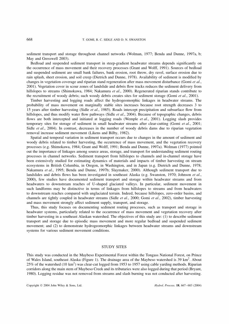
Sediment produced from hillslopes and stored in channels is subsequently transported downstream asbedload and suspended sediment, depending on the size of storm events, sediment supply, and channelroughness. The relationships between sediment deposition at weir ponds in LS1 and YA1 and maximum24 h rainfall during the various sampling intervals from 1 September to 15 November 1999 are shown inFigure 7. Bedload sediment transport in LS1 was two- to ten-fold greater than in YA1. Significant exponentialrelationships were derived between the maximum 24 h precipitation P (mm) and the total volume of sedimentV (m3) in LS1 and in YA1 (Figure 7).
LS1: V D 7Ð8 ð 10�4 e0Ð104P �R2 D 0Ð90, p < 0Ð001� �2�
YA1: V D 7Ð4 ð 10�4 e0Ð056P �R2 D 0Ð66, p D 0Ð008� �3�
Copyright 2004 John Wiley & Sons, Ltd. Hydrol. Process. 18, 667–683 (2004)
678 T. GOMI, R. C. SIDLE AND D. N. SWANSTON
Table III. Characteristics of woody debris and sediment storagea
Number of LWD per100 m
Number of FWDper 100 m
In-channel storage of sediment(m3 100 m)
Total In-channel Behind LWD BehindFWD/FOD
Behindboulder and
bedrock
LS1 upper 15 4 15 0Ð4 0Ð2 2Ð5LS1 lower 40 29 106 2Ð8 1Ð6 10Ð1LS2 upper 37 27 67 1Ð1 0Ð9 2Ð6LS2 lower 54 45 71 3Ð3 0Ð9 3Ð8LS3 upper 57 27 53 2Ð3 0Ð5 4Ð7LS3 lower 80 46 116 4Ð1 0Ð2 9Ð6YA1 upper 24 21 41 1Ð9 1Ð3 3Ð7YA1 lower 52 37 81 7Ð9 0Ð8 0Ð6YA2 upper 20 16 55 0Ð8 1Ð2 2Ð0YA2 lower 14 14 48 4Ð5 0Ð2 7Ð8YA3 upper 29 23 27 1Ð7 0Ð7 1Ð9YA3 lower 66 59 105 4Ð1 0Ð4 3Ð4
a See Table I for stream type codes.
Figure 6. Volume of in-channel large woody debris in the upper reaches of LS and YA channels
The exponent in Equation (2) (LS1) is significantly different than in Equation (3) (YA1; F D 5Ð71, p D 0Ð03)at the ˛ D 0Ð05 confidence level, whereas the constants are similar. For small rainfall events (e.g. 10 mmin 24 h), bedload movement was similar in both channels. During larger events, total bedload movement inLS1 was significantly greater than in YA1. In addition, the relationship between maximum 24 h precipitationand volume of sediment in LS1 was stronger (R2 D 0Ð90) than in YA1 (R2 D 0Ð66; Figure 7). These findingsimply that bedload sediment response to rainfall input in LS1 was less complex than in YA1. This result mayrelate to the higher availability of sediment in the LS1 channel due to its constant supply from unvegetatedbank slopes. Development of an armoured layer after disturbances in the YA channel also reduced sedimenttransport. Variations in bedload transport in YA1 during storms may be caused by sediment storage behindwoody debris and boulders or the sudden release of sediment from such storage sites (Adenlof and Wohl,1994). The median diameter D50 of the bedload was approximately 10 mm and was smaller than channel bedsubstrate (Table I). Although there was no replication of LS1 and YA1, we assumed that similar relationsbetween bedload transport and rainfall might be observed in the other LS and YA channels.
Total sediment yield during the selected storm events was estimated from bedload and suspended sedimentyields, although we could not collect suspended sediment samples during all phases of storm events. Total
Copyright 2004 John Wiley & Sons, Ltd. Hydrol. Process. 18, 667–683 (2004)
HYDROGEOGRAPHIC LINKAGES 679
Figure 7. Relationships between the volumes V (m3) of sediment deposited in weir ponds and maximum (event) 24 h precipitation P (mm)for sediment sampling periods in LS1 and YA1 from September to November 1999
suspended sediment yield from LS1 (19 to 207 kg per event) was 10- to 20-fold greater than from the YA1(2 to 37 kg per event). Suspended sediment accounted for a smaller percentage to the total sediment yieldin YA1 (26%, 32%, and 68%) compared with LS1 (49%, 67%, and 70%) during the storm events on 8 and22 September amd 1 November respectively. Because less bedload was transported late in the storm season,suspended sediment comprised 68% of the total sediment yield in YA1 during the 1 November storm. Lenziand Marchi (2000) estimated that suspended sediment contributed from 16 to 100% of the total sediment yieldin a small stream in Italy. These large variations in the percentage of suspended fractions of total sediment loadare affected by sediment sources, seasonal changes in availability of sediment, and the instantaneous supplyfrom the slope and the channel bed (Sidle and Campbell, 1985; Lenzi and Marchi, 2000). Cumulative bedloadyield during the 1999 monitoring period was 2Ð0 m3 and 0Ð1 m3 in the LS1 and YA1 channels respectively.Therefore, assuming an average proportion of suspended sediment to total sediment of 62% in LS1 and 42%in YA1 throughout the storm season, total sediment yields in LS1 and YA1 channels were approximately5Ð3 m3 and 0Ð2 m3 respectively.
Sediment transport and hydrogeomorphic linkages of headwater streams
Temporal variation. Based on results of sediment transport and storage in the LS and YA channels ofMaybeso watershed, temporal variation in sediment transport occurs along with changes in linkages fromhillslopes to streams. These changes are related to mass movement and vegetation recovery processes.Ground vegetation cover on previously exposed soil and till, and the regeneration of alder stands in theriparian areas after mass movements modify soil erosion processes and linkages from hillslopes to streams(Shimokawa, 1984). After the regeneration of alder riparian stands, the nitrogen-supplemented soils mayfacilitate regeneration of other successional plants (Bormann and Sidle, 1990). Soil under alder riparian standsmay be improved with the accumulation of organic matter, increases in flora and fauna (possibly contributing tothe formation of macropores), development of soil structure, and increases in infiltration capacity and hydraulicconductivity (Bormann and Sidle, 1990). The partial decoupling of side-slopes and streams gradually occursas slopes revegetate and consequently decrease the supply of sediment from hillslopes to channels in YA.
The role of woody debris related to the transport and storage of sediment may change with the successionof riparian stands after mass movement. Woody debris recruitment may change from early establishment ofalder to the replacement of alder with conifers in later stages of succession. Succession patterns of riparianforests after timber harvesting differ with and without mass movement in headwater streams (Gomi et al.,2001). Likens and Bilby (1982) noted that the succession of riparian stands after logging modified the amount
Copyright 2004 John Wiley & Sons, Ltd. Hydrol. Process. 18, 667–683 (2004)

680 T. GOMI, R. C. SIDLE AND D. N. SWANSTON
of woody debris dams for a periods of 50 to 100 years after disturbances. Although woody debris recruitedfrom alder riparian stands contributed to sediment storage 40 years after mass movement, alder typicallydecomposes and fragments more rapidly than conifers (Harmon et al., 1986).
Dominant sediment transport modes after timber harvesting in headwater streams of the Maybeso watershedcan be grouped in relation to triggering storm events (Table IV). Landslides and debris flows after timberharvesting were triggered by storm events with recurrence internals ½5 years. Relatively unsorted materials inlarge quantity (½100 m3), including cobbles and boulders (D50 ½ 200 mm) and LWD pieces, were transportedduring these events. Hyperconcentrated flows may occur when large amounts of sediment are transported fromthe hillslope and accumulate in channels (Table IV). Although only one case was observed, approximately1 m3 of sediment from a slope failure was transported as a hyperconcentrated flow during a storm with arecurrence interval of 1Ð5 to 5 years. A flood surge may also occur if a log jam breaks (Nakamura et al.,2000). Gravel, cobbles, and small boulders (10 < D50 < 200 mm) and FWD pieces were transported duringsuch intermediate events (Table IV). Smaller quantities of sediment (�1 m3) were transported more regularly(daily rainfall return period �1Ð5 years) as bedload and suspended sediment (Table IV). Materials smallerthan gravel, as well as organic matter (e.g. leaves and branches), were typically transported during thesesmaller events.
Spatial variation. A shift in the dominant geomorphic processes from up- to down-stream reaches withinheadwater streams causes various types of deposition and erosion features along channels. Sequential changesfrom colluvial- (mass movement) to alluvial-dominated (bedload and suspended sediment) processes occurredwithin 1 km in the Maybeso watershed due to changes in channel gradient, material size, and valleyconfiguration. Such changes also modified riparian structure and channel form (Nakamura et al., 2000). Mostof the sediment produced by the mass movement formed debris fans at the bottom of the U-shaped glacialvalley. A portion of this deposited material was subsequently transported as flood surges, bedload, andsuspended sediment due to break up of log jams, bank erosion, and channel avulsions on the debris fans, butmost of deposited sediment remained in the same location for longer periods. For example, materials thatentered from hillslopes to the bottom of valleys in Rock Creek, coastal Oregon, were stored on the valleyfloor for a long period (Dietrich and Dunne, 1978). Sediment stored in channels mobilizes more frequentlydepending on the stability of obstructions. Bedload sediment may gradually be transported from downstreamreaches of debris fans to the main stem of Maybeso Creek. Suspended sediment is transported directly to themain stream of Maybeso Creek during storm events. The dominant channel-reach morphology changes frombedrock and cascade to step–pool and pool–riffle in headwater streams (Montgomery and Buffington, 1997).
Table IV. Mode of sediment movements in headwater streams in the Maybeso watershed
Return periodsin 24 h
precipitation(years)
Totalsediment
volume �m3�
Mobile material Geomorphic changes
Landslides and debris flows ½5 ½100 D50 > 200 mm, LWD Fans and new channels formChannel aggradationChannel reach types rearranged
Hyperconcentrated flow floodsurge
1.5–5 1–100 10 < D50 < 200 mm,FWD
Small fans, lobes, side channelsform
Minor steps collapseLocal aggradation
Bedload and suspendedmovement
�1Ð5 �1 D50 D 10 mm, leavesand branches
Moderate channel erosion anddeposition
Local changes in pool depth
Copyright 2004 John Wiley & Sons, Ltd. Hydrol. Process. 18, 667–683 (2004)

HYDROGEOGRAPHIC LINKAGES 681
Sediment movement related to mass wasting and the recovery process alters the distribution of such channelreach types.
Although tight linkages from hillslopes to streams within headwater systems were observed, routingprocesses from the downstream portion of headwaters to the main channel of Maybeso Creek were notstrongly coupled (Figure 8). Because of decreases in the channel gradient and increased valley width, sedimentmovement is more dispersed in downstream reaches. Unit stream power is lower in wider and shallowerchannels, and this induces sediment deposition. Stream water percolates into substrate in some reaches and,conversely, groundwater recharges through the streambed. Wide floodplains, beaver ponds, and bogs interceptand dissipate material transport from headwaters to downstream reaches (Figure 8). Bryant (1980) documentedchannel changes in Maybeso Creek before and after timber harvesting and found that log jam formation, bankinstability, and sediment accumulation occurred after logging. Because mass movements did not directly enterthe main channel (Figure 8), most of sediment in Maybeso Creek was likely the result of bedload transportedfrom tributaries, bank erosion, and side-channel formation in floodplain materials. Schwab (1998) estimatedthat a greater amount of sediment was transported by mass movement in the early 1900s than after timberharvesting in the 1950s in Queen Charlotte Islands. Hogan et al. (1998) estimated that the most log jams wereformed during and after mass movement. Such results may be related to linkages of sediment and woodydebris movement between headwater streams and downstream systems at various spatial and temporal scales(Hogan et al., 1998; Slaymaker, 2000) (Figure 8).
Figure 8. Schematic view of linkages from hillslope to channels, and from headwater streams to main channels. Multiple landslides are oftenfound in headwater systems with ravine landforms, whereas single landslides affect channels with shallowly incised landforms. HeadwaterA: headwater channel eventually merges into wetlands and beaver ponds in both shallowly incised and ravine landforms. Headwater B:single landslides and channelized debris flows in headwater systems with shallowly incised landforms; sediment and water diffuse near thefoot of hillslopes and do not directly enter the main channel. Headwater C: because of alluvial material in the floodplain, the stream becomesinfluent during the dry season. Headwater D: multiple landslides are found in headwater systems. Because of the larger amount of sediment,
sediment is transported near or in the main channel
Copyright 2004 John Wiley & Sons, Ltd. Hydrol. Process. 18, 667–683 (2004)

682 T. GOMI, R. C. SIDLE AND D. N. SWANSTON
SUMMARY AND CONCLUSIONS
Hydrological processes with varying magnitudes and frequencies alter sediment movement after timberharvesting in headwater systems of the Maybeso watershed. The history of mass movement controls theavailability of sediment in channels and the structure of riparian vegetation. Recovery of vegetation afterepisodic mass movement modifies bedload and suspended sediment transport and in-channel storage of sed-iment in headwater streams. The dynamics of sediment movement in managed forest headwaters can besummarized according to the following sequence: (1) mass movement after timber harvesting is triggered bystorm events with recurrence intervals >5 years in logged areas; (2) sediment and woody debris redistributesfrom upper to lower reaches of channels; however, debris flows do not enter main channels; (3) subsequentsediment movement is transported from debris fans formed at the bottom of the U-shaped glacial valley;(4) greater amounts of bedload and suspended sediment are transported immediately after mass movement;(5) bedload and suspended sediment transport largely depends on vegetation recovery processes and woodydebris recruitment after mass movements; and, finally, (6) the sequence of sediment transport and transforma-tion of sediment movement modes from headwaters to downstream reaches alter riparian stands and channelmorphology; this, in turn, creates heterogeneous riparian and in-stream landscapes in the Maybeso watershed.
Landforms strongly influence sediment transport with respect to hydrologic and geomorphic linkages fromhillslopes to streams and from headwaters to downstream reaches in the Maybeso watershed. Landformcharacteristics, such as valley incision, valley floor topography, and vegetation cover, control the spatialand temporal distribution of sediment transport and storage (Nakamura et al., 1995; Benda and Dunne,1997b). Such landform characteristics are also important for understanding the patterns of disturbances inriparian zones and channel morphology throughout the channel network (Nakamura et al., 2000). Therefore,hydrogeomorphic linkages in different landforms must be evaluated to understand the dynamics of water,sediment, nutrients, and organic matter in channel networks and riparian zones.
Knowledge of sediment transport and storage and the interaction of sediment movement with riparianvegetation and woody debris may aid in the understanding of dynamic material fluxes and processing inheadwater streams. Since the total area of headwater systems comprises a major portion of the channel network,material transport in headwater systems in critical to understanding the dynamics of channel networks (Bendaand Dunne, 1997a; Sidle, 2000; Gomi et al., 2002). In particular, the importance of headwater streams forthe habitat and food supply of stream biota are a major concern in forest management.
ACKNOWLEDGEMENTS
This study was supported by USDA Forest Service, Pacific Northwest Research Station, and the Universityof British Columbia, including NSERC grant #203185-2000. We deeply appreciate Adelaide Johnson, USDAForest Service, for her support, discussion, and insightful comments throughout this study. We thank BrendaWright, Russell Smith, Junjiro Negishi, Dino Gnoato, Jeff Hogland, Robert Walton, and Yuho Okada for theirassistance and support of fieldwork. We also thank Frances Bile and Patricia Krosse, USDA Forest Service, forproviding topographic maps and soil profile data. We are finally grateful to Amod Dhakal, Richard Woodsmith,and anonymous reviewers for their critical comments in the review of the manuscript.
REFERENCES
Adenlof KA, Wohl EE. 1994. Controls on bedload movement in a subalpine stream of the Colorado Rocky Mountains, USA. Arctic andAlpine Research 26: 77–85.
Benda LE, Cundy TW. 1990. Predicting deposition of debris flows in mountain channels. Canadian Geotechnical Journal 27: 409–417.Benda L, Dunne T. 1997a. Stochastic forcing of sediment supply to channel networks from landsliding and debris flows. Water Resources
Research 33: 2849–2863.Benda L, Dunne T. 1997b. Stochastic forcing of sediment routing and storage in channel networks. Water Resources Research 33: 2865–2880.Bormann BT, Sidle RC. 1990. Changes in productivities and distribution of nutrients in a chronosequence at Glaicer Bay National Park,
Alaska. Journal of Ecology 78: 561–568.Bryant MD. 1980. Evolution of large organic debris after timber harvesting: Maybeso Creek, 1949–1978. USDA Forest Service, General
Technical Report PNW-101.
Copyright 2004 John Wiley & Sons, Ltd. Hydrol. Process. 18, 667–683 (2004)

HYDROGEOGRAPHIC LINKAGES 683
Dietrich WE, Dunne T. 1978. Sediment budget for small catchment in mountainous terrain. Zeitschrift fur Geomorphologie, NF 29: 191–206.Dhakal AS, Sidle RC. 2004. Distributed simulation of landslides for different rainfall conditions. Hydrological Processes 18: this issue.Dunne T. 1991. Stochastic aspect of the relations between climate, hydrology and landform evolution. Transactions, Japanese Geomorpho-
logical Union 12: 1–24.Gomi T, Sidle RC, Bryant MD, Woodsmith RD. 2001. Characteristics of woody debris and sediment in headwater streams, southeast Alaska.
Canadian Journal of Forest Research 31: 1386–1399.Gomi T, Sidle RC, Richardson JS. 2002. Understanding processes and downstream linkages of headwater systems. BioScience 52: 905–916.Grant GE, Wolff AL. 1991. Long-term patterns of sediment transport after timber harvesting, western Cascade mountains, Oregon. In
Sediment and Stream Water Quality in a Changing Environment: Trends and Explanation, Peters NE, Walling DE (eds). InternationalAssociation of Hydrological Science Publication 203. IAHS Press: Wallingford; 31–40.
Harmon ME, Franklin JF, Swanson FJ, Sollins P, Gregory SV, Lattin JD, Anderson NH, Cline SP, Aumen NG, Sedell JR, Lienkaem-per GW, Cromack K, Cummins KW. 1986. Ecology of coarse woody debris in temperate ecosystems. Advances in Ecological Research15: 133–302.
Hogan DL, Bird SA, Rice S. 1998. Stream channel morphology and recovery processes. In Carnation Creek and Queen Charlotte IslandsFish/Forest Workshop: Applying 20 Years of Coast Research to Management Solutions, Hogan DL, Tschaplinski PJ, Chatwin S (eds).British Columbia, Ministry of Forestry, Research Branch, Victoria, B.C., Land Management Handbook No. 41; 77–96.
Johnson AC, Swanston DN, McGee KE. 2000. Landslide initiation, runout, and deposition within clear-cuts and old-growth forests ofAlaska. Journal of the American Water Resources Association 36: 1–14.
Lenzi MA, Marchi L. 2000. Suspended sediment load during floods in a small stream of the Dolomites (northern Italy). Catena 39: 267–282.Likens GE, Bilby RE. 1982. Development, maintenance, and role of organic debris dams in New England streams. In Sediment budgets
and routing in forested drainage basins, Swanson FJ, Janda RJ, Dunne T, Swanston DN (eds). USDA Forest Service, General TechnicalReport PNW-141; 122–128.
May CL, Gresswell RE. 2003. Processes and rates of sediment and wood accumulation in headwater streams of the Oregon coast range,USA. Earth Surface Processes and Landforms 28: 409–424.
Montgomery DR, Buffington JM. 1997. Channel-reach morphology in mountain drainage basins. Geological Society of America Bulletin109: 596–611.
Montgomery DR, Schmit KM, Greenberg HM, Dietrich WE. 2000. Forest clearing and regional landsliding. Geology 28: 311–314.Nakamura F. 1986. Analysis of storage and transport processes based on age distribution of sediment. Transactions, Japanese Geomorpho-
logical Union 7: 165–184.Nakamura F, Maita H, Araya T. 1995. Sediment routing analyses based on chronological changes in hillslope and riverbed morphology.
Earth Surface Processes and Landforms 20: 333–346.Nakamura F, Swanson FJ, Wondzell SM. 2000. Disturbance regimes of stream and riparian systems—a disturbance–cascade perspective.
Hydrological Processes 14: 2847–2860.Roberts RG, Church M. 1986. The sediment budget in severely disturbed watershed, Queen Charlotte Ranges, British Columbia. Canadian
Journal of Forest Research 16: 1092–1106.Schwab JW. 1998. Landslides on the Queen Charlotte Islands: processes, rates and climatic events. In Carnation Creek and Queen Charlotte
Islands Fish/Forest Workshop: Applying 20 Years of Coast Research to Management Solutions, Hogan DL, Tschaplinski PJ, Chatwin S(eds). British Columbia, Ministry of Forestry, Research Branch, Victoria, B.C., Land Management Handbook No. 41; 41–47.
Shimokawa E. 1984. A natural recovery process of vegetation on landslide scars and landslide periodicity in forested drainage basin. InProceeding of Symposium on Effects of Forest Land Use on Erosion and Slope Stability, Hawaii; 99–107.
Sidle RC. 1984. Shallow groundwater fluctuations in unstable hillslopes in coastal Alaska. Zeitschrift fur Gletscherkunde und Glazialgeole-ologie 20: 79–95.
Sidle RC. 1988. Bedload transport regime of a small forest stream. Water Resources Research 24: 207–218.Sidle RC. 2000. Watershed challenges for the 21st century: a global perspective for mountain terrain. In Land Stewardship in the 21st Century:
The Contributions of Watershed Management, Ffolliot PF, Baker MB, Edminster CB, Dillon MC, Mora KL (Technical coordinators), 13–16March, Tucson, AZ. Proceedings Rocky Mountain Research Station RMRS-P-13, USDA Forest Service, Fort Collins, CO; 45–56.
Sidle RC, Campbell AJ. 1985. Patterns of suspended sediment transport in a coastal Alaska stream. Water Resources Bulletin 21: 909–917.Sidle RC, Pearce AJ, O’Loughlin CL. 1985. Hillslope Stability and Landuse. American Geophysical Union, Water Resources Monograph
11. AGU: Washington, DC.Sidle RC, Tsuboyama Y, Noguchi S, Hosoda I, Fujieda M, Shimizu T. 2000. Streamflow generation in steep headwaters: a linked hydro-
geomorphic paradigm. Hydrological Processes 14: 369–385.Sidle RC, Sasaki S, Ostuki M, Noguchi S, Baharuddin K. 2000. Sediment pathways in a tropical forest: effects of logging road and skid
trails. Hydrological Processes 18: this issue.Slaymaker O. 2000. Assessment of the geomorphic impact of forestry in British Columbia. AMBIO 29: 381–387.Swanston DN. 1967. Geology and slope failure in the Maybeso valley, Prince of Wales Island, Alaska. Unpublished PhD thesis, Michigan
State University.Swanston DN. 1970. Mechanics of debris avalanching in shallow till soils of southeast Alaska. USDA Forest Service, Research Paper
PNW-103.Tsukamoto Y, Ohta T, Noguchi H. 1982. Hydrological and geomorphological study of debris slides on forested hillslope in Japan. In
Recent Developments in the Explanation and Prediction of Erosion and Sediment Yield , Walling DE (ed.). International Association ofHydrological Science Publication 137. IAHS Press: Wallingford; 89–98.
Wemple BC, Swanson FJ, Jones JA. 2001. Forest roads and geomorphic process interaction, Cascade Range, Oregon. Earth Surface Processesand Landforms 21: 191–204.
Wolman MG. 1954. A method of sampling coarse riverbed material. Transactions, American Geophysical Union 35: 951–956.Wolman MG. 1977. Changing needs and opportunities in the sediment field. Water Resources Research 13: 50–54.
Copyright 2004 John Wiley & Sons, Ltd. Hydrol. Process. 18, 667–683 (2004)