Embed Size (px)
Citation preview
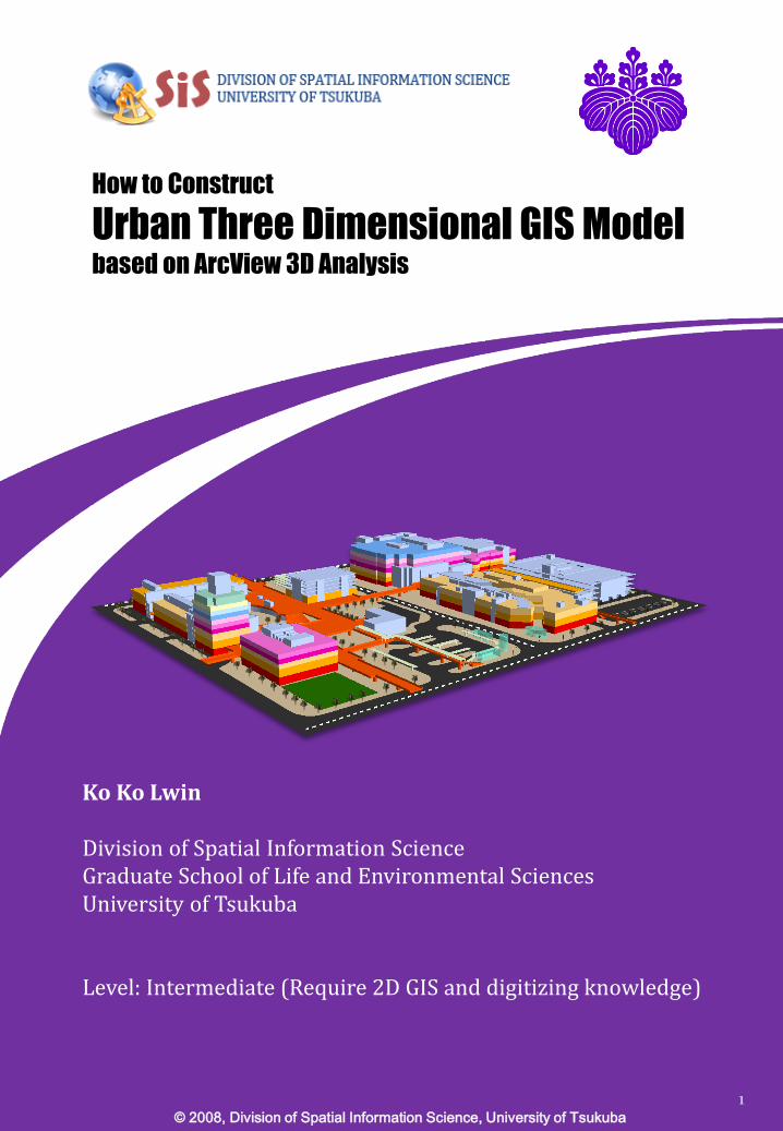
How to Construct
Urban Three Dimensional GIS Model based on ArcView 3D Analysis
© 2008, Division of Spatial Information Science, University of Tsukuba
1
Ko Ko Lwin
Division of Spatial Information ScienceGraduate School of Life and Environmental SciencesUniversity of Tsukuba
Level: Intermediate (Require 2D GIS and digitizing knowledge)
Preface
Visualization of three dimensional urban area is requiredfor effective urban development planning, utilitymanagement, public facility management andenvironmental impacts studies. The ArcView 3D Analystextension enables users to create, analyze, and displaysurface data along with other GIS dataset such as census,land use, transportation, vegetation, etc. Although ArcGISsupports 3D solid model, ArcGIS was extensively used inGIS analyses and other scientific purposes. In this tutorial,we will explain how to construct urban three dimensionalGIS model based on ArcView 3D Analysis extension. Beforedigging this tutorial, I assumed that you have alreadyexperienced in two dimensional GIS and digitizingknowledge. This tutorial does not cover digitizing anddatabase designing in 2D GIS. However, if you haveexperience in digitizing and database designing, you canexplore each map layer in this tutorial and then you willunderstand how to create map layers for 3D rendering.
Enjoy!
Ko Ko Lwin
Division of Spatial Information ScienceUniversity of Tsukuba
2

Contents
1. Download Tutorial Data2. Components of 3D GIS Model3. Map Layers Creation4. Construction of Urban 3D GIS Model
3

1. Download Tutorial Data
Download tutorial data from following URL.http://giswin.geo.tsukuba.ac.jp/sis/tutorial/koko/3dgis/3dgisTutorial.pdf
Unzip into your local disk (C or D)e.g. D:¥3D‐URBAN
Start ArcScene
Start > All Programs > ArcGIS > ArcScene
4

2. Components of 3D GIS Model
Data requirement for 3D GIS model:
EssentialEvery 3D GIS model requires surface elevationdata which can be acquired from many remotesensing data sources such as SRTM (Shuttle RadarTopography Mission), LIDAR (Light Detection andRanging) Elevation Data and so on.
Following URLs are free resources of digitalelevation data for worldwide coverage.
GEOTOPOhttp://eros.usgs.gov/#/Find_Data/Products_and_Data_Available/gtopo30_info
SRTMhttp://srtm.csi.cgiar.org/
OptionalDepend on your interesting in detailed level oftopographical features, additional optical images(satellite or aerial images) or fine scale GIS data(building footprints and other landscape features)are required to drape on surface elevation model.
Example of medium scale 3D GIS model
Aerial photo + 10m DEM
5
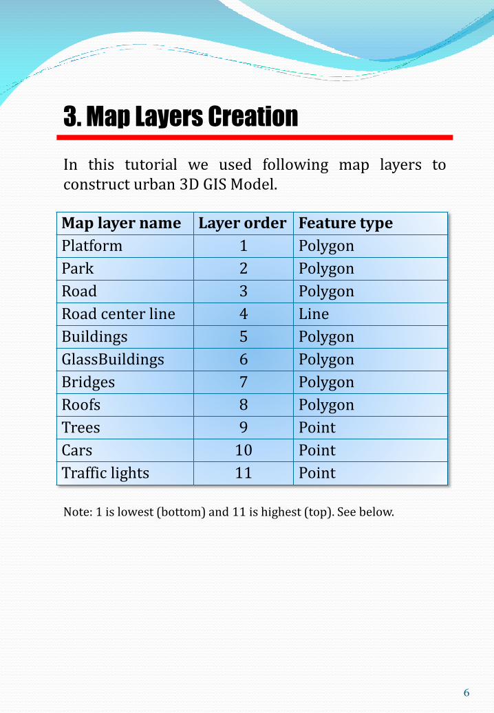
3. Map Layers Creation
In this tutorial we used following map layers toconstruct urban 3D GIS Model.
Map layer name Layer order Feature type
Platform 1 Polygon
Park 2 Polygon
Road 3 Polygon
Road center line 4 Line
Buildings 5 Polygon
GlassBuildings 6 Polygon
Bridges 7 Polygon
Roofs 8 Polygon
Trees 9 Point
Cars 10 Point
Traffic lights 11 Point
Note: 1 is lowest (bottom) and 11 is highest (top). See below.
6

How to create map layers?
These map layers are digitized on high resolutionaerial image (spatial resolution is 8cm) and heightinformation is extracted from DSM (Digital SurfaceModel) generated by LIDAR (Light Detection andRanging). LIDAR (Light Detection and Ranging) is anoptical remote sensing technology that measuresproperties of scattered light to find range and/orother information of a distant target.
Digitizing and Database Designing (In brief)
3. Map Layers Creation
7
Example in Building map layer digitizing anddatabase designing.

8
3. Map Layers Creation
Elevation and Height
Each map layer requires two attribute fields, Elevationand Height for 3 dimensional rendering
Elevation
Height
Ground based materials• building• roads• parks• etc.
Elevation
Height
Floating materials• roofs• floors• bridges• etc

9
Height information extracted from DSM
In this tutorial, we generated building heightattribute information from DSM (Digital SurfaceModel) LIDAR data.
3. Map Layers Creation
DSM
Building
Building height attribute information
10
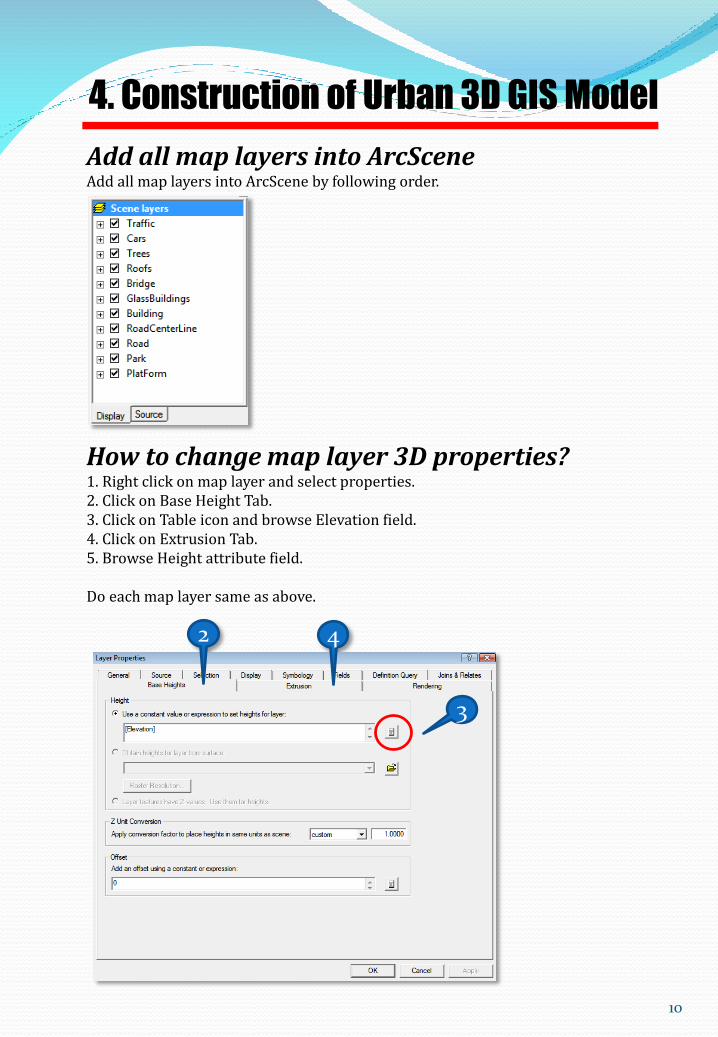
4. Construction of Urban 3D GIS Model
Add all map layers into ArcSceneAdd all map layers into ArcScene by following order.
How to change map layer 3D properties?1. Right click on map layer and select properties.2. Click on Base Height Tab.3. Click on Table icon and browse Elevation field.4. Click on Extrusion Tab.5. Browse Height attribute field.
Do each map layer same as above.
3
2 4
11
4. Construction of Urban 3D GIS Model
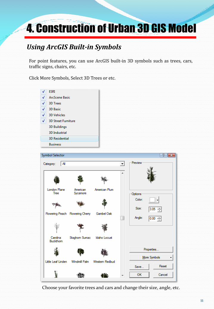
Using ArcGIS Built-in Symbols
For point features, you can use ArcGIS built-in 3D symbols such as trees, cars,traffic signs, chairs, etc.
Click More Symbols, Select 3D Trees or etc.
Choose your favorite trees and cars and change their size, angle, etc.

12
4. Construction of Urban 3D GIS Model
Change color and transparency for each layer as you wish.
Navigate your 3D Scene
Moving, panning and rotating Reset or zoom all layers
Using mouseZoom in: Mouse wheel upZoom out: Mouse wheel downPanning: Click and hold both right and left buttons

13
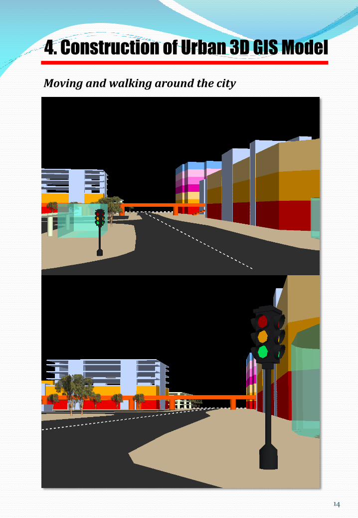
4. Construction of Urban 3D GIS Model
Moving and walking around the city
14
4. Construction of Urban 3D GIS Model
Moving and walking around the city

15
4. Construction of Urban 3D GIS Model
Moving and walking around the city
………. End of document ……….
Division of Spatial Information Science, Graduate School of Life and Environmental Sciences,
University of Tsukuba1-1-1 Tennodai, Tsukuba, Ibaraki 305-8572 Japan.