Embed Size (px)
Citation preview
952
7.5 GIS Data Based Automatic High-Fidelity 3D Road Network Modeling
GIS Data Based Automatic High-Fidelity 3D Road Network Modeling Jie Wang and Yuzhong Shen
Department of Modeling, Simulation, and Visualization Engineering Old Dominion Univers ity
[email protected], [email protected] Abstract. 30 road ~odels are widely used in many computer applications such as racing games and driving simulations_ However, almost all hl~h.-fideilly 3D road models were generated manually by professional artists at the expense of intensive labor. There are ver:J few eXlsllng methods for automatically generating 30 high-fidelity road networks, especially those existing in the real world. This paper pr.esents a novel approach thai can automatically produce 3D high-fidelity road networX models from real 20 road GIS data that mainly contain road. centertin~ in formation. The proposed method first builds parametric representations of the road cen~ertlnes through segm~ntallon and fitting . A basic set of civit engineering rutes (e.g ., cross stope , superelevation, grade) for road desl~n are then selected In orde.r to generat.e realistic road surfaces in compliance with these rules. While the proposed method ap~lIes to any types of roads, thiS paper mainly addresses automatic generation of compleK traffic interchanges and intersections which are the most sophisticated elements in the road networks. '
1.0 INTRODUCTION Road networks are critical infrastructures of human civilization and probably the most important means of transportation. With advances in computing technologies, 20 and 3D road models have been employed in many applications, such as computer games and virtual environment construction. Roads are complex 3D structures and traditional road models were generated by professional artists manually using modeling software tools such as Maya and 3ds Max. This approach requires both highly specialized and sophisticated skills and massive manual labor. Procedural modeling based automatic road generation methods [1-6] create road models using specially designed computer algorithms or procedures and they can dramatically reduce or eliminate the amount of manual editing needed for road modeling. However, most existing procedural road modeling methods aimed at the visual effects of the generated roads , not the geometric or architectural fidelity that mostly determines the driving experience.
Geographic information systems (GIS) are computer-based systems widely used to store, manipulate, display, and analyze geographic information in many fields. With the rapid development and widespread use of GIS techniques, vast GIS data are captured through various digital data collection methods such as remote sensing via cameras, digital scanners and Ll oAR.
As one kind of them, road GIS data which record the information of the real road network in the best possible way have also been used in many applications and facilitate our lives greatly, e.g., the automotive navigation system. Since real road GIS data contain road network information which is indispensable for some applications, especially for transportation, homeland security and defense applications, it will significantly reduce both the time and lab cost if 3D road network can be modeled from road GIS data directly and automatically. However, there are very few existing methods for GIS based automatic 3D high-fidelity road networks generation. Most GIS based modeling work and software focus on buildings [7, 8], vegetation and rural landscape visual ization [9-11] rather than roads.
Therefore, a method that can automatically produce 3D high-fidelity road network models from real road GIS data will greatly benefit numerous applications involving road networks. This paper addresses this problem by proposing a novel method which is used in an ongoing project to automatically generate 3D high-fidelity road network models from existing road GIS data in compliance with a set of selected civil engineering rules. The proposed method consists of several steps, including road GIS data preprocessing, road representation parameterization, civil engineering rules based road surface
https://ntrs.nasa.gov/search.jsp?R=20110012094 2018-08-20T20:47:55+00:00Z
953
modeling, and intersection and interchange generation.
Th is paper is organized as follows: section 2 describes each step of the proposed method in detail ; section 3 discusses the application fields and advantages of the proposed method, and finally this paper is concluded in section 4.
2.0 BODY In this section, the whole road network modeling method is described using a road network which contains several road segments, road intersections and a traffic interchange as shown in Figure 1 (a) as an example.
2.1 Road GIS Data Preprocessing
2.1 .1 GIS Data Import Although various data formats have been developed for GIS applications, such as GML (Geographic Markup Language) and TIGER (reference file format), shapefile format is the most widely used format and it is utilized in this research. A typical shapefile consists of a main file , an index file , a dBase file and a projection file. Among them, the first three files define the geometry and attributes in a shapefile. Three kinds of shape types are used to represent geometric shape features, which are point, polyline and polygon {12]. The main file contains the primary reference data with one record per shape feature; the index file stores the position and content length for each record in the main file; the dBase file contains the feature attribute for each record in the main fi le. A library named shapelib [1 3] is used in this project to read data from shapefile.
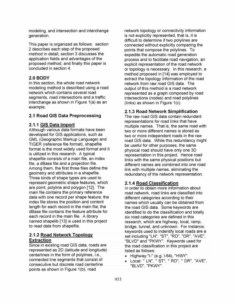
2.1 .2 Road Network Topology Extraction Since in existing road GIS data, roads are represented as 20 (latitude and longitude) centerlines in the form of polylines, i.e., connected line segments that consist of consecutive but discrete road centerline points as shown in Figure 1 (b) , road
network topology or connectivity information is not explicitly represented, that is, it is difficult to determine if two polylines are connected without explicitly comparing the points that compose the polylines. To expedite the automatic road generation process and to facilitate road navigation, an explicit representation of the road network or topology is necessary. In this research , a method proposed in (14) was employed to extract the topology information of the road network from raw road GIS data. The output of this method is a road network represented as a graph composed by road intersections (nodes) and road polylines (links) as shown in Figure 1 (c) .
2.1.3 Road Network Simplification The raw road GIS data contain redundant representations for road links that have multiple names. That is, the same road with two or more different names is stored as two or more independent roads in the raw road GIS data. VV'hile this redundancy might be useful for other purposes, the same physical road should have only one 3D representation in this project. Hence road links with the same physical positions but different names are combined into one road link with multiple names, eliminating the redundancy of the netvvork representation.
2.1.4 Road Classification In order to obtain more information about road network, road links are classified into different categories according to their names which usually can be obtained from the road GIS data. Some keywords are identified to do the classification and totally six road categories are defined in this research , which are highway, local , ramp, bridge, tunnel , and unknown. For instance, keywords used to indentify local roads are a set including "LN", "ST", "RO", "OR", "AVE", "BLVD" and "PKVVY". Keywords used for the road classification in this project are listed as follows: • Highway:"I-" (e.g. 1-64). "HWY". • Local:" LN", " ST", " RO", " DR", "AVE",
"BLVD". "PKWY".

954
. '. i __ • f-. " • . .. - ' ',. .,. ~
'--... ' , . . . .. ,'
, .. : : ' ': :-',
.. " " , "
. , " , , .. , ,
' -t:-< .-" . ... :-~ .. , )
'-
, . , . :/' . . . ; . .......
.~ ~:. . . ":' --
... ~.~'-"'" .' ,
. . - . . ... _.-. . " ~ .: ' " ... -, ,
, -, ,.... ',' ' ..
_. ',' . ~' L. --'~ '~., ,I ,~.
--.:;---;: / ' \
.... .. ,. ' '. ,: '\ ' " .. '
la) Ib)
.. -, Ie)
Figure 1 A road network example which contains several road segments, road intersections and a traffic interchange. (a) Satellite photo around VA403 Norfolk, VA from USGS. (b) Road centerline and discrete road centerline points from road GIS data shown in ArcGIS for the same area. Ie) Road network after topology extraction with extracted nodes indicated by red points.
• Ramp: "RAMP", 0-9+A-Z (e.g. 148). • Bridge: "BRIDGE". • Tunnel : "TUNNEL". • Unknown: "NULL".
2.2 Parametric Representation
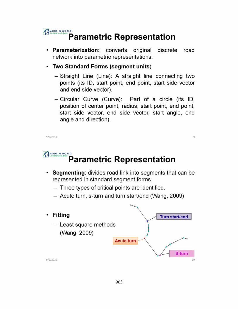
2.2.1 Parameterization As mentioned before, the road GIS data only contain discrete pOints of the road network in the form of polylines. This discrete representation has several drawbacks, with the most serious one being not supporting arbitrary resolution of representations. The proposed method converts the original discrete representation of the road network into parametric representations that have the advantages of supporting arbitrary resolution of levels of details (LOD) and reduced memory usage. Two standard parametric forms are defined as Straight Lines and Circular Curves.
• Straight Line (Line): A straight line connecting wo points and specified by its 10, start point, end point, start side vector and end side vector.
• Circular Curve (Curve) : Part of a circle and specified by its 10, position of center point, radius, start point, end point, start side vector, end side vector, start angle, end
angle and direction (clockwise I anticlockwise) .
Among these parameters, side vectors indicate the extension direction of road surface. This representation of road centerline data has several advantages. First of all , it is relatively simple and easy to understand and implement. More importantly, it is well-suited to apply civil engineering principles, especially for superelevation generation of curve road for which the center point and radius are required .
2.2.2 Segmenting and Fitting In order to divide the road links into segments that can be represented in standard segment forms , three types of critical points are identified to segment the road polylines: acute turn , s~turn and turn start/end [15] based on their geometric features. After the critical points are identified, road polyline links are partitioned into a set of segments that are groups of discrete points ready for segment fitting to obtain their appropriate analytic representations. Then least square methods [15] are employed to fit these road segments into straight lines and circular curves optimally. Based on the parametric

955
representation of road network, different levels of details can be employed to generate the road model.
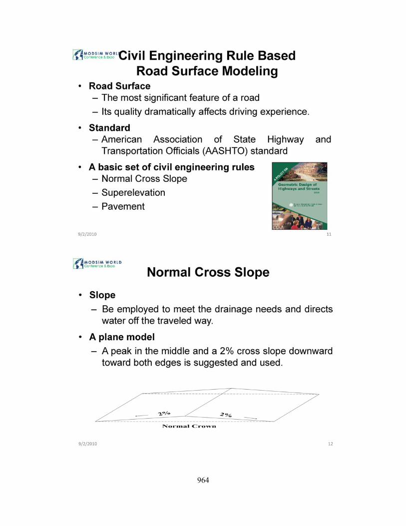
2.3 Civil Engineering Rule Based Road Surface Modeling Since the road surface is the most significant feature of a road and its quality dramatically affects our driving experience, principles and rules on road surface design are of ultimate importance. To model this most critical component of roads realistically, namely, road surface, a basic set of civi l engineering rules for road design are selected, including design speed, cross slope, superelevation, grade, etc. The road surfaces wi ll be generated in compliance with these civil engineering rules. Among all of them , normal cross slope for most road surfaces and superelevation for some curved road surfaces are two major factors directly determining the main shape of the road surfaces. Besides these, method for pavement modeling and rendering is also discussed in this section.
2.3.1 Normal Cross Slope Sloping on roadway cross section is employed to meet the drainage needs and direct water off the traveled way to facilitate road users and reduce accident potential. According to American Association of State Highway and Transportation Officials (AASHTO) standards [16]. a ptane model with a peak in the middle and a 2% cross slope downward toward both edges is preferred in this research for normal road surface modeling as shown in Figure 2.
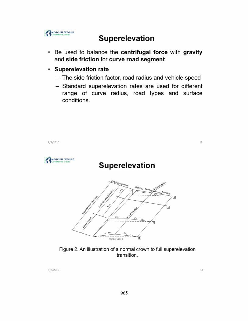
2.3.2 Superelevation The superelevation of a curved road segment is used to balance the centri fugal force that moves the vehicle traveling on this curve outward with gravity and side friction according to the laws of mechanics. Based on civil engineering rules [16] , the superelevation rate can be determined based on the side friction factor, road radius and vehicle speed and in this research, the standard superelevation rates suggested by [16] are used for different range of curve
radius , road types and surface conditions. The centerline of the roadbed is used as the axis of rotation for superelevation and an illustration of a superelevation transition from normal crown to full superelevation can be found in Figure 2.
OJ
Figure 2 An illustration of a normal crown to full superelevation transition
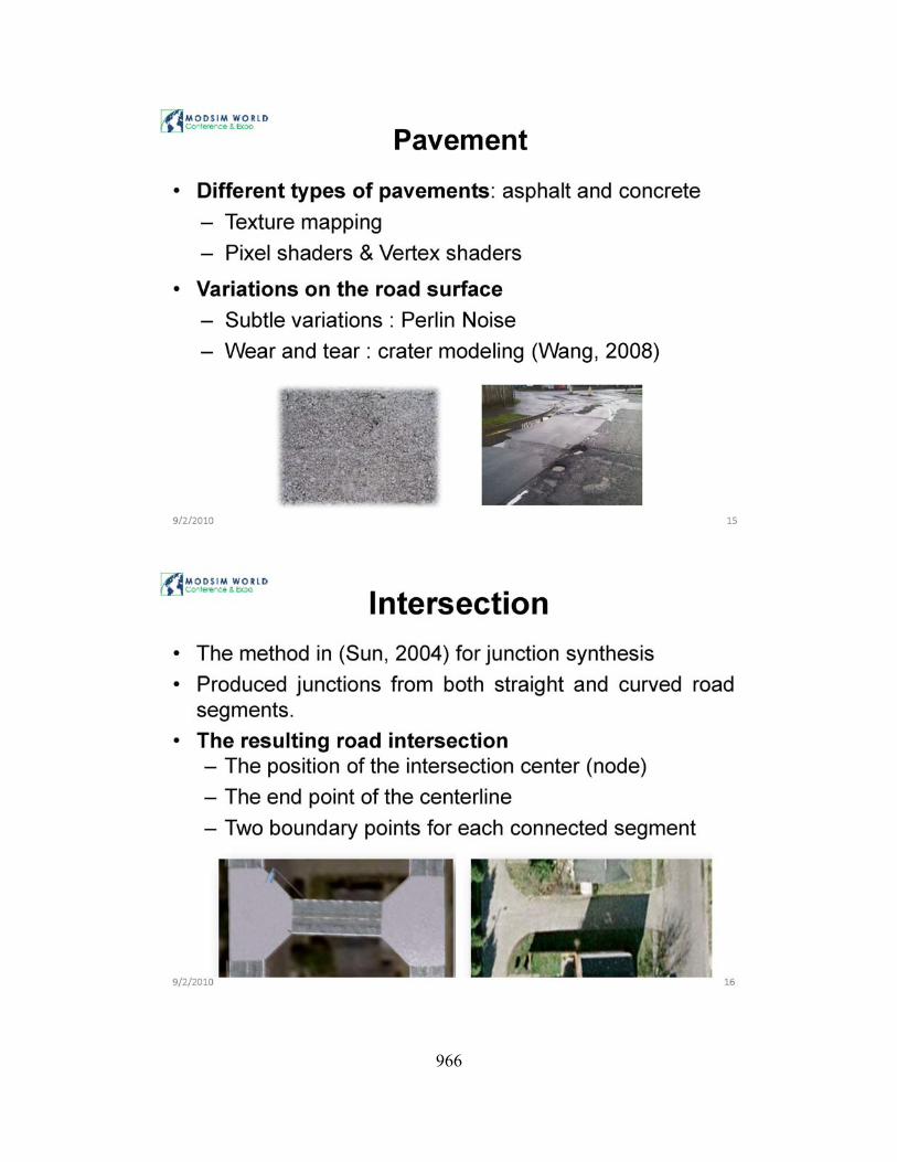
2.3.3 Pavement Road surfaces contain different types of pavements such as asphalt and concrete. Several methods can be used to render the road surface (pavements) , which are texture mapping , programmable pixel shaders, and programmable vertex shaders. Besides visual simulation of the road surfaces , the geometry of the road surfaces can be further modified to reflect the variations on the road surface using programmable vertex shaders by adjusting the vertex positions. For instance, subtle variations of the road surface can be achieved by applying Perlin Noise and significant changes of the road conditions can be obtained through addition of holes to the road surface. We have generated a series of mathematical models for modeling different kinds of craters on planetary surface [17] . These craters can be further modified to simulate the wear and tear of road surface.
2.4 Intersection and Interchange
2.4.1 Intersection The method discussed in [18] for junction synthesis was adopted, expanded and finally integrated into this research to
956
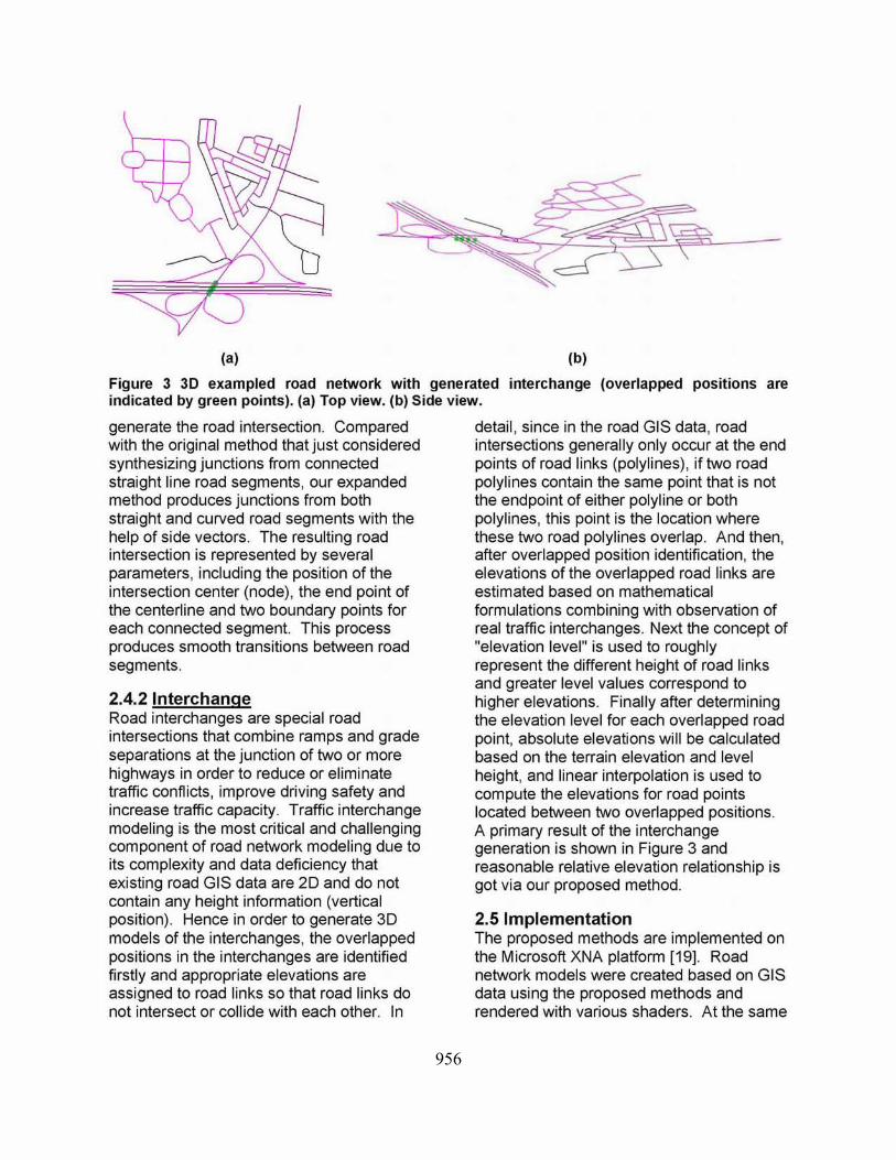
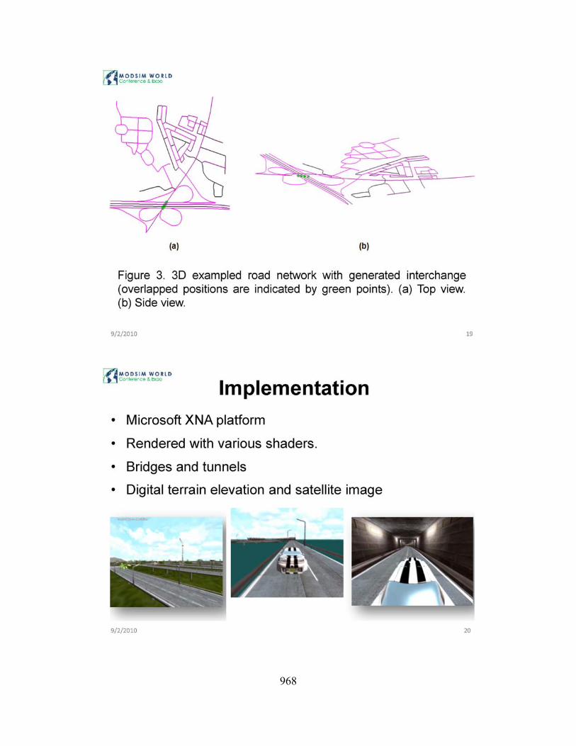
~I (bl Figure 3 3D exampled road network with generated interchange (overlapped positions are indicated by green points). (a) Top view. (b) Side view.
generate the road intersection. Compared with the original method that just considered synthesizing junctions from connected straight line road segments, our expanded method produces junctions from both straight and curved road segments with the help of side vectors. The resulting road intersection is represented by several parameters, including the position of the intersection center (node), the end point of the centerline and two boundary points for each connected segment. This process produces smooth transitions between road segments.
2.4.2 Interchange Road interchanges are special road intersections that combine ramps and grade separations at the junction of two or more highways in order to reduce or eliminate traffic conflicts, improve driving safety and increase traffic capacity. Traffic interchange modeling is the most critical and challenging component of road network modeling due to its complexity and data deficiency that existing road GIS data are 20 and do not contain any height information (vertical position). Hence in order to generate 3D models of the interchanges, the overlapped positions in the interchanges are identified firstly and appropriate elevations are assigned to road links so that road links do not intersect or collide with each other. In
detail, since in the road GIS data, road intersections generally only occur at the end points of road links (polylines) , if two road polylines contain the same point that is not the endpoint of either polyline or both polylines, this point is the location where these two road polylines overlap. And then, after overlapped position identification, the elevations of the overlapped road links are estimated based on mathematical formulations combining with observation of real traffic interchanges. Next the concept of "elevation level" is used to roughly represent the different height of road links and greater level values correspond to higher elevations. Finally after determining the elevation level for each overlapped road point, absolute elevations will be calculated based on the terrain elevation and level height, and linear interpolation is used to compute the elevations for road points located between two overlapped positions. A primary result of the interchange generation is shown in Figure 3 and reasonable relative elevation relationship is got via our proposed method.
2.5 Implementation The proposed methods are implemented on the Microsoft XNA platform [19]. Road network models were created based on GIS data using the proposed methods and rendered with various shaders. At the same
957
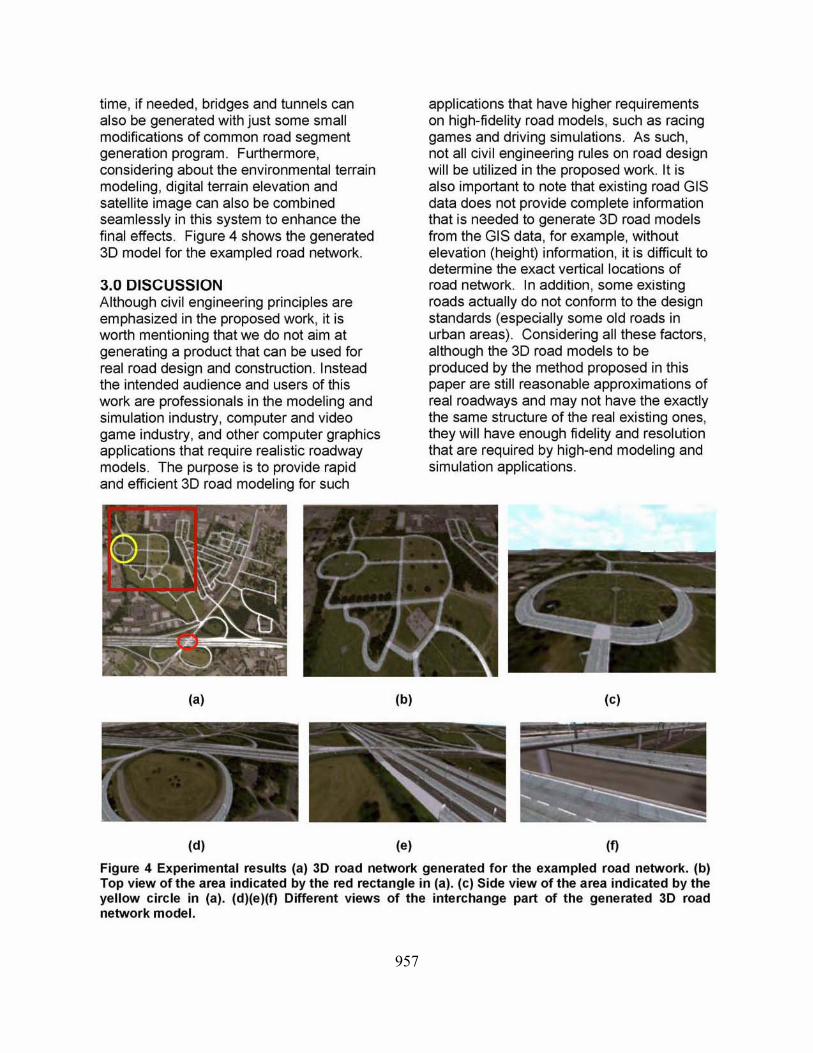
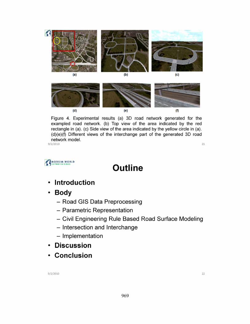
time, if needed, bridges and tunnels can also be generated with just some small modifications of common road segment generation program. Furthermore, considering about the environmental terrain modeling, digital terrain elevation and satellite image can also be combined seamlessly in th is system to enhance the final effects. Figure 4 shows the generated 3D model for the exampled road network.
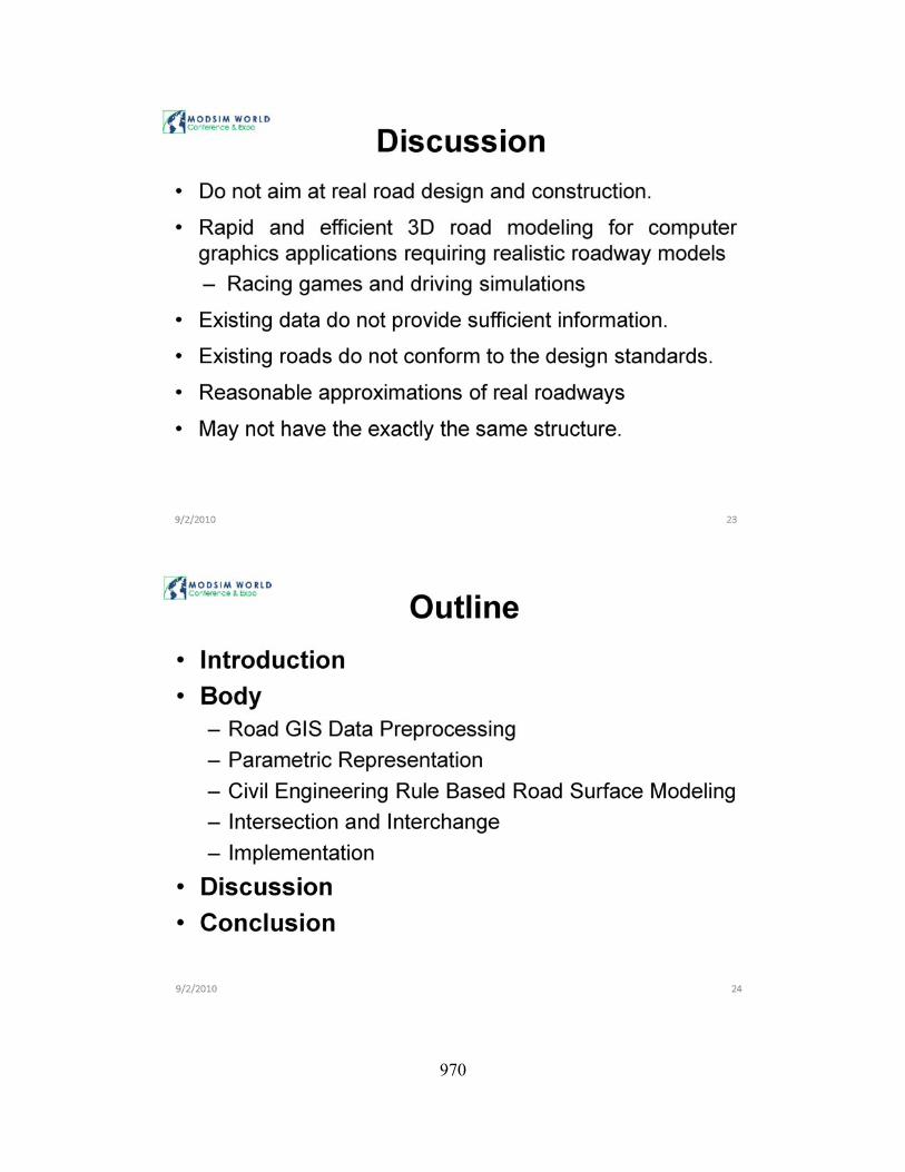
3,0 DISCUSSION Although civil engineering principles are emphasized in the proposed work, it is worth mentioning that we do not aim at generating a product that can be used for real road design and construction. Instead the intended audience and users of this work are professionals in the modeling and simulation industry, computer and video game industry, and other computer graphics applications that require realistic roadway models. The purpose is to provide rapid and efficient 3D road modeling for such
(al
(dl
(bl
(el
applications that have higher requirements on high-fidelity road models, such as racing games and driving Simulations. As such, not all civil engineering rules on road design will be utilized in the proposed work. It is also important to note that existing road GIS data does not provide complete information that is needed to generate 3D road models from the GIS data, for example, without elevation (height) information, it is difficult to determine the exact vertical locations of road network. In addition, some existing roads actually do not conform to the design standards (especially some old roads in urban areas). Considering all these factors , although the 3D road models to be produced by the method proposed in this paper are still reasonable approximations of real roadways and may not have the exactly the same structure of the real existing ones, they will have enough fidelity and resolution that are required by high-end modeling and simulation applications.
(el
(I)
Figure 4 Experimental results (a) 30 road network generated for the exampled road network. (b) Top view of the area indicated by the red rectangle in (a). (c) Side view of the area indicated by the yellow circle in (a) . (d)(e)(f) Different views of the interchange part of the generated 3D road network model.
958
4.0 CONCLUSION In conclusion, this paper worked on the automatic generation of 3D high-fidelity road network. models from real road GIS data. The proposed method can apply to the modeling of the whole road network. that is critical for applications that have stringent requirements on high fidelity road network, such as driving and transportation simulation. Also with minor modification, the proposed method can be extended for other areas, such as generation of subway system based on 20 subway maps.
5.0 REFERENCES [1] Y . I. H. Parish and P. Muiler.
"Procedural modeling of cities," in Proceedings of the 28th annual conference on Computer graphics and interactive techniques: ACM, 2001.
[2] J . Sun, X. Yu, G . Baciu, and M . Green, "Template-based generation of road netvvorks for virtual city modeling," in Proceedings of the ACM symposium on Virtual reality software and technology Hong Kong, China: ACM , 2002.
[3] T . Lechner, B. A. Watson, U. WIlensky, and M. Felsen, "Procedural City Modeling," in 1 sf Midwestern Graphics Conference, 2003.
[4] D. F. Evans, "High-fidelity Roadway Modeling for Real-time Driving Simulation." vol. Master: The University of Iowa, 1995.
(5) P. Willemsen, J . K. Kearney , and H. Wang, "Ribbon Networks for Modeling Navigable Paths of Autonomous Agents in Virtual Environments ," IEEE Transactions on Visualization and CompulerGraphics, vol. 12, pp. 331-342, May-June 2006.
[6) G . Thomas and S. Donikian, "Modelling virtual cities dedicated to behavioural animation," Computer Graphics Forum, vol. 19 , pp. 71-80, 2000.
(7] CommunityViz, "CommunityViz," in http://placeways.coml.
[8]
[9]
[10]
[11]
[12]
[13]
[14]
[15]
[16]
[17]
[18]
[19]
W . Lin , "Constructing a GIS-based 3D urban model using LiDAR and aerial photographs," in Geography. vol. MASTER OF SCIENC E, 2005, p. 175. A . Werner, O . Deussen, J. Dollner, H. C. Hege, P. Paar, and J . Rekittke, "Lenne3D-Walking through landscape plans," Trends in real-time landscape visualization and participation. Berlin: Wichmann, pp. 48-59, 2005. S. Ernst, "Inside Biosphere3D," in The free digital globe from a developer prospect. E.-o. Software, "Vue 8 - Digital Nature," in http://wwW.eonsoftware.coml. Wlkipedia, "Shapefile ," in http://en. wikipedia.orglwikilShapefile. "Shapelib," in http://shapelib. maploots. org! S. K. Jakkula, Y. Shen, and J . Sokolowski , "Extraction of Road Network Topology for Transportation and GIS Applications," in MODStM World Conference & Expo Virginia Beach, VA , 2007. J . Wang, O. Unal, M. Cetin, Y . Shen, and Y . Papel is , "High-Fidelity Roadway Modeling and Simulation ," in MODSIM World Conference & Expo 2009 Virginia Beach, VA, 2009. AASHTO , A Policy on Geometric Design of Highways and Streets. Washington, D.C, 2004. J. Wang and Y. Shen, "Synthesizing High-resolution Terrains with Craters ," in 2008 Modeling and Simulation Capstone Conference Norfolk, VA, 2008. J . Sun, G. Baciu, X. Yu, and M . Green, "IMAGE-BASED TEMPLATE GENERATION OF ROAD NETWORKS FOR VIRTUAL MAPS," International Journal of Image and Graphics, vol. 4 , pp. 701-720, 2004. Microsoft, "XNA," in http://www.xna.coml.
959
960

961

962
963
964
965
966

967
968
969
970

971