Embed Size (px)
Citation preview

Denton and Johnston; Housing Development on the Tahunanui Slump Page 1
Housing Development on a Large, Active Landslide:
The Tahunanui Slump Story, Nelson, New Zealand Paul C Denton Mike R Johnston Soils & Foundations Ltd, Nelson
SYNOPSIS: Nelson has a wide range of slope instability which largely reflects the varied geology of this city. One area of significant instability involves about 26 ha of hillside overlooking popular Tahunanui Beach. This area, the active Tahunanui Slump, is part of a complex rotational landslide. The active slump, some 700 metres wide, extends from sea level to the crest of the Port Hills and contains about 120 houses. Significant, extensive movements and related damage are documented within the Tahunanui Slump in the 1890s, 1929 and 1962 and involve roads and houses. Ongoing resurveys of the area confirm that less damaging movements are continuing, albeit at different rates in different areas. Residential development, which commenced in the 1920s, has been restricted since 1985 by the Nelson City Council who assumed responsibility for the Tahunanui area in 1950. The Building Act of 1991, and more specifically Section 36(2) has changed the basis by which land development can by regulated. The Resource Management Act 1991 specifies legal requirements to identify, inform and protect the public from landsliding hazards. The Tahunanui Slump poses a hazard to development including the possibility that developments on parts of it could be a danger to life. We present the results of our investigations to date. 1.0 INTRODUCTION
The picturesque hills above Tahunanui Beach in Nelson have been regarded by many as a desirable residential area for almost as long as slope instability has been recognised. Since the late 1800s, significant ground movements have been recorded in an area known as the Tahunanui Slump and comprise both dramatic failure events and less spectacular ongoing ground deformation (Bruce, 1962; Falconer, 1962; Falconer, 1963; Fyfe, 1963; Northey, 1962). Recorded major events include movement and damage in • 1893 during road construction across its toe • 1929 in the lower northern portion following
heavy rain and earthquake ground shaking
• 1935 near the centre • 1957 towards the upper eastern edge • 1962 the lower northern portion following
heavy rain and earthquake ground shaking Ongoing periodic ground resurveys initiated in 1953 have confirmed movement is continuing. The latest 10 yearly resurvey indicates horizontal movements of on the order of 100mm and vertical movements of on the order of 50mm for the period 1985-1994 (West, 1994). The Nelson City Council (NCC) assumed responsibility for the Tahunanui area in 1950 as a result of local government reorganisation and later initiated a stormwater drainage scheme

Denton and Johnston; Housing Development on the Tahunanui Slump Page 2
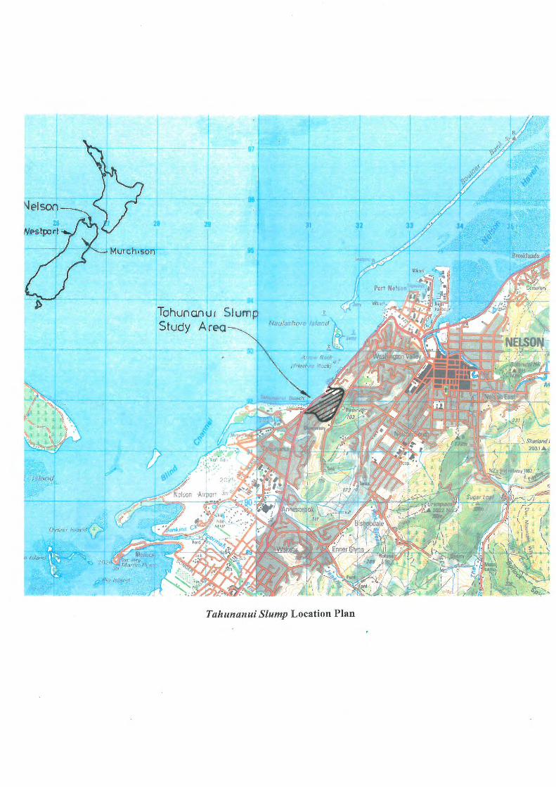
which had been previously lacking (Dickinson, 1990 and others). In recognition of the instability of the area the NCC has, since October 1985, imposed property development restrictions. With passage of the Building Act 1991, which came into effect from July 1992, the NCC has embraced a redefinition of its statutory obligations in several ways. Since 1991 Soils & Foundations has investigated more than 20 individual residential properties within the boundaries of the Tahunanui Slump. As part of a recent review of the slump we defined these boundaries in preparation for their inclusion in a Nelson City Council Geographic Information System (Soils & Foundations, 1995). These boundaries, to an accuracy no greater than ± 20 metres, are approximately shown on the Site Plan, Figure 1. Additional investigations are currently underway and we have documented a variety of features relating to the slump including • disturbed foundations (some removed
following failure) • localised ground settlement • deep, offset ground cracking (some
preserved beneath houses and other structures)
• localised elevated groundwater • damaged service utilities One of the principle findings of our review of the Tahunanui Slump is that it is a complex feature within a much larger landslide and that it contains a number of subsidiary failures of varying orders of magnitude (Soils & Foundations, 1995). Another is that insufficient data collection and interpretation has been completed to date. This latter finding has implications to both the knowledge and understanding of the geotechnical setting of the Tahunanui Slump as well as the selection of the most appropriate planning and regulation option(s).
2.0 BACKGROUND
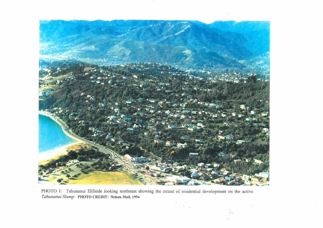
The hillside area containing the Tahunanui
Slump has long been recognised by developers and property owners as a desirable residential area (see photo 1) owing to a number of unique features including its • sunny northwesterly aspect • proximity to the accessible, sheltered
Tahunanui beach • spectacular views over Tasman Bay • varied topography including gently sloping
and reverse slopes on what would otherwise have been a moderately steep hillside
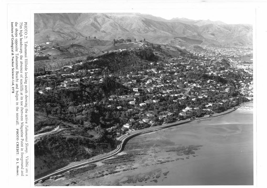
Ironically this topography, which makes the hillside appealing and in part encouraged residential development, is the result of large scale rotational slumping over a period of thousands of years. Also instability was recognised before residential development and certainly prior to the turn of the century and probably even from the time of European settlement in 1840. A summary of milestones is listed below and the affected areas, where records exist, are indicated on the Site Plan, Figure 1. 1893 In 1893 construction of Rocks Road across the toe of the slump was well advanced when significant stability problems were encountered. Movement resulted in bulges in the sea wall at the edge of the road which, although the sea wall has since been reconstructed, are still visible (Photo 2). No correlation between road damage and the instability of the hillside above was apparently made at that time. Surveys, for the subdivision of the hillside into residential allotments, were begun in the 1920’s and subsequent resurveys were to later provide the first hard measurements of movement. 1929 On the morning of 17 June 1929 a major earthquake centred near Murchison (RM 7.8*) was felt in Nelson with local shaking intensity of MM VIII*. Heavy rains and numerous

Denton and Johnston; Housing Development on the Tahunanui Slump Page 3
aftershocks affected the area in the weeks that followed. Approximately one month latter, during the night of 13 - 14 July 1929 two houses were wrenched off their foundations by landsliding adjacent to major road cracking. Local newspaper accounts reported an area of 2 ha was involved and that the hillside moved 5 metres down and across Rocks Road at the toe. Surface bulging of the road, involving some 3 metres of carriage width, was reported. 1939 Professor Patrick Marshall of Otago University reported on the hillside and identified it as an active landslide in an unpublished report to the Loans Board in November, 1939 (Marshall, 1939). The Loans Board subsequently refused permission to raise a loan for water reticulation only and insisted on adequate stormwater drainage and sewerage simultaneously. Several months later the NCC gave permission to tap a recently completed City Council high pressure water main in the area without the requirement for sewerage or stormwater drainage. 1944 Some survey plans, including plan #3310 dated July 1944, recorded up to 1.6 metres of movement on the lower part of the slump presumably since the first subdivisional surveys were completed 20 years earlier. 1957 A 375 mm diameter high pressure water main failed by tension indicating 200mm of movement since its installation in 1940. Ground cracking developed on several lawns in the vicinity in the upper eastern portion of the Tahunanui Slump. At least one 50mm crack developed beneath the foundation at the centre of a nearby house.
1962 On 10 and 17 May 1962, moderate earthquakes centred near Westport (RM 5.9) shook the area with a felt intensity of MM IV. 1962 had also been the wettest year since reliable records were began in 1862 and approximately two weeks following these earthquakes, there was further heavy rain in the area. On 1 June 1962 damaging movement occurred within the slump and of nine houses that were directly affected, four suffered serious damage with at least one being condemned and torn down. An area of 1 ha immediately above Rocks Road and south of the 1929 movement was affected. Minor movement and damage was recorded elsewhere, being widely distributed throughout the body of the slump. Further movement occurred following wet weather later that year and may have been related to the removal of toe support during the 1 June failures. Acting on the recommendations of the investigators of the 1962 event, the NCC initiated the installation of a new stormwater system on the hillside which, while construction is largely complete, is continuing.
1994 The most recent survey data compiled by DOSLI confirms continuing movements of apparently similar magnitudes recorded for previous 10 year periods in some localities (West, 1994).
3.0 GEOLOGIC SETTING
3.1 Bedrock Units The western side of the Port Hills consists of a sequence of consolidated well bedded sandstone-mudstone of the Magazine Point Formation which is overlain by the clay bound Port Hills Gravel formation (Johnston 1979,
The Richter Magnitude (RM scale) is a measure of the energy released by an earthquake at its source and it is calculated from seismographic records. It is a logartithmic scale used to measure the magnitude of earthquake waves. For every unit increase in magnitude there is a 31 fold increase in energy. The Modified Mercalli Intensity Scale (MM scale) categorises non-instrumental observations of the effects of an earthquake on people, fittings (furniture, crockery etc), structures and the environment. Although there are twelve levels in the scale, only the first ten (ie up to MM X) have been reliably observed in New Zealand. The Modified Mercallis scale for New Zealand has recently been revised.

Denton and Johnston; Housing Development on the Tahunanui Slump Page 4
1981). The Magazine Point Formation, of early Tertiary age, dips southeast into the Port Hills at about 65 - 70 o (below horizontal). The contact between the Magazine Point Formation and the Port Hills Gravel is an erosional unconformity dipping about 40o southeast which very approximately coincides with the 50 metre contour. The gravel dips parallel to the contact. The hillside from Magazine Point extending approximately 1.4 km to the south has been involved in a very large, complex and deep seated slope failure referred to at the Tahunanui Landslide. The southern half of this landslide is now regarded as inactive, although there are relatively minor failures at periodic intervals. This southern inactive area is not believed to have moved since the cutting of the sea cliffs during the post-glacial sea level maximum (about 6,000 years ago). The northern area, which is the subject of this paper, has however continued to move. This area, measuring approximately 700 metres in width and extending from sea level to the crest of the Port Hills makes up the Tahunanui Slump. The landslide and slump are composed of Port Hills Gravel. The relationship between the various geologic units is shown schematically on Cross-Section A - A’, Figure 2. The rocks of the Magazine Point Formation are well exposed on the shore platform in front of the slump at low tide and in the cliffs above Rocks Road to the immediate northeast. The in
situ Port Hills Gravel formation is exposed in the headscarp of the slump. Higher than normal rainfall in Nelson coupled with several intense rain events in 1995 has though surficial failures provided several fresh exposures in the headscarp. 3.2 Geological History
Rocks of the Magazine Point Formation accumulated during a marine transgression that moved north over the South Island during the early Tertiary (Eocene-Oligocene). The
formation, whose total thickness probably exceeds 1500 metres, was deposited by turbidity currents and submarine debris flows in a relatively shallow sea environment. Following deposition the formation was uplifed, tilted gently southeast and eroded prior to the accumulation of the Port Hills Gravel. The Ports Hills Gravel formation was deposited terrestrially during massive outpourings of debris from rising mountains that mark the onset of the Kaikoura Orogeny in the late Miocene. The formation is at least 500 metres thick and locally contains several metre thick siltstone beds. The Port Hills Gravel and the underlying Magazine Point Formation were subsequently folded and faulted during the mid Pliocene. In situ bedding exposed in the area adjacent to the slump defines the northwestern limb of the Port Hills Syncline which extends northeast through the Port Hills. Deep seated, rotational slumping of these units developed during the late Quaternary and is described more fully in the section on Development of the Tahunanui Slump. 3.3 Faulting and Seismicity
Nelson City lies within the main seismic zone of New Zealand, the zone with the highest rates of earthquake occurrence during the last 150 years of record. It has experienced moderate to strong ground shaking (> MM VIII), from earthquakes originating on faults beyond its boundaries at least five times since European settlement in 1840. A similar level of seismicity can be expected in future, with ground shaking of the order of MM VIII on average every 25 years (Johnston et al. 1993). A trace of the Flaxmore Fault, a component of the northeast trending Waimea-Flaxmore Fault System, is located approximately 2 km to the east of the Tahunanui Slump. The fault system is regarded as active (parts of it have moved within the last 125,000 years) and is therefore the source of past and future earthquakes of

Denton and Johnston; Housing Development on the Tahunanui Slump Page 5
RM > 7.5 that will produce intensities of MM X throughout Nelson City (Johnston et al. 1993). Although the ESE trending Grampian Fault is inferred to be concealed beneath the southern part of the Tahunanui Slump, it is mapped as inactive (Johnston 1979, 1981). 4.0 SLOPE STABILITY ISSUES
4.1 Nature of the Failure The Tahunanui Slump is a complex feature with a number of subsidiary failures of varying orders of magnitude which are summarised in Table 1 below. The approximate boundaries of the Tahunanui
Slump as well as the major subsidiary failures within it are indicated in plan (Figure 1) and in schematic cross-section (Figure 2). The rates and nature of movements within these subsidiary blocks differ substantially as generally indicated by both the periodic resurvey records and the distribution and character of historic failures.
4.2 Development of the Tahunanui Slump
The Tahunanui Landslide has occurred along a surface or sole plane extending from sea level to the top of the Port Hills. This plane intersects at approximately right angles the contact between the Magazine Point and Port Hills Gravel formations. Movement of the material above the sole plane has displaced both formations downslope and westward. Erosion by the sea has removed all of the displaced Magazine Point Formation so that within the boundaries of the landslide only Port Hills Gravel remains. The southern part of the landslide has apparently stabilised allowing coastal erosion to cut a seacliff at its toe. The age of the seacliff is not precisely known but is between 2000 years and 6000 years old. Therefore, the southern part of the landslide has been stable for several thousand years. In contrast the northern part of the landslide, the Tahunanui Slump, has remained active and the sea has been unable to cut a cliff at its toe. Erosion of the toe of the slump, which continued up to the construction of Rocks Road in the 1890s, further destabilised the slump.
TABLE 1 : Order of Magnitude Failures, Tahunanui Hillside
Order of
Magnitude
Description Comment
1° Tahunanui Landslide Southern part is stable 2° Tahunanui Slump The active northern part of the Tahunanui
Landslide. The Tahunanui Slump, of 26 ha, extends from sea level to a 75m high headscarp at the crest of the Port Hills.
3° Subsidiary Slumps Within the Tahunanui Slump there are up to 6 subsidiary slumps each with well defined headscarps and reverse topography.
4° Less well defined movements within the subsidiary slumps
Areas of 1-2 ha, particularly on the lower part of the hillside. Not as deep seated as the subsidiary slumps.
5° Superficial failures Minor failures up to several metres in depth and typical of what may occur on any hillside.

Denton and Johnston; Housing Development on the Tahunanui Slump Page 6
The material removed from the slump was carried by longshore drift southwest where it was deposited, as a series of gravel beach ridges, at the foot of the now inactive southern part of the Tahunanui Landslide. Although coastal erosion has played a major role in the continued movement of the Tahunanui Slump it appears unlikely that it was the cause of the wider Tahunanui Landslide. Both the Magazine Point Formation and Port Hills Gravel have a high natural stability. Slopes underlain by these units have been extensively eroded during the development of the seacliffs adjacent to Nelson Haven and the Waimea Inlet and, with the exception of the Tahunanui area, have not failed. In addition at Tahunanui, both formations dip into the hillside so that there are no obvious planes on which a slope failure of this size could occur. The Grampian Fault close to the southern edge of the Tahunanui Slump may be associated with the slump either by movement of the fault itself or by the creation of a zone of weakness allowing water to penetrate into the hillside (Johnston, 1979). A probable cause of the failure is severe ground shaking resulting from an earthquake centred in the Nelson area many thousands of years ago. The earthquake may have originated on one of the active faults of the adjacent Waimea-Flaxmore Fault System in Nelson City. 4.2.1 Seismicity
Clearly seismicity has been a contributing factor in recent historic failures as both the 1929 and 1962 movements were closely associated with moderate ground shaking at the site. Earthquake ground shaking may have the effect of “reshuffling the deck” and allowing rapid water ingress resulting in movement. A review of records of felt intensity earthquakes which began about 1912, by Northey (1962), indicated earthquakes of MM
IV are relatively frequent in Nelson, occurring on average at least twice a year with MM > IV occurring at least every other year. This suggests that ground shaking alone may not be enough to initiate major movements. It is however possible that this frequency of ground shaking coupled with high rainfall may be responsible for, by minor episodic movements, the total 10 yearly resurvey measurements of ground deformation. 4.2.2 Groundwater
A primary cause of the major movements has been attributed to periods of heavy and sustained rainfall (Northey, 1962; and others). It is, however, the influence of groundwater which is directly linked with such movements and not strictly rainfall. Records indicate numerous springs and permanent ponds existed prior to subdivision of the hillside. While some springs have been intercepted by the stormwater system, their distribution is widespread and not all have been controlled. During upwards of 35 site specific investigations in the Port Hills since 1991, we have encountered elevated levels of groundwater for sites • near the top of the ridge • midslope and lower • on both the eastern and western sides of the
Port Hills at most elevations. These high groundwater levels have been recorded at virtually all times of the year and near the top of a ridge with virtually no capacity for rainfall catchment. 4.2.3 Earthworks
What has also become clear during our review of historic instability is the effect earthworks and other developments related to human activities have had on ground movements. Construction of Rocks Road at the toe is one of the earliest documented links. Our initial review of historic photos suggests that in the
Denton and Johnston; Housing Development on the Tahunanui Slump Page 7
centre of the slump there are localised areas of fill and spoils placement related to early road development for subdivision. Some photos clearly show housing fill pad construction of several metres in thickness surcharging the head of steep slopes further oversteepened by undercutting for road construction and/or widening. Quarrying of road materials was undertaken in some areas (Dickinson, 1990) although their relation, if any, to subsequent damaging movements is not yet known. We believe the association between housing damage and historic ground movement may well, in some cases, be a direct, although difficult to establish, link. A scarcity of documentation and the passage of time, in some cases 50 or more years, complicates the ability to clearly establish any such links. 5.0 LANDUSE CONSIDERATIONS
At present the Tahunanui Slump is extensively built on and is regarded by many, despite its past history of movements, as a desirable residential area. It is also clear that is still active and has yet to reach stability. Although no dramatic movement has occurred since 1962, surveys and other evidence confirm that all of the slump is active, albeit at different rates in different areas. While no damage similar to that of the 1890s, 1929 or 1962 has occurred over the past 33 years such movements cannot be precluded in the future. Indeed, the historical evidence, admittedly over a relatively short time span, indicates that major movement could be expected approximately every 30 years. However, the 1929 and 1962 events may have been partly initiated by ground shaking of water saturated ground. Since 1962 the amount of water infiltrating into the slump has been reduced although it cannot be completely eliminated. Also the effectiveness of the stormwater system in
dewatering the slump has not been determined. It is possible that the amount of water diverted into the stormwater system may not be particularly large in relation to the total volume of groundwater affecting the slump. However, there is probably little doubt that the stormwater system has been effective in drying out the surface of the slump and reducing the incidence of relatively shallow failures. The NCC has undertaken to fulfil its statutory obligations under the Resource Management Act 1991 to assess the hazards and associated risks from, among other things, landsliding, protect the public from known hazards, and to make the public aware of the hazards and the steps which need to be taken to mitigate the effects. Since early 1994 the NCC has begun implementation of a city wide geographic information system (GIS) in order to manage these requirements. The need for a geotechnical component of this GIS has been suggested (Denton, 1994). Delineation of the boundaries of the Tahunanui Slump in the GIS and the development of planning criteria for it is included in the Nelson City District Plan released as a first draft for public comment in October 1995. While geohazards in Nelson City, including the Tahunanui Slump, have been recognised for many years it was not until the damaging movements in 1962 and a severe rainstorm event in 1970 that comprehensive efforts were undertaken by the NCC to manage geohazards. This included establishment of an “Engineering Conditions Registry” for properties associated with recognised geohazards and other engineering constraints. Included were all properties within the recognised boundaries of the Tahunanui Slump.
Since October 1985 further subdivision and building development has been severely restricted within the Tahunanui Slump by Condition #414. With passage of the Building Act 1991, implemented in July of 1992,

Denton and Johnston; Housing Development on the Tahunanui Slump Page 8
Section 36(2) “Building on land subject to erosion etc” has served to guide NCC policy. This section states that the territorial authority (NCC is a Unitary authority) shall grant a building consent provided that “The building work itself will not accelerate, worsen or result in erosion, avulsion, alluvion, falling debris, subsidence, inundation, or slippage of that land or any other property”. Since March of 1995 it has been NCC policy that provided a geotechnical engineering report stating that “Section 36(2) of the Building Act will be satisfied” is submitted by a ‘suitably qualified person’ the Council may issue a building consent. The NCC has attempted to establish a formal register of “suitably qualified persons” but has met substantial resistance from professional engineering organisations and others as late as December 1995. We are aware of 1. Council approval of limited developments
within the Tahunanui Slump where building consents have been accompanied by positive geotechnical engineering reports and
2. Council denial in the case of a negative geotechnical engineering report
It is clear that the Tahunanui Slump is an active feature that has yet to reach stability and therefore poses a hazard to development including the possibility that development on parts of it could be a danger to life. We have recommended that the area be designated a “Geotechnical Special Studies Zone”, subject to specific land development criteria. Options for landuse and development within the Tahunanui Slump identified by Soils & Foundations in 1995 included: • return the area to a state approximately that
prior to residential development, • allow development to continue with urban
infilling by section subdivision and possibly the construction of high occupancy apartment blocks and hotels, or
• maintain the area approximately as it is. One of our major recommendations to assist the NCC in selecting the most appropriate option(s) was implementation of a programme of further work set out in a prioritised list of 12 specific tasks. Clearly development of a more complete picture of the geotechnical character of the Tahunanui Slump is crucial if the best landuse management option(s) are to be selected. 6.0 CONCLUSIONS
6.1 The Tahunanui Slump is an active, complex rotational failure that has yet to reach stability. The approximate limits of the slump have been identified as well as the major subsidary block failures within this boundary.
6.2 Significant, extensive movements and related damage are documented within the body of the Tahunanui Slump in the 1890s, 1929 and 1962 and involve damage to roads and houses. Ongoing re-surveys confirm that less damaging movement are continuing, albeit at differest rates in different areas. 6.3 The Tahunanui Slump poses a hazard to development, including the possibility that development on parts of it could be a danger to life. It has been recommended that the slump be designated a “Geotechnical Special Studies Zone” subject to specific land development criteria. 6.4 Insufficient data collection and interpretations have been completed to date which at present basically limits planning and regulation options to maintaining the slump as a low density residential area. The most appropriate future option is unlikely to become known without completion of the further work recommended. 7.0 ACKNOWLEDGEMENTS We gratefully acknowledge information provided by various personnel at the Nelson City Council, particularly Ms Sue Twigg, Principal Policy Planner and Mr Peter

Denton and Johnston; Housing Development on the Tahunanui Slump Page 9
Thornton, Technical Services Engineer. Resources to present this paper are the courtesy of Royds Consulting Ltd, Nelson. REFERENCES DENTON, P C (1994): A Geotechnical GIS
for Nelson, New Zealand. Massey University Paper, August 1994.
DICKINSON, B E (1990): Historic Tahuna FALCONER, B H (1962): Some notes of the
Tahunanui Hillside, Nelson, November 1962.
FALCONER, B H (1963): Stability of the
Hillside at Tahunanui, Nelson, February 1963.
FYFE, H E (1962): Tahunanui Landslide.
Unpublished report held by the Institute of Geological and Nuclear Sciences, Lower Hutt.
JOHNSTON, M R; HULL, A G; AND
DOWNES, G L (1993): Earthquake,
Landslide and Coastal Hazards in Nelson
City, Ref 413399.21. Institute of Geological & Nuclear Sciences report.
JOHNSTON, M R (1979): Geology of the
Nelson Urban Area New Zealand Geological Survey, Urban Series Map 1.
JOHNSTON, M R (1981): Sheet 027AC - Dun
Mountain, Geological Map of New Zealand, 1:50,000. NZ Department of Scientific and Industrial Research, Wellington
MARSHALL, P (1939): Report on geological
features of Tahunanui Town District. Unpublished report to the Loans Board dated November 1939.
NEW ZEALAND GEOLOGICAL SURVEY
(1962): Tahunanui Slump of 6 June 1962. Unpublished report prepared for Earthquake and War Damage Commission.
NORTHEY, R D (1962): Report on Landslip
at Tahunanui, Nelson June 1 1962, August 1962. Unpublished report.
SMITH, W D; BERRYMAN, K R (1986):
Earthquake hazard in New Zealand; inferences from seismology and geology. In: Reilly, W I; Harford, B E (eds). Recent
Crustal Movements of the Pacific Region. The Royal Society of New Zealand bulletin 24: 223-243.
SMITH, W D; BERRYMAN, K R (1992):
Earthquake hazard estimates for New
Zealand; effects of changes in the seismicity
model. DSIR Contract Report 1992. SOILS & FOUNDATIONS 1995:
“Geotechnical Assessment, Tahunanui Slump, Nelson”, Ref 93134. Unpublished report dated December 1995.
TONKIN & TAYLOR LTD (1987):
“Definition of Tahunanui Slump Area - Tahunanui Hillside, Nelson”, Ref 7424. Unpublished report dated September 1987.
WEST J S 1994: “Report on the deformation
survey of Tahunanui Hillside”. Unpublished report dated September 1994.