Embed Size (px)
Citation preview


HONG KONGWEATHER SERVICES
FOR SHIPPING
15th EDITION
2004Hong Kong
Copyright reserved. No part of this publication may be reproduced without the permission of the Director of the Hong Kong Observatory.c

NOTES:
The Hong Kong Observatory is located at latitude 22o18'N andlongitude 114o10'E.
Since 1 January 1972, the Hong Kong Time Service has beenbased on Co-ordinated Universal Time (UTC). The Hong KongTime (HKT) is 8 hours ahead of UTC and for most practicalpurposes, UTC can be taken to be the same as Greenwich MeanTime (GMT).
Since 1 January 1986, the Hong Kong Observatory has adoptedmetric units in the provision of weather services to the public.This includes the use of 'kilometres' (km) for measurement ofhorizontal distance and 'kilometres per hour' (km/h) formeasurement of wind speed and speed of movement of weathersystems. However, the units 'knots' and 'nautical miles' remainto be used in weather bulletins and warnings for internationalshipping. For ease of reference, wind speeds in knots and metricunits corresponding to each category of the Beaufort scale ofwind force adopted by the Hong Kong Observatory are givenin Appendix I.
The information given in this publication is also available on theHong Kong Observatory website:
http://www.hko.gov.hk/wservice/tsheet/pms/index_e.htm
The cloud imagery on the cover was originally captured withthe Geostationary Meteorological Satellite of JapanMeteorological Agency.
CONTENTS
Page
1 INTRODUCTION 5
2 WEATHER SERVICES FOR SHIPS IN THE CHINA SEAS ANDTHE WESTERN NORTH PACIFIC 52.1 Meteorological Messages for the Global Maritime
Distress and Safety System 52.2 Marine Weather Forecasts 62.3 Weather Information for South China Coastal Waters 62.4 Tropical Cyclone Warnings for Shipping 6
3 WEATHER SERVICES FOR SHIPS IN THE HARBOUR 73.1 Local Weather Forecasts and Warnings 73.2 Visibility Reports for Hong Kong Harbour and Approaches 83.3 Weather Bulletins for Hong Kong Waters 93.4 Tropical Cyclone Warnings 93.5 Strong Monsoon Warnings 93.6 Tidal Information 103.7 Tsunami Warnings 10
4 HONG KONG PORT METEOROLOGICAL SERVICES 114.1 Hong Kong Voluntary Observing Ships 114.2 Port Meteorological Officer 114.3 Ship Weather Reports 114.4 Checking Instruments 124.5 Miscellaneous Meteorological Publications 134.6 Newsletter for Hong Kong Voluntary Observing Ships 13
5 OTHER USEFUL INFORMATION FOR SHIPS 135.1 World Weather Information Service 135.2 Severe Weather Information Centre 135.3 Satellite Imageries 145.4 Doppler Weather Radar Imageries 145.5 Meteorological Broadcasts for Aircraft 14
3

APPENDICES
Page
I Beaufort scale of wind force 15II Summary of Hong Kong weather bulletins for shipping 16III Map of forecast areas referred to in the Marine Weather Forecasts 17IV Map of forecast areas referred to in the Weather Information for
South China Coastal Waters 18V Local weather warnings 19VI Local weather broadcasts for Hong Kong 20VII Location map for hourly visibility reports 21VIII Tropical cyclone warning signals and strong monsoon signal used
in Hong Kong 22IX Useful telephone numbers 23X Code for ship weather reports 24XI Call signs, radio frequencies and hours of operation of the Hong
Kong Coast Radio Station 26XII Transmission methods for ship weather reports to the Hong Kong
Observatory via satellite 27XIII List of Inmarsat-C Coast Earth Stations 28XIV Schedules and radio frequencies of broadcasts for aircraft 29
4

1 INTRODUCTION
The main purpose of this publication is to provide under one coverinformation on the weather services provided by the Hong Kong Observatoryfor mariners at sea and in the harbour of Hong Kong. Target readers includecrew of ocean-going ships, operators of ship companies, and professionalsand other members of the public engaged in offshore and onshore marineactivities.
2 WEATHER SERVICES FOR SHIPS IN THE CHINA SEAS AND THE WESTERN NORTHPACIFIC
2.1 Meteorological Messages for the Global Maritime Distress and SafetySystem
The Global Maritime Distress and Safety System (GMDSS) is aworldwide network of automated communication for ships at sea. With theuse of terrestrial and satellite technology and ship-board radio-systems,GMDSS disseminates Maritime Safety Information (MSI) that includesmeteorological forecasts and warnings, navigational warnings, and searchand rescue information to ships. All ocean-going passenger ships and cargoships of over 300 gross tonnages engaged on international voyages arerequired to be fitted with suitable communication equipment for receivingMSI.
Under the GMDSS, the Hong Kong Observatory preparesmeteorological forecasts and warnings in routine messages and urgentmessages covering the sea area within Equator to 30oN, and 100o to 125oEwhich is Hong Kong's Area of Responsibility (AOR). All these messages arebroadcast via SafetyNET, a satellite-based worldwide broadcast service fordisseminating MSI via Inmarsat-C to ships in high seas. Routine messagesare issued four times daily at six-hour intervals and uplinked via the BeijingCoast Earth Station (CES) and Yamaguchi CES for SafetyNET broadcast.Urgent messages are issued in between the routine messages when a tropicalcyclone comes within Hong Kong's Area of Responsibility and uplinked viathe Yamaguchi CES for SafetyNET broadcast. Broadcast schedules of thesemessages are given in Appendix II.
Each GMDSS message prepared by the Hong Kong Observatoryconsists of two parts of meteorological information:
(a) warnings of gale force winds or above; and(b) a short synopsis (including any tropical cyclone information)
as well as 24-hour forecast on significant swell and seas, severeweather and reduced visibility for various areas within HongKong's AOR.
5
6
2.2 Marine Weather Forecasts
The Hong Kong Observatory issues marine weather forecast bulletinstwice daily for ships cruising in the China Seas and the western North Pacific.The bulletin contains warnings of gale force winds or above, a synopsis ofsignificant weather system within the sea area within 10o to 30oN and 105o
to 125oE, and 24-hour weather forecasts for ten marine areas. The warnings,whenever issued, are classified according to the expected wind strengthduring the forecast period as follows:
Class of Warning Beaufort ScaleSustained Wind Speedknots km/h
Gale 8 - 9 34 - 47 63 - 87Storm 10 - 11 48 - 63 88 - 117
Hurricane 12 64 or above 118 or above
The marine weather forecast bulletins are broadcast via NAVTEXwhich is a co-ordinated broadcast and automatic reception on 518 kHz bymeans of narrow-band direct-printing telegraphy. In Hong Kong, NAVTEXbroadcast is provided by the Hong Kong Coast Radio Station with a broadcastrange of about 700 km. Details of broadcast schedules and delineation offorecast areas are given in Appendix II and Appendix III respectively.
2.3 Weather Information for South China Coastal Waters
The Hong Kong Observatory issues weather information for thewaters along the coast of south China six times daily. The bulletin containswarnings of widespread fog and high winds (force 6 or higher), a descriptionof the general weather situation (including significant low pressure systemsor tropical cyclones that may affect the forecast area in the next 48 hours),24-hour forecasts of winds, significant weather, and sea state, as well as anoutlook for the next 24 hours for seven fishing areas. The delineation of theseven areas is shown in Appendix IV.
This bulletin together with the latest weather reports from selectedcoastal weather stations in south China coastal areas are broadcast throughlocal radio stations as well as single sideband radiotelephony (Appendix II).
2.4 Tropical Cyclone Warnings for Shipping
When a tropical cyclone is located within the area 10o to 30oN and105o to 125oE, the Hong Kong Observatory issues warning bulletins every threehours at 0200, 0500, 0800, 1100, 1400, 1700, 2000 and 2300 UTC and broadcasts

to ships via NAVTEX (Appendix II). Each warning bulletin contains informationin the following order:
(a) Date and time of observation;(b) Intensity classification of the tropical cyclone;(c) Name and sequence number of the tropical cyclone, if available;(d) Latitude and longitude of the centre of the tropical cyclone;(e) Direction and speed of movement of the centre of the tropical
cyclone;(f) Maximum sustained wind speed near the centre;(g) Wind and wave distribution around the tropical cyclone;(h) Other available information such as reports from ships near the centre
of the tropical cyclone;(i) 24-hour forecast position of the centre of the tropical cyclone;(j) 48-hour forecast position of the centre of the tropical cyclone; and(k) 72-hour forecast position of the centre of the tropical cyclone.
Tropical cyclones are classified according to the maximum sustainedwind speed (taken as the maximum 10-minute mean wind speed) near theircentres as follows:
Tropical Cyclone Maximum Sustained Wind SpeedBeaufort ScaleClassification Knots km/hr
Tropical Depression Up to 33 Up to 62 Up to Force 7Tropical Storm 34 - 47 63 - 87 Force 8 - 9
Severe Tropical Storm 48 - 63 88 - 117 Force 10 - 11Typhoon 64 or above 118 or above Force 12
3 WEATHER SERVICES FOR SHIPS IN THE HARBOUR
3.1 Local Weather Forecasts and Warnings
The Central Forecasting Office of the Hong Kong Observatory keepsa close watch on the changing weather situation in the Hong Kong arearound the clock. Warnings of tropical cyclones and the occurrence orimpending occurrence (normally within 4 hours) of severe weather such asthunderstorms, rainstorms or landslips are issued and updated as and whenrequired. A list of local weather warnings is given in Appendix V. Weatherforecasts issued are constantly reviewed in the light of new developmentsand are updated if necessary.
7
8
Each local weather bulletin consists of a general description of thecurrent weather situation and as appropriate information on tropical cyclones,a weather forecast for the Hong Kong area covering the rest of the dayand/or the next day depending on the time of issue of the forecast, a weatheroutlook and the latest readings of temperature and relative humidity atselected locations in Hong Kong.
Weather bulletins are broadcast by radio and television stationsfrom time to time. The frequencies and languages used by the radio stationsare listed in Appendix VI. The bulletin is also available through the Dial-a-Weather service of the Hong Kong Observatory at telephone number (852)1878 066 and on the Hong Kong Observatory website:
http://www.hko.gov.hk/wxinfo/currwx/flw.htm
Extended local weather forecasts up to 7 days ahead are availablethrough the Telephone Information Enquiry System of the Hong KongObservatory at telephone number (852) 2926 1133 and on the Hong KongObservatory website:
http://www.hko.gov.hk/wxinfo/currwx/f7d.htm
3.2 Visibility Reports for Hong Kong Harbour and Approaches
The Hong Kong Observatory keeps a visibility watch at the HongKong Observatory Headquarters in Kowloon and the Hong Kong InternationalAirport at Lantau. The government's Marine Department keeps a visibilitywatch of the coastal waters of Hong Kong covering the following ten areas:East Lamma Channel, Kowloon Bay, Ma Wan, South Lantau, Tathong Point,Urmston Road, Victoria Harbour, Waglan & Po Toi Islands, West LammaChannel & Cheung Chau, and Western Anchorage (Appendix VII).
Whenever the visibility in Victoria Harbour or its approaches isrestricted by fog, mist or haze to less than 3.7 km (2 nautical miles), hourlyvisibility reports will be broadcast by the Hong Kong Vessel Traffic Centreoperated by the Marine Department on VHF on the hour until the visibilityimproves to more than 3.7 km. These visibility reports and the visibility reportsat the Hong Kong Observatory Headquarters and the Hong Kong InternationalAirport will be shown on the visibility map on the Hong Kong Observatorywebsite:
http://www.hko.gov.hk/vis/vis_index.shtml

9
3.3 Weather Bulletins for Hong Kong Waters
When there is no tropical cyclone warning signal in effect, specialweather bulletins for the Hong Kong waters are issued eight times a day onSaturdays, and nine times a day on Sundays and other general holidays.The bulletins, broadcast in English only, contain the following information:
(a) winds at Cheung Chau, Waglan Island, Green Island, Kai Takand Star Ferry Kowloon;
(b) sea state and visibility at Waglan Island; and(c) sea surface temperature and tides in Victoria Harbour.
3.4 Tropical Cyclone Warnings
Whenever a tropical cyclone is centred within about 800 km ofHong Kong and may later affect Hong Kong, local tropical cyclone warningsare issued (Appendix VIII). These warnings include the latest position andexpected movement of the centre of the tropical cyclone, information onlocal winds, rainfall, rise in sea level and advice on precautionary measures.
When tropical cyclone warning signals are issued, warning bulletinsare despatched to the government's Information Services Department fordissemination to the press as well as local radio and television stations regularly.Members of the public can obtain the latest information through theemergency hotline (852) 2835 1473 of the Home Affairs Department, theDial-a-Weather service of the Hong Kong Observatory (852) 1878 066 andthe Hong Kong Observatory website:
http://www.hko.gov.hk/wxinfo/currwx/tc.htm
3.5 Strong Monsoon Warnings
The Strong Monsoon Signal is issued whenever a strong monsoonis blowing or is forecast within the next 12 hours in the Hong Kong harbouror coastal waters. Winter monsoon normally blows from the north or the eastwhile summer monsoon typically blows from the south or the southwest. Thiswarning is not used to warn strong winds associated with tropical cyclones.
The warning bulletins are broadcast by local radio and televisionstations. The public can also obtain such information through the Hong KongObservatory's Dial-a-Weather service at (852) 1878 066 and the Hong KongObservatory website:
http://www.hko.gov.hk/wxinfo/currwx/current.htm

10
3.6 Tidal Information
The Hong Kong Observatory operates a network of six tide gaugeslocated at Quarry Bay, Shek Pik, Tai Miu Wan, Tai Po Kau, Tsim Bei Tsui andWaglan Island. The Airport Authority operates a tide gauge at the HongKong International Airport at Lantau and the Marine Department operatestwo tide gauges at Kwai Chung and Ko Lau Wan. Every year, the HongKong Observatory prepares predictions of astronomical tides for the HongKong waters and publishes the "Tide Tables for Hong Kong".
Tidal predictions and real-time tidal information at various locationsin Hong Kong are available on the Hong Kong Observatory website:
http://www.hko.gov.hk/tide/etide_main.htm
3.7 Tsunami Warnings
Tsunamis are long wavelength ocean waves that may accompanythe occurrences of intense submarine earthquakes. Most tsunamis are notsevere enough to cause any damage but there were cases that resultedin heavy casualties and extensive damages. In Hong Kong, only two notablecases of tsunami have so far been recorded. On both occasions, the sealevel in Hong Kong was found to be only about 0.3 metre above the normaltide level.
The first arrival times of earthquake waves recorded at the HongKong Observatory Headquarters are sent in near real-time to the PacificTsunami Warning Centre (PTWC) in Honolulu, Hawaii. In return, the HongKong Observatory receives warnings of possible tsunamis caused byearthquakes in the Pacific. When a tsunami alert is received, the Hong KongObservatory closely monitors the situation including the sea water levelsrecorded by the network of tide gauges in Hong Kong. If the situationwarrants, the Hong Kong Observatory would issue a tsunami warning to thepublic.
Ships in dockyard and alongside wharves are vulnerable to damageby tsunamis and masters of ships are advised that, should a tsunami warningbe received, a fluctuation in the sea water level in the harbour is to beexpected. The rise in level may be great enough to flood wharves and partmooring wires. Masters should take precautions to guard against theseeventualities.

11
4 HONG KONG PORT METEOROLOGICAL SERVICES
4.1 Hong Kong Voluntary Observing Ships
Under the Voluntary Observing Ships scheme of the WorldMeteorological Organization (WMO), a fleet of locally based Hong KongVoluntary Observing Ships (HKVOS) are equipped by the Hong KongObservatory with instruments and publications such as barometers, barographs,meteorological logbooks, weather code cards and monthly weathersummaries. These ships make weather observations regularly and transmitweather reports by radiotelex or via satellite to meteorological centres duringtheir voyages. Masters of vessels calling Hong Kong and plying regularly inthe Far East are encouraged to participate in this scheme. For further details,please contact the Port Meteorological Officer (PMO) of the Hong KongObservatory (Appendix IX).
4.2 Port Meteorological Officer
The PMO of the Hong Kong Observatory is responsible for recruitingvoluntary observing ships and acts as a focus for the provision of meteorologicalservices to the marine community. Through regular visits to the voluntaryobserving ships, the PMO gives guidance to marine observers on makingweather reports and checks the accuracy of the meteorological instrumentson board to ensure the highest standard of weather observation. Informationon the port meteorological services provided by the Hong Kong Observatorycan be found on the Hong Kong Observatory website:
http://www.hko.gov.hk/wservice/tsheet/pms/index_e.htm
4.3 Ship Weather Reports
HKVOS are requested to send their weather reports to Hong Kongby radiotelex or via satellite when they are plying in the South China Sea andthe western North Pacific.
(a) Code
The code form to be used when transmitting an observation is shownin details in the "Hong Kong Weather Code Card for Ships" publishedby the Hong Kong Observatory. A brief explanation of this codeis given in Appendix X.

12
(b) Time of report
In general, weather reports should be made at 0000, 0600, 1200and 1800 UTC. When the presence of a tropical cyclone is knownor suspected, ships in the area concerned may be requested tomake additional weather reports at 0300, 0900, 1500 and 2100 UTC.Weather reports should be transmitted within one hour of theobservation time if possible but late reports are still of considerablevalue.
(c) Transmission of report
(i) Radiotelex
Ships equipped with radiotelex can transmit their weatherreports free-of-charge to the Hong Kong Coast Radio Stationwith the message heading "OBS METEO HONG KONG". Detailedinformation on call signs, radio frequencies and hours ofoperation are given in Appendix XI.
(ii) Satellite
Ships equipped with Inmarsat facilities can transmit their weatherreports free-of-charge to meteorological centres via CoastEarth Stations (CES) using two-digit service code 41. Methodsof transmitting ship weather reports to the Hong KongObservatory via satellite and a list of Inmarsat-C CES are shownin Appendices XII and XIII respectively.
4.4 Checking Instruments
Meteorological instruments of HKVOS are checked regularly onboard by the PMO during ship visits. Ships recruited by other nations canalso obtain this service by contacting the PMO of the Hong Kong Observatory. Ship barometers can be checked in Hong Kong by:
(a) calling (852) 2926 8473 (24-hour) to obtain a reading of theatmospheric pressure at the Hong Kong ObservatoryHeadquarters; and
(b) bringing the barometers directly to the Hong Kong ObservatoryHeadquarters for comparison. Arrangements can be madeby contacting the PMO.

13
4.5 Miscellaneous Meteorological Publications
Request for a fax copy of the daily weather map can be made bydialling the Hong Kong Observatory's Telephone Information Enquiry Systemat (852) 2926 1133. Alternatively, users can download the daily weather mapfrom the Hong Kong Observatory website:
http://www.hko.gov.hk/wxinfo/currwx/wxcht.htm
Copies of weather code card for ships, blank weather charts andother publications of the Hong Kong Observatory are supplied to VoluntaryObserving Ships on request through the PMO.
4.6 Newsletter for Hong Kong Voluntary Observing Ships
The Hong Kong Observatory has been publishing a newsletter forHKVOS since 1993 with a view to informing HKVOS and the associated shippingcompanies of developments in the port and marine meteorological servicesprovided by the Hong Kong Observatory. This newsletter also facilitates theexchange of views and suggestions on service improvements and is availableon the Hong Kong Observatory website:
http://www.hko.gov.hk/wservice/tsheet/pms/newsletter_e.htm
5 OTHER USEFUL INFORMATION FOR SHIPS
5.1 World Weather Information Service
The Hong Kong Observatory has developed and is operating onbehalf of WMO a pilot website called World Weather Information Service(WWIS) for the international media and for people everywhere to obtainofficial weather forecasts and climatological information issued by nationalmeteorological and hydrological services for cities around the world. Theaddress of this website is:
http://www.worldweather.org
5.2 Severe Weather Information Centre
The Hong Kong Observatory has developed and is operating onbehalf of WMO a pilot website called Severe Weather Information Centre(SWIC) for the international media and for people everywhere to obtainofficial information on severe weather around the world. The SWIC website

14
at the present state of development provides tropical cyclone advisoriesissued by regional specialized meteorological centres and nationalmeteorological and hydrological services. The address of this website is:
http://severe.worldweather.org
5.3 Satellite Imageries
The Hong Kong Observatory operates ground reception systems toreceive cloud images from geostationary and polar orbiting meteorologicalsatellites of China, Japan and the USA. Images received are posted on theHong Kong Observatory website:
http://www.hko.gov.hk/wxinfo/intersat/satpic_s.shtml
5.4 Doppler Weather Radar Imageries
The Hong Kong Observatory operates a Doppler weather radar onTai Mo Shan for weather surveillance. Real-time radar images are displayedon the Hong Kong Observatory website:
http://www.hko.gov.hk/wxinfo/radars/radar.htm
5.5 Meteorological Broadcasts for Aircraft
Weather observations, aerodrome forecasts and warnings for theHong Kong International Airport including any tropical cyclone warnings areprepared by the Hong Kong Observatory for the safety and efficiency ofinternational aircraft operations. These messages are broadcast in plainlanguage on specified radio channels round the clock. This may be usedby ships calling Hong Kong as a reference for the weather conditionsexperienced or expected in Hong Kong. Details of these broadcasts arelisted in Appendix XIV.

BEAUFORT SCALE OF WIND FORCE*Velocity equivalent at a
ProbableProbablestandard height of 10 metres
height ofMaximumabove open flat ground
Sea criterion waves inheight of
Beaufort Descriptive Meanmetres#
waves inscale term velocity m/s km/h metres#
number in knots
0 Calm <1 <0.5 <2 Sea like a mirror. - -
1 Light air 1-3 0.5-1.5 2-6 Ripples with the appearance of scales 0.1 0.1are formed, but without foam crests.
2 Light breeze 4-6 2.0-3.0 7-12 Small wavelets, still short but more 0.2 0.3pronounced; crests have a glassyappearance and do not break.
3 Gentle breeze 7-10 3.5-5.0 13-19 Large wavelets; crests begin to break; 0.6 1.0foam of glassy appearance; perhapsscattered white horses.
4 Moderate 11-16 5.5-8.0 20-30 Small waves; becoming longer; fairly 1.0 1.5breeze frequent white horses.
5 Fresh breeze 17-21 8.5-11.0 31-40 Moderate waves, taking a more 2.0 2.5pronounced long form; many whitehorses are formed. (chance of somespray)
6 Strong breeze 22-27 11.5-14.0 41-51 Large waves begin to form; the white 3.0 4.0foam crests are more extensiveeverywhere. (probably some spray)
7 Near gale 28-33 14.5-17.0 52-62 Sea heaps up and white foam from 4.0 5.5breaking waves begins to be blown instreaks along the direction of the wind.
8 Gale 34-40 17.5-20.5 63-75 Moderately high waves of greater 5.5 7.5length; edges of crests begin to breakinto the spindrift; the foam is blown inwell-marked streaks along the directionof the wind.
9 Strong gale 41-47 21.0-24.0 76-87 High waves; dense streaks of foam along 7.0 10.0the direction of the wind; crests of wavesbegin to topple, tumble and roll over;spray may affect visibility.
10 Storm 48-55 24.5-28.5 88-103 Very high waves with long overhanging 9.0 12.5crests; the resulting foam, in greatpatches, is blown in dense white streaksalong the direction of the wind; on thewhole, the surface of the sea takes on awhite appearance; the tumbling of thesea becomes heavy and shocklike;visibility affected.
11 Violent storm 56-63 29.0-32.5 104-117 Exceptionally high waves (small and 11.5 16.0medium-sized ships might be for a timelost to view behind the waves); the seais completely covered with long whitepatches of foam lying along thedirection of the wind; everywhere theedges of the wave crests are blown intofroth; visibility affected.
12 Hurricane 64 33.0 118 The air is filled with foam and spray; 14 -and over and over and over sea completely white with driving spray;
visibility very seriously affected.
* Due to local metrication preference, the wind velocity in metric units as specified in this table corresponding to eachcategory of the Beaufort scale of wind force may differ slightly from those adopted by other publications.
# These columns are added as a guide to show roughly what may be expected in the open sea, remote from land. Inenclosed waters, or when near land with an off-shore wind, wave height will be smaller and the waves steeper.
15
Appendix I

16
Appendix IISUMMARY OF HONG KONG WEATHER BULLETINS FOR SHIPPING
Weather bulletin Covering area Broadcast medium/schedule
Marine Weather 10 areas in the - NAVTEX via Hong Kong Coast Radio Station on 518 kHz Forecasts South China Sea (broadcast 6 times daily at 0150, 0550, 0950, 1350, 1750 &
2150 UTC)
- Internet: http://www.hko.gov.hk/wxinfo/currwx/fmar.htm
Weather 7 fishing areas off - Commercial Radio and Radio Television Hong Kong Information for the coast of south (broadcast 6 times daily around 0400, 0600, 1300, 1700, South China China 2000 & 2400 HKT in Cantonese channel and 2 times daily Coastal Waters around 0600 & 2400 HKT in English channel)
- Single Sideband Radiotelephony via Hong Kong Coast Radio Station on 8812 kHz (broadcast 3 times daily at 2233, 0533 & 0933 UTC; additional broadcast at 1333UTC if the tropical cyclone warning is in effect)
- Internet: http://www.hko.gov.hk/wxinfo/currwx/ffish.htm
Tropical Cyclone 10oN - 30oN, - NAVTEX via Hong Kong Coast Radio Station on 518 kHzWarnings for 105oE - 125oE (broadcast on receipt of warnings issued at 0200, 0500, Shipping 0800, 1100, 1400, 1700, 2000 & 2300 UTC; repeat at 0150,
0550, 0950, 1350, 1750 & 2150 UTC)
- Internet: http://www.hko.gov.hk/wxinfo/currwx/tcswarn.htm
Global Maritime Equator - 30oN, - SafetyNET via Beijing Coast Earth StationDistress and Safety 100oE - 125oE (broadcast 4 times daily at 0330, 1015, 1530 & 2215 UTC)System (GMDSS)Routine Messages - SafetyNET via Yamaguchi Coast Earth Station (broadcast
4 times daily at 0230, 0830, 1430 & 2030 UTC)
GMDSS Urgent Equator - 30oN, - SafetyNET via Yamaguchi Coast Earth Station (broadcast Messages 100oE - 125oE on receipt of messages issued at 0500, 1100, 1700 & 2300
UTC)
Local Weather local areas of - local radio and television stations (broadcast before or Forecasts Hong Kong after news programmes)
- Internet: http://www.hko.gov.hk/wxinfo/currwx/flw.htm
7-Day Weather local areas of - Internet: http://www.hko.gov.hk/wxinfo/currwx/f7d.htmForecasts Hong Kong
Visibility Report for 10 areas in - Vessel Traffic Services of the Marine Department on VHF Hong Kong Harbour Victoria Harbour Channel 12, 14 & 67 (broadcast on the hour when the and Approaches & its approaches visibility is less than 3.7 km)
- Internet: http://www.hko.gov.hk/vis/vis_index.shtml
Weather Bulletins for local waters of - Radio Television Hong Kong - Radio 3 (broadcast at 0530, Hong Kong Waters Hong Kong 0615, 0815, 1115, 1315, 1415, 1715 & 2015 HKT on Saturday
and at 0530, 0615, 0715, 0815, 1115, 1315, 1415, 1715 & 2015 HKT on Sunday & general holidays)
Tropical Cyclone within 800 km of - local radio and television stations (broadcast frequentlyWarnings Hong Kong when the warning is in effect)
- Internet: http://www.hko.gov.hk/wxinfo/currwx/tc.htm
Strong Monsoon local areas of - local radio and television stations (broadcast frequentlyWarnings Hong Kong when the warning is in effect)
- Internet: http://www.hko.gov.hk/wxinfo/currwx/current.htm

17
Appendix IIIMAP OF FORECAST AREAS REFERRED TO IN THE MARINE WEATHER FORECASTS

18
Appendix IVMAP OF FORECAST AREAS REFERRED TO IN THE
WEATHER INFORMATION FOR SOUTH CHINA COASTAL WATERS

19
Appendix VLOCAL WEATHER WARNINGS
Weather bulletin Contents
Tropical Cyclone Warnings Please refer to Section 3.4 and Appendix VIII
Rainstorm Warning The Amber Rainstorm Warning Signal gives alert about potentialheavy rain that may develop into Red or Black Rainstorm WarningSignal situations (see below). It also signifies possible flooding insome low-lying and poorly drained areas.
The Red Rainstorm Warning Signal warns the public of heavy rainwhich could cause serious road flooding and traffic congestion,and may affect schools and public examinations.
The Black Rainstorm Warning Signal indicates there are majordisruptions and inclement weather. People should stay home ortake shelter in a safe place.
Special Announcement This announcement is issued whenever heavy rain affects theon Flooding in the area and flooding is expected to occur or is occurring in thenorthern New Territories low-lying plains of the northern New Territories.
Landslip Warning A warning of landslips due to heavy rain is issued in consultationwith the Geotechnical Engineering Office whenever heavy rainhas occurred and is expected to continue in the next few hourssuch that landslips are considered to be likely.
Thunderstorm Warning This warning is intended to give short term (4 hours or less) noticeof the likelihood of thunderstorms affecting any part of HongKong and is issued irrespective of whether the thunderstorms arewidespread or isolated.
Strong Monsoon Warning Please refer to Section 3.5 and Appendix VIII.
Very Hot Weather Warning When very hot and fine weather is expected, this warning is issuedto warn people, particularly those engaging in outdoor activities,the risk of heatstroke and sunburn.
Cold Weather Warning This warning is issued whenever cold weather is expected in HongKong to warn people to beware of low body temperature.
Frost Warning This warning is issued whenever ground frost is expected to occuron high ground or inland in the New Territories.
Fire Danger Warning This warning service is operated in co-operation with theAgriculture, Fisheries and Conservation Department to warn thepublic of the likelihood of fires. A fire danger warning is issuedwhenever the relative humidity of the atmosphere is below certaincriteria and when the vegetation is dry. A yellow fire dangerwarning indicates that the fire risk is high while a red fire dangerwarning indicates that the fire risk is extreme.

20
Appendix VILOCAL WEATHER BROADCASTS FOR HONG KONG
Name of station Language used Frequency*
Commercial Radio Hong Kong English AM 864 kHz
Commercial Radio 1 Cantonese FM 88.1 - 89.5 MHz
Commercial Radio 2 Cantonese FM 90.3 - 92.1 MHz
Radio Television Hong Kong (Radio 1) Cantonese FM 92.6 - 94.4 MHz
Radio Television Hong Kong (Radio 2) Cantonese FM 94.8 - 96.9 MHz
Radio Television Hong Kong (Radio 3) English AM 567 kHz
Radio Television Hong Kong (Radio 4) English/Cantonese FM 97.6 - 98.9 MHz
Radio Television Hong Kong (Radio 5) Cantonese AM 783 kHz
Radio Television Hong Kong (Putonghua) Putonghua AM 621 kHz
Metro Radio (Metro Showbiz) Cantonese FM 99.7 - 102.1 MHz
Metro Radio (Metro Finance) Cantonese FM 102.4 - 106.3 MHz
Metro Radio (Metro Plus) English AM 1044 kHz
* AM - Amplitude ModulationFM - Frequency Modulation

21
Appendix VIILOCATION MAP FOR HOURLY VISIBILITY REPORTS

22
Appendix VIIITROPICAL CYCLONE WARNING SIGNALS
AND STRONG MONSOON SIGNAL USED IN HONG KONG
Sustainedwind speed Maximum
Signal expected gust expected Meaning of the signalor blowing (km/h)
(km/h)
This is a stand-by signal, indicatingStandby 1 - - that a tropical cyclone is centred
within 800 km of Hong Kong andmay later affect Hong Kong.
Strong winds are expected orblowing in Victoria Harbour, with asustained speed of 41 - 62 km/h.
Strong Wind 3 41 - 62 110 Gusts may exceed 110 km/h.Winds are normally expected tobecome generally stronger in theharbour areas about 12 hours afterthe issuing of this signal.
Northwesterly 8 NWGale or Storm
Southwesterly 8 SWGale or storm force winds are
Gale or Storm expected or blowing in Victoria63 -117 180 Harbour, with a sustained wind
Northeasterly 8 NEspeed of 63 - 117 km/h from the
Gale or Storm quarter indicated. Gusts mayexceed 180 km/h.
Southeasterly 8 SEGale or Storm
Increasing Gale or storm force winds areGale or Storm 9 - - increasing or expected to increase
significantly in strength.
Hurricane force winds are expectedor blowing. Sustained wind speedsHurricane 10 >118 220 are reaching upwards from 118 km/h.Gusts may exceed 220 km/h.
It is issued when winds associatedwith the summer or winter monsoonare blowing in excess of or areexpected to exceed 40 km/h nearsea level anywhere in Hong Kong.
Strong Monsoon >40 - Winter monsoon normally blows fromthe north or from the east whilesummer monsoon typically blowsfrom the southwest. In very exposedplaces, monsoon winds mayexceed 70 kilometres per hour.
23
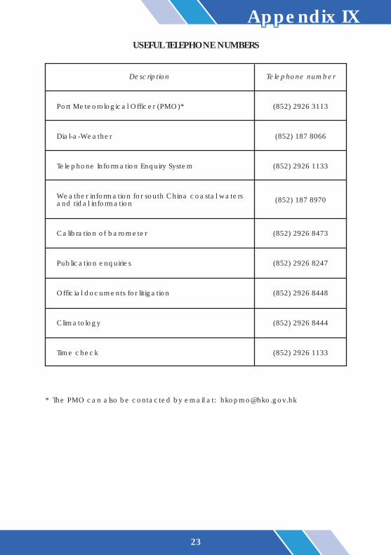
Appendix IXUSEFUL TELEPHONE NUMBERS
Description Telephone number
Port Meteorological Officer (PMO)* (852) 2926 3113
Dial-a-Weather (852) 187 8066
Telephone Information Enquiry System (852) 2926 1133
Weather information for south China coastal waters (852) 187 8970and tidal information
Calibration of barometer (852) 2926 8473
Publication enquiries (852) 2926 8247
Official documents for litigation (852) 2926 8448
Climatology (852) 2926 8444
Time check (852) 2926 1133
* The PMO can also be contacted by email at: [email protected]
24
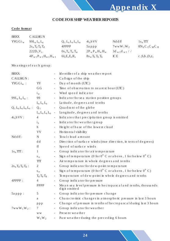
Appendix XCODE FOR SHIP WEATHER REPORTS
Code format
BBXX CALLSIGNYYGGi w 99LaLaLa QcLoLoLoLo 4ixhVV Nddff 1snTTT
2snTdTdTd 4PPPP 5appp 7wwW1W2 8NhCLCMCH
222D sV s 0s sTwTwTw 2PwPwHwHw 3dw1dw1 / /4Pw1Pw1Hw1Hw1 6I sE sE sR s 8swTbTbTb ICE c iS ib iD iz i
Meanings of each group:
BBXX: - Identifier of a ship weather reportCALLSIGN : - Call sign of the shipYYGGiw : YY - Day of month (UTC)
GG - Time of observation to nearest hour (UTC)i w - Wind speed indicator
99LaLaLa : 99 - Indicator for sea station position groupsLaLaLa - Latitude, degrees and tenths
QcLoLoLoLo : Qc - Quadrant of the globeLoLoLoLo - Longitude, degrees and tenths
4ixhVV : 4 - Indicates that precipitation group is omittedi x - Indicator for weather grouph - Height of base of the lowest cloudVV - Horizontal visibility
Nddff : N - Total cloud amountdd - Direction of surface winds (true direction, in tens of degrees)ff - Speed of surface winds
1snTTT : 1 - Group indicator for air temperatures n - Sign of temperature (0 for 0o C or above, 1 for below 0o C)TTT - Air temperature in whole degrees and tenths
2snTdTdTd : 2 - Group indicator for dew-point temperatures n - Sign of temperature (0 for 0o C or above, 1 for below 0o C)TdTdTd - Temperature of dew-point in whole degrees and tenths
4PPPP : 4 - Group indicator for pressurePPPP - Mean sea level pressure in hectopascal and tenths, thousands
digit omitted5appp : 5 - Group indicator for pressure change
a - Characteristic changes in atmospheric pressure in last 3 hoursppp - Change of pressure in tenths of hectopascal during last 3 hours
7wwW1W2 : 7 - Group indicator for weatherww - Present weatherW1W2 - Past weather during the preceding 6 hours

25
8NhCLCMCH : 8 - Group indicator for cloudsN h - Total amount of low clouds (or medium clouds, if no low
clouds)C L - Type of low clouds: Cu, Cb, Sc, StCM - Type of medium clouds: Ac, As, NsCH - Type of high clouds: Ci, Cs, Cc
222D sV s : 222 - Section indicator for maritime dataD s - Ship's course made good during the past 3 hoursVs - Ship's average speed during the past 3 hours
0s sTwTwTw : 0 - Group indicator for sea surface temperatures s - Sign and type of measurement of sea surface temperatureTwTwTw - Sea surface temperature in whole degrees and tenths
2PwPwHwHw : 2 - Group indicator for wind wavesP wP w - Period of wind waves in secondsHwHw - Height of wind waves in units of half metre
3dw1dw1 / / : 3 - Group indicator for swell directionsdw1dw1 - Direction in tens of degrees from which the predominant swell
is coming4Pw1Pw1Hw1Hw1: 4 - Group indicator for period and height of the predominant swell
Pw1Pw1 - Period of the first (predominant) swell in secondsHw1Hw1 - Height of the first (predominant) swell in units of half metre
6I sE sE sR s : 6 - Group indicator for ice accretionI s - Type of ice accretionE sE s - Thickness of ice in cmR s - Rate of ice accretion
8swTbTbTb : 8 - Group indicator for wet bulb temperatures w - Sign and type of wet bulb temperatureTbTbTb - Wet bulb temperature in whole degrees and tenths
ICE : - Indicator, ice group followsc iS ib iD iz i : c i - Concentration or arrangement of sea ice
S i - State of developmentb i - Ice of land originD i - Bearing of principal ice edgez i - Ice situation and trend over proceeding 3 hours
Appendix X - Cont'd

26
Appendix XICALL SIGNS, RADIO FREQUENCIES AND HOURS OF OPERATION OF
THE HONG KONG COAST RADIO STATION
Ships' weather reports transmitted via radiotelex with heading "OBS METEO HONG KONG" areaccepted without charge. The self call-code number is 1480, and the answer-back code toship is 1480 HKRDO VRX.
* Traffic list broadcast at 1200 and 1600 UTC. ** Traffic list broadcast at 0000, 0400 and 0800 UTC. # Available on request
Channel Call VRX VRX Operatingseries no. sign transmits receives hours Remarks
(kHz) (kHz) (UTC)
0811 VRX33 8421.5 8381.5 1000 - 2200 *
1213 VRX63 12585.5 12483 - #
1630 VRX83 16821 16698 2200 - 1000 **

27
Appendix XIITRANSMISSION METHODS FOR SHIP WEATHER REPORTS
TO THE HONG KONG OBSERVATORY VIA SATELLITE
(1) Select telex mode
(2) Select routine priority
(3) Enter the Coast Earth Station identity code(a) For using Inmarsat-C: enter the Hong Kong Observatory's telex number(b) For using Inmarsat-A or Inmarsat-B:
(i) Upon receipt of "Go Ahead" signal, enter 41 (the two-digit service code)(ii) Enter +(iii) Standby for the ANSWERBACK of the Hong Kong Observatory (54777 GEOPH HX)
(4) Start sending the weather report (free of charge to ships)
CES Identity Code Inmarsat Coast Earth Transmission
Station (CES) Pacific Ocean Region Indian Ocean Region Code
A Hong Kong, 13 - 6 11 - 6 13 - 6 11 - 6 41(Two-digitChina (Octal) (Decimal) (Octal) (Decimal) service code)
B Hong Kong, 118 118 41 (Two-digitChina service code)
C Singapore 210 328
802 54777(Hong KongObservatory
telex number)
Observatory
Observatory

28
Appendix XIIILIST OF INMARSAT-C COAST EARTH STATIONS
Country
Australia
Japan
Singapore
USA
Station name
Perth
Yamaguchi
Sentosa
Santa Paula
Identity code
222
203
210
201
Pacific Ocean Region (POR)
Country
Australia
France
Germany
Greece
Japan
Netherlands
Singapore
Station name
Perth
Aussaguel
Raisting
Thermopylae
Yamaguchi
Station 12
Sentosa
Identity code
322
321
333
305
303
312
328
Indian Ocean Region (IOR)
Country
Netherlands
UK
USA
Station name
Station 12
Goonhilly
Southbury
Identity code
012
002
001
Atlantic Ocean Region-West (AOR-W)
Atlantic Ocean Region-East (AOR-E)
Country
France
Germany
Greece
Netherlands
UK
USA
Station name
Aussaguel
Raisting
Thermopylae
Station 12
Goonhilly
Southbury
Identity code
121
115
120
112
102
101

29
Appendix XIVSCHEDULES AND RADIO FREQUENCIES OF BROADCASTS FOR AIRCRAFT
Call sign
HongKongHKG(MorseCode)
HongKongRadio
Frequency
338 kHz
6 679 kHz8 828 kHz13 282 kHz
Time ofbroadcast
HH+15HH+45
Time ofobservation
HHHH+30
Type ofmessage
Aviationweatherreport,forecastandwarning
Contents of message
Surface weather reportsand/or trend type landingforecasts at the airport inGuangzhou, Naha, Taibei,Gaoxiong, Manila and Mactanwhen available. Forecasts forHong Kong InternationalAirport valid for nine hours.Warnings of weatherhazardous to aircraft (SIGMET)within the Hong Kong airspace.
VOLMET BROADCAST
Call sign
Hong KongInternationalAirport ArrivalInformation
Hong KongInternationalAirportDepartureInformation
Frequency
128.20 MHz
127.05 MHz
Time ofbroadcast
Continuous
Type ofmessage
Current androutineinformation toarrivingaircraft
Current androutineinformation todepartingaircraft
Contents of message
Those relevant to weatherinformation at Hong KongInternational Airport includessur face wind, v i s ib i l i ty ,temperature, QNH and othersignificant meteorologicalinformation as appropriate.
ATIS BROADCAST