Embed Size (px)
Citation preview
102 The Oregon Coast Book, 2017–18 EditionCheck website for updates: hmsc.oregonstate.edu/quests
Hatfield Marine Science Center Quests
Tsunami Quest 2017

The Oregon Coast Book, 2017–18 Edition 103Check website for updates: hmsc.oregonstate.edu/quests
Use this map of Hatfield Marine Science Center to help you solve the following two Quests!
Quest Partners
BARRY FISHER BUILDINGNOAA: NWFSCNorthwest Fisheries Science Center EAST & WEST WINGS OSU entities, including CIMRS, COMES,
Facilities; Staff Lounge USDA
ED WING OSU Distance Education Graduate & Undergraduate Courses K-12 and teacher education Computer Services
GUIN LIBRARY
NAL NOAA: NWFSC, AFSC Alaska Fisheries Science Center OSU: Molluscan Aquaculture/MBP, MMI, COMES USDA
ODFW Oregon Dept. of Fish & WildlifeMarine Resource Program5/4/10
NOAA Marine Operations Center
Marina Store
Seawater System Pier
Ha#ield Marine Science Center
MAP HMSC
South Beach
HMSC Sustainability Quest – START HERE
HMSC Estuary Quest – START HERE
Nature Tra
il
OSU
Drive
HMSC Nature Trail Quest – START HERE
HMSC Tsunami Quest – START HERE

110 The Oregon Coast Book, 2017–18 EditionCheck website for updates: hmsc.oregonstate.edu/quests
Quest PartnersOregon Sea GrantOSU Hatfield Marine Science CenterLincoln County School DistrictOregon State Parks
This Quest was created with support from Oregon Sea Grant, the Gray Family Foundation, an OSU Extension Association Hoecker Award, and OSU Precollege Programs.

The Oregon Coast Book, 2017–18 Edition 111Check website for updates: hmsc.oregonstate.edu/quests
HMSC Tsunami QuestEstablished: 2016 by the 7th grade class at Newport Middle School, with help from their teacher Sean Bedell, Oregon State Parks, and Oregon Coast Quests.Box monitor: The Wiese Family
Driving directions: This Quest begins outside the entrance to the OSU Hatfield Marine Science Center (HMSC) Visi-tor Center. To get to HMSC from Newport, drive south on Hwy 101, cross the Yaquina Bay Bridge, get off at the first exit after the bridge, and follow the signs to the HMSC main entrance. Park in the main parking area.
Introduction: If the Oregon coast experiences a large earth-quake, a tsunami may reach low-lying areas within minutes! Therefore, it is important that coastal visitors and residents know what to do to stay safe. This Quest is a fun way to practice walking an evacuation route for this area. The direc-tions will take you on a 0.9-mile walk to the high ground that is closest to HMSC. The route is paved and level most of the way, and ends with a short, uphill hike on a gravel path. In a real emergency, you would want to evacuate very quickly. However, when you are doing this Quest, you can take time to explore, search for clues, discuss ideas, and learn about tsunami safety. Plan for at least 60 minutes to complete your round-trip walk.
Follow the directions and collect the clues to fill the num-bered squares. At the end of your journey, the word will lead you to the hidden Quest Box. When you find the box,
Page 1 of 8
HMSC Tsunami Quest Established: 2016 by the 7th grade class at Newport Middle School, with help from their teacher Sean Bedell, Oregon State Parks, and Oregon Coast Quests. Box monitor: The Wiese Family Driving Directions: This Quest begins outside the entrance to the OSU Hatfield Marine Science Center Visitor Center. To get to HMSC from Newport, drive south on Hwy 101, cross the Yaquina Bay Bridge, get off at the first exit after the bridge, and follow the signs to the HMSC main entrance. Park in the main parking area. Introduction: If the Oregon Coast experiences a large earthquake, a tsunami may reach low-lying areas within minutes! Therefore, it is important that coastal visitors and residents know what to do to stay safe. This Quest is a fun way to practice walking an evacuation route for this area. The directions will take you on a 0.9 mile walk to the high ground that is closest to HMSC. The route is paved and level most of the way, and ends with a short uphill hike on a gravel path. In a real emergency you would want to evacuate very quickly. However, when you are doing this Quest you can take time to explore, search for clues, discuss ideas, and learn about tsunami safety. Plan for at least 60 minutes to complete your round-trip walk. Follow the directions and collect the clues to fill the numbered squares. At the end of your journey, the word will lead you to the hidden Quest Box. When you find the box, please sign the log book and let us know what you thought of this Quest. Stamp your page as proof of accomplishment, and then put the box back in its hiding place for the next person to find.
For more information about tsunami safety on the coast, visit http://www.oregontsunami.org

112 The Oregon Coast Book, 2017–18 EditionCheck website for updates: hmsc.oregonstate.edu/quests
please sign the log book and let us know what you think of this Quest. Stamp your page as proof of accomplishment, and then put the box back in its hiding place for the next person to find. Enjoy!
For more information about tsunami safety on the coast, visit http://www.oregontsunami.org
Let’s begin…
Start your Quest near the two big yellow objects at the front of the Hatfield Marine Science Center Visitor Center. What are they? When you’re done with your fun, move to the building side of the buoy and take several steps to the tall, orange earthquake sign, to read about tsunamis.
A tsunami is a series of waves caused by the displacement of a large volume of water. What large event on the ocean floor could create a tsunami? Write your answer here:
___________________________________________
Which letter is silent in the word “tsunami”? Write that letter in square #1.
Tsunami means “harbor wave” in Japanese (tsu = harbor + nami = wave), reflecting Japan’s tsunami-prone history. Look to your left to see what the ocean washed up from a tsunami from Japan. Clue #2 is hidden in a painted square near its base.
Find a short display sign about tsunamis with a map on it. This map of the Tsunami Hazard Zone shows areas that would flood during a tsunami. Green areas are safe, but yellow and orange areas are in danger of inundation (flooding) soon after a near-shore earthquake. Where are you on the map? Are you in a danger area?
Turn west and see the bridge. That is where the ocean is. The south end of the bridge is also where the nearest high ground is located.
What is the first thing you should you do if you feel an earthquake RIGHT NOW? The sign tells you to Drop, __ __ __ __ __, and Hold On during the shaking. Clue #3 is the last letter of the missing word.
Before moving on, practice this first step now. The shaking might last a few minutes.
Once the shaking stops, you will need to move to high ground, right away. Which direc-tion should you walk from here?
The Oregon Coast Book, 2017–18 Edition 113Check website for updates: hmsc.oregonstate.edu/quests
Signs can help us know where to go. Go to the flagpole, and on the way, see a round, blue-and-white sign with helpful informa-tion. What is the first letter of the longest word on this sign? Put this letter in clue space #4. Walk the direction the arrow points, and follow the sidewalk along the street that exits the parking lot. Continue on this side-walk, past another round evacuation sign. When the sidewalk comes to an end, take the crosswalk across the street to a group of signs about tsunamis.
According to the short tsunami hazard zone sign, how long would it take you to get to high ground from here if you were walking briskly? Write out the number of minutes and use the word’s fifth letter for clue #5.
Look to the south and you will see a paved path with lights. Follow the path. On the right is our local marina. On the path, you will meet a sudden crosswalk. Make sure you look both ways before you cross the drive. After you pass a second crosswalk, stop at another tsunami hazard zone sign and find your position on the map. What color is the map in the place you are standing now? The second letter of the color is clue #6.
Continue on the path and stop near a crosswalk on the left that is marked with yellow signs. Do not cross the street. Instead, stand near the tall, brown lamppost and check your Quest map to find your position.
When should we evacuate? As soon as the shaking stops, evacuate to high ground immediately. DO NOT DELAY. The first wave could arrive in 15 minutes, so knowing in advance what to do, what to look for, and where to go saves precious time.
Did You Know? The orange and yellow colors on the map show where flooding could occur from different kinds of tsunamis. Tsunami waves made by earthquakes in distant places like Japan or Alaska take hours to arrive to the Oregon coast and can flood the orange areas on the map. Local tsunamis are made by earthquakes that happen right off the Oregon coast. We can feel the earthquake, the waves can arrive in as soon as 15 minutes, and the flooding could cover both the orange AND the yellow areas.
114 The Oregon Coast Book, 2017–18 EditionCheck website for updates: hmsc.oregonstate.edu/quests
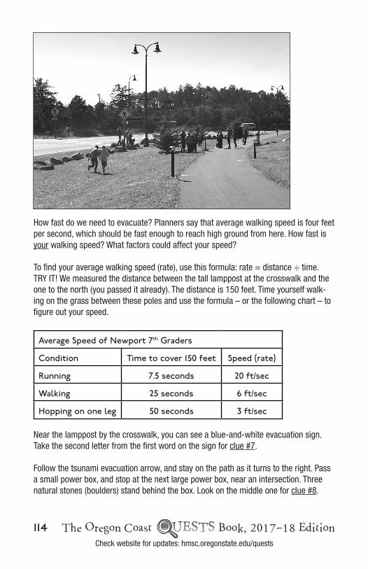
How fast do we need to evacuate? Planners say that average walking speed is four feet per second, which should be fast enough to reach high ground from here. How fast is your walking speed? What factors could affect your speed?
To find your average walking speed (rate), use this formula: rate = distance ÷ time. TRY IT! We measured the distance between the tall lamppost at the crosswalk and the one to the north (you passed it already). The distance is 150 feet. Time yourself walk-ing on the grass between these poles and use the formula – or the following chart – to figure out your speed.
Average Speed of Newport 7th Graders
Condition Time to cover 150 feet Speed (rate)
Running 7.5 seconds 20 ft/sec
Walking 25 seconds 6 ft/sec
Hopping on one leg 50 seconds 3 ft/sec
Near the lamppost by the crosswalk, you can see a blue-and-white evacuation sign. Take the second letter from the first word on the sign for clue #7.
Follow the tsunami evacuation arrow, and stay on the path as it turns to the right. Pass a small power box, and stop at the next large power box, near an intersection. Three natural stones (boulders) stand behind the box. Look on the middle one for clue #8.
Page 4 of 8
hazard zone sign and find your position on the map. What color is the map in the place you are standing now? The second letter of the color is clue #6.
Continue on the path and stop near a crosswalk on the left that is marked with yellow signs. Do not cross the street. Instead, stand near the tall brown lamppost and check your Quest map to find your position. How fast do we need to evacuate? Planners say that average walking speed is 4 feet per second, which should be fast enough to reach high ground from here. How fast is your walking speed? What factors could affect your speed? To find your average walking speed (rate), use this formula: TRY IT! We measured the distance between the tall lamppost at the crosswalk and the one to the north (you passed it already). The distance is 150 ft. Time yourself walking on the grass between these
Did You Know? The orange and yellow colors on the map show where flooding could occur from different kinds of tsunamis. Tsunami waves made by earthquakes in distant places like Japan or Alaska take hours to arrive to the Oregon coast and can flood the orange areas on the map. Local tsunamis are made by earthquakes that happen right off the Oregon coast. We can feel the earthquake, the waves can arrive in as soon as 15 minutes, and the flooding could cover both the orange AND the yellow areas.
The Oregon Coast Book, 2017–18 Edition 115Check website for updates: hmsc.oregonstate.edu/quests
What color is the power box? Clue #9 is the only letter that occurs more than once in the name of the color.
Continue on the path west and stop at the next short tsunami hazard zone sign, which is just past the intersection. From here, you can see the high ground that is your des-tination. This hill is covered by tall evergreen trees. What is the name that has been given to this hill? Read the sign to find out. The last letter of the second word in the hill’s name is clue #10.
From here, is there more than one direction you could walk to reach high ground? It is a good idea to think about alternate routes in case your path is blocked. Today, continue on the path toward the Yaquina Bay Bridge, and stop at the next short tsunami-hazard-zone sign.
This bridge was built 1934–1936, which makes it around 80 years old. The bridge could collapse if there was an earthquake. Think about ways you could get around it.
What two colors make up the tsunami evacuation sign with the wave on it? The third letter of the shorter word describing the color is clue #11. Turn left as the arrow directs, and carefully cross the street.
By the stairs to the bridge, find another short tsunami sign. This one says you are six minutes from high ground. Look carefully; the map shows a route in red that takes you up and over Highway 101. However, when we practice evacuation, we do NOT go that way, because it’s unsafe to walk across highway traffic. Instead, follow the path UNDER the bridge.
Find clue #12 hidden near the base of the stairs. An arrow in the stone points right to it!
Walk toward the trees and find the zig-zag trail with the wooden rail that goes up, up, up. This is when you will really make progress and get to high ground! Once you make it all the way to the top of the zig-zag trail, you can relax.
Did You Know? There are several trails that lead to the top of the hill, and some routes are steeper than others. The most gradual ascent is a wide, sloping road that starts at the base of the other side of the hill.

116 The Oregon Coast Book, 2017–18 EditionCheck website for updates: hmsc.oregonstate.edu/quests
Explore the space on the top of the hill. In a real emergency, you should plan to STAY here in this area for at least 24 hours, because tsunami waves could come in one after another for several hours. What supplies would be useful to have up here with you dur-ing your stay?
Look under one of the short signs for your last painted letter. It is clue #13.
Now that you have all your letters collected, what do they spell? Do you know what the significance of this number is? The answer is in the Quest Box (and on one of the signs)!
To finish your Quest, go back to the top of the zig-zag trail and search for something that matches your hidden message. Reach inside to retrieve the Quest Box. After you have signed the log and stamped your page, please return the box to its hiding place for others to find.
Congratulations! Return to HMSC the way you came. Can you make the return trip in under 14 minutes? Good luck!
7 4 5 9 10 1 6 9 10
12 11 8 13 3 6 2
Stamp page 215 of this book to record your find!
For more information about tsunami safety on the coast, visit http://www.oregontsunami.org
If you enjoyed this Quest, check out the Oregon Coast Quests Book which contains directions for 24 Quests in five Oregon counties. The book is available at the HMSC Gift Store and other local retailers. Visit hmsc.oregonstate.edu/quests for more information.