Embed Size (px)
Citation preview

D
Atlantic2017 Annual Issue
H E A LT HY F I S H E R I E S N E E D H E A LT HY H A B I TAT
Sustainably Managing Atlantic Coastal Fisheries • Atlantic States Marine Fisheries Commission • www.asmfc.org
In This Issue Submerged Aquatic Vegetation
An Introduction to SAV ................................2
Algal Blooms in the Northern Indian River Lagoon ......................................4
Why is SAV Habitat Absent in Georgiaand South Carolina? ......................................5
Submerged Aquatic Vegetation Conservation in the Albemarle-Pamlico Estuarine System ............................6
Conservation Moorings Protect and Preserve Fish Habitat .....................................8
The Effects of Temperature on SAV in New York Waters ..................................... 10
How our State and Federal Partners are Working to Protect SAV ....................... 12
Studying How Seagrass Health Impacts Carbon Sequestration ............... 13
SAV on the Lower Eastern Shore of the Chesapeake Bay .......................................... 16
Atlantic Coastal Fish HabitatPartnership Update
On the Ground Conservation................... 20Science and Data Developments ........... 212017 Melissa Laser Award ......................... 21
Updates from Around the CoastNew Hampshire ........................................... 22Massachusetts.............................................. 25Connecticut ................................................... 27New York ........................................................ 28New Jersey ..................................................... 29Pennsylvania ................................................ 31Maryland ....................................................... 32Virginia ........................................................... 32North Carolina ............................................. 35South Carolina ............................................. 36Georgia ........................................................... 37Florida............................................................. 39New England Fishery Management Council ................................ 39Mid-Atlantic Fishery Management Council ............................... 40NOAA Fisheries ............................................. 40
HABITAT HOTLINEHABITAT HOTLINE
Spotlight onSubmerged Aquatic Vegetation
As the Chair of the Atlantic States Marine Fisheries Commission’s Habitat Committee, it is my pleasure to present the 2017 Habitat Hotline Atlantic. This year’s issue focuses on the importance of and impacts to submerged aquatic vegetation (SAV) along the United States East Coast. This issue also coincides with the Habitat Committee’s re-evaluation of the Commission’s SAV Policy established 1997. SAV comprises some of the most productive ecosystems in the world. Conservation and restoration of coastal SAV resources are critical to maintain habitat and ecological functions of Commission-managed species. Determining current status and identifying trends in health and abundance are key factors in management of SAV resources. Evaluation of trends in the overall health of existing SAV beds should account for severity of threats from cumulative human activities, coastal development, and impacts to fisheries and water quality degradations.
The 2017 Habitat Hotline Atlantic also features examples of the commitment of the Habitat Committee and affiliated partners in improving fisheries habitat conservation through scientific research, restoration activities, partnerships, policy development, and education. It demonstrates the creative approaches to the challenges of understanding the dynamics of marine and coastal fish habitats. I invite you to enjoy reading about the various fish habitat-related conservation issues and projects happening along our coast.
January MurrayHabitat Committee Chair

2 2017 Issue | Atlantic States Marine Fisheries Commission | www.asmfc.org
Submerged AquAtic VegetAtion
An Introduction to SAVW. Judson Kenworthy, NOAA (retired)
Many of the estuaries, coastal bays, lagoons, and river mouths along the Atlantic seaboard are inhabited by submerged aquatic vascular plants. Commonly referred to as SAV in relatively low salinity environments or seagrass in marine waters, these rooted flowering plants are one of the most productive ecosystems on the planet. SAV are considered “foundation species” because they form structurally complex meadow-like features with large amounts of biomass in the water column and in the sediments, both of which are the basis of the many services these ecosystems provide for fisheries. SAV are also considered “bioindicator species” and act as “sentinels” of environmental quality. Generally, where you find thriving meadows of native species you can be assured that you have good or improving water quality and productive fish and wildlife habitat.
The meadows provide several important ecosystem services which are some of the main physical, chemical, and biological ingredients for essential fish habitat (EFH). Leaf canopies slow the flow of water and baffle wave energy. This traps suspended particles and organic matter and concentrates nutrients and food resources within the meadows, as well as in the sediments beneath the canopies. The large surface area of the leaves can be 5-10 times greater than the bottom area they occupy and the complex three dimensional structures of the leaf canopies provide critical nursery function and shelter from predation for larval, juvenile, and adult fish as well as their food resources. The surfaces of the leaves are also substrates for attached and epiphytic primary producers, microorganisms, and invertebrates which collectively enrich the overall magnitude of primary and secondary production directly available for fishery organisms. Fish and invertebrate grazers feed directly on the leaves and the associated epiphytic communities, while the slowly decaying organic matter produced by the plants
Submerged aquatic vegetation. Photo credit: Chesapeake Bay Foundation.
ensures a steady nutrient supply and source of energy for the detrital food web. Most all of the meadows grow rooted in unconsolidated sediments and similar ecological benefits are delivered directly to animals living in and on the bottom. The magnitude of organic matter production in the sediment and its influence on biogeochemistry differentiates the critical importance of SAV from all the other coastal primary producers.
By clearing the water of suspended particles, assimilating and storing nutrients in their tissue, and slowly recycling these nutrients while producing large amounts of oxygen, the meadows “biologically engineer” water and sediment
quality favorable to maintaining their health and condition, and the condition and abundance of fish and invertebrate species utilizing the habitat. Plant photosynthesis also captures large amounts of carbon dioxide from the water, a portion of which is buried in the sediment as “blue carbon” (read more about blue carbon on page 13). The sequestration of carbon in sediments beneath the beds contributes to the balance of the water’s chemical composition. Ultimately, this reduces the concentration of atmospheric carbon dioxide,
stabilizing the world’s climate and water temperatures, which directly benefits fishery organisms.
Over the past several decades, scientific understanding of the ecological values of SAV as EFH has matured considerably. This is due in part to the recognition that the plants live in a fluid medium and are just one of several biologically and physically interconnected habitats that support fishery production within the landscape of a larger coast-wide ecosystem (e.g., mudflats, marsh, reef, and mangrove). For some permanent fishery residents, the meadows provide many of the essential living requirements for recruitment, growth and reproduction. But many more fishery species are highly mobile and only utilize SAV temporarily as a stepping stone between different habitat types and from one ontogenetic life stage
32017 Issue | Atlantic States Marine Fisheries Commission | www.asmfc.org 3
to the next. The landscape concept has also improved our understanding of the relationships between meadow structure and its function in fishery production. Early in the 20th century scientists first began to appreciate the value of SAV when surveys revealed a significantly greater abundance of fishery organisms and their food in vegetated habitats compared to unvegetated areas. Initially, these studies led to a “presence vs. absence” paradigm with scientists and resource managers placing relatively higher value on benthic habitat where the plants were present. Since the early 1970s, when SAV rose to the forefront in global coastal ecosystem research while landscape ecology matured, we have learned that the ecological functions and services provided to fisheries by SAV extend over much broader spaces and across many time scales well beyond the instantaneous or seasonal presence of vegetation. The SAV meadow landscape is a spatially and temporally dynamic habitat that includes both the vegetation as well as gaps in cover within and outside the meadows. Research has shown that SAV distribution fluctuates annually and inter-annually and can move across the benthic seascape constantly redistributing itself. In many coastal systems the gaps and the cover of vegetation are temporary features embedded in a constantly changing benthic landscape of both actual and potential SAV habitat. It turns out that the unvegetated gaps are equally as important to ecosystem function and fisheries productivity as the plants themselves. It doesn’t matter whether they are distributed as persistent meadows or ephemeral patches of vegetation, large amounts of organic matter, nutrients, and food resources are continuously transported between the meadows and associated habitats. Experimental research and advanced stable isotope studies of coastal food webs has identified utilization of SAV by fishery organisms in unvegetated gaps within the meadows as well as the export of organic matter to tidal channels, mudflats, marshes, mangroves, reefs, shoreline wrack, and as far away as offshore submarine canyons.
As is often the case, we learn the true value of something only after we no longer have it. This was the situation in the 1930s when the Atlantic coast lost most of its eelgrass (Zostera marina) to a wasting disease epidemic. Many fisheries were directly impacted by the loss of this habitat and indirectly affected by the destabilization of sediments, erosion of shorelines, and degradation of environmental quality. We know that SAV has been thriving as a component of coastal and estuarine ecosystems for at
least 60 million years. Having survived through many stressful environmental changes these plants have genetically evolved a level of resilience allowing them to survive in the relatively harsh and ever changing land-water interface. Despite this, it took several decades for eelgrass to recover in many coastal systems; some systems experienced only partial recoveries and in others, there was no recovery at all.
Today, all around the globe, including many coastal systems on the Atlantic seaboard, reports of SAV declines without accompanying recovery are frequent and steadily growing in number. The scientific consensus is that humans are seriously testing the inherent resilience of SAV with unchecked population growth, coastal development, and overexploitation of natural resources. What were once infrequent and local factors responsible for the degradation of coastal habitats, these stressors have now become the “usual suspects”, chronically widespread, and more acute in many estuarine ecosystems. Notably, humans are modifying bathymetry, hydrology, and freshwater discharges and at the same time delivering excessive loads of sediments and nutrients into coastal water bodies at a pace far greater than the plants can tolerate, directly impairing the capability of SAV to photosynthesize, grow, and reproduce. These, and the additive effects of many other anthropogenic and environmental stressors, have shifted many SAV ecosystems away from equilibrium towards a tipping point where the likelihood of recovery is very uncertain. Research has shown that such shifts cascade up and down the estuarine food web and lead to significant and lasting negative impacts on fisheries.
Fortunately, many scientists and resource managers recognize how these problems diminish the functions and services provided by SAV and developed the policy and practice of designating SAV as EFH. EFH is just one of many management approaches being used by local, state, and federal resource agencies to prevent, mitigate, and reverse the negative trends we are observing for the status of SAV on the Atlantic coast. The bad news is the negative trends in SAV status are still prevalent, but there is good news. The public and commercial beneficiaries of EFH are becoming more aware of the need to protect, conserve, and restore SAV for the benefit of all fisheries and are actively collaborating with scientists and resource managers in ecosystem based management programs and many other conservation efforts to resolve the problems.

4 2017 Issue | Atlantic States Marine Fisheries Commission | www.asmfc.org
Algal Blooms in the Northern Indian River Lagoon: Will They Become the New Norm?By Chuck Jacoby, St. Johns River Water Management District
From late 2015 into March 2016, large portions of the northern Indian River Lagoon looked like liquid chocolate. This discoloration was caused by vast numbers of Aureoumbra lagunensis, a small, single-celled marine algae in the class Pelagophyceae. These phytoplankton are ~5 microns in diameter, which means over 200 would fit across the period at the end of this sentence. Being small, they divide more quickly than larger phytoplankton. Their ability to survive in high salinity, grow in low light, and gain nutrients from organic compounds also helps them outcompete other species. The latter trait allows them to strip nitrogen and phosphorus off carbon molecules before bacteria release those vital nutrients in forms that can be used by other algae and plants.
On March 18, 2016, conditions began to change, and people reported fish kills involving hundreds to thousands of fish. The reports continued for a week, with most sightings coming from Banana River Lagoon. Five phenomena likely contributed to the mortalities: 1) the extent of the brown tide, 2) the intensity of the bloom, 3) an unsurprising “crash” of the bloom, 4) cloudy weather, and 5) the physiology of Aureoumbra. The bloom extended throughout most of Banana River Lagoon at densities of over 2 million cells per liter. By mid-March, Aureoumbra cells were beginning to die, perhaps because nutrients were depleted. In addition, clouds obscured the sun on March 17–20, so daytime, photosynthetic production of oxygen decreased. In contrast, daytime and nighttime respiration by live Aureoumbra, the bacteria that were decomposing dead Aureoumbra, and other organisms remained constant, so dissolved oxygen concentrations fell below 2 milligrams per liter, which is lethal for fish. Typically, fish move
away from such conditions, but the extent of this bloom thwarted their escape. Aureoumbra cells can secrete mucus that makes them stick to the gills of fish, which would have made it even harder for the fish to get the oxygen they needed.
This was not the first brown tide recorded in the northern Indian River Lagoon, with Aureoumbra being a dominant organism in blooms that occurred in 2012 and 2013. Samples collected before 2012 contained low numbers of Aureoumbra, so it was not introduced until recently.
Regrettably, brown tides were not the only unusual blooms in recent years. In late 2010 and during 2011, a major bloom eventually affected 132,500 acres in the Banana River, the northern Indian River, and southern Mosquito Lagoons. This “superbloom” was preceded and
accompanied by a less intense bloom that began in late 2010 and eventually covered 47,500 acres from southern Banana River Lagoon to just north of Ft. Pierce Inlet. In addition to its intensity and duration, the superbloom was unusual because it comprised extremely small, blue-green bacteria (picocyanobacteria) and a green microflagellate tentatively placed in the class Pedinophyceae. These organisms are 1–4 microns in diameter, or about 1/100th the size of a grain of salt. Some samples
yielded 1 billion pedinophytes per liter. Although present in low numbers, pedinophytes had never bloomed in the preceding 14 years. Like Aureoumbra, these algae compete effectively because they divide rapidly, can use organic nutrients, tolerate high salinity, capture light efficiently, and escape being eaten by some filter feeders. The superbloom caused shading that severely stressed seagrasses for up to 21 months. Subsequent mapping documented widespread losses of seagrasses, which provide refuge and food for fish and wildlife. Twenty four thousand acres of seagrass in Banana River Lagoon was reduced to 3,000 acres.
Brown tide near Cocoa, Florida on March 4, 2016. Photo credit: T. Miller, St. Johns River Water Management District

52017 Issue | Atlantic States Marine Fisheries Commission | www.asmfc.org 5
Reducing bloom frequency and severity will require water resource management at broad spatial scales. Blooms of phytoplankton require nutrients, especially nitrogen and phosphorus. Loads of nutrients began to increase in the 1700s when settlers first drained land for farming, and the situation has been exacerbated by canals that bring water from other watersheds, more intensive use of fertilizer, and reliance on septic tanks. Targets for safe loads are set in the Clean Water Act’s Total Maximum Daily Load process, and Basin Management Action Plans outline projects to meet those targets. Key projects include restoring historical flows by diverting and cleaning water, treating stormwater before it reaches the Indian River Lagoon, reducing the use of fertilizer, and switching from septic tanks to centralized
sewage treatment. In addition, dredging will remove legacy loads of nutrients in sediments, rehabilitated coastal wetlands will filter nutrients, and restored oyster reefs will remove nutrients and phytoplankton. The process resembles putting the lagoon on a diet by reducing loads of nutrients and starting an exercise regime by removing nutrients already in the system. Local, regional, state, and federal partners contribute to achieving these goals, with Brevard County recently adopting a sales tax that will fund over $300 million dollars of projects in the next ten years. Brevard County spans 71% of the Indian River Lagoon so it has a major stake in restoring the health of the system, but all stakeholders need to contribute to preventing massive algal blooms from becoming the new norm.
Why is SAV habitat absent in Georgia and South Carolina? by January Murray, GA DNR
The South Atlantic Fishery Management Council Policy for Protection and Enhancement of Estuarine and Marine SAV Habitat (June 2014) states “In the South Atlantic region, Submerged Aquatic Vegetation (SAV) or seagrass habitat is primarily found in the states of Florida and North Carolina where environmental conditions are more favorable than in South Carolina and Georgia.” SAV are flowering plants anchored into the sediment via a root system which absorbs nutrients. SAV habitat requires environmental conditions such as non-turbid waters where available light can penetration though the water column for photosynthesis; salty and brackish waters; gently sloping and protected coastlines; and weak tidal movements.
Intertidal zone habitats in Georgia and South Carolina are characterized by extreme tidal amplitude (up to 9 feet in Georgia), strong tidal movement, and highly turbid waters. Large riverine inputs and tremendous amounts of sediment movement form soft shorelines composed of very fine silt and mud. Salt marshes and oyster reefs thrive within Georgia and South Carolina intertidal zone habitats since they work in tandem to provide critical ecosystem services such as natural filtration and detoxification; nutrient cycling; coastal protection and shoreline stabilization; and fisheries and nursey habitats for crabs, shrimp, other types of crustaceans, and juvenile fish species. These available habitats fill the void in both States where SAV lack the basic conditions for growth and survival.
Dissolved oxygen concentrations in Banana River Lagoon. Figure credit: St. Johns River Water Management District
Solar radiation from March 3 to March 25, 2016. Figure credit: Florida Automated Weather Network, Indian River Tower
6 2017 Issue | Atlantic States Marine Fisheries Commission | www.asmfc.org
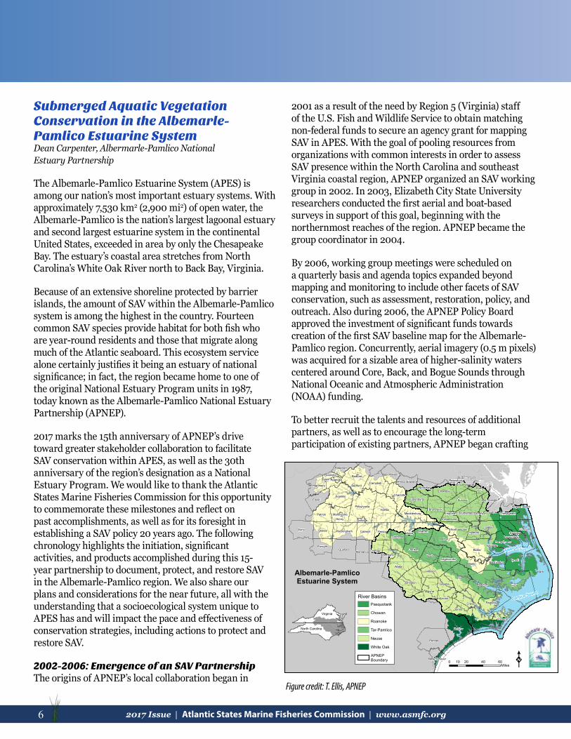
Submerged Aquatic Vegetation Conservation in the Albemarle-Pamlico Estuarine SystemDean Carpenter, Albermarle-Pamlico National Estuary Partnership
The Albemarle-Pamlico Estuarine System (APES) is among our nation’s most important estuary systems. With approximately 7,530 km2 (2,900 mi2) of open water, the Albemarle-Pamlico is the nation’s largest lagoonal estuary and second largest estuarine system in the continental United States, exceeded in area by only the Chesapeake Bay. The estuary’s coastal area stretches from North Carolina’s White Oak River north to Back Bay, Virginia.
Because of an extensive shoreline protected by barrier islands, the amount of SAV within the Albemarle-Pamlico system is among the highest in the country. Fourteen common SAV species provide habitat for both fish who are year-round residents and those that migrate along much of the Atlantic seaboard. This ecosystem service alone certainly justifies it being an estuary of national significance; in fact, the region became home to one of the original National Estuary Program units in 1987, today known as the Albemarle-Pamlico National Estuary Partnership (APNEP).
2017 marks the 15th anniversary of APNEP’s drive toward greater stakeholder collaboration to facilitate SAV conservation within APES, as well as the 30th anniversary of the region’s designation as a National Estuary Program. We would like to thank the Atlantic States Marine Fisheries Commission for this opportunity to commemorate these milestones and reflect on past accomplishments, as well as for its foresight in establishing a SAV policy 20 years ago. The following chronology highlights the initiation, significant activities, and products accomplished during this 15-year partnership to document, protect, and restore SAV in the Albemarle-Pamlico region. We also share our plans and considerations for the near future, all with the understanding that a socioecological system unique to APES has and will impact the pace and effectiveness of conservation strategies, including actions to protect and restore SAV.
2002-2006: Emergence of an SAV PartnershipThe origins of APNEP’s local collaboration began in
2001 as a result of the need by Region 5 (Virginia) staff of the U.S. Fish and Wildlife Service to obtain matching non-federal funds to secure an agency grant for mapping SAV in APES. With the goal of pooling resources from organizations with common interests in order to assess SAV presence within the North Carolina and southeast Virginia coastal region, APNEP organized an SAV working group in 2002. In 2003, Elizabeth City State University researchers conducted the first aerial and boat-based surveys in support of this goal, beginning with the northernmost reaches of the region. APNEP became the group coordinator in 2004.
By 2006, working group meetings were scheduled on a quarterly basis and agenda topics expanded beyond mapping and monitoring to include other facets of SAV conservation, such as assessment, restoration, policy, and outreach. Also during 2006, the APNEP Policy Board approved the investment of significant funds towards creation of the first SAV baseline map for the Albemarle-Pamlico region. Concurrently, aerial imagery (0.5 m pixels) was acquired for a sizable area of higher-salinity waters centered around Core, Back, and Bogue Sounds through National Oceanic and Atmospheric Administration (NOAA) funding.
To better recruit the talents and resources of additional partners, as well as to encourage the long-term participation of existing partners, APNEP began crafting
Dare
Hyde
Pitt
Carteret
Wake
Pender
Bertie
Onslow
Halifax
Beaufort
Craven
Halifax
Nash
Bedford
Surry
Tyrrell
Franklin
Johnston
Pittsylvania
Guilford
Wayne
Jones
Martin
Pamlico
Patrick
Floyd Sussex
Stokes
Henry
Lenoir
Suffolk
Franklin
Granville
WarrenCurrituck
Brunswick
GatesPerson
Surry
Forsyth
Wilson
Caswell
Mecklenburg
Campbell
Orange
CharlotteDinwiddie
Rockingham
Southampton
HertfordNorthampton
Edgecombe
Vance
Lunenburg
Durham
Washington
Greene
Botetourt
Nottoway
Greensville
Prince Edward
Alamance
Camden
Virginia Beach
Roanoke
Montgomery
Isle of Wight
Appomattox
Chesapeake
ChowanPerquimans
Pasquotank
New Hanover
Prince George
Danville
RoanokeSalem Petersburg
FranklinMartinsville
Bedford
Emporia
Pamlico Sound
AlbemarleSound
K0 20 40 6010Miles
North Carolina
Virginia
Albemarle-PamlicoEstuarine System
River Basins
APNEPBoundary
White Oak
Neuse
Tar-Pamlico
Roanoke
Chowan
Pasquotank
Figure credit: T. Ellis, APNEP
72017 Issue | Atlantic States Marine Fisheries Commission | www.asmfc.org 7
a Memorandum of Understanding (MOU). This document would formalize partner interactions for implementation of a combined effort to address the identification, status, and restoration of SAV habitat. The MOU was signed in 2006 by all signatories (nine state agencies, nine academic institutions, two non-Governmental organizations (NGOs) and four federal agencies), thus creating the “SAV Partnership.”
2007-2011: Creating a Baseline Map of “Visible” SAVAs the SAV Partnership entered 2007 with a solid base of partner and financial support, APNEP staff worked with NOAA partners to acquire digitally rectified aerial images through a NOAA general contractor. However, during cost negotiations it became clear that APNEP would have to utilize lower-resolution images than those of the 2006 NOAA effort (1.0 m pixels vs. 0.5 m pixels).
The NOAA flight subcontractor flew 1,795 flight-line miles during late 2007 and early 2008 to capture aerial images. Issues faced included the region’s large area, which meant that completing aerial image acquisition in a single mission was impossible, and also the low number of days when conditions were suitable for flying. The plane flew at an altitude of 24,000-feet, a vantage point where water clarity was undetectable (e.g., the presence of whitecaps or sedimentation from previous days’ rain events interfered with SAV detection), so a network of citizen volunteers throughout the coastal region submitted early morning water clarity readings on possible flight days.
The imagery was the product of a four-band color (three visible, one near infrared) digital mapping camera system. To ground truth these images for interpreters and facilitate estimation of interpreter error, multiple APNEP agency partners collectively committed to boat-based monitoring of 791 sampling stations within a month of the overflight. APNEP contracted with a local engineering firm to interpret the aerial images and create a three-class (none, patchy, dense) baseline map. This map of SAV extent during 2006-2008 was released in 2011, with the recognition that the estimate does not include that fraction of SAV where poor water clarity makes detection difficult with remote sensing.
2012-2017: Developing an SAV Sentinel Network and Initial TrendsPrior to releasing an initial map of the “visible” fraction of SAV, research was underway to develop complementary
monitoring protocols to detect the distribution and extent of the “invisible” SAV as well. The result of a two-year project funded by a North Carolina Coastal Recreational Fishing License (CRFL) grant was the 2012 report “Development of Submerged Aquatic Vegetation Monitoring Protocols in North Carolina,” produced by an APNEP team. Based on their research, the team proposed standardized boat-based protocols utilizing underwater sonar and cameras at sampling stations dispersed throughout APES. Because of boat access and sonar performance limitations due to shallow water, quadrat-based protocols were added to monitor SAV in the shallowest waters.
Since 2014, East Carolina University researchers, with the support of other APNEP partner organizations, have conducted sonar surveys to determine representative placement of SAV monitoring stations with funding from subsequent CRFL grants. Station dimensions are approximately 1 km shore parallel by 500 m shore normal (perpendicular) polygons, with half of the stations placed adjacent to undeveloped coastline. Station establishment has focused first on the areas of lowest levels of water clarity, such as the westernmost side of APES where tributaries deposit their sediment loads. Once stations are established into an SAV Sentinel Network, the objective is for them to be monitored at least annually during a defined sampling period.
While the areal extent of visible SAV in 2006-2008 was one of 24 indicators featured in APNEP’s 2012 ecosystem assessment, the shift to reporting on trends began with a second cycle of SAV aerial surveys in 2012-2014. This sampling cycle used similar protocols to those of the first survey, albeit with a smaller areal extent that centered on areas with high salinity SAV. Higher turbidity waters with lower salinity SAV will be assessed using the in-water techniques described above. A 2006-2008 vs. 2012-2014 change detection analysis is anticipated to be part of an SAV assessment update in late 2017. APNEP fully inherited the SAV Partnership in 2016, and established an “SAV Monitoring and Assessment Team” to continue progress on the former partnership’s core activities, plus a stakeholder-driven “SAV Action Team” as a forum to provide greater attention to policy, protection, restoration, and outreach issues.
2018-2022: Advancing on All FrontsWith solid footholds established, we anticipate advancement on multiple facets of SAV conservation. In
8 2017 Issue | Atlantic States Marine Fisheries Commission | www.asmfc.org
Conservation Moorings Protect and Preserve Fish HabitatBy Chris Powell, ACFHP Steering Committee
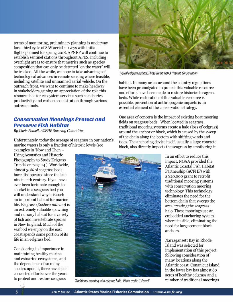
Unfortunately, today the acreage of seagrass in our nation’s marine waters is only a fraction of historic levels (see examples in ‘Now and Then – Using Acoustics and Historic Photography to Study Eelgrass Trends’ on page 14 ). Worldwide, almost 30% of seagrass beds have disappeared since the late nineteenth century. If you have ever been fortunate enough to snorkel in a seagrass bed you will understand why it is such an important habitat for marine life. Eelgrass (Zostera marina) is an extremely valuable spawning and nursery habitat for a variety of fish and invertebrate species in New England. Much of the seafood we enjoy on the east coast spends some portion of its life in an eelgrass bed.
Considering its importance in maintaining healthy marine and estuarine ecosystems, and the dependence of so many species upon it, there have been concerted efforts over the years to protect and restore seagrass
habitat. In many areas around the country regulations have been promulgated to protect this valuable resource and efforts have been made to restore historical seagrass beds. While restoration of this valuable resource is possible, prevention of anthropogenic impacts is an essential element of the conservation strategy.
One area of concern is the impact of existing boat mooring fields on seagrass beds. When located in seagrass, traditional mooring systems create a halo (loss of eelgrass) around the anchor or block, which is caused by the sweep of the chain along the bottom with shifting winds and tides. The anchoring device itself, usually a large concrete block, also directly impacts the seagrass by smothering it.
In an effort to reduce this impact, NOAA provided the Atlantic Coastal Fish Habitat Partnership (ACFHP) with a $20,000 grant to retrofit traditional mooring systems with conservation mooring technology. This technology eliminates the need for the bottom chain that sweeps the area creating the seagrass halo. These moorings use an embedded anchoring system where feasible, eliminating the need for large cement block anchors.
Narragansett Bay in Rhode Island was selected for implementation of this project, following consideration of many locations along the Atlantic coast. Conanicut Island in the lower bay has almost 60 acres of healthy eelgrass and a number of traditional moorings
Typical eelgrass habitat. Photo credit: NOAA Habitat Conservation
Traditional mooring with eelgrass halo. Photo credit: C. Powell
terms of monitoring, preliminary planning is underway for a third cycle of SAV aerial surveys with initial flights planned for spring 2018. APNEP will continue to establish sentinel stations throughout APES, including overflight areas to ensure that metrics such as species composition that can only be detected “on the water” will be tracked. All the while, we hope to take advantage of technological advances in remote sensing where feasible, including satellite and unmanned aerial vehicle. On the outreach front, we want to continue to make headway in stakeholders gaining an appreciation of the role this resource has for ecosystem services such as fisheries productivity and carbon sequestration through various outreach tools.

92017 Issue | Atlantic States Marine Fisheries Commission | www.asmfc.org 9
impacting this valuable habitat. ACFHP worked with the Rhode Island Division of Fish & Wildlife (RIDEM), the Town of Jamestown Conservation Commission, Clarks Boat Yard, Conanicut Marine Services, Inc., Jamestown Boat Yard, and the Aquidneck Mooring Company to execute the project.
Candidate moorings showing evidence of haloing were selected from aerial photographs for further study. Divers from RIDEM visually confirmed the suitability of each mooring for replacement. Two control mooring sites were also selected. Divers mapped the eelgrass halo around each mooring anchor by measuring the distance from the anchor to the established edge of the eelgrass along eight compass bearings. Then, the four traditional mooring systems were removed and replaced with new conservation moorings.
For the following two growing seasons the eelgrass halo was surveyed and mapped. Preliminary results show eelgrass is re-establishing in both the halo areas and in the areas once covered by the mooring block. The increase in eelgrass benefits the fish and invertebrate communities of Narragansett Bay, and these expanded nursery areas will ultimately benefit both commercial and recreational fishermen.
To increase public awareness of eelgrass habitat and conservation moorings, ACFHP developed an interpretative sign that was installed on the waterfront abutting the new moorings. Following the success of this project, the local yacht club and three of the marinas on the island have recently converted many of their traditional moorings to conservation moorings, protecting and preserving even MORE eelgrass habitat!
So the next time you have an opportunity to snorkel in a seagrass bed, DO IT! and enjoy this beautiful underwater world.
Typical eelgrass habitat. Photo credit: NOAA Habitat Conservation
Conservation mooring interpretative sign. Photo credit: C. Powell
Top row halo area (outlined in green) after conservation mooring installation in 2015 and bottom row one year later (2016). Figure credit: RIDEM
Hazelett Conservation Mooring System

10 2017 Issue | Atlantic States Marine Fisheries Commission | www.asmfc.org
The Effects of Temperature on SAV in New York WatersChris Pickerell, Cornell Cooperative Extension of Suffolk County
Eelgrass (Zostera marina) is a critically important ecosystem engineer that forms meadows that are irreplaceable in terms of habitat value. Numerous species of fish and shellfish rely on this habitat for food and shelter. Unfortunately, losses of eelgrass meadows in New York waters have been staggering over the last several decades; approaching 95% in some areas. Many factors contribute to these losses.
Eelgrass is a temperate species that thrives in cool, clear, and oligotrophic waters. Unfortunately, there are very few areas on Long Island where the growth requirements of eelgrass can currently be met. Extensive meadows are only found in the eastern reaches of Long Island Sound and the Peconic Estuary and in some areas near the inlets along the South Shore Estuary. This is a fraction of what was present historically, but based on recent losses, most of the waters off Long Island are presently unsuitable for the growth of eelgrass.
Although there are clearly many factors that affect eelgrass growth and survival, it is useful to measure one parameter while monitoring existing meadows or to help with restoration site selection. In theory and in practice, if one parameter is outside of the required range for the species,
it will not survive (think the weakest link in a chain). Temperature, light, sediment characteristics, nutrient levels, and disturbance are some of the most obvious parameters that can be measured to determine suitability for eelgrass, but it is unnecessary to measure all of these when one measurement will do. For our work, we rely on water temperature monitoring as a primary means of determining site suitability.
Monitoring growing season bottom temperature is a fairly simple means of basic site screening. In New York, this is used as a quick and dirty measure at candidate planting sites. If time and funding allow, we augment these measurements with deployment of light loggers that measure photosynthetically active radiation (PAR). Although site selection models may list a dozen or more factors that influence long-term eelgrass growth, if the
site is too warm to support eelgrass, it is very easy to eliminate potential areas quickly and inexpensively. However, just because a site meets temperature requirements does not mean that the site is suitable, as there may be other limiting factors. The next steps often involve measuring light and looking more closely at sediment characteristics as well as taking into account potential predators and bioturbators.
Why is temperature so important to eelgrass? The effects of elevated temperature on eelgrass are varied, but it comes down to causing energetically unfavorable stress on the plants as they reach a point where respirational energy demands outpace the ability of the plant to produce energy. In
Historic (blue) and more recent (red) distribution of eelgrass in Peconic Estuary, NY. Figure credit: Cornell Cooperative Extension (CCE)
Daily average bottom temperatures for Bullhead Bay, Southampton, NY. Figure credit: CCE
112017 Issue | Atlantic States Marine Fisheries Commission | www.asmfc.org 11
simple terms: respiration outcompetes photosynthesis and the plants use up their carbon stores, weaken, and die. We have seen this at many test planting sites over the years as otherwise vigorous and healthy looking plants in the spring more or less disintegrate or melt before our eyes as the warm waters of summer arrive.
Several years ago, with funding from the Peconic Estuary Program, Cooperative Extension conducted a study of the interrelation of light and temperature on eelgrass in the Peconic Estuary. For this work, we selected stations in existing healthy meadows, areas where eelgrass was in decline or recently lost, and sites where test plantings had failed in the past. At each site we deployed temperature and light loggers near the bottom. The temperature loggers recorded continuously for the growing season, May through September, while the light loggers were deployed for up to two week intervals to control for fouling of the sensors. The light loggers measured PAR, which allowed us to estimate Hsat (hours of light at or above saturation). In all cases, we used threshold values in the scientific literature to guide our assessments.
The study findings helped explain, at least in the simplest terms, why we were losing SAV in some areas and why
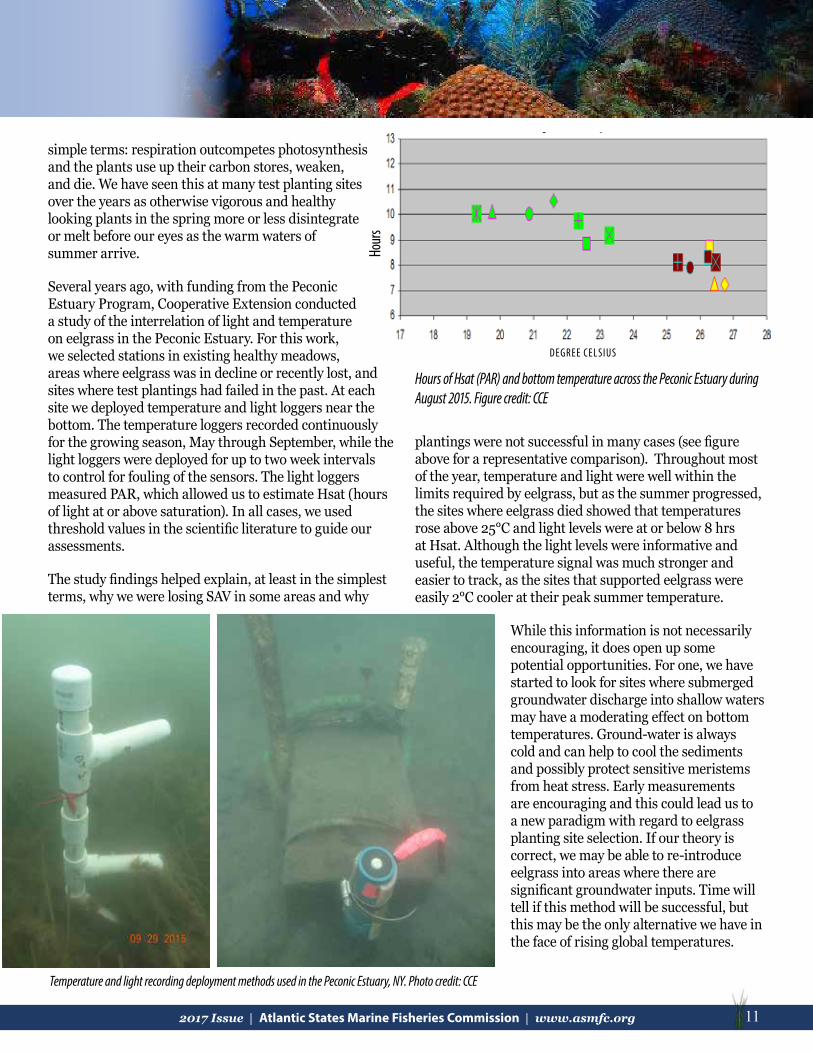
Hours of Hsat (PAR) and bottom temperature across the Peconic Estuary during August 2015. Figure credit: CCE
DEGREE CEL SIUS
Hour
s
plantings were not successful in many cases (see figure above for a representative comparison). Throughout most of the year, temperature and light were well within the limits required by eelgrass, but as the summer progressed, the sites where eelgrass died showed that temperatures rose above 25°C and light levels were at or below 8 hrs at Hsat. Although the light levels were informative and useful, the temperature signal was much stronger and easier to track, as the sites that supported eelgrass were easily 2°C cooler at their peak summer temperature.
While this information is not necessarily encouraging, it does open up some potential opportunities. For one, we have started to look for sites where submerged groundwater discharge into shallow waters may have a moderating effect on bottom temperatures. Ground-water is always cold and can help to cool the sediments and possibly protect sensitive meristems from heat stress. Early measurements are encouraging and this could lead us to a new paradigm with regard to eelgrass planting site selection. If our theory is correct, we may be able to re-introduce eelgrass into areas where there are significant groundwater inputs. Time will tell if this method will be successful, but this may be the only alternative we have in the face of rising global temperatures.
Temperature and light recording deployment methods used in the Peconic Estuary, NY. Photo credit: CCE

12 2017 Issue | Atlantic States Marine Fisheries Commission | www.asmfc.org
On the 20th anniversary of the Commission’s SAV Policy publication, the Habitat Committee decided to check in on the progress of each state and federal agency to conserve SAV over the past two decades. In January, the Habitat Program Coordinator sent out a survey asking each partner a series of questions based on the goals and components of the original policy statement.
The goal of the policy was to preserve, conserve, and restore where scientifically possible, in order to achieve a net gain in SAV distribution and abundance along the Atlantic coast and tidal tributaries, and to prevent any further losses of SAV in individual states by encouraging them to:
• Protect existing SAV beds from further losses due to degradation of water quality, physical damage to the plants, or disruption to the local benthic environment;
• Set and achieve state or regional water and habitat quality objectives that will result in restoration of SAV through natural re-vegetation;
• Develop and attain state SAV restoration goals in terms of acreage, abundance, and species diversity, considering historical distribution records and estimates of potential habitat.
The policy provided six key components to achieving its goal: 1) Assessment of historical, current and potential distribution and abundance of SAV; 2) Protection of existing SAV; 3) SAV Restoration; 4) Public Education and Involvement; 5) Research; and 6) Implementation.
The summarized results shown are from nine states (those who responded to the survey and have marine seagrass species within their borders). The states include New Hampshire, Massachusetts, Rhode Island, New York, New Jersey, Maryland, Virginia, North Carolina, and Florida.
Seven of the nine states have implemented a resource assessment and monitoring strategy to quantitatively evaluate SAV distribution and abundance. One state is currently in the process of developing an assessment. All nine states have put measures in place to limit permanent
and irreversible direct and indirect impacts to SAV and their habitats. Evaluation of the effectiveness of these measures has been mixed along the coast. One third of the states have carried out an evaluation, and one third have not. Two states have evaluations in development, and one state has conducted an evaluation in the past, but is not currently doing so.
Proportion of states that have implemented an SAV assessment and monitoring strategy.
Proportion of states that have evaluated the measures they put in place to limit permanent and irreversible direct and indirect impacts to SAV and their habitats.
Proportion of states that have identified key reasons for SAV loss.
Proportion of states that have identified suitable areas for conservation.
Proportion of states that have included SAV in their aquatic education programs.
Proportion of states that have supported SAV research.
Proportion of states that have set restoration goals.
How our State and Federal Partners are working to Protect SAV
KEY= yes= no= in progress= not recently= as needed= not, but another entity does

132017 Issue | Atlantic States Marine Fisheries Commission | www.asmfc.org 13
Studying How Seagrass Health Impacts Carbon SequestrationBy Phil Colarusso, Environmental Protection Agency
The most recent measurements of atmospheric carbon dioxide (CO2) concentrations show a continuing increase, despite a leveling off of global emissions. Scientists speculate that the loss and degradation of natural systems that absorb CO2 may explain this increase. Seagrasses, salt marshes, and mangroves, collectively are known as “blue carbon” because they are aquatic species that accumulate and sequester large quantities of carbon. Of these three habitats, research on carbon accumulation and sequestration in seagrasses is limited, and geographically skewed to tropical waters. Some data for the temperate species of eelgrass exists, but little work has been done north of Chesapeake Bay. To fill this data void, a team of scientists from the Environmental Protection Agency (EPA), Massachusetts Institute of Technology Sea Grant, and Boston University (with tremendous logistical support from Massachusetts Division of Marine Fisheries, the National Park Service, and a number of other institutions) have been measuring carbon accumulation in 14 eelgrass meadows from Rhode Island to Maine.
One of the objectives of this study was to determine if eelgrass “health” would impact the meadow’s ability to accumulate and sequester carbon. The team sampled meadows over a wide range of nitrogen exposure to establish a gradient of relative eelgrass “health”. Over 95% of the carbon found in a seagrass meadow is associated with the sediments, not just the plant biomass. Seagrasses
Looking for more information on seagrass?
Visit the NOAA Southeast Regional Office’s website!
In 1998, Fonseca et al. developed a comprehensive annotated bibliography and guidelines for seagrass conservation and restoration in the United States. As a follow-up, NOAA Fisheries contracted CSA Ocean Sciences Inc. to review the current literature and produce an updated bibliography, for years spanning 1998 to 2014. It focuses on peer-reviewed literature containing seagrass genera native to the United States and/or its territories. All of these documents as well as a bibliography of papers on seagrasses found outside the United States can be found at http://sero.nmfs.noaa.gov/habitat_conservation/hcd_headlines/fonseca_july2015.html.
Fifty-five percent of the states have set restoration goals, whereas 45% have not. Most (89%), however, have identified the key reasons for SAV loss in their state. Two thirds of states have identified suitable areas for protection and restoration, and two states are in the process of doing do. One state identifies conservation areas as needed.
Information is being included in aquatic education programs across the coast. Seven states have incorporated it directly, and other entities (such as National Estuarine Research Reserves) take on that role in other states. Most states (8) have also supported research on SAV.
From the survey, we found that most of our federal partners do not have regulatory authority pertaining to SAV, but do serve in an advisory role and can designate specific SAV areas as protected. More than half have developed technical guidance or SAV standards, and promote particular Best Management Practices. While they have not implemented the Commission’s SAV Policy, most have implemented other, similar policies to protect SAV.
There has been a lot of process to conserve SAV over the past 20 years on the Atlantic coast, but work can still be done. To read the Commission’s original SAV Policy, please visit http://www.asmfc.org/uploads/file/savpolicy.pdf. The updated policy will be available in early 2018.
View of the natural seafloor with an organic layer build up under the seagrass meadow. Photo credit: P. Colarusso, EPA
14 2017 Issue | Atlantic States Marine Fisheries Commission | www.asmfc.org
form layers of organic material similar to the peat deposits found in salt marshes. Through the use of stable isotopes, researchers demonstrated that a large percentage of that stored organic material does not come from the eelgrass itself, but originates outside the meadow. The physical structure of the plants in the water column facilitates particle deposition. Thus, a healthy, dense meadow should theoretically collect more particles from the water column than a sparse meadow.
The extensive root and rhizome structure produced by eelgrass effectively holds collected organic particles in place. Divers collected sediment cores from each meadow and from non-vegetated reference locations. In all cases, the amount of carbon in eelgrass was greater than the nearby reference locations. A collaborator at the University of Barcelona, Spain aged the cores using lead-210 isotope data. Many of the 30 cm cores contained carbon that was over 100 years old, thus demonstrating the ability of these meadows to sequester this carbon for extended periods.
As long as the meadows maintain their integrity, it seems likely that the carbon will remain sequestered. However, loss of these habitats due to declining water quality or physical disturbance could easily liberate carbon that has been locked away for centuries. Conversely, restoring these habitats can provide an important buffer to ocean acidification and global climate change. For further details on blue carbon or this study, contact Phil Colarusso at [email protected] or (617) 918-1506.
Now and Then – Using Acoustics and Historic Photography to Study Eelgrass Trends Jill Carr, Massachusetts Division of Marine Fisheries
With funding from the Massachusetts Bays National Estuary Program (MassBays), the Massachusetts Division of Marine Fisheries (MarineFisheries) Habitat Project assessed historic eelgrass trends in two Massachusetts embayments: Salem Sound and the Duxbury-Kingston-Plymouth (DKP) Bays system. The project utilized photo-interpretation methods to delineate eelgrass beds in historic aerial photography, implementing two patchiness categories to describe bed density. Side-scan acoustic mapping surveys were completed throughout the embayments to further assess and ground-truth eelgrass beds at a higher resolution. A data mining exercise
followed, examining water quality, weather, physical disturbance, and various biotic variables that may affect eelgrass.
In Salem Sound, we found extremely resilient yet highly vulnerable stands of eelgrass as well as some of the most robust and healthy eelgrass beds in Massachusetts. Since 1995, large-scale declines have occurred in the extreme inner harbors of Salem and Beverly, likely driven by compromised water quality and light availability, further aggravated by impacts associated with boating activity and physical disturbance. Aerial imagery from the 1930s and 1950s (MassDOT) confirmed historic losses in Salem and Manchester harbors, and verified the resiliency of several long-standing healthy beds along the coast of Beverly. The study detected several beds not previously mapped including natural beds, MarineFisheries’s restoration sites, and beds thought to be lost decades ago that are still hanging on. MarineFisheries estimated that 722 acres of eelgrass still existed embayment-wide in 2016, whereas the MA Department of Environmental Protection (DEP) eelgrass program estimated 691 acres in 1995 using different mapping methods.
The DKP system was estimated to have lost 56% of its eelgrass since 1995, with many beds shrinking and some disappearing altogether. The loss was characterized by dense beds thinning over time, with some eventually disappearing. All areas of DKP have been affected and
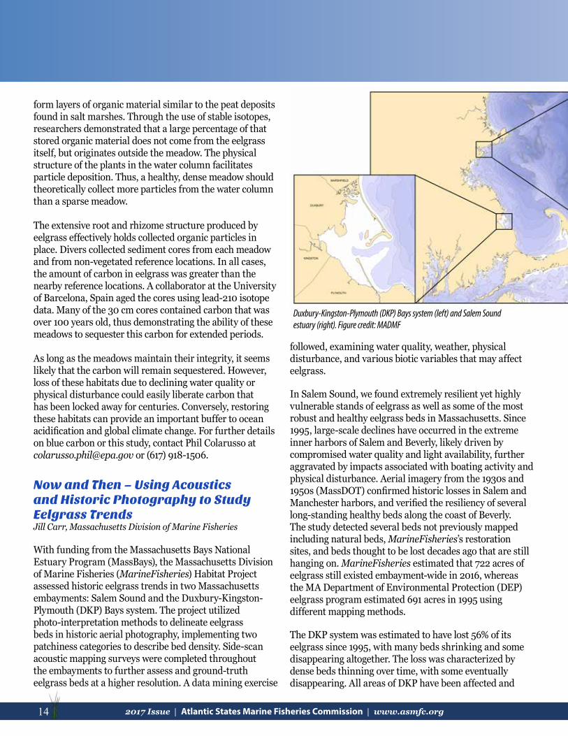
Duxbury-Kingston-Plymouth (DKP) Bays system (left) and Salem Sound estuary (right). Figure credit: MADMF

152017 Issue | Atlantic States Marine Fisheries Commission | www.asmfc.org 15
Mapped eelgrass polygons in DKP for sample years 1995, 2006, 2012, and 2014. Dense grass has >50% aerial coverage, sparse <50%, questionable mapped and unmapped areas refer to areas where DMF disagreed with previous historical map-ping designations. Figure Credit: MA DMF
Approximate edge of eelgrass bed (yellow), delineated using imagery from 1957 (DOT, left) and 2014 (USDA, right) in Manchester outer harbor, Salem Sound.
continue to map and monitor the embayment’s remaining eelgrass. In addition to mapping, MarineFisheries recommends further study of changes in temperature, turbidity, wasting disease, sediment toxicity, carbohydrate storage, residence time, and physical stressors. For further details on this study, please feel free to contact Jill Carr at [email protected] or (978) 282-0308 x108.
losses occurred at a variety of water depths. The primary causative factor is likely degrading water quality from runoff and wastewater, the effects of which are exacerbated by a documented temperatureincrease. Local losses due to geomorphological changes, shifting sandbars, and wasting disease may also be relevant
but were not studied. MarineFisheries estimated that 987 acres of eelgrass still existed embayment-wide in 2014, compared to DEP’s 1995 estimate of 2,277 acres using different mapping methods.
The two embayments studied have very different physical, geological, and
anthropogenic characteristics which can greatly affect both the fate of eelgrass beds and the ability to map them accurately. Challenges to photo-interpretation in Salem Sound include the presence of emergent and submerged rocky structures, kelp beds, and deep waters that made it difficult to discern eelgrass. However the grass that was successfully mapped is thought to be highly resilient, especially in the outer Sound areas, thanks to substantial flushing in the embayment. Inner harbor losses are cause for concern. In DKP, MassBays, MarineFisheries, and watershed groups are currently developing strategies to
16 2017 Issue | Atlantic States Marine Fisheries Commission | www.asmfc.org
SAV in Virginia’s Atlantic Coastal BaysRobert Orth, VIMS
Introduction and BackgroundThe ecosystems of the coastal bays on the seaside of the Eastern Shore of Virginia are renowned for their local, regional, and global value to migratory birds and diverse marine life. The inlet-influenced, ocean-dominated system in the bays has very good overall water quality. But the coastal bays suffered a major ecosystem state changes in the last century: the loss of the eelgrass in the 1930s due to a wasting disease and a concurrent hurricane. The state change in eelgrass resulted in the loss of critical ecosystem services and the provision of food and nursery habitat for numerous avian and marine species, notably the bay scallop (Argopecten irradians). The bay scallop in these seaside coastal bays formerly supported a lucrative commercial fishery, which never recovered following the loss of eelgrass. Taking into account the current market price of bay scallops of $14-18/lb., this fishery might be yielding up to $20 million annually, if not for the decimation of the bay scallop population. While eelgrass eventually rebounded from this pandemic decline in the Chesapeake Bay and in many coastal bays along the
eastern seaboard, eelgrass was not recorded in the Virginia coastal bays until the mid-1990s.
For 70 years the prevailing hypothesis was that the seaside bays underwent a major state change after the 1930s, such that conditions in these bays prevented eelgrass from recovering. However, the discovery of several, very small natural eelgrass patches (approx. 1 m2) in one of Virginia’s coastal bays (South Bay) in 1997 inspired a restoration project
that would alter the natural history of these bays forever. Following the discovery of these patches, the Virginia Institute of Marine Science (VIMS) scientists initiated a small-scale eelgrass restoration project using adult plants transplanted from healthy Chesapeake Bay eelgrass beds. VIMS planted several 4 m2 test plots in the fall of 1998 and followed their success for several years. In 1999, VIMS scientists broadcast eelgrass seeds collected from Chesapeake Bay eelgrass beds into South Bay. The plants from both the test plots and seeds survived, and thus was born a restoration project that today is the largest eelgrass restoration success story in the world.
Between 2001 and 2006, VIMS scientists collected seeds from Chesapeake Bay and broadcast them in successive years in large 1-acre plots in the four major bays that supported the bay scallop fishery in the early 1900s – South, Spider Crab, Cobb, and Hog Island Bays. It became apparent that the main reason eelgrass never recovered from the 1930s decline was there were no seeds left to recolonize the bays. In 2007, VIMS teamed up with colleagues from The Nature Conservancy (TNC) and embarked a volunteer-based seed collection effort conducted in South Bay for future seed enhancements of the four coastal bays.
Young volunteer seed collector looking at a scallop found in the eelgrass bed. Photo credit: TNC
Snorkeling for eelgrass seeds. Photo credit: TNC
Planting eelgrass seeds in the Chesapeake Bay. Photo credit: VIMS
172017 Issue | Atlantic States Marine Fisheries Commission | www.asmfc.org 17
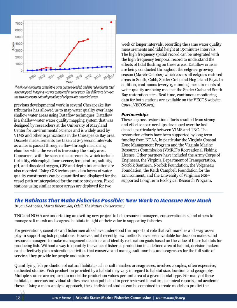
Through 2017, 74.5 million seeds have been broadcast into 536 acres in the four bays. The most exciting result of the project has been the natural spread of eelgrass from seeds produced and dispersed from these restored plots. In less than 20 years, 7,149 acres of the bays now have eelgrass. In addition, a bay scallop restoration program was initiated in 2009 and continues to be successful today, showing that it may be possible to re-introduce bay scallops at sustainable populations. The success of eelgrass in the Virginia Coastal Bays appears to be explained by a combination of plants receiving more light, and experiencing slightly cooler water temperatures as compared with restoration projects in Chesapeake Bay.
The ApproachSo just how did this all happen? There were three major components of this large-scale restoration effort: restore eelgrass with seeds, re-introduce the bay scallop, and monitor water quality.
Restore EelgrassVIMS and TNC adopted a seed based approach to the restoration process. While VIMS has previously conducted numerous studies using adult plants, the scale of the proposed effort precluded using adult plants because this approach was very labor intensive and costly. VIMS had been conducting basic research on eelgrass seeds and had previously developed protocols for collecting large numbers of seeds for projects in the Chesapeake Bay. It was clear that a seed-based restoration effort would be a logical approach here in the seaside bays given the scale of the project. This seed-based approach entailed several steps: 1. collecting eelgrass flowering shoots in the spring when seeds had matured and were being released from flowers,
normally around mid to late May into early June; 2. storing flowering shoots in large flow-through seawater tanks until all seeds have been released, usually taking about six weeks; 3. sieving seeds from the large seawater tanks removing all the dead debris; 4. determining the volume of seeds collected from the tanks and estimating seed numbers for use in the restoration work; 5. storing seeds in in a recirculating seawater tank at water temperatures of 25°C.; 6. identifying potential areas of seeds enhancement; and 7. broadcasting seeds into predetermined plots in the fall following seed collection, but before seeds germinate in November.
Restore the Bay ScallopFollowing on our success in restoring eelgrass to the coastal bays, we initiated a program in 2009 to re-establish a bay scallop population. Re-establishing a viable bay scallop population is a formidable task given its almost 80-year absence from these bays and the region’s isolation from existing natural populations of bay scallops in North Carolina and New Jersey.
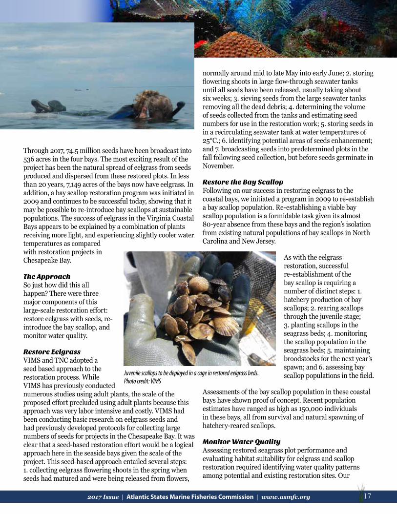
As with the eelgrass restoration, successful re-establishment of the bay scallop is requiring a number of distinct steps: 1. hatchery production of bay scallops; 2. rearing scallops through the juvenile stage; 3. planting scallops in the seagrass beds; 4. monitoring the scallop population in the seagrass beds; 5. maintaining broodstocks for the next year’s spawn; and 6. assessing bay scallop populations in the field.
Assessments of the bay scallop population in these coastal bays have shown proof of concept. Recent population estimates have ranged as high as 150,000 individuals in these bays, all from survival and natural spawning of hatchery-reared scallops.
Monitor Water QualityAssessing restored seagrass plot performance and evaluating habitat suitability for eelgrass and scallop restoration required identifying water quality patterns among potential and existing restoration sites. Our
Juvenile scallops to be deployed in a cage in restored eelgrass beds.Photo credit: VIMS
Snorkeling for eelgrass seeds. Photo credit: TNC
18 2017 Issue | Atlantic States Marine Fisheries Commission | www.asmfc.org
previous developmental work in several Chesapeake Bay tributaries has allowed us to map water quality over large shallow water areas using Dataflow techniques. Dataflow is a shallow-water water quality mapping system that was designed by researchers at the University of Maryland Center for Environmental Science and is widely used by VIMS and other organizations in the Chesapeake Bay area. Discrete measurements are taken at 2-3 second intervals as water is passed through a flow-through measuring chamber while the vessel is traversing the study area. Concurrent with the sensor measurements, which include turbidity, chlorophyll fluorescence, temperature, salinity, pH, and dissolved oxygen, GPS and depth information are also recorded. Using GIS techniques, data layers of water quality constituents can be quantified and displayed for the vessel path or interpolated for the entire study area. Fixed stations using similar sensor arrays are deployed for two
The blue line indicates cumulative acres planted/seeded, and the red indicates total acres mapped. Mapping was not completed in some years. The difference between the two represents natural spreading of eelgrass into unseeded areas.
week or longer intervals, recording the same water quality measurements and tidal height at 15-minutes intervals. The high frequency spatial record can be integrated with the high frequency temporal record to understand the effects of tidal flushing on these areas. Dataflow cruises are being conducted throughout the eelgrass growing season (March-October) which covers all eelgrass restored areas in South, Cobb, Spider Crab, and Hog Island Bays. In addition, continuous (every 15 minutes) measurements of water quality are being made at the Spider Crab and South Bay restoration sites. Real time, continuous monitoring data for both stations are available on the VECOS website (www.VECOS.org).
PartnershipsThese eelgrass restoration efforts resulted from strong and effective partnerships developed over the last decade, particularly between VIMS and TNC. The restoration efforts have been supported by long term funding from NOAA, in particular the Virginia Coastal Zone Management Program and the Virginia Marine Resources Commission (VMRC)’s Recreational Fishing License. Other partners have included the Army Corps of Engineers, the Virginia Department of Transportation, Norfolk Southern, Norfolk Foundation, the Volgeneau Foundation, the Keith Campbell Foundation for the Environment, and the University of Virginia’s NSF-supported Long Term Ecological Research Program.
The Habitats That Make Fisheries Possible: New Work to Measure How Much Bryan DeAngelis, Marta Ribera, Jay Odell, The Nature Conservancy
TNC and NOAA are undertaking an exciting new project to help resource managers, conservationists, and others to manage salt marsh and seagrass habitats in light of their value in supporting fisheries.
For generations, scientists and fishermen alike have understood the important role that salt marshes and seagrasses play in supporting fish populations. However, until recently, few methods have been available for decision makers and resource managers to make management decisions and identify restoration goals based on the value of these habitats for producing fish. Without a way to quantify the value of fisheries production in a defined area of habitat, decision makers can’t effectively plan restoration activities that conserve and manage salt marshes and seagrasses for the full suite of services they provide for people and nature.
Quantifying fish production of natural habitat, such as salt marshes or seagrasses, involves complex, often expensive, dedicated studies. Fish production provided by a habitat may vary in regard to habitat size, location, and geography. Multiple studies are required to model the production values per unit area of a given habitat type. For many of these habitats, numerous individual studies have been published in peer reviewed literature, technical reports, and academic theses. Using a meta-analysis approach, these individual studies can be combined to create models to predict the
192017 Issue | Atlantic States Marine Fisheries Commission | www.asmfc.org 19
augmented fish production values provided by a given area of habitat. Working with our scientific partners, including Drs. Philine zu Ermgassen, J. Grabowski, L. Rozas, R. Baker, S. Powers and others we are using this approach for estimating the fisheries production of salt marsh and seagrass habitats in the United States, where data allows. The method combines quantitative abundance data of juveniles utilizing the nursery habitat with established growth and mortality relationships to estimate the fish biomass enhancement for species over their lifetimes that can be attributed to the presence of the habitat. The method is based on the assumption that habitat availability can limit fish recruitment where nursery habitats have been severely reduced in extent.
Valuing an area of salt marsh or seagrass habitat by the amount, number, or type of fish they produce can help improve management by incorporating these values into decision-making, as well as provide communities and stakeholders with an understanding of the habitat required to achieve the desired ecosystem-based goals. Beyond advancing the science behind estimating fish productivity from these habitats, our goal is to “mechanize” the work into decision-support tools, so that natural resource managers, communities, and other stakeholders will have the ability to manage habitats for the suite of services they provide. For example, TNC has been leading a project to quantify both the water filtration rate and the average production of finfish and crabs gained from area of oyster reef habitat (http://oceanwealth.org/tools/oyster-calculator/). We are now working with NOAA and other partners to produce a similar Manager’s Guide and interactive, web-based tools to help identify quantitative objectives for restoration and conservation of salt marsh and seagrass habitats based on their estimated levels of fish production.
The tools and applications we are building will include habitat maps so that users can apply these estimates to their own bays and estuaries. To do this, we first needed to collect all available salt marsh and seagrass spatial data. For saltmarshes, we are using NOAA’s Coastal Change Analysis Program (C-CAP) latest habitat data, which are derived from satellite information. On the other hand, most seagrass data currently available are still created by hand-digitizing aerial images, which requires substantial time and money to collect. As a result, seagrass habitats are not mapped consistently throughout all states. Our
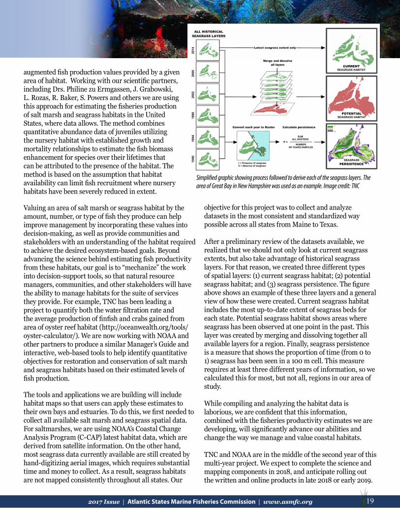
Simplified graphic showing process followed to derive each of the seagrass layers. The area of Great Bay in New Hampshire was used as an example. Image credit: TNC
objective for this project was to collect and analyze datasets in the most consistent and standardized way possible across all states from Maine to Texas.
After a preliminary review of the datasets available, we realized that we should not only look at current seagrass extents, but also take advantage of historical seagrass layers. For that reason, we created three different types of spatial layers: (1) current seagrass habitat; (2) potential seagrass habitat; and (3) seagrass persistence. The figure above shows an example of these three layers and a general view of how these were created. Current seagrass habitat includes the most up-to-date extent of seagrass beds for each state. Potential seagrass habitat shows areas where seagrass has been observed at one point in the past. This layer was created by merging and dissolving together all available layers for a region. Finally, seagrass persistence is a measure that shows the proportion of time (from 0 to 1) seagrass has been seen in a 100 m cell. This measure requires at least three different years of information, so we calculated this for most, but not all, regions in our area of study.
While compiling and analyzing the habitat data is laborious, we are confident that this information, combined with the fisheries productivity estimates we are developing, will significantly advance our abilities and change the way we manage and value coastal habitats.
TNC and NOAA are in the middle of the second year of this multi-year project. We expect to complete the science and mapping components in 2018, and anticipate rolling out the written and online products in late 2018 or early 2019.

20 2017 Issue | Atlantic States Marine Fisheries Commission | www.asmfc.org
AtlAntic coAStAl FiSh hAbitAt PArtnerShiP uPdAte
The Atlantic Coastal Fish Habitat Partnership (ACFHP or Partnership) has continued to help restore and protect fish habitat through on the ground conservation projects along the coast, science and data initiatives, and collaborating with partners to address fish habitat concerns in 2017.
The Partnership spent the first half of the year finalizing their five-year Conservation Strategic Plan and complimentary two-year Action Plan, both of which were released in July. These plans contain new conservation, science and data, outreach and communication, and financial objectives and strategies based on subregional priority habitats and threats.
The 2017 – 2021 Conservation Strategic Plan updates and revises ACFHP’s first conservation strategic plan, which covered the 2012 – 2016 time frame. Some of the Partnership’s accomplishments during this period can be found listed on page 5 of the new plan. Most notably, ACFHP contributed over $400,000 directly to conservation projects, leveraging on average $4 for each ACFHP restoration dollar. This has helped to open 75 river miles and restore almost 25 acres of priority fish habitat, adding an estimated $41 million in economic value to the Atlantic coast annually.
The 2017 – 2019 Action Plan has identified 32 specific actions to be taken to advance a subset of objectives and strategies listed in the Conservation Strategic Plan. These actions will be carried out by ACFHP and its partners.
On the Ground ConservationACFHP has continued promoting research on the relationship between black sea bass abundance and habitat characteristics in the Mid-Atlantic through a grant from the Mid-Atlantic Fishery Management Council. The project, led by Dr. Brad Stevens of University of Maryland Eastern Shore, is titled ‘Hab in the MAB: Characterizing black sea bass habitat in the Mid-Atlantic Bight.’ Dr. Stevens is collecting data on black sea bass abundance, stomach contents, and position in the food web, as well as
characteristics of the habitats black sea bass are associated with: bottom type; whether a reef is natural or artificial; and the plants, animals, and algae attached to each habitat. This work will lead to a better understanding of the importance of habitat and prey community structure on black sea bass feeding ecology. Dr. Stevens and his team
are halfway through their field seasons, and will finish their data collections at the end of 2018. So far they have sampled over 400 fish, recorded over 40 hours of underwater videos, and set up an artificial reef corridor to study habitat connectivity.
ACFHP has partnered with the U.S. Fish and Wildlife Service (Service) for the
eighth consecutive year to fund two new on-the-ground restoration projects in 2017. One project is located on the Sheepscot River in Lincoln County, Maine, and will remove both the Coopers Mills Dam and a section of the Head Tide Dam. This work is being led by the Atlantic Salmon Federation, in cooperation with over 10 other federal and state agencies and nongovernmental organizations. It will restore access to 71 river miles for federally endangered
Atlantic salmon and 11 other migratory fish species that are all less than 1% of their historic abundance in the river. The project addresses public safety, historic preservation, and increased recreational opportunities for the local communities. The North Carolina Coastal Federation is leading the second ACFHP-funded project, which will restore 300 linear ft of oyster reefs and estuarine shorelines in Bogue Sound, North Carolina. The existing shoreline suffers from severe erosion due to sea level rise, storms, and high wave activity. Restoration will provide valuable nursery habitat for fishes such as black sea bass and red drum, as well as foraging grounds for summer flounder and other trust species. For more information on this and other ACFHP-Service funded projects, please visit: www.atlanticfishhabitat.org/projects/fundedprojects/.
ConservationStrategic Plan2017-2021
ConservationAction Plan2017-2019
212017 Issue | Atlantic States Marine Fisheries Commission | www.asmfc.org 21
AtlAntic coAStAl FiSh hAbitAt PArtnerShiP uPdAte
Science and Data DevelopmentsACFHP has made great progress on its NOAA-funded pilot project to characterize fish habitat conservation areas through GIS mapping and analysis for the southeast region of the U.S. from North Carolina to Florida. The resulting maps will help ACFHP identify where best to invest effort and future National Fish Habitat Action Plan (NFHAP) funds. Species of concern, data layers, and metrics have all been selected, mainly during ACFHP’s Science and Data Committee meeting September 27-28. The analysis and mapping is currently underway through a collaboration with the Southeast Aquatic Resources Partnership (SARP). The final product will be released in early summer. Pending additional funding, this pilot project will be expanded to the entire ACFHP region.
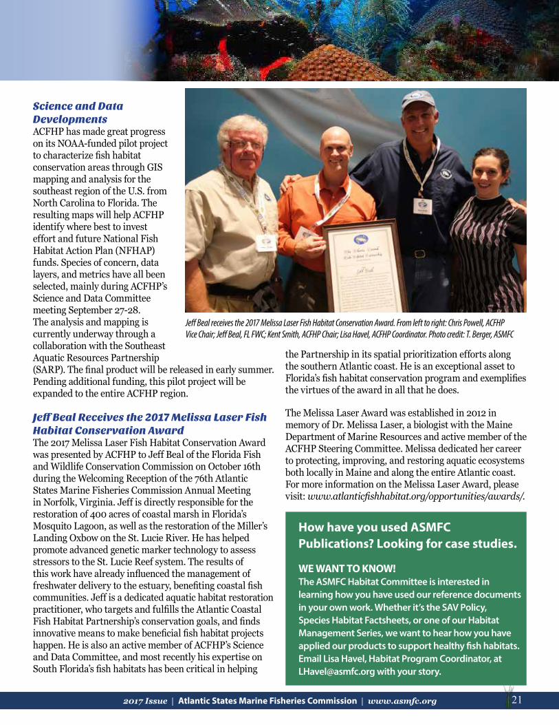
Jeff Beal Receives the 2017 Melissa Laser Fish Habitat Conservation AwardThe 2017 Melissa Laser Fish Habitat Conservation Award was presented by ACFHP to Jeff Beal of the Florida Fish and Wildlife Conservation Commission on October 16th during the Welcoming Reception of the 76th Atlantic States Marine Fisheries Commission Annual Meeting in Norfolk, Virginia. Jeff is directly responsible for the restoration of 400 acres of coastal marsh in Florida’s Mosquito Lagoon, as well as the restoration of the Miller’s Landing Oxbow on the St. Lucie River. He has helped promote advanced genetic marker technology to assess stressors to the St. Lucie Reef system. The results of this work have already influenced the management of freshwater delivery to the estuary, benefiting coastal fish communities. Jeff is a dedicated aquatic habitat restoration practitioner, who targets and fulfills the Atlantic Coastal Fish Habitat Partnership’s conservation goals, and finds innovative means to make beneficial fish habitat projects happen. He is also an active member of ACFHP’s Science and Data Committee, and most recently his expertise on South Florida’s fish habitats has been critical in helping
the Partnership in its spatial prioritization efforts along the southern Atlantic coast. He is an exceptional asset to Florida’s fish habitat conservation program and exemplifies the virtues of the award in all that he does.
The Melissa Laser Award was established in 2012 in memory of Dr. Melissa Laser, a biologist with the Maine Department of Marine Resources and active member of the ACFHP Steering Committee. Melissa dedicated her career to protecting, improving, and restoring aquatic ecosystems both locally in Maine and along the entire Atlantic coast. For more information on the Melissa Laser Award, please visit: www.atlanticfishhabitat.org/opportunities/awards/.
Jeff Beal receives the 2017 Melissa Laser Fish Habitat Conservation Award. From left to right: Chris Powell, ACFHP Vice Chair; Jeff Beal, FL FWC; Kent Smith, ACFHP Chair; Lisa Havel, ACFHP Coordinator. Photo credit: T. Berger, ASMFC
How have you used ASMFC Publications? Looking for case studies.
WE WANT TO KNOW!The ASMFC Habitat Committee is interested in learning how you have used our reference documents in your own work. Whether it’s the SAV Policy, Species Habitat Factsheets, or one of our Habitat Management Series, we want to hear how you have applied our products to support healthy fish habitats. Email Lisa Havel, Habitat Program Coordinator, at [email protected] with your story.

22 2017 Issue | Atlantic States Marine Fisheries Commission | www.asmfc.org
uPdAteS From Around the coASt
New Hampshire
Dam RemovalsCheri Patterson, New Hampshire Fish and Game Department, Kevin Lucey, NH Department of Environmental Services Coastal Program
The members of the New Hampshire (NH) River Restoration Task Force continue to work with state, federal, non-governmental organizations, individual dam owners, and municipalities on dam removal projects by providing technical advice with many potential dam removal projects. Many of the dams under consideration for removal are due to safety concerns investigated by the NH Department of Environmental Services (NHDES), Dam Safety Section. Letters of Deficiency have been issued and the dam owners (private, municipal, and state) are navigating through various stages to determine available options such as dam removal, repair, or modification to meet dam safety standards. These options consider many aspects such as public input, long and short term environmental and financial concerns, recreational impacts, fish passage, and others. Below is an update on dams currently being demolished or soon to be removed that affect NH coastal watersheds and diadromous fish passage and habitats.
Sawyer Mill Dam, Dover NHThe Upper and Lower Sawyer Mill Dams represent the first diadromous fish passage barriers on the Bellamy River, a major tributary river to the Great Bay Estuary. This dam removal project presents a unique opportunity to remove two high hazard dams that are located immediately upstream of the head-of-tide to re-establish connectivity between freshwater and tidal habitats, restore fish passage, improve water quality, and reduce flood hazards.
Gonic and Gonic Sawmill Dams, Cocheco River, Gonic, NHThe Gonic and Gonic Sawmill Dams are the third and fourth dams on the mainstem of the Cocheco River. The City of Rochester and the NHDES continue to pursue removal of both dams (feasibility study conducted in 2005); however, the unresolved ownership status of the Gonic Sawmill Dam and its adjacent 8.3 acre parcel continue to delay the project. In 2017, the City of Rochester with funding from DES and NOAA Coastal Zone Management completed a groundwater quality
investigation at the former sawmill site. NH Department of Justice is involved to evaluate ownership of the abandoned dam and adjacent sawmill site.
Great Dam, Exeter, NH, Exeter/Squamscott River – Owner, Town of ExeterMike Dionne, New Hampshire Fish and Game Department
Following a successful dam removal during summer 2016, the former Great Dam site in Exeter, NH, was ready to pass diadromous fish, primarily river herring, in spring 2017. Based on observations by NH Fish and Game Department (NHFG) biologists during the migration season, fish passage through the two primary zones of passage on river-right and river-left appeared limited. During certain flow conditions moderate fish passage was observed up through laterally-oriented fractures in the center bedrock outcropping. It was noted that minor adjustments to these areas of fractured rock may better enable fish passage at
August 3, 2017- USFWS and NOAA NMFS biologist and fish passage engineers review engineering design drawings for removal of the Lower Sawyer Mill Dam, Bellamy River, Dover, NH. Photo credit: K. Lucey, NHDES Coastal Program
Gonic Sawmill Dam, Cocheco River, Rochester, NH. Photo Credit: K. Lucey, NHDES Coastal Program
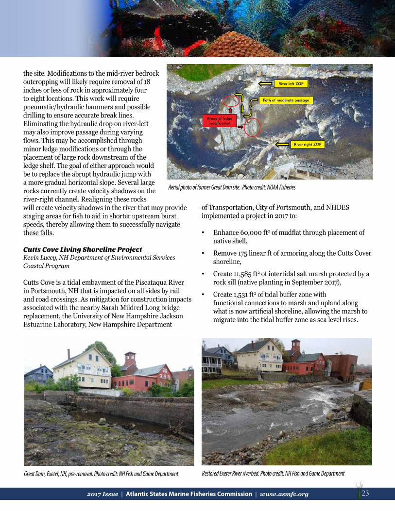
232017 Issue | Atlantic States Marine Fisheries Commission | www.asmfc.org 23
the site. Modifications to the mid-river bedrock outcropping will likely require removal of 18 inches or less of rock in approximately four to eight locations. This work will require pneumatic/hydraulic hammers and possible drilling to ensure accurate break lines. Eliminating the hydraulic drop on river-left may also improve passage during varying flows. This may be accomplished through minor ledge modifications or through the placement of large rock downstream of the ledge shelf. The goal of either approach would be to replace the abrupt hydraulic jump with a more gradual horizontal slope. Several large rocks currently create velocity shadows on the river-right channel. Realigning these rocks will create velocity shadows in the river that may provide staging areas for fish to aid in shorter upstream burst speeds, thereby allowing them to successfully navigate these falls.
Cutts Cove Living Shoreline ProjectKevin Lucey, NH Department of Environmental Services Coastal Program
Cutts Cove is a tidal embayment of the Piscataqua River in Portsmouth, NH that is impacted on all sides by rail and road crossings. As mitigation for construction impacts associated with the nearby Sarah Mildred Long bridge replacement, the University of New Hampshire Jackson Estuarine Laboratory, New Hampshire Department
of Transportation, City of Portsmouth, and NHDES implemented a project in 2017 to:
• Enhance 60,000 ft2 of mudflat through placement of native shell,
• Remove 175 linear ft of armoring along the Cutts Cover shoreline,
• Create 11,585 ft2 of intertidal salt marsh protected by a rock sill (native planting in September 2017),
• Create 1,531 ft2 of tidal buffer zone with functional connections to marsh and upland along what is now artificial shoreline, allowing the marsh to migrate into the tidal buffer zone as sea level rises.
River right ZOP
Path of moderate passage
River left ZOP
Areas of ledge modification
Great Dam, Exeter, NH, pre-removal. Photo credit: NH Fish and Game Department Restored Exeter River riverbed. Photo credit: NH Fish and Game Department
Aerial photo of former Great Dam site. Photo credit: NOAA Fisheries

24 2017 Issue | Atlantic States Marine Fisheries Commission | www.asmfc.org
Oyster Restoration in Great Bay Estuary, NHAlix Laferriere, The Nature Conservancy New Hampshire
During 2017, TNC in partnership with the University of New Hampshire worked together on oyster restoration efforts in a five-acre footprint of the Great Bay Estuary of New Hampshire. The site is adjacent to Nannie’s Island and juxtaposed the 2016 oyster restoration site. Five hundred yds3 of seasoned clam shell was placed at the site as reef base and in September 2017, 1 million juvenile oysters “spat on shell” will be placed on the shell. To further inform the reef restoration project, TNC is partnering with Dr. Tom Lippmann from the University of New Hampshire Center for Coastal & Mapping Laboratory to conduct bathymetric surveys of the restoration site. Dr. Lippmann will conduct four surveys across seasons to examine fine scale sediment dynamics on and around the reef base. In addition, this year TNC’s Oyster Conservationist Program has engaged 100 volunteers, including families, schools, businesses, and individuals across the Seacoast Region of New Hampshire and Southern Maine to grow oysters on their private docks for the restoration effort. This work was supported by funds from the Natural Resources Conservation Service through the Regional Conservation Partnership Program to support conservation in New Hampshire’s coastal watershed.
Coastal Wetland MappingCory Riley, Great Bay National Estuarine Research Reserve (NERR)
The Great Bay NERR is working with NOAA’s Office of Coastal Management to produce high resolution maps for all tidal wetlands in New Hampshire. This project involves training remote sensing software to recognize NH marsh features, and then conducting a detailed field accuracy
Seasoned clam shell deployed as reef base for the 2017 restoration site at Nannie Island, Great Bay Estuary, New Hampshire. Photo Credit: A. Laferriere, TNC
Chris Robinson and Kevin Lucey. Photo credit: R. Stevens, GBNERR
Cutts Cove Living Shoreline Project: construction of the rock sill associated with created intertidal salt marsh habitat. May 2017. Photo credit: NHDES, Coastal Program
assessment of all NH marshes. Each of the 24 habitat metrics used in this mapping scheme are sampled using up to 50 points located by stratified random sampling. Each point is visited in the field, the GPS coordinates noted, and the most appropriate habitat metric according to the NOAA mapping scheme is determined using a data dictionary. The resulting maps will provide an incredibly detailed baseline for how the state’s marshes are changing over time.

252017 Issue | Atlantic States Marine Fisheries Commission | www.asmfc.org 25
MassachusettsMark Rousseau, Massachusetts DMF
Massachusetts GOM Cod Industry-Based Survey assesses cod stocks with input from commercial fishermenGiven the poor stock status of Gulf of Maine (GOM) Atlantic cod, low catch limits, and many fishermen’s claims that the cod population is better than currently assessed, Massachusetts Division of Marine Fisheries (MarineFisheries) implemented a new GOM Cod Industry-Based Survey (Cod IBS) in April 2016. The survey is conducted on the commercial fishing vessel Miss Emily, a 53’ stern trawler out of Scituate, MA. The Cod IBS follows a stratified-random design with stations occurring from 10 to 160 fathoms within the GOM cod stock boundary. The survey area was selected to best suit the remnant population of GOM cod based on guidance from commercial fishermen along with input from the Massachusetts Marine Fisheries Institute, NOAA National Marine Fisheries Service (NMFS), and the Northeast Fisheries Science Center. The survey is conducted eight months per year during January, April, May, June, July, October, November, and December. Approximately 10 days of sampling occur in each survey month, making 30-minute tows and, depending on weather and sea conditions, averaging five tows per day. As of July 2017, 12 monthly survey cruises have been conducted completing 526 successful tows. The survey resumed on October 1st, 2017 and will continue through January 31st, 2018. For more information please contact Bill Hoffman at [email protected].
The Massachusetts and Rhode Island Offshore Wind Energy Areas: three current leases and two more to come.Deepwater Wind, Dong Energy, and Offshore MW are the three developers initiating the permitting process to develop offshore wind off the
coasts of Rhode Island and Massachusetts. Deepwater Wind installed the 5-turbine/30 MW Block Island Wind Farm, the first offshore wind farm in the U.S. Deepwater is planning the South Fork Wind Farm project, anticipated to reach 90 MW (15 turbines), and the 144 MW Revolution Wind project (24 turbines). Dong Energy is planning Bay State Wind, a project anticipated to reach 2 GW (about 285 turbines). Offshore MW is planning Vineyard Wind, a project anticipated to be 1.6 GW (about 230 turbines). Two additional lease areas in the Massachusetts Wind Energy Area (in green in the image) are
expected to be auctioned off in the summer/early fall of 2018. Lease activities to date have included geophysical surveys of the seafloor in the wind energy areas and the potential cable routes to shore. Offshore floating light and detection ranging (FLIDAR) buoys have been deployed to measure wind speed and direction, water and air temperatures, waves, and currents. See their onboard cameras here: https://portal.axys-aps.com/platforms/P2012P/. Concerns over impacts associated with impacts to squid and squid mops, jonah crab, and other invertebrates; the artificial reef effect; the compatibility between trawling and wind farms; and many other potential impacts are being voiced. The Ocean Studies Board of the National Academy of Science organized the Atlantic Offshore Renewable Energy Development and Fisheries Steering
Map of cod survey area. Figure credit: Marine Fisheries
Map of wind energy leases. Figure credit: BOEM
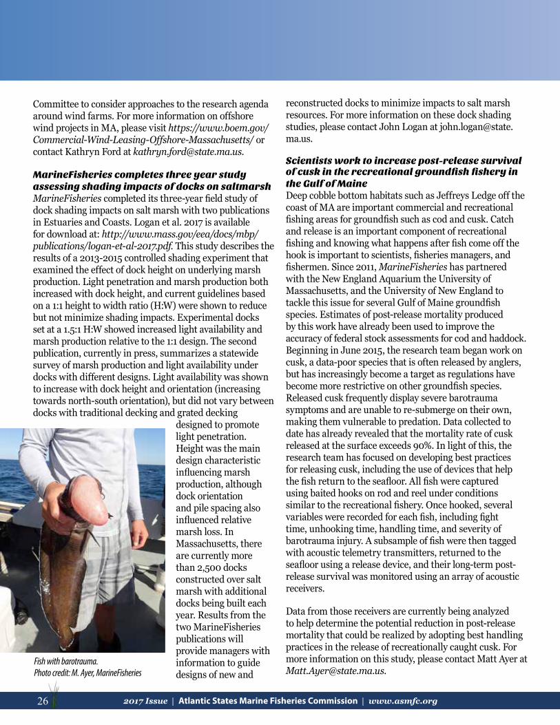
26 2017 Issue | Atlantic States Marine Fisheries Commission | www.asmfc.org
Committee to consider approaches to the research agenda around wind farms. For more information on offshore wind projects in MA, please visit https://www.boem.gov/Commercial-Wind-Leasing-Offshore-Massachusetts/ or contact Kathryn Ford at [email protected].
MarineFisheries completes three year study assessing shading impacts of docks on saltmarshMarineFisheries completed its three-year field study of dock shading impacts on salt marsh with two publications in Estuaries and Coasts. Logan et al. 2017 is available for download at: http://www.mass.gov/eea/docs/mbp/publications/logan-et-al-2017.pdf. This study describes the results of a 2013-2015 controlled shading experiment that examined the effect of dock height on underlying marsh production. Light penetration and marsh production both increased with dock height, and current guidelines based on a 1:1 height to width ratio (H:W) were shown to reduce but not minimize shading impacts. Experimental docks set at a 1.5:1 H:W showed increased light availability and marsh production relative to the 1:1 design. The second publication, currently in press, summarizes a statewide survey of marsh production and light availability under docks with different designs. Light availability was shown to increase with dock height and orientation (increasing towards north-south orientation), but did not vary between docks with traditional decking and grated decking
designed to promote light penetration. Height was the main design characteristic influencing marsh production, although dock orientation and pile spacing also influenced relative marsh loss. In Massachusetts, there are currently more than 2,500 docks constructed over salt marsh with additional docks being built each year. Results from the two MarineFisheries publications will provide managers with information to guide designs of new and
reconstructed docks to minimize impacts to salt marsh resources. For more information on these dock shading studies, please contact John Logan at [email protected].
Scientists work to increase post-release survival of cusk in the recreational groundfish fishery in the Gulf of MaineDeep cobble bottom habitats such as Jeffreys Ledge off the coast of MA are important commercial and recreational fishing areas for groundfish such as cod and cusk. Catch and release is an important component of recreational fishing and knowing what happens after fish come off the hook is important to scientists, fisheries managers, and fishermen. Since 2011, MarineFisheries has partnered with the New England Aquarium the University of Massachusetts, and the University of New England to tackle this issue for several Gulf of Maine groundfish species. Estimates of post-release mortality produced by this work have already been used to improve the accuracy of federal stock assessments for cod and haddock. Beginning in June 2015, the research team began work on cusk, a data-poor species that is often released by anglers, but has increasingly become a target as regulations have become more restrictive on other groundfish species. Released cusk frequently display severe barotrauma symptoms and are unable to re-submerge on their own, making them vulnerable to predation. Data collected to date has already revealed that the mortality rate of cusk released at the surface exceeds 90%. In light of this, the research team has focused on developing best practices for releasing cusk, including the use of devices that help the fish return to the seafloor. All fish were captured using baited hooks on rod and reel under conditions similar to the recreational fishery. Once hooked, several variables were recorded for each fish, including fight time, unhooking time, handling time, and severity of barotrauma injury. A subsample of fish were then tagged with acoustic telemetry transmitters, returned to the seafloor using a release device, and their long-term post-release survival was monitored using an array of acoustic receivers.
Data from those receivers are currently being analyzed to help determine the potential reduction in post-release mortality that could be realized by adopting best handling practices in the release of recreationally caught cusk. For more information on this study, please contact Matt Ayer at [email protected].
Fish with barotrauma. Photo credit: M. Ayer, MarineFisheries

272017 Issue | Atlantic States Marine Fisheries Commission | www.asmfc.org 27
ConnecticutStephen Gephard, Connecticut Department of Energy and Environmental Protection (DEEP)
Connecticut DEEP actively protects marine habitat in Long Island Sound by reviewing, commenting, and placing conditions upon permit applications for a variety of activities proposed in marine waters. These include transportation projects such as bridges, dredging, construction of new docks and seawalls, and aquaculture facilities. Much of the habitat restoration work for managed species focuses on opening migratory corridors for diadromous fish species and much of that work extends well inland and into freshwater habitat. During the 2016 construction season, five dams were removed and two fishways constructed for a gain of 36.5 riverine miles—a lot for such a heavily dammed state as Connecticut. Both fishways were steeppass style, built at the head-of-tide on the Goodwives and Menunketesuck rivers and alewives are the main beneficiary of both projects. Both included stand-alone eel passes to assist glass eels and elvers over the dams and into freshwater.
The Carpenters and Clark Brothers dams were removed on the Quinnipiac River to benefit not only alewife and blueback herring but also American shad and sea lamprey. These dams were upstream of two operational fishways. Ed Bills Pond Dam and Norton Mill Dam were removed from Connecticut River tributaries and benefitted the river herring species, American shad, sea lamprey, and in the case of Norton Mill Dam, Atlantic salmon. These two dam removals not only opened the streams to migration, but also converted unsuitable habitat that existed behind the dam to high-quality, important spawning and nursery habitat.
Although the DEEP provides critical leadership and technical guidance for all of these projects, partnerships are critical to their success. Municipalities and non-governmental organizations like TNC and Save the Sound are important Connecticut partners. They secure grants from NOAA, National Fish & Wildlife Foundation, U.S. Fish & Wildlife Service and others to fund these projects. Several dam removals were funded by Hurricane Sandy Resiliency Grants.
The 2017 field season is underway and we hope that by year’s end, there will be one more fishway and five fewer dams in Connecticut.
Early Breach- The Norton Mill Dam Removal on the Jeremy River opened 17 miles of diadromous fish habitat. Photo credit: CTDEEP
Chapmans Pond Dam is at the head-of-tide on the Menunketesuck River. The steeppass fishway on the left passes river herring; the eel pass on the right collects eels that drop into a trap where they are enumerated and carried around the dam. The substrate to the left is for glass eels; the substrate on the right is for larger yellow eels. Photo credit: CT DEEP
Even low dams like the Clark Bros Dam on the Quinnipiac River can block river herring runs. Photo credit: CTDEEP

28 2017 Issue | Atlantic States Marine Fisheries Commission | www.asmfc.org
Beaver Lake Dam during construction. Photo credit: V. O’NeillPassage Seaward Side. Photo credit: S. Harold, TNC
New YorkDawn McReynolds, New York Department of Environmental Conservation
Beaver Lake Dam Fish Passage, Mill Neck NYEvery spring, diadromous fish, alewife (Alosa pseudoherengus) and blueback herring (Alosa aestivalis), travel from the Atlantic Ocean into local rivers and streams along the eastern seaboard of the United States in order to spawn. In New York, these migratory fish species typically find impediments within the tributaries that block their passage from brackish to freshwater. The existence of manmade structures, such as dams, weirs, and culverts, prevent these fish from reaching their freshwater spawning grounds. These impediments, along with bycatch and poor water quality, have led to dwindling populations of alewife and blueback herring within New York State.
Partners on Long Island, NY are working to provide fish passage at impediments on tributaries where known, remnant herring runs still exist. Fish passage projects can be costly and slow to complete. However, despite the cost, tedious regulatory requirements, and overall community concerns, several fish passage projects have been completed and, as a result, herring populations are on the rise. The recently completed fish passage project at Beaver Lake Dam in Mill Neck, NY took nearly two decades to reach construction. Thanks to the efforts of TNC, New York Department of Environmental Conservation (NYSDEC), Friends of the Bay, the Village of Mill Neck, and funding through the National Fish & Wildlife Foundation’s Long Island Sound Futures Fund, a new Alaskan steeppass fishway was installed at Beaver Lake Dam in August 2017. This passage opens up 1.5 miles of stream corridor and 110 acres of associated wetlands to migratory fish. Hofstra University stocked alewife into the pond this past spring in order to jump start the run and Cornell Cooperative Extension, along with citizen scientists, will monitor the passage for spawning fish next year.
Hudson River Estuary- SAV Mapping, Science and RestorationSAV exists in the upper 125 miles of the tidal Hudson River estuary, where slightly brackish to freshwater conditions exist. SAV communities are dominated by Vallisneria americana, though around a dozen other species may be present. These communities are light-limited, and only occur at depths less than six feet. SAV plays a vital role in oxygenating the water column and provides cover, nursery and feeding habitats for a wide variety of fish, invertebrates, and
birds, as documented by several studies of Hudson River SAV functions.
SAV has been mapped on the Hudson River several times since 1995, and SAV volunteer monitors have conducted annual surveys since 2003 to provide important information about year-to-year changes in known SAV beds. Prior to 2011, SAV occupied around 4500 acres of the Hudson River estuary, about six percent of the river bottom area. However, SAV was nearly extirpated by Tropical Storm Irene in August 2011. Following two seasons of no or slow SAV recovery, the Hudson River NERR and other partners convened a meeting in 2014 to explore the feasibility of and need for Hudson River SAV restoration, and to refine an SAV restoration decision tree. Several important research needs were identified and subsequently funded by the Hudson River Foundation.
Scientists from SUNY College of Environmental Science and Forestry and the Cary Institute of Ecosystem Studies found the SAV loss was primarily caused by burial of the overwintering “buds” (turions) by a massive influx of sediments eroded from the watershed, rather than other factors, such as herbivory, scour, or lack of light. They determined that SAV habitat was not impaired in any way, and could support either natural recovery or restoration. Trial plantings of nursery stock SAV were largely successful
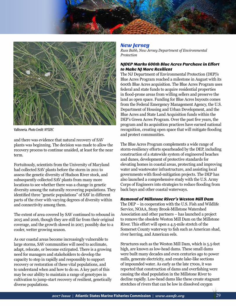
292017 Issue | Atlantic States Marine Fisheries Commission | www.asmfc.org 29
and there was evidence that natural recovery of SAV plants was beginning. The decision was made to allow the recovery process to continue unaided, at least for the near term.
Fortuitously, scientists from the University of Maryland had collected SAV plants before the storm in 2011 to assess the genetic diversity of Hudson River stock, and subsequently collected SAV plants from many more locations to see whether there was a change in genetic diversity among the naturally recovering populations. They identified three “genetic populations” of SAV in different parts of the river with varying degrees of diversity within and connectivity among them.
The extent of area covered by SAV continued to rebound in 2015 and 2016, though they are still far from their original coverage, and the growth slowed in 2017, possibly due to a cooler, wetter growing season.
As our coastal areas become increasingly vulnerable to large storms, SAV communities will need to acclimate, adapt, relocate, or become extirpated. There is a growing need for managers and stakeholders to develop the capacity to step in rapidly and responsibly to support recovery or restoration of these vital populations, and to understand when and how to do so. A key part of this may be our ability to maintain a range of genotypes in cultivation to jump-start recovery of resilient, genetically diverse populations.
Vallisneria. Photo Credit: NYSDEC
New JerseyRuss Babb, New Jersey Department of Environmental Protection
NJDEP Marks 600th Blue Acres Purchase in Effort to Make NJ More ResilientThe NJ Department of Environmental Protection (DEP)’s Blue Acres Program reached a milestone in August with its 600th Blue Acres acquisition. The Blue Acres Program uses federal and state funds to acquire residential properties in flood-prone areas from willing sellers and preserve the land as open space. Funding for Blue Acres buyouts comes from the Federal Emergency Management Agency, the U.S. Department of Housing and Urban Development, and the Blue Acres and State Land Acquisition funds within the DEP’s Green Acres Program. Over the past five years, the program and its acquisition practices have earned national recognition, creating open space that will mitigate flooding and protect communities.
The Blue Acres Program complements a wide range of storm-resiliency efforts spearheaded by the DEP, including construction of a statewide system of engineered beaches and dunes, development of protective standards for elevating homes in coastal areas, protecting and improving water and wastewater infrastructure, and assisting local governments with flood-mitigation projects. The DEP has also launched a comprehensive study with the U.S. Army Corps of Engineers into strategies to reduce flooding from back bays and other coastal waterways.
Removal of Millstone River’s Weston Mill DamThe DEP – in cooperation with the U.S. Fish and Wildlife Service, NOAA, Stony Brook-Millstone Watershed Association and other partners – has launched a project to remove the obsolete Weston Mill Dam on the Millstone River. This effort will open a 4.5-mile stretch of the Somerset County waterway to fish such as American shad, river herring, and American eels.
Structures such as the Weston Mill Dam, which is 5.5-feet high, are known as low-head dams. These small dams were built many decades and even centuries ago to power mills, generate electricity, and create lake-like sections of impounded water. As early as the late 1700s, it was reported that construction of dams and overfishing were causing the shad population in the Millstone River to decline rapidly. Low-head dams like these create stagnant stretches of rivers that can be low in dissolved oxygen

30 2017 Issue | Atlantic States Marine Fisheries Commission | www.asmfc.org
that aquatic life needs, while exacerbating excessive algae growth that can diminish recreational and scenic enjoyment.
Using funds from other Natural Resource Damages settlements, the DEP and partners have removed three dams on the Raritan, making some 10 miles of that river free-flowing again. The Calco Dam in Bridgewater was removed in 2011, followed by the Roberts Street Dam in Bridgewater and Hillsborough in 2012, and the Nevius Street Dam in Raritan Borough in 2013. The Island Farm Weir, another dam located at the confluence of the Raritan and Millstone rivers, is equipped with a fish ladder. It is not a candidate for removal because the area it impounds supports intakes operated by the New Jersey Water Supply Authority.
American Shad Return to Musconetcong RiverAfter an absence of at least a century, American shad have returned to the Musconetcong River in northern New Jersey. This milestone is the result of the removal of dams on the lower Musconetcong River several years ago, followed by the removal of the Hughesville Dam in a nearby county in 2016. These projects opened nearly six miles of the Musconetcong to migratory fish. The DEP is working with partners in developing plans to remove the Warren Glen Dam, the largest on the river, as well as others to open even more stretches to migratory fish. The DEP classifies much of the river as a Category 1 stream, affording it the state’s highest level of protection due to its exceptional ecological and fisheries values.
New Jersey, Delaware Team up to Deploy Famed Zuni/Tamaroa as Part of Artificial Reef Site Comprised of Former Military ShipsThe 205-foot U.S. Coast Guard Cutter Tamaroa, formerly the Navy fleet tug Zuni, was deployed 26 nautical miles
southeast of Cape May at the Del-Jersey-Land Inshore Reef. This artificial reef, established 10 years ago specifically for former military vessels, is jointly managed by New Jersey, Delaware, and Maryland.
This sinking was completed by the Delaware Department of Natural Resources and Environmental Control, in partnership with the DEP. The State of Delaware paid for the bulk of the acquisition of the cutter, preparation, and sinking, assisted by the DEP, which received funding from the Ann E. Clarke Foundation and the Sportfishing Fund. The New Jersey Division of Fish and Wildlife currently holds permits for 15 artificial reef sites – 13 in federal waters – including the Del-Jersey-Land Reef – and two in state waters. The reefs, encompassing a total of 25 mi2 of ocean floor, are made up of a variety of materials such as concrete and steel, fishing boats and barges, even subway
The Weston Mill Dam on the Millstone River. Photo credit: NJDEP
Top: Formerly of the U.S. navy (as the fleet tug Zuni), the vessel is shown on patrol as the U.S. Coast Guard Navy Cutter Tamaroa. Photo credit: U.S. Coast Guard.Botom: Retired by the U.S. Coast Guard in 1994, the Cutter Tamaroa is shown being prepared for sinking. Photo credit: Coleen Marine, Inc.
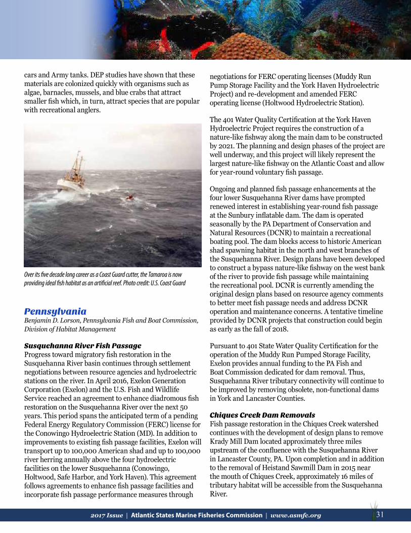
312017 Issue | Atlantic States Marine Fisheries Commission | www.asmfc.org 31
PennsylvaniaBenjamin D. Lorson, Pennsylvania Fish and Boat Commission, Division of Habitat Management
Susquehanna River Fish Passage Progress toward migratory fish restoration in the Susquehanna River basin continues through settlement negotiations between resource agencies and hydroelectric stations on the river. In April 2016, Exelon Generation Corporation (Exelon) and the U.S. Fish and Wildlife Service reached an agreement to enhance diadromous fish restoration on the Susquehanna River over the next 50 years. This period spans the anticipated term of a pending Federal Energy Regulatory Commission (FERC) license for the Conowingo Hydroelectric Station (MD). In addition to improvements to existing fish passage facilities, Exelon will transport up to 100,000 American shad and up to 100,000 river herring annually above the four hydroelectric facilities on the lower Susquehanna (Conowingo, Holtwood, Safe Harbor, and York Haven). This agreement follows agreements to enhance fish passage facilities and incorporate fish passage performance measures through
negotiations for FERC operating licenses (Muddy Run Pump Storage Facility and the York Haven Hydroelectric Project) and re-development and amended FERC operating license (Holtwood Hydroelectric Station).
The 401 Water Quality Certification at the York Haven Hydroelectric Project requires the construction of a nature-like fishway along the main dam to be constructed by 2021. The planning and design phases of the project are well underway, and this project will likely represent the largest nature-like fishway on the Atlantic Coast and allow for year-round voluntary fish passage.
Ongoing and planned fish passage enhancements at the four lower Susquehanna River dams have prompted renewed interest in establishing year-round fish passage at the Sunbury inflatable dam. The dam is operated seasonally by the PA Department of Conservation and Natural Resources (DCNR) to maintain a recreational boating pool. The dam blocks access to historic American shad spawning habitat in the north and west branches of the Susquehanna River. Design plans have been developed to construct a bypass nature-like fishway on the west bank of the river to provide fish passage while maintaining the recreational pool. DCNR is currently amending the original design plans based on resource agency comments to better meet fish passage needs and address DCNR operation and maintenance concerns. A tentative timeline provided by DCNR projects that construction could begin as early as the fall of 2018.
Pursuant to 401 State Water Quality Certification for the operation of the Muddy Run Pumped Storage Facility, Exelon provides annual funding to the PA Fish and Boat Commission dedicated for dam removal. Thus, Susquehanna River tributary connectivity will continue to be improved by removing obsolete, non-functional dams in York and Lancaster Counties.
Chiques Creek Dam RemovalsFish passage restoration in the Chiques Creek watershed continues with the development of design plans to remove Krady Mill Dam located approximately three miles upstream of the confluence with the Susquehanna River in Lancaster County, PA. Upon completion and in addition to the removal of Heistand Sawmill Dam in 2015 near the mouth of Chiques Creek, approximately 16 miles of tributary habitat will be accessible from the Susquehanna River.
Over its five decade long career as a Coast Guard cutter, the Tamaroa is now providing ideal fish habitat as an artificial reef. Photo credit: U.S. Coast Guard
cars and Army tanks. DEP studies have shown that these materials are colonized quickly with organisms such as algae, barnacles, mussels, and blue crabs that attract smaller fish which, in turn, attract species that are popular with recreational anglers.

32 2017 Issue | Atlantic States Marine Fisheries Commission | www.asmfc.org
MarylandMarek Topolski, Maryland Department of Natural Resources
Fish PassageSeveral fish passage projects in Maryland are planned. Removal of Bloede Dam on the Patapsco River began in early September, 2017. Phase 1 of the project is the relocation of an adjacent sewer line that passes through the dam. Sewer line relocation will take 8-12 months. Phase 2 is the dam removal which will begin late summer or fall 2018. Project completion (including tree plantings) is scheduled for Spring 2019. Fish passage options for the Elkton Dam in Elkton, MD are being considered by town officials, MD Department of Natural Resources staff, and U.S. Fish and Wildlife Service staff. The existing Denil fishway was installed on the dam in the mid 1990’s, but changing conditions around the site have caused accumulation of sand and gravel at the fishway entrance, inhibiting fish passage. One option is reconfiguration of a flood water bypass channel as a fishway.
Oyster RestorationAs part of the 2014 Chesapeake Bay Watershed Agreement, oyster restoration will occur in 10 tributaries (five in Maryland and five in Virginia). Maryland completed the initial restoration of Harris Creek in 2016. Three hundred fifty acres of Harris Creek has received oyster restoration activities: 197 acres received substrate (granite, mixed clam shell, and fossil shell) and oyster seed; 153 acres received only oyster seed. Based on initial monitoring of 42% of the sites, 98% of the area has met the threshold restoration criteria of having more than 15 oysters/m2 and 73% of the sites met the target restoration criteria of having more than 50 oysters/m2. Monitoring will continue over the next few years, including the remaining 58% of sites, and will examine the effectiveness of different substrates. More information can be found at these links:
• Update on Choptank Oyster Restoration Activities (https://chesapeakebay.noaa.gov/images/stories/pdf/2016marylandoysterimplementationupdate.pdf)
• Monitoring of Harris Creek Oyster Reefs Constructed in 2011 and 2012 (https://chesapeakebay.noaa.gov/images/stories/habitats/hc3ydcheckinjuly2016.pdf)
• Monitoring of Harris Creek Oyster Reefs Constructed in 2013 (https://chesapeakebay.noaa.gov/images/stories/pdf/2016oysterreefmonitoringreport.pdf)
Artificial Reef DevelopmentMaryland Artificial Reef Initiative (MARI) has been active in securing material for deployment at existing artificial reefs in Maryland waters of Chesapeake Bay. Four steel baffle wall panels from a pier renovation project at Calvert Cliffs Nuclear Power Plant were placed at the Plum Point reef site in June 2017. Material had previously been placed in April. The steel panels were donated and placed by the contractor free of charge. The contractor anticipates having two to four of these panels available every few months until completion of the pier renovation in 2018. All panels will likely be placed at the Plum Point reef site. MARI coordinated with Chesapeake Bay Foundation, Coastal Conservation Association’s Building Conservation Trust, and Carroll County Public Schools for a reef ball deployment at the Tilghman Island artificial reef site in June 2017. Students at Carroll County Public Schools constructed between 100 and 200 reef balls which were placed at the reef. Approximately half of the reef balls were seeded with oyster spat. MARI obtained roughly 1,000 tons of concrete material consisting of road slabs and lane dividers from the demolition of an I-895 overpass south of Baltimore, MD. The material was placed at Love Point reef in July 2017. This was the third load of material from the I-895 project deployed at the Love Point reef. The contractor anticipates having 800-1,000 tons of material ready for deployment every two to three months for the next year.
Virginia
Marine Debris Reduction Plan By Laura McKay, Virginia Coastal Zone Management Program
Marine debris, particularly plastic, continues to flow from Virginia’s rivers, bays, and airshed into the Atlantic Ocean at an alarming rate. Since the Virginia Coastal Zone Management (CZM) Program began working on this issue in 2012, awareness of the problem, and efforts to change human behavior, are also spreading.
Getting the message out to the public and improving communication among those working on the issue is one of the major themes in the Virginia Marine Debris Reduction Plan, which grew out of the first Marine Debris Summit in early 2013. With the tremendous help of Virginia CZM grantee, Clean Virginia Waterways, and many partners, a second Marine Debris Summit was held

332017 Issue | Atlantic States Marine Fisheries Commission | www.asmfc.org 33
at VIMS in March 2016 to review progress to date on the plan and to gather ideas for next steps. A summary of the plan and the 2016 Summit are available at: http://www.deq.virginia.gov/Programs/CoastalZoneManagement/CZMIssuesInitiatives/MarineDebris/2016VirginiaMarineDebrisSummit.aspx. Attending the two-day summit were 116 people representing 50+ different agencies and organizations. Great ideas, hatched in small group sessions, included offering training in social marketing techniques and extending successful efforts such as Clean Virginia Waterway’s “Beachy Clean” litter prevention program in Virginia Beach to additional locations. As a result of the first summit, Virginia CZM was able to secure funding from NOAA to establish baseline monitoring that meets federal standards and feeds into NOAA’s national database. Since April 2014, a team from the Virginia Aquarium, Clean Virginia Waterways, two contractors and 20+ trained and dedicated volunteers have completed 106 monthly surveys at four protected sites (where little public visitation occurs) on Virginia’s coast, collecting data and uploading it to the national database. An additional grant from NOAA to Virginia CZM starting in October 2016 will allow for extension of this effort into 2018. So far over 8,000 debris items have been documented within the roughly half mile of the shoreline areas monitored.
Virginia CZM’s 2016-2020 Coastal Enhancement Strategy will include a second, five-year round of grants on marine
debris reduction. This will provide $300,000 over the five years to allow Virginia CZM and Clean Virginia Waterways to continue to work with partners on refinement and implementation of Virginia’s Marine Debris Reduction Plan.
Use of Alternate Substrate in Virginia Oyster Reef Restoration EffortsAndy Lacatell, The Nature Conservancy
Restoring the Eastern oyster to a sustainable population level in the Chesapeake Bay is challenging enough without the hurdle of finding enough material to build new oyster sanctuaries. Fortunately, non-profits, state agencies, and the federal government have been
working together to build oyster reefs throughout the Bay using material other than oyster shell. A limited resource, natural oyster shell is a precious commodity for the commercial oyster industry.
Over the past three years, The VMRC, the U.S. Army Corps of Engineers and TNC have been partnering in the Piankatank River to build 50 acres of new oyster reef using crushed concrete and crushed granite of different sizes to create a foothold for the river’s strong spat sets. In 2014, TNC contracted with the VMRC to build a 21.5 acre reef
2016 Virginia Marine Debris Summit group. Photo credit: VA CZM
Burton Point Reef. Photo credit: A Lacatell, TNC

34 2017 Issue | Atlantic States Marine Fisheries Commission | www.asmfc.org
Lafayette oyster restoration. Photo credit: J. Rieger, Elizabeth River Project
at Fishing Bay in the Piankatank River using 9,500 tons of crushed concrete. In 2015, the partners continued their relationship and built an additional 3.5 acres of reef at Iron Point using about 3,000 tons of crushed granite and crushed concrete. The total cost for the project, delivered through a subcontract with local watermen, was $500,000. In 2017, the U.S. Army Corps of Engineers built a 25 acre reef using larger Class A1 granite stone in a somewhat experimental row design at Burton Point for a cost of about $2,000,000.
Three years later, after the construction of the first reef, oysters cover the Fishing Bay and Iron Point reefs. A strong spat set promises similar success at the Burton Point reef.
Using alternate substrate like crushed concrete or granite allows restoration efforts to move forward in a way that employs local small businesses and watermen while at the same time putting no pressure on the natural resources that are so important to the commercial oyster industry. The partners are hopeful that future funding will allow more restoration activity to occur in the coming years as we collectively work to meet our restoration goals for the Chesapeake Bay.
The Rebound of the Lafayette Oyster – A Partnership Success StoryAs of July 2017, the Elizabeth River Project and numerous partners have brought the Lafayette branch of the Elizabeth River closer than any other Virginia river to fully restored for native oyster populations.
The Elizabeth River Project and the Chesapeake Bay Foundation (CBF) began organizing the community to restore the Lafayette branch of the Elizabeth River in 2009. A Small Watershed Grant, administered by the National Fish and Wildlife Foundation (NFWF), in cooperation with the EPA and the federal Chesapeake Bay Program, provided the catalyst federal funding that allowed the non-profits to launch a community-wide plan for the Lafayette in 2011. In 2016, concerted efforts by many partners led to removal of the Lafayette from the list of bacteria-impaired waters within the state.
This past summer, the Elizabeth River Project restored 4.5 acres of oyster reef and expects funding this year to finish the final 4.5 acres, resulting in a total of 80 acres of functioning oyster reef as prescribed by a workgroup of Chesapeake Bay scientists. The Elizabeth River Project
has taken the lead with recent construction of oyster reefs in the Lafayette, including construction of ten reefs. The newest reef is being constructed with contractor Hodges & Hodges and lead funding from NOAA through the same NFWF program that launched the Lafayette focus. Continued federal funding of such efforts is imperative for progress across the Chesapeake Bay and leverages broad local and private support, as evidenced by efforts in the Lafayette.
As a part of the restoration effort, the CBF has seeded Lafayette oyster reefs with 40 million spat and has placed 875 oyster reef balls on Lafayette oyster reefs since 2010. Hundreds of citizen oyster gardeners and 80 citizen spat catchers have helped restore the oysters in the river over the years. With the help from the City of Norfolk, CBF has collected hundreds of bushels of oyster shells to serve as a base for the oyster spat.

352017 Issue | Atlantic States Marine Fisheries Commission | www.asmfc.org 35
The Rotary Club of Norfolk funded the first oyster reef restoration efforts in the Lafayette, holding an Oyster Fund Benefit Oct. 24, 1998 at the Norfolk Yacht & Country Club and additional events, raising more than $150,000 for the initiative. A total of 22.5 acres of reefs have been restored in the Lafayette with additional partners, including early leadership by the VMRC as one of the first entities to construct oyster reefs in the river, and further efforts by the U.S. Army Corps of Engineers and the City of Norfolk. The City of Norfolk also built a 1.4-acre oyster reef in the Lafayette in 2017 with NFWF Coastal Resiliency Funds. Through a collaborative effort, the U.S. Army Corps of Engineers, VIMS, Christopher Newport University, and NOAA discovered 48 acres of existing “relict” reefs in 2014. These reefs have some of the largest oysters seen anywhere in the bay. The non-profit organization Lafayette Wetlands Partnership invented a small-scale oyster block, nicknamed the “oyster berg,” to facilitate residential scale oyster reefs. These combined partner efforts appear to be tipping the scale to allow oyster populations to recover in the Lafayette to a degree that is rare around the Bay. For example, spat-on-shell success at the reef restored at the Granby Street bridge shows 118 oysters/m2, two times the Bay Program goal of 50 oysters/m2. The oyster restoration effort has shown many benefits including creating habitat and feeding grounds for other species from fish to river otters to wading birds, improving water quality, and protecting shorelines from erosion. In fact, trawl surveys along restored reefs in the Lafayette have documented 25 species of fish, including striped bass, red drum, summer flounder, silver perch, and blue crabs. For more information, contact: Joe Rieger, Deputy Director – Restoration, Elizabeth River Project, [email protected], (757) 392-7133.
North CarolinaJimmy Johnson, North Carolina Department of Environmental Quality
Significant progress has been made over the past year as North Carolina continues to emphasize oyster restoration as a means for moving the state’s coastal economy forward. The NC General Assembly has recognized the importance
Lafayette oyster restoration. Photo credit: J. Rieger, Elizabeth River Project
of the oyster from an economic driver standpoint as well as a way to improve water quality on a local level. The fact that oyster sanctuaries provide significant habitat for other aquatic species adds further benefit to the money and resources allocated towards oyster restoration and enhancement. Because of this, the legislature has increased the state’s financial interest in building oyster sanctuaries through appropriations and through providing some of the necessary policy guidance needed to make these efforts successful.
This past year, substantial progress has been made toward accomplishing the seven goals and multiple accompanying actions set forth in “The Oyster Restoration and Protection Plan for North Carolina: A Blueprint for Action 2015-2020” (Blueprint). The purpose behind the document is to reverse the decline of oyster populations in North Carolina through oyster restoration and mariculture. The annual “State of the Oyster Report” tracks the progress being made in carrying out the Blueprint. To view the report and the Blueprint, visit: www.ncoysters.org.
The North Carolina Coastal Federation is the lead organization spearheading this restoration effort through the administration of the Blueprint. The NC Division of Marine Fisheries (DMF) plays a crucial role in managing the creation of oyster sanctuaries and this past year, the NC Department of Commerce became an effective
partner in this effort because of the important role oysters play in NC’s coastal economy.
This past year, the DMF has completed work on the identification of strategic coastal habitats in the southern part of the state. This was the fourth and final coastal region where these habitats were identified. The identification of a subset of strategically located, high quality coastal habitats is an important non-regulatory planning tool for resource managers, local government, and conservation groups. These strategic coastal habitats were previously known as Strategic Habitat Areas (SHAs) in the previous two iterations of the Coastal Habitat Protection Plan.

36 2017 Issue | Atlantic States Marine Fisheries Commission | www.asmfc.org
As printed elsewhere in the Habitat Hotline, the APNEP and NOAA continue interpretation efforts of the photographs taken in 2013 and 2014 by the NC Department of Transportation to compare the extent of SAV coverage in the northeastern section of NC to the photographs taken of the area in 2008. SAV is a significant habitat for estuarine fishes and is also a key indicator of water quality and clarity. Initial analysis shows that the extent of SAV coverage in 2013 and 2014 is similar to what was mapped in 2008. However, density has decreased noticeably in many areas.
Agencies within the Department of Environmental Quality’s (DEQ) Division of Coastal Management, Division of Water Resources, Division of Marine Fisheries, Division of Energy, Mineral and Land Resources, and Division of Mitigation Services have been working on the next two-year Implementation Plan (IP) for NC’s Coastal Habitat Protection Plan. The IP for 2018-2020 will be adopted in late 2017 and used to guide the agencies within DEQ over the next two years in their efforts to protect, restore and enhance the significant habitats in the coastal and estuarine waters or North Carolina.
On November 1st, APNEP held a symposium in Raleigh to showcase the work being done in northeastern NC and southeastern VA. The symposium was called “Eyes on the Horizon” and was held in conjunction with the 30th Anniversary of APNEP. The one-day event was used to encourage stakeholder collaboration to develop more effective approaches to identifying, protecting, and restoring the significant resources of the Albemarle-Pamlico region. Its focus was on emerging issues related to the human communities, water quality and quantity, and natural systems within watersheds that flow into our sounds.
Not only did 2017 mark the 30th anniversary of APNEP, but 2017 also marked the 30th anniversary of the National Estuary Program. The symposium
was intended to help build on the foundation and 30 years of success in forming collaborative partnerships to protect and restore our “Estuary of National Significance” – the Albemarle-Pamlico Sounds and their associated waters.
South CarolinaDenise Sanger, South Carolina Department of Natural Resources
Living Shoreline Testing of MaterialsSouth Carolina is testing the efficacy of a variety of living shorelines materials, including oyster shell, experimental crab trap reefs, natural fibers, and oyster castles. The SC Department of Natural Resources (SCDNR), in association with the state’s Coastal Zone Management Agency, SC Department of Health and Environmental Control (SCDHEC) and the Ashepoo, Combahee, and Edisto (ACE) Basin and North Inlet-Winyah Bay NERRs, is evaluating several of these approaches (bagged oyster shell, modified crab traps, natural fibers) for erosion control. Sixteen living shoreline sites (13 in year 1, and three in year 2) have been installed, and pre-installation, post-installation, and post-hurricane Matthew monitoring data have been collected. In addition, 41 living shorelines at 10 pre-existing sites were also monitored. Monitoring will continue for
another year. The ultimate goal is to evaluate different options for possible streamlining of permitting and use by homeowners.
Charleston Harbor Deepening ProjectThe Charleston Harbor Deepening Project (Post 45) Study is in the Preconstruction Engineering and Design (PED) phase. The planned project will both widen and deepen existing channels to a 52 foot deep channel. The proposed project includes creation of artificial reefs and a berm around the Ocean Dredged Material Disposal Sites (ODMDS) using limestone rock dredged from the entrance channel. Material will be placed offshore in the Charleston ODMDS or on land in confined disposal facilities. The deepening could begin as early as the winter of 2017-2018 Image credit: U.S. Army Corps of Engineers

372017 Issue | Atlantic States Marine Fisheries Commission | www.asmfc.org 37
and is expected to continue for several years. Updates on the Charleston Harbor Post 45 Project are provided at http://www.sac.usace.army.mil/Missions/CivilWorks/CharlestonHarborPost45.aspx.
Sand Resources and NourishmentA new two-year cooperative agreement was established to process the geotechnical and geophysical data for four areas off SC, including Folly Beach, Cape Romain, Myrtle Beach and Hilton Head. These data will contribute to the BOEM Atlantic Sand Assessment Project (ASAP), and specifically will be used to develop a sand-shoal geologic model. This project is ongoing.
The U.S. Army Corps of Engineers is undertaking two major beach renourishment projects along the Garden City/Surfside Beach and North Myrtle Beach for the second half of 2017. The Garden City/Surfside Beach project is estimated to place sand on approximately 7.6 miles of shoreline. Approximately 700,000 yd3 of sand will be mined from one offshore borrow site using a hopper dredge. The Garden City/Surfside Beach borrow area is being monitored for approximately two years to assess potential impacts to habitat and living resources. Monitoring includes acoustic arrays to assess fish and turtle usage in relation to sediment composition and macrobenthic community changes. The North Myrtle Beach project will place sand on approximately 3.3 miles of shoreline. Approximately 362,000 yd3 of sand will be mined from one offshore borrow site using a hopper dredge. The North Myrtle Beach borrow area is being monitored for one year to assess the potential impacts related to sediment composition and macrobenthic community changes.
Artificial Reef ConstructionOne new artificial reef site was added off of Surfside Beach and approximately 100,000 ft3 of new habitat was created on all sites across the state. Plans are underway to add new material from a highway swing bridge welded to the top of a deck barge to the Charleston Deep Reef Marine Protected Area. Remote Operated Vehicle video footage of this site has shown the presence of numerous threatened deep-water grouper species including misty, snowy, and warsaw groupers, as well as red snapper. The site was originally created in the hopes that it would become a spawning location for these species.
GeorgiaJanuary Murray, Georgia Department of Natural Resources
Management of Artificial Reefs Georgia’s Department of Natural Resources (GADNR) continues to focus on providing suitable and accessible quality habitats for coastal recreational anglers through enhancement of Georgia’s 31 marine and 15 estuarine artificial reefs. These highly productive reef communities play an important role in Georgia’s marine and estuarine ecosystems and coastal economies. Material enhancements of these reefs generate substantial biological benefits while providing popular recreational fishing and diving opportunities. Reef project goals include seeking partnerships from fishing clubs and other interested organizations as well as accepting financial and material donations in order to further develop GA’s Artificial Reef System.
From July 2016-17, GADNR conducted one offshore artificial reef (OAR) enhancement at SAV Reef through deployment of a donated deck barge (90’ long x 30’ wide x 10’ high) located six nautical miles southeast of Tybee Island (31°55.008’N / 80°47.111’W). This is the sixth deployment completed by GADNR at SAV reef over the past three and a half years. Only one OAR materials enhancement was possible during the reporting period due to the lengthy and stalled reauthorization process of Regional Permit No. 36 (RP 36). RP 36 was reauthorized on April 11th, 2017 for Georgia’s 30 existing OARs and the addition of one new 400 yd diameter beach reef site, BSF (31°54.089’N / 80°50.073’W). The BSF reef was established in partnership with the Savannah Sport Fishing Club; identified using side-scan technology; vetted with extensive public review by GADNR staff and liaison with the Georgia commercial shrimping fleet and recreational anglers; and is located offshore within sight of land in the highly dynamic sand-sharing zone typified by strong currents and wave action.
From July 2016-17, one inshore artificial reef (IAR) enhancement was conducted at the Jove Creek estuarine reef site (31°13.041’N / 81°25.461’W) through deployment of approximately 460 bags of recycled oyster shells combined with 27 double wooden pallets weighing over four tons along 50 linear ft of shoreline. These materials will become colonized with oysters and barnacles creating habitat for small invertebrates and fishes that will attract sheepshead, spotted seatrout, and red drum. In addition, a
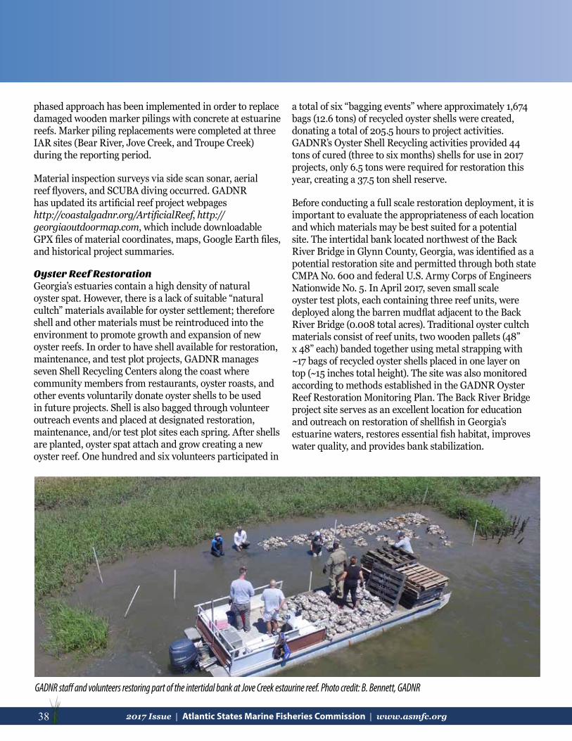
38 2017 Issue | Atlantic States Marine Fisheries Commission | www.asmfc.org
phased approach has been implemented in order to replace damaged wooden marker pilings with concrete at estuarine reefs. Marker piling replacements were completed at three IAR sites (Bear River, Jove Creek, and Troupe Creek) during the reporting period.
Material inspection surveys via side scan sonar, aerial reef flyovers, and SCUBA diving occurred. GADNR has updated its artificial reef project webpages http://coastalgadnr.org/ArtificialReef, http://georgiaoutdoormap.com, which include downloadable GPX files of material coordinates, maps, Google Earth files, and historical project summaries.
Oyster Reef Restoration Georgia’s estuaries contain a high density of natural oyster spat. However, there is a lack of suitable “natural cultch” materials available for oyster settlement; therefore shell and other materials must be reintroduced into the environment to promote growth and expansion of new oyster reefs. In order to have shell available for restoration, maintenance, and test plot projects, GADNR manages seven Shell Recycling Centers along the coast where community members from restaurants, oyster roasts, and other events voluntarily donate oyster shells to be used in future projects. Shell is also bagged through volunteer outreach events and placed at designated restoration, maintenance, and/or test plot sites each spring. After shells are planted, oyster spat attach and grow creating a new oyster reef. One hundred and six volunteers participated in
a total of six “bagging events” where approximately 1,674 bags (12.6 tons) of recycled oyster shells were created, donating a total of 205.5 hours to project activities. GADNR’s Oyster Shell Recycling activities provided 44 tons of cured (three to six months) shells for use in 2017 projects, only 6.5 tons were required for restoration this year, creating a 37.5 ton shell reserve.
Before conducting a full scale restoration deployment, it is important to evaluate the appropriateness of each location and which materials may be best suited for a potential site. The intertidal bank located northwest of the Back River Bridge in Glynn County, Georgia, was identified as a potential restoration site and permitted through both state CMPA No. 600 and federal U.S. Army Corps of Engineers Nationwide No. 5. In April 2017, seven small scale oyster test plots, each containing three reef units, were deployed along the barren mudflat adjacent to the Back River Bridge (0.008 total acres). Traditional oyster cultch materials consist of reef units, two wooden pallets (48” x 48” each) banded together using metal strapping with ~17 bags of recycled oyster shells placed in one layer on top (~15 inches total height). The site was also monitored according to methods established in the GADNR Oyster Reef Restoration Monitoring Plan. The Back River Bridge project site serves as an excellent location for education and outreach on restoration of shellfish in Georgia’s estuarine waters, restores essential fish habitat, improves water quality, and provides bank stabilization.
GADNR staff and volunteers restoring part of the intertidal bank at Jove Creek estaurine reef. Photo credit: B. Bennett, GADNR

392017 Issue | Atlantic States Marine Fisheries Commission | www.asmfc.org 39
FloridaKent Smith, Florida Fish and Wildlife Conservation Commission
The Florida Fish and Wildlife Commission is continuing the coordinated assessment of seagrass, oyster, and estuarine marsh habitats throughout the state. These programs include Seagrass Integrated Monitoring and Mapping (SIMM), Oyster Integrated Monitoring and Mapping (OIMMP) and Coastal Habitat Integrated Monitoring and Mapping (CHIMMP). Comprehensive GIS mapping products and status assessments of these habitats will be produced upon completion of these efforts. These will provide managers of fish habitat with critically important tools for prioritizing regional projects to conserve these habitats.http://myfwc.com/research/habitat/seagrasses/projects/active/simm/http://myfwc.com/research/habitat/coastal-wetlands/projects/chimmp/
Over the past year, Florida’s southeast Atlantic coral reef systems experienced one of the most severe mortality events on record. A number of diseases including white plague, white blotch (a new, previously unknown disease), and various bleaching diseases were documented, causing 100% mortality in some locations. This disease outbreak largely affected the Florida Keys reef tract, but was also observed in the coral systems to the north. Coral reef systems in Florida and the Caribbean before the 1950’s had as much as 70-80% live coral coverage, but today, live coral covers only <5-7% of the reef tract bottoms.
http://myfwc.com/research/habitat/coral/news-information/disease-outbreak/
Agencies and organizations in Florida working on enhancement and restoration of estuarine habitats have created regional technical support teams to enhance communication and support of focal projects. These “Estuarine Restoration Teams (ERTs)” now include the Northeast, East-Central
and Panhandle ERTs. Each team has numerous members and a steering committee that guides development, maintenance, and implementation of regional priority project plans. Coordination across organizations has led to grant support for larger scale habitat mosaic estuarine restoration projects, and partner sharing of limited resources to accomplish successful, high-quality fish habitat conservation projects. https://sites.google.com/site/nertinfo/documents
New England FisheryManagement CouncilMichelle Bachman, New England Fishery Management Council
The Council’s Omnibus Essential Fish Habitat (EFH) Amendment should be published this fall. The final stages of rulemaking are still pending, but the amendment will likely go into effect during 2018. This action will result in new EFH designations for New England species, updated Habitat Areas of Particular Concern, updated habitat management areas and groundfish closed areas, and new habitat research areas. The Council is developing a trailing action to the EFH Amendment that will address hydraulic clam dredge access in specific habitat management areas. Development of management alternatives will be informed by seafloor imagery and data from the University of Massachusetts Dartmouth School for Marine Science and Technology, as well as clam survey data from NMFS and the Science Center for Marine Fisheries.
The Council is poised to take final action on a Deep-Sea Coral Amendment in the coming months, and will then submit the amendment to NMFS for review. Because there
Left: Restored saltmarsh at the New Smyrna Beach, Florida FWC Ecocenter Facility. Right: Living shoreline demonstration in front of bulkhead at the New Smyrna Beach, Florida FWC Ecocenter Facility. Photo credit: J. Beal, Florida FWC

40 2017 Issue | Atlantic States Marine Fisheries Commission | www.asmfc.org
is a substantial lobster fishery presence in the vicinity of New England coral habitats, the Council collaborated actively with Commission staff and technical advisors to better understand the distribution of lobster fishing effort. NMFS has been another critical partner on this amendment, providing coral data from cruises conducted from 2012 to present along the continental margin and in the Gulf of Maine. NMFS collaborators on these cruises included University of Connecticut, University of Maine, Fisheries and Oceans Canada, and others.
The Council is excited to be starting a reboot of its fishing effects modeling efforts this fall. The Swept Area Seabed Impact Model was developed by the Council’s Habitat Plan Development Team between 2007 and 2010 to support the EFH Amendment. The updated version of the model, which will be termed ‘Fishing Effects Northeast,’ will include numerous refinements developed for the North Pacific Region’s 2015 EFH review. The North Pacific Fishing Effects model was based on SASI as well as on earlier modeling, and development and testing is an ongoing effort between the North Pacific Fishery Management Council, the Alaska Fisheries Science Center, Alaska Regional Office, and Alaska Pacific University. The revised Fishing Effects Northeast model will help the Council and our Atlantic coast partners to understand the distribution of fishing effort by gear type, and the effects of fishing on benthic habitats and designated EFH. The model domain includes New England and the Mid-Atlantic to the NC/VA border.
The Council has also been active this year commenting on non-fishing activities, including offshore wind energy projects and planning efforts, potential oil and gas development, and plans for naval testing and training. Council comments are often informed by discussions with ASMFC, Mid-Atlantic Fishery Management Council (MAFMC), and NMFS partners who are engaged in similar issues.
Mid-Atlantic Fishery Management CouncilJessica Coakley, Mid-Atlantic Fishery Management Council
In July 2017 NOAA Fisheries announced the publication of a final rule for the Mid-Atlantic Council’s Unmanaged Forage Omnibus Amendment. Forage species are small
NOAA Fisheries
Greater Atlantic Regional Fisheries OfficeLou Chiarella, NOAA Greater Atlantic Regional Fisheries Office
In FY17 GARFO completed approximately 500 EFH consultations. The majority of the consultations were with the U.S. Army Corps of Engineers for Clean Water Act Section 404 permits and Civil Works Projects. Projects included navigational dredging, shoreline protection, docks and marinas, port development, transportation projects, energy development, and general coastal development projects. In addition to EFH consultations, GARFO is actively involved in the licensing of hydroelectric projects under the Federal Power Act and use of prescriptive authorities to require fish passage at these facilities. Focus has been primarily in Maine rivers including the Penobscot River, Saco River, Union River, and Kennebec/Androscoggin Rivers. This also includes work in the Merrimack River in MA, Connecticut River in CT and MA, and Hudson River in NY. GARFO is also heavily involved
fish and invertebrates that serve as prey for larger commercially and recreationally important fish, as well as for marine mammals and sea birds. Anchovies, herring, chub mackerel, and sardines are some common forage species. This is the first rule in the Atlantic to list forage species as ecosystem component species. This action sets landing and possession limits for 17 species and species groups to prevent the expansion of directed commercial fisheries on these species in Mid-Atlantic federal waters. For more information, Mid-Atlantic fishermen can refer to the Mid-Atlantic Forage Species Identification Guide, which is available at www.mafmc.org/forage.

412017 Issue | Atlantic States Marine Fisheries Commission | www.asmfc.org 41
in offshore wind energy development activities, and is tracking the projects listed below.
MaineAqua Ventus A floating turbine Department of Energy research project off Mohegan Island
Massachusetts Wind Energy Area (WEA)Vineyard Wind Site Assessment Plan (SAP) is complete. Bay State Wind SAP completed. In discussions on their proposed fisheries characterization approach for the Construction and Operations Plan (COP).Two unleased BOEM has determined competitiveareas interest so a Public Sale Notice will be out soon.
Rhode Island/Massachusetts WEA South Fork This is a Deepwater Wind (DWW) projectProject for 15-16 turbines. Considered a NY project since the energy will be sold to NY. Their SAP is complete. COP is expected early next year.Revolution DWW project located in the RI/MA area, Wind but energy to be sold to MA.
New York WEAStatoil Project recent lease issued off NY. Very contentious project (pending lawsuit) due to significant overlap with squid and scallop fishing. Unsolicited There is an unsolicited request east of theRequest Statoil project but that is on hold for now. NY Master NY State Energy Research and Plan Development Authority is in the process of preparing a plan for offshore NY to be out at the end of November. An area of interest was announced in early October.
New Jersey WEADONG Energy has taken over development of the US Wind lease. PSEG Deepwater Wind and Public Service Enterprise Group (PSEG) will be developing Renewable Energy Systems Americas, Inc. lease.
Delaware WEASkipjack Wind DWW and PSEG are partnering in Farm development of the lease site. Energy will be sold to MD.
Maryland WEAUS Wind has completed their SAP and their COP is expected in 1st or 2nd quarter of FY18. Energy will be sold to DE, so we can expect the cables from the DE and MD projects to cross.
Virginia WEAVA Dominion holds the lease. They have completedPower their SAP.Coastal VA The research lease previously called Offshore Wind Virginia Offshore Wind Technology Advancement Project (VOWTAP) has brought in DONG Energy.
Southeast Regional Fisheries OfficePace Wilber, NOAA Southeast Regional Fisheries Office
During federal fiscal year 2017, NOAA Fisheries received 936 requests for project consultations in North Carolina, South Carolina, Georgia, and the Atlantic coast of Florida. Cumulatively, these projects proposed impacts to over 26,000 acres of coastal and wetland habitats. NOAA Fisheries was able to review 388 of the consultation requests and provided conservation recommendations for 90 of these projects.
Fish PassageNOAA Fisheries worked with the U.S. Fish and Wildlife Service and state agencies to complete and file with the FERC three comprehensive plans: the Roanoke River Diadromous Fishes Restoration Plan, Santee Basin Diadromous Fish Passage Restoration Plan, and Cape Fear River Basin Action Plan for Migratory Fish. Each of these plans focuses on restoration of diadromous fish populations to levels needed for historical species richness and viable fisheries. The objectives in each plan focus on improving the quality and quantity of spawning and nursery habitats for diadromous fishes; re-establishing aquatic biodiversity in the basin by restoring access to upstream habitats; recovering diadromous populations to levels supportable by existing and potentially available habitat; increasing the forage base for piscivorous species; and enhancing commercial and recreational fisheries for these species and the local economies they affect. FERC’s acceptance of these plans ensures the objectives in each will have special standing during FERC’s licensing of hydroelectric facilities within their respective river basins.

42 2017 Issue | Atlantic States Marine Fisheries Commission | www.asmfc.org
Port DevelopmentNOAA Fisheries is assisting state partners and the U.S. Army Corps of Engineers (Corps) during the Project Engineering Design phases of the Port of Savannah and Port of Charleston navigation improvement projects to refine project designs to minimize impacts to Essential Fish Habitat and examine options for beneficially using dredged material to enhance coastal habitat. The beneficial use opportunities include building artificial reefs for fish and islands for nesting shorebirds. Additionally for the Port of Savannah, NOAA Fisheries is working with the Corps on a new design for the fishway at New Savannah Bluff Lock and Dam; the fishway partly mitigates impacts from the harbor dredging. The redesigned fishway substantially improves the design approach in the Final Environmental Impact Statement by having the rock-arch ramp atop the dam or 100 meters upstream, rather than constructing it in a bypass canal. NOAA Fisheries is also assisting the Corps with design and implementation of the monitoring and adaptive management programs for the Port of Miami and Port Everglades navigation projects. During 2017, fieldwork for assessing impacts to coral reef habitat from the Port of Miami dredging was completed. During 2018, results will be evaluated and incorporated into future plans for the Port Everglades project.
Highways ProjectsNOAA Fisheries, the Federal Highway Administration, and state Departments of Transportation (DOTs) in North Carolina, South Carolina, and Georgia completed a Best Management Practices (BMP) manual for highway projects. The manual is part of an effort to streamline the consultations required by the Magnuson-Stevens Act (MSA) and Endangered Species Act (ESA). The manual identifies information needs for common project types, provides standardized effects analyses for those projects, and recommends BMPs for minimizing impacts to NOAA-trust resources. Additionally, opportunities for adaptive management were identified. NOAA Fisheries NMFS will assist DOTs with implementing the manual and facilitating its use during MSA and ESA consultations. The manual will also serve as the basis for programmatic MSA and ESA consultations during 2018.
HABITAT PROGRAM MISSIONTo work through the Commission, in cooperation with appropriate agencies and organizations, to enhance and cooperatively manage vital fish habitat for conservation, restoration, and protection, and to support the cooperative management of Commission managed species.
REPRODUCTIONSAny portion of this newsletter may be reproduced locally with credit given to the ASMFC Habitat Program.
2017 PUBLICATIONThe 2017 Annual Publication of Habitat Hotline Atlantic was made possible by the contributions of many, but the Habitat Committee would like to specifically acknowledge the efforts of the 2017 Editors:Michelle Bachman (NEFMC)Tina Berger (ASMFC)Lisa Havel (ASMFC)
LayoutLisa Hartman (ASMFC)
Partner Contributors: W. Judson Kenworthy, Chuck Jacoby, Dean Carpenter, Chris Powell, Chris Pickerell, Phil Colarusso, Jill Carr, Bowdoin W. Lusk, Bryan DeAngelis, Marta Ribera, Jay Odell, Lisa Havel, Cheri Patterson, Kevin Lucey, Mike Dionne, Alix Laferriere, Cory Riley, Stephen Gephard, Laura McKay, and Andy Lacatell
Several Habitat Committee members contributed articles to this issue: Russell Babb, Michelle Bachman, Lou Chiarella, Jessica Coakley, Lisa Havel, Jimmy Johnson, Ben Lorson, Dawn McReynolds, January Murray, Kent Smith, Mark Rousseau, Denise Sanger, Marek Topolski, Tony Watkinson, and Pace Wilber
Funding provided by Sport Fish RestorationBanner photo South Atlantic Fishery Management Council
Acknowledgements


