Embed Size (px)
Citation preview

D
Atlantic2016 Annual Issue
H E A LT HY F I S H E R I E S N E E D H E A LT HY H A B I TAT
Sustainably Managing Atlantic Coastal Fisheries • Atlantic States Marine Fisheries Commission • www.asmfc.org
In This Issue The Water Column
An Essay about Differences betweenSeascapes and Landscapes ........................2
Skinny Water - An Important Estuarine Habitat ..........................................3
A View from Across the Pond: What is Good Pelagic Habitat? ..................................6
White Shark Research: Expanding the Acoustic Array ..........................................7
Interactions between Marine Habitatsand the Water Column: Consequencesfor Fish Populations .......................................8
Prochlorococcus: The Ocean’sUnsung Hero ................................................. 10
Profile: ASMFC’s Tagging Committee ..... 11
New Sea Level Study ................................... 11
Atlantic Coastal Fish HabitatPartnership Update
On the Ground Conservation................... 14Science and Data Developments ........... 142016 Melissa Laser Award ......................... 15
Habitat ManagementSciaenid Habitat .......................................... 16
Updates from Around the CoastMaine .............................................................. 17New Hampshire ........................................... 18Massachusetts.............................................. 20Rhode Island ................................................. 22Connecticut ................................................... 24New York ........................................................ 24New Jersey ..................................................... 27Pennsylvania ................................................ 32Virginia ........................................................... 33North Carolina ............................................. 34South Carolina ............................................. 36Georgia ........................................................... 37Florida............................................................. 39New England Fishery Management Council ................................ 40Mid-Atlantic Fishery Management Council ............................... 40NOAA Fisheries ............................................. 41
HABITAT HOTLINEHABITAT HOTLINE
The Water ColumnOn behalf of the Atlantic States Marine Fisheries Commission (ASMFC) Habitat Committee, I am pleased to present Habitat Hotline Atlantic 2016. In this year’s edition, we focus our attention on the most ubiquitous, yet in some ways the most overlooked, component of fisheries habitat: the water column. The seafloor is adorned with rich, complex and productive features, living and nonliving alike, which provide opportunities for fish and invertebrates to shelter, feed, and breed. Yet, those varied features are all enveloped in and connected by water. Far from being simply the medium in which species important to coastal fisheries are suspended, the water column is
infinitely complex, exhibiting dynamic properties and considerable heterogeneity along the Atlantic coast. Temperature profiles, salinity gradients, chemical composition, microbial communities, current patterns, interactions with the atmosphere and benthos, and innumerable other attributes of the water column profoundly shape the ocean ecosystem and the fisheries that depend upon it.
One newsletter could never do full justice to the complexity, diversity, and importance of something so all-encompassing (from a fisheries point of view, at least) as the water column, but we have strived to assemble a diverse set of perspectives. John Manderson opens this edition with some probing thoughts on what makes an aqueous environment so different in terms of physics, physiology, and scale. Mark Dickey-Collas, Verena Trenkel, and Abigail McQuatters-Gollop then provide a perspective “from across the pond” on defining good pelagic habitat in the context of implementing ecosystem-based approaches in the European Union. Next, Ken Able takes us right to the edge of the sea to consider how “skinny water,” the very shallowest areas, can be critical as refuge and nursery habitat. My own contribution steps back from the edge but zooms down to the microbial level to look at Prochlorococcus, the most abundant photosynthetic cell in the world. Finally, Greg Skomal considers a much larger organism as he describes the movements and behavior of one of the most awe-inspiring residents of the pelagic realm: the great white shark.
As always, the content of Habitat Hotline Atlantic 2016 is not restricted solely to our focal theme. We describe the Habitat Committee’s newest habitat source document, as well as the Commission’s Interstate Tagging Committee. Also, the ASMFC member states, ACFHP, and key federal partners provide highlights of their ongoing habitat work. Clearly, dedication to habitat stewardship remains strong along the coast, and the Habitat Committee looks forward to doing our part to keeping up that momentum!
Jake Kritzer, Ph.D.Habitat Committee Chair

2 2016 Issue | Atlantic States Marine Fisheries Commission | www.asmfc.org
The WaTer Column: a Complex habiTaT
An Essay About Differences Between Seascapes and Landscapes John Pilling Manderson, Oceans & Climate Branch & Northeast Fisheries Science Center Cooperative Research Program
We are warm blooded creatures constrained by gravity to the interface between land and a transparent atmosphere rich with the gasses essential for life. Our ecological intuitions are shaped by our experiences satisfying ecological necessities on land. On land, sunlight penetrates to the surface where plants that fuel foodwebs take up nutrients that gravity causes to accumulate in soils. Those foods fuel our metabolisms and provide the “salts” required to maintain our tissues in states necessary for metabolism in the first place. Water is essential too, and as absent as salts from the atmosphere in quantities required for metabolism. Like most other terrestrial animals, we harvest water concentrated in patches on land by the force of gravity. Finally, our metabolisms are governed by body temperature that we regulate independently of atmospheric temperatures which can fluctuate rapidly between extremes that make life impossible without special adaptations. Like most other terrestrial organisms, we possess complex physiological adaptations that allow us to partially decouple the internal environment of our tissues from the atmosphere. Furthermore, most of the habitat resources we need and the processes manufacturing those resources occur on or very close to the land’s surface. Our adaptations range from behavioral habitat selection for specific properties of the atmosphere and land external to us, to physiological regulation of our internal environment independently of the environment. Our conceptual models of habitat and its structure and function rests on the foundation of this unique suite of physiological and behavioral adaptations we use to meet the requirements of life on land.
As terrestrial creatures, seascapes are the most remote and least transparent ecosystems on the earth. We are uncertain about the ways marine organisms interact with the salty liquid surrounding them. In the face of this uncertainty we often rely on terrestrial intuitions and analogies to develop hypotheses about the nature of organism-habitat relationships in the sea. We consider persistent and relatively stationary features of the seabed - its topography, geology, and the attached plants and animals that lend it structure - to be fundamental habitat characteristics. The invisible properties, structures, and
motions of the ocean’s liquid appear complex and chaotic. We sometimes view the liquid’s complexities as a nuisance and ignore them in the schemes we develop to classify and map habitats in the ocean. Even when we explicitly consider the ocean’s liquid, persistent features of the seabed defined by sharp gradients in physical structure we easily observe the furniture on the oceanographic stage and the fundamental units of analysis. To what degree is emphasis on the seabed and its structures a reflection of ecological intuition and the analogies we have developed as animals who meet our metabolic requirements on land?
Meeting the specific and conservative requirements of metabolism is different for organisms living in a salty liquid. Seawater is 850 times more dense than the atmosphere and similar to densities of living tissues (except bones and shells). Because liquid water is so dense, drag rather than gravity is the dominant force controlling movement, and most organisms are nearly neutrally buoyant with access to all 3 dimensions of the ocean’s hydrosphere during at least part of their lives. Water is not a limited habitat resource in the ocean and salts occur at concentrations nearly equal to those required within metabolically active tissues. As a result, marine organisms don’t need strong physiological regulation but can rely on behavioral selection for volumes of water with the right salinities. Variations in temperature are smaller and slower in the ocean because seawater’s capacity to store heat is four times higher than the atmosphere. Meanwhile, the transfer of heat between objects of different temperatures in the ocean occurs at least 20 times faster. Because heat is difficult to retain in an otherwise thermally benign ocean, most marine organisms are ‘cold blooded’ and rely on habitat selection for volumes of water with the right temperatures. Marine organisms must also actively select volumes of seawater with oxygen concentrations sufficient for metabolism because oxygen is a limited resource. Concentrations of the gas are four times lower in the ocean where it diffuses over a million times more slowly than in the atmosphere. To meet metabolic requirements for salt concentrations, oxygen, and temperature, marine organisms rely on relatively weak physiological regulation and strong habitat selection for volumes of liquid with specific characteristics.
Water column processes also underlie the manufacture and distribution of food that fuels metabolism in the sea. Sunlight required by plants for photosynthesis is

32016 Issue | Atlantic States Marine Fisheries Commission | www.asmfc.org 3
extinguished under the sea’s surface 100,000 times faster than in the atmosphere. While the force of drag is dominant in the ocean, gravity still operates to cause the bodies of dead plants and animals to sink slowly, allowing for most of that organic matter to be reconverted by bacteria back into nutrients useful for plants at depths where light is insufficient for photosynthesis. As a result, vertical and horizontal currents caused by wind, tides, and gradients in seawater density are required to bring nutrients back into well lit surface waters where tiny short-lived phytoplankton can use them. Phytoplankton and other materials fuel food webs that develop as they drift downstream to become concentrated along fronts where currents converge to “thicken” the soup. Under these circumstances, habitats in the ocean are not places, but diffuse networks connected by horizontal and vertical current flows that converge on nodes which concentrate resources derived from remote upstream sources.
For marine organisms, seascapes are primarily structured by properties of the liquid and its current flows. The seabed and its structures can provide important refuges from predation and refuge from or access to high velocity current flows, as well as particle trapping surfaces that are relatively impermeable compared to “fronts” created in the water column by vertical and horizontal differences in seawater densities and currents. Nevertheless, seascapes are primarily structured and regulated by properties and processes of the ocean liquid that define the habitats marine organisms select to meet their metabolic requirements.
The fundamental ecological differences between seascapes and landscapes are of great practical importance. The central goal of ecosystem-based management is to apportion “common property” marine resources to conservation, fisheries, energy production, and other uses and to balance trade-offs among ecological, social, and economic objectives. Our attempts to do this with fishery resources and others have been largely “place based.” Our ideas about property and property law have evolved over centuries based largely on perspectives shaped by our terrestrial experience existing in gas. Ecosystem based management needs to rest on paradigms consistent with the importance of properties and dynamics of the liquid that drives ecological dynamics in the sea. Building a seascape ecology useful for effective ecosystem management is particularly important now that global
climate change is causing the structure and dynamics of the ocean and its ecosystems to change rapidly at the same time as human demand for marine resources is rapidly increasing.
Skinny Water – An Important but Often Ignored Estuarine HabitatKenneth W. AbleRutgers University Marine Field Station
Our view of fish habitat is often focused on relatively few, structured habitats such as submerged aquatic vegetation, marshes, oyster reefs, etc. While these are clearly important, we often ignore one of the most common, abundant, and probably productive habitats, skinny water – shallow areas often two feet or less in depth. These same skinny waters are also the habitat most likely to be influenced by man.
Skinny water, as loosely defined herein, has a number of characteristics that make it unique relative to deeper waters. By its very nature, its volume is relatively small, so the surface to volume ratio is high. This means that the possibility for diffusion of air into the water or the substrate into the water is fairly high. This is particularly important in regard to oxygen, which is often a limiting
Figure 1. Aerial photograph of some flats in Great Bay adjacent to flood tidal deltas with salt marsh vegetation. Photo credit: Pete McClain

4 2016 Issue | Atlantic States Marine Fisheries Commission | www.asmfc.org
factor. Further, this shallow water, as is evident in sand flats (Fig. 1) with the high surface to volume ratio, also provides for relatively rapid temperature changes. This skinny water warms and cools faster than deeper waters. These temperature differences can provide optimal conditions for the plants and animals that live there. Also, the thinness of the water column makes light penetration throughout the water and to the bottom much more frequent. This in turn makes photosynthesis by substrate dwelling algae more productive. This same water clarity allows visual interactions between prey and competitors, and certainly much more so than in the deeper, light-limited, and turbid waters elsewhere in the estuary. Additionally, if these skinny waters make up a large proportion of an estuary, they can influence how quickly estuary waters warm and cool or even freeze.
The relatively small volume of water also makes fresh and saltwater exchanges more likely. For example, if the less dense freshwater, which is found near the surface, extends to shallower edges, variation in salinity may be greatest there. Also, fresh groundwater, which is quite near the surface of the substrate (the bottom of the estuary), can mix with the rest of the estuary and have a more marked effect along shallow shorelines. This diffusion can be rapidly increased in shallow water because of wave action, due to either wind blowing across the surface or from boat wakes.
The amount of skinny water might vary with seasons and storms, but it does so most predictably between high and low tides (Fig. 2). Along the East Coast of the U.S., this typically happens twice during a 24-hour period: two high tides and two low tides during the day and night. During these transitions the volume of the skinniest water changes dramatically. On flood tides, especially in intertidal creeks or along intertidal shorelines, swimming animals such as fishes can get access to feeding areas that were inaccessible on lower tides. Also, if they stay in the shallowest waters
by moving with the tides they can avoid larger predators that need deeper waters. Increasing food availability and reducing predation are probably the two most important factors necessary for fish, shrimp, and crabs to grow and survive, especially if the water is of the right temperature, an appropriate salinity, and sufficient oxygen.
Ecological ImportanceThe ecological importance of skinny water is evident in many estuaries based on the distribution of many plants and animals. The largest accumulation of vascular plants are the various forms of salt marsh cordgrass that dominate many estuaries from the inlet to the limits of salt waters. These plants are the basis for estuarine marsh production. They are complimented by underwater vegetation such as numerous kinds of algae that are dominated by sea lettuce in most shallow flats in the lower estuary. In addition, submerged vascular plants such as eelgrass and widgeon grass are largely limited to the shallow portions of estuaries because they are light-limited. Some of the most productive plants are unicellular algae (diatoms and dinoflagellates) that colonize tidal flats and grow quickly when they are exposed to the sun. This plant production provides food, either directly or indirectly, through the estuarine food web, and it accounts, in part, for the high productivity of estuaries and their role as nurseries for fishes.
The retention of extensive marshes with intertidal and subtidal shorelines and edges attest to the value of these habitats to a diverse estuarine fauna and the predators that feed on them. Their value is indicated by the abundance of the mummichog - an important predator on marsh insects - and other invertebrates, and also important prey for many wading birds and economically and recreationally important fisheries such as those for striped bass, bluefish, and white perch. Another shallow habitat of certain importance is the frequent occurrence, at least in natural marshes, of marsh pools. These shallows, typically less
than 2 feet, are imbedded in the marsh surface and provide extensive fish and shrimp habitat across all seasons, for these important components of marsh, and thus estuarine food webs. They are completely lacking around the edges of New York Harbor and where marshes have been destroyed, as in construction of lagoon developments.Figure 2. Depiction of shallow habitats across a natural shoreline (top) from mean low water (MLW) to mean
high water (MHW) and in unusually high water during spring/storm tides. Graphic credit: Dr. Ken Able, Rutgers University

52016 Issue | Atlantic States Marine Fisheries Commission | www.asmfc.org 5
Further evidence of the ecological value of shallow shorelines is apparent from the diverse fauna of killifishes, shrimps, blue crabs, silversides, and others and the fisheries for these. In many instances they include prime habitat for the juveniles and adults of many species of economic importance including summer and winter flounder, tautog, bluefish, etc. Why else are so many fisherman using kayaks these days?
The numerous ways in which we lose valuable skinny water in estuaries is most evident when we compare altered to relatively unaltered estuaries. An appropriate comparison is between the New York Harbor and the Hudson River, perhaps one of the most highly altered estuaries in the world (Fig. 3), to relatively unaltered estuaries. The former has lost shallow shorelines by the filling in of marshes and their associated creeks (yes they used to exist, even in Manhattan) since colonization by Europeans. In addition, the shorelines disappeared in the process of making Manhattan larger by approximately one third. To stabilize the shorelines, vertical bulkheads were built along most of the shore. This process extends to most of the estuarine waters around Manhattan.
In areas where some subtidal shallows still exist, they are further compromised because the numerous piers extend over the water and provide nearly 24 hours of night under their shaded surfaces, while the adjacent water is sometimes exposed to 24 hours of light from the tall buildings and street lights that line the waterfront (Fig. 3). These extremes of light are likely to have influence, especially on shallow waters. Our own research has documented that these shaded conditions decrease feeding ability and growth and thus survival for juvenile fishes and a somewhat reduced fauna for fishes and invertebrates. In urbanized estuaries such as New York Harbor, the water traffic is diverse and extensive - from tankers and ferries of all kinds, to more leisurely sailboats. The large latter ones chop up the water nearly continuously and produce waves, from all directions, that strike the shallow shorelines from all angles. These bounce off all vertical shorelines, may be absorbed by riprap, and stir up the sediments on any shallow shorelines. In the rare instances where skinny water still exists in New York Harbor, it retains its ecological value based on the common occurrence of the mummichog and other killifishes, juvenile blue crabs, and even horseshoe crabs.
The rapid urbanization of the shallows is evident in other estuaries. Further elimination of marshes and other skinny waters has occurred through construction of lagoon based housing developments (Fig. 4). The elevation of former intertidal areas to unflooded heights above average high water occurred as channels were dredged and the resulting fill covered the extensive skinny water, eliminating their role as a nursery and mitigating the numerous other ecological services it provides. Other detailed studies have verified that lagoon conditions reduce water quality, decrease the available oxygen in the water, and drastically reduce populations of fish and invertebrates.
Figure 4. Aerial photo of typical lagoon housing development. The channels in the lagoon were dredged and the sediments deposited on the former salt marsh surface to create higher land. Photo credit: Dr. Ken Able, Rutgers University
Figure 3. Manhattan shoreline showing typical man-made structures (piers, pile fields) constructed over filled in areas near shore. Used with permission from Dr. Ken Able, Rutgers University

6 2016 Issue | Atlantic States Marine Fisheries Commission | www.asmfc.org
A View from Across the Pond: What is Good Pelagic Habitat?Mark Dickey-Collas, International Council for the Exploration of the Sea, Copenhagen, DenmarkVerena Trenkel, IFREMER, Nantes, France Abigail McQuatters-Gollop, University of Plymouth, UK
The European Union has enacted a piece of legislation that requires countries to define, and then monitor progress towards achieving, good environmental status (GES) for amongst other things, pelagic habitats. This legislation is called the Marine Strategy Framework Directive (MSFD). Scientists are being asked to provide guidance on what is a good or bad pelagic system. Policy makers have requested that pelagic habitats be assessed and considered in addition to benthic habitats. When thinking about defining the objectives for the pelagic system, some studies have looked at a section of the system. For example, Trenkel and others worked with the fishing industry, lobby groups, and fisheries managers to define management objectives for pelagic fisheries in Europe and listed five important objectives (Fig. 1). However, few studies have considered what is a good system.
The phrase “good environmental status” (GES) means different things to different people (it is normative). It is probable that a decade ago, we would have been discussing “productive pelagic ecosystems.” Now we expect the systems to be in “good status.” The good is in relation to humans, thus probably related to goods and services, and stewardship and conservation for future generations. There are many services provided by the marine pelagic habitat such as the regulation of ocean circulation and weather, carbon recycling and balance, production of living resources, and tourism. Any consideration of good
pelagic habitat needs to relate to the perceived priorities and objectives of society at any specific time, and what is perceived as good is likely to change.
Recently, a group of researchers discussed the issue (http://www.ices.dk/news-and-events/asc/ASC2016/Pages/Theme-session-J.aspx) and concluded that the environmental variability of pelagic habitat played a larger role on its dynamics and state than anthropogenic pressures (excluding climate change and extreme pollution events). This means that even assessing “prevailing conditions” is a challenge for pelagic habitat. In most pelagic systems, the prevailing conditions are
a consequence of temperature, salinity, oxygen, ice cover, carbon dioxide, light, and turbidity. The consequences of the behavior of organisms and the issue of scale (temporal and spatial) further complicates any assessment of prevailing conditions.
When trying to assess GES and where we are in relation to it, many researchers propose the use of the Driver-
Pressure-State-Impact-Response (DPSIR) framework to guide management measures. In essence, this assumes that there are direct levers that can be pulled to reduce or increase the human pressures which will make the habitat respond in a given direction. This poses problems when prevailing conditions are thought to have more impact on the pelagic system than any direct consequence of a human-caused pressure. The obvious example of a clear DPSIR relationship is how fishing and hunting influence populations and ecosystem structure. However, when the influence of anthropogenic pressures is less easy to detect, researchers are beginning to suggest using thresholds or surveillance indicators to monitor pelagic community structure. Surveillance indicators have been proposed to monitor for change. If an indicator shows an unwelcome trajectory, beyond predefined thresholds, management action should be triggered. But having not defined good pelagic habitat means that the objectives for monitoring
Figure 1. Five sets of management objectives for pelagic fisheries. Adapted from Trenkel et al. 2015. Identifying marine pelagic ecosystem management objectives and indicators. Marine Policy 55, 23–32

72016 Issue | Atlantic States Marine Fisheries Commission | www.asmfc.org 7
are not so clear. So is monitoring the pelagic system for change enough for society’s expectations compared to a forthright statement of what GES is for pelagic habitats?
It is likely to be a great challenge to persuade managers to maintain funding for monitoring when direct links to anthropogenic pressures are not clear, and prevailing conditions are caused by poorly understood, complex interactions. If we already assess the states and pressures associated with invasive species, commercial fish populations, eutrophication, contaminants, and marine litter, why should we monitor other components of the pelagic ecosystem? There are probably many other factors that could impact the goodness of pelagic habitat that need to be considered when striving to manage marine activities, climate change and environmental variability influencing productivity and distributional changes of organisms being a prime example. The provision of globally important goods and services derived from the marine pelagic habitat cannot be overlooked, e.g. regulation of our climate.
We need to consider what we mean by good pelagic habitat; society expects us to. No one has described what society means by GES for pelagic habitat. “Good” is a normative word which we assumed relates to the provision of goods and services. The pelagic system provides many goods and services, some of global importance. Prevailing conditions are less easy to predict than for benthic habitats; they also vary greatly. Frameworks such as DPSIR may not be relevant as isolating anthropogenic-pressure state relationships proves challenging in many situations. However, even without objectives for management, Europe is moving towards the monitoring of pelagic state and ecosystem function, linked to action when trajectories move beyond thresholds. This is even in the absence of a definition of GES for pelagic habitat.
White Shark Research: Expanding the Acoustic ArrayGreg Skomal, Massachusetts Division of Marine Fisheries
With the growing seal population off the coast of Massachusetts, the white shark is becoming more common in our coastal waters during the summer and fall months. Since 2009, MarineFisheries’ Shark Research Project has been using state-of-the-art tagging technology to study the biology and ecology of this species in our waters and
along the east coast of the U.S. During this period, we have tagged more than 80 individual white sharks ranging in size from 7 - 18 feet, primarily in the nearshore waters from Orleans to the southern tip of Monomoy. These fish were tagged with multiple technologies, including acoustic transmitters, satellite-based tags, and accelerometers. Our findings to date show that white sharks travel extensively when they leave Massachusetts, with most moving to shelf waters off the southeastern U.S. from North Carolina to the Gulf of Mexico, while others move into the open Atlantic and dive to depths as great as 3,000 feet. Regardless of where they go, many of these sharks return to our coastal waters each year.
Over the last two years, we expanded our research beyond movement ecology to quantify relative abundance and regional population size. Although there are indications that this population is rebounding from overexploitation (see http://www.mass.gov/eea/docs/dfg/dmf/publica-tions/curtis-et-al-2014.pdf), population estimates are lacking for this species in the Atlantic. Knowing the number of white sharks that visit our waters each year is not only helpful for conservation and resource management, but it may have implications for public safety. To conduct this research, MarineFisheries initiated a traditional mark-recapture study in 2014 with financial and technical assistance from the Atlantic White Shark Conservancy (AWSC; www.atlanticwhiteshark.org). Using bi-weekly aerial (spotter pilot Wayne Davis[www.oceanaerials.com]) and vessel surveys (M/V Aleutian Dream), we identified, videotaped, and sexed 68 individual white sharks in 2014 and 141 white sharks in
White shark tagged off Massachusetts. Photo credit: John Chisholm

8 2016 Issue | Atlantic States Marine Fisheries Commission | www.asmfc.org
2015 off the east coast of Cape Cod from mid-June to the end of October. Of the latter, 40 returned to Massachusetts from the previous year.
To date, 65 of the 80 tagged white sharks are carrying acoustic transmitters that emit an individually-coded high frequency ping every 60-100 seconds. These pings are detected by an array of acoustic receivers maintained by MarineFisheries and the AWSC. When one of these sharks swims within 200 meters of a moored receiver, it is detected and the receiver logs the date, time, and individual tag number of that shark. After we download data from the receivers, we can examine local movements of the sharks as they relate to habitat use, residency, site fidelity, and other factors like temperature, tide, and time of day. In addition to white sharks, Massachusetts Division of Marine Fisheries (MA DMF) has been using this technology for many years to study a number of fish species including codfish, striped bass, and sand tiger sharks.
Since the quantity and quality of information coming from these tags is only as good as the geographic coverage of the acoustic array, MarineFisheries is expanding the receiver network throughout Massachusetts. With funding facilitated by Dept. of Fish and Game Commissioner George Peterson through the Executive Office of Energy and Environmental Affairs, additional receivers have been purchased and will be deployed in areas not previously covered including the North Shore, Cape Cod Bay, off the Islands, and Buzzards Bay. To facilitate the deployment of these new receivers, MA DMF works closely with local towns and harbormasters to choose specific areas including heavily populated beaches, surfing hotspots, and seal haulouts. Although white sharks are typically associated with the eastern coast of Cape Cod, our expansion of the array to the South Shore and Cape Cod Bay in 2015 indicated that these areas are occasionally visited by our tagged sharks. We are hopeful that the dramatic increase
Interactions between Marine Habitats and the Water Column: Consequences for Fish PopulationsKent Smith, Florida Fish and Wildlife Conservation Commission
Marine habitats, as with all types of habitat, are the physical elements that support biological communities. These physical components are dynamic in nature and influence the hydrodynamics of the water column, where most fish species spend much of their time, in a number of ways. Structural habitats, such as uneven sand bottom, seagrass, hard rock ledges, cobble rock, and even fine muddy bottoms, create turbulence zones; emit chemicals to which fish orient; and provide shelter, settling, and foraging habitat. Some benthic habitats are created by animals themselves – coral reefs, shellfish beds, and polychaete worm-rock reefs all rely on the water column for food, chemical compounds to build their shells, and oxygen in order to create the structures that fishes inhabit.
species can survive well down into the upper estuary by remaining in the upper freshwater lens, providing them access to imported marine food items that happen into that upper layer. Large scale examples of these confluences of waters with different densities exist in ocean environments as well. To the east of Cape Hatteras, North Carolina, the colder, more dense south flowing Labrador Current slams into the warmer, less dense north flowing Gulf Stream. These two massive bodies of water converge and create boundary currents and areas of floating debris and sargassum algae, where marine fish species such as cobia, triple tail, wahoo, dolphin, and tuna find abundant prey. Much of the sediment these currents carry also falls out of the water column creating sand shoals, such as Diamond Shoals, well offshore of the coast line. These sand shoals serve as important spawning, foraging, and aggregation habitat for a number of marine fish species, such as flounder, blue fish, and king mackerel, and are a direct result of the interaction of the currents that support them.
Larger structures like bivalve and coral reefs, sea mounts, and continental shelf features can dramatically influence the movement of water and the distribution of what is in the water column, much to the benefit of fish species. Tidal waters flowing across or along oyster reefs create larger turbulence zones in which schools of fish like spotted sea trout and black drum can await a buffet of forage species being transported to them by the tide. Shallow coral reefs in southeast Florida provide habitat for countless fishes and invertebrates that feed on small animals brought across the reef top into turbulent down-current waters by tides from the open ocean. Scaling up further, seamounts and continental shelf walls cause large volumes of cold nutrient rich water to upwell from the depths into shallower waters. Besides the large turbulence zones created by these features, these waters provide nutrients for plankton, which in turn create rich foraging grounds for larger fish and their prey items. Many species of fish also use these areas as significant spawning habitat. Fish spawning in the water column around these structures benefit from eddies and other current interruptions relative to dispersal of their fertilized eggs and larvae as well.
These physical interactions shape the habitats which support all fish species, and consideration of their contributions to the maintenance and conservation of ASMFC trust fish populations is of considerable importance to managers of these resources.Florida Keys coral reef with blue tang foraging in the overlying water column.
Photo credit: Florida Fish and Wildlife Conservation Commission
in receivers in 2016 will allow us to evaluate and quantify the extent to which white sharks utilize Massachusetts waters. This information will not only better inform our ecological and population research, but also provide local towns with the means by which to evaluate the presence of these sharks.

92016 Issue | Atlantic States Marine Fisheries Commission | www.asmfc.org 9
Currents and gradients in the water column also create “structure,” as defined by physical differences (salinity gradients-haloclines, temperature gradients-thermoclines, currents moving across or along one another) along a sharp grade that can create migratory pathways, larval dispersal corridors, and foraging oases for pelagic species. Moving water can even move fish habitats over long distances or distribute them from one location to another.
The water column in estuaries and oceans is constantly moving due to the effect of winds, tides, and the rotation of the earth. As the water moves across the bottom, irregularities in bottom features and frictional forces cause the water to move more slowly at the structure/water interface. Water above this interface speeds along, but a boundary layer of turbulent water creates conditions allowing planktonic organisms to become entrained or settle to take up a life on the bottom. This boundary layer provides a rich foraging habitat for many species of fish, and is a critically important habitat for some early life history phases of ASMFC-managed species, such as winter and summer flounder, red drum, and striped bass. Turbulence zones also exist on the down-current side of rocks, reefs, and other structure. In areas of strong current, such as in tidally flowing estuaries, along Gulf Stream reefs, or in rivers, turbulence zones create slow water resting habitat for ambush predators like striped bass, black sea bass, and American eel. Juveniles of these species also benefit from such turbulence zones as areas where they can rest as they migrate from rivers to estuaries or estuaries to ocean habitats.
Physical conditions of the water column itself vary, and when two water systems with different temperatures, salinities, or dissolved compounds meet, structure important to fish is created. Just about everyone has jumped into a body of water that was warm on the surface, but noticeably colder when you dove down to the bottom. Warmer water is less dense than colder water, which creates a thermocline. Thermoclines create boundaries that fish and their larvae can use for migrations both along and up through the water column. The same is true for waters of differing salinities, such as up the lower portions of rivers and into estuaries, where freshwater lenses float on top of seawater before mixing. Wedges of saline marine waters penetrate far up river systems, allowing estuarine species at various life stages to migrate well up into riverine habitats and take advantage of food sources and refuge from more marine predators. Likewise, freshwater
species can survive well down into the upper estuary by remaining in the upper freshwater lens, providing them access to imported marine food items that happen into that upper layer. Large scale examples of these confluences of waters with different densities exist in ocean environments as well. To the east of Cape Hatteras, North Carolina, the colder, more dense south flowing Labrador Current slams into the warmer, less dense north flowing Gulf Stream. These two massive bodies of water converge and create boundary currents and areas of floating debris and sargassum algae, where marine fish species such as cobia, triple tail, wahoo, dolphin, and tuna find abundant prey. Much of the sediment these currents carry also falls out of the water column creating sand shoals, such as Diamond Shoals, well offshore of the coast line. These sand shoals serve as important spawning, foraging, and aggregation habitat for a number of marine fish species, such as flounder, blue fish, and king mackerel, and are a direct result of the interaction of the currents that support them.
Larger structures like bivalve and coral reefs, sea mounts, and continental shelf features can dramatically influence the movement of water and the distribution of what is in the water column, much to the benefit of fish species. Tidal waters flowing across or along oyster reefs create larger turbulence zones in which schools of fish like spotted sea trout and black drum can await a buffet of forage species being transported to them by the tide. Shallow coral reefs in southeast Florida provide habitat for countless fishes and invertebrates that feed on small animals brought across the reef top into turbulent down-current waters by tides from the open ocean. Scaling up further, seamounts and continental shelf walls cause large volumes of cold nutrient rich water to upwell from the depths into shallower waters. Besides the large turbulence zones created by these features, these waters provide nutrients for plankton, which in turn create rich foraging grounds for larger fish and their prey items. Many species of fish also use these areas as significant spawning habitat. Fish spawning in the water column around these structures benefit from eddies and other current interruptions relative to dispersal of their fertilized eggs and larvae as well.
These physical interactions shape the habitats which support all fish species, and consideration of their contributions to the maintenance and conservation of ASMFC trust fish populations is of considerable importance to managers of these resources.Florida Keys coral reef with blue tang foraging in the overlying water column.
Photo credit: Florida Fish and Wildlife Conservation Commission

10 2016 Issue | Atlantic States Marine Fisheries Commission | www.asmfc.org
Prochlorococcus: The Ocean’s Unsung HeroJake Kritzer, Environmental Defense Fund
Ocean waters suspend and envelope not only the fishes and invertebrates that support our fisheries, but also a rich, complex, and poorly understood community of tiny microbes. Largely invisible within our vast, swirling seas, and unappreciated by too many people, these organisms are the engines that drive ocean ecosystems. They are responsible for the majority of photosynthesis, nutrient cycling, and other key processes in the oceans.
The field of microbiology has a history spanning centuries. Studies of marine microbes trailed those of terrestrial counterparts, but still have a long and rich tradition. Yet, one of the most complex and important marine microbes, the phytoplankton Prochlorococcus, remained unknown until just 30 years ago. In 1986, researchers Penny Chisholm with MIT, Robert Olson with the Woods Hole Oceanographic Institute, and their colleagues discovered this cyanobacterium in the Sargasso Sea.
That Prochlorococcus had gone undetected for so long is surprising given that it is the single most abundant photosynthetic cell on earth. The total biomass of Prochlorococcus in the global ocean approximates the biomass of the global human population. However, despite being so abundant and so widespread, Prochlorococcus is also incredibly small, even by microbial standards. Most other types of phytoplankton range from 10-1000 microns in diameter. Prochlorococcus, on the other hand, is less than 1 micron in diameter. That means 100 Prochlorococcus cells can stretch across the width of a single human hair.
The importance of photosynthetic organisms is well known. Whether Prochlorococcus, giant kelp, or a giant redwood, these plants, algae, and cyanobacteria release oxygen and produce the carbohydrates that fuel food webs. Their importance is even greater in the face of global climate change, for they provide some counterbalance to our excessive greenhouse gas emissions by capturing carbon dioxide. However, these organisms, like many others, are also subject to the adverse impacts of climate change, including rising temperatures, declining salinity, and altered ocean currents, as well as the related impact of ocean acidification that is also rooted in high CO2 concentrations.
Prochlorococcus might be able to adapt to these changes better than many organisms. Rather than consisting of a single, homogenous cell type, the global population of Prochlorococcus is instead comprised of different strains that are adapted to survival at different depths. If surface waters become too warm, too fresh, or too acidic, the deeper-dwelling strains might allow its important photosynthetic function to continue, albeit potentially at reduced capacity. Of course, Prochlorococcus also plays a role in nutrient acquisition and cycling, the nature of which varies by depth. A deeper shift in the photosynthetic function of Prochlorococcus might come at a cost for critical nutrient cycles taking place in shallower waters.
Fortunately, Prochlorococcus has genetic properties that might enable more rapid adaptation to the environmental changes underway, minimizing the extent to which key ecological functions are compromised. The number of genes in a single Prochlorococcus cell is around 2,000, far fewer than the 20,000-25,000 protein-coding genes in a human cell. However, there is considerable diversity among those genes. Around half of Prochlorococcus genes are ‘core’, or common to just about every individual, with the other half being flexible and adaptive. Each new Prochlorococcus cell examined reveals around 100-200 new flexible genes. Of course, more duplicate genes will emerge as more cells are examined, but this rate of new gene discovery suggests a total Prochlorococcus gene pool of around 80,000 genes – four times that of the human genome!
The microbiologist J.P. Young at the UK’s University of York has recently proposed that the genetic architecture of many bacteria is analogous to a smartphone. The core genes are the operating system that provides consistent functionality from one device to the next. The flexible genes are the apps that can emerge from a myriad of external sources, be readily incorporated into the unit, and can produce innumerable customized variations. The phone of a sports nut might be filled with apps from the major professional leagues, ESPN and the like. A gamer’s phone might instead be crammed with Angry Birds, Pokemon Go, and others. The phones are the same, but the services each provides vary widely by user.
If bacteria and their genes do operate like smartphones and their apps, then there might be hope for ocean ecosystems in a rapidly changing world. The potential for adaptation by Prochlorococcus and other critical microbes,

112016 Issue | Atlantic States Marine Fisheries Commission | www.asmfc.org 11
invisible to us but fully enmeshed within our ocean waters, will determine whether they can continue to be the engines that power the seas.
Note: Penny Chisholm provided invaluable information and insight for this article. However, any errors are those of the author.
New Study Shows that by 2100 Sea Level Might Be Rising at Fastest Rate since the Dawn of the Bronze Age Lisa Havel, ASMFC
Climate experts have already cautioned that a 2°C (3.6°F) rise in global temperatures above pre-industrial levels could be the magic number that triggers the most destructive climate change effects on Earth. Two of the four Representative Concentration Pathways (modeled trajectories based on a range of future anthropogenic emission scenarios accepted by the Intergovernmental Panel on Climate Change for its most recent [5th] Assessment Report) predict that we might reach this threshold by the middle of the century, and three of the four models predict that we will reach it by 2100. A new study titled ‘Coastal Sea Level Rise with Warming above 2°C’, published in the Proceedings of the National Academy of Sciences in November, found that though a 2°C increase in temperature will lead to a 20 cm rise in sea level globally; if we pass the 2°C threshold, sea level will be rising faster than any other time in human history. This sea level rise will not be uniform around the planet. According to the study, by 2040, North America’s Atlantic coastal areas might be some of the hardest hit - experiencing what could be a 40 cm (1.3 ft) rise in sea level. The same model predicts that New York City could see sea level rise by 1.3 m (4.27 ft). These projections increase the amount of water column habitat available to fish and other marine organisms, but will leave many people along the coast, especially in the developing world, vulnerable to flooding, erosion of coastline, and increased storm damage. To view this study’s abstract and instructions on how to download the full text, please visit: http://www.pnas.org/content/early/2016/11/02/1605312113.abstract.
Profile: The Atlantic States Marine Fisheries Commission Interstate Tagging CommitteeWilson Laney, USFWS, SE Region and Committee Vice Chair; Jeff Kipp, ASMFC, Committee Liaison; and Joshua Newhard, Tagging Database Manager, USFWS
Tag and recapture data are valuable inputs to the stock assessments of several species managed by the Commission (and/or the National Marine Fisheries Service or U.S. Fish and Wildlife Service (USFWS), in the case of federally-listed species), including Atlantic migratory striped bass, red drum, Atlantic sturgeon, weakfish, spiny dogfish, and coastal sharks. The Commission’s Interstate Tagging Committee (ITC) was created in 1999 to improve the quality and utility of fish tagging data. The goal of the ITC is to improve the availability and use of tagging information to support stock assessments and fisheries management through outreach, education, and coordination of existing programs.
Fish tagging programs are a vital part of a fishery manager’s tools for assessing fish populations. When conducted properly, tagging can yield a wealth of information, including data about movement patterns, population structure, and mortality rates. Tagging programs are usually designed by scientists, but any angler can contribute to this important research! The most important action that anglers can take to aid tagging programs is to return tags and information.
Tags come in all shapes, sizes, and colors, from simple streamer tags to sophisticated — and expensive — pop-off archival tags. Different tags are used for different species
Tagged red drum. Photo credit: Florida FWRI
12 2016 Issue | Atlantic States Marine Fisheries Commission | www.asmfc.org
and to get different kinds of information. Some of the tags you may come across while you’re fishing are portrayed on the ASMFC Cooperative Tagging Program and Registry web site (http://www.fishtag.info/index.htm), which provides information on coastwide tagging programs. Anglers can search a database by fish species, tag type, and tag color in order to identify recovered tags. This website is one of the ways the ITC tries to reach its goal. The site has been redesigned and the database of tagging programs updated to make them easier to use, more informative, and, of course, prettier.
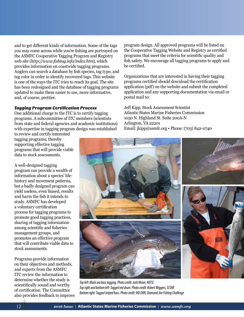
Tagging Program Certification ProcessOne additional charge to the ITC is to certify tagging programs. A subcommittee of ITC members (scientists from state and federal agencies and academic institutions) with expertise in tagging program design was established to review and certify interested tagging programs; thereby supporting effective tagging programs that will provide viable data to stock assessments.
A well-designed tagging program can provide a wealth of information about a species’ life-history and movement patterns, but a badly designed program can yield useless, even biased, results and harm the fish it intends to study. ASMFC has developed a voluntary certification process for tagging programs to promote good tagging practices, sharing of tagging information among scientific and fisheries management groups, and promotes an effective program that will contribute viable data to stock assessments.
Programs provide information on their objectives and methods, and experts from the ASMFC ITC review the information to determine whether the study is scientifically sound and worthy of certification. The Committee also provides feedback to improve
program design. All approved programs will be listed on the Cooperative Tagging Website and Registry as certified programs that meet the criteria for scientific quality and fish safety. We encourage all tagging programs to apply and be certified.
Organizations that are interested in having their tagging programs certified should download the certification application (pdf) on the website and submit the completed application and any supporting documentation via email or postal mail to:
Jeff Kipp, Stock Assessment Scientist Atlantic States Marine Fisheries Commission 1050 N. Highland St. Suite 200A-N Arlington, VA 22201 Email: [email protected] • Phone: (703) 842-0740
Top left: Black sea bass tagging. Photo credit: Josh Moser, NEFSCTop right and bottom left: Tagged red drum. Photo credit: Robert Wiggers, SCSNRBottom right: Tagged striped bass. Photo credit: MD DNR, Diamond Jim Fishing Challenge
132016 Issue | Atlantic States Marine Fisheries Commission | www.asmfc.org 13
One application per tagging program should be submitted regardless of the number of species tagged. ASMFC staff will confirm that applications are complete or request clarification where necessary.
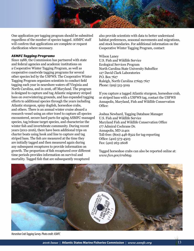
ASMFC Tagging ProgramsSince 1988, the Commission has partnered with state and federal agencies and academic institutions on a Cooperative Winter Tagging Program, as well as cooperative coastwide tagging programs for several other species led by the USFWS. The Cooperative Winter Tagging Program organizes scientists to conduct field tagging each year in nearshore waters off Virginia and North Carolina, and in 2016, off Maryland. The program is designed to capture and tag Atlantic migratory striped bass on overwintering grounds, and has expanded tagging efforts to additional species through the years including Atlantic sturgeon, spiny dogfish, horseshoe crabs, and others. There is an annual winter cruise aboard a research vessel using an otter trawl to capture all species encountered, secure hard parts for aging ASMFC-managed species, tag/release target species, and characterize the winter fish and invertebrate community. During recent years (2011-2016), there have been additional trips on charter boats using hook and line to capture and tag striped bass. The fish are measured at the time they are initially tagged and then measured again during any subsequent recaptures to provide information on growth. The proportion of fish recaptured over different time periods provides information on survival and mortality. Tagged fish that are subsequently recaptured
also provide scientists with data to better understand habitat preferences, seasonal movements and migrations, and stock boundaries. For additional information on the Cooperative Winter Tagging Program, contact:
Wilson LaneyU.S. Fish and Wildlife ServiceEcological Services ProgramNorth Carolina State University Suboffice127 David Clark LaboratoriesP.O. Box 7617Raleigh, North Carolina 27695-7617Phone: (919) 515-5019
If you capture a tagged Atlantic sturgeon, horseshoe crab, or striped bass with a USFWS tag, contact the USFWS Annapolis, Maryland, Fish and Wildlife Conservation Office:
Joshua Newhard, Tagging Database ManagerU.S. Fish and Wildlife ServiceMaryland Fish and Wildlife Conservation Office177 Admiral Cochrane Dr.Annapolis, MD 21401Toll-free: (800) 448-8322 for tag-reportingOffice: (410) 573-4503Fax: (410) 263-2608
Tagged horseshoe crabs can also be reported online at: www.fws.gov/crabtag.
Horseshoe Crab Tagging Survey. Photo credit: ASMFC

14 2016 Issue | Atlantic States Marine Fisheries Commission | www.asmfc.org
aTlanTiC CoasTal Fish habiTaT parTnership updaTe
The Atlantic Coastal Fish Habitat Partnership (ACFHP) has continued to help restore and protect fish habitat through on-the-ground conservation projects along the coast, addressing science and data needs, and collaborating with partners to address fish habitat concerns in 2016.
The Partnership spent the better part of this year updating their five-year Conservation Strategic Plan, setting new objectives and strategies based on subregional priority habitats and threats. The Plan will be finalized in early 2017. (Articles by Lisa Havel)
On the Ground ConservationACFHP has completed its conservation mooring project this year, installing four seagrass-friendly moorings in Jamestown, Rhode Island thanks to funding provided by the National Oceanic and Atmospheric Administration (NOAA). Conservation moorings use a buoyant bungee-like cord to minimize contact with the seafloor. This eliminates “chain sweeping” and subsequent damage to submerged aquatic vegetation that occurs around traditional mooring systems. Pre-mapping and monitoring prior to installation, and post-installation monitoring will allow us to quantify the recovery of seagrass habitat. The results will be presented at the 2016 Restore America’s Estuaries Conference in New Orleans, Louisiana in December 2016. A standing interpretive sign has been installed near the moorings to inform the public on the benefits of conservation moorings and submerged aquatic vegetation. This project was made possible with support from the Rhode Island Division of Fish and Wildlife, Town of Jamestown Conservation Commission, Clarks Boat Yard, Conanicut Marine Services Inc., and Jamestown Boat Yard. To learn more about conservation moorings, please read some of the press we’ve received on this project: http://www.jamestownpress.com/news/2016-06-02/News/Conservationists_attempt_to_restore_vital_eelgrass.html, http://www.jamestownpress.com/news/2015-12-17/News/Conservationist_attends_final_meeting.html, http://www.eregulations.com/rhodeisland/fishing/15risw/habitat-conservation/.
ACFHP has continued to make progress promoting research on offshore black sea bass habitat in the Mid-Atlantic through a grant from the Mid-Atlantic Fishery Management Council. The project, led by Dr. Brad Stevens of University of Maryland Eastern Shore, is titled ‘Hab in the MAB: Characterizing black sea bass habitat in the Mid-Atlantic Bight.’ The study will combine SCUBA, photography, videography, controlled angling, and stable isotope analysis techniques to better understand the importance of habitat and prey community structure on
black sea bass feeding ecology. Check back next year for an update on the progress and initial findings.
ACFHP has partnered with the USFWS for the seventh consecutive year to fund one new on-the-ground restoration project in 2016. The project, located on the Pawcatuck River in Westerly, Rhode Island, will improve riverine fish habitat through the removal of the Bradford Dam. This work is being led by The Nature Conservancy (TNC) Rhode Island, in coordination with the USFWS, Rhode Island Department of Environmental Management (RI DEM), and the Army Corps of Engineers (US ACE). It will restore access to 32 miles of spawning and nursery habitat, benefitting species such as shad, river herring, and American eel. For more information on this and other ACFHP-USFWS funded projects, please visit: www.atlanticfishhabitat.org/projects/fundedprojects/.
This summer, ACFHP published a report titled ‘Aligning the Atlantic Coastal Fish Habitat Partnership Efforts with Restoration Practitioners,’ which is based on a survey of over 80 fish habitat restoration practitioners along the Atlantic coast. From the survey, ACFHP gathered information on the current and future priority habitats for restoration, the most common restoration strategies, top threats to the priority habitats, and how ACFHP can help practitioners achieve their goals. Results from this survey will both assist ACFHP in strategic planning and focus our efforts on a regional and coast-wide scale. To read the report, please visit http://www.atlanticfishhabitat.org/wp-content/uploads/2012/10/Aligning-the-ACFHP-Efforts-with-Restoration-Practitioners.pdf.
Science and Data DevelopmentsAfter years of collaboration and analysis, ACFHP published the results of the Species-Habitat Matrix in the journal BioScience in April. The article, titled ‘The Importance of Benthic Habitats for Coastal Fisheries’ presents the evaluation of the relative importance of coastal, estuarine, and freshwater habitat types as living space during the major life stages of over 100 fish species.

152016 Issue | Atlantic States Marine Fisheries Commission | www.asmfc.org 15
aTlanTiC CoasTal Fish habiTaT parTnership updaTe
The study evaluated the importance of benthic habitats as a space for shelter, feeding, and breeding by coastal fishes and invertebrates in the four ACFHP subregions. The results can be used to evaluate trade-offs and develop habitat-management strategies. ACFHP is currently working to create a web-based tool that will allow fishery and habitat managers, scientists, and grassroots organizations to query data in the Species-Habitat Matrix. The web-based tool should be available in the upcoming months. The Species-Habitat Matrix was based on the expertise of many scientists along the Atlantic coast, and was spearheaded by a team of authors: Jake Kritzer (Environmental Defense Fund), Mari-Beth DeLucia (TNC), Emily Greene (Earth Resources Technology, Inc.), Caroly Shumway (US AID, formerly Merrimack River Watershed Council), Marek Topolski (Maryland Department of Natural Resources), Jessie Thomas-Blate (American Rivers), Lou Chiarella (National Marine Fisheries Service), Kay Davy (National Marine Fisheries Service), and Kent Smith (Florida Fish and Wildlife Conservation Commission). Access to the abstract and instructions to download the full article can be found here: http://bioscience.oxfordjournals.org/content/early/2016/03/04/biosci.biw014.abstract.
This year ACFHP received funding from NOAA to spatially prioritize fish habitat protection and restoration sites through GIS mapping and analysis for the southeast region of the U.S. from North Carolina to Florida. The resulting maps will help ACFHP identify where best to invest effort and future NFHAP funds. Pending additional funding, this resulting pilot project will be expanded to the entire ACFHP region. We are currently in phase I of the project, which includes identifying species of concern; prioritizing spatial locations for protection and restoration; and compiling, reviewing, and scoring existing GIS layers.
ACFHP also finalized the Decision Support Tool to Assess Aquatic Habitats & Threats in North Atlantic Watersheds & Estuaries this year. ACFHP worked with Downstream Strategies, LLC to compile and analyze the threats to inland, estuarine, and coastal aquatic species across the Northeast Atlantic. These data were then used to
model species distributions, which provided information to produce both distribution maps and a multi-criteria decision support tool for resource managers. This work was funded by the North Atlantic Landscape Conservation Cooperative. To view the tool, please visit www.fishhabitattool.org.
Bonnie Bick and Jim Long Receive 2016 Melissa Laser Fish Habitat Conservation AwardThe 2016 Melissa Laser Fish Habitat Conservation Award was presented by ACFHP to Bonnie Bick and Jim Long of the Mattawoman Watershed Society on October 23rd during the Welcoming Reception of the 75th Atlantic States Marine Fisheries Commission Annual Meeting in Bar Harbor, Maine. Over the last two decades, Bonnie and Jim have worked tirelessly without financial compensation to protect one of the most important fish breeding grounds in the Chesapeake Bay watershed, Mattawoman Creek. One of their greatest achievements has been the recent resource-friendly comprehensive growth plan adopted by Charles County. Among other things, this plan recognizes
the role of conserving Mattawoman Creek’s watershed for anadromous fish. This comprehensive ground-breaking plan provides a blueprint for future growth, both in Maryland and along the coast, while also addressing the needs of fish and wildlife in the area. Through their diligent voluntary efforts, Bonnie and Jim greatly aided the
From Left: ACFHP Steering Committee member Dr. Wilson Laney, Award recipient Jim Long, Mrs. and Mr. Laser, Award recipient Bonnie Bick,and Maine Commissioner Patrick Keliher

16 2016 Issue | Atlantic States Marine Fisheries Commission | www.asmfc.org
Department of Natural Resources by collecting data that otherwise would not exist. In turn, they used the science generated by these data to defend their beloved watershed.
In addition to the comprehensive growth plan, their accomplishments include protecting more than 1,000 acres along Mattawoman Creek, stopping the proposed Cross County Connector Extension across the watershed’s headwaters in Charles County, and encouraging replacement of the road project with a proposed bike path. Further, they promoted a 10% impervious surface cap within the watershed and served as enthusiastic citizen scientists collecting the critical fish spawning and habitat data necessary to support their efforts. They also attend and testify at countless development hearings.
The Melissa Laser Award was established in 2012 in memory of Dr. Melissa Laser, a biologist with the Maine Department of Marine Resources and active member of the ACFHP Steering Committee. Melissa dedicated her career to protecting, improving, and restoring aquatic ecosystems both locally in Maine and along the entire Atlantic coast. For more information on the Melissa Laser Award, please visit: www.atlanticfishhabitat.org/opportunities/awards/.
Habitat Management:Sciaenid Habitat Lisa Havel, ASMFC, with help from the authors of Sciaenid Habitat: A Review of Utilization, Threats, and Recommendations for Conservation, Management, and Research Needs
Sciaenid fishes, also known as drums due to the sound many of them produce, are found worldwide, with 57 described species in the western Atlantic. ASMFC manages some of these species, including Atlantic croaker, black drum, red drum, spot, spotted seatrout, and weakfish. This year, the ASMFC produced a detailed document describing up to date information on each of these species’ (plus three species of kingfishes) biology, habitat requirements, and habitat stresses. It also lists the greatest threats and research needs regarding sciaenid habitats.
In the western Atlantic Ocean, sciaenids are found from Maine to Mexico, in shallow coastal waters and larger bays and estuaries, including their tributaries. In general, they utilize a variety of habitats throughout their life stages,
including estuaries, salt marshes, freshwater marshes, oyster reefs, sea grasses, and mud banks/shores. Because of the way different species of sciaenids partition their use of habitat by lifestyle and species, several different habitat types are key for maintaining healthy populations.
Estuaries are important habitats for many sciaenids at every life stage. In the Mid Atlantic Bight, as many as 14 species can be present in estuaries as larvae, juveniles, or adults over the course of a year. Weakfish, for example, use estuaries as primary spawning habitat, while Atlantic croaker and spot use them as nurseries and seasonal adult foraging grounds. As dominant seasonal members of the estuarine fish assemblage, young sciaenids play important roles as both predators and prey.
Temperature, salinity, and dissolved oxygen vary considerably in estuarine environments and these factors are known to affect sciaenid growth rates, spawning, and spatial and temporal distribution. As a group, sciaenids are habitat generalists and may therefore be relatively resilient to changes in abiotic factors. However, Atlantic coast estuaries have been profoundly altered. Despite their ability to take advantage of a range of habitats, sciaenids are not immune to habitat degradation or suboptimal conditions, especially in the face of climate change.
Increasingly dense human populations along our coastlines threaten the health of estuaries and coastal waters, including sciaenid habitats. Widespread development, beach renourishment, dredging, overfishing, coastal armoring, pollution, and other human impacts have significantly altered the physical and chemical environments of estuarine and marine waters. Changes in hydrologic processes and runoff characteristics can increase turbidity and sedimentation and decrease light transmittance, which may lead to the loss of submerged aquatic vegetation. Anthropogenic alterations to the estuarine environment have been linked to changes in hydrography and salinity regimes, as well as food web modification, which can eventually reduce the quality of habitat for sciaenids and other estuary-dependent fishes.
To read more about sciaenid habitats and the ASMFC Habitat Program’s recommendations to mitigate threats to these habitats, keep an eye out for the press release in the upcoming weeks announcing the document’s availability on the ASMFC website!

172016 Issue | Atlantic States Marine Fisheries Commission | www.asmfc.org 17
updaTes From around The CoasT
MaineOliver Cox, Maine Department of Marine ResourcesDivision of Sea Run Fisheries and Habitat
Penobscot River Restoration Project Thanks to a multitude of private, state, tribal, and federal supporters, the Penobscot River Restoration Trust (Trust) has completed the third and final major component in the Penobscot River Restoration Project: the Howland Dam nature-like fishway. The first two major components were the removal of the two lowermost dams on the Penobscot River. The Great Works Dam was removed in 2012 and the Veazie Dam was removed in 2013.
“Construction of the Howland bypass is another milestone in efforts to restore Maine’s native sea-run fisheries in the Penobscot River,” said Patrick Keliher, Commissioner of the Maine Department of Marine Resources. “Passage of anadromous fish species is critical to the health of our state’s marine and freshwater ecosystems. This project will not only provide access to hundreds of miles of critical habitat to Maine’s native sea-run fish, it will ensure continued opportunity for renewable power generation on the Penobscot River.”
In addition to the Trust’s projects, the Milford Dam owners built a fish lift to replace the Denil fishway and allow for fisheries management. This innovative restoration project allowed dam owners to increase power generation at several other locations to replace the lost power generation at the Howland, Great Works, and Veazie Dams.
In 2010, the Maine Department of Marine Resources began restoring alewives to the Penobscot River in advance of the major dam removal projects. In partnership with the Atlantic Salmon Federation, USFWS, the Penobscot Indian Nation, and various other community groups, seven fish passage projects have been implemented to reconnect alewife with spawning habitat. In 2016, 1.8 million river herring were documented returning to the lower Penobscot River.
One species greatly benefitting from this project is American shad. From 1978 until the removal of the Veazie Dam in 2013 only 16 American shad were documented to have ascended the Veazie Dam fishway. The dam and the fishway were an overwhelming barrier that prevented American shad from accessing freshwater spawning habitat. This year, the Maine Department of Marine
Resources passed nearly 8,000 American shad upstream at the Milford Dam fish lift. American shad now have access to hundreds of miles of spawning habitat in the Penobscot River drainage.
Howland Bypass aerial view. Photo credit: JRoyte_TNC_Lighthawk
Howland focused project map (1.22.14)

18 2016 Issue | Atlantic States Marine Fisheries Commission | www.asmfc.org
New Hampshire
Tidal Stream Crossing Assessment Protocol (New Hampshire Coastal Zone)Kevin Lucey, New Hampshire Department of Environmental Services, Coastal Program, Restoration Coordinator
On September 10, 2015, approximately 35 natural resource managers and restoration experts representing areas from Nova Scotia to Long Island Sound convened in Portsmouth, New Hampshire, to participate in a Tidal Crossings Assessment Workshop. The workshop was convened by the Gulf of Maine Council, Northeast Regional Ocean Council, and North Atlantic Landscape Conservation Cooperative. The objective was to share information regarding jurisdictional efforts on developing protocols for assessing tidal stream crossings, enhance understanding of how management questions can be addressed through tidal stream crossing assessment, and determine interest in developing a regional tidal crossing protocol. During the workshop, New Hampshire partners presented their draft tidal stream crossing assessment protocol (Protocol) and discussed the objectives they hoped to achieve through implementation of a field and desktop-based assessment. With valuable feedback from regional partners, TNC has provided leadership on the revisions and field testing of the Protocol at multiple sites in 2016. The Protocol is designed to identify and prioritize: tidal restrictions, barriers to aquatic organism passage and saltmarsh migration, and road crossings that are at risk from storm events and sea level rise. New Hampshire partners plan to implement the Protocol on the roughly 100 tidal stream crossings in New Hampshire’s Coastal Zone in 2018. This work is partially funded through a NOAA Coastal Zone Management Grant through the New Hampshire Coastal Program.
Coastal Wetlands MappingRachel Stevens, Great Bay National Estuarine Research Reserve, Stewardship Coordinator and Wildlife Ecologist
Staff from the New Hampshire Coastal Program, New Hampshire Fish and Game Department (NH FGD), Great Bay National Estuarine Research Reserve (GBNERR), New Hampshire Department of Environmental Services (NH DES), and NOAA’s Office for Coastal Management collaborated to begin high resolution mapping of coastal wetlands throughout the state. The project area boundary was defined using a 2014 National Wetlands Inventory
Shea Flanagan and Joanne Glode (NH TNC) perform a longitudinal profile of Cains Brook at the crossing of Causeway Road in Seabrook, NH. Photo credit: NH Coastal Program
Left to right: Chris Robinson (OCM), Jamie Carter (OCM), Rachel Stevens (GBNERR), Hannah Blondin (NHDES), Kevin Lucey (NHDES) Photo credit: NHDES, Coastal Program
Chris Robinson and Kevin LuceyPhoto credit: Rachel Stevens (GBNERR)

192016 Issue | Atlantic States Marine Fisheries Commission | www.asmfc.org 19
update. Within this, approximately 24 habitats are identified, including a “recently flooded upland border” category. This detailed mapping, and subsequent change analysis over time, will allow us to track habitat impacts of sea level rise. Fieldwork this year focused on field verification of vegetation types in order to train the eCognition software being used to create draft maps. Maps will be drafted over the winter and an accuracy assessment is planned for the 2017 field season. This mapping product has several planned uses including contributing as a metric in the pending State of Our Estuaries Report being produced by the Piscataqua Region Estuaries Partnership.
Staff from NOAA’s Office for Coastal Management returned two weeks later to collaborate with the NH FGD and GBNERR to collect field data to develop a fine resolution digital elevation model (DEM) at two sites and compare it to elevation models developed with LiDAR data.
Oyster Restoration in Great Bay EstuaryElizabeth Baker, The Nature Conservancy, Director of Coastal & Marine Programs
In 2016, TNC, the University of New Hampshire, and independent oyster growers worked together to undertake oyster restoration efforts in 12 acres of the Great Bay Estuary of New Hampshire. Five acres of this work, northwest of Nannie Island in Newington, were supported by funds from the Aquatic Resource Mitigation Fund. The work includes seeding the restoration area with over 1 million juvenile oysters (spat-on-shell) later this fall. The remaining restoration work, located south of Adams Point in Durham and in the mouth of Lamprey River, was initiated
with support from the Natural Resources Conservation Service through the Regional Conservation Partnership Program to support conservation in New Hampshire’s coastal watershed. This was our 8th consecutive year of construction and the largest total effort to date, bringing the total oyster reef restoration effort to over 25 acres since 2009. In addition, this year TNC’s Oyster Conservationist Program has engaged 83 volunteers, including families, schools, businesses, and individuals across the Seacoast Region of New Hampshire and Southern Maine to grow oysters on their private docks for the restoration effort.
This was the largest group of Oyster Conservationist volunteers in the 11 year history of the program.
Dam RemovalsCheri Patterson, New Hampshire Fish and Game Department, Supervisor of Marine Programs
The members of the New Hampshire River Restoration Task Force continue to work with state, federal, non-governmental organizations, individual dam owners, and municipalities on dam removal projects by providing technical advice with many potential dam removal projects. Many of these dams under consideration for removal are due to safety concerns investigated by the NHDES, Dam Safety Section. Letters of Deficiency (LOD) have been issued and the dam owners (private, municipal, and state) are navigating through various stages to determine available options such as dam removal, repair, or modification to meet dam safety standards. These options consider many aspects such as public input, long and short term environmental and financial concerns, recreational impacts, etc. Following is an update of the dams currently being demolished
An Oyster Conservationist volunteer excited to receive baby oysters to grow out on dock. Photo Credit: The Nature Conservancy
Great Dam, Exeter, NH, pre-removal. Photo credit: NH FGD

20 2016 Issue | Atlantic States Marine Fisheries Commission | www.asmfc.org
or soon to be removed that affects New Hampshire coastal watersheds and diadromous fish passage and habitats.
Great Dam, Exeter/Squamscott River (Exeter, NH)Owner, Town of Exeter
The dam located in downtown Exeter, New Hampshire, and owned by the Town, was the first dam above head-of-tide. It had an attached inefficient denil fish ladder owned by the NH FGD. After receiving a LOD and several years of feasibility study, the Town decided in early 2014 to remove the dam. The Town and state and federal agencies funded the removal of the dam, currently under demolition and river restoration phase. This dam removal will allow unimpeded habitat access for diadromous fish to the next dam (7.4 miles) which has an associated denil fish ladder allowing access to another 6 miles of spawning and rearing habitat.
Sawyer Mill Dams, Bellamy River (Dover, NH)The Upper and Lower Sawyer Mill Dams represent the first diadromous fish passage barriers on the Bellamy River, a major tributary river to the Great Bay estuary. This dam removal project presents a unique opportunity to remove
Right: Sawyer Mill Dam, Dover, NHPhoto Credit: Kevin Lucey (NHDES, Coastal Program)
two high hazard dams that are located immediately upstream of the head-of-tide to re-establish connectivity between freshwater and tidal habitats, restore fish passage, improve water quality and reduce flood hazards. Removal of the Sawyer Mill Dams is scheduled to begin in July 2018. Funds are currently being sought for deconstruction and removal of the dam debris.
Massachusetts Mark Rousseau, Massachusetts Division of Marine Fisheries
On March 23, 2016, sixteen hundred cubic yards of concrete rubble were deployed into the waters of Nantucket Sound, creating the new Harwich artificial reef. The 9.9 acre (200 meter x 200 meter) site is located 2 miles south of the entrance to Saquatucket Harbor in Harwich at an approximate 32 ft depth. The site is designed to enhance fishing by providing benthic relief and interstitial spaces in an otherwise featureless location. Deployed structures extend 3 to 6 ft off the bottom and are dispersed in patches to minimize disturbance to the natural bottom. Structures provide habitat for many recreationally important species like black sea bass, tautog, and scup that spend all or part of their life cycle in Nantucket Sound.
MarineFisheries established a regulation prohibiting all commercial fishing activity on the reef site and within an additional 100 m buffer zone extending around the site. The rationale behind the establishment of the regulation is that the reef was created using revenue from the recreational saltwater fishing permit and that recreational fishing opportunities could be optimized by excluding commercial fishing activity and eliminating potential user group conflicts on the site.
For site monitoring, an acoustic receiver was deployed to document
Top left: Attached fish ladder demolition; bottom left: Dam removed; river restoration commencingPhoto credit: NH FGD

212016 Issue | Atlantic States Marine Fisheries Commission | www.asmfc.org 21
presence on the reef site of acoustic tagged fish, taking advantage of MarineFisheries ongoing striped bass, black sea bass, cod, and white shark acoustic tagging efforts occurring in the region. HOBO® sensors record bottom temperature hourly and will remain on-site indefinitely. Pre-deployment and time “0” benthic survey time-series data was collected to examine species presence/ successional colonization of native and invasive species over time. For more information on this and other artificial reef projects in Massachusetts, please visit Massachusetts Artificial reef projects or contact Mark Rousseau at [email protected].
Historic Eelgrass Trends In Two Massachusetts EmbaymentsWith funding from the MassBays Program, the MarineFisheries Habitat Project is assessing historic eelgrass trends in two Massachusetts embayments: Duxbury, Kingston, and Plymouth Bays (DKP) and Salem Sound. The project utilizes photo-interpretation methods to delineate eelgrass beds in historic aerial photos from
1951 to present, implementing two patchiness categories to better describe meadow density. Side scan mapping surveys are completed to further assess and groundtruth the meadows at a higher resolution. A data mining exercise follows, assessing water quality, weather, physical disturbance and various biotic variables that may cause or contribute to the eelgrass trends observed in the mapping exercises.
The DKP analysis completed this spring concluded that approximately 70% of eelgrass in DKP disappeared in the 60+ year study period. All areas of DKP were affected and losses occurred at a variety of water depths. The loss is likely caused primarily by degrading environmental conditions due to water quality impairments from runoff and wastewater, the effects of which are exacerbated by a documented temperature increase. Local losses due to geomorphological changes and direct impacts as a result of human activities in DKP are also relevant.
The acoustic survey of Salem Sound was completed in August 2016 and preliminary results suggest that eelgrass loss in this embayment has not been as extensive as in DKP. While some discrete areas have seen complete loss since 1951, others appear to have rebounded recently. Stay tuned for more results, and contact Jill Carr ( [email protected]) for more information.
Concrete rubble being transferred to create the new Harwich artificial reef. Photo credit: Mark Rousseau, MA DMF
Left: Loss over time in DKP; right: Sidescan image example in DKP. Photo credit: Jillian Carr, MA DMF

22 2016 Issue | Atlantic States Marine Fisheries Commission | www.asmfc.org
Measuring Carbon Sequestration Rates in New England Seagrass MeadowsIn 2016, the Environmental Protection Agency (EPA) in collaboration with MIT-Sea Grant, Boston University and Massachusetts Division of Marine Fisheries (MA DMF)kicked off a 2 year study of carbon sequestration rates in eight eelgrass meadows in New England. Sediment traps were placed in meadows and reference areas in Great Bay, New Hampshire; Gloucester, Nahant, Cohasset, Orleans (Pleasant Bay), West Falmouth, Tisbury, Massachusetts and Ningret Pond, Rhode Island. Plant growth rates, morphology, carbon and nitrogen tissue content were also collected. Sediment cores were taken and are being analyzed for carbon and nitrogen content. Analysis of carbon and nitrogen stable isotopes and lead-210 will be conducted on sections of the sediment cores. The combination of sediment traps and lead-210 dating will allow us to look at carbon sequestration on multiple time
EPA Diver Dan Arsenault collecting sediment core. Photo credit: Phil Colarusso.Sediment traps being deployed. Caps are removed once they are deployed. Photo credit: Dan Arsenault
Providence River (top of the Bay) looking South. Photo credit: Melissa Palmisciano, Narragansett Bay Estuary Program
scales. Work by this team in 2015 showed that eelgrass meadows can store significant quantities of carbon and often a large percentage of the carbon originates from sources outside of the meadow. For more information, please visit Green Eelgrass, Blue Carbon, or contact Phil Colarusso at [email protected].
Rhode IslandChris Powell, ACFHP Vice-chair
Enhancing and Restoring Urban Fish Habitats – New Life for the Providence and Seekonk Rivers?The water quality in Upper Narragansett Bay, and especially the urban Providence River, has shown improvements due to increased treatments of wastewater discharges resulting in a > 50% decrease in nutrients, > 90% reduction in toxins, and major decrease in raw sewage discharges from combined sewer overflows. The RI DEM Division of Fish & Wildlife, Marine Fisheries Program (RI Marine Fisheries)
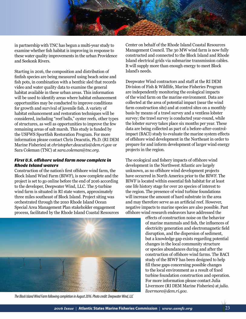
232016 Issue | Atlantic States Marine Fisheries Commission | www.asmfc.org 23
in partnership with TNC has begun a multi-year study to examine whether fish habitat is improving in response to these water quality improvements in the urban Providence and Seekonk Rivers.
Starting in 2016, the composition and distribution of finfish species are being measured using beach seine and fish pots, in combination with a benthic sled that records video and water quality data to examine the general habitat available in these urban areas. This information will be used to identify areas where habitat enhancement opportunities may be conducted to improve conditions for growth and survival of juvenile fish. A variety of habitat enhancement and restoration techniques will be considered, including “reef balls,” oyster reefs, other types of structures, as well as opportunities to improve the few remaining areas of salt marsh. This study is funded by the USFWS Sportfish Restoration Program. For more information please contact Chris Deacutis, Ph.D. (RI DEM Marine Fisheries) at [email protected] or Sara Coleman (TNC) at [email protected]. First U.S. offshore wind farm now complete in Rhode Island watersConstruction of the nation’s first offshore wind farm, the Block Island Wind Farm (BIWF), is now complete and the project is set to go online before the end of 2016 according to the developer, Deepwater Wind, LLC. The 5-turbine wind farm is situated in RI state waters, approximately three miles southeast of Block Island. Project siting was orchestrated through the 2010 Rhode Island Ocean Special Area Management Plan stakeholder engagement process, facilitated by the Rhode Island Coastal Resources
Center on behalf of the Rhode Island Coastal Resources Management Council. The 30 MW wind farm is now fully constructed and connected to the Block Island and Rhode Island electrical grids via submarine transmission cables. It will supply more than enough energy to meet Block Island’s needs.
Deepwater Wind contractors and staff at the RI DEM Division of Fish & Wildlife, Marine Fisheries Program are independently monitoring the ecological impacts of the wind farm on the marine environment. Data are collected at the area of potential impact (near the wind farm construction site) and at control sites on a monthly basis by means of a trawl survey and a ventless lobster survey; the trawl survey is conducted year-round, while the lobster survey takes place six months per year. These data are being collected as part of a before-after-control-impact (BACI) study to evaluate the marine system effects of offshore wind development in the Northeast in order to prepare for and inform development of larger wind energy projects in the region.
The ecological and fishery impacts of offshore wind development in the Northwest Atlantic are largely unknown, as no offshore wind development projects have occurred in North America prior to the BIWF. The BIWF is located within essential fish habitat for at least one life history stage for over 20 species of interest to the region. The presence of wind turbine foundations will increase the amount of hard substrate in the area and may therefore serve as an artificial reef. However, negative impacts to marine species are also possible. Past offshore wind research endeavors have addressed the
effects of construction noise on the behavior of marine mammals and fish, the influences of electricity generation and electromagnetic field disruption, and the dispersion of sediment, but a knowledge gap exists regarding potential changes in the local community structure or species abundances during and after the construction of offshore wind farms. The BACI study of the BIWF has been designed to help fill these gaps concerning possible changes to the local environment as a result of fixed turbine foundation construction and operation. For more information please contact Julia Livermore (RI DEM Marine Fisheries) at [email protected].
The Block Island Wind Farm following completion in August 2016. Photo credit: Deepwater Wind, LLC

24 2016 Issue | Atlantic States Marine Fisheries Commission | www.asmfc.org
ConnecticutPenny Howell, Connecticut Department of Energy and Environmental Protection
Connecticut is known as the “land of steady habits” for several reasons, one of which is that many of our streams and rivers are still restricted and diverted by dams built centuries ago by the first European industrialists to colonize the state. Even when these old dams are breached - either by deterioration, storms, or purposeful demolition – the parts and pieces left in the river can block fish passage and in some cases pose a threat to boats and anything else in the river. Three projects completed in 2016 remedied this century-old problem in three rivers using two approaches.
The first approach was the simplest: break up the dam material into small enough pieces to remove them from the river. This was done on Bigelow Brook, a small stream in Manchester that currently supports resident brown trout and other cold water species and had been dammed in some manner since 1672. The existing dam, which dates to the 1780, was intentionally breached in 1978, but the rubble from the breaching blocked fish passage.
In addition to freeing river flow, the project included restoring the riparian habitat and creating a public park in a 20-acre section of the original mill complex which now houses offices and apartments. A similar project removed a large concrete slab left from the breaching of the 200-foot long Griswold Rubber Dam on the Moosup River in Plainfield. This slab was impassable during low flows, and the rushing water over it created a velocity barrier during higher flows.
Dam removals are permanent and 100% maintenance-free fixes but in some circumstances are not possible. That was the case at Century Brass, an old dam on the Mad
River in Waterbury that was partially demolished over 25 years ago but the concrete sill that remained blocked fish passage. The Connecticut Department of Transportation funded and installed a rocky ramp fishway to get fish over what remains of the old dam. This style of fishway is maintenance free and won’t need costly repairs before all of the remaining downstream dams are removed and anadromous species such as river herring can reach it. This fishway also allows passage of many different species of fish so it is the next best thing to complete dam removal.
New YorkDawn McReynolds, New York State Department of Environmental Conservation
New York State Marine Artificial Reef Program Completes Biological SurveyThe New York State Artificial Reef Program (Program) manages a series of developed sites in its marine coastal district. A majority of the sites are located in the Atlantic Ocean near inlets of Long Island’s south shore. The Program must periodically monitor its reef sites to satisfy reef permit conditions.
In 2015 funding was secured from the Environmental Protection Fund, Oceans and Great Lakes Fund to conduct a focused biological monitoring study of reef productivity on the Hempstead and Atlantic Beach Reef Sites. The
2016 Connecticut dam removal projects. Photo credit: CT DEEP
Black sea bass, tautog and dusky shark attracted to the BRUV. Photo credit: SUNY COMAS/NYSDEC

252016 Issue | Atlantic States Marine Fisheries Commission | www.asmfc.org 25
survey was contracted through the Stony Brook University School of Marine & Atmospheric Sciences. The emphasis of the study was to assess the most repeatable and cost effective biological sampling methods and procedures to monitor fish, crustaceans, and epibenthic organisms on both reef sites.
Survey effort began in August 2014 and then resumed in April 2015, continuing through September 2015. A variety of materials (rock, concrete, steel) were monitored on patch reefs of each site. The biological sampling methods used were SCUBA transects using diver observation photos and videos, Baited Remote Underwater Videos (BRUV), passive acoustic sampling, and CTD environmental sampling.
Preliminary survey results from divers and BRUV’s documented the presence of typical reef associated species such as tautog, black sea bass, cunner, scup, red hake, Atlantic cod, conger eel, lobster, rock crab, grey triggerfish, summer flounder, and dogfish, among other species. Passive acoustic monitoring documented very large aggregations of menhaden over and in the vicinity of the reef sites studied.
The study documented that the material, age, and size of reefs had an effect on the biological composition at a site and varied between fish and benthic organisms. Reef size and shape were of particular importance. On-reef fish aggregations were observed to be four times larger than off-reef aggregations and were closely associated with reef vertical relief and rugosity.
Acoustically measured fish aggregations were significantly higher on reefs composed of concrete compared with steel (vessels) or rock.
Passive acoustic recordings on one reef documented the presence of odontocetes (likely dolphins) feeding on the site at night.
Reefs that were less than five years old had higher fish abundances recorded acoustically. Benthic communities appeared to fully develop by the 10 to 15 year mark. Medium-sized reefs (i.e. individual rock piles) exhibited higher fish abundances when measured acoustically. Diver observations of cunner, black sea bass, and tautog, the more abundant reef associated species,were higher on medium-sized reefs. Lobster and rock crabs were found to be present at reefs with higher rugosity.
Once completed, this study will be incorporated into a supplement to the Generic Environmental Impact Statement and Reef Plan for future Program permit renewals and new future reef sites.
Work on Sunken Meadow State Park’s Comprehensive Resiliency and Restoration Plan ContinuesFour years ago, Hurricane Sandy forever changed the future of Sunken Meadow Creek’s habitat
Above- A sample passive acoustic echogram showing very large menhaden schools over and near structure on the Atlantic Beach Reef. Image credit: SUNY SOMAS/NYSDEC
Diver photos illustrating variations in habitat enhancement through placement of different amounts of dredge rock on a site. Reef complexity is dependent on material size and profile that can range from low profile [A] to more convoluted high profile sections [C] with higher rugosity that hold large numbers of interstitial spaces for reef species to shelter in.Photo credit: SUNY SOMAS/NYSDEC
Black sea bass, tautog and dusky shark attracted to the BRUV. Photo credit: SUNY COMAS/NYSDEC

26 2016 Issue | Atlantic States Marine Fisheries Commission | www.asmfc.org
and water quality. On that fateful day, the manmade earthen berm that separated the freshwater portion of the Creek from the tidal Long Island Sound was breached, returning unrestricted tidal flow to the creek for the first time in over 50 years. Since that time, New York State Office of Parks, Recreation and Historic Preservation and partners (Connecticut Fund for the Environment/Save the Sound, NOAA Restoration Center, TNC, USFWS, and New York State Department of Environmental Conservation (NYSDEC) have been implementing a comprehensive resiliency and restoration plan, funded through the Hurricane Sandy Coastal Resiliency Competitive Grant Program. This plan has focused on enhancing the Creek, and the Park’s, ecosystems, water quality, and overall resiliency to climate change.
Some major achievements to date include the restoration of two acres of tidal marsh habitat on the Creek. After the breach, large stands of Phragmites australis began to die and erode away, leaving barren and exposed mudflat. In order to expedite the return of native vegetation to the Creek, partners, along with dozens of volunteers, planted 24,000 plugs of Spartina alterniflora over a two year time frame in the Creek. In 2017, partners will restore an additional 1.5 acres of tidal marsh to further enhance the Creek’s natural habitat.
In 2017, partners will install six Surface Elevation Tables (SETs) benchmarks in the newly planted marsh and in reference marshes. SETs are long term monitoring stations that determine marsh elevation change over time in order to determine if the marshes are capable of keeping pace with sea level rise predictions. These new SETs will be part of the greater SET monitoring network on Long Island and in the New York City area that includes more than 30 other SET monitoring locations. This network provides practitioners information on local marsh resiliency.
In addition to the tidal marsh restoration and monitoring effort, partners have also been working to complete a fish passage feasibility study and a Low Impact Development (LID) design and construction of a 12 acre parking lot at the park. The fish passage feasibility study will determine the appropriate solution for fish passage at the dams located near the headwaters of the Creek. This draft report, with designs, is expected by early 2017. The LID design of the parking lot is complete and the project is expected to go to construction during the winter of 2016/2017. The redesigned parking lot will feature areas of porous
pavement, permeable pavers, meadows, lawn, bioretention areas, new walkways, and trees. The parking lot is expected to treat stormwater runoff before it enters the Creek in order to improve local water quality.
Planting Spartina. Photo credit: Save the Sound
SET Monitoring. Photo credit: NYSDEC

272016 Issue | Atlantic States Marine Fisheries Commission | www.asmfc.org 27
New JerseyRuss Babb, New Jersey Department of Environmental Protection
DEP’S Artificial Reef Program Resumes Deployments The New Jersey Department of Environmental Protection’s (NJDEP) artificial reef deployment program is back on course as a result of restoration of federal funding made possible by a compromise the Christie Administration reached between recreational anglers and commercial fishermen over access to the popular reefs. The New Jersey Division of Fish and Wildlife Marine Fisheries Administration plans to sink as many as 10 vessels by the end of fall to become part of its network of artificial reefs. Two ships were deployed earlier this summer and the third deployment took place in the fall at the Axel Carlson Reef, just southeast of Manasquan Inlet, with the sinking of the 65-foot crew boat NY Harbor Charlie. The program also recently deployed the 68-foot trawler, Austin, as part of the Axel Carlson Reef, 4.4 nautical miles southeast of Manasquan Inlet and the 115-foot surf clam vessel, Lisa Kim, as part of the Wildwood Reef, 8.3 miles northeast of Cape May Inlet. The USFWS is providing $119,250 to the artificial reef program because of the compromise that permits commercial interests to have continued access to certain portions of two reefs in state waters and calls for the construction of a new reef for recreational fishing, also
in state waters. The USFWS had suspended the funding due to concerns that commercial fishing was intruding on and hampering recreational fishing on artificial reefs in state waters, which are funded by excise taxes on recreational fishing gear and motor boat fuel. Under the new rule, commercial fishing operations are permitted to continue using portions
of two existing reefs in state waters off Sandy Hook and Manasquan. Recreational anglers will continue to have access to all portions of these reefs. The NJDEP is matching the federal money for the program with $39,750 from state appropriations and a donation from a firm that creates concrete reef structures. The New Jersey Division of Fish and Wildlife currently holds permits for 15 artificial reef sites – 13 in federal waters and two in state waters. The reefs, encompassing a total of 25 square miles of ocean floor, are constructed from a variety of materials, such as rocks, concrete and steel, and even old ships and barges. These materials provide surfaces for a wide diversity of marine organisms to grow, ultimately providing food and habitat for many species of fish and shellfish. The reefs are placed to be within easy reach by boat of 12 inlets. NJDEP studies have shown that these materials are colonized quickly with organisms such as algae, barnacles, mussels, sea stars, blue crabs, and sea fans that attract smaller fish which, in turn, attract black sea bass, tautog, summer flounder, scup, lobster, and other sought-after species.
Recreational fishing brings more than $640 million in retail sales to New Jersey annually
The Austin, a 68 ft former trawler recently deployed on the Axel Carlson Reef, located 4.4 nautical miles SE of Manasquan Inlet, NJ. Photo credit: NJ MFA
The Lisa Kim, a 115 ft former clam dredge boat deployed on the Wildwood Reef, located nine miles northeast from Cape May Inlet. Photo credit: NJ MFA

28 2016 Issue | Atlantic States Marine Fisheries Commission | www.asmfc.org
As part of a $250,000 broader assessment of marine resources currently under way, the NJDEP and Rutgers University will be evaluating which artificial reef structure materials attract the most marine life. Artificial reefs are extremely popular with anglers and divers, contributing to the state’s economy through the creation of tourism opportunities and jobs. New Jersey’s commercial fishing industry ranks 7th in the nation in retail sales, and supports $327 million in salaries and wages and nearly 13,000 jobs. Recreational saltwater fishing brings in more than $640 million in retail sales and is directly responsible for nearly 10,000 jobs and more than $242 million in tax revenues, including $165 million in state and local taxes.
American Littoral Society Leads Fish Passage Project at Wreck PondThe American Littoral Society (Society) is working with federal, state, and local organizations to improve fish passage into and out of Wreck Pond in Spring Lake, New Jersey for two species of special concern, alewife (Alosa pseudoharengus) and blueback herring (Alosa aestivalis) (collectively known as river herring), as well as American eel (Anguilla rostrata). Wreck Pond is a 73-acre coastal pond located on the border of Spring Lake and Sea Girt, New Jersey and lies at the eastern end of the Wreck Pond Brook Watershed, which drains over 12 square miles of land from the boroughs of Sea Girt, Spring Lake, Spring Lake Heights, and Wall Township in Monmouth County, NJ. Wreck Pond is fed by three main tributaries: Wreck Pond Brook, Black Creek, and Hannabrand Brook that together, with smaller creeks and streams, provide
important habitat for birds, fish, and other wildlife.
Initial fish surveys began in 2006 as a permit condition to the extension of the existing 84-inch diameter pipe an additional 300 feet offshore. At the time, the pipe served as the only connection between Wreck Pond and the Atlantic Ocean. Work done from 2006 to 2008 identified a small spawning population of alewife. One blueback herring was captured in 2006; two were captured in 2007.
In 2014, with funding from the USFWS and later shared funding through a Spring Lake U.S. Department of Housing and
Urban Development grant, the Society and its partners began work to install a secondary bypass culvert (5.5’ X 8’ X 600’) that would improve aquatic connectivity to Wreck Pond from the Atlantic Ocean, with a main goal of improving fish passage into and out of the pond. The culvert was also designed with light tubes every 150 feet to better encourage anadromous fish movement. Other benefits include improved water quality and reduced risk of flooding. To better determine the success of the new culvert for fish passage, and gain current population data post-Hurricane Sandy, the Society began spring and fall fish studies in 2014. The spring fyke net surveys were designed to inventory adult river herring migrating into the watershed to spawn. Initial results indicated a small alewife run, with 103, 108, and 143 alewife captured in 2014, 2015, and 2016 respectively. Around 100 American eel have also been captured annually. No blueback herring have been seen since 2007. Fall seine surveys for young-of-year (YOY) alewife have met with limited success. YOY have been captured each year indicating successful spawning is occurring; however, abundance is unknown. In 2016, the Society established the first passive integrated transponder (PIT) tagging program in Wreck Pond to better track the movement of adult alewife in the watershed. One hundred and twenty adult alewife were tagged with PIT tags, and the movement of PIT tagged individuals throughout the watershed was tracked using five instream antenna arrays. The information from this component of the study will help better reveal alewife migratory and spawning behavior in Wreck Pond, and
The bypass culvert. Photo credit: The American Littoral Society

292016 Issue | Atlantic States Marine Fisheries Commission | www.asmfc.org 29
potentially identify spawning areas and future restoration efforts. The Society will continue to monitor post construction through 2021 and has been asked by USFWS to begin planning possible construction of a fish ladder within the watershed at Old Mill Dam.
Barnegat Bay Shellfish Restoration ProgramThe Barnegat Bay Shellfish Restoration Program (BBSRP) is a partnership of Rutgers Cooperative Extension (RCE) of Ocean County, NJ DEP Bureau of Shellfisheries, The County of Ocean, and the Barnegat Bay Partnership. BBSRP has now trained over 200 Certified Shellfish Gardeners who, with other ReClam the Bay volunteers, have put about 14 million clams, 4.2 million individual oysters, and millions of oysters as “spat on shell” in Barnegat Bay since the program started in 2005. The work is more than just endeavoring to restock a shellfish population. It is really about educating the public and empowering and energizing them to make changes to their lifestyle, and change their treatment of the environment. To initiate environmental stewardship at a young age, a curriculum that uses the growing of shellfish in the classroom to link science, math, and other educational skills together was developed by RCE. Shellfish in the Classroom enables teachers to engage students in the science necessary to improve and protect Barnegat Bay. Since students take their lessons home, students can initiate changes to family behavior that will help improve the bay. The ReClam the Bay education volunteers have visited numerous schools to instill an environmental awareness in our children.
The program reaches families at weekly demonstrations at the 10 shellfish nurseries during the summer, at fairs and festivals, museums and parks, and through partnering with local groups to share the message of how to protect Barnegat Bay and its watersheds. Using clams, oysters, bay scallops and ribbed mussels the program fosters a buy-in from the public to protect
the bay. The Clam Trail which is a mix of public art and science education features giant clams in various parts of Ocean County. Each clam, painted by a local artist, has a fact plaque that explains an integral part of how shellfish are part of the ecology and how protecting them protects the bay.
The program and the volunteers work with local, state, and federal officials to enlist their aid in encouraging and supporting citizen involvement. Donations and grants keep the program going. It will continue to build relationships with other organizations to link the culture, heritage, and the environment to instill pride and stewardship through understanding and ownership.
Restoration of New Jersey’s Delaware Bay BeachesThe American Littoral Society and its partners, with funding provided by USFWS and the National Fish and Wildlife Federation, have been hard at work in Delaware Bay restoring New Jersey beaches for horseshoe crabs and the federally-listed red knot in support of the recovery of this federally listed species, building shelled living shorelines to improve community resiliency and biodiversity, and monitoring each restoration to identify outcomes and apply adaptive management strategies when needed. To date, the Society and its partners have restored eight beaches to their pre-Sandy footprints; trucked, placed, and spread over 200,996 cubic yards of coarse-grained sand; removed 2,051 tons of rubble and restored
over 2.74 miles of beach. The Society also received additional funding from USFWS in 2016 and were able to add almost 14,000 cubic yards of two other beaches. Sand transport research conducted by Stockton University for the Society has shown that certain restored beaches are “source beaches” and by adding sand to them, sand is also added to adjacent beaches. As part of the beach restoration, the Society and its partners has tagged approximately Sharing the benefits of shellfish with schoolchildren. Photo credit: Reclam the Bay

30 2016 Issue | Atlantic States Marine Fisheries Commission | www.asmfc.org
14,000 horseshoe crabs since 2014 and has tagged numerous shorebirds including red knots.
The Society, along with strong community support and a growing volunteer base, has constructed three of five planned shelled living shoreline oyster reefs made from over 7,500 bags of whelk shell. Research has indicated that the double-rowed, intertidal living shorelines assist in accreting sand and keeping the previously placed sand on the beach. Recruitment surveys and fish use surveys have shown a healthy natural spat set of young oysters and a diverse community of crustaceans, other invertebrates, and fish that feed and live in and around the reef systems. The whelk shell has proven to be resilient as well, and has interlocked to form a stable substrate for attachment as well as providing interstitial environment for organisms to find refuge. Wave attenuation studies have shown that these reefs reduce up to 35% of wave activity and are keeping sand on the beach. Two additional reefs will be installed in the spring of 2017. For more information on the Society’s Delaware Bay work, go to www.restorenjbayshore.org.
The American Littoral Society is a 501(c)(3) nonprofit organization headquartered in Highlands, New Jersey that promotes the study and conservation of marine life and habitat, protects the coast from harm, and empowers others to do the same.
Living Shorelines Initiatives – Partnership for the Delaware EstuaryThe Partnership for the Delaware Estuary (PDE) created the Delaware Estuary Living Shoreline Initiative (DELSI) to address the increased loss of tidal salt marshes in the Delaware Estuary. In 2008, the PDE and Rutgers University developed the DELSI Tactic to help stabilize these eroding shorelines using a combination of native wetland plants, natural structures, and intertidal shellfish to trap sediment and absorb waves. This unique living shoreline tactic provides an economical approach for communities in the Delaware Estuary to combat the erosion of tidal marshes, which provide valuable services. Tidal marshes act as the estuary’s kidneys by filtering water. When waters rise, marshes act like sponges, retaining floodwaters and buffering against powerful storm surges. They also provide spawning sites, foraging areas, and nesting grounds to fish, birds, and animals. The PDE’s role in living shorelines has been to assist in the identification of shorelines in the estuary experiencing erosion, apply the best-known living shorelines tactics using native plants and shellfish, and to provide educational materials and workshops to agencies, land owners, and communities. The DELSI living shorelines have been installed along the Maurice River and Nantuxent Creek in New Jersey, and along the Lewes-Rehoboth Canal and Indian River Marina in Delaware. The DELSI has been implemented by using treatments consisting of coconut-
fiber logs and mats in areas experiencing various levels and types of erosion. Tests revealed that the logs persist over long periods of time in lower energy areas, and that mussels attach to the fibers of these products similar to the way they attach to marsh plants. Monitoring data has shown that the logs are able to trap sediment, increasing the elevation of the treated areas, and marsh grasses can flourish behind the logs. The PDE currently monitors the performance of each treatment to determine which attracts the greatest amount of ribbed mussels and which has the most benefits for marsh plants. Additionally, hybrid tactics
Healthy Wetland Edge. Photo Credit: The Partnership for the Delaware Estuary

312016 Issue | Atlantic States Marine Fisheries Commission | www.asmfc.org 31
consisting of the current DELSI design being deployed in tandem with an off-shore breakwater for use in moderate to high energy environments are currently being studied.
The PDE also partnered with TNC to develop a framework for developing consistent monitoring programs for coastal wetland restoration and living shoreline projects in New Jersey (link at http://tinyurl.com/grpkysz ). Monitoring of coastal restoration projects was needed in order to assess project performance (both in the general effectiveness of the restoration technique and in regard to meeting project-specific ecological and/or socioeconomic goals) and to inform adaptive management. The document is intended to provide guidance on how to select monitoring metrics and develop monitoring plans for coastal wetland restoration and living shoreline projects. Because it is important for all projects to have some level of monitoring, this framework was intended to cover a variety of coastal wetland restoration and living shoreline techniques, as well as users from a range of backgrounds - from those with little experience and small budgets, to experts with larger budgets who may plan to publish their findings. The framework walks through the process of developing a monitoring plan for living shoreline and wetland restoration or enhancement projects. During this process, users select metrics that are relevant to their projects’ goals and restoration type, and methods of collecting data for each metric appropriate for the user’s experience and resources. Finally, recommended components of a monitoring plan are suggested with a monitoring plan template that can be filled out for specific projects. By assessing coastal restoration projects with a common set of metrics and sharing lessons learned, three major
advantages are expected: 1) improved technique selection and project design that better meets sitespecific ecological and socioeconomic goals, 2) a better informed and interactive permitting process, and 3) increased funding and support for natural and nature-based solutions based upon the greater understanding of the ecological and socioeconomic benefits.
Gandy’s Beach Living Shoreline ProjectIn 2014, TNC and the USFWS began work on a large hybrid living shoreline project in Cumberland County, New Jersey along the Delaware Bay. The site of the project was tidal marsh and beach shoreline on TNC’s Gandy’s Beach Preserve. Working with local partners, the Rutgers University Haskin Shellfish Research Laboratory and the PDE, the project’s goal was to increase the resiliency and biodiversity of the project site through the installation of a nearshore living breakwater to reduce erosion and provide habitat for marine species, such as the Eastern oyster. In 2016, the project team began installing oyster castle breakwaters and shell bag reefs in the nearshore waters of the Gandy’s Beach Preserve. To date, about 3,000 linear feet of shoreline were enhanced through the project. Early monitoring results have indicated that the structures are reducing wave energy, oysters are attaching and growing on the structures and reef-associated fish species are being caught over the breakwaters. TNC and the project team will continue collecting physical and biological metrics for a minimum of five years following construction.
Living Shorelines Encouraged in New JerseyIn response to Superstorm Sandy, the NJDEP initiated an emergency adoption of changes to the State’s Coastal Permit Program Rules and the Coastal Zone Management Rules. The NJDEP formed an internal Living Shorelines Workgroup (LSW) to bring together the various offices and programs within the NJDEP to coordinate, promote, and explore opportunities to restore habitat and natural shorelines, to evaluate and refine practices that work best in coastal areas, and to use the findings to refine coastal policy and regulations moving forward.
The LSW is the primary point of contact in the NJDEP for living shoreline projects in coastal areas and participates in all phases from inception to post construction monitoring and assessment. However, it is most productive when brought in at the project’s inception so that it can help identify potential resource issues, offer design assistance, coordinate resources with other agencies
Photo Credit: Dr. Danielle Kreeger of the Partnership for the Delaware Estuary

32 2016 Issue | Atlantic States Marine Fisheries Commission | www.asmfc.org
and organizations, assist in identifying project sponsors (required by rule), and identify long-term monitoring needs of the project in an effort to improve the growing knowledgebase specific to New Jersey waters.
The NJDEP also worked with the Stevens Institute of Technology’s Center for Maritime Systems to develop a living shorelines guidance document for the engineering and regulatory community (http://www.nj.gov/dep/cmp/docs/living-shorelines-engineering-guidelines-final.pdf). The focus of the guidance document centers on the engineering components of living shorelines project design and identifying the critical parameters for each site. The document identifies parameters and the different methodologies used for determining the design conditions. The LSW continues to be an ideal forum for applicants to initially vet their proposal and to cooperatively adapt the project for specific areas.
PennsylvaniaBenjamin D. Lorson, Pennsylvania Fish and Boat Commission, Division of Habitat Management
Fish Passage RestorationChiques Creek Dam Removals Heistand Sawmill Dam was located on Chiques Creek approximately 500 feet upstream from its confluence with the Susquehanna River near Marietta, Lancaster County, Pennsylvania. The 12 ft dam was removed in 2015 to restore unimpeded fish passage to approximately 13 miles of Chiques Creek and tributaries to benefit resident and migratory fishes. Funding has been secured by the Pennsylvania Fish and Boat Commission (PFBC) and American Rivers to remove the next blockage, Krady Mill Dam, located on Chiques Creek approximately three miles upstream from the former Heistand Sawmill Dam. Removal will open an additional three miles of tributary habitat accessible from the Susquehanna River. Pursuant to 401 State Water Quality Certification for operation of the Muddy Run Pump Storage Facility, Exelon contributes funds annually to PFBC to focus on dam removal and fish passage restoration in York and Lancaster Counties, Pennsylvania.
Susquehanna River Fish PassageProgress toward migratory fish restoration in the Susquehanna River basin continues through settlement negotiations between resource agencies and hydroelectric stations on the river. In April 2016, Exelon Generation Corporation (Exelon) and the USFWS reached an agreement to enhance diadromous fish restoration on the Susquehanna River over the next 50 years. This period spans the anticipated term of a pending Federal Energy Regulatory Commission (FERC) license for the Conowingo Hydroelectric Station in Maryland. In addition to improvements to existing fish passage facilities, Exelon will transport up to 100,000 American shad and up to 100,000 river herring annually above the four hydroelectric facilities on the lower Susquehanna (Conowingo, Holtwood, Safe Harbor and York Haven). This agreement follows agreements to enhance fish passage facilities and incorporate fish passage performance measures through negotiations for FERC operating licenses (Muddy Run Pump Storage Facility and the York Haven Hydroelectric Project) and re-development and an amended FERC operating license (Holtwood Hydroelectric Station).
Fish passage improvements at the Holtwood Hydroelectric Station are being evaluated from 2015 through 2017 per Top and bottom photographs photo credit: The Nature Conservancy

332016 Issue | Atlantic States Marine Fisheries Commission | www.asmfc.org 33
conditions of the 401 Water Quality Certification. Fish passage counts in 2015 at Holtwood showed improvements in American shad passage; 64% of shad that passed Conowingo Dam passed Holtwood. Preliminary 2016 numbers show a decrease in American shad passage to 47%. This is still above the long-term average of 31% (range 3% to 63%) but has yet to reach the target of 75%. The 401 Water Quality Certification at the York Haven Hydroelectric Project requires the construction of a nature-like fishway along the main dam to be constructed by 2021. The planning and design phases of the project are well underway, and this project will likely represent the largest nature-like fishway on the Atlantic Coast and allow for year-round volitional fish passage.
Ongoing and planned enhancements at the four lower Susquehanna River dams have prompted renewed interest in establishing year round fish passage at the Sunbury inflatable dam. The dam is operated seasonally by the Pennsylvania Department of Conservation and Natural Resources (PADCNR) to maintain a recreational boating pool. The dam blocks access to historic American Shad spawning habitat in the North and West Branches of the Susquehanna River. Design plans have been developed to construct a bypass nature-like fishway on the west bank of the river to provide fish passage while maintaining the recreational pool. PADCNR is currently evaluating operation and maintenance needs associated with the facility prior to initiating construction.
Virginia Tony Watkinson, Virginia Marine Resources Commission, Habitat Management Division
Living Shorelines UpdateThe 2011 Virginia General Assembly adopted legislation that directed the Virginia Marine Resources Commission (VMRC), in cooperation with other interested state agencies and local wetlands boards, to establish and implement a general permit regulation. This general permit would authorize and encourage the use of living shorelines as the preferred alternative for stabilizing tidal shorelines in the
Commonwealth. The legislation defined living shorelines as “a shoreline management practice that provides erosion control and water quality benefits; protects, restores or enhances natural shoreline habitat; and maintains coastal processes through the strategic placement of plants, stone, sand fill, and other structural and organic materials.”
In the proper setting, living shoreline techniques can effectively control shoreline erosion while providing water quality benefits and maintaining natural habitat and coastal processes. Since identifying living shorelines as the preferred option for shoreline stabilization in Virginia, approximately ¼ of the areas involving erosion control structure requests included a living shoreline component (Table 1). While the majority of the permit requests sought traditional shoreline hardening measures, many of these bulkhead and riprap revetment projects represented replacement structures.
For this time period, projects acted on by VMRC, and/or the wetlands boards, included a living shoreline treatment along a total of 123,737 linear feet of shoreline. During the same period, 243,848 linear feet of riprap revetment and
151,804 linear feet of bulkhead were approved. This shift from traditional shoreline hardening measures will hopefully increase as Virginia’s waterfront property owners gain more confidence in these structures’ ability to protect private property while providing key ecological services to the natural resources and marine habitats that support the Commonwealth’s saltwater fisheries.
Table 1. Living Shoreline vs. Riprap and Bulkhead ProjectsJuly 1, 2011 - August 31, 2016
Living shorelines in Virginia. Photo credit: VMRC
Erosion Control Measure
LinearFootage
Percentof Total
Riprap
Bulkhead
Subtotal
Living Shoreline
243,848
151,804
395,652
47%
29%
123,737 24%
76%

34 2016 Issue | Atlantic States Marine Fisheries Commission | www.asmfc.org
North CarolinaJimmy Johnson, North Carolina Department of Environmental Quality
This past year, a significant amount of time was spent revising and rewriting North Carolina’s Coastal Habitat Protection Plan (CHPP) document. Several new commissioners from the Environmental Management Commission and the Marine Fisheries Commission were appointed to the CHPP Steering Committee, and with each new commissioner came a new set of eyes and ideas. At the August 2015 Steering Committee meeting, the commissioners asked that the CHPP document be drastically altered to include a much shorter plan intended for a broader audience along with a source document which contained the majority of the science. The two documents would go hand in hand, but the new, shorter CHPP would have broader appeal to the general public. With that in mind, the North Carolina Department of Environmental Quality (NCDEQ) requested an extension from the North Carolina General Assembly into the first quarter of 2016 to get the documents before the three commissions, and the General Assembly granted the request. The plan was approved by each of the three commissions in the first half of 2016; the Coastal Resources Commission, the Environmental Management Commission and the Marine Fisheries Commission. The final CHPP documents have been submitted to the North Carolina General Assembly and have been accepted without comment.
NCDEQ staff were actively engaged in the latest revision and then making the necessary changes that were requested by the CHPP Steering Committee at the August 2015 meeting. Over 25 staff members from NCDEQ have been involved in the current revision process and they have been recognized in the document itself for their contributions. The document, besides being written for a wider audience and drastically shortened, also includes new graphics, which should add to its appeal. New
information on the economic value of coastal fish habitats, due to enhanced fish production and ecosystem services, was highlighted throughout both documents. The source document was restructured and the habitat chapters were shortened. This effort reduced many of the redundancies seen in the previous two documents.
The CHPP Steering Committee, along with NCDEQ staff, has met on at least a quarterly basis since January 2015, reviewing the draft plan and making suggestions for revisions and updates. The current draft plan has also identified four priority habitat issues to focus on over the next five years: oyster restoration, living shorelines, sedimentation, and developing metrics.
Some work related to the priority issues has already begun. The North Carolina Division of Marine Fisheries (NC DMF) has been working on oyster restoration for many years through the building of oyster sanctuaries and the creation and enhancement of harvestable oyster reefs (planting of cultch material). The CHPP identifies oyster reefs as being “critical economically for the seafood industry, and ecologically for improving water quality and providing fish habitat.” The General Assembly, in its most recent budget, included additional funding for the expansion of the oyster restoration efforts currently underway.
Living shorelines are critical to protecting eroding shorelines as well as restoring fish habitat and ecosystem services. The CHPP states that, “Research in North Carolina has shown that living shorelines support a higher diversity and abundance of fish and shellfish than bulkhead-stabilized shorelines, effectively deter erosion, and survive storm events well.” The Division of Coastal Management (DCM) has an internal working group that meets quarterly to follow up on actions and research issues identified in their living shorelines strategy, which is available on DCM’s website. Currently, discussions are underway regarding the US ACE Nationwide Permit as it pertains to living shorelines, with the hope that the discussions will lead to a streamlined

352016 Issue | Atlantic States Marine Fisheries Commission | www.asmfc.org 35
permitting process, which in combination with the other benefits of living shorelines would be an incentive for property owners to choose a living shoreline method over a vertical stabilization method.
Addressing sedimentation is a priority primarily because there are a number of potential negative impacts from sedimentation on coastal habitats and water quality. While a moderate amount of sedimentation is needed to support soft bottom habitat and wetlands, excessive amounts “can silt over existing oyster beds and submerged aquatic vegetation, smother invertebrates, clog fish gills, reduce survival of fish eggs and larvae, reduce recruitment of new oysters onto shell, and lower overall diversity and abundance of marine life.” Pollutants also bind to the sediment particles and are transported into the estuarine system. More work is needed on the sources and rates of sedimentation in coastal waters and the effects on fish habitats.
Developing metrics to assess habitat trends and management effectiveness is the cornerstone of habitat protection and restoration. Without them, if and to what extent habitat conservation measures are needed is unknown. The development of metrics requires mapping efforts to identify trends in habitat distribution, developing indicators to assess habitat condition, monitoring fish habitat use in priority areas, and developing performance criteria to determine the success of management initiatives.
Work is already underway with regard to the identified priority issues. Mapping and restoration of oyster reefs and shell bottom continues to be carried out by NC DMF. The Albemarle-Pamlico National Estuary Partnership (APNEP) continues to take the lead on mapping the presence and extent of submerged aquatic vegetation. Partners, such as university and NOAA scientists, continue to study sedimentation and accretion in coastal wetlands to assess change and study the quality of the sediment inputs. APNEP continues to work on identifying indicators and the North Carolina Division of Water Resources (NC DWR) is currently leading a multiagency effort to set nutrient criteria for the waters of the state.
Staff from NCDEQ continues to meet with federal partners and other state agencies on a quarterly basis to review current permit requests and to strengthen the lines of
communication between the commenting agencies. DCM has taken the lead in this effort.
While NC DMF staff led in working on the revised plan, agency staff from throughout the department, as well as staff from the North Carolina Forest Service, the Division of Soil and Water within the North Carolina Department of Agriculture and Consumer Services, and the US ACE have also actively participated in the CHPP revision.
The Albemarle-Pamlico National Estuary Partnership contracted with RTI International to perform a cost analysis on the benefits and costs of the three oyster enhancement programs overseen by the North Carolina Division of Marine Fisheries. The study found that for every $1.00 invested, a return of $4.05 was realized from that investment. The full study can be found here: http://portal.ncdenr.org/c/document_library/get_file?uuid=cb8a2348-f68f-47e2-a356-da8ff43c902f&groupId=61563
The APNEP also contracted with RTI International to conduct a second study with the Albemarle-Pamlico Watershed. This analysis was to “measure and communicate the societal contributions made by natural resources within the Albemarle-Pamlico watershed.” The analysis sought to answer two primary questions:
1. What are the main ways in which the human populations in and around the watershed depend on and benefit from the watershed’s land and water resources and related ecosystems?
2. How can the benefits they derive each year from their connections to these natural assets and systems be measured and expressed in dollar terms?
The complete study can be found here: http://tinyurl.com/gq5yvf9
URL for the Planhttp://portal.ncdenr.org/c/document_library/get_file?uuid=68734102-5af8-462a-8562-734562dc965f&groupId=38337
URL for the Source Documenthttp://portal.ncdenr.org/c/document_library/get_file?uuid=5d02ccd2-3b9d-4979-88f2-ab2f9904ba61&groupId=38337

36 2016 Issue | Atlantic States Marine Fisheries Commission | www.asmfc.org
South CarolinaDenise Sanger, South Carolina Department of Natural Resources
Living Shoreline Testing of MaterialsThe South Carolina Department of Natural Resources (SCDNR) continued its development of living shorelines using a variety of materials including oyster shell, experimental crab trap reefs, natural fibers, and oyster castles. In association with the state’s Coastal Zone Management Agency, South Carolina Department of Health and Environmental Control, SCDNR is testing several of these approaches (bagged oyster shell, modified crab traps, natural fibers) for erosion control with funding from NOAA’s National Estuarine Research Reserve Science Collaborative. In the first year, 12 experimental shorelines have been installed. Additionally, a number of existing living shorelines created by SCDNR, TNC and USFWS, will be monitored for shoreline erosion success. The ultimate goal is to evaluate different options for possible streamlining of permitting and use by homeowners.
Charleston Harbor Deepening ProjectThe Charleston Harbor Deepening Project (Post 45) Study is continuing on an accelerated schedule. The planned project will both widen and deepen existing channels to a minimum of 54 ft (maintained) + 2 ft (overdraft) + 2 ft. (advanced maintenance) for the entrance channel, 52 + 2 + 2 ft for the lower harbor and 48 + 2 + 2 ft for the upper Cooper River section. The proposed project includes creation of artificial reefs and a berm around the Ocean Dredged Material Disposal Sites (ODMDS) using limestone rock dredged from the entrance channel. Other beneficial use of dredge material opportunities are also being explored to create additional habitat in or near the harbor. Material will be placed offshore in the Charleston ODMDS or on land in confined disposal facilities. The project is in the Preconstruction Engineering and Design phase. Updates on the Charleston Harbor Post 45 Project are provided at
http://www.sac.usace.army.mil/Missions/CivilWorks/CharlestonHarborPost45.aspx
Sand Resources and NourishmentThe SCDNR, working under a two-year cooperative agreement with the Bureau of Ocean Energy Management (BOEM), has compiled and assessed old and new data on sand resources in the Outer Continental Shelf (OCS) area of SC. The focus area for this project is located within the three to eight nautical mile (nm) OCS offshore of the coast of SC, and covers approximately 1,200 mi2. The seafloor in these federal waters is classified as submerged land, and its potential sand and gravel resources are under the administration of BOEM. Over 6,000 geotechnical samples and 11,680 miles of trackline were compiled into an inventory database. Approximately 2,080 geotechnical records and 3,480 miles of trackline were analyzed to assess the needs of beach communities for nourishment-quality sand. A new two-year cooperative agreement is being established to process the geotechnical and geophysical data for four areas off South Carolina including Folly Beach, Cape Romaine, Myrtle Beach, and Hilton Head from the BOEM Atlantic Sand Assessment Project and develop a sand-shoal geologic model.
The Town of Hilton Head is conducting a major renourishment of Hilton Head Island, South Carolina.
A coir log treatment for the SCDNR living shoreline study in coastal South Carolina. Photo credit: SCDNR

372016 Issue | Atlantic States Marine Fisheries Commission | www.asmfc.org 37
The project is in the process of pumping sand onto an estimated eight miles of shoreline along five areas of the island including the beach front and along Port Royal Sound. Approximately 2.06 million cubic yards of sand will be pumped from two offshore borrow sites, both of which have been mined in previous nourishment projects on the island. One of the borrow areas will be mined to 20 ft and monitoring is required for one year post-nourishment.
The US ACE is planning a major beach renourishment project at Garden City and Surfside Beach, South Carolina for winter of 2016/2017. This project is estimated to place sand on approximately 7.6 miles of shoreline. Approximately 700 thousand yds3 of sand will be mined from one offshore borrow site using a hopper dredge. The borrow areas will be monitored for one year to assess the potential impacts including acoustic arrays to assess fish and turtle usage in relation to sediment composition and macrobenthic community changes.
Wind Energy DevelopmentBOEM hosted several public scoping meetings in January 2016 concerning BOEM’s environmental review process and to solicit input on four areas it was considering for development of wind energy offshore South Carolina, including the South Carolina Grand Strand Call Area abutting a North Carolina Wind Energy Area known as
Wilmington East. The South Carolina Intergovernmental Renewable Energy Task Force met with BOEM in May 2016 to discuss environmental concerns about the Call Areas offshore Cape Romain and about the value to combining the North Carolina Wilmington East and Wilmington West Wind Energy Areas with the South Carolina Grand Strand Call Area. Since that meeting, BOEM has determined only the SC Grand Strand Call Area will move forward and its review will be combined with the two Wilmington areas.
GeorgiaJanuary Murray, Georgia Department of Natural Resources Coastal Resources Division
Management of Artificial Reefs The Georgia Department of Natural Resources (GADNR) continues to focus on providing suitable and accessible quality habitats for coastal recreational anglers through enhancement of Georgia’s 30 marine and 15 estuarine artificial reefs. These reefs play an important role in Georgia’s marine and estuarine ecosystems and coastal economies due to the substantial biological benefits generated through enhancements of these highly productive communities. These reefs also provide recreational opportunities as popular fishing and diving destinations. Reef project goals include seeking partnerships from fishing clubs and other interested organizations as well as accepting financial and material donations in order to further develop Georgia’s Artificial Reef System.
From August 2015-16, GADNR conducted three offshore artificial reef (OAR) enhancements through deployments of donated materials of opportunity: 400 concrete pole sections and bases to F Reef, and two separate deployments to SAV Reef totaling ~275 metal poultry transport cages, 26 concrete culvert sections, and six truckloads of concrete culvert/boxes. Two inshore artificial reef (IAR) enhancements were conducted at Troupe Creek and Joe’s Cut estuarine reef sites through deployment of 98 fabricated Fish Aggregating Device (FAD) units consisting of a three foot square, four inch thick concrete base with 1.5 inch diameter PVC protruding from the surface of the base combined with a donated steel frame. IAR and OAR databases were created to maintain and organize estuarine and marine ecosystem data. A phased approach has been implemented in order to replace damaged wooden pilings with concrete at estuarine reefs. In November of A Curlex® fiber treatment for the SCDNR living shoreline study site in coastal South
Carolina. Photo credit: SCDNR

38 2016 Issue | Atlantic States Marine Fisheries Commission | www.asmfc.org
2015, the Coastal Conservation Association of Georgia donated funds to replace the four wooden marker pilings at the Henry Vassa Cate IAR site. IAR state permits were maintained and OAR federal permits were renewed with the addition of one new beach reef site. Material inspection surveys via side scan sonar, aerial reef flyovers, and SCUBA diving occurred. GADNR updated artificial reef project webpages http://coastalgadnr.org/ArtificialReef, http://georgiaoutdoormap.com, which include downloadable GPX files of material coordinates, maps, Google Earth files, and historical project summaries. A GADNR Artificial Reef You Tube Channel was also created to house OAR video links http://tinyurl.com/zlh4wwb An Artificial Reef Strategic Plan, IAR Monitoring Plan, and IAR Coastal Use Survey were developed to establish strategies to promote reef habitat enhancements along the Georgia coast.
Oyster Reef Restoration Georgia’s estuaries contain a high density of natural oyster spat. However, there is a lack of suitable “natural cultch” materials available for oyster settlement; therefore, shell and other materials must be reintroduced into the environment to promote growth and expansion of new oyster reefs. GADNR manages seven Shell Recycling Centers along the coast where community members from restaurants, oyster roasts, and other events voluntarily donate oyster shells to be used in future projects. Recycling activities provided 37.9 tons of cured (three to six months)
shells, but only 3.6 tons were required for use in 2016 oyster projects, creating a 34.3-ton reserve. In the spring of 2016, GADNR conducted two oyster maintenance deployments in order to retain portions of the initial project footprint at existing reef sites overtaken by sediment. At the Overlook Park site, 100 oyster balls placed on top of 25 double wooden pallets including 75 oyster shell bags were deployed adjacent to prior restoration materials. At the Florida Passage site, 400 oyster shell bags were deployed on top of the existing reef footprint. All sites were permitted through the state CMPA No. 600 and federal US ACE Nationwide No. 27. In addition to these oyster project sites providing essential fish habitat, improved water quality, and bank stabilization, they also serve as excellent locations for education and outreach projects showcasing restoration of shellfish in Georgia’s estuarine waters. Both sites were monitored according to methods established in the GADNR Oyster Reef Restoration Monitoring Plan. In addition, a GADNR Oyster Restoration Strategic Plan was established to propose key restoration strategies, forecast and prioritize sites, and to promote oyster habitat creation along the Georgia coast.
The “Georgia Oyster Reef Mapping Project” was conducted in partnership with TNC, Georgia Coastal Management Program, and NOAA Office for Coastal Management to create a Geographic Information System dataset of existing natural and restored oyster reefs along the Georgia coast. This project mapped existing inventories of oyster
Overlook Park, Brunswick, Georgia: Deployment of 100 oster balls placed on top of 25 double wooden pallets banded together. Bags of recycled oyster shells were also used to fill free spaces on top of pallets. Photo credit: January Murray, GA DNR

392016 Issue | Atlantic States Marine Fisheries Commission | www.asmfc.org 39
reef locations using 2013 high resolution low tide aerial imagery. The data from this project were converted from a shapefile format to a polygon overlay in a .kml file that can be displayed in Google Earth™ for broader usability. This dataset can be used to search for favorable conditions of potential oyster reef restoration sites while not disturbing known oyster reefs. The dataset is available for public use and can be downloaded from NOAA’s Digital Coast data repository at: https://coast.noaa.gov/dataregistry/search/dataset/info/benthiccover
FloridaKent Smith, Florida Fish and Wildlife Conservation Commission Aquatic Habitat Conservation and Restoration Section
Preparation and permitting for dredging projects for the ports of Jacksonville and Port Everglades (Ft. Lauderdale) continue. Proposed mitigation for the deepening of the channel to the Jacksonville Port in the lower St. Johns River focuses on addressing the penetration of more saline waters further south into the estuary, stabilizing saltmarsh erosion, and creation of subtidal oyster reefs. The St. Johns
estuary supports populations of spotted seatrout, red drum, black drum, summer and southern flounder, American shad, and the southern most population of striped bass on the North American Atlantic coast. At Port Everglades, legal challenges to the US ACE permit issuance continue. These challenges largely revolve around the loss and mitigation of coral reef habitat in the deepened entrance channel to the port. Information from the monitoring of the Port of Miami has revealed hundreds of acres of unanticipated damage to coral habitat outside the footprint of the projected dredging impact zone, which is causing concern for expanded impacts at Port Everglades.
Florida partners have collaborated with the National Fish Habitat Partnership “Beyond the Pond” Foundation and ACFHP to develop a 12 acre saltmarsh and oyster reef project proposal to be collaboratively submitted with a similar project from South Carolina to the NOAA Coastal Resiliency Grant program for 2016. If funded, the project will bring approximately $300,000 of federal funding matched with approximately $150,000 in state funding to remove spoil from a number of piles and place oyster bags on and around Sawpit Island maintained by the Florida Department of Environmental Protection-Division of Recreation and Parks in Nassau County in northeast Florida.
Modified FAD designs were deployed at Joe’s Cut Inshore Artificial Reef. The photograph background shows FADs deployed in 2014 which are covered in oysters whereas the foreground shows FADs deployed in April 2016. Photo credit: January Murray, GA DNR

40 2016 Issue | Atlantic States Marine Fisheries Commission | www.asmfc.org
New England FisheryManagement CouncilMichelle Bachman, New England Fishery Management Council
The New England Fishery Management Council (Council)has made progress on a number of habitat-related initiatives during 2016. The Final Environmental Impact Statement for the Council’s Essential Fish Habitat (EFH) Amendment is undergoing review and will be published, along with a proposed rule, in early 2017. Implementation of the plan will occur later in the year.
As EFH Amendment review continues, the Council has been working to update management proposals related to deep-sea corals. Last winter, the Council’s technical working group, the Habitat Plan Development Team, evaluated updated data on the locations of coral habitats throughout New England. In April of this year, based on this technical guidance, the Council adopted a revised range of management alternatives for further analysis. The Council has been working with the Commission and with Maine representatives on the Plan Development Team to better understand how and where the lobster fishery operates within and around these draft coral zones, both in Area 1 and in Area 3. The Council will evaluate potential restrictions on the use of lobster traps in coral zones as part of amendment development. The Council is considering exempting lobster traps from coral zone gear restrictions. During the first few months of 2017, there will be a number of opportunities for industry members and other stakeholders to comment on preferred management approaches, before the amendment goes out for public hearings. The timing of these hearings and final Council action will depend on other Council work priorities. Note that the recently designated Northeast Canyons and Seamounts Marine National Monument overlaps with coral management areas under consideration by the Council.
Last fall, the Council initiated an action to consider hydraulic clam dredge exemptions in two habitat management areas
proposed via the EFH Amendment. The Plan Development Team has been assembling data to fully characterize habitat types and fishing effort in both management areas, and in the coming months will be working on draft management proposals for the Habitat Committee and Council to review. The goal is to have this clam exemption action finalized and implemented within one year of EFH Amendment implementation. For updates on all three habitat-related fishery management actions, visit http://www.nefmc.org/management-plans/habitat.
The Council has also been tracking and commenting on New England regional ocean planning efforts, offshore wind development, and projects that could negatively impact fish habitats and EFH. These initiatives may afford opportunities for collaboration with the Commission over common goals related to fisheries and fish habitat conservation.
A related press release can be found here: http://s3.amazonaws.com/nefmc.org/NEFMC-Habitat-release-Sept.-22-2016.pdf
Mid-Atlantic Fishery Management CouncilJessica Coakley, Mid-Atlantic Fishery Management Council
In 2016, the Mid-Atlantic Fishery Management Council (Council) completed a number of initiatives intended to address habitat and ecosystem objectives in its 2014-2018 Strategic Plan. The Council unanimously approved
a guidance document to facilitate the transition to an ecosystem approach to fisheries management (EAFM) in the Mid-Atlantic. The EAFM Guidance Document is designed to serve as an umbrella document that will enable the Council to coordinate ecosystem considerations across fishery management plans. The Council’s EAFM approach is organized around four major ecosystem-related issues: forage species, habitat, climate change and variability, and Round Herring. Photo credit: NEFSC

412016 Issue | Atlantic States Marine Fisheries Commission | www.asmfc.org 41
interactions. Development of the document was informed by a series of four workshops which brought together scientists, managers, and stakeholders to discuss each issue and associated best management practices. The EAFM Guidance Document and supporting documents are available at www.mafmc.org/eafm.
The Council also approved an amendment to protect unmanaged forage species in the Mid-Atlantic. If approved by the Secretary of Commerce, the Unmanaged Forage Omnibus Amendment would prohibit the development of new and expansion of existing directed commercial fisheries on a number of unmanaged forage species in Mid-Atlantic Federal waters. The prohibition would continue until the Council has had an opportunity to assess the available scientific information for these species and consider the potential impacts to existing fisheries, fishing communities, and the marine ecosystem. More information is available at: www.mafmc.org/actions/unmanaged-forage.
The Council has released a series of policy documents focused on non-fishing and fishing activities that threaten fish habitat. These documents outline the Council’s positions on six anthropogenic (human) activities: wind energy, offshore oil, marine transport, liquefied natural gas, coastal development, and fishing. Policy development was spearheaded by the Council’s Ecosystem and Ocean Planning (EOP) Committee in conjunction with input from members of the public, the Council’s EOP Advisory Panel, and subject matter experts on state coastal zone management, energy issues, and habitat. By clearly communicating its positions on anthropogenic activities,
the Council hopes to work more effectively with its management partners to mitigate and avoid adverse impacts to fish habitat. The habitat policies are available at www.mafmc.org/habitat
NOAA Fisheries
Greater Atlantic Regional Fisheries OfficeLou Chiarella, Habitat Conservation Division
Fish PassageRiver herring, primarily alewife, are responding well to the active management in the Penobscot River and improved passage facilities at the Milford Project. American shad, however, continue to exceed expectations. Absent active management (no stocking program, no trucking to upstream habitat), American shad counts at the Milford Project exceeded numbers observed in other Maine coastal rivers. Advances in restoration of sea-run fish was made possible by the regulatory agency’s early involvement in the licensing process and the Penobscot River Restoration Project which led to dam removal and improvements to fish passage.
Northeast Ocean PlanNOAA Fisheries worked closely with federal and state agencies, tribes, and the regional fishery management council to develop the NE Ocean Plan - the first coastal and marine spatial plan submitted for approval under the National Ocean Policy. This plan will promote sustainable use of our ocean resources by better informing agency decisions and improving agency coordination. The planning process includes
Photo © Michael Eversmier

42 2016 Issue | Atlantic States Marine Fisheries Commission | www.asmfc.org
the Northeast ocean data portal (northeastoceandata.org) which contains extensive data sets on existing coastal and ocean uses and natural resources; outlines a process for federal agencies to use the data portal to inform their activities; and identifies best practices for intergovernmental coordination. In addition, the ocean plan identifies known knowledge and information gaps and highlights science and research priorities. The Northeast Ocean plan is currently in the process of being certified by the National Ocean Council. Offshore WindThe Habitat Conservation Division (HCD) was involved in the permitting of the nation’s first offshore wind farm off the coast of Block Island, RI. HCD worked with the Deepwater Wind Project since 2009, working with the project applicant, the US ACE, and the state of Rhode Island. Through the involvement of HCD, sensitive habitats were avoided, impacts were minimized, and a thorough monitoring program was in place to help inform future wind projects.
Coastal Resiliency in the Mid-Atlantic HCD continues to be involved with a number of coastal resiliency initiatives especially within the New York/New Jersey region that was severely impacted by Hurricane Sandy in 2012. HCD has consulted with the Corps on a number of storm damage reduction projects including beach renourishment projects on the north shore of Long Island (Asharoken) and the south shore of Long Island (Fire Island Reformulation Study, Moriches Point, Port Monmouth, Manasquan Inlet to Barnegat Inlet and New Jersey Back Bay Study). Through EFH consultations, scoping comments and our review of the NEPA documents for these projects, we have provided the US ACE with information on aquatic resources in the project areas and the potential effects and recommendations to reduce adverse effects. HCD also participates on the Sandy Regional Infrastructure Resilience Coordination group with a number of other federal and state agencies to help streamline the review of large regional infrastructure and resiliency projects including transportation projects, stormwater management projects and storm protection projects.
Engineering with NatureStaff from the Greater Atlantic Regional Fisheries Office, NOAA Fisheries Office of Protected Resources, and the US ACE participated in a two day Engineering
with Nature Workshop (EWN) held on Oct 5 and 6 in Gloucester, Massachusetts. The purpose of the workshop was to strengthen collaboration between NOAA and the Corps and to identify opportunities to use the principles and practices of EWN for Corps projects to improve and enhance fisheries habitat. Examples of EWN include living shorelines, beneficial reuse of dredge material such as thin layer marsh placement and marsh restoration, reef creation, etc. http://planning.usace.army.mil/toolbox/webinars/15Oct15-EWN_PCoP.pdf New York Harbor Dredging Over the past 20 years, HCD has worked closely with the New York District of the US ACE to refine seasonal work restrictions for dredging within the New York and New Jersey Harbor area. A decade long data collection effort by the Corps identified winter flounder spawning habitat, the timing of the spawning and the timing of anadromous fish migration. This information resulted in a reduction in the area of the harbor where seasonal work restrictions were needed and a reduction in the duration of the seasonal restrictions. The data collected by the Corps was also used by the New England Fisheries Management Council to refine the EFH designations for winter flounder in the Omnibus Habitat Amendment. This effort is an example of how collaboration and cooperation between the Corps and NOAA has improved the efficiency of dredging in the harbor in time, money, focused resource protection, and advance knowledge of a species to help improve fisheries management.
Southeast Regional Fisheries OfficeVirginia Fay, Habitat Conservation Division
During federal fiscal year 2016, NOAA Fisheries received 859 requests for project consultations in North Carolina, South Carolina, Georgia, and the Atlantic coast of Florida. Cumulatively, these projects proposed impacts to over 19,000 acres. NOAA Fisheries was able to review 367 of the consultation requests and provided conservation recommendations for 131 of these projects.
Fish PassageNOAA Fisheries worked with the US ACE for its permit to rehabilitate the Hope Mills Dam, damaged during recent flooding events, to require installation of a ramp to pass American eel upstream into Little Rockfish Creek. This is the first occasion in the southeastern U.S. where

432016 Issue | Atlantic States Marine Fisheries Commission | www.asmfc.org 43
installation of a fish ramp was required by a permit issued by the US ACE under the Clean Water Act. Elsewhere in the region, the ramps at the Roanoke Rapids Dam continue to provide upstream passage for American eel, having passed over two million eels since 2010. NOAA Fisheries is also continuing its work with state partners to examine migration of American shad from Albemarle Sound up the Chowan and Roanoke Rivers. NOAA Fisheries is using this information to guide implementation of fishway prescriptions for hydropower licenses issued by the FERC in the Chowan-Roanoke River Basin.
Emergency ResponsesExceptional rainfall during October 2015, many locations in South Carolina receiving over 18 inches in 24 hours, led to catastrophic flooding in many rivers, severely damaging hundreds of bridges and highways. NOAA Fisheries worked with the South Carolina Department of Transportation and Federal Highway Administration throughout 2016 to review expeditiously over one hundred repairs that could affect essential fish habitat or streams used by anadromous fish. Similarly, Tropical Storm Hermine and Hurricane Matthew severely eroded shorelines in Florida, Georgia, South Carolina, and North Carolina during September and October. NOAA Fisheries is working with the US ACE in these states on interim measures to protect infrastructure in advance of the coming winter storms, as well as on plans for longer-term repairs.
Port DevelopmentNOAA Fisheries is assisting state partners and the US ACE during the Project Engineering Design phases of the Port Everglades and Port of Charleston expansion projects to refine project designs to minimize impacts to essential fish habitat and to examine options for beneficially using dredged material to enhance coastal habitat. The beneficial use opportunities include building artificial reefs for fish and islands for nesting shorebirds. NOAA Fisheries also is assisting the US ACE with the monitoring and adaptive management programs for the expansion of the Port of Miami and Port of Savannah helping these ports implement their expansion projects. For the Port of Miami, NOAA Fisheries led two week-long field investigation of coral reef habitat affected by dredging-related sedimentation and results appear in the journal PeerJ. For the Port of Savannah, the monitoring is gauging the success of mitigation efforts to restore over one thousand
acres of tidal freshwater marshes impacted by salt water intrusion from sea level rise and dredging the federal navigation channel.
HABITAT PROGRAM MISSION
To work through the Commission, in cooperation with appropriate agencies and organizations, to enhance and cooperatively manage vital fish habitat for conservation, restoration, and protection, and to support the cooperative management of Commission managed species.
REPRODUCTIONS
Any portion of this newsletter may be reproduced locally with credit given to the ASMFC Habitat Program.
2016 PUBLICATION
The 2016 Annual Publication of Habitat Hotline Atlantic was made possible by the contributions of many, but the Habitat Committee would like to specifically acknowledge the efforts of the 2016 Editors:Jimmy Johnson (NC DEQ)Tina Berger (ASMFC)Lisa Havel (ASMFC)
LayoutLisa Hartman (ASMFC)
Partner Contributors: Kenneth W. Able, Michelle Bachman, Elizabeth Baker, Mark Dickey-Collas, Oliver Cox, Virginia Fay, Benjamin D. Lorson, Kevin Lucey, John Pilling Manderson, Abigail McQuatters-Gollop, Chris Powell, Denise Sanger, Greg Skomal, Rachel Stevens, Verena Trenkel, Tony Watkinson
Several Habitat Committee members contributed articles to this issue: Russell Babb, Lou Chiarella, Jessica Coakley, Lisa Havel, Penny Howell, Jimmy Johnson, Jake Kritzer, Wilson Laney, Dawn McReynolds, January Murray, Cheri Patterson, Kent Smith, Mark Rousseau, Eric Schneider, Marek Topolski, Robert Van Dolah, Tony Watkinson, and Pace Wilber
Acknowledgements
Funding provided by Sport Fish RestorationBanner photo South Atlantic Fishery Management Council

44 2016 Issue | Atlantic States Marine Fisheries Commission | www.asmfc.org
Acronyms Defined
Atlantic States Marine Fisheries Commission1050 N. Highland StreetSuite 200A-NArlington, VA 22201703-842-0740
ACFHP Atlantic Coastal Fish Habitat Partnership
APNEP Albemarle-Pamlico National Estuary Partnership
ASMFC Atlantic States Marine Fisheries Commission
AWSH Atlantic white shark conservancy
BACI before-after-control-impactBBSRP Barnegat Bay Shellfish
Restoration ProgramBIWF Block Island Wind FarmBOEM Bureau of Ocean Energy
ManagementBRUV Baited Remote Underwater
VideosCHPP Coastal Habitat Protection
PlanCouncil New England Fishery
Management CouncilCTD Connecticut Department of
TransportationDCM Division of Coastal
ManagementDELSI Delaware Estuary Living
Shoreline InitiativeDEM digital elevation modelDKP Duxbury, Kingston and
Plymouth BaysDMF Division of Marine FisheriesDOE Department of Energy
DOI Department of InteriorDPSIR Driver-Pressure-State-
Impact-ResponseDWR Division of Water ResourcesEAFM ecosystem approach to
fisheries managementEFH Essential Fish HabitatEIS Environmental Impact
StatementEOP Ecosystem and Ocean
PlanningEPA Environmental Protection
AgencyEWN Engineering with Nature
WorkshopFAD Fish Aggregating DeviceFERC Federal Energy Regulatory
CommissionGADNR Georgia Department of
Natural ResourcesGES good environmental statusGBNERR Great Bay National Estuarine
Research ReserveHCD Habitat Conservation DivisionIAR inshore artificial reefITC Interstate Tagging
CommitteeLID Low Impact DevelopmentLOD Letters of DeficiencyLSW Living Shorelines Workgroup
NCDEQ North Carolina Department of Environmental Quality
NFHP National Fish Habitat Partnership
NFWF National Fish and Wildlife Federation
NHDES New Hampshire Department of Environmental Services
NHFGD New Hampshire Fish and Game Department
NJDEP New Jersey Department of Environmental Protection
NMFS National Marine Fisheries Service
NOAA National Oceanic and Atmospheric Administration
NYSDEC New York State Department of Environmental Conservation
OAR offshore artificial reefOCS outer continental shelfODMDS Ocean Dredged
Material Disposal SitesPADCNR Pennsylvania
Department of Conservation and Natural Resources
PDE Partnership for the Delaware Estuary
PFBC Pennsylvania Fish and Boat Commission
PIT passive integrated transponderRFI Request for InformationRICRC Rhode Island Coastal Resources
CenterRICRMC Rhode Island Coastal Resources
Management CouncilRI DEM Rhode Island Department of
Environmental ManagementRCE Rutgers Cooperative ExtensionSCDNR South Carolina Department of
Natural ResourcesSET Surface Elevation TablesSWMP System-wide monitoring programTNC The Nature ConservancyUS ACE US Army Corps of EngineersUSFWS US Fish and Wildlife ServiceVMRC Virginia Marine Resources
CommissionWEA Wind Energy AreaYOY young-of-year