Embed Size (px)
Citation preview

Guidelines for Determining Project Conformity With the General Plan and Zoning Regulations
Adopted by the City of Oakland
City Planning Commission
Adopted: May 6, 1998
Amended November 3, 1999 (100-31) Amended August 8, 2001
Amended December 5, 2001 Amended July 15, 2003
(Minor typographical changes May 28, 2004) Amended October 31, 2006
Amended July 21, 2009 Amended April 15, 2010 Amended March 15, 2011
Guidelines for Determining Project Conformity Oakland City Planning Commission Adopted May 6, 1998 Page 1
Guidelines for Determining Project Conformity With the General Plan and Zoning Regulations
Oakland City Planning Commission
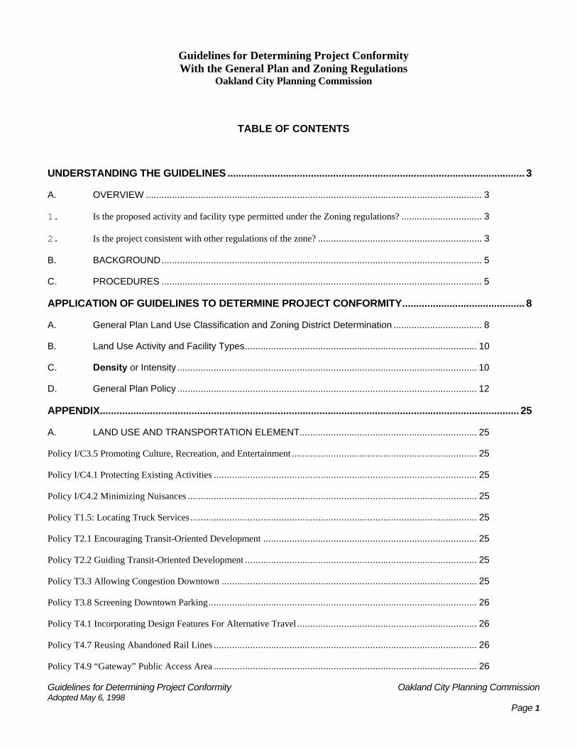
TABLE OF CONTENTS
UNDERSTANDING THE GUIDELINES ........................................................................................................... 3
A. OVERVIEW ................................................................................................................................. 3
1. Is the proposed activity and facility type permitted under the Zoning regulations? ............................... 3
2. Is the project consistent with other regulations of the zone? ............................................................... 3
B. BACKGROUND........................................................................................................................... 5
C. PROCEDURES ........................................................................................................................... 5
APPLICATION OF GUIDELINES TO DETERMINE PROJECT CONFORMITY............................................ 8
A. General Plan Land Use Classification and Zoning District Determination .................................. 8
B. Land Use Activity and Facility Types......................................................................................... 10
C. Density or Intensity ................................................................................................................... 10
D. General Plan Policy ................................................................................................................... 12
APPENDIX....................................................................................................................................................... 25
A. LAND USE AND TRANSPORTATION ELEMENT.................................................................... 25
Policy I/C3.5 Promoting Culture, Recreation, and Entertainment ....................................................................... 25
Policy I/C4.1 Protecting Existing Activities ..................................................................................................... 25
Policy I/C4.2 Minimizing Nuisances ............................................................................................................... 25
Policy T1.5: Locating Truck Services .............................................................................................................. 25
Policy T2.1 Encouraging Transit-Oriented Development .................................................................................. 25
Policy T2.2 Guiding Transit-Oriented Development ......................................................................................... 25
Policy T3.3 Allowing Congestion Downtown .................................................................................................. 25
Policy T3.8 Screening Downtown Parking....................................................................................................... 26
Policy T4.1 Incorporating Design Features For Alternative Travel ..................................................................... 26
Policy T4.7 Reusing Abandoned Rail Lines ..................................................................................................... 26
Policy T4.9 “Gateway” Public Access Area ..................................................................................................... 26

Guidelines for Determining Project Conformity Oakland City Planning Commission Adopted May 6, 1998 Page 2
Policy T6.2 Improving Streetscapes ................................................................................................................ 26
Policy T6.4 Rebuilding Freeways.................................................................................................................... 26
Policy D2.1 Enhancing the Downtown ............................................................................................................ 27
Policy D3.2 Incorporating Parking Facilities .................................................................................................... 27
Policy D6.2 Reusing Vacant or Underutilized Buildings ................................................................................... 27
Policy D9.1: Concentrating Commercial Development ..................................................................................... 27
Policy D10.6 Creating Infill Housing .............................................................................................................. 27
B. BICYCLE MASTER PLAN (BMP).............................................................................................. 29
C. ESTUARY POLICY PLAN ELEMENT....................................................................................... 30
D. OSCAR ELEMENT.................................................................................................................... 32
E. HISTORIC PRESERVATION ELEMENT.................................................................................. 33
Guidelines for Determining Project Conformity Oakland City Planning Commission Adopted May 6, 1998 Page 3
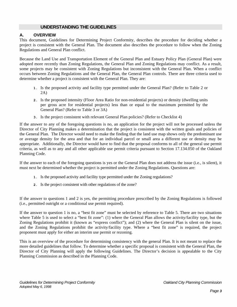
UNDERSTANDING THE GUIDELINES A. OVERVIEW This document, Guidelines for Determining Project Conformity, describes the procedure for deciding whether a project is consistent with the General Plan. The document also describes the procedure to follow when the Zoning Regulations and General Plan conflict.
Because the Land Use and Transportation Element of the General Plan and Estuary Policy Plan (General Plan) were adopted more recently than Zoning Regulations, the General Plan and Zoning Regulations may conflict. As a result, some projects may be consistent with Zoning Regulations but inconsistent with the General Plan. When a conflict occurs between Zoning Regulations and the General Plan, the General Plan controls. There are three criteria used to determine whether a project is consistent with the General Plan. They are:
1. Is the proposed activity and facility type permitted under the General Plan? (Refer to Table 2 or 2A)
2. Is the proposed intensity (Floor Area Ratio for non-residential projects) or density (dwelling units per gross acre for residential projects) less than or equal to the maximum permitted by the General Plan? (Refer to Table 3 or 3A)
3. Is the project consistent with relevant General Plan policies? (Refer to Checklist 4)
If the answer to any of the foregoing questions is no, an application for the project will not be processed unless the Director of City Planning makes a determination that the project is consistent with the written goals and policies of the General Plan. The Director would need to make the finding that the land use map shows only the predominant use or average density for the area and that for an individual parcel or small area a different use or density may be appropriate. Additionally, the Director would have to find that the proposal conforms to all of the general use permit criteria, as well as to any and all other applicable use permit criteria pursuant to Section 17.134.050 of the Oakland Planning Code.
If the answer to each of the foregoing questions is yes or the General Plan does not address the issue (i.e., is silent), it must next be determined whether the project is permitted under the Zoning Regulations. Questions are:
1. Is the proposed activity and facility type permitted under the Zoning regulations?
2. Is the project consistent with other regulations of the zone?
If the answer to questions 1 and 2 is yes, the permitting procedure prescribed by the Zoning Regulations is followed (i.e., permitted outright or a conditional use permit required).
If the answer to question 1 is no, a “best fit zone” must be selected by reference to Table 5. There are two situations where Table 5 is used to select a “best fit zone”: (1) where the General Plan allows the activity/facility type, but the Zoning Regulations prohibit it (known as “express conflict”); and (2) where the General Plan is silent on the issue, and the Zoning Regulations prohibit the activity/facility type. Where a “best fit zone” is required, the project proponent must apply for either an interim use permit or rezoning.
This is an overview of the procedure for determining consistency with the general Plan. It is not meant to replace the more detailed guidelines that follow. To determine whether a specific proposal is consistent with the General Plan, the Director of City Planning will apply the following Guidelines. The Director’s decision is appealable to the City Planning Commission as described in the Planning Code.

Guidelines for Determining Project Conformity Oakland City Planning Commission Adopted May 6, 1998 Page 4
Not
Pe
rmitt
ed
Allo
wed
with
inte
rim
Con
ditio
nal U
se P
erm
it or
R
ezon
ing
to
"Bes
t Fit"
Zon
e1
Not
Allo
wed
Opt
ions
2 : M
odify
pro
ject
to c
onfo
rm
to Z
onin
g or
R
ezon
e to
"Bes
t Fit"
Zon
e1 or
Va
rianc
e
Not
Allo
wed
Opt
ions
2 : M
odify
pro
ject
to c
onfo
rm
to G
ener
al P
lan
and
Zoni
ng
or
Appl
y fo
r Gen
eral
Pla
n Am
endm
ent
and
Rez
onin
g to
"Bes
t Fit"
Zon
e1
Con
ditio
nally
Pe
rmitt
ed
Con
ditio
nal
Use
Per
mit
(nor
mal
pro
cess
)
Con
ditio
nal
Use
Per
mit
(nor
mal
pro
cess
)
Not
Allo
wed
Opt
ions
2 : M
odify
pro
ject
to c
onfo
rm
to G
ener
al P
lan
or
Appl
y fo
r Gen
eral
Pla
n Am
endm
ent
or
Req
uest
a G
ener
al P
lan
conf
orm
ity
dete
rmin
atio
n fro
m th
e C
ity P
lann
ing
Dire
ctor
(In a
ll ca
ses,
a C
UP
is s
till r
equi
red
unde
r Zon
ing)
ZON
ING
/SU
BD
IVIS
ION
REG
ULA
TIO
NS
Perm
itted
Perm
itted
O
utrig
ht
Perm
itted
O
utrig
ht
Not
Allo
wed
Opt
ions
2 : M
odify
pro
ject
to c
onfo
rm
to G
ener
al P
lan
or
Appl
y fo
r Gen
eral
Pla
n Am
endm
ent
or
Req
uest
a G
ener
al P
lan
conf
orm
ity
dete
rmin
atio
n fro
m th
e C
ity P
lann
ing
Dire
ctor
(a
n in
terim
CU
P is
requ
ired)
Cle
arly
C
onfo
rms
Gen
eral
Pla
n is
Sile
nt
or N
ot C
lear
on
Con
form
ity
Cle
arly
Doe
s N
ot C
onfo
rm
= E
xpre
ss c
onfli
ct b
etw
een
Zoni
ng a
nd G
ener
al P
lan;
Gen
eral
Pla
n pr
evai
ls.
1 W
here
a re
zoni
ng o
ccur
s, th
e re
gula
tions
of t
he n
ew z
one
wou
ld a
pply
, inc
ludi
ng a
ny re
quire
men
ts fo
r a C
ondi
tiona
l Use
Per
mit.
2
Whe
re n
one
of th
e op
tions
are
feas
ible
, the
pro
ject
spo
nsor
sho
uld
be d
irect
ed to
the
Busi
ness
Ret
entio
n an
d At
tract
ion
sect
ion
for
assi
stan
ce in
loca
ting
an a
ppro
pria
te a
ltern
ate
site
.
PRO
JEC
T C
ON
SIST
ENC
Y W
ITH
GEN
ERA
L PL
AN
AN
D Z
ON
ING
/SU
BD
IVIS
ION
REG
ULA
TIO
NS
(Zon
ing/
Subd
ivis
ion
Reg
ulat
ions
pre
vail
unle
ss th
ere
is a
n ex
pres
s co
nflic
t)
GENERAL PLAN

Guidelines for Determining Project Conformity Oakland City Planning Commission Adopted May 6, 1998 Page 5
B. BACKGROUND On March 24, 1998, the City Council passed Resolution No. 74129 C.M.S. approving the new Land Use and Transportation Element of the Oakland General Plan. That resolution stipulates that
"Until the City's zoning regulations are updated, the City shall apply land use designations, zoning controls and subdivision controls as specified by the planning code and subdivision regulations, except where such action would expressly conflict with the updated General Plan. Where an express conflict does arise, the City will apply the updated General Plan policies and land use designation."
On May 12, 1998, the City Council passed Ordinance No. 12054 C.M.S. adopting interim controls for implementing the General Plan prior to the adoption of revisions to the Oakland Planning Code. This ordinance adds Chapter 17.01 to the Planning Code entitled "General Provisions of Planning Code and General Plan Conformity".
Subsequently, other Elements of the Oakland General Plan have been prepared and adopted by the Oakland City Council. Each of these Elements is also to be implemented on the basis of interim controls until final zones, zoning controls, subdivision, and environmental controls are adopted through the Zoning update process. Recently adopted General Plan Elements are: the Estuary Policy Plan (June 8, 1999, City Council Resolution No. 75037 C.M.S.), the Historic Preservation Element (amended July 21, 1998, Resolution No. 74403C.M.S.), and the Bicycle Master Plan, also an Element of the General Plan, (July 20, 1999, Resolution No. 75148 C.M.S.) The General Plan Guidelines for determining General Plan Conformity have been revised to reflect these recent adoptions.
Section 17.01.060 of the Planning Code directs the City Planning Commission to "adopt guidelines for determining the General Plan conformity of any specific proposal. Such guidelines shall address activity and facility types, density and intensity of development, and relevant General Plan policies. They shall also identify the 'best fit' zones of the Zoning Regulations, and other possible zones, corresponding to the Land Use Classifications of the General Plan."
Section 17.01.070 of the Planning Code stipulates that "the Director of City Planning shall determine whether any specific proposal conforms with the General Plan. The Director shall use the guidelines adopted pursuant to Section 17.01.060 in making this determination. Any interested party may request that this determination be made in writing, upon payment of a fee as prescribed in the City Master Fee Schedule."
Section 17.01.080 of the Planning Code provides that "within ten calendar days of a written determination by the Director of City Planning pursuant to Section 17.01.070, an appeal of said determination may be taken to the City Planning Commission by the applicant or any other interested party. Such appeal shall be accompanied by a fee as prescribed in the City Master Fee Schedule, and shall be processed in accordance with the Administrative Appeal Procedure."
These are the guidelines mandated by Section 17.01.060 of the Planning Code, to be used by staff in determining Project Conformity with the General Plan for all projects.
C. PROCEDURES The interim controls define an "express conflict" as "any situation where a proposal clearly conforms with the General Plan but is not permitted by the Zoning and/or Subdivision Regulations, or where a proposal clearly does not conform with the General Plan but is permitted or conditionally permitted by the Zoning and/or Subdivision Regulations." They also specify procedures to be followed in each case. These procedures, and, in some cases, project sponsor options, are summarized in Flow Chart 1.
There are three possibilities under the General Plan Elements: the project may be determined to "clearly conform", to "clearly not conform", or the General Plan may be silent or not clear as to conformity. In the Zoning and/or Subdivision Regulations, a project may be permitted outright, conditionally permitted, or not permitted. Therefore, nine possible combinations exist for evaluating for Zoning and/or Subdivision Regulations status and General Plan conformity.

Guidelines for Determining Project Conformity Oakland City Planning Commission Adopted May 6, 1998 Page 6
1. Discussion of "Express Conflict" between the General Plan and Zoning An "express conflict" exists where the project clearly conforms to the General Plan, but is not permitted by the Zoning and/or Subdivision Regulations, or where the project clearly does not conform to the General Plan, but is permitted or conditionally permitted by the Zoning and/or Subdivision Regulations.
In the case where the project clearly conforms to the General Plan, but is not allowed by the Zoning and/or Subdivision Regulations, the project may be allowed upon the granting of a conditional use permit. Section 17.01.100B of the Planning Code stipulates that this shall be processed as either a minor or major conditional use permit, in accordance with the regular conditional use permit procedures of the Zoning Regulations. In addition to the general use permit criteria, the following three special findings must be made:
• That the proposal is clearly appropriate in consideration of the characteristics of the proposal and the surrounding area;
• That the proposal is clearly consistent with the intent and desired character of the relevant Land Use Classification or Classifications of the General Plan and any associated policies;
• That the proposal will clearly promote implementation of the General Plan.
Since the proposal is not permitted under the Zoning Regulations, there would be no set development standards for evaluating it (e.g. height limit, setback, density, parking requirements, etc.). Therefore, Section 17.01.100B stipulates that the proposal shall be subject to the provisions of the "best fit zone" corresponding to the General Plan Land Use Classification in which the site is located (see Section B.5. below). However, the project sponsor may alternatively elect to apply for a rezoning to the "best fit zone" or other possible zone instead of a conditional use permit.
The only exception to this procedure is for proposals within the Mixed Housing Type Residential General Plan Classification, where no project can have a higher density than allowed by its current zoning without a major variance or a rezoning. Under no situation, however, can a project exceed the maximum density permitted under the General Plan, even if the density allowed by the current zoning is greater than the General Plan.
2. Examples of “No Express Conflict” between the General Plan and Zoning In the case where the project clearly does not conform to the General Plan, even if the Zoning and/or Subdivision Regulations permit it, the project is not allowed and no application may be accepted. The project sponsor may modify the project to conform to the General Plan, or apply for a General Plan Amendment. In addition, the determination that the project does not conform to the General Plan may be appealed to the City Planning Commission pursuant to Section 17.01.080.
In some cases, the proposed project may be consistent with the surrounding land uses and appropriate for the area, but not be permitted by the General Plan. It is recognized that the General Plan land uses are broadly applied to areas and that its details are largely illustrative of the Plan’s written goals and policies. It is quite possible that slightly different versions would service those goals and policies just as well, or even better. Because the map is generalized, and does not necessarily depict the accuracy of each parcel or very small land area, a determination of project consistency could be requested of the Director of City Planning. The applicant would need to demonstrate that a predominant use, or average density, different from that shown on the map would be appropriate for a relatively small area and that the project is in conformance with the written goals and policies of the General Plan. The project may be allowed upon the granting of an interim conditional use permit or a conditional use permit. Written notice of the Director’s determination would be sent to all property owners within 300 feet of the property involved. The Director’s determination may be appealed to the City Council pursuant to Section 17.01.080 B.
If the project clearly conforms with the General Plan or the General Plan is silent or not clear, and the project is permitted and/or conditionally permitted by the Zoning and/or Subdivision Regulations, there is no "express conflict" and the normal Zoning and/or Subdivision process applies.
Similarly, if the project clearly does not conform to the General Plan and is not allowed by the Zoning and/or Subdivision Regulations, there is no "express conflict". In this case, the project is not allowed, and no application

Guidelines for Determining Project Conformity Oakland City Planning Commission Adopted May 6, 1998 Page 7
may be accepted, since General Plan variances are not an option. To continue, the project sponsor has two choices: elect to modify the project to conform to the General Plan and existing Zoning; or apply for a General Plan Amendment and rezoning to the "best fit zone" or other possible zone. If the Director of Planning and Zoning issues a determination that the proposed project does not conform to the General Plan and the project sponsor disagrees with that determination, the project sponsor may appeal the determination of nonconformity with the General Plan to the City Planning Commission.
There is also no "express conflict" if the General Plan is silent or not clear and the Zoning and/or Subdivision Regulations do not allow the project. In this case, the project sponsor may modify the project to fit the zone, apply for a rezoning to the "best fit zone" or other possible zone, or apply for a variance, (since no variance from the General Plan would be involved).

Guidelines for Determining Project Conformity Oakland City Planning Commission Adopted May 6, 1998 Page 8
APPLICATION OF GUIDELINES TO DETERMINE PROJECT CONFORMITY In making a determination of Project Conformity with the General Plan, the following factors shall be evaluated:
• The General Plan Land Use Classification and Zoning District within which the proposed project is located
• The Zoning Land use classification of the project (activity and facility type)
• The Project intensity (residential density and/or nonresidential floor area ratio)
• Relevant General Plan policies from all adopted Elements.
In order to "clearly conform" to the General Plan, a project must be found to clearly conform by all relevant factors. If the project is found to clearly not conform in any one factor, then the entire project is in nonconformance. Note that if none of the General Plan policies identified in Section B4 apply to the project, this factor should not be considered in the conformity determination; in this case, only land use and project intensity would be considered.
A. General Plan Land Use Classification and Zoning District Determination To determine the correct General Plan Land Use Classification and Zoning District for the project proposal, determine the proposed project’s location on either the General Plan Land Use Diagram or Estuary Policy Plan Land Use Diagram and the City’s official Zoning Map. The General Plan Land Use Classifications are broad and indicate the kinds of development expected in any given area of the city. The Zoning District will assist in determining if the intent of the District is similar to that of the General Plan. These two elements will give the reviewer an initial understanding of possible conformity. The flow chart on the next page is intended to assist in this effort, beginning with the General Plan Land Use Classification and Zoning District. However, each project must also be evaluated according to the next three factors below, for a complete understanding of the potential project’s conformity status.

Guidelines for Determining Project Conformity Oakland City Planning Commission Adopted May 6, 1998 Page 9
FLOW CHART 1: Determining a Project’s Conformity with the General Plan and Zoning Regulations
Send Applicant to Port Planning, 530 Water Street
FIRST: Is the project located within the Port’s jurisdiction?
If YES:
If NO, follow steps 1 through 4
IDENTIFY PROJECT Zoning: Location: General Plan Designation:
Then choose A, B, or C below to determine the appropriate action:
A. IF THE PROJECT CONFORMS TO THE GENERAL PLAN: And the project is permitted by zoning, Then the project is permitted outright And the project would normally require a Conditional Use Permit (CUP), then it is permitted with approval of a CUP. But the project is not permitted by zoning; this is an express conflict with the General Plan. The project can only be allowed with an Interim CUP or an approved application for a Rezoning. See Table 5 for “Best Fit Zones” for the rezoning.
B. IF THE GENERAL PLAN IS SILENT: And the project is permitted by zoning. Then the project is permitted outright. And the project would normally require a CUP, then it is permitted with approval of a CUP But the project is not permitted by zoning,
ASSESS PROJECT ELEMENTS
1. Identify the project’s activity and facility type. See Section 2, and Table 2 or 2A.
2. Calculate the project’s density or intensity. See Section 3, and Table 3 or 3A.
3. Identify relevant General Plan Policies. See Section 4 and Checklist 4. The actual text of many policies are located in the appendix, or you can consult the Elements themselves.
SUMMARIZE FINDINGS Does the project conform to the General Plan Land Use Classification, density or intensity standards, and relevant Plan policies?
Does the project conform to Zoning activities or facilities, density/intensity*, and other regulations of the zone? * The General Plan ultimately controls application of density/intensity.
Guidelines for Determining Project Conformity Oakland City Planning Commission Adopted May 6, 1998 Page 10
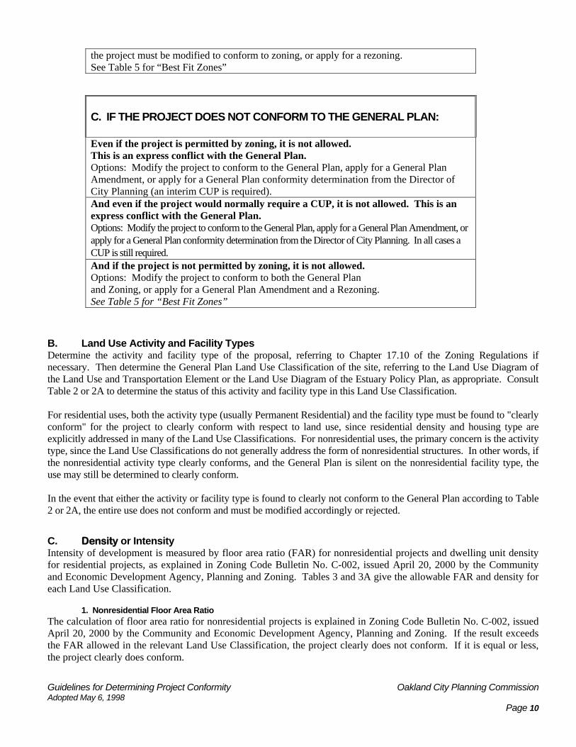
the project must be modified to conform to zoning, or apply for a rezoning. See Table 5 for “Best Fit Zones”
C. IF THE PROJECT DOES NOT CONFORM TO THE GENERAL PLAN: Even if the project is permitted by zoning, it is not allowed. This is an express conflict with the General Plan. Options: Modify the project to conform to the General Plan, apply for a General Plan Amendment, or apply for a General Plan conformity determination from the Director of City Planning (an interim CUP is required). And even if the project would normally require a CUP, it is not allowed. This is an express conflict with the General Plan. Options: Modify the project to conform to the General Plan, apply for a General Plan Amendment, or apply for a General Plan conformity determination from the Director of City Planning. In all cases a CUP is still required. And if the project is not permitted by zoning, it is not allowed. Options: Modify the project to conform to both the General Plan and Zoning, or apply for a General Plan Amendment and a Rezoning. See Table 5 for “Best Fit Zones”
B. Land Use Activity and Facility Types Determine the activity and facility type of the proposal, referring to Chapter 17.10 of the Zoning Regulations if necessary. Then determine the General Plan Land Use Classification of the site, referring to the Land Use Diagram of the Land Use and Transportation Element or the Land Use Diagram of the Estuary Policy Plan, as appropriate. Consult Table 2 or 2A to determine the status of this activity and facility type in this Land Use Classification. For residential uses, both the activity type (usually Permanent Residential) and the facility type must be found to "clearly conform" for the project to clearly conform with respect to land use, since residential density and housing type are explicitly addressed in many of the Land Use Classifications. For nonresidential uses, the primary concern is the activity type, since the Land Use Classifications do not generally address the form of nonresidential structures. In other words, if the nonresidential activity type clearly conforms, and the General Plan is silent on the nonresidential facility type, the use may still be determined to clearly conform. In the event that either the activity or facility type is found to clearly not conform to the General Plan according to Table 2 or 2A, the entire use does not conform and must be modified accordingly or rejected.
C. Density or Intensity Intensity of development is measured by floor area ratio (FAR) for nonresidential projects and dwelling unit density for residential projects, as explained in Zoning Code Bulletin No. C-002, issued April 20, 2000 by the Community and Economic Development Agency, Planning and Zoning. Tables 3 and 3A give the allowable FAR and density for each Land Use Classification.
1. Nonresidential Floor Area Ratio The calculation of floor area ratio for nonresidential projects is explained in Zoning Code Bulletin No. C-002, issued April 20, 2000 by the Community and Economic Development Agency, Planning and Zoning. If the result exceeds the FAR allowed in the relevant Land Use Classification, the project clearly does not conform. If it is equal or less, the project clearly does conform.
Guidelines for Determining Project Conformity Oakland City Planning Commission Adopted May 6, 1998 Page 11
Note, however, that the maximum FAR specified by the General Plan might not be allowed in particular cases. For example, in the Central Business District, an FAR of 20.0 is specified. However, the description of the Central Business District Land Use Classification states that "in some areas ... such as the Broadway spine, the highest FAR may be encouraged, while in other areas such as near Lake Merritt and Old Oakland, lower FARs may be appropriate." Thus, a project that was within the FAR limit of 20.0 in the CBD might still not be able to comply with the special use permit criteria of Section 17.01.100B, depending on its location within the downtown area. The policies for the downtown and its various sub-areas should also be consulted (see Section 4 below).
2. Residential Density Residential density is somewhat more complicated, because the General Plan specifies density as "principal units per gross acre". Gross acreage includes all land in the neighborhood, including streets and parks. To calculate permitted density on a particular parcel, this gross density figure must be translated to net density. To complicate matters further, there is not a consistent net-to-gross ratio for the entire City. It ranges from more than 80% in some parts of the hills to less than 60% downtown. Overall, an average net-to-gross ratio of 75% is assumed, except downtown where 60% is assumed, and is used in Table 3 or 3A to determine net density limits.
However, if it appears in any given situation that the net-to-gross ratio is significantly different than indicated in Table 3 or 3A, an individual calculation should be made for the site in question. This is done as follows:
a. Draw a 1,000-foot square centered on the site.
b. Calculate the total area of all developable land, exclusive of streets or parkland, within that square.
c. Divide the area determined in step 2 by 1,000,000 square feet (the total area of a 1,000-foot square). The result is the net-to-gross ratio for this area, expressed as a fraction. (Multiply by 100 to get a percent figure.)
d. Divide the maximum "principal units per gross acre" of the relevant Land Use Classification by the net-to-gross ratio determined in step 3. The result is the maximum principal units per net acre.
e. Divide 43,560 (the number of square feet in an acre) by the figure determined in step 4 to get the number of square feet of lot area per dwelling unit. This is the way density is calculated in the Zoning Regulations.
f. Divide the site area by the number determined in step 5, rounding to the nearest whole number. This is the maximum number of principal units permitted on the site by the General Plan.
For example, suppose that the site is 10,000 square feet and is located in the Mixed Housing Type Residential Land Use Classification, which allows up to 30 principal units per gross acre. Here is a possible scenario:
a. Draw the 1,000-foot square on a parcel map of the area, centered on the site.
b. Calculate developable area. Suppose the result is 780,000 square feet.
c. Divide 780,000 by 1,000,000. The result is 0.78, for a net-to-gross ratio of 78%. (780,000 / 1,000,000 = 0.78. 0.78 x 100 = 78)
d. Divide 30 principal units per gross acre by 0.78. The result is 38.46. This is the allowable number of principal units per net acre. (30 / 0.78 = 38.46)
e. Divide 43,560 square feet per acre by 38.46 units per acre. The result is 1,132.6 square feet of site area per unit. (43,560 / 38.46 = 1,132.6)
f. Divide the site area of 10,000 square feet by 1,132.6 square feet of site area per unit. The result is 8.83, which rounds to 9. (10,000 / 1,132.6 = 8.83 rounded to 9). Thus a maximum of 9 units is allowable on this site under the General Plan.

Guidelines for Determining Project Conformity Oakland City Planning Commission Adopted May 6, 1998 Page 12
3. Subdivisions in the Hillside Residential Land Use Classification In addition to maximum residential density, subdivision lot sizes are specified for the Hillside Residential Land Use Classification. The description of this classification states that "typical lot sizes range from approximately 8,000 square feet to one acre in size." Further, Policy N7.3, entitled "Hill Area Subdivision", reads:
"At least 8,000 square feet of lot area per dwelling unit should be required when land in the hill area is subdivided. Lots smaller than 8,000 square feet may be created only when this ratio is maintained for the parcel being divided."
This policy is interpreted to mean that the average lot size of any subdivision in the Hillside Residential Land Use Classification shall not be less than 8,000 square feet. However, this policy is only intended to apply to large, unsubdivided parcels. As a general rule, the policy would apply to subdivisions of five lots or more requiring a tract map, but not to subdivisions of four lots or fewer requiring a parcel map. In the latter case, the provisions of the Zoning and Subdivision Regulations regarding minimum lot size would prevail.
When a large parcel in the Hillside Residential area is subdivided, it must conform to the minimum lot size specified in the Zoning Regulations, the prevailing lot size specified in the Subdivision Regulations, and the 8,000 square foot minimum average lot size specified in Policy N7.3. If the average lot size of the proposed subdivision is less than 8,000 square feet, the project clearly does not conform to the General Plan and is not allowed. If the average lot size is 8,000 square feet or more, there is no General Plan problem and the Zoning and Subdivision Regulations prevail. The conditional use permit provided by Section 17.01.100B would not be allowed in this situation, since it is not the intent of the General Plan to permit subdivisions with lots smaller than would otherwise be allowed under current regulations.
4. Mixed Use Projects The density for Mixed Use Projects in the Central Business District and Jack London District is calculated pursuant to Ordinance No. 12349 C.M.S. dated July 24, 2001 amending the Oakland Planning Code Section 17.106.030.
D. General Plan Policy Checklist 4 lists policies from various General Plan elements that have been identified for use in screening projects for General Plan conformity. The policies listed in Checklist 4 are written in full form in the Appendix, however many additional policies that exist in the City’s General Plan Elements are not listed here. The Checklist and Appendix contain most policies that seem to be immediately relevant to land use decision-making, however it may be necessary to consult the Elements themselves for additional guidance or to resolve complex questions. For any given project, go through the checklist to determine whether any of these policies apply. If so, consult the policy to determine whether the project conforms. If none of these policies applies to the project, the conformity determination will be based solely on land use and intensity, as discussed above. However, if any of these policies do apply, the project must conform to them in order to conform to the General Plan.
For example, a hotel is proposed along upper Broadway in North Oakland in an area designated Community Commercial by the General Plan and zoned C-40. A hotel is a Transient Habitation Commercial Activity, which is conditionally permitted in the C-40 Zone. According to Table 2, the General Plan is silent on Transient Habitation Commercial Activities in the Community Commercial Land Use Classification. Suppose the calculated FAR of the hotel is 2.5; the Community Commercial designation allows an FAR up to 5.0. Thus, the hotel passes the land use and intensity tests, so it appears that the zoning would prevail and the hotel would be conditionally permitted. However, consulting the checklist in Table 4, we find the question "Does the project involve development of a hotel or motel? If yes, see policy N1.7." Policy N1.7 is entitled "Locating Hotel and Motels", and states:
"Hotels and motels should be encouraged to locate downtown, along the waterfront, near the airport, or along the I-880 corridor. No new hotels or motels should be located elsewhere in the city, however, the development of 'bed-and-breakfast' type lodgings should be allowed in the neighborhoods, provided that the use and activities of the establishment do not adversely impact nearby areas, and parking areas are screened." [emphasis added].

Guidelines for Determining Project Conformity Oakland City Planning Commission Adopted May 6, 1998 Page 13
Thus, it can be clearly seen that the proposed hotel would conflict with this policy, and would therefore not conform to the General Plan. As stipulated in Planning Code Section 17.01.120, the project is not allowed and no application may be accepted. The project sponsor has four options: change the project to conform (e.g. change the project from a hotel to some other use), apply for a General Plan amendment (in this case it would be an amendment to the text of Policy N1.7), find another site where the General Plan allows hotels. If the project sponsor believes that staff’s determination regarding General Plan conformity is in error, the sponsor may appeal the determination to the City Planning Commission.
1. "Best Fit Zone" and Other Possible Zones Under the conditional use permit provided by Section 17.01.100B of the Planning Code the project in question is to be subject to the "best fit zone" from the Zoning Regulations. Such "best fit zones" (and “other possible zones”) are identified in Table 5 or 5A for the various General Plan Land Use Classifications. Where more than one "best fit zone" is identified for a particular Land Use Classification, Section 17.100B stipulates that "the Director of City Planning shall determine which zone to apply, with consideration given to the characteristics of the proposal and the surrounding area and any relevant provisions of the General Plan." The Director's determination of "best fit zone" cannot be appealed to the City Planning Commission under Section 17.01.080, because it is made in conjunction with a conditional use permit, which allows appeals under the conditional use permit procedures. Where a “best fit zone” has a table containing height areas, the Director shall determine the most appropriate height area.
In the case where the project sponsor opts for a rezoning, or for a General Plan amendment to match the current zoning, the "best fit zone" or “other possible zones” are allowed in determining which zone or General Plan Land Use Classification to use. The City Planning Commission and City Council make the ultimate determination of which zone to apply since a rezoning requires passage of an ordinance by the Council with a recommendation from the Commission. Specifically, Section 17.144.060 of the Rezoning and Law Change Procedure provides that the Commission "shall consider whether the existing zone ... [is] inadequate or otherwise contrary to the public interest and may approve, modify, or disapprove the application." “If the project sponsor requests one of these other possible zones, the application should fully explain why this other zone is considered preferable to the "best fit zone.”

Guidelines for Determining Project Conformity Oakland City Planning Commission Adopted May 6, 1998 Page 14
CHARTS, TABLES AND CHECKLISTS
TABLE 2: LAND USE GENERAL PLAN LAND USE CLASSIFICATIONS
ZONING ACTIVITY AND FACILITY TYPES
Conforms w/ General Plan GP Silent or Unclear X:Clearly Does not Conform NA: Zoning regulations apply
Hill
side
Resid
entia
l*
Det
ache
d U
nit
Resid
entia
l*
Mix
ed H
ousin
g Ty
pe
Resid
entia
l*
Urb
an R
esid
entia
l*
Nei
ghbo
rhoo
d.
Cent
er M
ixed
Use
*
Com
mun
ity
Com
mer
cial
*
Regi
onal
Co
mm
erci
al*
Busin
ess M
ix*
Gen
eral
. In
dustr
ial*
Insti
tutio
nal*
Cent
ral B
usin
ess
Dist
rict*
Mix
ed-U
se W
ater
fron
t (S
ee T
able
5A
)
Hou
sing
Busin
ess.
Mix
*
Ope
n Sp
ace
RCA
*
Ope
n Sp
ace
(Oth
er) *
Residential Activities:
Permanent NA NA NA NA NA NA NA NA NA NA NA NA NA
Semi-Transient NA NA NA NA NA NA NA NA NA NA NA NA NA
Residential Care NA NA NA NA NA NA NA NA NA NA NA NA NA
Service-Enriched Permanent Housing NA NA NA NA NA NA NA NA NA NA NA
NA NA
Transitional Housing NA NA NA NA NA NA NA NA NA NA NA NA NA
Emergency Shelter NA NA NA NA NA NA NA NA NA NA NA NA NA
Civic Activities:
Essential Service NA NA NA NA NA NA NA NA NA NA NA NA NA
Limited Child-Care NA NA NA NA NA NA NA NA NA NA NA NA NA
Nursing Home NA NA NA NA NA NA NA NA NA NA NA NA NA
Community Assembly NA NA NA NA NA NA NA NA NA NA NA NA NA
Recreational Assembly NA NA NA NA NA NA NA NA NA NA NA NA NA
Community Education NA NA NA NA NA NA NA NA NA NA NA NA NA
Non-Assembly Cult. NA NA NA NA NA NA NA NA NA NA NA NA NA
Administrative NA NA NA NA NA NA NA NA NA NA NA NA NA
Residential Care NA NA NA NA NA NA NA NA NA NA NA NA NA
Health Care NA NA NA NA NA NA NA NA NA NA NA NA NA
Utility and Vehicular NA NA NA NA NA NA NA NA NA NA NA NA NA
Extensive Impact NA NA NA NA NA NA NA NA NA NA NA NA NA
Telecommunications NA NA NA NA NA NA NA NA NA NA NA NA NA
Commercial Activities:
General Food Sales NA NA NA NA NA NA NA NA NA NA NA NA NA
Full Service Restaurant NA NA NA NA NA NA NA NA NA NA NA NA NA
Limited Service Restaurant NA NA NA NA NA NA NA NA NA NA NA NA NA
Convenience Market NA NA NA NA NA NA NA NA NA NA NA NA NA
Fast-Food Restaurant NA NA NA NA NA NA NA NA NA NA NA NA NA
Alcohol Beverage Sales NA NA NA NA NA NA NA NA NA NA NA NA NA
Consumer Service NA NA NA NA NA NA NA NA NA NA NA NA NA

Guidelines for Determining Project Conformity Oakland City Planning Commission Adopted May 6, 1998 Page 15
TABLE 2: LAND USE GENERAL PLAN LAND USE CLASSIFICATIONS
ZONING ACTIVITY AND FACILITY TYPES
Conforms w/ General Plan GP Silent or Unclear X:Clearly Does not Conform NA: Zoning regulations apply
Hill
side
Resid
entia
l*
Det
ache
d U
nit
Resid
entia
l*
Mix
ed H
ousin
g Ty
pe
Resid
entia
l*
Urb
an R
esid
entia
l*
Nei
ghbo
rhoo
d.
Cent
er M
ixed
Use
*
Com
mun
ity
Com
mer
cial
*
Regi
onal
Co
mm
erci
al*
Busin
ess M
ix*
Gen
eral
. In
dustr
ial*
Insti
tutio
nal*
Cent
ral B
usin
ess
Dist
rict*
Mix
ed-U
se W
ater
fron
t (S
ee T
able
5A
)
Hou
sing
Busin
ess.
Mix
*
Ope
n Sp
ace
RCA
*
Ope
n Sp
ace
(Oth
er) *
Mechanical or Electrical Games NA NA NA NA NA NA NA NA NA NA NA
NA NA
Medical Service NA NA NA NA NA NA NA NA NA NA NA NA NA
General Retail Sales NA NA NA NA NA NA NA NA NA NA NA NA NA
Consultative &Financial Services NA NA NA NA NA NA NA NA NA NA NA
NA NA
Consumer Cleaning & Repair NA NA NA NA NA NA NA NA NA NA NA
NA NA
Consumer Dry Cleaning Plant NA NA NA NA NA NA NA NA NA NA NA
NA NA
Group Assembly NA NA NA NA NA NA NA NA NA NA NA NA NA
Personal Instruction & Improvement& Small Scale Entertainment
NA NA NA NA NA NA NA NA NA NA NA NA NA
Administrative NA NA NA NA NA NA NA NA NA NA NA NA NA
Business, Communications & Media NA NA NA NA NA NA NA NA NA NA NA
NA NA
Broadcasting & Recording NA NA NA NA NA NA NA NA NA NA NA NA NA
Research Service NA NA NA NA NA NA NA NA NA NA NA NA NA
General Wholesale Sales NA NA NA NA NA NA NA NA NA NA NA NA NA
Transient Habitation/B&B NA NA NA NA NA NA NA NA NA NA NA NA NA
Wholesale Professional Building Material Sales NA NA NA NA NA NA NA NA NA X NA NA
NA NA
Auto & Light Vehicle Sales & Rental / NA NA NA NA NA NA NA NA NA NA NA
NA NA
Auto& Light Vehicle /Gas Station & Servicing NA NA NA NA NA NA NA NA NA NA NA
NA NA
Auto & Light Vehicle Repair & Cleaning NA NA NA NA NA NA NA NA NA NA NA
NA NA
Auto Fee Parking NA NA NA NA NA NA NA NA NA NA NA NA NA
Taxi & Light Fleet Service NA NA NA NA NA NA NA NA NA NA NA NA NA
Animal Boarding NA NA NA NA NA NA NA NA NA NA NA NA NA
Animal Care NA NA NA NA NA NA NA NA NA NA NA NA NA
Undertaking Service NA NA NA NA NA NA NA NA NA NA NA NA NA
Industrial Activities:
Custom Manufacturing NA NA NA NA NA NA NA NA NA X NA NA NA NA
Light Manufacturing NA NA NA NA NA NA NA NA NA X NA NA NA NA

Guidelines for Determining Project Conformity Oakland City Planning Commission Adopted May 6, 1998 Page 16
TABLE 2: LAND USE GENERAL PLAN LAND USE CLASSIFICATIONS
ZONING ACTIVITY AND FACILITY TYPES
Conforms w/ General Plan GP Silent or Unclear X:Clearly Does not Conform NA: Zoning regulations apply
Hill
side
Resid
entia
l*
Det
ache
d U
nit
Resid
entia
l*
Mix
ed H
ousin
g Ty
pe
Resid
entia
l*
Urb
an R
esid
entia
l*
Nei
ghbo
rhoo
d.
Cent
er M
ixed
Use
*
Com
mun
ity
Com
mer
cial
*
Regi
onal
Co
mm
erci
al*
Busin
ess M
ix*
Gen
eral
. In
dustr
ial*
Insti
tutio
nal*
Cent
ral B
usin
ess
Dist
rict*
Mix
ed-U
se W
ater
fron
t (S
ee T
able
5A
)
Hou
sing
Busin
ess.
Mix
*
Ope
n Sp
ace
RCA
*
Ope
n Sp
ace
(Oth
er) *
General Manufacturing NA NA NA NA NA NA NA NA NA X NA NA NA NA
Heavy/ High Impact Manufacturing NA NA NA NA NA NA NA NA NA X NA NA
NA NA
Agricultural/Extractive:
Plant Nursery NA NA NA NA NA NA NA NA NA NA NA NA NA
Crop/Animal Raising NA NA NA NA NA NA NA NA NA NA NA NA NA
Mining and Quarrying NA NA NA NA NA NA NA NA NA NA NA NA NA
Residential Facilities:
One-Family Dwelling NA NA NA NA NA NA NA NA NA NA NA NA NA
One-Family dwelling w/Secondary unit NA NA NA NA NA NA NA NA NA NA NA
NA NA
Two-Family Dwelling NA NA NA NA NA NA NA NA NA NA NA NA NA
Multifamily Dwelling NA NA NA NA NA NA NA NA NA NA NA NA NA
Rooming House NA NA NA NA NA NA NA NA NA NA NA NA NA
Mobile Home NA NA NA NA NA NA NA NA NA NA NA NA NA
Nonresidential Facilities:
Enclosed NA NA NA NA NA NA NA NA NA NA NA NA NA
Open NA NA NA NA NA NA NA NA NA NA NA NA NA
Drive-In NA NA NA NA NA NA NA NA NA NA NA NA NA
Sidewalk Café NA NA NA NA NA NA NA NA NA NA NA NA NA
Shopping Center** NA NA NA NA NA NA NA NA NA NA NA NA NA
Drive-Through NA NA NA NA NA NA NA NA NA NA NA NA NA
Signs:
Residential NA NA NA NA NA NA NA NA NA NA NA NA NA
Special NA NA NA NA NA NA NA NA NA NA NA NA NA
Development NA NA NA NA NA NA NA NA NA NA NA NA NA
Realty NA NA NA NA NA NA NA NA NA NA NA NA NA
Civic NA NA NA NA NA NA NA NA NA NA NA NA NA
Business NA NA NA NA NA NA NA NA NA NA NA NA NA
Advertising NA NA NA NA NA NA NA NA NA NA NA NA NA
Telecommunications
Micro NA NA NA NA NA NA NA NA NA NA NA NA NA
Mini NA NA NA NA NA NA NA NA NA NA NA NA NA
Macro NA NA NA NA NA NA NA NA NA NA NA NA NA
Monopole NA NA NA NA NA NA NA NA NA NA NA NA NA

Guidelines for Determining Project Conformity Oakland City Planning Commission Adopted May 6, 1998 Page 17
TABLE 2: LAND USE GENERAL PLAN LAND USE CLASSIFICATIONS
ZONING ACTIVITY AND FACILITY TYPES
Conforms w/ General Plan GP Silent or Unclear X:Clearly Does not Conform NA: Zoning regulations apply
Hill
side
Resid
entia
l*
Det
ache
d U
nit
Resid
entia
l*
Mix
ed H
ousin
g Ty
pe
Resid
entia
l*
Urb
an R
esid
entia
l*
Nei
ghbo
rhoo
d.
Cent
er M
ixed
Use
*
Com
mun
ity
Com
mer
cial
*
Regi
onal
Co
mm
erci
al*
Busin
ess M
ix*
Gen
eral
. In
dustr
ial*
Insti
tutio
nal*
Cent
ral B
usin
ess
Dist
rict*
Mix
ed-U
se W
ater
fron
t (S
ee T
able
5A
)
Hou
sing
Busin
ess.
Mix
*
Ope
n Sp
ace
RCA
*
Ope
n Sp
ace
(Oth
er) *
Tower NA NA NA NA NA NA NA NA NA NA NA NA NA
Accessory Activ./Facil.
Live/work NA NA NA NA NA NA NA NA NA X NA NA
*This table only applies to the Institution General Plan Classification due to updates to the Zoning Ordinance. The Mixed Use Waterfront Classification is superseded by the Estuary Policy Plan Land Use Classifications. See Table 2A.

Guidelines for Determining Project Conformity Oakland City Planning Commission Adopted May 6, 1998 Page 18
TABLE 2A: ESTUARY POLICY PLAN LAND USE CLASSIFICATIONS
Jack London District O-9 San Antonio/Fruitvale
TABLE 2A: ESTUARY LAND USE ZONING REGULATIONS ACTIVITY AND FACILITY TYPES* = Clearly conforms = is silent or not clear X = Clearly does not conform Li
ght I
ndus
t.1
Off
Pric
e R
etai
l 1
Ret
. Din
e, E
nter
t 1
Ret
. Din
e, E
nter
t 2
Prod
uce
Mar
ket
W. C
omm
rc. R
ec. 1
Mix
ed U
se D
ist.
W. M
ixed
U. D
ist.
W. W
areh
ouse
Dist
.
Plan
. W. D
evel
. -1
W. C
omm
rc. R
ec. 2
Ligh
t Ind
ust 2
Plan
. W. D
evel
. 2
Res
id. M
ixed
U.
Hea
vy In
d.
Gen
. Com
mer
ce. 1
Plan
. W. D
ist. 3
Gen
. Com
mer
ce. 2
Ligh
t Ind
ust.
3
Residential Activity
Permanent X X X NA X X X X X
Semi-Transient X X X NA X X X X X
All Residential Care categories X X X NA X X X X X Civic Activities:
Essential Service NA
Limited Child Care X X NA X X X
Community Assembly X NA X X X
Recreational Assembly X NA X X X
Community Education X X X X X NA X X X X X
Non-Assembly Cultural NA
Administrative NA
Health Care X X X X X X X X X X X X X NA X X X X X
Utility and Vehicular X X X X X X X X NA
Extensive Impact NA
Telecommunications NA Commercial Activities:
General Food Sales NA
Full Service Restaurant NA
Limited Service Restaurant NA
Convenience Market NA
Fast-Food Restaurant * * NA
Alcoholic Beverage Sales NA
Consumer Service NA
Mechanical or Electronic Games NA
Medical Service X NA X X X X X
Gen. Retail Sales NA
Consult./Financial Service NA
Consumer Cleaning/Repair Svc. NA
Dry Cleaning Plant NA

Guidelines for Determining Project Conformity Oakland City Planning Commission Adopted May 6, 1998 Page 19
Jack London District O-9 San Antonio/Fruitvale
TABLE 2A: ESTUARY LAND USE ZONING REGULATIONS ACTIVITY AND FACILITY TYPES* = Clearly conforms = is silent or not clear X = Clearly does not conform Li
ght I
ndus
t.1
Off
Pric
e R
etai
l 1
Ret
. Din
e, E
nter
t 1
Ret
. Din
e, E
nter
t 2
Prod
uce
Mar
ket
W. C
omm
rc. R
ec. 1
Mix
ed U
se D
ist.
W. M
ixed
U. D
ist.
W. W
areh
ouse
Dist
.
Plan
. W. D
evel
. -1
W. C
omm
rc. R
ec. 2
Ligh
t Ind
ust 2
Plan
. W. D
evel
. 2
Res
id. M
ixed
U.
Hea
vy In
d.
Gen
. Com
mer
ce. 1
Plan
. W. D
ist. 3
Gen
. Com
mer
ce. 2
Ligh
t Ind
ust.
3
Group Assembly NA
Personal Instruction/Imprv NA
Administrative NA
Business/Communications Svc. NA
Broadcasting & Recording NA
Research Service NA
Gen. Wholesale Sales X X X X NA
Transient Habitation/B&B X NA X
Building Material Sales X X X X NA
Auto (Boat) Sales/Rental/Delivery X X X NA
Automobile Gas/Servicing X X X NA
Automobile Repair/Cleaning X X X X NA X
Auto (Boat) Parking – Fee X X NA
Taxi & Light Fleet X X X X NA
Transport/Warehousing X X X X NA
Animal Boarding NA
Animal Care NA
Undertaking Service NA
Scrap Operation X X X X X X X X X X X X X NA X X X X Manufacturing Activ.:
Custom Manufacturing NA
Light Manufacturing X X X X NA
General Manufacturing X X X X X X X X X NA
Heavy Manufacturing X X X X X X X X X X X X NA X X X X Agricultural/Extract.:
Plant Nursery NA
Crop and Animal Raising X X X X X X X X X X X X X NA X X X X X
Mining/Quarrying X X X X X X X X X X X X NA X X X X Residential Facilities:
One Family Dwelling X X X NA X X X X X
One Family Dwelling/Secondary X X X NA X X X X X
One Family Dwelling/Second X X X NA X X X X X

Guidelines for Determining Project Conformity Oakland City Planning Commission Adopted May 6, 1998 Page 20
Jack London District O-9 San Antonio/Fruitvale
TABLE 2A: ESTUARY LAND USE ZONING REGULATIONS ACTIVITY AND FACILITY TYPES* = Clearly conforms = is silent or not clear X = Clearly does not conform Li
ght I
ndus
t.1
Off
Pric
e R
etai
l 1
Ret
. Din
e, E
nter
t 1
Ret
. Din
e, E
nter
t 2
Prod
uce
Mar
ket
W. C
omm
rc. R
ec. 1
Mix
ed U
se D
ist.
W. M
ixed
U. D
ist.
W. W
areh
ouse
Dist
.
Plan
. W. D
evel
. -1
W. C
omm
rc. R
ec. 2
Ligh
t Ind
ust 2
Plan
. W. D
evel
. 2
Res
id. M
ixed
U.
Hea
vy In
d.
Gen
. Com
mer
ce. 1
Plan
. W. D
ist. 3
Gen
. Com
mer
ce. 2
Ligh
t Ind
ust.
3
Two Family Dwelling X X X NA X X X X X
Multi-Family Dwelling X X X NA X X X X X
Rooming House X X NA X X X X X
Downtown Live/Work* X X X X X X X NA X X X X X
Mobile Home X X X X X X X X X X X X X NA X X X X X NON-RESIDENTIAL FACILITIES
Enclosed NA
Open NA
Drive-in X X X NA
Sidewalk Café X NA X
Shopping Center/Fast Food X X NA
Drive Through X X X NA SIGNS
Residential X X X NA X X X X X
Special NA
Development NA
Realty NA
Civic NA
Business NA
Advertising NA TELECOMMUNICATIONS FAC.
Micro NA
Mini NA
Macro NA
Monopole NA
Tower NA ACCESSORY ACTIV./FACILITY
Live/Work X X X NA X X X X X *See Estuary Policy Plan: Policy JL 1.2 for a description of allowable uses. **The permitted, conditionally permitted, and prohibited activities for the Residential Mixed Use classification are always determined by the
underlying zoning designation. The HBX-3 zoning designation has been adopted by the City Council to implement the Residential Mixed Use Estuary Policy Plan classification.
NA = Not Applicable

Guidelines for Determining Project Conformity Oakland City Planning Commission Adopted May 6, 1998 Page 21
TABLE 3 MAXIMUM INTENSITY ALLOWED
Nonresidential Residential*
GENERAL PLAN LAND USE CLASSIFICATIONS
Maximum Floor Area Ratio
Maximum Density in Principal Units per Gross Acre
Assumed Net-to-Gross Ratio*
Maximum Density in Principal Units per Net Acre
Minimum Square Feet of Site Area per Principal Unit
Hillside Residential** NA NA NA NA NA
Detached Unit Residential** NA NA NA NA NA
Mixed Housing Type Residential** NA NA NA NA NA
Urban Residential** NA NA NA NA NA
Neighborhood Center Mixed Use** NA NA NA NA NA
Community Commercial** NA NA NA NA NA
Regional Commercial** NA NA NA NA NA
Business Mix** NA NA NA NA NA General Industrial & Transportation**
NA NA NA NA NA
Institutional** 8.0 125 75% 166.67 261
Central Business District** NA NA NA NA NA
Mixed Use Waterfront District See Table 3A See Table 3A See Table 3A See Table 3A See Table 3A
Housing & Business Mix** NA NA NA NA NA
Resource Conservation** NA NA NA NA NA
Urban Park & Open Space** NA NA NA NA NA * If it appears in any given situation that the net-to-gross ratio is significantly different than given here, an individual calculation should be made for the site in question, following the procedure explained in the Density/Intensity Section (C2) of this report.
**The density and nonresidential floor area ratio for each classification except Institutional are always determined by the underlying zoning designation. Zoning designations have been adopted by the City Council that implement the other General Plan classifications.
NA = Not Applicable

Guidelines for Determining Project Conformity Oakland City Planning Commission Adopted May 6, 1998 Page 22
TABLE 3A: DENSITY/INTENSITY
MAXIMUM INTENSITY ALLOWED
Nonresidential Residential* ESTUARY POLICY PLAN LAND USE CLASSIFICATIONS
Maximum Floor Area Ratio
Maximum Density in Principal Units per Gross Acre
Assumed Net-to-Gross Ratio*
Maximum Density in Principal Units per Net Acre
Minimum Square Feet of Site Area per Principal Unit
Light Industrial – 1 2.0 30 75% 40.0 1,089
Off Price Retail – 1 2.0 30 75% 40.0 1,089
Retail, Dining Entertainment (Phase 1)
Avg. 3.5 over area NA NA NA NA
Retail, Dining, Entertainment (Phase 2)
7.0 per parcel 125 75% 166.67 261
Produce Market 1.0 per parcel 30 75% 40.0 1,089
Waterfront Commercial Recreation – 1
Avg. 3.0 over area NA NA NA NA
Mixed Use District 5.0 per parcel 125 75% 166.67 261
Waterfront Mixed Use 2.0 per parcel 40 75% 53.33 817
Waterfront Warehouse District
5.0 per parcel 100 75% 133.33 327
Planned Waterfront Development – 1
1.0 per private parcel, Avg. 1.0 on remaining
30 per private, Avg. 30 on other
75% 40.0 1,089
W. Commercial Rec. 2 Avg. 1.0 NA NA NA NA
Light Industrial – 2 2.0 per parcel 30 75% 40.0 1,089
Plan. Water Devel. – 2 2.0 per parcel 40 75% 53.33 817
Resid. Mixed Use –1** NA NA NA NA NA
Heavy Industrial – 1 0.75 per parcel NA NA NA NA
Gen.Commercial – 1 1.0 per parcel NA NA NA NA
Plan Water District 3 0.5 per parcel NA NA NA NA
General Commercial –2 1.0 per parcel NA NA NA NA
Light Industrial – 3 0.5 per parcel NA NA NA NA
* If it appears in any given situation that the net-to-gross ratio is significantly different than given here an individual calculation should be made for the site in question, following the procedure explained in the Density/Intensity Section (C2) of this report.
**The density and nonresidential floor area ratio for the Residential Mixed Use classification are always determined by the underlying zoning designation. The HBX-3 zoning designation has been adopted by the City Council to implement the Residential Mixed Use Estuary Policy Plan classification.
NA = Not Applicable

Guidelines for Determining Project Conformity Oakland City Planning Commission Adopted May 6, 1998 Page 23
CHECKLIST 4: IDENTIFYING GENERAL PLAN POLICIES WITH SPECIFIC DEVELOPMENT IMPLICATIONS
Note: Planning staff should become familiar with all General Plan goals, objectives, and policies. This checklist is intended to assist in quickly locating those with the most specific development implications. (LUT = Land Use and Transportation Element) The full text of the policies is included in the Appendix attached. Yes No Policy Directory Does the project have a transportation or parking component or affect street development? If
yes, see Transportation and Transit-Oriented Development Policies: T2.1, T2.2, T3.3, T3.8, T4.7, T4.9, T6.2, and T6.4.
Is the project in the downtown area? If yes, see LUT- Downtown policies D1.3, D1.4, D1.5, D1.7, D1.9, D1.10, D1.12, D2.1, D3.2, D6.2, D8.1, D8.2, D8.4, D9.1, D10.2, D10.3, D10.6, D11.2, D12.3, D12.4
Does the project involve a ‘regional-type’ commercial business? If yes, see LUT-Industry and Commerce and Neighborhood policies I/C3.1, N1.4
Does the project involve large-scale office or institutional development? If yes, see LUT-Downtown and Neighborhood policies D8.1, N1.9, N2.4
Does the project involve development of a hotel or motel? If yes, see LUT-Neighborhood policy N1.7
Does the project include residential development? If yes, see LUT-Neighborhood policies N3.9, N7.1, N7.2, N8.2, and Open Space, Conservation, and Recreation Element policy OS4.2
Is the project in the hill area? If yes, see LUT-Neighborhood policy N7.3, and Open Space, Conservation, and Recreation Element policy OS1.3
Does the project include a secondary unit? If yes, see LUT-Neighborhood policies N3.3, N7.2; and interim zoning regulations.
Does the project involve an existing institution (college, university) or is it located on a golf course, cemetery, or EBMUD watershed? If yes, see Open Space, Conservation, and Recreation Element policies OS3.1, OS3.3, OS3.4
Could the project affect a street or bicycle facility? If yes, see BMP policies: 1, 2, 2.3, 2.5, 3, 3.1, 4, 4.2, 4.3, 4.4, 5, 5.4, 6, 7, 7.8, 8, 8.1, 8.2, and 10.
Is The Project in the Waterfront Area? If Yes, see Estuary Plan Policies: JL 1, 1.1, 3, 4, 4.3, 5, 6, 8.2, 12.3, 12.4, 12.5, 15.1, 15.2, OAK 1.2, 2.1, 2.2, 2.4, 3.1, 4.1, 4.2, 4.3, 4.4, 4.5, 6, 8, 9, SAF 1, 2, 2.1, 3, 3.2, 3.3, 4, 4.1, 5, 5.1, 6, 6.1, 7, 7.1, 7.3, 8, 8.2.
Does the project involve a "Designated Historic Property" (DHP) or "Potential Designated Historic Property" (PDHP)?* If yes, see Historic Preservation Element policies 1.2, 1.3, 2.2, 2.4, 2.6, 3.1, 3.2, 3.3, 3.5, 3.8, 3.9
* Consult the Oakland Cultural Heritage Survey or Screen 203 ("Update/Query Parcel Historic Data") for this property in the Permit Tracking System (PTS).

Guidelines for Determining Project Conformity Oakland City Planning Commission Adopted May 6, 1998 Page 24
TABLE 5: BEST FIT ZONES FOR THE GENERAL PLAN LAND USE CLASSIFICATIONS
Table 5 has been deleted because due to updates to the zoning ordinance, only the Institutional General Plan designation requires a “best fit zone.” The possible best fit zones for this classification are the S-1 Medical Center and S-2 Civic Center zones. TABLE 5A: BEST FIT ZONES FOR THE ESTUARY LAND USE CLASSIFICATIONS
Jack London District O-9 San Antonio/Fruitvale
ZONES THAT CORRESPOND TO GENERAL PLAN LAND USE CLASSIFICATIONS = "Best Fit" Zones = Other Possible Zones
Lig
ht In
dust
rial
1
Off
Pri
ce R
etai
l 1
Ret
ail D
inin
g/E
nt.1
Ret
ail D
inin
g/E
nt.2
Prod
uce
Mar
ket
W. C
omm
erce
. Rec
. 1
Mix
ed U
se D
istri
ct
W. M
ixed
Use
Dist
rict
W. W
areh
ouse
Dist
rict
Plan
ned
W. D
ev’t
1**
W. C
omm
erc.
Rec
2
Lig
ht In
d. 2
Plan
ned
W. D
ev’t
2
Res
/Mix
ed U
se**
Hea
vy In
dust
rial
Gen
eral
Com
mer
ce 1
Plan
ned
W. D
istri
ct 3
Gen
eral
Com
mer
ce 2
Lig
ht In
dust
rial
3
OS (RCA) OS (Rsrce Cons) NA NA
OS (*) Open Space (All other) NA NA
RH-1 through RH-4 NA NA
RD-1 through RD-2 NA NA
RM-1 through RM-4 NA NA
RU-1 through RU5 NA NA
R-80 High--Rise Apartment NA NA
CN-1 NA NA
CN-2 NA NA
CN-3 NA NA
CN-4 NA NA
CC-1 NA NA
CC-2 NA NA
CC-3 NA NA
C-40 Community Thorough NA NA
C-45 Community Shopping NA NA
CR-1 NA NA
HBX-1 through HBX3 NA NA
CIX-1 and CIX-2 NA NA
IG NA NA
IO NA NA
M-20 Light NA NA
M-30 General NA NA
M-40 Heavy NA NA
S-1 Medical Center NA NA
S-2 Civic Center NA NA
S-3 Research Center NA NA
S-15 Transit Oriented Devel. NA NA
*All water’s edge properties that have an Open Space Designation. See Estuary Policy Plan Figures II - 3 and II - 4 and policies. **There are no best fit zones for the Residential Mixed Use Estuary Policy Plan or Planned Waterfront Development 1 classifications. These classifications have been implemented by new zoning designations.

Guidelines for Determining Project Conformity Oakland City Planning Commission Adopted May 6, 1998 Page 25
APPENDIX
General Plan Policies with Specific Development Implications
This list is not exhaustive, and is not meant to summarize all of the policies in the General Plan Elements. Rather, this list contains policies that highlight clear implications for land use decision-making. Consult the General Plan Elements if necessary.
A. LAND USE AND TRANSPORTATION ELEMENT
INDUSTRY AND COMMERCE (I/C) Policy I/C2.2: Reusing Abandoned Buildings The reuse of abandoned buildings by non-traditional activities should be encouraged where the uses are consistent with, and will assist in the attainment of, the goals and objectives of the General Plan. Policy I/C3.1: Locating Commercial Businesses Commercial uses, which serve long term retail needs of regional consumers and which primarily offer durable goods, should be located in areas adjacent to the I-880 freeway or at locations visible or amenable to high volumes of vehicular traffic, and accessible by multiple modes of transportation.
Policy I/C3.5 Promoting Culture, Recreation, and Entertainment Cultural, recreational, and entertainment uses should be promoted within the downtown, particularly in the vicinity of the Fox and Paramount Theaters, and within the Jack London Square area.
Policy I/C4.1 Protecting Existing Activities Existing industrial, residential, and commercial activities and areas which are consistent with long term land use plans for the City should be protected from the intrusion of potentially incompatible land uses.
Policy I/C4.2 Minimizing Nuisances The potential for new or existing industrial or commercial uses, including seaport and airport activities, to create nuisance impacts on surrounding residential land uses should be minimized through appropriate siting and efficient implementation and enforcement of environmental and development controls.
TRANSPORTATION AND TRANSIT-ORIENTED DEVELOPMENT (T)
Policy T1.5: Locating Truck Services Truck services should be concentrated in areas adjacent to freeways and near the seaport and airport, while ensuring the attractiveness of the environment for visitors, local businesses and nearby neighborhoods.
Policy T2.1 Encouraging Transit-Oriented Development Transit-oriented development should be encouraged at existing or proposed transit nodes, defined by the convergence of two or more modes of public transit such as BART, bus, shuttle service, light rail or electric trolley, ferry, and inter-city or commuter rail. (See the vision for each of Oakland’s BART stations and Eastmont Town Center in the LUT Element).
Policy T2.2 Guiding Transit-Oriented Development Transit-oriented developments should be pedestrian oriented, encourage night and day times use, provide the neighborhood with needed goods and services, contain a mix of land uses, and be designed to be compatible with the character of surrounding neighborhoods.
Policy T3.3 Allowing Congestion Downtown For intersections within Downtown and for those that provide direct access to downtown locations, the City should accept a lower level of service and a higher level of traffic congestion than is accepted in other parts of Oakland. The desired pedestrian oriented nature of downtown activity and the positive effect of traffic congestion in promoting the use of transit or other methods of travel should be recognized.
Guidelines for Determining Project Conformity Oakland City Planning Commission Adopted May 6, 1998 Page 26
Policy T3.8 Screening Downtown Parking Cars parked in downtown lots should be screened from public view through the use of ground floor storefronts, parks and landscaping, or other pedestrian friendly, safe, and other attractive means.
Policy T4.1 Incorporating Design Features For Alternative Travel The City will require new development, rebuilding, or retrofit to incorporate design features in their projects that encourage the use of alternative modes of transportation such as transit, bicycling, and walking.
Policy T4.7 Reusing Abandoned Rail Lines Where rail lines (including siding and spurs) are to be abandoned, first consideration should be given to acquiring the line for transportation and recreational uses, such as bikeways, footpaths, or public transit.
Policy T4.9 “Gateway” Public Access Area The City, in concert with the East Bay Regional Park District, Port of Oakland, Oakland Base Reuse Authority, and the Bay Conservation and Development Commission, should support development of a “gateway” public park area at the terminus of the San Francisco/Oakland Bay Bridge east span that is reachable by auto, bicycle, or walking. (See also OSCAR).
Policy T6.2 Improving Streetscapes The City should make major efforts to improve the visual quality of streetscapes. Design of the streetscape, particularly in neighborhoods and commercial centers, should be pedestrian oriented, include lighting, directional signs, trees, benches, and other support facilities.
Policy T6.4 Rebuilding Freeways In the event of a major disaster, necessitating reconstruction of the I-880 freeway, the freeway should be rebuilt below ground in the downtown/Jack London square area.
DOWNTOWN (D) Policy D1.3: Planning for Chinatown The unique character of Chinatown, as a walkable center for Asian-American culture, a regional destination point, and a district with a mixed housing type residential component, should be supported and encouraged. Policy D1.4: Planning for Old Oakland Old Oakland should be respected and promoted as a significant historic resource and character-defining element, with Washington Street as its core. Residential development in Old Oakland should be of mixed housing type, with ground floor retail where feasible. Policy D1.5: Planning for the Gateway District New development and rehabilitation in the Gateway district should contribute to greater neighborhood cohesion and identity, emphasizing mixed housing type and urban density residential development. Policy D1.7: Planning for the Gold Coast The Gold Coast should be recognized and conserved as an established neighborhood providing urban density housing in a unique urban setting. Policy D1.9: Planning for the Channel Park Residential Area. The area between the Channel Park Arts, Educational, and Cultural Center and the waterfront should be developed as a walkable urban residential district, incorporating commercial development and open space as appropriate to take advantage of the cultural and recreational amenities provided by the center and the channel to the estuary, and easy transportation by BART. Policy D1.10: Planning for the Jack London District. Pedestrian-oriented entertainment, live-work enterprise, moderate-scale retail outlets, and office should be encouraged in the Jack London Waterfront area.
Policy D1.12 Planning for the Produce Market Area (see Estuary Plan Policy JL-4)

Guidelines for Determining Project Conformity Oakland City Planning Commission Adopted May 6, 1998 Page 27
The Produce Market should be recognized as California’s last example of an early twentieth century produce market. Should the wholesale distribution of produce be relocated to another site, the character and vitality of this unique district should be encouraged in its reuse if economically viable.
Policy D2.1 Enhancing the Downtown Downtown development should be visually interesting, harmonize with its surroundings, respect and enhance important views in and out of the downtown, respect the character, history, and pedestrian orientation of the downtown, and contribute to an overall attractive skyline.
Policy D3.2 Incorporating Parking Facilities New parking facilities for cars and bicycles should be incorporated into the design of any project in a manner that encourages and promotes safe pedestrian activity.
Policy D6.2 Reusing Vacant or Underutilized Buildings Existing vacant or underutilized buildings should be reused. Repair and rehabilitation, particularly of historic or architecturally significant structures should be strongly encouraged. However, where reuse is not economically feasible, demolition and other measures should be considered. (Landmark and Preservation District properties must follow Policy 2.4 of the Historic Preservation Element). Policy D8.1: Locating Office Development New large-scale office development should primarily be located along the Broadway corridor south of Grand Avenue, with concentrations at the 12th Street and 19th Street BART stations. The height of office development should respect the Lake Merritt edge. Small-scale offices should be allowed throughout the downtown, including in the downtown neighborhoods, when compatible with the character of surrounding development.
Policy D8.2: Respecting Public Parks Future office development on Harrison Street opposite Lakeside Park and Snow Park should provide ground level, landscaped, open space to soften the edge between Public Park land and the office core. This space should be clearly accessible to office workers and the public. Policy D8.4: Developing the Broadway Spine The Broadway spine, particularly near the 12th Street/City Center BART station, should be the primary location of new public office development.
Policy D9.1: Concentrating Commercial Development Concentrate region-serving or “destination” commercial development in the corridor around Broadway between 12th and 21st Streets, in Chinatown, and in the Jack London District. Ground floor locations for commercial uses that encourage a pedestrian-friendly environment should be encouraged throughout the downtown. Policy D10.2: Locating Housing Housing in the downtown should be encouraged in identifiable districts, within walking distance of the 19th Street, 12th Street/City Center, and Lake Merritt BART stations to encourage transit use, and in other locations where compatible with surrounding uses. Policy D10.3: Framework for Housing Densities. Downtown residential areas should generally be within the Urban Density Residential and Central Business District density range, where not otherwise specified. The height and bulk should reflect existing and desired district character, the overall city skyline, and the existence of historic structures or areas.
Policy D10.6 Creating Infill Housing Infill housing that respects surrounding development and the streetscape should be encouraged in the downtown to create or strengthen distinct districts.
Policy D11.2: Locating Mixed-Use Development Mixed-use development should be allowed in commercial areas, where the residential component is compatible with the desired commercial function of the area. Policy D12.3: Locating Entertainment Activities

Guidelines for Determining Project Conformity Oakland City Planning Commission Adopted May 6, 1998 Page 28
Large-scale entertainment uses should be encouraged to concentrate in the Jack London Waterfront and within the Broadway corridor area. However, existing large-scale facilities in the Downtown should be utilized to the fullest extent possible. Policy D12.4: Locating Smaller Scale Entertainment Activities Small-scale entertainment uses, such as small clubs, should be allowed to locate in the Jack London Waterfront area and to be dispersed throughout downtown districts, provided the City works with area residents and businesses to manage the impacts of such uses.
NEIGHBORHOODS (N) Policy N1.4: Locating Large Scale Commercial Activities. Commercial uses, which serve long term retail needs of regional consumers and which primarily offer high volume goods, should be located in areas visible or amenable to high volumes of traffic. Traffic generated by large-scale commercial developments should be directed to arterial streets and freeways and not adversely affect nearby residential streets. Policy N1.7: Locating Hotels and Motels. Hotels and motels should be encouraged to locate downtown, along the waterfront, near the airport, or along the I-880 corridor. No new hotels or motels should be located elsewhere in the city, however, the development of “bed-and-breakfast” type lodgings should be allowed in the neighborhoods, provided that the use and activities of the establishment do not adversely impact nearby areas, and parking areas are screened. Policy N1.8: Making Compatible Development. The height and bulk of commercial development in the “Neighborhood Mixed Use Center” and “Community Commercial” areas should be compatible with that which is allowed for residential development. Policy N1.9: Locating Major Office Development While office development should be allowed in commercial areas in the neighborhoods, the City should encourage major office development to locate in the downtown. Policy N2.4: Locating Services along Major Streets New large-scale community, government, and institutional uses should be located outside of areas that are predominantly residential. Preferably, they should be located along major thoroughfares with easy access to freeways and public transit or in the Downtown.
Policy N3.3: Facilitating Development of Second Units (see also N7.1 and N7.2) One accessory housing unit (also known as second or secondary unit) per property should be permitted outright in all residential zones, provided it meets the setback requirements for the primary structure, is clearly secondary to the primary structure, is compatible with other structures on the site and in the vicinity, and the property owner lives on-site. The permitting procedures and performance criteria applied to these units should facilitate construction of units, and not be prohibitive in their requirements. Accessory units should be allowed when a new primary residence is being constructed or may be added to properties with an existing residence.
Policy N3.9: Orienting Residential Development. Residential developments should be encouraged to face the street, and orient their units to desirable sunlight and views, while avoiding unreasonably blocking sunlight and views for neighboring buildings, respecting the privacy needs of residents of the development and surrounding properties, providing for sufficient conveniently located on-site open space, and avoiding undue noise exposure.
Policy N7.1: Ensuring Compatible Development New residential development in Detached Unit and Mixed Housing Type areas should be compatible with the density, scale, design, and existing or desired character of surrounding development. Policy N7.2: Defining Compatibility

Guidelines for Determining Project Conformity Oakland City Planning Commission Adopted May 6, 1998 Page 29
Infrastructure availability, environmental constraints and natural features, emergency response and evacuation times, street width and function, prevailing lot size, predominant development type and height, scenic values, distance to public transit, and desired neighborhood character are among the factors that could be taken into account when developing and mapping zoning designations or determining “compatibility”. These factors should be balanced with the citywide need for additional housing. Policy N7.3: Hill Area Subdivision At least 8,000 square feet of lot area per dwelling unit should be required when land in the hill area is subdivided. Lots smaller than 8,000 square feet may be created only when this ratio is maintained for the parcel being divided. Policy N8.2: Making Compatible Interfaces Between Densities The height of development in Urban Residential and other higher density residential areas should step down as it nears lower density residential areas to minimize conflicts at the interface between the different types of development.
B. BICYCLE MASTER PLAN (BMP)
BMP Policy 1: Create, enhance and maintain the recommended bikeway network.
Action 1.12: Diagonal Parking Discourage the installation of diagonal or 90-degree parking on streets included in the recommended bikeway network. Replace existing diagonal or 90-degree parking on streets included in the recommended bikeway network with parallel parking or off-street parking where feasible. BMP Policy 2: Establish design and maintenance standards for all streets that recognize the needs of bicyclists.
Action 2.3: Public Utilities When locating or relocating public utilities, design the placement of boxes, hydrants, curbs, poles and other objects so that they do not interfere with bicycle travel.
Action 2.5: Automobile Parking Whenever new on-street automobile parking spaces are created, especially the conversion of parallel parking to diagonal parking, the potential detrimental effects on cyclists should be considered. BMP Policy 3: Make efforts to obtain, redevelop, or encourage private redevelopment of unused railroad, utility, and other right-of-ways as linked, multi-use Class I bicycle paths or trails.
BMP Policy 4: Include provisions for safe and direct bicycle access to special development areas and key corridors.
Action 4.2: Broadway Corridor
Designate Broadway from Caldecott Field to Jack London Square as a transit/bicycle corridor promenade. Incorporate bicycle facilities in any development or redevelopment projects with ¼ mile of Broadway whenever feasible.
BMP Policy 5: Promote secure and conveniently located bicycle parking at destinations throughout Oakland.
BMP Policy 6: Support improved bicycle access to public transportation.
BMP Policy 8: Insure that the needs of bicyclists are considered in the design of new development and redevelopment projects. Action 8.2: Drive-up windows
Drive-up windows, drive-in services and take-out services, excluding car washes, should provide full access to bicyclists.
Guidelines for Determining Project Conformity Oakland City Planning Commission Adopted May 6, 1998 Page 30
BMP Policy 10: Prior to the implementation of bikeway projects, affected residents, merchants and property owners shall be notified in writing of the potential impacts.
C. ESTUARY POLICY PLAN ELEMENT
Note: The Open Space designation applies to the shoreline of every waterfront property. JACK LONDON DISTRICT (JL) Retail, Dining, and Entertainment District Policy JL-1: Reinforce retail, dining, and entertainment uses along the waterfront, and extend these uses along Broadway to create a regional entertainment destination.
Retail, Dining, and Entertainment District Policy JL-1.1: Expand commercial uses along the entire five-block frontage of lower Broadway.
Retail, Dining, and Entertainment District Policy JL-1.2: Intensify Phase I of Jack London Square.
Comment: Several more focused development directives are found with this policy. The following bullet point illustrates one particular directive regarding food carts and kiosks. Existing Zoning Regulations define this type of service as “fast food”, for purposes of Zoning administration.
Additional kiosks and retail extensions in the plaza adjacent to the existing Barnes and Noble bookstore. The kiosks,
food carts, etc., should help to intensity activity on a daily basis, and provide patrons with high quality food service and an attractive environment for outdoor eating, with views to the water.
Off Price Retail District Policy JL-3: Encourage the expansion of off-price retail establishments west of Broadway.
Produce District Policy JL- 4: Preserve the historic character of the Produce District, and encourage activities that create a viable urban mixed-use district.
Produce District Policy JL-4.3 Encourage the location of a farmers market along Franklin Street.
Mixed Use District Policy JL-5: Encourage the development of a mix of uses including housing within a context of commercial, and light industrial/manufacturing uses, and ancillary parking generally outside the existing boundaries of the historic district (API) and east to the Lake Merritt channel. Waterfront Warehouse District Policy JL-6: Encourage the preservation and adaptive reuse of existing buildings and new infill development to provide joint living and working quarters, residential, light industrial, wholesale, office, and compatible uses that preserve and respect the District’s unique character. Shoreline Access and Public Spaces Policy JL-8.2: Create new open spaces that expand the opportunities to view, appreciate, and enjoy the water’s edge.
Regional Circulation, Local Street Improvements, and Parking Policy JL-12.3: Reinforce a food and market orientation on Franklin Street. Regional Circulation, Local Street Improvements, and Parking Policy JL-12.4: Develop significant pedestrian improvements along Webster Street that create a strong link to the waterfront.
Regional Circulation, Local Street Improvements, and Parking Policy JL-12.5: 2nd and 3rd Streets: Reinforce Second Street and Third Street as an east-west connector for pedestrian, vehicular and bicycle movement. Regional Circulation, Local Street Improvements, and Parking Policy Policy JL-15.1: Provide Class II bike lanes on Second Street and portions of Third Street near Mandela Parkway. Regional Circulation, Local Street Improvements, and Parking Policy Bicycle Circulation Policy JL-15.2: Establish bike lanes on Washington Street.

Guidelines for Determining Project Conformity Oakland City Planning Commission Adopted May 6, 1998 Page 31
OAK TO NINTH AVENUE DISTRICT (OAK)
Shoreline Access and Public Spaces Policy OAK-1.2: Provide for continuous pedestrian and bicycle movement along the water’s edge.
Shoreline Access and Public Spaces Policy OAK–2.1: Expand Estuary Park. Encourage Aquatic Sports within the mouth of Lake Merritt Channel.
Shoreline Access and Public Spaces Policy OAK–2.2: Create a major new park on the east side of the mouth of the Lake Merritt Channel, at the Estuary.
Shoreline Access and Public Spaces Policy OAK-2.4: Establish a large park in the existing area of the Ninth Avenue Terminal. Establish a location for large civic events and cultural activities. A new park of significant size should be created in the area.
Shoreline Access and Public Spaces Policy OAK–3.1: Create a system of public open spaces that flanks both sides of Lake Merritt Channel.
Land Use Policy OAK-4.1: Preserve and expand the existing Fifth Avenue Point community as a neighborhood of artists and artisan studios, small businesses, and water-dependent activities.
Land Use Policy OAK-4.2: Promote the development of educational and cultural interpretive facilities (Oak to 9th).
Land Use Policy OAK-4.3: Facilitate the relocation of break-bulk cargo operations from the Ninth Avenue Terminal.
Land Use Policy OAK-4.4: Promote development of commercial-recreational uses in the vicinity of the Crescent Park and Clinton Basin.
Land Use Policy OAK-4.5: North of the Embarcadero, encourage a mixed-use district while maintaining viable industrial uses.
Regional Circulation and Local Street Improvements Policy OAK-6: Explore the future potential for a major new BART Station and major parking facility on BART property at Fifth Avenue and East 8th Street.
Regional Circulation and Local Street Improvements Policy OAK-8: Enhance Fifth Avenue as the principal pedestrian and vehicular linkage to the public open space surrounding the mouth of the Lake Merritt Channel.
Regional Circulation and Local Street Improvements Policy OAK-9: Improve the Embarcadero east of Oak Street as a multi-modal landscaped parkway with bicycle, pedestrian and vehicular facilities.
SAN ANTONIO/FRUITVALE DISTRICT (SAF)
Embarcadero Cove Policy SAF-1: Encourage the development of water-oriented commercial uses within Embarcadero Cove.
Brooklyn Basin Policy SAF-2: Maintain the industrial character and role of Brooklyn Basin as a place for food processing and manufacturing, and retain light industrial uses.
Brooklyn Basin Policy SAF-2.1: Encourage development of compatible office, support commercial and institutional uses.
Con-Agra Policy SAF-3: Encourage heavy industry in the vicinity of the Con-Agra plant to continue, while providing for the transition to a mix of new uses.
Con-Agra Policy SAF-3.2: Redevelop the area with a mixture of waterfront-oriented residential and/or commercial activities, which are compatible with the scale and character of surrounding areas.

Guidelines for Determining Project Conformity Oakland City Planning Commission Adopted May 6, 1998 Page 32
Con-Agra Policy SAF-3.3: Provide for strong links to surrounding areas and orient new development to the water.
Kennedy Tract Policy SAF-4: Encourage the preservation and expansion of the affordable residential neighborhood in the Kennedy Tract.
Kennedy Tract Policy SAF-4.1: Provide for a mixture of compatible uses with emphasis on a variety of affordable housing types, while maintaining the area’s character of small-scale buildings.
Owens-Brockway Policy SAF-5: Retain the existing industrial use of the Owens-Brockway site.
Owens-Brockway Policy SAF-5.1: Improve the compatibility between industrial and residential uses, and enhance the relationship of the plant with the waterfront.
42nd and High Street Policy SAF-6: Encourage the reuse of existing warehouse properties south of Alameda Avenue and west of High Street for high-quality retail uses that complement adjacent commercial uses.
42nd and High Street Policy SAF-6.1: Provide for new commercial activities adjacent to the 42nd Street interchange.
East of High Street Policy SAF-7: East of High Street, maintain existing viable industrial and service-oriented uses, and encourage the intensification of underutilized and vacant properties.
East of High Street Policy SAF-7.1 South of Tidewater Avenue, provide for continued industrial use, but also encourage new research and development and light industrial activities which are compatible with the adjacent EMBUD Oakport Facility and EBRPD’s Martin Luther King Jr. Regional Shoreline Park.
East of High Street Policy SAF-7.3: At the 66th Avenue interchanges, encourage development of commercial uses that can benefit from proximity to freeway interchanges and serve both regional and local markets.
Shoreline Access and Public Space Policy SAF-8: Develop a continuously accessible shoreline, extending from Ninth Avenue to Damon Slough.
Shoreline Access and Public Space Policy SAF-8.2: Develop a major new public park at Union Point.
D. OSCAR ELEMENT
Note: The Open Space designation applies to the shoreline of every waterfront property.
Policy OS1.3: Relate New Development to Slope Limit intensive urban development to areas where the predominant slope is less than 15 percent. Design development on slopes between 15 and 30 percent to minimize alteration of natural landforms. Strongly discourage development on slopes greater than 30 percent. To the extent permitted by law, when land is subdivided into two or more lots, retain areas with slopes over 30 percent as private, public, or common open space.
Policy OS3.1: University, College, and Institutional Open Space Retain open space at Oakland’s universities, colleges, and other institutions where such open space provides recreational, aesthetic, conservation, or historic benefits. Where such spaces are publicly owned, as at the community colleges, support the permanent retention of athletic fields and other recreational areas as open space. Such areas should not be converted to development unless they are replaced in kind with comparable areas or facilities in the immediate vicinity.
Policy OS3.3: Golf Course and Cemetery Open Space Retain golf courses and cemeteries as open space areas.
Policy OS3.4: East Bay Municipal Utility District Open Space Retain EBMUD watershed land and reservoirs as open space and promote their joint use for recreation.

Guidelines for Determining Project Conformity Oakland City Planning Commission Adopted May 6, 1998 Page 33
Policy OS4.2: Protection of Residential Yards Recognize the value of residential yards as a component of the City’s open space system and discourage excessive coverage of such areas by buildings or impervious surfaces.
E. HISTORIC PRESERVATION ELEMENT
Policy 1.2: Potential Designated Historic Properties The City considers any property receiving an existing or contingency rating from the Reconnaissance or Intensive Surveys of “A” (highest importance), “B” (major importance), or “C” (secondary importance) and all properties determined by the Surveys to contribute or potentially contribute to an Area of Primary or Secondary Importance to warrant consideration for possible preservation. Unless already designated as Landmarks, Preservation Districts, or Heritage properties pursuant to Policy 1.3, such properties will be called “Potential Designated Historic Properties.”
Policy 1.3: Designated Historic Properties The City will designate significant older properties which definitively warrant preservation as Landmarks, Preservation Districts or Heritage Properties. The designations will be based on a combination of Historical and Architectural Inventory Ratings, National Register of Historical Places criteria, and special criteria for Landmarks and Preservation District eligibility. Landmarks, properties, which contribute or potentially contribute to Preservation Districts, and Heritage Properties, will be called “Designated Historic Properties”.
Policy 2.2: Landmark and Preservation District Eligibility Criteria Landmarks and Preservation Districts will be classified according to importance, with three classes of Landmarks and two classes of Preservation Districts. Properties eligible for each of these classifications will be as follows: (see Historic Preservation Element Pg. 4-3)
Policy 2.4: Landmark and Preservation District Regulations (a) Demolitions and removals involving Landmarks or Preservation Districts will generally not be
permitted or be subject to postponement unless certain findings are made. Demolition or removal of more important Landmarks and of most Preservation District properties will normally not be permitted without the required findings, while demolition or removal of less important Landmarks will be subject only to postponement.
(b) Alterations or New Construction involving Landmarks or Preservation Districts will normally be approved if they are found to meet the Secretary of the Interior’s Standards for the Treatment of Historic Properties or if certain other findings are made.
(c) Findings for approval of demolitions, removals, alterations or New Construction involving Landmarks or Preservation Districts will seek to balance preservation of these properties with other concerns.
(d) Specific regulatory provisions are set forth in the tables entitled “Demolition and Removal Regulations for Landmarks and Preservation Districts” and “Alteration and New Construction Regulations for Landmarks and Preservation Districts”.
(See Historic Preservation Element Table 4-1, page 4-10 and Table 4-2, page 4-12)
Policy 2.6: Preservation Incentives Landmarks and all property contributing or potentially contributing to a Preservation District will be eligible for the following preservation incentives: (iv) Broader range of permitted or conditionally permitted uses; See Historic Preservation Element Action 2.6.5, page 4-27) Policy 3.1: Avoid or Minimize Adverse Historic Preservation Impacts Related To Discretionary City Actions. The City will make all reasonable efforts to avoid or minimize adverse effects on the Character-Defining Elements of existing or Potential Designated Historic Properties which could result from private or public projects requiring dis-cretionary City actions.

Guidelines for Determining Project Conformity Oakland City Planning Commission Adopted May 6, 1998 Page 34
Policy 3.2: Historic Preservation and City-Owned Properties To the extent consistent with other Oakland General Plan objectives, the City will ensure that all City-owned or controlled properties warranting preservation will, in fact, be preserved. All City-owned or controlled properties which may be eligible for Landmark or Heritage Property designation or as contributors or potential contributors to a Preservation District will be considered for such designation. Policy 3.3: Designated Historic Property Status For Certain City-Assisted Properties. To the extent consistent with other General Plan Goals, Policies and Objectives, as a condition for providing financial assistance to projects involving existing or Potential Designated Historic Properties, the City will require that complete application be made for such properties to receive the highest local designation for which they are eligible prior to issuance of a building permit for the project or transfer of title (for City-owned or controlled properties), whichever comes first. However, Landmark or Preservation District applications will not be required for projects which are small-scale or do not change exterior appearance.
Policy 3.5: Historic Preservation and Discretionary Permit Approvals. For additions or alteration to Heritage Properties or Potential Designated Historic Properties requiring discretionary City permits, the City will make a finding that: (1) the design matches or is compatible with, but not necessarily identical to, the property's existing or historical design; or (2) the proposed design comprehensively modifies and is at least equal in quality to the existing design and is compatible with the character of the neighborhood; or (3) the existing design is undistinguished and does not warrant retention and the proposed design is compatible with the character of the neighborhood.
For any project involving complete demolition of Heritage Properties or Potential Designated Historic Properties requiring discretionary City permits, the City will make a finding that: (1) the design quality of the proposed project is at least equal to that of the original structure and is compatible with the character of the neighborhood; or (2) the public benefits of the proposed project outweigh the benefit of retaining the original structure; or (3) the existing design is undistinguished and does not warrant retention and the proposed design is compatible with the character of the neighborhood. Policy 3.8: Definition Of "Local Register Of Historical Resources" And Historic Preservation "Significant Effects" For Environmental Review Purposes. For purposes of environmental review under the California Environmental Quality Act, the following properties will constitute the City of Oakland's Local Register of Historical Resources (Any property listed on the California Register of Historical Resources or officially determined to be eligible for listing on the California Register of Historical Resources is also considered a "Historical Resource" pursuant to Section 21084.1 of the California Environmental Quality Act):
1) All Designated Historic Properties, and 2) Those Potential Designated Historic Properties that have an existing rating of "A" or "B" or are located within an
Area of Primary Importance. Until complete implementation of Action 2.1.2 (Re-designation), the Local Register of Historical Resources will also include the following designated properties: Oakland Landmarks, S-7 Preservation Combining Zone properties, and Preservation Study List properties. Complete demolition of a Historical Resource will normally be considered a significant effect that cannot be mitigated to a level less than significant and will, in most cases, require preparation of an Environmental Impact Report.
A proposed addition or alteration to a Historical Resource that has the potential to disqualify a property from Landmark or Preservation District eligibility or may have substantial adverse effects on the property's Character-Defining Elements will normally, unless adequately mitigated, be considered to have a significant effect. Policy 3.9: Consistency of Zoning with Existing or Eligible Preservation Districts
(a) Unless necessary to achieve some other Oakland General Plan goal or policy which is of greater significance,
the base zone of existing or eligible Preservation Districts shall not encourage demolition or removal of a district's contributing or potentially contributing properties nor encourage new construction that is incompatible with these properties.
(b) The City will always consider including a historic preservation component in area wide or specific plans. As
part of any amendment to the Zoning Regulations, the impact on historic properties will be evaluated.