Embed Size (px)
Citation preview

97
Carpathian Journal of Earth and Environmental Sciences, August 2014, Vol. 9, No. 3, p. 97 - 108
GROUNDWATER RESOURCES FOR DRINKING WATER SUPPLY IN SERBIA´S SOUTHEAST PANNONIAN BASIN
Dušan POLOMČIĆ, Bojan HAJDIN, Marina ĆUK, Petar PAPIĆ* & Zoran STEVANOVIĆ
University of Belgrade, Faculty of Mining and Geology, Đušina 7, 11000 Belgrade, Serbia
E-mail: [email protected], Tel. +381(0)113219235
Abstract: Long-term monitoring of groundwater regimes has been conducted to study the impact of
prolonged groundwater abstraction from an aquifer in northern Serbia (Bačka District). This aquifer within
the Pannonian Basin represents the principal source of drinking water supply. In general, the quality of the
groundwater used as the drinking water supply in this region is not satisfactory. The quality of raw water is
analysed. Groundwater temperature is in range of 14 and 24 ºC, while turbidity is between 0.3 and 9.3 NTU.
The chemical parameters that have elevated concentrations include the ammonium ion (0.05 – 0.4 mg/L),
iron (0.05 – 3 mg/L), arsenic (10 – 210 µg/L) and KMnO4 demand (4 – 195 mg/L). The dissolved solid
content of waters in some locations exceeds 1000 mg/L. A hydrodynamic model was used to study the
effects of current groundwater abstractions. The scenarios that were assessed reflected reduced precipitation
and different rates of groundwater abstraction. The outcomes presented in this paper, have contributed
creating a clearer picture of the hydrogeological characteristics of this part of the Pannonian Basin and
provided insight into the conditions for more robust management of this groundwater resource.
Key words: groundwater management, monitoring, groundwater quality, balance, database
1. INTRODUCTION
Groundwater is the only resource from which
water is withdrawn to provide water supply for the
population and industry in Bačka District (northern
Serbia) (Polomčić et al., 2011). As such, this resource is of great importance to the development of industry
and communities of Bačka. Long-term groundwater
abstraction from groundwater bodies shared by Bačka and southern Hungary is compounded by declining
groundwater levels in both countries and an utter lack
of knowledge about the amounts of groundwater
withdrawn by each country. The Water Managemant
Master Plan of the Republic of Serbia identifies
various concepts aimed at resolving the water supply
problem in Bačka, such as the development of a regional water supply system (Đurić et al., 2007). Short-term orientation of water supply (5-10 years) is
to develop micro-regional water systems (connecting
several villages and municipalities in a unit,
depending on the available sources) (PSSTD, 2009).
However, in solving water supply problems in the
Bačka District there are problems related to the
groundwater quality where priority is given to
settlements with elevated concentrations of arsenic in
groundwater, which is of geological origin (Papić et al., 2012). In 2008, hydrogeological investigations
were conducted within the scope of the project
entitled Sustainable Development of Hungarian-
Serbian Transboundary Aquifer (SUDEHSTRA), a
cross-border cooperation project funded by the
European Union (ERDF/INTERREG
IIIA/Community Initiative), whose objective and
tasks were fully in line with the targets of the EU
Water Framework Directive (WFD, EC 2000/60) and
the daughter Groundwater Directive (Stevanović et al., 2008, 2011). A recommendation after completing
the project was to continue monitoring, and this has
been done, and results of new research are presented
in this paper. In 2010 and 2011, further investigations
were undertaken in Bačka District (Serbia), which
included the recording of groundwater abstractions,
monitoring of groundwater level fluctuations, and
sampling of water for chemical analyses. Data on the
groundwater regime in Bačka were used to verify the
appointed prediction of groundwater regime
according to the SUDEHSTRA project, and provide
an adequate basis for groundwater management in

98
this part of the Southeast Pannonian Basin.
This paper has two complementary aims: (a)
to determine the groundwater balance for aquifers
used for water supply through utilization of a
groundwater model, (b) to analyse groundwater
quality used for public water supply in Serbia´s
Southeast Pannonian Basin (Bačka region).
2. STUDY AREA
The study area encompasses a part of Serbia
(Bačka District), up to the border with Hungary (Fig.
1A). The eastern and western boundaries of the study
area are defined by the Tisa (Tisza) and Danube rivers.
The southern border is defined by the channel Danube-
Tisa-Danube (Fig. 1B). This channel represents a
hydro-system with great economic significance for
Serbia. It serves a multitude of purposes: drains the
excess water during the humid season, provides the
necessary quantities of water for irrigation in the dry
season, supplies water to industry and some
settlements around the main channel network, serves
for navigation, fishing, etc. (Milanović et al., 2011). The surface of the study area is 5148 km
2.
The study area is within the Pannonian Basin, a
vast lowland surrounded by mountain ranges, whose
formation began in the Eocene, when strong tectonic
movements led to the break-up and sinking of parts of
the former mainland. After separating from the
Tethys, the sunken region was occupied by a new sea,
the Paratethys, which during the Neogene period
played a dominant role in the formation of the
geological makeup of the region between the Alps
and the Carpathian Mountains (and further to the east)
(Royden et al., 1983; Royden & Horváth, 1988).
2.1. Geological setting
The oldest rocks in the study area are
Precambrian and Paleozoic formations that constitute
the basement of younger sedimentary rocks. High
temperatures and pressures have led to
recrystallization, producing metamorphic rocks. The
overlying rocks are Triassic and Cretaceous
sediments, represented by carbonate, flysch, sand-
clay and marl deposits (Čanović et al., 1988). During
the Tertiary period, largely clay and sand sediments
were deposited within the basin, whose thickness in
the northeast is greater than 2500 m. The deeper
reaches of this complex include considerable oil and
gas deposits, while the youngest, Pliocene sediments
are significant from a water supply perspective.
Quaternary clay-sand and sand-gravel sediments,
which are as thick as 200 m in Bačka, are the principal sources of water supply in this area (Kukin,
1969). A large part of the territory of Bačka District is
covered with sediments, deposited as loess plateaus,
and loess-like sediments (Ćalić et al., 2012).
2.2. Hydrogeological setting
With regard to the hydrogeological
characteristics of the Pannonian Basin in Serbia,
there are four distinct hydrogeological systems (Fig.
1C) between the youngest Quaternary deposits on
the ground surface and the deepest geological
formations which make up the floor of the basin
(Milosavljević et al., 1997). The first hydrogeological system is made up
of deposits from the ground surface to the Upper
Pontian floor. Up to a depth of about 200 m, this
system features sand-clay deposits where
groundwater relevant to water supply has been
formed. The deeper systems contain thermal and
mineral waters, whose temperatures are up to 80oC,
with a mineral content that was found to be as high
as 50 g/L in the deepest reaches. The first
hydrogeological complex comprises the so-called
“first” aquifer, then the “second” aquifer (commonly
referred to as the “Basic water-bearing complex”
(BWC) because it is used for drinking water supply
by the entire Province of Vojvodina (Josipović & Soro, 2012), and the “third” aquifer is in Pliocene
sand deposits (Fig. 1D). The third aquifer is a major
contributor to the water supply in other parts of
Vojvodina, such that it was not studied in any detail
within the scope of this research.
The first aquifer is recharged by infiltration of
atmospheric precipitation and, in alluviums, by
infiltration of surface water. Recharge on account of
groundwater flow from the Lower Quaternary water-
bearing complex (BWC) is also characteristic,
particularly in areas where Lower Pleistocene sand
deposits are in direct contact with Upper Pleistocene
sediments. Under natural conditions, the aquifer is
discharged through evapotranspiration as well as
groundwater flow to surface streams, but artificial
discharge through groundwater abstraction via water
wells is also considerable (Dimkić et al., 2007). Pleistocene sediments that make up the BWC
extend beyond Serbia’s borders, into other parts of the
Pannonian Basin in Croatia, Hungary and Romania.
The aquifer is confined, largely subartesian. Today,
the piezometric head distribution is significantly
affected by numerous groundwater abstractions.
Infiltration of precipitation is a considerable source of
recharge of the BWC in the loess found over a
considerable portion of the ground surface in northern
Serbia (according to SUDEHSTRA project
infiltration of precipitation is 20–30%).

99
Figure 1. A) Geographic location of the study area B) Groundwater monitoring locations; sections C-C´ and D-D´. C)
Regional hydrogeological section through the terrain with four distinct hydrogeological systems (Marinović, 1982, modified). D) Extent and inter-relationships of Tertiary and Quaternary aquifers relevant to drinking water supply: I (first aquifer) -
Loess, alluvion, terraces and sand-gravel deposits ; II (second aquifer, called “Basic water-bearing complex” - BWC - Fluvial
- lacustrine sand deposits; III (third aquifer) - Pliocene sand deposits; l-f: Low permeable fluvial-swamp deposits.
The aquifer is also recharged by groundwater
flowing from distant areas, originating in the
northwest from Mt. Mecsek in Hungary and in the
northeast and east from the Carpathian Mountains
and from Fruška Gora Mt. in the south (Polomčić et al., 2010). Another source of recharge is infiltration
of water from the Danube and the Tisa when the
stages of these two rivers are high. The BWC is
predominantly discharged by groundwater
abstractions that have resulted in lowered
groundwater levels across the region, as a result of
over-exploitation. A low average hydraulic gradient,
of the order of 10-3
, causes a very small groundwater
flow velocity (Polomčić et al., 2011).

100
3. METHODS
The methods used for determination of
qualitative and quantitative characteristics of the
transboundary aquifers within the SUDEHSTRA
Project (2007-2008) included four levels of research:
preparatory activities, data collection, network
monitoring, development of a hydrodynamical model
(Stevanović et al., 2008; Polomčić et al., 2010; Stevanović et al., 2011). One of the key outcomes of
these efforts was the development of a hydrodynamic
model, which was supplemented with new data on
groundwater abstractions from aquifers in Bačka
collected in 2010 and 2011 and presented in this
paper. Only the first aquifer and BWC were
considered. This allowed a more accurate assessment
of the groundwater regime to be obtained; very
important for the water supply of Bačka.
3.1. Monitoring, field sampling and analytical methods
The groundwater regime monitoring system
was set up in such a way as to ensure that as much
groundwater information as possible was gathered in
the study area (Bačka). The selected wells were representative of the methods of abstraction in the
entire area. Groundwater levels were measured at
the exploitation wells at the 12 groundwater sources
(Table 2, Fig. 5). To ensure reliable and frequent
recording, divers were installed and the time interval
was set at one hour.
In addition to collecting groundwater
quantitative data, a large number of physicochemical
analyses of the raw water sampled from various
groundwater sources for drinking water supply were
conducted using 150 groundwater samples. The well
water sampling procedure was consistent with the
relevant regulations (Official Gazette of the SFRY No.
33/87). During sampling, groundwater temperature,
conductivity and pH were also measured, while the
remaining parameters were determined by accredited
labs in Serbia. The groundwater hardness was
determined by complexometric titration, turbidity by
the nephelometric method, dry residue by the
gravimetric method, nitrate, nitrite and ammonium ions
by the spectrophotometric method, and KMnO4
demand by the volumetric method. Atomic absorption
spectrometry was used to determine metals
concentrations.
3.2. Database
In situ investigations were conducted in the
study area for the purpose of developing a
hydrodynamic model, comprised of data collection
at the groundwater sources and surveying of the
water supply providers. During the SUDEHSTRA
project, a large number of data were collected to
help identify the characteristics and operating modes
of the groundwater sources. The many data were
entered into a database designed for efficient
processing. Different types of data were selected
according to various criteria and used to develop the
hydrodynamic model.
The database was created in MS Access and its
structure is that of a relational database, comprising
14 spreadsheets, among which appropriate
relationships were, established (Fig. 2). Based on
common characteristics of the data, a total of nine
forms were developed to integrate the data (Fig. 2).
In addition to providing insight into the general
organization of the groundwater sources and water
supply providers, the forms contained information
about the hydrogeological characteristics of the
source, the number and structural features of the
groundwater abstraction facilities, the technology
applied and the water quality at source, along with
some information pertaining to groundwater
protection at source. The data on groundwater regime
monitoring and hydrodynamic characteristics of the
groundwater sources were particularly important. For
model purposes, queries and search tools were
developed to allow for the extraction of data based on
a large number of criteria (keys) and retrieval of
answers from all forms.
Table 1. Hydrogeological layers which are presented in the model and initial values of hydraulic parameters (Kh-
horizontal hydraulic conductivity, Kv - vertical hydraulic conductivity)
Layer
number
Layer hydrogeological
functions Lithostratigraphic members
Kh
(m/day)
Kv
(m/day) Porosity (-)
1 partially permeable layer
clayey sediments from the loess plateau
in the center of the exploration area
(Telečki plateau on the Serbian side)
4 0.004 0.1
2 first water bearing layers alluvial sediments and Pliocene sands 2 0.004 0.2
3 impermeable layer Plio-Quaternary clay 0.015 0.0002 0.1
4 second water bearing layer Plio-Quaternary sands 10 0.4 0.2

101
Figure 2. Database home page and spreadsheet relationships.
Two aspects of the database are noteworthy: the
menus and command buttons are designed to be
extremely user-friendly and the applicability of the
database was broadened to include water supply
organizations. This facilitates the standardization,
archiving and availability of the data to relevant
government institutions. Another important
characteristic is that the database was developed in MS
Access, such that its software compatibility allows for
full integration with Serbia’s leading geological
information system (GeolISS), and the data are
exportable to Modflow which was used in groundwater
modeling. All new data, from 2010 and 2011, have
been incorporated into the existing database.
3.3. Development and calibration of a hydrodynamic model
A multiple-layer hydrodynamic model was
developed to assess and analyze current groundwater
abstractions. Its inputs included the data collected from
regional geological and hydrogeological investigations,
previous exploratory and production boring, regional
geophysical investigations, as well as
hydrometeorological and hydrological data and
groundwater abstraction records. The applied
numerical model was MODFLOW-2000, a modular
three-dimensional finite difference groundwater flow
model developed by the US Geological Survey
(Harbaugh et al., 2000). The software used was
Groundwater Vistas 5.33b (Environmental Simulations
International, Ltd.). The hydrodynamic model of the
area of investigation consists of four layers observed in
the vertical profile (Table 1). Each layer corresponds to
a geologic layer in the vertical section of the field.
These layers are separated and represented
schematically on the basis of knowledge of the area
and analysis of extensive field data. Part of southern
Hungary (from the Serbian border to
Kiskunfelegzhaza) was covered by the model during
the SUDEHSTRA project (125km×145km) (István et
al., 2008; Stevanović et al., 2008, Polomčić et al., 2010). The flow field was modeled with a basic cell
size of 1000 m × 1000 m, reduced to 125 m × 125 m
within the zones of the groundwater sources (Fig. 3).
Hydraulic parameters on the model are presented with
hydraulic conductivity (horizontal and vertical) and
porosity. Each of these hydraulic parameters was taken
as a representative value in each discretization cell
(Table 1). The following boundary conditions were
specified in the model: recharge, evapotranspiration,
general head boundary, boundary with defined flow,
drainage and river boundary, and no-flow cells (Fig. 3)
(Polomčić et al., 2010). Infiltration rate was imported
on the basis of topographic and geological
characteristics of the area. Maximum infiltration rate
(100 mm/year) was considered on the loess plateau
north from Bascalmas, while the lowest (20 mm/yr)
was in the valley of the River Tisa. Evapotranspiration
is a function of the depth of groundwater, and it was
found that below a depth of 5 m this is practically
nonexistent (E = 0).
102
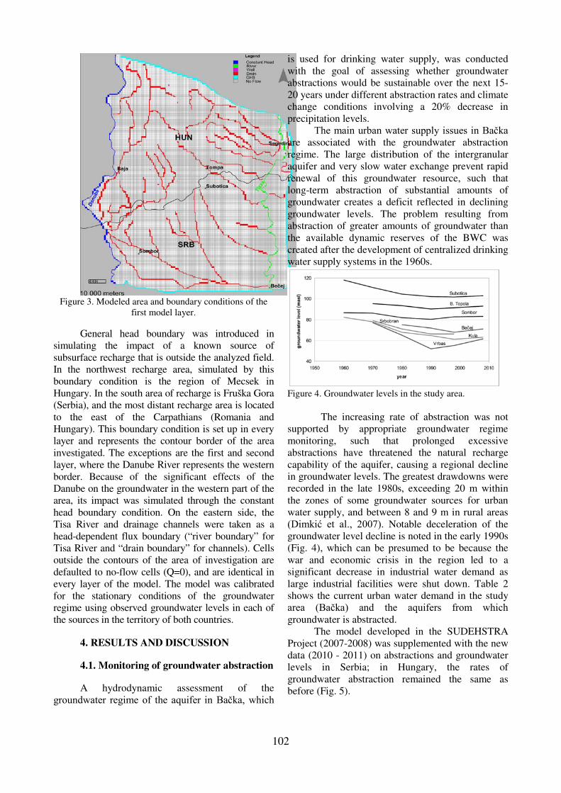
Figure 3. Modeled area and boundary conditions of the
first model layer.
General head boundary was introduced in
simulating the impact of a known source of
subsurface recharge that is outside the analyzed field.
In the northwest recharge area, simulated by this
boundary condition is the region of Mecsek in
Hungary. In the south area of recharge is Fruška Gora
(Serbia), and the most distant recharge area is located
to the east of the Carpathians (Romania and
Hungary). This boundary condition is set up in every
layer and represents the contour border of the area
investigated. The exceptions are the first and second
layer, where the Danube River represents the western
border. Because of the significant effects of the
Danube on the groundwater in the western part of the
area, its impact was simulated through the constant
head boundary condition. On the eastern side, the
Tisa River and drainage channels were taken as a
head-dependent flux boundary (“river boundary” for
Tisa River and “drain boundary” for channels). Cells
outside the contours of the area of investigation are
defaulted to no-flow cells (Q=0), and are identical in
every layer of the model. The model was calibrated
for the stationary conditions of the groundwater
regime using observed groundwater levels in each of
the sources in the territory of both countries.
4. RESULTS AND DISCUSSION
4.1. Monitoring of groundwater abstraction
A hydrodynamic assessment of the
groundwater regime of the aquifer in Bačka, which
is used for drinking water supply, was conducted
with the goal of assessing whether groundwater
abstractions would be sustainable over the next 15-
20 years under different abstraction rates and climate
change conditions involving a 20% decrease in
precipitation levels.
The main urban water supply issues in Bačka are associated with the groundwater abstraction
regime. The large distribution of the intergranular
aquifer and very slow water exchange prevent rapid
renewal of this groundwater resource, such that
long-term abstraction of substantial amounts of
groundwater creates a deficit reflected in declining
groundwater levels. The problem resulting from
abstraction of greater amounts of groundwater than
the available dynamic reserves of the BWC was
created after the development of centralized drinking
water supply systems in the 1960s.
Figure 4. Groundwater levels in the study area.
The increasing rate of abstraction was not
supported by appropriate groundwater regime
monitoring, such that prolonged excessive
abstractions have threatened the natural recharge
capability of the aquifer, causing a regional decline
in groundwater levels. The greatest drawdowns were
recorded in the late 1980s, exceeding 20 m within
the zones of some groundwater sources for urban
water supply, and between 8 and 9 m in rural areas
(Dimkić et al., 2007). Notable deceleration of the
groundwater level decline is noted in the early 1990s
(Fig. 4), which can be presumed to be because the
war and economic crisis in the region led to a
significant decrease in industrial water demand as
large industrial facilities were shut down. Table 2
shows the current urban water demand in the study
area (Bačka) and the aquifers from which groundwater is abstracted.
The model developed in the SUDEHSTRA
Project (2007-2008) was supplemented with the new
data (2010 - 2011) on abstractions and groundwater
levels in Serbia; in Hungary, the rates of
groundwater abstraction remained the same as
before (Fig. 5).

103
Table 2. Average rates of groundwater abstraction for
public and industry water supply in Bačka in 2010 and 2011.
City /
town
Exploited
aquifer
Public
water
supply [l/s]
Industry water
extraction
[l/s]
1 Ada II (BWC) 33 20
2 Apatin I + II
(BWC) 52
110
3 B.
Topola II (BWC) 22
30
4 Bečej II (BWC) 96 80
5 Kanjiža II (BWC) 25 40
6 Kula I + II
(BWC) 46
50
7 Mali Iđoš II (BWC) 15 15
8 Senta II (BWC) 50 55
9 Sombor I + II
(BWC) 145
165
10 Srbobran I + II
(BWC) 30
15
11 Subotica II (BWC) 258 270
12 Vrbas I + II
(BWC) 65
100
The distributions of the groundwater levels of
the first aquifer and the BWC generally coincide,
suggesting their hydraulic contact and a common
source of recharge: infiltration of precipitation within
a spacious loess plateau in southern Hungary and the
Teleč Plateau in Serbia - from Subotica in the north to
Kula and Vrbas in the south (Fig. 5). Occasional
differences in general groundwater levels are a result
of the rates of abstraction from these aquifers.
Relative to the first aquifer, the largest BWC
drawdowns were recorded in Bačka (Fig. 5, Table 2).
4.2. Basic hydrochemistry
The chemical composition of the groundwater
is the combined result of the composition of water
that enters the groundwater reservoir and the reactions
with minerals present in the rock that may modify the
water composition. To facilitate insight into the
qualitative characteristics of the groundwater used as
drinking water supply in this part of Serbia, the study
area was divided into the following zones:
Monitoring Area 1 – MA1 (groundwater sources in
the extended area of Subotica), Monitoring Area 2 –
MA2 (groundwater sources in the vicinity of Bečej), and Monitoring Area 3 – MA3 (groundwater sources
in the vicinity of Sombor) (Fig. 1B). Each of these
locations represented an area that holds the largest
groundwater sources in the given region.
The groundwaters in Bačka, as well as in the
entire Pannonian Basin, are several thousand years
old (6.000 – 22.000 years); water exchange is slow,
such that groundwater is in perpetual interaction with
the surrounding sediments (Josipović & Soro 2012; Vukoje, 2001). Hydrogen and oxygen isotopes
indicated that most of the waters are of paleometeoric
origin, infiltrated during a cold period. The waters are
generally of the NaHCO3 type. Na and HCO3 were
found to increase with depth and/or temperature
(Varsányi et al., 1997). In the 500 m thick upper zone
of the gravel and sandy aquifers used for drinking
water supply in Hungary, the basin-type areas, the
dissolved solid content of waters is less than 1g/L. In
the recharge areas the calcium-hydrocarbonate type
characteristically becomes an alkali-hydrocarbonate
type in direction of the flow along the flow pass
(Ministry for environment and water, 2006).
Figure 5. Piezometric head distribution based on the data observations in 2010 and 2011, of A) the first aquifer, and B)
the BWC in Bačka and southern Hungary (Southeast Pannonian Basin). Legend: Numbers 1 to 12 indicate the groundwater sources identified in Table 2.

104
Figure 6. Depths of tapped intervals at which groundwater
is withdrawn, settings of the abstraction wells and basic
chemistry.
A hydrochemical scheme of changes in
chemical composition with depth was developed. The
basic cation-anion composition of the groundwater
was found to vary with the depth of the tapped aquifer
(Fig. 6). The basic chemistry is determined largely by
the presence of hydrocarbonates, up to 98%
equivalent in the Quaternary strata of MA1 and MA2.
The deeper aquifer in MA2 and MA3 is characterized
by elevated concentrations of chlorides of up to 50%
equivalent at some locations, and extremely low
chloride concentrations in the Quaternary strata in
MA1. The sodium ion was found to dominate all the
water-bearing complex, except the Quaternary
deposits in MA1 where the cation composition
primarily featured calcium and magnesium (Fig. 6)
(Mandić & Papić, 2005).
4.3. Groundwater quality
Groundwater abstracted for the public water
supply in Bačka region has poor quality, but it is possible to apply treatment technologies to achieve
regulated drinking water standards. Among the non-
compliant parameters, those that stood out included:
temperature, turbidity, ammonium ion (NH4+), iron,
arsenic and KMnO4 demand (Table 3).
With regard to the physical parameters,
groundwater temperatures were found to be in the 14-
24oC range, which is much higher than the optimal
12oC for drinking water. Water coloration and turbidity
also failed to meet drinking water standards. KMnO4
demand is a measure of the content of organic
substances. Some organic substances found in
groundwater do not degrade to mineral forms (nitrates,
ammonia, carbon dioxide), but retain rather stable
organic structures known as humic acid and salts.
Humic substances are the most frequent organic
substances found in the Pannonian Basin groundwater,
which give this groundwater a characteristic yellow
color. With regard to the BWC, the lowest KMnO4
demand within the study area was recorded in MA1.
Among the nitrogen triad (ammonium, nitrites
and nitrates), the presence of the ammonium ion was
found to have the most significant impact on
groundwater quality. Nitrites and nitrates occurred
sporadically, as a result of the transitional oxidation-
reduction environment of the aquifer. Ammonium ion
concentrations in virtually the entire study area, at all
sampled wells, exceeded the MPC (Maximum
Permissible Concentration) prescribed by drinking
water standards (0.1 mg/L) (Official Gazette of the
FRY No. 42/98) (Table 3). The main process
responsible for the high ammonium concentrations is
likely to be mineralization from sediments rich in
organic matter. Mildly elevated nitrate concentrations
were recorded in MA1 and MA2, while extremely low
nitrite concentrations were indicative of a reducing
environment.
Iron concentrations ranging from 0.4 mg/L to 1
mg/L were recorded at MA1, where the second aquifer
is tapped. To the south, east and west, iron
concentrations in the first aquifer declined to 0.05 –3
mg/L. The iron concentrations in the deeper aquifer
formed in Pliocene sands were considerably lower,
compared with those of the Quaternary strata of the
shallower aquifer.
Table 3. Parallel representation of average physicochemical parameters in the extended areas of MA1, MA2 and MA3
Parameter Monitoring area 1 Monitoring area 2 Monitoring area 3 MPC (Official Gazette
of the FRY No. 42/98)
Temperature (oC) 17 14-24 13.8-21.5 Optimal 12
Conductivity (µS/cm) 456-600 340-1319 Not measured 2500
pH ca. 7.7 7.6-8.3 6.96-8.4 6.8-8.5
Turbidity (NTU) 1.7-9.3 0.3-12.3 Not measured 1
TDS (mg/L) ca. 370 315-831 390-1414 1000
KMnO4 demand (mg/L) 4-9 5.6-104 4.8-195 12
Fe (mg/L) 0.4-1 0.05-1.45 0.14-3 0.3
NH4+ (mg/L) 0.398-0.173 0.05-2.63 0.02-3.2 0.1
As (µg/L) 20-173 <10-100 10-210 10

105
Arsenic concentrations are a major concern for
drinking water supply as a number of harmful effects
of arsenic on human health have been identified
throughout the world, such as skin changes;
cardiovascular, respiratory and neurological effects;
and skin and various other cancers (Petrusevski et al.,
2007). For this reason it is necessary to determine the
concentration of this element and extremely important
to identify the source and mobility of arsenic in the
groundwater.
The mobility of arsenic in groundwater
depends on highly-complex geochemical processes in
a particular setting (Kim et al., 2009). A condition
that favors arsenic migration is a reduction
environment where desorption and dissolution take
place. Low Eh values (<50 mV), the absence of
dissolved oxygen, elevated Fe, Mn, NH4+
concentrations, high alkalinity, the presence of
organic substances and low sulfate concentrations (<5
mg/L) are the general hydrochemical characteristics
of groundwaters that feature elevated arsenic
concentrations (Smedley & Kinninburgh, 2002).
These are the very features that characterized the
groundwater in the study area. The largest city in the
study area is Subotica (MA1) (population 140,000); it
is the only city with a water treatment plant. The area
covered by Subotica obtains its drinking water supply
from 13 groundwater sources. Based on the analyses,
the average concentration of arsenic at these
groundwater sources was 110 µg/L. The presence of
the ammonium ion and absence of nitrates in the
groundwater suggested a reducing medium, which
generally creates favorable conditions for arsenic
migration in groundwater. The iron concentration in
the groundwater used for drinking water supply in
Subotica varied from 0.04 to 0.96 mg/L (Papić et al., 2012). The iron concentration in the groundwater
used for drinking water supply in Subotica varied
from 0.04 to 0.96 mg/L (Papić et al., 2012).
Table 3 shows As concentrations in
groundwaters used for drinking water supply in
Vojvodina. At nearly all MA1 locations, arsenic
concentrations exceeded the MPC, while in MA3 they
were found to be as high as 210 µg/L. MA2 featured
arsenic concentrations from 10 to 100 µg/L. Other
countries that share the Pannonian Basin also have
drinking water supply concerns due to elevated arsenic
concentrations in groundwater. In Croatia, the areas of
Osijek in the Baranja region and Vukovar in the Srijem
region are particularly threatened, with arsenic
concentrations in the groundwater used for drinking
water supply measuring as high as 491 µg/L.
Groundwater is tapped from Middle - Upper
Pleistocene sediments (Ujević et al., 2010). In Romania and Hungary, about half a million people
who live in the Pannonian Basin use groundwater with
arsenic concentrations exceeding the MPC, while
arsenic concentrations in the groundwater withdrawn
for drinking water supply are up to 240 µg/L (Rowland
et al., 2010).
4.4. Groundwater balance of the first aquifer and BWC in the Southeast Pannonian Basin
Water extraction from the first aquifer and
BWC extends beyond Serbia’s borders into other
parts of the Southeast Pannonian Basin. The
groundwater balance of a groundwater system can be
determined by calculating the inputs and outputs of
water, and the storage changes of the groundwater
system. For the area included in the model, the major
inputs of water are the infiltration of the precipitation
and groundwater inflow, while the major outputs
from a groundwater system are evapotranspiration,
groundwater pumping, groundwater discharge in
rivers (Danube and Tisa) and drainage channels. The
groundwater balance was assessed based on the
groundwater abstraction rate recorded in Bačka in 2010 and 2011, and in southern Hungary in 2008.
All data related to groundwater balance on the
Hungarian side of the Pannonian Basin used in this
paper are defined in the SUDEHSTRA Project
(Stevanović et al., 2011). Table 4 is a numerical
representation of the current groundwater balance
elements of the first aquifer and the BWC in the
Southeast Pannonian Basin.
The groundwater balance assessments of the
first aquifer and the BWC indicated that precipitation
and evapotranspiration play significant roles in the
study area. The difference between these parameters
represents the amount of water infiltrated into the
water-bearing complex (directly into the first aquifer,
and indirectly into the BWC – from the first aquifer
through a semi-pervious interbed), amounting to 5637
l/s. Most of the infiltrated water is withdrawn by
production wells (4547 l/s); drainage channels take up
1037 l/s and surface streams 1077 l/s.
The high precipitation infiltration rate is driven
by the geomorphological and geological features of
the surface sediments. A relatively large loess plateau
on the surface of the study area, characterized by a
strong precipitation infiltration capability, determines
the general direction of groundwater flow, from the
central loess plateau to the fringes of the Bačka region (Polomčić et al., 2010). Under current groundwater withdrawal conditions, the considered aquifer is
drained via production wells and into the Danube and
Tisa rivers and drainage channels.
Prognostic calculations focused on two basic
scenarios: climate change reflected in decreasing

106
precipitation and different rates of abstraction in
Serbia and Hungary (four variants). In the first two
scenarios (Variants A and B), the current rate of
abstraction was considered, but with precipitation
reduced by 10 and 20%, respectively, while in
Variants C and D the rate of abstraction was
increased and precipitation reduced by 20%. The
resulting groundwater balance is shown in table 4.
Compared with the current groundwater
balance of the aquifer, reflecting the current rates of
groundwater abstraction (Table 4), in Variants A and
B, due to reduced precipitation and the current rate
of abstraction, evapotranspiration declines as a result
of declining groundwater levels by 2060-4155 l/s
(Table 4). This causes a redistribution of the
drainage of the aquifer into surface streams. Less
groundwater is drained into the drainage channels
and the Danube River, on aggregate between 424 l/s
(Variant B) and 840 l/s (Variant A). However, due to
a decline in groundwater levels (Variant A),
groundwater will likely be recharged on account of
infiltration from the Tisa River.
Variant C is extreme, in terms of both the
assumed climate change impact and the rates of
abstraction. This variant involves the greatest
decline in groundwater levels in the study area,
compared with the present state. Consequently,
evapotranspiration is reduced (by 4213 l/s), as are
the amounts of water drained into the Danube (488
l/s) and the drainage channels (377 l/s). On the other
hand, this variant involves the highest rate of
infiltration from the Tisa River (139 l/s) (Table 4).
Variant D retained the elevated rate of groundwater
abstraction in Hungary, but this rate was reduced in
Serbia by 15% relative to the current rate. With
regard to the redistribution of groundwater in these
circumstances, the water balance in Variant D is
similar to that in Variant C.
Characteristic of the analyzed scenarios and
variants of climate change and rates of groundwater
abstraction is a groundwater balance deficit compared
to the current balance of BWC (Table 4). The highest
deficit of 1331 l/s occurs in Variant C, which is the
most extreme case in terms of climate change and
groundwater abstraction rate. The calculated
reductions of recharge of the tapped aquifers and
different rates of abstraction in Serbia and Hungary
allowed further declines in groundwater levels
relative to the present state to be predicted.
Additional drawdowns in each of the analyzed
variants for three groundwater sources that feature the
highest rates of abstraction in Bačka are shown in figure 7. The climate change impact forecast involving
reduced precipitation infiltration by 10% and 20%
relative to long-term averages suggests a significant
decline in groundwater levels in Serbia, ranging from
14.4 to 18.2 m in the areas of Subotica, Sombor and
Bečej. Additional drawdowns in excess of 10 m occur in Kula and Bečej, as well as in the extended area of Szeged, Hungary. In the entire study area, both
aquifers would experience an additional drawdown of
0.5 – 1 m. In Variant C, relative to Variant A, the
groundwater source in Subotica shows a larger
drawdown as a result of a higher rate of groundwater
abstraction from the aquifer in Hungary. With
increasing distance from the state border, the impact of
the increased rate of abstraction in Hungary would
decrease.
Figure 7. Additional drawdowns at selected groundwater
sources in Bačka.
Table 4. Current groundwater balance and groundwater balance forecasts for the first aquifer and the BWC in the
Southeast Pannonian Basin
Variant
Infiltration
of the
precipitation
Groundwater
inflow
Evapo-
transpiration Wells
Danube
River
Tisa
River
Drainage
channel
Water
budget
difference
Groundwater
deficit
(l/s) (l/s) (l/s) (l/s) (l/s) (l/s) (l/s) (l/s) (l/s)
2011 28160 4025 -22523 -4547 -1019 -58 -1037 3001 0
A 22528 3361 -18368 -4547 -556 127 -660 1886 1115
B 25344 3448 -20463 -4547 -810 35 -822 2185 816
C 22528 2981 -18310 -4697 -531 139 -620 1670 1331
D 22528 3582 -18518 -4365 -625 46 -671 1977 1024
(2011 – reference year, A - Current exploitation, Infiltration of precipitation 80%, B - Current exploitation, Infiltration
of precipitation 90%, C - Infiltration of precipitation 80%, Expl. SRB 100%, Expl. HUN 110%, D - Infiltration of
precipitation 80%, Expl. SRB 85%, Expl. HUN 110%, mark “–“ groundwater outflow from the model).

107
At select groundwater sources the drawdowns
would remain virtually the same (Sombor and Bečej) as in Variant A. Groundwater abstraction in Hungary
would have virtually no impact on groundwater levels
south of Bačka Topola (water source 3, Table 2) in
Serbia. A reduced rate of groundwater abstraction in
Bačka, at decreased precipitation infiltration rates (Variant D), results in a smaller drawdown than in
Variant C. Under these conditions, the greatest
difference between additional drawdowns relative to
Variant C would occur in Subotica, as a result of the
reduced yield of the largest of the three analyzed
groundwater sources.
5. CONCLUSIONS
Drinking water supply in the southeastern part
of the Pannonian Basin is provided by groundwater
abstractions from the first aquifer and the basic water-
bearing complex (BWC) in Quaternary sediments.
These sediments, up to a depth of about 200 m, are
characterized by sand and gravel deposits that contain
significant amounts of water for drinking water supply.
The basic groundwater chemistry is dominated by
hydrocarbonate, while the cation composition varies
with the depth from which groundwater is withdrawn.
The reduction conditions that prevail in the
geoenvironment result in elevated concentrations of
iron, manganese, the ammonium ion and organic
substances. However, high arsenic concentrations are
among the principal water quality issues, as
concentrations of this element at some groundwater
sources exceed the drinking water standard several
times.
Groundwater balance assessments of the first
aquifer and the basic water-bearing complex (BWC)
indicated that precipitation plays a significant role in
the study area. Relative to the groundwater balance
under current abstraction conditions, the first two
analyzed variants showed that reduced precipitation, at
current abstraction rates, is likely to lead to reduced
evapotranspiration as a result of a decline in
groundwater levels by 2.06 – 4.21 m3/s. In these cases,
there will be additional permanent drawdowns from
0.5 to 1 m of both aquifers over the entire study area,
and from 14.4 to 18.2 m at the most productive
groundwater sources.
When the worst-case climate change scenario,
compounded by increased rates of abstraction (in
Hungary), was analyzed, the largest decline in
groundwater levels was found to occur in the state
border area. In essence, any increase in abstraction
rates in Hungary would be expected to result in a
further decline in groundwater levels of the tapped
aquifers all the way to Bačka Topola in Serbia.
One of the characteristics of the groundwater
abstractions from this aquifer is over-exploitation, with
more groundwater being withdrawn than can naturally
be renewed. Compared to the current balance of
groundwater in the BWC, all the analyzed scenarios
indicated a larger deficit of groundwater (max. 1331
l/s).
ACKNOWLEDGEMENTS
Our gratitude goes to Bačka Waterworks which supported the investigations and whose results are
presented in this work and the Ministry of Education,
Science and Technological Development of Serbia for
financing the project III-43004.
REFERENCES
Ćalić, J., Gaudenyi, T., Milošević, M., Štrbac, D. & Milivojević, M. 2012. Geomorphometrical method
for delineation of plains - case study of the South-
Eastern (Serbian) segment of the Pannonian Plain;
Carpathian Journal of Earth and Environmental
Sciences, May 2012, Vol. 7, No. 2, 239 – 248.
Čanović, M., Kemenci, R. & Pantić, N., 1988. The
Mesozoic of the Pannonian basin in Vojvodina
(Yugoslavia). Matica Srpska, Novi Sad, pp. 112-114
[in Serbian].
Dimkić M., Stevanović Z. & Đurić D., 2007. Utilization,
Protection and Status of Groundwater in Serbia.
Regional IWA Conference on Groundwater in the
Danube river basin and other large river basins,
Jaroslav Černi Institute for Development of Water Resources, Belgrade, pp 83-102.
Đurić D., Josipović J., Jevtić G., Slimak, T., & Pušić, M., 2007. Groundwater Management in Vojvodina,
Proceedings Regional IWA Conference on
Groundwater Management in the Danube River basin
and large river basin, IWA, 185-192.
Harbaugh, A.W., Banta, E.R., Hill, M.C. & McDonald, M.G., 2000. MODFLOW-2000. The U.S. Geological
Survey Modular Ground-Water Model, User Guide
to Modularization Concepts and the Ground-Water
Flow Process, U.S. Geological Survey Open-File
Report 00-92, Reston, VA, USA, pp 121.
István, V., Kovács, B., Stevanović. Z. & Polomčić, D., 2008. Hydrodynamic modelling of the transboundary
Hungarian-Serbian aquifer. Proceedings of XIIth
Congress of Hungarian Geomathematics and The 1st
Congress of Croatian and Hungarian
Geomathematics. Applications of geostatistics, GIS
and remote sensing in the fields of geosciences and
environmental protection, 29-31 May 2008. Book of
Abstracts. Mórahalom, Hungary.
Josipović, J., & Soro, A., 2012. Groundwater of Vojvodina.
Monograph. Jaroslav Černi Institute for the
Development of Water Resources, Belgrade, pp. 37.
[in Serbian].
Kim, Y.T., Yoon, H.O., Yoon, C. & Woo, N.C., 2009.
Arsenic species in ecosystems affected by arsenic-

108
rich spring water near an abandoned mine in Korea.
Environ. Pollut. 157(12):3495-501.
Kukin, A., 1969. Geological conditions of artesian water
occurrence in Backa and their physical and chemical
properties, Proc. Nat. Sci 37, Matica Srpska, Novi
Sad, pp. 55-58. [in Serbian].
Mandić, M. & Papić, P., 2005. A Contribution to the
Understanding of the Qualitative Properties of
Groundwater in Vojvodina. In: Proceedings 14th
Conference of Geologists of Serbia and Montenegro,
Novi Sad pp. 385-390 [in Serbian]
Marinović, Đ., 1982. The general geological and
hydrogeological conditions in the province of
Vojvodina. In: Proceedings VII Yugoslav
Symposium of hydrogeology and engineering
geology, III/3, Novi Sad. [in Serbian].
Milanović, A., Milijašević, D. & Brankov, J., 2011.
Assessment of polluting effects and surface water
quality using water pollution index: a case study of
hydro – system Danube – Tisa – Danube, Serbia;
Carpathian Journal of Earth and Environmental
Sciences, September 2011, Vol. 6, No. 2, p. 269 –
277.
Milosavljević, S., Vasiljević, M. & Vilovski, S., 1997.
Hydrogeological studies in Vojvodina (Research
drinking, industrial and mineral water). In:
Monograph 100 years of hydrogeology in
Yugoslavia, Faculty of Mining and Geology,
Belgrade, pp.117-146 [in Serbian].
Ministry for environment and water, 2006. Groundwaters
in Hungary II (compiled by the Water Management
Directorate of VITUKI Environmental Protection and
Water Management Research Institute on behalf of
the Ministry for Environment and Water), Budapest,
pp. 26-27.
Papić, P., Ćuk, M., Todorović, M., Stojković, J., Hajdin,
B., Atanacković, N. & Polomčić, D., 2012. Arsenic
in tap waters of the south Pannonian basin (Serbia)
and arsenic risk assessment, Pol. J. Environ. Stud.
Vol. 21, No 6, 1783-1790.
Petrusevski, B., Sharma, S.K., Schippers, J.C. & Shordt, K., 2007. Arsenic in drinking water. Delft: IRC
International Water and Sanitation Centre, Vol. 17,
pp. 1-57.
Polomčić, D., Stevanović, Z., Dokmanović, P., Papić, P., Ristić-Vakanjac, V., Hajdin, B., Milanović, S. & Bajić, D., (2011) Groundwater supply in Serbia –
Situation and Perspectives. In: Polomčić D. and Ristić-Vakanjac V. (ed) 40 years of the Department
of Hydrogeology. Faculty of Mining and Geology.
Belgrade, Serbia, pp 45 - 78. [in Serbian].
Polomčić, D., Stevanović, Z., Milanović, S., Sorajić, S., Hajdin, B. & Kljajić, Ž., 2010. Sustainable
development of the Hungarian – Serbian
transboundary aquifer. Vodoprivreda 246-248 pp.
223-235 Belgrade.
Provincial secretariat of science and technology development (PSSTD), 2009. Water Supply and
Water Protection Strategy for the Autonomous
Province of Vojvodina. University of Novi Sad,
Faculty of Science and Mathematics, pp. 52-70 [in
Serbian]. Regulation of Hygienic Correctness of Drinking Water.
Official Gazette of the SFRY No. 42/98.
Regulation of sampling and laboratory methods for the analysis of drinking water. Official Gazette of the
SFRY No. 33/87.
Rowland, H., Omoregie, E., Millot, R., Millot, R., Jimenez, C., Mertens, J., Baciu, C., Hug, S. & Berg, M., 2010. Geochemistry and arsenic
behaviour in groundwater resources of the
Pannonian Basin (Hungary and Romania). Applied
Geochemistry 26: 1–17.
Royden, L.H., & Horváth, F., 1988. The Pannonian Basin
– a Study of Basin Evolution. American Association
of Petroleum Geologists - Memoir Series. 45, 1-16.
Royden, L.H., Horváth, F. & Rumpler, J., 1983. Evolution
of the Pannonian Basin System 1. Tectonics.
Tectonics vol. 2, issue 1, pp. 63-90.
Smedley, P.L. & Kinninburgh, D.G., 2002. A review of the
source, behaviour and distribution of arsenic in
natural waters. Applied Geochemistry 17: 517-568.
Stevanović, Z., Kozák, P., Lazić, M., Szanyi, J., Polomčić, D., Kovács, B., Török, J., Milanović, S. & Hajdin, B., 2008. Towards sustainable management of
transboundary Hungarian – Serbian aquifer. IV
International Symposium on Transboundary Waters
Management, CD 4 pages, Ses. 1(2), Thessaloniki.
Stevanović, Z., Kozák, P., Lazić, M., Szanyi, J., Polomčić, D., Kovács, B., Török, J., Milanović, S., Hajdin, B. & Papić, P., 2011. Towards Sustainable
Management of Transboundary Hungarian-Serbian
Aquifer. Chapter in the International Monography
Transboundary Water Resources Management: A
Multidisciplinary Approach, 1 Ed. (eds. Ganoulis J.,
Aureli A. and Fried J.). Wiley-VCH Verlag, 143-149.
Ujević, M., Duić, Ž., Casiot, C., Sipos, L., Santo, V., Dadić, Ž. & Halamić, J., 2010. Occurrence and
geochemistry of arsenic in the groundwater of
Eastern Croatia. Applied Geochemistry 25:1017–
1029.
Varsányi, I., Matray, J.M. & Kovács, L. Ó., 1997.
Geochemistry of formation waters in the Pannonian
Basin (southeast Hungary), Chemical Geology
Volume 140, Issues 1–2:89–106. PII:S0009-2541 97
00045-4.
Vukoje, M.S., 2001. Water Supply in Zrenjanin (in Serbia).
Yugoslav Association of Water Supply and
Sewerage, vol. 52, pp. 87-90 [in Serbian].
Received at: 21. 06. 2013
Revised at: 10. 04. 2014
Accepted for publication at: 14. 04. 2014
Published online at: 26. 04. 2014


![Assessment of groundwater quality for drinking and ... · Suitability of groundwater for domestic and irrigation purposes is determined by its groundwater geochemistry [5]. This study](https://img.dokumen.tips/doc/110x75/5f807958319eab23e57b9e43/assessment-of-groundwater-quality-for-drinking-and-suitability-of-groundwater.jpg)