Embed Size (px)
Citation preview

Groundwater and climate change in
Africa: review of aquifer properties
data
Groundwater Science Programmes
Internal Report IR/10/076


BRITISH GEOLOGICAL SURVEY
GROUNDWATER SCIENCE PROGRAMME
INTERNAL REPORT IR/10/076
The National Grid and other
Ordnance Survey data are used
with the permission of the Controller of Her Majesty‟s
Stationery Office.
Licence No: 100017897/2010.
Keywords
Africa; aquifer properties;
systematic data review; hydrogeology data
Bibliographical reference
BONSOR H C, AND MACDONALD
A M. 2010. Technical note: a
systematic review of aquifer
properties studies in Africa. British Geological Survey,
Internal Report, IR/10/076.
30pp.
Copyright in materials derived
from the British Geological
Survey‟s work is owned by the Natural Environment Research
Council (NERC) and/or the
authority that commissioned the work. You may not copy or adapt
this publication without first
obtaining permission. Contact the BGS Intellectual Property Rights
Section, British Geological Survey, Keyworth,
e-mail [email protected]. You may
quote extracts of a reasonable length without prior permission,
provided a full acknowledgement
is given of the source of the extract.
Maps and diagrams in this book
use topography based on Ordnance Survey mapping.
Groundwater and climate change
in Africa: review of aquifer
properties data
H C Bonsor and A M MacDonald
© NERC 2010. All rights reserved Keyworth, Nottingham British Geological Survey 2010

The full range of our publications is available from BGS shops at
Nottingham, Edinburgh, London and Cardiff (Welsh publications
only) see contact details below or shop online at
www.geologyshop.com
The London Information Office also maintains a reference
collection of BGS publications, including maps, for consultation.
We publish an annual catalogue of our maps and other
publications; this catalogue is available online or from any of the
BGS shops.
The British Geological Survey carries out the geological survey of
Great Britain and Northern Ireland (the latter as an agency
service for the government of Northern Ireland), and of the
surrounding continental shelf, as well as basic research projects.
It also undertakes programmes of technical aid in geology in
developing countries.
The British Geological Survey is a component body of the Natural
Environment Research Council.
British Geological Survey offices
BGS Central Enquiries Desk
Tel 0115 936 3143 Fax 0115 936 3276
email [email protected]
Kingsley Dunham Centre, Keyworth, Nottingham NG12 5GG
Tel 0115 936 3241 Fax 0115 936 3488
email [email protected]
Murchison House, West Mains Road, Edinburgh EH9 3LA
Tel 0131 667 1000 Fax 0131 668 2683
email [email protected]
Natural History Museum, Cromwell Road, London SW7 5BD
Tel 020 7589 4090 Fax 020 7584 8270
Tel 020 7942 5344/45 email [email protected]
Columbus House, Greenmeadow Springs, Tongwynlais,
Cardiff CF15 7NE
Tel 029 2052 1962 Fax 029 2052 1963
Maclean Building, Crowmarsh Gifford, Wallingford
OX10 8BB
Tel 01491 838800 Fax 01491 692345
Geological Survey of Northern Ireland, Colby House,
Stranmillis Court, Belfast BT9 5BF
Tel 028 9038 8462 Fax 028 9038 8461
www.bgs.ac.uk/gsni/
Parent Body
Natural Environment Research Council, Polaris House,
North Star Avenue, Swindon SN2 1EU
Tel 01793 411500 Fax 01793 411501
www.nerc.ac.uk
Website www.bgs.ac.uk
Shop online at www.geologyshop.com
BRITISH GEOLOGICAL SURVEY

IR/10/076; Final final Last modified: 2011/09/16 13:04
i
Foreword
In 2010 the Department for International Development (DFID) commissioned a BGS-led team to
undertake a one-year study aimed to improve understanding of the resilience of African
groundwater to climate change and links to livelihoods. As part of this project, the research team
undertook hydrogeological field studies in West and East Africa, examined the linkages between
water use and household economy, and developed an aquifer resilience map for Africa using
existing hydrological maps and data. This is one of a series of progress reports written for the
project partners and steering group to help discussion.
This report describes the methodology and results of a systematic review of existing aquifer
properties data from Africa, undertaken within the one-year project. The compiled data were
used to attribute an aquifer properties map developed within the project. The data review was
also one of a series of components within the project, which was used to strengthen the evidence
base between climate change and aquifer resilience.

IR/10/076; Final final Last modified: 2011/09/16 13:04
ii
Acknowledgements
As with all projects we would like to thank are a number of BGS and external colleagues for
their help and assistance:
Jeff Davies (BGS) for his invaluable assistance in sourcing grey literature, containing aquifer
properties studies, and much data collated through his work with BGS.
The Project Steering Group, for their general comments and helpful insight with this work – Guy
Howard (DFID); Stephen Foster (GWMATE); Mike Edmunds (UoOx), Declan Conway (UAE);
Richard Carter (WaterAid); Vincent Casey (WaterAid); Richard Harding (CEH) and Tamiru
Abiye (University of Witwatersrand, Johannesburg).

IR/10/076; Final final Last modified: 2011/09/16 13:04
i
Contents
Foreword ......................................................................................................................................... i
Acknowledgements ........................................................................................................................ ii
Contents ........................................................................................................................................... i
1 Introduction ............................................................................................................................ 3
2 The review of aquifer properties data in Africa .................................................................. 4
2.1 A comprehensive review ................................................................................................ 4
2.2 The search criteria .......................................................................................................... 4
2.3 The confidence criteria ................................................................................................... 4
3 Aquifer properties data identified ........................................................................................ 8
4 Preliminary analysis of aquifer properties data .................................................................. 9
References .................................................................................................................................... 14
Appendix 1 ................................................................................................................................... 15
Appendix 2 ................................................................................................................................... 17
FIGURES
Fig. 1 Spatial and geological distribution of reviewed aquifer properties data within Africa
.......................................................................................................................................….............7
Fig. 2 Distribution and number of yield data identified within Basement geology across
Africa.......................................................................................................................................…...8
Fig. 3 Probability distribution of the collated basement yield data. The data has a skewed normal
distribution.................................................................................................................................9
Fig. 4 Rank percentile analysis of basement yields.....................................................................9
Fig. 5 Box plot indicating the median and interquartile range of borehole yields within different
basement rock types in Africa. Sample size is indicated by the numbers in brackets..............10
Fig. 6 Rank percentile analysis of basement yields according to rock type..................................11
Fig. 7 Variation in basement yield with climate, across all basement rock types.........................11
Fig. 8 Variation in basement yields with climate, in different rock types.....................................12

IR/10/076; Final final Last modified: 2011/09/16 13:04
ii
TABLES
Table 1 Confidence criteria applied to data studies……………………………….................5
Table 2 Confidence criteria applied to qualitative review studies ...……..……………….......6

IR/10/076; Final final Last modified: 2011/09/16 13:04
3
1 Introduction
The review of aquifer properties data from Africa was conducted as part of a one year DFID-
funded research programme, aimed at improving understanding of the impacts of climate change
on groundwater resources and local livelihoods – see http://www.bgs.ac.uk/GWResilience/. The
review was one of a series of components within the project, which was used to strengthen the
evidence base between climate change and aquifer resilience. The overall outputs of the project
were:
Two hydrogeological case studies in West and East Africa – which assess the storage
and availability of groundwater in different aquifers across different climate zones in
Africa
A water use and livelihood case study (analysis of Water Economy and Livelihoods
(WELs) data, Ethiopia) – examining the linkages between water use and household
economy
A review of hydrogeological data for Africa
A map of groundwater resilience to climate change in Africa
Data collated within the review were used to attribute an aquifer properties map of Africa. In
total, 280 sets of aquifer properties data in Africa have been identified from 145 published and
grey literature reports. This report is a progress report for the project partners and steering group
to help discussion. The report describes the criteria used to identify and systematically review the
studies. An initial analysis of the data is also provided in this report.
The relatively few studies identified by the review reflect the paucity of hydrogeological data
within Africa. Quantitative aquifer properties data – transmissvity (T) and storage (S) data – are
scarce within Africa, and as a result, this review compiled borehole yield data and qualitative
review studies, as well as actual aquifer properties data.

IR/10/076; Final final Last modified: 2011/09/16 13:04
4
2 The review of aquifer properties data in Africa
2.1 A COMPREHENSIVE REVIEW
Quantitative aquifer properties data – transmissvity (T) and storage (S) – are highly scarce for
Africa, and often within grey literature. Due to scarcity of aquifer properties data in Africa, this
review compiled borehole yield data and qualitative review studies, as well as actual aquifer
properties data, so that the review was as comprehensive as possible.
2.2 THE SEARCH CRITERIA
Most of the studies identified by the review were found from an extensive web search using
several of the main search engines – Web of Science, Science Direct, Google, Google scholar
and Google books. The web search criteria utilised are outlined in Appendix 1. Each search
generally pulled up between 5 000 and 30 000 hits (up to 100,000 hits), from which 1-4 aquifer
properties studies might be sourced. Aquifer properties studies were identified from the web
search results, using the following sifting approach:
the title of item included the word “groundwater” or directly relates to groundwater
potential, aquifers or aquifer parameters
the title of item includes, or refers to, a geographic location or aquifer in Africa
the item is within published scientific literature, or downloadable grey literature (e.g. a
United Nations report, or a USGS technical document)
In general, only the first 100 hits were found to be relevant to any one search.
An initial sift of the studies identified was used to exclude any reports which did not:
contain at least some information (qualitative or quantitative) relating to aquifer
properties
include some description of the geology
In addition to the web, aquifer properties data studies and databases (e.g. regional yield
databases) were identified within grey literature (e.g. BGS field data reports, country water
ministry reports) through individual researchers and organisations known to the project team.
The same inclusion criteria were applied to the results of these more focused searches, as were to
the web searches (see above). The review of grey literature is not exhaustive, and only the most
accessible data and databases (e.g. BGS and WaterAid data) were included within this review.
Future work would expand the grey literature review.
In total 280 aquifer properties datasets were identified from 145 reports in peer-reviewed and
grey literature.
2.3 THE CONFIDENCE CRITERIA
A confidence rank was applied to all studies included within the review using set criteria (Tables
1 and 2). Due to the scarcity of T and S data within Africa, both yield data (used as a proxy for

IR/10/076; Final final Last modified: 2011/09/16 13:04
5
T) and qualitative review studies – have been included within this review. Separate confidence
criteria were applied to accommodate the qualitative and quantitative data types reviewed. In
general, highest confidence was assigned to the data studies which provide reliable quantitative
aquifer properties data (T and S), and regional qualitative review studies with a strong evidence-
base.
1. Data studies
High confidence (1-2) was assigned to the data studies which estimate aquifer properties
from: controlled pumping tests of more than 5 hours duration with observation boreholes
(Table 1); from a large sample base (>20 boreholes); display at least some raw pumping
test data; and include description of the regional geology and methods.
Moderate confidence (3-4) was assigned to aquifer properties data which are: derived
from pumping tests of <5 hours duration; derived from a small sample base; or include
insufficient information on the geology or methodology used. Modelled aquifer
properties data were also evaluated to be of moderate confidence, due to lack of reliable
hydrogeological field data available to develop and calibrate the models at an appropriate
scale.
Low confidence (5) was assigned to aquifer properties data if: there is limited information
on the methodology or geology of the study area; or, if there is no attempt to validate
modelled aquifer properties data.
Studies were only excluded from the review if:
the methodology of the study would lead to significant error in the derived
aquifer properties estimates – e.g. if pumping tests were <1 hour duration;
the source of the aquifer properties data was unknown;
the geology of the study area was unknown; or
there were gross errors in data interpretation – e.g. the derived data mean was
outside the data range.
2. Yield data
Due to the scarcity of T and S data within Africa, yield data were included in the review
as a proxy of T. Yield data are more widely available than T and S data in Africa, and
have been shown to be a useful proxy for T data in various hydrogeological domains (e.g.
Graham at al. 2009; Banks et al. 2005). Inclusion of the yield data ensured a much better
spatial distribution of data, and the approach was found to be particularly useful in areas
of low data availability. The data were assigned a lower confidence (3-4) than aquifer
properties data. Table 1 outlines the criteria used to review yield data.
3. Qualitative review studies
Qualitative review studies of a hydrogeological domain, regional hydrogeology, or
specific aquifers, were some of the most useful information sources identified by the
review. Review studies, by their nature, are based on a wide range of data and field
experience and as a result can provide more reliable geological and hydrogeological

IR/10/076; Final final Last modified: 2011/09/16 13:04
6
information than a small sampling survey. Whilst review studies often do not give
quantitative aquifer properties data, they can provide a valuable description of how an
aquifer system works.
Table 2 outlines the criteria used to review these studies. Highest confidence (1) was
assigned to studies which include and reference several (>2) data sources for an aquifer
or region, and provide a valuable overview of how the aquifer system works.
Confidence Confidence rank Criteria
High
1 Aquifer properties data (T and S) are derived from controlled
pumping tests (>5 hr duration) with observation boreholes;
Large sample base (>20 sites);
Good description of field methods, including raw data;
Description of site including geology and source
Plus any of the following:
Inclusion of yield data within study, as a proxy comparison to
pumping test data;
Recent study (T, S estimates <10 years old)
High-
Medium 2 Aquifer properties data (T only) are derived from controlled
pumping tests >5 hr duration, but no observation boreholes;
Large sample base (>20 sites);
Good description of field methods;
Description of geology and source
Plus any of the following:
Raw pumping test data
Comparison of study results, to other work within region;
Inclusion of yield data within study, as a proxy comparison to
pumping test data;
Recent study (T estimate <10 years old)
Medium 3 Aquifer properties data (T only) are derived from pumping
tests (some <5hr duration), but little known to methods;
And/or:
Aquifer properties data derived from production yields of
boreholes and wells,
Plus 2 of the following:
Small sample base within recharge area (<20);
Summary data only;
Some qualitative hydrogeological data ;
Limited description of geology and source;
Comparison of study results, to other work within region;
Inclusion of yield data within study, as a proxy comparison to
pumping test data;
Modelled data, using sufficient accurate hydrogeological
field-data;
Recent study (T estimate <10 years old)
Medium-
Low 4 Aquifer properties data derived from production yields of
boreholes and wells, but no information to methods;
Summary data only, and small sample base;
Or:
Modelled aquifer properties data, based on insufficient

IR/10/076; Final final Last modified: 2011/09/16 13:04
7
accurate field-data;
Plus any of the following:
Small sample base (<20);
Limited description of geology and source;
No comparison of study results, to other work within region;
Dated study (>10 years)
Low 5 The parameter is modelled, based on little, or no, accurate
hydrogeological field-data
No comparison of study results, to other work within region,
or proxy yield data;
Plus any of the following:
Small sample base (<20);
Summary data only;
Little, or no, description of field or modelling methodology;
Limited description of the geology;
Dated study (>10 years)
Table 1 – Confidence criteria applied to data studies.
Table 2 – Confidence criteria applied to aquifer review studies.
Confidence Confidence rank Criteria
High 1 Qualitative hydrogeological information relating to a
hydrogeological domain, or specific aquifer;
Strong evidence-base to review (several data sources);
Good description of data sources, and the methodology
behind summary aquifer properties data;
Description of geology and source
Plus any of the following:
Inclusion of yield data, comparison to summary T and S data;
Recent review (<30 years old)
Medium 2 Qualitative information on the regional hydrogeology, the
hydrogeological domain, or specific aquifer;
Moderate evidence base to review (max. 2 data sources);
Smaller review area;
Some description of data sources, but limited information to
methodology of data
Plus any of the following:
Inclusion of yield data, or modelled data, comparison to
summary T and S data;
Recent data reviewed (<30 years old)
Low 3 Limited qualitative information on the regional hydrogeology,
the hydrogeological domain, or specific aquifer;
Weak evidence base (one data source), with limited, or no
information to data sources and methodology;
Geographically small review area

IR/10/076; Final final Last modified: 2011/09/16 13:04
8
3 Aquifer properties data identified
In total, 280 aquifer properties studies from Africa were identified from 145 reports in peer-
reviewed and grey literature. These studies provide data for many of the major sedimentary
basins and basement aquifer domains in Africa, but there are limited aquifer properties data
(quantitative or qualitative) for central and western Africa (e.g. the Taoudeni Basin) and from
volcanic hydrogeological domains – Fig. 1. High confidence (1-2) data are scarce (only 18% of
studies reviewed), with most (65%) of the identified studies containing either moderate
confidence (3) aquifer properties data or qualitative estimates. The full reference list of reviewed
aquifer properties studies are listed according to confidence rank in Appendix 2.
Due to the paucity of hydrogeological data within Africa, qualitative review studies and borehole
yield data have been included within the review as well as actual aquifer properties data to
achieve a better spatial distribution of data. This approach was found to be useful, particularly in
regions of poor data availability. The confidence rank, systematically assigned to the data,
ensures appropriate emphasis is placed on the different data.
Fig. 1 – Spatial and geological distribution of reviewed aquifer properties data within Africa.
IR/10/076; Final final Last modified: 2011/09/16 13:04
9
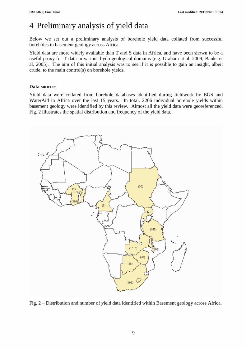
4 Preliminary analysis of yield data
Below we set out a preliminary analysis of borehole yield data collated from successful
boreholes in basement geology across Africa.
Yield data are more widely available than T and S data in Africa, and have been shown to be a
useful proxy for T data in various hydrogeological domains (e.g. Graham at al. 2009; Banks et
al. 2005). The aim of this initial analysis was to see if it is possible to gain an insight, albeit
crude, to the main control(s) on borehole yields.
Data sources
Yield data were collated from borehole databases identified during fieldwork by BGS and
WaterAid in Africa over the last 15 years. In total, 2206 individual borehole yields within
basement geology were identified by this review. Almost all the yield data were georeferenced.
Fig. 2 illustrates the spatial distribution and frequency of the yield data.
Fig. 2 – Distribution and number of yield data identified within Basement geology across Africa.

IR/10/076; Final final Last modified: 2011/09/16 13:04
10
Initial analysis
Looking at the entire yield dataset, most basement yield values lie between 0.1 and 5 l/s, and the
geometric mean is 0.94 l/s. The yield data display an approximate log normal distribution (Fig.
3), indicating a relatively broad range of yields as would be expected in other geologies – i.e.
basement yields are not all low. An approximate log normal distribution of the data is also
indicated when the yield data are analysed by rank percentile – Fig. 4. A straight line would be
expected if the data were perfectly normally distributed on the log plot of yield rank percentile;
the slightly curved line shown for the borehole yields indicates the slight skew to the data – Fig.
4.
Fig. 3 – Probability distribution of the collated basement yield data. The data has an approximate
log normal distribution.
Fig. 4 – Rank percentile analysis of basement yields.
0
200
400
600
800
1000
1200
1400
1600
0.1-1.0 1.0-5.0 5.0-20 >20
Freq
uen
cy
yield (l/s)

IR/10/076; Final final Last modified: 2011/09/16 13:04
11
Yield and geology
Fig. 5 shows how borehole yield varies with different basement rock types. The median and
interquartile range of yields within gneiss, granite and schists are indicated to be very similar,
and the median yield in these rock types is approximately 0.8 l/s – Fig. 5. The probability
distribution of the data also indicates a similar spread of yield values between the three rock
types – Fig. 6.
The greatest spread of yields and the highest median yield (approx. 1.2/s) is shown within meta-
sedimentary rocks. The lowest spread of yields and the lowest median yield (approx. 0.6 l/s) is
observed from boreholes within basement regolith. The probability distribution of the yield data
from these two rock types is distinct from the other basement rock types – Fig. 6.
Fig. 5 – Box plot indicating the median and interquartile range of borehole yields within
different basement rock types in Africa. The range displayed excludes outlier yields – the lowest
value is still within 1.5 of the interquartile range of the lower quartile, and the highest datum is
still within 1.5 of the upper quartile. Sample size is indicated by the numbers in brackets.

IR/10/076; Final final Last modified: 2011/09/16 13:04
12
Fig. 6 – Rank percentile analysis of basement yield according to rock types.
Yield and climate
Fig. 7 shows how the collated basement yields (across all basement rock types) vary with
climate. Fig. 8 shows how the yield data vary with climate according to different basement rock
types.
In most basement rock types a slightly greater spread of yields and a higher median yield is
observed in tropical wet regions (where annual rainfall exceeds 1000 mm/yr), than in seasonally
wet regions (annual rainfall 500-1000 mm/yr) – Fig. 8. The exception to this is within schistose
basement rock, where a higher median yield and a greater spread of yields is indicated within
semi-arid climatic regions (annual rainfall <500 mm/yr) – Fig. 8. This trend is also indicated
when yield data is collated for all basement rock types (Fig. 7) – however, the sample base for
semi-arid regions is small.
Fig. 7 – Variation in basement yields with climate, across all basement rock types.

IR/10/076; Final final Last modified: 2011/09/16 13:04
13
Fig. 8 – Variation in basement yields with climate, in different basement rock types.
Sampling bias and limitations
Results from this analysis should not be over-interpreted. Whilst the data provide a useful
preliminary assessment into the controls on yield, there are clear limitations.
The yield data are derived predominantly from seasonally wet or wet climate zones in
Africa (Fig. 7) – i.e. in areas where average annual rainfall exceeds 500 mm/yr and where
there are less than 6 dry months in a year. The yield data should not, therefore, be treated
as typical yields for basement rocks in semi-arid regions.
Different weathering of basement rocks in different climate zones might cause a
basement rock type (e.g. „granite) to differ significantly between climate zones.
Comparison of yield data for a basement rock type (e.g. „granite‟) across different climate
zones should not, therefore, be over-interpreted.
Yield data were analysed from successful boreholes. The yield data may therefore
overestimate the productivity of basement geology.
Borehole yields in Africa are often limited by the capacity of borehole pumps. The yield
data may therefore underestimate the productivity of the basement aquifers where
boreholes are successful.
Gneiss Granite
Schist Basement regolith

IR/10/076; Final final Last modified: 2011/09/16 13:04
14
References
British Geological Survey holds most of the references listed below, and copies may be obtained
via the library service subject to copyright legislation (contact [email protected] for details).
The library catalogue is available at: http://geolib.bgs.ac.uk.
BANKS, D., MORLAND, G. and FRENSTAD, B. (2005), Use of non-parametric statistics as a tool for the
hydraulic and hydrogeochemical characterization of hard rock aquifers, Scottish Journal of Geology, 41; (1) 69-79.
GRAHAM, M.T., BALL, D.F., Ó DOCHARTAIGH B.É. and MACDONALD, A.M. (2009), Using transmissivity,
specific capacity and borehole yield data to assess the productivity of Scottish aquifers, Quarterly Journal of
Engineering Geology and Hydrogeology, 42; 227-235.

IR/10/076; Final final Last modified: 2011/09/16 13:04
15
Appendix 1
Table of search criteria used to identify aquifer properties data studies within web searches.
Search engine Search criteria
Google, Google
Scholar, and Google
Books
Groundwater + Chad basin
Aquifer + Chad Basin
Pumping test + Chad Basin
Groundwater + Kufra Basin
Groundwater + Upper Nile Basin
Groundwater + Senegal basin
Senegal Basin aquifer
Groundwater + Volta basin
Groundwater + Taoudeni basin
Groundwater + Iullemeden basin
Groundwater + Sokoto Basin
Groundwater + Congo Basin
Groundwater + DRC basin
Groundwater + Zaire Basin
Congo aquifer
Central Africa + groundwater
Central Africa aquifers
Groundwater + West African Coastal Basin
West Africa coastal aquifers
Groundwater + East Africa coastal basins
East Africa coastal aquifers
Groundwater + Kalahari basin
Kalahari recharge
Kalahari water supplies
Groundwater + Karoo basin
Karoo aquifer + groundwater
Karoo aquifer basin
Karoo water
Web of Science and
Science Direct
Groundwater + Chad basin
Aquifer + Chad Basin
Pumping test + Chad Basin
Groundwater + Kufra Basin
Groundwater + Upper Nile Basin
Groundwater + Senegal basin
Senegal Basin aquifer
Groundwater + Volta basin
Groundwater + Taoudeni basin
Groundwater + Iullemeden basin
Groundwater + Sokoto Basin
Groundwater + Congo Basin
Groundwater + DRC basin
Groundwater + Zaire Basin
Congo aquifer
Central Africa + groundwater
Central Africa aquifers
Groundwater + West African Coastal Basin
West Africa coastal aquifers
Groundwater + East Africa coastal basins
East Africa coastal aquifers
Groundwater + Kalahari basin
Kalahari recharge
Kalahari water supplies
Groundwater + Karoo basin
Karoo aquifer + groundwater
Karoo aquifer basin

IR/10/076; Final final Last modified: 2011/09/16 13:04
16
Karoo water

IR/10/076; Final final Last modified: 2011/09/16 13:04
17
Appendix 2
Table 1 – References of the aquifer properties data studies reviewed, according to confidence
rank. Some references are assigned multiple confidence values – these are review papers or
regional studies, which contain aquifer properties data relating to more than one aquifer.
Confidence
rank
Study reference
1
Cheney CS, Rutter HK, Farr J and Phofuetsile, P (2006) Hydrogeological potential of the deep
aquifer of the Kalahari, southwestern Botswana, QJEGH; 39, 303-312
Davies, J (1978) Jwaneng GW Resources Study - Area A - Final Report, Ministry of Mineral
Resources, unpublished
Jalludin M & Razach M (2004) Assessment of hydraulic properties of sedimentary and
volcanic aquifer systems under arid conditions in the Republic of Djibouti (Horn of Africa),
Hydrogeology Journal, 12; 159-170.
2 Acheampong SY and Hess JW (1999) HG framework and hydrochemical framework of the
shallow GW system in the southern Voltaian Sed Basin, Ghana, Hydrogeology Journal; 6;
527-537.
Barthel R, Sonneveld BGJS, Gotzinger J, Keyzer MA, Pande S, Printz A, & Gaiser T (2009)
Integrated assessment of groundwater resources in the Oueme Basin, Benin, Physics and
chemistry of the Earth, 34; 236-250
Buckley, DK (1983) The Mochudi GW exploration Project, Final Report, Government of
Republic Botswana, Depart. Of Geological Survey
Cheney CS (1981) Report GS10/13 Hydrogeological investigations into Stormberg Basalts on
the Lephepe/Dibete area
Chilton PJ & Smith-Carington AK (1984) Characteristics of the weathered basement in
Malawi in relation to rural water supplies, in 'Challenges in African Hydrology and Water
Resources (Proceedings of the Harare Symposium, July 1984), IAHS Publ no 144.
DANDIA (1982) Water Master plan for Iringa, Ruvumba and Mbeya reions: Hydrogeology,
Vol. 9
Farr JL, Baron J, Peart RJ, Milner E (1979) Investigation into supplementary GW sources for
augmentation of the Caborone/Lobatse w/supply, Report GS10/7
Government of Republic of Botswana (August 1974) Redevelopment of Francistown gw
resource, Report on Phase III,
Graham MT (2008) The Hydrogeology of the Northern Agago County in Padar District,
Uganda, BGS Groundwater Programme Open Report, OR/08/040, NERC
Herbert, R (1992) Final report on ODA/BGS R&D Project 97/7: Development of horizontal
drilling rig for alluvial aquifers of high permeability
IBRD (1980) Tabora Region Water Master Plan, Final Report, Volume 6A, borehole
catalogue, The United Repub of Tanzania, Ministry of water, energy and minerals
Kortatsi BK & Quansah J (2004) Assessment of groundwater potential in the Sunyani and
Techiman Areas of Ghana for Urban Water Supply, West African Journal of Applied Ecology,
5; 75-94.
Martin N (2005) Development of a water balance model for the Atankwidi catchment, West
Africa - a case study of groundwater recharge in a semi-arid climate, Dissertation, Univeristy

IR/10/076; Final final Last modified: 2011/09/16 13:04
18
Gottingen.
Martin N & van de Giesen N (2005) Spatial distribution of GW production and development
potential in the Volta River basin of Ghana and Burkino Faso, Water International, 30; 2, 239-
249.
Macdonald AM, Kemp SJ and Davies J (2005) Transmissivity variations in mudstones,
Ground Water, 43; 2; 259-269
Moallim M. A. (1993) Management of groundwater resources in Somali, MSc Thesis King
Fahd University of Petroleum and Minerals, Dhahran, Saudi Arabia pp 212.
Neumann Redlin (1984) Palapye, groundwater exploration project, Vol 2
Neumann-Redlin, C and Hutchins, D (1981) Morupule Power Station, GW resource study,
Letshana area, Government of Republic of Botswana, Depart. Of Geological Survey
Taylor R and Howard K (2000) A tectono-geomorphic model of the hydrogeology of depply
weathered crystalline rock: evidence from Uganda, Hydrogeology Journal; 2000; 8, 279-294.
Tearfund (2007) Dufur: water supply in a vulnerable environment; Phase 2 of Tearfunds
Durfur Env Study, October 2007.
Thangarajan M, Linn F, Uhl V, Bakaya TB and Gabaake GG (1999) Modelling ana inland
delta aquifer system to evolve pre-development management schemes: a case study in Upper
Thamalakane River Valley, Botswana, southern Africa, Env. Geology, 38; 4; 285.
Thompson, DM and Lovell, CJ (1995) Small-scale irrigation using collector wells pilot
project - Zimbabwe; hydrogeological evaluation and pumping test analysis
Wright EP (1992) Hydrogeology of crystalline basement aquifers in Africa, in Wright EP &
Burgess WG (eds) The hydrogeology of crystalline basement aquifers in Africa, Geol. Soc.
Spec. Publ. No 66, 1992
Wright EP, Benfield AC, Edmunds WM and Kitching R (1982) Hydrogeology of the Kufra
and Sirte Basins, eastern Libya, QJEG, 15; 83-103.
3 Abdalla O A E (2009) GW recharge/discharge in semi-arid regions interpreted from isotope
and chloride concentrations in the White Nile Rift, Sudan, Hydrogeology J., 2009, 17; 679-
692.
Adelana SMA, Olasehinde PI & Vrbka P (2003) Isotope and geochemical characterization of
surface and subsurface waters in the semi-arid Sokoto Basin, Nigeria, African Journal of
Science & Technology, 4; 2, 80-89.
Agyekum WA & Dapaah-Siakwan S (2008) the occurrence of gw in northeastern Ghana, in
Adalena&MacDonald (eds) Applied GW Studies in Africa, IAH selected papers, 13; IAH
press
Ahmad, MU 1983. A quantitative model to predict a safe yield for well fields in Kufra and
Sarir Basins, Libya, Ground Water; 21, 1, 58-66
Aynew, T (2004) the movement and occurance of groundwater in the Ethiopian volcanic
terrain, In GW climate conference proceedings, www.gwclim.org
Ayamsegna JA & Amoateng-Mensah P (2002) Well monitoring: World visions experience in
Ghana, In Conference Proceedings ' Sustainable environmental sanitation and water services,
28th WEDC Conference, Calcutta, India
Bannerman & Ayibotele (1984) Some critical issues with monitoring crystalline rock aquifers
for GW management in rural areas, In Challenges in African Hydrology and Waert Resources,
Proceedings of the Harare Symposium July 1984, IAHS Publ 144.
Bauer P, Held RJ, Zimmermann S, Linn F and Kinzelback, W (2006) Coupled flow and

IR/10/076; Final final Last modified: 2011/09/16 13:04
19
salinity transport modelling in semi-arid envs: The shashe river valley, Botswana, Journal of
Hydrology, 316; 163-183
Bouchaou, Michelot, Vengosh et al. (2008) Application of multiple isotopic and geochemical
tracers for investigation of recharge, salinization and residence time of water in the Souss-
Massa aquifer, southwest of Morocco, J. of Hydrol., 352; 267-287.
Carter RC (1994) The groundwater hydrology of the Manga grasslands, NE Nigeria:
importance to agricultural development strategy for the area: Quarterly J. of Engineering
Geology, 27; S73-S83.
Chilton J & Foster SSD (1995) Hydrogeological characterisation and water-supply potential
of basement aquifers in tropical Africa, Hydrogeology J., 3; 1, 36-49.
Chilton J (1991) Report on a visit to Zimbabwe 20th to 30th April 1991, BGS Technical
Report, WD/91/27R
Davies (2003) Lesotho Lowlands Water supply feasibility study, BGS commissioned report,
CR/03/176C
Dassi L, Zouari K & Faye S (2005) Identifying sources of groundwater recharge in the
Merguellil Basin (Tunisia) using isotopic methods: implication of dam reservoir water
accounting
Ebraheem AM, Riad S, Wycik P & Seif El Nasr AM (2002) Simulation of impact of present
and future groundwater extraction from the non-replenished Nubian SST aquifer in SW
Egypt, Env. Geology, 43; 188-196
Edet A, and Okereke C (2004) Hydrogeological and hydrochem character of the regolith
aquifer, norther Obudu Plateau, S Nigeria, Hydrogeology Jounral; 13; 391-415.
Fass, T and Reichart, B (2005) Geochemical and Isotopic characterisation of a local catchment
within a crystalline basement in western African Benin, in XX, pp 271-278
Faye S, Cisse Faye S & Evans D (2001) Origin and distribution of saline groundwater in the
Saloum coastal aquifer, in Proceedings of the first international conference on Saltwater
intrusion and coastal aquifers, Morrocco, April 23-25, 2001
Faye S, Maloszewski P, Stichler W, Trimborn P, Faye SC and Gaye CB (2005) GW
salinization in the Saoum (Senegal) delta aquifer: minor elements and isotopic indicators, Sci
of Tot Env., 343; 243-259.
Fridel MJ & Finn C (2008) Hydrogeology of the Islamic Republic of Mauritania, USGS Open
File Report 2008-1138.
Foster SSD, Bath AH, Farr JL & Lewis WJ (1984) The likelihood of active groundwater
recharge in the Botswana Kalahari, J. of Hydrol., 55; 113-136.
Goverment of the Republic of Botswana (August 1972) GW investigation report for
construction of botswana-zambia highway, Chief Roads Engineer
Hazell JRT & Barker M (1995) Evaluation of alluvial aquifers for small-scale irrigation in
part of Southern Sahel, West Africa, QJEG, 28; S75-S90.
Howard KWF & Karundu J (1992) Contraints on the exploitation of basment aquifers in East
Africa - water balance implications and the role of the regoolith, J. of Hydrol., 139; 183-196
Hydromin consultants (1990) Consolidated emergency water supply programmes, Final
Report, Vol 1, Republic of Botswana, Department of Water Affairs
Iyioriobe SE & Ako BD (1986) The hydrogeology of the Gombe subcatchment, Benue valley,
Nigeria, J. of African Earth Sciences, 5; 5; 509-518.
JICA (1988) The study on GW resources development and managment in the internal

IR/10/076; Final final Last modified: 2011/09/16 13:04
20
drainage basin in the united republic of tanzania, Final Report, Summary, Internal drainage
basin water office, Ministry of water, United republic, Tanzania
JICA (1991) GW development study in SW region of the democratic republic of Madasgcar,
Vol 1, summary report, July 1991, Japan Internation Cooperation Agency.
JICA (1995) The study on national water resources master plan in the republic of zambia:
final report supporting report (V) well inventory study, Yachiyo Engineering Co, Ltd (YEC)
JICA, Sanya Consultants (1985) RWS project in Midlands Province, Zimbabwe: Terminal
construction report, Vol 1 Main Report
Jones MJ (1985) THe weathered zone aquifers of the basement complex areas of Africa, in
Wright EP (ed) Hydrogeology of crystalline basement aquifers in Africa
Kortatsi BK (1994) Groundwater utilisation in Ghana, Conference Proceedings, Helsinki,
June 1994 'Future GW resources at Risk' IAHS Publ no. 222, 1994
LeBlanc M, Favreau G, Tweed S, Leduc C, Razack M and Mofor L (2007) Remote sensing
for groundwater modelling in large semi-arid areas: Lake Chad, Africa, Hydrogeology
Journal, 15; 97-100.
Lloyd JW and Farag MH (1978) Fossil groundwater gradients in arid regional sedimentary
basins, Ground Water, 16; 6, 388-394,
Lovell C (2000) Productive water points in dryland areas: guidelines for planning RWS,
ITDG publishing
Lutz A, Thomas JM, Pohll G & McKay A (2007) Groundwater resource sustainability in the
Nagobo Basin of Ghana, Journal of African Earth Sciences, 49; 61-70. AND Lutz PHD thesis
(also saved as AFT235)
MacDonald AM, Davies J & Calow RC (2008) Africa hydrogeology and RWS, in
Adalena&MacDonald (eds) Applied gw studies in Africa, IAH selected papers, vol 13; IAH
press
Obuobie E (2008) Estimation of groundwater recharge in the context of future climate change
in the White Volta Basin, W Africa, PhD Thesis, University of Bonn, 2008
Offodile ME (2002) Groundwater study and development in Nigeria, Mecon., Jos, Nigeria,
451 pp.
Ofosu S (2006) The Hydrgeology of the Voltaian Fm of the northern region of Ghana, MSc
Thesis, Univserity of Nevada.
Rwebugisa R. A. (2008) Groundwater recharge assessment in the Makutupora Basin,
Dodoma, Tanzania, MSc Thesis, ITC institute, Netherlands.
Solomon S and Quiel F (2006) GW study using remote sensing and GIS in the central
highlands of Eritrea, Hydrogeology Jounral; 14; 729-741.
Sami K & Hughes DA (1996) A comparison of recharge estimates to a fractured sedimentary
aquifer in South Africa from a chloride mass balance and ana integrated surface-subsurface
model, J. of Hydrol., 179; 111-136.
Shata, AA (1982) Hydrogeology of the Great Nubian Sandstone Basin, Egypt, QJEG London,
15; 127-133.
Sultan M et al. (2007) Natural discharge: A key to sustainable utilization of fossil
groundwater, Journal of Hydrology; 335; 25; 36.
Sultan, Yan, Sturchio et al. (2007) Natural discahrge: a key to sustainable utilization of fossil
groundwater, J of Hydrol., 335; 25, 36.

IR/10/076; Final final Last modified: 2011/09/16 13:04
21
Taylor and Howard (1996) Groundwater recharge in the Victoria Nile basin of east Africa:
support for the soil moisture balance approach using stable isotope tracers and flow
modelling, J. of Hydol., 180; 31-35.
Tearfund (2007) Dufur: water supply in a vulnerable environment; Phase 2 of Tearfunds
Durfur Env Study, October 2007.
Thompson, DM and Lovell, CJ (1995) Small-scale irrigation using collector wells pilot
project - Zimbabwe; hydrogeological evaluation and pumping test analysis
Tijani MN & Nton ME (2009) Hydraulic, textural and geochemical characteristics of the Ajali
Formation, Anambra Basin, Nigeria; implication for groundwater quality, Environ. Geol. 56;
935-951
Van Tonder GJ & Kirchner J (1990) Estimation of natural groundwater recharge in the Karoo
Aquifers of South Africa, J. of Hydrol., 121, 395-419.
Wright, EP, Murray KH, Herbert R, Kitching R and Carruthers R (1985) BGS/ODA
Zimbabwe Government collector well project, Internal Report
Yidana SM, Ophori D & Baneong-Yakubo (2008) Hydrogeological and hydrochemical
characterization of the Voltaian Basin: the Afram Plains areas, Env Geology, 53; 6,
4 Akudago JA, Kankam-Yeboah K, Chegbeleh LP & Nishigaki M (2007) Assessment of well
design and sustainability in hard-rock Formations in northern Ghana, Hydrogeology J., 15;
789-797.
Akujieze, CN, Coker SJL, Oteze GE (2003) GW in Nigeria - a millennium experience -
distribution, practice, problems and solutions, Hydrogeology J. 11; 250-274.
Anthony E (2006) GW exploration and management using geophysics: northern region of
Ghana, PhD Thesis, Brandenburg Technical Univeristy of Cottbus, Faculty of Env Sciences
and Process Engineering, BTU
Davies, J et al. 1977 - Department of Geological Survey, Republic of Botswana (1977)
Interim report for Jwaneng, investigation on gw resources, in Area A
Dawoud MA, Arabi NE, Khater A and van Wonderen J (2006) Impact of rehabilitation of
Assuit barrage, Nile River, on groundwater rise in urban areas, Journal of African Earth
Sciences, 395; 407.
Gossel W, Sefelnasr AM, Wycisk P and Ebraheem AM, (2008) A GIS-based flow model for
gw resources management in the developemnt areas in eastern Sahara, Africa, in Adelana and
MacDonald (eds) Applied GW studies in Africa, IAH selected papers, Vol 13, IAH.
Guendouz, Moulla, Reminin & Michelot (2003) Hydrochemical & isotopic behaviour of a
Saharan phreatic aquifer suffering severe natual and anthropic constraints (case of Oued-Souf
region, Algeria), Hydrogeology J., 14; 955-968.
JICA (1988) Basic design study report on the rural water supply project (phase-II) in Republic
of Zimbabwe, JICA May 1988
Kebede S, Travi Y, Asrat, A, alemayehu T, Ayenew T & Tessema Z (2007) Groundwater
origin and flow along transects in Ethipoian rift volcanic aquifers, Hydrogeology J., doi
10.1007/s10040-007-0210-0
MacDonald Shand Consortium (1991) Joint Upper Limpopo Basin Study, Stage 1, Annex G,
Department of Water Affairs Republic of South Africa, Report No. A000 00 0291
Magowe M & Carr JR (1999) Relationship between lineaments and groundwater occurrence
in western Botswana, Ground Water, 37; 2, p282-286
Mailu GM (1994) The influence of Precambrian metamorphic rocks on groundwater in the
Chyulu area, Kenya, Hydrogeology J., 2; 2, 26-32.

IR/10/076; Final final Last modified: 2011/09/16 13:04
22
Table 2 – References of the aquifer review according to confidence rank.
Confidence
rank
Study reference
1
Cobbing JE and Davies J (2008) The benefits of a scientific approach to sustainable dev of
GW in SSA, in Adalena&MacDonald (eds) Applied GW studies in Africa, IAH selected
papers, Vol 13; IAH press
Dapaah-Siakwan & Gyau-Boake (2000) Hydrogeologic framework and borehole yields in
Ghana, Hydrogeology J., 8; 405-416.
Davies J (2009) Hydrogeological mapping of north-central Madagascar using limited data,
Groundwater conference Cape Town, South Africa, 16-18 Nov 2009
Mazor E (1982) Rain recharge in the Kalahari - a note on some approaches to the problem, J.
of Hydrol., 55; 137-144.
Mpamba NH, et al. (2008) GW mining: a reality for Lusaka urban aquifers? In
Adalena&MacDonald (eds) Applied GW studies in Africa, IAH selected papers, vol 13; IAH
press
Okoye-Krhoda, G (1989) Groundwater assessment in sedimentary basins of eastern Kenya,
Africa, in Regional Characterisation of Water Quality - Proceedings of the Baltimore
Symposium, May 1989, IAHS Publ. 182, 1989
Sami K (1996) Evaluation of variations in BH yield from a fractured Karoo aquifer, South
Africa, Ground Water, 34; 1; 114-121.
SWECO (1978) Botswana Rural Water Supply: evaluation of existing RWS and preparation
guidelines for nitrate reduction, Final Report, VBB-59497
Vouillamoz JM, Descloitres M & Toe G (XXXX) La caraterisation des aquiferes de socle du
Burkina Faso par sondages RMP
Vrbka, Bussert and Abdalla (2008) GW in North and Central Sudan, in Adelena&MacDonald
(eds) Applied GW studies in Africa, IAH selected papers, 13;
5 Gear, D (1977) The manner of groundwater occurrence in Rhodesia, Hydrological Branch,
Ministry of Water development, Salisbury
Jorgensen NO & Banoeng-Yakubo BK (2001) Env isotopes (18O, 2H, 87Sr/86Sr)as a tool in
groundwater investigations in the Keta Basin, Ghana, Hydrogeology J., 9; 190-201.
Osenbruck, Stadler, Sultenfuss et al. (2009) Impact of recharge variations on water quality as
indicated by excess air in groundwater of the Kalahari, Botswana, Geochimica et
Cosmochimica Actoa, 73; 911-922.
Uma KO & Kehinde MO (1992) Quantitative assessment of groundwater potential of small
basins in parts of SE Nigeria, Hydrol. Sci. J., 37; 4;

IR/10/076; Final final Last modified: 2011/09/16 13:04
23
Descroix L, Mahe G, Lebel, T, et al. (2009) Spatio-temporal variability of hydrological
regimes around the boundaries between Sahelian and Sudanian areas of West Africa: a
synthesis, J. of Hydrology, 375; 90-102
Guiraud R (1988) L'hydrogeoloie de l'Afrique, J. of African Earth Sciences, 7; 3, 519-543.
Gyau-Boakye P, et al. 2008. GW a sa vital resource for rural development: an example from
Ghana, in Adalena&MacDonald (eds) Applied studies in gw studies in Africa, IAH selected
papers, 13; IAH press
Houston J (1992) RWS: comparative case histories from Nigeria and Zimbabwe, in Wright EP
(ed) Hydrogeology of crystalline basement aquifers in Africa
Kehinde MO & Loehnert EP (1989) Review of African Groundwater resources, Journal of
African Earth Sciences, 9; 1,, 179-185
Lamouroux C and Hani A (2006) Identification of groundwater flow paths in complex aquifer
systems, Hydrol. Processes, 20; 14, 2971-2987.
Rueedi, J., Brennwald MS, Purtschert R, Beyerle U, Hofer M and Klipfer R (2005) Estimating
the amount and spatial distribution of recharge in the Iullemmeden Basin (Niger) based on
3H, 3He and CFC-11 measurements, Hydrological Processes, 19; 17, 3285-3298
Shahin M (2007) Water Resources and Hydrometrology of the Arab region, Water Science
and Technoloyg Library, Vol. 59, Springer, Netherlands.
UNDP (1989) Swaziland country report: groundwater
UNDP (1989) Tanzania Country report: groundwater
UNDP (1989) Zambia country report: groundwater
Wright EP (1992) Hydrogeology of crystalline basement aquifers in Africa, in Wright EP &
Burgess WG (eds) The hydrogeology of crystalline basement aquifers in Africa, Geol. Soc.
Spec. Publ. No 66, 1992
2 Alker M (2008) The Lake Chad Basin Aquifer system, in Scheumann&Harrfahrdt-Pahle (eds)
Conceptualising Cooperation for Africa's transboundary Aquifer systems, d.i.e, German Dev
Institute, 2008, Bonn
Faillace C (2007) Hydrogeological of hard rocks in some eastern and western Africa
countries, in Krasney and Sharp (eds) Groundwater in fractured rocks, IAH green book, Vol 9.
IAH press.
Farah, Mustafa & Kumai (2000) Sources of groundwater recharge at the confluence of the
Niles, Sudan, Environmental Geology, 39; 6, 667-675.
Grossmann M The Kilimanjaro Aquifer, in Scheumann&Harrfahrdt-Pahle (eds)
Conceptualising Cooperation for Africa's transboundary Aquifer systems, d.i.e, German Dev
Institute, 2008, Bonn
International Atomic Energy Agency (1991) Hydrogeological investigation of sites for the
geological disposal of radioactive waste, Technical Reports Series, No. 391, 68 pp.
Kouame KJ, Jourda JP, Biemi J and LeBlanc Y (2008) Groundwater modelling and
implication for groundwater protection: Case study of the Abidjan aquifer, Cote d'Ivoire, in
(Eds) Adalena & MacDonald, Applied Groundwater Studies in Africa, IAH 13, p457-473.
Mwango F. K., Muhangu B. C., Juma C. O. And Githae I. T. (2002) Groundwater resources in
Kenya, in Proceedings of the International Workshop, Tapoli, Libya, 2-4 June 2002
Oga, Marlin, Dever, Filly, and Njitchoua (2008) Hydrochemical and isotopic characteristics of
coastal GW near Abidjan, in Adelena&MacDonald (eds) Applied GW studies in Africa, IAH
selected papers, 13;

IR/10/076; Final final Last modified: 2011/09/16 13:04
24
Onugba A, and Yaya OO (2008) Sustainable gw development in Nigeria, in
Adalena&MacDonald (eds) Applied gw studies in Africa, IAH selected papers, Vol 13; IAH
press
UNDP (1989) Madagascar country report: groundwater
UNDP (1989) Malawi country report: groundwater
UNDP (1989) Mozambique country report: groundwater
UNDP (1989) South Africa country report: groundwater
UNDP (1989) Zaire DRCongo country report: groundwater
3 Africa Borehole Initiative (2005) Groundwater in Kenya.
Amin I. E. & Khayat Z. A. (2002) Groundwater mining in the Tripoli Area, Lebanon, at 2002
Denver Annual Meeting 27-30 October, Session 108: Hydrogeology in Developing Countries:
Opportunities and Challenges (Poster).
Bakker B. H. (XXXX) Groundwater Management in Kenya; the need for improved
legislation, delegation of authority and independent decision-making, in Experiences from
Developing Countries, ILRI Workshop, pp 111-126.
Bisson R. A. And Lehr J. H. (2004) Case Study North West Somali, in Modern groundwater
exploration: discovering new water resources in consolidated rocks using innovative concepts,
exploration, drilling, aquifer testing and managment, Wiley p33-117.
Foster S. F. and Tuinhof A. (2005) Kenya: The role of groundwater in the water-supply of
Greater Nairobi, in Sustainable Groundwater Management: lessons from practice, GW-MATE
World Bank case profile collection, No. 13,