Embed Size (px)
Citation preview

GPS-based Industry Applications and Utilization
International Satellite Navigation Forum 2007
Moscow, Russia
April 9, 2007
Michael Shaw, DirectorU.S. National Coordination Office for
Space-Based Positioning, Navigation, and Timing (PNT)

2International Satellite Navigation Forum, 9 Apr 07
GPS Civil Applications
• Enabling technology– Unlimited growth potential– $68 billion industry worldwide by year 2010
• Wide range of civil uses– Telecommunications, surveying, law enforcement,
emergency response, agriculture, mining, etc.– Used in conjunction with remote sensing
• Expanding use in transportation safety– Aviation, maritime, railroad, highway, etc.– Potential to reduce land-based navigation systems

3International Satellite Navigation Forum, 9 Apr 07
Background
• U.S. policy encourages and promotes commercial growth in markets/applications
• GPS performance is better than ever and will continue to improve
– Augmentations enable high performance today
– New GPS signal now available
– Many additional upgrades scheduled
• International cooperation is essential
– Other nations are also implementing satnav systems
– Compatibility and interoperability are critical

4International Satellite Navigation Forum, 9 Apr 07
U.S. Policy
• Provide civil GPS and augmentations free of direct user fees on continuous, worldwide basis
• Provide open, free access to informationneeded to use civil GPS and augmentations
• Improve performance through modernization of GPS and augmentations
• Seek to ensure that international space-based PNT systems are interoperable with civil GPS and augmentations or, at a minimum, are compatible
Policy stability and transparency improve industry confidence and investment

5International Satellite Navigation Forum, 9 Apr 07
―Aviation
―Maritime
– Precise timing
– Surveying/Mapping
– Public Services
– Railroads
– Recreational
– Construction
– Automatic Vehicle Location
– Cell phones (e.g. E911 services)
– Agriculture
– Tracking wildlife
– Atmospheric/Space weather
– Visually impaired
– Computer security
– Map making
– Scientific Research
GPS Applications

6International Satellite Navigation Forum, 9 Apr 07
New Commercial Applications Developed Every Day
• Open pit mining
• Child safety
• Automatic snowplow guidance
• Spacecraft control
• Power grid management
• Wireless mobile applications

7International Satellite Navigation Forum, 9 Apr 07
Aviation
• Reliable and accurate positioning worldwide
• Reduced delays
• More fuel-efficient routes
• Increased safety
• Increased system capacity
8International Satellite Navigation Forum, 9 Apr 07
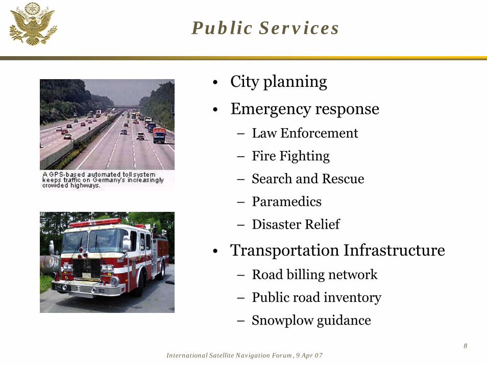
Public Services
• City planning
• Emergency response
– Law Enforcement
– Fire Fighting
– Search and Rescue
– Paramedics
– Disaster Relief
• Transportation Infrastructure
– Road billing network
– Public road inventory
– Snowplow guidance

9International Satellite Navigation Forum, 9 Apr 07
Construction
• Machinery, asset, and personnel management
• Rapid surveys for laying foundation piles, etc.
• Accident prevention
• Remote control of machinery possible
– Japanese volcano damGPS/RTK technology was used in the GPS/RTK technology was used in the construction of the construction of the ØØresundresund Bridge Bridge
between Denmark and Swedenbetween Denmark and Sweden

10International Satellite Navigation Forum, 9 Apr 07
Precision Agriculture
• Maximize use of resources– Optimized plowing of crop rows– Tailored applications of seeds,
fertilizer, water, pesticides– Improved management of land,
machinery, personnel, time– Greater crop yields– Net benefit: $5-14 per acre
• Minimize environmental impacts– Localized identification and
treatment of distressed crops reduces chemical use
– Precise leveling of fields prevents fluid runoff

11International Satellite Navigation Forum, 9 Apr 07
Summary
• The U.S. supports free access to civilian GNSS signals with public domain documentation necessary to develop user equipment
• GPS is a key component of the global information infrastructure – Compatible with other satellite navigation systems and
interoperable at the user level
– Guided at a national level as multi-use asset
– Acquired and operated by Air Force on behalf of the USG
• The U.S. promotes open competition and market growth for commercial GNSS equipment
GPS is a Global Public Service providing consistent, predictable, dependable performance

12International Satellite Navigation Forum, 9 Apr 07
Contact Information
Michael E. ShawDirector
U.S. National Coordination Office for Space-Based PNT 14th and Constitution Ave, N.W.
Washington, D.C. 20230
Ph: (202) 482-5809Fax: (202) 482-4429
Presentation and other GPS information available:www.PNT.gov

13International Satellite Navigation Forum, 9 Apr 07
Backups

14International Satellite Navigation Forum, 9 Apr 07
PNT.gov

15International Satellite Navigation Forum, 9 Apr 07
GPS.gov

16International Satellite Navigation Forum, 9 Apr 07
Automatic Vehicle Location
• Cargo Fleet Tracking– Improves safety and security
• Fleet Control/Dispatch– Increases fuel savings– Improves asset management
• Emergency Operations– Reduces response times – Reduces injury and property loss
• Road Maintenance• In Vehicle Navigation
– Determines accurate position – Reduces air pollution

17International Satellite Navigation Forum, 9 Apr 07
Surveying/Mapping
• Sub-centimeter accuracy
• 100%-300% savings in time, cost, & labor
– Control survey point: $10,000 in 1986; $250 in 1997
• Rural electrification
• Telecom tower placement
• Pipelines
• Oil, gas, and mineral exploration
• Flood plain mapping
• $3.12B market by 2003

18International Satellite Navigation Forum, 9 Apr 07
Scientific Research
• Monitoring geological change
– Glaciers, tectonic plates, earthquakes, volcanoes
• Wildlife behavior
• Atmospheric modeling
– Water vapor content
• Oceanic studies
– Tidal patterns
– Surface mapping
• Time transfer

19International Satellite Navigation Forum, 9 Apr 07
Recreational
• Portable receivers for fishermen, hunters, hikers, cyclists, etc.
• Recreational facilities --golf courses, ski resorts
• Integration of GPS into cellular phones
– E-911 requirement
• $3.8B market by 2003

20International Satellite Navigation Forum, 9 Apr 07
Timing
• GPS offers an inexpensive alternative to costly, high maintenance timing equipment
• Telecommunications network synchronization & management
– Phones, pagers, wireless systems
– LANs, WANs, Internet
• Financial transactions
• Electrical power grid management & fault location
• Digital signatures for e-commerce