Embed Size (px)
Citation preview

GO TO CONTENTS PAGE
CITY OF WANNEROO
District Planning Scheme No. 2
Updated to include AMD 185 GG 29/10/2021
Prepared by the
Department of Planning, Lands and Heritage
Original Town Planning Scheme Gazettal
6 July 2001
Disclaimer
This is a copy of the Local Planning Scheme produced from an electronic version of the Scheme held and maintained by the Department of Planning, Lands and Heritage. Whilst all care has been taken to accurately portray the current Scheme provisions, no responsibility shall be taken for any omissions or errors in this documentation.
Consultation with the respective Local Government Authority should be made to view a legal version of the Scheme.
Please advise the Department of Planning, Lands and Heritage of any errors or omissions in this document.
Department of Planning, Lands and Heritage Gordon Stephenson House 140 William Street Perth WA 6000
Locked Bag 2506 Perth WA 6001
website: www.dplh.wa.gov.au email: [email protected]
tel: 08 6551 9000 fax: 08 6551 9001 National Relay Service: 13 36 77 infoline: 1800 626 477

City of Wanneroo DPS 2 Page No. 2
CITY OF WANNEROO DPS 2 - SCHEME AMENDMENTS
AMD NO
GAZETTAL DATE
UPDATED DETAILS
WHEN BY
2 7/5/02 3/5/02 DH Schedule 3 - increasing the net lettable area of the Hocking Local Centre from 500m2 to 700m2.
6 5/7/02 15/7/02 DH Schedule 2 - adding additional use area item number 1-28 being “Lot 49 (56) St Andres Drive, Yanchep“ with an additional use “Shop not exceeding 44 square metres NLA.“
1 15/11/02 18/11/02 DH Schedule 13 - including Lot 23 Badgerup Road, Gnangara in the Description of Locality for Special Rural Zone 17. Schedule 13 - In Special Rural Zone 17 changing the building envelope figure in Special Provision No. 5 from 1,200m2 to 1,600m2. Schedule 13 - In Special Rural Zone 17 including new Special Provision No. 12. Modifying Development Guide Plan for Special Rural Zone No. 17 by including Lot 23 Badgerup Road.
8 18/2/03 26/2/03 DH Schedule 3 - deleting reference to the Mindarie Centre located on Part Lot 962.
4 4/3/03 5/3/03 DH Schedule 3 - adding reference to Locality Yanchep located on Portion of Lot 1010 on diagram DP27575, 65 Yanchep Beach, Road, Yanchep.
22 31/10/03 5/111/03 DH Part 4 – modifying clauses 4.23.1 to 4.23.3 and 4.23.6.
5 7/11/03 6/11/03 DH Schedule 3 – modifying text under column ‘Description of Centre and Commercial Zones’ the words and numbers [‘Part Lot 1001 on Plan 19619 (164) Tapping Way’ with ‘Portion of Lot 8002 Santa Barbara Parade’; and under column ‘NLA (m2) the number ‘3500’ with ‘500’.
31 25/11/03 24/11/03 DH Schedule 2 – modifying the additional use permitted for Lot 8 Mangano Place, Wanneroo from “Restaurant and Function Centre” to “child Care Centre”.
33 3/8/04 4/8/04 DH Schedule 12 – amending by inserting ‘Portion of Lot 2’ under Environmental Condition 2, Location of Land.
39 20/8/05 24/8/04 DH Schedule 3 – deleting the Ridgewood Centre, Pt Lot 31 on Plan 13337 (870) Connolly Drive and 3500m2 net lettable area for the Ridgewood Centre from Schedule 3 – Centres & Commercial Zones.
21 31/8/04 31/8/04 DH Schedule 2 – Section 1 – including “Number 1-29, Portion of lot 27 Wanneroo Road, Neerabup” (A29)

City of Wanneroo DPS 2 Page No. 3
AMD NO
GAZETTAL DATE
UPDATED DETAILS
WHEN BY
26 10/9/04 13/9/04 DH Schedule 14 - amending by including Special Provision (SP6) being Lot 51 (575) Flynn Drive, Carramar. Part 9 – inserting new Clause “9.1.3. Part 9 – modify clause 9.4 by replacing the first sentence in Clause 9.4.1. Part 9 – replace the second sentence in subclause 9.4.(a). Part 9 – replacing subclause 9.4.1(b). Part 9 – modify clause 9.4.2 by replacing ‘sixty (60)’ with ‘ninety (90)’. Part 9 – modify Clause 9.6.1(b. Part 9 – modify Clause 9.6.1(b)(i). Part 9 – modifying Clause 9.6.3(b). Part 9 - modifying Clause 9.6.3(c). Part 9 – modifying Clause 9.6.5. Part 9 – modifying Clause 9.6.5. Part 9 – inserting a new Clause 9.6.8. Part 9 – modify Clause 9.7. Part 9 – including the second sentence of Clause 9.7 as a new subclause 9.7.2. Part 9 – including the third sentence of Clause 9.7 as a new subclause 9.7.3. Part 9 – inserting a new subclause ‘Clause 9.7.4’. Part 9 – modify Clause 9.8.1 by: - before the word ‘date’ insert ‘later’. - after the word ‘date’ insert ‘when’. - replace the word ‘adopted’ with ‘either certified,’. - after the words ‘subclause 9.6.3’ insert ‘or adopted, signed and sealed by the Local government under subclause 9.6.5’. Part 9 – modify Clause 9.8.3(b) as follows: - after the word ‘however’ insert ‘notwithstanding the provisions of paragraph (f),’. - after the word ‘may’ insert ‘by a clear statement of intent to do so,’. Part 9 – modify Clause 9.8.3(f), Part 9 – modify Clause 9.11.1 as follows: - replace ‘and 3.15.3’ with ‘,3.15.3 and 3.23.2’. - delete the word ‘should’. - replace the word ‘shall’ with ‘should’. - insert ‘Rural Community,’ after ‘Marina,’. replace ‘this’ with the word ‘that’. Part 9 – modify Clause 9.12.3 by deleting ‘the Minister or’. Modify Schedule 7 as follows: - insert after the first sentence the words ‘The proponent should submit a schedule to the City including a summary detailing how the following matters in Parts A and B below have been addressed.’ - replacing (b) in Part A with the words ‘a site analysis assessment and key opportunities and constraints of the structure planning area including landform, topography, hydrology, landscape, vegetation, soils, conservation and heritage values, main physical/natural features, ownership, land use, roads and public transport, and services;’ - modify (c) in Part A by deleting the words ‘land reserved by’, inserting the words ‘consistency with’ before the words ‘the Metropolitan’, and inserting the words ‘and the City’s Scheme’ after the words ‘Region Scheme’. - replace (e) in Part A with the words ‘the planning context for the structure plan area including regional and neighbourhood structure, relevant strategies, Scheme provisions and policies and how the proposed Structure Plan is to be integrated into the surrounding area;’ - modify (f) in Part A by inserting ‘(including description & concepts)’ after the words ‘public open space’, insert ‘,mixed use, business, industrial’ before the words ‘and commercial’ and delete ‘(including the location and hierarchy of centres and the net lettable area of shops)’. -inserting the words ‘likely employment requirements of the population residing within the structure plan area, measures proposed to establish a framework to encourage and retain local employment,’ at the start of (h) in Part A. - modify (i) in Part A by inserting ‘locations,’ after the words ‘together with’, and after the words ‘retail floor space’ insert ‘and the maximum retail net lettable area to be developed’.
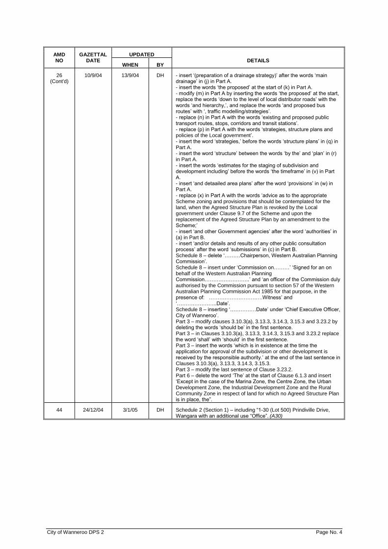
City of Wanneroo DPS 2 Page No. 4
AMD NO
GAZETTAL DATE
UPDATED DETAILS
WHEN BY
26 (Cont'd)
10/9/04 13/9/04 DH - insert ‘(preparation of a drainage strategy)’ after the words ‘main drainage’ in (j) in Part A. - insert the words ‘the proposed’ at the start of (k) in Part A. - modify (m) in Part A by inserting the words ‘the proposed’ at the start, replace the words ‘down to the level of local distributor roads’ with the words ‘and hierarchy,’, and replace the words ‘and proposed bus routes’ with ‘, traffic modelling/strategies’. - replace (n) in Part A with the words ‘existing and proposed public transport routes, stops, corridors and transit stations’. - replace (p) in Part A with the words ‘strategies, structure plans and policies of the Local government’. - insert the word ‘strategies,’ before the words ‘structure plans’ in (q) in Part A. - insert the word ‘structure’ between the words ‘by the’ and ‘plan’ in (r) in Part A. - insert the words ‘estimates for the staging of subdivision and development including’ before the words ‘the timeframe’ in (v) in Part A. - insert ‘and detaailed area plans’ after the word ‘provisions’ in (w) in Part A. - replace (x) in Part A with the words ‘advice as to the appropriate Scheme zoning and provisions that should be contemplated for the land, when the Agreed Structure Plan is revoked by the Local government under Clause 9.7 of the Scheme and upon the replacement of the Agreed Structure Plan by an amendment to the Scheme;’ - insert ‘and other Government agencies’ after the word ‘authorities’ in (a) in Part B. - insert ‘and/or details and results of any other public consultation process’ after the word ‘submissions’ in (c) in Part B. Schedule 8 – delete ‘………Chairperson, Western Australian Planning Commission’. Schedule 8 – insert under ‘Commission on………’ ‘Signed for an on behalf of the Western Australian Planning Commission……………………..’ and ‘an officer of the Commission duly authorised by the Commission pursuant to section 57 of the Western Australian Planning Commission Act 1985 for that purpose, in the presence of: ………………………….Witness’ and ‘…………………..Date’. Schedule 8 – inserting ‘……………Date’ under ‘Chief Executive Officer, City of Wanneroo’. Part 3 – modify clauses 3.10.3(a), 3.13.3, 3.14.3, 3.15.3 and 3.23.2 by deleting the words ‘should be’ in the first sentence. Part 3 – in Clauses 3.10.3(a), 3.13.3, 3.14.3, 3.15.3 and 3.23.2 replace the word ‘shall’ with ‘should’ in the first sentence. Part 3 – insert the words ‘which is in existence at the time the application for approval of the subdivision or other development is received by the responsible authority.’ at the end of the last sentence in Clauses 3.10.3(a), 3.13.3, 3.14.3, 3.15.3. Part 3 – modify the last sentence of Clause 3.23.2. Part 6 – delete the word ‘The’ at the start of Clause 6.1.3 and insert ‘Except in the case of the Marina Zone, the Centre Zone, the Urban Development Zone, the Industrial Development Zone and the Rural Community Zone in respect of land for which no Agreed Structure Plan is in place, the”.
44 24/12/04 3/1/05 DH Schedule 2 (Section 1) – including “1-30 (Lot 500) Prindiville Drive, Wangara with an additional use “Office”. (A30)

City of Wanneroo DPS 2 Page No. 5
AMD NO
GAZETTAL DATE
UPDATED DETAILS
WHEN BY
17 21/1/05 24/1/05 DH Part 3 – modifying subclause 3.183(e) by replacing the words “Clause 4.7” with “Clause 4.2”. Part 4 – modifying Clause 4.2 heading and subclause 4.2.1 by replacing the term “design standards” with the term “development standards” in the Clause 4.2 heading (and including Contents page) and subclause 4.2.1. Part 4 – modifying Clause 4.2 by replacing “Clause 3.13.4 and 3.13.5” with “Subclause 3.13.5 and 3.13.6” in subclause 4.2.1. Part 4 – modifying clause 4.2.1 by replacing the term “the density requirements of the Residential Planning Codes” with the term “housing density requirements of the Residential Design Codes”. Part 4 – modifying subclauses 4.5.1 and 4.6.3.2 by deleting the phrase “Minimum area of lot per dwelling prescribed in Column 3, Table 1 of” and replace it with “housing density requirements”. Part 4 – modifying Clause 4.8 by adding the phrase “of a high standard of architectural design and” following “non residential development shall be”. Part 4 – modifying Clause 4.23 in subclause 4.23.5 by adding at the end of the last sentence “or other location on the lot as approved by Local government under subclause 4.23.6.” Part 4 – modifying in subclause 4.23.6 by replacing the words “subclause 4.23.3(b), (d) and (l)” with “subclause 4.23.3 (b), (d), (e), (k) and (l)”, and replacing the words “in writing” with “upon application for planning approval”. Schedule 1 – amend definition for “commercial vehicle” by moving the sentence commencing with the phrase “The term shall not include…” to the end of the definition. Table 1 – modify by – - introducing the use class “Market Garden Sales” into the table as a discretionary (D) use in the General Rural and Resource Zones only and an “X” use in all other zones; - by adding “3.23 The Rural Community Zone” to the list at the end of the Table. Schedule 1 – adding statement “this Schedule comprises two sets of definitions, 1. General Definitions and 2. Land Use Definitions” after the title Schedule 1 – Interpretations. Schedule 1 – adding “1.” before the heading “General Definitions” and “2.” before the heading “Land Use Definitions”. Schedule 1 – adding a new definitions “market garden sales” and “woodyard” in Land Use Definitions. Schedule 1 – amending the definition for “Bed and breakfast”. Schedule 1 – deleting the definitions of “communication antenna – domestic” and “Communication antenna – commercial”. Schedule 1 – deleting the definition of “consulting rooms” and replacing it with new definition “consulting room”. Schedule 1 – amending definition of “storage yard” and “marina wall”. Table 1 & Table 2 – modifying by amending the land use “consulting rooms” to read “consulting room”. Table of Contents – modifying table of contents to refer to Schedule 1 – Interpretations as comprising two sets of definitions, “1. General Definitions and 2. Land Use Definitions”. Schedule 2 – modifying Section 1 by deleting the listings under reference numbers “1.10, 1.11, 1.12, 1.13 and 1.22”. Schedule 9 – modifying clause 2.0, point 3 by adding “, or in the administration of Part 10 of the Scheme” at the end of the clause. Schedule 9 – modifying clause 2.0, point 4 by adding the words “treatments and” following the word “intersection”. Schedule 9 – modifying clause 3.0, first paragraph by adding the words “intersection treatments,” following “dual use paths,”. Part 10 – modifying subclause 10.6.5 by deleting the following “which are zoned for General and Light Industry and Mixed Business purposes”. Part 10 – modifying subclause 10.5.6 by replacing rhe words “shall only” with “may” and including the text “,or at a time as the Local government determines having regard to the principles outlined in Clause 10.3 and within a 5 year period from the date of the contribution from the owner under Clause 10.10.6.”

City of Wanneroo DPS 2 Page No. 6
AMD NO
GAZETTAL DATE
UPDATED DETAILS
WHEN BY
17 (Cont’d)
Part 10 – modifying subclause 10.5.3 by deleting existing formula “S =
G H x 100” and inserting “S = (GH) x V”. Part 10 – modifying subclause 10.5.3 by inserting “V = value of the reserve, subject to subclause 10.5.3(b)” after the description of value G. Part 10 – modifying subclause 10.5.3 by deleting the words “…that the” and inserting the phrase “…, subject to subclause 10.5.3(b), that the area of the …” after “…the reserve” in line 5. Part 10 - modifying subclause 10.5.3 by inserting the phrase “…, subject to subclause 10.5.3(b),…” after “…a Reserve” in the description of value S. Part 10 - modifying subclause 10.5.3 by deleting the description of value G and insert “G =- the area of the owner’s land within the historic subdivision area.” Part 10 - modifying subclause 10.5.3 by denoting the last sentence of the subclause, commencing “the area of a reserve…” as subclause (b), and the preceding section of the subclause as subclause (a). Schedule 2 – including the eastern portion of Lot 888 Prindiville Drive, Wangara in site reference number 1.17 – Additional use (Markets) of Section 1. Part 3 – renumbering subclause 3.16.3(a) and 3.17.3(a) as subclauses 3.16.3 and 3.17.3 , and renumbering the remainder of subclauses 3.16.3(b), (c), (d) and (e) and 3.17.3 (b), (c), (d) and (e), including the preambles, as subclauses 3.16.4 (a), (b), (c) and (d) and 3.17.4 (a), (b), (c) and (d). Note: there are no clauses 3.16.4 or 3.17.4. Part 10 – modifying subclause 10.10.4 by deleting the words commencing in line two “final approval by the Minister for Planning and publication of Amendment No. 816 in the Government Gazette and”. Part 10 – modifying subclause 10.10.4 by deleting the words “Amendment 816 and” from the seventh line. Part 10 – modifying subclause 10.10.4 by replacing the word “come” in the eighth line with the word “came”. Part 10 – modifying subclause 10.10.4 by deleting the words “Amendment No. 816 and” from the twelfth line and replacing the words “have come” in the thirteenth line with the word “came”. Part 10 – modifying subclause 10.10.5 by deleting the words “Amendment No. 816 and”. Part 10 – modifying clause 10.11 by deleting the phrase “Upon final approval by the Minister for Planning and publication of Amendment No. 816 in the Government Gazette and…”. Schedule 9, section 2.0 point 8 – modify by replacing the words “Scheme Amendment Nos 773 and 816 introducing these provisions” with “East Wanneroo planning and developer contribution arrangement provisions either under this scheme or former Town Planning Scheme No. 1”. Schedule 15, Rural Community Zone 1 – modify by deleting current Special Provision 1.1.2(l) and adding “Nutrient attenuating onsite effluent disposal systems shall be required within this zone to the satisfaction of the City of Wanneroo.”. Schedule 14 - deleting Special Provision No. 2 to Special Residential Zone No. 2.
38 21/10/05 1/11/05 DH Part 4 – including new Clause “4.24 Protection and Relocation of Native Fauna”.
49 11/11/05 14/11/05 DH Table 1 – modifying the use class “Ancillary Accommodation” from not permitted (X) to a discretionary (D) use in the General Rural, Rural Resource, Special Rural and Special Residential zones.
54 6/1/06 11/1/06 DH Schedule 2, Section 1 – deleting the listing under reference number 1.14. Schedule 3 – Centre & Commercial Zones – modifying by inserting “Wanneroo Local Centre (Villanova Street), Lot 5 Villanova Street, Wanneroo, NLA(m2) 700”
46 7/2/06 8/2/06 DH Schedule 2, Section 1 – adding additional use “Portion of Lot 6278, 2632 Wanneroo Road, Nowergup”. (A31)
City of Wanneroo DPS 2 Page No. 7
AMD NO
GAZETTAL DATE
UPDATED DETAILS
WHEN BY
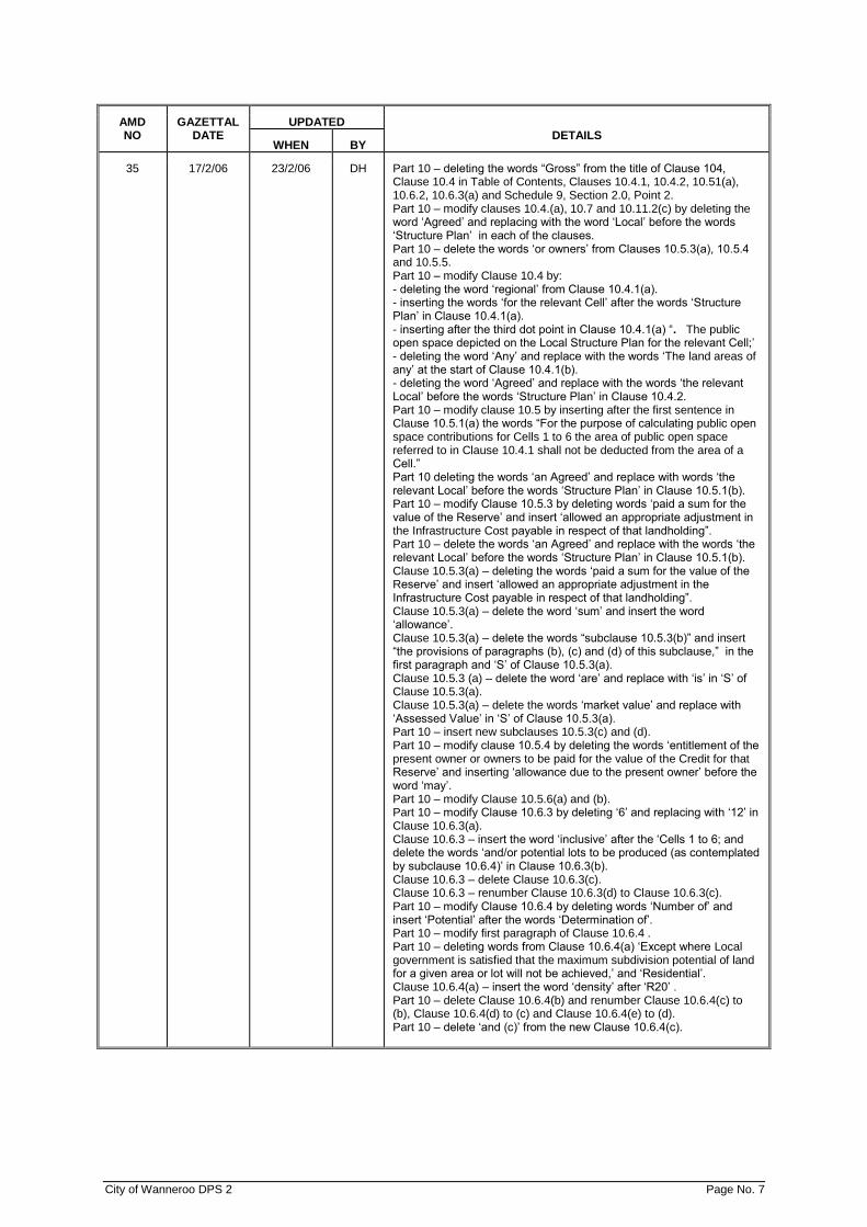
35 17/2/06 23/2/06 DH Part 10 – deleting the words “Gross” from the title of Clause 104, Clause 10.4 in Table of Contents, Clauses 10.4.1, 10.4.2, 10.51(a), 10.6.2, 10.6.3(a) and Schedule 9, Section 2.0, Point 2. Part 10 – modify clauses 10.4.(a), 10.7 and 10.11.2(c) by deleting the word ‘Agreed’ and replacing with the word ‘Local’ before the words ‘Structure Plan’ in each of the clauses. Part 10 – delete the words ‘or owners’ from Clauses 10.5.3(a), 10.5.4 and 10.5.5. Part 10 – modify Clause 10.4 by: - deleting the word ‘regional’ from Clause 10.4.1(a). - inserting the words ‘for the relevant Cell’ after the words ‘Structure Plan’ in Clause 10.4.1(a). - inserting after the third dot point in Clause 10.4.1(a) “. The public open space depicted on the Local Structure Plan for the relevant Cell;’ - deleting the word ‘Any’ and replace with the words ‘The land areas of any’ at the start of Clause 10.4.1(b). - deleting the word ‘Agreed’ and replace with the words ‘the relevant Local’ before the words ‘Structure Plan’ in Clause 10.4.2. Part 10 – modify clause 10.5 by inserting after the first sentence in Clause 10.5.1(a) the words “For the purpose of calculating public open space contributions for Cells 1 to 6 the area of public open space referred to in Clause 10.4.1 shall not be deducted from the area of a Cell.” Part 10 deleting the words ‘an Agreed’ and replace with words ‘the relevant Local’ before the words ‘Structure Plan’ in Clause 10.5.1(b). Part 10 – modify Clause 10.5.3 by deleting words ‘paid a sum for the value of the Reserve’ and insert ‘allowed an appropriate adjustment in the Infrastructure Cost payable in respect of that landholding”. Part 10 – delete the words ‘an Agreed’ and replace with the words ‘the relevant Local’ before the words ‘Structure Plan’ in Clause 10.5.1(b). Clause 10.5.3(a) – deleting the words ‘paid a sum for the value of the Reserve’ and insert ‘allowed an appropriate adjustment in the Infrastructure Cost payable in respect of that landholding”. Clause 10.5.3(a) – delete the word ‘sum’ and insert the word ‘allowance’. Clause 10.5.3(a) – delete the words “subclause 10.5.3(b)” and insert “the provisions of paragraphs (b), (c) and (d) of this subclause,” in the first paragraph and ‘S’ of Clause 10.5.3(a). Clause 10.5.3 (a) – delete the word ‘are’ and replace with ‘is’ in ‘S’ of Clause 10.5.3(a). Clause 10.5.3(a) – delete the words ‘market value’ and replace with ‘Assessed Value’ in ‘S’ of Clause 10.5.3(a). Part 10 – insert new subclauses 10.5.3(c) and (d). Part 10 – modify clause 10.5.4 by deleting the words ‘entitlement of the present owner or owners to be paid for the value of the Credit for that Reserve’ and inserting ‘allowance due to the present owner’ before the word ‘may’. Part 10 – modify Clause 10.5.6(a) and (b). Part 10 – modify Clause 10.6.3 by deleting ‘6’ and replacing with ‘12’ in Clause 10.6.3(a). Clause 10.6.3 – insert the word ‘inclusive’ after the ‘Cells 1 to 6; and delete the words ‘and/or potential lots to be produced (as contemplated by subclause 10.6.4)’ in Clause 10.6.3(b). Clause 10.6.3 – delete Clause 10.6.3(c). Clause 10.6.3 – renumber Clause 10.6.3(d) to Clause 10.6.3(c). Part 10 – modify Clause 10.6.4 by deleting words ‘Number of’ and insert ‘Potential’ after the words ‘Determination of’. Part 10 – modify first paragraph of Clause 10.6.4 . Part 10 – deleting words from Clause 10.6.4(a) ‘Except where Local government is satisfied that the maximum subdivision potential of land for a given area or lot will not be achieved,’ and ‘Residential’. Clause 10.6.4(a) – insert the word ‘density’ after ‘R20’ . Part 10 – delete Clause 10.6.4(b) and renumber Clause 10.6.4(c) to (b), Clause 10.6.4(d) to (c) and Clause 10.6.4(e) to (d). Part 10 – delete ‘and (c)’ from the new Clause 10.6.4(c).

City of Wanneroo DPS 2 Page No. 8
AMD NO
GAZETTAL DATE
UPDATED DETAILS
WHEN BY
35 (Cont'd)
17/2/06 23/2/06 DH Part 10 – modify new clause 10.6.4(d) by changing reference to ’10.6.4(d) to ’10.6.4.(c)’ and inserting the word ‘subclause’ after the word ‘this’. Clause 10.7 – modify by: - inserting the words ‘and/or density’ after the words ‘any use’ and ‘for the purpose’. - delete the words ‘proposed to be’. - Following the phrase “...Cell Costs have previously been paid” add the phrase “under clause 10.6 hereof”. Clause 10.10 modify by: - delete “10.10.6” and insert “10.10.5” in Clause 10.10.3. - Delete “10.10.6(d) and insert “10.10.5(d)” in the last sentence of Clause 10.10.4. - Delete the words “Agreed” in Clause 10.10.4. - Delete Clause 10.10.5 and renumber Clause “10.10.6” to 10.10.5”. - Delete the word ‘the’ and insert the words ‘a conventional green title, survey strata or strata’ before the ‘subdivision’ in the new Clause 10.10.5. - insert the words ‘deposited plan’ before the word ‘diagram’ and include the words ‘diagram of survey’ in brackets ‘(diagram of survey)’ in the new Clause 10.10.5. - Delete the word ‘of’ and insert the word ‘to’ before ‘Regulation’ in the new Clause 10.10.5. - delete “10.106(d)” and insert “10.10.5(d)” in the new Clause 10.10.5(d). Part 10 – insert a new Clause “Clause 10.10.6”. Part 10 – modify by: - deleting first two paragraphs between the title of Clause 10.11 and Clause 10.11.1. Part 10 – modify Clause 10.11.3 by: - deleting the words ‘to be acquired’ and ‘fair market’. - inserting the words “The Local government may also apply a further among above the Assessed Value to recognize any compulsory taking of land and/or acquisition of structures.” after the last sentence. Part 10 – modify Clause 10.11.6 by: - after the word ‘review’ inserting “, other than the Assessed Value which shall be dealt with under Clause 10.14. An owner who lodges an objection under this clause shall submit with the objection supporting evidence from a suitably qualified person in the specific field of the cost revision being objected to and can only object to those elements that have been altered as part of the review.”. - between the words ‘Local government’ and ‘during’ insert the words ‘in accordance with this subclause’. - between the words ‘Local government’ and ‘during’ insert the words ‘in accordance with this subclause’. - after the last sentence in Clause 10.11.6 insert the words “The arbitrator shall be bound by the provisions of Part 10 and Schedule 9 of the Scheme and the Local Structure Plan for that Cell.”. Part 10 – modify Clause 10.12 by: - modifying the last sentence of Clause 10.12.2 to read “Local government will endeavour to respond to an owner’s claim within 60 days.”. - deleting Clause 10.12.6(b) and renumbering Clause “10.12.6(a)” to “10.12.6”. Clause 10.14 modify by: - modify Clause 10.14.2 by replacing the word ‘shall’ with ‘may’ between the words ‘the Local government’ and ‘claim compensation’. - modifying Clause 10.14.2 by deleting words ‘Land Acquisition and Public Works Act 1902’ and inserting ‘Land Administration Act 1997’. - delete Clause 10.14.3(a) and renumber the subclause 10.14.3(b) to (a). Part 10 – modify new Clause 10.14.3(a) by: - deleting the words “the carrying out of Cell Works’ and insert ‘any purpose’. - deleting the words ‘a licensed valuer’ and inserting ‘two licensed valuers”.
City of Wanneroo DPS 2 Page No. 9
AMD NO
GAZETTAL DATE
UPDATED DETAILS
WHEN BY
35 (Cont'd)
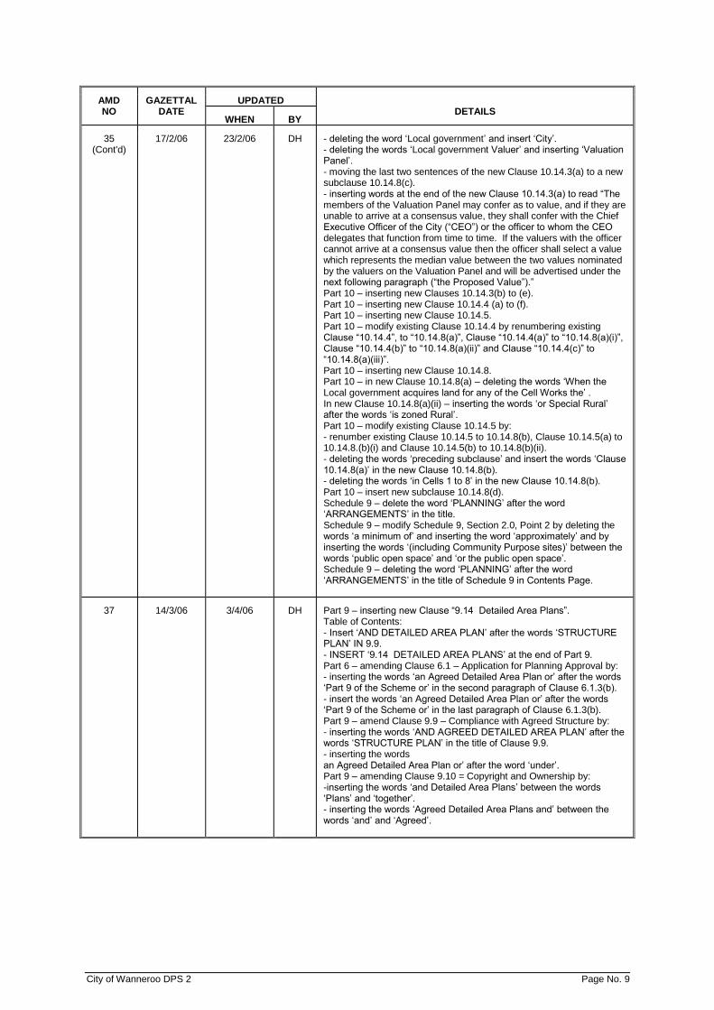
17/2/06 23/2/06 DH - deleting the word ‘Local government’ and insert ‘City’. - deleting the words ‘Local government Valuer’ and inserting ‘Valuation Panel’. - moving the last two sentences of the new Clause 10.14.3(a) to a new subclause 10.14.8(c). - inserting words at the end of the new Clause 10.14.3(a) to read “The members of the Valuation Panel may confer as to value, and if they are unable to arrive at a consensus value, they shall confer with the Chief Executive Officer of the City (“CEO”) or the officer to whom the CEO delegates that function from time to time. If the valuers with the officer cannot arrive at a consensus value then the officer shall select a value which represents the median value between the two values nominated by the valuers on the Valuation Panel and will be advertised under the next following paragraph (“the Proposed Value”).” Part 10 – inserting new Clauses 10.14.3(b) to (e). Part 10 – inserting new Clause 10.14.4 (a) to (f). Part 10 – inserting new Clause 10.14.5. Part 10 – modify existing Clause 10.14.4 by renumbering existing Clause “10.14.4”, to “10.14.8(a)”, Clause “10.14.4(a)” to “10.14.8(a)(i)”, Clause “10.14.4(b)” to “10.14.8(a)(ii)” and Clause “10.14.4(c)” to “10.14.8(a)(iii)”. Part 10 – inserting new Clause 10.14.8. Part 10 – in new Clause 10.14.8(a) – deleting the words ‘When the Local government acquires land for any of the Cell Works the’ . In new Clause 10.14.8(a)(ii) – inserting the words ‘or Special Rural’ after the words ‘is zoned Rural’. Part 10 – modify existing Clause 10.14.5 by: - renumber existing Clause 10.14.5 to 10.14.8(b), Clause 10.14.5(a) to 10.14.8.(b)(i) and Clause 10.14.5(b) to 10.14.8(b)(ii). - deleting the words ‘preceding subclause’ and insert the words ‘Clause 10.14.8(a)’ in the new Clause 10.14.8(b). - deleting the words ‘in Cells 1 to 8’ in the new Clause 10.14.8(b). Part 10 – insert new subclause 10.14.8(d). Schedule 9 – delete the word ‘PLANNING’ after the word ‘ARRANGEMENTS’ in the title. Schedule 9 – modify Schedule 9, Section 2.0, Point 2 by deleting the words ‘a minimum of’ and inserting the word ‘approximately’ and by inserting the words ‘(including Community Purpose sites)’ between the words ‘public open space’ and ‘or the public open space’. Schedule 9 – deleting the word ‘PLANNING’ after the word ‘ARRANGEMENTS’ in the title of Schedule 9 in Contents Page.
37 14/3/06 3/4/06 DH Part 9 – inserting new Clause “9.14 Detailed Area Plans”. Table of Contents: - Insert ‘AND DETAILED AREA PLAN’ after the words ‘STRUCTURE PLAN’ IN 9.9. - INSERT ‘9.14 DETAILED AREA PLANS’ at the end of Part 9. Part 6 – amending Clause 6.1 – Application for Planning Approval by: - inserting the words ‘an Agreed Detailed Area Plan or’ after the words ‘Part 9 of the Scheme or’ in the second paragraph of Clause 6.1.3(b). - insert the words ‘an Agreed Detailed Area Plan or’ after the words ‘Part 9 of the Scheme or’ in the last paragraph of Clause 6.1.3(b). Part 9 – amend Clause 9.9 – Compliance with Agreed Structure by: - inserting the words ‘AND AGREED DETAILED AREA PLAN’ after the words ‘STRUCTURE PLAN’ in the title of Clause 9.9. - inserting the words an Agreed Detailed Area Plan or’ after the word ‘under’. Part 9 – amending Clause 9.10 = Copyright and Ownership by: -inserting the words ‘and Detailed Area Plans’ between the words ‘Plans’ and ‘together’. - inserting the words ‘Agreed Detailed Area Plans and’ between the words ‘and’ and ‘Agreed’.

City of Wanneroo DPS 2 Page No. 10
AMD NO
GAZETTAL DATE
UPDATED DETAILS
WHEN BY
37 (Cont'd)
14/3/06 3/4/06 DH Part 9 – amending Clause 9.12 – Reconsideration and Appeal by: - inserting the words ‘or a Detailed Area Plan’ between the words ‘Plan’ and ‘in the exercise’ in Clause 9.12.3. -inserting the words ‘or the Detailed Area Plan’ between the words ‘Plan’ and ‘is dissatisfied’ in Clause 9.12.3. - inserting the words ‘or the Detailed Area Plan’ between the words ‘Structure Plan’ and ‘is’ in Clause 9.12.6. Schedule 1 – amending the definition of ‘Proponent’ by: - inserting the words ‘or a Detailed Area Plan’ between the words ‘Plan’ and ‘or’. - inserting the words ‘or a Detailed Area Plan’ between the words ‘Plan’ and ‘under’. Schedule 1 – after the definition of ‘density code’ inserting definition “Detailed Area Plan”. - inserting definition ‘Agreed Detailed Area Plan” after the definition of ‘advertising device’.
52 16/6/06 26/6/06 DH Part 3 – modifying subclause 3.7.1 by inserting words ‘or proposed’ following words ‘is intended to accommodate existing’. Part 3 – modifying subclause 3.7.2(a) by inserting the words ‘or proposed’ following words ‘make provision for existing’. Part 4 – renumbering clause 4.8 to subclause 4.8.1. Part 4 – inserting new subclause 4.8.2. Part 4 – modifying subclause 4.23.3(b) by inserting the zone ‘Special Residential,’ before the zone ‘Special Rural’. Part 6 – modifying subclause 6.10.1 by deleting ‘,or the Minister’ and replacing the words ‘Town Planning Appeal Tribunal’ with the words ‘State Administrative Tribunal’. Part 6 – modifying subclause 6.11 by deleting the words ‘the Minister or’ after the words ‘given by’ and ‘imposed by’ and replacing the words ‘Town Planning Appeal Tribunal’ with ‘State Administrative Tribunal’. Part 9 – modifying subclause 9.12.3 by replacing the words ‘Town Planning Appeal Tribunal’ with words ‘State Administrative Tribunal’. Part 9 – modifying subclause 9.12.2 by replacing ’35’ days with ‘60’ days. Part 11 – modifying subclause 11.4.6.2 by replacing word ‘must’ with the word ‘should’. Table 1 – modifying use class ‘Pharmacy’ from an ‘X’ use in the Mixed use and Business zones to a ‘D’ use. Table 1 – renaming use class ‘Mast and Antenna’ to ‘Mast or Antenna’. Table 2 – modifying number of on-site car parking spaces in use class ‘Primary School’ to read “A minimum of 46 car bays for staff and visitor parking for the first 475 students and then ten (10) car bays for every 100 students or part thereof afterwards, plus fourteen (14) pickup/set down bays for every 100 students or part thereof which may be provided in the road reserve.” Table 2 – modifying use class ‘Secondary School’. Table 2 – modifying number of on-site car parking spaces from ‘see Child Care Centre’ for use class ‘Kindergarten’ to read “Provision of a drive-in pickup/set down facility plus eight (8) bays.’ Schedule 1 – deleting “(See “communications antenna”.)” from definition of ‘mast or antenna”. Schedule 1 – amending definition ‘medical centre’ by deleting the phrase ‘ ‘and may include ancillary uses such as a pathologist, radiologist and pharmacy.” Schedule 1 – renaming definition of ‘markets (retail)” to “market (retail)”. Schedule 1 – renaming definition of ‘motor vehicle repair’ to ‘motor vehicle repairs’. Modifying clauses and subclauses 1.9.1, 1.9.2, 1.9.3, 3.4.2, 4.2.1, 4.4, 4.4.1, 4.4.2, 4.4.3, 4.4.4, 4.4.6, 4.4.7, 4.5 and 4.21.1 by replacing the word ‘Planning’ before the word ‘Codes’ with the word ‘Design’. Part 4 and 5 – modifying titles of Clauses 4.4 and 4.5 and titles in contents page of Clauses 4.4 and 4.5 by replacing the word ‘Planning’ before the word ‘Codes’ with the word ‘Design’.
City of Wanneroo DPS 2 Page No. 11
AMD NO
GAZETTAL DATE
UPDATED DETAILS
WHEN BY
52 (Cont’d)
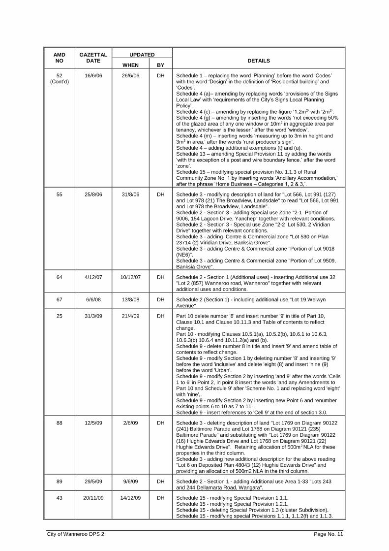
16/6/06 26/6/06 DH Schedule 1 – replacing the word ‘Planning’ before the word ‘Codes’ with the word ‘Design’ in the definition of ‘Residential building’ and ‘Codes’. Schedule 4 (a)– amending by replacing words ‘provisions of the Signs Local Law’ with ‘requirements of the City’s Signs Local Planning Policy’. Schedule 4 (c) – amending by replacing the figure ‘1.2m2’ with ‘2m2’. Schedule 4 (g) – amending by inserting the words ‘not exceeding 50% of the glazed area of any one window or 10m2 in aggregate area per tenancy, whichever is the lesser,’ after the word ‘window’. Schedule 4 (m) – inserting words ‘measuring up to 3m in height and 3m2 in area,’ after the words ‘rural producer’s sign’. Schedule 4 – adding additional exemptions (t) and (u). Schedule 13 – amending Special Provision 11 by adding the words ‘with the exception of a post and wire boundary fence.’ after the word ‘zone’. Schedule 15 – modifying special provision No. 1.1.3 of Rural Community Zone No. 1 by inserting words ‘Ancillary Accommodation,’ after the phrase ‘Home Business – Categories 1, 2 & 3,’.
55 25/8/06 31/8/06 DH Schedule 3 - modifying description of land for "Lot 566, Lot 991 (127) and Lot 978 (21) The Broadview, Landsdale" to read "Lot 566, Lot 991 and Lot 978 the Broadview, Landsdale". Schedule 2 - Section 3 - adding Special use Zone "2-1 Portion of 9006, 154 Lagoon Drive, Yanchep" together with relevant conditions. Schedule 2 - Section 3 - Special use Zone "2-2 Lot 530, 2 Viridian Drive" together with relevant conditions. Schedule 3 - adding :Centre & Commercial zone "Lot 530 on Plan 23714 (2) Viridian Drive, Banksia Grove". Schedule 3 - adding Centre & Commercial zone "Portion of Lot 9018 (NE6)". Schedule 3 - adding Centre & Commercial zone "Portion of Lot 9509, Banksia Grove".
64 4/12/07 10/12/07 DH Schedule 2 - Section 1 (Additional uses) - inserting Additional use 32 "Lot 2 (857) Wanneroo road, Wanneroo" together with relevant additional uses and conditions.
67 6/6/08 13/8/08 DH Schedule 2 (Section 1) - including additional use "Lot 19 Welwyn Avenue"
25 31/3/09 21/4/09 DH Part 10 delete number '8' and insert number '9' in title of Part 10, Clause 10.1 and Clause 10.11.3 and Table of contents to reflect change. Part 10 - modifying Clauses 10.5.1(a), 10.5.2(b), 10.6.1 to 10.6.3, 10.6.3(b) 10.6.4 and 10.11.2(a) and (b). Schedule 9 - delete number 8 in title and insert '9' and amend table of contents to reflect change. Schedule 9 - modify Section 1 by deleting number '8' and inserting '9' before the word 'inclusive' and delete 'eight (8) and insert 'nine (9) before the word 'Urban'. Schedule 9 - modify Section 2 by inserting 'and 9' after the words 'Cells 1 to 6' in Point 2, in point 8 insert the words 'and any Amendments to Part 10 and Schedule 9' after 'Scheme No. 1 and replacing word 'eight' with 'nine',. Schedule 9 - modify Section 2 by inserting new Point 6 and renumber existing points 6 to 10 as 7 to 11. Schedule 9 - insert references to 'Cell 9' at the end of section 3.0.
88 12/5/09 2/6/09 DH Schedule 3 - deleting description of land "Lot 1769 on Diagram 90122 (241) Baltimore Parade and Lot 1768 on Diagram 90121 (235) Baltimore Parade" and substituting with "Lot 1769 on Diagram 90122 (16) Hughie Edwards Drive and Lot 1768 on Diagram 90121 (22) Hughie Edwards Drive". Retaining allocation of 500m2 NLA for these properties in the third column. Schedule 3 - adding new additional description for the above reading "Lot 6 on Deposited Plan 48043 (12) Hughie Edwards Drive" and providing an allocation of 500m2 NLA in the third column.
89 29/5/09 9/6/09 DH Schedule 2 - Section 1 - adding Additional use Area 1-33 "Lots 243 and 244 Dellamarta Road, Wangara".
43 20/11/09 14/12/09 DH Schedule 15 - modifying Special Provision 1.1.1. Schedule 15 - modifying Special Provision 1.2.1. Schedule 15 - deleting Special Provision 1.3 (cluster Subdivision). Schedule 15 - modifying special Provisions 1.1.1, 1.1.2(f) and 1.1.3.
City of Wanneroo DPS 2 Page No. 12
AMD NO
GAZETTAL DATE
UPDATED DETAILS
WHEN BY
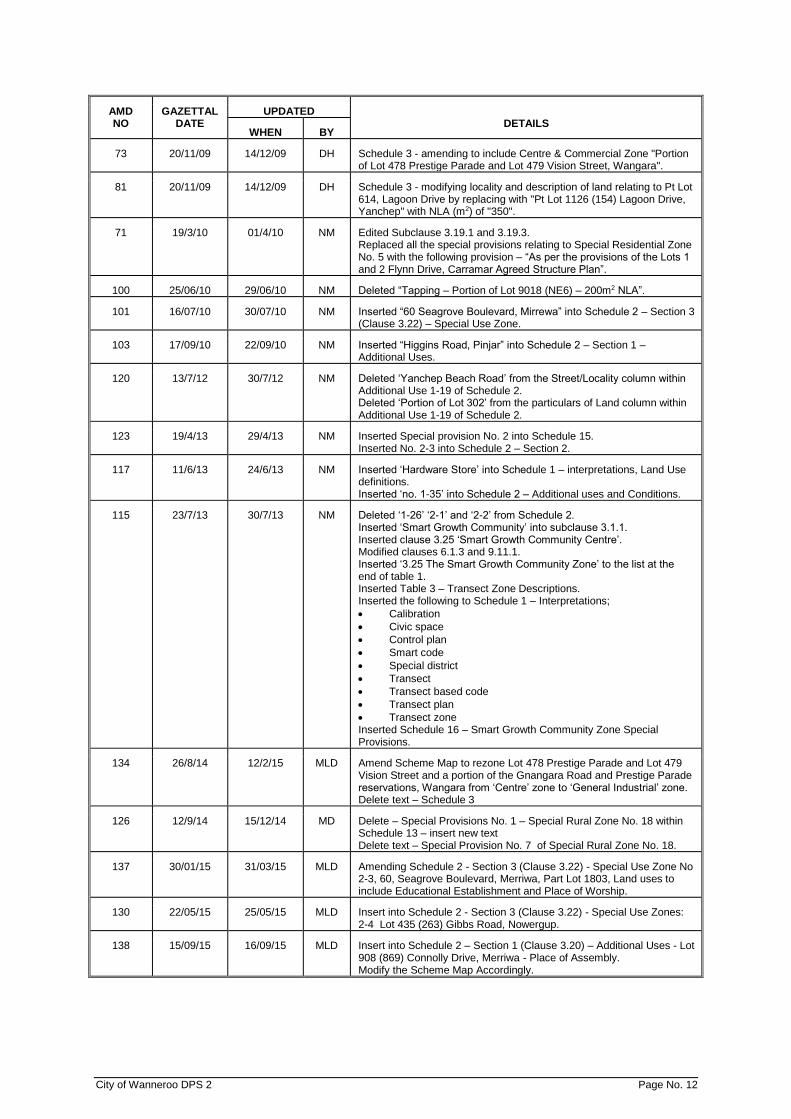
73 20/11/09 14/12/09 DH Schedule 3 - amending to include Centre & Commercial Zone "Portion of Lot 478 Prestige Parade and Lot 479 Vision Street, Wangara".
81 20/11/09 14/12/09 DH Schedule 3 - modifying locality and description of land relating to Pt Lot 614, Lagoon Drive by replacing with "Pt Lot 1126 (154) Lagoon Drive, Yanchep" with NLA (m2) of "350".
71 19/3/10 01/4/10 NM Edited Subclause 3.19.1 and 3.19.3. Replaced all the special provisions relating to Special Residential Zone No. 5 with the following provision – “As per the provisions of the Lots 1 and 2 Flynn Drive, Carramar Agreed Structure Plan”.
100 25/06/10 29/06/10 NM Deleted “Tapping – Portion of Lot 9018 (NE6) – 200m2 NLA”.
101 16/07/10 30/07/10 NM Inserted “60 Seagrove Boulevard, Mirrewa” into Schedule 2 – Section 3 (Clause 3.22) – Special Use Zone.
103 17/09/10 22/09/10 NM Inserted “Higgins Road, Pinjar” into Schedule 2 – Section 1 – Additional Uses.
120 13/7/12 30/7/12 NM Deleted ‘Yanchep Beach Road’ from the Street/Locality column within Additional Use 1-19 of Schedule 2. Deleted ‘Portion of Lot 302’ from the particulars of Land column within Additional Use 1-19 of Schedule 2.
123 19/4/13 29/4/13 NM Inserted Special provision No. 2 into Schedule 15. Inserted No. 2-3 into Schedule 2 – Section 2.
117 11/6/13 24/6/13 NM Inserted ‘Hardware Store’ into Schedule 1 – interpretations, Land Use definitions. Inserted ‘no. 1-35’ into Schedule 2 – Additional uses and Conditions.
115 23/7/13 30/7/13 NM Deleted ‘1-26’ ‘2-1’ and ‘2-2’ from Schedule 2. Inserted ‘Smart Growth Community’ into subclause 3.1.1. Inserted clause 3.25 ‘Smart Growth Community Centre’. Modified clauses 6.1.3 and 9.11.1. Inserted ‘3.25 The Smart Growth Community Zone’ to the list at the end of table 1. Inserted Table 3 – Transect Zone Descriptions. Inserted the following to Schedule 1 – Interpretations;
• Calibration
• Civic space
• Control plan
• Smart code
• Special district
• Transect
• Transect based code
• Transect plan
• Transect zone Inserted Schedule 16 – Smart Growth Community Zone Special Provisions.
134 26/8/14 12/2/15 MLD Amend Scheme Map to rezone Lot 478 Prestige Parade and Lot 479 Vision Street and a portion of the Gnangara Road and Prestige Parade reservations, Wangara from ‘Centre’ zone to ‘General Industrial’ zone. Delete text – Schedule 3
126 12/9/14 15/12/14 MD Delete – Special Provisions No. 1 – Special Rural Zone No. 18 within Schedule 13 – insert new text Delete text – Special Provision No. 7 of Special Rural Zone No. 18.
137 30/01/15 31/03/15 MLD Amending Schedule 2 - Section 3 (Clause 3.22) - Special Use Zone No 2-3, 60, Seagrove Boulevard, Merriwa, Part Lot 1803, Land uses to include Educational Establishment and Place of Worship.
130 22/05/15 25/05/15 MLD Insert into Schedule 2 - Section 3 (Clause 3.22) - Special Use Zones: 2-4 Lot 435 (263) Gibbs Road, Nowergup.
138 15/09/15 16/09/15 MLD Insert into Schedule 2 – Section 1 (Clause 3.20) – Additional Uses - Lot 908 (869) Connolly Drive, Merriwa - Place of Assembly. Modify the Scheme Map Accordingly.

City of Wanneroo DPS 2 Page No. 13
AMD NO
GAZETTAL DATE
UPDATED DETAILS
WHEN BY
128 11/09/15 07/10/15 HB Rezoning Lot 4, 5 and 888 Prindiville Drive and Lot 897, 898 Irwin Road to 'Special Use'; Modifying Schedule 2 - Section 1 by deleting Additional Use No. 1-17. Modifying Schedule 3 by deleting the entry relating to Lot 4 (35) Prindiville Drive, Wangara; Modifying Schedule 2 - Section 3 - Special Use Zones.
109 11/12/15 07/01/16 MLD Introducing a new local reserve classification titled ‘Conservation ‘and applying the ‘Conservation’ reserve classification to various local reserves throughout the City of Wanneroo, as depicted on the Scheme (Amendment) Maps.
122 09/09/14 21/01/16 RO Insert new clause 5.5 ‘Special Control Areas’. Insert new schedule, Schedule 17 ‘Development Control Areas’. Insert new schedule, Schedule 18 ‘Development Contribution Plan’. Amend scheme map to apply the Development Contribution Areas 1 and 2.
151 01/04/16 11/04/16 RO Rezoning Lot 5483 (41) Park Lane, Alexander Heights from Civic and Cultural zone to Parks and Recreation Reserve in accordance with the Scheme Amendment map.
119 29/04/16 02/05/16 RO Inserting a new clause 4.5.4, 4.5.5 and 4.5.6. Amending the scheme maps accordingly.
121 31/05/16 02/06/16 RO Amend Clause 3.1.1 in the Scheme to include 'Landscape Enhancement' in the list of zones. Insert Clause 3.26 “Landscape Enhancement Zone” in the Scheme. Insert the Landscape Enhancement Zone in Table 1 (Zoning Table) of the Scheme, with the corresponding use permissibility's. Apply the Landscape Enhancement Zone as shown on the Scheme (Amendment) Map.

City of Wanneroo DPS 2 Page No. 14
AMD NO
GAZETTAL DATE
UPDATED DETAILS
WHEN BY
132 15/07/16 18/07/16 MLD Deleted the following clauses from the Scheme Text, as they have been superseded by the deemed provisions set out in the Planning and Development (Local Planning Scheme) Regulations 2015 Schedule 2: 3.25.6, 3.25.14, 4.4.6, 4.6.4, 5.1.2, 5.1.4, 5.15, 5.1.6, 5.1.7, 5.1.8, 5.1.9, 5.2, 6.1, 6.3, 6.4, 6.5, 6.7, 6.8, 6.9.1, 6.9.2, 6.9.3, 6.12, 8.4, 8.6, 8.7, 8.8, 8.11, Part IX, Schedules 6, 7 and 8 in their entirety. Removed the following clauses from the Scheme Text and inserting them into Schedule A – Supplemental Provisions: 6.1.3(e), 6.1.3(f), 6.1.3(g), 6.1.3(i). Schedule A – Supplemental Provisions: Clauses 60 and 61(1) inserted. Schedule 1 – Interpretations amended by:
• Deleting the following definitions as they have been superseded by the definitions in the deemed provisions set out in the Planning and Development (Local Planning Schemes) Regulations 2015 Schedule 2: Act, advertisement, agreed Local Development Plan, agreed structure plan, amenity, building code of Australia , codes, cultural heritage significance, Local Development Plan, heritage list, owner, premises, reserve, scheme area, substantial development and zone;
• Amended definitions for ‘Conservation’ and ‘Proponent’;
• Inserted definition for home office. Amended the following clauses by removing the cross reference to the clause deleted by the amendment and replaced them with the cross reference to deemed provisions set out in the Planning and Development (Local Planning Scheme) Regulations 2015 Schedule 2: 2.3.2, 2.3.4.1, 3.2.2, 3.10.3, 3.13.3, 3.13.4, 3.14.3, 3.14.4, 3.15.3, 3.15.4, 3.17.2, 3.18.3, 3.23.2, 3.25,5, 3.25.9, 3.25.12, 3.25.13, 4.2.2 (a), 4.2.3 (a), 4.5.1, 4.6.2.1, 4.6.3.1, 4.21.2, 4.24.1, 5.3.2.2, 6.6.2, 6.6.3, 7.2.2, 10.1, 10.14.1, Schedule 2 – R3, Schedule 15 – RC1, RC2, Schedule 4. Deleted references to the following terms and replaced them with the corresponding term throughout the scheme:
• ‘Town Planning and Development Act 1928’ with ‘Planning and Development Act, 2005’;
• ‘Agreed Structure Plan’ with ‘Structure Plan’;
• ‘with Structure Plan’;
• ‘Planning Approval’ with ‘Development Approval’;
• ‘Residential Planning Codes’ with ‘Residential Design Codes’;
• ‘Detailed Area Plan with Local Development Plan’. Updated the following clauses: 1.4, 1.5, 3.17.2(h), 3.19.1, 3.23.4, 3.25.10, 3.7.4, 3.13.6, 4.4.4, 4.4.5, 4.4.7, 4.4.7, 4.5, 4.6.3.2, 4.6.1.1, 4.22.1, 5.1.3, 7.1(c), 8.1.2, 8.2.4, 8.5.1, 8.5.2, 8.9.1, 8.9.2, 8.10.2, 10.10.5, 10.11.6, 10.12.3, 10.14.2, 10.14.8(c), 11.4.3.1 and 11.5.7.1. Table 1 – The Zoning Table modified by making Ancillary Accommodation a ‘P’ use in the Residential Zone. Renumbered the remaining scheme provisions and schedules sequentially and updated any cross referencing to new clause numbers as required.

City of Wanneroo DPS 2 Page No. 15
AMD NO
GAZETTAL DATE
UPDATED DETAILS
WHEN BY
102 06/09/16 24/10/16 MLD Part 9 amended by:
• Sub clause 9.5.2(a) reworded – Public Open Space shall include: a) all community purpose sites except in Cell 9.
• Second sentence of sub clause 10.6.2 reworded. "This will be calculated be determining the number of hectares in the Area of a Cell and multiplying that area by 9 in the case of Cells 1 to 6 and multiplying that area by 13 in the case of Cell 9."
• Sub clause 10.6.3 amended to redefine variables 'B(1)' and 'D' of the formulae to calculate the Infrastructure Cost Per Lot –
"B(1) = in the case of Cells 1 to 6 the lots produced at the rate of 9 lots per hectare for the Area equivalent of the land holding of an owner, and in the case of Cell 9 at the rate of 13 lots per hectare for the Area equivalent of the land holding of an owner; and” “D = in the case of Cells 1 to 6 the number of lots to be produced to achieve 9 lots per hectare for the Area equivalent of the unsubdivided balance area of a Cell, and in the case of Cell 9 the number of lots to be produced to achieve 13 lots per hectare for the Area equivalent of the unsubdivided balance area of that Cell."
• The last sentence of subclause 10.6.4(a) deleted and replaced – "This shall be calculated by Council by dividing the total area of the lot by 450m2 to derive a lot potential for the lot in Cells 1 - 6. In the case of Cell 9 this shall be calculated by dividing the total area of the lot by 500m2 to derive a lot potential for the lots in that Cell."
Schedule 6 amended by:
• Subclause 2.6 re-worded – “In the case of Cell 9, the development of public open space areas to a basic standard as proposed in the City of Wanneroo Local Planning Policy 4.3 'Public Open Space'.
• Including the following provisions in Clause 3 under Cell 9: The cost of acquisition of the land for buffer and landscaping of the buffer along the eastern boundary abutting Alexander Drive. Community Purpose Site:
• The acquisition of land for the 5000m2 Community Purpose site;
• Design and construction of a Community Centre on the Community Purpose site.
158 21/10/16 12/01/17 RC Modify the scheme maps to recode three properties in Girrawheen, Marangaroo and Wanneroo from R20 to R20/R40 in accordance with the scheme amendment maps included at Attachment 1. Amend clause 4.5.4(b) of District Planning Scheme No.2
148 28/10/16 12/01/17 RC Amend “Table 1 (Clause 3.2—The Zoning Table” by modifying the use class ‘Liquor Store’ to a discretionary use requiring advertising (‘A’) in the Commercial and Business Zones, and modifying the use class ‘Tavern’ to a discretionary use requiring advertising (‘A’) in the Business, Commercial and Private Clubs/Recreation Zones.
156 12/05/17 15/05/17 MLD Rezoning a portion of Lot 886 (4) St Andrews Drive, Yanchep from Public Use (Local Reserve) to Residential with a density coding of R40.
155 31/10/17 1/11/17 MLD Rezoning Lot 9340 Hickory Road, Quinns Rock from 'Public Use' to 'Residential R30' and amending the Scheme Map accordingly.
159 10/11/17 15/11/17 GM Rezoned a portion of Lot 354 (25) Capilano Avenue, Yanchep from Public Use (Local Reserve) to Urban Development.

City of Wanneroo DPS 2 Page No. 16
AMD NO
GAZETTAL DATE
UPDATED DETAILS
WHEN BY
157 06/04/18 12/04/18 GM Clause 3.2.2 – deleted the following: 'The Special Use Zone, Marina Zone, Urban Development Zone, Industrial Development Zone, Rural Community Zone and Centre Zone are not listed in Table 1 and the permissibility of uses in those zones is to be determined by the provisions specifically applying to them in the Scheme or in any Agreed Structure Plan approved under Part 9'. New clause 3.2.3 included: 'If the zoning table does not identify any permissible uses for land in a zone the local government may, in considering an application for development approval for land within the zone, have due regard to any of the following plans that apply to the land -
(a) A structure plan; (b) An activity centre plan; (c) A local development plan.'
New Clause 3.2.4 included: 'Notwithstanding clause 3.2.3 and any other provision of the scheme, for land which is subject to clause 3.2.3 and a Structure Plan or Activity Centre Plan referred to in Schedule 16 of the scheme, the local government shall determine the permissibilty of uses in accordance with the use permissibility provisions for that land included in Schedule 16”. Renumbered clauses 3.2.3 to 3.2.5 to clauses 3.2.4 to 3.2.6. Clause 3.13.3 deleted and replaced. Clause 3.13.4 deleted and replaced. Clauses 3.10.3(b), 3.13.4, 3.14.4, 3.15.4 and 3.23.4 modified by replacing the words 'in accordance with' to 'with regard to'. New Schedule 16 (Clause 3.2.4) - Land Use Permissibility for Structure Plan and Activity Centre Plans inserted. Scheme Map amended by designating the land subject to the Yanchep City Centre Activity Centre Plan No. 100 with a density code of R-AC0.
150
27/04/18
01/05/18
GM
1. Removing the ‘Urban Development’ zoning on Lot 12462 (47) Drovers Place, Wanneroo and reserving this land parcel as ‘Public Use’ for the purpose of emergency services, as shown in Attachment 1.
2. Rezoning Lot 100 (25) Drovers Place, Wanneroo from ‘Urban Development’ to ‘Special Use’, as shown in Attachment 1.
3. Rezoning Lot 5 (33) Drovers Place, Wanneroo from 'Urban Development’ to ‘Residential R20’, as shown in Attachment 1.
4. Rezoning Portion Lot 810 (1397), Lot 811 (1387), Lot 1 (1369), Lot 132 (1351) and Lot 11 (1349) Wanneroo Road, Wanneroo from ‘Urban Development’ to ‘Business’; as shown in Attachment 1.
5. Removing the ‘Urban Development’ zoning on Lot 11 (1349) Wanneroo Road, Wanneroo, and reserving this land parcel as ‘Public Use’ for the purpose of drainage, as shown in Attachment 1.
6. Rezoning Lot 10 (1327), Lot 501 (1321), Lot 2 (1303) and Lot 406 (1297) Wanneroo Road, Wanneroo from ‘Urban Development’ to ‘Special Residential’ as shown in Attachment 1.
7. Designating Lot 810 (1397) and Lot 811 (1387) Wanneroo Road, Wanneroo as Additional Use area ‘1-37’ and Lot 1 (1369) and Lot 132 (1351) Wanneroo Road, Wanneroo as Additional Use area ‘1-38’ on the Scheme Map, as shown in Attachment 1.
8. Designating Lot 100 (25) Drovers Place, Wanneroo as Special Use Area ‘2-6’ on the Scheme Map, as shown in Attachment 1.
9. Amending the Scheme Map to identify all lots referred to in Items 2-6 above as ‘SCA No. 1’, as shown in Attachment 1.
Schedule 2 – Section 1 (Clause 3.20) – Additional Uses – inserted No. 1-37, Portion Lot 810 (1397) and Lot 811 (1387) Wanneroo Road, Wanneroo and 1-38, Lot 1 (1369) and Lot 132 (1351) Wanneroo Road, Wanneroo. Drovers Place, Wanneroo. Schedule 2 – Section 3 (Clause 3.22) – Special Use Zones – inserted 2-6, Lot 100 (25) Drovers Place, Wanneroo. Inserted new Schedule 17 (Clause 5.4.1.1 (b)) – Special Control Areas – SCA1, Lot 100 (25) and Lot 5 (33) Drovers Place, Wanneroo. Schedule 1 (Clause 1.9) – Interpretations – inserted definition for ‘Costume Hire’. Inserted new Clause 5.4.1.1 (b).
City of Wanneroo DPS 2 Page No. 17
AMD NO
GAZETTAL DATE
UPDATED DETAILS
WHEN BY
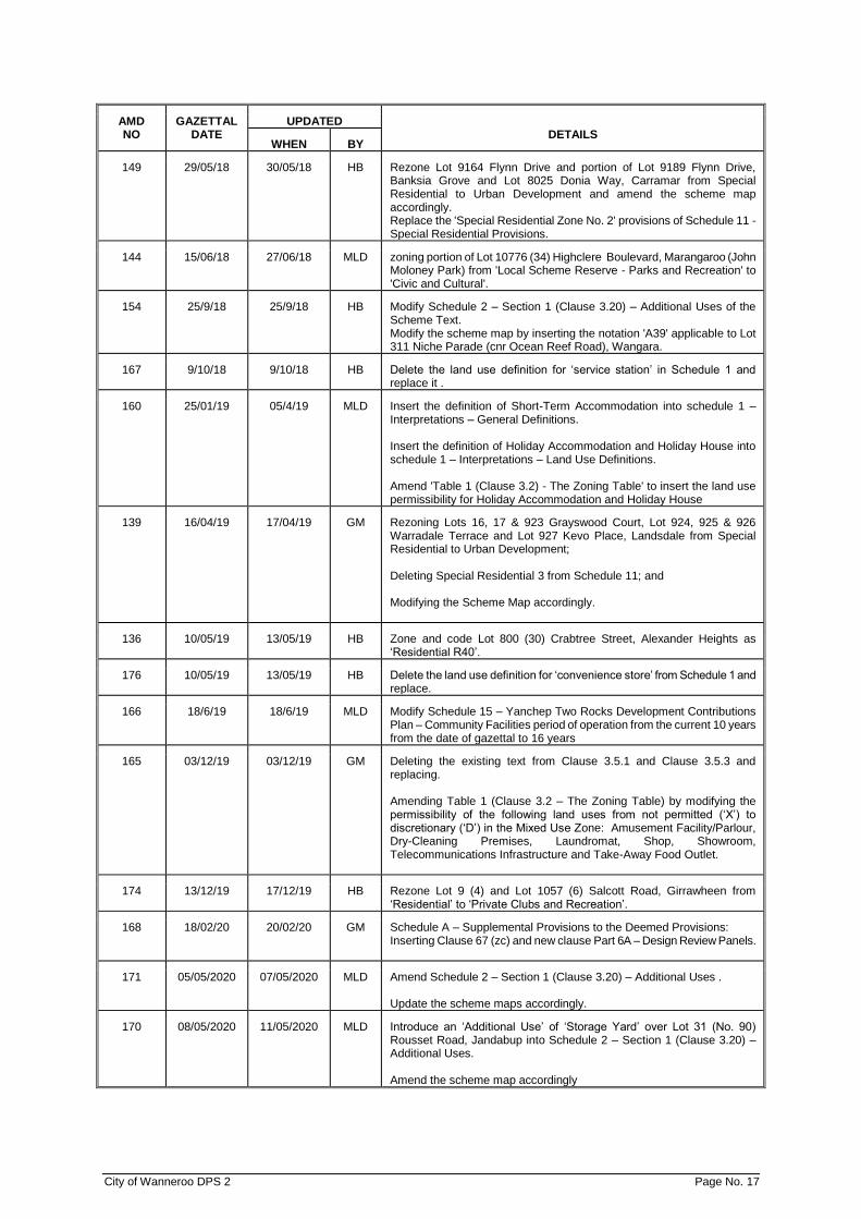
149 29/05/18 30/05/18 HB Rezone Lot 9164 Flynn Drive and portion of Lot 9189 Flynn Drive, Banksia Grove and Lot 8025 Donia Way, Carramar from Special Residential to Urban Development and amend the scheme map accordingly. Replace the 'Special Residential Zone No. 2' provisions of Schedule 11 - Special Residential Provisions.
144 15/06/18 27/06/18 MLD zoning portion of Lot 10776 (34) Highclere Boulevard, Marangaroo (John Moloney Park) from 'Local Scheme Reserve - Parks and Recreation' to 'Civic and Cultural'.
154 25/9/18 25/9/18 HB Modify Schedule 2 – Section 1 (Clause 3.20) – Additional Uses of the Scheme Text. Modify the scheme map by inserting the notation 'A39' applicable to Lot 311 Niche Parade (cnr Ocean Reef Road), Wangara.
167 9/10/18 9/10/18 HB Delete the land use definition for ‘service station’ in Schedule 1 and replace it .
160 25/01/19 05/4/19 MLD Insert the definition of Short-Term Accommodation into schedule 1 – Interpretations – General Definitions. Insert the definition of Holiday Accommodation and Holiday House into schedule 1 – Interpretations – Land Use Definitions. Amend 'Table 1 (Clause 3.2) - The Zoning Table' to insert the land use permissibility for Holiday Accommodation and Holiday House
139 16/04/19 17/04/19 GM Rezoning Lots 16, 17 & 923 Grayswood Court, Lot 924, 925 & 926 Warradale Terrace and Lot 927 Kevo Place, Landsdale from Special Residential to Urban Development; Deleting Special Residential 3 from Schedule 11; and Modifying the Scheme Map accordingly.
136 10/05/19 13/05/19 HB Zone and code Lot 800 (30) Crabtree Street, Alexander Heights as ‘Residential R40’.
176 10/05/19 13/05/19 HB Delete the land use definition for ‘convenience store’ from Schedule 1 and replace.
166 18/6/19 18/6/19 MLD Modify Schedule 15 – Yanchep Two Rocks Development Contributions Plan – Community Facilities period of operation from the current 10 years from the date of gazettal to 16 years
165 03/12/19 03/12/19 GM Deleting the existing text from Clause 3.5.1 and Clause 3.5.3 and replacing. Amending Table 1 (Clause 3.2 – The Zoning Table) by modifying the permissibility of the following land uses from not permitted (‘X’) to discretionary (‘D’) in the Mixed Use Zone: Amusement Facility/Parlour, Dry-Cleaning Premises, Laundromat, Shop, Showroom, Telecommunications Infrastructure and Take-Away Food Outlet.
174 13/12/19 17/12/19 HB Rezone Lot 9 (4) and Lot 1057 (6) Salcott Road, Girrawheen from ‘Residential’ to ‘Private Clubs and Recreation’.
168 18/02/20 20/02/20 GM Schedule A – Supplemental Provisions to the Deemed Provisions: Inserting Clause 67 (zc) and new clause Part 6A – Design Review Panels.
171 05/05/2020 07/05/2020 MLD Amend Schedule 2 – Section 1 (Clause 3.20) – Additional Uses . Update the scheme maps accordingly.
170 08/05/2020 11/05/2020 MLD Introduce an ‘Additional Use’ of ‘Storage Yard’ over Lot 31 (No. 90) Rousset Road, Jandabup into Schedule 2 – Section 1 (Clause 3.20) – Additional Uses. Amend the scheme map accordingly

City of Wanneroo DPS 2 Page No. 18
AMD NO
GAZETTAL DATE
UPDATED DETAILS
WHEN BY
180 14/08/2020 25/08/2020 GM Modifying the permissibility of the following land uses from discretionary (‘D’) to not permitted (‘X’) in the Special Residential Zone: i. Cattery ii. Child care Centre iii. Consulting Room Deleting Special Residential No. 6 from Schedule 11.
178 13/10/2020 14/10/2020 GM Modifying the percentage of the total cost to acquire and construct Dundebar Road as defined in Schedule 6, clause 3 of District Planning Scheme No 2 from 100% to 50%, as per the following: Cell 3 Dundebar Road (between Griffiths Road and Steven Street) *50% of the total cost to acquire the ultimate road reserve land; *50% of the total cost of constructing the full earthworks, one carriageway and all structures.
179 15/01/2021 18/01/2021 MLD Rezoning Lots 1, 2, 7, 12, 13, 36, 37 & 38 Caporn Street, Wanneroo from ‘Rural Resource’ to ‘Urban Development; and
Modifying the Scheme Map accordingly.
177 22/1/2021 3/2/2021 MLD Rezone Lot 9193 Joesph Banks Boulevard, Banksia Grove from Special Residential to Urban Development and amending the scheme map accordingly; and Modify Schedule 11 – Special Residential Provisions relating to Special Residential Zone No. 2 by deleting ‘Portion of Lot 9189 Flynn Drive, Banksia Grove’ currently described as Lot 9193 Joesph Banks Boulevard,
Banksia Grove.
184 01/04/2021 06/04/2021 MLD Amending Schedule 2 – A42 – 87 Innovation Circuit, Wangara Amend Scheme Map Accordingly.
187 28/5/2021 2/6/2021 MLD Rezoning land subject to the Swan Location 13460 Yanchep Beach Road Structure Plan No. 41 from ‘Urban Development’ to ‘Service Industrial’ and ‘Business’, as shown on the Scheme (Amendment) Map No. 1. Reclassifying land subject to the Blackmore Local Structure Plan No. 97 from ‘Urban Development’ to ‘Residential’ with density codes of R40 and R60 and ‘Local Schemes Reserve—Parks and Recreation’, as shown on the Scheme (Amendment) Map No. 2.
173 30/07/21 9/08/2021 HB Rezone Lot 250 (20) Burbridge Avenue, Koondoola from the ‘Civic and Cultural’ Zone to the ‘Commercial Zone’; Recode Lot 250 (20) Burbridge Avenue, Koondoola and Lots 155 (20), 251 (38), 252 (34) and 253 (28) Koondoola Avenue, Koondoola from the ‘R20’ to the ‘R60’ residential density code; Amend the Scheme Maps accordingly; Amend Schedule 3 of District Planning Scheme No. 2 to include Lot 250 (20) Burbridge Avenue, Koondoola at Koondoola (Koondoola Plaza) as part of the centre description.
182 8/10/2021 22/11/2021 HB Allow Retirement Village, Reception Centre, Aged and Dependent Persons’ Dwelling as additional uses at Lot 23 (198) Mary Street, Wanneroo and amends Schedule 2 with conditions. Amend the scheme map accordingly.
City of Wanneroo DPS 2 Page No. 19
AMD NO
GAZETTAL DATE
UPDATED DETAILS
WHEN BY
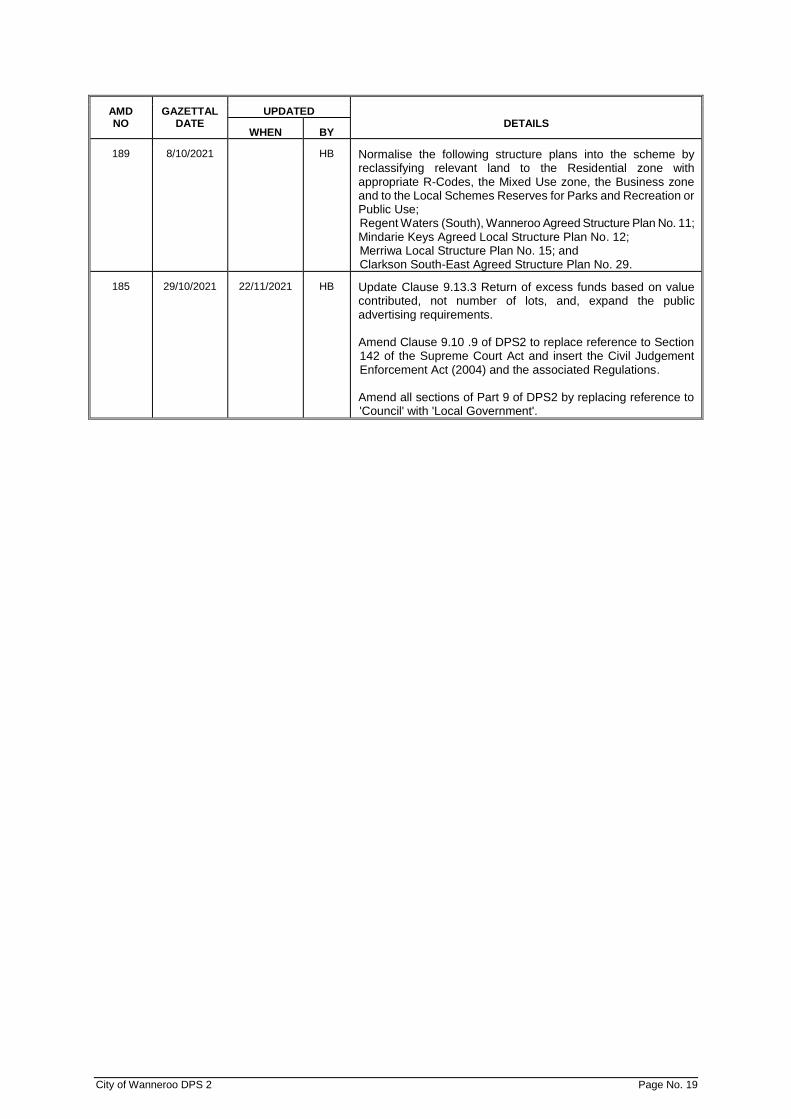
189 8/10/2021 HB Normalise the following structure plans into the scheme by reclassifying relevant land to the Residential zone with appropriate R-Codes, the Mixed Use zone, the Business zone and to the Local Schemes Reserves for Parks and Recreation or Public Use; Regent Waters (South), Wanneroo Agreed Structure Plan No. 11; Mindarie Keys Agreed Local Structure Plan No. 12; Merriwa Local Structure Plan No. 15; and Clarkson South-East Agreed Structure Plan No. 29.
185 29/10/2021 22/11/2021 HB Update Clause 9.13.3 Return of excess funds based on value contributed, not number of lots, and, expand the public advertising requirements. Amend Clause 9.10 .9 of DPS2 to replace reference to Section 142 of the Supreme Court Act and insert the Civil Judgement Enforcement Act (2004) and the associated Regulations. Amend all sections of Part 9 of DPS2 by replacing reference to 'Council' with 'Local Government'.

THE CITY OF WANNEROO DISTRICT PLANNING SCHEME NO. 2 The City of Wanneroo local government, under and by virtue of the powers conferred upon it in that behalf by the Planning and Development Act 2005, (as amended), hereunder referred to as The Act, hereby makes the following Town Planning Scheme for the purposes laid down in the Act.

City of Wanneroo DPS 2 Page No. 21
TABLE OF CONTENTS
PART I - PRELIMINARY ....................................................................................................................... 24
1.1 Citation ................................................................................................................................. 24 1.2 Responsible Authority .......................................................................................................... 24 1.3 The Scheme Area ................................................................................................................ 24 1.4 Contents Of Scheme ............................................................................................................ 24 1.5 Arrangement Of The Scheme Text ...................................................................................... 24 1.6 Scheme Aims And Objectives .............................................................................................. 25 1.7 Relationship With The Metropolitan Region Scheme .......................................................... 26 1.8 Relationship Of Scheme To Local Laws .............................................................................. 26 1.9 Interpretation ........................................................................................................................ 26
PART II – RESERVES ........................................................................................................................... 27
2.1 Reserves .............................................................................................................................. 27 2.2 Metropolitan Region Scheme Reserves .............................................................................. 27 2.3 Local Reserves..................................................................................................................... 27
PART III - ZONES .................................................................................................................................. 29
3.1 Zones ................................................................................................................................... 29 3.2 Zoning Table ........................................................................................................................ 29 3.3 Unlisted Uses ....................................................................................................................... 30 3.4 The Residential Zone ........................................................................................................... 30 3.5 The Mixed Use Zone ............................................................................................................ 31 3.6 The Business Zone .............................................................................................................. 31 3.7 The Commercial Zone .......................................................................................................... 31 3.8 The Civic And Cultural Zone ................................................................................................ 32 3.9 The Private Clubs/Recreation Zone ..................................................................................... 32 3.10 The Marina Zone .................................................................................................................. 32 3.11 The General Industrial Zone ................................................................................................ 32 3.12 The Service Industrial Zone ................................................................................................. 33 3.13 The Centre Zone .................................................................................................................. 33 3.14 The Urban Development Zone ............................................................................................. 34 3.15 The Industrial Development Zone ........................................................................................ 34 3.16 The General Rural Zone ...................................................................................................... 35 3.17 The Rural Resource Zone .................................................................................................... 36 3.18 The Special Rural Zone ....................................................................................................... 38 3.19 The Special Residential Zone .............................................................................................. 40 3.20 Additional Uses (Schedule 2 - Section 1) ............................................................................ 41 3.21 Restricted Uses (Schedule 2 - Section 2) ............................................................................ 41 3.22 The Special Use Zone (Schedule 2 - Section 3) .................................................................. 42 3.23 Rural Community Zone ........................................................................................................ 42 3.24 New Development Around Existing Railway Stations .......................................................... 42 3.25 Smart Growth Community Zone........................................................................................... 43 3.26 Landscape Enhancement Zone ........................................................................................... 44
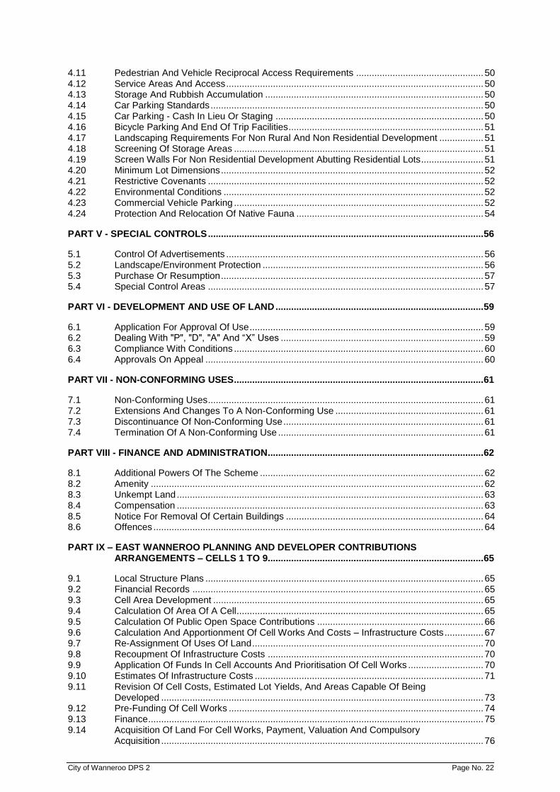
PART IV - GENERAL DEVELOPMENT REQUIREMENTS ................................................................. 46
4.1 Exclusions ............................................................................................................................ 46 4.2 Variations To Site And Development Standards And Requirements .................................. 46 4.3 Requirements Not Readily Determined By The Scheme ..................................................... 46 4.4 Residential Design Codes .................................................................................................... 46 4.5 Special Application Of Residential Design Codes ............................................................... 47 4.6 Home Business .................................................................................................................... 48 4.7 Setbacks For Non Rural And Non Residential Development .............................................. 48 4.8 Building Facades For Non Rural And Non Residential Development.................................. 49 4.9 Traffic Entrances .................................................................................................................. 49 4.10 Visual Truncations To Vehicular Accessways In The Vicinity Of Streets Or Rights-
Of-Way ................................................................................................................................. 50
City of Wanneroo DPS 2 Page No. 22
4.11 Pedestrian And Vehicle Reciprocal Access Requirements ................................................. 50 4.12 Service Areas And Access ................................................................................................... 50 4.13 Storage And Rubbish Accumulation .................................................................................... 50 4.14 Car Parking Standards ......................................................................................................... 50 4.15 Car Parking - Cash In Lieu Or Staging ................................................................................ 50 4.16 Bicycle Parking And End Of Trip Facilities ........................................................................... 51 4.17 Landscaping Requirements For Non Rural And Non Residential Development ................. 51 4.18 Screening Of Storage Areas ................................................................................................ 51 4.19 Screen Walls For Non Residential Development Abutting Residential Lots ........................ 51 4.20 Minimum Lot Dimensions ..................................................................................................... 52 4.21 Restrictive Covenants .......................................................................................................... 52 4.22 Environmental Conditions .................................................................................................... 52 4.23 Commercial Vehicle Parking ................................................................................................ 52 4.24 Protection And Relocation Of Native Fauna ........................................................................ 54
PART V - SPECIAL CONTROLS .......................................................................................................... 56
5.1 Control Of Advertisements ................................................................................................... 56 5.2 Landscape/Environment Protection ..................................................................................... 56 5.3 Purchase Or Resumption ..................................................................................................... 57 5.4 Special Control Areas .......................................................................................................... 57
PART VI - DEVELOPMENT AND USE OF LAND ................................................................................ 59
6.1 Application For Approval Of Use .......................................................................................... 59 6.2 Dealing With "P", "D", "A" And “X” Uses .............................................................................. 59 6.3 Compliance With Conditions ................................................................................................ 60 6.4 Approvals On Appeal ........................................................................................................... 60
PART VII - NON-CONFORMING USES ................................................................................................ 61
7.1 Non-Conforming Uses .......................................................................................................... 61 7.2 Extensions And Changes To A Non-Conforming Use ......................................................... 61 7.3 Discontinuance Of Non-Conforming Use ............................................................................. 61 7.4 Termination Of A Non-Conforming Use ............................................................................... 61
PART VIII - FINANCE AND ADMINISTRATION ................................................................................... 62
8.1 Additional Powers Of The Scheme ...................................................................................... 62 8.2 Amenity ................................................................................................................................ 62 8.3 Unkempt Land ...................................................................................................................... 63 8.4 Compensation ...................................................................................................................... 63 8.5 Notice For Removal Of Certain Buildings ............................................................................ 64 8.6 Offences ............................................................................................................................... 64
PART IX – EAST WANNEROO PLANNING AND DEVELOPER CONTRIBUTIONS ARRANGEMENTS – CELLS 1 TO 9................................................................................... 65
9.1 Local Structure Plans ........................................................................................................... 65 9.2 Financial Records ................................................................................................................ 65 9.3 Cell Area Development ........................................................................................................ 65 9.4 Calculation Of Area Of A Cell ............................................................................................... 65 9.5 Calculation Of Public Open Space Contributions ................................................................ 66 9.6 Calculation And Apportionment Of Cell Works And Costs – Infrastructure Costs ............... 67 9.7 Re-Assignment Of Uses Of Land ......................................................................................... 70 9.8 Recoupment Of Infrastructure Costs ................................................................................... 70 9.9 Application Of Funds In Cell Accounts And Prioritisation Of Cell Works ............................. 70 9.10 Estimates Of Infrastructure Costs ........................................................................................ 71 9.11 Revision Of Cell Costs, Estimated Lot Yields, And Areas Capable Of Being
Developed ............................................................................................................................ 73 9.12 Pre-Funding Of Cell Works .................................................................................................. 74 9.13 Finance ................................................................................................................................. 75 9.14 Acquisition Of Land For Cell Works, Payment, Valuation And Compulsory
Acquisition ............................................................................................................................ 76

City of Wanneroo DPS 2 Page No. 23
PART X - DISTRICT DISTRIBUTOR ROAD INFRASTRUCTURE CONTRIBUTIONS ARRANGEMENTS CELLS 1 TO 4 CLARKSON/BUTLER PLANNING DISTRICT ........... 79
10.1 Area Of Cells ........................................................................................................................ 79 10.2 Definitions ............................................................................................................................. 79 10.3 Objective .............................................................................................................................. 79 10.4 Landowner Contributions ..................................................................................................... 79 10.5 General Provisions ............................................................................................................... 82
TABLES ................................................................................................................................................ 84
Table 1 (Clause 3.2) - The Zoning Table ........................................................................................... 84 Table 2 (Clause 4.14) - Car Parking Standards ................................................................................. 87 Table 3 (Subclause 3.25.8) – Transect Zone Descriptions ................................................................ 90
SCHEDULES ......................................................................................................................................... 92
Schedule 1 (Clause 1.9) - Interpretations ........................................................................................ 92 Schedule 2 Section 1 (Clause 3.20) - Additional Uses .................................................................. 108 Schedule 2 Section 2 (Clause 3.21) - Restricted Uses .................................................................. 116 Schedule 2 Section 3 (Clause 3.22) - Special Use Zones ............................................................. 118 Schedule 3 (Subclauses 3.7.3 & 3.13.5) - Centre & Commercial Zones ....................................... 121 Schedule 4 (Clause 61(1) Of The Deemed Provisions) - Exempted Advertisements ................... 123 Schedule 5 (Sub Clause 5.2.1) - Places And Objects Having Significance For The Purpose
Of Protection Of The Landscape Or Environment ..................................................... 125 Schedule 6 (Part 9 Refers) East Wanneroo Planning And Developer Contribution
Arrangements (Cells 1 To 9 Inclusive) Cell Works And Contribution Provisions ....... 126 Schedule 7 (Part 10 Refers) Clarkson/Butler District Distributor Road Infrastructure
Developer Contribution Arrangements (Cells 1 To 4 Inclusive) Cell Works And Contribution Provisions .............................................................................................. 131
Schedule 8 (Clause 4.21) – Restrictive Covenants ....................................................................... 134 Schedule 9 (Clause 4.22) - Environmental Conditions .................................................................. 135 Schedule 10 (Clause 3.18) – Special Rural Provisions ................................................................... 138 Schedule 11 (Clause 3.19) – Special Residential Provisions .......................................................... 158 Schedule 12 (Clause 3.23) - Rural Community Provisions .............................................................. 159 Schedule 13 (Clause 3.25.4) – Smart Growth Community Zone Special Provisions ...................... 165 Schedule 14 Development Contribution Areas ................................................................................ 168 Schedule 15 Development Contribution Plan .................................................................................. 175 Schedule 16 (Clause 3.2.4) – Land Use Permissibility For Structure Plans And Activity
Centre Plans ............................................................................................................... 179 Schedule 17 (Clause 5.4.1.1 (B) – Special Control Areas .............................................................. 183 Schedule A Supplemental Provisions To The Deemed Provisions .............................................. 195 City of Wanneroo ................................................................................................................................. 197
City of Wanneroo DPS 2 Page No. 24
PART I - PRELIMINARY 1.1 CITATION
1.1.1 The City of Wanneroo District Planning Scheme No. 2 (“the Scheme”) comes into operation on its Gazettal date.
1.1.2 Shire of Wanneroo Town Planning Scheme No. 1 – (Gazettal date 13 September, 1972) is hereby revoked.
1.1.3 The Scheme shall be cited as the City of Wanneroo District Planning Scheme No 2.
1.2 RESPONSIBLE AUTHORITY
The authority responsible for implementing and enforcement of the Scheme is the local government of the City of Wanneroo hereinafter referred to as the “local government” except that where land is shown in the Scheme Map as “Regional Reserve” the responsible authority shall be deemed to be the Western Australian Planning Commission, and the provisions of the Metropolitan Region Scheme shall apply to such reservations.
1.3 THE SCHEME AREA
The Scheme shall apply to the whole of the District as shown by the inner edge of the broken black line on the Scheme Map.
1.4 CONTENTS OF SCHEME
AMD 132 GG 15/7/16
The Scheme comprises:
a) this Scheme Text;
b) the deemed provisions (set out in the Planning and Development (Local Planning Schemes) Regulations 2015 Schedule 2);
c) Supplemental Provisions contained in Schedule A;
d) the Scheme Map;
e) Residential Density Code Maps. 1.5 ARRANGEMENT OF THE SCHEME TEXT
AMD 132 GG 15/7/16
PART 1 PRELIMINARY PART 2 RESERVES PART 3 ZONES PART 4 GENERAL DEVELOPMENT REQUIREMENTS PART 5 SPECIAL CONTROLS PART 6 DEVELOPMENT AND USE OF LAND PART 7 NON-CONFORMING USES PART 8 FINANCE AND ADMINISTRATION PART 9 EAST WANNEROO PLANNING AND DEVELOPER CONTRIBUTION
ARRANGEMENTS PART 10 CLARKSON-BUTLER DISTRICT DISTRIBUTOR ROAD CONTRIBUTION
ARRANGEMENTS TABLES SCHEDULES

City of Wanneroo DPS 2 Page No. 25
1.6 SCHEME AIMS AND OBJECTIVES
The aims and objectives of the Scheme are:
Regional planning framework:
(a) To facilitate a sustainable approach to development in accordance with the statutory provisions of the Metropolitan Region Scheme and the planning principles embodied in state and regional policies relevant to the City.
Local planning framework:
(b) To encourage and facilitate development of the City in accordance with the City of Wanneroo Strategic Plan 1999/2002 and subsequent updates.
(c) To provide an accountable planning framework appropriate
to the needs of a rapidly developing City and its diverse lifestyle opportunities.
(d) To facilitate the co-ordination and early provision of social
and community facilities and other physical infrastructure in line with the needs of new development.
(e) To promote the revitalisation of existing urban areas in order
to meet the changing needs of the community. Land Use & Development
(f) To encourage development which will: ▪ provide high standards of amenity, safety and welfare, ▪ strive to ensure that new developments are energy-
efficient, ▪ ensure permanent and easy access by the public to the
ocean shore and recreation reserves, ▪ promote the development of business which increases
employment opportunities close to living places, ▪ support a safe, efficient and effective transportation
system. (g) To encourage urban design which is compatible with and
appropriate to the natural, built and social environment of the City.
Agriculture (h) To protect and where appropriate, enhance the prospects of
market gardening and other agricultural activity. Heritage Conservation (i) To encourage the conservation and continued use of
identified places and objects of cultural heritage significance. Environmental Protection
(j) To provide the local government and landowners with appropriate mechanisms to protect identified places of landscape or environmental value within the City.
(k) To ensure that adequate regard is given to the protection of
the natural environment in the determination of land use and development proposals in accordance with sustainable development principles.
Urban Development (l) To enable the local government to formulate arrangements
for the sharing of costs on an equitable basis amongst landowners for the provision of infrastructure for urban, industrial and other development carried out in accordance with the Scheme.

City of Wanneroo DPS 2 Page No. 26
(m) To promote planning, management and strategic control of
development in a rational and systematic manner, taking into account the aspirations of residents, environmental capacity, and the costs and benefits of development.
Development Assessment & Approval Process
(n) To provide guidance on the procedures to be followed in the lodgement, assessment and determination of applications for the development and use of land within the City.
(o) To ensure that proper regard is given to the needs of the
community in the determination of land use and development proposals.
1.7 RELATIONSHIP WITH THE METROPOLITAN REGION SCHEME
The Scheme is complementary to, and is not a substitute for, the Metropolitan Region Scheme, and the provisions of the Metropolitan Region Scheme, as amended, continue to have effect.
1.8 RELATIONSHIP OF SCHEME TO LOCAL LAWS
Where a provision of the Scheme is inconsistent with any local law, the provisions of the Scheme shall prevail.
1.9 INTERPRETATION
1.9.1 Words and expressions used in the Scheme shall have the respective meanings given to them in Schedule 1 or elsewhere in the Scheme and the Residential Design Codes.
AMD 52 GG 16/6/06 AMD 132 GG 15/7/16
1.9.2 Where a word or term is defined in the Residential Design Codes then notwithstanding
anything else in the Scheme that word or term when used in respect of residential development has the meaning given to it in the Residential Design Codes.
AMD 52 GG 16/6/06 AMD 132 GG 15/7/16 1.9.3 Words and expressions used in the Scheme but not defined in Schedule 1, elsewhere
in the Scheme or in the Residential Design Codes shall have their normal and common meanings. AMD 52 GG 16/6/06, AMD 132 GG 15/7/16

City of Wanneroo DPS 2 Page No. 27
PART II – RESERVES 2.1 RESERVES
Certain lands within the Scheme Area are shown on the Scheme Map and classified into either: a) Metropolitan Region Scheme Reserves; or
b) Local Reserves.
2.2 METROPOLITAN REGION SCHEME RESERVES
2.2.1 The land shown as “Metropolitan Region Scheme Reserves” on the Scheme Map are lands reserved under the Metropolitan Region Scheme and are shown on the Scheme Map in order to comply with the Metropolitan Region Town Planning Scheme Act, 1959, as amended. Those lands are not reserved by this Scheme. The provisions of the Metropolitan Region Scheme continue to apply to such reserves.
2.2.2 Amendment of Metropolitan Region Scheme - AMD 132 GG 15/7/16
Where, after the gazettal date, the Metropolitan Region Scheme is amended to zone a Regional Reserve, the local government shall treat an application for Development Approval on such land as though the development involves a “D” use, and such of the provisions of Part 3 and Part 6 as are relevant to “D” uses shall apply until the Scheme has been amended to include the land in a zone or Local Reserve (see subclause 3.2.2).
2.3 LOCAL RESERVES
2.3.1 Local Reserves
Local Reserves are delineated and depicted on the Scheme Map according to the legend thereon.
2.3.2 Use and Development of Local Reserves AMD 132 GG 15/7/16
A person shall not use, commence or carry out development on a local reserve without first having obtained development approval under Part 7 of the deemed provisions of the Scheme.
2.3.3 Without affecting the generality of the preceding sub clause and without limiting the
meaning of the term, ‘development”, for the purpose of sub clause 2.3.2, shall include:
(a) The demolition of or damage to any building or works; (b) The removal of or damage to any tree; (c) The excavation, spoil or waste of land so as to destroy, affect or impair its
usefulness for the purpose for which it is reserved; (d) The construction, extension, or alteration of any building or structure other
than a boundary fence.
2.3.4 Applications for Development approval on Local Reserves AMD 132 GG 15/7/16
2.3.4.1 The local government when considering applications for Development approval for land within a Local Reserve shall have due regard to the ultimate purpose intended for the Local Reserve and the relevant matters set out in Clause 67 of the deemed provisions (“Matters to be Considered by local government”).
City of Wanneroo DPS 2 Page No. 28
2.3.4.2 Provisions in the Scheme relating to applications for Development Approval and the exercise of any discretion thereon shall, insofar as they are not inconsistent with this clause, apply to Local Reserves. AMD 132 GG 15/7/16
2.3.4.3 The local government shall treat an application for development approval
for land within a local reserve as though the development involves a ‘D’ use and such of the provisions of Part 3 and Part 6 as are relevant to ‘D’ uses shall apply. AMD 132 GG 15/7/16
2.3.4.4 To the extent that it is reasonable to do so, the local government shall apply
or impose development standards and requirements which would be imposed for development of the kind in question on zoned land, and the Local government shall for that purpose stipulate the zone most relevant for comparison.
2.3.4.5 Where any land is partly zoned under the Scheme and partly included in a
Local Reserve, then the general provisions of the Scheme shall apply to the part which is zoned, and where the circumstances permit, the local government may give one decision in respect of the part of the land which is zoned and a different decision in respect of the part of the land included in the Local Reserve.
2.3.4.6 The local government shall, in the case of land reserved for the purposes of
a public authority, consult with that authority before giving its approval.
2.3.5 Right of Disposal
The local government may deal with or dispose of land it has acquired for a Local Reserve upon such terms and conditions as it thinks fit provided that the land is used or preserved for the use for which the land is reserved.

City of Wanneroo DPS 2 Page No. 29
PART III - ZONES 3.1 ZONES
3.1.1 The following zones are used for the classification of land within the Scheme Area:
Residential Mixed Use Business Commercial Civic & Cultural Private Clubs/Recreation Marina General Industrial Service Industrial Centre Urban Development Industrial Development General Rural Rural Resource Special Rural Special Residential Special Use Rural Community Smart Growth Community AMD 115 GG 23/07/13
Landscape Enhancement AMD 121 GG 31/05/16
The zones are delineated and depicted on the Scheme Map and Structure Plan Maps according to the legend thereon.
3.2 ZONING TABLE
3.2.1 The Zoning Table (hereinafter called Table 1) indicates subject to the provisions of the Scheme, the permissibility of use classes within the various zones. The permissibility of any use class is indicated by a symbol determined by cross reference between the list of “Use Classes” listed down the left hand side of Table 1 and the “Zones” listed along the top of Table 1.
3.2.2 The symbols used in Table 1 have the following meanings:
AMD 132 GG 15/7/16; AMD 157 GG 06/04/18
“P” = A use class that is permitted but which may be subject to any conditions that the local government may wish to impose in granting its approval;
“D” = A use class that is not permitted, unless the local government grants its
approval after following the procedures laid down by subclause 6.2.2; “A” = A use class that is not permitted unless the local government has exercised
its discretion and has granted development approval after giving notice in accordance with Clause 64 of the deemed provisions;
“X” = A use class that is not permitted except where provision is made specifically
for local government to approve an otherwise prohibited use.

City of Wanneroo DPS 2 Page No. 30
3.2.3 If the zoning table does not identify any permissible uses for land in a zone the local government may, in considering an application for development approval for land within the zone, have due regard to any of the following plans that apply to the land -
AMD 157 GG 06/04/18 (a) a structure plan;
(b) an activity centre plan;
(c) a local development plan.
3.2.4 Notwithstanding clause 3.2.3 and any other provision of the scheme, for land which is
subject to clause 3.2.3 and a Structure Plan or Activity Centre Plan referred to in Schedule 16 of the scheme, the local government shall determine the permissibility of uses in accordance with the use permissibility provisions for that land included in Schedule 16. AMD 157 GG 06/04/18
3.2.5 Where in Table 1 a particular use is mentioned it is deemed to be excluded from any other use class which by its more general terms might otherwise include such particular use.
3.2.6 Where a building or land is used, or a proposed building is designed, for more than one
use, it shall be regarded for the purposes of the Scheme as being used or designed partially for each of those uses.
3.3 UNLISTED USES
If the use of the land for a particular purpose is not specifically mentioned in Table 1 and cannot reasonably be determined as falling within the interpretation of one of the use categories the local government may:
a) determine that the use is consistent with the objectives and purposes of the particular
zone and is therefore permitted; or b) determine that the proposed use may be consistent with the objectives and purposes of
the zone and thereafter follow the “D” procedures of Clause 6.2.2 in considering an application for development approval; or AMD 132 GG 15/7/16
c) determine that the use is not consistent with the objectives and purposes of the
particular zone and is therefore not permitted. 3.4 THE RESIDENTIAL ZONE
3.4.1 The Residential Zone is intended primarily for residential development in an environment where high standards of amenity and safety predominate to ensure the health and welfare of the population.
3.4.2 Residential development is provided for at a range of densities with a variety of housing
to meet the needs of different household types. This is done through application of the Residential Design Codes (R-Codes), and the allocation of a residential density code to an area of land. AMD 52 GG 16/6/06
3.4.3 The objectives of the Residential Zone are to:
(a) maintain the predominantly single residential character and amenity of
established residential areas; (b) provide the opportunity for grouped and multiple dwellings in selected locations
so that there is a choice in the type of housing available within the City;
City of Wanneroo DPS 2 Page No. 31
(c) provide the opportunity for aged persons housing in most residential areas in recognition of an increasing percentage of aged residents within the City; and
(d) provide for compatible urban support services.
3.5 THE MIXED USE ZONE
3.5.1 The objectives of the Mixed Use Zone are: AMD 165 GG 03/12/19
(a) To provide for a wide variety of active uses on street level which are compatible with residential and other non-active uses on upper levels.
(b) To allow for the development of a mix of varied but compatible land uses such as
housing, offices, showrooms, amusement centres, eating establishments and appropriate industrial activities which do not generate nuisances detrimental to the amenity of the district or to the health, welfare and safety of its residents.
3.5.2 The zoning will provide an intermediate stage between Residential and Commercial or
Business Zone areas.
3.6 THE BUSINESS ZONE
3.6.1 The Business Zone is intended to accommodate warehouses, showrooms, trade and professional services and small scale complementary and incidental retailing uses, as well as providing for retail and commercial businesses which require large areas such as bulky goods and category/theme-based retail outlets that provide for the needs of the community but which due to their nature are generally not appropriate to or cannot be accommodated in a commercial area.
3.6.2 The objectives of the Business Zone are to:
(a) provide for retail and commercial businesses which require large areas such as bulky goods and category/theme based retail outlets as well as complementary business services;
(b) ensure that development within this zone creates an attractive façade to the
street for the visual amenity of surrounding areas. 3.7 THE COMMERCIAL ZONE
3.7.1 The Commercial Zone is intended to accommodate existing or proposed shopping and business centres where the planning of the locality is well advanced. AMD 52 GG 16/6/06
3.7.2 The objectives of the Commercial Zone are to:
(a) make provision for existing or proposed retail and commercial areas that are not
covered currently by a Structure Plan; AMD 52 GG 16/6/06 AMD 132 GG 15/7/16
(b) provide for a wide range of uses within existing commercial areas, including
retailing, entertainment, professional offices, business services and residential.
3.7.3 All land contained in the Commercial Zone shall specify a maximum retail net lettable area (NLA) which relates to retail floor area. The maximum NLA shall be included in Schedule 3 of this Scheme and shall bind the development of the land to no more than that area specified.
3.7.4 Notwithstanding the provisions of clause 3.7.3, the floorspace figures contained within
Schedule 3 shall be adhered to except where a provision to the contrary is made in a Structure Plan or Activity Centre Plan for the centre locality as adopted by the local government and the Commission. AMD 132 GG 15/7/16

City of Wanneroo DPS 2 Page No. 32
3.8 THE CIVIC AND CULTURAL ZONE
3.8.1 The objective of the Civic and Cultural Zone is to make specific provision for public facilities such as government offices, halls, theatres and art galleries.
3.8.2 Although many of the uses permitted in the Civic and Cultural Zone may be equally
appropriate in the Centre Zone, it is provided as a separate zone to stand in its own right should the need arise.
3.9 THE PRIVATE CLUBS/RECREATION ZONE
The objective of the Private Clubs/Recreation Zone is to accommodate uses such as private golf clubs, private educational, institutional, recreational and tourist accommodation activities.
3.10 THE MARINA ZONE
3.10.1 The Marina Zone is intended to accommodate a wide range of appropriate development adjacent to marinas.
3.10.2 The objectives of the Marina Zone are to:
(a) accommodate commercial, residential, recreational and associated activities
related to marinas; (b) guide and manage the planning and development of areas adjacent to marinas
to ensure a diverse mix of uses and high standards of amenity.
3.10.3 The following general provisions shall apply:
(a) Subject to Clause 27 of the deemed provisions, no subdivision (including strata or survey strata subdivision) or other development should be commenced or carried out in a Marina Zone until a Structure Plan has been prepared and adopted under the provisions of Part 4 of the deemed provisions. No subdivision (including strata or survey strata subdivision) should be commenced or carried out and no other development shall be commenced or carried out otherwise than in conformity with a Structure Plan which is in existence at the time the application for approval of the subdivision or other development is received by the responsible authority. AMD 26 GG 10/9/04; AMD 132 GG 15/7/16
(b) The permissibility of uses in the Marina Zone, subject to Clause 27 of the
deemed provisions shall be determined with regard to the provisions of the relevant Structure Plan. AMD 132 GG 15/7/16; AMD 157 GG 06/04/18
3.11 THE GENERAL INDUSTRIAL ZONE
3.11.1 The General Industrial Zone is intended to provide for industrial development which the local government considers would be obtrusive in or detrimental to the amenity of the Service Industrial Zone.
3.11.2 The objectives of the General Industrial Zone are to:
(a) accommodate a wide range of industrial activities, including those generally
involving production, processing, storage, wholesaling or distribution processes; (b) minimise adverse visual and environmental effects of industrial uses on
surrounding areas.
3.11.3 Non-industrial development is not favoured in the General Industrial Zone.

City of Wanneroo DPS 2 Page No. 33
3.12 THE SERVICE INDUSTRIAL ZONE
3.12.1 The Service Industrial Zone is intended to provide for a wide range of business, industrial and recreational developments which the local government may consider would be inappropriate in Commercial, Business and General Industrial Zones and which are capable of being conducted in a manner which will prevent them being obtrusive, or detrimental to the local amenity.
3.12.2 The objectives of the Service Industrial Zone are to:
(a) accommodate a range of light industries, showrooms and warehouses,
entertainment and recreational activities, and complementary business services which, by their nature, would not detrimentally affect the amenity of surrounding areas;
(b) ensure that development within this zone creates an attractive façade to the
street for the visual amenity of surrounding areas.
3.13 THE CENTRE ZONE
3.13.1 The Centre Zone is intended to accommodate existing and proposed business centres or other planning precincts where the local government considers that a Structure Plan is necessary to provide for the co-ordinated planning and development of these centres. The centres may range in size from small neighbourhood centres to large multi-purpose regional centres. AMD 132 GG 15/7/16
3.13.2 The objectives of the Centre Zone are to:
(a) provide for a hierarchy of centres from small neighbourhood centres to large
regional centres, catering for the diverse needs of the community for goods and services;
(b) ensure that the City’s commercial centres are integrated and complement one
another in the range of retail, commercial, entertainment and community services and activities they provide for residents, workers and visitors;
(c) encourage development within centres to create an attractive urban
environment; (d) provide the opportunity for the coordinated and comprehensive planning and
development of centres through a Structure Plan process. AMD 132 GG 15/7/16
3.13.3 Subject to Clause 43 of the deemed provisions, no subdivision (including strata or survey strata subdivision) or other development should be commenced or carried out in a Centre Zone until an Activity Centre Plan has been prepared and adopted under the provisions of Part 5 of the deemed provisions of the Scheme. No subdivision (including strata or survey strata subdivision) should be carried out an no development shall be commenced or carried out otherwise than in conformity with an Activity Centre Plan which is in existence at the time the application for approval of the subdivision or other development is received by the responsible authority.
AMD 26 GG 10/9/04; AMD 132 GG 15/7/16; AMD 157 GG 06/04/18
3.13.4 The permissibility of uses in the Centre Zone subject to Clause 43 of the deemed provisions shall be determined with regard to the provisions of the relevant Activity Centre Plan. AMD 132 GG 15/7/16; AMD 157 GG 06/04/18
3.13.5 All Centre Zones shall specify the proposed maximum retail net lettable area (NLA)
which relates to retail floor areas. The maximum NLA shall be included in Schedule 3 of this Scheme and shall bind the development of the land to no more than that area specified.
City of Wanneroo DPS 2 Page No. 34
3.13.6 Notwithstanding the provisions of sub-clause 3.13.5, the floorspace figures contained within Schedule 3 shall be adhered to except where a provision to the contrary is made in a Structure Plan or Activity Centre Plan for the centre locality as adopted by the local government and the Commission. AMD 132 GG 15/7/16
3.14 THE URBAN DEVELOPMENT ZONE
3.14.1 The purpose of the Urban Development Zone is to provide for the orderly planning and development of larger areas of land in an integrated manner within a regional context whilst retaining flexibility to review planning with changing circumstances. In considering applications for development and changes to residential density codings in areas near existing and proposed future railway stations the local government will have due regard to the desirability of higher residential densities, transit related development and good pedestrian and vehicular access to stations in order to promote public transport usage.
3.14.2 The objectives of the Urban Development Zone are to:
(a) designate land for future urban development; (b) provide for the orderly planning of large areas of land for residential and
associated purposes through a comprehensive structure planning process;
(c) enable planning to be flexible and responsive to changing circumstances throughout the developmental stages of the area.
3.14.3 Subject to Clause 27 of the deemed provisions, no subdivision (including strata or
survey strata subdivision) or other development should be commenced or carried out in an Urban Development Zone until a Structure Plan has been prepared and adopted under the provisions of Part 4 of the deemed provisions. No subdivision (including strata or survey strata subdivision) should be commenced or carried out and no other development shall be commenced or carried out otherwise than in conformity with a Structure Plan which is in existence at the time the application for approval of the subdivision or other development is received by the responsible authority.
AMD 26 GG 10/9/04; AMD 132 GG 15/7/16 3.14.4 The permissibility of uses in the Urban Development Zone subject to Clause 27 of the
deemed provisions shall be determined with regard to the provisions of the relevant Structure Plan. AMD 132 GG 15/7/16; AMD 157 GG 06/04/18
3.15 THE INDUSTRIAL DEVELOPMENT ZONE
3.15.1 The purpose of the Industrial Development Zone is to provide for the orderly planning of larger areas of land proposed for industrial use in an integrated manner within a regional context whilst retaining flexibility to review planning with changing circumstances.
3.15.2 The objectives of the Industrial Development Zone are to:
(a) designate land for future industrial development; (b) provide for the orderly and comprehensive planning and development of large
areas of industrial land for industrial and employment purposes;
(c) enable planning to be flexible and responsive to changing circumstances throughout the developmental stages of the area.

City of Wanneroo DPS 2 Page No. 35
3.15.3 Subject to Clause 27 of the deemed provisions no subdivision (including strata or survey strata subdivision) or other development should be commenced or carried out in an Industrial Development Zone until a Structure Plan has been prepared and adopted under the provisions of Part 4 of the deemed provisions. No subdivision (including strata or survey strata subdivision) should be commenced or carried out and no other development shall be commenced or carried out otherwise than in conformity with the Structure Plan which is in existence at the time the application for approval of the subdivision or other development is received by the responsible authority.
AMD 26 GG 10/9/04; AMD 132 GG 15/7/16
3.15.4 The permissibility of uses in the Industrial Development Zone subject to Clause 27 of
the deemed provisions shall be determined with regard to the provisions of the relevant Structure Plan. AMD 132 GG 15/7/16; AMD 157 GG 06/04/18
3.16 THE GENERAL RURAL ZONE
3.16.1 The objectives of the General Rural Zone are to:
(a) accommodate agricultural, horticultural and equestrian activities; (b) maintain and enhance the rural character and amenity of the areas designated
for rural use and to protect their ground water and environmental values.
3.16.2 When considering applications for subdivision or for Development Approval for development which relate to land which is within the General Rural Zone, local government shall have regard to the objectives set out in Clause 3.16.1 for the General Rural Zone, the contents of any Local Rural Strategy adopted by local government and the Commission and any other requirement for proper and orderly planning.
AMD 132 GG 15/7/16
3.16.3 Where residential development is carried out in the General Rural Zone, the following provisions shall apply:
No person shall construct any building or undertake any development or other works, other than a fire break or an equivalent alternative approved by local government or an accessway, closer than 7.5 metres to a street alignment or 4 metres to any other boundary. AMD 17 GG 21/1/05
(a) Notwithstanding that “Grouped Dwelling” is designated as a not permitted use
class in the General Rural Zone in Table 1, the local government may approve the development of a maximum of two grouped dwellings on a lot if having regard to all relevant considerations it is reasonable to do so provided the local government is satisfied of all the following facts:
i) The lot is a minimum of 5 hectares in area if situated south of Flynn
Drive and 8 hectares in area if situated north of Flynn Drive; ii) Both dwellings will be erected in a position that complies with all other
provisions of the Scheme, subject to any discretionary modifications by the local government;
iii) The second dwelling is necessary or desirable to provide
accommodation on the lot for a person or persons who will assist in the lawful management or exploitation of a rural or other resource on the land consistent with the objectives of the Zone;
iv) There is no current proposal for or intention of any person to propose
subdivision of the lot including strata or survey strata subdivision.
City of Wanneroo DPS 2 Page No. 36
(b) If the local government approves or has at any time before the gazettal of the Scheme approved a second dwelling on a lot in the circumstances set out in paragraph (a), that approval shall not be and shall not be taken to be support in any way for the future subdivision or strata subdivision of the lot or provision of separate certificates of title in respect of the two dwellings on the lot.
(c) It is the intent of the preceding paragraphs (b) and (c) that a second dwelling on
a lot in this zone should be allowed to facilitate the carrying on of rural and resource exploitation uses, and the provisions should expressly not be used presently or in the future to support fragmentation of the land, or the alienation of ownership or use of either of the dwellings from the ownership and control of the person carrying on the rural or resource exploitation use.
(d) Notwithstanding anything set out in the preceding paragraphs, any approval by
the local government for two grouped dwellings under the preceding paragraph (a) shall in any case require the owner seeking approval for a second dwelling to grant a Restrictive Covenant in gross in favour of the local government against the lot prepared at that owner's expense by solicitors for the local government precluding the owner or any future owner of the lot from seeking strata-subdivision or subdivision approval in any form for the lot.
3.17 THE RURAL RESOURCE ZONE
3.17.1 The objectives of the Rural Resource Zone are to:
(a) protect from incompatible uses or subdivision, intensive agriculture, horticultural and animal husbandry areas with the best prospects for continued or expanded use;
(b) protect from incompatible uses or subdivision basic raw materials priority areas
and basic raw materials key extraction areas.
3.17.2 When considering applications for subdivision or for Development approval for development which relate to land which is within the Rural Resource Zone, local government shall have regard to the relevant matters listed in Clause 67 of the deemed provisions and in addition to the following matters: AMD 132 GG 15/7/16
(a) The contents of any Local Rural Strategy adopted by local government and the
Western Australian Planning Commission.
(b) Within the Rural Resource Zone, the priority uses are intensive agriculture, horticulture and basic raw materials extraction.
(c) The local government shall not support any use or subdivision or zoning that is,
or potentially could be, incompatible with the carrying out of the priority uses referred to in sub clause 3.17.2 (b).
(d) Unless proved otherwise to the satisfaction of the local government on a case by
case basis, rural residential development is considered an incompatible use.
(e) There is a presumption in favour of applications for agriculture and intensive agriculture in the agricultural resource areas identified in the Local Rural Strategy subject to the acceptable management of any offsite environmental and land use impacts.
(f) There is a presumption in favour of applications for the extraction of basic raw
materials in the basic raw materials resource areas identified in the Local Rural Strategy subject to the management of offsite impacts and an approved land restoration plan to a standard suitable for intended subsequent long term land uses.

City of Wanneroo DPS 2 Page No. 37
(g) Notwithstanding the presumptions in sub clauses (e) & (f) above the local government will not support any proposals that adversely impact on any designated Bush Forever site, conservation category wetlands and their buffers, important heritage site and important site of Aboriginal significance. AMD 17 GG 21/1/05
(h) In the Rural Resource Zone, erection of a single house shall be subject to
Development Approval. AMD 132 GG 15/7/16
(i) In applying for Development approval for ‘sensitive uses’ within the Rural Resource Zone or on lots directly abutting the boundary of the Rural Resource Zone, the local government shall require that the applicant includes with the application a written acknowledgment by the applicant, acknowledging the nature and legitimacy of any nearby existing or future priority use, and acceptance of the existence, or potential existence of noise, dust, odour and other impacts which may be associated with such uses. The local government shall not grant Development approval to any ‘sensitive use’ where an acknowledgment in writing as required under this subclause does not accompany the planning application. AMD 132 GG 15/7/16
(j) A copy of such written acknowledgments shall be kept in a permanent register
by the local government, which shall be made available for public information.
(k) In addition to the provision of the written acknowledgments required pursuant to (i) above, applicants shall also be required, prior to granting of Development Approval by the local government, to arrange for the inclusion on the title of the land concerned, a notice to the same effect as that given by the written acknowledgment, to facilitate awareness of the matters concerned by future owners of that land. AMD 132 GG 15/7/16
3.17.3 No person shall construct any building or undertake any development or other works,
other than a fire break or an equivalent alternative proposed by local government or an accessway, closer than 7.5 metres to a street alignment or 4 metres to any other boundary.
3.17.4 Where residential development is carried out in the Rural Resource Zone, the following
provisions shall apply: AMD 17 GG 21/1/05
(a) Notwithstanding that "Grouped Dwelling" is designated as a not permitted use class in the Rural Resource Zone in Table 1, the local government may approve the development of a maximum of two grouped dwellings on a lot if having regard to all relevant considerations it is reasonable to do so provided the local government is satisfied of all the following facts:
i) The lot is a minimum of 5 hectares in area if situated south of Flynn
Drive and 8 hectares in area if situated north of Flynn Drive;
ii) Both dwellings will be erected in a position that complies with all other provisions of the Scheme, subject to any discretionary modifications by the local government;
iii) The second dwelling is necessary or desirable to provide
accommodation on the lot for a person or persons who will assist in the lawful management or exploitation of a rural or other resource on the land consistent with the objectives of the Zone;
iv) There is no current proposal for or intention of any person to propose
subdivision of the lot including strata or survey strata subdivision.

City of Wanneroo DPS 2 Page No. 38
(b) If the local government approves or has at any time before the gazettal of the scheme approved a second dwelling on a lot in the circumstances set out in paragraph (a), that approval shall not be and shall not be taken to be support in any way for the future subdivision or strata subdivision of the lot or provision of separate certificates of title in respect of the two dwellings on the lot.
(c) It is the intent of the preceding paragraphs (b) and (c) that a second dwelling on
a lot in this zone should be allowed to facilitate the carrying on of rural and resource exploitation uses, and the provisions should expressly not be used presently or in the future to support fragmentation of the land, or the alienation of ownership or use of either of the dwellings from the ownership and control of the person carrying on the rural or resource exploitation use.
(d) Notwithstanding anything set out in the preceding paragraphs, any approval by
the local government for two grouped dwellings under the preceding paragraph (a) shall in any case require a person seeking approval for a second dwelling to grant a Restrictive Covenant in gross in favour of the local government against the lot prepared at that owner's expense by solicitors for the local government precluding the owner or any future owner of the lot from seeking strata subdivision or subdivision approval in any form for the lot.
3.18 THE SPECIAL RURAL ZONE
3.18.1 The Special Rural Zone is intended to accommodate rural-residential retreats on lots generally ranging between one and four hectares in size. In some cases, agricultural uses are also intended to be accommodated. All development in the Special Rural Zone shall be conducted in a manner that preserves local amenity and the natural landscape or rural character of the zone concerned.
3.18.2 The objectives of the Special Rural Zone are to:
(a) designate areas where rural-residential retreats can be accommodated without
detriment to the environment or the rural character; (b) meet the demand for a rural lifestyle on small rural lots generally ranging from
one to four hectares in size; (c) maintain and enhance the rural character and amenity of the locality.
3.18.3 The general provisions set out hereafter shall apply to the Special Rural Zone:
(a) The Scheme provisions for a specific Special Rural Zone shall include a
Structure Plan for that specific Zone. The - Structure Plan for a specific Zone shall include any of the matters in Clause 16 of the deemed provisions. Subdivision and development should be in accordance with the Structure Plan.
AMD 132 GG 15/7/16 (b) The subdivider shall ensure that each prospective purchaser of a subdivided lot
acknowledges in writing, at the time of purchase of a lot, the requirements and provisions of the Rights in Water and Irrigation Act and more specifically the fact that:
i) the Water and Rivers Commission imposes constraints on the extraction
of ground water from and the use of groundwater on the land. ii) where the lot is within a proclaimed groundwater area it is unlikely that a
licence will be issued for the use of groundwater for amounts more than 1500m3 per annum, ie sufficient for house and domestic garden requirements and for the irrigation of approximately 0.1 hectare of pasture or other crops.
(c) Only one dwelling (a single house) may be erected on each lot.

City of Wanneroo DPS 2 Page No. 39
(d) No development shall take place within 25 metres of a street boundary or within 15 metres of a side or rear boundary. Where a lot has a boundary with more than one street the local government shall designate one such street as the frontage and may permit buildings to within 15 metres from the other street boundaries.
(e) When exercising its powers to relax requirements and standards under the
provisions of Clause 4.2 the local government shall, in addition, pay particular regard to the effect on flora and fauna, and the character and amenity of the Special Rural Zone. AMD 17 GG 21/1/05
(f) Except where a reticulated water supply is provided, a person shall not construct
a dwelling unless a concrete water tank of not less than 90,000 litres or other type of domestic water supply approved by the local government is incorporated in the plans and constructed at the same time as the dwelling. If with the approval of the local government groundwater is used the approval of the Water and Rivers Commission is also required. All lots less than 2 hectares in size shall have a reticulated scheme water supply to the satisfaction of the Water Corporation.
(g) The approval of the local government and of the Commissioner for Health to the
proposed method of disposal of sewage and other domestic wastes (either solid or liquid) is required.
(h) No dwelling shall be constructed unless it is on at least a 1,000m2 portion of the
lot, located behind the building setback line, which will result in the dwelling and base of the dwelling effluent disposal chamber being a minimum height (as determined by the Health Department of Western Australia and the Department of Environmental Protection) above the expected maximum water table level as shown on the Structure Plan. This will ensure compliance with the requirements for effluent disposal systems set down by the Health Department of Western Australia. AMD 132 GG 15/7/16
(i) The land is to be managed in such a manner as to avoid it being laid bare of
vegetation. Land shall not be cleared of vegetation except where necessary to permit the construction of buildings or where the vegetation is dead or poses a hazard to safety.
(j) A person shall not without Development approval of the local government
remove, cut down, or damage any vegetation on land within a Special Rural Zone including street verges. Where the local government grants approval it may impose a condition requiring the planting of suitable vegetation at the cost of the applicant. AMD 132 GG 15/7/16
(k) Local government may permit an area of not more than 1,000m2, in a central
location on each lot, to be cleared for the establishment of a residence, garage, ancillary buildings and a non-commercial garden/product/ pasture area, this cleared area shall be no closer than 15 metres to any side or rear boundary.
(l) The approval of local government is required for the keeping of horses. In
seeking such approval, the applicant is required to include with the application a management plan demonstrating that the proposal is acceptable to Agriculture Western Australia and the Department of Environmental Protection.
(m) The subdivider shall develop all areas designated as or set aside for the
purposes of public open space within the land the subject of the subdivision to the satisfaction of the local government and within the period stipulated by the local government.

City of Wanneroo DPS 2 Page No. 40
3.18.4 Special Provisions relating to individual Special Rural Zones are set out in Schedule 10. In the case of any conflict the Special Provisions shall prevail over the general provisions of the Scheme. The Special Provisions for a specific Special Rural Zone shall specify, amongst other things:
(a) Proposals for the control of land uses and development which will ensure that
the objectives of the zone are secured, and the rural environment and amenities are not impaired;
(b) Any stipulation or requirement the owner of the land must satisfy pursuant to any
agreement between the owner and the local government;
(c) Without limiting the generality of subclause 3.18.3, any other obligation of the owner relevant to the subdivision, development or use of the land.
3.18.5 Notwithstanding any other provision of the Scheme, in the case of any conflict between
the special provisions relating to individual Special Rural Zones and Table 1, the special provisions shall prevail.
When a Special Rural Zone Structure Plan was adopted and approved under the City’s Town Planning Scheme No 1 immediately before the revocation of Scheme No 1, and was referred to in Schedule 4 of Scheme No 1, it shall have the status of a Structure Plan under subclause 3.18.3 of this Scheme as if it was prepared and adopted under the provisions of this Scheme. AMD 132 GG 15/7/16
3.18.6 Where a Structure Plan has effect under this Scheme by force of the provisions of
subclause 3.18.5, any change in title of the Structure Plan, or in other matters whatsoever, shall be made to the extent only that is it necessary to provide it with the form of a Structure Plan under this Scheme, and to make its terms consistent in all ways with the provisions of this Scheme, including (but without limiting the generality of the foregoing) any standards or requirements. AMD 132 GG 15/7/16
3.19 THE SPECIAL RESIDENTIAL ZONE
3.19.1 The Special Residential Zone is intended to accommodate the development of single houses on lots of not less than 2,000m2 with an average lot size of not less than 3,000m2 unless otherwise approved on the relevant Structure Plan for that zone.
AMD 132 GG 15/7/16 3.19.2 The objectives of the Special Residential Zone are to:
(a) accommodate a spacious style of living in a low-density setting; (b) maintain important environmental and landscape values through site-sensitive
design and development.
3.19.3 A Structure Plan shall be a prerequisite to the creation of a Special Residential Zone in any locality and the general provisions set out hereunder shall apply: AMD 132 GG 15/7/16
(a) Subdivision should be in accordance with the Structure Plan. AMD 132 GG 15/7/16 (b) A reticulated deep sewerage system will be required if, in the opinion of the
relevant authorities, the land is considered not suitable for the long term, efficient on-site disposal of effluent.
(c) A reticulated water supply from the Water Corporation network shall be provided
to each lot. (d) Only one dwelling (a single house) shall be permitted on each lot.

City of Wanneroo DPS 2 Page No. 41
(e) No building shall be constructed closer than 15 metres to a street alignment,
within 5 metres of a side boundary, or within 10 metres of the rear boundary of any lot. Where a lot has frontage to more than one street, the local government shall designate one such street as the frontage and may permit the construction of buildings to within 7.5 metre from the other street boundaries.
(f) Except to the extent necessary for the construction of approved buildings and
driveways, no land shall be cleared of vegetation without the prior written approval of the local government.
(g) A person shall not without Development approval of the local government
remove, cut down, or damage any mature tree on land within a Special Residential Zone including street verges. AMD 132 GG 15/7/16
(h) The local government may, as a condition of any approval granted under
general provisions (f) and (g) of this subclause, require the applicant to plant and/or maintain to its satisfaction mature trees and shrubs to promote the natural or other aesthetic setting of the area.
(i) No cattle, goats, sheep, horses, bees or any other animal stipulated from time to
time by the local government to be inappropriate to Special Residential Zones, shall be kept on any lot.
3.19.4 Special Provisions relating to individual Special Residential Zones are set out in
Schedule 11. In the case of any conflict the Special Provisions shall prevail over the general provisions of the Scheme.
3.19.5 Notwithstanding any other provision of the Scheme, in the case of any conflict between
the Special Provisions relating to individual Special Residential Zones and Table 1, the Special Provisions shall prevail.
3.19.6 When a Special Residential Zone Structure Plan was adopted and approved under the
City’s Town Planning Scheme No 1 immediately before the revocation of Scheme No 1, and was referred to in Schedule 6 of Scheme No 1, it shall have the status of a Structure Plan under Clause 3.19 of the Scheme as if it was prepared and adopted under the provisions of the Scheme. AMD 132 GG 15/7/16
3.19.7 Where a Structure Plan has effect under the Scheme by force of the provisions of
subclause 3.19.6, any change in title of the Structure Plan, or in other matters whatsoever, shall be made to the extent only that it is necessary to provide it with the form of a Structure Plan under this Scheme, and to make its terms consistent in all ways with the provisions of this Scheme, including (but without limiting the generality of the foregoing) any standards or requirements. AMD 132 GG 15/7/16
3.20 ADDITIONAL USES (SCHEDULE 2 - SECTION 1)
Notwithstanding anything contained in Table 1, the land specified in Section 1 of Schedule 2 may be used for the specific use or uses that are listed in addition to any uses permissible in the zone in which the land is situated subject to the conditions set out in Schedule 2 with respect to that land.
3.21 RESTRICTED USES (SCHEDULE 2 - SECTION 2)
Notwithstanding anything contained in Table 1, the land specified in Section 2 of Schedule 2 may only be used for the specific use or uses that are listed and subject to the conditions set out in Schedule 2 with respect to that land.
City of Wanneroo DPS 2 Page No. 42
3.22 THE SPECIAL USE ZONE (SCHEDULE 2 - SECTION 3)
The Special Use Zone is set out in Section 3 of Schedule 2 and is in addition to the zones in Table 1. No person shall use any land or any structure or buildings on land in a Special Use Zone except for the purpose set out against that land in Schedule 2 and subject to compliance with any conditions set out in Schedule 2 with respect to that land.
3.23 RURAL COMMUNITY ZONE
3.23.1 The purpose of the Rural Community Zone is to provide for the orderly and integrated subdivision and development of larger areas of land proposed for rural residential use, in a manner which maintains the environmental, vegetation and landscape characteristics of the locality.
3.23.2 No subdivision (including strata or survey strata subdivision), or other development
should be, commenced or carried out in a Rural Community Zone until a Structure Plan has been prepared and adopted under the provisions of Part 4 of the deemed provisions. No subdivision (including strata or survey strata subdivision) should be commenced or carried out, and no development shall be commenced or carried out otherwise than in conformity with the Special Provisions contained in Schedule 12 of the Scheme and a Structure Plan, which is in existence at the time the application for approval of the subdivision or other development is received by the responsible authority. AMD 26 GG 10/9/04; AMD 132 GG 15/7/16
3.23.3 The intent of this Clause is to address the possibility of strata cluster subdivisional development being approved as an alternative to conventional subdivisional development in the Rural Community Zone. For the purpose of this Clause, the terms “conventional subdivision” and “cluster subdivision” are explained by the following hypothetical examples:
(a) Conventional subdivision may involve a 100 hectare lot being subdivided into
fifty lots each of 2 hectares where 2 hectares is the minimum lot size stipulated by the Special Provisions contained in Schedule 12 of the Scheme.
(b) A cluster subdivision in the same circumstances may involve fifty small lots
clustered perhaps on one 10 hectare portion of the 100 hectare original lot, leaving 90 hectares in a single common rural area lot, protected from further subdivision (including strata or survey strata subdivision) and development.
Consistent with the aim of preserving the environmental, vegetation and landscape characteristics of the Rural Community Zone, in specific cases a cluster subdivision lot yield equal to or greater (if specified in Schedule 12) than the maximum lot yield possible by conventional subdivision may be permitted.
3.23.4 The permissibility of uses in the Rural Community Zone shall be determined with regard
to the provisions of the relevant Structure Plan and any provisions contained in Schedule 12. AMD 132 GG 15/7/16; AMD 157 GG 06/04/18
3.23.5 Schedule 12 is incorporated in the Scheme and the provisions of that Schedule shall
have full force and effect as provisions of the Scheme.
3.24 NEW DEVELOPMENT AROUND EXISTING RAILWAY STATIONS
In order to promote public transport usage, local government shall encourage appropriate transit-related development to take place around existing railway stations. This relates to both private property, and government-owned land and air rights above that land where achievable.
City of Wanneroo DPS 2 Page No. 43
3.25 SMART GROWTH COMMUNITY ZONE AMD 115 GG 23/7/13
3.25.1 The purpose of the Smart Growth Community Zone is to facilitate the orderly planning
and development in an integrated manner within a regional context through the application of a Transect Based Code. The Transect Based Code is to include standards to regulate land use and coordinate the design of buildings, thoroughfares and civic spaces to promote development that adheres to the principles of the Transect.
3.25.2 The objectives of the Smart Growth Community zone are to —
(a) designate land for future urban development; (b) provide a framework for the application of a comprehensive Transect Based
Code to facilitate the orderly planning and development of land; (c) demonstrate development innovation through the incorporation of diverse and
immersive human habitats that span the various zones of the transect; and (d) promote development that is responsive to the natural landscape, environment
and contextual setting.
3.25.3 Subclauses 4.4.3, 4.4.4 and 4.4.5 shall not apply to the Smart Growth Community zone.
3.25.4 Special Provisions relating to individual Smart Growth Community zones are set out in
Schedule 13. 3.25.5 Subject to Clause 27 of the deemed provisions, no subdivision (including strata or
survey strata subdivision) or other development should be commenced or carried out in a Smart Growth Community zone until a Structure Plan has been prepared and adopted under Part 4 of deemed provisions of the Scheme. No subdivision (including strata or survey strata subdivision) should be commenced or carried out and no other development shall be commenced or carried out otherwise than in conformity with a Structure Plan which is in existence at the time of the application for approval of the subdivision or other development is received by the responsible authority.
AMD 132 GG 15/7/16 3.25.6 The Structure Plan area shall allocate transect zones of the transect, and may allocate
civic spaces and special districts. A minimum of three of the following transect zones shall be allocated to any Smart Growth Community zone — AMD 132 GG 15/7/16
Transect Zone 1—Natural Reserve (T1) Transect Zone 2—Natural Living (T2) Transect Zone 3—Sub-Urban (T3) Transect Zone 4—General Urban (T4) Transect Zone 5—Urban Centre (T5) Transect Zone 6—Urban Core (T6).
3.25.7 The character and development within each transect zone shall be consistent with the
transect zone descriptions contained in Table 3. 3.25.8 A Transect Based Code shall form part of a Structure Plan under Part 4 of the deemed
provisions of the Scheme. AMD 132 GG 15/7/16 3.25.9 Notwithstanding clause 3.25.8, the Western Australian Planning Commission is not
required to consider, approve or administer the Transect Based Code component of the Structure Plan. AMD 132 GG 15/7/16

City of Wanneroo DPS 2 Page No. 44
3.25.10 The Transect Based Code component of a Structure Plan shall be consistent with the
remainder of the Structure Plan in relation to residential density, lot size ranges, thoroughfare width, layout and hierarchy, public open space, land use permissibility and any other issue identified by the Western Australian Planning Commission in a Structure Plan. AMD 132 GG 15/7/16
3.25.11 In addition to the items referred to in Clause 16 of the deemed provisions, the Transect
Based Code, shall include the following design standards calibrated from the SmartCode® model ordinance — AMD 132 GG 15/7/16
(a) Regulating Plan Series, comprising as a minimum, a Transect Plan and Control
Plan. (b) Urban Standards, comprising as a minimum, standards for building types, site
coverage, building setbacks, car parking placement, building height and building frontage types.
(c) Thoroughfare Standards, comprising as a minimum, the assignment of
thoroughfare types for all vehicular and pedestrian ways of the movement network and the inclusion of design specifications for each thoroughfare type.
(d) Landscape Standards, allocating civic space types to all public open space
areas and including design specifications for each type.
3.25.12 The Transect Based Code, excluding residential density, lot size ranges, thoroughfare width, layout and hierarchy, public open space and any other issue identified by the Western Australian Planning Commission in a Structure Plan, may be varied through the preparation and approval of a Local Development Plan in accordance with part 6 of the deemed provisions. AMD 132 GG 15/7/16
3.26 LANDSCAPE ENHANCEMENT ZONE
AMD 121 GG 31/05/16
3.26.1 The Landscape Enhancement Zone is intended to accommodate agricultural and horticultural land uses and small-scale tourism activities. All development in the Landscape Enhancement Zone shall be conducted in a manner that preserves the rural character of land within this zone.
3.26.2 The objectives of the Landscape Enhancement Zone are to:
(a) Enable a range of activities and land uses that support the characteristics of the
landscape, including agricultural and horticultural land uses, and small-scale tourism activities.
(b) Ensure that development maintains the rural character of the locality and does
not adversely affect the existing landscape and scenic values.
(c) Facilitate development that:
i) Is compatible with the landscape amenity and rural character of the Zone;
ii) Will not have a detrimental impact on sensitive land uses;
iii) Is coordinated and compatible with surrounding land parcels; and
iv) Does not necessitate the provision of large scale unplanned and
uncoordinated service infrastructure and community services.
(d) Encourage land use and management practices compatible with landscape and environmental conservation.
City of Wanneroo DPS 2 Page No. 45
(e) Encourage the preservation of vegetation and fauna and the protection of areas of visual or landscape quality.
3.26.3 When considering applications for Planning Approval for development which relate to
land which is within the Landscape Enhancement Zone, Council shall have regard to the objectives set out in Clause 3.26.2 of the Landscape Enhancement Zone, the relevant matters listed in Clause 6.8 of the Scheme and to the following:
(a) The Council shall not support any use or zoning that is, or potentially could be,
incompatible with the intent of the Landscape Enhancement Zone as set out in Clause 3.26.1.
(b) Council will not support any proposals that adversely impact on any designated
Bush Forever site, conservation category wetlands and their buffers, important heritage site and important site of Aboriginal significance.
(c) A person shall not without Planning Approval of the Council remove, cut down,
or damage any vegetation on land within a Landscape Enhancement Zone including street verges. Where the Council grants approval it may impose a condition requiring the planting of suitable vegetation at the cost of the applicant.
(d) The provisions of any Local Planning Policy relating to the Zone.
3.26.4 Building and development on a lot, except for fences and firebreaks, must be contained
within a building envelope defined on a plan adopted by Council. Such an envelope shall accord with any relevant Council Policy and must be located so as to:
(a) avoid detrimentally impacting on areas of landscape and scenic value;
(b) avoid areas where ground or soil conditions may inhibit the structural integrity of
buildings or cause pollution, erosion or flooding;
(c) maximise opportunities for buildings to take advantage of passive solar light; and
(d) maximise opportunities for efficient effluent disposal.
3.26.5 Notwithstanding the requirements set out in Clause 3.26.4, Council may at its discretion
approve development outside the building envelope, if it is satisfied that the amenity of the area, the privacy of adjoining properties, and the landscape or environment of the area will not be detrimentally affected.

City of Wanneroo DPS 2 Page No. 46
PART IV - GENERAL DEVELOPMENT REQUIREMENTS 4.1 EXCLUSIONS
In the General Rural Zone, the Rural Resource Zone, the Special Rural Zone, the Rural Community Zone and the Special Residential Zone, the provisions of Clauses 3.16, 3.17, 3.18, 3.19 and 3.23 as the case may be, shall prevail if there is any conflict or inconsistency with this Part.
4.2 VARIATIONS TO SITE AND DEVELOPMENT STANDARDS AND REQUIREMENTS
AMD 17 GG 21/1/05
4.2.1 Except for the requirements set out in Clauses 3.7.3, 3.7.4, Subclause 3.13.5 and 3.13.6 of the Scheme and housing density requirements of the Residential Design Codes, if a development is the subject of an application for Development Approval and does not comply with a development standard or requirement prescribed under the Scheme or the Residential Design Codes, the local government may, notwithstanding the non compliance, approve the application conditionally or subject to such conditions as the local government thinks fit. AMD 17 GG 21/1/05; AMD 52 GG 16/6/06; AMD 132 GG 15/7/16
4.2.2 In considering an application for development approval under this clause, where, in the
opinion of local government, the variation is likely to affect any owners or occupiers in the general locality or adjoining the site which is subject of consideration for the variation, the local government shall: AMD 132 GG 15/7/16
(a) consult the affected parties by following one or more of the provisions for
advertising uses pursuant to Clause 64 of the deemed provisions; and AMD 132 GG 15/7/16
(b) have regard to any expressed views prior to making its decision to grant the variation.
4.2.3 The power conferred by this clause may only be exercised if the local government is
satisfied that:
(a) approval of the proposed development would be appropriate having regard to the criteria set out in Clause 67 of the deemed provisions; and
AMD 132 GG 15/7/16
(b) the non-compliance will not have any adverse effect upon the occupiers or users of the development or the inhabitants of the locality or upon the likely future development of the locality.
4.3 REQUIREMENTS NOT READILY DETERMINED BY THE SCHEME
Where in the circumstances of a particular case a requirement or standard cannot readily be determined from an examination of the Scheme, such requirement or standard shall be determined by the local government. In making such a determination the local government shall have regard to any study or policy relevant to the area or the development in question and may have regard to any other matter relevant to amenity and orderly and proper planning.
4.4 RESIDENTIAL DESIGN CODES
AMD 52 GG 16/6/06
4.4.1 For the purposes of this Scheme “Residential Design Codes” means the Residential
Design Codes set out in Appendix 2 to the Commission’s Statement of Planning Policy No. 1, together with any amendments thereto.
AMD 52 GG 16/6/06; AMD 132 GG 15/7/16
4.4.2 A copy of the Residential Design Codes, as amended, shall be kept and made
available for public inspection at the offices of the local government. AMD 52 GG 16/6/06; AMD 132 GG 15/7/16

City of Wanneroo DPS 2 Page No. 47
4.4.3 Unless otherwise provided for in the Scheme the development of land for any of the residential purposes dealt with by the Residential Design Codes shall conform to the provisions of those Codes. AMD 52 GG 16/6/06; AMD 132 GG 15/7/16
4.4.4 The Residential Design Codes density applicable to land within the Scheme Area shall
be determined by reference to the legend shown on the Residential Density Codes Maps. AMD 52 GG 16/6/06; AMD 132 GG 15/7/16
4.4.5 Where land within the Scheme area is subject to a Structure Plan and a Residential
Density Code is not specified on the Residential Density Codes Maps, the Residential Density Codes for the area shall be determined according to the Structure Plan, in accordance with clause 27 of the deemed provisions. AMD 132 GG 15/7/16
4.4.6 Notwithstanding that the Residential Density Codes Maps may purport to apply a
Residential Design Code over land which is reserved under this Scheme, the Residential Design Codes are not applicable to land which is reserved under this Scheme. AMD 132 GG 15/7/16
4.5 SPECIAL APPLICATION OF RESIDENTIAL DESIGN CODES
AMD 52 GG 16/6/06; AMD 158 GG 21/10/16
4.5.1 Where residential development is proposed to be mixed with non-residential
development, local government may vary any provision of the R-Codes with the exception of the housing density requirements of the R-Codes.
AMD 17 GG 21/1/05; AMD 132 GG 15/7/16
Before exercising its powers of discretion local government may require that a proposal be advertised, and plans made available for public inspection in accordance with the procedures laid down in Clause 64 of the deemed provisions. AMD 132 GG 15/7/16
4.5.2 The provisions of clauses 3.16, 3.17, 3.18 and 3.19 relating to setbacks shall prevail over
any inconsistent provisions of the R-Codes. AMD 132 GG 15/7/16 4.5.3 Notwithstanding the density code applicable in a particular instance, development in
excess of a single dwelling shall not be permitted in unsewered areas unless:
(a) the development accords with the Government Sewerage Policy - Perth Metropolitan Region (1995); or
(b) the Health Department of Western Australia recommends to local government
that there are exceptional circumstances to warrant a variation from the Policy.
4.5.4 Split Density Code – Development AMD 119 GG 29/04/16
Where a split residential density code is depicted on the Scheme Maps, any development shall conform to the lower density code applicable to the lot, unless the local government determines that development up to the higher density code would comply with the following requirements:
(a) sufficient capacity exists in all necessary public utility services to adequately
meet the needs of the development;
(b) the development has a maximum of one consolidated vehicular access point for each street frontage of the lot, with reciprocal access rights to serve all dwellings. AMD 158 GG 21/10/16

City of Wanneroo DPS 2 Page No. 48
4.5.5 Split Density Code – Subdivision AMD 119 GG 29/4/16
(a) Subdivision of land with a split residential density code should not result in the need for additional crossovers to those already available to the development site.
(b) In respect of applications for subdivision of land with a split residential density code, Council should recommend that:
i) a right of carriageway easement is established between the lots created
to ensure that development has one consolidated vehicle access point; and
ii) a restrictive covenant is placed on the certificate(s) of title preventing
vehicle access from the remainder of the lot(s).
4.5.6 For land with a split residential density code directly abutting Wanneroo Road or Mirrabooka Avenue, a Noise Management Plan shall be provided along with any subdivision application, or development application proposing grouped dwellings. The Noise Management Plan shall address the potential for road transport noise and recommend noise mitigation measures where appropriate. AMD 119 GG 29/4/16
4.6 HOME BUSINESS
4.6.1 Home Business – Category 1
4.6.1.1 A person may conduct a Home Business – Category 1 within a dwelling without the need to first obtain Development approval. AMD 132 GG 15/7/16
4.6.1.2 If in the opinion of the local government the activity is no longer consistent
with the limits of a Home Business – Category 1, or is otherwise causing a nuisance or annoyance to neighbours or to owners or occupiers of land in the neighbourhood, local government may serve notice on the person requiring the person to cease using the dwelling for the home business.
4.6.2 Home Business – Category 2
4.6.2.1 A person wishing to conduct a Home Business - Category 2 on residential
premises is required to first obtain Development approval under Part 7 of the deemed provisions. AMD 132 GG 15/7/16
4.6.3 Home Business – Category 3
4.6.3.1 A person wishing to conduct a Home Business – Category 3 on residential
premises is required to first obtain Development approval under Part 7 of the deemed provisions. AMD 132 GG 15/7/16
4.6.3.2 The provisions of the R-Codes and all other clauses in the Scheme relating
to developments in a Residential Zone shall apply to a Home Business – Category 3. Local government may exercise its discretion and vary a provision of the R-Codes, except the housing density requirements of the R- Codes. AMD 17 GG 21/1/05; AMD 132 GG 15/7/16
4.7 SETBACKS FOR NON RURAL AND NON RESIDENTIAL DEVELOPMENT
4.7.1 Subject to the provisions of Part 3 or as otherwise provided in this clause, non rural and non-residential buildings shall be set back as follows:
(a) street boundary – 6 metres; (b) side and rear boundaries – Nil.
City of Wanneroo DPS 2 Page No. 49
4.7.2 Where a lot has a boundary with two or more streets, the local government shall determine which of these streets may be considered secondary street boundaries. Setbacks to secondary street boundaries may be reduced by local government to 3 metres.
4.7.3 Where a non-residential development is proposed to be located on a lot having a
common boundary with a Residential Zoned lot, the side and rear setbacks shall not be less than:
(a) 3 metres for buildings of one storey; or (b) 6 metres for buildings of two or more storeys.
4.7.4 That portion of a lot within 3 metres of the street alignment shall only be permitted to be
used for a means of access and landscaping. 4.7.5 That portion of a lot between 3 metres of the street alignment and the building setback
line shall only be permitted to be used for:
(a) a means of access; (b) the loading and unloading of vehicles; (c) landscaping;
(d) a trade display;
(e) the daily parking of vehicles used by employees and customers of the
development.
No such area shall be used for the parking of vehicles displayed for sale or which are being wrecked or repaired or for the stacking or storage of materials, products or wastes.
4.7.6 All buildings constructed on a lot adjoining a Right-of-Way shall be setback a minimum
of 1.5 metres from the Right-of-Way, or in the case of a carport, garage or parking bay, such additional distance that local government may require to ensure adequate vehicular manoeuvring.
4.7.7 All development on land abutting a road which is proposed to be widened shall be
setback from the street alignment of the road as if the road had been widened as proposed.
4.8 BUILDING FACADES FOR NON RURAL AND NON RESIDENTIAL DEVELOPMENT
4.8.1 The façade or facades of all non rural and non-residential development shall be of a high standard of architectural design and constructed in brick, masonry and/or plate glass or other approved material which in the opinion of local government would not adversely impact on the amenity or streetscape of the area. Where metal clad walls are approved by local government they shall have a factory applied paint finish.
AMD 17 GG 21/1/05; AMD 52 GG 16/6/06
4.8.2 The facade or facades of all non rural and non-residential development shall have
incorporated in their design, integrated panels for the purpose of signage placement. AMD 52 GG 16/6/06
4.9 TRAFFIC ENTRANCES
The local government may where it considers it desirable and in the interests of traffic safety, to reduce traffic hazards or otherwise to assist in the planning for vehicular traffic, direct the owner of any lot to limit access and egress or provide such additional access and egress as it requires to any premises.
City of Wanneroo DPS 2 Page No. 50
4.10 VISUAL TRUNCATIONS TO VEHICULAR ACCESSWAYS IN THE VICINITY OF STREETS OR RIGHTS-OF-WAY
No building, wall, fence, landscaping or other development greater than 0.6 metres in height measured from the natural ground level at the boundary shall be constructed or maintained within the sight line area stipulated in the Australian Standard for Off Street Parking AS2890.1 at the intersection of a vehicular access way and a street or right-of-way.
4.11 PEDESTRIAN AND VEHICLE RECIPROCAL ACCESS REQUIREMENTS
If the local government approves car parking and pedestrian access on neighbouring premises in a manner which relies on the reciprocal movement of vehicles and pedestrians between or across the premises, the owners concerned shall allow the necessary reciprocal access and parking at all times to the satisfaction of local government.
4.12 SERVICE AREAS AND ACCESS
Provision shall be made for service access to the rear of all taverns, hotels, motels, shops, showrooms, restaurants, takeaway food outlets, drive through takeaway food outlets and other commercial uses as required by the local government for the purpose of loading and unloading goods unless considered by the local government to be undesirable in a particular instance.
4.13 STORAGE AND RUBBISH ACCUMULATION
All storage, including the storage of accumulated rubbish, shall be confined to within a building, or a suitably enclosed area screened from its immediate surrounds and any adjacent public street or road by normal viewing by a wall not less than 1.8 metres in height constructed of brick, masonry or other approved material. All storage of accumulated rubbish shall be located in a position accessible to rubbish collection vehicles and where vehicular access and car parking will not be adversely affected.
4.14 CAR PARKING STANDARDS
4.14.1 The number of on-site car parking bays to be provided for specified development shall be in accordance with Table 2. Where development is not specified in Table 2 the local government shall determine the parking standard. The local government may also determine that a general car parking standard shall apply irrespective of the development proposed in cases where it considers this to be appropriate.
4.14.2 The design of off-street parking areas including parking for disabled shall be in
accordance with Australian Standards AS 2890.1 or AS 2890.2 as amended from time to time. Car parking areas shall be constructed, marked, drained and thereafter maintained to the satisfaction of the local government.
4.15 CAR PARKING - CASH IN LIEU OR STAGING
4.15.1 The local government may permit car parking to be provided in stages subject to the landowner setting aside an area of land sufficient to accommodate the total carparking requirement for the development and entering into a legal agreement to satisfactorily complete all the remaining parking when requested to do so by the local government.
4.15.2 Local government may accept a cash payment in lieu of the provision of any required
parking area subject to being satisfied that there is adequate provision for car parking or a reasonable expectation that there will be adequate provision for public car parking in the proximity of the proposed development.

City of Wanneroo DPS 2 Page No. 51
4.15.3 The cash payment shall be calculated having regard to the estimated cost of construction of the parking area or areas suitable for the proposed development and includes the value, as estimated by the local government, of that area of land which would have had to be provided to meet the car parking requirements specified by the Scheme. The cash payment may be discounted and may be payable in such manner as the local government shall from time to time determine.
4.15.4 Any cash payment received by the local government pursuant to this clause shall be
paid into appropriate funds to be used to provide public car parks in the locality as deemed appropriate by local government.
4.16 BICYCLE PARKING AND END OF TRIP FACILITIES
Local government may require the provision of bicycle parking and end of trip facilities such as showers, change rooms and lockers in commercial developments and other employment centres in accordance with Austroads’ Guide to Engineering Practice Part 14: Bicycles.
4.17 LANDSCAPING REQUIREMENTS FOR NON RURAL AND NON RESIDENTIAL
DEVELOPMENT
4.17.1 A minimum of 8% of the area of a development site shall be set aside, developed and maintained as landscaping to a standard satisfactory to the local government. In addition, the road verge adjacent to the lot shall be landscaped and maintained to the satisfaction of the local government.
4.17.2 When a proposed development includes a car parking area abutting a street, an area
no less than 3 metres wide within the lot along all street alignments shall be set aside, developed and maintained as landscaping to a standard satisfactory to the local government. This landscaped area shall be included in the minimum 8% of the area of the total development site referred to in the previous subclause.
4.17.3 Landscaping shall be carried out and maintained on all those areas of a development
site which are not approved for buildings, accessways, storage purposes or car parking. Alternatively, local government may require these areas to be screened from view of streets and other public places.
4.17.4 Landscape areas shall be designed and located to improve the visual appeal of the
development from the street and other public spaces and the standard of amenity for those using the development. The use of endemic trees and shrubs are encouraged.
4.17.5 Shade trees shall be planted and maintained in car parking areas designed within the
wells at the rate of one tree for every four (4) car parking bays, to the local government’s satisfaction.
4.18 SCREENING OF STORAGE AREAS
The owner of land on which there is stored, stacked or allowed to remain any materials which in local government’s opinion detract from the amenity of the area shall completely screen the said materials from adjoining properties and from streets in a manner specified by and to the satisfaction of local government, by means of walls, fences, hedges or shrubs.
4.19 SCREEN WALLS FOR NON RESIDENTIAL DEVELOPMENT ABUTTING RESIDENTIAL LOTS
Where a non-residential development is proposed to be located on a lot having a common boundary with a lot that is zoned or developed for residential purposes, a screen wall at least 1.8 metres in height and to a standard specified by the local government shall be provided along the common boundary of the two lots to protect the residential amenity.

City of Wanneroo DPS 2 Page No. 52
4.20 MINIMUM LOT DIMENSIONS
Minimum lot sizes and frontages are not specifically set for the purposes of this Part. The extent of any development on any lot shall be dependent upon other development requirements. Notwithstanding the foregoing, the local government may establish policies outlining specific minimum lot dimensions for specific types of development where it considers that it is prudent to do so.
4.21 RESTRICTIVE COVENANTS
4.21.1 Subject to subclause 4.21.2, a restrictive covenant affecting any land in the Scheme area by which, or the effect of which is that, the number of residential dwellings which may be constructed on the land is limited or restricted to less than that permitted by the Scheme, is hereby extinguished or varied to the extent that it is inconsistent with the provisions of the Residential Design Codes which apply under the Scheme. Land burdened by such restrictive covenants which may be extinguished or varied are detailed in Schedule 8. AMD 52 GG 16/6/06; AMD 132 GG 15/7/16
4.21.2 Where subclause 4.21.1 operates to extinguish or vary a restrictive covenant local
government will not grant development approval to the development of the land which would, but for the operation of subclause 4.21.1, have been prohibited unless the application has been dealt with as an ‘A’ use and has complied with all of the advertising requirements of Clause 64 of the deemed provisions. AMD 132 GG 15/7/16
4.22 ENVIRONMENTAL CONDITIONS
4.22.1 In accordance with Section 81 of the Act, environmental conditions imposed by the Minister for the Environment on the Scheme or amendments to the Scheme and contained in Statements under Section 48F Environmental Protection Act, shall be incorporated into the Scheme by provision made in Schedule 9 of the Scheme contemporaneously with the making of the Scheme or amendment. AMD 132 GG 15/7/16
4.22.2 Where appropriate, the environmental conditions are indicated on the Scheme Map by
the symbol “EC” to indicate that environmental conditions apply to the land. 4.22.3 The local government shall maintain a register of all the Statements published under
Section 48F referred to in subclause 4.22.1 which shall be made available for public inspection at the offices of the local government.
4.23 COMMERCIAL VEHICLE PARKING
4.23.1 Parking of commercial vehicles in the Residential, Mixed Use, Business, Urban Development, Centre, Marina, Commercial, Special Residential, Special Rural, Rural Community, General Rural and Rural Resource Zones shall not be permitted except in accordance with the provisions set out in the following paragraphs of this clause. The provisions of clause 4.23 do not apply when the commercial vehicle parking is in association with or incidental to a commercial use that has been approved by the local government or a use that is otherwise lawfully being undertaken on the land.
AMD 22 GG 31/10/03
4.23.2 A person shall not park, or permit to be parked, more than one commercial vehicle on any lot in the zones referred to in this clause except in the Special Rural, Rural Community, General Rural and Rural Resource Zones, where the following provisions shall apply in respect to the parking of more than one commercial vehicle on any lot in those zones: AMD 22 GG 31/10/03
(a) upon application for development approval local government may permit up to two commercial vehicles to be parked on a lot in the Special Rural and Rural Community zones, or on a lot of two hectares or less in the General Rural and Rural Resource zones; AMD 132 GG 15/7/16

City of Wanneroo DPS 2 Page No. 53
(b) upon application for development approval local government may permit up to four commercial vehicles to be parked on a lot larger than two hectares in the General Rural and Rural Resource zones. AMD 132 GG 15/7/16
4.23.3 A person may only park a commercial vehicle on a lot in the zones referred to in this clause if: AMD 22 GG 31/10/03
(a) the lot on which the vehicle is parked contains only a single house (including any associated outbuildings) provided that local government may permit the parking of such vehicle on a lot which contains grouped dwellings if it is of the opinion that this will not adversely affect the amenity of the grouped dwelling development or the surrounding area;
(b) in the case of a lot in the Residential, Mixed Use, Business, Urban Development, Centre, Marina and Commercial zones the vehicle is parked entirely on the subject lot and is located on a hard standing area which is located behind the front of the dwelling, or alternatively the vehicle is parked within a garage. In the case of a lot in the Special Residential, Special Rural, Rural Community, General Rural and Rural Resource Zones, the vehicle(s) shall not be readily visible from beyond the property boundaries and shall be located within the building envelope (if applicable) and behind the building setbacks, with adequate screening or alternatively parked within a garage;
AMD 52 GG 16/6/06
(c) the vehicle is used as an essential part of the lawful occupation of an occupant of the dwelling. The foregoing requirement of this item shall not be satisfied in any case unless the owner of the vehicle or an occupier of the dwelling within seven days of the local government making a request, supplies to the local government full information as to the name and occupation of the person said to be using the vehicle. The request for that information is made for the purpose of this item by posting the request to the address of the owner of the vehicle shown on the vehicle registration, or by posting the request to or leaving it at the dwelling addressed in general way to the occupier. The parking of the vehicle on the lot does not authorise the conduct on that lot of the occupation of the vehicle user;
(d) the vehicle does not exceed 3 metres in height (including the load), 2.5 metres in width, or 8 metres in length, except in the case of a lot in the Special Rural, Rural Community, General Rural and Rural Resource Zones where the height and width are not controlled but the maximum vehicle combination length shall not exceed 19 metres;
(e) the vehicle is not started or manoeuvred on site between the hours of 10.00 pm
and 6.00 am the next following day;
(f) while on the lot, the vehicle’s motor is not left running while the vehicle is unattended or in any event for any period in excess of five minutes;
(g) storage of liquid fuels on the lot complies with the Explosive and Dangerous Goods Act, 1961;
(h) the vehicle is not used or designed for use for the transportation of livestock or the transportation or disposal of liquid or solid wastes or other use so as to cause nuisance or pollution as defined in the Health Act 1911 and/or the Environmental Protection Act 1986;
(i) the vehicle is not carrying a refrigeration unit which is operating on a continuous or intermittent basis;
(j) while on the lot, there is no transfer of goods or passengers from one vehicle to another vehicle, unloading or unloading of the vehicle, or storage of goods associated with the use of the vehicle;

City of Wanneroo DPS 2 Page No. 54
(k) the vehicle is not used or operated as a tow truck or other emergency vehicle, between the hours of 10.00 pm to 6.00 am in a manner that adversely affects the residential amenity of the area;
(l) the parking and manoeuvring of the vehicle shall not cause damage or removal to existing vegetation on the lot.
4.23.4 Where a noise complaint is substantiated in accordance with the relevant Regulations made pursuant to the Environmental Protection Act 1986, the hours of operation shall be restricted to 7.00 am – 9.00 pm Monday to Saturday and 9.30 am – 9.00 pm Sundays and Public Holidays.
Any restrictions imposed on the hours of operation shall not limit further application of the relevant Regulations made pursuant to the Environmental Protection Act 1986.
4.23.5 Only minor servicing, including minor mechanical repairs and adjustments, and/or cleaning that generates easily contained liquid waste is carried out on the lot. Liquid waste shall be as defined in the Health (Liquid Waste) Regulations 1993 and shall be disposed of in accordance with the same or other location on the lot as approved by local government under subclause 4.23.6. AMD 17 GG 21/1/05
All cleaning and servicing shall be conducted behind the front of the dwelling.
4.23.6 The local government may upon application for development approval approve a variation to any of the requirements of subclause 4.23.3 (b), (d), (e), (k) and (l) provided the local government is satisfied in the circumstances that the variation will not adversely affect the amenity of the area surrounding the subject land. Surrounding landowners and occupants may be invited to comment on the proposed variation.
AMD 22 GG 31/10/03; AMD 17 GG 21/1/05; AMD 132 GG 15/7/16
4.23.7 An approval of the local government granted under subclause 4.23.6 is personal to the person to whom it is granted, is not capable of being transferred or assigned to any other person, and does not run with the land in respect of which it is granted.
4.23.8 A vehicle shall be considered to be parked on a lot for the purpose of this clause if it
remains on that lot for more than one hour in aggregate over any period of 24 hours unless the vehicle is being used bona fide in connection with ongoing construction work legally being carried out on the lot, the burden of proving which shall lie upon the person asserting it.
4.24 PROTECTION AND RELOCATION OF NATIVE FAUNA
AMD 38 GG 21/10/05
4.24.1 Where land is to be cleared of vegetation or where landforms or drainage patterns are
to be altered and in the opinion of the City the area may provide habitat for native fauna, the local government may, as part of the preparation of a Structure Plan under Part 4 of the deemed provisions or an approval to commence development and/or subdivision, require the proponent to prepare a Native Fauna Management Plan to the satisfaction of the City on the advice of the Department of Conservation and Land Management prior to clearing the land. AMD 132 GG 15/7/16
4.24.2 The Native Fauna Management Plan is to be prepared and implemented at the
developer’s/subdivider’s cost by a suitably qualified person(s) acceptable to the City. 4.24.3 The Native Fauna Management Plan should include, but is not limited to the following:
(a) a description of the field survey and recording methodology; (b) a time frame and program for undertaking the surveys; (c) the field survey results and recommendations;

City of Wanneroo DPS 2 Page No. 55
(d) the method of protecting, enhancing and conserving the existing habitat where any native fauna is to be retained on-site or on adjoining land;
(e) a time frame and program for undertaking the trapping and relocation of any
native fauna; (f) the method of relocating the native fauna, if appropriate; (g) a description of the trapping procedure, if required; (h) the identification of a suitable alternative habitat for the native fauna, if required;
and (i) a time frame for advising local government and the relevant Government
agencies of the outcome of any relocation program undertaken for any native fauna.

City of Wanneroo DPS 2 Page No. 56
PART V - SPECIAL CONTROLS 5.1 CONTROL OF ADVERTISEMENTS
5.1.1 Objectives
The objectives of the provisions for control of advertisements are:
(a) to ensure that the visual quality and character of particular localities and transport corridors are not eroded;
(b) to achieve advertising signs that are not misleading or dangerous to vehicular or
pedestrian traffic;
(c) to minimise the total area and impact of outdoor advertising commensurate with the realistic needs of commerce for such advertising;
(d) to prohibit outdoor advertising which is considered to be superfluous or
unnecessary by virtue of their number, colours, height, prominence, visual impact, size, relevance to the premises on which they are located, number and content;
(e) to reduce and minimise clutter; and (f) to promote a high standard of design and presentation in outdoor advertising.
5.1.2 Existing Advertisements
Advertisements which:
(a) were lawfully erected, placed or displayed prior to the Gazettal Date of the
Scheme; or
(b) may be erected, placed or displayed pursuant to a licence or other approval granted by the local government prior to the approval of this Scheme:
may, except as otherwise provided, continue to be displayed or be erected and displayed in accordance with the licence or approval as appropriate.
5.1.3 Enforcements and Penalties
The offences and penalties specified in Clause 8.10 of the Scheme shall apply to the advertiser in this Clause.
5.2 LANDSCAPE/ENVIRONMENT PROTECTION
5.2.1 Schedule 5
5.2.1.1 Schedule 5 contains details of those places and objects within the City which the local government has classified as having significance for the purpose of protection of the landscape or environment.
5.2.1.2 If the local government at any time considers that a place or object has
significance from the point of view of protection of the environment or landscape, the local government may classify the place or object accordingly and should add details thereof to Schedule 5 by amendment to the Scheme.
City of Wanneroo DPS 2 Page No. 57
5.2.1.3 If the local government at any time considers that any Schedule 5 place or object should no longer be subject to the provisions of this clause the local government may initiate an amendment to the Scheme for the deletion of the place or object from Schedule 5.
5.2.2 Written Consent of the local government
5.2.2.1 Notwithstanding any other provisions of the Scheme to the contrary the
approval of the local government is required for the following development on or in relation to any place of landscape or environmental value listed in Schedule 5:
(a) the clearing, excavation or filling of any land; (b) the felling, removal, killing or causing of irreparable damage to any
tree; (c) the erection of any fence; (d) the commencement or carrying out of any renovation, modification,
refitting, decoration or demolition of any building; or (e) the alteration or removal of any building or object or part thereof.
5.2.2.2 Without affecting the generality of the preceding paragraph and
notwithstanding the provisions of clause 61 no development shall be commenced or carried out on land listed in Schedule 5, without Development Approval. AMD 132 GG 15/7/16
5.2.3 Agreements
The local government may:
5.2.3.1 enter into agreements with the owners or occupiers of land on which any
Schedule 5 place or object is situated for the purpose of ensuring its preservation or conservation;
5.2.3.2 enter into agreements with any State or Commonwealth government
authority or other body in Western Australia, for the preservation or conservation of any place or object listed in Schedule 5.
5.3 PURCHASE OR RESUMPTION
The local government may purchase, or, subject to the Act, take compulsorily all or part of any parcel of land on which any Schedule 5 place or object is situated, as in the opinion of the local government is necessary for its preservation, or which the local government considers necessary for the conservation of the natural beauties of an area, for the preservation of any particular tree or trees and without limiting the generality of the foregoing for the preservation of any place or object of cultural heritage significance or other scientific interest.
5.4 SPECIAL CONTROL AREAS AMD 122 GG 09/09/14
5.4.1 Operation of Special Control Areas
5.4.1.1 The following special control areas are shown on the Scheme Map:
(a) Development Contribution Areas shown on the Scheme Map as DCA with a number and included in Schedule 14.
(b) Special Control Areas shown on the Scheme Map as SCA with a
number and included in Schedule 17. AMD 150 GG 27/04/18

City of Wanneroo DPS 2 Page No. 58
5.4.1.2 In respect of a special control area shown on a Scheme Map, the provisions applying to a special control area apply in addition to the provisions applying to any underlying zone or reserve and any general provisions of the Scheme.
City of Wanneroo DPS 2 Page No. 59
PART VI - DEVELOPMENT AND USE OF LAND 6.1 APPLICATION FOR APPROVAL OF USE
6.1.1 Without affecting the generality of any other provision of the Scheme, for the purpose of the Scheme the commencement, carrying out or change of a use on land shall be a development notwithstanding that it does not involve the carrying out of any building or other works.
6.1.2 If an application for Development approval involves the carrying out of building or other
work on land, the approval by the local government of the application, shall unless the local government stipulates otherwise in its approval, be an approval also of the commencement and carrying out of any use of the land: AMD 132 GG 15/7/16
(a) which is specifically proposed and referred to in the application; or (b) which is normally associated with and follows as the most usual consequence of
the carrying out or completion of the building or other work.
6.2 DEALING WITH "P", "D", "A" AND “X” USES
6.2.1 “P” Uses – If an application under the Scheme for Development approval involves a “P” use, the local government shall not refuse the application by reason of the unsuitability of that use, but notwithstanding that, the local government may in its discretion impose conditions upon the Development approval and if the application proposes or necessarily involves any building or other work, the local government upon considering that building or other work may exercise its discretion as to the approval or refusal and the conditions to be attached to the proposed development. AMD 132 GG 15/7/16
6.2.2 “D” Uses –The local government in exercising its discretion as to the approval or
refusal of an application for Development Approval, shall have regard to the provisions of Clause 67 of the deemed provisions. AMD 132 GG 15/7/16
If in any particular case local government considers that it would be appropriate to consult with the public generally or with the owners or occupiers of properties adjoining or in the vicinity of a site the subject of an application for Development approval involving a “D” use, the local government may direct that the provisions of Clause 64 of the deemed provisions shall apply to that application. AMD 132 GG 15/7/16
6.2.3 “A” Uses –The use is not permitted unless the local government has exercised its
discretion and has granted development approval after giving special notice in accordance with Clause 64 of the deemed provisions. AMD 132 GG 15/7/16
6.2.4 “X” Uses–The local government shall refuse to approve any application for
Development approval which involves an “X” use, except as otherwise specifically provided by the Scheme. AMD 132 GG 15/7/16
6.2.5 If the local government in exercising any discretion is required by the Scheme or by any other written law to have due regard to any matter or thing, it shall be deemed to have had due regard to such matter or thing unless the contrary is expressly stated in the Minutes of the relevant local government Meeting or the document communicating the determination for decision to the applicant, or is otherwise proved. In any event, due regard to the matter or thing by the responsible Committee or officer of the local government under delegated authority shall be sufficient compliance.
City of Wanneroo DPS 2 Page No. 60
6.3 COMPLIANCE WITH CONDITIONS
6.3.1 If the local government or the State Administrative Tribunal on appeal from a decision of the local government, or any other decision making authority grants its approval of any development subject to conditions, no person shall use any land or building affected by the conditions or suffer or permit them to be used, or otherwise commence or carry out or suffer or permit the commencement or carrying out of any development on land otherwise than in accordance with the conditions. AMD 52 GG 16/6/06
6.3.2 The local government may, on application in writing from the owner of land in respect of
which development approval has been granted, revoke or amend the development approval, prior to the commencement of the use or development subject of the Development Approval. AMD 132 GG 15/7/16
6.3.3 No use shall commence until such time as all conditions of approval have been satisfied
and the development from which the use is to be conducted has been completed in accordance with approved plans, unless otherwise agreed in writing by the local government.
6.4 APPROVALS ON APPEAL
In any case where a Development Approval is given by the State Administrative Tribunal, or where a condition is imposed the Tribunal, then that approval and/or any such conditions shall be deemed for the purpose of enforcement to have been imposed by the local government under the Scheme and may be enforced by the local government as such.
AMD 52 GG 16/6/06; AMD 132 GG 15/7/16
City of Wanneroo DPS 2 Page No. 61
PART VII - NON-CONFORMING USES 7.1 NON-CONFORMING USES
Except as otherwise provided in this Scheme, no provision of the Scheme shall be deemed to prevent:
a) the continued use of any land or building for the purpose for which it was being lawfully
used at the Gazettal date of the Scheme; or b) the carrying out of any development thereon for which, immediately prior to that time,
an approval or approvals, lawfully required to authorise the development to be carried out, were duly obtained and are current, provided that any conditions stipulated in the approval or approvals shall be complied with and these conditions shall be enforced by local government as if they had been imposed under the Scheme; or
c) the continued display of advertisements which were lawfully erected, placed or
displayed prior to the approval of this Scheme. 7.2 EXTENSIONS AND CHANGES TO A NON-CONFORMING USE
7.2.1 A person shall not alter or extend a non-conforming use or erect, alter or extend a building used in conjunction with a non-conforming use or change the use of land from a non-conforming use to another non-conforming use without first having applied for and obtained Development Approval under the Scheme. AMD 132 GG 15/7/16
7.2.2 An application for Development Approval under this Clause shall be advertised in
accordance with Clause 64 of the deemed provisions. AMD 132 GG 15/7/16 7.2.3 Where an application is for a change of use from an existing non-conforming use to
another non-conforming use, the local government shall not grant its development approval unless the proposed use is: AMD 132 GG 15/7/16
(a) substantially less detrimental to the amenity of the locality than the existing non-
conforming use; and (b) in the opinion of the local government is closer to the intended purpose of the
zone. 7.3 DISCONTINUANCE OF NON-CONFORMING USE
When a non-conforming use of any land or buildings has been discontinued for a period of six consecutive months or the building is destroyed or damaged to the extent of at least 75% of its value, such land or buildings shall not thereafter be used otherwise than in conformity with the provisions of the Scheme.
7.4 TERMINATION OF A NON-CONFORMING USE
The local government may effect the discontinuance of a non-conforming use by the purchase of the land and buildings, or by the payment of compensation to the owner or the occupier or to both the owner and the occupier of that land, and may enter into an agreement with the owner for that purpose.

City of Wanneroo DPS 2 Page No. 62
PART VIII - FINANCE AND ADMINISTRATION 8.1 ADDITIONAL POWERS OF THE SCHEME
8.1.1 The local government in implementing the Scheme has, in addition to all other powers vested in it, the following powers:
(a) The local government may enter into an agreement with any owner, occupier or other person having an interest in land affected by the provisions of the Scheme in respect of any matters pertaining to the Scheme.
(b) The local government may acquire any land or buildings within the Scheme Area
pursuant to the provisions of the Scheme or the Act. The local government may deal with or dispose of any land which it has acquired pursuant to the provisions of the Scheme or the Act in accordance with the law and for such purpose may make such agreements with other owners as it considers fit.
8.1.2 The procedure for carrying out any compulsory acquisition under this Scheme shall be
the procedure in the Land Administration Act 1997 subject to the modification referred to in sections of the Planning and Development Act 2005 (as amended).
AMD 132 GG 15/7/16 8.1.3 Without affecting the generality of the preceding subclause, the local government may,
with the prior consent of the Minister, acquire premises by purchase or resumption for public works to facilitate the development of adjacent land in accordance with a Structure Plan to assist a landowner who is endeavouring to develop land to comply with a Structure Plan, provided that the landowner:
(a) proves to the local government’s satisfaction that during a period of not less than
six months, bone fide negotiations to acquire the premises have not been successful; and
(b) enters into an agreement with the local government to meet all the costs of
purchase or resumption including the local government’s legal costs, and to develop the premises for the purposes specified within the specified time limit.
8.1.4 Disposal of Land
The local government may deal with or dispose of any land which it has acquired pursuant to the preceding subclauses, in accordance with the Act and in conformity with the provisions of the Scheme, upon such terms and conditions as it thinks fit, and for such purpose may make such agreements with other owners and parties as it thinks fit.
8.2 AMENITY
8.2.1 No building shall be so constructed, finished or left unfinished that its external appearance would significantly detract from the amenity of the locality or tend to depreciate the value of adjoining property. All land and buildings shall be so used and maintained as to preserve the local amenity.
8.2.2 No land, building or appliance shall be used in such a manner as to permit the escape
therefrom of smoke, dust, fumes, odour, noise, glare, vibration or waste products in such quantity or extent or in such a manner as will create or be a nuisance to any inhabitant, or to traffic or persons using any land or roads in the vicinity.
8.2.3 If the local government forms the opinion that there has been a breach of the
requirements of the preceding subclauses it may, by notice in writing, require the owner to make good the breach in the manner and within the time stated in the notice. The notice may be served on the owner personally or by posting it to the last address of the owner known to the local government, and if served by post, shall be deemed to have been served three (3) clear days after the date of posting.
City of Wanneroo DPS 2 Page No. 63
8.2.4 Any person upon whom a notice is served pursuant to this clause may, within 28 days of the date of service of the notice on that person, appeal pursuant to Part 14 of the Act against the requirements of the notice and, where any such appeal is lodged the effect of the notice shall be suspended until a decision to uphold, quash or vary the notice has been made on the appeal or the appeal has been withdrawn, whereupon the time stated in the notice shall again begin to run. AMD 132 GG 15/7/16
8.2.5 Failure to comply with a notice under this clause shall be a breach of the provisions of
the Scheme. 8.3 UNKEMPT LAND
8.3.1 On any land within the Scheme Area any undergrowth, refuse, rubbish or disused material which in the opinion of the local government is likely to affect adversely the value of adjoining property or the health, comfort or convenience of the inhabitants thereof, the local government may cause a notice to be served on the owner or occupier of such land requiring that the land is cleared of trees, scrub, undergrowth, refuse or rubbish, or such refuse, rubbish or disused material is removed from such land within a specified period.
8.3.2 Every owner or occupier of land upon whom a notice is served shall comply with such
notice within the time period therein specified. 8.3.3 Where the owner or occupier does not clear the land or remove the refuse, rubbish or
disused material as required by the notice given by the local government, the local government may without payment or any compensation in respect thereof, clear or remove it and dispose of it at the expense of and recover in a court of competent jurisdiction the amount of the expense from the owner or occupier to whom the notice is given.
8.3.4 Failure to comply with a notice under this clause shall be a breach of the provisions of
the Scheme. 8.4 COMPENSATION
8.4.1 A claim for compensation for injurious affection can be made pursuant to Section 173 of the Act when the Scheme: AMD 132 GG 15/7/16
(a) permits development on land for no purpose other than a public purpose; (b) prohibits wholly or partially the continuance of any non-conforming use
according to the terms of the Act.
8.4.2 The time limit for the making of claims for compensation for injurious affection pursuant to Section 173 of the Act resultant from the making of, or the making of an amendment to, the Scheme, is six (6) months from the date of publication of the Scheme or Scheme Amendment in the Government Gazette. AMD 132 GG 15/7/16
8.4.3 In addition to the compensation provisions of the Act and sub-clause 8.4.1 of this
Scheme, where, in respect of any application for development approval to commence or carry out development on land reserved under this Scheme, the local government, or any appellate body thereafter, refuses or grants approval subject to conditions such that the effect of the decision is to permit the land to be used or developed for no purpose other than a public purpose, the owner of the land may claim compensation from the local government for injurious affection. AMD 132 GG 15/7/16
8.4.4 The time limit for the making of claims for compensation pursuant to subclause 8.5.3 is
not later than 6 months after the date of the decision of the local government or appellate body.
City of Wanneroo DPS 2 Page No. 64
8.5 NOTICE FOR REMOVAL OF CERTAIN BUILDINGS
8.5.1 Twenty eight (28) days’ written notice is hereby prescribed as the notice to be given pursuant to Section 214 of the Act for the removal of certain buildings.
AMD 132 GG 15/7/16 8.5.2 Local government may recover expenses under section 215(2) of the Act in a court of
competent jurisdiction. AMD 132 GG 15/7/16
8.6 OFFENCES
8.6.1 No person shall depart from or permit or suffer any departure from the requirements and provisions of the Scheme, nor shall any person use or suffer or permit the use of any land or building or undertake or suffer or permit the undertaking of any development within the Scheme Area:
(a) otherwise than in accordance with the provisions of the Scheme; (b) unless all approvals required by the Scheme have been granted and issued; (c) unless all conditions imposed upon the grant and issue of any approval required
by the Scheme have been and continue to be complied with; (d) unless all standards laid down and all requirements prescribed by the Scheme
or determined by the local government pursuant to the Scheme with respect to that building or that use of that part have been and continue to be complied with.
8.6.2 Any person who fails to comply with any of the provisions of the Scheme is guilty of an
offence and without prejudice to any other remedy given herein is liable to such penalties as are prescribed by Section 223 of the Act.

City of Wanneroo DPS 2 Page No. 65
PART IX – EAST WANNEROO PLANNING AND DEVELOPER CONTRIBUTIONS ARRANGEMENTS – CELLS 1 TO 9
AMD 25 GG 31/3/09
9.1 LOCAL STRUCTURE PLANS
Local government has prepared Local Structure Plans for Cells 1 – 9 inclusive in East Wanneroo in accordance with the provisions of Part 4 of the deemed provisions of the Scheme for the purpose of facilitating subdivision and development of the land comprised in such Cells. Irrespective of the provisions of Part 4 of the deemed provisions, after a Structure Plan has been adopted for a Cell in East Wanneroo, it shall not be modified without the approval of the local government and Western Australian Planning Commission. AMD 132 GG 15/7/16
9.2 FINANCIAL RECORDS
9.2.1 The local government shall for the purpose of properly managing the implementation of a Local Structure Plan for each Cell, establish Cell Accounts for each Cell into which contributions from owners of land within that Cell which are made in accordance with this Part will be credited and from which all payments for Infrastructure Costs associated with the implementation of the Local Structure Plan for that Cell and any acquisition by local government under subclause 9.10.13 will be paid.
9.2.2 The Cell Accounts shall be maintained in accordance with the provisions of the local
Government (Financial Management) Regulations 1996 and shall be audited on an annual basis.
Local government shall make available for inspection to any owner of land within a Cell on request, a detailed statement of accounts for that Cell.
9.3 CELL AREA DEVELOPMENT
Within each Cell, Cell Works will be undertaken for the benefit of land contained within the Cell as generally set out in Schedule 6.
With a view to implementing Cell Works for each Cell in the most economical and prompt manner possible, the local government shall determine the order and manner in which the Cell Works are to be carried out and may appoint contractors to carry out such works where it considers it appropriate to do so.
9.4 CALCULATION OF AREA OF A CELL
AMD 35 GG 17/2/06
9.4.1 The Area of a Cell is calculated by deducting from the total area of the Cell (represented by the sum area of all the land in the Cell). AMD 35 GG 17/2/06
(a) the total of the land areas in a Cell for public purposes as shown on the Local
Structure Plan for the relevant Cell including: AMD 35 GG 17/2/06
▪ Crown Reserves; ▪ High school sites; ▪ The roads set out in Schedule 6 and drainage and underpasses associated
with such roads; ▪ The public open space depicted on the Local Structure Plan for the relevant
Cell; AMD 35 GG 17/2/06 ▪ Land reserved “Other Major Highways” under the Metropolitan Region
Scheme; and
(b) The land areas of any other developments which in the opinion of the local government have a limited subdivision or development potential.
AMD 35 GG 17/2/06
City of Wanneroo DPS 2 Page No. 66
9.4.2 Additionally, for the purpose of estimating lot yields for apportioning the cost of acquiring land for public open space in accordance with Clause 9.6, the Area of a Cell will be further reduced by the proposed land area of any private school sites within the Cell as shown on the relevant Local Structure Plan. AMD 35 GG 17/2/06
9.5 CALCULATION OF PUBLIC OPEN SPACE CONTRIBUTIONS
AMD 35 GG 17/2/06
9.5.1 (a) All owners of land in Cells 1 to 6 and 9, are required to contribute towards the
provision of 10% of the Area of a Cell for public open space the cost of which shall form part of the Cell Costs. For the purpose of calculating public open space contributions for Cells 1 to 6 the area of public open space referred to in Clause 9.4.1 shall not be deducted from the area of a Cell.
AMD 35 GG 17/2/06; AMD 25 GG 31/3/09
With the exception of the Landsdale District Centre site, the area of all local/neighbourhood/district shopping centre sites will be included in the Gross Area of a Cell, and the area of school sites and land required for local drainage shall be deducted from the Gross Area of a Cell to form the basis for determining the total area of public open space to be provided in a Cell; and
(b) All owners of land in Cells 7 and 8 shall be required to contribute towards the
provision of public open space as part of the Cell Costs, where such public open space is identified by way of environmental impact assessment, buffer or any other requirements on the relevant Local Structure Plan. AMD 35 GG 17/2/06
9.5.2 Public open space shall include:
(a) all community purpose sites except in Cell 9; and AMD 102 GG 06/09/16
(b) those reserves previously given up for public open space on historic
subdivisions being:
▪ Reserve 27294 ▪ Reserve 27071 ▪ Reserve 34683 (in respect of Cell 5 only) AMD 25 GG 31/3/09 ▪ Reserve 24794 ▪ Reserve 24881 ▪ Reserve 27340 ▪ Reserve 25489 ▪ (‘the Reserves')
9.5.3 (a) If a land holding in a Cell previously contributed land for one of the Reserves
referred to in subclause 9.5.2 (b) as part of an historic subdivision, the present owner of such land holding shall be allowed an appropriate adjustment in the Infrastructure Cost payable in respect of that landholding. The allowance due to an owner is the proportion of the total value of the Reserve, subject to the provisions of paragraphs (b) (c) and (d) of this subclause, that the area of the owner’s landholding bears to the total land area in the historic subdivision and shall be calculated in accordance with the following formula:
AMD 17 GG 21/1/05; AMD 35 GG 17/2/06
S = (G H) X V AMD 17 GG 21/1/05 Where: S = the value of the proportion of the historic contribution that an owner’s
land in a Cell made to a Reserve, subject to the provisions of paragraphs (b), (c) and (d) of this subclause, for which the owner is entitled to be paid the Assessed Value (“the Credit”).
AMD 17 GG 21/1/05; AMD 35 GG 17/2/06
H = the total land area of the historic subdivision which contributed to the
Reserve.
City of Wanneroo DPS 2 Page No. 67
G = the area of the owner’s land within the historic subdivision area. AMD 17 GG 21/1/05
V = value of the reserve, subject to subclause 9.5.3(b)
AMD 17 GG 21/1/05
(b) The area of a Reserve that is to be valued is, for the purpose of calculating
public open space in this clause, to be limited to 10% of the area of the historic subdivision that created it whether or not the actual area of the Reserve exceeds that proportion. AMD 17 GG 21/1/05
(c) The value to be applied under paragraph (b) of this subclause shall be the same
as the value established from time to time of public open space for the purpose of calculating the relevant Cell Costs. AMD 35 GG 17/2/06
(d) Credit shall be allowed for public open space in historic subdivision once only. If
public open space in an historic subdivision has been the subject of allowance under paragraph (c) of this subclause, no further allowance shall be made in respect of that public open space on any further subdivision of land from the historic subdivision, whether the further subdivision is a conventional green title, survey strata or strata subdivision. AMD 35 GG 17/2/06
9.5.4 If a land holding of an owner now overlapping two or more Cells was previously part of
land which was subdivided and contributed land for one of the Reserves referred to in subclause 9.5.2 (b), even if the Reserve is not in the same Cell as the current land holding, or is not in any Cell, then the allowance due to the present owner may be spread as a Cell Cost across the different Cell Accounts for the Cells in which such land holding is situated; AMD 35 GG 17/2/06
9.5.5 In the case in subclauses 9.5.3 and 9.5.4, the present owner of the land which
historically contributed the Reserve will still be required to contribute to the public open space component of the calculation of the Infrastructure Costs described in Clause 9.6 for each Cell without regard to the public open space contribution previously made on the historic subdivision. AMD 35 GG 17/2/06
9.5.6 The allowance due to an owner may be paid or allowed at the time such owner
subdivides or develops any part of the owner’s landholding generally in accordance with the Local Structure Plan for the Cell in which the landholding is situated. Such payment may, at the discretion of the City, be credited against the Cell Infrastructure Costs payable by the owner for the subdivision or development.
AMD 17 GG 21/1/05; AMD 35 GG 17/2/06
9.6 CALCULATION AND APPORTIONMENT OF CELL WORKS AND COSTS –
INFRASTRUCTURE COSTS AMD 35 GG 17/2/06
9.6.1 Cell Costs shall be estimated by the local government and recovered from owners of land in each Cell in the manner provided for in this Part.
Cells 1 to 6 and 9 – Infrastructure Cost Per Lot: AMD 25 GG 31/3/09
9.6.2 Local government will, for the purposes of apportioning Cell Costs to Owners in Cells 1
to 6 and 9, make an estimate of the lot yield for each Cell called the ‘Estimated Lot Yield’. This will be calculated be determining the number of hectares in the Area of a Cell and multiplying that area by 9 in the case of Cells 1 to 6 and multiplying that area by 13 in the case of Cell 9.
AMD 35 GG 17/2/06; AMD 25 GG 31/3/09; AMD 102 GG 06/09/16
City of Wanneroo DPS 2 Page No. 68
9.6.3 The contribution to be made by each owner of land within a Cell to the implementation of the Cell Works for that Cell (to the extent that the land relates to Cells 1 to 6 and 9) shall be an Infrastructure Cost, based on an Infrastructure Cost Per Lot which is to be calculated by the local government in the following manner: AMD 25 GG 31/3/09
(a) The Infrastructure Cost Per Lot is determined by first deriving the Net Cell Cost:
(i) A – B = C
Where:
A = gross cost of Cell Works being the total of fixed actual and estimated
future costs which will be based on costs estimated no more than 12 months in advance. Such estimates shall be based on an average for each Cell cost and recognise all factors affecting the development of the relevant Cell and associated constraints the local government will encounter in the provision of the Cell Works. This shall include (but not be limited to) variable market conditions and the nexus between the time frame of development and provision of Cell Works
B = payments made to date by owners of land who subdivide or develop
land within a Cell calculated on the basis of whichever is the lesser of:
(1) in the case of Cells 1 to 6 the lots produced at the rate of 9 lots
per hectare for the Area equivalent of the land holding of an owner, and in the case of Cell 9 at the rate of 13 lots per hectare for the Area equivalent of the land holding of an owner; and AMD 35 GG 17/2/06; AMD 102 GG 06/09/16
(2) the actual number of lots produced by the land holding of an
owner;
C = Net Cell Costs;
and then dividing the Net Cell Cost by the subdivision potential of the balance of the Area of a Cell remaining unsubdivided.
AMD 35 GG 17/2/06
(ii) C D = E
Where:
D = in the case of Cells 1 to 6 the number of lots to be produced to achieve 9 lots per hectare for the Area equivalent of the unsubdivided balance area of a Cell, and in the case of Cell 9 the number of lots to be produced to achieve 13 lots per hectare for the Area equivalent of the unsubdivided balance area of that Cell.
AMD 35 GG 17/2/06; AMD 102 GG 06/09/16
E = the Infrastructure Cost Per Lot.
(b) The Infrastructure Cost payable by each owner of land in Cells 1 to 6 and 9 inclusive is calculated by multiplying the number of lots produced by the Infrastructure Cost Per Lot. AMD 35 GG 17/2/06; AMD 25 GG 31/3/09
(c) Infrastructure Costs shall not be payable for land that is used for government
school sites. AMD 35 GG 17/2/06

City of Wanneroo DPS 2 Page No. 69
9.6.4 Cells 1 to 6 and 9 – Determination of Potential Lots to Which the Infrastructure Cost Per Lot Applies . AMD 35 GG 17/2/06; AMD 25 GG 31/3/09
In addition to the number of lots on which the Infrastructure Cost payable by each owner pursuant to subclause 9.6.3(b) is assessed, a further Infrastructure Cost Per Lot shall be payable on the potential lots/dwellings capable of being produced, assessed in accordance with the following provisions: AMD 35 GG 17/2/06 (a) where land is identified by local government as having potential or the capability
of being developed for grouped housing development or for any other non-public purpose land uses, the Infrastructure Cost per lot will be charged on the basis that the lot has residential subdivision potential at R20 density at the time that lot is created. This shall be calculated by local government by dividing the total area of the lot by 450m2 to derive a lot potential for the lot in Cells 1 - 6. In the case of Cell 9 this shall be calculated by dividing the total area of the lot by 500m2 to derive a lot potential for the lots in that Cell;
AMD 35 GG 17/2/06; AMD 102 GG 06/09/16, AMD 185 GG 29/10/2021
(b) where local government is satisfied that an area of land is intended to be developed as a church or a private school and local government considers it appropriate in the circumstances, the Infrastructure Cost per lot may be charged on the basis of the Estimated Lot Yield referred to in subclause 9.6.2 or any other agreed basis;
(c) where a subdivision is proposed for land on which a dwelling exists, and a
smaller lot is created to contain the dwelling, the lot containing the dwelling (“the existing house lot”) will be subject to an Infrastructure Cost Per Lot contribution based on the Residential R20 density described in subclause 9.6.4(a). If, however, the owner of such land can demonstrate that the size of the existing house lot is required to accommodate the dwelling, landscaping and other outbuildings associated with that dwelling and that the actual development potential of that lot may not exist without substantial cost and redevelopment, then local government may, at its discretion, reduce the Infrastructure Cost Per Lot contribution payable for the existing house lot provided any future subdivision or development of the existing house lot will incur further contributions as outlined in subclause 9.6.4(a); AMD 35 GG 17/2/06
(d) where a subdivision of the kind contemplated in subclause 9.6.4(c) is proposed
the local government may impose on the balance of the lot excluding the existing house lot (“the remaining land”) an Infrastructure Cost Per Lot contribution based on the R20 development potential of that lot as prescribed in Paragraph (a) of this subclause local government may reduce or defer such payment if: AMD 35 GG 17/2/06
(i) the owner of such a lot can demonstrate that the subdivision was
primarily carried out to create the existing house lot and to effect the sale of the remaining land; and
(ii) the size of the remaining land is such that it will be developed in stages
or will be further subdivided.
9.6.5 Cells 7 & 8 Calculation of Infrastructure Cost Per Square Metre
The infrastructure contribution to be paid by owners of land in Cells 7 and 8 shall be calculated on the basis of the number of square metres of each Cell which are capable of being developed (“the Infrastructure Cost Per Square Metre”). AMD 17 GG 21/1/05
The Infrastructure Cost to be paid by each owner of land in Cells 7 and 8 is calculated as follows:
X Y = Z

City of Wanneroo DPS 2 Page No. 70
X = gross cost of Cell Works being the total of fixed actual and Estimated Future Costs the calculation of which will be based on costs anticipated no more than six (6) months in advance. Such estimates shall be based on an average for each Cell cost and recognise all factors affecting the development of the relevant Cell and associated constraints the local government will encounter in the provision of the Cell Works. This shall include (but not be limited to) variable market conditions and the nexus between the time frame of development and provision of Cell Works.
Y = the area of a Cell which the local government estimates by deducting all land for
existing and future roads, proposed drainage sites and other land for public purposes as depicted on the Structure Plan for the Cell from the total area of a Cell.
Z = the Infrastructure Cost Per Square Metre.
9.6.6 Cell 7 & 8 Variables Affecting the Calculation of Infrastructure Costs
(a) In the case of subdivision and strata subdivision, the Infrastructure Cost
contribution of an owner of land within Cell 7 or 8 will be calculated by multiplying the Infrastructure Cost per Square Metre by the total area of each lot proposed to be created with the exception of land or lots created for public purposes; and
(b) in the case of development, the contribution of an owner of land within Cell 7 or
8 will be calculated by multiplying the Infrastructure Cost Per Square Metre by the total area of the land that the local government considers to be the subject of the Application to Commence Development or an application for a Building Licence including the area of all structures, car parking, storage, landscaping, necessary setbacks and the like.
9.7 RE-ASSIGNMENT OF USES OF LAND
Where land originally proposed on a Local Structure Plan in any Cell for any use and/or density, is subsequently subdivided and/or developed for a purpose and/or density and for which no Cell Costs or only partial Cell Costs have previously been paid under clause 9.6 hereof, such land will be liable for the full payment of the Cell Costs. The level of contribution required will reflect the rate of Infrastructure Cost Per Lot or Per Square Metre (or part thereof as applicable) current at the time the further subdivision or development occurs. AMD 35 GG 17/2/06
9.8 RECOUPMENT OF INFRASTRUCTURE COSTS
Subject to the agreement of the Western Australian Planning Commission, local government may retrospectively obtain payment of Infrastructure Costs from any owner or former owner of land within a Cell where the appropriate Infrastructure Contribution payment as required by subclauses 9.10.6 (a) – (c) was inadvertently not required or made.
9.9 APPLICATION OF FUNDS IN CELL ACCOUNTS AND PRIORITISATION OF CELL
WORKS
9.9.1 Borrowing of Funds (Including borrowings from other Cell Accounts to carry out Cell Works)
Local government may borrow funds contained in another Cell Account or borrow from any other permitted source to undertake or to complete Cell Works in a Cell or where it can be demonstrated that such borrowing will generally be of benefit to owners of land in a particular Cell.
9.9.2 Accounting for Borrowings in Cell Accounts
Where funds are borrowed pursuant to subclause 10.9.1, the local government shall at all times keep proper accounts of any such transactions and shall charge interest at the rate applicable to the scheme accounts from time to time.
City of Wanneroo DPS 2 Page No. 71
9.9.3 Changes in Priority of Cell Works
Local government, with the objective of minimising any borrowing and in managing the land acquisition and road construction programme for each Cell, may use funds in a Cell Account to undertake any Cell Works for that Cell as local government sees fit. The components used to calculate the Infrastructure Cost contributions shall not determine or limit local government’s decision as to whether any Cell Work should be carried out in priority to another.
9.10 ESTIMATES OF INFRASTRUCTURE COSTS
9.10.1 The local government may, upon receiving any written request from an owner of land in a Cell make an estimate of Infrastructure Costs and issue an estimate to the enquirer which states the rate of contribution of Infrastructure Costs for the subject Cell. All estimates issued by local government in writing, are valid for a period not exceeding six (6) months from the date of issue. The estimate will be based on the calculation described in Clause 9.6 and will be an estimate of the Infrastructure Costs that will apply in six (6) months from the date of issue.
9.10.2 Where an owner of land in a Cell seeks to make a payment for Infrastructure Costs
based on the estimate provided under subclause 9.10.1 and the Infrastructure Costs being charged by local government at the time are less than the amount of the estimate, then the owner may pay the lesser amount.
9.10.3 Where an owner has been provided with an estimate of the Infrastructure Cost for any
land of the owner within a Cell and the owner subsequently pays a sum equal to that estimate within the time allowed for under subclause 9.10.1, then the owner is not liable to pay further Infrastructure Costs in relation to that land unless the estimation provided by the local government was calculated in error, then subclauses 9.10.5 (a) to (c) and Clause 9.8 would apply. AMD 35 GG 17/2/06
9.10.4 The provisions of subclause 9.10.3 shall not apply to those owners or former owners of
land in a Cell who, prior to the adoption of an Local Structure Plan for the Cell have made a payment to Cell Works on the basis of Infrastructure Cost Contribution that is less than the contribution rate required after the Local Structure Plan for the relevant Cell came into effect. In such circumstances, local government may seek a further payment from those owners who have made such payments, which represents the difference between such payment and the amount of the owner’s contribution calculated as if the payment was made at the time the Local Structure Plan for that Cell came into effect. AMD 17 GG 21/1/05; AMD 35 GG 17/2/06
Owners shall make the further payment stipulated by local government on demand in accordance with subclause 9.10.5(d). AMD 35 GG 17/2/06
9.10.5 The contribution of an owner to Cell Costs by way of payment of Infrastructure Costs
shall be paid: AMD 35 GG 17/2/06
(a) prior to local government providing written advice to the Commission confirming that conditions relating to a conventional green title, survey strata or strata subdivision or amalgamation have been completed to enable the Commission to endorse its approval to the relevant plan or deposited plan (diagram of survey) pursuant to Section 145 of the Act or as otherwise required of the relevant local government and/or Western Australian Planning Commission under the Strata Titles Act 1985 and its Regulations; or AMD 35 GG 17/2/06; AMD 132 GG 15/7/16
(b) prior to the issue of a Building Licence for any development (including a use) on
the land of an owner in a Cell; or

City of Wanneroo DPS 2 Page No. 72
(c) at the time of granting of development approval by the local government or the Commission for the commencement of any development on land of the Owner in a Cell involving the creation or production of any new lot or residential unit; or
(d) whether or not an owner has reached the stage of subdividing or amalgamating
or carrying out any use or development on land within a Cell subject to the approval of the Commission, such owner shall be liable to pay to the local government the Infrastructure Costs or such part thereof as the local government from time to time requires as from the date of posting to him by or on behalf of the local government by prepaid post addressed to the owner’s last address known to the local government of a notice informing such owner of the amount of the appropriate proportion or part then required and calling on the owner to make payment. Within six (6) months of the posting to an owner of such a notice the owner shall pay the sum sought together with any interest accrued to the date of payment.
Local government shall advertise or cause to be advertised in a newspaper circulated in the District any requirement for Infrastructure Contributions to be paid under subclause 9.10.5(d) to all affected landowners.
9.10.6 Having regard to the availability of funds in the relevant Cell Account and the priority of
Cell Works, the local government shall endeavour to offset any credit to which an owner is entitled under this Part against the Infrastructure Contribution first assessed to be payable by that owner after determination of the credit. AMD 35 GG 17/2/06
9.10.7 If the date upon which the liability of an owner or former owner to pay Infrastructure Costs cannot be ascertained with certainty by reference to the time of the commencement of a development including a use involving the creation or production of a new or additional dwelling, then the date upon which the Infrastructure Costs shall be treated as being due and payable shall be the date of posting by the local government to the owner of a demand for payment of the contribution by prepaid letter addressed to the owner at the last address known to the local government of the owner.
9.10.8 The local government may agree (but is not required) to allow an owner to defer part of
any Infrastructure Costs payable by such owner prior to or upon such costs becoming due and payable until a date acceptable to the local government and subject to payment of interest. Any interest payable pursuant to subclause 9.10.9 shall only be calculated on the balance of the Infrastructure Costs outstanding.
9.10.9 Interest shall be paid on all overdue Infrastructure Costs at the rate payable from time
to time on judgement debts pursuant to Civil Judgement Enforcement Act (2004) and the associated Regulations from the date the contribution became due until the date of payment, although on application by an owner, the local government may agree to suspend or waive such interest or any part thereof if satisfied that it would be fair and equitable to make such allowance. AMD 185 GG 29/10/2021
9.10.10 Any overdue Infrastructure Costs relating to land in a Cell shall be a liquidated debt due
to the local government by the owner of such land and may be recovered by the local government in a court of competent civil jurisdiction.
9.10.11 Additionally, any overdue Infrastructure Costs relating to land in a Cell shall be a
charge on that land and the local government may lodge a caveat against the title of the land in respect thereof. The local government may at the cost of the owner of such land and subject to such other conditions as local government considers appropriate, withdraw a caveat to permit dealings and thereafter re-lodge the caveat to prevent further dealing until such costs are paid. Upon the payment of all Cell Costs contributions in respect of any land, and if requested to do so the local government shall withdraw any such caveat which it has lodged on the title to that land at the request of and at the expense of the Owner.

City of Wanneroo DPS 2 Page No. 73
9.10.12 The local government may, but is not required, to accept land within the Cell to the
value of any amount due to local government in respect of Infrastructure Costs in lieu of payment of that amount. The land can either be provided to local government on an en globo basis or as serviced and developed land. Any such land shall only be valued on a fair market value basis by a licensed valuer who is a member of the Australian Institute of Valuers and Land Economists (Inc) (WA Division) (“AIVLE”) acceptable to the parties or if no such agreement can be reached as nominated by the President for the time being of AIVLE.
The local government shall hold any land so acquired for future sale and expenditure of the proceeds on Cell Works, or for transfer to an owner in exchange for land required to be contributed for other Cell Works, on a fair market value basis.
9.10.13 Where local government is required to acquire land for Cell Works and the owner of the
land requests that Local government acquire the balance of the lot, local government may, subject to availability of funds within the Cell Account for that Cell, acquire such land. If deemed appropriate by the local government, funds may be drawn from another approved source.
9.10.14 Where local government acquires land pursuant to subclause 9.10.13, it may at its
absolute discretion, either offer this land for sale on a fair market value basis to an adjoining owner or other interested party or alternatively subdivide or develop this land in accordance with the prescribed zoning and the Structure Plan for the Cell.
9.10.15 Where local government sells any land pursuant to subclause 9.10.14 the proceeds of
sale shall be credited to the Cell Account from which the acquisition, subdivision or development costs were drawn, and they shall not form part of the local government’s Municipal Fund unless the acquisition, subdivision or development costs were drawn from that Fund.
9.11 REVISION OF CELL COSTS, ESTIMATED LOT YIELDS, AND AREAS CAPABLE OF BEING
DEVELOPED AMD 35 GG 17/2/06
9.11.1 The local government shall from time to time review Cell Costs provided such reviews
are conducted at least on an annual basis and in any event prior to the commencement of each new financial year.
9.11.2 Local government shall, at the time it reviews Cell Costs, review:
(a) the Estimated Lot Yield referred to in subclause 9.6.2 in respect of Cells 1 to 6
and 9; AMD 35 GG 17/2/06 (b) the Infrastructure Cost per Lot in respect of Cells 1 – 6 and 9; AMD 35 GG 17/2/06 (c) the remaining area of Cells 7 and 8 which is capable of being developed;
having regard for the actual lots produced in each Cell since the last review, the remaining Cell Works, any amendments to the Local Structure Plan and any other factors the local government considers relevant. AMD 35 GG 17/2/06
9.11.3 When calculating or reviewing Cell Costs, local government will have regard to the
value of the land required for Cell Works and include an amount of 10% over and above the assessed value of such land, to ensure that local government has or will receive sufficient funds in the Cell Accounts to acquire land for Cell Works relating to the 9 Cells in East Wanneroo to meet its obligations for appropriate payment to such owners, and ensure the Cell Works can be completed in a manner that minimises the need for external borrowing. The local government may also apply a further amount above the Assessed Value to recognize any compulsory taking of land and/or acquisition of structures. AMD 35 GG 17/2/06; AMD 25 GG 31/3/09

City of Wanneroo DPS 2 Page No. 74
9.11.4 The local government, in reviewing the various elements pursuant to subclauses 9.11.1
and 9.11.2, may revise or amend any of those elements and any Infrastructure Costs payable by an owner of land in a Cell.
9.11.5 Following revision or amendment of the elements mentioned in subclauses 9.11.1 to
9.11.3 inclusive, the local government shall notify by way of public advertising all owners of land in a Cell that are affected by the outcome of the review advising of the availability of details concerning the review and revisions and inviting comment.
9.11.6 Following the issue of the invitation pursuant to subclause 9.11.5 a period of 42 days
shall be allowed from the date such advertising commenced for an owner affected by the review to object to the revision of Cell Costs and any other finding of the review, other than the Assessed Value which shall be dealt with under Clause 9.14. An owner who lodges an objection under this clause shall submit with the objection supporting evidence from a suitably qualified person in the specific field of the cost revision being objected to and can only object to those elements that have been altered as part of the review. Any objection received by the local government in accordance with this subclause during this period shall be assessed by the local government and if not agreed by the local government, shall be referred by the local government to the arbitration of a single arbitrator in the manner provided by the Commercial Arbitration Act 2012. The arbitrator shall be bound by the provisions of Part 9 and Schedule 6 of the Scheme and the Local Structure Plan for that Cell. AMD 35 GG 17/2/06
9.11.7 If the parties are unable to agree upon the arbitrator, the arbitrator may be nominated by the President for the time being of the Law Society of Western Australia (or its successor) on the application of any party. The costs of each party involved in the arbitration process will be borne by that party, however, in the case where the arbitrator believes an objection to be frivolous or where a party has unnecessarily frustrated the process of arbitration, the Arbitrator may at his discretion, award costs against the erring party.
9.11.8 The local government shall after each annual review and as part of the updating of the
business plans prepared for Cells, prepare a summary financial statement for each Cell stating all income, expenditure and works undertaken for the preceding financial year. This statement will be forwarded to the Commission together with a schedule of any revisions that have been made pursuant to this clause. The Commission may provide the local government with any comment or objection it may have pursuant to subclause 9.11.6.
9.12 PRE-FUNDING OF CELL WORKS
AMD 35 GG 17/2/06
9.12.1 An owner of land with a Cell may, with the prior approval of the local government, undertake any or all of the Cell Works referred to in Schedule 6.
9.12.2 Where an owner wishes to undertake Cell Works pursuant to subclause 9.12.1, the
owner shall, before commencing to carry out such works, first lodge a formal claim for the cost of those Cell Works with the local government which reserves the right to review and accept or reject the claim, and to permit or prevent the owner from carrying out the works until such time as the owner’s claim has been agreed. Local government will endeavour to respond to an owner’s claim within 60 days. AMD 35 GG 17/2/06
9.12.3 If local government agrees that an owner can pre-fund Cell Works the owner shall at all
times maintain proper and itemised records of all relevant expenditure, including receipts and invoices and provide copies of the same to the local government on request. Where the cost of carrying out such works exceeds the amount of the claim originally agreed to by local government, local government may accept or reject the additional cost or any part thereof.

City of Wanneroo DPS 2 Page No. 75
Any dispute regarding the entitlement of the owner to additional reimbursement from the Cell Account shall be referred to the arbitration of a single arbitrator in the manner provided by the Commercial Arbitration Act 2012 and if the parties are unable to agree upon the arbitrator he may be nominated by the President for the time being of the Law Society of Western Australia (or its successor) on the application of any party. AMD 132 GG 15/7/16
9.12.4 Where the local government accepts a claim for an entitlement to re-imbursement for the carrying out of Cell Works, local government shall record the extent of the claim and if necessary adjust the extent of Cell Costs accordingly.
9.12.5 Where an owner seeks a credit for a contribution to Cell Works (whether by the
provision of land or the construction of any works) against his Infrastructure Cost liability and local government has previously agreed to the carrying out of such works by that owner on that basis, then the credit to be given to the owner will be calculated on the basis of the greater of the value of the Cell Works as ascribed by the local government in the calculation of the Cell Costs or the cost incurred by that owner.
9.12.6 Notwithstanding subclause 9.12.5, where an owner has pre-funded works and the
credit allowed by local government exceeds the obligation for payment towards Infrastructure Costs by the owner under this Part, the owner shall be refunded the excess after local government has received sufficient contributions from other owners in that Cell towards meeting all the anticipated Cell Costs. AMD 35 GG 17/2/06
9.13 FINANCE
9.13.1 The local government may (but is not obliged to do so) raise loans or provide funds from other sources for the purpose of providing the finance necessary for the implementation of the designated Cell Works and any interest or charges incurred in doing so will be deemed to be a Cell Cost.
9.13.2 Where a Cell remains with no further land remaining from which a contribution to Cell
Works can be levied by the local government under the provisions of this Part, local government may (but is not obliged to do so) complete any outstanding Cell Works.
9.13.3 In the event that upon the subdivision, development or strata subdivision of all the land
in the Cell, the Infrastructure Contributions received by the Local Government exceeds the amount necessary to complete the Cell Works and meet all of the Cell Costs, the amount of such excess will be distributed amongst the owners who made Infrastructure Cost payments to the Cell Account in accordance with sub clause 9.6.3.
The amount of any excess that an owner may be entitled to receive shall be in the same proportion to the total value of contributions paid by the landowner to the total value of the contributions received in a Cell. The amount payable to an owner under this clause shall be reduced by the amount of any shortfall in the payments made by that owner to their assessed Infrastructure Costs.
If an owner or other person or persons, corporation or other legal entity entitled to an interest in a Cell cannot be located by the Local Government after the giving of public notice by way of an advertisement in a local, state or national newspaper circulating in the area on at least two occasions, writing by registered mail to their last known address as shown in the Local Government records and on the City's website and no request for a claim is received by the Local Government within a period of six months from a decision being made by the Local Government to distribute excess funds, that owner's proportion of the surplus funds may be expended, subject to the approval of the Minister of Planning, either towards further improvements and facilities within the Cell or transferred to the Cell Account of an abutting Cell where insufficient funds will be received to complete Cell Works that are common to both Cells and thereafter such an owner shall have no claim in respect to such money. AMD 185 GG 29/10/2021

City of Wanneroo DPS 2 Page No. 76
9.14 ACQUISITION OF LAND FOR CELL WORKS, PAYMENT, VALUATION AND COMPULSORY ACQUISITION AMD 35 GG 17/2/06
9.14.1 Without limiting the generality of Clause 78 of the deemed provisions if an owner fails or refuses to transfer any part of the land of the owner which is required as part of the Cell Works following the giving of any notice by the local government requiring such land, the local government may forthwith or after giving such formal notices as to the local government shall seem appropriate in the circumstances, compulsorily acquire the relevant portion of that owner’s land within the Cell. AMD 132 GG 15/7/16
9.14.2 Where land has been compulsorily acquired and a lawful claim for compensation has
been served on the local government, the local government may claim compensation for betterment under section 184 of the Act and the value attributed to the betterment of the land the subject of the claim shall be set off against any compensation otherwise payable to the claimant under the Land Administration Act 1997 or any re-enactment of its provisions related to compulsory acquisition and compensation.
AMD 35 GG 17/2/06; AMD 132 GG 15/7/16
9.14.3 (a) Subject to subclause 9.14.6, if it is necessary, for any purpose, to ascertain the
value of any land, such value shall be determined by two licensed valuers appointed from time to time by the City herein referred to as “the Valuation Panel”. The members of the Valuation Panel may confer as to value, and if they are unable to arrive at a consensus value, they shall confer with the Chief Executive Officer of the City (“CEO”) or the officer to whom the CEO delegates that function from time to time. If the valuers with the officer cannot arrive at a consensus value, then the officer shall select a value which represents the median value between the two values nominated by the valuers on the Valuation Panel and will be advertised under the next following paragraph (“the Proposed Value”). AMD 35 GG 17/2/06
(b) As soon as possible after the Proposed Value has been ascertained it shall be
advertised at least once in each a newspaper circulating within the State and a newspaper only circulating locally, and an opportunity for submissions within a period of not less than 28 days from the latest advertisement shall be given. Additionally, a written notification to the same effect should be given to any owner of land within the relevant Cell who, at the time of advertising, has received approval to subdivide land within the Cell but who has not made contribution to Cell Costs on that subdivision. That notification shall allow not less than 28 days from its date for submissions to be made in regard to the Proposed Value. AMD 35 GG 17/2/06
(c) The City shall as soon as possible consider all submissions made on the
Proposed Value and may refer any submission to the Valuation panel for comment, but where a submission is accompanied by expert valuation advice based on the valuation principles contained in this Part, it shall be referred by the City to the Valuation Panel for comment. Having considered the submissions and any comment from the Valuation Panel, the local government shall fix upon the value to be applied under this clause (“the Assessed Value”) until the next Assessed Value has been determined. AMD 35 GG 17/2/06
(d) It is intended that any Assessed Value should apply for no more than 12 months
but while an Assessed Value remains current it shall stand as the Value of land within the relevant Cell for all purposes under this Part. AMD 35 GG 17/2/06
(e) Where land is acquired, otherwise than by compulsory taking, for the purpose of
determining the amount to be paid to the owner from whom the land is acquired the value of the land shall be calculated according to the same Assessed Value as was applied to the Infrastructure Contribution paid or payable by that owner on the subdivision of land in the same deposited plan as contains the land acquired. AMD 35 GG 17/2/06

City of Wanneroo DPS 2 Page No. 77
9.14.4 In ascertaining the Assessed Value under Clause 9.14.3, all land shall be valued in its broad acre form as depicted on 1 January 1989, ignoring any services or infrastructure provided in accordance with the provisions of the relevant Local Structure Plan and applying the following principles: AMD 35 GG 17/2/06
(a) regard is to be had to the land classifications and zonings existing at the date
of valuation; (b) the date of valuation is to be the date on which the local government requests
the Valuation Panel to provide the relevant Assessed Value; (c) ignoring any improvements or words on the land; (d) ignoring any condition on the land which might require rectification or
remediation; (e) in selecting relevant sales evidence, regard should be had first to values derived
from land in the same Cell, and if that is not adequate evidence, from nearby or similar Cells in the East Wanneroo area, in priority to any other sales evidence;
(f) the method of valuation shall otherwise be in accordance with normal fair market
valuation principles.
9.14.5 Where land is acquired in the circumstances contemplated in Clause 9.14.3(e), the local government shall pay to the owner an additional amount not more than 10% of the amount calculated under that clause. This provision does not apply to public open space referred to in Clause 9.5.2(b). AMD 35 GG 17/2/06
9.14.6 Where land is acquired for a Cell Work it shall be valued without regard to the Cell
Work and the purpose for which the land is acquired shall not be taken into consideration.
9.14.7 Where the local government has acquired land for Cell Works it may lease such land
and/or any associated buildings until the land is required for the purpose for which it was acquired or for any other period the local government determines to be appropriate. Any land that is acquired for Cell Works shall only be leased or rented for uses that do not affect or detrimentally impact on the surrounding residents or land uses and the future use and enjoyment of the land for the purpose the land was acquired for. All rent and other money received by it under the lease shall be credited to the Cell Account for the Cell from which the land was acquired.
9.14.8 Where land required for Cell Works is ceded to the Crown prior to the Minister for
Planning granting final approval and publication of Amendment No. 35 in the Government Gazette and the appointment of the Valuation Panel by the City under Clause 9.14.3, the land shall be valued in-accordance with the following subclauses by a licensed valuer appointed from time to time by the local government herein referred to as “the local government Valuer”. AMD 35 GG 17/2/06
(a) the land value shall be the capital amount that an unencumbered estate in fee
simple of the land en globo might reasonably be expected to realise upon sale and reflecting that: AMD 35 GG 17/2/06
(i) if the land is zoned or to be zoned for residential or industrial or any higher
purpose, then the land shall be valued on a fair market value basis accordingly;
(ii) if the land is zoned Rural or Special Rural and is not proposed by the
Scheme to be rezoned for any higher purpose then the land shall be valued on a fair market value basis according to its existing zoning; and

City of Wanneroo DPS 2 Page No. 78
(iii) the value placed upon the land of any owner of land within a Cell may be revised from time to time by the local government Valuer provided that if it is necessary as a result of such revision, the Valuer may reconsider the values placed on other land and make such re-evaluations as he considers just and equitable.
(b) Subject to the provisions of the Clause 9.14.8(a), the local government Valuer
shall apply the following provisions when valuing land; AMD 35 GG 17/2/06
(i) the method of valuation shall be in accordance with normal fair market valuation principles;
(ii) unless the provisions of the Scheme indicate a contrary intention, the date
of valuation shall be the date upon which the local government gives notice to the owner in writing that it requires the land, or the date upon which the local government and the owner agree that the land should be made available, and if neither of those provisions applies, the relevant time shall be the date upon which the land is made available for the relevant Cell Works.
(c) If an owner of land that is the subject of such a valuation rejects the value
ascribed to such land by the Valuation Panel, the owner may give notice of such rejection to the City within 28 days after having been informed of the value. If the City does not agree to change the value to a figure acceptable to the owner, the value shall be determined by arbitration in accordance with the Commercial Arbitration Act 2012 AMD 35 GG 17/2/06
(d) Clauses 9.14.8 does not apply to those reserves previously transferred to the
Crown for public open space on historic subdivisions as identified in Clause 9.5.2(b).

City of Wanneroo DPS 2 Page No. 79
PART X - DISTRICT DISTRIBUTOR ROAD INFRASTRUCTURE CONTRIBUTIONS ARRANGEMENTS CELLS 1 TO 4
CLARKSON/BUTLER PLANNING DISTRICT 10.1 AREA OF CELLS
The provisions of Part 11 shall apply to the land contained within the black line as shown on Map 1 in Schedule 7 (hereinafter referred to as the Clarkson/Butler Planning District). The Clarkson/Butler Planning District is broken into four (4) Cells delineated by the broken black line on Map 1 in Schedule 7.
10.2 DEFINITIONS
The following definitions apply to this Part:
“Cell” or “Cells” mean those parts of the Scheme area located in the Clarkson/Butler locality of the City’s District, as set out in Map 1 in Schedule 7. “Cell Works” are those works required for the construction of District Distributor Roads and Pedestrian Crossings described in Schedule 7 or as agreed to by the local government and the Western Australian Planning Commission. “Contributing Landholding” - refers to the total area of the landholding of a Landholder in a Cell contributing to Cell Works as described in the table in Schedule 7. “District Distributor Roads” are those roads generally comprising portions of Marmion Avenue, Connolly Drive, Neerabup Drive, Hester Avenue and Lukin Drive generally shown on Map 1 in Schedule 7. “Infrastructure Contributions” for the purposes of Part 10 means the contribution of a landowner towards Cell Works comprising District Distributor Road works or cash payments and Pedestrian Crossings works or cash payments together with the Landowner’s proportion of Incidental Cell Works Costs calculated in accordance with this Part. “Landowner” or “Landowners” refers to the registered proprietors of the contributing landholdings within Cells 1 to 4 as described in the table in Schedule 7, or their successors in title. “Pedestrian Crossings” means the grade separated or if agreed to by the local government and the Commission, at grade, traffic controlled pedestrian crossings constructed on parts of the District Distributor Roads as described in Schedule 7.
10.3 OBJECTIVE
The objective of the Part 10 provisions is to provide a simple framework for Landowners of Contributing Landholdings to meet their pro-rata ‘area’ based Infrastructure Contributions within each Cell through the construction of their Cell Works in accordance with a timing and staging strategy which they may determine to the satisfaction of the local government.
10.4 LANDOWNER CONTRIBUTIONS
Landowners shall make Infrastructure Contributions as outlined in this Part.
10.4.1 District Distributor Road Contributions
10.4.1.1 Subject to the satisfaction of the local government, Landowners within each Cell may determine the order and manner in which construction of District Distributor Roads is carried out within a particular Cell.

City of Wanneroo DPS 2 Page No. 80
10.4.1.2 Notwithstanding subclause 10.4.1.1, the local government may determine the order and manner in which that construction is to be carried out and may, if necessary, appoint contractors to carry out such works where it considers it appropriate to do so.
10.4.1.3 Unless otherwise determined by the local government, wherever possible,
the District Distributor Roads will be constructed by Landowners adjacent to their Contributing Landholding.
10.4.2 Calculation and Apportionment of Infrastructure Contributions District Distributor Road
Component.
10.4.2.1 Calculation of Gross Area of a Cell
The gross area of a Cell is the total area of the Contributing Landholdings in a Cell.
10.4.2.2 Formula for Infrastructure Contributions
The Infrastructure Contribution to be made within each Cell toward providing District Distributor Roads shall be in accordance with the following formula:
(A divided by B) multiplied by C Equals D or (AB) x C = D
Where: A = Area of Contributing Landholding B = Gross area of the Cell C = The total length of District Distributor Roads within a Cell D = Total length of Landowner’s District Distributor Road
Infrastructure Contribution.
10.4.3 Timing of Infrastructure Contributions for District Distributor Roads
Landowners will meet their Infrastructure Contributions for District Distributor Roads through construction of these roads.
10.4.3.1 Unless otherwise agreed by the local government in writing, Infrastructure
Contributions for District Distributor Roads shall be constructed prior to local government providing written advice to the Commission confirming that conditions relating to the subdivision or amalgamation have been completed to enable the Commission to endorse its approval to the relevant plan or diagram of survey pursuant of Section 145 of the Act or as otherwise required of the relevant local government or the Commission under the Strata Titles Act 1985 and its Regulations in the case of strata subdivision (hereinafter referred to as clearance). AMD 132 GG 15/7/16
110.4.3.2 Local government may from time to time accept a part contribution from
Landowners as a payment towards their Infrastructure contribution. The amount of the part contribution is to be determined by the local government and will be based on the proportion that the total area of the Landowner’s land the subject of the relevant clearance bears to the whole of the Landowner’s Contributing Landholding in a Cell, applied to the relevant Infrastructure Contribution for District Distributor Roads to be constructed by that landowner.
10.4.3.3 Notwithstanding subclause 10.4.3.2, Landowners must construct 50% or
more of the total District Distributor Roads representing part of their Infrastructure Contribution prior to 50% of their Contributing Landholding having received clearance by the local government as described in 10.4.3.1.

City of Wanneroo DPS 2 Page No. 81
10.4.3.4 Subject to subclause 10.4.3.3, the local government may accept additional part contributions as described in subclause 10.4.3.2 prior to 90% of the Contributing Landholding having received clearance by the local government as described in subclause 10.4.3.1 at which point the Landholder must construct its total District Distributor Roads component of the Infrastructure Contribution.
10.4.3.5 Unless otherwise agreed to by the local government, should a Landowner
not construct District Distributor Road’s as detailed in subclause 10.4.3, the local government may use any payments previously received from that Landowner for the construction of District Distributor Roads within the relevant Cell.
10.4.3.6 Upon the satisfactory construction of District Distributor Road by a
Landowner, local government shall return to the Landowner any payments previously received from that landowner as part contribution for that portion of District Distributor Road.
10.4.4 Pedestrian Crossing(s) Contributions
10.4.4.1 Subject to the satisfaction of the local government, Landowners within each
Cell may determine the order and manner in which construction of Pedestrian Crossings is carried out within a particular Cell.
10.4.4.2 Notwithstanding subclause 10.4.4.1, the local government may determine
the order and manner in which that construction is to be carried out and may, if necessary, appoint contractors to carry out such works where it considers it appropriate to do so.
10.4.4.3 Unless otherwise determined by the local government, wherever possible
Pedestrian Crossings will be constructed by Landowners adjacent to their Contributing Landholdings.
10.4.5 Calculation and Appointment of Pedestrian Crossings Contributions.
10.4.5.1 Calculation of Gross Area of a Cell
The Gross Area of a Cell is the total area of the Contributing Landholdings in a Cell.
10.4.5.2 Formula for Contributions
The Infrastructure contribution to be made by each landowner within a Cell to Pedestrian Crossings shall be in accordance with the following formula:
(A divided by B) multiplied by E equals F or (AB) x E = F Where: A = Area of Contributing Landholding B = Gross area of the Cell E = The total number of Pedestrian Crossings within a Cell F = Total Landowner Pedestrian Crossing Infrastructure
Contribution.
10.4.6 Timing of Pedestrian Crossings Contributions
10.4.6.1 Pedestrian Crossings Infrastructure Contributions shall be made on the same basis as District Distributor Road Contributions as outlined in subclauses 10.4.3.1 - 10.4.3.2.
City of Wanneroo DPS 2 Page No. 82
10.4.6.2 Notwithstanding subclause 10.4.4.2, Pedestrian Crossings should be constructed at the time that the District Distributor Road within which the Pedestrian Crossing is situated is constructed and that construction will be undertaken by the landowner(s) constructing that portion of the District Distributor Road. AMD 52 GG 16/6/06
10.4.6.3 Where a Pedestrian Crossing has been constructed pursuant to subclause
10.4.6.2, Infrastructure Contributions for that Pedestrian Crossing shall be determined by the local government as a proportion that each contributing landholding bears to the total area of the Cell. Unless otherwise agreed to by the local government, Contributing Landowners will compensate the constructing landholder based on the above proportional contribution within 6 months of the completion of construction to the satisfaction of local government.
10.4.6.4 Local government may, at its discretion, accept a cash payment from a
landowner to extinguish all or part of that Landholders Infrastructure Contribution for Pedestrian Crossings within a Cell.
10.4.6.5 Local government may, at its discretion, use cash payments already
received as Infrastructure contributions within a Cell for the purposes of constructing Pedestrian Crossings within that Cell.
10.5 GENERAL PROVISIONS
10.5.1 Consultative Committee
Local government may form a Consultative Committee for each or all Cells comprising of Landowners, representatives of local government and the Western Australian Planning Commission and any other persons considered appropriate by local government to make recommendations to local government in respect to timing and arrangements for Cell Works.
10.5.2 Retrospective Payment of Infrastructure Contributions
Subject to the agreement of the Western Australian Planning Commission Local government may retrospectively obtain payment from any landowner where the appropriate Infrastructure Contribution payment as required by Clause 10.4.3.1 or 10.4.6.1 was inadvertently not required or made.
10.5.3 Payment of Excess over Estimate
Landowners in a Cell who, prior to the publication of final approval of Amendment No. 821 to Town Planning Scheme No. 1 in the Government Gazette have either constructed Cell Works or made a cash payment towards such works based on preliminary estimates will be required, after Amendment No. 821 came into effect and when Infrastructure Contributions have been determined, to provide further Cell Works or payments which represent the difference between the preliminary contribution and the amount of the landowner’s contribution calculated at the time Amendment No. 821 came into effect.
In such circumstances Landowners shall make the further contribution stipulated by local government within 6 months of the date of the request or in accordance with other arrangements agreed to by local government.

City of Wanneroo DPS 2 Page No. 83
10.5.4 Compensation for over Provision
Unless otherwise determined by the local government, should a Landowner be entitled to credit where the value of any constructed Cell Works or payment of those works exceeds the total Landowners contribution at the time Amendment No. 821 came into effect, then the difference shall be calculated by the local government and that Landowner reimbursed either by cash payment paid proportionately by the remaining Landowners within the Cell or via some other arrangements agreed to by the local government.
10.5.5 Recoverability of Infrastructure Contributions
Any overdue Landowner Infrastructure Contributions relating to land in a Cell shall be a liquidated debt due to the local government by the landowner of such land and may be recovered by the local government in a court of competent civil jurisdiction.
10.5.6 Additionally, any Infrastructure Contributions relating to land in a Cell which are due but
not met shall be a charge on that land and the local government may lodge a caveat against the title of the land in respect thereof. The local government may at the cost of the Landowner and subject to such other conditions as local government considers appropriate, withdraw a caveat to permit dealings and thereafter relodge the caveat to prevent further dealing until such costs are paid. Upon the completion of the Landowner Contributions in respect of such land and upon receiving a request in writing the local government shall withdraw any such caveat which it has lodged on the title at the expense of the landowner.
10.5.7 Arbitration
10.5.7.1 Pursuant to subclauses 10.4.6.4, 10.5.3 and 10.5.4, in the event where a
landowner and the local government are unable to agree to the amount of a cash payment required under these parts then the matter is to be referred to the arbitration of a single arbitrator in the manner provided by the Commercial Arbitration Act, 2012 AMD 132 GG 15/7/16
10.5.7.2 If the parties are unable to agree upon the arbitrator, the arbitrator may be
nominated by the President for the time being of the Royal Australian Institute of Civil Engineers (or its successor) on the application of any party. The costs of each party involved in the arbitration process will be borne by that party, however, in the case where the arbitrator believes an objection to be frivolous or where a party has unnecessarily frustrated the process of arbitration, the arbitrator may, at his discretion, award the costs against the erring party.
10.5.8 Financial Records
10.5.8.1 In the case where cash payments are received for Infrastructure
Contributions within a Cell, the local government shall for the purpose of properly managing the implementation of Cell Works for each Cell, establish Cell Accounts for the Cell into which cash payments from Landowners of land within that Cell which are made in accordance with this Part will be credited and from which required payments for Cell Works will be paid.
10.5.8.2 The Cell Accounts shall be maintained in accordance with the provisions of
the local Government (Financial Management) Regulations 1996 and shall be audited on an annual basis. Local government shall make available for inspection to any landowner on request, a detailed statement of accounts for that Cell.
10.5.8.3 The local government may (but is not obliged to do so) raise loans or
provide funds from other sources for the purpose of providing the finance necessary for the implementation of the designated Cell Works and any interest or charges incurred in doing so will be deemed to be a cost which will form part of the Cell Works.

City of Wanneroo DPS 2 Page No. 84
TABLES
TABLE 1 (CLAUSE 3.2) - THE ZONING TABLE AMD 148 GG 28/10/16
ZONES
USE CLASSES
RE
SID
EN
TIA
L
MIX
ED
US
E
BU
SIN
ES
S
CO
MM
ER
CIA
L
CIV
IC &
CU
LT
UR
AL
PR
IVA
TE
CL
UB
S/R
EC
RE
AT
ION
GE
NE
RA
L I
ND
US
TR
IAL
SE
RV
ICE
IN
DU
ST
RIA
L
GE
NE
RA
L R
UR
AL
RU
RA
L R
ES
OU
RC
E
SP
EC
IAL
RU
RA
L
SP
EC
IAL
RE
SID
EN
TIA
L
LA
ND
SC
AP
E E
NH
AN
CE
ME
NT
AM
D 1
21
GG
06/0
9/1
6
Abattoir X X X X X X D X X X X X X
Aged or Dependent Persons’ Dwelling
D D D D X X X X X X X X X
Amusement Facility/Parlour AMD 165 GG 03/12/19
X D D D D D X D X X X X X
Ancillary Accommodation AMD 49 GG 11/11/05; AMD 132 GG 15/7/16
P A A A X X X X D D D D D
Animal Husbandry X X X X X X X X D D X X D
Aquaculture X X X X X X X X D D X X D
Art Gallery X D P P P P X X A A A X D
Auction Room X A D D X X P P X X X X X
Bakery X D D D X X D D X X X X X
Bank X P P P X X X X X X X X X
Beauty Parlour X P P P X D X X X X X X X
Bed & Breakfast D P D P X D X X D D D D D
Camping Ground X X X X X P X X A A A X D
Car Park X D P P P P P P X X X X X
Car Wash X X D D X X P P X X X X X
Caravan Park D X X X X P X X X X X X D
Caretaker’s Dwelling D D D D D D D D A A X X D
Cattery AMD 180 GG 14/08/2020
X X X X X X X X D D D X D
Child Care Centre AMD 180 GG 14/08/2020
D D D D D D X X X X X X X
Cinema X X D D D D X X X X X X X
Cinema Complex X X X A X X X X X X X X X
Civic Building D D D D P D X X A A X X D
Club (Non-Residential) X X D P D P X D X X X X X
Concrete Batching Plant X X X X X X D X X X X X X
Consulting Room AMD 17 GG 21/1/05; AMD 180 GG 14/08/2020
D P P P D X X X X X X X X
Convenience Store X D P P X D D D X X X X X
Corner Store A P P P X X X X X X X X D
Costume Hire X D P P X X X D X X X X X
Department Store X X X D X X X X X X X X X
Display Home Centre D D D D X X X X X X X X X
Drive In Theatre X X X X D D X X X X X X X
Drive –Through Food Outlet X X D D X X X X X X X X X
Dry Cleaning Premises AMD 165 GG 03/12/19
X D D P X X P P X X X X X
Education Establishment X D D D D D X D X X X X X
Equestrian Activity X X X X X D X X D D D X D
Factory Unit X X X X X X D D X X X X X
Fuel Depot X X X X X X P D X X X X X
Funeral Parlour X X D D X X X D X X X X X
Golf Course X X X X X D X X X X X X D
Grouped Dwelling D D D D X X X X X X X X X
Hairdresser X P P P X D X X X X X X X

City of Wanneroo DPS 2 Page No. 85
ZONES USE CLASSES
RE
SID
EN
TIA
L
MIX
ED
US
E
BU
SIN
ES
S
CO
MM
ER
CIA
L
CIV
IC &
CU
LT
UR
AL
PR
IVA
TE
CL
UB
S/R
EC
RE
AT
ION
GE
NE
RA
L I
ND
US
TR
IAL
SE
RV
ICE
IN
DU
ST
RIA
L
GE
NE
RA
L R
UR
AL
RU
RA
L R
ES
OU
RC
E
SP
EC
IAL
RU
RA
L
SP
EC
IAL
RE
SID
EN
TIA
L
LA
ND
SC
AP
E E
NH
AN
CE
ME
NT
AM
D 1
21
GG
06/0
9/1
6
Hall X D D D P D X X X X X X D
Hardware Store X X D P X X X D X X X X X
Hire Service X X X X X X D D X X X X X
Holiday Accommodation AMD 160 GG 25/1/19
D D D D X D X X D X D D D
Holiday House AMD 160 GG 25/1/19
D D D D X D X X D X D D D
Holiday Village/Resort X X X X X D X X X X X X D
Home Business – Cat 1 P P P P X X X X P P P P P
Home Business – Cat 2 D P P P X X X X P P P P P
Home Business – Cat 3 D P P P X X X X D D D D D
Hospital X X D D D X X X X X X X X
Hotel X X D D X D X X X X X X X
Industry – Extractive X X X X X X D X D D X X X
Industry – General X X X X X X P A X X X X X
Industry – Hazardous X X X X X X D X X X X X X
Industry – Light X X X X X X P P X X X X X
Industry – Rural X X X X X X D D P P A X X
Intensive Agriculture X X X X X X X X P P X X P
Kennels X X X X X X X X D D X X X
Kindergarten D D D D D D X X X X X X X
Landscape Supplies X X X X X X P D X X X X X
Laundromat AMD 165 GG 03/12/19
X D P P X X X P X X X X X
Laundry X X D D X X P P X X X X X
Liquor Store AMD 148 GG 28/10/16
X X A A X X X X X X X X X
Lunch Bar X P P P X X D D X X X X X
Market Garden Sales AMD 17 GG 21/1/05
X X X X X X X X D D X X X
Market (Retail) X X X D X X X X X X X X D
Mast or Antenna AMD 17 GG 21/1/05; AMD 52 GG 16/6/06
D D D D D D D D D D D D D
Medical Centre X P P P D X X X X X X X X
Milk Depot X X X X X X P D X X X X X
Motel X X D D X D X X X X X X X
Motor Vehicle Repairs X X X X X X P D X X X X X
Multiple Dwelling D D D D X D X X X X X X X
Night Club X X D D X D X D X X X X X
Nursing Home D D D D D X X X X X X X X
Office X P P P X D X X X X X X X
Open Air Display X X X X X X D D X X X X X
Park D D D D D D D D D D D D D
Park Home Park D X X X X D X X X X X X X
Pharmacy AMD 52 GG 16/6/06
X D D P X X X X X X X X X
Piggery X X X X X X X X D D X X X
Place of Assembly X D D D P D X D X X X X X
Place of Worship A D D D P D X D X X X X X
Plant Nursery X X A A X X X D D D X X D
Private Recreation X D D D D P X X A X X X D
Public Exhibition Facility X D D D P P X X X X X X X

City of Wanneroo DPS 2 Page No. 86
ZONES USE CLASSES
RE
SID
EN
TIA
L
MIX
ED
US
E
BU
SIN
ES
S
CO
MM
ER
CIA
L
CIV
IC &
CU
LT
UR
AL
PR
IVA
TE
CL
UB
S/R
EC
RE
AT
ION
GE
NE
RA
L I
ND
US
TR
IAL
SE
RV
ICE
IN
DU
ST
RIA
L
GE
NE
RA
L R
UR
AL
RU
RA
L R
ES
OU
RC
E
SP
EC
IAL
RU
RA
L
SP
EC
IAL
RE
SID
EN
TIA
L
LA
ND
SC
AP
E E
NH
AN
CE
ME
NT
AM
D 1
21
GG
06/0
9/1
6
Reception Centre X D D P D D X X X X X X D
Recreation Centre X D D D D D X D X X X X X
Residential Building D D D D X D X X X X X X X
Restaurant X D P P D D X X A A X X D
Restricted Premises X X X D X X X X X X X X X
Retirement Village D D D D X D X X X X X X X
Road House X X D D X X D D X X X X X
Roadside Stall X X X X X X X X D D A X P
Rural Use X X X X X X X X P P D X P
Salvage Yard X X X X X X P D X X X X X
Service Station X X D D X X D D X X X X X
Shop AMD 165 GG 03/12/19
X D X P X X X X X X X X X
Showroom AMD 165 GG 03/12/19
X D P P X X X P X X X X X
Single House P D D D X X X X D D D P D
Smash Repair Station X X X X X X D X X X X X X
Special Place of Assembly X X X X D D X X X X X X X
Sports Ground X X X X D D X X X X X X X
Stables X X X X X D X X P D D X D
Stall – General X D D D D D X D X X X X D
Storage Yard X X X X X X P D X X X X X
Supermarket X X X P X X X X X X X X X
Take-Away Food Outlet AMD 165 GG 03/12/19
X D D D X X X X X X X X X
Tavern AMD 148 GG 28/10/16
X X A A X A X X X X X X D
Telecommunications Infrastructure AMD 165 GG 03/12/19
X D D D D D D D D D A X D
Theatre X X P P D D X X X X X X X
Trade Display X X X X X X D D X X X X X
Transport Depot X X X X X X P P X X X X X
Vehicle Sales/Hire Premises X X D D X X P P X X X X X
Vehicle Wrecking X X X X X X D X X X X X X
Veterinary Consulting Rooms X X P P X X X P D X X X X
Veterinary Hospital X X D D X X X P A A X X X
Video Hire X X D P X X X D X X X X X
Warehouse X X D X X X P P X X X X X
Winery X X X X X X X X D D X X D
Woodyard X X X X X X P D X X X X X
For Zones which have not been listed in this table refer to: 3.10 The Marina Zone 3.13 The Centre Zone 3.14 The Urban Development Zone 3.15 The Industrial Development Zone 3.22 The Special Use Zone. 3.23 The Rural Community Zone AMD 17 GG 21/1/05
3.25 The Smart Growth Community Zone AMD 115 GG 23/7/13

City of Wanneroo DPS 2 Page No. 87
TABLE 2 (CLAUSE 4.14) - CAR PARKING STANDARDS
USE CLASS NUMBER OF ON-SITE CAR PARKING SPACES
Residential
Ancillary Accommodation AMD 132 GG 15/7/16
As per Residential Design Codes
Camping Ground 1 per 40 camp sites but not less than 2
Caravan Park 1 per caravan site plus 1 visitor bay per 10 caravans for permanent sites and 1 visitor bay per 20 caravan sites for short stay sites with an overall minimum of two visitor bays plus 1 per non resident staff member
Bed & Breakfast 2 plus 1 per 2 guests
Caretaker’s Dwelling 2
Display Home Centre 5 per display home
Grouped Dwelling AMD 132 GG 15/7/16
As per Residential Design Codes
Multiple Dwelling AMD 132 GG 15/7/16
As per Residential Design Codes
Nursing Home 1 per 5 residents plus 1 staff member
Park Home Park 1 per park home plus 1 visitor bay per 10 park homes (minimum 2) plus 1 per non resident staff member plus event parking
Residential Building 1 per 2 people accommodated
Retirement Village 1 per dwelling plus 1 visitor bay per 10 dwellings (minimum 2) plus 1 per non resident staff member plus event parking
Single House AMD 132 GG 15/7/16
As per Residential Design Codes
Commercial
Amusement Facility/Parlour See Shopping Centre
Auction Room 1 per 4 people accommodated
Bakery See Shopping Centre
Bank 1 per 30 m2 NLA
Beauty Parlour See Shopping Centre
Car Wash Nil if incidental to other development on same site otherwise 1
Cattery 1 per staff member but not less than 5
Child Care Centre Per local planning policy but not less than 5
Consulting Room AMD 17 GG 21/1/05
5
Convenience Store 7 per 100m2 NLA. Up to 50% of bays may be located in refuelling positions
Corner Store 2 per dwelling plus 4 per 100m2 GFA
Costume Hire 1 per 30m2 NLA
Department Store See Shopping Centre
Drive –Through Food Outlet 1 per 4 guests in indoor and outdoor seated areas plus 7 per 100m2 NLA for non seated areas. Up to 50% of non seated area parking may be located in drive through queue
Dry Cleaning Premises See Shopping Centre
Funeral Parlour 1 per 4 people accommodated
Hairdresser See Shopping Centre
Hardware Store 1 per 30 m2 NLA
Hire Service 1 per 50m2 GFA
Hotel 1 per bedroom plus 1 per 3 m2 drinking area plus 1 per 5m2 of seating area
Kennels 1 per staff member but not less than 5
Landscape Supplies 1 per staff member but not less than 5
Laundromat See Shopping Centre
Laundry 1 per 50 m2 GFA
Liquor Store See Shopping Centre
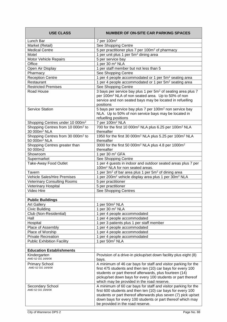
City of Wanneroo DPS 2 Page No. 88
USE CLASS NUMBER OF ON-SITE CAR PARKING SPACES
Lunch Bar 7 per 100m2
Market (Retail) See Shopping Centre
Medical Centre 5 per practitioner plus 7 per 100m2 of pharmacy
Motel 1 per unit plus 1 per 5m2 dining area
Motor Vehicle Repairs 5 per service bay
Office 1 per 30 m2 NLA
Open Air Display 1 per staff member but not less than 5
Pharmacy See Shopping Centre
Reception Centre 1 per 4 people accommodated or 1 per 5m2 seating area
Restaurant 1 per 4 people accommodated or 1 per 5m2 seating area
Restricted Premises See Shopping Centre
Road House 3 bays per service bay plus 1 per 5m2 of seating area plus 7 per 100m2 NLA of non seated area. Up to 50% of non service and non seated bays may be located in refuelling positions
Service Station 5 bays per service bay plus 7 per 100m2 non service bay NLA. Up to 50% of non service bays may be located in refuelling positions
Shopping Centres under 10 000m2 7 per 100m2 NLA
Shopping Centres from 10 000m2 to 30 000m2 NLA
700 for the first 10 000m2 NLA plus 6.25 per 100m2 NLA thereafter
Shopping Centres from 30 000m2 to 50 000m2 NLA
1950 for the first 30 000m2 NLA plus 5.25 per 100m2 NLA thereafter
Shopping Centres greater than 50 000m2
3000 for the first 50 000m2 NLA plus 4.8 per 1000m2 thereafter
Showroom 1 per 30 m2 GFA
Supermarket See Shopping Centre
Take-Away Food Outlet 1 per 4 guests in indoor and outdoor seated areas plus 7 per 100m2 NLA for non seated areas.
Tavern 1 per 3m2 of bar area plus 1 per 5m2 of dining area
Vehicle Sales/Hire Premises 1 per 200m2 vehicle display area plus 1 per 30m2 NLA
Veterinary Consulting Rooms 5 per practitioner
Veterinary Hospital 5 per practitioner
Video Hire See Shopping Centres
Public Buildings
Art Gallery 1 per 50m2 NLA
Civic Building 1 per 30 m2 NLA
Club (Non-Residential) 1 per 4 people accommodated
Hall 1 per 4 people accommodated
Hospital 1 per 3 patients plus 1 per staff member
Place of Assembly 1 per 4 people accommodated
Place of Worship 1 per 4 people accommodated
Private Recreation 1 per 4 people accommodated
Public Exhibition Facility 1 per 50m2 NLA
Education Establishments
Kindergarten AMD 52 GG 16/6/06
Provision of a drive-in pickup/set down facility plus eight (8) bays.
Primary School AMD 52 GG 16/6/06
A minimum of 46 car bays for staff and visitor parking for the first 475 students and then ten (10) car bays for every 100 students or part thereof afterwards, plus fourteen (14) pickup/set down bays for every 100 students or part thereof which may be provided in the road reserve.
Secondary School AMD 52 GG 16/6/06
A minimum of 60 car bays for staff and visitor parking for the first 600 students and then ten (10) car bays for every 100 students or part thereof afterwards plus seven (7) pick up/set down bays for every 100 students or part thereof which may be provided in the road reserve.
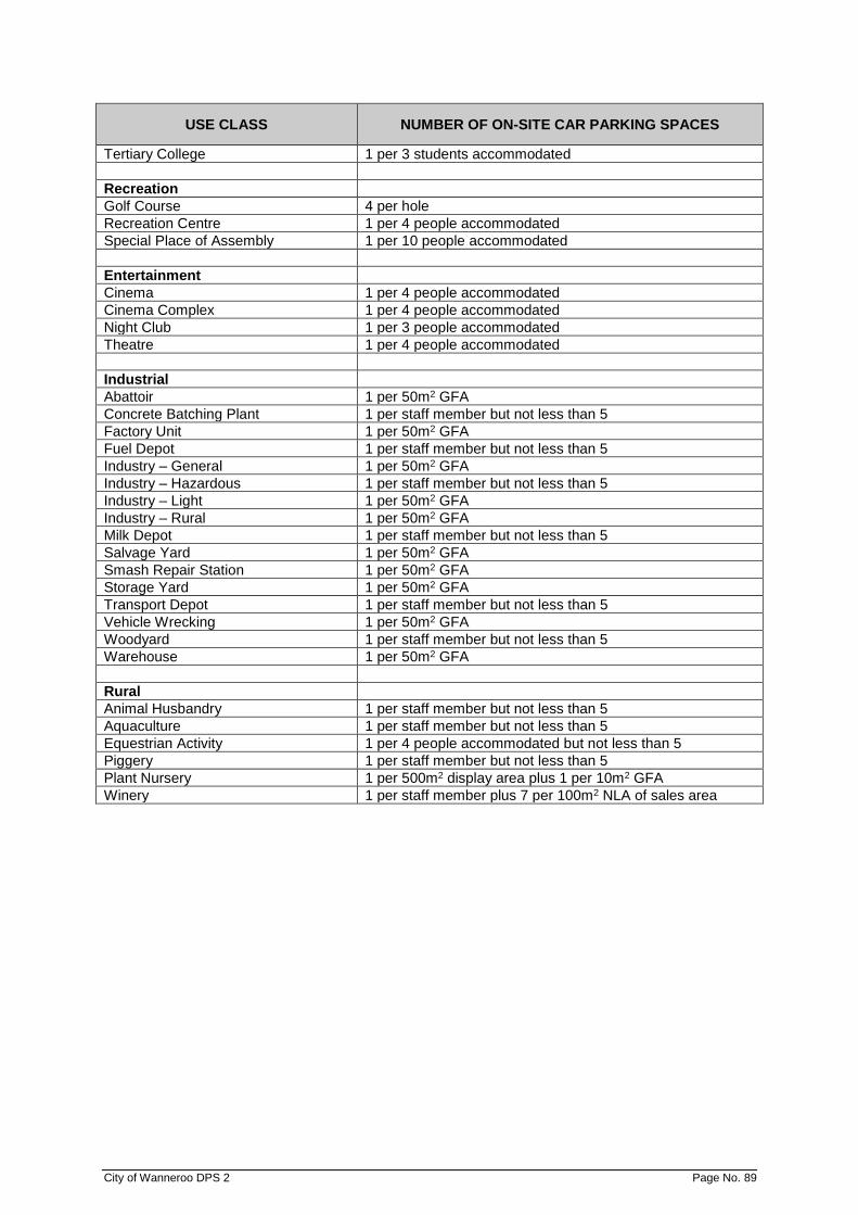
City of Wanneroo DPS 2 Page No. 89
USE CLASS NUMBER OF ON-SITE CAR PARKING SPACES
Tertiary College 1 per 3 students accommodated
Recreation
Golf Course 4 per hole
Recreation Centre 1 per 4 people accommodated
Special Place of Assembly 1 per 10 people accommodated
Entertainment
Cinema 1 per 4 people accommodated
Cinema Complex 1 per 4 people accommodated
Night Club 1 per 3 people accommodated
Theatre 1 per 4 people accommodated
Industrial
Abattoir 1 per 50m2 GFA
Concrete Batching Plant 1 per staff member but not less than 5
Factory Unit 1 per 50m2 GFA
Fuel Depot 1 per staff member but not less than 5
Industry – General 1 per 50m2 GFA
Industry – Hazardous 1 per staff member but not less than 5
Industry – Light 1 per 50m2 GFA
Industry – Rural 1 per 50m2 GFA
Milk Depot 1 per staff member but not less than 5
Salvage Yard 1 per 50m2 GFA
Smash Repair Station 1 per 50m2 GFA
Storage Yard 1 per 50m2 GFA
Transport Depot 1 per staff member but not less than 5
Vehicle Wrecking 1 per 50m2 GFA
Woodyard 1 per staff member but not less than 5
Warehouse 1 per 50m2 GFA
Rural
Animal Husbandry 1 per staff member but not less than 5
Aquaculture 1 per staff member but not less than 5
Equestrian Activity 1 per 4 people accommodated but not less than 5
Piggery 1 per staff member but not less than 5
Plant Nursery 1 per 500m2 display area plus 1 per 10m2 GFA
Winery 1 per staff member plus 7 per 100m2 NLA of sales area
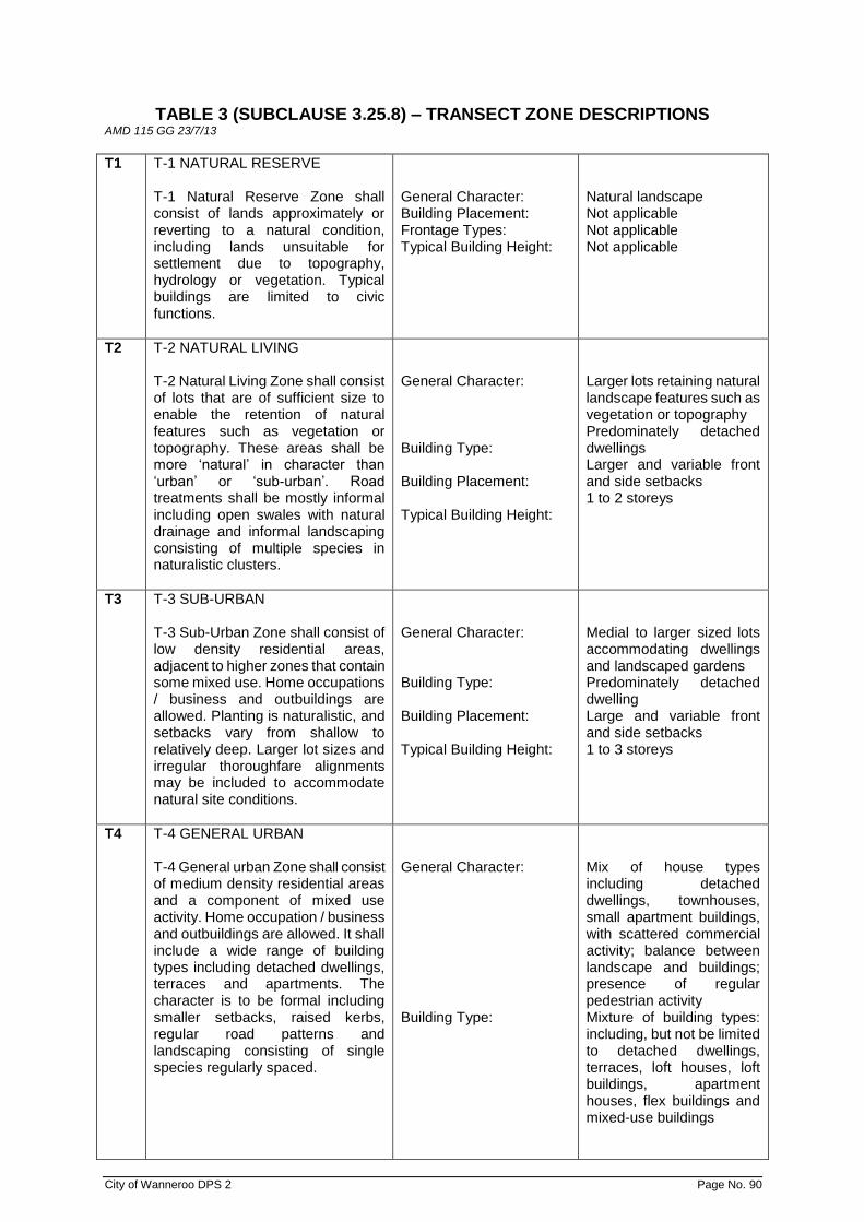
City of Wanneroo DPS 2 Page No. 90
TABLE 3 (SUBCLAUSE 3.25.8) – TRANSECT ZONE DESCRIPTIONS AMD 115 GG 23/7/13
T1 T-1 NATURAL RESERVE T-1 Natural Reserve Zone shall consist of lands approximately or reverting to a natural condition, including lands unsuitable for settlement due to topography, hydrology or vegetation. Typical buildings are limited to civic functions.
General Character: Building Placement: Frontage Types: Typical Building Height:
Natural landscape Not applicable Not applicable Not applicable
T2 T-2 NATURAL LIVING T-2 Natural Living Zone shall consist of lots that are of sufficient size to enable the retention of natural features such as vegetation or topography. These areas shall be more ‘natural’ in character than ‘urban’ or ‘sub-urban’. Road treatments shall be mostly informal including open swales with natural drainage and informal landscaping consisting of multiple species in naturalistic clusters.
General Character: Building Type: Building Placement: Typical Building Height:
Larger lots retaining natural landscape features such as vegetation or topography Predominately detached dwellings Larger and variable front and side setbacks 1 to 2 storeys
T3 T-3 SUB-URBAN T-3 Sub-Urban Zone shall consist of low density residential areas, adjacent to higher zones that contain some mixed use. Home occupations / business and outbuildings are allowed. Planting is naturalistic, and setbacks vary from shallow to relatively deep. Larger lot sizes and irregular thoroughfare alignments may be included to accommodate natural site conditions.
General Character: Building Type: Building Placement: Typical Building Height:
Medial to larger sized lots accommodating dwellings and landscaped gardens Predominately detached dwelling Large and variable front and side setbacks 1 to 3 storeys
T4 T-4 GENERAL URBAN T-4 General urban Zone shall consist of medium density residential areas and a component of mixed use activity. Home occupation / business and outbuildings are allowed. It shall include a wide range of building types including detached dwellings, terraces and apartments. The character is to be formal including smaller setbacks, raised kerbs, regular road patterns and landscaping consisting of single species regularly spaced.
General Character: Building Type:
Mix of house types including detached dwellings, townhouses, small apartment buildings, with scattered commercial activity; balance between landscape and buildings; presence of regular pedestrian activity Mixture of building types: including, but not be limited to detached dwellings, terraces, loft houses, loft buildings, apartment houses, flex buildings and mixed-use buildings

City of Wanneroo DPS 2 Page No. 91
Building Placement: Typical Building Height:
Shallow to medium front and side setbacks 1 to 6 storeys
T5 T-5 URBAN CENTRE T-5 Urban Centre Zone shall consist of higher density mixed use buildings that accommodate retail, offices, terraces and apartments. It shall have a tight network of streets, with wide footpaths, raised kerbs, regular street tree planting and buildings set close to the footpaths.
General Character: Building Type: Building Placement: Typical Building Height:
Shops mixed with townhouses, larger apartments, offices, lodging, work places, and civic buildings; predominately attached buildings; trees within the thoroughfare reserve; substantial pedestrian activity Predominately apartments and mixed use buildings Shall setbacks or none; buildings oriented to street, attached buildings form a continuous street wall 2 to 8 storeys
T6 T-6 URBAN CORE T-6 Urban Core Zone shall consist of the highest density and height, with the greatest variety of uses and civic buildings of regional importance. It shall have larger blocks; regular street tree planting and buildings set close to wide footpaths.
General Character: Building Type: Building Placement: Typical Building Height:
Medium to high density mixed use buildings, for a range of uses including retail, residential, commercial, entertainment, civic and cultural; trees within the thoroughfare reserve; highest pedestrian and transit activity Predominately apartments, commercial buildings and mixed use buildings Shallow setbacks or none; buildings oriented to street; attached buildings form a continuous street wall 1 to 8 storeys
SD SD SPECIAL DISTRICT SD Special District is an area that by its intrinsic function, disposition or configuration cannot or should not conform to one or more of the Transect Zones.
All standards and controls to regulate development within a Special District shall be established through the Local Structure Plan and refined in Local Development Plans. AMD 132 GG 15/7/16
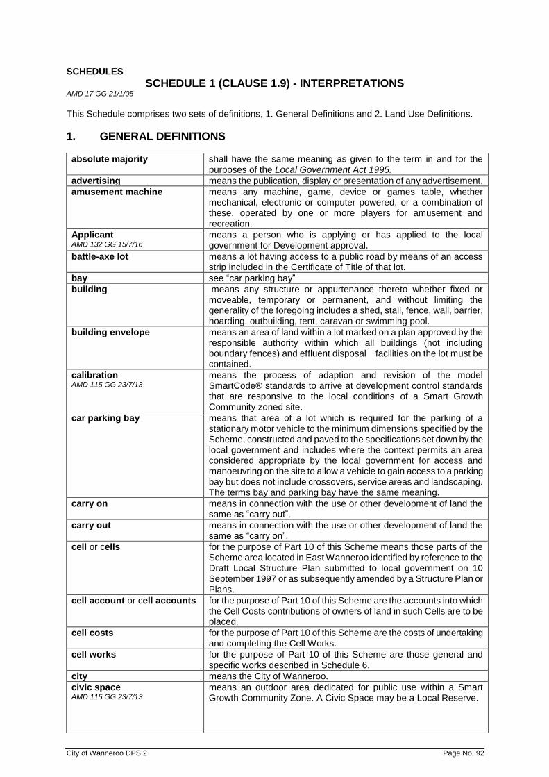
City of Wanneroo DPS 2 Page No. 92
SCHEDULES
SCHEDULE 1 (CLAUSE 1.9) - INTERPRETATIONS AMD 17 GG 21/1/05
This Schedule comprises two sets of definitions, 1. General Definitions and 2. Land Use Definitions.
1. GENERAL DEFINITIONS
absolute majority shall have the same meaning as given to the term in and for the purposes of the Local Government Act 1995.
advertising means the publication, display or presentation of any advertisement.
amusement machine means any machine, game, device or games table, whether mechanical, electronic or computer powered, or a combination of these, operated by one or more players for amusement and recreation.
Applicant AMD 132 GG 15/7/16
means a person who is applying or has applied to the local government for Development approval.
battle-axe lot means a lot having access to a public road by means of an access strip included in the Certificate of Title of that lot.
bay see “car parking bay”
building means any structure or appurtenance thereto whether fixed or moveable, temporary or permanent, and without limiting the generality of the foregoing includes a shed, stall, fence, wall, barrier, hoarding, outbuilding, tent, caravan or swimming pool.
building envelope means an area of land within a lot marked on a plan approved by the responsible authority within which all buildings (not including boundary fences) and effluent disposal facilities on the lot must be contained.
calibration AMD 115 GG 23/7/13
means the process of adaption and revision of the model SmartCode® standards to arrive at development control standards that are responsive to the local conditions of a Smart Growth Community zoned site.
car parking bay means that area of a lot which is required for the parking of a stationary motor vehicle to the minimum dimensions specified by the Scheme, constructed and paved to the specifications set down by the local government and includes where the context permits an area considered appropriate by the local government for access and manoeuvring on the site to allow a vehicle to gain access to a parking bay but does not include crossovers, service areas and landscaping. The terms bay and parking bay have the same meaning.
carry on means in connection with the use or other development of land the same as “carry out”.
carry out means in connection with the use or other development of land the same as “carry on”.
cell or cells for the purpose of Part 10 of this Scheme means those parts of the Scheme area located in East Wanneroo identified by reference to the Draft Local Structure Plan submitted to local government on 10 September 1997 or as subsequently amended by a Structure Plan or Plans.
cell account or cell accounts for the purpose of Part 10 of this Scheme are the accounts into which the Cell Costs contributions of owners of land in such Cells are to be placed.
cell costs for the purpose of Part 10 of this Scheme are the costs of undertaking and completing the Cell Works.
cell works for the purpose of Part 10 of this Scheme are those general and specific works described in Schedule 6.
city means the City of Wanneroo.
civic space AMD 115 GG 23/7/13
means an outdoor area dedicated for public use within a Smart Growth Community Zone. A Civic Space may be a Local Reserve.

City of Wanneroo DPS 2 Page No. 93
commercial vehicle AMD 17 GG 21/1/05
means a vehicle whether licensed or not which is used or designed for use for business, trade or commercial purposes or in conjunction with a business, trade or profession and without limiting the generality of the foregoing includes any utility, van, truck, trailer, tractor and any wheeled attachment to any of them or any wheeled article designed to be an attachment to any of them, and any bus or omnibus or any earthmoving machine whether self-propelled or not. If a truck, prime mover or other vehicle is attached to a trailer, semi-trailer or any other attachment, each trailer, semi-trailer or other attachment is to be regarded as a separate commercial vehicle. A loaded combination, such as a bobcat, forklift or other vehicle or attachment loaded on a truck, trailer or other attachment is to be regarded as one commercial vehicle. The term shall not include a vehicle designed for use as a passenger car or any trailer or other thing most commonly used as an attachment to a passenger car, or a van, utility or light truck which is rated by the manufacturer as being suitable to carry loads of not more than 1.5 tonnes.
Commission: means the Western Australian Planning Commission constituted under the Western Australian Planning Commission Act 1985 (as amended).
community purpose: means the use of premises designed or adapted primarily for the provision of education, social, cultural and recreational facilities and services by organisations involved in activities for community benefit.
conservation AMD 132 GG 15/7/16
means, in relation to any place on the Heritage List (Clause 8 of the deemed provisions, the management of that place in a manner that will: (a) enable the cultural heritage significance of that place to be
retained; and (b) yield the greatest sustainable benefit for the present
community without diminishing the cultural heritage significance of that place, and may include the preservation, stabilisation, protection, restoration, reconstruction, adaptation and maintenance of that place in accordance with relevant professional standards, and the provision of an appropriate visual setting.
contributing land means all land capable of being subdivided or developed by an Owner contained with a Cell referred to in Part 10 of the Scheme.
control plan AMD 115 GG 23/7/13
means a plan that forms part of the regulating plan series for a Smart Growth community zone that is used to regulate locations where specific design responses are required.
convenience goods means goods sold or offered for sale by retail, and being goods ordinarily consumed on a regular basis by people residing in or resorting to the locality and includes food and other articles of household use, pharmaceutical products, newspapers and magazines.
local government means the local government of the City of Wanneroo.
curtilage in relation to a dwelling means the yard of the dwelling; or an area in the immediate vicinity of the dwelling, situated on the same lot as, and used for purposes ancillary to, the dwelling. The curtilage shall not include the area located between the frontage and the dwelling. The term shall have a like meaning in relation to land around buildings other than dwellings.
density code means the code based on the number of dwellings permitted per hectare as provided in the R-Codes. The density code applicable to any land is shown on the Residential Density Code Map.
development shall have the same meaning given to it in and for the purposes of the Act but shall also include in relation to any building, object, structure or places listed on the Heritage List any act or thing that: (a) is likely to change the character of the place or the external
appearance of any building; or (b) would constitute an irreversible alteration to the fabric of any
building.

City of Wanneroo DPS 2 Page No. 94
development site AMD 132 GG 15/7/16
means land the subject of an application for a Development Approval.
district means the municipal district of the City of Wanneroo.
equipment hire means the use of land and/or buildings for the hire of domestic trailers and lawnmowers and other equipment of a like kind and may include the display of some items of that equipment, but does not include the hire of domestic or commercial motor vehicles, caravans or boats. Equipment hire is only to be considered for approval where it is to be conducted: (a) on a minor scale to be determined by the local government on
each case but involving no more than 10 items of equipment; (b) in conjunction with and ancillary to a compatible predominant
use such as ‘service station’ or ‘convenience store’; and (c) in a manner which does not adversely affect the function of the
predominant use or detract from amenity.
façade means the exposed face of a building facing any road or open space or the frontal outward appearance of the building.
floor area shall have the same meaning given to it in and for the purposes of the Building Code of Australia 1996.
frontage AMD 132 GG 15/7/16
when used in relation to a building that is used for: (a) residential purposes, has the same meaning given to the term
in the Residential Design Codes; or (b) purposes other than residential purposes, means the road
alignment at the front of a lot and, if a lot abuts two or more roads, the one to which the building or proposed building faces.
Gazettal Date means the date on which the Scheme came into force; being the date on which notice of the Minister’s approval of the Scheme is published in the Government Gazette.
gross floor area (GFA) has the same meaning as “floor area” in the Building Codes of Australia.
gross leasable area (GLA) means, in relation to a building, the area of all floors capable of being occupied by a tenant for exclusive use, which area is measured from the centre line of joint partitions or walls and from the outside faces of external walls or the building alignment, including shop fronts, basements, mezzanines and storage areas.
height AMD 132 GG 15/7/16
when used in relation to a building that is used for: (a) residential purposes, has the same meaning given to it in and
for the purpose of the Residential Design Codes; and (b) purposes other than residential purposes, means the
measurement taken from the natural ground level immediately in front of the centre of the face of the building to a level of the top of the eaves, parapet or flat roof, whichever is the highest.
incidental use means a use of premises which is ancillary and subordinate to the predominant use.
infrastructure cost or costs for the purpose of Part 10 of the Scheme means the contribution of an owner of land in a Cell towards the Cell Costs.
land shall have the same meaning given to the term in and for the purposes of the Act.
lot shall have the same meaning as is given to it in and for the purposes of the Act and “allotment” has the same meaning, but shall not include a Strata or survey Strata lot.
local reserve means land, other than a regional reserve, which is reserved for a specific purpose.
low density in relation to residential development means a density less than R25 under the Codes.
marina frontage means the boundary line between the marina and adjacent lots as defined on a Structure Plan.
marina wall AMD 17 GG 21/1/05
means a retaining wall constructed in a marina to retain a stabilised level land surface at or near the marina frontage.
medium density in the case of residential development means a density between and including R25 and R60 under the Codes.
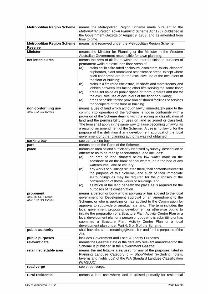
City of Wanneroo DPS 2 Page No. 95
Metropolitan Region Scheme means the Metropolitan Region Scheme made pursuant to the Metropolitan Region Town Planning Scheme Act 1959 published in the Government Gazette of August 9, 1963, and as amended from time to time.
Metropolitan Region Scheme Reserve
means land reserved under the Metropolitan Region Scheme.
Minister means the Minister for Planning or the Minister in the Western Australian Government responsible for town planning.
net lettable area means the area of all floors within the internal finished surfaces of permanent walls but excludes floor areas of: (a) stairs not in a fire rated enclosure, escalators, toilets, cleaners’
cupboards, plant rooms and other service areas, except where such floor areas are for the exclusive use of the occupiers of the floor or building;
(b) stairs in a fire rated enclosure, lift shafts and motor rooms, and lobbies between lifts facing other lifts serving the same floor;
(c) areas set aside as public space or thoroughfares and not for the exclusive use of occupiers of the floor or building;
(d) areas set aside for the provision of shared facilities or services for occupiers of the floor or building.
non-conforming use AMD 132 GG 15/7/16
means a use of land which although lawful immediately prior to the coming into operation of the Scheme is not in conformity with a provision of the Scheme dealing with the zoning or classification of land and the permissibility of uses on land so zoned or classified. The term shall apply in the same way to a use becoming unlawful as a result of an amendment of the Scheme. A use is not lawful for the purpose of this definition if any development approval of the local government or other planning authority was not obtained.
parking bay see car parking bay.
part means one of the Parts of the Scheme.
place means an area of land sufficiently identified by survey, description or otherwise as to be readily ascertainable, and includes: (a) an area of land situated below low water mark on the
seashore or on the bank of tidal waters, or in the bed of any watercourse, lake or estuary;
(b) any works or buildings situated there, their contents relevant to the purpose of this Scheme, and such of their immediate surroundings as may be required for the purposes of the conservation of those works or buildings; and
(c) as much of the land beneath the place as is required for the purposes of its conservation.
proponent AMD 37 GG 14/3/06; AMD 132 GG 15/7/16
means a person or body who is applying or has applied to the local government for Development approval or an amendment to the Scheme, or who is applying or has applied to the Commission for approval to subdivide or amalgamate land. The term includes the local government proposing development or otherwise opting to initiate the preparation of a Structure Plan, Activity Centre Plan or a local development plan or a person or body who is submitting or has submitted a Structure Plan, Activity Centre Plan or a local development plan under Part 4, 5 or 6 of the Scheme.
public authority shall have the same meaning given to it in and for the purposes of the Act.
public purposes includes Government and Local Authority Purposes.
relevant date means the Gazettal Date or the date any relevant amendment to the Scheme is published in the Government Gazette.
retail net lettable area means the net lettable area used for any of the purposes listed in Planning Landuse Category 5 – Shop/Retail (excluding hotels, taverns and nightclubs) of the WA Standard Landuse Classification (WASLUC).
road verge see street verge.
rural-residential means a land use where land is utilised primarily for residential

City of Wanneroo DPS 2 Page No. 96
purposes in a rural landscape but often also for some form of limited agricultural or rural use.
rural resource means a rural land use or basic raw material which has been deemed, in policies adopted by the Western Australian Planning Commission, to have State or regional strategic significance.
Schedule means a schedule to the Scheme.
Scheme means the City of Wanneroo District Planning Scheme No. 2.
sensitive use means any use in which people involved in that use may have reason to object to noise, dust, odour and other impacts which may arise from rural resource operations and includes, but is not limited to, residential, hospitals, schools, shops and all public establishments where food and drink is consumed.
set back means the horizontal distance between a wall at any point and an adjacent lot boundary measured at right angles (90º) to the wall.
short-term accommodation AMD 160 GG 25/01/19
means temporary accommodation provided either continuously or from time to time with no guest accommodated for periods totalling more than 3 months in any 12 month period.
SmartCode AMD 115 GG 23/7/13
means a form-based code consisting of a unified development ordinance calibrated to the local conditions of the land within a Smart Growth Community zone. SmartCode applies the transect as the organising principle for the creation of diverse human habitats ranging from the very urban to the very natural.
Special District AMD 115 GG 23/7/13
means an area that, by its intrinsic function, disposition and/or configuration, does not conform to one or more of the normative transect zones identified in the Transect Based Code for a Smart Growth Community zone.
street alignment means the boundary between the land comprising a road reserve and the land that abuts thereon.
street verge means the land between the street alignment of any lot and the road pavement.
structure plan means a document consisting of maps and text making provision for the subdivision and/or development of a specific area, and which provides a policy framework for such future subdivision and development.
Transect AMD 115 GG 23/7/13
a geographical cross-section of a Smart Growth Community zone used to reveal a sequence of environments that vary by their level and intensity of urban character ranging from the very natural to the very urban. This range of environments provides the basis for organising the components of the built environment and landscape including buildings, land use, streets, planting and all the other physical elements of the human habitat.
Transect Based Code AMD 115 GG 23/7/13
means a method for regulating and organising development to achieve a specific urban form. The Code uses the transect to understand and organise the human habitat in a continuum of intensity ranging from the most natural to the most urban condition. The transect zones that comprise the transect are differentiated primarily by physical intensity of the built form, the relationship between the natural and the built environment and the complexity of uses within each zone.
Transect Plan AMD 115 GG 23/7/13
a plan that forms part of the regulating plan series for a Smart Growth Community zone used to assign transect zones, special districts and civic spaces for the classification of land within a Smart Growth Community zone.
Transect Zone AMD 115 GG 23/7/13
means any of the six zones that are allocated on the Regulating Plan Series of a Transect Based Code to achieve the development and design outcomes intended of a Smart Growth Community zone. They include the Natural Reserve (T1 Zone), Natural Living (T2 Zone), Sub-Urban (T3 Zone), General Urban (T4 Zone), Urban Centre (T5 Zone) and Urban Core (T6 Zone).
vehicle includes motorcycles, boats, caravans, trailers.
wholesale means the sale of any goods to any person or persons other than the

City of Wanneroo DPS 2 Page No. 97
ultimate consumer of those goods
.
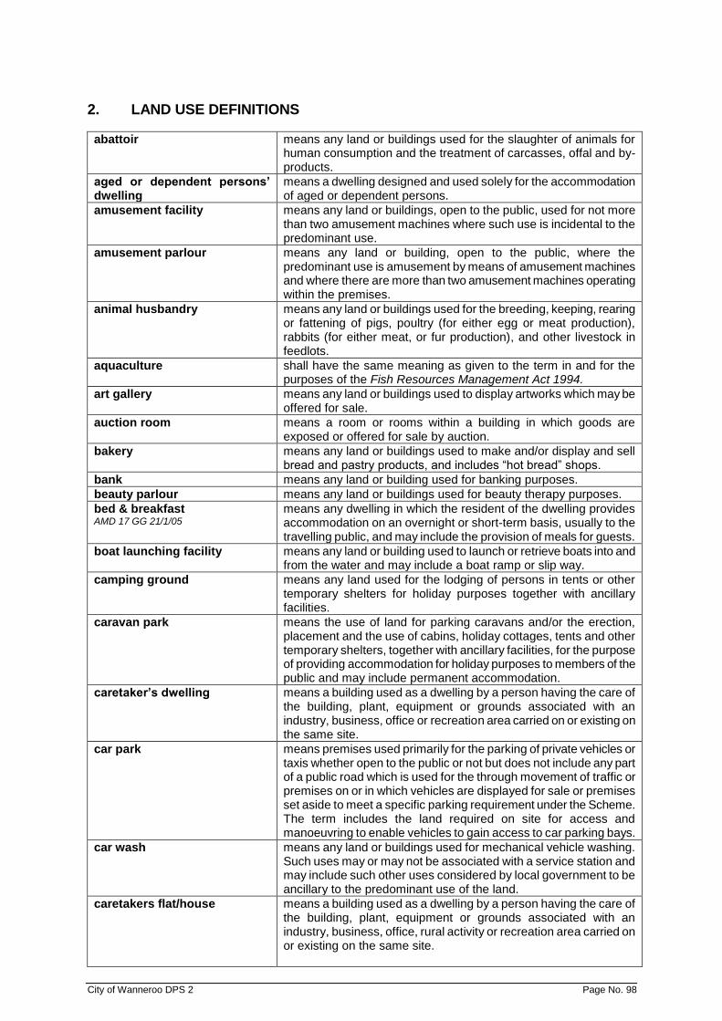
City of Wanneroo DPS 2 Page No. 98
2. LAND USE DEFINITIONS
abattoir means any land or buildings used for the slaughter of animals for human consumption and the treatment of carcasses, offal and by-products.
aged or dependent persons’ dwelling
means a dwelling designed and used solely for the accommodation of aged or dependent persons.
amusement facility means any land or buildings, open to the public, used for not more than two amusement machines where such use is incidental to the predominant use.
amusement parlour means any land or building, open to the public, where the predominant use is amusement by means of amusement machines and where there are more than two amusement machines operating within the premises.
animal husbandry means any land or buildings used for the breeding, keeping, rearing or fattening of pigs, poultry (for either egg or meat production), rabbits (for either meat, or fur production), and other livestock in feedlots.
aquaculture shall have the same meaning as given to the term in and for the purposes of the Fish Resources Management Act 1994.
art gallery means any land or buildings used to display artworks which may be offered for sale.
auction room means a room or rooms within a building in which goods are exposed or offered for sale by auction.
bakery means any land or buildings used to make and/or display and sell bread and pastry products, and includes “hot bread” shops.
bank means any land or building used for banking purposes.
beauty parlour means any land or buildings used for beauty therapy purposes.
bed & breakfast AMD 17 GG 21/1/05
means any dwelling in which the resident of the dwelling provides accommodation on an overnight or short-term basis, usually to the travelling public, and may include the provision of meals for guests.
boat launching facility means any land or building used to launch or retrieve boats into and from the water and may include a boat ramp or slip way.
camping ground means any land used for the lodging of persons in tents or other temporary shelters for holiday purposes together with ancillary facilities.
caravan park means the use of land for parking caravans and/or the erection, placement and the use of cabins, holiday cottages, tents and other temporary shelters, together with ancillary facilities, for the purpose of providing accommodation for holiday purposes to members of the public and may include permanent accommodation.
caretaker’s dwelling means a building used as a dwelling by a person having the care of the building, plant, equipment or grounds associated with an industry, business, office or recreation area carried on or existing on the same site.
car park means premises used primarily for the parking of private vehicles or taxis whether open to the public or not but does not include any part of a public road which is used for the through movement of traffic or premises on or in which vehicles are displayed for sale or premises set aside to meet a specific parking requirement under the Scheme. The term includes the land required on site for access and manoeuvring to enable vehicles to gain access to car parking bays.
car wash means any land or buildings used for mechanical vehicle washing. Such uses may or may not be associated with a service station and may include such other uses considered by local government to be ancillary to the predominant use of the land.
caretakers flat/house means a building used as a dwelling by a person having the care of the building, plant, equipment or grounds associated with an industry, business, office, rural activity or recreation area carried on or existing on the same site.
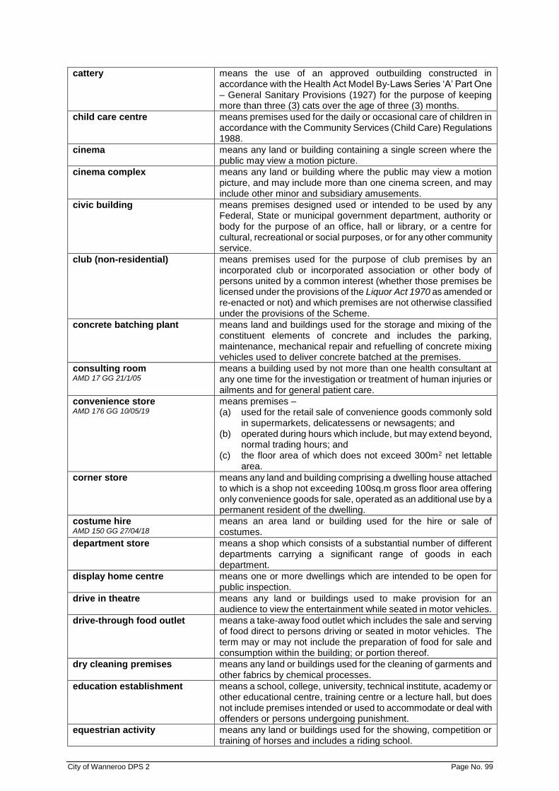
City of Wanneroo DPS 2 Page No. 99
cattery means the use of an approved outbuilding constructed in accordance with the Health Act Model By-Laws Series ‘A’ Part One – General Sanitary Provisions (1927) for the purpose of keeping more than three (3) cats over the age of three (3) months.
child care centre means premises used for the daily or occasional care of children in accordance with the Community Services (Child Care) Regulations 1988.
cinema means any land or building containing a single screen where the public may view a motion picture.
cinema complex means any land or building where the public may view a motion picture, and may include more than one cinema screen, and may include other minor and subsidiary amusements.
civic building means premises designed used or intended to be used by any Federal, State or municipal government department, authority or body for the purpose of an office, hall or library, or a centre for cultural, recreational or social purposes, or for any other community service.
club (non-residential) means premises used for the purpose of club premises by an incorporated club or incorporated association or other body of persons united by a common interest (whether those premises be licensed under the provisions of the Liquor Act 1970 as amended or re-enacted or not) and which premises are not otherwise classified under the provisions of the Scheme.
concrete batching plant means land and buildings used for the storage and mixing of the constituent elements of concrete and includes the parking, maintenance, mechanical repair and refuelling of concrete mixing vehicles used to deliver concrete batched at the premises.
consulting room AMD 17 GG 21/1/05
means a building used by not more than one health consultant at any one time for the investigation or treatment of human injuries or ailments and for general patient care.
convenience store AMD 176 GG 10/05/19
means premises – (a) used for the retail sale of convenience goods commonly sold
in supermarkets, delicatessens or newsagents; and (b) operated during hours which include, but may extend beyond,
normal trading hours; and (c) the floor area of which does not exceed 300m2 net lettable
area.
corner store means any land and building comprising a dwelling house attached to which is a shop not exceeding 100sq.m gross floor area offering only convenience goods for sale, operated as an additional use by a permanent resident of the dwelling.
costume hire AMD 150 GG 27/04/18
means an area land or building used for the hire or sale of costumes.
department store means a shop which consists of a substantial number of different departments carrying a significant range of goods in each department.
display home centre means one or more dwellings which are intended to be open for public inspection.
drive in theatre means any land or buildings used to make provision for an audience to view the entertainment while seated in motor vehicles.
drive-through food outlet means a take-away food outlet which includes the sale and serving of food direct to persons driving or seated in motor vehicles. The term may or may not include the preparation of food for sale and consumption within the building; or portion thereof.
dry cleaning premises means any land or buildings used for the cleaning of garments and other fabrics by chemical processes.
education establishment means a school, college, university, technical institute, academy or other educational centre, training centre or a lecture hall, but does not include premises intended or used to accommodate or deal with offenders or persons undergoing punishment.
equestrian activity means any land or buildings used for the showing, competition or training of horses and includes a riding school.

City of Wanneroo DPS 2 Page No. 100
extractive industry see industry – extractive.
factory unit means a building or structure, or a group of buildings or structures on one lot, in which are carried on two or more separate industries or storage areas not owned or managed by the same person, or in which provision is made for the carrying on of two or more separate industries or storage areas not owned or managed by the same person.
fuel depot means any land or building used for the storage and sale in bulk of solid or liquid or gaseous fuel, but does not include a service station and specifically excludes the sale by retail into the final user’s vehicle of such fuel from the premises.
funeral parlour means any land or buildings used to prepare and store bodies for burial or cremation and may include facilities to conduct memorial services.
general industry refer industry – general.
hairdresser means premises used for the cutting, styling and tending to customers hair and may include the sale of hair care products.
hardware store AMD 117 GG 11/6/13
means premises used for the display and sale of goods and products primarily of a hardware nature used for house, garden, and industrial trade purposes being primarily tools, implements, fittings, trade supply items, paints, equipment, appliances, construction materials, furnishings, garden improvement products, plants, outdoor furniture and the lake, and may include the incidental sale of food.
hazardous industry refer industry – hazardous.
health studio see “recreation centre”.
hire service means land and buildings used for the hire of goods and equipment and may include the display of some items of goods and equipment.
holiday accommodation AMD 160 GG 25/1/19
means 2 or more dwellings on one lot used to provide short term accommodation for persons other than the owner of the lot.
holiday house AMD 160 GG 25/1/19
means a single dwelling on one lot used to provide short term accommodation but does not include a bed and breakfast.
holiday village/resort means composite holiday recreation development, incorporating a variety of holiday accommodation types, including caravan park, holiday cottages and motel units with directly associated facilities and services, and may include licensed premises under the Liquor Act 1970-1976 (as amended).
home business – category 1 means an occupation carried on within a dwelling by a resident of the dwelling which: (a) does not entail the retail sale, display or hire of goods of any
nature; (b) does not cause injury to or prejudicially affect the amenity of
the neighbourhood; (c) does not entail any substantial and/or inappropriate
modification of the dwelling; (d) does not entail employment of any other person; (e) does not occupy an area greater than 20m2 or where more
than one resident is involved not cause the area used for home business within the dwelling to occupy an area greater than 30m2;
(f) does not display any advertising signage; (g) does not attract customers or regular and frequent deliveries
of goods or equipment to the site; (h) will not result in the requirement for a greater number of
parking facilities than normally reserved for a single dwelling, and will not result in any increase in the amount of vehicular traffic in the vicinity;
(i) does not entail the presence, parking and garaging of a vehicle of more than 1.5 tonnes tare weight;
(j) does not involve the servicing or repair for gain of motor vehicles;
City of Wanneroo DPS 2 Page No. 101
(k) notwithstanding the above, a Home Business Category 1 may entail the operation of a Family Day Care Centre as defined in the Community Services (Child Care) Regulations 1998.
home business – category 2 means an occupation carried on in a dwelling or on land around a dwelling by a resident of the dwelling which: (a) does not entail the retail sale, outdoor display or hire of goods
of any nature; (b) does not cause injury to or prejudicially affect the amenity of
the neighbourhood; (c) does not detract from the residential appearance of the
dwelling house or domestic outbuilding; (d) entails the employment of no more than 1 person not a
member of the occupier’s household; (e) does not occupy an area greater than 30m2; (f) does not have more than one advertisement sign and the sign
displayed does not exceed 0.2 square metres in area; (g) will not result in the requirement for a greater number of
parking facilities than normally reserved for a single dwelling, and will not result in a substantial increase in the amount of vehicular traffic in the vicinity;
(h) does not involve the servicing or repair for gain of motor vehicles; and
(i) does not entail the presence, parking and garaging of a vehicle of more than 3.5 tonnes tare weight.
home business – category 3 means a business, service, trade or similar activity carried on in a dwelling or on land around a dwelling by a resident of the dwelling which: (a) does not entail the retail sale, outdoor display or hire of goods
of any nature; (b) does not cause injury to or prejudicially affect the amenity of
the neighbourhood; (c) does not detract from the residential appearance of the
dwelling house or domestic outbuilding; (d) entails employment of a maximum of 2 persons not members
of the occupier’s household. Local government may approve a greater number of employees, not exceeding 4 persons, subject to community consultation;
(e) occupies an area not exceeding 50 square metres. Local government may approve; subject to community consultation; an area of up to 100 square metres, or one third of the floor area of the dwelling whichever is the lesser;
(f) displays a sign describing the nature of the approved home occupation. The sign must not exceed 0.2 square metres, and a maximum 2 metres high;
(g) will not result in traffic difficulties as a result of the inadequacy of on-site and off-site parking;
(h) will not result in a substantial increase in the amount of vehicular traffic in the vicinity;
(i) does not involve the servicing or repair for gain of motor vehicles; and
(j) does not entail the presence, parking and garaging of a vehicle of more than 3.5 tonnes tare weight.
home office means a dwelling used by an occupier of the dwelling to carry out a home occupation if the carrying out of the home occupation – (a) is solely within the dwelling; and (b) does not entail clients or customers travelling to and from the
dwelling; and (c) does not involve the display of a sign on the premises; and (d) does not require any change to the external appearance of the
dwelling.
hospital means any land or buildings where people are admitted and lodged for medical treatment or care.
City of Wanneroo DPS 2 Page No. 102
hotel means any land or buildings used for the overnight accommodation of patrons and may include facilities for consumption of beverages or a restaurant, or a betting agency operated in accordance with the Totalisator Agency Betting Board Act 1960, or facilities for entertainment, but does not include a bed and breakfast facility, and which may be the subject of a hotel licence granted under the provisions of the Liquor Licensing Act 1988.
industry means the carrying out of any process for and incidental to: (a) making, altering, repairing, ornamenting, painting, finishing,
cleaning, packing, canning, adapting, breaking up or demolishing of any article or part of any article;
(b) winning, processing or treatment of minerals; (c) generation of electricity or the production of gas; (d) the manufacture of edible goods;
and includes, when carried out on land upon which the process is carried out and in connection with that process, the storage of goods, any work of administration or accounting, or the wholesaling of, or the incidental sale of goods resulting from the process, and the use of land for the amenity of persons engaged in the process; but does not include: (i) the carrying out of agriculture; (ii) on-site work on buildings or land; and (iii) in the case of edible goods, the preparation of food for
retail sale from the premises. (e) depots for bulk storage and distribution purposes.
industry – extractive means the extraction of sand, gravel, clay, peat, soil, rock, stone, minerals or any similar substance from land, and includes the manufacture of products from those materials when the manufacture and storage is carried out on the land from which any of those materials is extracted or on land adjacent thereto.
industry – general means an industry other than an extractive, rural, light, hazardous or service industry and which by virtue of its scale, intensity or nature, is regarded by local government as development which would be too obtrusive or detrimental to amenity and therefore inappropriate in zones other than the General Industrial Zone.
industry – hazardous means an industry which, when in operation and when all measures proposed to minimise its impact on the locality have been employed (including measures to isolate the industry from existing or likely future development on other land in the locality), would pose a significant risk in relation to the locality, to human health, life or property, or to the biophysical environment. Examples of such industry include oil refineries and chemical plants but would generally exclude light, rural or service industries.
industry – light means an industry: (a) in which the processes carried on, the machinery used, and
the goods and commodities carried to and from the premises, will not cause any injury to, or will not adversely affect the amenity of the locality by reason of the emission of light, noise, electrical interference, vibration, smell, fumes, smoke, vapour, steam, soot, ash, dust, waste water or other waste products; and
(b) the establishment of which will not, or the conduct of which does not, impose an undue load on any existing or proposed service for the supply or provision of water, gas, electricity, sewerage facilities, or any other like services.
industry – rural means an industry handling, treating, processing or packing primary products grown, reared or produced in the locality, and a workshop used for the servicing of plant or equipment used for rural purposes in the locality.

City of Wanneroo DPS 2 Page No. 103
institutional building means a building used or designed for use wholly or principally for the purpose of: (a) a hospital or sanitarium for the treatment of infectious or
contagious diseases; (b) a penal or reformative institution; (c) a hospital for the treatment of the mentally handicapped; (d) any other similar use.
intensive agriculture means any land or buildings used for trade or commercial purposes for the following: (a) the production of grapes, vegetables, flowers, exotic and
native plants, fruit and nuts (including market gardens); or (b) the establishment and operation of plant and fruit nurseries; or (c) the development of land for irrigated fodder product and
irrigated pasture (including turf farms).
kennels means any land or buildings used for the boarding and breeding of domestic animals for remuneration where such premises are registered or required to be registered by the local government, and may include the sale of domestic animals.
landscape supplies means any land or buildings used for the storage and sale of items such as woodchips, logs, rocks, sand, stone, paving slabs and other such materials intended for landscaping purposes.
laundromat premises open to the public in which washing machines and clothes dryers are available for use and may include dry cleaning services.
laundry premises used for the washing, drying and ironing of clothes, linen and other fabrics.
liquor store means any land or buildings the subject of a liquor store licence granted under the provisions of the Liquor Licensing Act 1988.
lunch bar means premises used as a take-away food outlet but within the hours of 6.00 am to 4.00 pm only.
marina means premises at which berths or pens, and fuelling, servicing, repairing, storage (including storage on land) and other facilities for boats are provided, with or without the sale of boating gear and equipment, and includes all jetties, piers, embankments, quays and moorings appurtenant thereto and all offices and storerooms used in connection therewith.
marina filling station means any land or buildings used for the storage and supply of liquid fuels and lubricants for marine craft, but in which no industry is carried on; but does not include a service station.
market garden see “intensive agriculture”.
market garden sales AMD 17 GG 21/1/05
means the sale or offering for sale of fresh fruit and vegetables from a lot which is predominantly used as a market garden.
market (retail) AMD 52 GG 16/6/06
means retail premises at which goods are sold from temporary stalls in individual bays leased to or otherwise occupied by independent stallholders.
mast or antenna AMD 52 GG 16/6/06
means any mast, aerial, satellite dish and other associated equipment used for the transmission or reception of radio or television signals or for other electronic communications. A television antenna on a dwelling roof being consistent with the predominant style and size of television antenna on other dwellings in the locality is not included, provided its vertical and horizontal dimensions do not exceed two metres.
medical centre AMD 52 GG 16/6/06
means premises accommodating two or more consulting rooms.
milk depot means a depot to which milk is delivered for distribution to consumers, but in which milk is not processed or pasteurised.
motel means premises used to accommodate patrons in a manner similar to an hotel but at which special provision is made for the accommodation of patrons with motor vehicles and which does not operate with an Hotel or Limited Hotel Licence, or a Cabaret Licence or a Tavern Licence or a Special Facility Licence.

City of Wanneroo DPS 2 Page No. 104
motor vehicle repairs AMD 52 GG 16/6/06
means any land or buildings used for or in connection with electrical and mechanical repairs and overhauls to motor vehicles. The term includes repairs to tyres but does not include recapping or retreading of tyres, panel beating, spray painting or chassis reshaping.
night club means any land or buildings used to provide entertainment and dancing and may include the provision of food and drink for consumption on the premises, but does not include the sale of packaged liquor or gaming and to which a licence under the provisions of the Liquor Licensing Act 1988 may have been granted.
nursing home means premises in which persons who do not require constant medical attention are received as patients and lodged for the purposes of medical supervision and nursing care.
office means any premises used for the administration of clerical, technical, professional or other like business activities but does not include administration facilities which are required in association with a predominant use on site, and does not include consulting rooms or medical centres.
open air display means the use of a site external to a building for the display and / or sale of goods or equipment.
park home means a moveable dwelling, not being a vehicle as defined under the Road Traffic Act 1974, but constructed and maintained on its own chassis and wheels and capable of mobility at all times, although stabilised by jacks and provided with skirtings and being so designed and constructed as to permit independent occupancy for dwelling purposes.
park home park means the use of land for the parking of park homes for the purpose of providing permanent accommodation, together with ancillary facilities.
pharmacy premises used for the preparation and dispensing of drugs and other medicinal products and where this occurs other predominantly toiletry products may be displayed and offered for sale by retail.
piggery shall have the same meaning given to the term in and for the purposes of the Health Act 1911.
place of assembly means premises where the public assemble or go for any cultural, religious, recreational, sporting or other activity save that where the scale of development proposed is greater than can be reasonably accommodated in any area, the use shall be dealt with as a “Special Place of Assembly”.
place of worship includes buildings used primarily for the religious activities of a church, but does not include an institution for primary, secondary or higher education, or a residential training institution.
plant nursery means land and/or buildings used for the propagation, nurturing and growing of plants, and where that is the predominant use may include as an incidental use the retail sale of seeds, bulbs, seedlings, shrubs, trees and other nursery stock and additionally plant containers, fertilisers, soil conditioners, weedicides, pesticides sold in bags or other containers, garden implements, sprinklers and home reticulation equipment.
private recreation means land used for parks, gardens, playgrounds, sports arenas, or other grounds for recreation which are not usually open to the public without charge.
public exhibition facility means any premises used for the public display of materials, of an artistic, cultural or historical nature, or for educational purposes and includes a museum or art gallery and may include sales of such materials.
public utility means any work or undertaking constructed or maintained by a public authority or municipality as may be required to provide water, sewerage, electricity, gas, drainage, communications, passenger transport or other similar services.

City of Wanneroo DPS 2 Page No. 105
reception centre means premises used for functions on formal or ceremonial occasions, but not for unhosted use for general entertainment purposes, and may include catering facilities.
recreation centre means any premises used for physical exercise or sports including swimming, ice skating, ten pin bowling, cricket, tennis, squash, soccer, billiards and similar activities.
residential building AMD 52 GG 16/6/06
has the same meaning given to it in the Residential Design Codes.
resort means any land or buildings used for the overnight or holiday accommodation of patrons in self-contained units or apartments and may include incidental on-site recreational facilities such as golf, swimming, bike riding, tennis, bowls, fishing, and may also include restaurants, shops and entertainment facilities, with all or most facilities usually being limited for the convenience of residents.
restaurant means any premises where the predominant use is the preparation of food for sale and consumption within the building or portion thereof. The expression may include the sale of food for consumption off the premises, where local government is of the opinion that it is incidental to the business. The term may include an outdoor eating area which shall be treated as being within the building of the Restaurant. The expression excludes Drive Through Food Outlets.
restricted premises means any premises used or designed to be used primarily for the sale by retail or wholesale, or the offer for hire, loan or exchange, or the exhibition, display or delivery of: (a) publications that are classified as restricted publications
pursuant to the Indecent Publications and Articles Act 1902 (as amended); or
(b) materials, compounds, preparations or articles which are used or intended to be used primarily on or in connection with any form of sexual behaviour or activities.
retirement village means any land or buildings used to accommodate aged persons and retirees together with ancillary facilities.
roadhouse means any land or buildings used for the predominant purpose of a service station but incidentally including a restaurant and/or convenience store.
roadside stall means a place, stand, vehicle or other thing which offers for sale to the general public, produce or any commodity which is grown or manufactured on the land or site, upon which the stall is located.
rural industry see industry – rural.
rural use means agriculture, horticulture and may include aquaculture, and includes the raising of livestock and the retail sale of the produce of the property where satisfactory access and parking can be provided, and provided that any processing of the produce prior to sale can take place on site.
salvage yard means any land or buildings used for the storage and sale of materials salvaged from the erection, demolition, dismantling or renovating of, or fire or flood damage to structures including (but without limiting the generality of the foregoing) buildings, machinery, vehicles and boats.
service station AMD 167 GG 9/10/18
means premises other than premises used for a transport depot, panel beating, spray painting, major repairs or wrecking, that are used for – (a) the retail sale of petroleum products, motor vehicle
accessories and goods of an incidental or convenience nature; or
(b) the carrying out of greasing, tyre repairs and minor mechanical repairs to motor vehicles.
shop means premises where goods are kept exposed or offered for sale by retail. This interpretation excludes restricted premises, but may include a bakery.

City of Wanneroo DPS 2 Page No. 106
showroom means premises wherein goods are displayed and may be offered for sale or hire excluding the sale of foodstuffs, liquor or beverages, items of clothing or apparel (except as hereinafter stipulated in this definition) or personal adornment, magazines, books, newspapers or paper products, and medicinal or pharmaceutical products unless assembled or manufactured on the premises. The term includes the sale of secondhand clothing or apparel by welfare and charitable agencies with the approval of local government.
smash repair station means land and buildings used for, or in connection with, smash repairs including panel beating, spray painting, chassis reshaping, application and sanding down of motor vehicle body filler.
special place of assembly means premises used for a sports stadium, racecourse, showground, fun fair, multi-purpose sporting recreational complex, or other amusements. These uses require special siting to provide for large numbers of spectators, car parking, landscaping and protection of amenity.
stables means any land, building or structure used for the housing, keeping and feeding of horses, asses and mules and associated incidental activities.
stall – general means a place, stand, vehicle or other thing where goods are exposed or offered for sale by retail, and being distinguished from a shop in that it is not permanently housed in a place that is structurally part of a building and of which the stallholder has exclusive possession.
storage yard AMD 17 GG 21/1/05 means any land or buildings used for the storage of goods, equipment, plant or materials.
take-away food outlet means premises used for the preparation, sale and serving of food to customers in a form ready to be eaten without further preparation, primarily off the premises, but excludes Drive Through Food Outlet.
tavern means any land or buildings wherein the primary use is the consumption of beverages and may include a restaurant or facilities for entertainment and to which a licence may have been granted under the provisions of the Liquor Licensing Act 1988.
telecommunications infrastructure
means any part of the infrastructure of a telecommunications network and includes any line, equipment, apparatus, tower, antenna, tunnel, duct, hole, pit or other structure used, or for use, in or in connection with a telecommunications network.
theatre means any land or building where the public may view a theatrical production.
trade display means the use of any land or building for the moderate and controlled display of trade goods and equipment for advertisement as approved by the local government.
transport depot means any land or building designed and used, or which is adapted for use for one or more of the following purposes: (a) for the parking or garaging of more than one commercial
vehicle; (b) for the transfer of goods or passengers from one vehicle to
another vehicle; and may include the maintenance, mechanical repair or refuelling of the vehicles referred to in (a) or (b) above but does not include any of the functions defined under Smash Repair Station.
vehicle sales/hire premises means any land or buildings used for the display, sale or hire of new or second-hand vehicles, motorcycles, boats or caravans, or any one of more of them, together with ancillary uses such as the servicing of such goods or the sale of spare parts.
vehicle wrecking means any land or buildings used for the storage, breaking up or dismantling of motor vehicles and includes the sale of second-hand motor vehicle accessories and spare parts.

City of Wanneroo DPS 2 Page No. 107
veterinary consulting rooms means a building in which one or more veterinary surgeons or veterinarians treat the minor ailments of domestic animals and household pets as patients. No animal undergoing treatment may remain on the premises overnight.
veterinary hospital means the use of any land or buildings for the treatment of minor or major ailments of animals, and includes the accommodation of animals for periods longer than overnight.
warehouse means premises used for storage of goods and may include the carrying out of commercial transactions involving the sale of such goods by wholesale.
winery means any land or buildings used for the production and/or sale to the public of viticulture produce.
woodyard AMD 17 GG 21/1/05
means any land on which wood is stored, sawn, or cut.

City of Wanneroo DPS 2 Page No. 108
SCHEDULE 2 - SECTION 1 (CLAUSE 3.20) - ADDITIONAL USES
NO STREET/LOCALITY PARTICULARS OF LAND
ADDITIONAL USE AND CONDITIONS (WHERE APPLICABLE)
A1 1-1 771 Wanneroo Road Wanneroo
Lot 30 Medical Centre & Professional Offices
A2 1-2 1964 Wanneroo Road Neerabup
Lot 36 Sale of birds, bird seed and associated bird accessories
A3 1-3 1976 Wanneroo Road Neerabup
Lot 50 i) sale of wildflower & wildflower seeds, nuts and cones;
ii) sale of gift-packed quarantined native plants;
iii) sale of arts and crafts made from wildflowers and native plants;
iv) sale of souvenirs featuring wildflowers and native plants;
v) sale of light refreshments
A4 1-4 2038 Wanneroo Road Neerabup
Lot 42 Hardware Store/Automotive Repairs/Service Station
A5 1-5 2310 Wanneroo Road Nowergup
Loc 1955 Tavern
A6 1-6 2624 Wanneroo Road Nowergup
Lot 1 Service Station and Convenience Store
A7 1-7 Queensway Road Landsdale
Lot 57 Plant Nursery
A8 1-8 Yanchep Beach Rd Yanchep
Lot 200 Service Station and Video Hire
A9 1-9 Badgerup Road, Gnangara
Pt Lot 7 Rural Store not exceeding 100m2
A10 1-10 Lot 65 Belgrade Road, Wanneroo
DELETED BY AMD 17 GG 21/1/05
A11 1-11 Lot 215 Morialta Avenue Quinns Rocks
DELETED BY AMD 17 GG 21/1/05
A12 1-12 Lot 58 Parkin Way Marangaroo
DELETED BY AMD 17 GG 21/1/05
A13 1-13 Lot 1795 & Lot 1796 Polglase Fairway Clarkson
DELETED BY AMD 17 GG 21/1/05
A14 1-14 Villanova Street Wanneroo AMD 54 GG 6/1/06
DELETED BY AMD 54 GG 6/1/06
A15 1-15 Mangano Place Wanneroo AMD 31 GG 25/11/03
Lot 8 Child Care Centre
A16 1-16 Bernard Road Carabooda
Pt Lot 7 Service Station
A17 1-17 Lot 5 & Lot 888 Eastern Portion Prindiville Drive Wangara AMD 17 GG 21/1/05
DELETED BY AMD 128 GG 11/11/15
A18 1-18 Menchetti Road Neerabup
Lot 32 Rural Store not exceeding 100m2

City of Wanneroo DPS 2 Page No. 109
SCHEDULE 2 - SECTION 1 (CLAUSE 3.20) - ADDITIONAL USES (Cont'd)
NO STREET/ LOCALITY
PARTICULARS OF LAND
ADDITIONAL USE AND CONDITIONS (WHERE APPLICABLE)
A19 1-19 Stevenage Street and Glenrothes Crescent Yanchep Welwyn Avenue, Yanchep AMD 67 GG 6/6/08; AMD 120 GG 13/7/12
Lots 1-6, 7-13 and 20 Lot 19
Business Zone Uses Service Industrial
A20 1-20 876 Wanneroo Road, Wanneroo
Lot 1 Medical Centre, Pharmacy and Office
A21 1-21 880 Wanneroo Road, Wanneroo
Lot 80 Office and Medical Centre
A22 1-22 Lot 12, 2359 Marmion Avenue, Jindalee
DELETED BY AMD 17 GG 21/1/05
A23 1-23 2 Ridgewood Boulevard, Ridgewood
Lot 1 Take-away Food Outlet and Restaurant
A24 1-24 1890 Wanneroo Road, Neerabup
Lot 14 Treating, processing and packing of apiary products
A25 1-25 529 Wanneroo Road, Woodvale
Lot 36 Restaurant, Production winery and wine sales
A26 1-26 2469 Marmion Avenue, Jindalee
DELETED BY AMD 115 GG 23/7/13
A27 1-27 9 Bergen Way, Mindarie
Lot 6 Drive Through/Take-away Food Outlet
A28 1-28 St Andrews Drive, Yanchep AMD 6 GG 5/7/02
Lot 49 Shop not exceeding 44 square metres NLA.
A29 1-29 Wanneroo Road, Neerabup AMD 21 GG 31/8/04
Portion of Lot 27 Additional Use: Sale of vegetable and flower seeds; Sale of stockfeed; Sale of fertiliser, fungicides and insecticides; Sale and repair of farm machinery, farming implements and irrigation equipment; Showroom and hardware area for the display and sale of items related to the agricultural industry, with a maximum area open to the public of 2,000 square metres; Warehouse for storage of the above items (not open to the public for sale of goods).
City of Wanneroo DPS 2 Page No. 110
SCHEDULE 2 - SECTION 1 (CLAUSE 3.20) - ADDITIONAL USES (Cont'd)
NO STREET/LOCALITY PARTICULARS OF LAND
ADDITIONAL USE AND CONDITIONS (WHERE APPLICABLE)
A29 1-29 Wanneroo Road, Neerabup (Cont’d) AMD 21 GG 31/8/04
Portion of Lot 27 Conditions: i) Development to include provision
to local government’s satisfaction of facilities for farmer advice and education;
ii) Development to be designed to
be complementary to the rural character of the broader surrounding area.
A30 1-30 Prindiville Drive, Wangara AMD 1 GG 24/12/04
Lot 500 Office
A31 1-31 2632 Wanneroo Road, Nowergup AMD 46 GG 7/2/06
Portion of Lot 6278
Additional Uses: Showroom for display, sale and storage of Agricultural/Horticultural equipment and supplies, with a maximum area open to the public of 600 square metres. Education Establishment for provision of training courses to growers. Plant Nursery. Conditions: i) Development to include provision
to local government’s satisfaction of facilities for farmer advice and education;
ii) Development to be designed to
be complementary to the rural character of the broader surrounding area.
A32 1-32 Wanneroo Road, Wanneroo AMD 64 GG 4/12/07
Lot 2 (857) Medical Centre
A33 1-33 Dellamarta Road, Wangara AMD 89 GG 29/5/09
Lots 243 and 244
Office with a maximum floor area of 1500m2 Net Lettable Area
City of Wanneroo DPS 2 Page No. 111
SCHEDULE 2 - SECTION 1 (CLAUSE 3.20) - ADDITIONAL USES (Cont'd)
NO STREET/ LOCALITY
PARTICULARS OF LAND
ADDITIONAL USE AND CONDITIONS (WHERE APPLICABLE)
A34 1-34 Higgins Road, Pinjar AMD 103 GG 17/09/10
Lot 2295 (149) Solar Power Station, comprising such structures, buildings and infrastructure which, in local government’s opinion, are necessary for and ancillary to the conversion of solar energy into electricity. Conditions: The applicant shall prepare the following management plans to the specification and satisfaction of the City, prior to the City approving any development for the land. a) The preparation of an operation,
maintenance and emergency management plan in consultation with Western Power for the proposed transformer and solar power station to provide the highest level of protection to the groundwater from oils, chemicals and pollutants to the specifications and satisfaction of the Department of Water, Department of Environment and Conservation and the City of Wanneroo.
b) Bushfire Management Plan. c) Flora and Fauna Management.
A35 1-35 156 & 170 Gnangara Road, Darch AMD 117 GG 11/6/13
Lots 9111 and 9112
Hardware Store Conditions 1. The Additional Use of ‘Hardware
Store’ is restricted to the northern half of the subject lots.
2. The portion of development(s)
facing the intersection of Gnangara Road and Hartman Drive shall include architectural emphasis to achieve a landmark feature of appropriate amenity, to the satisfaction of local government.

City of Wanneroo DPS 2 Page No. 112
SCHEDULE 2 - SECTION 1 (CLAUSE 3.20) - ADDITIONAL USES (Cont'd)
NO STREET/ LOCALITY
PARTICULARS OF LAND
ADDITIONAL USE AND CONDITIONS (WHERE APPLICABLE)
A37 1-37 Wanneroo Road, Wanneroo AMD 150 GG 27/04/18
Portion Lot 810 (1397) and Lot 811 (1387)
Growers Mart, Large Format Category/Theme Based Showroom, Retail Nursery, Shop and Self-Storage Units (Lot 811 Wanneroo Road only) Conditions: 1. The land use definitions for
‘Growers Mart’, ‘Large Format Category/Theme Based Showroom’ and ‘Retail Nursery’ are prescribed as follows: Growers Mart: means any land or buildings used for the wholesale, distribution and retail sale of primary products including fruit and vegetables, meat, fish, bread. Large Format Category/Theme Based Showroom: means a premises wherein goods, which are otherwise excluded by the Showroom definition in Schedule 1, are displayed and may be offered for sale and hire, that:
a) are not supermarkets or
department stores, as defined in Schedule 1;
b) are category/theme based retail outlets;
c) due to their nature are generally not appropriate to or cannot be accommodated in a commercial area; and
d) have a minimum gross floor area of 500m2.
Retail Nursery: means land and/or buildings used for the storage, display and retail sale of nursery and horticultural products including plants, seeds, bulbs, seedlings, trees and other nursery stock and products associated with horticulture, domestic gardens, outdoor living, garden decor and clothing for gardening and may include associated outdoor leisure products and an incidental café.

City of Wanneroo DPS 2 Page No. 113
SCHEDULE 2 - SECTION 1 (CLAUSE 3.20) - ADDITIONAL USES (Cont'd)
NO STREET/ LOCALITY
PARTICULARS OF LAND
ADDITIONAL USE AND CONDITIONS (WHERE APPLICABLE)
A37 1-37 Wanneroo Road, Wanneroo (Cont’d) AMD 150 GG 27/04/18
Portion Lot 810 (1397) and Lot 811 (1387)
2. Conditions for ‘Shop’ are prescribed as follows:
i. Shop (on Lot 810 and
811): minimum retail NLA 200m2 per tenancy, maximum retail NLA up to 1500m2 per tenancy, maximum overall NLA up to 3000m2 across Lot 810 and 811.
ii. The applicant is to prepare a traffic impact assessment, to the satisfaction of the City of Wanneroo, in consultation with Main Roads.
iii. A ‘Shop’ shall not be approved until adequate vehicular access arrangements can be achieved, to the satisfaction of the City of Wanneroo, in consultation with Main Roads.
iv. The applicant shall undertake any works necessary to ensure adequate vehicular access arrangements are achieved, to the satisfaction of the City of Wanneroo, in consultation with Main Roads.
A38 1-38 Wanneroo Road, Wanneroo AMD 150 GG 27/04/18
Lot 1 (1369) and Lot 132 (1351)
Large Format Category/Theme Based Showroom and Retail Nursery Condition: The land use definitions for ‘Large Format Category/Theme Based Showroom’ and ‘Retail Nursery’ are prescribed as follows: Large Format Category/Theme Based Showroom : means a premises wherein goods, which are otherwise excluded by the Showroom definition in Schedule 1, are displayed and may be offered for sale and hire, that:

City of Wanneroo DPS 2 Page No. 114
SCHEDULE 2 - SECTION 1 (CLAUSE 3.20) - ADDITIONAL USES (Cont'd)
NO STREET/ LOCALITY
PARTICULARS OF LAND
ADDITIONAL USE AND CONDITIONS (WHERE APPLICABLE)
A38 1-38 Wanneroo Road, Wanneroo (Cont’d) AMD 150 GG 27/04/18
Lot 1 (1369) and Lot 132 (1351)
a) are not supermarkets or department stores, as defined in Schedule 1;
b) are category/theme based retail outlets;
c) due to their nature are generally not appropriate to or cannot be accommodated in a commercial area; and
d) have a minimum gross floor area of 500m2.
Retail Nursery: means land and/or buildings used for the storage, display and retail sale of nursery and horticultural products including plants, seeds, bulbs, seedlings, trees and other nursery stock and products associated with horticulture, domestic gardens, outdoor living, garden decor and clothing for gardening and may include associated outdoor leisure products and an incidental café.
A39 1-39 1 Niche Parade (cnr Ocean Reef Road), Wangara. AMD 154 GG 25/9/18
Lot 311 on Deposited Plan 400352
Drive Through Food Outlet ('P' use) limited to a maximum of 300 m2 nla.
A40 1-40 90 Rousett Road, Jandabup AMD 170 GG 8/5/2020
Lot 31 Storage yard Conditions: To expire within 3 years of the date the subject land is gazetted ‘Urban’ under the Metropolitan Region Scheme.
A41 1-41 Prindiville Drive, Wangara AMD 171 GG 5/5/2020
Lot 7 on Strata Plan 18103 Certificate of Title Volume 2132 Folio 388 (No. 20)
Restricted Premises – ‘D’ use
A42 1-42 87 Innovation Circuit AMD 184 GG 1/4/2021
Lot 216 on Deposited Plan 35032
Smash Repairs Station (‘D’ use)
A43 1-43 198 Mary Street, Wanneroo. AMD 182 GG 08/10/2021
Lot 23 Retirement Village, Reception Centre, Aged and Dependent Persons’ Dwelling Conditions: i. Development is to be in accordance
with an approved Local Development Plan (LDP).
ii. The LDP shall include provisions relating to retention of:

City of Wanneroo DPS 2 Page No. 115
a) threatened species and
communities in consultation with the Department of Biodiversity, Conservation and Attractions; and the Commonwealth Department of Agriculture, Water and Environment; and
b) remnant vegetation in the
southeast and/or northeast of the site, and that these areas should not be impacted by any bushfire management measures/requirements associated with future development, but may be utilised for passive recreation purposes associated with the proposed development.

City of Wanneroo DPS 2 Page No. 116
SCHEDULE 2 – SECTION 2 (CLAUSE 3.21) - RESTRICTED USES
NO STREET/ LOCALITY
PARTICULARS OF LAND
RESTRICTED USE AND CONDITIONS (WHERE APPLICABLE)
R1 2-1 2469 Marmion Avenue, Jindalee
DELETED BY AMD 115 GG 23/7/13
R2 2-2 2469 Marmion Avenue, Jindalee
DELETED BY AMD 115 GG 23/7/13
R3 2-3 59 Sydney Road, Gnangara; and 1701 Ocean Reef Road, Gnangara AMD 123 GG 19/4/13
Lot 700; and port of Lot 50
‘P’ Uses – Auction Room Car Park Car Wash Dry Cleaning premises Industry – General Industry – Light Landscape Supplies Laundry Motor Vehicle Repairs Salvage Yard Storage Yard Transport Depot Vehicle Sales/Hire premises Warehouse Woodyard ‘D’ Uses – Bakery Caretaker’s Dwelling Convenience Store Factory Unit Hire Service Lunch Bar Mast or Antenna Milk Depot Open Air Display Park Road House Service Station Smash Repair Station Telecommunications Infrastructure Trade Display Vehicle Wrecking Conditions – (i) Subject to Clause 27 of the deemed
provisions, no subdivision (including strata or survey strata subdivision) or other development should be commenced or carried out in the ‘Restricted Use’ zone No. ‘2.3’ until a single Structure Plan has been prepared and adopted under the provisions of Part 4 of the deemed provisions for the area defined as Lot 700 Sydney Road, Gnangara, portion of Lot 50 Ocean Reef Road, Gnangara zoned ‘Restricted Use’
City of Wanneroo DPS 2 Page No. 117
NO STREET/ LOCALITY
PARTICULARS OF LAND
RESTRICTED USE AND CONDITIONS (WHERE APPLICABLE)
No. ‘2.3’; and portion of Lot 10 Sydney Road, Gnangara, zoned ‘Industrial Development’. No subdivision (including strata or survey strata subdivision) should be commenced or carried out and no other development shall be commenced or carried out otherwise than in conformity with a Structure Plan which is in existence at the time the application for approval of the subdivision or other development is received by the responsible authority.
(ii) The local structure plan, subdivision
and development must be in accordance with Western Australian Planning Commission’s (WAPC) Planning for Bush Fire Protection Guidelines.

City of Wanneroo DPS 2 Page No. 118
SCHEDULE 2 – SECTION 3 (CLAUSE 3.22) - SPECIAL USE ZONES
NO STREET/ LOCALITY
PARTICULARS OF LAND
SPECIAL USE AND CONDITIONS (WHERE APPLICABLE)
2-1
154 Lagoon Drive, Yanchep AMD 55 GG 25/8/06 AMD 132 GG 15/7/16
Portion of 9006 Land use as per commercial Zone with the following exceptions: Single House, Grouped Dwellings and Multiple Dwellings not permitted. Development to be in accordance with endorsed local development plan
2-2
2 Viridian Drive AMD 55 GG 25/8/06
Lot 530 Land use as per Commercial Zone with the exception that: Residential development shall not be permitted unless it forms part of mixed use development that complies with Clause 4.2 of the Residential Design Codes of Western Australia.
2-3 60, Seagrove Boulevard, Mirrewa AMD 101 GG 16/07/10 AMD 137 GG 31/01/15
Part Lot 1803 Land uses to include Educational Establishment and Place of Worship. Conditions: The use of Educational Establishment is restricted to the existing school buildings and any minor extension approved by local government. The area between existing school buildings and Grand Paradiso Parade is to be retained for the use of the Educational Establishment as open space or playground area. The Educational Establishment shall have a maximum of 410 students until 31 December 2016, at which point, after this date the Educational Establishment shall revert to a maximum of 290 students, unless local government otherwise approves an extension to this timeframe.
City of Wanneroo DPS 2 Page No. 119
SCHEDULE 2 – SECTION 3 (CLAUSE 3.22) - SPECIAL USE ZONES (Cont’d)
NO STREET/ LOCALITY
PARTICULARS OF LAND
ADDITONAL USE AND CONDITIONS (WHERE APPLICABLE)
2-4 263 Gibbs Road, Nowergup AMD 130 GG 22/05/15
Lot 435 Land Use as per the 'General Rural' zone with the exception that: 'Warehouse' use is permitted. 'Poultry farm' is not permitted. Conditions: (i) Warehouse use is restricted to within the
existing poultry sheds on Lot 435 Gibbs Road, Nowergup.
(ii) Warehouse to be used for storage
purposes only. (iii) Warehouse must not be open to the public
for sale of goods. (iv) The period of any development approval
granted for a warehouse use on the property shall not exceed 5 years from the date of the development approval.
(v) Any development approval granted for a
warehouse use on the property shall be contingent upon the cessation of all poultry farm operations on the property.
2-5 33-39 Prindiville Drive, 4-6 Irwin Road, Wangara AMD 128 GG 11/11/15.
Lots 4, 5, 888, 897 and 898
Land use as per Commercial Zone with the following exceptions: 'P' Uses Bakery, Market (Retail), Warehouse. 'D' Uses Education Establishment, Hardware Store, Industry - Light, Mast or Antenna, Office, Open Air Display, Plant Nursery. Land use as per Commercial Zone with the following exceptions: 'X' Uses Aged or Dependent Persons' Dwelling, Ancillary Accommodation, Bed & Breakfast, Caretaker's Dwelling, Cinema, Cinema Complex, Civic Building, Club (Non - Residential), Corner Store, Department Store, Display Home Centre, Grouped Dwelling, Hall, Home Business - Cat 1, Home Business - Cat 2, Home Business - Cat 3, Hospital, Hotel, Kindergarten, Motel, Multiple Dwelling, Night Club, Nursing Home, Place of Assembly, Place of Worship, Private Recreation, Public Exhibition Facility, Reception Centre,
City of Wanneroo DPS 2 Page No. 120
NO STREET/ LOCALITY
PARTICULARS OF LAND
ADDITONAL USE AND CONDITIONS (WHERE APPLICABLE)
Recreation Centre, Residential Building, Retirement Village, Road House, Service Station, Single House, Stall - General, Theatre, Vehicle Sales/Hire Premises, Veterinary Consulting Rooms, Veterinary Hospital. Conditions: 1. The Retail Net Lettable Area (NLA) shall
be limited to the following:
Land Description NLA (m2)
Lot 4 (35) Prindiville Drive, Wangara
500
Lot 888 (39) Prindiville Drive, Wangara
2,500
The Market (Retail) Net Lettable Area (NLA) shall be limited to the following:
Land Description NLA (m2)
Lot 5 (33) Prindiville Drive, Wangara
4,200
2. A detailed area plan is to be approved by the
City prior to any further development on the site with all development to be in accordance with the endorsed Local Development Plans. The Local Development Plan shall address the following:
- Parking and access; - Loading and unloading; - Urban design principles including Interface
with Prindiville Drive.
2-6 Drovers Place, Wanneroo AMD 150 GG 27/04/18
Lot 100 (25) The following land uses are discretionary (‘D’) on Lot 100:
• Holiday Village/Resort
• Mast or Antenna
• Private Recreation
• Private Exhibition Facility
• Reception Centre
• Restaurant All other land uses shall be prohibited (‘X’).

City of Wanneroo DPS 2 Page No. 121
SCHEDULE 3 (SUBCLAUSES 3.7.3 & 3.13.5) - CENTRE & COMMERCIAL ZONES
COMMERCIAL AND CENTRE ZONES: RETAIL NET LETTABLE AREA
LOCALITY DESCRIPTION OF CENTRE AND COMMERCIAL ZONES
NLA (m2)
ALEXANDER HEIGHTS (Alinjarra Village)
Lot 5484 on Diagram 57377 (40) Greenpark Road 1000
ALEXANDER HEIGHTS Lots 1-5 on Plan 23848 (190-200) Mirrabooka Avenue 12000
BANKSIA GROVE (Neerabup)
Lot 2000 on Plan 21683 (131) Clarkson Avenue Lot 2001 on Plan 21682 (129) Flynn Drive
15000
BANKSIA GROVE AMD 55 GG 25/8/06
Portion of Lot 9509 Lot 530 on Plan 23714 (2) Viridian Drive
4500 200
CLARKSON DISTRICT CENTRE
Various lots on Plans 12492, 23837, 23838 & 23839 comprising approximately 41ha. and bounded generally by Marmion Avenue to the west, Belleville Gardens to the north, Neerabup Road to the south and Victorsen Parade to the east.
28800
CLARKSON Lot 1 on Diagram 93277 (30) Ainsbury Parade 3000
CLARKSON Lot 16 on Plan 12489 (650) Connolly Drive 3000
GIRRAWHEEN (Newpark)
Lot 501 on Diagram 47190 (64) Marangaroo Drive 10500
GIRRAWHEEN (Marangaroo)
Lot 503 on Diagram 52429 (70) Marangaroo Drive 2000
GIRRAWHEEN (Hainsworth Plaza)
Lot 10 on Plan 16672 (1) Tonkin Place 1000
GIRRAWHEEN (Summerfield)
Lot 4 on Diagram 52358 (3) Wade Court 5500
HOCKING AMD 2 GG 7/5/02
Lot 179 on Diagram 95026 (21) East Road 700
JINDALEE Lot 10 on Plan 12465 (2469) Marmion Avenue 3000
KOONDOOLA (Koondoola Plaza)
Lot 250 (20) Burbridge Avenue, Koondoola AMD 173 GG 30/7/21 Lot 252 on Diagram 51424 (34) Koondoola Avenue
3000
LANDSDALE AMD 55 GG 25/9/06
Lot 566, Lot 991 and Lot 978 The Broadview 3000
MADELEY (Kingsway City)
Lots 161, 168, 888 and 1168 on Diagram 98863 (168-190) Wanneroo Road
15000
MARANGAROO (Banksia MiniMart)
Lot 417 on Plan 15037 (50) Highclere Boulevard 500

SCHEDULE 3 (SUBCLAUSES 3.7.3 & 3.13.5) - CENTRE & COMMERCIAL ZONES (Cont’d)
COMMERCIAL AND CENTRE ZONES: RETAIL NET LETTABLE AREA
City of Wanneroo DPS 2 Page No. 122
LOCALITY DESCRIPTION OF CENTRE AND COMMERCIAL ZONES
NLA (m2)
MERRIWA Pt Lot 1384 on Diagram 83356 (44) Baltimore Parade 4000
MERRIWA AMD 88 GG 12/5/09
Lot 1769 on Diagram 90122 (16) Hughie Edwards Drive and Lot 1768 on Diagram 90121 (22) Hughie Edwards Drive Lot 6 on Deposited Plan 48043 (12) Hughie Edwards Drive
500 500
MINDARIE Lots 1 on Diagram 94178 (6) Rothesay Heights, and Lot 2 on Diagram 94198 (36) Anchorage Drive
2000
QUINNS ROCKS Lot 21 on Diagram 73962 (23) Beverley Crescent 1500
QUINNS ROCKS (General Store)
Lot 119 on Plan 7318 (80) Ocean Drive 500
QUINNS ROCKS Lot 80 on Plan 16188 (121) Quinns Road 2500
QUINNS ROCKS AMD 5 GG 7/11/03
Portion of Lot 8002 Santa Barbara Parade 500
QUINNS ROCKS Lot 292 on Plan 20371 (8) Duncombe Grove 500
TWO ROCKS (Atlantis Village)
Lot 51 on Diagram 67042 ( 8) Enterprise Avenue 1500
WANNEROO DISTRICT CENTRE
Various lots in the precinct generally bounded by the following roads/lots (in a clockwise direction from the southwest): Frederick Street, Crisafulli Avenue, Leach Street, Hastings Street, Shaw Road, Keane Street, Frederick Street, Church Street, Wanneroo Road, Pt Loc 1657 (northern & eastern boundaries), Dundebar Road, Civic Drive, Sinagra Street, Wanneroo Road and Ariti Avenue.
30000
YANCHEP Lot 12 on Diagram 73759 (3) Newman Road 1500
YANCHEP AMD 81 GGT 20/11/09
Pt Lot 1126 (154) Lagoon Drive, Yanchep 350
YANCHEP AMD 4 GG 4/3/03
Portion of Lot 1010 on diagram DP27575, 65 Yanchep Beach Road, Yanchep
550
WANNEROO LOCAL CENTRE (Villanova Street) AMD 54 GG 6/1/06
Lot 5 Villanova Street, Wanneroo 700

City of Wanneroo DPS 2 Page No. 123
SCHEDULE 4 (CLAUSE 61(1) OF THE DEEMED PROVISIONS) - EXEMPTED ADVERTISEMENTS
(a) All signs or advertising devices for which a licence is required under the local government’s Signs
Local Law and where the sign or advertising device does not exceed the design requirements of the City’s Signs Local Planning Policy; AMD 52 GG 16/6/06
(b) a sign erected or maintained in accordance with an Act; (c) a property disposal sign not exceeding 2m2 erected on private property or immediately adjacent
to the front boundary, where it is not possible to erect it on private property; AMD 52 GG 16/6/06 (d) a plate not exceeding 0.2m2 in area erected or affixed on the street alignment or between that
alignment and the building line to indicate the name and occupation or profession of the occupier of the premises;
(e) a direction sign; (f) a sign used solely for the direction and control of people, animals or vehicles or to indicate the
name or street number of a premises, if the area of the sign does not exceed 0.2m2; (g) an advertisement affixed to or painted on a shop window not exceeding 50% of the glazed area
of any one window or 10m2 in aggregate area per tenancy, whichever is the lesser, by the occupier thereof and relating to the business carried on therein; AMD 52 GG 16/6/06
(h) a sign displaying solely the name and occupation of any occupier of business premises painted
on a window or wall of those premises providing that the sign does not exceed 1.2m2 in area and a height of 600mm;
(i) a sign within a building unless: (i) it is clearly visible from a public place outside the building; (ii) it is exempted under any other paragraph of this sub clause; or (iii) it is considered objectionable by the local government; (j) a sign not larger than 0.6m x 0.9m on an advertising pillar or panel approved by or with the
consent of the local government for the purpose of displaying public notices for information; (k) a building name sign on any building, where it is of a single line of letters not exceeding 300mm
in height, fixed to the facade of the building; (l) newspaper or magazine posters, provided they are displayed against the outside wall of the
business premises from which the newspapers or magazines are sold; (m) a rural producer’s sign measuring up to 3m in height and 3m2 in area, which is the only sign on
the lot on which it is erected; AMD 52 GG 16/6/06
(n) a sign erected by the local government, or with the approval of the local government, on land
under the care, control and management of the local government; (o) a sign erected and maintained on street furniture, bus shelters or seats in accordance with the
terms and conditions of a contract between the local government and the company responsible for those signs;
(p) a maximum of 4 garage sale signs, each not greater than 0.25m2, advertising the sale of second
hand domestic goods in domestic quantities, not being part of a business, trade or profession and only being displayed on the day of the sale and on no more than 2 occasions for the same lot in each 6 month period;

City of Wanneroo DPS 2 Page No. 124
(q) a sign or signs erected in accordance with a special event permit issued under the City of Wanneroo Signs Local Law;
(r) a sign painted on a kerb, adjacent to a property depicting the house number and in accordance
with specifications approved by the local government; (s) a sign erected by the local government for the purpose of: (i) encouraging participation in voting (but not in favour of any candidate, political party,
group or thing) at a local government election, provided that the signs are erected no more than 5 weeks prior to the election; or
(ii) indicating the name and location of a polling place for an election. (t) an election sign which is: AMD 52 GG 16/6/06
(i) erected on private property with the approval of the owner of that property, where such approval has been obtained prior to the erection of the election sign;
(ii) not in excess of 0.75m2 in area per property, except a corner property which may display
one sign facing each thoroughfare of the corner; (iii) erected not more than 28 days prior to the date of the election to which it relates; (iv) erected in accordance with the restriction provisions of Clause 16 of the Signs Local Law
1999; AMD 132 GG 15/7/16 (v) removed within 7 days of the date of the election.
(u) a sign permanently affixed or painted on a vehicle to identify a company, business, service or product supplied or sold by that company. AMD 52 GG 16/6/06
The above signs are exempt from the requirement to obtain Development approval except where the signs contain any illumination or radio; animation or movement in its design or structure; reflective; retro-reflective or fluorescent materials in its design or structure. AMD 132 GG 15/7/16

City of Wanneroo DPS 2 Page No. 125
SCHEDULE 5 (SUB CLAUSE 5.2.1) - PLACES AND OBJECTS HAVING SIGNIFICANCE FOR THE PURPOSE OF PROTECTION OF THE LANDSCAPE
OR ENVIRONMENT
Locality Address Description
Jandabup Reserve 7349 (110) Hawkins Road
Lake Jandabup Reserve
Neerabup Reserve 27575 (200) Burns Beach Road
Neerabup National Park
Nowergup Reserve 24581 (2500) Wanneroo Road
Nowergup Lake Fauna Reserve
Yanchep Reserve 9869 (3499) Wanneroo Road
Yanchep National Park
City of Wanneroo DPS 2 Page No. 126
SCHEDULE 6 – (PART 9 REFERS) EAST WANNEROO PLANNING AND DEVELOPER CONTRIBUTION ARRANGEMENTS (CELLS 1 TO 9 INCLUSIVE)
CELL WORKS AND CONTRIBUTION PROVISIONS AMD 25 GG 31/3/09
1.0 INTRODUCTION
For the purposes of administering the orderly development of the East Wanneroo Cells 1 to 9 inclusive, as outlined in Part 9 of the Scheme, the following shall be classified as Cell Works which are to be paid for by the affected Owners located in each of the nine (9) Urban and Industrial Cells in the East Wanneroo area. AMD 25 GG 31/3/09
These Cell Works and Contribution Provisions are presented in the form of General Cell Works and Specified Cell Works.
2.0 GENERAL CELL WORKS
1. The carrying out by local government of any cadastral survey or resurvey in connection with any matter set out in the Scheme in connection with Cell Works.
2. The acquisition of land for any arterial road (and associated infrastructure) and
approximately 10% of the area of the Urban Cells 1 to 6 and 9 for public open space (including Community Purpose sites) or the public open space areas identified on the Structure Plan for the Industrial Cells 7 and 8. AMD 35 GG 17/2/06; AMD 25 GG 31/3/09
3. Any compensation paid or payable for or in respect of the provision of any of the Cell
Works or facilities referred to in this Schedule, or in the administration of Part 9 of the Scheme. AMD 17 GG 21/1/05
4. The provision of any road including land acquisition, earthworks, the formation,
preparation, priming and sealing of the road and the provision of kerbing, drainage, service ducts, intersection treatments and lighting and costs associated with the relocation of existing services in connection with the road or in the road reserve, as referred to in this Schedule. AMD 17 GG 21/1/05
5. The provision of any easement or way, including but without limiting the generality of the
foregoing any carriageway, cycleway or walkway as referred to in this Schedule. 6. In the case of Cell 9, the development of public open space areas to a basic standard as
proposed in the City of Wanneroo Local Planning Policy 4.3 ‘Public Open Space’. ADDED BY AMD 25 GG 31/3/09 & SUBSEQUENT CLAUSES RENUMBERED; AMD 102 GG 06/09/16
7. Any environmental remediation or improvement including the removal of any
contaminant and peat associated with Cell Works referred to in this Schedule. 8. Any consulting fees associated with designing and undertaking Cell Works.
9. All costs associated with the preparation, processing and gazettal of the East Wanneroo
planning and developer contribution arrangement provisions either under this scheme or former Town Planning Scheme No. 1 and any Amendments to Part 9 and Schedule 6, the District Structure Plan for East Wanneroo and the Local Structure Plans for the nine Urban and Industrial Cells, including but not limited to any environmental assessment as required by the Department of Environmental Protection (DEP) and Environmental Protection Authority (EPA). AMD 17 GG 21/1/05; AMD 25 GG 31/3/09
10. Interest on loans raised externally or provided by the local government or drawn from the
various accounts from each Cell (in accordance with Clause 9.9) apportioned to Cell Works and any other cost incurred by local government with the preparation and administration of Part 9 of the Scheme.

City of Wanneroo DPS 2 Page No. 127
11. Local government administration costs including bank charges, audit fees, office and sundry costs, legal expenses, valuation fees, conveyancing fees, local government staff salaries and on costs and the costs of establishing a Geographic Information System facilitating the administration of the ongoing management of development of the East Wanneroo area along with the specific requirements of the Scheme pertaining thereto.
3.0 SPECIFIC CELL WORKS
For the purposes of understanding the extent of Cell Works proposed, the term ‘structures’ includes but is not limited to underpasses/overpasses, drainage sites associated with arterial roads, dual use paths, intersection treatments, etc. AMD 17 GG 21/1/05
Cell 1
Pinjar Road (between Wanneroo Road and Caporn Street) * 50% of the total cost to acquire the ultimate road reserved land; * 50% of the total cost of constructing the full earthworks, one carriageway and all structures. Pinjar Road (between Caporn Street and Clarkson Avenue) * 100% of the total cost to acquire the ultimate road reserve land; * 100% of the total cost of constructing the full earthworks, one carriageway and all structures. Reimbursement to the local government of a proportional contribution toward Joondalup Drive (between Wanneroo Road and western boundary of Pt Lot 8 Drovers Place).
Cell 2 Pinjar Road (between Wanneroo Road and Caporn Street) * 50% of the total cost to acquire the ultimate road reserve land; * 50% of the total cost of constructing the full earthworks, one carriageway and all structures. Dundebar Road (between Wanneroo Road and Griffiths Road) * 100% of the total cost to acquire the ultimate road reserve land; * 100% of the total cost of constructing the full earthworks, one carriageway and all structures. Caporn Street (between Pinjar Road and the eastern boundary of Cell 2) * 100% of the total cost to acquire the ultimate road reserve land; * 100% of the total cost of constructing the full earthworks, one carriageway and all structures. Reimbursement to the local government of a proportional contribution toward Joondalup Drive (between Wanneroo Road and western boundary of Pt Lot 8 Drovers Place).
Cell 3 AMD 178 GG 13/10/2020
Dundebar Road (between Griffiths Road and Steven Street) * 50% of the total cost to acquire the ultimate road reserve land; * 50% of the total cost of constructing the full earthworks, one carriageway and all structures.
Cell 4
Elliot Road (abutting Cell 4) * 100% of the total cost to acquire the ultimate road reserve land; * 100% of the total cost of constructing the full earthworks, one carriageway and all structures.

City of Wanneroo DPS 2 Page No. 128
Lenore Road (between northern end of Cell 4 and Ocean Reef Road) * 100% of the total cost to acquire the ultimate road reserve land; * 100% of the total cost of constructing the full earthworks, one carriageway and all structures.
Reimbursement to the local government of half the cost for the reserve and half the cost of construction of the full earthworks and one carriageway for the portion of Ocean Reef Road which abuts Cell 4 between Wanneroo Road and Lenore Road/Hartman Drive intersection. Cell 5
Mirrabooka Avenue (abutting Cell 6 and Cell 8)
* 50% of the total cost to acquire the ultimate road reserve land; * 50% of the total cost of constructing the full earthworks, one carriageway and all structures.
Mirrabooka Avenue (between Furniss Road and Gnangara Road)
* 100% of the total cost to acquire the ultimate road reserve land; * 100% of the total cost of constructing the full earthworks, one carriage and all structures.
Hepburn Avenue (between Mirrabooka Avenue and Rangeview Road)
* 73% of the total cost to acquire the ultimate road reserve land; * 73% of the total cost of constructing the full earthworks, one carriageway and all structures.
Hepburn Avenue (between Rangeview Road and the eastern boundary of Cell 5)
* 100% of the total cost of constructing the full earthworks, one carriageway and all structures.
Ocean Reef Road (between Mirrabooka Avenue and the eastern boundary of Cell 5) * 100% of the total cost to acquire the ultimate road reserve land; * 100% of the total cost of constructing the full earthworks, one carriageway and all structures.
Cell 6
Skeit Road (between Hepburn Avenue and Gnangara Road) * 100% of the total cost to acquire the ultimate road reserve land; * 100% of the total cost of constructing the full earthworks, one carriageway and all structures. Hepburn Avenue (abutting the Kingsway Recreation Reserve) * 100% of the total cost of constructing the full earthworks, one carriageway and all structures. Hepburn Avenue (between the eastern boundary of Kingsway Recreation Reserve and Mirrabooka Avenue) * 73% of the total cost to acquire the ultimate road reserve land; * 73% of the total cost of constructing the full earthworks, one carriageway and all structures. Mirrabooka Avenue (between Hepburn Avenue and Furniss Road) * 50% of the total cost to acquire the ultimate road reserve land; * 50% of the total cost of constructing the full earthworks, one carriageway and all structures. Gnangara Road (between Wanneroo Road and Hartman Drive/Skeit Road) * 50% of the total cost to acquire the ultimate road reserve land; * 50% of the total cost of constructing the full earthworks, one carriageway and all structures.

City of Wanneroo DPS 2 Page No. 129
Cell 7 Hartman Drive (between Gnangara Road and Action Place) * 50% of the total cost to acquire the ultimate road reserve land; * 50% of the total cost of constructing the full earthworks, one carriageway and all structures. Gnangara Road (between Wanneroo Road and Hartman Drive/Skeit Road) * 50% of the total cost to acquire the ultimate road reserve land; * 50% of the total cost of constructing the full earthworks, one carriageway and all structures.
Cell 8 AMD 25 GG 31/3/09
Hartman Drive (between Gnangara Road and Action Place) * 50% of the total cost to acquire the ultimate road reserve land; * 50% of the total cost of constructing the full earthworks, one carriageway and all structures. Hartman Drive (between Action Place and Ocean Reef Road) * 100% of the total cost to acquire the ultimate road reserve land; * 100% of the total cost of constructing the full earthworks, one carriageway and all structures. Gnangara Road (between Hartman Drive/Skeit Road and Mirrabooka Avenue) * 100% of the total cost to acquire the ultimate road reserve land; * 100% of the total cost of constructing the full earthworks, one carriageway and all structures. Ocean Reef Road (between Hartman Drive/Lenore Road and Mirrabooka Avenue) * 100% of the total cost to acquire the ultimate road reserve land; * 100% of the total cost of constructing the full earthworks, one carriageway and all structures. Mirrabooka Avenue (between Gnangara Road and Ocean Reef Road) * 50% of the total cost to acquire the ultimate road reserve land; * 50% of the total cost of constructing the full earthworks, one carriageway and all structures. Cell 9 Gnangara Road/Ocean Reef Road (between Alexander Drive and the western boundary of Cell 9); * 100% of the total cost to acquire the ultimate road reserve land; * 100% of the total cost of constructing the full earthworks, one carriage way and all structures; Hepburn Avenue (between Alexander Drive and the Western boundary of Cell 9); * 100% of the total cost to acquire any road widening for the ultimate road reserve; * 100% of the total cost of constructing the full earthworks, one carriage way and all structures; Reimbursement to the local government of its portion of the costs for the above works; Alexander Drive (between Hepburn Avenue and Gnangara Road) *100% of the total cost to acquire the ultimate road reserve land, including associated drainage sites; * 100% of the total cost of constructing the full earthworks, one carriage way and all structures; Reimbursement to the local government of its portion of the costs for the above works. The cost of acquisition of the land for buffer and landscaping of the buffer along the eastern boundary abutting Alexander Drive. AMD 102 GG 16/09/16
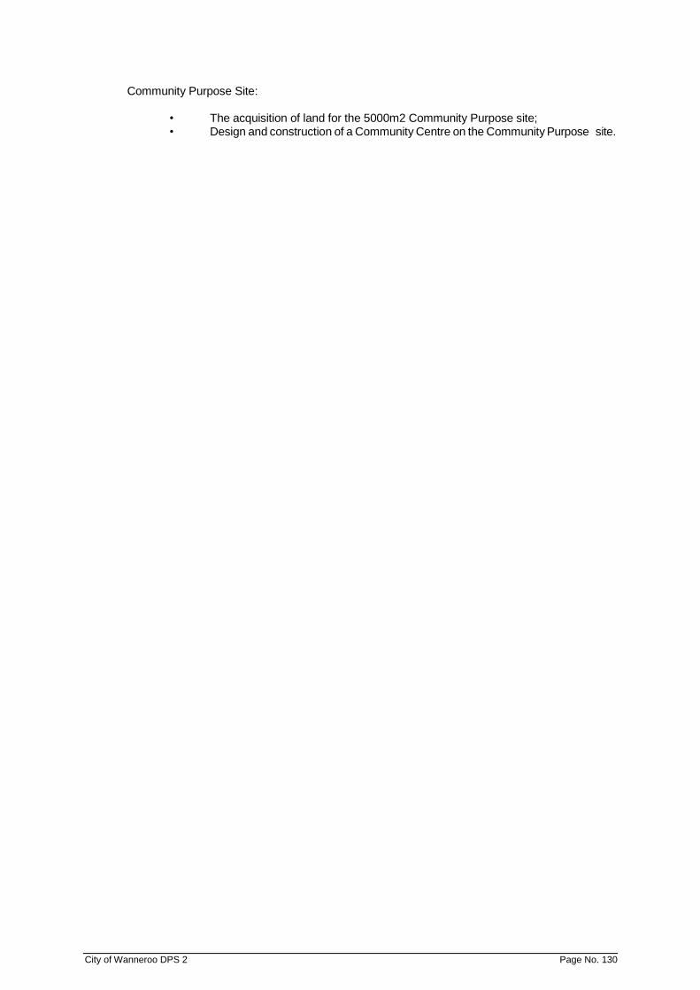
City of Wanneroo DPS 2 Page No. 130
Community Purpose Site:
• The acquisition of land for the 5000m2 Community Purpose site; • Design and construction of a Community Centre on the Community Purpose site.
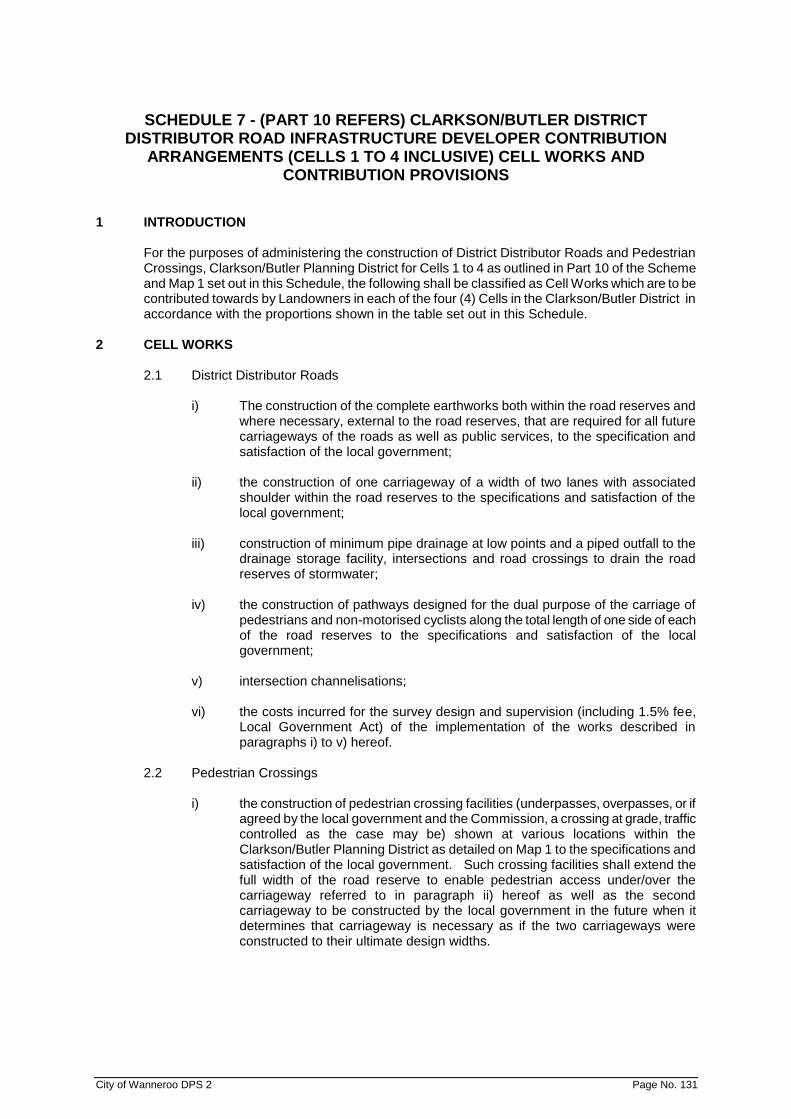
City of Wanneroo DPS 2 Page No. 131
SCHEDULE 7 - (PART 10 REFERS) CLARKSON/BUTLER DISTRICT DISTRIBUTOR ROAD INFRASTRUCTURE DEVELOPER CONTRIBUTION
ARRANGEMENTS (CELLS 1 TO 4 INCLUSIVE) CELL WORKS AND CONTRIBUTION PROVISIONS
1 INTRODUCTION
For the purposes of administering the construction of District Distributor Roads and Pedestrian Crossings, Clarkson/Butler Planning District for Cells 1 to 4 as outlined in Part 10 of the Scheme and Map 1 set out in this Schedule, the following shall be classified as Cell Works which are to be contributed towards by Landowners in each of the four (4) Cells in the Clarkson/Butler District in accordance with the proportions shown in the table set out in this Schedule.
2 CELL WORKS
2.1 District Distributor Roads
i) The construction of the complete earthworks both within the road reserves and where necessary, external to the road reserves, that are required for all future carriageways of the roads as well as public services, to the specification and satisfaction of the local government;
ii) the construction of one carriageway of a width of two lanes with associated
shoulder within the road reserves to the specifications and satisfaction of the local government;
iii) construction of minimum pipe drainage at low points and a piped outfall to the
drainage storage facility, intersections and road crossings to drain the road reserves of stormwater;
iv) the construction of pathways designed for the dual purpose of the carriage of
pedestrians and non-motorised cyclists along the total length of one side of each of the road reserves to the specifications and satisfaction of the local government;
v) intersection channelisations; vi) the costs incurred for the survey design and supervision (including 1.5% fee,
Local Government Act) of the implementation of the works described in paragraphs i) to v) hereof.
2.2 Pedestrian Crossings
i) the construction of pedestrian crossing facilities (underpasses, overpasses, or if
agreed by the local government and the Commission, a crossing at grade, traffic controlled as the case may be) shown at various locations within the Clarkson/Butler Planning District as detailed on Map 1 to the specifications and satisfaction of the local government. Such crossing facilities shall extend the full width of the road reserve to enable pedestrian access under/over the carriageway referred to in paragraph ii) hereof as well as the second carriageway to be constructed by the local government in the future when it determines that carriageway is necessary as if the two carriageways were constructed to their ultimate design widths.

City of Wanneroo DPS 2 Page No. 132
2.3 Other
i) All costs associated with the preparation, processing and Gazettal of the Scheme Amendment introducing these provisions.
ii) Interest on loans raised externally or provided by the local government or drawn
from the various accounts from each Cell (in accordance with Part 10) apportioned to Cell Works and any other cost incurred by local government with the preparation and administration of Part 10 of the Scheme.

City of Wanneroo DPS 2 Page No. 133
SCHEDULE 7
Lot (or portions Area % District Distributor Roads Pedestrian Crossings
of - see Map 1) Km's Funded Balance P.Crossings Funded Balance
Cell 1 3 (NW) 44.7201 6.3% 0.31 0.26 0.05 0.25 0.00 0.25
905 10.1717 1.4% 0.07 0.00 0.07 0.06 0.00 0.06
7(NW) 77.2048 11.0% 0.54 0.00 0.54 0.44 0.00 0.44
8(NW) 69.3996 9.8% 0.49 0.00 0.49 0.39 0.00 0.39
9 104.6549 14.8% 0.73 0.00 0.73 0.59 0.00 0.59
10 112.2947 15.9% 0.79 0.00 0.79 0.64 0.00 0.64
12 77.5797 11.0% 0.54 0.00 0.54 0.44 0.00 0.44
1000 7.8643 1.1% 0.06 0.00 0.06 0.04 0.00 0.04
1001 43.5038 6.2% 0.30 0.00 0.30 0.25 0.00 0.25
1002 34.1598 4.8% 0.24 0.00 0.24 0.19 0.00 0.19
2 60.3032 8.6% 0.42 0.66 -0.24 0.34 0.00 0.34
593 2.4789 0.4% 0.02 0.00 0.02 0.01 0.00 0.01
1 60.5478 8.6% 0.42 0.00 0.42 0.34 0.00 0.34
Total 704.8833 100.0% 4.93 0.92 4.01 4.00 0.00 4.00
Cell 2 3(NE) 45.1883 9.4% 0.48 0.00 0.48 0.56 0.00 0.56
8(NE) 59.5474 12.4% 0.63 0.00 0.63 0.74 0.00 0.74
7(NE) 82.3923 17.2% 0.87 0.00 0.87 1.03 0.00 1.03
11(NE) 76.6275 16.0% 0.81 0.00 0.81 0.96 0.00 0.96
33 114.1992 23.8% 1.21 0.00 1.21 1.43 0.00 1.43
32(NE) 98.3015 20.5% 1.04 0.00 1.04 1.23 0.00 1.23
905 4.0017 0.8% 0.04 0.00 0.04 0.05 0.00 0.05
Total 480.2579 100.0% 5.08 0.00 5.08 6.00 0.00 6.00
Cell 3 3(SW) & 31 81.6082 25.5% 1.13 0.65 0.36 1.02 0.00 0.82
15(SW) 111.9903 35.1% 1.55 1.27 0.11 1.40 0.50 0.62
17(SW) 125.85 39.4% 1.74 1.26 0.30 1.58 0.50 0.76
*Homeswest n/a n/a n/a 0.47 n/a n/a 0.80 n/a
Total 319.4485 100.0% 4.42 3.65 0.77 4.0 1.8 2.20
Cell 4 3(SE) 50.6422 9.0% 0.75 0.50 0.25 0.63 0.00 0.63
11(SE) 19.8502 3.5% 0.29 0.00 0.29 0.25 0.00 0.25
31 61.4767 10.9% 0.91 1.39 -0.48 0.77 0.50 0.27
32(SE) 68.8959 12.3% 1.02 0.39 0.63 0.86 0.00 0.86
16 120.3225 21.4% 1.77 0.00 1.77 1.50 0.00 1.50
15(SE) 137.7752 24.5% 2.03 0.65 1.38 1.72 0.00 1.72
17(SE) 102.55 18.3% 1.51 0.00 1.51 1.28 0.00 1.28
Total 561.5127 100.0% 8.28 2.94 5.34 7.00 0.50 6.50
Total 2066.1024 22.71 7.50 15.21 21.00 2.30 18.70
* Homeswest have previously undertaken District Distributor Road Infrastructure Works in Cell 3 and require compensation from landowners in Cell 3 on a proportional area basis. The balance of works shown for Cell 3 reflect only the outstanding works required (and assume Homeswest will be compensated).
City of Wanneroo DPS 2 Page No. 134
SCHEDULE 8 (CLAUSE 4.21) – RESTRICTIVE COVENANTS
1 Land burdened by the Restrictive Covenant
2 Description of the Covenant
3 Extinguishment or Variation of the Covenant
4 Description of Land benefited by the covenant

City of Wanneroo DPS 2 Page No. 135
SCHEDULE 9 (CLAUSE 4.22) - ENVIRONMENTAL CONDITIONS 1. LOCATION OF LAND:
EC1 Lots 201 & 202 Breakwater Drive, Two Rocks (Rural Community Zone No 1) Environmental Conditions: 1.1 Environmental Management Plans
1.1.1 The following Environmental Management Plans shall be prepared in accordance with the specifications set out in Attachment 1 of the Minister for the Environment’s “Statement that a Scheme may be implemented” No. 537 published on 15 February 2000:
▪ Drainage, Nutrient and Water Management Plan ▪ Karst Landform Management Plan
1.1.2 The Environmental Management Plans referred to in Condition 1.1.1 shall be
prepared and implemented in accordance with the provisions of the Plans, to the requirements of the Responsible Authority.
1.2 Vegetation and Fauna Management
1.2.1 Regionally significant vegetation ('Bush Forever' sites) which surrounds the amendment area (as shown in Figure 1 of the Minister’s Statement) shall be protected from indirect and direct impacts associated with the development of the amendment area by the following:
▪ Clear delineation of regionally significant areas of vegetation from the
amendment area through the use of dual use paths, public open space areas and the like.
▪ Control of off-road vehicle use and dumping of rubbish.
▪ Fire management.
▪ Promotion of community awareness of bushland protection.
1.3 Aboriginal Heritage Management
1.3.1 The subdivider shall protect on a lot or public open space area not less than 3 hectares, the identified heritage site and the area immediately surrounding the site shall be fenced and sign posted, as appropriate. The entrance to the cave (which is part of the Aboriginal site) shall be gated in as sensitive a manner as possible. The Responsible Authority shall also ensure that management of the cave is undertaken to ensure public safety and to protect the biodiversity and cultural values of the cave and surrounding 3 hectares.
1.3.2 Prior to commencement of site works, contractors shall undergo a briefing on
Aboriginal Heritage issues to enable them to recognise materials that may constitute an Aboriginal Site. During earthworks, all contractors shall be supervised by a Site Manager, who shall seek advice from the Aboriginal Affairs Department to confirm the identification of any suspected site.

City of Wanneroo DPS 2 Page No. 136
2. LOCATION OF LAND: AMD 33 GG 3/8/04 EC2 Portion of Lot 2, Lots 207, 206, 220, 320, 321, 204, 101, 303, 304, 302, 16, 102, 301, Part 103, 200, 221, 209, 8, 322, 310, 311, 312, 309, 315, 208, 205, 200, 201, Location 11353 and Reserve 11932 Yanchep-Two Rocks District Environmental Conditions:
2.1 Environmental Management Plans
2.1.1 The following Environmental Management Plans shall be prepared in
accordance with the specifications set out in Attachment 1 of the Minister for the Environment’s “Statement that a Scheme may be implemented” No. 538 published on 15 February 2000:
▪ Stygofauna and/or Troglobitic Fauna Management Plan ▪ Drainage, Nutrient and Water Management Plan ▪ Karst Management Strategy ▪ Solid and Liquid Waste Management Plan ▪ Aboriginal Culture and Heritage Management Plan
2.1.2 The Environmental Management Plans referred to in Condition 2.1.1 shall be
prepared and implemented in accordance with the provisions of the Plans, to the requirements of the Responsible Authority.
2.2 Vegetation and Fauna Management
2.2.1 Regionally significant vegetation (Bush Forever sites) which surrounds the
amendment area (as shown in Figure 1 of the Minister’s Statement) shall be protected from indirect and direct impacts associated with the development of the amendment area by the following:
▪ Clear delineation of regionally significant areas of vegetation from the
amendment area through the use of dual use paths, public open space areas and the like
▪ Control of off-road vehicle use and dumping of rubbish. ▪ Fire management. ▪ Promotion of community awareness of bushland protection.
2.3 Stygofauna and Troglobitic Fauna Management
2.3.1 If studies in relation to karst and hydrology (see 2.4.1) indicate the likelihood of
significant stygofauna and/or troglobitic fauna assemblages being present in or immediately adjacent to the amendment area, the landowner (with assistance from relevant scientific experts) shall undertake a survey (at the Local Structure Planning Stage) to assess the nature and extent of any population/s.
The survey shall be completed prior to finalisation of the Local Structure Plan and to the requirements of the Responsible Authority on advice from the Department of Conservation and Land Management and the University of Western Australia (Department of Zoology).
2.4 Assessment of Karst Landform
2.4.1 At the District and Local Structure Planning Stage, the landowner shall review
existing geotechnical information and undertake further site investigations to confirm the nature and extent of karst landform within the amendment area.

City of Wanneroo DPS 2 Page No. 137
This review shall be completed prior to finalisation of the District and Local Structure Plan and to the requirements of the Responsible Authority on advice from the Department of Environmental Protection.
2.5 Solid and Liquid Waste Management
2.5.1 The landowner shall ensure that lots within the industrial zone are connected to
the deep sewerage system for the disposal of appropriate liquid wastes as approved by the relevant Government Agency/ies.
2.6 Environmental Reporting AMD 102 GG 6/09/16
2.6.1 The Responsible Authority shall provide a report to the Environmental Protection
Authority every five years, or at the time of the review of the existing town planning scheme (whichever is the earlier), as per Section 48H of the Environmental Protection Act.
In the case of Cell 9, the development of public open space areas to a basic
standard as proposed in the City of Wanneroo Local Planning Policy 4.3 'Public Open Space'.
3. LOCATION OF LAND AMD 41 GG 3/12/04
EC3 Portions of Lots 118 and 807 and ‘A’ Class Reserve 27575, Clarkson Environmental Conditions: 3.1 Buffer from Tamala Park Landfill
Residential land uses shall not be permitted within 500 metres of the active face of any existing or proposed putrescible waste filling area. Encroachments within this buffer may be acceptable if it is demonstrated to the Environmental Protection Authority, through appropriate studies and investigations, that odour, noise, landfill gas and dust will not adversely impact on future residents.
3.2 Environmental Management Plans
The following Management Plans are to be prepared in accordance with the specifications set out in Attachment 2 to the Minister for the Environment’s “Statement that a Scheme may be Implemented” No 629 published on 8 July 2003 and shall subsequently be implemented in accordance with the provisions of those Management Plans: - Environmental Management Plan. - Stygofauna and Troglobitic Fauna Management Plan.

City of Wanneroo DPS 2 Page No. 138
SCHEDULE 10 (CLAUSE 3.18) – SPECIAL RURAL PROVISIONS
NO DESCRIPTION OF LOCALITY
SPECIAL PROVISIONS
SR1 1 Swan Location 1757 and 618 Flynn Drive and Wanneroo Road, Wanneroo
1) The minimum lot size shall be not less than 2ha. The maximum number of Special Rural lots to be created in the Amendment area shall be 154. Subdivision shall generally be in accordance with the Structure Plan
2) The land the subject of this zone may be used for
residential, equestrian, horticultural and/or agricultural purposes only. Notwithstanding this, the use of lots of less than 4 ha in area for commercial purposes is prohibited.
3) The existing vegetation on lots which are to be used
for approved equestrian, horticultural and/or agricultural purposes may be cleared to the extent approved for those purposes.
4) The keeping of livestock and poultry for commercial
purposes is prohibited.
SR2 2 Pt Swan Location 1942 and Pt 1669 and Lot 16 Swan Location 1791 Trichet Road, Wanneroo.
1) The minimum lot size shall be not less than 1.0 hectare and the average lot size shall be not less than 1.85ha and subdivision shall be carried out in accordance with the Structure Plan
2) The land east of Franklin Road/Lenore Road may be
used for equestrian, residential and/or horticultural purposes only.
3) Subject to the provisions of Special Provision No 4
the land west of Franklin Road/Lenore Road may be used for rural/residential purposes.
4) The keeping of livestock (with the exception of
horses) and poultry for commercial purposes is prohibited.
5) The existing vegetation on lots which are to be used
for approved equestrian or horticultural purposes may be cleared to the extent approved for those purposes.

SCHEDULE 10 (CLAUSE 3.18) – SPECIAL RURAL PROVISIONS (CONT'D)
City of Wanneroo DPS 2 Page No. 139
NO DESCRIPTION OF LOCALITY
SPECIAL PROVISIONS
SR3 3 Swan Location 1805 corner Franklin and Caporn Roads, Wanneroo
1) The minimum lot size shall be not less than 1.0 hectare and the average lot size not less than 1.5ha and subdivision shall generally be in accordance with the “Structure Plan”.
2) The land the subject of this Zone may be used for
residential and/or horticultural purposes only.
3) The existing vegetation on lots which are to be used for horticultural purposes may be cleared to the extent approved for that purpose.
4) The keeping of livestock and poultry for commercial
purposes is prohibited.
SR4 4 Swan Location 1948 and 1540 Corner Pinjar Road and Neaves Road, Wanneroo.
1) The minimum lot size shall be 1.0 hectare with the average lot size being not less than 1.5ha and all subdivision shall be carried out in accordance with the Structure Plan.
2) The land the subject of this Zone may be used for
equestrian, residential and/or horticultural purposes only.
3) The existing vegetation on lots which are to be used
for approved equestrian or horticultural purposes may be cleared to the extent approved for those purposes.
4) The keeping of livestock (with the exception of
horses) and poultry for commercial purposes is prohibited.
5) All fencing must be carried out to the satisfaction of
the Local Authority.
SR5 5 Lot Numbers 3, 4, 5 Sydney Road, Swan Location 2488 Part Swan Location 887 Sydney Road, Perth Shire Location 104 (C/T 1048 Sydney Road; Lots 18 and 19 Lorian Road, Swan Location 1882; Part Swan Location 1494 Lorian Road and Lot 20 Knight Street, Swan Location 1882 (A113 and 287).
1) The minimum lot size shall be not less than 1.0 hectare and subdivision shall generally be in accordance with the Structure Plan adopted 23 September 1987”.
2) The land the subject of this Zone may be used for equestrian, residential and/or horticultural purposes only.
3) The existing vegetation on lots which are to be used for approved equestrian or horticultural purposes may be cleared to the extent approved for those purposes.
(formerly SRZ No.7 under TPS1)

SCHEDULE 10 (CLAUSE 3.18) – SPECIAL RURAL PROVISIONS (CONT'D)
City of Wanneroo DPS 2 Page No. 140
NO DESCRIPTION OF LOCALITY
SPECIAL PROVISIONS
SR5 5 Cont'd 4) The keeping of livestock (with the exception of horses) and poultry for commercial purposes is prohibited.
5) Each lot is to have included within it an area of at
least 1000m2 which for the land west of Sydney Road, lies above the 47 metre (AHD) contour; for the land east of Sydney Road, lies above the 48 metre (AHD) contour; all residential development must be undertaken above that level.
6) No Road surface is to be constructed below the
46.75 metre (AHD) contour.
SR6 6 Part Swan Location 1942 and Part 1669 and Lot 16 Swan Location 1791 Trichet Road, Wanneroo.
1) The minimum lot size shall be not less than 1.0 hectare and the average lot size shall be not less than 1.85ha and subdivision shall be carried out in accordance with the Structure Plan
2) The land the subject of this Zone may be used for residential, equestrian and/or horticultural purposes only.
3) The existing vegetation on lots which are to be used for approved equestrian or horticultural purposes may be cleared to the extent approved for those purposes.
4) The keeping of livestock (with the exception of horses) and poultry for commercial purposes is prohibited.
(formerly SRZ No.12 under TPS1)
SR7 7 Swan Locations 672, 774, 1687, 1688, 2385, 2384, 2451 and Pt Swan Location 740.
1) The minimum lot size shall be 1.0 hectare and all subdivision shall be carried out in accordance with the Structure Plan
2) The land the subject of this Zone may be used for residential and equestrian purposes only.
3) The existing vegetation on lots which are to be used for approved equestrian purposes may be cleared to the extent approved for that purpose.
4) The keeping of livestock and poultry for commercial purposes is prohibited.
(formerly SRZ No. 15 under TPS1)

SCHEDULE 10 (CLAUSE 3.18) – SPECIAL RURAL PROVISIONS (CONT'D)
City of Wanneroo DPS 2 Page No. 141
NO DESCRIPTION OF LOCALITY
SPECIAL PROVISIONS
SR8 8 Lots 1584, 1866, 2311 and 2314 Neaves Road, Mariginiup.
1) The minimum lot size shall not be less than 2.0 hectares and the subdivisions and development shall be carried out in accordance with the Structure Plan.
2) As parts of the land are subject to periodic inundation, no dwelling shall be constructed unless it is on at least a 1000m2 portion of the lot, located behind the building setback, which will result in:
i) the finished floor level of dwellings being:
a. within areas determined by the City of Wanneroo to be subject to periodic inundation - a minimum of thirteen hundred (1300) millimetres above the Reduced Level to which flooding may occur (as determined from time to time by the City of Wanneroo);
b. within areas determined by the City of Wanneroo to not be subject to periodic inundation - a minimum of four hundred (400) millimetres above natural ground level;
(ii) the underside of effluent disposal chambers
of conventional effluent disposal systems servicing dwellings being a minimum of two (2) metres above the estimated maximum water table level as determined from time to time by the Water and Rivers Commission or equivalent State Government agency;
(iii) the underside effluent disposal chambers or
effluent disposal pads of modified, nutrient attenuating on-site sewage disposal systems servicing dwellings being a minimum of five hundred (500) millimetres above the estimated maximum water table level as determined from time to time by the Water and Rivers Commission or equivalent State Government agency;
(iv) the effluent disposal chambers of
conventional on-site sewage disposal systems servicing dwellings being a minimum horizontal distance of one hundred (100) metres from areas determined from time to time by the City of Wanneroo to be subject to periodic inundation;
(formerly SRZ No.15 under TPS1)
SCHEDULE 10 (CLAUSE 3.18) – SPECIAL RURAL PROVISIONS (CONT'D)
City of Wanneroo DPS 2 Page No. 142
NO DESCRIPTION OF LOCALITY
SPECIAL PROVISIONS
SR8 8 Cont’d (v) the effluent disposal chambers or effluent disposal pads of modified, nutrient attenuating on-site sewage disposal systems servicing dwellings being a minimum horizontal distance of fifty (50) metres from areas determined from time to time by the City of Wanneroo to be subject to periodic inundation.
3) The land the subject of this Zone may be used for
residential and equestrian purposes only.
4) The existing vegetation on lots which are to be used for approved equestrian purposes may be cleared to the extent approved for that purpose.
5) The keeping of livestock (with the exception of horses) and/or poultry for commercial purposes is prohibited.
SR9 9 Portions of Swan Locations 1811, 1826, Lot 1 Swan Location 1827 and Lot 13 Swan Location 1676 Badgerup Road, Gnangara.
1) The minimum lot size shall be not less than 1ha and subdivision shall generally be in accordance with the Structure Plan.
2) The land the subject of this Zone may be used for residential, equestrian and/or non-commercial horticultural purposes only.
3) The keeping of livestock and poultry for commercial purposes is prohibited.
4) Local government may permit an area of not more than 2000 m2, in a central location on each lot, to be cleared for the establishment of a residence and a non-commercial garden/produce/pasture area, this cleared area shall be no closer than 15 metres to any side boundary.
5) Development of this Zone shall have regard to
protection of landscape qualities including topography and vegetation cover, as well as replanting where appropriate, in order to minimise the potential for soil erosion.
(formerly SRZ No.18 under TPS1)
SCHEDULE 10 (CLAUSE 3.18) – SPECIAL RURAL PROVISIONS (CONT'D)
City of Wanneroo DPS 2 Page No. 143
NO DESCRIPTION OF LOCALITY
SPECIAL PROVISIONS
SR10 10 Portion Swan Location 934 and Swan Locations 2383, 2483 and 2829 Badgerup Road, Wanneroo.
1) The minimum lot size shall be 1ha and all subdivision shall be carried out in accordance with the Structure Plan.
2) The land the subject of this Zone may be used for rural/residential purposes and ancillary uses.
3) The keeping of livestock for commercial purposes is prohibited. Livestock shall be precluded from the transition zone shown on the Structure Plan by means of a stock-proof fence.
4) No more than one horse shall be permitted on any lot.
5) A cleared building envelope measuring no greater than 2000 m2 and sited outside the transition zone will be permitted on each lot in a position to be endorsed by the local government. The clearing of trees and native vegetation outside of the building envelope is prohibited other than for fences, fire breaks, access and servicing.
6) Ancillary land uses may be permitted on the condition that they do not generate further significant nutrient application, or involve the clearing of land (other than for building envelopes, fences, firebreaks, access and servicing).
7) An on-site stormwater drainage system shall be
constructed which is capable of retaining for three to four days a one-in-ten year flood event, and this system is to be designed in accordance with local government specifications.
8) Septic systems are to be located at least 100m from
Lake Badgerup with a minimum of 2m vertical separation between the base of the leach drains or soakwell and the highest known groundwater level or bedrock. Where separation cannot be achieved other Health Department of Western Australia approved domestic waste water treatment system with adequate phosphorus retention capacity may be installed provided that the base of the system or modified irrigation area are above the highest known water table or are installed to the satisfaction of the Health Department.
(formerly SRZ No. 19 under TPS1)
SCHEDULE 10 (CLAUSE 3.18) – SPECIAL RURAL PROVISIONS (CONT'D)
City of Wanneroo DPS 2 Page No. 144
NO DESCRIPTION OF LOCALITY
SPECIAL PROVISIONS
SR11 11 Swan Location 1739 Neaves Road, Mariginiup.
1) The minimum lot size shall not be less than 2.0 hectares and the subdivisions and development shall be carried out in accordance with the Structure Plan.
2) The land the subject of this Zone may be used for residential/equestrian purposes only.
3) The keeping of livestock and/or poultry for
commercial purposes is prohibited.
4) A building envelope no greater than 10 per cent of the lot size is to be endorsed by the local government for each lot.
5) Lots shall not be cleared of vegetation (new or
existing remnant) outside of the endorsed building envelopes. Fertiliser application is to be restricted to the building envelope.
6) No reticulated water can be provided by the Water Corporation.
7) As part of the land is subject to periodic flooding, no
dwelling shall be constructed unless it is on a portion of the lot at least 1000m2 in area located behind the building setback, which will result in the dwelling and on-site effluent disposal system being located such that there is a two metre vertical separation between the base of the leach drain and the highest recorded groundwater level or bedrock, and at least a 100 metre horizontal separation between the disposal system and the nearest water body.
Alternative disposal systems can be considered if approved by the local government subject to advice from the Environmental Protection Authority and an appropriate amendment to these provisions.
(formerly SRZ No.20 under TPS1)

SCHEDULE 10 (CLAUSE 3.18) – SPECIAL RURAL PROVISIONS (CONT'D)
City of Wanneroo DPS 2 Page No. 145
NO DESCRIPTION OF LOCALITY
SPECIAL PROVISIONS
SR12 12 Pt Lot 22 Swan Locations 1794 and 2731 Badgerup Road, Wanneroo.
1) The minimum lot size shall be 1 hectare and all subdivision shall be carried out in accordance with the Structure Plan.
2) The land the subject of this Zone may be used for residential, equestrian and/or non-commercial horticultural purposes only.
3) The keeping of livestock and poultry for commercial purposes is prohibited.
4) local government may permit the clearing of 2000 m2 in a central location on a lot for the establishment of a non-commercial private product/pasture area. This cleared area shall be no closer than 10m to a side boundary.
5) All effluent disposal systems are to be located above the 47.5m AHD contour.
(formerly SRZ No.21 under TPS1)
SR13 13 Lots 5, 7, 53 and Portion Location 3144 Adams Road, Mariginiup
1) The minimum lot size should be 1.0 hectare and subdivision should generally be in accordance with the Structure Plan.
2) The land the subject of this Zone may be used for residential purposes only.
3) The keeping of livestock is prohibited.
4) The keeping of poultry for commercial purposes is prohibited.
5) No dwelling shall be approved by the local
government unless it is connected to an alternative domestic wastewater treatment system as approved by the Health Department of Western Australia with an adequate phosphorus retention capacity, as determined by the Department of Environmental protection and with the base of the system or the modified irrigation area being 0.5 metres above the estimated maximum water table level as determined from time to time by the Water and Rivers Commission or equivalent State Government agency.
6) No dwelling shall be constructed unless it has a
vertical separation of at least 1.5 metres between the top of the building pad and the estimated maximum water table level as determined from time to time by the Water and Rivers Commission or equivalent State Government Agency or is constructed at the minimum level indicated on the Structure Plan.
(formerly SRZ No. 24 under TPS1)

SCHEDULE 10 (CLAUSE 3.18) – SPECIAL RURAL PROVISIONS (CONT'D)
City of Wanneroo DPS 2 Page No. 146
NO DESCRIPTION OF LOCALITY
SPECIAL PROVISIONS
SR13 13 Cont'd 7) All lots 2 hectares or below being provided with a reticulated water supply.
8) All dwellings and buildings should be aesthetically compatible with the site in terms of height and construction.
9) The subdivider shall plant indigenous trees and shrubs of a species and at a density and distribution to the satisfaction of the local government prior to the transfer of lot(s) to a new owner.
10) The subdivider shall maintain the trees and shrubs planted until the land is sold, or shall plant sufficient numbers of trees and shrubs to allow for natural loss. Thereafter, the owners of the subdivided lots shall be responsible for the maintenance and replacement (if and where necessary) of those trees and shrubs planted by the subdivider to the satisfaction of the local government.
SR14 14 Part Swan Location 887 Sydney Road, Gnangara
1) The land the subject of this Zone may be used for rural/residential living purposes only.
2) The keeping of livestock is prohibited.
3) A cleared building envelope area measuring at least 1000m2 and sited above 48 metres (AHD) will be permitted on each lot in a position to be endorsed by the local government generally as depicted on the Structure Plan. The clearing of trees and native vegetation outside of this designated building envelope area is prohibited.
4) Ancillary land uses may be permitted but only within
the designated building envelope area and on the condition that they do not generate further significant nutrient application, or involve the clearing (other than for building envelopes, fences, firebreaks, access and servicing).
6) An adequate buffer of native vegetation shall be
provided in the form of a public open space reservation along land which abuts Lake Gnangara. The size and configuration of the public open space reservation shall be as shown on the Structure Plan.
(formerly SRZ No. 25 under TPS1)

SCHEDULE 10 (CLAUSE 3.18) – SPECIAL RURAL PROVISIONS (CONT'D)
City of Wanneroo DPS 2 Page No. 147
NO DESCRIPTION OF LOCALITY
SPECIAL PROVISIONS
SR14 14 Cont'd 7) Septic systems are to be located at least 100m from Lake Gnangara with a minimum of 2m vertical separation between the base of the leach drains or soakwell and the highest known groundwater level or bedrock. As an alternative, other Health Department of Western Australia approved domestic wastewater treatment systems with adequate phosphorus retention capacity may be installed provided that the base of the system or modified irrigation area are above the highest known water table or are installed to the satisfaction of the Environmental Protection Authority.
8) Where native vegetation is absent or degraded
within the public open space reservation, the developer of the estate shall rehabilitate the area with appropriate indigenous trees and shrubs as required.
9) Where other cleared areas of native vegetation
exist, these shall be rehabilitated with indigenous species.
10) An on-site stormwater drainage system shall be constructed by the developer of the estate which is capable of retaining for three to four days a one-in-ten year flood event, and this system is to be designed in accordance with local government specifications.
SR15 15 1) The minimum lot size should not be less than 1.0 hectares whereby subdivision should generally be in accordance with the Structure Plan.
2) The land the subject of this Zone may be used for rural/residential living purposes only.
3) The keeping of livestock is prohibited.
4) A cleared building envelope area measuring not more than 1000m2 and sited above 48 metres (AHD) will be permitted on each lot in a position to be endorsed by the local government generally as depicted on the Structure Plan. The clearing of trees and native vegetation outside of this designated building envelope area is prohibited.
(formerly SRZ No. 26 under TPS1)

SCHEDULE 10 (CLAUSE 3.18) – SPECIAL RURAL PROVISIONS (CONT'D)
City of Wanneroo DPS 2 Page No. 148
NO DESCRIPTION OF LOCALITY
SPECIAL PROVISIONS
SR15 15 Cont'd 5) Ancillary land uses may be permitted but only within the designated building envelope area and on the condition that they do not generate further significant nutrient application, pose an increased risk to groundwater quality, or involve the clearing of land (other than for building envelopes, fences, firebreaks, access and servicing). Ancillary land uses shall be in accordance with the Water and Rivers Commission’s guidelines for ‘Acceptability of Land Uses within Public Drinking Water Source Areas’.
6) An adequate buffer of native vegetation shall be
provided in the form of a public open space reserve along land which abuts Lake Gnangara. The size and configuration of the public open space reservation shall be as shown on the Structure Plan.
7) Septic systems shall be situated within the
designated building envelope area and in the case of Lot 4, shall be situated only in the portion of the building envelope outside the groundwater capture zone as noted on the Structure Plan. Septic systems are to be located at least 100m from Lake Gnangara with a minimum of 2m vertical separation between the base of the leach drains or soakwell and the highest predicted groundwater level or bedrock. As an alternative, other Health Department of Western Australia approved domestic wastewater treatment systems with adequate phosphorus retention capacity may be installed provided that the base of the system or modified irrigation area are above the highest predicted water table or are installed to the satisfaction of the Environmental Protection Authority
8) Where native vegetation is absent or degraded within the public open space reservation, the developer of the estate shall rehabilitate the area with appropriate indigenous trees and shrubs as required.
9) Where other areas cleared of native vegetation exist, these shall be rehabilitated with indigenous species.
10) An on-site stormwater drainage system shall be constructed by the developer of the estate which is capable of retaining for three to four days a one-in-ten year flood event, and this system is to be designed in accordance with local government specifications.
11) Each lot shall be serviced by a reticulated water supply.

SCHEDULE 10 (CLAUSE 3.18) – SPECIAL RURAL PROVISIONS (CONT'D)
City of Wanneroo DPS 2 Page No. 149
NO DESCRIPTION OF LOCALITY
SPECIAL PROVISIONS
SR16 16 Lot 21 Badgerup Road, Gnangara
1) The minimum lot size shall be 1.0 hectare and all subdivision shall be carried out in accordance with the Structure Plan.
2) The land the subject of this Zone may be used for residential purposes only.
3) The keeping of livestock and poultry for commercial purposes is prohibited.
4) A cleared building envelope will be permitted on each lot in a position to be endorsed by the local government. All building envelopes are to be located below 65m AHD.
5) All lots are to be serviced with a reticulated water supply.
6) Ownership or horses on each lot is restricted to a maximum of 2.
(formerly SRZ No. 27 under TPS1)
17 (formerly SRZ No.28 under TPS1)
Lots 23, 24, 25, 26, 27 and 28 Badgerup Road, Gnangara AMD 1 GG 15/11/02
1) The minimum lot size should be not less than one hectare and subdivision should generally be in accordance with the Structure Plan.
2) The land the subject of this zone may be used for residential and equestrian purposes only. Ancillary land uses may be permitted on the condition that they do not generate further significant nutrient application, or involve the clearing of land (other than for building envelopes, fences, fire breaks, access and servicing).
3) The keeping of livestock for commercial purposes is prohibited.
4) No more than one horse shall be permitted on any lot.
5) A cleared building envelope measuring no greater than 1,600 m2 will be permitted on each lot as shown on the Structure Plan. The clearing of trees and native vegetation outside of the building envelope is prohibited other than for fences, fire breaks, access and servicing. The position of the building envelope shown on each lot may be varied subject to local government approval.

SCHEDULE 10 (CLAUSE 3.18) – SPECIAL RURAL PROVISIONS (CONT'D)
City of Wanneroo DPS 2 Page No. 150
NO DESCRIPTION OF LOCALITY
SPECIAL PROVISIONS
SR17 17 Cont'd 6) Where re-vegetation is indicated on the Structure Plan, the subdivider of the estate shall re-vegetate the area in accordance with the recommendations contained in Appendix D1 of the ‘Special Rural Rezoning Proposal Report for Lots 24, 25, 26, 27 and 28 Badgerup Road, Gnangara’ prepared by Greg Rowe and Associates and dated November 1996 and such re-vegetation shall be undertaken by the subdivider prior to any lots being created.
7) The subdivider shall provide a reticulated water supply to all proposed lots within this zone.
8) The 2.5 metre widening of Badgerup Road shown
on the Structure Plan shall be ceded free of cost to the Crown at the time of subdivision of the land within this zone.
9) Prior to the final approval of a plan or diagram of survey, the subdivider shall undertake to the satisfaction of the Department of Environmental Protection a site investigation of building envelopes shown on the Structure Plan which have previously been used for market gardening purposes to determine the presence or otherwise of contamination through past use of fertiliser, pesticides, or herbicides.
Should such contamination be determined as present, the subdivider shall undertake such actions as deemed necessary by the Department of Environmental Protection to achieve an acceptable building envelope.
10) Proposed Lot Nos 19 and 20 shown on the Structure Plan are to be the subject of Service Agreements between the owners of those lots and the Water Corporation, ensuring that the owners of those lots are aware that these lots will not receive a normal standard of water supply from the Water Corporation’s reticulated supply due to the height of these lots, and the difficulty this presents for normal gravity supply.
11) On-site effluent disposal system requirements:
a) the underside of effluent disposal chambers of conventional effluent disposal systems servicing dwellings shall be a minimum of two (2) metres above the estimated maximum water table level as determined from time to time by the Water and Rivers Commission or equivalent State Government agency;
SCHEDULE 10 (CLAUSE 3.18) – SPECIAL RURAL PROVISIONS (CONT'D)
City of Wanneroo DPS 2 Page No. 151
NO
DESCRIPTION OF LOCALITY
SPECIAL PROVISIONS
SR17 17 Cont'd b) the underside of effluent disposal chambers or effluent disposal pads of modified nutrient attenuating on-site sewage disposal systems servicing dwellings shall be a minimum of five hundred (500) millimetres above the estimated maximum water table level as determined from time to time by the Water and Rivers Commission or equivalent State Government agency;
c) the effluent disposal chambers of conventional on-site sewage disposal systems servicing dwellings shall be a minimum horizontal distance of one hundred (100) metres from areas determined from time to time by the City of Wanneroo to be subject to periodic inundation;
d) the effluent disposal chambers or effluent
disposal pads of modified, nutrient attenuating on-site sewage disposal systems servicing dwellings shall be a minimum horizontal distance of fifty (50) metres from areas determined from time to time by the City of Wanneroo to be subject to periodic inundation.
12) The following additional provisions apply to Lot 23
Badgerup Road:
a) Prior to applying for subdivision approval, the subdivider shall prepare and implement to the satisfaction of the local government a Revegetation Plan for Lot 23. Subsequent owners of the subdivided lots shall maintain the vegetation planted to the satisfaction of the local government.
b) The subdivider shall establish all firebreaks
required around all proposed lots to be created to the satisfaction of the local government.
SCHEDULE 10 (CLAUSE 3.18) – SPECIAL RURAL PROVISIONS (CONT'D)
City of Wanneroo DPS 2 Page No. 152
NO DESCRIPTION OF LOCALITY
SPECIAL PROVISIONS
SR18 18 Description of Locality Lot 50 and Loc 3288 Bailey Road, Carabooda
1) Subdivision and development shall be in accordance with the Structure Plan dated 2 August 2011. AMD 126 GG
12/9/14
2) Building Envelopes:
a) In the interest of landscape preservation, indicative building envelopes (to a maximum size of 2000 m2) shall be shown on the lots in the Modified Structure Plan.
b) Prior to the final approval of a plan or diagram of subdivision, the subdivider shall produce certificates from a registered engineer that the area within the indicative building envelope is geologically suitable for the construction of a dwelling house.
3) Bushfire Management:
Prior to the issue of clearances for diagrams of surveys, Local government shall require the subdivider to prepare a Bush Fire Management Plan to the satisfaction of the Local government and the Bush Fires Board. Such a plan will be used as the basis for ongoing bush fire management over the property.
(formerly SRZ No.29 under TPS1)
4) Prior to subdivision of the land for rural-residential
purposes, the subdivider shall prepare to the satisfaction of the Local government, a Caves and Other Karstic Features Management Plan on which the Local government will seek and have regard to advice from relevant State Government agencies, such plan to address the following matters:
a) the identification and protection of caves and other karstic features on the subject land;
b) the stability of all lands proposed for
development including buildings, roads and driveways;
c) the location of bores and on-site effluent disposal systems so as to avoid any detrimental impact on the water balance and water quality affecting caves;
d) control of access, particularly by children, and including access to caves on Reserve 24637;
e) inclusion of advisory records on the title of
proposed lots affected by caves.
SCHEDULE 10 (CLAUSE 3.18) – SPECIAL RURAL PROVISIONS (CONT'D)
City of Wanneroo DPS 2 Page No. 153
NO DESCRIPTION OF LOCALITY
SPECIAL PROVISIONS
SR18 18 Cont'd 5) Prior to subdivision of the land for rural-residential purposes, the subdivider shall undertake a survey to the satisfaction of the Local government, of significant trees worthy of protection.
6) The subdivider shall make arrangements satisfactory to the Water and Rivers Commission to ensure that the prospective purchasers in the initial transfer of lots acknowledge in writing that they are aware that the lots are located within the Wanneroo Groundwater Area where there is a need to obtain a licence before a well/bore can be constructed. The licence will contain a number of conditions including the quantity of water that can be pumped each year.
7) The land subject of this zone shall only be used for
residential and controlled non-commercial keeping of livestock. AMD 126 GG 12/9/14
8) Building Envelopes: Buildings shall not be constructed outside of the geologically verified envelopes except where approved by Local government.
9) Dwellings of more than a single-storey shall not be permitted on those lots shown with an asterisk (*) on the Modified Structure Plan, unless otherwise approved by Local government.
10) The following guidelines for building shall apply (these
guidelines being of an advisory rather than a mandatory nature) - a) Guidelines for Colour
i) The following colours are suitable for blending into the environment -
Cinnamon, rusts, brown, fawn, buff colours, greys, black, blood red to darker red, greens from yellow-green to dark green, blue-greens, all shades of blue from sky blue to darker, all purples from lavender to darker.
ii) The following colours would be obtrusive for
this area -
White and cream, all shades of yellow and orange, pinks and bright reds, pale blues and mauves, silver, gold and pale greys.
b) Guidelines for materials
i) The following materials are suitable for blending into the environment -
Brick, mud brick and timber
SCHEDULE 10 (CLAUSE 3.18) – SPECIAL RURAL PROVISIONS (CONT'D)
City of Wanneroo DPS 2 Page No. 154
NO DESCRIPTION OF LOCALITY
SPECIAL PROVISIONS
SR18 18 cont’d
ii) The following materials would be obtrusive for this area -
Raw galvanised iron, pale colour-bond materials, glass or plastic roof panels and white stucco.
11) Except with the approval of the Local government, no
fencing outside of the building envelope shall be constructed within the land the subject of this zone with the exception of a post and wire boundary fence.
AMD 52 GG 16/6/06
12) With the intention of preventing over-stocking or other
practices detrimental to the amenity of the zone, the breeding or keeping of animals, other than domestic pets, shall not be permitted without the approval in writing of Local government. If approved, the keeping or breeding of animals shall be restricted, by the erection of fencing, to the fixed building envelope area. Trees within the building envelope shall also be fenced to protect them from damage by livestock. In considering any applications for breeding or keeping of stock, Local government will be guided by advice from the Department of Agriculture. Notwithstanding the above, in cases where stocking approval has been given but where environmental problems develop, Local government may, after consultation with the Department of Agriculture, take appropriate action to ban or reduce the stocking of animals. Individual land owners shall be responsible for organising and meeting all costs associated with obtaining advice from the Department of Agriculture where the keeping of any stock is proposed.
13) No vegetation on any part of the proposed lots may be
cleared for any purpose other than the construction of buildings, driveways, strategic fire breaks, selective clearing of lower fuel areas around buildings and for road construction associated with the subdivision development of the property. The land is to be managed in such a manner to avoid the land being laid bare of vegetation resulting in loose, wind erodible conditions. All improvements within building envelopes shall be sited and located such that the removal of vegetation within the building envelope is minimised. The Local government may also, at its discretion, vary the position of any required fire break or building envelope to avoid destruction of vegetation or other ways to take account of the physical features of the land, subject to the land owner concerned providing a certificate from a registered engineer that the area within the proposed new building envelope is geologically suitable for construction of a dwelling house

SCHEDULE 10 (CLAUSE 3.18) – SPECIAL RURAL PROVISIONS (CONT'D)
City of Wanneroo DPS 2 Page No. 155
NO DESCRIPTION OF LOCALITY
SPECIAL PROVISIONS
SR18 18 Cont'd 14) Outside of an approved building envelope, only endemic vegetation may be planted. (Endemic vegetation in this case being vegetation of the Cottesloe North Complex).
15) Bushfire Management:
a) Individual land owners shall be responsible for the maintenance of strategic fire breaks where they cross the land owners lot as depicted on the Bush Fire Management Plan.
b) The clearing of firebreaks, other than for
strategic fire break purposes, will not be permitted unless for safety reasons to comply with Local government and Bush Fire Board requirements. Selective clearing of low fuel areas to a minimum of 20m around each building shall be required by Local government. Such low fuel zones should be kept free of debris and shrubs and maintained to a standard approved by Local government in accordance with the Bush Fire Management Plan.
c) All fire breaks shall be provided to the specification and satisfaction of the Local Authority and the Bush Fires Board.
16) On Site Effluent Disposal System Requirements:
a) The underside of effluent disposal chambers of conventional effluent disposal systems servicing dwellings shall be a minimum of two (2) metres above the estimated maximum water table level as determined from time to time by the Water and Rivers Commission or equivalent State Government agency;
b) The underside of effluent disposal chambers of
effluent disposal pads of modified nutrient attenuating on-site sewage disposal systems servicing dwellings shall be a minimum of five hundred (500) millimetres above the estimated maximum water table level as determined from time to time by the Water and Rivers Commission or equivalent State Government agency;
c) The effluent disposal chambers of conventional on-site sewage disposal systems servicing dwellings shall be a minimum horizontal distance of one hundred (100) metres from areas determined from time to time by the City of Wanneroo to be subject to periodic inundation;
SCHEDULE 10 (CLAUSE 3.18) – SPECIAL RURAL PROVISIONS (CONT'D)
City of Wanneroo DPS 2 Page No. 156
NO DESCRIPTION OF LOCALITY
SPECIAL PROVISIONS
SR18 18 Cont'd d) The effluent disposal chambers or effluent disposal pads of modified, nutrient attenuating on-site sewerage disposal systems servicing dwellings shall be a minimum horizontal distance of fifty (50) metres from areas determined from time to time by the City of Wanneroo to be subject to periodic inundation.
17) All caves and other karstic landform features shall not be damaged in any way unless the prior written approval of the Local government has first been obtained.
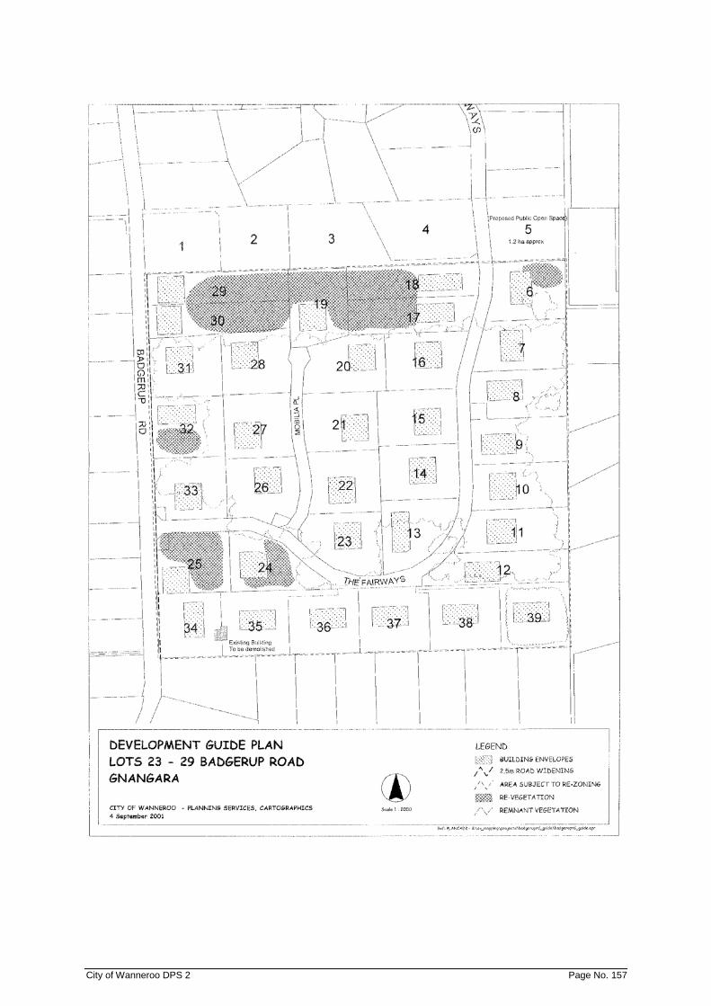
City of Wanneroo DPS 2 Page No. 157
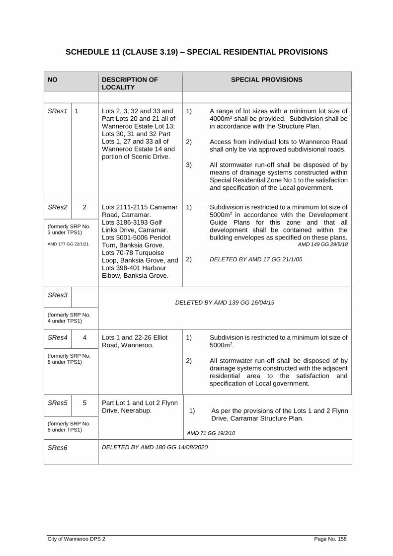
City of Wanneroo DPS 2 Page No. 158
SCHEDULE 11 (CLAUSE 3.19) – SPECIAL RESIDENTIAL PROVISIONS
NO DESCRIPTION OF LOCALITY
SPECIAL PROVISIONS
SRes1 1 Lots 2, 3, 32 and 33 and Part Lots 20 and 21 all of Wanneroo Estate Lot 13; Lots 30, 31 and 32 Part Lots 1, 27 and 33 all of Wanneroo Estate 14 and portion of Scenic Drive.
1) A range of lot sizes with a minimum lot size of 4000m2 shall be provided. Subdivision shall be in accordance with the Structure Plan.
2) Access from individual lots to Wanneroo Road shall only be via approved subdivisional roads.
3) All stormwater run-off shall be disposed of by means of drainage systems constructed within Special Residential Zone No 1 to the satisfaction and specification of the Local government.
SRes2 2 Lots 2111-2115 Carramar Road, Carramar. Lots 3186-3193 Golf Links Drive, Carramar. Lots 5001-5006 Peridot Turn, Banksia Grove. Lots 70-78 Turquoise Loop, Banksia Grove, and Lots 398-401 Harbour Elbow, Banksia Grove.
1) Subdivision is restricted to a minimum lot size of 5000m2 in accordance with the Development Guide Plans for this zone and that all development shall be contained within the building envelopes as specified on these plans.
AMD 149 GG 29/5/18
2) DELETED BY AMD 17 GG 21/1/05
(formerly SRP No. 3 under TPS1) AMD 177 GG 22/1/21
SRes3 DELETED BY AMD 139 GG 16/04/19
(formerly SRP No. 4 under TPS1)
SRes4 4 Lots 1 and 22-26 Elliot Road, Wanneroo.
1) Subdivision is restricted to a minimum lot size of 5000m2.
2) All stormwater run-off shall be disposed of by drainage systems constructed with the adjacent residential area to the satisfaction and specification of Local government.
(formerly SRP No. 6 under TPS1)
SRes5 5 Part Lot 1 and Lot 2 Flynn Drive, Neerabup.
1) As per the provisions of the Lots 1 and 2 Flynn Drive, Carramar Structure Plan.
AMD 71 GG 19/3/10
(formerly SRP No. 8 under TPS1)
SRes6 DELETED BY AMD 180 GG 14/08/2020

City of Wanneroo DPS 2 Page No. 159
SCHEDULE 12 (CLAUSE 3.23) - RURAL COMMUNITY PROVISIONS
NO DESCRIPTION OF LOCALITY
SPECIAL PROVISIONS
RC1 1 Lots 201 and 202 Breakwater Drive, Two Rocks AMD 17 GG 21/1/05 AMD 52 GG 16/6/06 AMD 43 GG 20/11/09
1.1 Special Provisions (General) 1.1.1 Rural Community Zone No 1 provides for
conventional subdivision. The special provisions which follow are in the first instance general, thereafter additional provisions apply to conventional subdivision and cluster subdivision.
1.1.2 In addition to the matters contained in Clause 16
of the deemed provisions a Structure Plan for this land shall also include the following:
(a) Identification of the aboriginal, heritage,
environmental and landscape features and significant vegetation to be retained, and management provisions to maintain these qualities.
(b) The management provisions prepared
pursuant to (a) above shall include preparation of a Vegetation and Fauna Management Plan to the satisfaction of the Local government on advice from the relevant State Government agencies and which addresses–
▪ the identification and retention of
“locally significant” areas of native vegetation, especially those areas of native vegetation that provide fauna habitat;
▪ clear delineation and retention of all three significant stands of trees to avoid habitat loss for fauna, particularly threatened fauna;
▪ details of maintenance arrangements for the onsite native vegetation;
▪ allocation of management responsibilities relating to the onsite native vegetation and identification of timing for implementation as appropriate;
▪ fire management; ▪ control of off-road vehicle use and
dumping of rubbish.
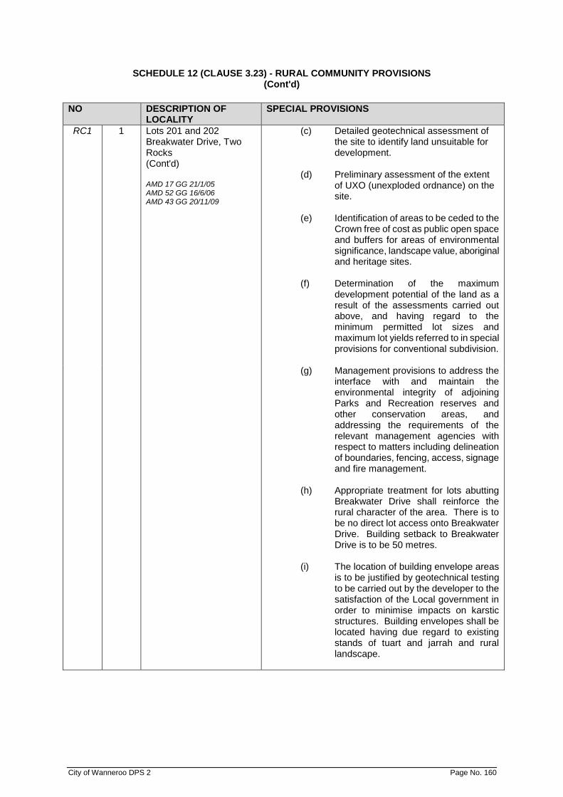
SCHEDULE 12 (CLAUSE 3.23) - RURAL COMMUNITY PROVISIONS (Cont'd)
City of Wanneroo DPS 2 Page No. 160
NO DESCRIPTION OF LOCALITY
SPECIAL PROVISIONS
RC1 1 Lots 201 and 202 Breakwater Drive, Two Rocks (Cont'd) AMD 17 GG 21/1/05 AMD 52 GG 16/6/06 AMD 43 GG 20/11/09
(c) Detailed geotechnical assessment of the site to identify land unsuitable for development.
(d) Preliminary assessment of the extent
of UXO (unexploded ordnance) on the site.
(e) Identification of areas to be ceded to the
Crown free of cost as public open space and buffers for areas of environmental significance, landscape value, aboriginal and heritage sites.
(f) Determination of the maximum
development potential of the land as a result of the assessments carried out above, and having regard to the minimum permitted lot sizes and maximum lot yields referred to in special provisions for conventional subdivision.
(g) Management provisions to address the
interface with and maintain the environmental integrity of adjoining Parks and Recreation reserves and other conservation areas, and addressing the requirements of the relevant management agencies with respect to matters including delineation of boundaries, fencing, access, signage and fire management.
(h) Appropriate treatment for lots abutting
Breakwater Drive shall reinforce the rural character of the area. There is to be no direct lot access onto Breakwater Drive. Building setback to Breakwater Drive is to be 50 metres.
(i) The location of building envelope areas
is to be justified by geotechnical testing to be carried out by the developer to the satisfaction of the Local government in order to minimise impacts on karstic structures. Building envelopes shall be located having due regard to existing stands of tuart and jarrah and rural landscape.

SCHEDULE 12 (CLAUSE 3.23) - RURAL COMMUNITY PROVISIONS (Cont'd)
City of Wanneroo DPS 2 Page No. 161
NO DESCRIPTION OF LOCALITY
SPECIAL PROVISIONS
RC1 1 Lots 201 and 202 Breakwater Drive, Two Rocks (CONT'D) AMD 17 GG 21/1/05 AMD 52 GG 16/6/06
(j) The design of the drainage system should be based on water sensitive design principles to ensure water conservation and maximum recharge to the groundwater system and avoid impacting on karstic structures.
(k) Local government will only grant
approval to the keeping of horses when it is satisfied that the site has been suitably fenced to protect trees and other vegetation requiring protection. Should a horse or horses be kept and damage is being caused to trees and other vegetation by the horse or horses, then Local government may require that the horse or horses be removed from the lot until such time as improvements to the satisfaction of Local government have been made to the fencing which is intended to protect the trees and other vegetation. The landowner will be required to rehabilitate, to the satisfaction of the Local government, any trees and other vegetation damaged by the keeping of horses on the property.
(l) Nutrient attenuating onsite effluent
disposal systems shall be required within this zone to the satisfaction of the City of Wanneroo.
(m) The identification of an area for local
public open space and a 5000 sqm Community Purposes Site to be ceded to the Crown free of cost.
1.1.3 The land the subject of this zone may be used
for rural-residential purposes, and no more than one residence shall be permitted on each lot. Home Business - Categories 1, 2 & 3, Ancillary Accommodation, and a maximum of one appropriately located Corner Store (as designated on the Structure Plan).may be considered as “D” uses.
1.1.4 The developer will undertake planting a 15 metre
wide landscape buffer (i) parallel with the eastern boundary of Lots 201 and 202 and (ii) along both sides of Breakwater Drive.

SCHEDULE 12 (CLAUSE 3.23) - RURAL COMMUNITY PROVISIONS (Cont'd)
City of Wanneroo DPS 2 Page No. 162
NO DESCRIPTION OF LOCALITY
SPECIAL PROVISIONS
RC1 1 Lots 201 and 202 Breakwater Drive, Two Rocks (Cont'd) AMD 17 GG 21/1/05 AMD 52 GG 16/6/06 AMD 43 GG 20/11/09
1.2 Special Provisions (Conventional Subdivision) 1.2.1 The lot yield of Rural Community Zone No 1 shall
be determined through a detailed site analysis to be undertaken to the satisfaction of the Local government and the Commission as part of the preparation of a Structure Plan for the land.. The size of the lots to be created in this zone shall also be determined through this detailed site analysis, but should not involve lot sizes less than 1 hectare.
1.2.2 A cleared building envelope measuring no
greater than 2000m2 will be permitted on each lot in a position to be endorsed by the Local government. The clearing of trees and native vegetation outside of the building envelope is prohibited other than for fences, fire breaks, access and servicing.
1.2.3 No more than one horse shall be permitted on
any lot unless permitted by the Local government in consultation with the relevant Government agencies.
1.2.4 The keeping of livestock and poultry for
commercial purposes is prohibited. 1.2.5 The land is to be managed in such a manner as
to avoid the land being laid bare of vegetation resulting in loose, wind erodible conditions. In particular, lots shall not be cleared of trees except where necessary to permit the construction of houses and outbuildings within the building envelope or where the Local government agrees that trees are dead or pose a hazard to safety.
1.2.6 The interface with Crown land to the west, north
and south must be perceived as being publicly accessible i.e. public open space area, road, bridle path, dual use path, walkway.
1.2.7 Building envelopes being located on the western
side of those lots adjacent to the Mitchell Freeway to minimise noise impacts.
1.2.8 Building envelopes for the lots proposed under
the conventional subdivision option being located to minimise development being viewed from the Mitchell Freeway.

SCHEDULE 12 (CLAUSE 3.23) - RURAL COMMUNITY PROVISIONS (Cont'd)
City of Wanneroo DPS 2 Page No. 163
NO DESCRIPTION OF LOCALITY
SPECIAL PROVISIONS
RC2 2 Lot 6 Sydney Road, Gnangara; portion of Lot 10 Sydney Road, Gnangara; and portion of Lot 50 Ocean Reef Road, Gnangara
2.1 In addition to the matters contained in Clause 16 of the deemed provisions of the Scheme, a Structure Plan for this land shall also include the following –
(a) Identification of the final Bush Forever
area 463 boundary and associated management provisions.
(b) The management provisions prepared
pursuant to (a) above shall include preparation of a Bush Forever Rehabilitation and Management Plan which addresses—
(i) Revegetation of areas within the
Bush Forever boundary in accordance with the Bush Forever Negotiated Planning Solution and the Department of Environment and Conservation restrictive covenant management guidelines;
(ii) Delineation of boundaries and fencing requirements
(iii) Bush Fire management; (iv) Weed and pest control and
management (v) Dieback control and management; (vi) Bush interface measures; (vii) Controls for unauthorised off-road
vehicle use and dumping of rubbish; and
(viii) Controls for access, including signage.
(c) Identification of any registered Aboriginal
heritage sites. (d) Delineation of any contamination on Lot
6. (e) The location of building envelopes for
future dwellings shall be located outside of the areas identified in (a), (c) and (d) above and depicted on the structure plan. Building envelopes shall be located having due regard to bush fire management requirement including any building protection and/or hazard separation zones.
(f) No drainage of stormwater and/or
wastewater shall enter the Bush Forever area.

SCHEDULE 12 (CLAUSE 3.23) - RURAL COMMUNITY PROVISIONS (Cont'd)
City of Wanneroo DPS 2 Page No. 164
NO DESCRIPTION OF LOCALITY
SPECIAL PROVISIONS
2.2 The clearing of trees and native vegetation within the Bush Forever area 463, other than for fire management purposes, is prohibited without the prior approval of the City of Wanneroo and the Department of Environment and Conservation.
2.3 No domestic animals or other livestock (including
horses) are to be kept within Bush Forever area 463.
2.4 These general provisions are not intended to
preclude subdivision of the Aboriginal Cemetery from Lot 6 for vesting with a suitable management authority (i.e. Metropolitan Cemeteries Board).
2.5 There shall be no subdivision or development
within the Bush Forever area, with the exception of only amalgamation proposals.
3.0 The local structure plan, subdivision and
development must be in accordance with Western Australian Planning Commission’s (WAPC) Planning for Bush Fire Protection Guidelines, which includes but is not limited to—
(i) identifying appropriate hazard
separation zones and building protection zones;
(ii) construction to AS3959-2009 (noting (iii) below);
(iii) no residential development within the bush fire attack level (BAL) zones BAL-FZ or BAL-40; and
(iv) consideration of ember protection features incorporated in all dwelling design within the zone.
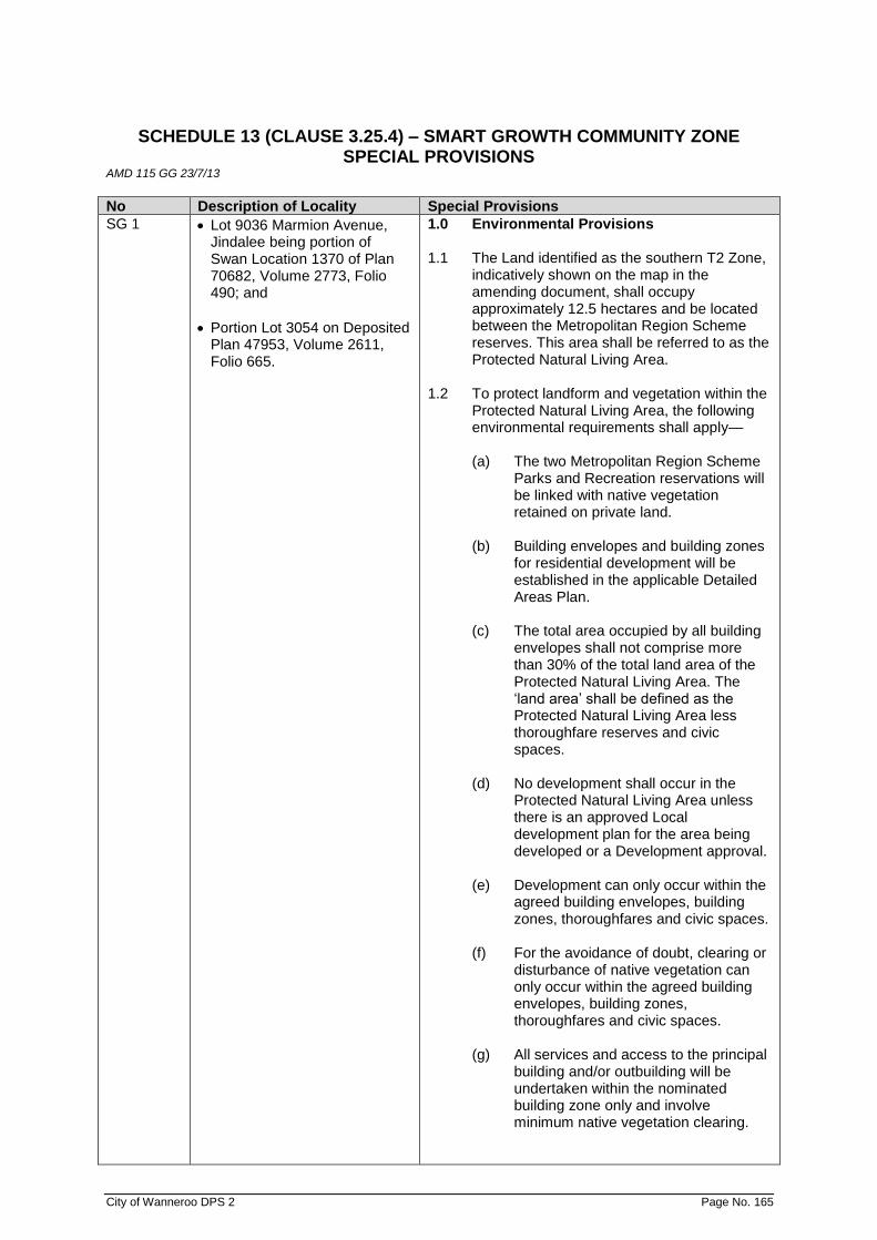
City of Wanneroo DPS 2 Page No. 165
SCHEDULE 13 (CLAUSE 3.25.4) – SMART GROWTH COMMUNITY ZONE SPECIAL PROVISIONS
AMD 115 GG 23/7/13
No Description of Locality Special Provisions
SG 1 • Lot 9036 Marmion Avenue, Jindalee being portion of Swan Location 1370 of Plan 70682, Volume 2773, Folio 490; and
• Portion Lot 3054 on Deposited Plan 47953, Volume 2611, Folio 665.
1.0 Environmental Provisions 1.1 The Land identified as the southern T2 Zone,
indicatively shown on the map in the amending document, shall occupy approximately 12.5 hectares and be located between the Metropolitan Region Scheme reserves. This area shall be referred to as the Protected Natural Living Area.
1.2 To protect landform and vegetation within the
Protected Natural Living Area, the following environmental requirements shall apply—
(a) The two Metropolitan Region Scheme
Parks and Recreation reservations will be linked with native vegetation retained on private land.
(b) Building envelopes and building zones
for residential development will be established in the applicable Detailed Areas Plan.
(c) The total area occupied by all building
envelopes shall not comprise more than 30% of the total land area of the Protected Natural Living Area. The ‘land area’ shall be defined as the Protected Natural Living Area less thoroughfare reserves and civic spaces.
(d) No development shall occur in the
Protected Natural Living Area unless there is an approved Local development plan for the area being developed or a Development approval.
(e) Development can only occur within the
agreed building envelopes, building zones, thoroughfares and civic spaces.
(f) For the avoidance of doubt, clearing or
disturbance of native vegetation can only occur within the agreed building envelopes, building zones, thoroughfares and civic spaces.
(g) All services and access to the principal
building and/or outbuilding will be undertaken within the nominated building zone only and involve minimum native vegetation clearing.
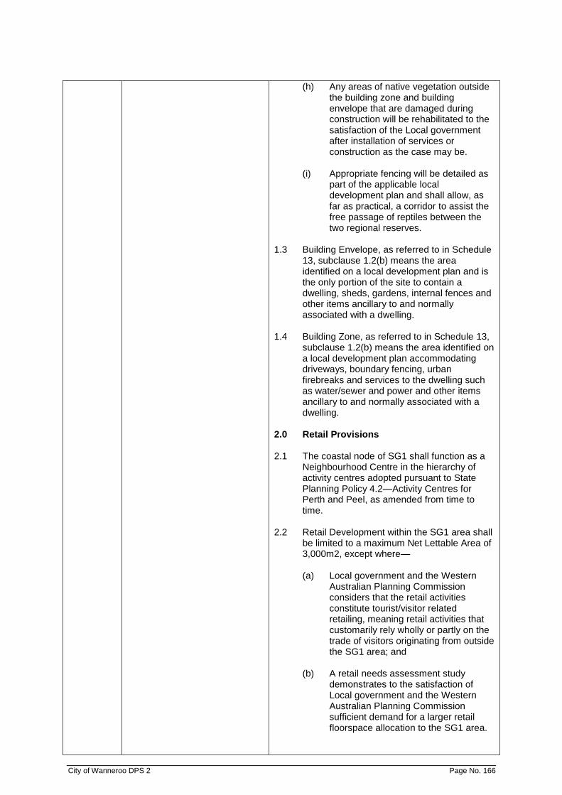
City of Wanneroo DPS 2 Page No. 166
(h) Any areas of native vegetation outside the building zone and building envelope that are damaged during construction will be rehabilitated to the satisfaction of the Local government after installation of services or construction as the case may be.
(i) Appropriate fencing will be detailed as
part of the applicable local development plan and shall allow, as far as practical, a corridor to assist the free passage of reptiles between the two regional reserves.
1.3 Building Envelope, as referred to in Schedule
13, subclause 1.2(b) means the area identified on a local development plan and is the only portion of the site to contain a dwelling, sheds, gardens, internal fences and other items ancillary to and normally associated with a dwelling.
1.4 Building Zone, as referred to in Schedule 13,
subclause 1.2(b) means the area identified on a local development plan accommodating driveways, boundary fencing, urban firebreaks and services to the dwelling such as water/sewer and power and other items ancillary to and normally associated with a dwelling.
2.0 Retail Provisions 2.1 The coastal node of SG1 shall function as a
Neighbourhood Centre in the hierarchy of activity centres adopted pursuant to State Planning Policy 4.2—Activity Centres for Perth and Peel, as amended from time to time.
2.2 Retail Development within the SG1 area shall
be limited to a maximum Net Lettable Area of 3,000m2, except where—
(a) Local government and the Western
Australian Planning Commission considers that the retail activities constitute tourist/visitor related retailing, meaning retail activities that customarily rely wholly or partly on the trade of visitors originating from outside the SG1 area; and
(b) A retail needs assessment study
demonstrates to the satisfaction of Local government and the Western Australian Planning Commission sufficient demand for a larger retail floorspace allocation to the SG1 area.

City of Wanneroo DPS 2 Page No. 167
3.0 Application of Adopted Policies 3.1 City of Wanneroo Local Planning Policies
adopted under the Scheme do not apply to the SG1 area unless otherwise stated in an adopted local planning policy.

City of Wanneroo DPS 2 Page No. 168
SCHEDULE 14 – DEVELOPMENT CONTRIBUTION AREAS AMD 122 GG 09/09/14
1.0 Interpretation
In Schedule 14, unless the context otherwise requires—
‘Administrative costs’ means such costs as are reasonably incurred for the preparation and (with respect to standard infrastructure items) implementation of the development contribution plan.
‘Administrative items’ means the administrative matters required to be carried out by or on behalf of the local government in order to prepare and (with respect to standard infrastructure items) implement the development contribution plan, including legal, accounting, planning, engineering, and other professional advice.
‘Cost apportionment schedule’ means a schedule prepared and distributed in accordance with Clause 10.0.
‘Cost contribution’ means the contribution to the cost of infrastructure and administrative costs.
‘Development contribution area’ means the area shown on the scheme map as DCA and included in Schedule 15. ‘Development contribution plan’ means a development contribution plan prepared in accordance with the provisions of State Planning Policy 3.6 Development Contributions for Infrastructure and the provisions of this Schedule 15 of the scheme.
‘Development contribution plan report’ means a report prepared and distributed in accordance with clause 10.0.
‘Infrastructure’ means the standard infrastructure items (services and facilities set out in Appendix 1 of State Planning Policy 3.6 Development Contributions for Infrastructure) and community infrastructure, including recreational facilities; community centres; child care and after school centres; libraries and cultural facilities and such other services and facilities for which development contributions may reasonably be requested having regard to the objectives, scope and provisions of State Planning Policy 3.6 Development Contributions for Infrastructure.
‘Infrastructure costs’ means such costs as are reasonably incurred for the acquisition and construction of infrastructure.
‘Local government’ means the local government or local governments in which the development contribution area is located or through which the services and facilities are provided.
‘Owner’ means an owner of land that is located within a development contribution area.
2.0 Purpose
The purpose of having development contribution areas is to:
(a) provide for the equitable sharing of the costs of infrastructure and administrative costs between owners;
(b) ensure that cost contributions are reasonably required as a result of the subdivision and
development of land in the development contribution area; and
(c) coordinate the timely provision of Infrastructure.

City of Wanneroo DPS 2 Page No. 169
3.0 Development contribution plan required
A development contribution plan is required to be prepared for each development contribution area.
4.0 Development contribution plan part of scheme
The development contribution plans are incorporated in Schedule 18 as part of this scheme. 5.0 Subdivision, strata subdivision and development
The local government shall not withhold its support for subdivision, strata subdivision or refuse to approve a development solely for the reason that a development contribution plan is not in effect, there is no approval to advertise a development contribution plan, or that there is no other arrangement with respect to an owner’s contribution towards the provision of community infrastructure.
6.0 Guiding principles for development contribution plans
The development contribution plan for any development contribution area is to be prepared in accordance with the following principles:
(a) Need and the nexus
The need for the infrastructure included in the plan must be clearly demonstrated (need) and the connection between the development and the demand created should be clearly established (nexus).
(b) Transparency
Both the method for calculating the development contribution and the manner in which it is applied should be clear, transparent and simple to understand and administer.
(c) Equity
Development contributions should be levied from all developments within a development contribution area, based on their relative contribution to need.
(d) Certainty
All development contributions should be clearly identified and methods of accounting for cost adjustments determined at the commencement of a development.
(e) Efficiency
Development contributions should be justified on a whole of life capital cost basis consistent with maintaining financial discipline on service providers by precluding over recovery of costs.
(f) Consistency
Development contributions should be applied uniformly across a development contribution area and the for applying contributions should be consistent.
(g) Right of consultation and review
Owners have the right to be consulted on the manner in which development contributions are determined. They also have the opportunity to seek a review by an independent third party if they believe the calculation of the costs of the contributions is not reasonable.
City of Wanneroo DPS 2 Page No. 170
(h) Accountable
There must be accountability in the manner in which development contributions are determined and expended.
7.0 Recommended content of development contribution plans
7.1 The development contribution plan is to specify -
(a) the development contribution area to which the development contribution plan applies;
(b) the infrastructure and administrative items to be funded through the
development contribution plan;
(c) the method of determining the cost contribution of each owner; and
(d) the priority and timing for the provision of infrastructure. 8.0 Period of development contribution plan
A development contribution plan shall specify the period during which it is to operate. 9.0 Land excluded
In calculating both the area of an owner’s land and the total area of land in a development contribution area, the area of land provided in that development contribution area for:
(a) roads designated under the Metropolitan Region Scheme as primary regional roads and
other regional roads;
(b) existing public open space;
(c) existing government primary and secondary schools; and
(d) such other land as is set out in the development contribution plan;
is to be excluded. 10.0 Development contribution plan report and cost apportionment schedule
10.1 Within 90 days of the development contribution plan coming into effect, the local government is to adopt and make available a development contribution plan report and cost apportionment schedule to all owners in the development contribution area.
10.2 The development contribution plan report and the cost apportionment schedule shall set
out in detail the calculation of the cost contribution for each owner in the development contribution area, based on the methodology provided in the development contribution plan, and shall take into account any proposed staging of the development.
10.3 The development contribution plan report and the cost apportionment schedule do not
form part of the scheme, but once adopted by the local government they are subject to review as provided under clause 11.0.
11.0 Cost contributions based on estimates
11.1 The determination of Infrastructure costs and administrative costs is to be based on amounts expended, but when expenditure has not occurred, it is to be based on the best and latest estimated costs available to the local government and adjusted accordingly, if necessary.

City of Wanneroo DPS 2 Page No. 171
11.2 Where a cost apportionment schedule contains estimated costs, such estimated costs are to be reviewed at least annually by the local government—
(a) in the case of land to be acquired, in accordance with clause 12.0; and
(b) in all other cases, in accordance with the best and latest information available to
the local government, until the expenditure on the relevant item of infrastructure or administrative costs has occurred.
11.3 The local government is to have such estimated costs independently certified by
appropriate qualified persons and must provide such independent certification to an owner when requested to do so.
11.4 The local government's review of estimated costs, carried out in accordance with clause
11.2, shall recommend that the estimated costs are to be:
(a) maintained;
(b) reduced; or
(c) increased.
11.5 Where the review of estimated costs recommends those costs be maintained or reduced, pursuant to clauses 11.4(a) or (b), then the local government shall decide to either maintain or reduce the estimated costs and shall notify owners of its decision.
11.6 Where the review of estimated costs recommends those costs be increased pursuant to
clause 11.4(c), then the local government shall in writing invite comment on the proposal from owners for a period of not less than 28 days, prior to making any decision to increase the estimated costs.
11.7 The local government shall consider all submissions received and within ninety (90) days
of the date of the latest date specified in the notice given under clause 11.6, decide that the estimated costs are to be:
(a) maintained; or
(b) increased and if so the degree of that increase.
The local government shall notify affected persons of its decision.
11.8 If an owner objects to the amount of a cost contribution, the owner may give notice to the
local government requesting a review of the amount of the cost contribution by an appropriate qualified person (‘independent expert’) agreed by the local government and the owner at the owner’s expense, within 28 days after being informed of the cost contribution.
11.9 If the independent expert does not change the cost contribution to a figure acceptable to
the owner, the cost contribution is to be determined -
(a) by any method agreed between the local government and the owner; or
(b) if the local government and the owner cannot agree on a method pursuant to (a) or on an independent expert, by arbitration in accordance with the Commercial Arbitration Act 1985, with the costs to be shared equally between the local government and owner.
City of Wanneroo DPS 2 Page No. 172
12.0 Valuation
12.1 Clause 12.0 applies in order to determine the value of land to be acquired for the purpose of providing Infrastructure.
12.2 In clause 12.0:
‘Value’ means the fair market value of land, at a specified date, which is defined as the capital sum that would be negotiated in an arm’s length transaction in an open and unrestricted market, assuming the highest and best use of the land with all its potential and limitations (other than the limitation arising from the transaction for which the land is being valued), wherein the parties act knowledgeably, prudently and without compulsion to buy or sell. ‘Valuer’ means a licensed valuer agreed by the local government and the owner, or, where the local government and the owner are unable to reach agreement, by a valuer appointed by the President of the Western Australian Division of the Australian Property Institute.
12.3 If an owner objects to a valuation made by the valuer, the owner may give notice to the
local government requesting a review of the amount of the value, at the owner’s expense, within 28 days after being informed of the value.
12.4 If, following a review, the valuer’s determination of the value of the land is still not a figure
acceptable to the owner, the value is to be determined -
(a) by any method agreed between the local government and the owner; or
(b) if the local government and the owner cannot agree, the owner may apply to the State Administrative Tribunal for a review of the matter under part 14 of the Planning and Development Act 2005.
13.0 Liability for cost contributions
13.1 An owner must make a cost contribution in accordance with the applicable development contribution plan and the provisions of Schedule 15.
13.2 An owner’s liability to pay the owner’s cost contribution to the local government arises on
the earlier of -
(a) the Western Australian Planning Commission endorsing its approval on the deposited plan or survey strata plan of the subdivision of the owner’s land within the development contribution area;
(b) the commencement of any development on the owner's land within the
development contribution area with the exception of clearing and earthworks commenced under a Development Approval in the case of land subdivisions;
(c) the approval of any strata plan by the local government or Western Australian
Planning Commission on the owner’s land within the development contribution area; or
(d) the approval of a change or extension of use by the local government on the
owner’s land within the development contribution area.
The liability arises only once upon the earliest of the above listed events.
13.3 Notwithstanding clause 13.2, an owner’s liability to pay the owner’s cost contribution does not arise if the owner commences development of the first single house or outbuildings associated with that first single house on an existing lot which has not been subdivided or strata subdivided since the coming into effect of the development contribution plan.
13.4 Where a development contribution plan expires in accordance with clause 8.0, an

City of Wanneroo DPS 2 Page No. 173
owner’s liability to pay the owner’s cost contribution under that development contribution plan shall be deemed to continue in effect and be carried over into any subsequent development contribution plan which includes the owner’s land, subject to such liability.
14.0 Payment of cost contribution
14.1 The owner, with the agreement of the local government, is to pay the owner’s cost contribution by:
(a) cheque or cash;
(b) transferring to the local government or a public authority land in satisfaction of
the cost contribution;
(c) the provision of physical infrastructure;
(d) some other method acceptable to the local government; or
(e) any combination of these methods.
14.2 The owner, with the agreement of the local government, may pay the owner’s cost contribution in a lump sum, by instalments or in such other manner acceptable to the local government.
14.3 Payment by an owner of the cost contribution, including a cost contribution based upon
estimated costs in a manner acceptable to the local government, constitutes full and final discharge of the owner’s liability under the development contribution plan and the local government shall provide certification in writing to the owner of such discharge if requested by the owner.
15.0 Charge on land
15.1 The amount of any cost contribution for which an owner is liable under clause 13.0, but has not paid, is a charge on the owner’s land to which the cost contribution relates, and the local government may lodge a caveat, at the owner’s expense, against the owner’s certificate of title to that land.
15.2 The local government, at the owner’s expense and subject to other conditions as the
local government thinks fit, can withdraw a caveat lodged under clause 15.1 to permit a dealing and may then re-lodge the caveat to prevent further dealings.
15.3 If the cost contribution is paid in full, the local government, if requested to do so by the
owner and at the expense of the owner, is to withdraw any caveat lodged under Clause 15.0.
16.0 Administration of funds
16.1 The local government is to establish and maintain a reserve account in accordance with the Local Government Act 1995 for each development contribution area into which cost contributions for that development contribution area will be credited and from which all payments for the infrastructure costs and administrative costs within that development contribution area will be paid.
The purpose of such a reserve account or the use of money in such a reserve account is limited to the application of funds for that development contribution area.
16.2 Interest earned on cost contributions credited to a reserve account in accordance with
clause 16.1 is to be applied in the development contribution area to which the reserve account relates.
16.3 The local government is to publish an audited annual statement of accounts for that
City of Wanneroo DPS 2 Page No. 174
development contribution area as soon as practicable after the audited annual statement of accounts becomes available.
17.0 Shortfall or excess in cost contributions
17.1 If there is a shortfall in the total of cost contributions when all cost contributions have been made or accounted for in a particular development contribution area, the local government may -
(a) make good the shortfall;
(b) enter into agreements with owners to fund the shortfall; or
(c) raise loans or borrow from a financial institution, but nothing in subclause
17.1(a) restricts the right or power of the local government to impose a differential rate to a specified development contribution area in that regard.
17.2 If there is an excess in funds available to the development contribution area when all
cost contributions have been made or accounted for in a particular development contribution area, the local government is to refund the excess funds to contributing owners for that development contribution area. To the extent, if any, that it is not reasonably practicable to identify owners and/or their entitled amount of refund, any excess in funds shall be applied to the provision of additional facilities or improvements in that development contribution area.
18.0 Powers of the local government
The local government in implementing the development contribution plan has the power to -
(a) acquire any land or buildings within the scheme area under the provisions of the Planning and Development Act 2005; and
(b) deal with or dispose of any land which it has acquired under the provisions of the
Planning and Development Act 2005 in accordance with the law and for such purpose may make such agreements with other owners as it considers fit.
19.0 Arbitration
Subject to clauses 12.3 and 12.4, any dispute between an owner and the local government in connection with the cost contribution required to be made by an owner is to be resolved by arbitration in accordance with the Commercial Arbitration Act 1985."

City of Wanneroo DPS 2 Page No. 175
SCHEDULE 15 – DEVELOPMENT CONTRIBUTION PLAN AMD 122 GG 09/09/14
Reference No. Alkimos Eglinton Development Contributions Plan – Community Facilities.
Area Name: Alkimos Eglinton Development Contribution Area; identified as DCA (1) on the Scheme Map.
Relationship to other planning instruments:
The development contribution plan generally conforms to the Alkimos Eglinton District Structure Plan, the Northern Coastal Growth Corridor Community Facilities Plan and the City of Wanneroo Long Term Financial Plan 2013/14 - 2022/23.
Infrastructure and administrative items to be funded:
District Facilities Surf Life Saving Club, Alkimos South Coastal Village - facility to support surf lifesaving operations and associated activities, including:
• Planning, design and project management costs;
• Site, servicing and construction costs. Public Open Space (Active), Alkimos Regional Parks and Recreation Reserve - playing fields and associated infrastructure to support sporting and recreational uses, including;
• Planning, design and project management costs;
• Site, servicing and construction costs. Multipurpose Hard Courts, Alkimos Regional Parks and Recreation Reserve - fenced hard courts facilities and associated amenity to support a variety of court sports, including:
• Planning, design and project management costs;
• Site, servicing and construction costs. Library, Alkimos Secondary Centre - facility to support the storage and community access to printed and electronic media and associated community meetings and activities, including:
• Planning, design and project management costs;
• Land acquisition costs;
• Site, servicing and construction costs. Community Centre, Alkimos Secondary Centre - facility to support community meetings, gatherings and associated activities, including:
• Planning, design and project management costs;
• Land acquisition costs;
• Site, servicing and construction costs. Indoor Recreation Centre, Alkimos Secondary Centre - facility to support indoor recreation and sporting activities, including:
• Planning, design and project management costs;
• Land acquisition costs;
• Site, servicing and construction costs. Public Open Space (Active), Eglinton District Centre - playing fields and associated infrastructure to support sporting and recreational uses, including:
• Planning, design and project management costs;
• Site, servicing and construction costs. Multipurpose Hard Courts, Eglinton District Centre - Fenced hard courts facilities and associated amenity to support a variety of court sports, including;
• Planning, design and project management costs;
• Site, servicing and construction costs.
City of Wanneroo DPS 2 Page No. 176
Indoor Recreation Centre, Eglinton District Centre - Facility to support indoor recreation and sporting activities, including:
• Planning, design and project management costs;
• Land acquisition costs;
• Site, servicing and construction costs. Community Centre, Eglinton District Centre - facility to support community meetings, gatherings and associated activities, including:
• Planning, design and project management costs;
• Land acquisition costs;
• Site, servicing and construction costs. Library, Eglinton District Centre - facility to support the storage and community access to printed and electronic media and associated community meetings and activities, including:
• Planning, design and project management costs;
• Land acquisition costs;
• Site, servicing and construction costs. Contributions shall be payable for the initial district facility only. No contributions shall be payable for any future upgrade of a district facility to regional standard. Administrative Costs
• Costs to prepare and administer the plan during the period of operation;
• Costs to prepare and review estimates;
• Costs to prepare the cost apportionment schedule;
• Valuation costs; and
• Costs to service loans established by Council to fund early provision of facilities.
Method for calculating contributions:
The Council’s Northern Coastal Growth Corridor Community Facilities Plan Report identifies the needs that impact on the Development Contribution Plan. The contributions outlined in the Development Contribution Plan Report have been based on the need for facilities generated by additional development in the development contribution area. This calculation excludes the:
• demand for a facility that is generated by the current population;
• demand created by external usage - the proportion of use drawn from outside of the main catchment area; and
• future usage - the proportion of usage that will be generated by future development outside of the development contribution plan timeframe.
The methodology for determining contributions is in accordance with the following formula:
• CPH = TC / NCA
• CC = CPH x GSA
Where: CPH =Cost per hectare ($/ha) TC =Total cost of delivering community facilities ($) NCA = Net contributing area (ha) CC = Cost Contribution Amount ($) GSA = Gross area of proposed subdivision (ha)
Period of operation: 25 years from the date of gazettal.
Priority and timing: In accordance with the Development Contribution Plan Report and the Northern Coastal Growth Corridor Community Facilities Plan.
Review process: The Development Contribution Plan will be reviewed when considered

City of Wanneroo DPS 2 Page No. 177
appropriate, but at a time that is no longer than 5 years after the date of gazettal of this amendment, having regard to the rate of subsequent development in the area since the last review and the degree of development potential still existing. The estimated infrastructure costs shown in the cost apportionment schedule will be reviewed at least annually in accordance with clause 11 of Schedule 14 of DPS No. 2.
Reference No. Yanchep Two Rocks Development Contributions Plan – Community Facilities
Area Name: Yanchep Two Rocks Development Contribution Area; identified as DCA (2) on the Scheme (Amendment) Map.
Relationship to other planning instruments:
The development contribution plan generally conforms to the Yanchep Two Rocks District Structure Plan, the Northern Coastal Growth Corridor Community Facilities Plan and the City of Wanneroo Long Term Financial Plan 2013/14 - 2022/23.
Infrastructure and administrative items to be funded:
District Facilities Surf Life Saving Club, Yanchep Lagoon - facility to support surf lifesaving operation and associated activities, including:
• Planning, design and project management costs;
• Site, servicing and construction costs. Coastal Node Facilities, Capricorn Coastal Node - facilities and amenity to support community use and enjoyment of coastal node areas, including:
• Planning, design and project management costs;
• Site, servicing and construction costs. Public Open Space (Active), Yanchep Metropolitan Centre - playing fields and associated infrastructure to support sporting and recreational uses, including;
• Planning, design and project management costs;
• Land acquisition costs, on the basis that the land shall not form part of the minimum 10% public open space contribution for Lot 602 Yanchep Beach Road;
• Site, servicing and construction costs. Contributions shall be payable for the initial district facility only. No contributions shall be payable for any future upgrade of a district facility to regional standard." Administrative Costs
• Costs to prepare and administer the plan during the period of operation;
• Costs to prepare and review estimates;
• Costs to prepare the cost apportionment schedule;
• Valuation costs; and
• Costs to service loans established by Council to fund early provision of facilities.
Method for calculating contributions:
The Council’s Northern Coastal Growth Corridor Community Facilities Plan identifies the needs that impact on the Development Contribution Plan. The contributions outlined in the Development Contribution Plan have been based on the need for facilities generated by additional development in the development contribution area. This calculation excludes the:
• demand for a facility that is generated by the current population;
• demand created by external usage - the proportion of use drawn from outside of the main catchment area; and
• future usage - the proportion of usage that will be generated by future

City of Wanneroo DPS 2 Page No. 178
development outside of the development contribution plan timeframe. The methodology for determining contributions is in accordance with the following formula: CC = TC x NDU / TDU Where: CC = Landowner's Cost Contribution Amount ($) TC = Total cost of delivering community facilities + Total Administrative Costs ($) NDU = Number of additional lots proposed to be created as part of a proposed subdivision; and the number of dwellings proposed to be created as part of an application for development approval, other than the first dwelling. TDU = Total number of dwellings expected within the DCA.
Period of operation: AMD 166 GG 18/6/19
16 years from the date of gazettal.
Priority and timing: In accordance with the Development Contribution Plan Report and the Northern Coastal Growth Corridor Community Facilities Plan.
Review process: The Development Contribution Plan will be reviewed when considered appropriate, but at a time that is no longer than 5 years after the date of gazettal of this amendment, having regard to the rate of subsequent development in the area since the last review and the degree of development potential still existing. The estimated infrastructure costs shown in the cost apportionment schedule will be reviewed at least annually in accordance with clause 11 of Schedule 14 of DPS No. 2.
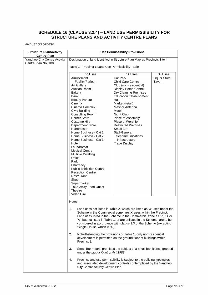
City of Wanneroo DPS 2 Page No. 179
SCHEDULE 16 (CLAUSE 3.2.4) – LAND USE PERMISSIBILITY FOR STRUCTURE PLANS AND ACTIVITY CENTRE PLANS
AMD 157 GG 06/04/18
Structure Plan/Activity
Centre Plan Use Permissibility Provisions
Yanchep City Centre Activity Centre Plan No. 100
Designation of land identified in Structure Plan Map as Precincts 1 to 4. Table 1 - Precinct 1 Land Use Permissibility Table
'P' Uses 'D' Uses 'A' Uses
Amusement Facility/Parlour
Art Gallery Auction Room Bakery Bank Beauty Parlour Cinema Cinema Complex Civic Building Consulting Room Corner Store Costume Hire Department Store Hairdresser Home Business - Cat 1 Home Business - Cat 2 Home Business - Cat 3 Hotel Laundromat Medical Centre Multiple Dwelling Office Park Pharmacy Public Exhibition Centre Reception Centre Restaurant Shop Supermarket Take Away Food Outlet Theatre Video Hire
Car Park Child Care Centre Club (non-residential) Display Home Centre Dry Cleaning Premises Education Establishment Hall Market (retail) Mast or Antenna Motel Night Club Place of Assembly Place of Worship Restricted Premises Small Bar Stall-General Telecommunications
Infrastructure Trade Display
Liquor Store Tavern
Notes: 1. Land uses not listed in Table 2, which are listed as 'X' uses under the
Scheme in the Commercial zone, are 'X' uses within the Precinct. Land uses listed in the Scheme in the Commercial zone as 'P', 'D' or 'A', but not listed in Table 1, or are unlisted in the Scheme, are to be considered in accordance with clause 3.3 of the Scheme (excepting 'Single House' which is 'X').
2. Notwithstanding the provisions of Table 1, only non-residential
development is permitted on the ground floor of buildings within Precinct 1.
3. Small Bar means premises the subject of a small bar license granted
under the Liquor Control Act 1988. 4. Precinct land use permissibility is subject to the building typologies
and associated development controls contemplated by the Yanchep City Centre Activity Centre Plan.
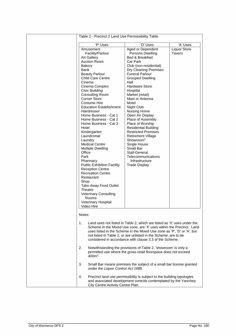
City of Wanneroo DPS 2 Page No. 180
Table 2 - Precinct 2 Land Use Permissibility Table
'P' Uses 'D' Uses 'A' Uses
Amusement Facility/Parlour
Art Gallery Auction Room Bakery Bank Beauty Parlour Child Care Centre Cinema Cinema Complex Civic Building Consulting Room Corner Store Costume Hire Education Establishment Hairdresser Home Business - Cat 1 Home Business - Cat 2 Home Business - Cat 3 Hotel Kindergarten Laundromat Laundry Medical Centre Multiple Dwelling Office Park Pharmacy Public Exhibition Facility Reception Centre Recreation Centre Restaurant Shop Take Away Food Outlet Theatre Veterinary Consulting
Rooms Veterinary Hospital Video Hire
Aged or Dependent Persons Dwelling
Bed & Breakfast Car Park Club (non-residential) Dry Cleaning Premises Funeral Parlour Grouped Dwelling Hall Hardware Store Hospital Market (retail) Mast or Antenna Motel Night Club Nursing Home Open Air Display Place of Assembly Place of Worship Residential Building Restricted Premises Retirement Village Showroom2 Single House Small Bar Stall-General Telecommunications
Infrastructure Trade Display
Liquor Store Tavern
Notes: 1. Land uses not listed in Table 2, which are listed as 'X' uses under the
Scheme in the Mixed Use zone, are 'X' uses within the Precinct. Land uses listed in the Scheme in the Mixed Use zone as 'P', 'D' or 'A', but not listed in Table 2, or are unlisted in the Scheme, are to be considered in accordance with clause 3.3 of the Scheme.
2. Notwithstanding the provisions of Table 2, 'showroom' is only a
permitted use where the gross retail floorspace does not exceed 400m2.
3. Small Bar means premises the subject of a small bar license granted
under the Liquor Control Act 1988. 4. Precinct land use permissibility is subject to the building typologies
and associated development controls contemplated by the Yanchep City Centre Activity Centre Plan.

City of Wanneroo DPS 2 Page No. 181
Table 3 - Precinct 3 Land Use Permissibility Table
'P' Uses 'D' Uses 'A' Uses
Consulting Room Corner Store Hospital Lunch Bar Medical Centre Office Park Pharmacy Recreation Centre
Amusement Facility/Parlour
Art Gallery Bakery Bank Beauty Parlour Car Park Child Care Centre Cinema Civic Building Club (non-residential) Dry Cleaning Premises Education Establishment Hall Hotel Laundromat Laundry Mast or Antenna Multiple Dwelling Place of Assembly Place of Worship Private Recreation Public Exhibition Facility Reception Centre Recreation Centre Residential Building Shop2
Small Bar Special Place of Assembly Take Away Food Outlet Telecommunications
Infrastructure
Liquor Store Tavern
Notes: 1. Land uses not listed in Table 3, which are listed as 'X' uses under the
Scheme in the Business zone, are 'X' uses within the Precinct. Land uses listed in the Scheme in the Business zone as 'P', 'D' or 'A', but not listed in Table 3, or are unlisted in the Scheme, are to be considered in accordance with clause 3.3 of the Scheme. (excepting 'Single House' which is 'X').
2. Notwithstanding the provisions of Table 3, 'shop' is only a permitted
use where the gross retail floorspace does not exceed 300m2. 3. Small Bar means premises the subject of a small bar license granted
under the Liquor Control Act 1988. 4. Precinct land use permissibility is subject to the building typologies
and associated development controls contemplated by the Yanchep City Centre Activity Centre Plan.

City of Wanneroo DPS 2 Page No. 182
Table 4 - Precinct 4 Land Use Permissibility Table
'P' Uses 'D' Uses 'A' Uses
Amusement Facility/Parlour
Art Gallery Auction Room Bakery Bank Car Wash Consulting Room Convenience Store Corner Store Costume Hire Drive Through Food
Outlet Dry Cleaning Premises Hardware Store Hire Service Laundromat Laundry Lunch Bar Medical Centre Office Open Air Display Pharmacy Public Exhibition Facility Recreation Centre Restaurant Road House Service Station Showroom Take Away Food Outlet Veterinary Consulting
Rooms Veterinary Hospital Video Hire
Beauty Parlour Car Park Child Care Centre Civic Building Club (non-residential) Education Establishment Factory Unit Funeral Parlour Hairdresser Hall Hotel Lanscape Supplies Market (retail) Mast or Antenna Motel Motor Vehicle Repairs Place of Assembly Place of Worship Plant Nursery Private Research Reception Centre Residential Building Restricted Premises Shop2 Stall-General Telecommunications
Infrastructure Trade Display Warehouse
Liquor Store Tavern
Notes: 1. Land uses not listed in Table 4, which are listed as 'X' uses under the
Scheme in the Business zone, are 'X' uses within the Precinct. Land uses listed in the Scheme in the Business zone as 'P', 'D' or 'A', but not listed in Table 4, or are unlisted in the Scheme, are to be considered in accordance with clause 3.3 of the Scheme (excepting 'Single House' which is 'X').
2. Notwithstanding the provisions of Table 4, 'shop' is only permitted in
Precinct 4 where the gross retail floor space of the shop exceeds 300m2.
3. Precinct land use permissibility is subject to the building typologies
and associated development controls contemplated by the Yanchep City Centre Activity Centre Plan.

City of Wanneroo DPS 2 Page No. 183
SCHEDULE 17 (CLAUSE 5.4.1.1 (B) – SPECIAL CONTROL AREAS AMD 150 GG 27/04/18
NO DESCRIPTION OF LOCALITY
SPECIAL PROVISIONS
SCA 1 Lot 100 (25) and Lot 5 (33) Drovers Place, Wanneroo Portion Lot 810 (1397), Lot 811 (1387), Lot 1 (1369), Lot 132 (1351), Lot 11 (1349), Lot 10 (1327), Lot 501 (1321), Lot 2 (1303) and Lot 406 (1297) Wanneroo Road, Wanneroo
1.0 General Special Control Area Provisions
The following provisions apply in this Special Control Area. Where any inconsistency arises between any Special Provision of this Schedule and the General Provisions of the Scheme, then the provision of this Schedule shall prevail to the extent of that inconsistency.
1.1 Land Use Definitions
In addition to the definitions prescribed in Schedule 1, the land use definitions for ‘Growers Mart’, ‘Large Format Category/Theme Based Showroom’ and ‘Retail Nursery’ provided in Schedule 2 – Section 1 (Additional Use numbers 1-37 and 1-38) shall also be read in conjunction with the provisions of this Special Control Area.
1.2 Objectives of the Special Control Area
The general objectives of this Special Control Area are as follows:
a) guide subdivision and provide for a variety of
appropriate land uses and development, where proposals will have high exposure to Yellagonga Regional Park;
b) facilitate adaptive built form that maintains a visual relationship with and provides pedestrian access to Yellagonga Regional Park; and
c) to protect and enhance the environmental, heritage, and landscape values of the adjacent Yellagonga Regional Park.
1.3 Local Development Plan Requirements
1.3.1 Local development plans prepared for this Special Control Area should be consistent with the objectives as outlined in Clause 1.2 of this Schedule.
1.3.2 The local government may resolve not to support or approve development within the Special Control Area in the absence of a local development plan, unless it is satisfied that the development proposed is of a scale and permanence that will not prejudice the provision of infrastructure and services to the area; or other development on land within and adjoining the Special Control Area.
1.3.3 In addition to any general matters required to be
included within a local development plan under the General Provisions of this Scheme, local development plans for the Special Control Area should illustrate, as a minimum, the following where applicable: a) Detailed site analysis including topography,
City of Wanneroo DPS 2 Page No. 184
NO DESCRIPTION OF LOCALITY
SPECIAL PROVISIONS
vegetation, tree survey, view corridors, and microclimate. The vegetation analysis and tree survey should clearly identify and justify the extent of: i. any clearing that is proposed during
the development stages; and ii. vegetation that will be retained and
managed at the subdivision and development stages.
b) Footpaths and shared paths, linking with Yellagonga Regional Park;
c) Integration of landscaping and public realm with Yellagonga Regional Park;
d) Principles of landscape design; e) Maintenance of visual relationship with
Yellagonga Regional Park; f) Fencing as it relates to Yellagonga Regional
Park; g) Signage as it relates to Yellagonga
Regional Park; and h) Earthworks plan with indicative design
levels and likely extent of retaining walls. 1.4 Wetland Buffers
1.4.1 Areas designated as a wetland buffer in the Plan included in this Schedule shall preclude development, however will allow low-impact uses, including:
a) water sensitive urban design best
management practices; b) passive recreational facilities as deemed
appropriate by the local government; c) amenity landscaping utilising locally native
species; and d) other low-impact uses as deemed
appropriate by the local government in consideration of the advice from relevant government agencies.
1.4.2 Any application for development and/or subdivision
affecting or adjacent to Lake Joondalup or the Wetland Buffer shall be supported by a Wetland Management Plan that incorporates the following to the satisfaction of the Western Australian Planning Commission (subdivision) and the Local Government (development):
a) a concept plan showing the location of
wetland compatible uses to be included within the buffer area, and those areas to be rehabilitated with native vegetation;
b) a re-vegetation plan to provide for the planting of native vegetation within the wetland buffer area.
c) midge management plans; d) fertiliser and irrigation management plan; e) urban Water Management Plan

City of Wanneroo DPS 2 Page No. 185
NO DESCRIPTION OF LOCALITY
SPECIAL PROVISIONS
demonstrating: i. onsite retention and treatment of all
stormwater up to the one year critical duration rainfall event;
ii. attenuation of peak flows to pre-clearing levels; and
iii. the use of appropriate water sensitive urban design structural controls to achieve above design criteria;
f) bushfire management; and g) dieback management.
1.5 High Groundwater Areas
1.5.1 The local government shall not support subdivision or approve development on land that is shown as a ‘High Groundwater Area’ on the Plan included in this Schedule, unless it can be demonstrated that: a) finished floor levels, without the use of a
controlled groundwater level, can be achieved that have 1.2 metre separation from historical maximum groundwater levels and 0.5 metre separation from 100 Year Average Recurrence Interval (ARI) Top Water Level in flood storage areas;
b) the introduction of fill to achieve (a) will not present any interruption to flood water flows in the 100 Year ARI flood event;
c) the introduction of fill to achieve (a) will coordinate with natural levels at the common boundary with Yellagonga Regional Park;
d) batters arising from introduced fill shall result in no retaining walls greater than one metre required, and that batters can be revegetated to prevent future erosion;
e) fill introduced to the site shall be clean of Phytophthora dieback, weeds and accredited as such;
f) all stormwater up to and including the 1 Year ARI critical duration event shall be infiltrated at source and not conveyed through the drainage network to infiltration areas in open space or drainage reserves; and
g) stormwater leaving the development site shall not exceed pre-development flow rates. All post development stormwater shall be attenuated on the development site and off-line from overland flow paths.

City of Wanneroo DPS 2 Page No. 186
NO DESCRIPTION OF LOCALITY
SPECIAL PROVISIONS
1.5.2 The conditions above shall be demonstrated to the local government in the form of Urban Water Management Plans that incorporate an indicative earthworking plan, indicative design levels and modelling of 100 year flood levels for Lake Joondalup; in addition to any requirement or guidance issued by the local government and/or relevant government agencies.
1.5.3 Urban Water Management Plans shall be finalised by the applicant and endorsed by the local government through a condition of subdivision or development, issued prior to commencement of any site works.
2.0 Special Control Area Provisions – SCA No. 1 (a)
2.1 Extent of Special Control Area 1 (a):
Special Control Area 1 (a) incorporates the following lots:
• Lot 100 (25), Drovers Place, Wanneroo
• Lot 5 (33) Drovers Place, Wanneroo
2.2 Intent of Special Control Area 1 (a) The intent of Special Control Area 1 (a) is to provide for a
diverse precinct of residential, community and private recreation uses that integrate with the environment of Yellagonga Regional Park.
2.3 Development and Application Requirements
2.3.1 The design of development adjacent to the Yellagonga Regional Park shall limit the visual impact of site levels, retaining walls, and fencing. Visually impermeable fencing and/or retaining walls above one metre in height shall be prohibited adjacent to Yellagonga Regional Park.
2.3.2 Development shall be designed at a scale and level that would render it unobtrusive from the Yellagonga Regional Park boundary and shall be screened from the park by way of local native vegetation.
3.0 Special Control Area Provisions – SCA No. 1 (b) 3.1 Extent of Special Control Area 1 (b):
Special Control Area 1 (b) incorporates the following lots:
• Portion Lot 810 (1397) Wanneroo Road, Wanneroo
• Lot 811 (1387) Wanneroo Road, Wanneroo
• Lot 1 (1369) Wanneroo Road, Wanneroo
• Lot 132 (1351) Wanneroo Road, Wanneroo
• Lot 11 (1349) Wanneroo Road, Wanneroo
City of Wanneroo DPS 2 Page No. 187
NO DESCRIPTION OF LOCALITY
SPECIAL PROVISIONS
3.2 Intent of Special Control Area 1 (b)
The intent of Special Control Area 1 (b) is to provide for a Business Zone with built form that respects and recognises the environment of Yellagonga Regional Park.
3.3 Development Requirements
3.3.1 Development adjacent to the Yellagonga Regional Park shall coordinate with natural levels at the common boundary with Yellagonga Regional Park to minimise the visual impact of site levels, retaining walls, and fencing. Retaining walls above one metre in height shall be discouraged.
3.3.2 The location and design of buildings, access ways and footpaths shall provide for view corridors to the Yellagonga Regional Park.
3.3.3 The bulk and scale of any future development shall
have regard for preserving the views, significance and character of and visual relationship to Yellagonga Regional Park.
3.3.4 Provision of a Right-of-Carriageway Easement from
Wanneroo Road to the existing Pump Station site and works required to interface the Pump Station installation with the proposed adjacent subdivision or development.
3.3.5 Service areas shall be integrated within the
development and designed to minimise any negative visual impacts along the interface with the Yellagonga Regional Park and Wanneroo Road. All service areas shall be appropriately screened from the public realm.
3.3.6 Hardscape shall provide for reduction of impervious
area to facilitate water sensitive design. 3.3.7 Building façades shall be of a high architectural
standard utilising brick, masonry, concrete and glazing and include colour schemes sympathetic to the natural environment.
3.3.8 Buildings are to be designed to suit local climatic
conditions, be energy efficient and designed to help reduce the risk and fear of crime.
3.3.9 New buildings are to be of a quality of architectural
design that is consistent with the role, setting and natural character of the Special Control Area.
3.3.10 Buildings are to provide opportunities for passive
surveillance and be sited to enable and encourage pedestrian access to Yellagonga Regional Park. This may include glazing and seating or alfresco areas to integrate development with the Yellagonga Regional Park.

City of Wanneroo DPS 2 Page No. 188
NO DESCRIPTION OF LOCALITY
SPECIAL PROVISIONS
3.3.11 A minimum of eight percent of a site shall be
provided as landscaping in addition to the Wetland Buffer defined in the Plan included in this Schedule.
4.0 Special Control Area Provisions – SCA No. 1 (c) 4.1 Extent of Special Control Area 1 (c):
Special Control Area 1 (c) incorporates the following lots:
• Lot 10 (1327) Wanneroo Road, Wanneroo
• Lot 501 (1321) Wanneroo Road, Wanneroo
• Lot 2 (1303) Wanneroo Road, Wanneroo
• Lot 406 (1297) Wanneroo Road, Wanneroo 4.2 Intent of Special Control Area 1 (c)
The intent of Special Control Area 1 (c) is to provide for single dwellings in a natural landscape setting, whilst protecting adjacent natural assets.
4.3 Subdivision and Development Provisions
4.3.1 The minimum lot size shall not be less than 2,000sqm.
4.3.2 All lots shall be connected to a reticulated sewage
system.
4.3.3 With the exception of a suitable access driveway, development (including earthworks) shall be located within the building envelope identified on the approved local development plan.
4.3.4 No vegetation shall be cleared or removed outside
the building envelope, or that area used for an approved vehicular access, without the prior approval of the local government.
4.3.5 Development shall be designed at a scale and level
that would render it unobtrusive from the Yellagonga Regional Park boundary and shall be screened from the park by way of local native vegetation.
4.4 Specific Local Development Plan Requirements
In addition to any matters required to be included within a local development plan under the General Provisions of this Scheme and Clause 1.3.3 of this Schedule, a local development plan for Special Control Area 1 (c) shall illustrate the following: a) Building envelopes on lots to be created through
subdivision, to a maximum area of 800sqm. Up to three building envelopes may be proposed on a single lot, provided the total land area of all envelopes does not exceed 800sqm.
City of Wanneroo DPS 2 Page No. 189
No. Description of
Locality Special Provisions
SCA2 Land bound by
Gnangara Road to
the North,
Alexander Drive to
the East, Hepburn
Avenue to the
South and the
eastern boundary
of East Wanneroo
Cell 5 as shown on
the Scheme Map.
AMD 146 GG 24/9/19
1. Objective
To reduce the risk of radio frequency emissions and interference to the
operations of the Perth International Telecommunications Centre (PITC)
located on Lot 1 (620) Gnangara Road, Cullacabardee.
2. Special Provisions Shall Prevail
(a) Where any inconsistency arises between any Special Provision of
this Schedule and the general provisions of the Scheme or any
other document, then the provision(s) of this Schedule shall prevail
to the extent of that inconsistency; and
(b) The special provisions of SCA 2 cannot be varied except to the
extent provided for by this schedule.
3. Subdivision and Development
(a) Notwithstanding Clauses 61(1)(c) and 61(1)(d) of the Deemed
Provisions Development Approval is required for Residential
Development within SCA 2.
(b) The subdivision and development of all land within SCA 2 shall
have due regard to the requirements of any Structure Plan, Local
Development Plan or Local Planning Policy that is adopted under
or for the purposes of this Scheme subject to the provisions
contained within the Scheme.
(c) Residential subdivision and development within SCA 2 is to
achieve a minimum average site area of not less than 500m2 per
dwelling.
(d) Lots within SCA 2 are to have a predominantly north south
orientation.
(e) Roads within SCA 2 are to have a predominantly east west
orientation.
4. Residential Development
All Residential development is to comply with the following standards:
(a) The maximum height of any residential building is not to exceed
the height limits for Category B Buildings provided in Table 3 of the
Residential Design Codes;
(b) To the extent permitted by the Building Code of Australia or
planning requirements, double brick construction must be used for
all external walls except:
i. Garages (for which single brick construction may be
used); and
ii. Outbuildings (for which materials other than brick may be
used).
(c) Outbuildings not constructed of brick must not exceed 2.7 metres
in height above natural ground level;

City of Wanneroo DPS 2 Page No. 190
No. Description of
Locality Special Provisions
(d) If all external walls are not double brick construction (except
garages and outbuildings), overlapping sisalation must be installed
between the outer wall and abutting inner wall located on the
eastern side of the building;
(e) All roofs (except roofs of garages and outbuildings with dimensions
less than 3.0 metres x 3.0 metres) must have a pitch of at least 10
degrees;
(f) All garages must not have a permanent opening on the eastern
side; or on more than one side but, for avoidance of doubt, one of
the 3 enclosed sides may include a garage door;
(g) Antennae connected to equipment that has transmit capabilities
must not be installed without planning approval and such will only
be permitted with the prior written approval of Telstra Corporation
Limited;
(h) Where practical, windows must be located on the northern and
southern sides of any residential dwellings; and
(i) Where practical, kitchens must be located on the western side of
residential dwellings.
5. Non-Residential Development Requirements
All development within the Northern Commercial Area, Southern
Commercial Area and Southern Community Purpose Area (as detailed in
Schedule One of the SCA) is to comply with the following standards:
(a) Prior to the approval of any non-residential subdivision or
development, a Local Development Plan is to be prepared which
identifies:
i. measures to mitigate radiofrequency interference with the
PITC. This is to include the identification of walls that are
required to be solid and/or have glazing in accordance
with Clauses 5(b), 5(e), 6.1(a), 6.2(a) and 6.3(a);
ii. the orientation of building frontage, setbacks, car parking
and landscaping to provide an attractive and integrated
interface to residential areas and the public street network;
iii. the retention of remnant vegetation within car parking and
development sites; and
iv. the orientation and positioning of services and loading
areas to avoid interfacing with residential areas.
(b) Any eastern facing walls for buildings that front Alexander Drive
must be solid unless approved in accordance with Clause 7.1;
(c) All roofs must have a pitch of at least 10 degrees, except for
portions of the roof accommodating roof mounted plant;
(d) Unless varied in accordance with the requirements of Clause 7.2,
car parking is to be located:
i. To the west of the buildings adjacent to Alexander Drive;
and/or,
ii. Between the buildings; and/or
City of Wanneroo DPS 2 Page No. 191
No. Description of
Locality Special Provisions
iii. To the south of the buildings for the Southern Commercial
Area; and/or
iv. To the south and/or west of the Southern Community
Purpose Area; and/or
v. To the north of the buildings for the Northern Commercial
Area.
(e) Vehicle access is not permitted from Alexander Drive other than
from:
i. Existing constructed roads;
ii. The existing access for the Ambulance Depot on Lot 1982
Alexander Drive; and
iii. The proposed extension to Sedano Glade through to
Alexander Drive.
(f) All glazing on the windows and glass doors of the following
building elevations is to be treated with RF shielding window film to
block up to 20 Gigahertz frequencies:
i. The eastern elevation of all buildings fronting or directly
facing Alexander Drive;
ii. The northern elevation of buildings of the Southern
Commercial Area and Southern Community Purpose
Area, where the walls front or directly faces the extension
of Sedano Glade, where identified in an approved Local
Development Plan; and
iii. The southern elevation of the Northern Commercial Area.
(g) Any other requirement applicable to an area as specified in Clause
6 below.
6. Development Requirements for Specific Commercial Areas
The following provisions apply to the specific areas identified in Schedule
One of SCA 2.
6.1 Northern Commercial Area
For the Northern Commercial Area (Lot 1982 Alexander Drive), the
following additional provisions apply:
(a) The wall/s on the southern elevation of a building must be solid
unless approved in accordance with Clause 7.1;
(b) The height of all buildings must not exceed 6.0 metres above
finished ground level;
(c) No electrical or illuminated signs are permitted on the southern or
eastern elevations of the buildings above 6.0 metres above
finished ground level;
(d) Architectural features and isolated mechanical plant screening may
be permitted up to 9.0 metres in height if such screening provides
a barrier between the plant and the eastern and northern
elevations to screen any such plant from creating potential radio
frequency emission issue to PITC; and

City of Wanneroo DPS 2 Page No. 192
No. Description of
Locality Special Provisions
(e) Stand-alone signage shall not contain electrical/illuminated signs
located higher than 6.0 metres above finished ground level on the
southern or eastern elevations of the signage structure.
6.2 Southern Commercial Area and Southern Community Purpose Area
For the Southern Commercial Area (Landsdale Road), and Southern
Community Purpose Area the following additional provisions apply:
(a) The wall/s on northern elevation of buildings, where the wall fronts
or directly faces the extension of Sedano Glade and are identified
on an endorsed Local Development Plan as being solid must be
solid unless approved in accordance with Clause 7.1;
(b) The height of all buildings must not exceed 7.5 metres above
finished ground levels;
(c) No electrical or illuminated signs are permitted on the northern or
eastern elevations of the buildings above 6.0 metres above
finished ground levels unless specifically permitted by an endorsed
Local Development Plan;
(d) Architectural features may be permitted up to 13.0 metres in height
above finished ground levels where specifically permitted by an
endorsed Local Development Plan;
(e) Isolated mechanical plant screening may be permitted up to 9.0
metres in height above finished ground levels if such screening
provides a barrier between the plant and the eastern and northern
elevations to screen any such plant from creating potential radio
frequency emission issue to PITC; and
(f) Stand-alone signage shall not contain electrical/illuminated signs
located higher than 6.0 metres above finished ground levels on the
northern or eastern elevations of the signage structure unless
specifically permitted by an endorsed Local Development Plan.
7. Variations to Non-Residential Development Requirements
7.1 Solid Wall Requirement
Variation to Clauses 5(a), 6.1(a) and 6.2(a) may be permitted where a 3.0
metre wide landscape strip is provided on the lot, adjacent to the Alexander
Drive frontage, and planted with trees at a minimum of 7.5 metre intervals
between the centre line of the trunk of each tree with the following species
and planting sizes:
i. Common Sheoak - 200mm pot size;
ii. Candle Banksia - 200mm pot size;
iii. Holly Leaf Banksia - 200mm pot size;
iv. Firewood Banksia - 200mm pot size;
v. Marri - 200mm pot size;
vi. Jarrah - 200mm pot size; and
vii. Coastal Blackbutt - 200mm pot size.
7.2 Car Parking
Where a landscaping strip is provided in accordance with Clause 7.1:

City of Wanneroo DPS 2 Page No. 193
No. Description of
Locality Special Provisions
i. Not more than one row of car parking bays may be provided
between the Alexander Drive landscaping strip and buildings on
the site; and
ii. a limited number of bays may be provided in a second row directly
in front of the eastern elevation of each building that faces
Alexander Drive.
Schedule One
Refer to Schedule One Plan.
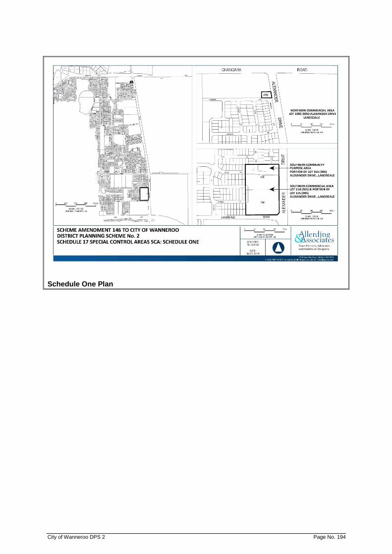
City of Wanneroo DPS 2 Page No. 194
Schedule One Plan

City of Wanneroo DPS 2 Page No. 195
SCHEDULE A - SUPPLEMENTAL PROVISIONS TO THE DEEMED PROVISIONS
These provisions are to be read in conjunction with the deemed provisions (Schedule 2) contained in the
Planning and Development (Local Planning Schemes) Regulations 2015.
Clause 60:
(c) the terms or conditions of any development approval obtained under Part 8 are complied
with.
Clause 61(1):
(k) The signage and advertisements contained in Schedule 4 of this Scheme, except in
respect of a place included on the Heritage List or which in the opinion of Council will
affect such a place.
(l) the erection or extension of a single house on a lot if a single house is a permitted (“P”)
use in the zone (where the R Codes do not apply) in which that lot is located, where the
development standards set out in the scheme for that particular zone (including boundary
setbacks) are satisfied, unless the development is located in a place that is:
(i) entered in the Register of Heritage Places under the Heritage of Western
Australia Act 1990; or
(ii) the subject of an order under the Heritage of Western Australia Act 1990 Part 6;
or
(iii) included on a heritage list prepared in accordance with this Scheme; or
(iv) within an area designated under the Scheme as a heritage area; or
(v) the subject of a heritage agreement entered into under the Heritage of Western
Australia Act 1990 section 29;
(m) the erection or extension of an outbuilding, external fixture, boundary wall or fence, patio,
pergola, veranda, garage, carport or swimming pool on the same lot as a single house if
a single house is a permitted (“P”) in the zone (where the R Codes do not apply) where
the development standards set out in the scheme for that particular zone (including
boundary setbacks) are satisfied, unless the development is located in a place that is:
(i) entered in the Register of Heritage Places under the Heritage of Western
Australia Act 1990; or
(ii) the subject of an order under the Heritage of Western Australia Act 1990 Part 6;
or
(iii) included on a heritage list prepared in accordance with this Scheme; or
(iv) within an area designated under the Scheme as a heritage area; or
(v) the subject of a heritage agreement entered into under the Heritage of Western
Australia Act 1990 section 29;
(n) the erection of a boundary fence in any zone where the R-Codes do not apply;
(o) the carrying out of works urgently necessary to ensure public safety, for the safety or
security of plant or equipment or for the maintenance of essential services;

City of Wanneroo DPS 2 Page No. 196
(p) the demolition of any building or structure except where the building or structure is:
(i) located in a place that has been entered in the Register of Places under the Heritage of Western Australia Act 1990; or
(ii) the subject of an order under Part 6 of the Heritage of Western Australia Act 1990; or
(iii) included on the Heritage List prepared in accordance with the scheme; or
(iv) located in an area that will in the opinion of Council affect a place included on the Heritage List pursuant to subclause 5.2.2 of the Scheme;
Clause 61(2):
(g) the conducting of a Home Business – Category 1. Clause 67 (zc) any relevant advice of a Design Review Panel. AMD 168 GG 18/02/20 Part 6A – Design Review Panels AMD 168 GG 18/02/20
60A. The Local Government may appoint a Design Review Panel for the purpose of considering, and
advising the Local Government with respect to applications and/or planning documents.
60B. The Local Government shall prepare and adopt a local planning policy that details the operation
of the Design Review Panel and specifies the matters on which the Design Review Panel will be
consulted.
60C. When considering applications and/or planning documents on which a recommendation has been
made by the Design Review Panel, the decision-maker shall have due regard for that
recommendation.

City of Wanneroo DPS 2 Page No. 197
CITY OF WANNEROO
DISTRICT PLANNING SCHEME NO. 2
Adopted by resolution of the Local government of the City of Wanneroo at the Ordinary meeting of the Local government held on the 27th day of March 1991. Modified by resolution of the Local government of the City of Wanneroo at the Special meeting of the Local government held on the 22nd day of August 1996. Modified by resolution of the Local government of the City of Wanneroo at the Special meeting of the Local government held on the 10th day of September 1997. On July 1, 1998, the City of Wanneroo ceased to exist. In its place, the City of Joondalup and the Shire of Wanneroo were created, with both municipalities coming into existence on the same date, July 1, 1998. Adopted for final approval by resolution of the Shire of Wanneroo at the Ordinary Meeting of the Local government held on the 22nd day of September 1998. Modified and adopted for final approval by resolution of the Shire of Wanneroo at the Special Meeting of the Local government held on the 17th May 1999. On July 1, 1999 the Shire of Wanneroo became the City of Wanneroo, notice of which was published in the Government Gazette on 18 June 1999. Adopted for final approval by the Local government of the City of Wanneroo at the Ordinary meeting held on the 6th day of February 2001 and the Common Seal of the City of Wanneroo was hereunto affixed by the authority of a resolution of the Local government in the presence of: ..............................................……….. MAYOR ...............................................……….. CHIEF EXECUTIVE OFFICER Recommended/Submitted for final approval .......................................................................
CHAIRPERSON, WESTERN AUSTRALIAN PLANNING COMMISSION
DATE ............................................................
Final Approval Granted ....................................................................... MINISTER FOR PLANNING
DATE 27/6/2001..............................................