Embed Size (px)
Citation preview

ESA UNCLASSIFIED – For Official Use
esrin
Via Galileo Galilei Casella Postale 64
00044 Frascati Italy�
Tel. (39) 06 941801 Fax (39) 06 94180 280
www.esa.int�
GMES SPACE COMPONENT - DATA ACCESS PORTFOLIO SPECIFICATIONS
DOCUMENT for CORE DATASETS 2010-2013 (DAP/S)
Prepared by EOP-GS Reference COPE-GSOP-EOPG-RS-14-0007 Issue 1 Revision 0 Date of Issue 1 Jul 2014 Status Issued Document Type RQ Distribution
ESA UNCLASSIFIED – For Official Use

ESA UNCLASSIFIED – For Official Use
Title
Issue 1 Revision 0
Author Date
Approved by Date
Reason for change Issue Revision Date
Issue Revision Reason for change Date Pages Paragraph(s)
Page 2/85 Date 1 Jul 2014 Issue 1 Rev 0
ESA UNCLASSIFIED – For Official Use

ESA UNCLASSIFIED – For Official Use
Table of contents:
1 Introduction ........................................................................................................................................... 5 1.1 Background ...................................................................................................................................................... 5 1.2 Scope of the document .................................................................................................................................. 5 1.3 Applicable Documents................................................................................................................................. 6 1.4 Reference Documents .................................................................................................................................. 6 1.5 Web References ............................................................................................................................................. 6 1.6 Structure of the document ........................................................................................................................... 7
2 USAGE of the document ..................................................................................................................... 8
3 User Definitions and use purposes ................................................................................................ 9 3.1 Copernicus Services [Copernicus Services] ......................................................................................... 9 3.2 Institutions and bodies of the Union [Union_Inst] ............................................................................ 9 3.3 Participants to a research project financed under the Union research programmes [Union_Research_Projects] ................................................................................................................................... 9 3.4 Public authority [Public_Auth] .............................................................................................................. 10 3.5 International Organisations and international NGOs [INT_ORG_NGO] .................................. 10 3.6 Public [Public] ............................................................................................................................................. 10
4 Usage types (services), or Use Definition .................................................................................. 10 4.1 DISCOVERY Service .................................................................................................................................... 11 4.2 VIEW Service ................................................................................................................................................ 11 4.3 DOWNLOAD Service: ................................................................................................................................. 11
5 Usage rights ......................................................................................................................................... 12
6 CORE dataset specifications .............................................................................................................. 13 6.1 General requirements .................................................................................................................................. 13
6.1.1 Sensor transitions .................................................................................................................................................... 13 6.1.2 Consistency ............................................................................................................................................................... 13 6.1.3 INSPIRE ..................................................................................................................................................................... 13
6.2 Optical HR Pan Europe coverage (HR_IMAGE_2015) .................................................................... 13 6.3 Optical HR Pan Europe coverage (HR_IMAGE_2018) .................................................................... 25 6.4 Optical VHR multispectral and panchromatic coverage over Europe (VHR_IMAGE_2015) 26 6.5 Optical VHR Pan Europe coverage (VHR_IMAGE_2018) ............................................................... 36 6.6 Riparian zone delta coverage of previous DWH Phase (Riparian) .......................................... 36 6.7 European Optical MR1 composites (MR_IMAGE_2015) ................................................................ 37 6.8 European Optical MR1 composites (MR_IMAGE_2018) ................................................................ 41 6.9 Optical HR1 worldwide coverage (HR1_OPTICAL_GLOBAL) ...................................................... 42 6.10 Optical HR2 worldwide coverage (HR2_OPTICAL_GLOBAL) .................................................... 44 6.11 Optical MR2 worldwide coverage (MR_OPTICAL_GLOBAL) ..................................................... 45 6.12 Optical LR worldwide coverage (LR_OPTICAL_GLOBAL) .......................................................... 47 6.13 SAR HR2/MR1 Worldwide coverage (HR2-MR1_SAR_GLOBAL) ............................................. 49
Page 3/85 Date 1 Jul 2014 Issue 1 Rev 0
ESA UNCLASSIFIED – For Official Use

ESA UNCLASSIFIED – For Official Use
6.14 SAR LR Worldwide coverage (LR_SAR_GLOBAL) .......................................................................... 50 6.15 SAR Altimetry MR2 Worldwide coverage (MR2_ALTIMETRY) ................................................ 52 6.16 Sea Ice Monitoring HR2/MR1 SAR (HR2/MR1_SAR_SEA_ICE) ................................................. 53 6.17 Global/Regional Systematic Ocean Colour data (OC _2014-2020) ........................................ 54 6.18 Systematic Global and Regional sea surface temperature data (SST_2014-2020) ......... 57 6.19 Systematic Global and Regional Altimeter / Sea Level data (ALT_2014-2020) ................ 59 6.20 Data for aerosol monitoring and forecasting (AER_2014-2020)............................................ 61 6.21 Data for sulphur dioxide (SO2) atmospheric composition monitoring and forecasting (SO2_2014-2020) .................................................................................................................................................. 63 6.22 Data for formaldehyde (HCHO) atmospheric composition monitoring and forecasting (HCHO_2014-2020) .............................................................................................................................................. 64 6.23 Data for Ozone (O3) atmospheric composition monitoring and forecasting (O3_2014-2020) 66 6.24 Data for Carbon Monoxide (CO) atmospheric composition monitoring and forecasting (CO_2014-2020) ..................................................................................................................................................... 67 6.25 Data for Carbon Dioxide (CO2) atmospheric composition monitoring and forecasting (CO2_2014-2020) .................................................................................................................................................. 69 6.26 Data for Methane (CH4) atmospheric composition monitoring and forecasting (CH4_2014-2020) .................................................................................................................................................. 70 6.27 Data for Nitrogen Dioxide (NO2) atmospheric composition monitoring and forecasting (NO2_2014-2020) .................................................................................................................................................. 72 6.28 Licences for previous CORE datasets of previous CSC-DA Phases ......................................... 73
7 Annex A – Cloud assessment methodology ............................................................................... 75
Examples of typical cloud cover and haze situations ................................................................... 75
8 ANNEX B – Structure of the ‘Master’ shapefile ......................................................................... 83
Page 4/85 Date 1 Jul 2014 Issue 1 Rev 0
ESA UNCLASSIFIED – For Official Use

ESA UNCLASSIFIED – For Official Use
1 INTRODUCTION
1.1 Background
The European Space Agency is leading a federation of Earth observation missions named Copernicus (formerly GMES) Space Component which has the objective to ensure comprehensive and sustainable supply of data from space-based observations in response to the Copernicus (formerly GMES) Service needs. The Copernicus Space Component provides harmonised access to data from different sources, ensuring seamless access to different EO data coming from multiple missions including ESA, EUMETSAT, national and other third party missions. The Copernicus‘Regulation’ foresee that “Copernicus shall include a Service Component ensuring delivery of information in atmosphere monitoring, marine monitoring, land monitoring, climate change monitoring, emergency management and security. In particular, Copernicus should deliver information on the state of the atmosphere including at the local, national, European and global scale; information on the state of the oceans, including through the setting-up of a dedicated European grouping for marine monitoring; information in support of land monitoring supporting the implementation of local, national and European policies; information in support of climate change adaptation and mitigation; geospatial information in support of emergency management, including through prevention activities, and civil security including support for the Union’s external action. The Commission should identify appropriate contractual arrangements fostering the sustainability of service provision.” The following chapters describe the requirements for such CORE datasets to the level of detail known at present. It is not excluded that the requirements will still evolve. As part of the formerly called GMES Space Component Data Access [GSCDA], ESA has developed a supporting infrastructure (the so called Coordinated Data Access System – CDS) and has elaborated guidance for operational interfaces with CCMs, as detailed in [AD1]. Data must be provided according to predefined operational scenarios and related interface protocols.
1.2 Scope of the document This document specifies the technical and licence details of the CORE datasets to be procured for the Data Warehouse that require an early acquisition during spring and summer 2014, and for which sufficient detail is known at the time of issuing this document.
Page 5/85 Date 1 Jul 2014 Issue 1 Rev 0
ESA UNCLASSIFIED – For Official Use

1.3 Applicable Documents The following documents contain requirements applicable to the activity:
[AD. 1] CSC-DA_PACKAGE_FOR_CCMs, Ref. COPE-GSEG-EOPG-TN-09-0037, Version 2.2.
[AD. 2] Licence: Terms & Conditions for Use of EO Data from the Data Access Portfolio during the Copernicus Phase 2014-2020
[AD. 3] CSC Data Access Portfolio - Specifications Document for CORE datasets 2014-2020 (DAP-S) V1.0 [Copernicus-GSOP-EOPG-RS-10-0030]
[AD. 4] CSC Data Access Portfolio 2014-2020– Generic Dataset Specifications Document (DAP-G) V1.0 [Copernicus-GSOP-EOPG-RS-10-0031]
[AD. 5] Quotation templates for specific (CORE) datasets
[AD. 6] Quotation templates for generic (ADDITIONAL) datasets
[AD. 7] Statistical Reporting templates for CORE and ADDITIONAL datasets
[AD. 8] Monthly Management Reporting template
1.4 Reference Documents The following links or documents can be consulted by the Contractor as they contain relevant information:
[RD. 1] Data Warehouse Requirements - Version 2.0,
Copernicus Data Access Specifications of the space-based Earth Observation needs for the period 2014-2020 issue 2.0, 05/03/2014
http://www.copernicus.eu/pages-principales/library/specifications/
[RD. 2] Data Warehouse Data Access Portfolio Document,
COPE-PMAN-EOPG-TN-13-0001, Issue 2.8, 15/12/2013
1.5 Web References [WR. 1] Copernicus Programme: http://www.copernicus.eu/
[WR. 2] Sentinels Online http://Sentinel.esa.int [WR. 3] Copernicus Space Component Data Access Portal http://copernicusdata.esa.int
Page 6/85 Date 1 Jul 2014 Issue 1 Rev 0
ESA UNCLASSIFIED – For Official Use
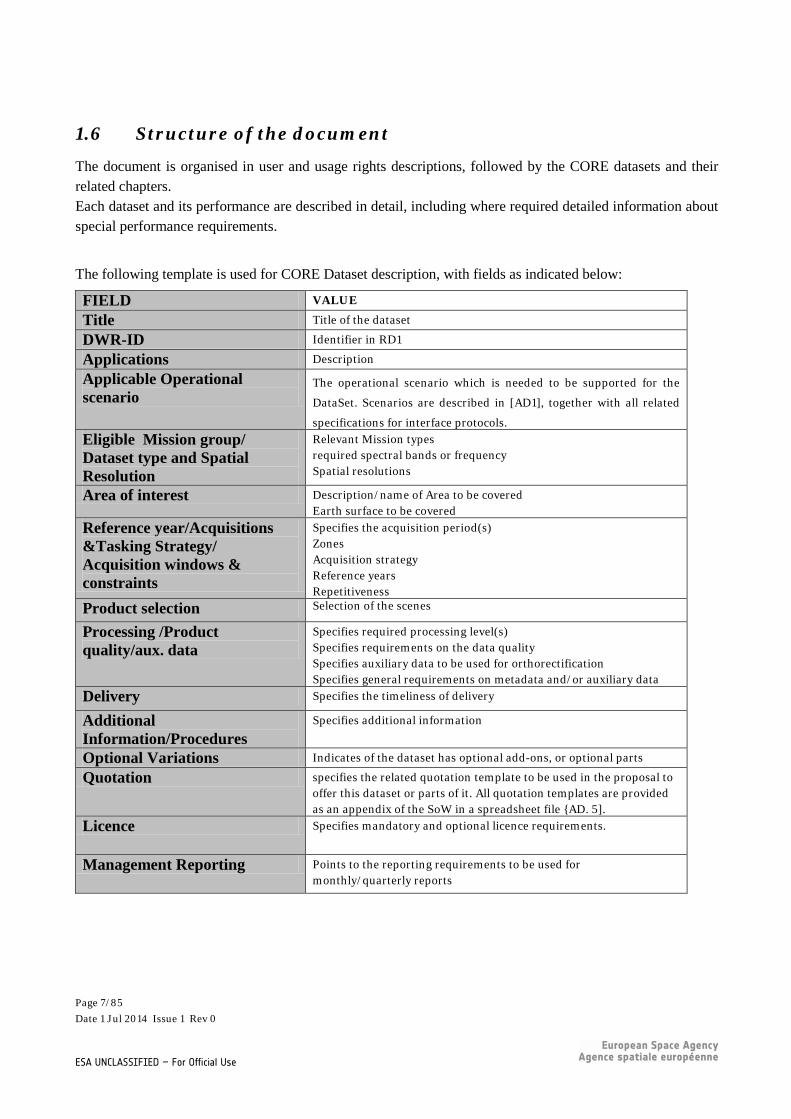
1.6 Structure of the document
The document is organised in user and usage rights descriptions, followed by the CORE datasets and their related chapters. Each dataset and its performance are described in detail, including where required detailed information about special performance requirements.
The following template is used for CORE Dataset description, with fields as indicated below:
FIELD VALUE
Title Title of the dataset
DWR-ID Identifier in RD1
Applications Description
Applicable Operational scenario
The operational scenario which is needed to be supported for the
DataSet. Scenarios are described in [AD1], together with all related
specifications for interface protocols. Eligible Mission group/ Dataset type and Spatial Resolution
Relevant Mission types required spectral bands or frequency Spatial resolutions
Area of interest Description/name of Area to be covered Earth surface to be covered
Reference year/Acquisitions &Tasking Strategy/ Acquisition windows & constraints
Specifies the acquisition period(s) Zones Acquisition strategy Reference years Repetitiveness
Product selection Selection of the scenes
Processing /Product quality/aux. data
Specifies required processing level(s) Specifies requirements on the data quality Specifies auxiliary data to be used for orthorectification Specifies general requirements on metadata and/or auxiliary data
Delivery Specifies the timeliness of delivery
Additional Information/Procedures
Specifies additional information
Optional Variations Indicates of the dataset has optional add-ons, or optional parts
Quotation specifies the related quotation template to be used in the proposal to offer this dataset or parts of it. All quotation templates are provided as an appendix of the SoW in a spreadsheet file {AD. 5].
Licence Specifies mandatory and optional licence requirements.
Management Reporting Points to the reporting requirements to be used for monthly/quarterly reports
Page 7/85 Date 1 Jul 2014 Issue 1 Rev 0
ESA UNCLASSIFIED – For Official Use

2 USAGE OF THE DOCUMENT The document presents a description of the CORE Datasets. The Datasets descriptions shall be used for the preparation of the proposals as follows: Please add to your proposal a compliance matrix per dataset for all fields:
FIELD COMPLIANCE VALUE Insert field name C No additional text required Insert field name PC In case of partial compliance,
please describe the deviations Insert field name NC Please explain which features
are not compliant By using the defined templates for the quotation of a dataset offered, the contractor shall make sure to insert the name of the offered mission (if applicable with which instrument is offered and which product). Note: CCMs with better spatial resolution than the targeted one can also apply for the specific datasets, and may be taken into consideration in the evaluation. Forms shall be filled out independently by each CCM. DISCLAIMER:
The content of the DAP-S gives an indication of the potential specific datasets to be contracted, with many options regarding dataset composition, service level and licence conditions. ESA may, pending budget availability, offers received and prioritisation of requirements, decide not to contract parts of the DAP-S specific datasets or to alter the set-up of the dataset handling in the contracts.
Page 8/85 Date 1 Jul 2014 Issue 1 Rev 0
ESA UNCLASSIFIED – For Official Use

3 USER DEFINITIONS AND USE PURPOSES
User types are defined below. The sections below also define the usage allowed by each user category. These user categories are referred to in the specification by their abbreviation in square brackets.
3.1 Copernicus Services [Copernicus Services]
Copernicus Services first established under the EU Regulation 911/2010 and then under the EU Regulation establishing the Copernicus programme.
This category is provided for clarification. Legally speaking, Copernicus Services providers are either Institutions and bodies of the Union (see below) or their sub-contractors and therefore does not need an extension of licensing rights beyond these provided to the [Union_Inst], in particular for already acquired licensing rights on datasets from previous Data Warehouse exercises.
3.2 Institutions and bodies of the Union [Union_Inst]
The institutions and bodies of the Union, as well as their contractors, may use the Primary Products and Altered Productsfor activities whose purpose is within the Union Public tasks (development, implementation and monitoring of policies and related activities as defined by the Union Treaties and subsequent Union legal acts).
It includes:
(1) The European Institutions set up under the Union Treaties;
(2) The European Union Agencies.
3.3 Participants to a research project financed under the Union research programmes [Union_Research_Projects]
This includes any natural or legal person officially registered as participant of a project funded under the FP7 or Horizon 2020 Space themes. Participants in such projects may use the Primary Products for activities within the project.
As an option, participants to a project financed under Horizon 2020 outside the Space themes may use for activities within the project, already acquired Primary Products.
Page 9/85 Date 1 Jul 2014 Issue 1 Rev 0
ESA UNCLASSIFIED – For Official Use

3.4 Public authority [Public_Auth]
Public authorities include:
(3) Any government or other public administration of States participating in the Copernicus programme, including public advisory bodies, at national, regional or local level.;
(4) Any natural or legal person performing public administrative functions under national law, including specific duties, activities or services in relation to a Union policy;
(5) Any natural or legal person having public responsibilities or functions, or providing public services relating to a Union policy under the control of a body or person falling within (3) or (4), such as a contractor of a public authority;
(6) Any research and academic organisation.
Public authorities, as well as their contractors, may use the Primary Products and Altered Products for activities whose purpose is within the Union Public tasks.
3.5 International Organisations and international NGOs [INT_ORG_NGO]
International Organisations are defined as: Any International Governmental Organisation created by an international treaty which can be looked up in the UN online database of treaties. Specialised agencies of the UN are included;
International Organisations, as well as their contractors, may use the Primary Products for activities whose purpose is within the Union Public tasks. The international NGOs are defined as: Any International Non-Governmental Organisation specialised in humanitarian, development or environmental activities.
Non-Governmental Organisations, as well as their contractors, may use the Primary Products for activities whose purpose is within the Union Public tasks.
3.6 Public [Public]
Any natural or legal person.
In the case that the Download service (see below) is authorised for the Public, the use of the Primary Products may be limited to non-commercial activities.
Page 10/85 Date 1 Jul 2014 Issue 1 Rev 0
ESA UNCLASSIFIED – For Official Use

4 USAGE TYPES (SERVICES), OR USE DEFINITION
The usage types have been defined adhering to the INSPIRE nomenclature (Article 11(1) (a), (b) and (c) of Directive 2007/2/EC). For each dataset the usage type per user category should be specified.
4.1 DISCOVERY Service
The DISCOVERY service shall make it possible to search for spatial datasets and services on the basis of the content of the corresponding metadata and to display the content of the metadata.
All users can access such services
4.2 VIEW Service
The VIEW service shall make it possible, as a minimum, to display, navigate, zoom in/out, pan or overlay viewable spatial datasets and to display legend information and any relevant content of metadata.
4.3 DOWNLOAD Service:
The DOWNLOAD service shall enable the beneficiary:
(7) to make an unlimited number of copies of the Primary Products as needed (archiving and backup purposes included);
(8) to install on as many individual computers as needed, including internal computer network;
(9) to alter or modify the Primary Products by invoking a computer application to produce Altered Products and Value Added Products;
(10) to post Metadata of the Primary Products or its Altered Products on an Internet website with the display of a credit in the following form: “includes material (c) Mission name (year of acquisition), all rights reserved”;
(11) to make hard copies or to display on an Internet web site a Representation of any extract of the Primary Products or its Altered Products at any resolution, with the display of a credit in the following form: “includes material (c) Mission name (year of acquisition), all rights reserved”; the data received by client applications, through the above Internet posting, should be such that it is not
Page 11/85 Date 1 Jul 2014 Issue 1 Rev 0
ESA UNCLASSIFIED – For Official Use

possible to recreate the Primary Products or Altered Products (unless that right is provided);
(12) to use the Primary Products or its Altered Products for internal or external demonstration purposes;
(13) to retain all Intellectual Property Rights associated with any Values Added Products developed on the basis of the Primary Products
As a logical consequence of the definition of Value Added Products, Copernicus services shall be able to generate high information content from the Primary Products and disseminate this high information content as Copernicus service information in accordance with the Copernicus data and information policy.
5 USAGE RIGHTS
The licensed usage rights must ensure the fulfilment of the Copernicus services' operational tasks as defined under the Copernicus Regulation. In particular the licensed rights shall not prevent the generation and dissemination of Copernicus service information (derived information from CCM primary products used as inputs) under a free, full and open dissemination regime in application of the Commission Delegated Regulation No 1159/2013 and the Copernicus Regulation.
(b) In the case of the Copernicus Emergency Management Service and the Copernicus Security Service, [Public_Auth] shall have access to Primary Products.
(c) When the CCME provides download access to CCM data with the authorisation to set up a viewing service for these data, the [Union_Inst] will have the right to set up such viewing service.
Page 12/85 Date 1 Jul 2014 Issue 1 Rev 0
ESA UNCLASSIFIED – For Official Use
6 CORE DATASET SPECIFICATIONS
6.1 General requirements
6.1.1 Sensor transitions The provision of datasets shall support a seamless transition when satellite missions supporting the data provision are replaced by new ones as supplied by one CCME, as far as technically possible. The data provision scheme shall thus support the parallel provision of data from the old and the new missions for the duration necessary to allow cross calibration and comparability of datasets (as far as the implication on the budget distribution is reasonable).
6.1.2 Consistency During each acquisition campaign the dataset characteristics of procured data shall not be modified unilaterally by the data providers.
6.1.3 INSPIRE CCME data shall be delivered in standard formats; with complete and validated INSPIRE compliant metadata. The datasets shall be identified according to a standard file naming convention. A single, common harmonised format should be considered for the delivery of individual files used to provide wall-to-wall coverage of an AOI from different missions.
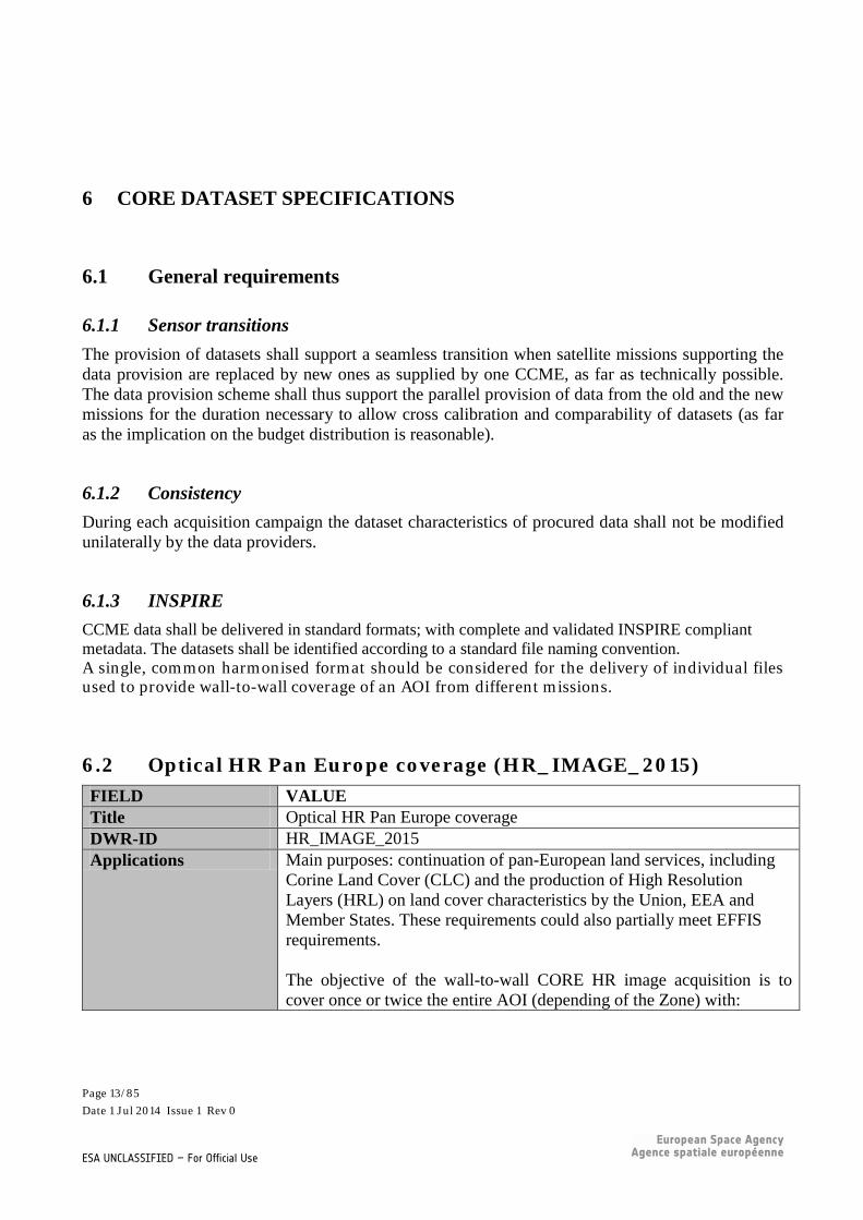
6.2 Optical HR Pan Europe coverage (HR_IMAGE_2015) FIELD VALUE Title Optical HR Pan Europe coverage DWR-ID HR_IMAGE_2015 Applications Main purposes: continuation of pan-European land services, including
Corine Land Cover (CLC) and the production of High Resolution Layers (HRL) on land cover characteristics by the Union, EEA and Member States. These requirements could also partially meet EFFIS requirements. The objective of the wall-to-wall CORE HR image acquisition is to cover once or twice the entire AOI (depending of the Zone) with:
Page 13/85 Date 1 Jul 2014 Issue 1 Rev 0
ESA UNCLASSIFIED – For Official Use
• The least possible number of scenes; • Coming from the least possible sensors; • Leaving only the smallest possible gaps and • Being acquired as close as possible to the respective reference date
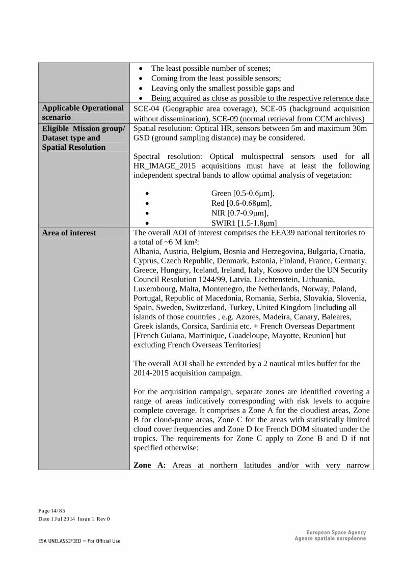
Applicable Operational scenario
SCE-04 (Geographic area coverage), SCE-05 (background acquisition without dissemination), SCE-09 (normal retrieval from CCM archives)
Eligible Mission group/ Dataset type and Spatial Resolution
Spatial resolution: Optical HR, sensors between 5m and maximum 30m GSD (ground sampling distance) may be considered. Spectral resolution: Optical multispectral sensors used for all HR_IMAGE_2015 acquisitions must have at least the following independent spectral bands to allow optimal analysis of vegetation:
• Green [0.5-0.6μm], • Red [0.6-0.68μm], • NIR [0.7-0.9μm], • SWIR1 [1.5-1.8μm]
Area of interest The overall AOI of interest comprises the EEA39 national territories to a total of ~6 M km²: Albania, Austria, Belgium, Bosnia and Herzegovina, Bulgaria, Croatia, Cyprus, Czech Republic, Denmark, Estonia, Finland, France, Germany, Greece, Hungary, Iceland, Ireland, Italy, Kosovo under the UN Security Council Resolution 1244/99, Latvia, Liechtenstein, Lithuania, Luxembourg, Malta, Montenegro, the Netherlands, Norway, Poland, Portugal, Republic of Macedonia, Romania, Serbia, Slovakia, Slovenia, Spain, Sweden, Switzerland, Turkey, United Kingdom [including all islands of those countries , e.g. Azores, Madeira, Canary, Baleares, Greek islands, Corsica, Sardinia etc. + French Overseas Department [French Guiana, Martinique, Guadeloupe, Mayotte, Reunion] but excluding French Overseas Territories] The overall AOI shall be extended by a 2 nautical miles buffer for the 2014-2015 acquisition campaign. For the acquisition campaign, separate zones are identified covering a range of areas indicatively corresponding with risk levels to acquire complete coverage. It comprises a Zone A for the cloudiest areas, Zone B for cloud-prone areas, Zone C for the areas with statistically limited cloud cover frequencies and Zone D for French DOM situated under the tropics. The requirements for Zone C apply to Zone B and D if not specified otherwise:
Zone A: Areas at northern latitudes and/or with very narrow
Page 14/85 Date 1 Jul 2014 Issue 1 Rev 0
ESA UNCLASSIFIED – For Official Use

phenological windows and or very difficult observation conditions: A minimum of one cloud-free coverage (VNIR + SWIR) shall be achieved. Zone B: Areas at mid-latitudes with a high probability of suitable acquisition windows during the observation periods: Two cloud-free coverages (one VNIR + SWIR; second: preferably VNIR + SWIR, VNIR only acceptable as second choice). The second coverage is considered a best effort. Zone C: Areas at lower latitudes with extended phenological observation periods and predominantly clear sky conditions during those. Atlantic islands belong to Zone C. Two cloud-free coverages with preferably homogenous sensor VNIR + SWIR acquisitions.
Zone D: Overseas areas (i.e. French DOMs One cloud-free coverage (VNIR + SWIR).
Reference year/Acquisitions &Tasking Strategy/ Acquisition windows & constraints
Reference Year Data acquisition shall start the year before the reference year (i.e. in 2014). In this year the bulk of data shall be acquired. Reference year is 2015. The reference year +1 (2016) is an option for new tasking in case of low achievement in previous years and/or in case no gap filling could be done using other CCMs after the acquisitions of the reference year 2015 are closed.
Page 15/85 Date 1 Jul 2014 Issue 1 Rev 0
ESA UNCLASSIFIED – For Official Use
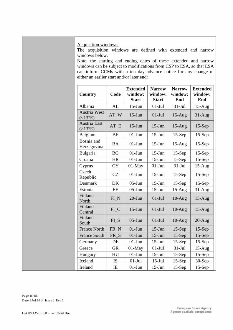
Acquisition windows: The acquisition windows are defined with extended and narrow windows below. Note: the starting and ending dates of these extended and narrow windows can be subject to modifications from CSP to ESA, so that ESA can inform CCMs with a ten day advance notice for any change of either an earlier start and/or later end:
Country Code Extended window:
Start
Narrow window:
Start
Narrow window:
End
Extended window:
End Albania AL 15-Jun 01-Jul 31-Jul 15-Aug Austria West (<13°E) AT_W 15-Jun 01-Jul 15-Aug 31-Aug
Austria East (>13°E) AT_E 15-Jun 15-Jun 15-Aug 15-Sep
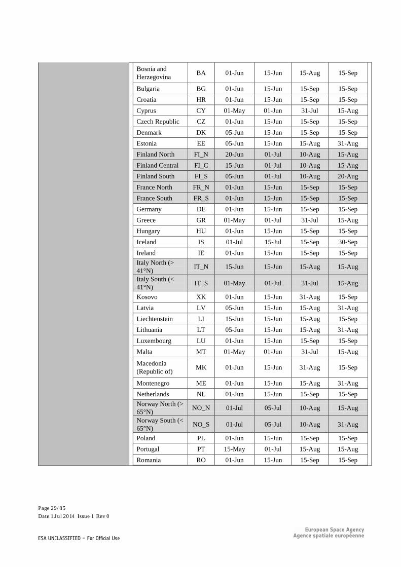
Belgium BE 01-Jun 15-Jun 15-Sep 15-Sep Bosnia and Herzegovina BA 01-Jun 15-Jun 15-Aug 15-Sep
Bulgaria BG 01-Jun 15-Jun 15-Sep 15-Sep Croatia HR 01-Jun 15-Jun 15-Sep 15-Sep Cyprus CY 01-May 01-Jun 31-Jul 15-Aug Czech Republic CZ 01-Jun 15-Jun 15-Sep 15-Sep
Denmark DK 05-Jun 15-Jun 15-Sep 15-Sep Estonia EE 05-Jun 15-Jun 15-Aug 31-Aug Finland North FI_N 20-Jun 01-Jul 10-Aug 15-Aug
Finland Central FI_C 15-Jun 01-Jul 10-Aug 15-Aug
Finland South FI_S 05-Jun 01-Jul 10-Aug 20-Aug
France North FR_N 01-Jun 15-Jun 15-Sep 15-Sep France South FR_S 01-Jun 15-Jun 15-Sep 15-Sep Germany DE 01-Jun 15-Jun 15-Sep 15-Sep Greece GR 01-May 01-Jul 31-Jul 15-Aug Hungary HU 01-Jun 15-Jun 15-Sep 15-Sep Iceland IS 01-Jul 15-Jul 15-Sep 30-Sep Ireland IE 01-Jun 15-Jun 15-Sep 15-Sep
Page 16/85 Date 1 Jul 2014 Issue 1 Rev 0
ESA UNCLASSIFIED – For Official Use

Italy North (> 41°N) IT_N 15-Jun 15-Jun 15-Aug 15-Aug
Italy South (< 41°N) IT_S 01-May 01-Jul 31-Jul 15-Aug
Kosovo XK 01-Jun 15-Jun 31-Aug 15-Sep Latvia LV 05-Jun 15-Jun 15-Aug 31-Aug Liechtenstein LI 15-Jun 15-Jun 15-Aug 15-Sep Lithuania LT 05-Jun 15-Jun 15-Aug 31-Aug Luxembourg LU 01-Jun 15-Jun 15-Sep 15-Sep Malta MT 01-May 01-Jun 31-Jul 15-Aug Macedonia (Republic of) MK 01-Jun 15-Jun 31-Aug 15-Sep
Montenegro ME 01-Jun 15-Jun 15-Aug 31-Aug Netherlands NL 01-Jun 15-Jun 15-Sep 15-Sep Norway North (> 65°N)
NO_N 01-Jul 05-Jul 10-Aug 15-Aug
Norway South (< 65°N)
NO_S 01-Jul 05-Jul 10-Aug 31-Aug
Poland PL 01-Jun 15-Jun 15-Sep 15-Sep Portugal PT 15-May 01-Jul 15-Aug 15-Aug Romania RO 01-Jun 15-Jun 15-Sep 15-Sep Serbia RS 01-Jun 15-Jun 15-Sep 15-Sep Slovakia SK 01-Jun 15-Jun 15-Sep 15-Sep Slovenia SI 15-Jun 15-Jun 15-Sep 15-Sep Spain ES 15-May 01-Jul 31-Jul 15-Aug Sweden North (> 65°N)
SE_N 01-Jul 05-Jul 10-Aug 15-Aug
Sweden Central (61°N - 65° N)
SE_C 01-Jul 05-Jul 10-Aug 31-Aug
Sweden South (< 61°N)
SE_S 05-Jun 15-Jun 15-Aug 15-Sep
Switzerland CH 15-Jun 01-Jul 15-Aug 31-Aug Turkey West (< 30°E) TR_W 15-May 01-Jul 31-Jul 15-Aug
Page 17/85 Date 1 Jul 2014 Issue 1 Rev 0
ESA UNCLASSIFIED – For Official Use

Turkey Central-West (30°E - 35°E)
TR_C-W 01-Jun 15-Jun 15-Aug 31-Aug
Turkey Central-East (35°E - 40°E)
TR_C-E 15-Jun 15-Jun 15-Aug 31-Aug
Turkey East (>40°E) TR_E 01-Jul 01-Jul 31-Jul 15-Aug
United Kingdom North (Scotland + N. Ireland)
UK_N 15-Jun 15-Jun 15-Sep 15-Sep
United Kingdom South (England + Wales)
UK_S 01-Jun 15-Jun 15-Sep 15-Sep
For the Atlantic Islands and French DOM areas, the following time windows are to be applied: a) Azores: narrow [01-Aug | 15-Aug], extended [15-Jul | 30-Aug]; b) Canaries: narrow [01-Jul | 31-Aug], extended [01-Jun | 30-Sep]; c) Guadeloupe: December to March; d) French Guiana: July to December; e) Madeira: narrow [01-Aug | 15-Aug], extended [15-Jul | 30-Aug]; f) Martinique: December to March; g) Mayotte: April to November; h) Reunion: May to December. Zone Objectives Zone A objective: a minimum of one cloud-free coverage (VNIR + SWIR) in the narrow acquisition window. Optimally 2 coverages within narrow windows, alternative within extended windows. Zone B objective: A first and most important coverage including VNIR + SWIR shall be acquired during the narrow window of acquisition. The second coverage shall be acquired with ideally 6 weeks, but minimally with a 4-week time difference to the first coverage. The second coverage can be either upfront or after the first
Page 18/85 Date 1 Jul 2014 Issue 1 Rev 0
ESA UNCLASSIFIED – For Official Use

coverage, but within the extended acquisition window. Preference is given to VNIR + SWIR. VNIR only is acceptable for the second coverage if SWIR is not available (second priority). Zone C objective: A first and most important coverage including VNIR + SWIR shall be acquired during the narrow window of acquisition. The second coverage shall be acquired with ideally 6 weeks, but minimally with a 4-week time difference to the first coverage. The second coverage can be either upfront or after the first coverage, but within the extended acquisition window. Preference is given to VNIR + SWIR. VNIR only is acceptable for the second coverage if SWIR is not available (second priority). Zone D objective: One coverage including VNIR + SWIR shall be acquired during the DOM specific windows of acquisition. Procurement Strategy for YEAR 1 (2014) Zone A: it is assumed that Contributing Missions with VNIR+SWIR or with VNIR only sensors will systematically speculatively task their missions in the extended windows, to populate the archives with suitable data. Product selection and Production: see below
Zone B: it is assumed that that Contributing Missions with VNIR+SWIR or with VNIR only sensors will systematically speculatively task their missions in the extended windows, to populate the archives with suitable data. Product selection and Production: see below
Zone C: it is assumed that that Contributing Missions with VNIR+SWIR or with VNIR only sensors will systematically speculatively task their missions in the extended windows, to populate the archives with suitable data. Product selection and Production: see below Zone D: it is assumed that that Contributing Missions with VNIR+SWIR or with VNIR only sensors will systematically speculatively task their missions in the extended windows, to populate the archives with suitable data. Product selection and Production: see below Procurement Strategy for YEAR 2 (Reference year 2015): Zone A: ESA will contract 1 Contributing Mission with VNIR+SWIR
Page 19/85 Date 1 Jul 2014 Issue 1 Rev 0
ESA UNCLASSIFIED – For Official Use

sensor for systematic tasking-only in the extended windows over the non-achieved AOIs of YEAR 1, which may include gaps for up to 2 coverages. This state of ‘achievement/acceptance’ is defined by CSP/ESA at the end of YEAR 1. In addition and depending on price, ESA may contract additional Contributing Mission(s) with VNIR for tasking-only during the narrow and/or extended acquisition window. Product selection and Production: see below Zone B: ESA will contract 1 Contributing Mission with VNIR+SWIR sensors for systematic tasking-only in the extended windows, over the non-achieved AOIs of YEAR 1, which may include gaps for 2 coverages. The state of ‘achievement/acceptance’ is defined by CSP/ESA at the end of YEAR 1. In addition and depending on price, ESA may contract additional Contributing Mission(s) with VNIR for tasking only within the extended acquisition windows but outside the narrow acquisition windows. Product selection and Production: see below
Zone C: ESA will contract one Contributing Mission with VNIR+SWIR sensor for systematic tasking-only in the extended windows, over the non-achieved AOIs of YEAR 1, which may include gaps for 2 coverages. The state of ‘achievement/acceptance’ is defined by CSP/ESA at the end of YEAR 1. In addition and depending on price, ESA may contract additional Contributing Mission(s) with VNIR for tasking-only during the extended acquisition windows but outside the narrow acquisition windows. Product selection and Production: see below Zone D: ESA may contract Contributing Mission(s) with VNIR sensor for systematic tasking-only to complement the achievement of YEAR 1. Product selection and Production: see below CCM proposals shall contain - for YEAR 1 an overview on achievement per large region (maps and
excel table with percentages). - for YEAR 2 feasibility studies defining probabilities of achievement
per large regions. Payment strategy YEAR 1: For production, ESA will establish an FFP per large region,
Page 20/85 Date 1 Jul 2014 Issue 1 Rev 0
ESA UNCLASSIFIED – For Official Use
assuming all quality criteria are fulfilled. After products have been selected by CSPs (see ‘Product selection’), ESA will pay CCMs pro-rated based on cloud-free km2 ground area contributing to the coverage. YEAR 2: For tasking-only ESA will pay a fixed price for a defined repetitive tasking scheme, which can be schedule-driven (tasking at every x days), or result-driven (tasking until an AoI is covered at least x times). For production, ESA will establish an FFP per large region, assuming all quality criteria are fulfilled. After products have been selected by CSPs (see ‘Product selection’), ESA will pay CCMs pro-rated based on cloud-free km2 ground area contributing to the coverage.
Product selection It is up to the CSPs to review the available scenes on their appropriateness for compiling the required final coverage(s), and confirming acceptance to ESA, including the assignment of products to COV#1 or COV#2, via a shapefile. Production will be confirmed to CCMs according to acceptance by CSPs. It is expected that the acceptance of products for production will take place at the end of the acquisition period in YEAR 1 and YEAR 2. For the purpose of selection, CCMs shall provide information on all acquired scenes fulfilling the quality criteria and the following cloud criteria (per product):
• Zone A (cloudiest): CC 20% max; • Zone B (cloud prone): CC 10% max (preferred), alternative CC
20% • Zones C/D (limited cloud): CC 5% max. (preferred), alternative
CC 10% in a shape-file of the EEA39 countries in LAEA ETRS89 projection (EPSG code 3035) as background layer, which shall comprise layers on a per-sensor and per-year basis. The shapefile shall contain high resolution Georeferenced Quicklooks of all products with the following list of attributes: • Identification of the scene; • Date of acquisition; • Status of product (acquired, accepted/rejected, processed, delivered
to CDS) • Expected delivery date (for those products in accepted status) • % of cloud cover • Encoding of haze (no haze – almost transparent haze – semi-
Page 21/85 Date 1 Jul 2014 Issue 1 Rev 0
ESA UNCLASSIFIED – For Official Use

transparent haze/cloud – see examples in Annex)
An example of the shapefile attribute table is provided by ESA in Annex B
For YEAR 2, this shapefile is to be provided by each CCM by the 25th of each calendar month (cut-off date 15th of that month) for information, and eventual mitigation actions. ESA will merge the various contributions into a master shapefile and provide to CSPs for information. At the end of YEAR 1 acquisition periods, this shapefile is to be delivered within a week from request by ESA (which could be during negotiation or as soon as the contract is signed) For YEAR 2 acquisition periods, this shapefile is to be delivered within a week of the end of each country acquisition window.
Processing /Product quality/aux. data
Radiometric resolution: minimum bit depth of 7-bits signal dynamic range is acceptable, higher bit depth is preferred (e.g. 16-bits).
Product quality: According to zone dependency, the smallest possible product unit of production and for which Contributing Missions have a quality index shall have a maximum allowed Cloud Coverage threshold as follows:
• Zone A: CC 20% max; • Zone B: CC 10% max (optimally), alternative 20% • Zones C/D: CC 5% max (optimally), alternative 10%
Products spanning across zones are allowed with the least stringent cloud coverage. Scenes comprising haze shall be flagged accordingly for further consideration, and are subject to rejection by the Copernicus service coordinator, in consultation with the service providers implementing the land services. Presence of perennial snow and glaciers is allowed. The sun elevation angle shall be higher than 20° to ensure sufficient illumination and to minimize the effect of shadows.
The off-nadir viewing angle shall be less than 25°.
Saturated pixels, seasonal snow, cloud cover per product above the defined thresholds and areas with a signal to noise ratio of less than 50:1 (at 35% ground reflectance) shall a-priori not be proposed in the
Page 22/85 Date 1 Jul 2014 Issue 1 Rev 0
ESA UNCLASSIFIED – For Official Use

monthly shapefile, may however be considered as backup.
Processing Levels The scenes shall be provided with two different levels of processing: Level1 (system correction):
• System corrected and at-sensor radiometric and geometric calibrated data;
• Ortho layer, (i.e. x, y coordinates (ETRS89)) Ortho-rectified Level to ETRS89/ETRS-LAEA:
• Reference: CORE_001 COV#1 of DWH V1 (IMAGE 2012) • For native resolution <10m: Spatial resolution resampled to the
resolution of Sentinel-2 VNIR bands (10m) in both national and European projection
• For native resolution >10m: resampling at native resolution (e.g. 20m)
• Ortho-rectified at-sensor radiance values (resampled using cubic convolution method);
• GCP file with respect to reference data set; Metadata: INSPIRE compliant metadata for all processing levels shall be supplied in XML format.
Radiometric correction: A cascade approach may be considered for radiometric and atmospheric corrections in decreasing order of priority as follows:
• Top of Atmosphere (TOA) planetary reflectances, 16-bit data. Sensor specific in-band solar irradiance values (ESUN) shall be provided.
• ESUN corrected but not solar elevation corrected. • Radiometric calibrated data with calibration parameters enabling
the conversion of image digital numbers (DN) into spectral radiance (W/m2/sr/um). Solar spectral irradiances within each spectral band and the solar elevation for each scene are required to convert the image DNs into TOA (Top Of Atmosphere) reflectance values
Orthocorrection:
• Ortho ready processing shall include basic corrections such as rectilinear geometry, radiometric distortion (i.e. source data).
• Ortho-rectification has to be full-parametric or making use of RPC functions and shall OPTIONALLY be based on the EU-DEM, available from http://land.copernicus.eu/in-situ/eu-dem .
Page 23/85 Date 1 Jul 2014 Issue 1 Rev 0
ESA UNCLASSIFIED – For Official Use

In case a different DEM is used an OPTION to supply the DEM shall be proposed.
• European projection is required for all coverages in ETRS89, LAEA (EPSG code 3035).
• National projection is OPTIONAL and may be requested on a case by case basis. CCMs are requested to propose a cost per country in [AD.5 ].
• Grid alignment: GeoTIFF key: The GeoTIFF key "GTRasterTypeGeoKey" shall have the value 1, corresponding to "RasterPixelIsArea".
• Pixel alignment: The values of the coordinates for the upper-left corner (x and y) of the upper-left pixel of an image dataset shall be an integer multiple of the pixel size (resolution) in the corresponding direction (x and y).
• Ortho-rectification accuracy: o Relative accuracy (2014-2015): Reference less than 1
pixel difference with CORE_001 COV#1 of DWH V1 (IMAGE 2012)
File format: File format and structure: geoTIFF fully compliant with TIFF version 6 or JPEG2000. In case of non-compliance or different format, CCMs are requested to provide a quotation for becoming compliant
Delivery Delivery shall be done not later than 60 days after acceptance
Delivery shall be made per large region within a country
Page 24/85 Date 1 Jul 2014 Issue 1 Rev 0
ESA UNCLASSIFIED – For Official Use

Additional Information/Procedures
Optional Variations Quotation The spreadsheet worksheet HR_IMAGE_2015 shall be used
Licence Multi-user DOWNLOAD and VIEW licences shall be acquired to cover
as a baseline all relevant activities of users in [Copernicus Services], [Union_Inst], [Union_Research_Projects] and [Public_Authorities]. VIEW mode may be considered an option towards [INT_ORG_NGO] depending on price. DOWNLOAD by FP7/Horizon 2020 projects outside the Space themes shall be quoted as an additional OPTION.
Management Reporting See reporting Excel worksheets HR_IMAGE_2015_COV#1, HR_IMAGE_2015_COV#2 and HR_ACQ_ACHIEVEMENT_MAPs, to be provided alongside the master-shapefile and the CDS automated reports.
6.3 Optical HR Pan Europe coverage (HR_IMAGE_2018) The Reference year 2018 HR European coverage is assumed to have similar specifications as the HR_IMAGE_2015 exercise.
Page 25/85 Date 1 Jul 2014 Issue 1 Rev 0
ESA UNCLASSIFIED – For Official Use

CCMs are invited to provide an OPTION for the provision of this dataset, under the assumption that the Reference Year will be 2018, and for the 2 cases
• the other conditions are as described in chapter 6.2 • CCMs are complementing Sentinel-2, thus a FUP price on a per km2 basis shall be
proposed alongside a full FFP proposal [HR_IMAGE_2018]
6.4 Optical VHR multispectral and panchromatic coverage over Europe (VHR_IMAGE_2015)
FIELD VALUE Title Optical VHR multispectral and panchromatic coverage over Europe DWR-ID VHR_IMAGE_2015 Applications Land local component applications for hotspots, i.e. specific areas of
interest at pan-European level (EEA39) (land cover over riparian zones for the purpose of biodiversity monitoring, monitoring of coastal areas, risk areas, protected areas (Natura 2000 sites), Land Parcel Identification…) and at national level. Land local component applications over hotspots at pan-European level (Urban Atlas, Land Parcel Identification…) and at national level. The objective of the wall-to-wall CORE VHR image acquisition is to cover once the entire AOI (depending of the Zone) with: • The least possible number of scenes; • Coming from the least possible sensors; • Leaving only the smallest possible gaps and • Being acquired as close as possible to the respective reference date
Applicable Operational scenario
SCE-04 (Geographic area coverage), SCE-05 (background acquisition without dissemination), SCE-09 (normal retrieval from CCM archives)
Eligible Mission group/ Dataset type and Spatial Resolution
First priority: Optical very high resolution multispectral (preferred), with both:
• Optical multispectral VHR2 up to 2m data products • Panchromatic VHR1 data products.
Alternatively, products with the following resolution may be considered:
• Optical multispectral VHR2 up to 4m (second priority) • HR1 data products (third priority) with VNIR+PAN • HR1 data products (fourth priority) with VNIR only
Page 26/85 Date 1 Jul 2014 Issue 1 Rev 0
ESA UNCLASSIFIED – For Official Use

Spectral resolution: Optical multispectral sensors used for all VHR_IMAGE_2015 acquisitions must have at least the following independent spectral bands to allow optimal analysis of vegetation:
• Green [0.5-0.6μm], Red [0.6-0.68μm], NIR [0.7-0.9μm]. • Panchromatic [0.45-0.85μm].
SWIR1 [1.5-1.8μm] is considered an asset but not mandatory. Area of interest The overall AOI of interest comprises the EEA39 national territories to
a total of ~6 M km²: Albania, Austria, Belgium, Bosnia and Herzegovina, Bulgaria, Croatia, Cyprus, Czech Republic, Denmark, Estonia, Finland, France, Germany, Greece, Hungary, Iceland, Ireland, Italy, Kosovo under the UN Security Council Resolution 1244/99, Latvia, Liechtenstein, Lithuania, Luxembourg, Malta, Montenegro, the Netherlands, Norway, Poland, Portugal, Republic of Macedonia, Romania, Serbia, Slovakia, Slovenia, Spain, Sweden, Switzerland, Turkey, United Kingdom [including all islands of those countries , e.g. Azores, Madeira, Canary, Baleares, Greek islands, Corsica, Sardinia etc. + French Overseas Department [French Guiana, Martinique, Guadeloupe, Mayotte, Reunion] but excluding French Overseas Territories] The overall AOI shall be extended by a 2 nautical miles buffer. For the acquisition campaign, separate zones are identified covering a range of areas indicatively corresponding with risk levels to acquire complete coverage. It comprises a Zone A for the cloudiest areas, Zone B for cloud-prone areas, Zone C for the areas with statistically limited cloud cover frequencies and Zone D for French DOM situated under the tropics. The requirements for Zone C apply to Zone B and D if not specified otherwise: Zone A: Areas at northern latitudes and/or with very narrow phenological windows and or very difficult observation conditions. Zone B: Areas at mid-latitudes with a high probability of suitable acquisition windows during the observation periods. Zone C: Areas at lower latitudes with extended phenological observation periods and predominantly clear sky conditions during those. Atlantic islands, Canary, Baleares, Greek islands, Corsica, Sardinia belong to Zone C.
Zone D: French DOMs,
Page 27/85 Date 1 Jul 2014 Issue 1 Rev 0
ESA UNCLASSIFIED – For Official Use

Reference year/Acquisitions &Tasking Strategy/ Acquisition windows & constraints
Reference Year and Repetitiveness Data acquisition shall start the year before the reference year (i.e. in 2014). Reference year is 2015. The bulk of acquisitions shall be within the reference year. The reference year +1 (2016) is an OPTION for new tasking in case of low achievement in previous years and/or in case no gap filling could be done using other CCMs at the end of 2015. Acquisition windows The acquisition windows are defined with extended and narrow windows below. Note: the starting and ending dates of these extended and narrow windows can be subject to modifications from CSP to ESA, so that ESA can inform CCMs with a ten day advance notice for any change of either an earlier start and/or later end:
Country Code Extended window:
Start
Narrow window:
Start
Narrow window:
End
Extended window:
End
Albania AL 15-Jun 01-Jul 31-Jul 15-Aug Austria West (<13°E) AT_W 15-Jun 01-Jul 15-Aug 31-Aug
Austria East (>13°E) AT_E 15-Jun 15-Jun 15-Aug 15-Sep
Belgium BE 01-Jun 15-Jun 15-Sep 15-Sep
Page 28/85 Date 1 Jul 2014 Issue 1 Rev 0
ESA UNCLASSIFIED – For Official Use
Bosnia and Herzegovina BA 01-Jun 15-Jun 15-Aug 15-Sep
Bulgaria BG 01-Jun 15-Jun 15-Sep 15-Sep Croatia HR 01-Jun 15-Jun 15-Sep 15-Sep Cyprus CY 01-May 01-Jun 31-Jul 15-Aug Czech Republic CZ 01-Jun 15-Jun 15-Sep 15-Sep Denmark DK 05-Jun 15-Jun 15-Sep 15-Sep Estonia EE 05-Jun 15-Jun 15-Aug 31-Aug Finland North FI_N 20-Jun 01-Jul 10-Aug 15-Aug Finland Central FI_C 15-Jun 01-Jul 10-Aug 15-Aug Finland South FI_S 05-Jun 01-Jul 10-Aug 20-Aug France North FR_N 01-Jun 15-Jun 15-Sep 15-Sep France South FR_S 01-Jun 15-Jun 15-Sep 15-Sep Germany DE 01-Jun 15-Jun 15-Sep 15-Sep Greece GR 01-May 01-Jul 31-Jul 15-Aug Hungary HU 01-Jun 15-Jun 15-Sep 15-Sep Iceland IS 01-Jul 15-Jul 15-Sep 30-Sep Ireland IE 01-Jun 15-Jun 15-Sep 15-Sep Italy North (> 41°N) IT_N 15-Jun 15-Jun 15-Aug 15-Aug
Italy South (< 41°N) IT_S 01-May 01-Jul 31-Jul 15-Aug
Kosovo XK 01-Jun 15-Jun 31-Aug 15-Sep Latvia LV 05-Jun 15-Jun 15-Aug 31-Aug Liechtenstein LI 15-Jun 15-Jun 15-Aug 15-Sep Lithuania LT 05-Jun 15-Jun 15-Aug 31-Aug Luxembourg LU 01-Jun 15-Jun 15-Sep 15-Sep Malta MT 01-May 01-Jun 31-Jul 15-Aug
Macedonia (Republic of) MK 01-Jun 15-Jun 31-Aug 15-Sep
Montenegro ME 01-Jun 15-Jun 15-Aug 31-Aug Netherlands NL 01-Jun 15-Jun 15-Sep 15-Sep Norway North (> 65°N) NO_N 01-Jul 05-Jul 10-Aug 15-Aug
Norway South (< 65°N) NO_S 01-Jul 05-Jul 10-Aug 31-Aug
Poland PL 01-Jun 15-Jun 15-Sep 15-Sep Portugal PT 15-May 01-Jul 15-Aug 15-Aug Romania RO 01-Jun 15-Jun 15-Sep 15-Sep
Page 29/85 Date 1 Jul 2014 Issue 1 Rev 0
ESA UNCLASSIFIED – For Official Use

Serbia RS 01-Jun 15-Jun 15-Sep 15-Sep Slovakia SK 01-Jun 15-Jun 15-Sep 15-Sep Slovenia SI 15-Jun 15-Jun 15-Sep 15-Sep Spain ES 15-May 01-Jul 31-Jul 15-Aug
Sweden North (> 65°N) SE_N 01-Jul 05-Jul 10-Aug 15-Aug
Sweden Central (61°N - 65° N) SE_C 01-Jul 05-Jul 10-Aug 31-Aug
Sweden South (< 61°N) SE_S 05-Jun 15-Jun 15-Aug 15-Sep
Switzerland CH 15-Jun 01-Jul 15-Aug 31-Aug Turkey West (< 30°E) TR_W 15-May 01-Jul 31-Jul 15-Aug
Turkey Central-West (30°E - 35°E)
TR_C-W 01-Jun 15-Jun 15-Aug 31-Aug
Turkey Central-East (35°E - 40°E)
TR_C-E 15-Jun 15-Jun 15-Aug 31-Aug
Turkey East (>40°E) TR_E 01-Jul 01-Jul 31-Jul 15-Aug
United Kingdom North (Scotland + N. Ireland)
UK_N 15-Jun 15-Jun 15-Sep 15-Sep
United Kingdom South (England + Wales)
UK_S 01-Jun 15-Jun 15-Sep 15-Sep
For the DOMs and Atlantic Islands, the following time windows are to be applied: a) Azores: narrow [01-Aug | 15-Aug], extended [15-Jul | 30-Aug]; b) Canaries: narrow [01-Jul | 31-Aug], extended [01-Jun | 30-Sep]; c) Guadeloupe: December to March; d) French Guiana: July to December; e) Madeira: narrow [01-Aug | 15-Aug], extended [15-Jul | 30-Aug]; f) Martinique: December to March; g) Mayotte: April to November; h) Reunion: May to December. Objective: 1 cloud-free coverage comprising Zones A, B, C, D within narrow (optimally) or extended windows Procurement Strategy For all Zones, it is assumed that Contributing Missions with
Page 30/85 Date 1 Jul 2014 Issue 1 Rev 0
ESA UNCLASSIFIED – For Official Use

VNIR+PAN or with VNIR only sensors will more or less systematically speculatively task their missions in the extended windows, to populate the archives with suitable data. Product selection and Production: see below
Based on proposals received, , a maximum cost for the total VHR_IMAGE_2015 dataset will be defined. ESA with the CSPs will at the end of the YEAR 1 acquisition period analyse (accept, reject) the results achieved per large region, for maximising sensor homogeneity and coverage, within the constraint of the budget available. Based on the results of YEAR 1, ESA will assign each large region with priority for YEAR 2 to one CCM. ESA may assign more than one CCM to difficult large regions. Product selection: see below
Proposals shall contain - for YEAR 1 an overview on achievement per large region (maps and
excel table with percentages). - for YEAR 2 feasibility studies defining probabilities of achievement
per large regions. Feasibility studies need furthermore to indicate potential conflict and overlap with JRC CwRS acquisition campaigns and their impact on VHR_IMAGE_2015. Feasibility
Page 31/85 Date 1 Jul 2014 Issue 1 Rev 0
ESA UNCLASSIFIED – For Official Use
studies shall furthermore indicate if probabilities of success are expected to increase when a set of adjacent large regions is assigned to one CCM, instead of large regions dispersed across Europe.
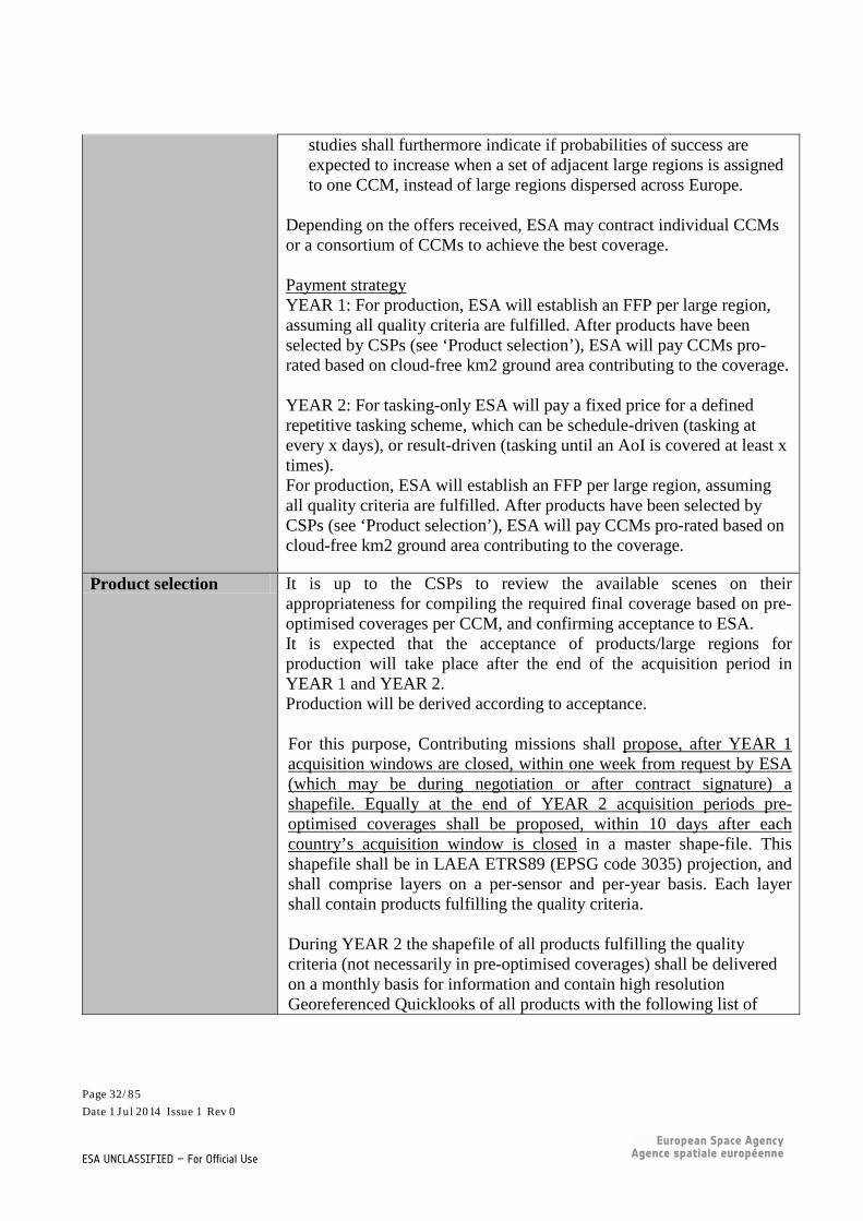
Depending on the offers received, ESA may contract individual CCMs or a consortium of CCMs to achieve the best coverage. Payment strategy YEAR 1: For production, ESA will establish an FFP per large region, assuming all quality criteria are fulfilled. After products have been selected by CSPs (see ‘Product selection’), ESA will pay CCMs pro-rated based on cloud-free km2 ground area contributing to the coverage. YEAR 2: For tasking-only ESA will pay a fixed price for a defined repetitive tasking scheme, which can be schedule-driven (tasking at every x days), or result-driven (tasking until an AoI is covered at least x times). For production, ESA will establish an FFP per large region, assuming all quality criteria are fulfilled. After products have been selected by CSPs (see ‘Product selection’), ESA will pay CCMs pro-rated based on cloud-free km2 ground area contributing to the coverage.
Product selection It is up to the CSPs to review the available scenes on their appropriateness for compiling the required final coverage based on pre-optimised coverages per CCM, and confirming acceptance to ESA. It is expected that the acceptance of products/large regions for production will take place after the end of the acquisition period in YEAR 1 and YEAR 2. Production will be derived according to acceptance. For this purpose, Contributing missions shall propose, after YEAR 1 acquisition windows are closed, within one week from request by ESA (which may be during negotiation or after contract signature) a shapefile. Equally at the end of YEAR 2 acquisition periods pre-optimised coverages shall be proposed, within 10 days after each country’s acquisition window is closed in a master shape-file. This shapefile shall be in LAEA ETRS89 (EPSG code 3035) projection, and shall comprise layers on a per-sensor and per-year basis. Each layer shall contain products fulfilling the quality criteria. During YEAR 2 the shapefile of all products fulfilling the quality criteria (not necessarily in pre-optimised coverages) shall be delivered on a monthly basis for information and contain high resolution Georeferenced Quicklooks of all products with the following list of
Page 32/85 Date 1 Jul 2014 Issue 1 Rev 0
ESA UNCLASSIFIED – For Official Use

attributes: • Identification of the scene; • Date of acquisition; • Status of product (acquired, accepted/rejected, processed, delivered
to CDS) • Expected delivery date (for those products in accepted status) • % of cloud cover • Encoding of haze (no haze – almost transparent haze – semi-
transparent haze/cloud – see examples in Annex A) An example of the master shapefile attribute table is provided in Annex B.
During YEAR 2 this shapefile is to be provided by each CCM by the 25th of each calendar month. ESA will merge the various contributions into a master shapefile and provide to CSPs for information. At the end of YEAR 2 acquisition periods, this shapefile is to be delivered within 10 days of the end of each country acquisition window, as pre-optimised coverages (cloud-optimised and scene-minimised).
Processing /Product quality/aux. data
Radiometric resolution: minimum bit depth of 7-bits signal dynamic range is acceptable, higher bit depth is preferred (e.g. 16-bits).
Product quality: According to zone dependency, the smallest possible product unit of production and for which Contributing Missions have a quality index shall have a maximum allowed Cloud Coverage threshold as follows:
• Zone A: CC 20% max; • Zone B: CC 10% max (optimally), alternative 20% • Zones C/D: CC 5% max (optimally), alternative 10%
Products spanning across zones are allowed with the least stringent cloud coverage. Presence of perennial snow and glaciers is allowed. The sun elevation angle shall be higher than 20° (preferable higher than 23°) to ensure sufficient illumination and to minimize the effect of shadows.
The off-nadir viewing angle shall be less than 30°.
Saturated pixels, seasonal snow, cloud cover per product above the defined thresholds and areas with a signal to noise ratio of less than 50:1
Page 33/85 Date 1 Jul 2014 Issue 1 Rev 0
ESA UNCLASSIFIED – For Official Use

(at 35% ground reflectance) shall a-priori not be proposed in the monthly shapefile, may however be considered as backup at the end of YEAR 2.
Processing Levels The scenes shall be provided with two different levels of processing: Level1 (system correction):
• System corrected and at-sensor radiometric and geometric calibrated data;
• Ortho layer, (i.e. x, y coordinates (ETRS89)) Ortho-rectified Level to ETRS89/ETRS-LAEA:
• Reference: CORE_003 delivered under DWH V1 • Ortho-rectified at-sensor radiance values (resampled using cubic
convolution method); • GCP file with respect to reference data set;
Metadata: INSPIRE compliant metadata for all processing levels shall be supplied in XML format.
Radiometric correction: A cascade approach may be considered for radiometric and atmospheric corrections in decreasing order of priority as follows:
• Top of Atmosphere (TOA) planetary reflectances, 16-bit data. Sensor specific in-band solar irradiance values (ESUN) shall be provided.
• ESUN corrected but not solar elevation corrected. • Radiometric calibrated data with calibration parameters enabling
the conversion of image digital numbers (DN) into spectral radiance (W/m2/sr/um). Solar spectral irradiances within each spectral band and the solar elevation for each scene are required to convert the image DNs into TOA (Top Of Atmosphere) reflectance values
Orthocorrection:
• Ortho ready processing shall include basic corrections such as rectilinear geometry, radiometric distortion (i.e. source data).
• Ortho-rectification has to be full-parametric or making use of RPC functions and shall OPTIONALLY be based on the EU-DEM, available from http://land.copernicus.eu/in-situ/eu-dem . In case a different DEM is used an OPTION to supply the DEM shall be proposed.
• European projection is required for all coverage ETRS89, LAEA
Page 34/85 Date 1 Jul 2014 Issue 1 Rev 0
ESA UNCLASSIFIED – For Official Use

(EPSG code 3035). • National projection is optional and may be requested on a case
by case basis. CCMs are requested to propose a cost per country. • Grid alignment: GeoTIFF key: The GeoTIFF key
"GTRasterTypeGeoKey" shall have the value 1, corresponding to "RasterPixelIsArea".
• Pixel alignment: The values of the coordinates for the upper-left corner (x and y) of the upper-left pixel of an image dataset shall be an integer multiple of the pixel size (resolution) in the corresponding direction (x and y).
• Ortho-rectification accuracy: o Relative accuracy: less than 1 pixel difference from
CORE_003 DWH V1. This coverage should use both VHR multispectral and panchromatic scene in a Bundle Data Product.
File format: File format and structure: geoTIFF fully compliant with TIFF version 6
Delivery Delivery shall be made per large scale regions and no later than 90 days
after acceptance.
Additional Information/Procedures
Page 35/85 Date 1 Jul 2014 Issue 1 Rev 0
ESA UNCLASSIFIED – For Official Use

Optional Variations Quotation The spreadsheet worksheet VHR_IMAGE_2015 shall be used
Licence Multi-user licences shall be acquired to cover as a baseline for [Copernicus Services], [Union_Inst], [Union_Research_Projects] and as option for [Public_Authorities] (DOWNLOAD service). VIEW mode should however be considered an option towards [Public] and will be used if affordable. Access for CSPs from FP7/Horizon 2020 outside the Space themes shall be quoted as an additional OPTION.
Management Reporting See reporting Excel worksheets VHR_IMAGE_2015 and VHR_ACQ_ACHIEVEMENT_MAPs alongside the master-shapefile and the CDS automated reports.
6.5 Optical VHR Pan Europe coverage (VHR_IMAGE_2018) The Reference year 2018 VHR European coverage is assumed to have similar specifications as the VHR_IMAGE_2015 exercise. CCMs are invited to provide an OPTION for the provision of this dataset, under the assumption that the Reference Year will be 2018, and all other conditions remain valid as described in 6.4
6.6 Riparian zone delta coverage of previous DWH Phase (Riparian)
This dataset shall cover the remaining EO data needs that could not previously be procured under the DWH V1 Phase (2010-2014), and that are required to perform the analysis of Riparian zones according to the EEA tender specifications described hereunder: http://www.eea.europa.eu/about-us/tenders/eea-mdi-14-001-copernicus/annex-i-tender-specifications/view This CORE dataset shall provide the remaining km2 of the Riparian coverage with data from archive during 2011-2013, sensed in the vegetation growing season’s acquisition windows as defined for CORE_001 in the DWH V1 Phase. Gaps are indicated in the map below (Source: EEA) and more precisely in the external document called [Analysis_Esa_Footprints2_Riparian V1.PDF]. PLEASE NOTE the file
Page 36/85 Date 1 Jul 2014 Issue 1 Rev 0
ESA UNCLASSIFIED – For Official Use

[Analysis_Esa_Footprints2_Riparian V1.PDF] represents a preliminary version, a revised version may be released shortly. For the data type required, all specifications of CORE_003 of the DWH V1 remain to be valid.
6.7 European Optical MR1 composites (MR_IMAGE_2015) FIELD VALUE Title European optical MR1 composites DWR-ID MR_IMAGE_2015 Applications Pan-European land services and EFFIS.
Intra-seasonal time series are essential for the production of High Resolution Layers (HRL) on land cover characteristics by the Union,
Page 37/85 Date 1 Jul 2014 Issue 1 Rev 0
ESA UNCLASSIFIED – For Official Use

EEA and Member States, in particular for vegetation related discrimination of characteristics, such as grasslands or semi-natural vegetation. These requirements could also partially meet EFFIS requirements
Applicable Operational scenario
SCE-04 (Geographic area coverage), SCE-09 (normal retrieval from CCM archives)
Eligible Mission group/ Dataset type and Spatial Resolution
Optical medium resolution multispectral. Spatial resolution: Sensors between 30m and maximum 60m GSD shall be considered. Spectral resolution: optical multispectral sensors used for all MR_IMAGE_2015 acquisitions must have at least the following independent spectral bands to allow optimal analysis of vegetation: Green [0.5-0.6μm], Red [0.6-0.68μm], NIR [0.7-0.9μm], SWIR1 [1.5-1.8μm].
Area of interest The overall AOI of interest comprises the EEA39 national territories to a total of ~6 M km²: Albania, Austria, Belgium, Bosnia and Herzegovina, Bulgaria, Croatia, Cyprus, Czech Republic, Denmark, Estonia, Finland, France, Germany, Greece, Hungary, Iceland, Ireland, Italy, Kosovo under the UN Security Council Resolution 1244/99, Latvia, Liechtenstein, Lithuania, Luxembourg, Malta, Montenegro, the Netherlands, Norway, Poland, Portugal, Republic of Macedonia, Romania, Serbia, Slovakia, Slovenia, Spain, Sweden, Switzerland, Turkey, United Kingdom [including all islands of those countries , e.g. Azores, Madeira, Canary, Baleares, Greek islands, Corsica, Sardinia etc. + French Overseas Department [French Guiana, Martinique, Guadeloupe, Mayotte, Reunion] but excluding French Overseas Territories]. The overall AOI shall be extended by a 12 nautical miles buffer (territorial waters).
Reference year/Acquisitions &Tasking Strategy/ Acquisition windows & constraints
The objective of the wall-to-wall CORE MR image acquisition is to cover minimum 3, better 5 and optimally 8 monthly cloud-free coverages of the entire AOI with:
• The least possible number of scenes; • Coming from the least possible sensors; • Leaving only the smallest possible gaps
Data acquisition shall start the year before the reference year (i.e. in 2014). 2015 is the Reference Year. The objective is to achieve optimally a set of 2 times 8 coverages in 2014 and 2015, if budget allows.
Page 38/85 Date 1 Jul 2014 Issue 1 Rev 0
ESA UNCLASSIFIED – For Official Use

The reference year +1 is only used for gap-filling. Acquisition windows: Optimally: March to October within the same year. In case of budget shortage, the following order of priority will be applied: 1. 3 months out of April to July (with preference on later months) 2. August-September 3. March 4. October Ideally, the area to be covered by the MR composites shall be temporally and spatially synchronised with HR_IMAGE_2015. Payment strategy: ESA will establish and pay a Firm Fixed Price for any cloud-free km2 of Europe delivered in a given coverage, assuming all quality criteria are fulfilled for the products of which the coverage is composed. ESA will pay CCMs pro-rated based on cloud-free km2 ground area contributing to the coverage of each month.
Product selection The CCM shall for each month assess the quality of the products available and compose/propose the best coverage possible for any given month, minimising clouds/haze and number of individual products. Such coverages shall be proposed to SCI for acceptance.
Processing /Product quality/aux. data
Radiometric resolution: Minimum bit depth of 7-bit signal dynamic range is mandatory, a maximum of up to 16-bit depth can be considered. There is no defined cloud cover per product, however the optimized coverages shall foresee to have the least cloud cover and least number of products possible. Presence of perennial snow and glaciers is allowed. However, temporary snow, saturated pixels and data gaps have to be excluded from the monthly optimised coverages. The sun elevation angle shall be higher than 20° (preferable higher than 23°), to ensure sufficient illumination and to minimize the effect of shadows. The off-nadir viewing angle shall be less than 25°. Saturated pixels, snow (excl. perennial), clouds and areas with a signal to noise ratio of less than 50:1 (at 35% ground reflectance) will count as data gaps.
Page 39/85 Date 1 Jul 2014 Issue 1 Rev 0
ESA UNCLASSIFIED – For Official Use

Processing levels: The scenes shall be provided with two different levels of processing: Level 1 (system correction):
• System corrected and at-sensor radiometric and geometric calibrated data;
• Ortho layer, (i.e. x, y coordinates (ETRS89) for each pixel centre;
Level 2 (ortho-rectified to ETRS89/ETRS-LAEA)):
• Reference: CORE_001 COV#1 of the DWH V1/IMAGE 2012 • Ortho-rectified at-sensor radiance values (resampled using
cubic convolution method); • GCP file with respect to reference data set;
Metadata: INSPIRE compliant metadata for all processing levels shall be supplied in XML format.
Radiometric correction: A cascade approach may be considered for radiometric and atmospheric corrections in decreasing order of priority as follows:
• Top of Atmosphere (TOA) planetary reflectances, 16-bit data. Sensor specific in-band solar irradiance values (ESUN) shall be provided.
• ESUN corrected but not solar elevation corrected. • Radiometric calibrated data with calibration parameters enabling
the conversion of image digital numbers (DN) into spectral radiance (W/m2/sr/um). Solar spectral irradiances within each spectral band and the solar elevation for each scene are required to convert the image DNs into TOA (Top Of Atmosphere) reflectance values
Orthocorrection:
• Ortho ready processing shall include basic corrections such as rectilinear geometry, radiometric distortion (i.e. source data).
• Ortho-rectification has to be full-parametric or making use of RPC functions and shall OPTIONALLY be based on the EU-DEM, available from http://land.copernicus.eu/in-situ/eu-dem . In case a different DEM is used an OPTION to supply the DEM shall be proposed.
• European projection is required for all coverage ETRS89, LAEA (EPSG code 3035).
• Grid alignment: GeoTIFF key: The GeoTIFF key
Page 40/85 Date 1 Jul 2014 Issue 1 Rev 0
ESA UNCLASSIFIED – For Official Use

"GTRasterTypeGeoKey" shall have the value 1, corresponding to "RasterPixelIsArea".
• Pixel alignment: The values of the coordinates for the upper-left corner (x and y) of the upper-left pixel of an image dataset shall be an integer multiple of the pixel size (resolution) in the corresponding direction (x and y).
• Ortho-rectification accuracy: o Absolute accuracy: Ortho-rectification must be accurate
to less than 0.75 pixel size equivalent RMSE and a max displacement of less than 1.5 pixels in no more than 0.1% of any 50x50 km2 area within the AOI with respect to the reference data set. The Reference dataset is assumed to be CORE_001 COV#1 of the DWH V1/IMAGE 2012
Delivery Within 60 days from acceptance for 2014 coverages. Within 15 days from acceptance of a single monthly coverage as of 2015.
Additional Information/Procedures
Optional Variations Quotation The spreadsheet worksheet MR_IMAGE_2015 shall be used
Licence Multi-user DOWNLOAD and VIEW licences shall be acquired to cover as a baseline all relevant activities of users in [Copernicus Services], [Union_Inst], [Union_Research_Projects] and [Public_Authorities]. VIEW mode should however be considered an option towards [INT_ORG_NGO] and will be used if affordable. Note: number of monthly composites) has a higher priority than the licence extension to provide a view service Access for CSPs from FP7/Horizon 2020 outside the Space themes shall be quoted as an additional OPTION.
Management Reporting See reporting Excel worksheets MR_IMAGE_2015 and MR_ACQ_ACHIEVEMENT_MAPs alongside the master-shapefile and the CDS automated reports.
6.8 European Optical MR1 composites (MR_IMAGE_2018) The Reference year 2018 MR European coverages are assumed to have similar specifications as the MR_IMAGE_2015 exercise..
Page 41/85 Date 1 Jul 2014 Issue 1 Rev 0
ESA UNCLASSIFIED – For Official Use

CCMs are invited to provide an OPTION for the provision of this dataset, under the assumption that the Reference Year will be 2018, and all other conditions remain valid as described in 6.6.
6.9 Optical HR1 worldwide coverage (HR1_OPTICAL_GLOBAL) FIELD VALUE Title Worldwide optical HR1 coverage DWR-ID HR1_OPTICAL_GLOBAL Applications Main application: Global Land for monitoring protected areas and
validation of biophysical products. Note: This need is expected to be covered by both CCMs and Sentinel-2, CCMs shall therefore provide a dataset quotation.
Applicable Operational scenario
SCE-04 (Geographic area coverage), SCE-05 (Background Acquisition) , SCE-09 (Retrieval from archive), SCE-10 (Direct retrieval from Archives of Global Systematic missions)
Eligible Mission group/ Dataset type and Spatial Resolution
Spatial resolution: HR1 (4m < x <= 10m) (preference) HR2 (10m < x <= 30m) second priority Spectral resolution: Optical multispectral sensors with visible and near infra-red (VNIR); short wave infra-red (SWIR). SWIR bands should be preferably at the same spatial resolution as the VNIR bands.
Area of interest Worldwide coverage: Target: all land surfaces from 90° North to 90° South and from 180° West to 180° East. Minimum baseline: all land masses between 75° North and 56° South and between 180° West and 180° East. AOI in km2:149,248,300. (in case of target coverage) Among which: 15,000km2 (Protected areas in Bolivia for PACSBIO) + at least 100,000 km2 for validation sites in protected Natural areas in Africa. Non-contiguous AOI.
Reference year/Acquisitions &Tasking Strategy/ Acquisition windows & constraints
Reference Year/Acquisition windows: systematic Frequency: one coverage every 3 years in case of CCMs only Standard acquisition. Multiple sensors can be used.
Page 42/85 Date 1 Jul 2014 Issue 1 Rev 0
ESA UNCLASSIFIED – For Official Use

90 days lead time. Product selection Systematic
Processing /Product quality/aux. data
Atmospherically corrected products Ortho-rectified products UTM projection, WGS84, Projected over a regular latitude/longitude grid. Geometric accuracy: Optimally: RMSE (i.e. max. absolute 1-Dimensional Root Mean Square Error threshold [m] required on product) desirable 1/3 resolution; mandatory 20m without GCPs and 12m with GCPs. Radiometric accuracy: < 5% absolute. Radiometric resolution: 12 bits per pixel. Coverage characteristics: single date.
Delivery The data should be delivered in normal mode. Additional Information/Procedures
n/a
Optional Variations n/a Quotation The spreadsheet worksheet HR1_OPTICAL_GLOBAL shall be used
Licence N/A for Sentinel-2. In case CCMs will be used: Multi-user DOWNLOAD and VIEW licences shall be acquired to cover as a baseline all relevant activities of users in [Copernicus Services], [Union_Inst], [Union_Research_Projects] and [Public_Authorities]. VIEW mode should however be considered an option towards [INT_ORG_NGO] and will be used if affordable. Access for CSPs from FP7/Horizon 2020 outside the Space themes shall be quoted as an additional OPTION.
Management Reporting See reporting Excel worksheet HR1 _OPTICAL_GLOBAL alongside the CDS automated reports.
Page 43/85 Date 1 Jul 2014 Issue 1 Rev 0
ESA UNCLASSIFIED – For Official Use

6.10 Optical HR2 worldwide coverage (HR2_OPTICAL_GLOBAL) FIELD VALUE Title Worldwide optical HR2 coverage DWR-ID HR2_OPTICAL_GLOBAL Applications Main application: Global Land for monitoring protected areas.
Note: This need is expected to be covered by both CCMs and Sentinel-2, CCMs shall therefore provide a dataset quotation .
Applicable Operational scenario
SCE-04 (Geographic area coverage), SCE-05 (Background Acquisition) , SCE-09 (Retrieval from archive), SCE-10 (Direct retrieval from Archives of Global Systematic missions)
Eligible Mission group/ Dataset type and Spatial Resolution
Spatial resolution: HR2 (10m < x <= 30m). Spectral resolution: Optical multispectral sensors with visible and near infra-red (VNIR); short wave infra-red (SWIR); Optimally in addition middle wave infra-red (MIR) and thermal infra-red (TIR) bands. SWIR and MIR bands should be preferably at the same spatial resolution as the VNIR bands. TIR is a suitable band, it can be at a lower resolution.
Area of interest Worldwide coverage: Target: all land surfaces from 90° North to 90° South and from 180° West to 180° East. Minimum baseline: all land masses between 75° North and 56° South and between 180° West and 180° East. Amount in km²: at least 173 000km² (protected areas in Bolivia) + 3 000 000 km² (protected areas in Africa). Non-contiguous AOI.
Reference year/Acquisitions &Tasking Strategy/ Acquisition windows & constraints
Reference Year/Acquisition windows: systematic Frequency: one coverage every 3 years in case of CCMs only Standard acquisition (LLT). Multiple sensors can be used.
Product selection Systematic
Processing /Product quality/aux. data
Maximum cloud coverage per product: 20%. Atmospherically corrected products Ortho-rectified products UTM projection, WGS84, Projected over a regular latitude/longitude grid. Geometric accuracy: Optimally RMSE (i.e. max. absolute 1-Dimensional Root Mean Square
Page 44/85 Date 1 Jul 2014 Issue 1 Rev 0
ESA UNCLASSIFIED – For Official Use

Error threshold [m] required on product) shall be desirable 1/3 resolution; mandatory 20m without GCPs and 12m with GCPs1. Radiometric accuracy: < 5% absolute. Radiometric resolution: 12 bits per pixel. Coverage characteristics: single date.
Delivery The data should be delivered in normal mode. Additional Information/Procedures
n/a
Optional Variations n/a Quotation The spreadsheet worksheet HR2_OPTICAL_GLOBAL shall be used
Licence N/A for Sentinel-2. In case CCMs will be used: Multi-user DOWNLOAD and VIEW licences shall be acquired to cover as a baseline all relevant activities of users in [Copernicus Services], [Union_Inst], [Union_Research_Projects] and [Public_Authorities]. VIEW mode should however be considered an option towards [INT_ORG_NGO] and will be used if affordable. Access for CSPs from FP7/Horizon 2020 outside the Space themes shall be quoted as an additional OPTION.
Management Reporting See reporting Excel worksheet HR2 _OPTICAL_GLOBAL alongside the CDS automated reports.
6.11 Optical MR2 worldwide coverage (MR_OPTICAL_GLOBAL) FIELD VALUE Title Optical MR2 Worldwide coverage DWR-ID MR_OPTICAL_GLOBAL Applications Main application: Global Land and EFIS.
A worldwide coverage in MR2 data with imaging multi-spectral radiometers shall be provided for the production of bio-geophysical parameters. Note: This need is expected to be covered by CCMs and Sentinel-3 (with Proba-V sub-kilometric data being considered as CCM),
Page 45/85 Date 1 Jul 2014 Issue 1 Rev 0
ESA UNCLASSIFIED – For Official Use
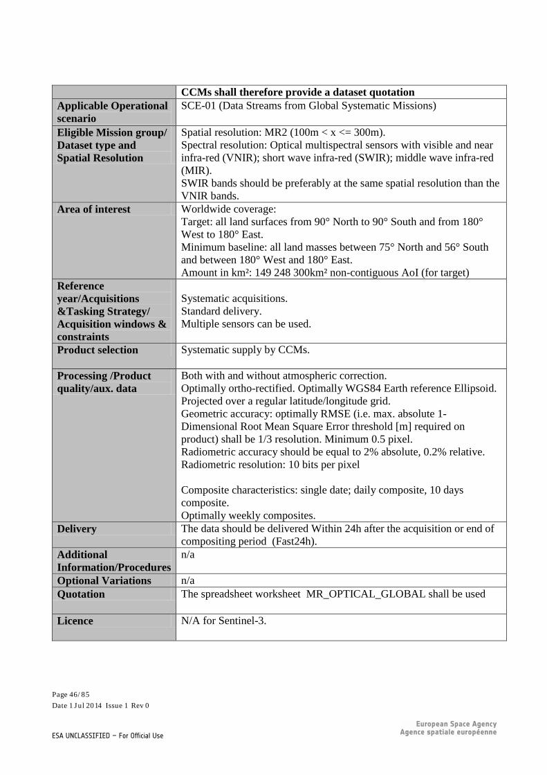
CCMs shall therefore provide a dataset quotation Applicable Operational scenario
SCE-01 (Data Streams from Global Systematic Missions)
Eligible Mission group/ Dataset type and Spatial Resolution
Spatial resolution: MR2 (100m < x <= 300m). Spectral resolution: Optical multispectral sensors with visible and near infra-red (VNIR); short wave infra-red (SWIR); middle wave infra-red (MIR). SWIR bands should be preferably at the same spatial resolution than the VNIR bands.
Area of interest Worldwide coverage: Target: all land surfaces from 90° North to 90° South and from 180° West to 180° East. Minimum baseline: all land masses between 75° North and 56° South and between 180° West and 180° East. Amount in km²: 149 248 300km² non-contiguous AoI (for target)
Reference year/Acquisitions &Tasking Strategy/ Acquisition windows & constraints
Systematic acquisitions. Standard delivery. Multiple sensors can be used.
Product selection Systematic supply by CCMs.
Processing /Product quality/aux. data
Both with and without atmospheric correction. Optimally ortho-rectified. Optimally WGS84 Earth reference Ellipsoid. Projected over a regular latitude/longitude grid. Geometric accuracy: optimally RMSE (i.e. max. absolute 1-Dimensional Root Mean Square Error threshold [m] required on product) shall be 1/3 resolution. Minimum 0.5 pixel. Radiometric accuracy should be equal to 2% absolute, 0.2% relative. Radiometric resolution: 10 bits per pixel Composite characteristics: single date; daily composite, 10 days composite. Optimally weekly composites.
Delivery The data should be delivered Within 24h after the acquisition or end of compositing period (Fast24h).
Additional Information/Procedures
n/a
Optional Variations n/a Quotation The spreadsheet worksheet MR_OPTICAL_GLOBAL shall be used
Licence N/A for Sentinel-3.
Page 46/85 Date 1 Jul 2014 Issue 1 Rev 0
ESA UNCLASSIFIED – For Official Use

For CCMs: Authorised users for DOWNLOAD service are [Copernicus Services], [Union_Inst] and [Union_Research_Projects]. Access for CSPs from FP7/Horizon 2020 outside the Space themes shall be quoted as an additional OPTION.
Management Reporting See reporting Excel worksheet MR2 _OPTICAL_GLOBAL alongside the CDS automated reports.
6.12 Optical LR worldwide coverage (LR_OPTICAL_GLOBAL) FIELD VALUE Title Optical LR Worldwide coverage DWR-ID LR_OPTICAL_GLOBAL Applications Main application: Global Land, for the production of biogeophysical
parameters Note: This need is expected to be covered by CCMs and Sentinel-3 and Proba-V kilometric products, CCMs shall therefore provide a dataset quotation..
Applicable Operational scenario
SCE-01 (Data Streams from Global Systematic Missions)
Eligible Mission group/ Dataset type and Spatial Resolution
Worldwide coverage in LR data with imaging multi-spectral radiometers shall be provided. Spatial resolution: LR (x > 300m). Spectral resolution: Optical multispectral sensors with visible and near infra-red (VNIR); short wave infra-red (SWIR); middle wave infra-red (MIR); thermal infra-red (TIR). Characteristics: VIS (min: blue and red), NIR (min 1 channel) and SWIR (min 1 channel). Target: TIR (3 channels: 1 in the 3.5-5.5 micron window, 2 in the 8-14 micron window). VIS, SWIR, TIR bands in the field of view (IFOV) should be similar. SWIR, TIR bands IFOV shall not be larger than 2 times the VIS IFOV.
Area of interest Worldwide coverage: target: all land surfaces from 90° North to 90° South and from 180° West to 180° East. Minimum baseline: all land masses between 75° North and 56° South and between 180° West and 180° East. AOI in km2:149 248 300km² non-contiguous AoI
Reference year/Acquisitions &Tasking Strategy/
Systematic acquisition. Standard acquisition.
Page 47/85 Date 1 Jul 2014 Issue 1 Rev 0
ESA UNCLASSIFIED – For Official Use

Acquisition windows & constraints
Multiple sensors can be used.
Product selection Systematic supply by CCMs.
Processing /Product quality/aux. data
Single day passes (satellite orbits) shall be provided as TOA reflectance. Daily and multi-date syntheses shall be provided as TOA and/or TOC reflectance. With ortho-rectification. EPSG CODE: WGS84. Footprint of the IFOV across the whole swath > 1/3km. Target: 1km +/- 25% - projected over a regular latitude/longitude grid, - pixel size = 1/112°. Geometric accuracy: RMSE (i.e. max. absolute 1-Dimensional Root Mean Square Error threshold [m] required on product) shall be 1/3 resolution. Composite characteristics: daily composite; optimally weekly composites; 10 days composite (from 1st to 10th from 11th to 20th, and from 21st to end of the month).
Delivery The data should be delivered within 24h after the acquisition or after the end of compositing period (Fast24h).
Additional Information/Procedures
n/a
Optional Variations n/a Quotation The spreadsheet worksheet LR_OPTICAL_GLOBAL shall be used
Licence N/A for Sentinel-3 and Proba-V kilometric products. For CCMs: Authorised users for DOWNLOAD service are [Copernicus Services], [Union_Inst], and [Union_Research_Projects]. Access for CSPs from FP7/Horizon 2020 outside the Space themes shall be quoted as an additional OPTION.
Management Reporting See reporting Excel worksheet LR _OPTICAL_GLOBAL alongside the CDS automated reports.
Page 48/85 Date 1 Jul 2014 Issue 1 Rev 0
ESA UNCLASSIFIED – For Official Use

6.13 SAR HR2/MR1 Worldwide coverage (HR2-MR1_SAR_GLOBAL)
FIELD VALUE Title SAR HR2-MR1 worldwide coverage DWR-ID MR1_SAR_GLOBAL Applications Main applications: Global Land.
Note: This need is expected to be covered by both CCMs and Sentinel-1, CCMs shall therefore provide a dataset quotation..
Applicable Operational scenario
SCE-01 (Data Streams from Global Systematic Missions); SCE-02 (Regional monitoring)
Eligible Mission group/ Dataset type and Spatial Resolution
SAR. Spatial resolution: HR2/MR1. Frequency band: C. Sentinel-1 mode: Interferometric Wide Swath (IW) Polarisation: VV or VV-VH (and HH or HH-HV for polar areas) InSAR (Interferometry).
Area of interest Worldwide coverage: target: all land surfaces from 90° North to 90° South and from 180° West to 180° East. (with a hole at the Poles for Sentinel-1 due to SAR right looking only). Minimum baseline: all land masses between 75° North and 56° South and between 180° West and 180° East. AOI in km2:149 248 300km² non-contiguous AoI
Reference year/Acquisitions &Tasking Strategy/ Acquisition windows & constraints
Standard acquisition. Multiple sensors can be used. Sentinel-1 coverage frequency over land depends on areas, spanning from every repeat cycle in Europe to few coverage per year for areas of low interest.
Product selection Systematic supply by CCM
Processing /Product quality/aux. data
Absolute Radiometric Accuracy (3 sigma): 1dB. Radiometric resolution (S1 IW GRD product): 1.7 dB Pixel coding: 16 bits per pixel. Optimally with ortho-rectification (not part of Sentinel-1 core products). EPSG CODE: "EPSG:4326" Projected over a regular grid. Geometric accuracy: optimally RMSE (i.e. max. absolute 1-
Page 49/85 Date 1 Jul 2014 Issue 1 Rev 0
ESA UNCLASSIFIED – For Official Use

Dimensional Root Mean Square Error threshold [m] required on product) shall be 1/3 resolution.
Delivery The data should be delivered within 24h after the acquisition (Fast24h). Additional Information/Procedures
n/a
Optional Variations n/a Quotation The spreadsheet worksheet HR2-MR1_SAR_GLOBAL shall be used
Licence N/A for Sentinel-1. In case CCMs will be used: Authorised users for DOWNLOAD service are [Copernicus Services], [Union_Inst], and [Union_Research_Projects]. Access for CSPs from FP7/Horizon 2020 outside the Space themes shall be quoted as an additional OPTION.
Management Reporting See reporting Excel worksheet MR1_SAR_GLOBAL alongside the CDS automated reports.
6.14 SAR LR Worldwide coverage (LR_SAR_GLOBAL) FIELD VALUE Title SAR LR worldwide coverage DWR-ID LR_SAR_GLOBAL Applications Main applications: Global Land
Note: This need is expected to be covered by CCMs and Ascat data on Metop satellites, therefore CCMs shall provide a dataset quotation .
Applicable Operational scenario
SCE-01 (Data Streams from Global Systematic Missions)
Eligible Mission group/ Dataset type and Spatial Resolution
Worldwide coverage SAR. Spatial resolution: LR. Frequency band C. Single polarimetry: VV. No InSAR (Interferometry).
Area of interest Worldwide coverage: target: all land surfaces from 90° North to 90° South and from 180° West to 180° East. Minimum baseline: all land masses between 75° North and 56° South and between 180° West and 180° East.
Page 50/85 Date 1 Jul 2014 Issue 1 Rev 0
ESA UNCLASSIFIED – For Official Use

AOI in km2:149 248 300km² non-contiguous AoI Reference year/Acquisitions &Tasking Strategy/ Acquisition windows & constraints
Standard acquisition. Single sensors can be used.
Product selection Systematic supply from CCMs.
Processing /Product quality/aux. data
Radiometric accuracy should be equal to 0.6 dB. Radiometric resolution: 8 bits per pixel. With ortho-rectification. EPSG CODE: WGS84. Projected over a regular grid. Geometric accuracy: RMSE (i.e. max. absolute 1-Dimensional Root Mean Square Error threshold [m] required on product) shall be 1/3 resolution. Daily composite. The SSM (surface soil moisture) products derived from Metop/Ascat are also required.
Delivery The data should be delivered within 24h after the acquisition (Fast24h). Additional Information/Procedures
n/a
Optional Variations n/a Quotation The spreadsheet worksheet LR_SAR_GLOBAL shall be used
Licence Authorised users for DOWNLOAD service are [Copernicus Services], [Union_Inst], and [Union_Research_Projects]. Access for CSPs from FP7/Horizon 2020 outside the Space themes shall be quoted as an additional OPTION.
Management Reporting See reporting Excel worksheet LR_SAR_GLOBAL alongside the CDS automated reports.
Page 51/85 Date 1 Jul 2014 Issue 1 Rev 0
ESA UNCLASSIFIED – For Official Use

6.15 SAR Altimetry MR2 Worldwide coverage (MR2_ALTIMETRY)
FIELD VALUE Title SAR Altimetry MR2 Worldwide coverage DWR-ID MR2_ALTIMETRY Applications Note: This need is expected to be covered by CCMs and the SAR
Radar Altimeter (SRAL) of Sentinel-3, as well as by the POSEIDON/JASON altimeter data series. Therefore CCMs shall provide a dataset quotation..
Applicable Operational scenario
SCE-01 (Data Streams from Global Systematic Missions)
Eligible Mission group/ Dataset type and Spatial Resolution
SAR Spatial resolution: MR 2. Frequency bands: Ku and C.
Area of interest Worldwide coverage: target: all land surfaces from 90° North to 90° South and from 180° West to 180° East. Minimum baseline: all land masses between 75° North and 56° South and between 180° West and 180° East. AOI in km2:149 248 300km² non-contiguous AoI
Reference year/Acquisitions &Tasking Strategy/ Acquisition windows & constraints
Standard acquisition. Multiple sensors can be used.
Product selection Systematic supply from CCMs.
Processing /Product quality/aux. data
Radiometric resolution: 8 bits per pixel. With ortho-rectification. EPSG CODE: WGS84. Projected over a regular grid. Geometric accuracy: RMSE (i.e. max. absolute 1-Dimensional Root Mean Square Error threshold [m] required on product) shall be 1/3 resolution.. Daily composite.
Delivery The data should be delivered within 24h after the acquisition (Fast24h). Additional Information/Procedures
n/a
Optional Variations n/a Quotation The spreadsheet worksheet MR2_ALTIMETRY shall be used
Page 52/85 Date 1 Jul 2014 Issue 1 Rev 0
ESA UNCLASSIFIED – For Official Use

Licence CCMs: Authorised users for DOWNLOAD service are [Copernicus Services], [Union_Inst], and [Union_Research_Projects]. Access for CSPs from FP7/Horizon 2020 outside the Space themes shall be quoted as an additional OPTION.
Management Reporting See reporting Excel files MR2_ALTIMETRY alongside the CDS automated reports.
6.16 Sea Ice Monitoring HR2/MR1 SAR (HR2/MR1_SAR_SEA_ICE)
FIELD VALUE Title Sea Ice Monitoring MR1 SAR DWR-ID MR1_SAR_SEA_ICE Applications Main applications: sea ice monitoring to support marine activities and
data assimilation for ice and weather forecast models. Note: This need is expected to be covered by CCMs and Sentinel-1, Therefore CCMs shall provide a dataset quotation...
Applicable Operational scenario
SCE-02 Regional Monitoring (direct flow)
Eligible Mission group/ Dataset type and Spatial Resolution
SAR. Spatial resolution: HR2, MR1. Frequency band: C. Polarization: Single (HH) or Dual (HH-HV). Modes e.g.
- Interferometric wide-swath (IW), swath 250 km, 5×20 m res - Extra wide-swath (EW), swath 400 km, 20×40 m res
Area of interest Baltic, Artic Ocean, Greenland, Svalbard, Barents Sea, Kara Sea, Labrador Sea and Antarctica. AOIs are non-contiguous and may change in extension during sea ice season.
Reference year/Acquisitions &Tasking Strategy/ Acquisition windows & constraints
Systematic daily SAR data coverage for ice covered areas, optimally at least once per day. For the Baltic, coverage is needed during ice season: November – May. Beginning and end is depending on severity of the Baltic Sea ice information. CSP will inform ESA/ CCME no latter than 10 days before beginning of SAR requirements. The Baltic ice charts are updated in the morning. For the other AOIs an all year coverage is needed.
Product selection CCMs shall provide products fulfilling the quality and timeliness requirements in a systematic way as contractually agreed.
Page 53/85 Date 1 Jul 2014 Issue 1 Rev 0
ESA UNCLASSIFIED – For Official Use

Processing /Product quality/aux. data
Radiometric resolution: 16 bits per pixel. Processing level GRD
Delivery NRT1h (Optimal); NRT3h (latest). Additional Information/Procedures
Baltic, Artic Ocean, Greenland, Svalbard, Barents Sea, Bering Sea, Kara Sea, Labrador Sea and Antarctica.: Timelines of acquisition are important and shall be described by the CCME, as ice charts are currently updated in the morning.
Optional Variations n/a Quotation The spreadsheet worksheet HR2-MR1_SAR_SEA_ICE shall be used
The smallest FIRM FIXED PRICE (FFP) unit to be contracted to a single CCME is a month of data in a given product mode (with a respective FIXED UNIT PRICE)
Licence For CCMs: Authorised users for DOWNLOAD service are [Copernicus Services], [Union_Inst], and [Union_Research_Projects]. Access for CSPs from FP7/Horizon 2020 outside the Space themes shall be quoted as an additional OPTION.
Management Reporting See reporting Excel worksheet MR1_SAR_SEA_ICE and SEAICE_Milestones alongside the CDS automated reports.
6.17 Global/Regional Systematic Ocean Colour data (OC _2014-2020)
FIELD VALUE Title Global/Regional Systematic Ocean Colour data DWR-ID CORE_012 Applications Main purposes:
a. Global/Regional Systematic Ocean colour data for marine applications; b. Global and regional Ocean colour, continuous tracking over oceans, reprocessing of archived data for climatic application, when improved algorithms or auxiliary data become available Note: This need is expected to be covered by CCMs and Sentinel-3, Therefore CCMs shall provide a dataset quotation .
Applicable Operational scenario
New data (NRT+ delayed): SCE-01 + SCE-11 Re-processed/re-analysis: SCE-12
Eligible Mission group/ MR1, MR2, LR (>300m), medium to low resolution imaging
Page 54/85 Date 1 Jul 2014 Issue 1 Rev 0
ESA UNCLASSIFIED – For Official Use

Dataset type and Spatial Resolution
radiometers (ocean colour instruments) Optical multispectral (VIS, NIR, SWIR)
Area of interest World Ocean and European regional seas. Europe is made of 7 regional seas: Arctic, Baltic, North West Shelves, South West Shelves, Mediterranean Sea, Black Sea The European Seas area is delimited in Lat from 27.5 N to 62 N and Lon from 15W to 43.5E
Reference year/Acquisitions &Tasking Strategy/ Acquisition windows & constraints
Systematic daily.
Product selection Systematic delivery: NRT+ delayed Global (incl. European) Seas L2 in 1km spatial resolution + NRT+ delayed only Mediterranean and NW shelves Seas L1A in 1 km spatial resolution Re-analysis dataset: the entire SeaWiFS, MODIS and MERIS L2 mission data completely reprocessed with the updated processing parameters/software; with • Global 4km data • European 1km data Note: CCMEs shall make available to CSPs all reprocessed data after completion of the reprocessing activity.
Processing /Product quality/aux. data
Products shall be - Geolocation accuracy 500 m in latitude/longitude - L1A and L2 (L2 = water leaving radiance spectra and L1 = TOA
radiances from visible to NIR). L1a data are preferred to L1b in order to speed up the computation of L2 data by extracting the area of interest from the entire available orbit before the processing.
Re-analysis data: the entire SeaWiFS, MODIS and MERIS L2 mission data, completely reprocessed with the updated processing parameters/software in 1km (Europe) and 4km (Global) L1a required parameters: - L1 top-of -atmosphere (TOA) radiances at sensor wavelengths
(visible to NIR) - Attitude and ephemeris data associated to each L1a pass (NRT and
Page 55/85 Date 1 Jul 2014 Issue 1 Rev 0
ESA UNCLASSIFIED – For Official Use

DT) - All associated ancillary information for atmospheric correction (e.g.
illumination conditions, pressure, ozone, surface winds) 2 L2 required parameters are:
- water leaving radiance spectra (as primary optical data for bio-optical algorithms);
- Chlorophyll case 1 (computed with standard case 1 algorithm), - Chlorophyll case 2 (computed with standard case 2 algorithm) - Diffuse attenuation coefficient (eg K490) - Absorption of chromophoric dissolved organic matter (CDOM, also
called Yellow Substance) - Total suspended matter concentration (TSM). - Inherent Optical properties - Aerosol optical thickness (τa(λ)) - Photosynthetic Available Radiation (PAR) - Satellite zenith angle - Satellite azimuth angle - L2 processing flags - All associated ancillary information for atmospheric correction (e.g.
illumination conditions, pressure, ozone, surface winds) Re-analysis data: the entire SeaWiFS, MODIS and MERIS L2 mission data, completely with the updated processing parameters/software in 1km (Europe) and 4km (Global) Ancillary data for atmospheric correction (pressure, ozone, surface winds) required
Delivery NRT3h + delayed + re-analysis data Timeliness: - NRT3h, delivery once per orbit - Delayed consolidated product with 2 -4 days time delay (as soon as
ancillary and precision orbital data become available) Offline delivery of re-analysis and fully validated final products for climate analysis required whenever a new reprocessed version of data is available from CCMEs/CCMs
Additional Information/Procedures
This dataset will rely on as many data as possible for various instruments of this mission group type, i.e. as many as possible will be contracted to deliver this dataset, in daily and various temporal composites. CCMEs are encouraged to offer all possible datasets in order to increase data density and to decrease cloud coverage
Page 56/85 Date 1 Jul 2014 Issue 1 Rev 0
ESA UNCLASSIFIED – For Official Use
Optional Variations n/a Quotation The spreadsheet worksheet OC _2014-2020 shall be used
The smallest FIRM FIXED PRICE (FFP) unit to be contracted to a single CCME is a month of data in a given product mode (FFP)
Licence Authorised users are [Copernicus_Services], [Union_Institutions] and [Union_Research_Projects], [Public_Authorities], [International_Organisation_NGO] and [Public] (DOWNLOAD service).
Management Reporting See reporting Excel worksheet OC _2014-2020 alongside the CDS automated reports.
6.18 Systematic Global and Regional sea surface temperature data (SST_2014-2020)
FIELD VALUE Title Systematic Global and Regional sea surface temperature data DWR-ID CORE_013 Applications Main purposes:
a. Marine Requirements: Global and regional sea surface temperature, continuous tracking over oceans; b. Reprocessing of archived data for climatic application, when improved algorithms or auxiliary data become available Note: This need is expected to be covered by CCMs and Sentinel-3, Therefore CCMs shall provide a dataset quotation .
Applicable Operational scenario
New data (NRT+ delayed): SCE-01 + SCE-11 Re-processed/re-analysis: SCE-12
Eligible Mission group/ Dataset type and Spatial Resolution
MG3 (LR, MR): sea surface temperature instruments, in combination of Microwave SST and TIR (geo and polar) LR: multispectral (VNIR, MIR, TIR) with 0.5 km spatial for TIR, VIS required for cloud clearing TIR, highest spatial and temporal resolution required for all data. Microwave SST at 6.9GHz are required in combination All available geostationary and polar-orbiting satellites will be required
Area of interest World Ocean 510 Mkm2, including European regional seas 50 Mkm2 World Ocean and European regional seas. The regional seas cover: Arctic, Baltic, North-east Atlantic, and Mediterranean sea
Page 57/85 Date 1 Jul 2014 Issue 1 Rev 0
ESA UNCLASSIFIED – For Official Use

Reference year/Acquisitions &Tasking Strategy/ Acquisition windows & constraints
Systematic daily.
Product selection Systematic delivery: NRT every orbit + daily delivery for 2 days delayed products Complete re-analysis dataset: 20+ years of Archived L1b from AVHRR, ATSR-1, together with other ESA specific satellite data ATSR-2, AATSR is required Note: CCMEs shall make available to CSPs all reprocessed data after completion of the reprocessing activity
Processing /Product quality/aux. data
Products shall be - Geolocation accuracy 500 m in latitude/longitude - Access to all microwave SST data sets (ideally L1b brightness
temperatures) from AMSRE (EoS AQUA), Windsat, TRMM TMI and GCOM-W AMSR is required
- Geostationary split window thermal (10-12um) data re required to resolve diurnal variability.
- Archive data should be at the highest spatial and temporal resolution possible in all cases.
- All new acquisition products shall be Level 2 (NRT + delayed) Re-analysis data: Best available reprocessed L2 products L2P for new data L1B for archived data Re-analysis data: global ocean best available data products including every elementary reprocessing for : SST level 2P products
Delivery Timeliness: - NRT3h, delivery once per orbit - Geostationary hourly data at full resolution for regional coverage - Delayed consolidated product with 2 days time delay with daily
delivery (as soon as ancillary and precision orbital data become available)
Offline delivery of re-analysis and fully validated final products for climate analysis with data required whenever a reprocessed version of the dataset is available
Additional This dataset will rely on as many data as possible for various
Page 58/85 Date 1 Jul 2014 Issue 1 Rev 0
ESA UNCLASSIFIED – For Official Use

Information/Procedures instruments of this mission group type, i.e. as many as possible will be contracted to deliver this dataset, in daily and various temporal composites. CCMEs are encouraged to offer all possible datasets in order to increase data density and to decrease cloud coverage
Optional Variations n/a Quotation The spreadsheet worksheet SST _2014-2020 shall be used
The smallest FIRM FIXED PRICE (FFP) unit to be contracted to a single CCME is a month of data in a given product mode (FFP)
Licence Authorised users are [Copernicus_Services], [Union_Institutions] and [Union_Research_Projects], [Public_Authorities], [International_Organisation_NGO] and [Public] (DOWNLOAD service). Access for CSPs from FP7/Horizon 2020 outside the Space themes shall be quoted as an additional OPTION.
Management Reporting See reporting Excel worksheet SST _2014-2020 alongside the CDS automated reports.
6.19 Systematic Global and Regional Altimeter / Sea Level data (ALT_2014-2020)
FIELD VALUE Title Systematic Global and Regional Altimeter / Sea Level data DWR-ID CORE_014 Applications Main purposes:
a. Marine Requirements: Global and regional sea level, continuous tracking over oceans; b. Reprocessing of archived data for climatic application, when improved algorithms or auxiliary data become available.
Applicable Operational scenario
New data (NRT+ delayed): SCE-01 + SCE-11 Archived data: SCE-10 Re-processed/re-analysis: SCE-12
Eligible Mission group/ Dataset type and Spatial Resolution
LR/Altimeter (>300m) For offshore product an along track resolution of 500 m is adequate For coastal application the availability of SAR high resolution mode data is highly desirable MG3: (radar altimeter/sea level, e.g. at least Jason-1, Jason 2, Jason-3,
Page 59/85 Date 1 Jul 2014 Issue 1 Rev 0
ESA UNCLASSIFIED – For Official Use
ENVISAT RA, SARAL, Sentinel 3 SRAL etc. CRYOSAT should allow completing the sampling with some changes to the current processing baseline Required time and space coverage implies the simultaneous use of as many as possible altimetry missions : − monitoring of diurnal signals such as solar tides with measurements from a non sun-synchronous orbit − monitoring of mesoscale features which have typical scale length of 100 km and time length of 10 days with measurements from as many as possible simultaneous missions with optimized orbit selection for mesoscale monitoring. Absolute minimum to perform operational oceanography is to get data from two simultaneous missions
Area of interest World Ocean 510 Mkm2, including European regional seas 50 Mkm2 World Ocean and European regional seas. The regional seas cover: Arctic, Baltic, North-east Atlantic, and Mediterranean sea
Reference year/Acquisitions &Tasking Strategy/ Acquisition windows & constraints
Systematic daily. NRT + STC + offline Re-analysis dataset: • Access to L2 archive is required when a reprocessing is performed
for improved level 2 products Note: CCMEs shall make available to ESA for CSC-DA a copy of all reprocessed data after completion of the reprocessing activity
Product selection Systematic supply by CCM Processing /Product quality/aux. data
Products shall be - With geolocation accuracy of 100 m in latitude/longitude Accuracy of 10 cm in altitude for NRT, 5 cm for STC, 2 cm for off line L2 product including : - Radar altimeter ret racked data corrected from instrumental effects - ionospheric correction from dual frequency radar measurement - wet tropospheric correction from collocated radiometric
measurements - Precise Orbit Determination for altitude reference - Ancillary information from external sources (met fields, tides and
barotropic modelling, geoid and mean sea surface,…) Level 2 products is a composite product combining information from the three sensors: radar altimeter, POD and radiometer
Delivery Timeliness: - NRT3 hours, delivery once per orbit, delivery of every orbit
Page 60/85 Date 1 Jul 2014 Issue 1 Rev 0
ESA UNCLASSIFIED – For Official Use

- Daily delivery of slow time critical (STC) products with a 2 days time delay
Offline delivery every about 30-40 days of consolidated and fully validated final products for climate analysis. (Acceptable delay one month)
Additional Information/Procedures
This dataset will rely on as many data as possible for various instruments of this mission group type, i.e. as many as possible will be contracted to deliver this dataset, in daily and various temporal composites. CCMEs are encouraged to offer all possible datasets in order to increase data density
Optional Variations n/a Quotation The spreadsheet worksheet ALT_2014-2020 shall be used
The smallest FIRM FIXED PRICE (FFP) unit to be contracted to a single CCME is a month of data in a given product mode (FFP)
Licence Authorised users are [Copernicus_Services], [Union_Institutions] and [Union_Research_Projects], [Public_Authorities], [International_Organisation_NGO] and [Public] (DOWNLOAD service). Access for CSPs from FP7/Horizon 2020 outside the Space themes shall be quoted as an additional OPTION.
Management Reporting See reporting Excel worksheet ALT_2014-2020 alongside the CDS automated reports.
6.20 Data for aerosol monitoring and forecasting (AER_2014-2020)
FIELD VALUE Title Data for aerosol monitoring and forecasting DWR-ID CORE_017 Applications Main purposes: Atmospheric composition analysis and forecast. Data to
be used for assimilation of aerosol optical depth for near-real-time atmospheric composition analysis and forecast and for reanalyses
Applicable Operational scenario
New data (NRT+ delayed): SCE-01 + SCE-11 Archived data: SCE-10 Re-processed/re-analysis: SCE-12
Eligible Mission group/ Dataset type and Spatial Resolution
S4/S5P/S5/S3 mission group/ Imaging multi-spectral radiometers (VIS/NIR) & multiple direction/polarisation radiometers, at least - Envisat/MERIS
Page 61/85 Date 1 Jul 2014 Issue 1 Rev 0
ESA UNCLASSIFIED – For Official Use

- Envisat/AATSR - PARASOL/POLDER - GLORY/APS - AURA/OMI - Etc.
Area of interest Global Reference year/Acquisitions &Tasking Strategy/ Acquisition windows & constraints
Daily continuous data stream (all orbits) + offline data + re-analysis data Note: CCMEs shall make available to ESA for CSC-DA a copy of all reprocessed data after completion of the reprocessing activity ARCHIVE/Re-analysis: archive of latest reprocessed version to be made available from CCMs to CSC-DA when reprocessing is finished
Product selection Systematic supply by CCM When available, products with better ancillary shall be delivered for monthly reanalyses.
Processing /Product quality/aux. data
Level 2
Delivery Timeliness: - Continuous data stream NRT - Offline when better ancillary data become available for monthly re-
analysis One-off for re-processed archive
Additional Information/Procedures
This dataset will rely on as many data as possible for various instruments of this mission group type, i.e. as many as possible will be contracted to deliver this dataset, in daily and various temporal composites. CCMEs are encouraged to offer all possible datasets in order to increase data density Timeliness requirements shall have precedence over amount of data
Optional Variations n/a Quotation The spreadsheet worksheet AER_2014-2020 shall be used
The smallest FIRM FIXED PRICE (FFP) unit to be contracted to a single CCME is a month of data in a given product mode (FFP)
Licence Authorised users are [Copernicus_Services], [Union_Institutions] and [Union_Research_Projects], [Public_Authorities], [International_Organisation_NGO] and [Public] (DOWNLOAD service).
Page 62/85 Date 1 Jul 2014 Issue 1 Rev 0
ESA UNCLASSIFIED – For Official Use

Access for CSPs from FP7/Horizon 2020 outside the Space themes shall be quoted as an additional OPTION.
Management Reporting See reporting Excel worksheet AER_2014-2020 alongside the CDS automated reports.
6.21 Data for sulphur dioxide (SO2) atmospheric composition monitoring and forecasting (SO2_2014-2020)
FIELD VALUE Title Data for sulphur dioxide (SO2) atmospheric composition monitoring
and forecasting DWR-ID CORE_018 Applications Main purposes: Atmospheric composition analysis and forecast. Data to
be used for assimilation of aerosol optical depth for near-real-time atmospheric composition analysis and forecast and for reanalyses
Applicable Operational scenario
New data (NRT+ delayed): SCE-01 + SCE-11 Archived data: SCE-10 Re-processed/re-analysis: SCE-12
Eligible Mission group/ Dataset type and Spatial Resolution
S4/S5P/S5 mission group/ atmospheric chemistry, at least - Envisat/Sciamachy - AURA/MLS - AURA/OMI - Etc.
Area of interest Global Reference year/Acquisitions &Tasking Strategy/ Acquisition windows & constraints
Daily continuous data stream (all orbits) + offline data + re-analysis data Note: CCMEs shall make available to ESA for CSC-DA a copy of all reprocessed data after completion of the reprocessing activity ARCHIVE/Re-analysis: archive of latest reprocessed version to be made available from CCMs to CSC-DA when reprocessing is finished
Product selection Systematic supply by CCM When available, products with better ancillary shall be delivered for monthly reanalyses.
Processing /Product quality/aux. data
Level 2
Delivery Timeliness: - Continuous data stream for NRT i.e. with goal of 3 hours after
Page 63/85 Date 1 Jul 2014 Issue 1 Rev 0
ESA UNCLASSIFIED – For Official Use

acquisition (6 hours alternative). - Offline when better ancillary data become available for monthly re-analysis - One-off for re-processed archive
Additional Information/Procedures
This dataset will rely on as many data as possible for various instruments of this mission group type, i.e. as many as possible will be contracted to deliver this dataset, in daily and various temporal composites. CCMEs are encouraged to offer all possible datasets in order to increase data density Timeliness requirements shall have precedence over amount of data
Optional Variations n/a Quotation The spreadsheet worksheet SO2_2014-2020 shall be used
The smallest FIRM FIXED PRICE (FFP) unit to be contracted to a single CCME is a month of data in a given product mode (FFP)
Licence Authorised users are [Copernicus_Services], [Union_Institutions] and [Union_Research_Projects], [Public_Authorities], [International_Organisation_NGO] and [Public] (DOWNLOAD service). Access for CSPs from FP7/Horizon 2020 outside the Space themes shall be quoted as an additional OPTION.
Management Reporting See reporting Excel worksheet SO2_2014-2020 alongside the CDS automated reports.
6.22 Data for formaldehyde (HCHO) atmospheric composition monitoring and forecasting (HCHO_2014-2020)
FIELD VALUE Title Data for formaldehyde (HCHO) atmospheric composition monitoring and
forecasting DWR-ID CORE_019 Applications Main purposes: Atmospheric composition analysis and forecast. Data to
be used for assimilation of aerosol optical depth for near-real-time atmospheric composition analysis and forecast and for reanalyses
Applicable Operational scenario
New data (NRT+ delayed): SCE-01 + SCE-11 Archived data: SCE-10 Re-processed/re-analysis: SCE-12
Eligible Mission group/ S4/S5P/S5 mission group/ atmospheric chemistry, at least
Page 64/85 Date 1 Jul 2014 Issue 1 Rev 0
ESA UNCLASSIFIED – For Official Use

Dataset type and Spatial Resolution
- Envisat/Sciamachy - AURA/OMI - Etc.
Area of interest Global Reference year/Acquisitions &Tasking Strategy/ Acquisition windows & constraints
Daily continuous data stream (all orbits) + offline data + re-analysis data Note: CCMEs shall make available to ESA for CSC-DA a copy of all reprocessed data after completion of the reprocessing activity ARCHIVE/Re-analysis: archive of latest reprocessed version to be made available from CCMs to CSC-DA when reprocessing is finished
Product selection Systematic supply by CCM When available, products with better ancillary shall be delivered for monthly reanalyses.
Processing /Product quality/aux. data
Level 2
Delivery Timeliness: - Continuous data stream for NRT i.e. with goal of 3 hours after
acquisition (6 hours alternative). - Offline when better ancillary data become available for monthly re-
analysis One-off for re-processed archive
Additional Information/Procedures
This dataset will rely on as many data as possible for various instruments of this mission group type, i.e. as many as possible will be contracted to deliver this dataset, in daily and various temporal composites. CCMEs are encouraged to offer all possible datasets in order to increase data density Timeliness requirements shall have precedence over amount of data
Optional Variations n/a Quotation The spreadsheet worksheet HCHO_2014-2020 shall be used
The smallest FIRM FIXED PRICE (FFP) unit to be contracted to a single CCME is a month of data in a given product mode (FFP)
Licence Authorised users are [Copernicus_Services], [Union_Institutions] and [Union_Research_Projects], [Public_Authorities], [International_Organisation_NGO] and [Public] (DOWNLOAD service). Access for CSPs from FP7/Horizon 2020 outside the Space themes shall be quoted as an additional OPTION.
Page 65/85 Date 1 Jul 2014 Issue 1 Rev 0
ESA UNCLASSIFIED – For Official Use

Management Reporting See reporting Excel worksheet HCHO_2014-2020 alongside the CDS automated reports.
6.23 Data for Ozone (O3) atmospheric composition monitoring and forecasting (O3_2014-2020)
FIELD VALUE Title Data for Ozone (O3) atmospheric composition monitoring and
forecasting DWR-ID CORE_020 Applications Main purposes: Atmospheric composition analysis and forecast. Data to
be used for assimilation of aerosol optical depth for near-real-time atmospheric composition analysis and forecast and for reanalyses
Applicable Operational scenario
New data (NRT+ delayed): SCE-01 + SCE-11 Archived data: SCE-10 Re-processed/re-analysis: SCE-12
Eligible Mission group/ Dataset type and Spatial Resolution
S4/S5P/S5 mission group/ atmospheric chemistry, at least - AURA/MLS - Etc.
Area of interest Global Reference year/Acquisitions &Tasking Strategy/ Acquisition windows & constraints
Daily continuous data stream (all orbits) + offline data + re-analysis data Note: CCMEs shall make available to ESA for CSC-DA a copy of all reprocessed data after completion of the reprocessing activity ARCHIVE/Re-analysis: archive of latest reprocessed version to be made available from CCMs to CSC-DA when reprocessing is finished
Product selection Systematic supply by CCM When available, products with better ancillary shall be delivered for monthly reanalyses.
Processing /Product quality/aux. data
Level 2
Delivery Timeliness: - Continuous data stream for NRT i.e. with goal of 3 hours after
acquisition (6 hours alternative). - Offline when better ancillary data become available for monthly re-
analysis One-off for re-processed archive
Additional This dataset will rely on as many data as possible for various
Page 66/85 Date 1 Jul 2014 Issue 1 Rev 0
ESA UNCLASSIFIED – For Official Use

Information/Procedures instruments of this mission group type, i.e. as many as possible will be contracted to deliver this dataset, in daily and various temporal composites. CCMEs are encouraged to offer all possible datasets in order to increase data density Timeliness requirements shall have precedence over amount of data
Optional Variations n/a Quotation The spreadsheet worksheet O3_2014-2020 shall be used
The smallest FIRM FIXED PRICE (FFP) unit to be contracted to a single CCME is a month of data in a given product mode (FFP)
Licence Authorised users are [Copernicus_Services], [Union_Institutions] and [Union_Research_Projects], [Public_Authorities], [International_Organisation_NGO] and [Public] (DOWNLOAD service). Access for CSPs from FP7/Horizon 2020 outside the Space themes shall be quoted as an additional OPTION.
Management Reporting See reporting Excel worksheet O3_2014-2020 alongside the CDS automated reports.
6.24 Data for Carbon Monoxide (CO) atmospheric composition monitoring and forecasting (CO_2014-2020)
FIELD VALUE Title Data for Carbon Monoxide (CO) atmospheric composition monitoring and
forecasting DWR-ID CORE_021 Applications Main purposes: Atmospheric composition analysis and forecast. Data to
be used for assimilation of aerosol optical depth for near-real-time atmospheric composition analysis and forecast and for reanalyses
Applicable Operational scenario
New data (NRT+ delayed): SCE-01 + SCE-11 Archived data: SCE-10 Re-processed/re-analysis: SCE-12
Eligible Mission group/ Dataset type and Spatial Resolution
S4/S5P/S5 mission group/ atmospheric chemistry, at least - Envisat/Sciamachy - AURA/MLS - TERRA/MOPITT - Etc.
Area of interest Global Reference Daily continuous data stream (all orbits)
Page 67/85 Date 1 Jul 2014 Issue 1 Rev 0
ESA UNCLASSIFIED – For Official Use

year/Acquisitions &Tasking Strategy/ Acquisition windows & constraints
+ offline data + re-analysis data Note: CCMEs shall make available to ESA for CSC-DA a copy of all reprocessed data after completion of the reprocessing activity ARCHIVE/Re-analysis: archive of latest reprocessed version to be made available from CCMs to CSC-DA when reprocessing is finished
Product selection Systematic supply by CCM When available, products with better ancillary shall be delivered for monthly reanalyses.
Processing /Product quality/aux. data
Level 2
Delivery Timeliness: - Continuous data stream for NRT i.e. with goal of 3 hours after
acquisition (6 hours alternative). - Offline when better ancillary data become available for monthly re-
analysis One-off for re-processed archive
Additional Information/Procedures
This dataset will rely on as many data as possible for various instruments of this mission group type, i.e. as many as possible will be contracted to deliver this dataset, in daily and various temporal composites. CCMEs are encouraged to offer all possible datasets in order to increase data density Timeliness requirements shall have precedence over amount of data
Optional Variations n/a Quotation The spreadsheet worksheet CO_2014-2020 shall be used
The smallest FIRM FIXED PRICE (FFP) unit to be contracted to a single CCME is a month of data in a given product mode (FFP)
Licence Authorised users are [Copernicus_Services], [Union_Institutions] and [Union_Research_Projects], [Public_Authorities], [International_Organisation_NGO] and [Public] (DOWNLOAD service). Access for CSPs from FP7/Horizon 2020 outside the Space themes shall be quoted as an additional OPTION.
Management Reporting See reporting Excel worksheet CO_2014-2020 alongside the CDS automated reports.
Page 68/85 Date 1 Jul 2014 Issue 1 Rev 0
ESA UNCLASSIFIED – For Official Use

6.25 Data for Carbon Dioxide (CO2) atmospheric composition monitoring and forecasting (CO2_2014-2020)
FIELD VALUE Title Data for Carbon Dioxide (CO2) atmospheric composition monitoring and
forecasting DWR-ID CORE_022 Applications Main purposes: Atmospheric composition analysis and forecast. Data to
be used for assimilation of aerosol optical depth for near-real-time atmospheric composition analysis and forecast and for reanalyses
Applicable Operational scenario
New data (NRT+ delayed): SCE-01 + SCE-11 Archived data: SCE-10 Re-processed/re-analysis: SCE-12
Eligible Mission group/ Dataset type and Spatial Resolution
S4/S5P/S5 mission group/ atmospheric chemistry, at least - Envisat/Sciamachy - OCO-2 - GOSAT - Etc.
Area of interest Global Reference year/Acquisitions &Tasking Strategy/ Acquisition windows & constraints
Daily continuous data stream (all orbits) + offline data + re-analysis data Note: CCMEs shall make available to ESA for CSC-DA a copy of all reprocessed data after completion of the reprocessing activity ARCHIVE/Re-analysis: archive of latest reprocessed version to be made available from CCMs to CSC-DA when reprocessing is finished
Product selection Systematic supply by CCM When available, products with better ancillary shall be delivered for monthly reanalyses.
Processing /Product quality/aux. data
Level 2
Delivery Timeliness: - Continuous data stream for NRT i.e. with goal of 3 hours after
acquisition (6 hours alternative). - Offline when better ancillary data become available for monthly re-
analysis One-off for re-processed archive
Additional Information/Procedures
This dataset will rely on as many data as possible for various instruments of this mission group type, i.e. as many as possible will be contracted to deliver this dataset, in daily and various temporal composites.
Page 69/85 Date 1 Jul 2014 Issue 1 Rev 0
ESA UNCLASSIFIED – For Official Use
CCMEs are encouraged to offer all possible datasets in order to increase data density Timeliness requirements shall have precedence over amount of data
Optional Variations n/a Quotation The spreadsheet worksheet CO2_2014-2020 shall be used
The smallest FIRM FIXED PRICE (FFP) unit to be contracted to a single CCME is a month of data in a given product mode (FFP)
Licence Authorised users are [Copernicus_Services], [Union_Institutions] and [Union_Research_Projects], [Public_Authorities], [International_Organisation_NGO] and [Public] (DOWNLOAD service). Access for CSPs from FP7/Horizon 2020 outside the Space themes shall be quoted as an additional OPTION.
Management Reporting See reporting Excel worksheet CO2_2014-2020 alongside the CDS automated reports.
6.26 Data for Methane (CH4) atmospheric composition monitoring and forecasting (CH4_2014-2020)
FIELD VALUE Title Data for Methane (CH4) atmospheric composition monitoring and
forecasting DWR-ID CORE_023 Applications Main purposes: Atmospheric composition analysis and forecast. Data to
be used for assimilation of aerosol optical depth for near-real-time atmospheric composition analysis and forecast and for reanalyses
Applicable Operational scenario
New data (NRT+ delayed): SCE-01 + SCE-11 Archived data: SCE-10 Re-processed/re-analysis: SCE-12
Eligible Mission group/ Dataset type and Spatial Resolution
S4/S5P/S5 mission group/ atmospheric chemistry, at least - Envisat/Sciamachy - Envisat/MIPAS - GOSAT - Etc.
Area of interest Global Reference year/Acquisitions &Tasking Strategy/ Acquisition windows &
Daily continuous data stream (all orbits) + offline data + re-analysis data Note: CCMEs shall make available to ESA for CSC-DA a copy of
Page 70/85 Date 1 Jul 2014 Issue 1 Rev 0
ESA UNCLASSIFIED – For Official Use

constraints all reprocessed data after completion of the reprocessing activity ARCHIVE/Re-analysis: archive of latest reprocessed version to be made available from CCMs to CSC-DA when reprocessing is finished
Product selection Systematic supply by CCM When available, products with better ancillary shall be delivered for monthly reanalyses.
Processing /Product quality/aux. data
Level 2
Delivery Timeliness: - Continuous data stream for NRT i.e. with goal of 3 hours after
acquisition (6 hours alternative). - Offline when better ancillary data become available for monthly re-
analysis One-off for re-processed archive
Additional Information/Procedures
This dataset will rely on as many data as possible for various instruments of this mission group type, i.e. as many as possible will be contracted to deliver this dataset, in daily and various temporal composites. CCMEs are encouraged to offer all possible datasets in order to increase data density Timeliness requirements shall have precedence over amount of data
Optional Variations n/a Quotation The spreadsheet worksheet CH4_2014-2020 shall be used
The smallest FIRM FIXED PRICE (FFP) unit to be contracted to a single CCME is a month of data in a given product mode (FFP)
Licence Authorised users are [Copernicus_Services], [Union_Institutions] and [Union_Research_Projects], [Public_Authorities], [International_Organisation_NGO] and [Public] (DOWNLOAD service). Access for CSPs from FP7/Horizon 2020 outside the Space themes shall be quoted as an additional OPTION.
Management Reporting See reporting Excel worksheet CH4_2014-2020 alongside the CDS automated reports.
Page 71/85 Date 1 Jul 2014 Issue 1 Rev 0
ESA UNCLASSIFIED – For Official Use

6.27 Data for Nitrogen Dioxide (NO2) atmospheric composition monitoring and forecasting (NO2_2014-2020)
FIELD VALUE Title Data for Methane (CH4) atmospheric composition monitoring and
forecasting DWR-ID CORE_024 Applications Main purposes: Atmospheric composition analysis and forecast. Data to
be used for assimilation of aerosol optical depth for near-real-time atmospheric composition analysis and forecast and for reanalyses
Applicable Operational scenario
New data (NRT+ delayed): SCE-01 + SCE-11 Archived data: SCE-10 Re-processed/re-analysis: SCE-12
Eligible Mission group/ Dataset type and Spatial Resolution
S4/S5P/S5 mission group/ atmospheric chemistry, at least - Envisat/MIPAS - Etc.
Area of interest Global Reference year/Acquisitions &Tasking Strategy/ Acquisition windows & constraints
Daily continuous data stream (all orbits) + offline data + re-analysis data Note: CCMEs shall make available to ESA for CSC-DA a copy of all reprocessed data after completion of the reprocessing activity ARCHIVE/Re-analysis: archive of latest reprocessed version to be made available from CCMs to CSC-DA when reprocessing is finished
Product selection Systematic supply by CCM When available, products with better ancillary shall be delivered for monthly reanalyses.
Processing /Product quality/aux. data
Level 2
Delivery Timeliness: - Continuous data stream for NRT i.e. with goal of 3 hours after
acquisition (6 hours alternative). - Offline when better ancillary data become available for monthly re-
analysis One-off for re-processed archive
Additional Information/Procedures
This dataset will rely on as many data as possible for various instruments of this mission group type, i.e. as many as possible will be contracted to deliver this dataset, in daily and various temporal composites. CCMEs are encouraged to offer all possible datasets in order to increase data density
Page 72/85 Date 1 Jul 2014 Issue 1 Rev 0
ESA UNCLASSIFIED – For Official Use
Timeliness requirements shall have precedence over amount of data
Optional Variations n/a Quotation The spreadsheet worksheet NO2_2014-2020 shall be used
The smallest FIRM FIXED PRICE (FFP) unit to be contracted to a single CCME is a month of data in a given product mode (FFP)
Licence Authorised users are [Copernicus_Services], [Union_Institutions] and [Union_Research_Projects], [Public_Authorities], [International_Organisation_NGO] and [Public] (DOWNLOAD service). Access for CSPs from FP7/Horizon 2020 outside the Space themes shall be quoted as an additional OPTION.
Management Reporting See reporting Excel worksheet NO2_2014-2020 alongside the CDS automated reports.
6.28 Licences for previous CORE datasets of previous CSC-DA Phases
FIELD VALUE Title Licences for Previous CORE datasets of previous CSC-DA Phases DWR-ID Licences for access to CDS-CI Archived CORE datasets
• IMAGE2006 • IMAGE2009 • CORE_01 - Optical HR Pan EU • CORE_03 - Optical VHR2 coverage over EU 2011-2013 • CORE_04 - Optical new worldwide LR coverage • CORE_05 - Optical archive worldwide LR coverage • CORE_06 - Optical new worldwide MR coverage • CORE_07 - Optical archive worldwide MR coverage • CORE_08 - European Monthly MR composites 2011-2012 • CORE_09 - Sub-Saharan Optical coverage HR2 • CORE_11 - Sea Ice monitoring • CORE_30 - Urban Atlas inl. access to DAP_MG2b_01.
Applications Various Applicable Operational scenario
n/a
Eligible Mission group/ Various
Page 73/85 Date 1 Jul 2014 Issue 1 Rev 0
ESA UNCLASSIFIED – For Official Use
Dataset type and Spatial Resolution Area of interest Various Reference year/Acquisitions &Tasking Strategy/ Acquisition windows & constraints
n/a
Product selection n/a Processing /Product quality/aux. data
n/a
Delivery From CDS to CSP and from CCM to CSP Additional Information/Procedures
n/a
Optional Variations n/a Quotation The spreadsheet worksheet Licences previous DWH V1 CORE shall be
used
Licence OPTION for DOWNLOAD where not yet granted, for [Copernicus Services], [Union_Inst] [Union_Research_Projects], [Public_Auth]; OPTION for Archive_CORE_09 - Sub-Saharan Optical coverage to [INT_ORG_NGO] as DOWNLOAD OPTION for [INT_ORG_NGO] and [Public] VIEW access to each CORE dataset. Access for CSPs from FP7/Horizon 2020 outside the Space themes shall be quoted as an additional OPTION.
Management Reporting n/a
Page 74/85 Date 1 Jul 2014 Issue 1 Rev 0
ESA UNCLASSIFIED – For Official Use

ESA UNCLASSIFIED – For Official Use
7 ANNEX A – CLOUD ASSESSMENT METHODOLOGY
EXAMPLES OF TYPICAL CLOUD COVER AND HAZE SITUATIONS
An in-depth analysis carried out on a database of satellite images obtained from various sensors has led to the determination of a classification of the problems that typically occur. These problems arise in the images with different orders of gravity and may limit or completely compromise the profitable use of the images themselves. The identified classes are the following: 1) Almost transparent haze (code 10 in Annex 7) 2) Semi-transparent haze/clouds (code 01 in Annex 7) 3) Clouds (code 00 in Annex 7) 4) Shadows 5) Snow Below some typical examples for each of the above classes are provided. On the right column an interpretation of the cloudy areas is given, obtained from manual digitization of clouds and shadows and the usage of a closure algorithm applied with 500 meters radius obtained. These masks are given as guideline.
Class image info
Image sample Clouds and shadows interpretation
Almost transparent haze SPOT5 2.5 meters CORE003
Page 75/85 Date 1 Jul 2014 Issue 1 Rev 0
ESA UNCLASSIFIED – For Official Use
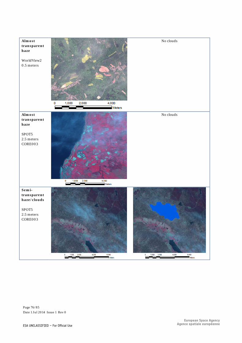
Almost transparent haze WorldView2 0.5 meters
No clouds
Almost transparent haze SPOT5 2.5 meters CORE003
No clouds
Semi-transparent haze/clouds SPOT5 2.5 meters CORE003
Page 76/85 Date 1 Jul 2014 Issue 1 Rev 0
ESA UNCLASSIFIED – For Official Use

Semi-transparent haze/clouds WorldView2 0.5 meters
Semi-transparent haze/clouds SPOT5 2.5 meters CORE003
Semi-transparent haze/clouds SPOT5 2.5 meters CORE003
Page 77/85 Date 1 Jul 2014 Issue 1 Rev 0
ESA UNCLASSIFIED – For Official Use

Clouds SPOT5 2.5 meters CORE003
Clouds GeoEye Multispectral 2.0 meters
Clouds SPOT5 2.5 meters CORE003
Page 78/85 Date 1 Jul 2014 Issue 1 Rev 0
ESA UNCLASSIFIED – For Official Use
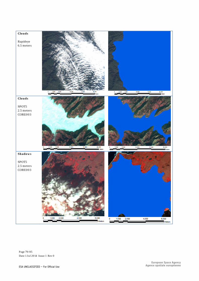
Clouds Rapideye 6.5 meters
Clouds SPOT5 2.5 meters CORE003
Shadows SPOT5 2.5 meters CORE003
Page 79/85 Date 1 Jul 2014 Issue 1 Rev 0
ESA UNCLASSIFIED – For Official Use

Shadows WorldView2 0.5 meters
Shadows WorldView1 0.5 meters PAN
Snow SPOT5 2.5 meters CORE003
No clouds (temporary snow cover should be included in
the cloud mask)
Page 80/85 Date 1 Jul 2014 Issue 1 Rev 0
ESA UNCLASSIFIED – For Official Use

Snow SPOT5 2.5 meters CORE003
No clouds (temporary snow cover should be included in
the cloud mask)
Snow SPOT5 10 meters
No clouds (temporary snow cover should be included in
the cloud mask)
(permanent snow should not be included in the cloud mask)
Snow Rapideye 6.5 meters
No clouds (temporary snow cover should be included in
the cloud mask)
(permanent snow should not be included in the cloud mask)
Page 81/85 Date 1 Jul 2014 Issue 1 Rev 0
ESA UNCLASSIFIED – For Official Use

Page 82/85 Date 1 Jul 2014 Issue 1 Rev 0
ESA UNCLASSIFIED – For Official Use
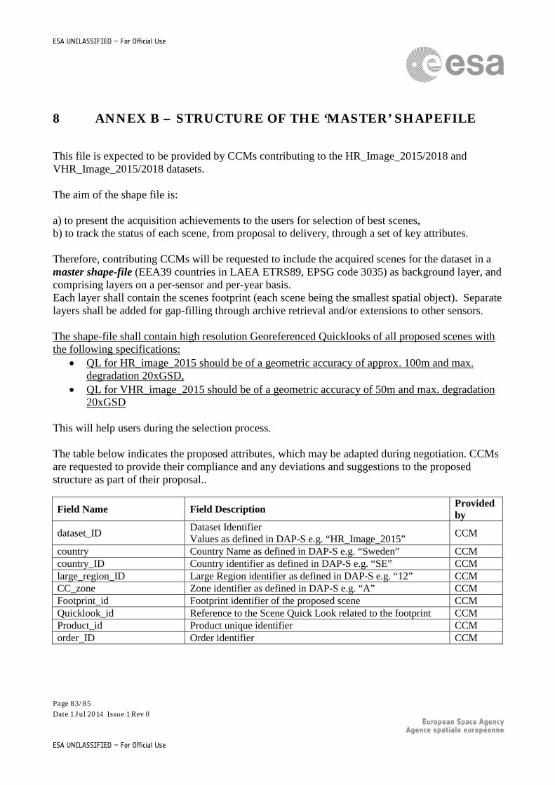
ESA UNCLASSIFIED – For Official Use
8 ANNEX B – STRUCTURE OF THE ‘MASTER’ SHAPEFILE
This file is expected to be provided by CCMs contributing to the HR_Image_2015/2018 and VHR_Image_2015/2018 datasets. The aim of the shape file is: a) to present the acquisition achievements to the users for selection of best scenes, b) to track the status of each scene, from proposal to delivery, through a set of key attributes. Therefore, contributing CCMs will be requested to include the acquired scenes for the dataset in a master shape-file (EEA39 countries in LAEA ETRS89, EPSG code 3035) as background layer, and comprising layers on a per-sensor and per-year basis. Each layer shall contain the scenes footprint (each scene being the smallest spatial object). Separate layers shall be added for gap-filling through archive retrieval and/or extensions to other sensors. The shape-file shall contain high resolution Georeferenced Quicklooks of all proposed scenes with the following specifications:
• QL for HR_image_2015 should be of a geometric accuracy of approx. 100m and max. degradation 20xGSD,
• QL for VHR_image_2015 should be of a geometric accuracy of 50m and max. degradation 20xGSD
This will help users during the selection process. The table below indicates the proposed attributes, which may be adapted during negotiation. CCMs are requested to provide their compliance and any deviations and suggestions to the proposed structure as part of their proposal..
Field Name Field Description Provided by
dataset_ID Dataset Identifier Values as defined in DAP-S e.g. “HR_Image_2015” CCM
country Country Name as defined in DAP-S e.g. “Sweden” CCM country_ID Country identifier as defined in DAP-S e.g. “SE” CCM large_region_ID Large Region identifier as defined in DAP-S e.g. “12” CCM CC_zone Zone identifier as defined in DAP-S e.g. “A” CCM Footprint_id Footprint identifier of the proposed scene CCM Quicklook_id Reference to the Scene Quick Look related to the footprint CCM Product_id Product unique identifier CCM order_ID Order identifier CCM
Page 83/85 Date 1 Jul 2014 Issue 1 Rev 0
ESA UNCLASSIFIED – For Official Use

proposal_date Date of proposal CCM order_date Date of order CCM acq_date Acquisition Date CCM
within_ext_window Indicator whether Acquisition is within Extended Acquisition window Values: yes/no
CCM
within_nar_window Indicator whether Acquisition is within Narrow Acquisition window Values: yes/no
CCM
year Year of acquisition campaign CCM mission Mission Type as per sensor configuration table CCM sensor Sensor Type as per sensor configuration table CCM Product_type Product Type as per sensor configuration table CCM resolution_m Resolution in meter CCM
projection Projection Info Values e.g. “ETRS_89” CCM
proc_level
Processing Levels as defined in DAP-S Values: “Level 1” “Ortho-rectified Level”
CCM
path Path Info CCM row Row Info CCM shift Shift Info CCM off_nad_angle (°) Off Nadir Angle CCM elev_angle (°) Sun Elevation Angle CCM
delivery_status Delivery Status Values: pre-processing/delivered
CCM
delivery_date Delivery Date CCM aoi_covered_km2 Size of Scene in km2 CCM aoi_covered_cloud_free_km2 Cloud free area of scene in km2 CCM CC Percentage of cloud cover CCM
haze Encoding of haze as defined in DAP-S Values: no haze, almost transparent haze, semi-transparent haze/cloud
CCM
Coverage Indication to which Coverage the item is mapped Values: COV#1/COV#2
CSP
proposal_status Status of Product Selection Values: accepted/rejected/on hold
CSP
Comment Comments from CSPs CSP ESA will merge all CCMs contributions into one file and send it to the user who will visualise the achievement of each CCM at the end of the acquisition campaign and be able to select the most
Page 84/85 Date 1 Jul 2014 Issue 1 Rev 0
ESA UNCLASSIFIED – For Official Use

appropriate scene for their application. The shape file will be exchanged and updated in turns by CSP and CCM for data proposal (CCM), data selection (CSP) and data delivery, including optimisation (CCM).
Page 85/85 Date 1 Jul 2014 Issue 1 Rev 0
ESA UNCLASSIFIED – For Official Use