Embed Size (px)
Citation preview

GIS WG Survey – March 2017, page 1
GIS Working Group Survey Results
March 2017
Background
The GIS Working Group (GIS WG) was formed in 2009 to address common geospatial issues –
maps, boundaries, data exchange, standards – that affected the work of humanitarian and
development actors in Myanmar. The group has been convened by MIMU, meeting on a regular
basis over this period (generally monthly until early 2017).
The GIS WG aims, as agreed in the Terms of Reference, are listed on the final page of this
document. In summary, the GIS WG aims to:
1. Develop and share best practices;
2. Exchange information and experiences;
3. Establish and promote standards and norms;
4. Promote transparent information sharing;
5. Promote capacity building;
6. Collaborate in developing and disseminating common tools and approaches;
7. Advocate for improved policies;
A short online survey was conducted by MIMU over a two-week period in March 2017 to gather
the views of GIS WG members on the GIS WG activities and how it could better achieve its
objectives. It was disseminated to the 30 members of the GIS WG. The anonymous survey
included sections on attendance at GIS WG meetings, the perceived quality and usefulness of
the GIS WG meetings and the extent to which the GIS WG is meeting its objectives.
This report has been prepared by MIMU on behalf of GIS WG. The remarks and conclusions are
suggestions drawn from the survey results for further discussion in the GIS WG.

GIS WG Survey – March 2017, page 2
GIS Working Group Survey Results
March 2017
Survey participation
1) Profile of respondents
7 respondents participated in the survey and they all
were from Yangon. Most respondents worked for
INGOs (4), others were UN (2) and Red Cross (1). Based
on the received responses, members were focusing on
areas of Information Management, Geospatial
Specialist and Monitoring and Evaluation. The overall
mailing list of the GIS WG includes 30 persons.
2) Meeting Attendance
Respondents fell into three main groups with regards to attendance – those who attend as
often as possible (43% of respondents), those who not attended for a while (29%) and those who
attend when the subject is of interest (43%).
The main reasons for not attending meetings were travel (57%), and other commitments (43%).
One respondent did not attend due to lack of interest in the meeting topics.

GIS WG Survey – March 2017, page 3
GIS Working Group Survey Results
March 2017
3) Meeting quality
Overall meeting management was generally considered by respondents to be good (agenda,
timeliness, place, ability to participate). All respondents were generally positive about the
presentations (interesting and relevant). Most respondents considered that the meetings were
comprehensive and understandable.
4) Usefulness of the meetings
Respondents generally found the GIS
working group meetings to be
somewhat useful or very useful for
presentations, technical knowledge,
updates and as a forum for advice,
resources and suggestion. None of the
survey respondents felt the meetings
were not useful.

GIS WG Survey – March 2017, page 4
GIS Working Group Survey Results
March 2017
5) Meeting minutes
Comments were also sought on the use, content and
presentation of the meeting minutes. The meeting
minutes were generally seen as useful with 43% of
respondents always or usually opening and reading
them, while the remaining 4 persons reported
sometimes opening and reading the meeting
minutes. None of the respondents rarely or never
read the minutes.
All respondents were satisfied with the
presentation, content and format of
the meeting minutes. 57% of the
respondents were aware that they
could use the Google group for
information sharing among the GIS
working group members.
6) Meeting Objectives
Most respondents felt that the GIS working group meets its objectives, whereas 2-3
respondents felt that improvement was needed. In addition, 1-3 people thought that the
meeting exceeds the expectations.
GIS WG Survey – March 2017, page 5
GIS Working Group Survey Results
March 2017
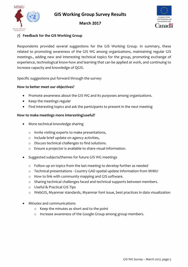
7) Feedback for the GIS Working Group
Respondents provided several suggestions for the GIS Working Group. In summary, these
related to promoting awareness of the GIS WG among organizations, maintaining regular GIS
meetings., adding new and interesting technical topics for the group, promoting exchange of
experience, technological know-how and learning that can be applied at work, and continuing to
increase capacity and knowledge of QGIS.
Specific suggestions put forward through the survey:
How to better meet our objectives?
Promote awareness about the GIS WG and its purposes among organizations.
Keep the meetings regular
Find interesting topics and ask the participants to present in the next meeting
How to make meetings more interesting/useful?
More technical knowledge sharing
o Invite visiting experts to make presentations,
o Include brief update on agency activities,
o Discuss technical challenges to find solutions.
o Ensure a projector is available to share visual information.
Suggested subjects/themes for future GIS WG meetings
o Follow up on topics from the last meeting to develop further as needed
o Technical presentations - Country GAD spatial update information from MIMU
o How to link with community mapping and GIS software.
o Sharing technical challenges faced and technical supports between members.
o Useful & Practical GIS Tips
o WebGIS, Myanmar standards, Myanmar font issue, best practices in data visualization
Minutes and communications
o Keep the minutes as short and to the point
o Increase awareness of the Google Group among group members.

GIS WG Survey – March 2017, page 6
GIS Working Group Survey Results
March 2017
ANNEX : GIS Working Group Objectives
The specific objectives of the GIS Working Group as detailed in the 2014 Terms of Reference are
as follows:
1. Develop and share best practices as well as new developments in GIS
2. Exchange information and experiences on how data was processed, analyzed and
disseminated and exchange their data and/or final products.
3. Establish and promote standards and norms for maps and other geospatial information
which enable information sharing and exchange to enable better use of resources
4. Promote transparent information sharing to promote avoid duplication
5. Promote capacity building for improved spatial data management,
6. Collaborate in developing and disseminating common tools and approaches which
advance the use of GIS standards and practice in humanitarian response and
development activities (e.g. common mapping platforms)
7. Advocate for improved policies promoting the use of international standards and norms
and best practice that promote the efficient and effective use of GIS to support
humanitarian and development activities.