Embed Size (px)
Citation preview

Getting The Most Out of a Plant Map
Plant Collections Map Applications From Botanical Gardens
Veronica Nixon, GIS Manager, Desert Botanical Garden
ESRI USER CONFERENCE 2018

D E S E R T B O T A N I C A L G A R D E N
Listening to the butterflies?
Making contact with the mothership?
Soil moisture sensor?

D E S E R T B O T A N I C A L G A R D E N
Listening to the butterflies?
Making contact with the mothership?
Soil moisture sensor?
Survey GPS is frequently used by botanical gardens to create a full plant map.

D E S E R T B O T A N I C A L G A R D E N
Botanical Garden 101
• Mission-focused: Botanical Education, Research, Exhibition, and Conservation
• Accessioned plant collections
• Plant database
• Plant map

D E S E R T B O T A N I C A L G A R D E N
Detailed plant collection maps

D E S E R T B O T A N I C A L G A R D E N
DenverBotanicGardens
LongwoodGardens
New YorkBotanicalGarden
DesertBotanicalGarden
NationalTropicalBotanicalGarden
UC DavisArboretum
San FranciscoBotanical Garden
MissouriBotanicalGarden
HuntsvilleBotanicalGarden
The Huntington
ChicagoBotanicGarden
“How does your organization use your plant map?”
MontgomeryBotanicalCenter
Red ButteGarden

D E S E R T B O T A N I C A L G A R D E N
Usage categories
• Plant records management
• Horticulture
• Education
• Construction
• Collections reporting
• Collections planning
In the following slides, each category is described in turn and illustrated with two examples contributed by various botanical gardens and arboreta.

D E S E R T B O T A N I C A L G A R D E N
Plant records management
• Conduct plant inventories
• Replace accession tags
• Coordinate ID work
• Sample plant material
• Track living tributes
• Support global research and conservation
D E S E R T B O T A N I C A L G A R D E N
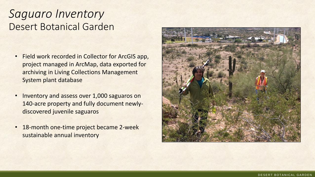
• Field work recorded in Collector for ArcGIS app, project managed in ArcMap, data exported for archiving in Living Collections Management System plant database
• Inventory and assess over 1,000 saguaros on 140-acre property and fully document newly-discovered juvenile saguaros
• 18-month one-time project became 2-week sustainable annual inventory
Saguaro InventoryDesert Botanical Garden

D E S E R T B O T A N I C A L G A R D E N
Garden Information SystemsSan Francisco Botanical Garden
• Created in Web AppBuilder for ArcGIS
• Visualizes inventory status of every plant in garden. Pie chart shows proportion of plants in each inventory stage
• Alternately displays inventory work completed over timespan of interest
Image courtesy of Steve Gensler, San Francisco Botanical Garden

D E S E R T B O T A N I C A L G A R D E N
Horticulture
• Document new plantings
• Organize pest control• Monitoring
• Intervention
• Coordinate arboriculture work• Health and hazard assessment
• Tree pruning rotation
• On-board new staff

D E S E R T B O T A N I C A L G A R D E N
Horticulture Pin MapDesert Botanical Garden
• Created in Web AppBuilder for ArcGIS
• Horticulture Department “pins” new/moved plantings that will be formally mapped and accessioned
• Effective interdepartmental communication tool

D E S E R T B O T A N I C A L G A R D E N
Emerald Ash Borer monitoringChicago Botanic Garden
• Maps created and queried in ArcMap
• Utilized by Plant Health Care staff to plan Ash Tree treatment and removal, and to systematically monitor health of remaining trees
• Figure depicts dramatic decrease in Ash Trees in plant collection before and after Emerald Ash Borer effect
Image courtesy of Veronica Harry-Jackson, Chicago Botanic Garden

D E S E R T B O T A N I C A L G A R D E N
Education
• Plan tours and classes
• Search plant collections
• Publish Story Maps
• Create TaleBlazer games

D E S E R T B O T A N I C A L G A R D E N
What’s in BloomThe Huntington
• App created with Esri Story Map (Map Series) template
• Visitors discover what is currently in bloom
• View photos and navigate to plant locations throughout the gardens
Image courtesy of Kelly Shunn, The Huntington

D E S E R T B O T A N I C A L G A R D E N
Garden GamesRed Butte Garden
• Built with TaleBlazer augmented reality platform from the Michigan Institute for Technology (MIT)
• Mobile, location-based games on garden grounds
• Latest game coincides with seasonal Lego sculpture exhibit
• Summer camp students create their own games

D E S E R T B O T A N I C A L G A R D E N
Construction
• Preparing plant salvage plans for City construction permits
• Orchestrating movement of plants while keeping data intact
• Designing and digging safely around existing plants and root zones
• Identifying impacted plants early before design changes become costly

D E S E R T B O T A N I C A L G A R D E N
• Field checks completed using Collector for ArcGIS app, data organized and mapped in ArcMap and exported to .dwg for final layout by landscape architect
• Salvage plan for construction permitting
• 1,400 plants assessed and documentedfor Heritage Garden construction
Heritage Garden salvage planDesert Botanical Garden

D E S E R T B O T A N I C A L G A R D E N
Waterway Enhancement ProjectUC Davis Arboretum
• ArcGIS, linked to IrisBG plant records database, was used to generate plant maps which were printed and used in the field
• As plant collections were transplanted, maps ensured that correct accession number and taxon name were kept with each plant specimen during move
Image courtesy of Angelica Sauceda, UC Davis Arboretum

D E S E R T B O T A N I C A L G A R D E N
Planning & reporting
• Disaster planning & recovery
• Landscape-level collections planning
• Reporting to:
• Board of Directors
• USDA
• Accreditation bodies• Plant Collections Network
• American Alliance of Museums

D E S E R T B O T A N I C A L G A R D E N
Sea level rise modelingMontgomery Botanical Center
• Analysis carried out in ArcMap using a digital elevation model and contour map in conjunction with plant collections map
• Modeled impact of sea level rise on plant collections
• Calculated percentage of property and collections that will be submerged
• “Half-life:” Can Botanic Gardens Weather the Climate?”
Image courtesy of Patrick Griffith, Montgomery Botanical Center

D E S E R T B O T A N I C A L G A R D E N
Taxonomic diversity mapDesert Botanical Garden
• Heat map created in ArcMap
• Visualizes areas of high and low taxonomic diversity
• May be used to plan tours and exhibits, or to monitor and strategically increase diversity of plantings
• Other meaningful enumeration areas include planting beds or thematic areas

D E S E R T B O T A N I C A L G A R D E N
Future Directions
• New ways for visitors to interact with plant collections through the plant map• Augmented reality
• More spatial analysis• 3D tree shade modeling

D E S E R T B O T A N I C A L G A R D E N
3D tree shade analysis idea
• Plant collections shade analysis
• Improve trail shading
• Urban forestry
• Please up-vote and comment on ArcGIS Ideas Forum
Image: Shadow Impact Analysis Tutorial For ArcGIS ProAnalysis support: Esri Analyst Andy Shoemaker

D E S E R T B O T A N I C A L G A R D E N
Resources & References
• Sampling of public plant collections maps and tours• A Living Collections Management System (Missouri Botanical Garden and Desert Botanical Garden)• Missouri Botanical Garden Map Gallery (Missouri Botanical Garden)• Gardens Navigator (Denver Botanic Gardens)• Plant Explorer (Longwood Gardens)• Plant Finder (Chicago Botanic Garden)• Magnificent Magnolias on Explorer for ArcGIS app (San Francisco Botanical Garden)• Find Plants (San Francisco Botanical Garden)• What's In Bloom (The Huntington)• Garden Games on TaleBlazer app (Red Butte Garden)
• Papers• Nixon, V. “Geodesign in the Desert.” ArcUser. Winter 2017: 66-69.• Griffith, P., Barber, G., Lima, J., Barros, M., Calonje, C., Noblick, L., Calonje, M., Magellan, T., Dosmann, M., Thibault, T., Gerlowski, N. 2017.
Plant Collections “Half-life:” Can Botanic Gardens Weather the Climate? Curator: The Museum Journal. 60(4): 395-410.• Xiao, Q.; McPherson, E.G. 2005. Tree health mapping with multispectral remote sensing data at UC Davis, California. Urban Ecosystems 8:
349–361.
• Alliance for Public Gardens (APGG) website and LinkedIn Group
• American Public Gardens (APGA) Plant Collections Community (library and forum available to members)

D E S E R T B O T A N I C A L G A R D E N
Thank you to all of the gardens that contributed ideas and content
• Kayla Flamm, GIS Specialist, Missouri Botanical Garden
• Kristina Aguilar, Plant Records Manager, Longwood Gardens
• Angelica Sauceda, Plant Records Specialist, UC Davis Arboretum
• Mary Burke, Director of Planning and Collections, UC Davis Arboretum
• Steve Gensler, GIS Manager, San Francisco Botanical Garden
• Dave Sivertsen, Gardens Technology Coordinator, The Huntington
• Kelly Shunn, GIS Mapping and Interpretation Technician, The Huntington
• Cindy Newlander, Associate Director of Horticulture, Denver Botanic Gardens
• Veronica Harry-Jackson, GIS Specialist, Chicago Botanic Garden
• Tracy Cook, Assistant Curator, Huntsville Botanical Garden
• Kristine Paulus, Plant Records Manager, New York Botanical Garden
• Ben Nyberg, GIS Specialist, National Tropical Botanical Garden
• Patrick Griffith, Executive Director, Montgomery Botanical Center
• Eddy Dawson, IT Manager, Red Butte Garden
• Research and Horticulture staff, Desert Botanical Garden

D E S E R T B O T A N I C A L G A R D E N
Questions?