Embed Size (px)
Citation preview

Geotechnical Consultants
GEOTECHNICAL INVESTIGATION
AND LANDSLIDE RISK
ASSESSMENT
TasWater
Proposed Sewer and Water Works in Rosebery
GL13098Ab 16 September 2013
Geotechnical Consultants Geoton Pty Ltd ABN 69 315 541 003
PO Box 522 Prospect TAS 7250 Office 3 Level 1 Images Centre
2 Trotters Lane Prospect TAS T (03) 6343 1900 F (03) 6343 1906
www.geoton.com.au
16 September 2013
Reference: GL13098Ab TasWater
PO Box 314DC
Ulverstone TAS 7315
Attention: Mr David Krushka
Dear Sir
RE: Geotechnical Investigation and Landslide Risk Assessment
Proposed Sewer and Water Works in Rosebery
We have pleasure in submitting herein our report detailing the results of the geotechnical
investigation and landslide risk assessment conducted at the above site.
Should you require clarification of any aspect of this report, please contact Tony Barriera at
this office on - (03) 6343 1900.
For and on behalf of Geoton Pty Ltd
Tony Barriera
Director
Geotechnical Investigation and Landslide Risk Assessment
Geoton Pty Ltd 1 GL13098Ab 16 September 2013
CONTENTS
1 INTRODUCTION 3
2 SCOPE OF WORKS 3
2.1 Scoping the study 3
3 GEOLOGY 3
3.1 Sewer Pipeline 4
3.2 Waste Water Treatment Plant 4
3.3 Outfall Pipeline 4
3.4 Water Treatment Plant 4
3.5 Water Pipeline 4
4 FIELD INVESTIGATION 4
5 LANDSLIDE HAZARD 5
6 SITE DESCRIPTION 5
6.1 Sewer Pipeline 5
6.1.1 Stirling Valley to Propsting Street 5
6.1.2 Propsting Street to Murchison Highway 6
6.1.3 Murchison Highway to Hollywood Street 7
6.1.4 Hollywood Street to Park Road Pump Station 7
6.1.5 Park Road Pump Station to Rosebery Park 8
6.1.6 Rosebery Park to Shackle Street 9
6.1.7 Shackle Street to the Railway Line 10
6.1.8 Railway Line to the Proposed WWTP 10
6.1.9 Corner of Park Road and Primrose Road 11
6.2 Waste Water Treatment Plant 11
6.2.1 Trenches 12
6.2.2 WWTP Foundations 12
Geotechnical Investigation and Landslide Risk Assessment
Geoton Pty Ltd 2 GL13098Ab 16 September 2013
6.3 Outfall Pipeline 12
6.3.1 Laboratory Testing 13
6.3.2 Slope Stability 14
6.4 Water Treatment Plant 14
6.4.1 WTP Foundations 15
6.5 Water Pipeline 15
7 DISCUSSION AND RECOMMENDATIONS 16
7.1 Excavation 16
7.2 Pipeline Foundation 17
7.3 Groundwater 17
7.4 Embedment and Backfilling 17
7.5 Erosion 18
8 LIMITATIONS 18
Limitations of Report
Figures
Figure 1: Site Plan – Proposed Sewer Pipeline
Figure 2: Site Plan – Proposed Waste Water Treatment Plant and Outfall
Figure 3: Site Plan – Proposed Water Treatment Plant and Pipeline
Figure 4: Geology Plan
Appendices
Appendix A: Borehole and Test Pit Logs
Appendix B: Qualitative Terminology for Use in Assessing Risk to Property
Appendix C: Some Guidelines for Hillside Construction
Appendix D: Site Photographs
Geotechnical Investigation and Landslide Risk Assessment
Geoton Pty Ltd 3 GL13098Ab 16 September 2013
1 INTRODUCTION
In response to a request by Mr David Krushka of TasWater, Geoton Pty Ltd has carried out a
geotechnical investigation for the Proposed Sewer and Water Works in Rosebery.
We understand that the Proposed Sewer and Water Works in Rosebery involves the
construction of the following:
A 3km long sewer pipeline with a nominal founding depth of 1.2m;
A Waste Water Treatment Plant (WWTP);
An outfall pipeline from the WWTP to the Stitt River;
A Water Treatment Plant (WTP), two alternative locations; and
A short 100m long water pipeline in the Stirling Valley.
A site plan showing the preliminary sewer alignment was provided showing the pipe running
from Stirling Valley Pump Station through the township of Rosebery to the new Waste Water
Treatment Plant above the Stitt River.
2 SCOPE OF WORKS
The purpose of the investigation is to assess the ground conditions along the proposed
pipeline routes (sewer pipeline, outfall and water pipeline) and the treatment plant sites.
This geotechnical assessment will be used as supporting information for tenderers to estimate
the treatment plant and pipeline installation costs (inclusive of excavation costs) and the
suitability of the excavated material for bedding and backfill.
In addition, a landslide risk assessment will be conducted along the proposed location of the
outfall pipeline.
The output of this survey work will provide TasWater with maps and estimate the proportion
and classifications of ground condition profiles (rock, clay, unconsolidated sediments etc) and
associated penetrability of the ground along the proposed pipeline route.
2.1 Scoping the study
Geoton identified 47 nominal test locations along the proposed pipeline routes, in addition to 7
test locations at each of the proposed treatment plants. The test locations were based upon
observations during fieldwork that were considered to be areas that may involve a potential
change in subsurface conditions. A site plan showing the test locations is provided as Figures
1 to 3.
3 GEOLOGY
An extract of the geology map showing all relevant areas is attached as Figure 4.
Geotechnical Investigation and Landslide Risk Assessment
Geoton Pty Ltd 4 GL13098Ab 16 September 2013
3.1 Sewer Pipeline
The Mineral Resources Tasmania (MRT) Geology 1:25,000 Scale Digital Sheets, indicates
that the proposed sewer pipeline is situated on either Quaternary aged glacial deposits or a
number of varying Cambrian aged volcaniclastic units (sandstone, siltstone, conglomerate or
porphyry), with this being generally confirmed by the field data.
3.2 Waste Water Treatment Plant
The Mineral Resources Tasmania (MRT) Geology 1:25,000 Scale Digital Sheets, indicates
that the proposed WWTP is situated on Quaternary aged glacial deposits, with this being
generally confirmed by the field data.
3.3 Outfall Pipeline
The Mineral Resources Tasmania (MRT) Geology 1:25,000 Scale Digital Sheets, indicates
that the proposed outfall pipeline is situated on Quaternary aged glacial deposits on the upper
slopes with Cambrian aged volcaniclastics located on the lower slopes towards the Stitt River,
with this being generally confirmed by the field data.
3.4 Water Treatment Plant
The Mineral Resources Tasmania (MRT) Geology 1:25,000 Scale Digital Sheets, indicates
that the proposed WTP is situated on Cambrian aged volcaniclastics, with this being generally
confirmed by the field data.
3.5 Water Pipeline
The Mineral Resources Tasmania (MRT) Geology 1:25,000 Scale Digital Sheets, indicates
that the proposed water pipeline is situated on Cambrian aged coarse grained volcaniclastic
sandstone, with this being generally confirmed by the field data.
4 FIELD INVESTIGATION
To aid in the field investigation, Geoton staff walked and reviewed the proposed route to
determine access and appropriate locations for the investigation.
The field investigated was conducted between 14 August 2013 and 10 September 2013 and
involved the subsurface investigation of 61 locations along the pipeline routes and at the
treatment plant locations. The investigation was conducted by drilling of boreholes by hand
and Drilltech auger rig and the excavation of test pits by a 5 tonne excavator to depths of
between 0.3m and 3.5m.
Insitu vane shear strength tests and pocket penetrometer tests were conducted in clay layers
encountered in the investigation. The results of the field tests are shown on the borehole and
excavation logs. The borehole and excavation logs are included in Appendix A.
The test locations were identified by hand-held GPS equipment and their locations are shown
on the site plans provided as Figures 1 to 3.
Geotechnical Investigation and Landslide Risk Assessment
Geoton Pty Ltd 5 GL13098Ab 16 September 2013
5 LANDSLIDE HAZARD
The site is not within an area mapped for landslide hazards by MRT. However, the steep
slopes at the location of the proposed outfall pipeline display past landslide characteristics. A
landslide risk assessment has been conducted on the outfall area with the results and
recommendations provided in Section 6.3.2 below. The remainder of the site is considered to
have a LOW landslide hazard risk provided the construction follows good hill practices.
The qualitative likelihood, consequence and risk terms used in this report for risk to property
are given in Appendix B. The risk terms are defined by a matrix that brings together different
combinations of likelihood and consequence. Risk matrices help to communicate the results
of risk assessment, rank risks, set priorities and develop transparent approaches to decision
making. The notes attached to the tables and terms and the comments on response to risk in
Appendix B are intended to help explain the risk assessment and management process.
In our experience, regulating authorities allow developments to proceed with VERY LOW to
LOW risk.
An information sheet entitled “Some Guidelines for Hillside Construction” adapted from the
Journal of the Australian Geomechanics Society, volume 42, Number 1, dated March 2007, is
presented in Appendix C.
6 SITE DESCRIPTION
6.1 Sewer Pipeline
6.1.1 Stirling Valley to Propsting Street
Through this section the pipeline runs from the Stirling Valley Pump station uphill through
dense native forest to the start of Propsting Street. This section is characterised by shallow
topsoil overlying volcaniclastic rock. Numerous rocky outcrops were identified along this
section (see Plate 1). The existing sewer pipeline through this section is partially above
ground possibly due to the shallow rock.
Test locations 1 to 7 were drilled/excavated along the proposed pipeline route within this
section, with the subsurface conditions being relatively uniform.
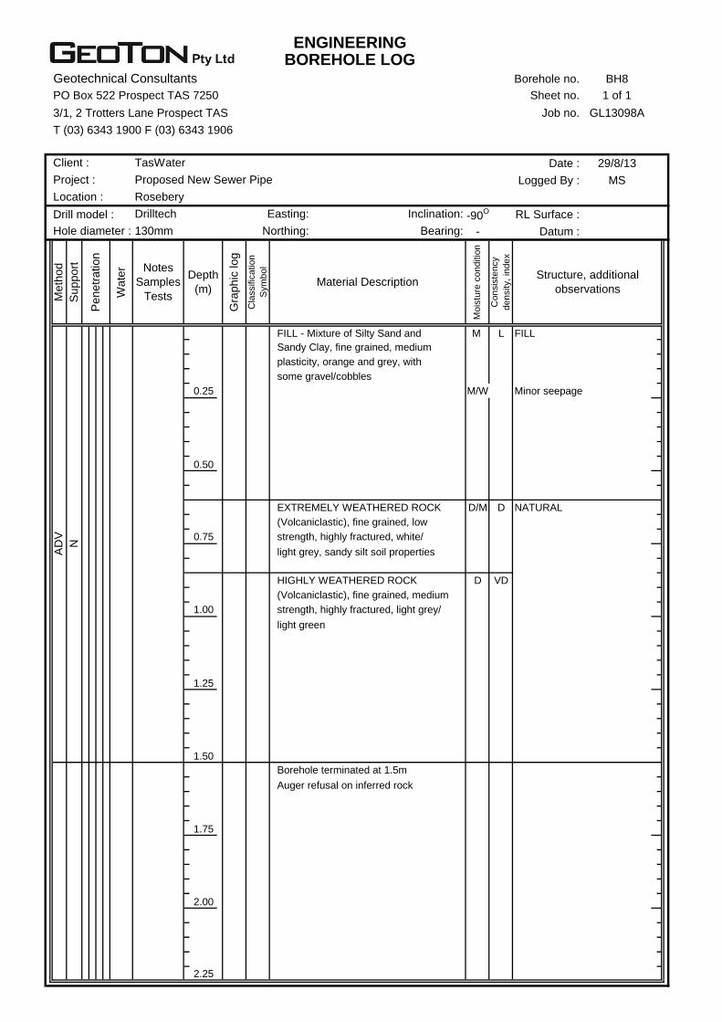
Borehole BH1 located at the base of the hill near the existing pump station encountered
uncontrolled fill to a depth 0.4m, overlying clayey silt to auger refusal on inferred rock at a
depth of 1.5m.
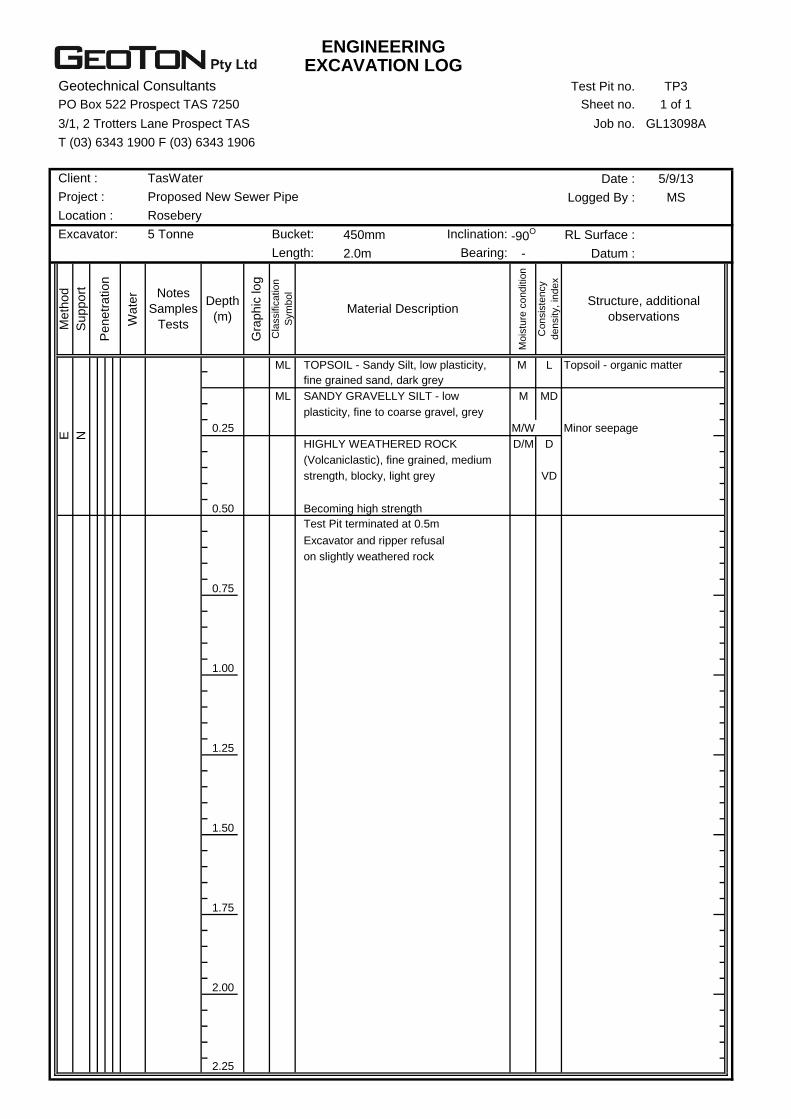
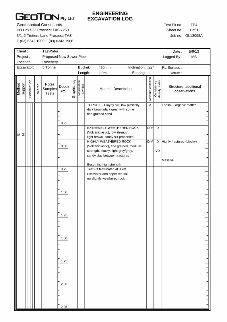
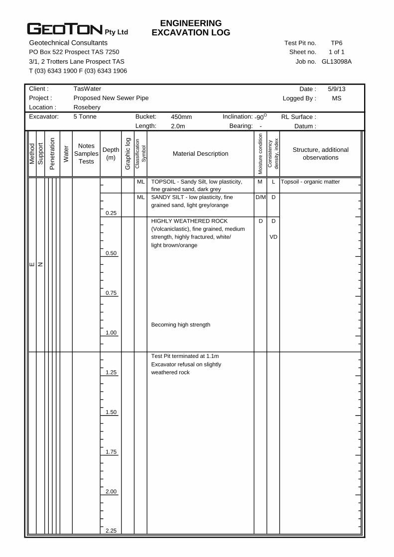
Test Pits TP2 to TP6 through the majority of this section encountered shallow topsoil and silt
to depths of 0.2m to 0.25m, overlying extremely/highly weathered rock (volcaniclastic) to
excavator refusal on slightly weathered rock at depths of 0.3m to 1.1m (see Plates 2 & 3).
Test Pit TP7 at the start of Propsting Street encountered uncontrolled fill to a depth of 1.1m,
overlying extremely/highly weathered rock (volcaniclastic) to excavator refusal on slightly
weathered rock at a depth of 1.8m.
Geotechnical Investigation and Landslide Risk Assessment
Geoton Pty Ltd 6 GL13098Ab 16 September 2013
Groundwater seepage was encountered in BH1 at a depth of 1.0m. In addition, minor
seepage was encountered in the low lying areas at the interface between the silty soils and
the rock.
Excavation along this section will only be partially achievable with a conventional excavator of
about 20 tonne. Due to the presence of shallow rock it is considered that larger excavating
equipment and possible rock breaking will be required.
We consider that the excavated materials would generally be suitable for trench backfilling.
Larger cobbles and boulders encountered in trench excavations may not be suitable to be
used within the trench backfill and will need to be disposed off-site.
Suitable pipe bedding material will need to be sourced off-site.
We consider the slopes within this section for the current pipeline alignment possess a LOW
slope stability risk.
Additional test locations were unable to be conducted due to the dense forest, with any
additional locations for an alternative route first requiring substantial clearing.
6.1.2 Propsting Street to Murchison Highway
Through this section the proposed pipeline route runs through the township of Rosebery
across ground with only gentle slopes.
Test locations 8 to 16 were drilled/excavated along the proposed pipeline route within this
section, with the subsurface conditions encountered being somewhat variable.
Test location 8 to 11 typically encountered uncontrolled fill to depths of 0.25m to 1.8m,
overlying extremely/highly weathered rock (volcaniclastic) to auger/excavator refusal on
slightly weathered rock at depths of 0.7m to 2.2m.
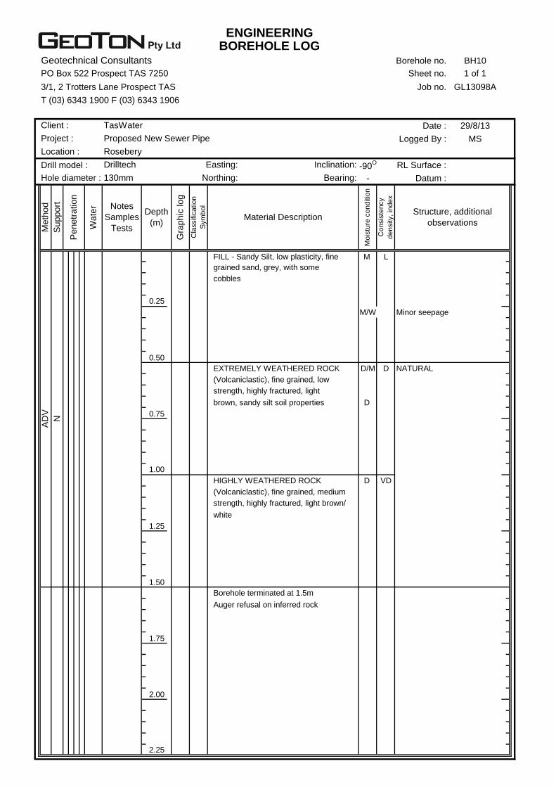
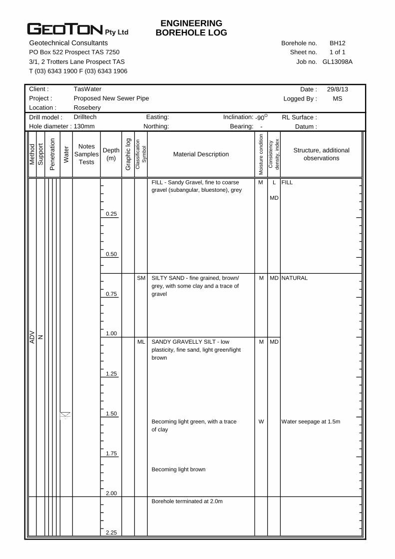
Boreholes BH12 to BH16 typically encountered uncontrolled fill to depths of 0.6m to 3.0m,
overlying medium dense sand or silt to the investigated depths of 2.0m to 3.5m.
Groundwater seepage was encountered in BH12 to BH16 at depths of 1.4m to 2.5m. The
groundwater seepage in Borehole BH15 and BH16 was interpreted as being a perched water
table within the uncontrolled fill.
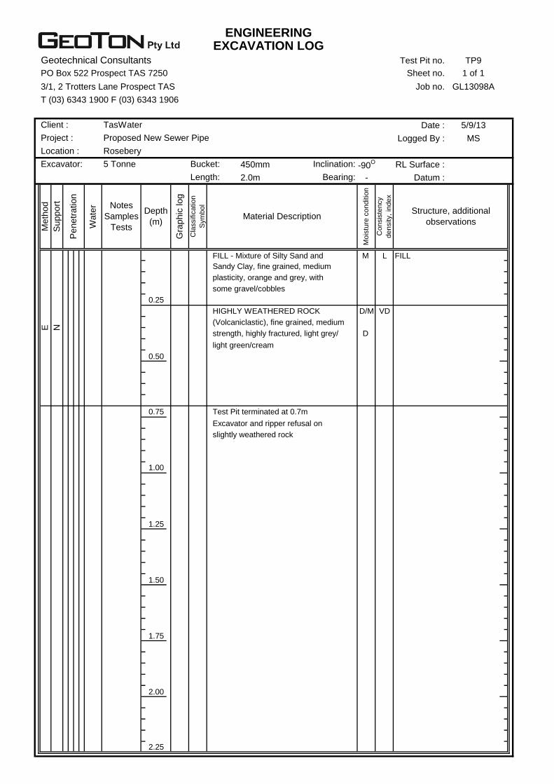
An outcrop of rock is encountered near test location 14.
It is considered that trench excavations through this section should be readily achievable for
most of the alignment with an excavator of about 20 tonne, however due to the presence of
shallow rock at test location TP9 (see Plate 4) and outcropping rock near test location 14,
larger excavating equipment and possible rock breaking may be required.
The foundation of all trenches should be within the natural ground to minimise settlement, and
as such the trenches will be required to be substantially deeper than the nominal founding
depth of 1.2m at test locations B11 (1.8m of fill), BH15 (1.5m of fill) and BH16 (3.0m of fill).
Alternatively, additional bedding will be required from the natural ground depth to the
proposed design alignment depth.
We consider that trench support will be required in areas of deep uncontrolled fill (BH11, BH15
and BH16). In addition, where trench excavations encounter groundwater, in the vicinity of
Geotechnical Investigation and Landslide Risk Assessment
Geoton Pty Ltd 7 GL13098Ab 16 September 2013
test locations BH15 and BH16, this will require either dewatering or consideration should be
given for a wet installation.
We consider that the excavated materials would generally be suitable for trench backfilling.
Variable fill material and larger cobbles/boulders encountered in trench excavations may not
be suitable to be used within the trench backfill and will need to be disposed off-site.
Suitable pipe bedding material will need to be sourced off-site.
We consider the slopes within this section for the current pipeline alignment possess a LOW
slope stability risk.
6.1.3 Murchison Highway to Hollywood Street
Through this section the proposed pipeline route runs down the walking track from the
Murchison Highway to Hollywood Street. The proposed alignment runs along a gully which is
characterised by deep fill (to create the walking track) and scattered rocky outcrops.
Test Pit TP17 was excavated in this section and encountered fill to a depth 0.3m, overlying
weakly cemented gravelly sand to a depth of 0.75m, underlain by highly weathered rock to
excavator refusal at a depth of 0.9m.
No groundwater seepage was encountered in the test pit.
Excavation along this section will only be partially achievable with a conventional excavator of
about 20 tonne. Due to the presence of shallow rock we consider that larger excavating
equipment and possible rock breaking will be required.
We consider that trenches within the natural ground should generally remain open over the
short term for pipe installation without the need for support.
We consider that the excavated materials would generally be suitable for trench backfilling.
Larger cobbles and boulders encountered in trench excavations may not be suitable to be
used within the trench backfill and will need to be disposed off-site.
Suitable pipe bedding material will need to be sourced off-site.
We consider the slopes within this section for the current pipeline alignment possess a LOW
slope stability risk.
6.1.4 Hollywood Street to Park Road Pump Station
Through this section the proposed pipeline route runs along the back of the houses along
Hollywood Street (above the Stitt River) and crosses Rosebery Creek. The test locations at
the back of Hollywood Street were conducted in the middle of the built up access track due to
the nearby existing services. Minor outcrops of rock and boulders were evident down towards
the proposed Rosebery Creek crossing.
Test locations 18 to 22 were drilled/excavated along the proposed pipeline route within this
section, with the subsurface conditions encountered being somewhat variable.
The boreholes/test pits typically encountered uncontrolled fill to depths of 0.8m to 2.0m,
overlying natural sandy silt or clayey sand to the investigated depths of 1.5m to 2.6m. Test Pit
TP22 was terminated at 1.5m due to excavator refusal on slightly weathered rock.

Geotechnical Investigation and Landslide Risk Assessment
Geoton Pty Ltd 8 GL13098Ab 16 September 2013
Groundwater seepage was encountered at the base of the fill in each borehole at depths of
0.7m to 1.8m.
It is considered that trench excavations through this section should be readily achievable for
most of the alignment with an excavator of about 20 tonne, however some areas of large
boulders and shallow rock (approaching Rosebery Creek) may require larger excavating
equipment or possible rock breaking.
The foundation of all trenches should be within the natural ground, and as such the trenches
will be required to be substantially deeper than the nominal founding depth of 1.2m at test
locations B18 (1.5m of fill) and BH21 (2.0m of fill). Alternatively, additional bedding will be
required from the natural ground depth to the proposed design alignment depth.
Where trench excavations encounter groundwater this will require either dewatering or
consideration should be given for a wet installation and possible shoring. In addition, trench
support will also be required in areas of deep uncontrolled fill. However, as the test locations
were conducted in the middle of the built up access track, the depth of fill is most likely
exaggerated and therefore if the proposed pipeline is set back into the bank the depth of fill
should be minimal with a corresponding decrease for the need for shoring.
We consider that the excavated materials would generally be suitable for trench backfilling.
Variable fill material and larger cobbles/boulders encountered in trench excavations may not
be suitable to be used within the trench backfill and will need to be disposed off-site.
Suitable pipe bedding material will need to be sourced off-site.
We consider the slopes within this section for the current pipeline alignment possess a LOW
slope stability risk, provided that the pipeline is founded within the natural ground.
6.1.5 Park Road Pump Station to Rosebery Park
Through this section the proposed pipeline route runs along Park Road crossing the Stitt River
and continues around to the back of Rosebery Park.
Test locations 23 to 28 were drilled/excavated along the proposed pipeline route within this
section, with the subsurface conditions encountered being variable.
Test locations 23 and 24 at the Stitt River Crossing encountered fill or topsoil to a depth of
0.25m, overlying medium dense or stiff soils to the investigated depths of 1.8m and 2.15m.
BH24 was terminated at 2.15m due to auger refusal on inferred rock.
Test locations 25 to 28 encountered uncontrolled fill to depths of 0.2m to 1.6m, overlying
varying units of silt, sand and weathered rock to the investigated depths of 0.9m to 2.2m.
BH26 was terminated at a depth of 0.9m due to auger refusal on inferred rock.
Groundwater seepage was encountered at the Stitt River crossing at depths of 1.5m and
1.75m. In addition, groundwater seepage was encountered towards the base of the fill at test
location BH25 (1.0m) and BH27 (1.5m).
It is considered that trench excavations through this section should be readily achievable for
most of the alignment with an excavator of about 20 tonne, however some areas of large
boulders and shallow rock (BH26) may require larger excavating equipment or possible rock
breaking.

Geotechnical Investigation and Landslide Risk Assessment
Geoton Pty Ltd 9 GL13098Ab 16 September 2013
The foundation of all trenches should be within the natural ground, and as such the trenches
will be required to be substantially deeper than the nominal founding depth of 1.2m at test
locations B25 (1.5m of fill) and BH27 (1.7m of fill).
We consider that trench support will be required in areas of deep uncontrolled fill (BH25 and
BH27). In addition, where trench excavations encounter groundwater, in the vicinity of test
locations BH25 and BH27, excavations below the water level may collapse requiring
temporary trench support. In addition, excavations for the Stitt River crossing which encounter
water seepage will require either dewatering or consideration should be given for a wet
installation with trench support.
Suitable pipe bedding material will need to be sourced off-site.
We consider that the excavated materials would generally be suitable for trench backfilling.
Variable fill material and larger cobbles/boulders encountered in trench excavations may not
be suitable to be used within the trench backfill and will need to be disposed off-site.
6.1.6 Rosebery Park to Shackle Street
Through this section the proposed pipeline route runs up the walking track from Rosebery
Park to Shackle Street.
A test pit/borehole investigation was not conducted in this area as the location of the existing
water and sewage pipe was unable to be determined. However the existing walking track is
cut down into the natural ground with the cut batter logged combined with shallow hand auger
holes.
The logs of the cut batter (test location 29) encountered sandy silt topsoil to a depth of 0.15m,
overlying clayey silt (with some cobbles and boulders) to a depth of 1.0m, underlain cobbles
and boulders in a clayey silt matrix, becoming weakly cemented at the base of the cutting at a
depth of 1.4m. The soil profile is interpreted as being glacial derived with this being confirmed
by the geology map.
No groundwater seepage was encountered over the investigated depth.
It is considered that trench excavations through this section should be readily achievable for
most of the alignment with an excavator of about 20 tonne, however some areas of large
boulders and highly cemented soils may require larger excavating equipment or possible rock
breaking.
We consider that trenches should generally remain open over the short term for pipe
installation without the need for support.
We consider that the excavated materials would generally be suitable for trench backfilling.
Larger cobbles and boulders encountered in trench excavations may not be suitable to be
used within the trench backfill and will need to be disposed off-site.
Suitable pipe bedding material will need to be sourced off-site.
We consider the slopes within this section for the current pipeline alignment possess a LOW
slope stability risk, provided the alignment follows best practices, with the pipeline being
orientated up and down slope rather than across slope.

Geotechnical Investigation and Landslide Risk Assessment
Geoton Pty Ltd 10 GL13098Ab 16 September 2013
6.1.7 Shackle Street to the Railway Line
Through this section the proposed pipeline route runs from Shackle Street to the railway line.
Test locations 30 and 31 were excavated along the proposed pipeline route within this section,
with the subsurface conditions encountered being somewhat variable.
Test locations 30 and 31 encountered topsoil or uncontrolled fill to depths of 0.15m and 0.4m,
overlying sandy silt to depths of 0.6m and 0.9m, overlying clayey gravel to depths of 0.9m and
1.7m, underlain by highly weathered rock (volcaniclastic) to excavator refusal at depths of
1.1m and 1.9m.
No significant groundwater seepage was encountered over the investigated depths.
It is considered that trench excavations through this section should be readily achievable for
most of the alignment with an excavator of about 20 tonne, however some areas of large
boulders and shallow rock (TP30) may require larger excavating equipment or possible rock
breaking.
We consider that trenches should generally remain open over the short term for pipe
installation without the need for support.
We consider that the excavated materials would generally be suitable for trench backfilling.
Variable fill material and larger cobbles/boulders encountered in trench excavations may not
be suitable to be used within the trench backfill and will need to be disposed off-site.
Suitable pipe bedding material will need to be sourced off-site.
We consider the slopes within this section for the current pipeline alignment possess a LOW
slope stability risk.
6.1.8 Railway Line to the Proposed WWTP
Through this section the proposed pipeline route runs along the railway line, behind the house
along Chester Street and continues to the proposed WWTP.
Test locations 32 to 38 were excavated along the proposed pipeline route within this section,
with the subsurface conditions encountered being somewhat variable.
The test locations all encountered glacial derived soils that were typically weakly cemented.
The test locations encountered topsoil or fill to depths of 0.15m to 0.4m, typically overlying
sandy silt or silty sand to depths of 0.25m to 1.5m, underlain by varying weakly cemented
units of sand and gravel to the investigated depths of 1.1m to 2.1m. Test location TP35 was
terminated at a depth of 1.1m due to excavator refusal on slightly weathered rock.
Groundwater seepage was encountered in TP36 at a depth of 0.3m. The test location was in
a small drainage depression. The remainder of the test locations did not encounter any
groundwater seepage over the investigated depths.
It is considered that trench excavations through this section should be readily achievable for
most of the alignment with an excavator of about 20 tonne, however some areas of large
boulders, cemented soils and shallow rock (TP36) may require larger excavating equipment or
possible rock breaking.

Geotechnical Investigation and Landslide Risk Assessment
Geoton Pty Ltd 11 GL13098Ab 16 September 2013
We consider that trenches for the majority of this section should generally remain open over
the short term for pipe installation without the need for support. Where trench excavations
encounter groundwater, in the vicinity of test location TP36, excavations below the water level
may collapse requiring temporary trench support.
We consider that the excavated materials would generally be suitable for trench backfilling.
Larger cobbles and boulders encountered in trench excavations may not be suitable to be
used within the trench backfill and will need to be disposed off-site.
Suitable pipe bedding material will need to be sourced off-site.
We consider the slopes within this section for the current pipeline alignment possess a LOW
slope stability risk.
6.1.9 Corner of Park Road and Primrose Road
A small section of pipe is to be installed at the corner of Park Road and Primrose Road. The
area has been modified significantly with the placement of fill. In addition, insitu rock is seen
in nearby road cuttings.
Test location 34 was excavated along the proposed pipeline route within this section.
Test location 34 encountered roadbase fill to a depth of 0.3m, overlying landfill material to a
depth of 0.9m (see Plate 5), underlain by natural clayey sand to the investigated depth of
2.0m.
No groundwater seepage was encountered in the test pit.
It is considered that trench excavations through this section should be readily achievable for
most of the alignment with an excavator of about 20 tonne, however some areas of shallow
rock may be encountered (based on the site observations) and may require larger excavating
equipment or possible rock breaking.
We consider that trench support will be required in areas of deep uncontrolled fill.
We consider that the excavated natural material would generally be suitable for trench
backfilling. Landfill waste encountered in trench excavations will not be suitable to be used
within the trench backfill and will need to be disposed off-site.
Suitable pipe bedding material will need to be sourced off-site.
We consider the slopes within this section for the current pipeline alignment possess a LOW
slope stability risk.
6.2 Waste Water Treatment Plant
The proposed WWTP is located on the western side of the existing access road off Chester
Avenue. The site is generally covered with dense native forest and is relatively level with only
gentle undulation and minor drainage depressions.
The geology maps show the site of the proposed WWTP is located on Quaternary aged
glacial deposits.
Geotechnical Investigation and Landslide Risk Assessment
Geoton Pty Ltd 12 GL13098Ab 16 September 2013
Test locations 44 to 50 were excavated at the proposed site of the WWTP, with the
subsurface conditions encountered being somewhat variable.
The test pits typically encountered topsoil to depths of 0.1m to 0.2m, overlying sandy silt or
silty gravel to depths of 0.25m to 1.0m, underlain by varying weakly cemented units of sand,
gravel, silt and cobbles/boulders (see Plate 6) to the investigated depths of 1.0m to 2.0m.
Test locations 48, 49 and 50 were terminated at depths of 1.0m to 1.2m due to excavator
refusal on strongly cemented gravel and cobbles.
Minor groundwater seepage was encountered above the cemented soils (perched water table)
in test locations 44, 47 and 50.
6.2.1 Trenches
It is considered that trench excavations through this section should be readily achievable for
most of the alignment with an excavator of about 20 tonne, however some areas of large
boulders and strongly cemented soils (Test locations 48, 49 and 50) may require larger
excavating equipment or possible rock breaking.
We consider that trenches should generally remain open over the short term for pipe
installation without the need for support.
We consider that the excavated natural material would generally be suitable for trench
backfilling. Larger cobbles and boulders encountered in trench excavations may not be
suitable to be used within the trench backfill and will need to be disposed off-site.
Suitable pipe bedding material will need to be sourced off-site.
We consider the slopes for the proposed WWTP possess a LOW slope stability risk.
6.2.2 WWTP Foundations
Insofar as it may be applicable, after allowing due consideration of the site geology, drainage
and soil conditions, the site has been classified as follows:
CLASS A (AS 2870)
This Classification is applicable only for ground conditions encountered at the time of this
investigation. If cut or fill earthworks are carried out, then the Site Classification will need to
be re-assessed, and possibly changed.
Insofar as it may be applicable, particular attention should be paid to the design of footings as
required by AS 2870 – 2011.
Conditions at this site dictate that the founding medium for all footings should extend through
the loose topsoil and sandy silt soils onto the weakly cemented soils or better.
Pad or bored pier footings founded within the weakly cemented soils at depths below 0.3m to
1.0m may be proportioned to an allowable bearing pressure of 250kPa.
6.3 Outfall Pipeline
The outfall pipeline runs from the proposed WWTP down a steep hillslope and discharges into
the Stitt River. The hill slope is densely vegetated with native forest and a track has been
Geotechnical Investigation and Landslide Risk Assessment
Geoton Pty Ltd 13 GL13098Ab 16 September 2013
cleared along the proposed alignment (see Plates 7 & 8). An Engineering Geologist walked
along the proposed alignment on 10 September 2013, in fine conditions. A site plan,
annotated with site observations is presented in Figure 2.
The upper slopes of the proposed outfall pipe alignment are situated on Quaternary aged
glacial deposits, with the lower slopes towards the Stitt River on Cambrian aged
volcaniclastics.
The hill slope typically has slope angles between 25 O and 38O and is undulating in the steeper
sections with evidence of several shallow landslide features. In addition, the proposed
alignment crosses two minor drainage depressions that show evidence of land instability with
shallow landslide features (see Figure 2).
The proposed alignment does not follow best practices in regards to land stability with the
alignment running across slope in some sections. However, the alignment chosen utilises the
gentler and more stable slopes than the adjacent surrounding area. The alignment chosen is
considered to be acceptable provided the recommendations below are adhered to.
Test locations 39 to 42 were drilled by hand auger along the proposed outfall pipeline route,
with the subsurface conditions encountered being somewhat variable.
The test locations on the upper slopes (BH39 and BH42) encountered topsoil and sand to
depths of 0.2m and 0.3m, overlying sandy silt to auger refusal on inferred cemented soils at
depths of 0.6m and 1.1m. The test locations on the lower slopes (BH40 and BH41)
encountered topsoil to a depth of 0.2m, overlying clayey silt to depths of 0.5m and 0.6m,
underlain by gravelly clayey silt to auger refusal on inferred weathered rock at depths of 0.7m
and 0.75m.
No groundwater seepage was encountered over the investigated depths. However,
groundwater seepage is expected in the drainage depressions along the proposed alignment.
Subsoil drains will be required through the drainage depressions to discharge water
downslope of the pipeline. Also concrete encasement of the pipeline may be considered tp
prevent exposure of the pipe through erosion of the drainage depression.
It is considered that trench excavations through this section should be readily achievable for
most of the alignment with an excavator of about 20 tonne, however some areas of shallow
rock and strongly cemented soils may require larger excavating equipment or possible rock
breaking.
We consider that trenches should generally remain open over the short term for pipe
installation without the need for support.
We consider that the excavated natural material would generally be suitable for trench
backfilling.
Suitable pipe bedding material will need to be sourced off-site.
6.3.1 Laboratory Testing
The table below presents a summary of the test results.
Geotechnical Investigation and Landslide Risk Assessment
Geoton Pty Ltd 14 GL13098Ab 16 September 2013
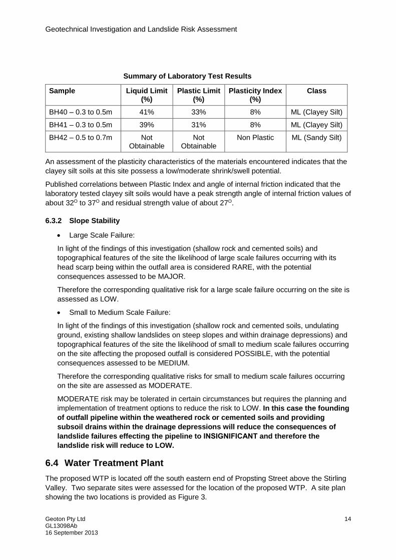
Summary of Laboratory Test Results
Sample Liquid Limit (%)
Plastic Limit (%)
Plasticity Index (%)
Class
BH40 – 0.3 to 0.5m 41% 33% 8% ML (Clayey Silt)
BH41 – 0.3 to 0.5m 39% 31% 8% ML (Clayey Silt)
BH42 – 0.5 to 0.7m Not Obtainable
Not Obtainable
Non Plastic ML (Sandy Silt)
An assessment of the plasticity characteristics of the materials encountered indicates that the
clayey silt soils at this site possess a low/moderate shrink/swell potential.
Published correlations between Plastic Index and angle of internal friction indicated that the
laboratory tested clayey silt soils would have a peak strength angle of internal friction values of
about 32O to 37O and residual strength value of about 27O.
6.3.2 Slope Stability
Large Scale Failure:
In light of the findings of this investigation (shallow rock and cemented soils) and
topographical features of the site the likelihood of large scale failures occurring with its
head scarp being within the outfall area is considered RARE, with the potential
consequences assessed to be MAJOR.
Therefore the corresponding qualitative risk for a large scale failure occurring on the site is
assessed as LOW.
Small to Medium Scale Failure:
In light of the findings of this investigation (shallow rock and cemented soils, undulating
ground, existing shallow landslides on steep slopes and within drainage depressions) and
topographical features of the site the likelihood of small to medium scale failures occurring
on the site affecting the proposed outfall is considered POSSIBLE, with the potential
consequences assessed to be MEDIUM.
Therefore the corresponding qualitative risks for small to medium scale failures occurring
on the site are assessed as MODERATE.
MODERATE risk may be tolerated in certain circumstances but requires the planning and
implementation of treatment options to reduce the risk to LOW. In this case the founding
of outfall pipeline within the weathered rock or cemented soils and providing
subsoil drains within the drainage depressions will reduce the consequences of
landslide failures effecting the pipeline to INSIGNIFICANT and therefore the
landslide risk will reduce to LOW.
6.4 Water Treatment Plant
The proposed WTP is located off the south eastern end of Propsting Street above the Stirling
Valley. Two separate sites were assessed for the location of the proposed WTP. A site plan
showing the two locations is provided as Figure 3.
Geotechnical Investigation and Landslide Risk Assessment
Geoton Pty Ltd 15 GL13098Ab 16 September 2013
The first site assessed (“Site 1”) is a small hill located on the north eastern side at the end of
Propsting Street. The hill is sparsely vegetated and displays numerous rocky outcrops.
The second site assessed (“Site 2”) is located along a ridge directly south of Site 1. Site 2 is
only gently sloping and is predominantly densely vegetated.
The geology maps show that both sites are located on Cambrian aged volcaniclastics.
Test locations 51 to 54 were excavated at Site 1 and test locations 55 to 57 were excavated at
Site 2, with the subsurface conditions encountered being relatively uniform.
At Site 1 the test pits on the hill TP52 to TP54 encountered topsoil/sandy silt to depths of 0.1m
to 0.5m, overlying highly weathered rock to excavator refusal at depths of 0.25m to 0.9m (see
Plates 9 & 10). Test location TP51 located on the flat area at the base of the hill encountered
fill to a depth of 1.3m, overlying highly weathered rock to excavator refusal at a depth of 1.6m.
At Site 2 the test pits encountered topsoil or fill to depths of 0.1m to 0.4m, overlying
extremely/highly weathered rock to excavator refusal at depths of 0.5m to 1.1m (see Plate 11).
Groundwater seepage was encountered within the fill of test location 51. The remainder of
the test locations did not encounter any groundwater seepage over the investigated depths.
We consider the slopes for the proposed WTP possess a LOW slope stability risk.
6.4.1 WTP Foundations
Insofar as it may be applicable, after allowing due consideration of the site geology, drainage
and soil conditions, both Site 1 and Site 2 have been classified as follows:
CLASS A (AS 2870)
This Classification is applicable only for ground conditions encountered at the time of this
investigation. If cut or fill earthworks are carried out, then the Site Classification will need to
be re-assessed, and possibly changed.
Insofar as it may be applicable, particular attention should be paid to the design of footings as
required by AS 2870 – 2011.
Conditions at this site dictate that the founding medium at both sites for all footings should
extend through the loose topsoil and sandy silt soils onto the extremely/highly weathered rock
or better.
Pad or bored pier footings founded to depths below auger/excavator refusal of 0.25m to 1.1m
may be proportioned to an allowable bearing pressure of 500kPa.
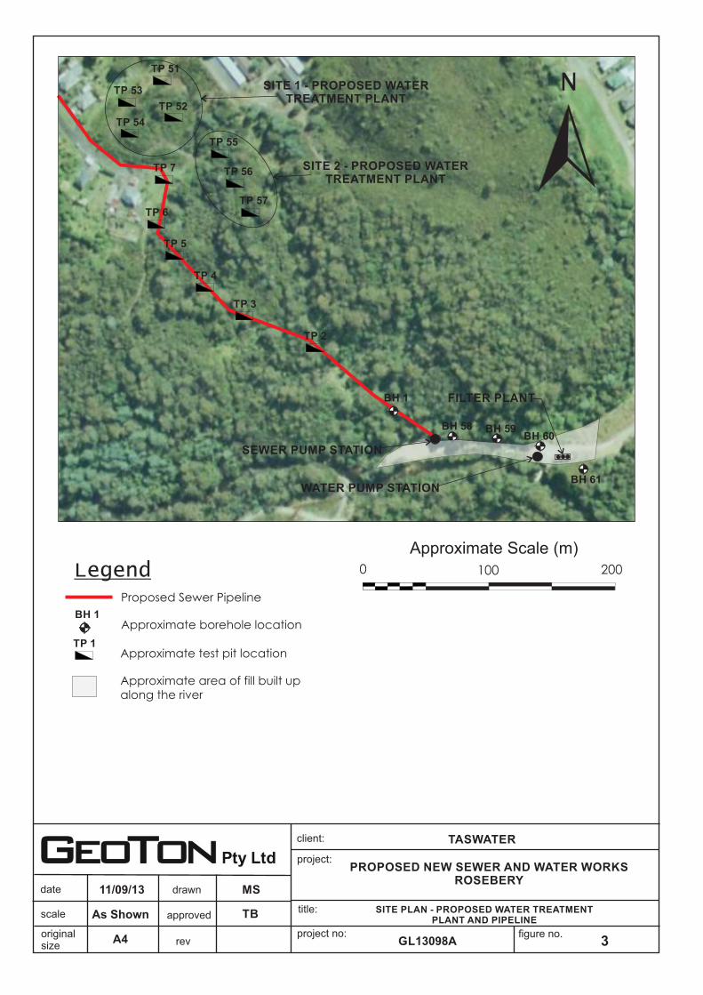
6.5 Water Pipeline
The proposed water pipeline is located in the Stirling Valley and is approximately 100m long
running along the Stitt River between the two existing pump stations. Anecdotal evidence
suggest that the area along the Stitt River has been substantially modified by the placement of
fill to create the access road and working area (see Figure 3).
Geotechnical Investigation and Landslide Risk Assessment
Geoton Pty Ltd 16 GL13098Ab 16 September 2013
The field investigation was required to be conducted using hand tools as MMG were unable to
locate their existing water pipe. Test locations 58 to 61 were drilled by hand auger, with the
subsurface conditions encountered being somewhat variable.
Boreholes BH58, BH59 and BH61 encountered topsoil or fill to depths of 0.15m to 0.5m,
overlying clayey silt or sandy silt to auger refusal on inferred rock at depths of 0.9m to 1.8m.
Borehole BH60 was unable to penetrate the fill and was terminated within the fill at a depth of
0.5m.
Groundwater seepage was encountered at depths of 0.75m to 1.5m within the Boreholes
BH58, BH59 and BH61.
It is considered that trench excavations through this section should be readily achievable for
most of the alignment with an excavator of about 20 tonne.
We consider that trenches should generally remain open over the short term for pipe
installation without the need for support. Where trench excavations encounter groundwater it
is considered that excavations below the water level will collapse requiring temporary trench
support. Excavations which encounter water seepage will require either dewatering or
consideration should be given for a wet installation with trench support.
We consider that the excavated materials would generally be suitable for trench backfilling.
Suitable pipe bedding material will need to be sourced off-site.
We consider the slopes within this section for the current pipeline alignment possess a LOW
slope stability risk.
7 DISCUSSION AND RECOMMENDATIONS
7.1 Excavation
Excavation along the section from the Stirling Valley to Propsting Street will only be partially
achievable with a conventional excavator of about 20 tonne. Due to the presence of shallow
rock larger excavating equipment and possible rock breaking will be required through this
section.
The remainder of the proposed pipeline alignment (Propsting Street to the WWTP) should be
readily achievable, to the nominal founding depth of 1.2m for the pipeline, with a conventional
excavator of about 20 tonne. Of the test locations investigated from Propsting Street to the
WWTP only 5 locations as stated in the sections of the report above encountered excavator
refusal at depths less than 1.2m.
It is recommended that at the watercourse crossings and in areas where deep uncontrolled fill
and potentially collapsible soils are encountered as stated in the sections of the report above
that shoring be provided for the trench excavation.
All trenches should be maintained in a stable condition to prevent movement or collapse and
the length of trench open at any one time should be minimised.
The minimum width of the trench shall be sufficient for the placement and compaction of
embedment materials, particularly below the pipe spring line (width) and in the haunch support

Geotechnical Investigation and Landslide Risk Assessment
Geoton Pty Ltd 17 GL13098Ab 16 September 2013
area, to ensure complete filling with material to the specified relative compaction and the
making and inspection of joints.
7.2 Pipeline Foundation
The foundation of all trenches should be within the natural ground. The test pits and
boreholes generally revealed suitable founding conditions along the route. Due to the
presence of deep uncontrolled fill in numerous scattered locations the foundation of the
trenches in these locations will be required to be deeper than the nominal founding depth of
1.2m and possible backfilling with bedding material to the design alignment depth.
For stability reasons the pipeline foundation for the outfall is required to be within the
cemented soils or weathered rock.
Soft soils and/or uncontrolled fill may be encountered in areas not covered by the investigation
in particular in low lying areas where water may pond or within water way crossings. In areas
where soft or loose soils are encountered, some improvement works such as providing a
geotextile and/or coarse rock fill should be considered to bridge across these areas of soft or
loose soils.
It is recommended that the base of trench excavations be inspected to ensure that suitable
founding conditions exist, in particular at locations where the pipeline changes direction and
thrust block structures are proposed.
7.3 Groundwater
Groundwater was encountered in some of the boreholes and test pits over their investigated
depths.
Where groundwater is encountered in trench excavations, de-watering of the trench will be
required during construction, to maintain the stability of the surrounding soil and to provide
suitable working conditions. The trench should be kept free of water until the pipeline is
installed and embedded with fill materials placed and compacted to the required height to
prevent flotation.
Alternatively, wet installation and the use of shoring may need to be considered in some
areas.
The use of heavier granular backfill may also be considered in areas where a high water table
is likely to occur along the route.
7.4 Embedment and Backfilling
Compaction of the insitu clay soils around the pipes may be problematic.
AS/NZS2566.2 recommends that material in the embedment zone should ideally consist of:
Selected cohesionless soils;
Controlled low strength materials (CL/SM); and
Stabilised soils.
Geotechnical Investigation and Landslide Risk Assessment
Geoton Pty Ltd 18 GL13098Ab 16 September 2013
It is considered that the subsurface conditions encountered in the boreholes and test pits
would be suitable for use as general backfill. Compaction of backfill will be difficult where it is
saturated or placed in trenches that have standing water. It is recommended that a free
draining granular fill be used within water filled trenches.
In soft and water logged areas, alternative encasement methods around the pipeline may be
considered through the areas of soft ground, such as placing gravel around the pipeline
wrapped in a geofabric.
7.5 Erosion
No areas of deep gully erosion were observed along the proposed pipeline route. Where the
outlet pipe passes through drainage depressions concrete encasement should be considered
to prevent possible erosion of these drainage depressions exposing the pipe. We consider
that the potential for soil erosion along the pipeline route would be minimal, provided that best
pipeline practices and the recommendations below are followed:
The upper layers of the trenches should be compacted to at least 98% standard
compaction;
The backfill should be mounded along the trench to allow for settlement and prevent
channels forming that may concentrate surface water flows causing erosion;
Where long and steep slope runs of the pipeline occur, shallow cut off drains should be
installed at about 20m spacings; and
The area should be vegetated as soon as possible or alternatively mulch should be
provided until vegetation becomes established.
8 LIMITATIONS
Although the borehole and test pit data provides an indication of subsurface conditions along
the proposed pipeline route, variations in soil conditions may occur in areas of the site not
specifically covered by the field investigation. To the best of our knowledge, they represent a
reasonable interpretation of the general condition along the proposed route. Under no
circumstances, however, can it be considered that these findings represent the actual state of
the proposed route at all points. The base of all trench excavations should therefore be
inspected to ensure that the founding medium meets the requirements of the project.
Geoton Pty Ltd ABN 69 315 541 003
Geotechnical Consultants - Limitations of report
These notes have been prepared to assist in the interpretation and understanding of the limitations of this report.
Project specific criteria
The report has been developed on the basis of unique project specific requirements as understood by Geoton and applies only to the site investigated. Project criteria are typically identified in the Client brief and the associated proposal prepared by Geoton and may include risk factors arising from limitations on scope imposed by the Client. The report should not be used without further consultation if significant changes to the project occur. No responsibility for problems that might occur due to changed factors will be accepted without consultation.
Subsurface variations with time
Because a report is based on conditions which existed at the time of subsurface exploration, decisions should not be based on a report whose adequacy may have been affected by time. For example, water levels can vary with time, fill may be placed on a site and pollutants may migrate with time. In the event of significant delays in the commencement of a project, further advice should be sought.
Interpretation of factual data
Site assessment identifies actual subsurface conditions only at those points where samples are taken and at the time they are taken. All available data is interpreted by professionals to provide an opinion about overall site conditions, their likely impact on the proposed development and recommended actions. Actual conditions may differ from those inferred to exist, as it is virtually impossible to provide a definitive subsurface profile which includes all the possible variabilities inherent in soil and rock masses.
Report Recommendations
The report is based on the assumption that the site conditions as revealed through selective point sampling are indicative of actual conditions throughout an area. This assumption cannot be substantiated until earthworks and/or foundation construction is almost complete and therefore the report recommendations can only be regarded as preliminary. Where variations in conditions are encountered, further advice should be sought.
Specific purposes
This report should not be applied to any project other than that originally specified at the time the report was issued.
Interpretation by others
Geoton will not be responsible for interpretations of site data or the report findings by others involved in the design and construction process. Where any confusion exists, clarification should be sought from Geoton.
Report integrity
The report as a whole presents the findings of the site assessment and the report should not be copied in part or altered in any way.
Geoenvironmental issues
This report does not cover issues of site contamination unless specifically required to do so by the client. In the absence of such a request, Geoton take no responsibility for such issues.

Figures

approved
date
scale title:
project no:
project:
client:
figure no.originalsize
drawn
revA3
MS11/09/13
As Shown SITE PLAN - PROPOSED SEWER PIPELINE
Figure 1
Approximate Scale (m)
3002001000 400
BH 1Approximate borehole location
DCP 2
DCP 3
DCP 5
BH 7
BH 9
BH 8
TB
TASWATER
PROPOSED NEW SEWER AND WATER WORKSROSEBERY
GL13098A
Legend
Proposed Sewer - Rising Main
Approximate test pit locationTP 1
!RS208
RS207
RS203
Park Road SPS
Stirling Valley SPS
Proposed Sewer - Gravity Main
TP 2
TP 3
TP 5
TP 6
TP 4
TP 7
TP 57
TP 55
TP 56
TP 52
TP 51TP 53
TP 54
BH 1
BH 8
TP 9
BH 10
BH 11
BH 12
BH 13
BH 14
BH 15
BH 16
TP 17
BH 18BH 19
BH 20
BH 21
TP 22
TP 23
BH 24
BH 25
BH 26
BH 27
BH 28
C 29 (cutting)
BH 30
BH 31
C 32 (cutting)
C 33 (cutting)TP 34
TP 35
TP 36
TP 37
TP 38
BH 39
BH 40
BH 41
TP 43
SEE FIGURE 2(Wastewater TreatmentPlant and Outfall)
SEE FIGURE 3(Water Treatment Plant)
C 1Approximate cutting exposure
BH 42

approved
date
rev
scale title:
project no:
project:
client:
figure no.originalsize
drawn
A4
Legend
2
MS11/09/13
SITE PLAN - PROPOSED WASTEWATER TREATMENT PLANT AND OUTFALL
TB
TASWATER
PROPOSED NEW SEWER AND WATER WORKSROSEBERY
GL13098A
As Shown
N
BH 1Approximate borehole location
Approximate test pit location
TP 46
TP 49
TP 45
TP 44
TP 48
TP 47
TP 50
TP 1
PROPOSED WASTEWATERTREATMENT PLANT
BA
RK
ER
CR
EE
K
STITT RIVER
Proposed Outfall Pipeline
AC
CE
SS
RO
AD
BH 41
BH 40
BH 39
BH 42
Approximate slopeo12
Drainage channel
Break of slope - well defined
Approximate Scale (m)100500
o
38
SMALL SHALLOWLANDSLIDE WITHINMINOR DRAINAGEDEPRESSION
PIPELINE FALLALONG BARKER
OCREEK APPROX 5-10
o
30-35
MINOR DRAINAGEDEPRESSION
o
25-30
o
25
o
18
PIPELINE FALLAROUND BEND
OAPPROX 15-19
PIPELINE FALLNEAR LEVEL - ALONG CONTOURLINE
approved
date
rev
scale title:
project no:
project:
client:
figure no.originalsize
drawn
A4
Legend
3
MS11/09/13
SITE PLAN - PROPOSED WATER TREATMENT PLANT AND PIPELINE
TB
TASWATER
PROPOSED NEW SEWER AND WATER WORKSROSEBERY
GL13098A
As Shown
BH 1Approximate borehole location
Approximate test pit locationTP 1
Proposed Sewer Pipeline
Approximate Scale (m)2001000
TP 2
TP 3
TP 4
TP 5
TP 6
TP 7
TP 57
TP 56
TP 55
TP 54
TP 53
TP 52
TP 51
BH 1
SITE 1 - PROPOSED WATERTREATMENT PLANT
SITE 2 - PROPOSED WATERTREATMENT PLANT
N
SEWER PUMP STATION
WATER PUMP STATION
FILTER PLANT
BH 58 BH 59
BH 61
BH 60
Approximate area of fill built upalong the river

approved
date
scale title:
project no:
project:
client:
figure no.originalsize
drawn
revA3
MS11/09/13
As Shown GEOLOGY PLAN
Figure 4
Approximate Scale (m)
3002001000 400Geology Legend
N
TB
TASWATER
PROPOSED NEW SEWER PIPEROSEBERY
GL13098A
Cambrian felsic volcaniclastic and pyroclastic rocks, usually feldspar phyric (Cdvt)
Cambrian units of coarse-grained crystal rich volcaniclastic sandstone (Cdsvx)
Quaternary glacial and glaciogene deposits (Qpgg)
Cambrian volcanicalstic sandstone, with minorsiltstone and conglomerate (Cdtss)
Cambrian feldspar-quartz porphyry (Cdfs)
Legend
Proposed Sewer
Cambrian felsic to intermediate volcaniclastic (Cdt)

Appendix A Borehole & Excavation Logs

ENGINEERINGBOREHOLE LOG
Geotechnical Consultants Borehole no. BH1
PO Box 522 Prospect TAS 7250 Sheet no. 1 of 1
3/1, 2 Trotters Lane Prospect TAS Job no. GL13098A
T (03) 6343 1900 F (03) 6343 1906
Date : 10/9/13
Logged By : MS
Drill model : -90O RL Surface :
- Datum :
M L FILL
0.25 D/M MD
ML M F NATURAL
0.50
St V-60kPa
0.75
1.00 W Water seepage at 1.0m
V-62kPa
1.25
1.50
1.75
2.00
2.25
HA N
Structure, additional
observations
Penetr
ation
Co
nsis
ten
cy
de
nsity,
ind
ex
Mo
istu
re c
on
ditio
n
Auger refusal due to inferred rock
(grading towards rock)
Borehole terminated at 1.5m
Client :
Project :
Location : Rosebery
Proposed New Sewer Pipe
TasWater
CLAYEY SILT - low plasticity, light
grey
Becoming orange, becoming medium
FILL - Sandy Gravel (rock fill), fine to
coarse angular gravel, brown, with
plasticity
a trace of cobbles
FILL - Sandy Silt, low plasticity, fine
grained sand, brown
Hole diameter :
Material Description
Cla
ssific
atio
n
Sym
bo
l
Depth
(m)
Inclination:
Bearing:
Me
thod Notes
Samples
Tests
Gra
phic
log
Suppo
rt
Wate
r
Easting:
Northing:
Hand Auger
80mm
With some gravel/cobbles

ENGINEERINGEXCAVATION LOG
Geotechnical Consultants Test Pit no. TP2
PO Box 522 Prospect TAS 7250 Sheet no. 1 of 1
3/1, 2 Trotters Lane Prospect TAS Job no. GL13098A
T (03) 6343 1900 F (03) 6343 1906
Date : 5/9/13
Logged By : MS
450mm -90O RL Surface :
2.0m - Datum :
ML M F Topsoil - organic matter
M MD
0.25
Massive
0.50
0.75
1.00
1.25
1.50
1.75
2.00
2.25
E
N
Excavator:
on slightly weathered rock
Co
nsis
ten
cy
de
nsity,
ind
ex
Structure, additional
observations
TOPSOIL - Clayey Silt, low plasticity,
dark grey, with some sand
HIGHLY WEATHERED ROCK
(Volcaniclastic), fine grained, medium
strength, blocky, light grey/white
Test Pit terminated at 0.3m
Excavator and ripper refusal
Depth
(m)
Gra
phic
log
Cla
ssific
atio
n
Sym
bo
l
Material Description
Mo
istu
re c
on
ditio
n
Me
thod
Suppo
rt
Penetr
ation
Wate
r Notes
Samples
Tests
5 Tonne Bucket: Inclination:
Length: Bearing:
Client : TasWater
Project : Proposed New Sewer Pipe
Location : Rosebery
ENGINEERINGEXCAVATION LOG
Geotechnical Consultants Test Pit no. TP3
PO Box 522 Prospect TAS 7250 Sheet no. 1 of 1
3/1, 2 Trotters Lane Prospect TAS Job no. GL13098A
T (03) 6343 1900 F (03) 6343 1906
Date : 5/9/13
Logged By : MS
450mm -90O RL Surface :
2.0m - Datum :
ML M L Topsoil - organic matter
ML M MD
0.25 M/W Minor seepage
D/M D
VD
0.50
0.75
1.00
1.25
1.50
1.75
2.00
2.25
E
N
Excavator and ripper refusal
on slightly weathered rock
strength, blocky, light grey
Becoming high strength
Test Pit terminated at 0.5mM
ois
ture
co
nd
itio
n
Co
nsis
ten
cy
de
nsity,
ind
ex
Structure, additional
observations
TOPSOIL - Sandy Silt, low plasticity,
fine grained sand, dark grey
SANDY GRAVELLY SILT - low
plasticity, fine to coarse gravel, grey
HIGHLY WEATHERED ROCK
(Volcaniclastic), fine grained, medium
Length: Bearing:
Me
thod
Suppo
rt
Penetr
ation
Wate
r Notes
Samples
Tests
Depth
(m)
Gra
phic
log
Cla
ssific
atio
n
Sym
bo
l
Material Description
Project : Proposed New Sewer Pipe
Location : Rosebery
Excavator: 5 Tonne Bucket: Inclination:
Client : TasWater
ENGINEERINGEXCAVATION LOG
Geotechnical Consultants Test Pit no. TP4
PO Box 522 Prospect TAS 7250 Sheet no. 1 of 1
3/1, 2 Trotters Lane Prospect TAS Job no. GL13098A
T (03) 6343 1900 F (03) 6343 1906
Date : 5/9/13
Logged By : MS
450mm -90O RL Surface :
2.0m - Datum :
M L Topsoil - organic matter
0.25
D/M D
D/M D Highly fractured (blocky)
0.50
VD
Massive
0.75
1.00
1.25
1.50
1.75
2.00
2.25
E
N
on slightly weathered rock
sandy clay between fractures
Becoming high strength
Test Pit terminated at 0.7m
Excavator and ripper refusal
light brown, sandy silt properties
HIGHLY WEATHERED ROCK
(Volcaniclastic), fine grained, medium
strength, blocky, light grey/grey, M
ois
ture
co
nd
itio
n
Co
nsis
ten
cy
de
nsity,
ind
ex
Structure, additional
observations
TOPSOIL - Clayey Silt, low plasticity,
dark brown/dark grey, with some
fine grained sand
EXTREMELY WEATHERED ROCK
(Volcaniclastic), low strength,
Length: Bearing:
Me
thod
Suppo
rt
Penetr
ation
Wate
r Notes
Samples
Tests
Depth
(m)
Gra
phic
log
Cla
ssific
atio
n
Sym
bo
l
Material Description
Project : Proposed New Sewer Pipe
Location : Rosebery
Excavator: 5 Tonne Bucket: Inclination:
Client : TasWater

ENGINEERINGEXCAVATION LOG
Geotechnical Consultants Test Pit no. TP5
PO Box 522 Prospect TAS 7250 Sheet no. 1 of 1
3/1, 2 Trotters Lane Prospect TAS Job no. GL13098A
T (03) 6343 1900 F (03) 6343 1906
Date : 5/9/13
Logged By : MS
450mm -90O RL Surface :
2.0m - Datum :
ML M L Topsoil - organic matter
0.25 D/M D Highly fractured (blocky)
VD
Massive
0.50
0.75
1.00
1.25
1.50
1.75
2.00
2.25
E
N
Test Pit terminated at 0.4m
Excavator and ripper refusal
on slightly weathered rockM
ois
ture
co
nd
itio
n
Co
nsis
ten
cy
de
nsity,
ind
ex
Structure, additional
observations
TOPSOIL - Sandy Silt, low plasticity,
fine grained sand, dark grey
HIGHLY WEATHERED ROCK
(Volcaniclastic), fine grained, high
strength, blocky, white mottled green
Length: Bearing:
Me
thod
Suppo
rt
Penetr
ation
Wate
r Notes
Samples
Tests
Depth
(m)
Gra
phic
log
Cla
ssific
atio
n
Sym
bo
l
Material Description
Project : Proposed New Sewer Pipe
Location : Rosebery
Excavator: 5 Tonne Bucket: Inclination:
Client : TasWater
ENGINEERINGEXCAVATION LOG
Geotechnical Consultants Test Pit no. TP6
PO Box 522 Prospect TAS 7250 Sheet no. 1 of 1
3/1, 2 Trotters Lane Prospect TAS Job no. GL13098A
T (03) 6343 1900 F (03) 6343 1906
Date : 5/9/13
Logged By : MS
450mm -90O RL Surface :
2.0m - Datum :
ML M L Topsoil - organic matter
ML D/M D
0.25
D D
VD
0.50
0.75
1.00
1.25
1.50
1.75
2.00
2.25
E
N
Test Pit terminated at 1.1m
Excavator refusal on slightly
weathered rock
Becoming high strength
strength, highly fractured, white/
light brown/orange
Mo
istu
re c
on
ditio
n
Co
nsis
ten
cy
de
nsity,
ind
ex
Structure, additional
observations
TOPSOIL - Sandy Silt, low plasticity,
fine grained sand, dark grey
SANDY SILT - low plasticity, fine
grained sand, light grey/orange
HIGHLY WEATHERED ROCK
(Volcaniclastic), fine grained, medium
Length: Bearing:
Me
thod
Suppo
rt
Penetr
ation
Wate
r Notes
Samples
Tests
Depth
(m)
Gra
phic
log
Cla
ssific
atio
n
Sym
bo
l
Material Description
Project : Proposed New Sewer Pipe
Location : Rosebery
Excavator: 5 Tonne Bucket: Inclination:
Client : TasWater

ENGINEERINGEXCAVATION LOG
Geotechnical Consultants Test Pit no. TP7
PO Box 522 Prospect TAS 7250 Sheet no. 1 of 1
3/1, 2 Trotters Lane Prospect TAS Job no. GL13098A
T (03) 6343 1900 F (03) 6343 1906
Date : 5/9/13
Logged By : MS
450mm -90O RL Surface :
2.0m - Datum :
M L
M L
0.25
0.50
0.75
1.00
D/M D NATURAL
1.25 D VD
1.50 D VD
1.75
2.00
2.25
E
N
Test Pit terminated at 1.8m
Excavator refusal on slightly
weathered rock
strength, highly fractured, white/
light brown/orange
HIGHLY WEATHERED ROCK
(Volcaniclastic), fine grained, high
EXTREMELY WEATHERED ROCK
(Volcaniclastic), fine grained, low
strength, highly fractured, white/
orange, sandy silt soil properties
Mo
istu
re c
on
ditio
n
Co
nsis
ten
cy
de
nsity,
ind
ex
Structure, additional
observations
FILL - Sandy Silt, low plasticity, fine
grained sand, dark grey
FILL - Mixture of sand, silt, cobbles
and gravel, orange/brown
(predominantly subangular/angular
gravel and cobbles)
Length: Bearing:
Me
thod
Suppo
rt
Penetr
ation
Wate
r Notes
Samples
Tests
Depth
(m)
Gra
phic
log
Cla
ssific
atio
n
Sym
bo
l
Material Description
Project : Proposed New Sewer Pipe
Location : Rosebery
Excavator: 5 Tonne Bucket: Inclination:
Client : TasWater
ENGINEERINGBOREHOLE LOG
Geotechnical Consultants Borehole no. BH8
PO Box 522 Prospect TAS 7250 Sheet no. 1 of 1
3/1, 2 Trotters Lane Prospect TAS Job no. GL13098A
T (03) 6343 1900 F (03) 6343 1906
Date : 29/8/13
Logged By : MS
Drill model : -90O RL Surface :
- Datum :
M L FILL
0.25 M/W Minor seepage
0.50
D/M D NATURAL
0.75
D VD
1.00
1.25
1.50
1.75
2.00
2.25
Auger refusal on inferred rock
Borehole terminated at 1.5m
HIGHLY WEATHERED ROCK
(Volcaniclastic), fine grained, medium
strength, highly fractured, light grey/
light green
EXTREMELY WEATHERED ROCK
(Volcaniclastic), fine grained, low
strength, highly fractured, white/
light grey, sandy silt soil properties
Mo
istu
re c
on
ditio
n
Co
nsis
ten
cy
de
nsity,
ind
ex
Structure, additional
observations
AD
V
N
FILL - Mixture of Silty Sand and
Sandy Clay, fine grained, medium
plasticity, orange and grey, with
some gravel/cobbles
Hole diameter : 130mm Northing: Bearing:
Me
thod
Suppo
rt
Penetr
ation
Wate
r Notes
Samples
Tests
Depth
(m)
Gra
phic
log
Cla
ssific
atio
n
Sym
bo
l
Material Description
Location : Rosebery
Drilltech Easting: Inclination:
Client : TasWater
Project : Proposed New Sewer Pipe
ENGINEERINGEXCAVATION LOG
Geotechnical Consultants Test Pit no. TP9
PO Box 522 Prospect TAS 7250 Sheet no. 1 of 1
3/1, 2 Trotters Lane Prospect TAS Job no. GL13098A
T (03) 6343 1900 F (03) 6343 1906
Date : 5/9/13
Logged By : MS
450mm -90O RL Surface :
2.0m - Datum :
M L FILL
0.25
D/M VD
D
0.50
0.75
1.00
1.25
1.50
1.75
2.00
2.25
Excavator and ripper refusal on
slightly weathered rock
Test Pit terminated at 0.7m
(Volcaniclastic), fine grained, medium
strength, highly fractured, light grey/
light green/cream
plasticity, orange and grey, with
some gravel/cobbles
HIGHLY WEATHERED ROCK
Co
nsis
ten
cy
de
nsity,
ind
ex
Structure, additional
observations
FILL - Mixture of Silty Sand and
Sandy Clay, fine grained, medium
Depth
(m)
Gra
phic
log
Cla
ssific
atio
n
Sym
bo
l
Material Description
Mo
istu
re c
on
ditio
n
Me
thod
Suppo
rt
Penetr
ation
Wate
r Notes
Samples
Tests
E
N
5 Tonne Bucket: Inclination:
Length: Bearing:
Excavator:
Client : TasWater
Project : Proposed New Sewer Pipe
Location : Rosebery
ENGINEERINGBOREHOLE LOG
Geotechnical Consultants Borehole no. BH10
PO Box 522 Prospect TAS 7250 Sheet no. 1 of 1
3/1, 2 Trotters Lane Prospect TAS Job no. GL13098A
T (03) 6343 1900 F (03) 6343 1906
Date : 29/8/13
Logged By : MS
Drill model : -90O RL Surface :
- Datum :
M L
0.25
M/W Minor seepage
0.50
D/M D NATURAL
D
0.75
1.00
D VD
1.25
1.50
1.75
2.00
2.25
AD
V
N
Borehole terminated at 1.5m
Auger refusal on inferred rock
HIGHLY WEATHERED ROCK
(Volcaniclastic), fine grained, medium
strength, highly fractured, light brown/
white
EXTREMELY WEATHERED ROCK
(Volcaniclastic), fine grained, low
strength, highly fractured, light
brown, sandy silt soil properties
cobbles
Co
nsis
ten
cy
de
nsity,
ind
ex
Structure, additional
observations
FILL - Sandy Silt, low plasticity, fine
grained sand, grey, with some
Depth
(m)
Gra
phic
log
Cla
ssific
atio
n
Sym
bo
l
Material Description
Mo
istu
re c
on
ditio
n
Me
thod
Suppo
rt
Penetr
ation
Wate
r Notes
Samples
Tests
Drilltech Easting: Inclination:
Hole diameter : 130mm Northing: Bearing:
Client : TasWater
Project : Proposed New Sewer Pipe
Location : Rosebery

ENGINEERINGBOREHOLE LOG
Geotechnical Consultants Borehole no. BH11
PO Box 522 Prospect TAS 7250 Sheet no. 1 of 1
3/1, 2 Trotters Lane Prospect TAS Job no. GL13098A
T (03) 6343 1900 F (03) 6343 1906
Date : 29/8/13
Logged By : MS
Drill model : -90O RL Surface :
- Datum :
M L FILL
0.25
M L
0.50
M L
0.75
1.00
1.25
1.50
1.75 (possible old topsoil layer)
SM M MD NATURAL
2.00
D VD
2.25
AD
V
N
HIGHLY WEATHERED ROCK
(Volcaniclastic), fine grained, medium
strength, highly fractured, light brown/
white, low plasticity fines
Borehole terminated at 2.2m
SILTY SAND - fine grained, light
brown/light green, with a trace of
cobbles
With some cobbles
Becoming dark grey
FILL - Clayey Sand, fine/medium
grained sand, low plasticity fines,
light brown, with a trace of organic
matter
grained sand, dark grey
clay
FILL - Sandy Silt, low plasticity, fine
Co
nsis
ten
cy
de
nsity,
ind
ex
Structure, additional
observations
FILL - Gravelly Sand, fine to coarse
grained, orange/brown, with some
Depth
(m)
Gra
phic
log
Cla
ssific
atio
n
Sym
bo
l
Material Description
Mo
istu
re c
on
ditio
n
Me
thod
Suppo
rt
Penetr
ation
Wate
r Notes
Samples
Tests
Drilltech Easting: Inclination:
Hole diameter : 130mm Northing: Bearing:
Client : TasWater
Project : Proposed New Sewer Pipe
Location : Rosebery
ENGINEERINGBOREHOLE LOG
Geotechnical Consultants Borehole no. BH12
PO Box 522 Prospect TAS 7250 Sheet no. 1 of 1
3/1, 2 Trotters Lane Prospect TAS Job no. GL13098A
T (03) 6343 1900 F (03) 6343 1906
Date : 29/8/13
Logged By : MS
Drill model : -90O RL Surface :
- Datum :
M L FILL
MD
0.25
0.50
SM M MD NATURAL
0.75
1.00
ML M MD
1.25
1.50
W Water seepage at 1.5m
1.75
2.00
2.25
Borehole terminated at 2.0m
Becoming light brown
Becoming light green, with a trace
of clay
SANDY GRAVELLY SILT - low
plasticity, fine sand, light green/light
brown
SILTY SAND - fine grained, brown/
grey, with some clay and a trace of
gravel
Co
nsis
ten
cy
de
nsity,
ind
ex
Structure, additional
observations
FILL - Sandy Gravel, fine to coarse
gravel (subangular, bluestone), grey
Depth
(m)
Gra
phic
log
Cla
ssific
atio
n
Sym
bo
l
Material Description
Mo
istu
re c
on
ditio
n
Me
thod
Suppo
rt
Penetr
ation
Wate
r Notes
Samples
Tests
AD
V
N
Drilltech Easting: Inclination:
Hole diameter : 130mm Northing: Bearing:
Client : TasWater
Project : Proposed New Sewer Pipe
Location : Rosebery

ENGINEERINGBOREHOLE LOG
Geotechnical Consultants Borehole no. BH13
PO Box 522 Prospect TAS 7250 Sheet no. 1 of 1
3/1, 2 Trotters Lane Prospect TAS Job no. GL13098A
T (03) 6343 1900 F (03) 6343 1906
Date : 29/8/13
Logged By : MS
Drill model : -90O RL Surface :
- Datum :
M MD Bitumen Seal
0.25 D/M
M MD NATURAL?
0.50
ML M St NATURAL
0.75
1.00 V-70kPa
1.25
ML M St
1.50
W Water seepage at 1.6m
1.75
2.00
2.25 Borehole terminated at 2.2m
AD
V
N
SANDY SILT - low plasticity, fine
grained sand, light grey
SANDY CLAYEY SILT - low plasticity,
light grey mottled orange
FILL? - Sandy Gravel Silt, low
plasticity, fine to coarse gravel, brown
silt
Co
nsis
ten
cy
de
nsity,
ind
ex
Structure, additional
observations
FILL - Sandy Gravel Roadbase, fine
to coarse gravel, grey, with some
Depth
(m)
Gra
phic
log
Cla
ssific
atio
n
Sym
bo
l
Material Description
Mo
istu
re c
on
ditio
n
Me
thod
Suppo
rt
Penetr
ation
Wate
r Notes
Samples
Tests
Drilltech Easting: Inclination:
Hole diameter : 130mm Northing: Bearing:
Client : TasWater
Project : Proposed New Sewer Pipe
Location : Rosebery

ENGINEERINGBOREHOLE LOG
Geotechnical Consultants Borehole no. BH14
PO Box 522 Prospect TAS 7250 Sheet no. 1 of 1
3/1, 2 Trotters Lane Prospect TAS Job no. GL13098A
T (03) 6343 1900 F (03) 6343 1906
Date : 29/8/13
Logged By : MS
Drill model : -90O RL Surface :
- Datum :
M MD FILL
0.25
M MD
0.50
0.75
ML M F NATURAL
1.00 V-40kPa
1.25
1.50 W St V-54kPa
1.75
2.00 V-60kPa
2.25
Client :
Borehole terminated at 2.2m
AD
V
N
Becoming light grey/light brown
SANDY SILT - low plasticity, fine
grained sand, light grey, with a
trace of clay
with some cobbles
FILL - Clayey Sand, fine grained,
low plasticity fines, orange/brown,
Co
nsis
ten
cy
de
nsity,
ind
ex
Structure, additional
observations
FILL - Sandy Gravel Roadbase, fine
to coarse gravel, brown
Depth
(m)
Gra
phic
log
Cla
ssific
atio
n
Sym
bo
l
Material Description
Mo
istu
re c
on
ditio
n
Me
thod
Suppo
rt
Penetr
ation
Wate
r Notes
Samples
Tests
Drilltech Easting: Inclination:
Hole diameter : 130mm Northing: Bearing:
TasWater
Project : Proposed New Sewer Pipe
Location : Rosebery
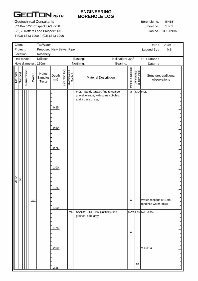
ENGINEERINGBOREHOLE LOG
Geotechnical Consultants Borehole no. BH15
PO Box 522 Prospect TAS 7250 Sheet no. 1 of 2
3/1, 2 Trotters Lane Prospect TAS Job no. GL13098A
T (03) 6343 1900 F (03) 6343 1906
Date : 29/8/13
Logged By : MS
Drill model : -90O RL Surface :
- Datum :
M MD FILL
0.25
0.50
0.75
1.00
1.25
W Water seepage at 1.4m
(perched water table)
1.50
ML M/W F/S NATURAL
1.75
W
2.00 F V-40kPa
St
2.25
Me
thod
Suppo
rt
Penetr
ation
Wate
r
SANDY SILT - low plasticity, fine
grained, dark grey
AD
V
N
and a trace of clay
Co
nsis
ten
cy
de
nsity,
ind
ex
Structure, additional
observations
FILL - Sandy Gravel, fine to coarse
gravel, orange, with some cobbles,
Depth
(m)
Gra
phic
log
Cla
ssific
atio
n
Sym
bo
l
Material Description
Mo
istu
re c
on
ditio
n
Notes
Samples
Tests
Drilltech Easting: Inclination:
Hole diameter : 130mm Northing: Bearing:
Client : TasWater
Project : Proposed New Sewer Pipe
Location : Rosebery
ENGINEERINGBOREHOLE LOG
Geotechnical Consultants Borehole no. BH15
PO Box 522 Prospect TAS 7250 Sheet no. 2 of 2
3/1, 2 Trotters Lane Prospect TAS Job no. GL13098A
T (03) 6343 1900 F (03) 6343 1906
Date : 29/8/13
Logged By : MS
Drill model : -90O RL Surface :
- Datum :
ML W St
2.50
2.75
3.00
3.25
3.50
3.75
4.00
4.25
4.50
Client :
Borehole terminated at 2.6m
Auger refusal due to inferred rock
Co
nsis
ten
cy
de
nsity,
ind
ex
Structure, additional
observations
SANDY SILT - low plasticity, fine
grained, dark grey
Depth
(m)
Gra
phic
log
Cla
ssific
atio
n
Sym
bo
l
Material Description
Mo
istu
re c
on
ditio
n
Me
thod
Suppo
rt
Penetr
ation
Wate
r Notes
Samples
Tests
Drilltech Easting: Inclination:
Hole diameter : 130mm Northing: Bearing:
AD
V
N
TasWater
Project : Proposed New Sewer Pipe
Location : Rosebery
ENGINEERINGBOREHOLE LOG
Geotechnical Consultants Borehole no. BH16
PO Box 522 Prospect TAS 7250 Sheet no. 1 of 2
3/1, 2 Trotters Lane Prospect TAS Job no. GL13098A
T (03) 6343 1900 F (03) 6343 1906
Date : 29/8/13
Logged By : MS
Drill model : -90O RL Surface :
- Datum :
M MD FILL
0.25
D/M
0.50
0.75 D/M MD/
L
1.00
1.25
1.50
1.75
2.00
2.25
Me
thod
Suppo
rt
Penetr
ation
Wate
r
AD
V
N
grained, light grey, with some silt
FILL - Gravelly Sand, fine to coarse
and a trace of clay
Co
nsis
ten
cy
de
nsity,
ind
ex
Structure, additional
observations
FILL - Sandy Gravel, fine to coarse
gravel, orange, with some cobbles,
Depth
(m)
Gra
phic
log
Cla
ssific
atio
n
Sym
bo
l
Material Description
Mo
istu
re c
on
ditio
n
Notes
Samples
Tests
Drilltech Easting: Inclination:
Hole diameter : 130mm Northing: Bearing:
Client : TasWater
Project : Proposed New Sewer Pipe
Location : Rosebery

ENGINEERINGBOREHOLE LOG
Geotechnical Consultants Borehole no. BH16
PO Box 522 Prospect TAS 7250 Sheet no. 2 of 2
3/1, 2 Trotters Lane Prospect TAS Job no. GL13098A
T (03) 6343 1900 F (03) 6343 1906
Date : 29/8/13
Logged By : MS
Drill model : -90O RL Surface :
- Datum :
D/M MD FILL
2.50 W Water seepage at 2.5m
(perched water table)
2.75
3.00
ML M St NATURAL
3.25
3.50
3.75
4.00
4.25
4.50
Client :
Borehole terminated at 3.5m
Auger refusal due to inferred rock
GRAVELLY SILT - low plasticity,
fine to coarse gravel, light grey/
light green
Co
nsis
ten
cy
de
nsity,
ind
ex
Structure, additional
observations
FILL - Gravelly Sand, fine to coarse
grained, light grey, with some silt
Depth
(m)
Gra
phic
log
Cla
ssific
atio
n
Sym
bo
l
Material Description
Mo
istu
re c
on
ditio
n
Me
thod
Suppo
rt
Penetr
ation
Wate
r Notes
Samples
Tests
Drilltech Easting: Inclination:
Hole diameter : 130mm Northing: Bearing:
AD
V
N
TasWater
Project : Proposed New Sewer Pipe
Location : Rosebery
ENGINEERINGEXCAVATION LOG
Geotechnical Consultants Test Pit no. TP17
PO Box 522 Prospect TAS 7250 Sheet no. 1 of 1
3/1, 2 Trotters Lane Prospect TAS Job no. GL13098A
T (03) 6343 1900 F (03) 6343 1906
Date : 4/9/13
Logged By : MS
450mm -90O RL Surface :
2.0m - Datum :
M L FILL
0.25 M/W Minor seepage
above natural
SW M D NATURAL
0.50
0.75
D VD
1.00
1.25
1.50
1.75
2.00
2.25
Me
thod
Suppo
rt
Penetr
ation
Wate
r
E
N
on slightly weathered rock
HIGHLY WEATHERED ROCK
(Volcaniclastic Sandstone), high
strength, light green
Test Pit terminated at 0.9m
Excavator and ripper refusal
GRAVELLY SAND - fine to coarse
grained, brown/light green, with some
cobbles/boulders, weakly cemented
cobbles
Co
nsis
ten
cy
de
nsity,
ind
ex
Structure, additional
observations
FILL - Sandy Silt, low plasticity, fine
grained sand, grey, with some
Depth
(m)
Gra
phic
log
Cla
ssific
atio
n
Sym
bo
l
Material Description
Mo
istu
re c
on
ditio
n
Notes
Samples
Tests
5 Tonne Bucket: Inclination:
Length: Bearing:
Excavator:
Client : TasWater
Project : Proposed New Sewer Pipe
Location : Rosebery
ENGINEERINGBOREHOLE LOG
Geotechnical Consultants Borehole no. BH18
PO Box 522 Prospect TAS 7250 Sheet no. 1 of 1
3/1, 2 Trotters Lane Prospect TAS Job no. GL13098A
T (03) 6343 1900 F (03) 6343 1906
Date : 29/8/13
Logged By : MS
Drill model : -90O RL Surface :
- Datum :
M L
0.25
M F
0.50
0.75
1.00 M/W F/S V-30kPa
1.25 W Water seepage at 1.25m
(perched water table)
1.50
ML M St NATURAL
D/M
1.75
2.00
2.25
SANDY SILT - low plasticity, fine
grained sand, light green/grey, with
some gravel
grading towards rock?
FILL - Clayey Silt, medium plasticity,
orange mottled grey, with some
with a trace of cobbles
Borehole terminated at 1.8m
Auger refusal due to inferred rock
Co
nsis
ten
cy
de
nsity,
ind
ex
Structure, additional
observations
FILL - Clayey Gravel, fine to coarse
gravel, low plasticity fines, brown,
Depth
(m)
Gra
phic
log
Cla
ssific
atio
n
Sym
bo
l
Material Description
Mo
istu
re c
on
ditio
n
Me
thod
Suppo
rt
Penetr
ation
Wate
r Notes
Samples
Tests
Drilltech Easting: Inclination:
Hole diameter : 130mm Northing: Bearing:
AD
V
N
Becoming brown/dark brown
gravel
TasWater
Project : Proposed New Sewer Pipe
Location : Rosebery
Client :

ENGINEERINGBOREHOLE LOG
Geotechnical Consultants Borehole no. BH19
PO Box 522 Prospect TAS 7250 Sheet no. 1 of 1
3/1, 2 Trotters Lane Prospect TAS Job no. GL13098A
T (03) 6343 1900 F (03) 6343 1906
Date : 29/8/13
Logged By : MS
Drill model : -90O RL Surface :
- Datum :
M F
0.25
0.50 V-44kPa
M/W Minor seepage above
0.75 the natural ground
ML M St NATURAL
1.00 V-64kPa
1.25
1.50
1.75 W Water seepage at 1.75m
2.00 V-refusal
2.25
Borehole terminated at 2.0m
With some gravel
Becoming light grey, no clay
Becoming orange, with some clay
Co
nsis
ten
cy
de
nsity,
ind
ex
Structure, additional
observations
FILL - Clayey Silt, low plasticity, dark
grey, with some gravel
Depth
(m)
Gra
phic
log
Cla
ssific
atio
n
Sym
bo
l
Material Description
Mo
istu
re c
on
ditio
n
Me
thod
Suppo
rt
Penetr
ation
Wate
r Notes
Samples
Tests
AD
V
N
SANDY SILT - low plasticity, fine
grained sand, light brown, with a
trace of gravel
Drilltech Easting: Inclination:
Hole diameter : 130mm Northing: Bearing:
Client : TasWater
Project : Proposed New Sewer Pipe
Location : Rosebery
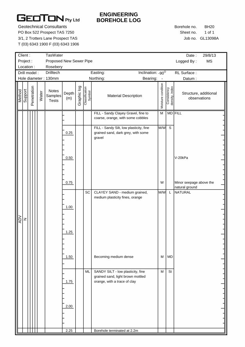
ENGINEERINGBOREHOLE LOG
Geotechnical Consultants Borehole no. BH20
PO Box 522 Prospect TAS 7250 Sheet no. 1 of 1
3/1, 2 Trotters Lane Prospect TAS Job no. GL13098A
T (03) 6343 1900 F (03) 6343 1906
Date : 29/8/13
Logged By : MS
Drill model : -90O RL Surface :
- Datum :
M MD FILL
M/W S
0.25
0.50 V-20kPa
0.75 W Minor seepage above the
natural ground
SC M/W L NATURAL
1.00
1.25
1.50 M MD
ML M St
1.75
2.00
2.25 Borehole terminated at 2.2m
SANDY SILT - low plasticity, fine
grained sand, light brown mottled
orange, with a trace of clay
AD
V
N
Becoming medium dense
CLAYEY SAND - medium grained,
medium plasticity fines, orange
FILL - Sandy Silt, low plasticity, fine
grained sand, dark grey, with some
gravel
Co
nsis
ten
cy
de
nsity,
ind
ex
Structure, additional
observations
FILL - Sandy Clayey Gravel, fine to
coarse, orange, with some cobbles
Depth
(m)
Gra
phic
log
Cla
ssific
atio
n
Sym
bo
l
Material Description
Mo
istu
re c
on
ditio
n
Me
thod
Suppo
rt
Penetr
ation
Wate
r Notes
Samples
Tests
Drilltech Easting: Inclination:
Hole diameter : 130mm Northing: Bearing:
Client : TasWater
Project : Proposed New Sewer Pipe
Location : Rosebery
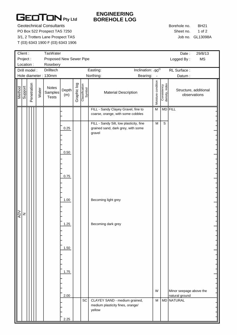
ENGINEERINGBOREHOLE LOG
Geotechnical Consultants Borehole no. BH21
PO Box 522 Prospect TAS 7250 Sheet no. 1 of 2
3/1, 2 Trotters Lane Prospect TAS Job no. GL13098A
T (03) 6343 1900 F (03) 6343 1906
Date : 29/8/13
Logged By : MS
Drill model : -90O RL Surface :
- Datum :
M MD FILL
M S
0.25
0.50
0.75
1.00
1.25
1.50
1.75
W Minor seepage above the
2.00 natural ground
SC M MD NATURAL
2.25
AD
V
N
CLAYEY SAND - medium grained,
medium plasticity fines, orange/
yellow
Becoming dark grey
Becoming light grey
FILL - Sandy Silt, low plasticity, fine
grained sand, dark grey, with some
gravel
Co
nsis
ten
cy
de
nsity,
ind
ex
Structure, additional
observations
FILL - Sandy Clayey Gravel, fine to
coarse, orange, with some cobbles
Depth
(m)
Gra
phic
log
Cla
ssific
atio
n
Sym
bo
l
Material Description
Mo
istu
re c
on
ditio
n
Me
thod
Suppo
rt
Penetr
ation
Wate
r Notes
Samples
Tests
Drilltech Easting: Inclination:
Hole diameter : 130mm Northing: Bearing:
Client : TasWater
Project : Proposed New Sewer Pipe
Location : Rosebery
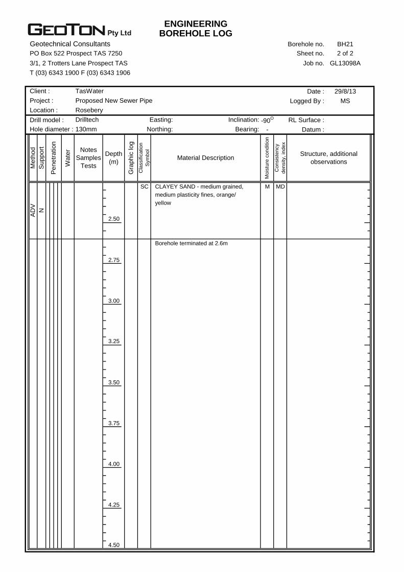
ENGINEERINGBOREHOLE LOG
Geotechnical Consultants Borehole no. BH21
PO Box 522 Prospect TAS 7250 Sheet no. 2 of 2
3/1, 2 Trotters Lane Prospect TAS Job no. GL13098A
T (03) 6343 1900 F (03) 6343 1906
Date : 29/8/13
Logged By : MS
Drill model : -90O RL Surface :
- Datum :
SC M MD
2.50
2.75
3.00
3.25
3.50
3.75
4.00
4.25
4.50
Structure, additional
observations
CLAYEY SAND - medium grained,
medium plasticity fines, orange/
Depth
(m)
Gra
phic
log
Cla
ssific
atio
n
Sym
bo
l
Material Description
Mo
istu
re c
on
ditio
n
Notes
Samples
Tests
Drilltech Easting: Inclination:
Hole diameter : 130mm Northing: Bearing:
Client : TasWater
Project : Proposed New Sewer Pipe
Location : Rosebery
Borehole terminated at 2.6m
yellow
Co
nsis
ten
cy
de
nsity,
ind
ex
AD
V
N
Me
thod
Suppo
rt
Penetr
ation
Wate
r
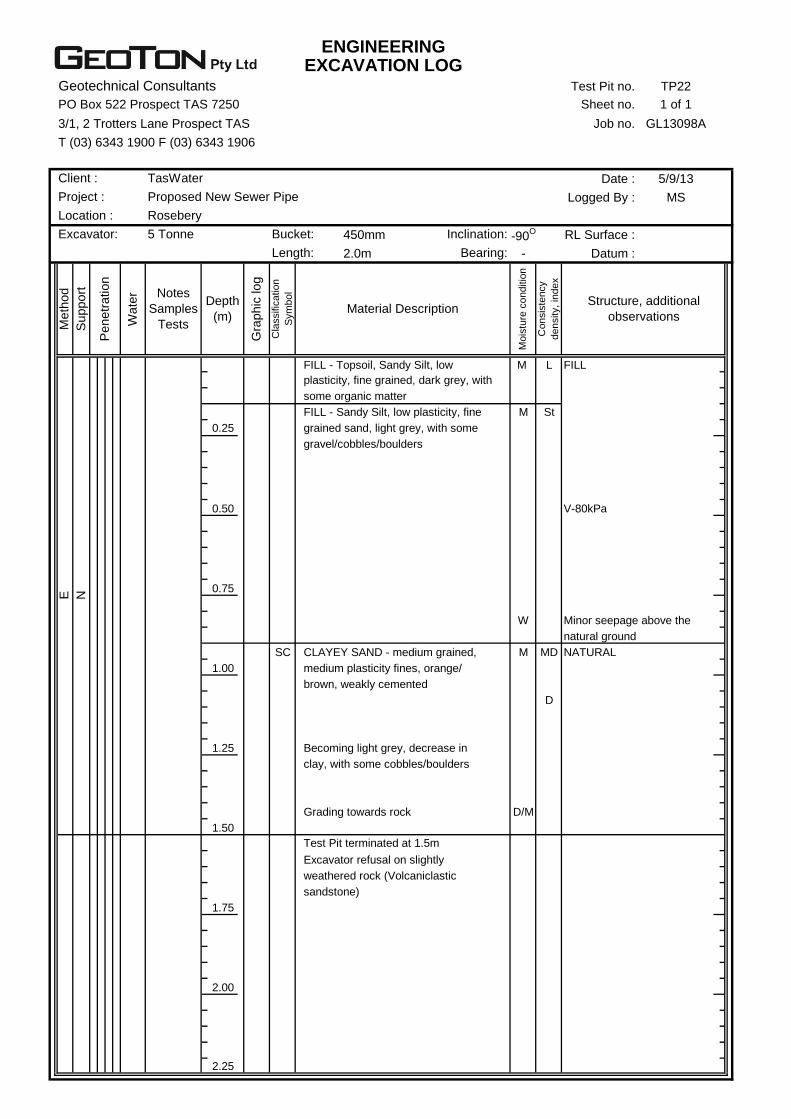
ENGINEERINGEXCAVATION LOG
Geotechnical Consultants Test Pit no. TP22
PO Box 522 Prospect TAS 7250 Sheet no. 1 of 1
3/1, 2 Trotters Lane Prospect TAS Job no. GL13098A
T (03) 6343 1900 F (03) 6343 1906
Date : 5/9/13
Logged By : MS
450mm -90O RL Surface :
2.0m - Datum :
M L FILL
M St
0.25
0.50 V-80kPa
0.75
W Minor seepage above the
natural ground
SC M MD NATURAL
1.00
D
1.25
D/M
1.50
1.75
2.00
2.25
Test Pit terminated at 1.5m
Excavator refusal on slightly
weathered rock (Volcaniclastic
sandstone)
clay, with some cobbles/boulders
Grading towards rock
brown, weakly cemented
Becoming light grey, decrease in
some organic matter
FILL - Sandy Silt, low plasticity, fine
grained sand, light grey, with some
gravel/cobbles/boulders
Co
nsis
ten
cy
de
nsity,
ind
ex
Structure, additional
observations
FILL - Topsoil, Sandy Silt, low
plasticity, fine grained, dark grey, with
Depth
(m)
Gra
phic
log
Cla
ssific
atio
n
Sym
bo
l
Material Description
Mo
istu
re c
on
ditio
n
Me
thod
Suppo
rt
Penetr
ation
Wate
r Notes
Samples
Tests
5 Tonne Bucket: Inclination:
Length: Bearing:
Excavator:
E
N
CLAYEY SAND - medium grained,
medium plasticity fines, orange/
Client : TasWater
Project : Proposed New Sewer Pipe
Location : Rosebery
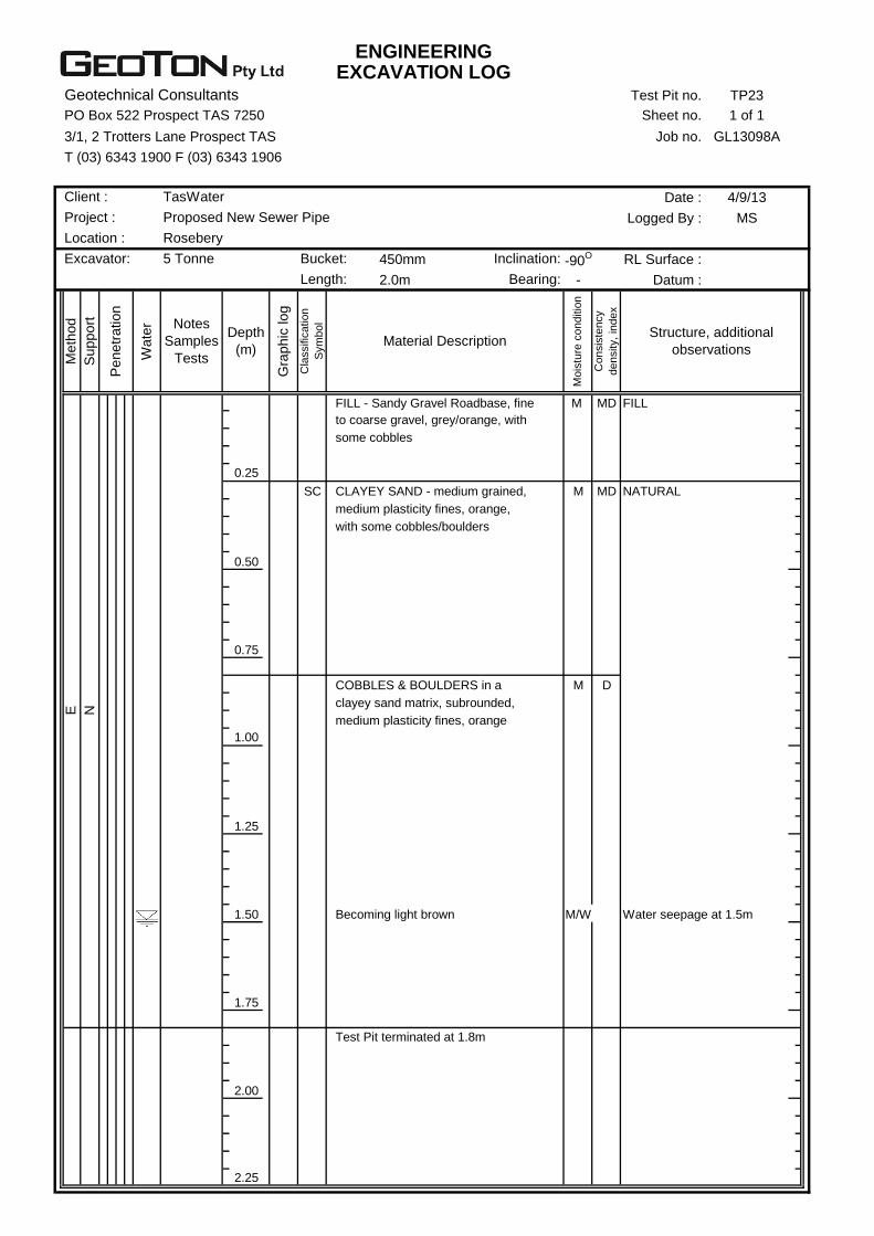
ENGINEERINGEXCAVATION LOG
Geotechnical Consultants Test Pit no. TP23
PO Box 522 Prospect TAS 7250 Sheet no. 1 of 1
3/1, 2 Trotters Lane Prospect TAS Job no. GL13098A
T (03) 6343 1900 F (03) 6343 1906
Date : 4/9/13
Logged By : MS
450mm -90O RL Surface :
2.0m - Datum :
M MD FILL
0.25
SC M MD NATURAL
0.50
0.75
M D
1.00
1.25
1.50 M/W Water seepage at 1.5m
1.75
2.00
2.25
some cobbles
CLAYEY SAND - medium grained,
Test Pit terminated at 1.8m
Becoming light brown
Co
nsis
ten
cy
de
nsity,
ind
ex
Structure, additional
observations
FILL - Sandy Gravel Roadbase, fine
to coarse gravel, grey/orange, with
Depth
(m)
Gra
phic
log
Cla
ssific
atio
n
Sym
bo
l
Material Description
Mo
istu
re c
on
ditio
n
Me
thod
Suppo
rt
Penetr
ation
Wate
r Notes
Samples
Tests
E
N
COBBLES & BOULDERS in a
clayey sand matrix, subrounded,
medium plasticity fines, orange
medium plasticity fines, orange,
with some cobbles/boulders
5 Tonne Bucket: Inclination:
Length: Bearing:
Client : TasWater
Project : Proposed New Sewer Pipe
Location : Rosebery
Excavator:

ENGINEERINGBOREHOLE LOG
Geotechnical Consultants Borehole no. BH24
PO Box 522 Prospect TAS 7250 Sheet no. 1 of 1
3/1, 2 Trotters Lane Prospect TAS Job no. GL13098A
T (03) 6343 1900 F (03) 6343 1906
Date : 29/8/13
Logged By : MS
Drill model : -90O RL Surface :
- Datum :
ML M L Topsoil - grass roots
Disturbed
0.25
ML M St NATURAL
0.50
ML M St
0.75
1.00 V-80kPa
1.25
1.50
1.75 W Water seepage at 1.75m
SW W MD
2.00 V-refusal
D
2.25
Grading towards rock
Borehole terminated 2.15m, Auger
refusal on inferred rock
GRAVELLY SAND - fine to coarse
grained, brown, with a trace of clay
CLAYEY SILT - medium plasticity,
orange, with some fine grained
sand
grained sand, light grey/cream, with
a trace of clay
some gravel
SANDY SILT - low plasticity, fine
Co
nsis
ten
cy
de
nsity,
ind
ex
Structure, additional
observations
TOPSOIL - Sandy Silt, low plasticity,
fine grained sand, dark grey, with
Depth
(m)
Gra
phic
log
Cla
ssific
atio
n
Sym
bo
l
Material Description
Mo
istu
re c
on
ditio
n
Me
thod
Suppo
rt
Penetr
ation
Wate
r Notes
Samples
Tests
AD
V
N
Drilltech Easting: Inclination:
Hole diameter : 130mm Northing: Bearing:
Client : TasWater
Project : Proposed New Sewer Pipe
Location : Rosebery
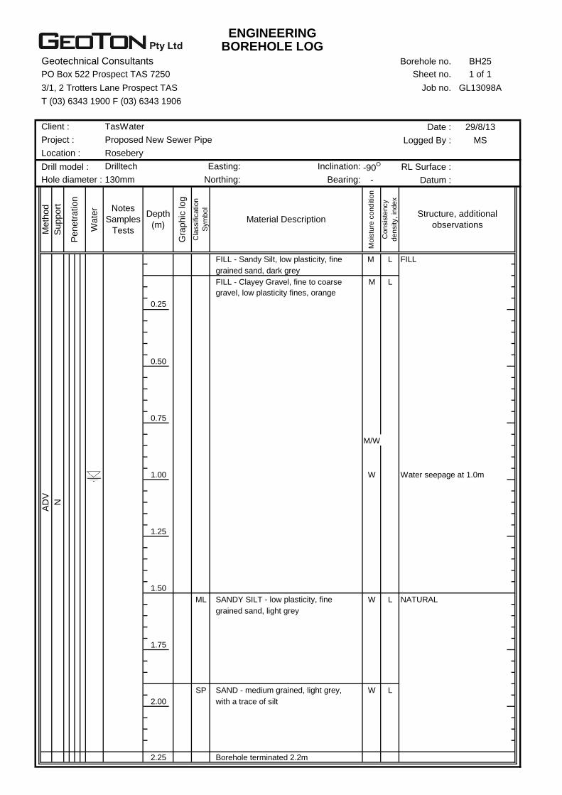
ENGINEERINGBOREHOLE LOG
Geotechnical Consultants Borehole no. BH25
PO Box 522 Prospect TAS 7250 Sheet no. 1 of 1
3/1, 2 Trotters Lane Prospect TAS Job no. GL13098A
T (03) 6343 1900 F (03) 6343 1906
Date : 29/8/13
Logged By : MS
Drill model : -90O RL Surface :
- Datum :
M L FILL
M L
0.25
0.50
0.75
M/W
1.00 W Water seepage at 1.0m
1.25
1.50
ML W L NATURAL
1.75
SP W L
2.00
2.25 Borehole terminated 2.2m
SAND - medium grained, light grey,
with a trace of silt
SANDY SILT - low plasticity, fine
grained sand, light grey
AD
V
N
FILL - Clayey Gravel, fine to coarse
gravel, low plasticity fines, orange
Co
nsis
ten
cy
de
nsity,
ind
ex
Structure, additional
observations
FILL - Sandy Silt, low plasticity, fine
grained sand, dark grey
Depth
(m)
Gra
phic
log
Cla
ssific
atio
n
Sym
bo
l
Material Description
Mo
istu
re c
on
ditio
n
Me
thod
Suppo
rt
Penetr
ation
Wate
r Notes
Samples
Tests
Drilltech Easting: Inclination:
Hole diameter : 130mm Northing: Bearing:
Client : TasWater
Project : Proposed New Sewer Pipe
Location : Rosebery
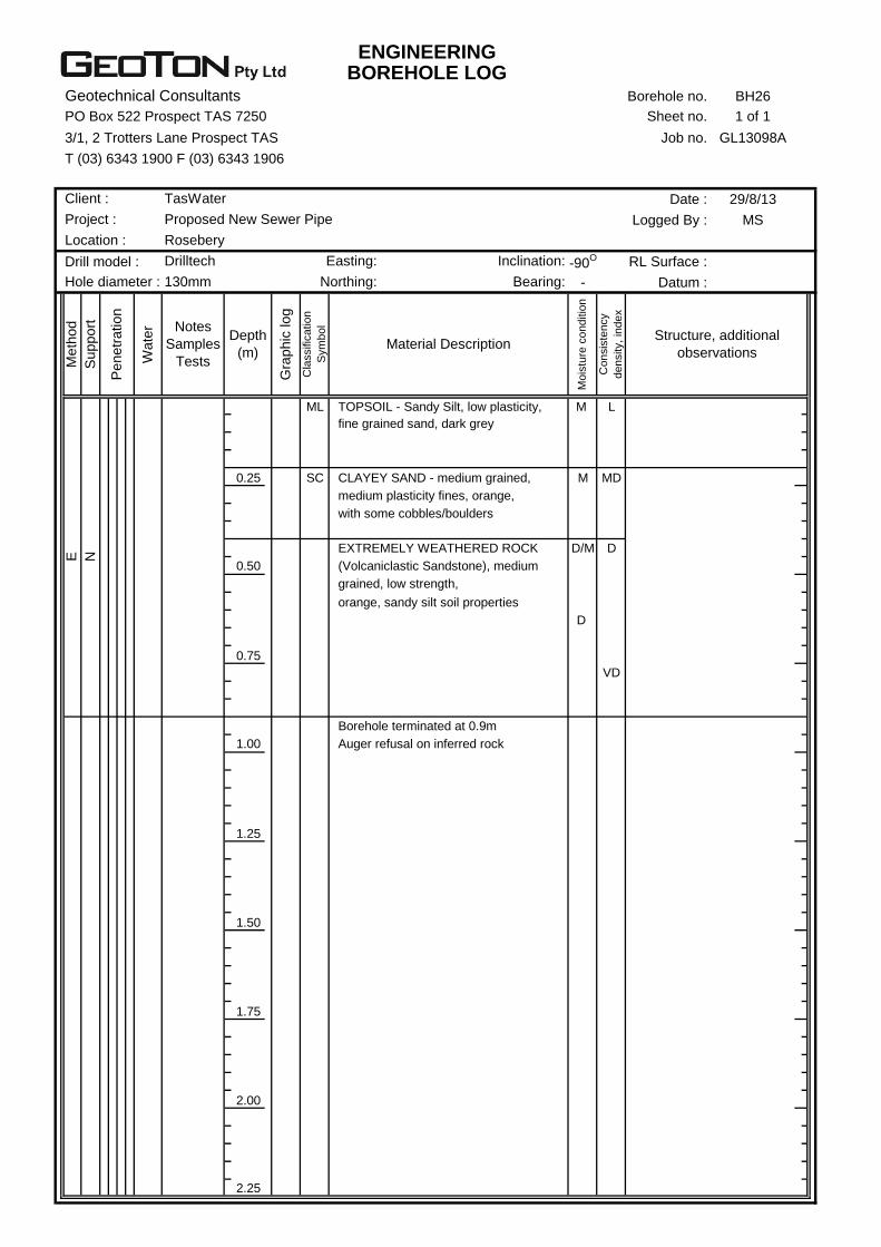
ENGINEERINGBOREHOLE LOG
Geotechnical Consultants Borehole no. BH26
PO Box 522 Prospect TAS 7250 Sheet no. 1 of 1
3/1, 2 Trotters Lane Prospect TAS Job no. GL13098A
T (03) 6343 1900 F (03) 6343 1906
Date : 29/8/13
Logged By : MS
Drill model : -90O RL Surface :
- Datum :
ML M L
0.25 SC M MD
D/M D
0.50
D
0.75
VD
1.00
1.25
1.50
1.75
2.00
2.25
Borehole terminated at 0.9m
Auger refusal on inferred rock
grained, low strength,
orange, sandy silt soil properties
with some cobbles/boulders
EXTREMELY WEATHERED ROCK
(Volcaniclastic Sandstone), medium
CLAYEY SAND - medium grained,
medium plasticity fines, orange,
Co
nsis
ten
cy
de
nsity,
ind
ex
Structure, additional
observations
TOPSOIL - Sandy Silt, low plasticity,
fine grained sand, dark grey
Depth
(m)
Gra
phic
log
Cla
ssific
atio
n
Sym
bo
l
Material Description
Mo
istu
re c
on
ditio
n
Me
thod
Suppo
rt
Penetr
ation
Wate
r Notes
Samples
Tests
Drilltech Easting: Inclination:
Hole diameter : 130mm Northing: Bearing:
E N
Client : TasWater
Project : Proposed New Sewer Pipe
Location : Rosebery
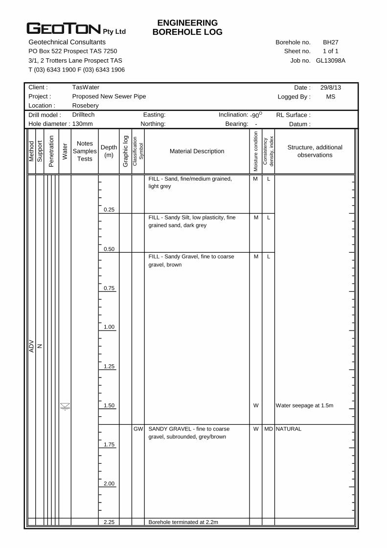
ENGINEERINGBOREHOLE LOG
Geotechnical Consultants Borehole no. BH27
PO Box 522 Prospect TAS 7250 Sheet no. 1 of 1
3/1, 2 Trotters Lane Prospect TAS Job no. GL13098A
T (03) 6343 1900 F (03) 6343 1906
Date : 29/8/13
Logged By : MS
Drill model : -90O RL Surface :
- Datum :
M L
0.25
M L
0.50
M L
0.75
1.00
1.25
1.50 W Water seepage at 1.5m
GW W MD NATURAL
1.75
2.00
2.25
AD
V
N
Borehole terminated at 2.2m
SANDY GRAVEL - fine to coarse
gravel, subrounded, grey/brown
FILL - Sandy Gravel, fine to coarse
gravel, brown
grained sand, dark grey
FILL - Sandy Silt, low plasticity, fine
Co
nsis
ten
cy
de
nsity,
ind
ex
Structure, additional
observations
FILL - Sand, fine/medium grained,
light grey
Depth
(m)
Gra
phic
log
Cla
ssific
atio
n
Sym
bo
l
Material Description
Mo
istu
re c
on
ditio
n
Me
thod
Suppo
rt
Penetr
ation
Wate
r Notes
Samples
Tests
Drilltech Easting: Inclination:
Hole diameter : 130mm Northing: Bearing:
Client : TasWater
Project : Proposed New Sewer Pipe
Location : Rosebery

ENGINEERINGBOREHOLE LOG
Geotechnical Consultants Borehole no. BH28
PO Box 522 Prospect TAS 7250 Sheet no. 1 of 1
3/1, 2 Trotters Lane Prospect TAS Job no. GL13098A
T (03) 6343 1900 F (03) 6343 1906
Date : 29/8/13
Logged By : MS
Drill model : -90O RL Surface :
- Datum :
M MD
0.25
0.50
ML M F
0.75
1.00 St V-70kPa
1.25
SC M MD
1.50 W Water seepage at 1.45m
M D
D/M
1.75
VD
2.00
2.25
AD
V
N
Borehole terminated at 1.8m
Auger refusal on inferred rock
EXTREMELY WEATHERED ROCK
(Volcaniclastic Sandstone), medium
grained, low strength,
orange, sandy silt soil properties
CLAYEY SAND - medium grained,
medium plasticity fines, orange,
with some gravel
CLAYEY SILT - low plasticity, brown/
light grey, with some fine grained
sand
Co
nsis
ten
cy
de
nsity,
ind
ex
Structure, additional
observations
FILL - Silty Gravel Roadbase, fine
to coarse gravel, light blue
Depth
(m)
Gra
phic
log
Cla
ssific
atio
n
Sym
bo
l
Material Description
Mo
istu
re c
on
ditio
n
Me
thod
Suppo
rt
Penetr
ation
Wate
r Notes
Samples
Tests
Drilltech Easting: Inclination:
Hole diameter : 130mm Northing: Bearing:
Client : TasWater
Project : Proposed New Sewer Pipe
Location : Rosebery

ENGINEERING LOG
Geotechnical Consultants Test no. C29
PO Box 522 Prospect TAS 7250 Sheet no. 1 of 1
3/1, 2 Trotters Lane Prospect TAS Job no. GL13098A
T (03) 6343 1900 F (03) 6343 1906
Date : 29/8/13
Logged By : MS
Drill model : -90O RL Surface :
- Datum :
M L Top of cutting along walking
track
ML M St
0.25
0.50
0.75
1.00
M D Glacial
1.25
1.50
1.75
2.00
2.25
N
Becoming weakly cemented
Bottom of cutting at 1.4m
Hand auger refusal
COBBLES & BOULDERS in a clayey
silt matrix, subrounded, orange
some clay
CLAYEY SILT - medium plasticity,
orange mottled grey, with some
cobbles/boulders
Co
nsis
ten
cy
de
nsity,
ind
ex
Structure, additional
observations
TOPSOIL - Sandy Silt, low plasticity,
fine grained sand, dark brown, with
Depth
(m)
Gra
phic
log
Cla
ssific
atio
n
Sym
bo
l
Material Description
Mo
istu
re c
on
ditio
n
Me
thod
Suppo
rt
Penetr
ation
Wate
r Notes
Samples
Tests
Easting: Inclination:
Hole diameter : Northing: Bearing:
Client : TasWater
Project : Proposed New Sewer Pipe
Location : Rosebery

ENGINEERINGEXCAVATION LOG
Geotechnical Consultants Test Pit no. TP30
PO Box 522 Prospect TAS 7250 Sheet no. 1 of 1
3/1, 2 Trotters Lane Prospect TAS Job no. GL13098A
T (03) 6343 1900 F (03) 6343 1906
Date : 4/9/13
Logged By : MS
450mm -90O RL Surface :
2.0m - Datum :
M L Topsoil
ML M MD NATURAL
0.25
GC M MD Glacial
0.50
0.75
D
D VD
1.00
1.25
1.50
1.75
2.00
2.25
E
N
Weakly cemented
grained, medium strength, light grey
CLAYEY GRAVEL - fine to coarse,
medium plasticity fines, orange,
Test Pit terminated at 1.1m
Excavator and ripper refusal
on slightly weathered rock
With some cobbles/boulders
HIGHLY WEATHERED ROCK
(Volcaniclastic Sandstone), fine
with some cobbles
some clay
SANDY SILT - low plasticity, fine
grained sand, light brown, with a
trace of gravel
Co
nsis
ten
cy
de
nsity,
ind
ex
Structure, additional
observations
TOPSOIL - Sandy Silt, low plasticity,
fine grained sand, dark grey, with
Depth
(m)
Gra
phic
log
Cla
ssific
atio
n
Sym
bo
l
Material Description
Mo
istu
re c
on
ditio
n
Me
thod
Suppo
rt
Penetr
ation
Wate
r Notes
Samples
Tests
5 Tonne Bucket: Inclination:
Length: Bearing:
Excavator:
Client : TasWater
Project : Proposed New Sewer Pipe
Location : Rosebery
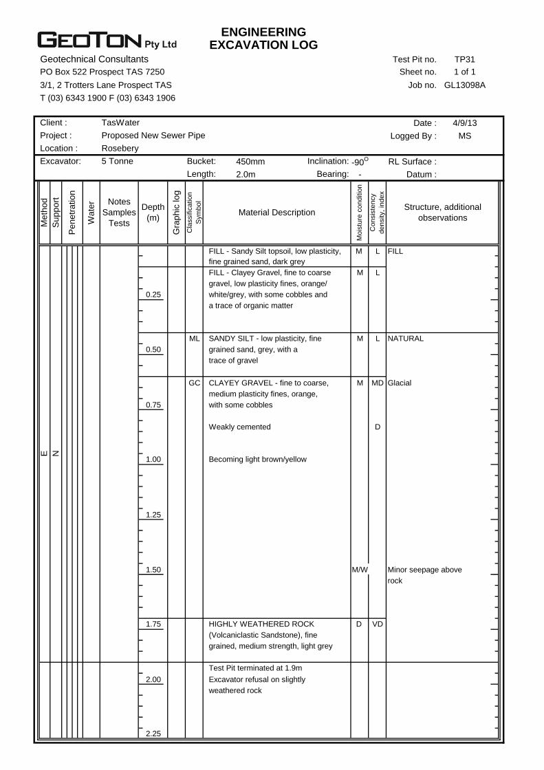
ENGINEERINGEXCAVATION LOG
Geotechnical Consultants Test Pit no. TP31
PO Box 522 Prospect TAS 7250 Sheet no. 1 of 1
3/1, 2 Trotters Lane Prospect TAS Job no. GL13098A
T (03) 6343 1900 F (03) 6343 1906
Date : 4/9/13
Logged By : MS
450mm -90O RL Surface :
2.0m - Datum :
M L FILL
M L
0.25
ML M L NATURAL
0.50
GC M MD Glacial
0.75
D
1.00
1.25
1.50 M/W Minor seepage above
rock
1.75 D VD
2.00
2.25
E
N
weathered rock
(Volcaniclastic Sandstone), fine
grained, medium strength, light grey
Test Pit terminated at 1.9m
Excavator refusal on slightly
HIGHLY WEATHERED ROCK
Weakly cemented
Becoming light brown/yellow
trace of gravel
CLAYEY GRAVEL - fine to coarse,
medium plasticity fines, orange,
with some cobbles
SANDY SILT - low plasticity, fine
grained sand, grey, with a
FILL - Clayey Gravel, fine to coarse
gravel, low plasticity fines, orange/
white/grey, with some cobbles and
a trace of organic matter
Co
nsis
ten
cy
de
nsity,
ind
ex
Structure, additional
observations
FILL - Sandy Silt topsoil, low plasticity,
fine grained sand, dark grey
Depth
(m)
Gra
phic
log
Cla
ssific
atio
n
Sym
bo
l
Material Description
Mo
istu
re c
on
ditio
n
Me
thod
Suppo
rt
Penetr
ation
Wate
r Notes
Samples
Tests
Excavator: 5 Tonne Bucket: Inclination:
Length: Bearing:
Client : TasWater
Project : Proposed New Sewer Pipe
Location : Rosebery
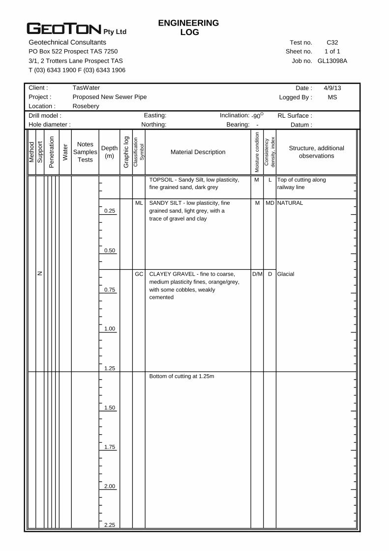
ENGINEERING LOG
Geotechnical Consultants Test no. C32
PO Box 522 Prospect TAS 7250 Sheet no. 1 of 1
3/1, 2 Trotters Lane Prospect TAS Job no. GL13098A
T (03) 6343 1900 F (03) 6343 1906
Date : 4/9/13
Logged By : MS
Drill model : -90O RL Surface :
- Datum :
M L Top of cutting along
railway line
ML M MD NATURAL
0.25
0.50
GC D/M D Glacial
0.75
1.00
1.25
1.50
1.75
2.00
2.25
N
Bottom of cutting at 1.25m
cemented
CLAYEY GRAVEL - fine to coarse,
medium plasticity fines, orange/grey,
with some cobbles, weakly
SANDY SILT - low plasticity, fine
grained sand, light grey, with a
trace of gravel and clay
Co
nsis
ten
cy
de
nsity,
ind
ex
Structure, additional
observations
TOPSOIL - Sandy Silt, low plasticity,
fine grained sand, dark grey
Depth
(m)
Gra
phic
log
Cla
ssific
atio
n
Sym
bo
l
Material Description
Mo
istu
re c
on
ditio
n
Me
thod
Suppo
rt
Penetr
ation
Wate
r Notes
Samples
Tests
Easting: Inclination:
Hole diameter : Northing: Bearing:
Client : TasWater
Project : Proposed New Sewer Pipe
Location : Rosebery
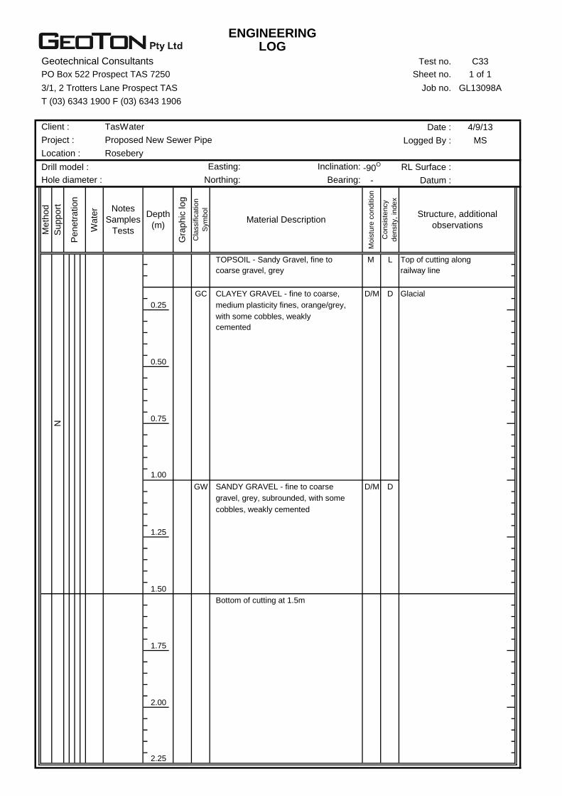
ENGINEERINGLOG
Geotechnical Consultants Test no. C33
PO Box 522 Prospect TAS 7250 Sheet no. 1 of 1
3/1, 2 Trotters Lane Prospect TAS Job no. GL13098A
T (03) 6343 1900 F (03) 6343 1906
Date : 4/9/13
Logged By : MS
Drill model : -90O RL Surface :
- Datum :
M L Top of cutting along
railway line
GC D/M D Glacial
0.25
0.50
0.75
1.00
GW D/M D
1.25
1.50
1.75
2.00
2.25
N
Bottom of cutting at 1.5m
SANDY GRAVEL - fine to coarse
gravel, grey, subrounded, with some
cobbles, weakly cemented
cemented
CLAYEY GRAVEL - fine to coarse,
medium plasticity fines, orange/grey,
with some cobbles, weakly
Co
nsis
ten
cy
de
nsity,
ind
ex
Structure, additional
observations
TOPSOIL - Sandy Gravel, fine to
coarse gravel, grey
Depth
(m)
Gra
phic
log
Cla
ssific
atio
n
Sym
bo
l
Material Description
Mo
istu
re c
on
ditio
n
Me
thod
Suppo
rt
Penetr
ation
Wate
r Notes
Samples
Tests
Easting: Inclination:
Hole diameter : Northing: Bearing:
Client : TasWater
Project : Proposed New Sewer Pipe
Location : Rosebery
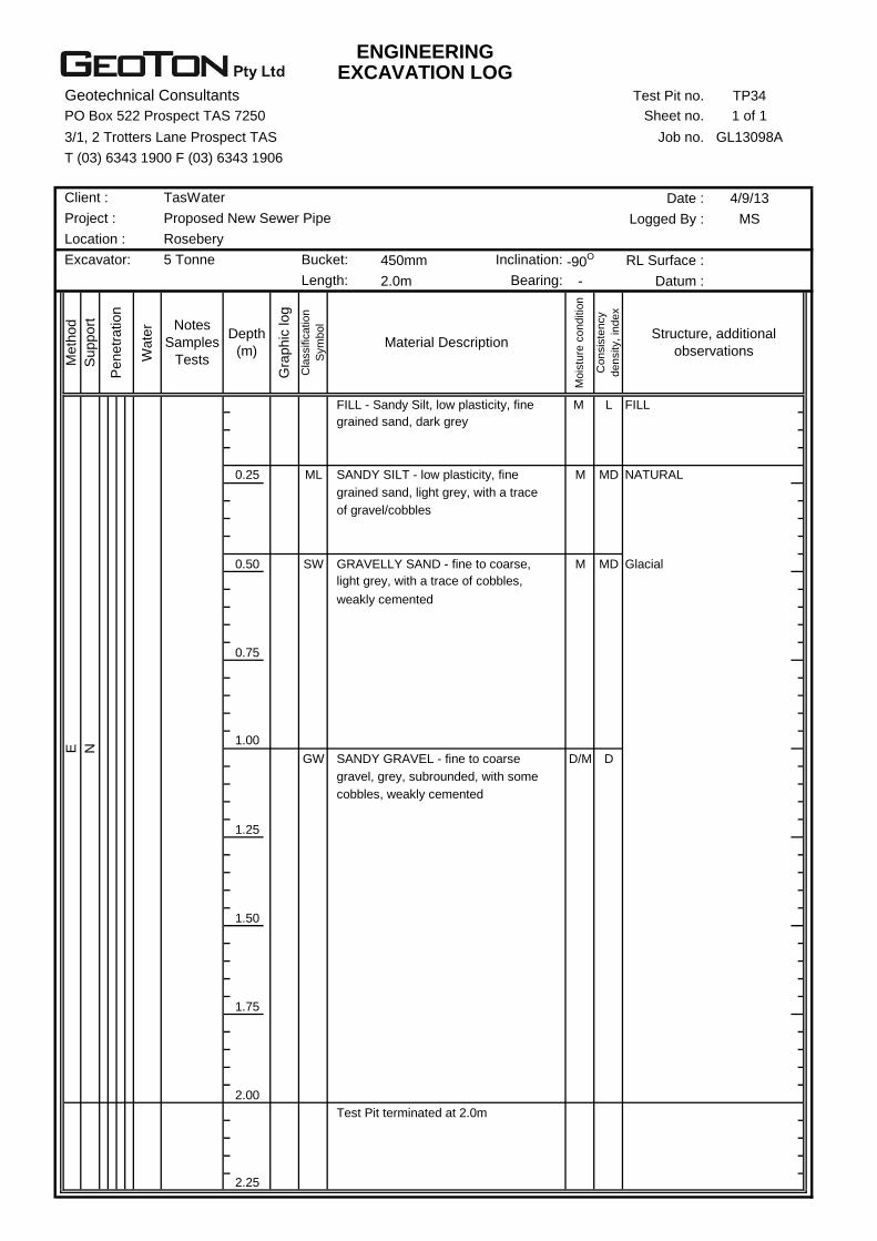
ENGINEERINGEXCAVATION LOG
Geotechnical Consultants Test Pit no. TP34
PO Box 522 Prospect TAS 7250 Sheet no. 1 of 1
3/1, 2 Trotters Lane Prospect TAS Job no. GL13098A
T (03) 6343 1900 F (03) 6343 1906
Date : 4/9/13
Logged By : MS
450mm -90O RL Surface :
2.0m - Datum :
M L FILL
0.25 ML M MD NATURAL
0.50 SW M MD Glacial
0.75
1.00
GW D/M D
1.25
1.50
1.75
2.00
2.25
E
N
Test Pit terminated at 2.0m
SANDY GRAVEL - fine to coarse
gravel, grey, subrounded, with some
cobbles, weakly cemented
light grey, with a trace of cobbles,
weakly cemented
of gravel/cobbles
GRAVELLY SAND - fine to coarse,
SANDY SILT - low plasticity, fine
grained sand, light grey, with a trace
Co
nsis
ten
cy
de
nsity,
ind
ex
Structure, additional
observations
FILL - Sandy Silt, low plasticity, fine
grained sand, dark grey
Depth
(m)
Gra
phic
log
Cla
ssific
atio
n
Sym
bo
l
Material Description
Mo
istu
re c
on
ditio
n
Me
thod
Suppo
rt
Penetr
ation
Wate
r Notes
Samples
Tests
Excavator: 5 Tonne Bucket: Inclination:
Length: Bearing:
Client : TasWater
Project : Proposed New Sewer Pipe
Location : Rosebery
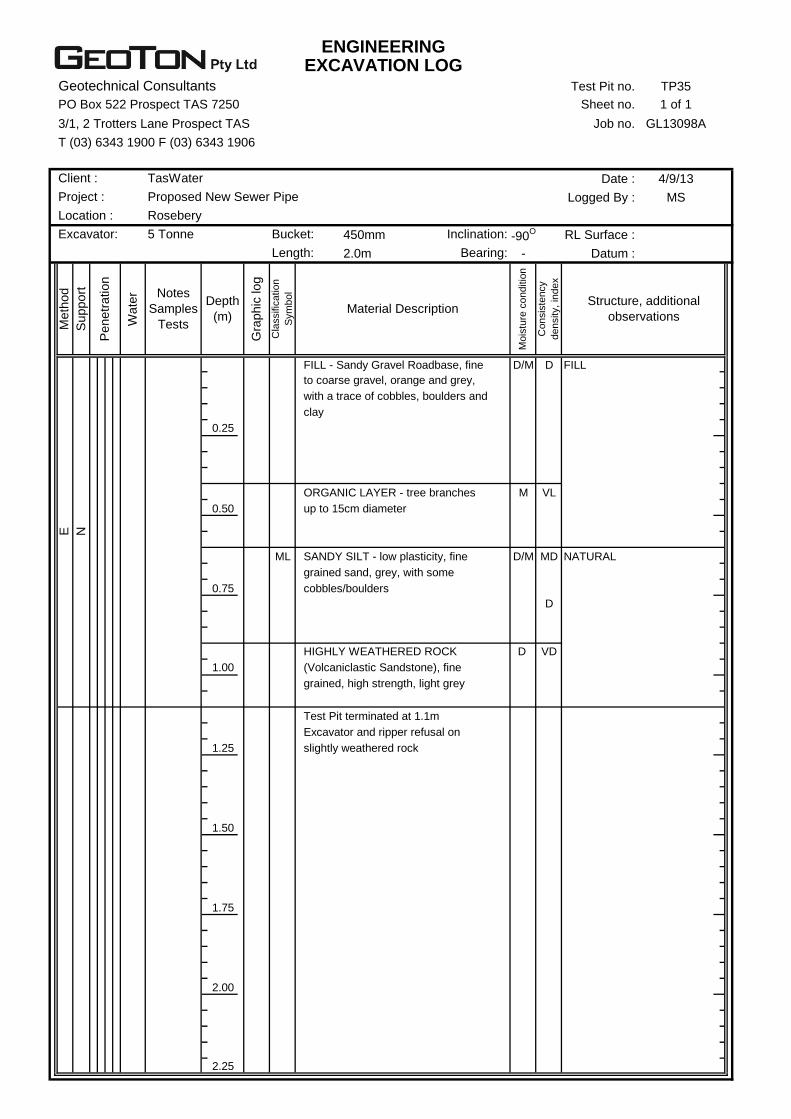
ENGINEERINGEXCAVATION LOG
Geotechnical Consultants Test Pit no. TP35
PO Box 522 Prospect TAS 7250 Sheet no. 1 of 1
3/1, 2 Trotters Lane Prospect TAS Job no. GL13098A
T (03) 6343 1900 F (03) 6343 1906
Date : 4/9/13
Logged By : MS
450mm -90O RL Surface :
2.0m - Datum :
D/M D FILL
0.25
M VL
0.50
ML D/M MD NATURAL
0.75
D
D VD
1.00
1.25
1.50
1.75
2.00
2.25
E
N
grained, high strength, light grey
Test Pit terminated at 1.1m
Excavator and ripper refusal on
slightly weathered rock
HIGHLY WEATHERED ROCK
(Volcaniclastic Sandstone), fine
SANDY SILT - low plasticity, fine
grained sand, grey, with some
cobbles/boulders
ORGANIC LAYER - tree branches
up to 15cm diameter
with a trace of cobbles, boulders and
clay
Co
nsis
ten
cy
de
nsity,
ind
ex
Structure, additional
observations
FILL - Sandy Gravel Roadbase, fine
to coarse gravel, orange and grey,
Depth
(m)
Gra
phic
log
Cla
ssific
atio
n
Sym
bo
l
Material Description
Mo
istu
re c
on
ditio
n
Me
thod
Suppo
rt
Penetr
ation
Wate
r Notes
Samples
Tests
Excavator: 5 Tonne Bucket: Inclination:
Length: Bearing:
Client : TasWater
Project : Proposed New Sewer Pipe
Location : Rosebery

ENGINEERINGEXCAVATION LOG
Geotechnical Consultants Test Pit no. TP36
PO Box 522 Prospect TAS 7250 Sheet no. 1 of 1
3/1, 2 Trotters Lane Prospect TAS Job no. GL13098A
T (03) 6343 1900 F (03) 6343 1906
Date : 4/9/13
Logged By : MS
450mm -90O RL Surface :
2.0m - Datum :
ML M L Topsoil - organic matter
ML M/W L
0.25
W Water seepage at 0.3m
Minor test pit collapse
0.50
ML M MD
0.75 D
1.00
1.25
1.50
SC M D Glacial
1.75
2.00
2.25
E
N
Test Pit terminated at 1.8m
CLAYEY SAND - medium grained,
orange, with a trace of cobbles,
weakly cemented
Becoming light grey/light blue
SANDY SILT - low plasticity, fine
grained sand, light grey, with a trace
of gravel
GRAVELLY SANDY SILT - low
plasticity fines, brown/grey, with
some cobbles, subrounded
Co
nsis
ten
cy
de
nsity,
ind
ex
Structure, additional
observations
TOPSOIL - Sandy Silt, low plasticity,
fine grained sand, dark grey
Depth
(m)
Gra
phic
log
Cla
ssific
atio
n
Sym
bo
l
Material Description
Mo
istu
re c
on
ditio
n
Me
thod
Suppo
rt
Penetr
ation
Wate
r Notes
Samples
Tests
Excavator: 5 Tonne Bucket: Inclination:
Length: Bearing:
Client : TasWater
Project : Proposed New Sewer Pipe
Location : Rosebery
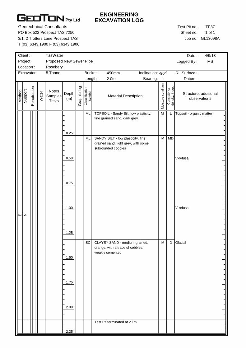
ENGINEERINGEXCAVATION LOG
Geotechnical Consultants Test Pit no. TP37
PO Box 522 Prospect TAS 7250 Sheet no. 1 of 1
3/1, 2 Trotters Lane Prospect TAS Job no. GL13098A
T (03) 6343 1900 F (03) 6343 1906
Date : 4/9/13
Logged By : MS
450mm -90O RL Surface :
2.0m - Datum :
ML M L Topsoil - organic matter
0.25
ML M MD
0.50 V-refusal
0.75
1.00 V-refusal
1.25
SC M D Glacial
1.50
1.75
2.00
2.25
E
N
Test Pit terminated at 2.1m
CLAYEY SAND - medium grained,
orange, with a trace of cobbles,
weakly cemented
grained sand, light grey, with some
subrounded cobbles
SANDY SILT - low plasticity, fine
Co
nsis
ten
cy
de
nsity,
ind
ex
Structure, additional
observations
TOPSOIL - Sandy Silt, low plasticity,
fine grained sand, dark grey
Depth
(m)
Gra
phic
log
Cla
ssific
atio
n
Sym
bo
l
Material Description
Mo
istu
re c
on
ditio
n
Me
thod
Suppo
rt
Penetr
ation
Wate
r Notes
Samples
Tests
Excavator: 5 Tonne Bucket: Inclination:
Length: Bearing:
Client : TasWater
Project : Proposed New Sewer Pipe
Location : Rosebery
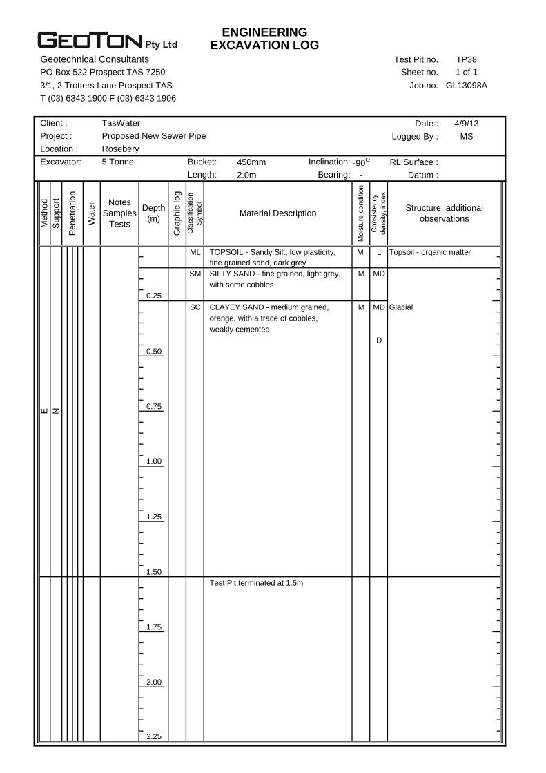
ENGINEERINGEXCAVATION LOG
Geotechnical Consultants Test Pit no. TP38
PO Box 522 Prospect TAS 7250 Sheet no. 1 of 1
3/1, 2 Trotters Lane Prospect TAS Job no. GL13098A
T (03) 6343 1900 F (03) 6343 1906
Date : 4/9/13
Logged By : MS
450mm -90O RL Surface :
2.0m - Datum :
ML M L Topsoil - organic matter
SM M MD
0.25
SC M MD Glacial
D
0.50
0.75
1.00
1.25
1.50
1.75
2.00
2.25
E
N
Test Pit terminated at 1.5m
orange, with a trace of cobbles,
weakly cemented
SILTY SAND - fine grained, light grey,
with some cobbles
CLAYEY SAND - medium grained,
Co
nsis
ten
cy
de
nsity,
ind
ex
Structure, additional
observations
TOPSOIL - Sandy Silt, low plasticity,
fine grained sand, dark grey
Depth
(m)
Gra
phic
log
Cla
ssific
atio
n
Sym
bo
l
Material Description
Mo
istu
re c
on
ditio
n
Me
thod
Suppo
rt
Penetr
ation
Wate
r Notes
Samples
Tests
Excavator: 5 Tonne Bucket: Inclination:
Length: Bearing:
Client : TasWater
Project : Proposed New Sewer Pipe
Location : Rosebery

ENGINEERINGBOREHOLE LOG
Geotechnical Consultants Borehole no. BH39
PO Box 522 Prospect TAS 7250 Sheet no. 1 of 1
3/1, 2 Trotters Lane Prospect TAS Job no. GL13098A
T (03) 6343 1900 F (03) 6343 1906
Date : 10/9/13
Logged By : MS
Drill model : -90O RL Surface :
- Datum :
ML M L Topsoil - organic matter
0.25 ML M MD
0.50 D/M D
0.75
1.00
1.25
1.50
1.75
2.00
2.25
HA N
Borehole terminated at 0.6m
Auger refusal on inferred weakly
cemented glacial soils
Becoming light brown/light yellow
SANDY SILT - non plastic, fine
grained sand, light grey
Co
nsis
ten
cy
de
nsity,
ind
ex
Structure, additional
observations
TOPSOIL - Sandy Silt, low plasticity,
fine grained sand, dark grey
Depth
(m)
Gra
phic
log
Cla
ssific
atio
n
Sym
bo
l
Material Description
Mo
istu
re c
on
ditio
n
Me
thod
Suppo
rt
Penetr
ation
Wate
r Notes
Samples
Tests
Hand Auger Easting: Inclination:
Hole diameter : 80mm Northing: Bearing:
Client : TasWater
Project : Proposed New Sewer Pipe (outfall)
Location : Rosebery
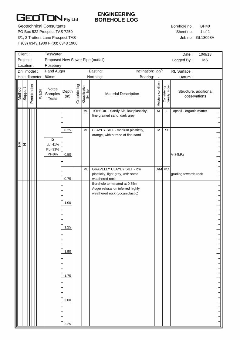
ENGINEERINGBOREHOLE LOG
Geotechnical Consultants Borehole no. BH40
PO Box 522 Prospect TAS 7250 Sheet no. 1 of 1
3/1, 2 Trotters Lane Prospect TAS Job no. GL13098A
T (03) 6343 1900 F (03) 6343 1906
Date : 10/9/13
Logged By : MS
Drill model : -90O RL Surface :
- Datum :
ML M L Topsoil - organic matter
0.25 ML M St
D
LL=41%
PL=33%
PI=8% 0.50 V-84kPa
ML D/M VSt
grading towards rock
0.75
Auger refusal on inferred highly
weathered rock (vocaniclastic)
1.00
1.25
1.50
1.75
2.00
2.25
HA N
Borehole terminated at 0.75m
GRAVELLY CLAYEY SILT - low
plasticity, light grey, with some
weathered rock
CLAYEY SILT - medium plasticity,
orange, with a trace of fine sand
Co
nsis
ten
cy
de
nsity,
ind
ex
Structure, additional
observations
TOPSOIL - Sandy Silt, low plasticity,
fine grained sand, dark grey
Depth
(m)
Gra
phic
log
Cla
ssific
atio
n
Sym
bo
l
Material Description
Mo
istu
re c
on
ditio
n
Me
thod
Suppo
rt
Penetr
ation
Wate
r Notes
Samples
Tests
Hand Auger Easting: Inclination:
Hole diameter : 80mm Northing: Bearing:
Client : TasWater
Project : Proposed New Sewer Pipe (outfall)
Location : Rosebery
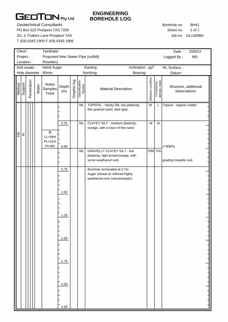
ENGINEERINGBOREHOLE LOG
Geotechnical Consultants Borehole no. BH41
PO Box 522 Prospect TAS 7250 Sheet no. 1 of 1
3/1, 2 Trotters Lane Prospect TAS Job no. GL13098A
T (03) 6343 1900 F (03) 6343 1906
Date : 10/9/13
Logged By : MS
Drill model : -90O RL Surface :
- Datum :
ML M L Topsoil - organic matter
0.25 ML M St
D
LL=39%
PL=31%
PI=8% 0.50 V-90kPa
ML D/M VSt
grading towards rock
0.75
1.00
1.25
1.50
1.75
2.00
2.25
HA N
Auger refusal on inferred highly
weathered rock (volcaniclastic)
GRAVELLY CLAYEY SILT - low
plasticity, light brown/orange, with
some weathered rock
Borehole terminated at 0.7m
CLAYEY SILT - medium plasticity,
orange, with a trace of fine sand
Co
nsis
ten
cy
de
nsity,
ind
ex
Structure, additional
observations
TOPSOIL - Sandy Silt, low plasticity,
fine grained sand, dark grey
Depth
(m)
Gra
phic
log
Cla
ssific
atio
n
Sym
bo
l
Material Description
Mo
istu
re c
on
ditio
n
Me
thod
Suppo
rt
Penetr
ation
Wate
r Notes
Samples
Tests
Hand Auger Easting: Inclination:
Hole diameter : 80mm Northing: Bearing:
Client : TasWater
Project : Proposed New Sewer Pipe (outfall)
Location : Rosebery

ENGINEERINGBOREHOLE LOG
Geotechnical Consultants Borehole no. BH42
PO Box 522 Prospect TAS 7250 Sheet no. 1 of 1
3/1, 2 Trotters Lane Prospect TAS Job no. GL13098A
T (03) 6343 1900 F (03) 6343 1906
Date : 10/9/13
Logged By : MS
Drill model : -90O RL Surface :
- Datum :
ML M L Topsoil - organic matter
SM M MD
0.25
ML M MD
0.50 V-90kPa
D
LL=NO
PI=NP
0.75 D/M D V-refusal
1.00
1.25
1.50
1.75
2.00
2.25
Borehole terminated at 1.1m
Auger refusal on inferred weakly
cemented glacial soils
Becoming light brown/light yellow
SANDY SILT - non plastic, fine
grained sand, light grey
SILTY SAND - fine grained, light
grey, with a trace of gravel/cobbles
Co
nsis
ten
cy
de
nsity,
ind
ex
Structure, additional
observations
TOPSOIL - Sandy Silt, low plasticity,
fine grained sand, dark grey
Depth
(m)
Gra
phic
log
Cla
ssific
atio
n
Sym
bo
l
Material Description
Mo
istu
re c
on
ditio
n
Me
thod
Suppo
rt
Penetr
ation
Wate
r Notes
Samples
Tests
Hand Auger Easting: Inclination:
Hole diameter : 80mm Northing: Bearing:
HA N
Client : TasWater
Project : Proposed New Sewer Pipe (outfall)
Location : Rosebery
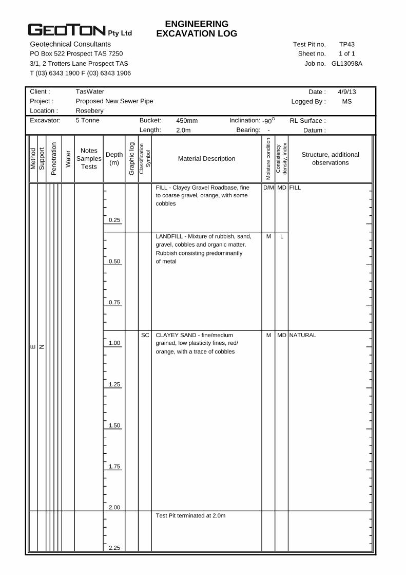
ENGINEERINGEXCAVATION LOG
Geotechnical Consultants Test Pit no. TP43
PO Box 522 Prospect TAS 7250 Sheet no. 1 of 1
3/1, 2 Trotters Lane Prospect TAS Job no. GL13098A
T (03) 6343 1900 F (03) 6343 1906
Date : 4/9/13
Logged By : MS
450mm -90O RL Surface :
2.0m - Datum :
D/M MD FILL
0.25
M L
0.50
0.75
SC M MD NATURAL
1.00
1.25
1.50
1.75
2.00
2.25
LANDFILL - Mixture of rubbish, sand,
gravel, cobbles and organic matter.
Rubbish consisting predominantly
of metal
Test Pit terminated at 2.0m
Co
nsis
ten
cy
de
nsity,
ind
ex
Structure, additional
observations
FILL - Clayey Gravel Roadbase, fine
to coarse gravel, orange, with some
Depth
(m)
Gra
phic
log
Cla
ssific
atio
n
Sym
bo
l
Material Description
Mo
istu
re c
on
ditio
n
Me
thod
Suppo
rt
Penetr
ation
Wate
r Notes
Samples
Tests
E
N
orange, with a trace of cobbles
CLAYEY SAND - fine/medium
grained, low plasticity fines, red/
Length: Bearing:
Client : TasWater
Project : Proposed New Sewer Pipe
Location : Rosebery
cobbles
Excavator: 5 Tonne Bucket: Inclination:
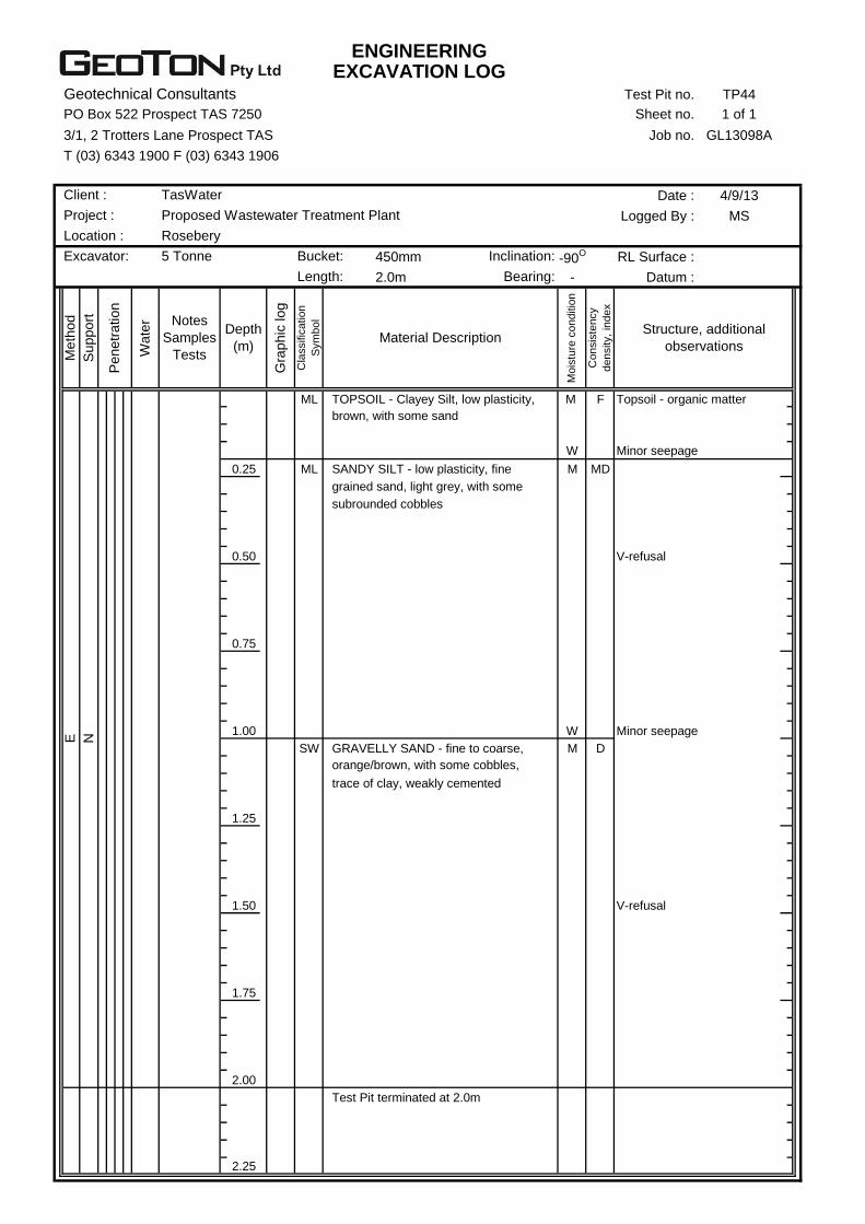
ENGINEERINGEXCAVATION LOG
Geotechnical Consultants Test Pit no. TP44
PO Box 522 Prospect TAS 7250 Sheet no. 1 of 1
3/1, 2 Trotters Lane Prospect TAS Job no. GL13098A
T (03) 6343 1900 F (03) 6343 1906
Date : 4/9/13
Logged By : MS
450mm -90O RL Surface :
2.0m - Datum :
ML M F Topsoil - organic matter
W Minor seepage
0.25 ML M MD
0.50 V-refusal
0.75
1.00 W Minor seepage
SW M D
1.25
1.50 V-refusal
1.75
2.00
2.25
Test Pit terminated at 2.0m
E
N
GRAVELLY SAND - fine to coarse,
orange/brown, with some cobbles,
trace of clay, weakly cemented
subrounded cobbles
SANDY SILT - low plasticity, fine
grained sand, light grey, with some
Co
nsis
ten
cy
de
nsity,
ind
ex
Structure, additional
observations
TOPSOIL - Clayey Silt, low plasticity,
brown, with some sand
Depth
(m)
Gra
phic
log
Cla
ssific
atio
n
Sym
bo
l
Material Description
Mo
istu
re c
on
ditio
n
Me
thod
Suppo
rt
Penetr
ation
Wate
r Notes
Samples
Tests
Excavator: 5 Tonne Bucket: Inclination:
Length: Bearing:
Client : TasWater
Project : Proposed Wastewater Treatment Plant
Location : Rosebery
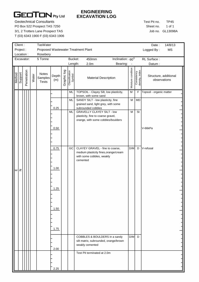
ENGINEERINGEXCAVATION LOG
Geotechnical Consultants Test Pit no. TP45
PO Box 522 Prospect TAS 7250 Sheet no. 1 of 1
3/1, 2 Trotters Lane Prospect TAS Job no. GL13098A
T (03) 6343 1900 F (03) 6343 1906
Date : 14/8/13
Logged By : MS
450mm -90O RL Surface :
2.0m - Datum :
ML M F Topsoil - organic matter
ML M MD
0.25
ML M St
0.50 V-66kPa
0.75 GC D/M D V-refusal
1.00
1.25
1.50
1.75
D/M D
2.00
2.25
Test Pit terminated at 2.0m
silt matrix, subrounded, orange/brown
weakly cemented
CLAYEY GRAVEL - fine to coarse,
plasticity, fine to coarse gravel,
orange, with some cobbles/boulders
SANDY SILT - low plasticity, fine
grained sand, light grey, with some
subrounded cobbles
GRAVELLY CLAYEY SILT - low
COBBLES & BOULDERS in a sandy
Co
nsis
ten
cy
de
nsity,
ind
ex
Structure, additional
observations
TOPSOIL - Clayey Silt, low plasticity,
brown, with some sand
Depth
(m)
Gra
phic
log
Cla
ssific
atio
n
Sym
bo
l
Material Description
Mo
istu
re c
on
ditio
n
Me
thod
Suppo
rt
Penetr
ation
Wate
r Notes
Samples
Tests
Excavator: 5 Tonne Bucket: Inclination:
Length: Bearing:
E
N
medium plasticity fines,orange/cream
with some cobbles, weakly
cemented
Client : TasWater
Project : Proposed Wastewater Treatment Plant
Location : Rosebery
ENGINEERINGEXCAVATION LOG
Geotechnical Consultants Test Pit no. TP46
PO Box 522 Prospect TAS 7250 Sheet no. 1 of 1
3/1, 2 Trotters Lane Prospect TAS Job no. GL13098A
T (03) 6343 1900 F (03) 6343 1906
Date : 14/8/13
Logged By : MS
450mm -90O RL Surface :
2.0m - Datum :
ML M F Topsoil - organic matter
ML M MD
0.25
ML M St
0.50 V-90kPa
0.75 H V-refusal
1.00 V-refusal
1.25
SW M MD
1.50
D/M D
1.75
2.00
2.25
Becoming weakly cemented
GRAVELLY CLAYEY SILT - low
plasticity, fine to coarse gravel,
light grey, with some cobbles/
boulders
Test Pit terminated at 2.0m
Becoming cemented, dark orange, with
a trace of subrounded gravel/cobbles
SAND - medium grained, orange/
yellow, with some clay/silt
SILTY GRAVEL - fine to coarse gravel,
low plasticity fines, grey, with some
subrounded cobbles
Co
nsis
ten
cy
de
nsity,
ind
ex
Structure, additional
observations
TOPSOIL - Clayey Silt, low plasticity,
brown, with some sand
Depth
(m)
Gra
phic
log
Cla
ssific
atio
n
Sym
bo
l
Material Description
Mo
istu
re c
on
ditio
n
Me
thod
Suppo
rt
Penetr
ation
Wate
r Notes
Samples
Tests
E
N
Excavator: 5 Tonne Bucket: Inclination:
Length: Bearing:
Client : TasWater
Project : Proposed Wastewater Treatment Plant
Location : Rosebery
ENGINEERINGEXCAVATION LOG
Geotechnical Consultants Test Pit no. TP47
PO Box 522 Prospect TAS 7250 Sheet no. 1 of 1
3/1, 2 Trotters Lane Prospect TAS Job no. GL13098A
T (03) 6343 1900 F (03) 6343 1906
Date : 4/9/13
Logged By : MS
450mm -90O RL Surface :
2.0m - Datum :
ML M F Topsoil - organic matter
ML M/W L
0.25
W Water seepage above
cemented gravels
0.50 D/M D V-refusal
VD
0.75
D/M VD Weakly cemented
1.00
1.25
1.50
1.75
2.00
2.25
Near excavator refusal
Test Pit terminated at 1.7m
E
N
GRAVEL & COBBLES in a sandy
silt matrix, subrounded, light grey
weakly cemented
sand matrix, weakly cemented,
light grey
GRAVEL & COBBLES in clayey
SANDY SILT - low plasticity, fine
grained sand, light grey, with some
subrounded cobbles
Co
nsis
ten
cy
de
nsity,
ind
ex
Structure, additional
observations
TOPSOIL - Sandy Silt, low plasticity,
fine grained sand, brown
Depth
(m)
Gra
phic
log
Cla
ssific
atio
n
Sym
bo
l
Material Description
Mo
istu
re c
on
ditio
n
Me
thod
Suppo
rt
Penetr
ation
Wate
r Notes
Samples
Tests
Excavator: 5 Tonne Bucket: Inclination:
Length: Bearing:
Client : TasWater
Project : Proposed Wastewater Treatment Plant
Location : Rosebery

ENGINEERINGEXCAVATION LOG
Geotechnical Consultants Test Pit no. TP48
PO Box 522 Prospect TAS 7250 Sheet no. 1 of 1
3/1, 2 Trotters Lane Prospect TAS Job no. GL13098A
T (03) 6343 1900 F (03) 6343 1906
Date : 14/8/13
Logged By : MS
450mm -90O RL Surface :
2.0m - Datum :
ML M F Topsoil - organic matter
ML M/W L
0.25
0.50
M D Weakly cemented
0.75
D/M VD
1.00
1.25
1.50
1.75
2.00
2.25
Test Pit terminated at 1.0m
Excavator refusal - strongly cemented
brown/orange
SANDY SILT - low plasticity, fine
grained sand, light grey, with some
subrounded cobbles
Co
nsis
ten
cy
de
nsity,
ind
ex
Structure, additional
observations
TOPSOIL - Sandy Silt, low plasticity,
fine grained sand, brown
Depth
(m)
Gra
phic
log
Cla
ssific
atio
n
Sym
bo
l
Material Description
Mo
istu
re c
on
ditio
n
Me
thod
Suppo
rt
Penetr
ation
Wate
r Notes
Samples
Tests
Excavator: 5 Tonne Bucket: Inclination:
Length: Bearing:
E
N
GRAVEL & COBBLES in clayey
sand matrix, weakly cemented,
Client : TasWater
Project : Proposed Wastewater Treatment Plant
Location : Rosebery

ENGINEERINGEXCAVATION LOG
Geotechnical Consultants Test Pit no. TP49
PO Box 522 Prospect TAS 7250 Sheet no. 1 of 1
3/1, 2 Trotters Lane Prospect TAS Job no. GL13098A
T (03) 6343 1900 F (03) 6343 1906
Date : 14/8/13
Logged By : MS
450mm -90O RL Surface :
2.0m - Datum :
ML M F Topsoil - organic matter
ML M MD
0.25
D/M D Weakly cemented
0.50
0.75
1.00
1.25
1.50
1.75
2.00
2.25
Excavator refusal - strongly cemented
Test Pit terminated at 1.2m
GRAVEL & COBBLES in clayey
sand matrix, weakly cemented,
brown/orange
SILTY GRAVEL - fine to coarse gravel,
low plasticity fines, grey, with some
subrounded cobbles
Co
nsis
ten
cy
de
nsity,
ind
ex
Structure, additional
observations
TOPSOIL - Sandy Silt, low plasticity,
fine grained sand, brown
Depth
(m)
Gra
phic
log
Cla
ssific
atio
n
Sym
bo
l
Material Description
Mo
istu
re c
on
ditio
n
Me
thod
Suppo
rt
Penetr
ation
Wate
r Notes
Samples
Tests
E
N
Excavator: 5 Tonne Bucket: Inclination:
Length: Bearing:
Client : TasWater
Project : Proposed Wastewater Treatment Plant
Location : Rosebery
ENGINEERINGEXCAVATION LOG
Geotechnical Consultants Test Pit no. TP50
PO Box 522 Prospect TAS 7250 Sheet no. 1 of 1
3/1, 2 Trotters Lane Prospect TAS Job no. GL13098A
T (03) 6343 1900 F (03) 6343 1906
Date : 4/9/13
Logged By : MS
450mm -90O RL Surface :
2.0m - Datum :
ML M F Topsoil - organic matter
ML M MD
0.25
W Minor seepage
M D
0.50 D/M
VD
0.75
1.00
1.25
1.50
1.75
2.00
2.25
Test Pit terminated at 1.2m
Excavator refusal - strongly cemented
Becoming light grey/cream
GRAVEL & COBBLES in clayey
sand matrix, weakly cemented,
brown/orange
SANDY SILT - low plasticity, fine
grained sand, light grey, with some
subrounded cobbles
Co
nsis
ten
cy
de
nsity,
ind
ex
Structure, additional
observations
TOPSOIL - Sandy Silt, low plasticity,
fine grained sand, brown
Depth
(m)
Gra
phic
log
Cla
ssific
atio
n
Sym
bo
l
Material Description
Mo
istu
re c
on
ditio
n
Me
thod
Suppo
rt
Penetr
ation
Wate
r Notes
Samples
Tests
Excavator: 5 Tonne Bucket: Inclination:
Length: Bearing:
Client : TasWater
Project : Proposed Wastewater Treatment Plant
Location : Rosebery
E
N
ENGINEERINGEXCAVATION LOG
Geotechnical Consultants Test Pit no. TP51
PO Box 522 Prospect TAS 7250 Sheet no. 1 of 1
3/1, 2 Trotters Lane Prospect TAS Job no. GL13098A
T (03) 6343 1900 F (03) 6343 1906
Date : 5/9/13
Logged By : MS
450mm -90O RL Surface :
2.0m - Datum :
M L FILL
0.25 W Water seepage at 0.25m
0.50
0.75
1.00
1.25
D VD NATURAL
1.50
1.75
2.00
2.25
Test Pit terminated at 1.7m
Excavator and ripper refusal
on slightly weathered rock
HIGHLY WEATHERED ROCK
(Volcaniclastic), fine grained, medium
strength, highly fractured, light grey/
light blue
orange, with a trace of organic
matter
Co
nsis
ten
cy
de
nsity,
ind
ex
Structure, additional
observations
FILL - Mixture of clay, gravel, cobbles
and boulders, subangular, brown/
Depth
(m)
Gra
phic
log
Cla
ssific
atio
n
Sym
bo
l
Material Description
Mo
istu
re c
on
ditio
n
Me
thod
Suppo
rt
Penetr
ation
Wate
r Notes
Samples
Tests
Excavator: 5 Tonne Bucket: Inclination:
Length: Bearing:
TasWater
Project : Proposed Water Treatment Plant
Location : Rosebery
E
N
Client :

ENGINEERINGEXCAVATION LOG
Geotechnical Consultants Test Pit no. TP52
PO Box 522 Prospect TAS 7250 Sheet no. 1 of 1
3/1, 2 Trotters Lane Prospect TAS Job no. GL13098A
T (03) 6343 1900 F (03) 6343 1906
Date : 5/9/13
Logged By : MS
450mm -90O RL Surface :
2.0m - Datum :
ML M F/S
0.25 ML M MD
0.50
D/M D
D
0.75
VD
Massive
1.00
1.25
1.50
1.75
2.00
2.25
on slightly weathered rock
Becoming light grey/light blue
Test Pit terminated at 0.9m
Excavator and ripper refusal
HIGHLY WEATHERED ROCK
(Volcaniclastic), fine grained, medium
strength, highly fractured, light grey/
light brown
gravel/cobbles
sand
SANDY SILT - low plasticity, fine
grained sand, grey, with some
Co
nsis
ten
cy
de
nsity,
ind
ex
Structure, additional
observations
TOPSOIL - Clayey Silt, low plasticity,
dark brown, with some fine grained
Depth
(m)
Gra
phic
log
Cla
ssific
atio
n
Sym
bo
l
Material Description
Mo
istu
re c
on
ditio
n
Me
thod
Suppo
rt
Penetr
ation
Wate
r Notes
Samples
Tests
5 Tonne Bucket: Inclination:
Length: Bearing:
Client : TasWater
Project : Proposed Water Treatment Plant
Location : Rosebery
E
N
Excavator:

ENGINEERINGEXCAVATION LOG
Geotechnical Consultants Test Pit no. TP53
PO Box 522 Prospect TAS 7250 Sheet no. 1 of 1
3/1, 2 Trotters Lane Prospect TAS Job no. GL13098A
T (03) 6343 1900 F (03) 6343 1906
Date : 5/9/13
Logged By : MS
450mm -90O RL Surface :
2.0m - Datum :
M L
D/M D
Highly fractured
0.25
D VD
0.50
0.75
1.00
1.25
1.50
1.75
2.00
2.25
Becoming light blue
Test Pit terminated at 0.6m
Excavator and ripper refusal
on slightly weathered rock
strength, blocky, light grey/orange
EXTREMELY WEATHERED ROCK
(Volcaniclastic), fine grained, low
strength, cream/light orange,
clayey sand soil properties
Co
nsis
ten
cy
de
nsity,
ind
ex
Structure, additional
observations
TOPSOIL - Sandy Silt, low plasticity,
fine grained sand, grey
Depth
(m)
Gra
phic
log
Cla
ssific
atio
n
Sym
bo
l
Material Description
Mo
istu
re c
on
ditio
n
Notes
Samples
Tests
Excavator: 5 Tonne Bucket: Inclination:
Length: Bearing:
Client : TasWater
Project : Proposed Water Treatment Plant
Location : Rosebery
HIGHLY WEATHERED ROCK
(Volcaniclastic), fine grained, medium
Me
thod
Suppo
rt
Penetr
ation
Wate
r
E
N
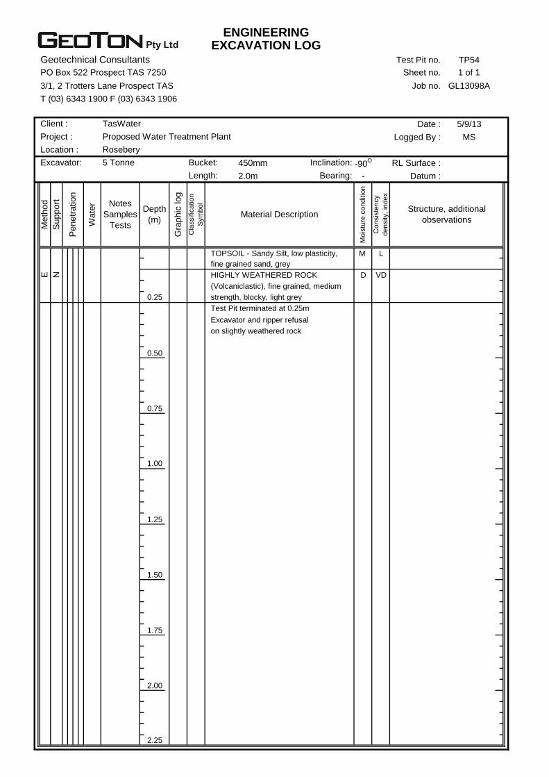
ENGINEERINGEXCAVATION LOG
Geotechnical Consultants Test Pit no. TP54
PO Box 522 Prospect TAS 7250 Sheet no. 1 of 1
3/1, 2 Trotters Lane Prospect TAS Job no. GL13098A
T (03) 6343 1900 F (03) 6343 1906
Date : 5/9/13
Logged By : MS
450mm -90O RL Surface :
2.0m - Datum :
M L
D VD
0.25
0.50
0.75
1.00
1.25
1.50
1.75
2.00
2.25
Excavator and ripper refusal
on slightly weathered rock
HIGHLY WEATHERED ROCK
(Volcaniclastic), fine grained, medium
strength, blocky, light grey
Test Pit terminated at 0.25m
Co
nsis
ten
cy
de
nsity,
ind
ex
Structure, additional
observations
TOPSOIL - Sandy Silt, low plasticity,
fine grained sand, grey
Depth
(m)
Gra
phic
log
Cla
ssific
atio
n
Sym
bo
l
Material Description
Mo
istu
re c
on
ditio
n
Me
thod
Suppo
rt
Penetr
ation
Wate
r Notes
Samples
Tests
Excavator: 5 Tonne Bucket: Inclination:
Length: Bearing:
TasWater
Project : Proposed Water Treatment Plant
Location : Rosebery
Client :
E
N
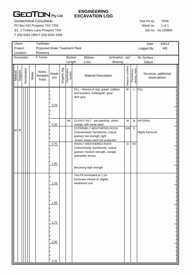
ENGINEERINGEXCAVATION LOG
Geotechnical Consultants Test Pit no. TP55
PO Box 522 Prospect TAS 7250 Sheet no. 1 of 1
3/1, 2 Trotters Lane Prospect TAS Job no. GL13098A
T (03) 6343 1900 F (03) 6343 1906
Date : 5/9/13
Logged By : MS
450mm -90O RL Surface :
2.0m - Datum :
M L FILL
0.25
ML M St NATURAL
0.50
D/M D
Highly fractured
0.75 D VD
1.00
1.25
1.50
1.75
2.00
2.25
Becoming high strength
Test Pit terminated at 1.1m
Excavator refusal on slightly
weathered rock
(Volcaniclastic Sandstone), coarse
grained, medium strength, orange/
pink/white, blocky
EXTREMELY WEATHERED ROCK
(Volcaniclastic Sandstone), coarse
grained, low strength, light
brown, clayey sand soil properties
HIGHLY WEATHERED ROCK
CLAYEY SILT - low plasticity, white/
orange, with some sand
dark grey
Co
nsis
ten
cy
de
nsity,
ind
ex
Structure, additional
observations
FILL - Mixture of clay, gravel, cobbles
and boulders, subangular, grey/
Depth
(m)
Gra
phic
log
Cla
ssific
atio
n
Sym
bo
l
Material Description
Mo
istu
re c
on
ditio
n
Me
thod
Suppo
rt
Penetr
ation
Wate
r Notes
Samples
Tests
5 Tonne Bucket: Inclination:
Length: Bearing:
Client : TasWater
Project : Proposed Water Treatment Plant
Location : Rosebery
Excavator:
E
N

ENGINEERINGEXCAVATION LOG
Geotechnical Consultants Test Pit no. TP56
PO Box 522 Prospect TAS 7250 Sheet no. 1 of 1
3/1, 2 Trotters Lane Prospect TAS Job no. GL13098A
T (03) 6343 1900 F (03) 6343 1906
Date : 5/9/13
Logged By : MS
450mm -90O RL Surface :
2.0m - Datum :
M L
0.25 D D
Highly fractured
D VD
0.50
0.75
1.00
1.25
1.50
1.75
2.00
2.25
Excavator refusal on slightly
weathered rock
pink/white, blocky
Test Pit terminated at 0.7m
grained, low strength, light brown
HIGHLY WEATHERED ROCK
(Volcaniclastic Sandstone), coarse
grained, medium strength, orange/
EXTREMELY WEATHERED ROCK
(Volcaniclastic Sandstone), coarse
Co
nsis
ten
cy
de
nsity,
ind
ex
Structure, additional
observations
TOPSOIL - Sandy Silt, low plasticity,
fine grained sand, dark grey
Depth
(m)
Gra
phic
log
Cla
ssific
atio
n
Sym
bo
l
Material Description
Mo
istu
re c
on
ditio
n
Penetr
ation
Wate
r Notes
Samples
Tests
Excavator: 5 Tonne Bucket: Inclination:
Length: Bearing:
Client : TasWater
Project : Proposed Water Treatment Plant
Location : Rosebery
Me
thod
Suppo
rt
E
N
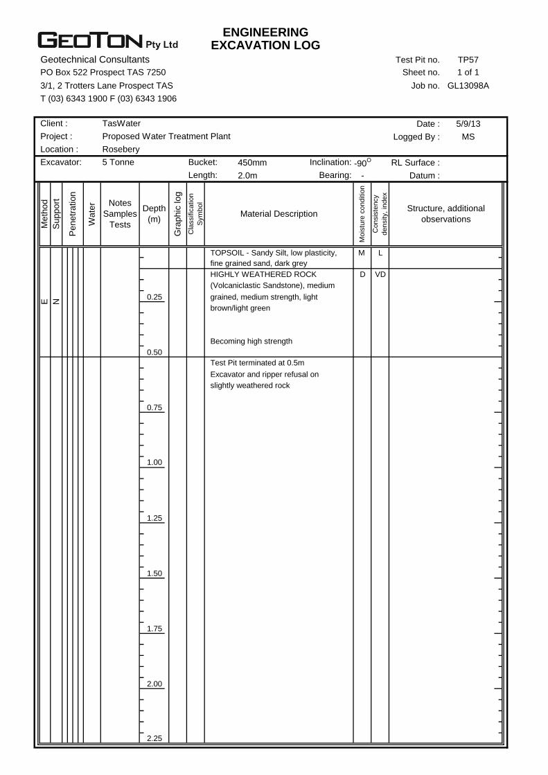
ENGINEERINGEXCAVATION LOG
Geotechnical Consultants Test Pit no. TP57
PO Box 522 Prospect TAS 7250 Sheet no. 1 of 1
3/1, 2 Trotters Lane Prospect TAS Job no. GL13098A
T (03) 6343 1900 F (03) 6343 1906
Date : 5/9/13
Logged By : MS
450mm -90O RL Surface :
2.0m - Datum :
M L
D VD
0.25
0.50
0.75
1.00
1.25
1.50
1.75
2.00
2.25
Test Pit terminated at 0.5m
Excavator and ripper refusal on
slightly weathered rock
Becoming high strength
HIGHLY WEATHERED ROCK
(Volcaniclastic Sandstone), medium
grained, medium strength, light
brown/light green
Co
nsis
ten
cy
de
nsity,
ind
ex
Structure, additional
observations
TOPSOIL - Sandy Silt, low plasticity,
fine grained sand, dark grey
Depth
(m)
Gra
phic
log
Cla
ssific
atio
n
Sym
bo
l
Material Description
Mo
istu
re c
on
ditio
n
Me
thod
Suppo
rt
Penetr
ation
Wate
r Notes
Samples
Tests
Excavator: 5 Tonne Bucket: Inclination:
Length: Bearing:
Client : TasWater
Project : Proposed Water Treatment Plant
Location : Rosebery
E
N
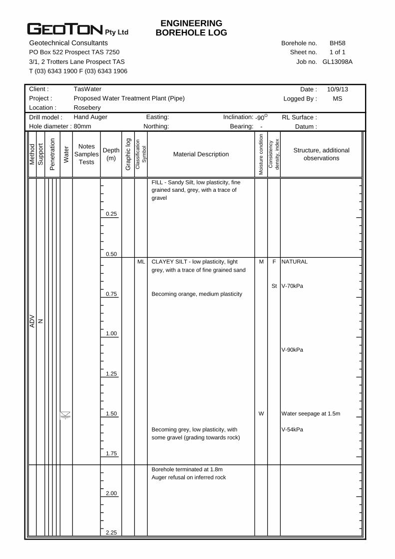
ENGINEERINGBOREHOLE LOG
Geotechnical Consultants Borehole no. BH58
PO Box 522 Prospect TAS 7250 Sheet no. 1 of 1
3/1, 2 Trotters Lane Prospect TAS Job no. GL13098A
T (03) 6343 1900 F (03) 6343 1906
Date : 10/9/13
Logged By : MS
Drill model : -90O RL Surface :
- Datum :
0.25
0.50
ML M F NATURAL
St V-70kPa
0.75
1.00
V-90kPa
1.25
1.50 W Water seepage at 1.5m
V-54kPa
1.75
2.00
2.25
CLAYEY SILT - low plasticity, light
grey, with a trace of fine grained sand
Becoming orange, medium plasticity
Borehole terminated at 1.8m
Auger refusal on inferred rock
Becoming grey, low plasticity, with
some gravel (grading towards rock)
gravel
Co
nsis
ten
cy
de
nsity,
ind
ex
Structure, additional
observations
FILL - Sandy Silt, low plasticity, fine
grained sand, grey, with a trace of
Depth
(m)
Gra
phic
log
Cla
ssific
atio
n
Sym
bo
l
Material Description
Mo
istu
re c
on
ditio
n
Me
thod
Suppo
rt
Penetr
ation
Wate
r Notes
Samples
Tests
AD
V
N
Hand Auger Easting: Inclination:
Hole diameter : 80mm Northing: Bearing:
Client : TasWater
Project : Proposed Water Treatment Plant (Pipe)
Location : Rosebery
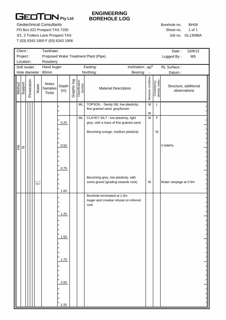
ENGINEERINGBOREHOLE LOG
Geotechnical Consultants Borehole no. BH59
PO Box 522 Prospect TAS 7250 Sheet no. 1 of 1
3/1, 2 Trotters Lane Prospect TAS Job no. GL13098A
T (03) 6343 1900 F (03) 6343 1906
Date : 10/9/13
Logged By : MS
Drill model : -90O RL Surface :
- Datum :
ML M L
W
ML M F
0.25
St
0.50 V-64kPa
0.75
W Water seepage at 0.9m
1.00
1.25
1.50
1.75
2.00
2.25
Borehole terminated at 1.0m
Auger and crowbar refusal on inferred
rock
Becoming grey, low plasticity, with
some gravel (grading towards rock)
Becoming orange, medium plasticity
CLAYEY SILT - low plasticity, light
grey, with a trace of fine grained sand
Co
nsis
ten
cy
de
nsity,
ind
ex
Structure, additional
observations
TOPSOIL - Sandy Silt, low plasticity,
fine grained sand, grey/brown
Depth
(m)
Gra
phic
log
Cla
ssific
atio
n
Sym
bo
l
Material Description
Mo
istu
re c
on
ditio
n
Me
thod
Suppo
rt
Penetr
ation
Wate
r Notes
Samples
Tests
Hand Auger Easting: Inclination:
Hole diameter : 80mm Northing: Bearing:
Client : TasWater
Project : Proposed Water Treatment Plant (Pipe)
Location : Rosebery
HA N

ENGINEERINGBOREHOLE LOG
Geotechnical Consultants Borehole no. BH60
PO Box 522 Prospect TAS 7250 Sheet no. 1 of 1
3/1, 2 Trotters Lane Prospect TAS Job no. GL13098A
T (03) 6343 1900 F (03) 6343 1906
Date : 10/9/13
Logged By : MS
Drill model : -90O RL Surface :
- Datum :
MD D/M
0.25
D
0.50
0.75
1.00
1.25
1.50
1.75
2.00
2.25
Borehole terminated at 0.5m
Auger and crowbar refusal on inferred
cobbles/boulder
cobbles and boulders
Co
nsis
ten
cy
de
nsity,
ind
ex
Structure, additional
observations
FILL - Clayey Gravel, fine to coarse,
low plasticity fines, with some
Depth
(m)
Gra
phic
log
Cla
ssific
atio
n
Sym
bo
l
Material Description
Mo
istu
re c
on
ditio
n
Me
thod
Suppo
rt
Penetr
ation
Wate
r Notes
Samples
Tests
Hand Auger Easting: Inclination:
Hole diameter : 80mm Northing: Bearing:
Client : TasWater
Project : Proposed Water Treatment Plant (Pipe)
Location : Rosebery
AD
V
N
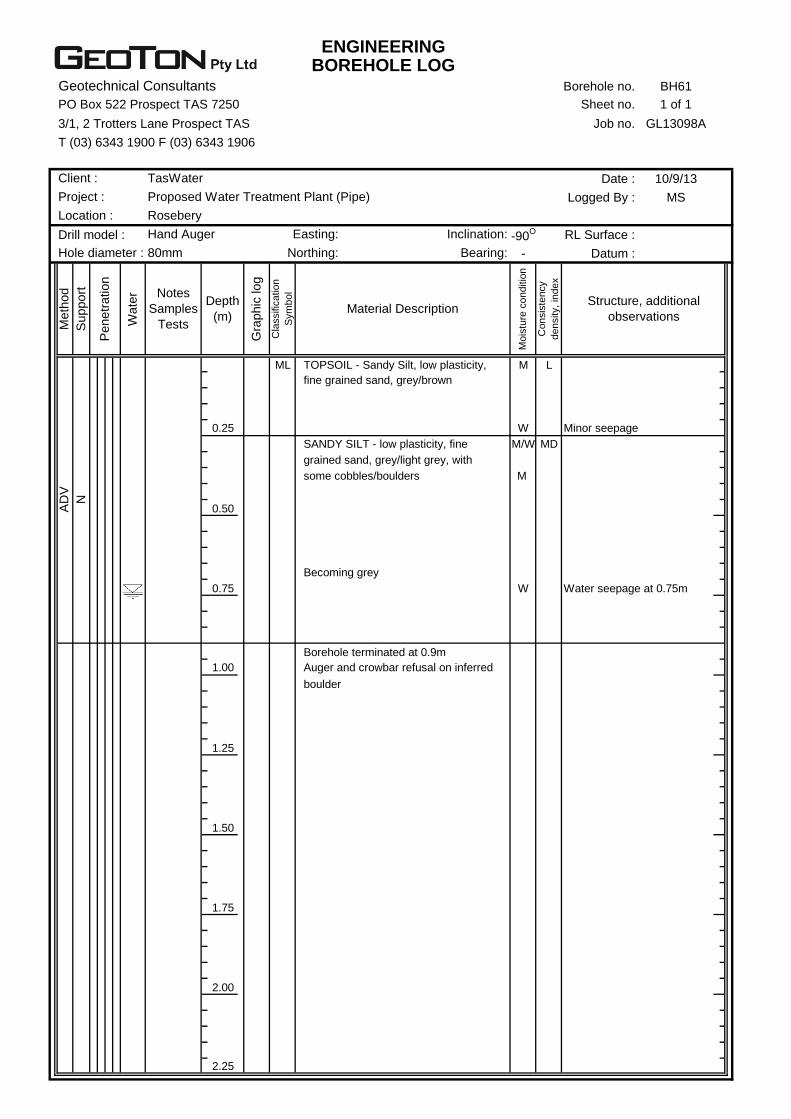
ENGINEERINGBOREHOLE LOG
Geotechnical Consultants Borehole no. BH61
PO Box 522 Prospect TAS 7250 Sheet no. 1 of 1
3/1, 2 Trotters Lane Prospect TAS Job no. GL13098A
T (03) 6343 1900 F (03) 6343 1906
Date : 10/9/13
Logged By : MS
Drill model : -90O RL Surface :
- Datum :
ML M L
0.25 W Minor seepage
M/W MD
M
0.50
0.75 W Water seepage at 0.75m
1.00
1.25
1.50
1.75
2.00
2.25
boulder
Borehole terminated at 0.9m
Auger and crowbar refusal on inferred
Becoming grey
grained sand, grey/light grey, with
some cobbles/boulders
SANDY SILT - low plasticity, fine
Co
nsis
ten
cy
de
nsity,
ind
ex
Structure, additional
observations
TOPSOIL - Sandy Silt, low plasticity,
fine grained sand, grey/brown
Depth
(m)
Gra
phic
log
Cla
ssific
atio
n
Sym
bo
l
Material Description
Mo
istu
re c
on
ditio
n
Me
thod
Suppo
rt
Penetr
ation
Wate
r Notes
Samples
Tests
Hand Auger Easting: Inclination:
Hole diameter : 80mm Northing: Bearing:
Client : TasWater
Project : Proposed Water Treatment Plant (Pipe)
Location : Rosebery
AD
V
N

Borehole Log Explanation Sheet Method
TERM Description
AS Auger Screwing*
AD Auger Drilling*
RR Roller / Tricone
W Washbore
CT Cable Tool
HA Hand Auger
DT Diatube
B Blank Bit
V V Bit
T TC Bit * Bit shown by suffix e.g. ADT
Support
TERM Description
M Mud
N Nil
C Casing
Notes, samples, tests
TERM Description
U50 Undisturbed sample 50 mm diameter
U63 Undisturbed sample 63 mm diameter
D Disturbed sample
N Standard Penetration Test (SPT)
N* SPT – sample recovered
NC SPT with solid cone
V Vane Shear
PP Pocket Penetrometer
P Pressumeter
BS Bulk sample
E Environmental Sample
R Refusal
Penetration
1 2 3 4
No resistance ranging to refusal
Water
Symbol Description
Water inflow
Water outflow
17/3/08 water on date shown
Classification symbols and soil description Based on unified classification system
Moisture
TERM Description
D Dry
M Moist
W Wet
WP Plastic Limit
WL Liquid Limit
Consistency/Density index
TERM Description
VS very soft
S soft
F firm
St stiff
VSt very stiff
H hard
Fb friable
VL very loose
L loose
MD medium dense
D dense
VD Very dense

Excavation Log Explanation Sheet Method
TERM Description
N Natural exposure
X Existing excavation
BH Backhoe bucket
B Bulldozer blade
R Ripper
E Excavator
Support
TERM Description
S Shoring
N Nil
Penetration
1 2 3 4
No resistance ranging to refusal
Water
Symbol Description
Water inflow
Water outflow
17/3/08 water on date shown
Notes, samples, tests
TERM Description
U50 Undisturbed sample 50 mm diameter
U63 Undisturbed sample 63 mm diameter
D Disturbed sample
PP Pocket Penetrometer
V Vane Shear
BS Bulk sample
E Environmental Sample
R Refusal
Classification symbols and soil description Based on unified classification system
Moisture
TERM Description
D Dry
M Moist
W Wet
WP Plastic Limit
WL Liquid Limit
Consistency/Density index
TERM Description
VS very soft
S soft
F firm
St stiff
VSt very stiff
H hard
Fb friable
VL very loose
L loose
MD medium dense
D dense
VD Very dense
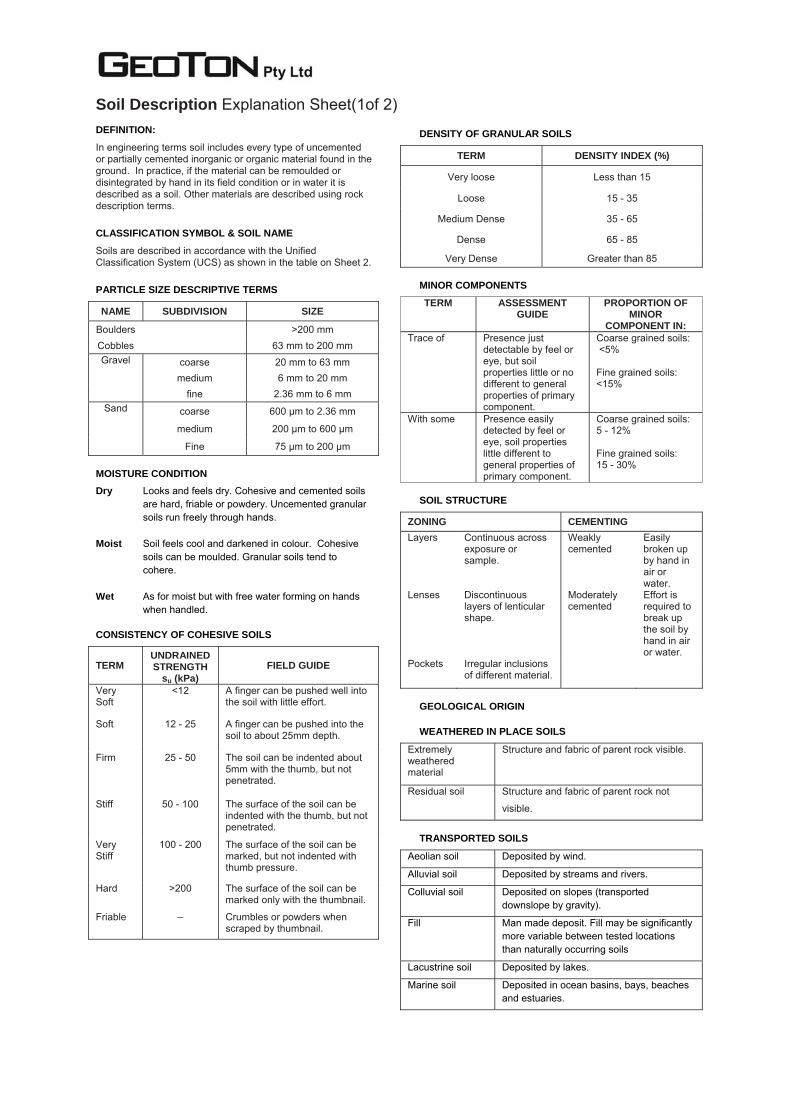
Soil Description Explanation Sheet(1of 2)
DEFINITION:
In engineering terms soil includes every type of uncemented or partially cemented inorganic or organic material found in the ground. In practice, if the material can be remoulded or disintegrated by hand in its field condition or in water it is described as a soil. Other materials are described using rock description terms.
CLASSIFICATION SYMBOL & SOIL NAME
Soils are described in accordance with the Unified Classification System (UCS) as shown in the table on Sheet 2.
PARTICLE SIZE DESCRIPTIVE TERMS
NAME SUBDIVISION SIZE
Boulders >200 mm Cobbles 63 mm to 200 mm Gravel coarse 20 mm to 63 mm
medium 6 mm to 20 mm fine 2.36 mm to 6 mm
Sand coarse 600 µm to 2.36 mm
medium 200 µm to 600 µm
Fine 75 µm to 200 µm
MOISTURE CONDITION Dry Looks and feels dry. Cohesive and cemented soils
are hard, friable or powdery. Uncemented granular soils run freely through hands.
Moist Soil feels cool and darkened in colour. Cohesive
soils can be moulded. Granular soils tend to cohere.
Wet As for moist but with free water forming on hands
when handled.
CONSISTENCY OF COHESIVE SOILS
TERM UNDRAINED STRENGTH
su (kPa) FIELD GUIDE
Very Soft
<12 A finger can be pushed well into the soil with little effort.
Soft 12 - 25 A finger can be pushed into the soil to about 25mm depth.
Firm 25 - 50 The soil can be indented about 5mm with the thumb, but not penetrated.
Stiff 50 - 100 The surface of the soil can be indented with the thumb, but not penetrated.
Very Stiff
100 - 200 The surface of the soil can be marked, but not indented with thumb pressure.
Hard >200 The surface of the soil can be marked only with the thumbnail.
Friable – Crumbles or powders when scraped by thumbnail.
DENSITY OF GRANULAR SOILS
TERM DENSITY INDEX (%)
Very loose Less than 15
Loose 15 - 35
Medium Dense 35 - 65
Dense 65 - 85
Very Dense Greater than 85
MINOR COMPONENTS
TERM ASSESSMENT GUIDE
PROPORTION OF MINOR
COMPONENT IN: Trace of Presence just
detectable by feel or eye, but soil properties little or no different to general properties of primary component.
Coarse grained soils: <5% Fine grained soils: <15%
With some Presence easily detected by feel or eye, soil properties little different to general properties of primary component.
Coarse grained soils: 5 - 12% Fine grained soils: 15 - 30%
SOIL STRUCTURE
ZONING CEMENTING Layers Continuous across
exposure or sample.
Weakly cemented
Easily broken up by hand in air or water.
Lenses Discontinuous layers of lenticular shape.
Moderately cemented
Effort is required to break up the soil by hand in air or water.
Pockets Irregular inclusions of different material.
GEOLOGICAL ORIGIN
WEATHERED IN PLACE SOILS
Extremely weathered material
Structure and fabric of parent rock visible.
Residual soil Structure and fabric of parent rock not
visible.
TRANSPORTED SOILS
Aeolian soil Deposited by wind.
Alluvial soil Deposited by streams and rivers.
Colluvial soil Deposited on slopes (transported downslope by gravity).
Fill Man made deposit. Fill may be significantly more variable between tested locations than naturally occurring soils
Lacustrine soil Deposited by lakes.
Marine soil Deposited in ocean basins, bays, beaches and estuaries.
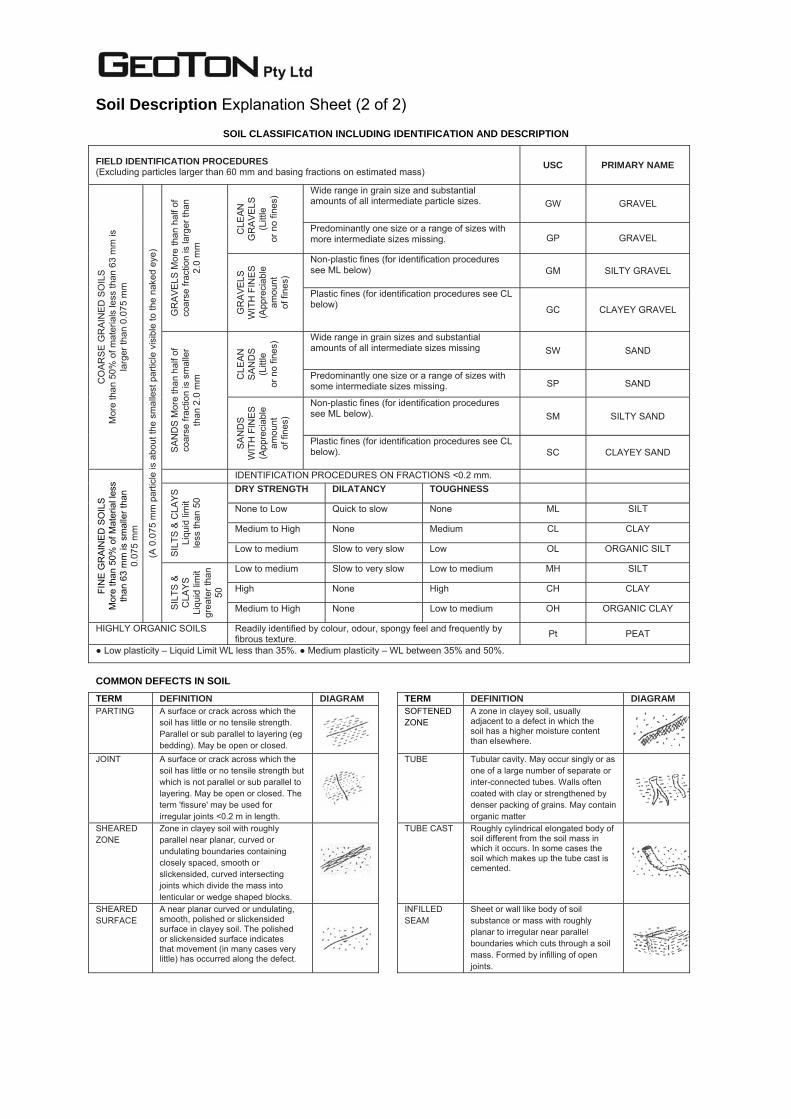
Soil Description Explanation Sheet (2 of 2)
SOIL CLASSIFICATION INCLUDING IDENTIFICATION AND DESCRIPTION FIELD IDENTIFICATION PROCEDURES (Excluding particles larger than 60 mm and basing fractions on estimated mass)
USC PRIMARY NAME
CO
ARS
E G
RAI
NED
SO
ILS
M
ore
than
50%
of m
ater
ials
less
than
63
mm
is
larg
er th
an 0
.075
mm
(A 0
.075
mm
par
ticle
is a
bout
the
smal
lest
par
ticle
vis
ible
to th
e na
ked
eye)
GR
AVE
LS M
ore
than
hal
f of
coar
se fr
actio
n is
larg
er th
an
2.0
mm
CLE
AN
GR
AVE
LS
(Litt
le
or n
o fin
es) Wide range in grain size and substantial
amounts of all intermediate particle sizes. GW GRAVEL
Predominantly one size or a range of sizes with more intermediate sizes missing. GP GRAVEL
GR
AVE
LS
WIT
H F
INE
S (A
ppre
ciab
le
amou
nt
of fi
nes)
Non-plastic fines (for identification procedures see ML below) GM SILTY GRAVEL
Plastic fines (for identification procedures see CL below)
GC CLAYEY GRAVEL
SA
ND
S M
ore
than
hal
f of
coar
se fr
actio
n is
sm
alle
r th
an 2
.0 m
m CLE
AN
SA
ND
S (L
ittle
or
no
fines
) Wide range in grain sizes and substantial amounts of all intermediate sizes missing SW SAND
Predominantly one size or a range of sizes with some intermediate sizes missing. SP SAND
SA
ND
S
WIT
H F
INE
S (A
ppre
ciab
le
amou
nt
of fi
nes)
Non-plastic fines (for identification procedures see ML below). SM SILTY SAND
Plastic fines (for identification procedures see CL below). SC CLAYEY SAND
FIN
E G
RAI
NE
D S
OIL
S M
ore
than
50%
of M
ater
ial l
ess
than
63
mm
is s
mal
ler t
han
0.07
5 m
m
IDENTIFICATION PROCEDURES ON FRACTIONS <0.2 mm.
SIL
TS &
CLA
YS
Liqu
id li
mit
less
than
50
DRY STRENGTH DILATANCY TOUGHNESS
None to Low Quick to slow None ML SILT
Medium to High None Medium CL CLAY
Low to medium Slow to very slow Low OL ORGANIC SILT
SIL
TS &
C
LAY
S
Liqu
id li
mit
gr
eate
r tha
n 50
Low to medium Slow to very slow Low to medium MH SILT
High None High CH CLAY
Medium to High None Low to medium OH ORGANIC CLAY
HIGHLY ORGANIC SOILS Readily identified by colour, odour, spongy feel and frequently by fibrous texture. Pt PEAT
● Low plasticity – Liquid Limit WL less than 35%. ● Medium plasticity – WL between 35% and 50%.
COMMON DEFECTS IN SOIL
TERM DEFINITION DIAGRAM TERM DEFINITION DIAGRAM PARTING A surface or crack across which the
soil has little or no tensile strength. Parallel or sub parallel to layering (eg bedding). May be open or closed.
SOFTENED ZONE
A zone in clayey soil, usually adjacent to a defect in which the soil has a higher moisture content than elsewhere.
JOINT A surface or crack across which the soil has little or no tensile strength but which is not parallel or sub parallel to layering. May be open or closed. The term 'fissure' may be used for irregular joints <0.2 m in length.
TUBE Tubular cavity. May occur singly or as one of a large number of separate or inter-connected tubes. Walls often coated with clay or strengthened by denser packing of grains. May contain organic matter
SHEARED ZONE
Zone in clayey soil with roughly parallel near planar, curved or undulating boundaries containing closely spaced, smooth or slickensided, curved intersecting joints which divide the mass into lenticular or wedge shaped blocks.
TUBE CAST Roughly cylindrical elongated body of soil different from the soil mass in which it occurs. In some cases the soil which makes up the tube cast is cemented.
SHEARED SURFACE
A near planar curved or undulating, smooth, polished or slickensided surface in clayey soil. The polished or slickensided surface indicates that movement (in many cases very little) has occurred along the defect.
INFILLED SEAM
Sheet or wall like body of soil substance or mass with roughly planar to irregular near parallel boundaries which cuts through a soil mass. Formed by infilling of open joints.

Appendix B Qualitative Terminology for Use in Assessing Risk to Property

Geoton Pty Ltd (adapted from Australian Geomechanics Vol 42 No 1 March 2007) 1
QUALITATIVE TERMINOLOGY FOR USE IN ASSESSING RISK TO PROPERTY QUALITATIVE MEASURES OF LIKELIHOOD Approximate Annual Probability Implied Indicative Landslide
Recurrence Interval
Description Descriptor Level Indicative
Value Notional
Boundary 10-1
5x10⁻²
5x10⁻³
5x10⁻⁴
5x10⁻⁵
5x10⁻⁶
10 years20 years
200 years
2000 years
20,000 years
200,000 years
The event is expected to occur over the design life. ALMOST CERTAIN A
10-2 100 years The event will probably occur under adverse conditions over the design life. LIKELY B
10-3 1000 years The event could occur under adverse conditions over the design life. POSSIBLE C
10-4 10,000 years The event might occur under very adverse circumstances over the design life. UNLIKELY D
10-5 100,000 years The event is conceivable but only under exceptional circumstances over the design life. RARE E
10-6 1,000,000 years The event is inconceivable or fanciful over the design life. BARELY CREDIBLE F Note: (1) The table should be used from left to right; use Approximate Annual Probability or Description to assign Descriptor, not vice versa. QUALITATIVE MEASURES OF CONSEQUENCES TO PROPERTY Approximate Cost of Damage Description Descriptor Level
IndicativeValue
Notional Boundary
200%
100%
40%
10%
1%
Structure(s) completely destroyed and/or large scale damage requiring major engineering works for stabilisation. Could cause at least one adjacent property major consequence damage.
CATASTROPHIC 1
60% Extensive damage to most of structure, and/or extending beyond site boundaries requiring significant stabilisation works. Could cause at least one adjacent property medium consequence damage.
MAJOR 2
20% Moderate damage to some of structure, and/or significant part of site requiring large stabilisation works. Could cause at least one adjacent property minor consequence damage.
MEDIUM 3
5% Limited damage to part of structure, and/or part of site requiring some reinstatement stabilisation works. MINOR 4
0.5%
Little damage. (Note for high probability event (Almost Certain), this category may be subdivided at a notional boundary of 0.1%. See Risk Matrix.)
INSIGNIFICANT 5
Notes: (2) The Approximate Cost of Damage is expressed as a percentage of market value, being the cost of the improved value of the unaffected property which includes the
land plus the unaffected structures. (3) The Approximate Cost is to be an estimate of the direct cost of the damage, such as the cost of reinstatement of the damaged portion of the property (land plus
structures), stabilization works required to render the site to tolerable risk level for the landslide which has occurred and professional design fees, and consequential costs such as legal fees, temporary accommodation. It does not include additional stabilisation works to address other landslides which may affect the property.
(4) The table should be used from left to right; use Approximate Cost of Damage or Description to assign Descriptor, not vice versa

Geoton Pty Ltd (adapted from Australian Geomechanics Vol 42 No 1 March 2007) 2
QUALITATIVE TERMINOLOGY FOR USE IN ASSESSING RISK TO PROPERTY (CONTINUED) QUALITATIVE RISK ANALYSIS MATRIX – LEVEL OF RISK TO PROPERTY
LIKELIHOOD CONSEQUENCES TO PROPERTY (With Indicative Approximate Cost of Damage) Indicative Value of
Approximate Annual Probability
1: CATASTROPHIC200%
2: MAJOR60%
3: MEDIUM20%
4: MINOR5%
5:INSIGNIFICANT
0.5%
A – ALMOST CERTAIN 10-1 VH VH VH H M or L (5)
B - LIKELY 10-2 VH VH H M L C - POSSIBLE 10-3 VH H M M VL
D - UNLIKELY 10-4 H M L L VL
E - RARE 10-5 M L L VL VL
F - BARELY CREDIBLE 10-6 L VL VL VL VL Notes: (5) For Cell A5, may be subdivided such that a consequence of less than 0.1% is Low Risk.
(6) When considering a risk assessment it must be clearly stated whether it is for existing conditions or with risk control measures which may not be implemented at the current time.
RISK LEVEL IMPLICATIONS
Risk Level Example Implications (7)
VH VERY HIGH RISK Unacceptable without treatment. Extensive detailed investigation and research, planning and implementation of treatment options essential to reduce risk to Low; may be too expensive and not practical. Work likely to cost more than value of the property.
H HIGH RISK Unacceptable without treatment. Detailed investigation, planning and implementation of treatment options required to reduce risk to Low. Work would cost a substantial sum in relation to the value of the property.
M MODERATE RISK May be tolerated in certain circumstances (subject to regulator’s approval) but requires investigation, planning and implementation of treatment options to reduce the risk to Low. Treatment options to reduce to Low risk should be implemented as soon as practicable.
L LOW RISK Usually acceptable to regulators. Where treatment has been required to reduce the risk to this level, ongoing maintenance is required.
VL VERY LOW RISK Acceptable. Manage by normal slope maintenance procedures.
Note: (7) The implications for a particular situation are to be determined by all parties to the risk assessment and may depend on the nature of the property at risk; these are only given as a general guide

Appendix C Some Guidelines for Hillside Construction

PRACTICE NOTE GUIDELINES FOR LANDSLIDE RISK MANAGEMENT 2007
Australian Geomechanics Vol 42 No 1 March 2007
APPENDIX - SOME GUIDELINES FOR HILLSIDE CONSTRUCTION
GOOD ENGINEERING PRACTICE POOR ENGINEERING PRACTICE ADVICE
GEOTECHNICAL ASSESSMENT
Obtain advice from a qualified, experienced geotechnical practitioner at early stage of planning and before site works.
Prepare detailed plan and start site works before geotechnical advice.
PLANNING SITE PLANNING Having obtained geotechnical advice, plan the development with the risk
arising from the identified hazards and consequences in mind. Plan development without regard for the Risk.
DESIGN AND CONSTRUCTION
HOUSE DESIGN Use flexible structures which incorporate properly designed brickwork, timber or steel frames, timber or panel cladding. Consider use of split levels. Use decks for recreational areas where appropriate.
Floor plans which require extensive cutting and filling. Movement intolerant structures.
SITE CLEARING Retain natural vegetation wherever practicable. Indiscriminately clear the site. EARTHWORKS Retain natural contours wherever possible. Indiscriminatory bulk earthworks.
CUTS Minimise depth. Support with engineered retaining walls or batter to appropriate slope. Provide drainage measures and erosion control.
Large scale cuts and benching. Unsupported cuts. Ignore drainage requirements
FILLS
Minimise height. Strip vegetation and topsoil and key into natural slopes prior to filling. Use clean fill materials and compact to engineering standards. Batter to appropriate slope or support with engineered retaining wall. Provide surface drainage and appropriate subsurface drainage.
Loose or poorly compacted fill, which if it fails, may flow a considerable distance including onto property below. Block natural drainage lines. Fill over existing vegetation and topsoil. Include stumps, trees, vegetation, topsoil, boulders, building rubble etc in fill.
ROCK OUTCROPS & BOULDERS
Remove or stabilise boulders which may have unacceptable risk. Support rock faces where necessary.
Disturb or undercut detached blocks or boulders.
RETAINING WALLS
Found on rock where practicable. Provide subsurface drainage within wall backfill and surface drainage on slope above. Construct wall as soon as possible after cut/fill operation.
Construct a structurally inadequate wall such as sandstone flagging, brick or unreinforced blockwork. Lack of subsurface drains and weepholes.
FOOTINGS Found within rock where practicable. Use rows of piers or strip footings oriented up and down slope. Design for lateral creep pressures if necessary. Backfill footing excavations to exclude ingress of surface water.
Found on topsoil, loose fill, detached boulders or undercut cliffs.
SWIMMING POOLS
Engineer designed. Support on piers to rock where practicable. Provide with under-drainage and gravity drain outlet where practicable. Design for high soil pressures which may develop on uphill side whilst there may be little or no lateral support on downhill side.
DRAINAGE
SURFACE
Provide at tops of cut and fill slopes. Discharge to street drainage or natural water courses. Provide general falls to prevent blockage by siltation and incorporate silt traps. Line to minimise infiltration and make flexible where possible. Special structures to dissipate energy at changes of slope and/or direction.
Discharge at top of fills and cuts. Allow water to pond on bench areas.
SUBSURFACE Provide filter around subsurface drain. Provide drain behind retaining walls. Use flexible pipelines with access for maintenance. Prevent inflow of surface water.
Discharge roof runoff into absorption trenches.
SEPTIC & SULLAGE
Usually requires pump-out or mains sewer systems; absorption trenches may be possible in some areas if risk is acceptable. Storage tanks should be water-tight and adequately founded.
Discharge sullage directly onto and into slopes. Use absorption trenches without consideration of landslide risk.
EROSION CONTROL &
LANDSCAPING
Control erosion as this may lead to instability. Revegetate cleared area.
Failure to observe earthworks and drainage recommendations when landscaping.
DRAWINGS AND SITE VISITS DURING CONSTRUCTION DRAWINGS Building Application drawings should be viewed by geotechnical consultant SITE VISITS Site Visits by consultant may be appropriate during construction/
INSPECTION AND MAINTENANCE BY OWNER OWNER’S
RESPONSIBILITY
Clean drainage systems; repair broken joints in drains and leaks in supply pipes. Where structural distress is evident see advice. If seepage observed, determine causes or seek advice on consequences.

PRACTICE NOTE GUIDELINES FOR LANDSLIDE RISK MANAGEMENT 2007
Australian Geomechanics Vol 42 No 1 March 2007