Embed Size (px)
Citation preview

Geotechnical Assessment (2008) Preliminary Geotechnical Assessment (Coffey, 2008)
Geotechnical A
ssessment (2008)

The following document was prepared in 2008 by Coffey Geotechnics Pty Ltd for Coopers GapWind Farm Pty Ltd. It is important to note that this document was prepared for a client separateto AGL and for a wind farm layout and specification that is different to that which is currentlyproposed as a part of this Community Infrastructure Designation. This document has beenincluded as a reference document to this IAR purely for the purposes of providing further detailbehind some aspects of the study previously undertaken on the site, and is intended to be readonly where referenced within the IAR Volume One document.

Coffey Geotechnics Pty Ltd ABN 93 056 929 483 47 Doggett Street Newstead QLD 4006 Australia
PRELIMINARY GEOTECHNICAL ASSESSMENT
Coopers Gap Windfarm GEOTKPAR01416AA-AB 7 April 2008
Investec Bank (Australia) Limited
Coffey Geotechnics Pty Ltd ABN 93 056 929 483 GEOTKPAR01416AA-AB 47 Doggett Street Newstead QLD 4006 Australia PO Box 2301 Fortitude Valley BC QLD 4006 Australia T (+61) (7) 3608 2500 F (+61) (7) 3852 2805 www.coffey.com.au/geotechnics
7 April 2008
Investec Bank (AUSTRALIA) Limited 300 Gilles St Adelaide SA 5000
Attention: Mr Jim Trenery
Dear Jim
RE: Preliminary Geotechnical Assessment
Coopers Gap Windfarm
Pleas find following our preliminary geotechnical assessment for Coopers Gap Windfarm. We trust that this report will satisfy your requirements for the time being. We would be pleased to work with you to develop a scope of work for a more detailed geotechnical assessment.
Should you require further information or assistance, please contact the undersigned.
For and on behalf of Coffey Geotechnics Pty Ltd
Ian Shipway
Principal
Distribution: 3 copies Investec Bank (Australia) Limited
1 Copy Coffey Brisbane Library

CONTENTS
Coffey Geotechnics GEOTKPAR01416AA-AB 7 August 2008
i
1 INTRODUCTION 1
2 PROJECT DESCRIPTION 1
3 WORK CONDUCTED FOR THIS ASSESSMENT 2
4 GEOLOGICAL FRAMEWORK & SURFACE OBSERVATIONS 2
4.1 Geology 2
4.2 Surface Conditions 3
5 SUB-SURFACE CONDITIONS 3
5.1 Observations in test pits 3
5.2 Observations in Cuttings 6
5.3 Observations at Quarry Site 6
6 PRELIMINARY GEOTECHNICAL ASSESSMENT 7
6.1 Founding of Wind Turbine Generators 7
6.2 Excavation Conditions 8
6.2.1 General Excavations for Footings and Roads 8
6.2.2 Excavation of Cable Trenches 8
6.3 Road Construction Issues 9
6.3.1 Geometrics and General Issues 9
6.3.2 Materials for Road Construction 9
6.3.3 The Potential Quarry Site 10
6.4 Founding of Guy Anchor Block 11
important information about your coffey report
Drawings
Drawing 1: Site Plan
Appendices
Appendix A: Field Investigation Data

Preliminary Geotechnical Assessment
Coffey Geotechnics GEOTKPAR01416AA-AB 7 August 2008
1
1 INTRODUCTION
Coffey Geotechnics has conducted a preliminary geotechnical assessment of the proposed site for the Coopers Gap Windfarm in south east Queensland. The assessment was conducted on behalf of Investec Bank (Australia) Limited with the following intentions:
• Identify and generally characterise the different geological units within the extents of the project;
• Make a generalised preliminary assessment as to the likely founding depths for Wind Turbine Generator (WTG) footings in the different geological units; and,
• Make a preliminary assessment of geotechnical constraints that could affect the construction of access roads and other infrastructure.
This report presents the results of our assessment, addresses the items above, and provides information on some other geotechnical aspects discussed on site with Mr Jim Trenery of Investec Bank. Also included are design parameters for guy anchor blocks which we understand are necessary for the construction of wind monitoring towers.
Figure 1.1. General Site Location
2 PROJECT DESCRIPTION
The site for the proposed windfarm is located off Niagara Road in Boyneside which is about 70 km south west of Kingaroy as indicated on Figure 1.1. Topographically, this vicinity is characterised by a series of north west to westerly trending ridgelines along which up to 147 wind turbine generators are to be distributed. Drawing 1 shows the general layout of wind turbines at the time of the assessment.
The turbines will be founded through steel reinforced concrete footings which generally found at up to 3m below surface level. Footings may be either of the gravity variety, that is, possessing sufficient weight to resist the overturning moments developed by the mass and operation of the turbine, or may be smaller footings that provide resistance to the forces through ground anchors.
0 10km
Approximate Site Location

Preliminary Geotechnical Assessment
Coffey Geotechnics GEOTKPAR01416AA-AB 7 August 2008
2
Roads connecting the wind turbine sites to the surrounding public road system will be required to allow construction, and also to provide access for maintenance vehicles for the design life of the wind turbines. Construction traffic will include large, heavily laden trucks. Experience indicates that although such vehicles are generally limited to grades of less than 10%, they can often traverse short distances with grades up to 20% in good weather conditions with assistance.
In addition to the access roads, the WTGs will need to be linked by a series of electrical cables which are generally layed in trenches with a depth of at least 1m below ground surface level.
3 WORK CONDUCTED FOR THIS ASSESSMENT
The work conducted for this assessment comprised the following:
o A desktop review of available geological information.
o A site visit by a Principal Engineering Geologist on 21 and 22 May 2008. During this site visit, twenty two test pits (designated CG1 to CG22) were excavated using a rubber tyred backhoe to allow assessment of typical subsurface features and limited geotechnical assessment.
The test pits were distributed over several of the ridge lines upon which the windfarm will be developed. These ridge lines have been designated A to I on Drawing 1 to assist with referencing in this report. The intent behind excavation of the test pits was to provide general characterisation of the range of ground conditions within the different ridge lines, rather than to investigate the specific sites of wind turbines.
The test pits were excavated to refusal or in several cases were terminated at depths below 2m depth where it was considered that no further useful information would be gained by proceeding further. The backhoe that excavated the test pits was a modern Case machine fitted with a 600mm wide bucket with tiger teeth in near new condition.
Some parts of the site, particularly those areas to the north west, could not be assessed due to access restrictions as discussions between the developer and land holders were still ongoing at the time of the site visit.
In addition to the main site area, a visit was made to a location which could be a potential source for construction materials, and two cuttings on Niagara Road where subsurface conditions were exposed over a depth of about 6m. Drawing 1 shows these locations.
4 GEOLOGICAL FRAMEWORK & SURFACE OBSERVATIONS
4.1 Geology
Published geological information shows that the vicinity of the proposed windfarm is mainly underlain by basalt bedrock of Tertiary age. Basalt is a dark, fine grained, volcanic rock that was deposited as distinct layers of lava which could vary in thickness from a few metres to nearly a hundred metres. Although basalt is usually very strong in its fresh state, it weathers relatively quickly (in geological time scales) to form dark brown and red clay soils. The pattern of basalt weathering often leaves “corestones” or boulders of strong rock within a soil matrix. This rapid weathering, coupled with the mode of deposition in successive layers can often lead to a situation where one layer weathers to a soil and then is overlain by a new lava flow, which is itself weathered and partially eroded. The result of this is that terrain formed in basalt can often have relatively weak material underneath strong rock, a situation that is relatively uncommon outside of basalt terrains.

Preliminary Geotechnical Assessment
Coffey Geotechnics GEOTKPAR01416AA-AB 7 August 2008
3
There are areas of the site to the north east that are underlain by older sedimentary rocks. These materials are not discussed in this report as those areas could not be visited during field work due to the access constraints outlined previously.
4.2 Surface Conditions
The development area comprises a series of west to north west trending ridge lines which rise to as high as 850m above sea level. The area has generally been cleared, with only scattered trees remaining. Grazing is the predominant land use along the ridge lines and slopes. Ground cover is mainly long grass with some prickly pear and small shrubs. Clay soils are generally evident at the surface, with zones of scattered rock fragments and rare areas of rock outcrop. Where outcrop is visible at the surface it usually comprises fractured basalt which would break into large fragments on excavation.
Slopes vary greatly in steepness from very shallow to angles steeper than 20o. The density of contour lines on Drawing 1 provide a reasonable comparison of the steepness of different areas. The current access to Ridges F and G required us to traverse slopes of up to 10o (about 17%). Access to Ridge H uphill of test pit CG21 would require a long section of slope of 15o (27%) to be traversed. Current access to most of the other ridges assessed involves traversing slopes of not more than 7o (12%).
5 SUB-SURFACE CONDITIONS
5.1 Observations in test pits
The test pits revealed a profile comprising variably weathered basalt which formed a profile as outlined in Table 1. More detailed descriptions of materials are provided on the Engineering Logs included in Appendix A, which also includes sheets explaining the meaning of the terms used in the descriptions.
TABLE 1. SUMMARY OF MATERIALS OBSERVED IN TEST PITS
Depth Range Generalised Material Description
Not present at many locations. Generally around 0.5m thickness but over 3.3m in CG21 on Ridge H
Unit 1 Very stiff and hard, brown and red brown clay. Clay is generally of high plasticity with some medium plasticity materials.
Not present at some locations. Generally about 0.5m thick, but varies.
Unit 2 Very stiff and hard gravelly clay or very dense clayey gravel usually with some large rock fragments over 100mm in size. Generally medium or high plasticity clay.
Present only at a few locations.
Unit 3 Basalt fragments in a soil matrix. Rock fragments varying in size from 100mm to 500mm in size in a matrix of stiff to hard clay. In some locations fragments are much smaller than others.
Found in nearly all test pits. Unit 4 Weathered basalt bedrock. Varies in degree of weathering. Generally high to very high strength but with numerous soils strength zones between sections of rock. In most cases the backhoe bucket refused after penetrating about 0.5m, but in some cases penetrated over 1m into predominantly rock strength material. The spoil size of the excavated material varied significantly from about 100mm to as large as 600mm.

Preliminary Geotechnical Assessment
Coffey Geotechnics GEOTKPAR01416AA-AB 7 August 2008
4
Figure 5.1 shows the profile from test pit CG8 on Ridge C.
Figure 5.2 Profile in test pit CG8 showing clay over basalt.
Units 1 & 2 Clay & gravelly clay
Unit 4 Moderately weathered basalt

Preliminary Geotechnical Assessment
Coffey Geotechnics GEOTKPAR01416AA-AB 7 August 2008
5
The difference between Unit 3 and Unit 4 relates to the assessed quantity of rock strength material, with Unit 4 comprising mainly rock with some soil zones. Figure 5.1 shows a comparison of spoil between two of the test pits to give some idea of the range of sizes of excavated spoil observed.
Figure 5.1. Comparison of Spoil from Two Test Pits
Test Pit CG 13. Most fragments up to 80mm in size but some to 300mm.
Test Pit CG 17. Most fragments from 300 to 500mm in size with some larger and smaller.

Preliminary Geotechnical Assessment
Coffey Geotechnics GEOTKPAR01416AA-AB 7 August 2008
6
5.2 Observations in Cuttings
The two cuttings revealed highly complex, variable conditions over short distances. Some parts of the cutting face exhibited deep soil strength zones, whilst other areas were rock from near the surface. The materials were generally weathered such that the block size in disturbance was generally up to 100mm, but with some blocks to about 600mm in size. These conditions are generally consistent with those revealed in the test pits. Figure 5.3 shows a typical cutting face. Note the spoil forming at the base which is a mixture of soil and rock strength material.
Figure 5.3. View of South Western Side of Road Cutting
5.3 Observations at Quarry Site
Conditions at the potential quarry site are quite different to those on the surrounding hillsides. In this location the near surface materials comprise variably sized fragments of fresh, very high strength basalt as shown on Figure 5.4. These conditions have formed through the collapse of large, joint defined “columns” of basalt which make up the adjacent hillside. Lava flows from which the basalt was formed often develop such continuous near vertical joints as they cool. At this location the adjacent creek appears to have undercut the base of the slope, exposing the columns and allowing collapse.

Preliminary Geotechnical Assessment
Coffey Geotechnics GEOTKPAR01416AA-AB 7 August 2008
7
Figure 5.4. Part of potential borrow area, with source of material upslope
6 PRELIMINARY GEOTECHNICAL ASSESSMENT
6.1 Founding of Wind Turbine Generators
The WTGs will be founded on either “gravity” type near surface footings or reinforced concrete footings restrained by ground anchors.
For the anchored footing design to be appropriate for a specific WTG site the near surface materials must have appropriate strength and stiffness and there must be suitable rock at depth over the bond length of the anchors which would be at depths greater than 10m below the base of the footing.
Basalt provides specific challenges for an anchored footing system because of the potential for less strong materials underlying strong near surface materials. At this stage, the near surface investigations conducted so far have not revealed such conditions but they may still present undetected.
The main parameters pertinent to design of footings of both kinds are elastic modulus, serviceability bearing pressure and ultimate bearing capacity of the near surface materials. A key parameter governing design of an anchored footing is the allowable bond stress of the ground to grout bond at depth.
Based on the available information and our experience of the design requirements at other sites, we consider that at least some of the WTG sites would be able to satisfy the near surface criteria for an anchored footing. Deeper drilling to provide a greater understanding of the geology of the successive

Preliminary Geotechnical Assessment
Coffey Geotechnics GEOTKPAR01416AA-AB 7 August 2008
8
lava flows comprising the ridge lines would be needed to make an assessment of the anchor bond zones. The quantity (and therefore the cost) of such investigation may be greater than usual for non basalt sites.
Based on the information available, we are of the opinion that suitable founding strata would be present at most locations between 0.7m and 1.5m depth and that an economic gravity footing could be designed for these ground conditions with the possible exception of the deep clay soils intersected by test pit CG21 on Ridge H. Note that these conditions have been found in only a singe test pit, and that this pit was excavated on the flanks of the slope rather than the ridge line because of access constraints.
6.2 Excavation Conditions
6.2.1 General Excavations for Footings and Roads
The test pits have demonstrated that the majority of materials on site can be excavated down to about 1m depth or a bit less using a backhoe. Note that this was achieved using good equipment (detailed previously) in a confined trench. Large hydraulic excavators (ie, 30 tonne or greater) should be able to penetrate further, particularly in a larger bulk excavation. However, the variably weathered nature of the bedrock and the presence of rock outcrop in some locations suggests that there will be some zones where excavation using excavators would not be practical or economic. Large bulldozers or even blasting could be required if such zones cannot be avoided.
6.2.2 Excavation of Cable Trenches
During past assessments with respect to cable trenches and the like, we have developed a table of excavation classes as shown on Table 2.
TABLE 2: EXCAVATION CLASS DEFINITIONS
Class Typical Material Descriptions Likely Type of Machine to be Used
I Soil; soil & “very weak rock” (i.e. typical Unconfined Compressive Strength (UCS) < 2 MPa)
Cleveland Bucket Wheel Excavator
II “Weak rock” (i.e. typical UCS<40MPa), open closely jointed “strong” rock.
Vermeer Chain Trencher
III Tight jointed “strong rock”; variable rocky ground. Tracked Excavators & Hammers
IV Massive “strong” rock. Blasting or Heavy Use of Rock Hammers
The conditions revealed by the test pits (and inferred by surface observation) generally fall into either Class II or Class III with the majority being “variable rocky ground” (Class III). Whilst a Vermeer trencher may be successful in some parts of the development, a particular challenge is posed by the large, high strength boulders within the soils which allow the trencher to get up to speed before bringing it to a rapid halt, often resulting in broken teeth and slow repairs. Taking this into account, we consider

Preliminary Geotechnical Assessment
Coffey Geotechnics GEOTKPAR01416AA-AB 7 August 2008
9
that large excavators would be a more economical alternative for excavating cable trenches. Note that even using such equipment it may be necessary to divert trenches around some zones of stronger material or alternatively resort to blasting or heavy rock hammers for short sections.
6.3 Road Construction Issues
6.3.1 Geometrics and General Issues
The philosophy behind road construction should be carefully considered prior to embarking on the project. Our understanding is that the roads are required to be serviceable during construction under relatively heavy traffic and for the in-service period under infrequent light traffic. An all weather, easily maintained, unsealed road is usually adopted. Our experience suggests that as the majority of traffic will be experienced during the construction period there is little point in trying to construct the final pavement surface at the outset. It will often be more practical for the contractor to form the road and maintain/resurface during the construction period as required by very short term traffic requirements. The finished surface would be trimmed etc on completion of construction of the turbines and other infrastructure.
In previous projects we have been advised that the maximum grade trafficable by the required construction traffic is 10%, however we are also aware that in practice short sections of road at up to 20% grade have been used. Larger trucks may require assistance to get through these steeper sections and they may not be passable during wet weather.
As noted previously, the current access to several of the ridge lines (F, G and H) involves traversing slopes significantly steeper than 10% and at some places steeper than 20% grade. It is likely that there are other unobserved locations that will be similarly steep. However it is possible that there are other practical routes to access many of these sites where grades would not be as steep. These will need to be carefully assessed, and it may be worth considering accessibility in detail when finalising turbine locations.
If large tracked cranes are required for construction, as is the case in many wind farms it may be necessary to construct access roads over 10m wide with tight tolerances on the maximum side slopes. Under these circumstances the steep terrain of the development area may provide an even greater challenge. Routes for roads will need to be carefully selected to limit the amount of cut required to meet the specification for cross fall.
6.3.2 Materials for Road Construction
Construction materials for a serviceable road as outlined above would generally comprise a mixture of gravel, sand and clay/silt binders. Usually the maximum size of these materials would be about 80mm except for the case of certain weak rocks that break down under a grid roller. For unsealed roads such materials generally require slightly more plastic fines than a typical road base will usually possess. The less processing a material requires, the cheaper it will be. Therefore preference would be given to materials that can be excavated and used immediately, rather than those that require crushing and complex screening. An intermediate step would be basic screening to remove oversize particles.
In our opinion it may be practical to use some of the materials won during excavation of footings and small cuts for roads in construction of road pavements. The challenges posed by basaltic materials in this regard are the high plasticity of the clay component and the large blocks of strong rock that are likely to be won from some locations as shown in Figure 5.1. This material would certainly require

Preliminary Geotechnical Assessment
Coffey Geotechnics GEOTKPAR01416AA-AB 7 August 2008
10
screening to remove larger blocks. These could be crushed by mobile on site crushing plant if greater volumes of material are required than can be provided by screening alone. In some areas (ie, Ridges A and C) there is a high proportion of clay which may make the materials unusable unless the materials can be selectively won to remove the more clayey components.
6.3.3 The Potential Quarry Site
Economics will dictate that carting material for road construction from off site would only be contemplated if insufficient suitable material can be won on site during construction. Materials observed near the surface of the proposed quarry site comprised fragments of very high strength basalt (varying from gravel to over 0.5m in size) that appeared to be suitable for crushing to make good quality road material. Whilst the material appears generally suitable there are a number of issues which may affect the practicality of this source. Firstly, the mode of collapse of the basalt columns has formed very steep slopes adjacent to the hillside which may be readily subject to instability during extraction of resource. The extraction plan would need to be carefully considered to maintain the safety of those working on site.
Another aspect is the access road to the quarry site, a small section of which is shown on Figure 6.1. As shown this is an unsealed road in poor condition with many twists and low overhead clearance in several locations. It is likely that the road would need to be upgraded if significant truck traffic was considered. It is possible that the road may not be trafficable by larger semi-tippers even after upgrading.
Figure 6.1. Small section of proposed quarry access road
Preliminary Geotechnical Assessment
Coffey Geotechnics GEOTKPAR01416AA-AB 7 August 2008
11
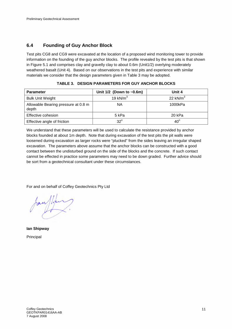
6.4 Founding of Guy Anchor Block
Test pits CG8 and CG9 were excavated at the location of a proposed wind monitoring tower to provide information on the founding of the guy anchor blocks. The profile revealed by the test pits is that shown in Figure 5.1 and comprises clay and gravelly clay to about 0.6m (Unit1/2) overlying moderately weathered basalt (Unit 4). Based on our observations in the test pits and experience with similar materials we consider that the design parameters given in Table 3 may be adopted.
TABLE 3. DESIGN PARAMETERS FOR GUY ANCHOR BLOCKS
Parameter Unit 1/2 (Down to ~0.6m) Unit 4
Bulk Unit Weight 19 kN/m3 22 kN/m3
Allowable Bearing pressure at 0.8 m depth
NA 1000kPa
Effective cohesion 5 kPa 20 kPa
Effective angle of friction 32o 40o
We understand that these parameters will be used to calculate the resistance provided by anchor blocks founded at about 1m depth. Note that during excavation of the test pits the pit walls were loosened during excavation as larger rocks were “plucked” from the sides leaving an irregular shaped excavation. The parameters above assume that the anchor blocks can be constructed with a good contact between the undisturbed ground on the side of the blocks and the concrete. If such contact cannot be effected in practice some parameters may need to be down graded. Further advice should be sort from a geotechnical consultant under these circumstances.
For and on behalf of Coffey Geotechnics Pty Ltd
Ian Shipway
Principal

Drawings

Appendix A Field Investigation Data


Res
idu
al S
oil
RS
-XW
Bas
alt
HW
Bas
alt
CLAY: High plasticity, dark brown & red brown; traceof fine to medium basalt gravel.
CLAY & GRAVELLY CLAY: High plasticity clay (redbrown) & low plasticty, gravelly clay (pale brown) withfine to coarse basalt gravel; with a trace to someangular basalt fragments to 150mm in size.
HW BASALT: Dark brown and red brown; mediumto high strength; numerous XW seams and zones ofhard, red brown, high plasticity clay; breaks intofragments up to 150mm (but mainly <50mm) onexcavation.
Near refusal at 1.3mTest pit CG1 terminated at 1.3m
H
Non
e O
bser
ved
BH CH
CH/CL
D-MN
natural exposureexisting excavationbackhoe bucketbulldozer bladeripperexcavator
no resistanceranging torefusal
water outflow
consistency/density index
drymoistwetplastic limitliquid limit
Sketch
material substance
moisture
water
VSSFStVStHFbVLLMDDVD
met
hod
cons
iste
ncy/
dens
ity in
dex
water levelon date shown
1 2 3 4
100
200
300
400
classification symbols andsoil descriptionbased on unified classificationsystem
clas
sific
atio
nsy
mbo
l
excavation information
equipment type and model:
excavation dimensions:
notes, samples, testsvery softsoftfirmstiffvery stiffhardfriablevery looseloosemedium densedensevery dense
Engineering Log - Excavation
CASE - 450mm Bucket
3.5m long 0.7m wide
structure andadditional observations
un
itg
eolo
gy
water inflow
0.5
1.0
1.5
2.0
2.5
Easting:
Northing:
Pit Orientation:
For
m G
EO
5.2
Issu
e 3
Rev
.2
Test pit location:
depthmetres m
oist
ure
cond
ition
wat
er
RL
material
supportS shoring
DMWWpWL
methodNXBHBRE
penetration
U50
U63
DVBsER
undisturbed sample 50mm diameterundisturbed sample 63mm diameterdisturbed samplevane shear (kPa)bulk sampleenvironmental samplerefusal
Excavation No.
346041 m
7044000 m
soil type: plasticity or particle characteristics,colour, secondary and minor components.
pene
trat
ion
grap
hic
log
pock
etpe
netr
o-m
eter
1 2 3 supp
ort
1 of 1
N nil
kPa
notessamples,tests, etc
AHD
INVESTEC BANK (AUSTRALIA) LIMITED
COOPERS GAP WINDFARM
See Figure 1R.L. Surface:
datum:
Client:
Principal:
Project:
Sheet
Date started:
Date completed:
Logged by:
Checked by:
CG1
GEOTKPAR01416AA21.5.2008
21.5.2008
IS
Project No:
PR
OJE
CT
FIL
E: T
ES
TC
AS
E2.
GP
J. L
IBR
AR
Y F
ILE
: CO
FG
EO
TE
CH
VE
R7R
EV
4.G
LB.
TE
MP
LAT
E F
ILE
: CO
FF
EY
.GD
T
FR
AM
E T
ITLE
: TE
ST
PIT
. D
AT
E: 7
.8.0
8

RS
/XW
BA
SA
LT
MW
BA
SA
LT
GRAVELLY CLAY: High plasticity, red brown & grey;approx 35% fine to coarse angular basalt fragmentsto 150mm in size.
MW BASALT: Dark brown stained pale brown; highto very high strength; numerous XW zones comprisnghard, red brown, high plasticity clay; breaks intofragments from 20mm to 200mm in size onexcavation.
Near refusal at 1.4mTest pit CG10 terminated at 1.4m
H
Non
e O
bser
ved
BH CH D-MN
natural exposureexisting excavationbackhoe bucketbulldozer bladeripperexcavator
no resistanceranging torefusal
water outflow
consistency/density index
drymoistwetplastic limitliquid limit
Sketch
material substance
moisture
water
VSSFStVStHFbVLLMDDVD
met
hod
cons
iste
ncy/
dens
ity in
dex
water levelon date shown
1 2 3 4
100
200
300
400
classification symbols andsoil descriptionbased on unified classificationsystem
clas
sific
atio
nsy
mbo
l
excavation information
equipment type and model:
excavation dimensions:
notes, samples, testsvery softsoftfirmstiffvery stiffhardfriablevery looseloosemedium densedensevery dense
Engineering Log - Excavation
CASE - 450mm Bucket
3.5m long 0.7m wide
structure andadditional observations
un
itg
eolo
gy
water inflow
0.5
1.0
1.5
2.0
2.5
Easting:
Northing:
Pit Orientation:
For
m G
EO
5.2
Issu
e 3
Rev
.2
Test pit location:
depthmetres m
oist
ure
cond
ition
wat
er
RL
material
supportS shoring
DMWWpWL
methodNXBHBRE
penetration
U50
U63
DVBsER
undisturbed sample 50mm diameterundisturbed sample 63mm diameterdisturbed samplevane shear (kPa)bulk sampleenvironmental samplerefusal
Excavation No.
346041 m
7044000 m
soil type: plasticity or particle characteristics,colour, secondary and minor components.
pene
trat
ion
grap
hic
log
pock
etpe
netr
o-m
eter
1 2 3 supp
ort
1 of 1
N nil
kPa
notessamples,tests, etc
AHD
INVESTEC BANK (AUSTRALIA) LIMITED
COOPERS GAP WINDFARM
See Figure 1R.L. Surface:
datum:
Client:
Principal:
Project:
Sheet
Date started:
Date completed:
Logged by:
Checked by:
CG10
GEOTKPAR01416AA22.5.2008
22.5.2008
IS
Project No:
PR
OJE
CT
FIL
E: T
ES
TC
AS
E2.
GP
J. L
IBR
AR
Y F
ILE
: CO
FG
EO
TE
CH
VE
R7R
EV
4.G
LB.
TE
MP
LAT
E F
ILE
: CO
FF
EY
.GD
T
FR
AM
E T
ITLE
: TE
ST
PIT
. D
AT
E: 7
.8.0
8

RS
/HW
BA
SA
LT
MW
BA
SA
LT
Corestones in a soil matrixMIXTURE OF SOIL (30%) AND ROCK (70%): Soil isgravelly clay; medium to high plasticity, dark brown;fine to coarse angular basalt gravel; rock comprisesbasalt fragments to 400mm in size (angular).
HW BASALT: Dark brown and red brown (stained);medium to high strength; numerous XW zonescomprisng hard, red brown, high plasticity clay; breaksinto fragments up to 100mm in size (but mainly up to50mm) on excavation.
Near refusal at 1.0mTest pit CG11 terminated at 1m
Non
e O
bser
ved
BH D-M D-MN
natural exposureexisting excavationbackhoe bucketbulldozer bladeripperexcavator
no resistanceranging torefusal
water outflow
consistency/density index
drymoistwetplastic limitliquid limit
Sketch
material substance
moisture
water
VSSFStVStHFbVLLMDDVD
met
hod
cons
iste
ncy/
dens
ity in
dex
water levelon date shown
1 2 3 4
100
200
300
400
classification symbols andsoil descriptionbased on unified classificationsystem
clas
sific
atio
nsy
mbo
l
excavation information
equipment type and model:
excavation dimensions:
notes, samples, testsvery softsoftfirmstiffvery stiffhardfriablevery looseloosemedium densedensevery dense
Engineering Log - Excavation
CASE - 450mm Bucket
3.5m long 0.7m wide
structure andadditional observations
un
itg
eolo
gy
water inflow
0.5
1.0
1.5
2.0
2.5
Easting:
Northing:
Pit Orientation:
For
m G
EO
5.2
Issu
e 3
Rev
.2
Test pit location:
depthmetres m
oist
ure
cond
ition
wat
er
RL
material
supportS shoring
DMWWpWL
methodNXBHBRE
penetration
U50
U63
DVBsER
undisturbed sample 50mm diameterundisturbed sample 63mm diameterdisturbed samplevane shear (kPa)bulk sampleenvironmental samplerefusal
Excavation No.
345940 m
7041944 m
soil type: plasticity or particle characteristics,colour, secondary and minor components.
pene
trat
ion
grap
hic
log
pock
etpe
netr
o-m
eter
1 2 3 supp
ort
1 of 1
N nil
kPa
notessamples,tests, etc
AHD
INVESTEC BANK (AUSTRALIA) LIMITED
COOPERS GAP WINDFARM
See Figure 1R.L. Surface:
datum:
Client:
Principal:
Project:
Sheet
Date started:
Date completed:
Logged by:
Checked by:
CG11
GEOTKPAR01416AA22.5.2008
22.5.2008
IS
Project No:
PR
OJE
CT
FIL
E: T
ES
TC
AS
E2.
GP
J. L
IBR
AR
Y F
ILE
: CO
FG
EO
TE
CH
VE
R7R
EV
4.G
LB.
TE
MP
LAT
E F
ILE
: CO
FF
EY
.GD
T
FR
AM
E T
ITLE
: TE
ST
PIT
. D
AT
E: 7
.8.0
8

RS
/XW
BA
SA
LT
MW
BA
SA
LT
GRAVELLY CLAY: Medium plasticity, dark brownand grey; 40% fine to coarse gravel; trace of angularbasalt fragments to 150mm in size.
HW BASALT: Dark brown and red brown (stained);medium to high strength; numerous XW zonescomprisng hard, red brown, high plasticity clay; breaksinto fragments up to 100mm in size (but mainly up to50mm) on excavation.
Near refusal at 0.9mTest pit CG12 terminated at 0.9m
H
Non
e O
bser
ved
BH CL D-MN
natural exposureexisting excavationbackhoe bucketbulldozer bladeripperexcavator
no resistanceranging torefusal
water outflow
consistency/density index
drymoistwetplastic limitliquid limit
Sketch
material substance
moisture
water
VSSFStVStHFbVLLMDDVD
met
hod
cons
iste
ncy/
dens
ity in
dex
water levelon date shown
1 2 3 4
100
200
300
400
classification symbols andsoil descriptionbased on unified classificationsystem
clas
sific
atio
nsy
mbo
l
excavation information
equipment type and model:
excavation dimensions:
notes, samples, testsvery softsoftfirmstiffvery stiffhardfriablevery looseloosemedium densedensevery dense
Engineering Log - Excavation
CASE - 450mm Bucket
3.5m long 0.7m wide
structure andadditional observations
un
itg
eolo
gy
water inflow
0.5
1.0
1.5
2.0
2.5
Easting:
Northing:
Pit Orientation:
For
m G
EO
5.2
Issu
e 3
Rev
.2
Test pit location:
depthmetres m
oist
ure
cond
ition
wat
er
RL
material
supportS shoring
DMWWpWL
methodNXBHBRE
penetration
U50
U63
DVBsER
undisturbed sample 50mm diameterundisturbed sample 63mm diameterdisturbed samplevane shear (kPa)bulk sampleenvironmental samplerefusal
Excavation No.
345568 m
7042010 m
soil type: plasticity or particle characteristics,colour, secondary and minor components.
pene
trat
ion
grap
hic
log
pock
etpe
netr
o-m
eter
1 2 3 supp
ort
1 of 1
N nil
kPa
notessamples,tests, etc
AHD
INVESTEC BANK (AUSTRALIA) LIMITED
COOPERS GAP WINDFARM
See Figure 1R.L. Surface:
datum:
Client:
Principal:
Project:
Sheet
Date started:
Date completed:
Logged by:
Checked by:
CG12
GEOTKPAR01416AA22.5.2008
22.5.2008
IS
Project No:
PR
OJE
CT
FIL
E: T
ES
TC
AS
E2.
GP
J. L
IBR
AR
Y F
ILE
: CO
FG
EO
TE
CH
VE
R7R
EV
4.G
LB.
TE
MP
LAT
E F
ILE
: CO
FF
EY
.GD
T
FR
AM
E T
ITLE
: TE
ST
PIT
. D
AT
E: 7
.8.0
8

RS
/XW
BA
SA
LT
HW
BA
SA
LT
GRAVELLY CLAY: Medium plasticity, dark brownand grey; 40% fine to coarse gravel; trace of angularbasalt fragments to 150mm in size.
HW BASALT: Dark brown and red brown (stained);medium to high strength; numerous XW zonescomprisng hard, red brown, high plasticity clay; mainlyfragments to 80mm, but some to 300mm in size.
Near refusal at 1.4mTest pit CG13 terminated at 1.4m
VSt/ H
Non
e O
bser
ved
BH CL D-MN
natural exposureexisting excavationbackhoe bucketbulldozer bladeripperexcavator
no resistanceranging torefusal
water outflow
consistency/density index
drymoistwetplastic limitliquid limit
Sketch
material substance
moisture
water
VSSFStVStHFbVLLMDDVD
met
hod
cons
iste
ncy/
dens
ity in
dex
water levelon date shown
1 2 3 4
100
200
300
400
classification symbols andsoil descriptionbased on unified classificationsystem
clas
sific
atio
nsy
mbo
l
excavation information
equipment type and model:
excavation dimensions:
notes, samples, testsvery softsoftfirmstiffvery stiffhardfriablevery looseloosemedium densedensevery dense
Engineering Log - Excavation
CASE - 450mm Bucket
3.5m long 0.7m wide
structure andadditional observations
un
itg
eolo
gy
water inflow
0.5
1.0
1.5
2.0
2.5
Easting:
Northing:
Pit Orientation:
For
m G
EO
5.2
Issu
e 3
Rev
.2
Test pit location:
depthmetres m
oist
ure
cond
ition
wat
er
RL
material
supportS shoring
DMWWpWL
methodNXBHBRE
penetration
U50
U63
DVBsER
undisturbed sample 50mm diameterundisturbed sample 63mm diameterdisturbed samplevane shear (kPa)bulk sampleenvironmental samplerefusal
Excavation No.
340360 m
7040874 m
soil type: plasticity or particle characteristics,colour, secondary and minor components.
pene
trat
ion
grap
hic
log
pock
etpe
netr
o-m
eter
1 2 3 supp
ort
1 of 1
N nil
kPa
notessamples,tests, etc
AHD
INVESTEC BANK (AUSTRALIA) LIMITED
COOPERS GAP WINDFARM
See Figure 1R.L. Surface:
datum:
Client:
Principal:
Project:
Sheet
Date started:
Date completed:
Logged by:
Checked by:
CG13
GEOTKPAR01416AA22.5.2008
22.5.2008
IS
Project No:
PR
OJE
CT
FIL
E: T
ES
TC
AS
E2.
GP
J. L
IBR
AR
Y F
ILE
: CO
FG
EO
TE
CH
VE
R7R
EV
4.G
LB.
TE
MP
LAT
E F
ILE
: CO
FF
EY
.GD
T
FR
AM
E T
ITLE
: TE
ST
PIT
. D
AT
E: 7
.8.0
8

RS
/XW
BA
SA
LT
HW
BA
SA
LT
GRAVELLY CLAY: Medium plasticity, dark brownand grey; 40% fine to coarse gravel; trace of angularbasalt fragments to 150mm in size; some pockets andzones of (CH) CL, high plasticity, dark brown; up to0.5mm in size.
HW BASALT: Dark brown and red brown (stained);medium to high strength; numerous XW zonescomprisng hard, red brown, high plasticity clay; breaksinto fragments up to 100mm in size (but mainly up to50mm) on excavation; near refusal at 0.90m,
Near Refusal at 0.9mTest pit CG14 terminated at 0.9m
H
Non
e O
bser
ved
BH CL D-MN
natural exposureexisting excavationbackhoe bucketbulldozer bladeripperexcavator
no resistanceranging torefusal
water outflow
consistency/density index
drymoistwetplastic limitliquid limit
Sketch
material substance
moisture
water
VSSFStVStHFbVLLMDDVD
met
hod
cons
iste
ncy/
dens
ity in
dex
water levelon date shown
1 2 3 4
100
200
300
400
classification symbols andsoil descriptionbased on unified classificationsystem
clas
sific
atio
nsy
mbo
l
excavation information
equipment type and model:
excavation dimensions:
notes, samples, testsvery softsoftfirmstiffvery stiffhardfriablevery looseloosemedium densedensevery dense
Engineering Log - Excavation
CASE - 450mm Bucket
3.5m long 0.7m wide
structure andadditional observations
un
itg
eolo
gy
water inflow
0.5
1.0
1.5
2.0
2.5
Easting:
Northing:
Pit Orientation:
For
m G
EO
5.2
Issu
e 3
Rev
.2
Test pit location:
depthmetres m
oist
ure
cond
ition
wat
er
RL
material
supportS shoring
DMWWpWL
methodNXBHBRE
penetration
U50
U63
DVBsER
undisturbed sample 50mm diameterundisturbed sample 63mm diameterdisturbed samplevane shear (kPa)bulk sampleenvironmental samplerefusal
Excavation No.
346525 m
7040826 m
soil type: plasticity or particle characteristics,colour, secondary and minor components.
pene
trat
ion
grap
hic
log
pock
etpe
netr
o-m
eter
1 2 3 supp
ort
1 of 1
N nil
kPa
notessamples,tests, etc
AHD
INVESTEC BANK (AUSTRALIA) LIMITED
COOPERS GAP WINDFARM
See Figure 1R.L. Surface:
datum:
Client:
Principal:
Project:
Sheet
Date started:
Date completed:
Logged by:
Checked by:
CG14
GEOTKPAR01416AA22.5.2008
22.5.2008
IS
Project No:
PR
OJE
CT
FIL
E: T
ES
TC
AS
E2.
GP
J. L
IBR
AR
Y F
ILE
: CO
FG
EO
TE
CH
VE
R7R
EV
4.G
LB.
TE
MP
LAT
E F
ILE
: CO
FF
EY
.GD
T
FR
AM
E T
ITLE
: TE
ST
PIT
. D
AT
E: 7
.8.0
8

RS
/XW
BA
SA
LT
MW
BA
SA
LT
GRAVELLY CLAY: Medium plasticity, dark brownand grey; 40% fine to coarse gravel; trace of angularbasalt fragments to 150mm in size; some pockets of(CH) clay, red brown and orange brown; to 1mm insize.
HW BASALT: Dark brown and red brown (stained);medium to high strength; numerous XW zonescomprisng hard, red brown, high plasticity clay; mainlyfragments to 150mm, but some to 300mm in size.
Near refusal at 1.40mTest pit CG15 terminated at 1.4m
H
Non
e O
bser
ved
BH CL D-M
natural exposureexisting excavationbackhoe bucketbulldozer bladeripperexcavator
no resistanceranging torefusal
water outflow
consistency/density index
drymoistwetplastic limitliquid limit
Sketch
material substance
moisture
water
VSSFStVStHFbVLLMDDVD
met
hod
cons
iste
ncy/
dens
ity in
dex
water levelon date shown
1 2 3 4
100
200
300
400
classification symbols andsoil descriptionbased on unified classificationsystem
clas
sific
atio
nsy
mbo
l
excavation information
equipment type and model:
excavation dimensions:
notes, samples, testsvery softsoftfirmstiffvery stiffhardfriablevery looseloosemedium densedensevery dense
Engineering Log - Excavation
CASE - 450mm Bucket
3.5m long 0.7m wide
structure andadditional observations
un
itg
eolo
gy
water inflow
0.5
1.0
1.5
2.0
2.5
Easting:
Northing:
Pit Orientation:
For
m G
EO
5.2
Issu
e 3
Rev
.2
Test pit location:
depthmetres m
oist
ure
cond
ition
wat
er
RL
material
supportS shoring
DMWWpWL
methodNXBHBRE
penetration
U50
U63
DVBsER
undisturbed sample 50mm diameterundisturbed sample 63mm diameterdisturbed samplevane shear (kPa)bulk sampleenvironmental samplerefusal
Excavation No.
345657 m
7039508 m
soil type: plasticity or particle characteristics,colour, secondary and minor components.
pene
trat
ion
grap
hic
log
pock
etpe
netr
o-m
eter
1 2 3 supp
ort
1 of 1
N nil
kPa
notessamples,tests, etc
AHD
INVESTEC BANK (AUSTRALIA) LIMITED
COOPERS GAP WINDFARM
See Figure 1R.L. Surface:
datum:
Client:
Principal:
Project:
Sheet
Date started:
Date completed:
Logged by:
Checked by:
CG15
GEOTKPAR01416AA22.5.2008
22.5.2008
IS
Project No:
PR
OJE
CT
FIL
E: T
ES
TC
AS
E2.
GP
J. L
IBR
AR
Y F
ILE
: CO
FG
EO
TE
CH
VE
R7R
EV
4.G
LB.
TE
MP
LAT
E F
ILE
: CO
FF
EY
.GD
T
FR
AM
E T
ITLE
: TE
ST
PIT
. D
AT
E: 7
.8.0
8

RS
XW
BA
SA
LT
HW
BA
SA
LT
SILTY CLAY: Medium to high plasticity, dark brown
GRAVELLY CLAY: Medium plasticity, dark brownand grey; 40% fine to coarse gravel; trace of angularbasalt fragments to 150mm in size; some pockets ofdark brown CH
HW BASALT: Dark brown and red brown (stained);medium to high strength; numerous XW zonescomprisng hard, red brown, high plasticity clay; mostfragments to 100mm in size some to 300mm; plateyfragments with orentation down slope.
Refusal at 1.3mTest pit CG16 terminated at 1.3m
Fb/VH
Non
e O
bser
ved
BH CL/CH
CL
D-MN
natural exposureexisting excavationbackhoe bucketbulldozer bladeripperexcavator
no resistanceranging torefusal
water outflow
consistency/density index
drymoistwetplastic limitliquid limit
Sketch
material substance
moisture
water
VSSFStVStHFbVLLMDDVD
met
hod
cons
iste
ncy/
dens
ity in
dex
water levelon date shown
1 2 3 4
100
200
300
400
classification symbols andsoil descriptionbased on unified classificationsystem
clas
sific
atio
nsy
mbo
l
excavation information
equipment type and model:
excavation dimensions:
notes, samples, testsvery softsoftfirmstiffvery stiffhardfriablevery looseloosemedium densedensevery dense
Engineering Log - Excavation
CASE - 450mm Bucket
3.5m long 0.7m wide
structure andadditional observations
un
itg
eolo
gy
water inflow
0.5
1.0
1.5
2.0
2.5
Easting:
Northing:
Pit Orientation:
For
m G
EO
5.2
Issu
e 3
Rev
.2
Test pit location:
depthmetres m
oist
ure
cond
ition
wat
er
RL
material
supportS shoring
DMWWpWL
methodNXBHBRE
penetration
U50
U63
DVBsER
undisturbed sample 50mm diameterundisturbed sample 63mm diameterdisturbed samplevane shear (kPa)bulk sampleenvironmental samplerefusal
Excavation No.
345459 m
7039554 m
soil type: plasticity or particle characteristics,colour, secondary and minor components.
pene
trat
ion
grap
hic
log
pock
etpe
netr
o-m
eter
1 2 3 supp
ort
1 of 1
N nil
kPa
notessamples,tests, etc
AHD
INVESTEC BANK (AUSTRALIA) LIMITED
COOPERS GAP WINDFARM
See Figure 1R.L. Surface:
datum:
Client:
Principal:
Project:
Sheet
Date started:
Date completed:
Logged by:
Checked by:
CG16
GEOTKPAR01416AA22.5.2008
22.5.2008
IS
Project No:
PR
OJE
CT
FIL
E: T
ES
TC
AS
E2.
GP
J. L
IBR
AR
Y F
ILE
: CO
FG
EO
TE
CH
VE
R7R
EV
4.G
LB.
TE
MP
LAT
E F
ILE
: CO
FF
EY
.GD
T
FR
AM
E T
ITLE
: TE
ST
PIT
. D
AT
E: 7
.8.0
8

HW
-MW
BA
SA
LT
MIXTURE OF SOIL (25%) and ROCK (75%): Soil isgravelly clay; medium plasticity, dark brown; rockcomprises rock fragments to 600mm in size; angularbasalt.
Near refusal at 0.7mTest pit CG17 terminated at 0.7m
Non
e O
bser
vedB
H D-MN
natural exposureexisting excavationbackhoe bucketbulldozer bladeripperexcavator
no resistanceranging torefusal
water outflow
consistency/density index
drymoistwetplastic limitliquid limit
Sketch
material substance
moisture
water
VSSFStVStHFbVLLMDDVD
met
hod
cons
iste
ncy/
dens
ity in
dex
water levelon date shown
1 2 3 4
100
200
300
400
classification symbols andsoil descriptionbased on unified classificationsystem
clas
sific
atio
nsy
mbo
l
excavation information
equipment type and model:
excavation dimensions:
notes, samples, testsvery softsoftfirmstiffvery stiffhardfriablevery looseloosemedium densedensevery dense
Engineering Log - Excavation
CASE - 450mm Bucket
3.5m long 0.7m wide
structure andadditional observations
un
itg
eolo
gy
water inflow
0.5
1.0
1.5
2.0
2.5
Easting:
Northing:
Pit Orientation:
For
m G
EO
5.2
Issu
e 3
Rev
.2
Test pit location:
depthmetres m
oist
ure
cond
ition
wat
er
RL
material
supportS shoring
DMWWpWL
methodNXBHBRE
penetration
U50
U63
DVBsER
undisturbed sample 50mm diameterundisturbed sample 63mm diameterdisturbed samplevane shear (kPa)bulk sampleenvironmental samplerefusal
Excavation No.
345354 m
7039572 m
soil type: plasticity or particle characteristics,colour, secondary and minor components.
pene
trat
ion
grap
hic
log
pock
etpe
netr
o-m
eter
1 2 3 supp
ort
1 of 1
N nil
kPa
notessamples,tests, etc
AHD
INVESTEC BANK (AUSTRALIA) LIMITED
COOPERS GAP WINDFARM
See Figure 1R.L. Surface:
datum:
Client:
Principal:
Project:
Sheet
Date started:
Date completed:
Logged by:
Checked by:
CG17
GEOTKPAR01416AA22.5.2008
22.5.2008
IS
Project No:
PR
OJE
CT
FIL
E: T
ES
TC
AS
E2.
GP
J. L
IBR
AR
Y F
ILE
: CO
FG
EO
TE
CH
VE
R7R
EV
4.G
LB.
TE
MP
LAT
E F
ILE
: CO
FF
EY
.GD
T
FR
AM
E T
ITLE
: TE
ST
PIT
. D
AT
E: 7
.8.0
8

RE
SID
UA
L S
OIL
XW
BA
SA
LT
XW
-HW
BA
SA
LT
CLAY: High plasticity, dark brown; some fine tocoarse basalt gravel; some zones medium plasticityclay; trace of boulders to 300mm in size
CLAY: High plasticity, red brown.
SILTY CLAY: Low to medium plasticity, orangebrown and pale brown; trace of fine to coarse basaltgravel.
CLAYEY GRAVEL: Fine to coarse, angular, orangebrown and pale brown; ~40% low plasticity fines;some angular basalt fragments to 150mm in size.
Test pit CG18 terminated at 2.1m
H
H
Fb/H
VD
Non
e O
bser
ved
BH CH
CH
CL
GC
D-M
M
D
D
N
natural exposureexisting excavationbackhoe bucketbulldozer bladeripperexcavator
no resistanceranging torefusal
water outflow
consistency/density index
drymoistwetplastic limitliquid limit
Sketch
material substance
moisture
water
VSSFStVStHFbVLLMDDVD
met
hod
cons
iste
ncy/
dens
ity in
dex
water levelon date shown
1 2 3 4
100
200
300
400
classification symbols andsoil descriptionbased on unified classificationsystem
clas
sific
atio
nsy
mbo
l
excavation information
equipment type and model:
excavation dimensions:
notes, samples, testsvery softsoftfirmstiffvery stiffhardfriablevery looseloosemedium densedensevery dense
Engineering Log - Excavation
CASE - 450mm Bucket
3.5m long 0.7m wide
structure andadditional observations
un
itg
eolo
gy
water inflow
0.5
1.0
1.5
2.0
2.5
Easting:
Northing:
Pit Orientation:
For
m G
EO
5.2
Issu
e 3
Rev
.2
Test pit location:
depthmetres m
oist
ure
cond
ition
wat
er
RL
material
supportS shoring
DMWWpWL
methodNXBHBRE
penetration
U50
U63
DVBsER
undisturbed sample 50mm diameterundisturbed sample 63mm diameterdisturbed samplevane shear (kPa)bulk sampleenvironmental samplerefusal
Excavation No.
345216 m
7039561 m
soil type: plasticity or particle characteristics,colour, secondary and minor components.
pene
trat
ion
grap
hic
log
pock
etpe
netr
o-m
eter
1 2 3 supp
ort
1 of 1
N nil
kPa
notessamples,tests, etc
AHD
INVESTEC BANK (AUSTRALIA) LIMITED
COOPERS GAP WINDFARM
See Figure 1R.L. Surface:
datum:
Client:
Principal:
Project:
Sheet
Date started:
Date completed:
Logged by:
Checked by:
CG18
GEOTKPAR01416AA22.5.2008
22.5.2008
IS
Project No:
PR
OJE
CT
FIL
E: T
ES
TC
AS
E2.
GP
J. L
IBR
AR
Y F
ILE
: CO
FG
EO
TE
CH
VE
R7R
EV
4.G
LB.
TE
MP
LAT
E F
ILE
: CO
FF
EY
.GD
T
FR
AM
E T
ITLE
: TE
ST
PIT
. D
AT
E: 7
.8.0
8

XW
BA
SA
LT
NW
BA
SA
LT
GRAVELLY CLAY:Medium plasticity, dark brownand grey; 40% fine to coarse gravel; trace of angularbasalt fragments to 30mm in size.
HW BASALT: Dark brown and red brown (stained);medium to high strength; numerous XW zonescomprisng hard, red brown, high plasticity clay; breaksinto fragments up to 400mm in size (but mainly up to50mm) on excavation.
Refusal on basalt at 1.00mTest pit CG19 terminated at 0.95m
H
Non
e O
bser
ved
BH CL D-MN
natural exposureexisting excavationbackhoe bucketbulldozer bladeripperexcavator
no resistanceranging torefusal
water outflow
consistency/density index
drymoistwetplastic limitliquid limit
Sketch
material substance
moisture
water
VSSFStVStHFbVLLMDDVD
met
hod
cons
iste
ncy/
dens
ity in
dex
water levelon date shown
1 2 3 4
100
200
300
400
classification symbols andsoil descriptionbased on unified classificationsystem
clas
sific
atio
nsy
mbo
l
excavation information
equipment type and model:
excavation dimensions:
notes, samples, testsvery softsoftfirmstiffvery stiffhardfriablevery looseloosemedium densedensevery dense
Engineering Log - Excavation
CASE - 450mm Bucket
3.5m long 0.7m wide
structure andadditional observations
un
itg
eolo
gy
water inflow
0.5
1.0
1.5
2.0
2.5
Easting:
Northing:
Pit Orientation:
For
m G
EO
5.2
Issu
e 3
Rev
.2
Test pit location:
depthmetres m
oist
ure
cond
ition
wat
er
RL
material
supportS shoring
DMWWpWL
methodNXBHBRE
penetration
U50
U63
DVBsER
undisturbed sample 50mm diameterundisturbed sample 63mm diameterdisturbed samplevane shear (kPa)bulk sampleenvironmental samplerefusal
Excavation No.
3450222 m
7039564 m
soil type: plasticity or particle characteristics,colour, secondary and minor components.
pene
trat
ion
grap
hic
log
pock
etpe
netr
o-m
eter
1 2 3 supp
ort
1 of 1
N nil
kPa
notessamples,tests, etc
AHD
INVESTEC BANK (AUSTRALIA) LIMITED
COOPERS GAP WINDFARM
See Figure 1R.L. Surface:
datum:
Client:
Principal:
Project:
Sheet
Date started:
Date completed:
Logged by:
Checked by:
CG19
GEOTKPAR01416AA22.5.2008
22.5.2008
IS
Project No:
PR
OJE
CT
FIL
E: T
ES
TC
AS
E2.
GP
J. L
IBR
AR
Y F
ILE
: CO
FG
EO
TE
CH
VE
R7R
EV
4.G
LB.
TE
MP
LAT
E F
ILE
: CO
FF
EY
.GD
T
FR
AM
E T
ITLE
: TE
ST
PIT
. D
AT
E: 7
.8.0
8

RE
SID
UA
L S
OIL
RS
/XW
BA
SA
LT
XW
BA
SA
LT
HW
-MW
CLAY: High plasticity, dark brown/ red brown; tracefine to medium basalt gravel; Numerous fissures;breaks into fragments 10mm-50mm in size underhand pressure.
SILTY CLAY/ CLAY: Medium plasticity/ highplasticity, pale brown/ dark brown; with some fine tocoarse basalt gravel.
CLAYEY GRAVEL: Fine to coarse, pale grey;approximately 30% low plasticity fines; trace of basaltfragments to 100mm in size.
HW-MW BASALT: Dark brown and red brown;medium to very high strength; with some XW zones ofdark brown low plasticity clay; breaks into fragmentsfrom 10mm - 150mm in size on excavation.Test pit CG2 terminated at 1.4m
H
VD
Non
e O
bser
ved
BH CH
CL/CH
GC
D-MN
natural exposureexisting excavationbackhoe bucketbulldozer bladeripperexcavator
no resistanceranging torefusal
water outflow
consistency/density index
drymoistwetplastic limitliquid limit
Sketch
material substance
moisture
water
VSSFStVStHFbVLLMDDVD
met
hod
cons
iste
ncy/
dens
ity in
dex
water levelon date shown
1 2 3 4
100
200
300
400
classification symbols andsoil descriptionbased on unified classificationsystem
clas
sific
atio
nsy
mbo
l
excavation information
equipment type and model:
excavation dimensions:
notes, samples, testsvery softsoftfirmstiffvery stiffhardfriablevery looseloosemedium densedensevery dense
Engineering Log - Excavation
CASE - 450mm Bucket
3.5m long 0.7m wide
structure andadditional observations
un
itg
eolo
gy
water inflow
0.5
1.0
1.5
2.0
2.5
Easting:
Northing:
Pit Orientation:
For
m G
EO
5.2
Issu
e 3
Rev
.2
Test pit location:
depthmetres m
oist
ure
cond
ition
wat
er
RL
material
supportS shoring
DMWWpWL
methodNXBHBRE
penetration
U50
U63
DVBsER
undisturbed sample 50mm diameterundisturbed sample 63mm diameterdisturbed samplevane shear (kPa)bulk sampleenvironmental samplerefusal
Excavation No.
345880 m
7044046 m
soil type: plasticity or particle characteristics,colour, secondary and minor components.
pene
trat
ion
grap
hic
log
pock
etpe
netr
o-m
eter
1 2 3 supp
ort
1 of 1
N nil
kPa
notessamples,tests, etc
AHD
INVESTEC BANK (AUSTRALIA) LIMITED
COOPERS GAP WINDFARM
See Figure 1R.L. Surface:
datum:
Client:
Principal:
Project:
Sheet
Date started:
Date completed:
Logged by:
Checked by:
CG2
GEOTKPAR01416AA21.5.2008
21.5.2008
IS
Project No:
PR
OJE
CT
FIL
E: T
ES
TC
AS
E2.
GP
J. L
IBR
AR
Y F
ILE
: CO
FG
EO
TE
CH
VE
R7R
EV
4.G
LB.
TE
MP
LAT
E F
ILE
: CO
FF
EY
.GD
T
FR
AM
E T
ITLE
: TE
ST
PIT
. D
AT
E: 7
.8.0
8

XW
BA
SA
LT
MW
BA
SA
LT
GRAVELLY CLAY: Medium plasticity, dark brownand grey; 40% fine to coarse gravel; trace of angularbasalt fragments to 150mm in size.
MW BASALT: Dark grey and pale brown; highstrength to very high strength; breaks into fragmentsof 40mm to 300mm on excavation; numerous clayseams and zone of variable thickness
Refusal at 1.1mTest pit CG20 terminated at 1.1m
H
Non
e O
bser
ved
BH CL
MW
D-MN
natural exposureexisting excavationbackhoe bucketbulldozer bladeripperexcavator
no resistanceranging torefusal
water outflow
consistency/density index
drymoistwetplastic limitliquid limit
Sketch
material substance
moisture
water
VSSFStVStHFbVLLMDDVD
met
hod
cons
iste
ncy/
dens
ity in
dex
water levelon date shown
1 2 3 4
100
200
300
400
classification symbols andsoil descriptionbased on unified classificationsystem
clas
sific
atio
nsy
mbo
l
excavation information
equipment type and model:
excavation dimensions:
notes, samples, testsvery softsoftfirmstiffvery stiffhardfriablevery looseloosemedium densedensevery dense
Engineering Log - Excavation
CASE - 450mm Bucket
3.5m long 0.7m wide
structure andadditional observations
un
itg
eolo
gy
water inflow
0.5
1.0
1.5
2.0
2.5
Easting:
Northing:
Pit Orientation:
For
m G
EO
5.2
Issu
e 3
Rev
.2
Test pit location:
depthmetres m
oist
ure
cond
ition
wat
er
RL
material
supportS shoring
DMWWpWL
methodNXBHBRE
penetration
U50
U63
DVBsER
undisturbed sample 50mm diameterundisturbed sample 63mm diameterdisturbed samplevane shear (kPa)bulk sampleenvironmental samplerefusal
Excavation No.
346086 m
7040163 m
soil type: plasticity or particle characteristics,colour, secondary and minor components.
pene
trat
ion
grap
hic
log
pock
etpe
netr
o-m
eter
1 2 3 supp
ort
1 of 1
N nil
kPa
notessamples,tests, etc
AHD
INVESTEC BANK (AUSTRALIA) LIMITED
COOPERS GAP WINDFARM
See Figure 1R.L. Surface:
datum:
Client:
Principal:
Project:
Sheet
Date started:
Date completed:
Logged by:
Checked by:
CG20
GEOTKPAR01416AA22.5.2008
22.5.2008
IS
Project No:
PR
OJE
CT
FIL
E: T
ES
TC
AS
E2.
GP
J. L
IBR
AR
Y F
ILE
: CO
FG
EO
TE
CH
VE
R7R
EV
4.G
LB.
TE
MP
LAT
E F
ILE
: CO
FF
EY
.GD
T
FR
AM
E T
ITLE
: TE
ST
PIT
. D
AT
E: 7
.8.0
8

CO
LL
UV
IUM
RE
SID
UA
LS
OIL
XW
BA
SA
LT
GRAVELLY CLAY: High plasticity, dark brown andred brown; approximately 40% fine to coarsesubangular gravel; some cobbles and boulders to300mm.
CLAY: High plasticity, red brown; some fine tocoarse gravel.
CLAY: High plasticity, yellow brown and pale grey,banded in part; trace of fine to coarse gravel; somepockets of white silt.
H
Non
e O
bser
ved
BH CH
CH
CH
D-M
D-M
M
N
natural exposureexisting excavationbackhoe bucketbulldozer bladeripperexcavator
no resistanceranging torefusal
water outflow
consistency/density index
drymoistwetplastic limitliquid limit
Sketch
material substance
moisture
water
VSSFStVStHFbVLLMDDVD
met
hod
cons
iste
ncy/
dens
ity in
dex
water levelon date shown
1 2 3 4
100
200
300
400
classification symbols andsoil descriptionbased on unified classificationsystem
clas
sific
atio
nsy
mbo
l
excavation information
equipment type and model:
excavation dimensions:
notes, samples, testsvery softsoftfirmstiffvery stiffhardfriablevery looseloosemedium densedensevery dense
Engineering Log - Excavation
CASE - 450mm Bucket
3.5m long 0.7m wide
structure andadditional observations
un
itg
eolo
gy
water inflow
0.5
1.0
1.5
2.0
2.5
Easting:
Northing:
Pit Orientation:
For
m G
EO
5.2
Issu
e 3
Rev
.2
Test pit location:
depthmetres m
oist
ure
cond
ition
wat
er
RL
material
supportS shoring
DMWWpWL
methodNXBHBRE
penetration
U50
U63
DVBsER
undisturbed sample 50mm diameterundisturbed sample 63mm diameterdisturbed samplevane shear (kPa)bulk sampleenvironmental samplerefusal
Excavation No.
340255 m
7044976 m
soil type: plasticity or particle characteristics,colour, secondary and minor components.
pene
trat
ion
grap
hic
log
pock
etpe
netr
o-m
eter
1 2 3 supp
ort
1 of 2
N nil
kPa
notessamples,tests, etc
AHD
INVESTEC BANK (AUSTRALIA) LIMITED
COOPERS GAP WINDFARM
See Figure 1R.L. Surface:
datum:
Client:
Principal:
Project:
Sheet
Date started:
Date completed:
Logged by:
Checked by:
CG21
GEOTKPAR01416AA22.5.2008
22.5.2008
IS
Project No:
PR
OJE
CT
FIL
E: T
ES
TC
AS
E2.
GP
J. L
IBR
AR
Y F
ILE
: CO
FG
EO
TE
CH
VE
R7R
EV
4.G
LB.
TE
MP
LAT
E F
ILE
: CO
FF
EY
.GD
T
FR
AM
E T
ITLE
: TE
ST
PIT
. D
AT
E: 7
.8.0
8

CLAY: High plasticity, yellow brown and pale grey,banded in part; trace of fine to coarse gravel; somepockets of white silt. (continued)
GRAVELLY CLAY: Medium plasticity with numerousfragments of basalt.
Test pit CG21 terminated at 3.3m
H
BH
GC
MN
natural exposureexisting excavationbackhoe bucketbulldozer bladeripperexcavator
no resistanceranging torefusal
water outflow
consistency/density index
drymoistwetplastic limitliquid limit
Sketch
material substance
moisture
water
VSSFStVStHFbVLLMDDVD
met
hod
cons
iste
ncy/
dens
ity in
dex
water levelon date shown
1 2 3 4
100
200
300
400
classification symbols andsoil descriptionbased on unified classificationsystem
clas
sific
atio
nsy
mbo
l
excavation information
equipment type and model:
excavation dimensions:
notes, samples, testsvery softsoftfirmstiffvery stiffhardfriablevery looseloosemedium densedensevery dense
Engineering Log - Excavation
CASE - 450mm Bucket
3.5m long 0.7m wide
structure andadditional observations
un
itg
eolo
gy
water inflow
3.0
3.5
4.0
4.5
5.0
Easting:
Northing:
Pit Orientation:
For
m G
EO
5.2
Issu
e 3
Rev
.2
Test pit location:
depthmetres m
oist
ure
cond
ition
wat
er
RL
material
supportS shoring
DMWWpWL
methodNXBHBRE
penetration
U50
U63
DVBsER
undisturbed sample 50mm diameterundisturbed sample 63mm diameterdisturbed samplevane shear (kPa)bulk sampleenvironmental samplerefusal
Excavation No.
340255 m
7044976 m
soil type: plasticity or particle characteristics,colour, secondary and minor components.
pene
trat
ion
grap
hic
log
pock
etpe
netr
o-m
eter
1 2 3 supp
ort
2 of 2
N nil
kPa
notessamples,tests, etc
AHD
INVESTEC BANK (AUSTRALIA) LIMITED
COOPERS GAP WINDFARM
See Figure 1R.L. Surface:
datum:
Client:
Principal:
Project:
Sheet
Date started:
Date completed:
Logged by:
Checked by:
CG21
GEOTKPAR01416AA22.5.2008
22.5.2008
IS
Project No:
PR
OJE
CT
FIL
E: T
ES
TC
AS
E2.
GP
J. L
IBR
AR
Y F
ILE
: CO
FG
EO
TE
CH
VE
R7R
EV
4.G
LB.
TE
MP
LAT
E F
ILE
: CO
FF
EY
.GD
T
FR
AM
E T
ITLE
: TE
ST
PIT
. D
AT
E: 7
.8.0
8

RE
SID
UA
L S
OIL
XW
BA
SA
LT
HW
BA
SA
LT
SILTY CLAY: Medium plasticity, dark brown.
CLAY: High plasticity, red brown; trace of fine tocoarse angular basalt gravel.
GRAVELLY CLAY: High plasticity,red brown; 25%fine to coarse angular gravel.
GRAVELLY CLAY: Fine to coarse; red brown andgrey; with some cobbles and boulders of vesicularbasalt to 300mm in size; resistance increasing withdepth.
HW BASALT: Low to medium strength, dark brownand red brown; some clayey zones.
Test pit CG22 terminated at 2.1m
Fb/VSt
H
VD
Non
e O
bser
ved
BH CL
CH
CH
GC
D-M
M
N
natural exposureexisting excavationbackhoe bucketbulldozer bladeripperexcavator
no resistanceranging torefusal
water outflow
consistency/density index
drymoistwetplastic limitliquid limit
Sketch
material substance
moisture
water
VSSFStVStHFbVLLMDDVD
met
hod
cons
iste
ncy/
dens
ity in
dex
water levelon date shown
1 2 3 4
100
200
300
400
classification symbols andsoil descriptionbased on unified classificationsystem
clas
sific
atio
nsy
mbo
l
excavation information
equipment type and model:
excavation dimensions:
notes, samples, testsvery softsoftfirmstiffvery stiffhardfriablevery looseloosemedium densedensevery dense
Engineering Log - Excavation
CASE - 450mm Bucket
3.5m long 0.7m wide
structure andadditional observations
un
itg
eolo
gy
water inflow
0.5
1.0
1.5
2.0
2.5
Easting:
Northing:
Pit Orientation:
For
m G
EO
5.2
Issu
e 3
Rev
.2
Test pit location:
depthmetres m
oist
ure
cond
ition
wat
er
RL
material
supportS shoring
DMWWpWL
methodNXBHBRE
penetration
U50
U63
DVBsER
undisturbed sample 50mm diameterundisturbed sample 63mm diameterdisturbed samplevane shear (kPa)bulk sampleenvironmental samplerefusal
Excavation No.
341870 m
7046404 m
soil type: plasticity or particle characteristics,colour, secondary and minor components.
pene
trat
ion
grap
hic
log
pock
etpe
netr
o-m
eter
1 2 3 supp
ort
1 of 1
N nil
kPa
notessamples,tests, etc
AHD
INVESTEC BANK (AUSTRALIA) LIMITED
COOPERS GAP WINDFARM
See Figure 1R.L. Surface:
datum:
Client:
Principal:
Project:
Sheet
Date started:
Date completed:
Logged by:
Checked by:
CG22
GEOTKPAR01416AA22.5.2008
22.5.2008
IS
Project No:
PR
OJE
CT
FIL
E: T
ES
TC
AS
E2.
GP
J. L
IBR
AR
Y F
ILE
: CO
FG
EO
TE
CH
VE
R7R
EV
4.G
LB.
TE
MP
LAT
E F
ILE
: CO
FF
EY
.GD
T
FR
AM
E T
ITLE
: TE
ST
PIT
. D
AT
E: 7
.8.0
8

RE
SID
UA
LS
OIL
HW
BA
SA
LT
HW
/MW
BA
SA
LT
CLAY: High plasticity, dark brown; trace of fine tocoarse basalt gravel; numerous fissures; breaks into10mm to 50mm in size fragments under handpressure.
HW BASALT: Pale grey brown and grey; very lowstrength; fragmented; some zones residual soil andsome zones MW rock of medium to high strength.
HW-MH BASALT: Greg and pale grey red; mediumto very high strength; beaks along defects to formfragments; 20mm to 100mm in size.
Block size increasing to 50mm - 200mm.
Near refusal at 1.35mTest pit CG3 terminated at 1.3m
H
Non
e O
bser
ved
BH CH D-MN
natural exposureexisting excavationbackhoe bucketbulldozer bladeripperexcavator
no resistanceranging torefusal
water outflow
consistency/density index
drymoistwetplastic limitliquid limit
Sketch
material substance
moisture
water
VSSFStVStHFbVLLMDDVD
met
hod
cons
iste
ncy/
dens
ity in
dex
water levelon date shown
1 2 3 4
100
200
300
400
classification symbols andsoil descriptionbased on unified classificationsystem
clas
sific
atio
nsy
mbo
l
excavation information
equipment type and model:
excavation dimensions:
notes, samples, testsvery softsoftfirmstiffvery stiffhardfriablevery looseloosemedium densedensevery dense
Engineering Log - Excavation
CASE - 450mm Bucket
3.5m long 0.7m wide
structure andadditional observations
un
itg
eolo
gy
water inflow
0.5
1.0
1.5
2.0
2.5
Easting:
Northing:
Pit Orientation:
For
m G
EO
5.2
Issu
e 3
Rev
.2
Test pit location:
depthmetres m
oist
ure
cond
ition
wat
er
RL
material
supportS shoring
DMWWpWL
methodNXBHBRE
penetration
U50
U63
DVBsER
undisturbed sample 50mm diameterundisturbed sample 63mm diameterdisturbed samplevane shear (kPa)bulk sampleenvironmental samplerefusal
Excavation No.
346131 m
7044909 m
soil type: plasticity or particle characteristics,colour, secondary and minor components.
pene
trat
ion
grap
hic
log
pock
etpe
netr
o-m
eter
1 2 3 supp
ort
1 of 1
N nil
kPa
notessamples,tests, etc
AHD
INVESTEC BANK (AUSTRALIA) LIMITED
COOPERS GAP WINDFARM
See Figure 1R.L. Surface:
datum:
Client:
Principal:
Project:
Sheet
Date started:
Date completed:
Logged by:
Checked by:
CG3
GEOTKPAR01416AA21.5.2008
21.5.2008
IS
Project No:
PR
OJE
CT
FIL
E: T
ES
TC
AS
E2.
GP
J. L
IBR
AR
Y F
ILE
: CO
FG
EO
TE
CH
VE
R7R
EV
4.G
LB.
TE
MP
LAT
E F
ILE
: CO
FF
EY
.GD
T
FR
AM
E T
ITLE
: TE
ST
PIT
. D
AT
E: 7
.8.0
8

RE
SID
UA
LS
OIL
XW
BA
SA
LT
CLAY: High plasticity, red brown; traces of finebasalt gravel, moist.
CLAY: Medium to high plasticity, pale brown andbrown; trace of firm basalt;hard; moist; trace ofcobbles and boulders.
GRAVELLY CLAY: Medium plasticity, dark grey withsome pale grey; some fine to coarse basalt gravel;traces of cobbles and boulders to 250mm.
VSt
H
Non
e O
bser
ved
BH CH
CL/CH
CL
M
D-M
N
natural exposureexisting excavationbackhoe bucketbulldozer bladeripperexcavator
no resistanceranging torefusal
water outflow
consistency/density index
drymoistwetplastic limitliquid limit
Sketch
material substance
moisture
water
VSSFStVStHFbVLLMDDVD
met
hod
cons
iste
ncy/
dens
ity in
dex
water levelon date shown
1 2 3 4
100
200
300
400
classification symbols andsoil descriptionbased on unified classificationsystem
clas
sific
atio
nsy
mbo
l
excavation information
equipment type and model:
excavation dimensions:
notes, samples, testsvery softsoftfirmstiffvery stiffhardfriablevery looseloosemedium densedensevery dense
Engineering Log - Excavation
CASE - 450mm Bucket
3.5m long 0.7m wide
structure andadditional observations
un
itg
eolo
gy
water inflow
0.5
1.0
1.5
2.0
2.5
Easting:
Northing:
Pit Orientation:
For
m G
EO
5.2
Issu
e 3
Rev
.2
Test pit location:
depthmetres m
oist
ure
cond
ition
wat
er
RL
material
supportS shoring
DMWWpWL
methodNXBHBRE
penetration
U50
U63
DVBsER
undisturbed sample 50mm diameterundisturbed sample 63mm diameterdisturbed samplevane shear (kPa)bulk sampleenvironmental samplerefusal
Excavation No.
346080 m
7044945 m
soil type: plasticity or particle characteristics,colour, secondary and minor components.
pene
trat
ion
grap
hic
log
pock
etpe
netr
o-m
eter
1 2 3 supp
ort
1 of 2
N nil
kPa
notessamples,tests, etc
AHD
INVESTEC BANK (AUSTRALIA) LIMITED
COOPERS GAP WINDFARM
See Figure 1R.L. Surface:
datum:
Client:
Principal:
Project:
Sheet
Date started:
Date completed:
Logged by:
Checked by:
CG4
GEOTKPAR01416AA21.5.2008
21.5.2008
IS
Project No:
PR
OJE
CT
FIL
E: T
ES
TC
AS
E2.
GP
J. L
IBR
AR
Y F
ILE
: CO
FG
EO
TE
CH
VE
R7R
EV
4.G
LB.
TE
MP
LAT
E F
ILE
: CO
FF
EY
.GD
T
FR
AM
E T
ITLE
: TE
ST
PIT
. D
AT
E: 7
.8.0
8

Test pit CG4 terminated at 2.6m
H
BH D-MN
natural exposureexisting excavationbackhoe bucketbulldozer bladeripperexcavator
no resistanceranging torefusal
water outflow
consistency/density index
drymoistwetplastic limitliquid limit
Sketch
material substance
moisture
water
VSSFStVStHFbVLLMDDVD
met
hod
cons
iste
ncy/
dens
ity in
dex
water levelon date shown
1 2 3 4
100
200
300
400
classification symbols andsoil descriptionbased on unified classificationsystem
clas
sific
atio
nsy
mbo
l
excavation information
equipment type and model:
excavation dimensions:
notes, samples, testsvery softsoftfirmstiffvery stiffhardfriablevery looseloosemedium densedensevery dense
Engineering Log - Excavation
CASE - 450mm Bucket
3.5m long 0.7m wide
structure andadditional observations
un
itg
eolo
gy
water inflow
3.0
3.5
4.0
4.5
5.0
Easting:
Northing:
Pit Orientation:
For
m G
EO
5.2
Issu
e 3
Rev
.2
Test pit location:
depthmetres m
oist
ure
cond
ition
wat
er
RL
material
supportS shoring
DMWWpWL
methodNXBHBRE
penetration
U50
U63
DVBsER
undisturbed sample 50mm diameterundisturbed sample 63mm diameterdisturbed samplevane shear (kPa)bulk sampleenvironmental samplerefusal
Excavation No.
346080 m
7044945 m
soil type: plasticity or particle characteristics,colour, secondary and minor components.
pene
trat
ion
grap
hic
log
pock
etpe
netr
o-m
eter
1 2 3 supp
ort
2 of 2
N nil
kPa
notessamples,tests, etc
AHD
INVESTEC BANK (AUSTRALIA) LIMITED
COOPERS GAP WINDFARM
See Figure 1R.L. Surface:
datum:
Client:
Principal:
Project:
Sheet
Date started:
Date completed:
Logged by:
Checked by:
CG4
GEOTKPAR01416AA21.5.2008
21.5.2008
IS
Project No:
PR
OJE
CT
FIL
E: T
ES
TC
AS
E2.
GP
J. L
IBR
AR
Y F
ILE
: CO
FG
EO
TE
CH
VE
R7R
EV
4.G
LB.
TE
MP
LAT
E F
ILE
: CO
FF
EY
.GD
T
FR
AM
E T
ITLE
: TE
ST
PIT
. D
AT
E: 7
.8.0
8

XW
/MW
BA
SA
LT
MW
BA
SA
LT
Weathered in-situ corestones (sub angular tosubrounded)
MIXTURE OF SOIL AND ROCK: Basalt fragmentsfrom 60mm to 300mm in size of high strength to veryhigh strength (70%); in a matrix of very stiff, gravellyclay (CH) of medium platicity.
MW BASALT: Dark grey, stained pale brown; VHS;broken into blocks to 400mm on excavation.
Test pit CG5 terminated at 0.9m
Non
e O
bser
ved
BH D-MN
natural exposureexisting excavationbackhoe bucketbulldozer bladeripperexcavator
no resistanceranging torefusal
water outflow
consistency/density index
drymoistwetplastic limitliquid limit
Sketch
material substance
moisture
water
VSSFStVStHFbVLLMDDVD
met
hod
cons
iste
ncy/
dens
ity in
dex
water levelon date shown
1 2 3 4
100
200
300
400
classification symbols andsoil descriptionbased on unified classificationsystem
clas
sific
atio
nsy
mbo
l
excavation information
equipment type and model:
excavation dimensions:
notes, samples, testsvery softsoftfirmstiffvery stiffhardfriablevery looseloosemedium densedensevery dense
Engineering Log - Excavation
CASE - 450mm Bucket
3.5m long 0.7m wide
structure andadditional observations
un
itg
eolo
gy
water inflow
0.5
1.0
1.5
2.0
2.5
Easting:
Northing:
Pit Orientation:
For
m G
EO
5.2
Issu
e 3
Rev
.2
Test pit location:
depthmetres m
oist
ure
cond
ition
wat
er
RL
material
supportS shoring
DMWWpWL
methodNXBHBRE
penetration
U50
U63
DVBsER
undisturbed sample 50mm diameterundisturbed sample 63mm diameterdisturbed samplevane shear (kPa)bulk sampleenvironmental samplerefusal
Excavation No.
346020 m
7044967 m
soil type: plasticity or particle characteristics,colour, secondary and minor components.
pene
trat
ion
grap
hic
log
pock
etpe
netr
o-m
eter
1 2 3 supp
ort
1 of 1
N nil
kPa
notessamples,tests, etc
AHD
INVESTEC BANK (AUSTRALIA) LIMITED
COOPERS GAP WINDFARM
See Figure 1R.L. Surface:
datum:
Client:
Principal:
Project:
Sheet
Date started:
Date completed:
Logged by:
Checked by:
CG5
GEOTKPAR01416AA21.5.2008
21.5.2008
IS
Project No:
PR
OJE
CT
FIL
E: T
ES
TC
AS
E2.
GP
J. L
IBR
AR
Y F
ILE
: CO
FG
EO
TE
CH
VE
R7R
EV
4.G
LB.
TE
MP
LAT
E F
ILE
: CO
FF
EY
.GD
T
FR
AM
E T
ITLE
: TE
ST
PIT
. D
AT
E: 7
.8.0
8

XW
-MW
BA
SA
LT
MW
BA
SA
LT
Weathered in-situ corestones (sub angular tosubrounded)
MIXTURE OF SOIL AND ROCK: Basalt fragmentsfrom 60mm to 300mm in size of high strength to veryhigh strength (70%); in a matrix of very stiff, gravellyclay (CH) of medium platicity.
MW BASALT: Dark grey, stained pale brown; veryhigh strength; broken into blocks to 400mm in size onexcavation.
Test pit CG6 terminated at 0.9m
Non
e O
bser
ved
BH D-MN
natural exposureexisting excavationbackhoe bucketbulldozer bladeripperexcavator
no resistanceranging torefusal
water outflow
consistency/density index
drymoistwetplastic limitliquid limit
Sketch
material substance
moisture
water
VSSFStVStHFbVLLMDDVD
met
hod
cons
iste
ncy/
dens
ity in
dex
water levelon date shown
1 2 3 4
100
200
300
400
classification symbols andsoil descriptionbased on unified classificationsystem
clas
sific
atio
nsy
mbo
l
excavation information
equipment type and model:
excavation dimensions:
notes, samples, testsvery softsoftfirmstiffvery stiffhardfriablevery looseloosemedium densedensevery dense
Engineering Log - Excavation
CASE - 450mm Bucket
3.5m long 0.7m wide
structure andadditional observations
un
itg
eolo
gy
water inflow
0.5
1.0
1.5
2.0
2.5
Easting:
Northing:
Pit Orientation:
For
m G
EO
5.2
Issu
e 3
Rev
.2
Test pit location:
depthmetres m
oist
ure
cond
ition
wat
er
RL
material
supportS shoring
DMWWpWL
methodNXBHBRE
penetration
U50
U63
DVBsER
undisturbed sample 50mm diameterundisturbed sample 63mm diameterdisturbed samplevane shear (kPa)bulk sampleenvironmental samplerefusal
Excavation No.
346014 m
7044978 m
soil type: plasticity or particle characteristics,colour, secondary and minor components.
pene
trat
ion
grap
hic
log
pock
etpe
netr
o-m
eter
1 2 3 supp
ort
1 of 1
N nil
kPa
notessamples,tests, etc
AHD
INVESTEC BANK (AUSTRALIA) LIMITED
COOPERS GAP WINDFARM
See Figure 1R.L. Surface:
datum:
Client:
Principal:
Project:
Sheet
Date started:
Date completed:
Logged by:
Checked by:
CG6
GEOTKPAR01416AA21.5.2008
21.5.2008
IS
Project No:
PR
OJE
CT
FIL
E: T
ES
TC
AS
E2.
GP
J. L
IBR
AR
Y F
ILE
: CO
FG
EO
TE
CH
VE
R7R
EV
4.G
LB.
TE
MP
LAT
E F
ILE
: CO
FF
EY
.GD
T
FR
AM
E T
ITLE
: TE
ST
PIT
. D
AT
E: 7
.8.0
8
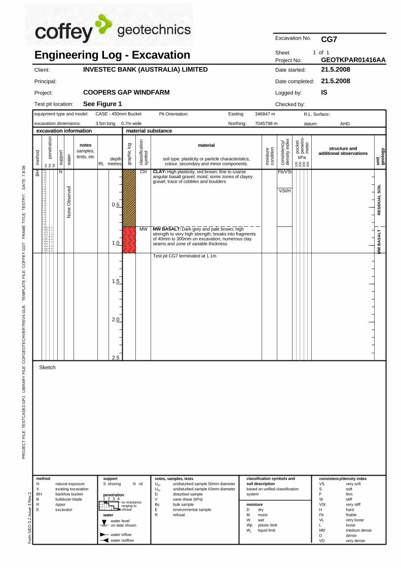
RE
SID
UA
L S
OIL
MW
BA
SA
LT
CLAY: High plasticity, red brown; fine to coarseangular basalt gravel; moist; some zones of clayeygravel; trace of cobbles and boulders
MW BASALT: Dark grey and pale brown; highstrength to very high strength; breaks into fragmentsof 40mm to 300mm on excavation; numerous clayseams and zone of variable thickness
Test pit CG7 terminated at 1.1m
Fb/VSt
VSt/H
Non
e O
bser
ved
BH CH
MW
N
natural exposureexisting excavationbackhoe bucketbulldozer bladeripperexcavator
no resistanceranging torefusal
water outflow
consistency/density index
drymoistwetplastic limitliquid limit
Sketch
material substance
moisture
water
VSSFStVStHFbVLLMDDVD
met
hod
cons
iste
ncy/
dens
ity in
dex
water levelon date shown
1 2 3 4
100
200
300
400
classification symbols andsoil descriptionbased on unified classificationsystem
clas
sific
atio
nsy
mbo
l
excavation information
equipment type and model:
excavation dimensions:
notes, samples, testsvery softsoftfirmstiffvery stiffhardfriablevery looseloosemedium densedensevery dense
Engineering Log - Excavation
CASE - 450mm Bucket
3.5m long 0.7m wide
structure andadditional observations
un
itg
eolo
gy
water inflow
0.5
1.0
1.5
2.0
2.5
Easting:
Northing:
Pit Orientation:
For
m G
EO
5.2
Issu
e 3
Rev
.2
Test pit location:
depthmetres m
oist
ure
cond
ition
wat
er
RL
material
supportS shoring
DMWWpWL
methodNXBHBRE
penetration
U50
U63
DVBsER
undisturbed sample 50mm diameterundisturbed sample 63mm diameterdisturbed samplevane shear (kPa)bulk sampleenvironmental samplerefusal
Excavation No.
346847 m
7045798 m
soil type: plasticity or particle characteristics,colour, secondary and minor components.
pene
trat
ion
grap
hic
log
pock
etpe
netr
o-m
eter
1 2 3 supp
ort
1 of 1
N nil
kPa
notessamples,tests, etc
AHD
INVESTEC BANK (AUSTRALIA) LIMITED
COOPERS GAP WINDFARM
See Figure 1R.L. Surface:
datum:
Client:
Principal:
Project:
Sheet
Date started:
Date completed:
Logged by:
Checked by:
CG7
GEOTKPAR01416AA21.5.2008
21.5.2008
IS
Project No:
PR
OJE
CT
FIL
E: T
ES
TC
AS
E2.
GP
J. L
IBR
AR
Y F
ILE
: CO
FG
EO
TE
CH
VE
R7R
EV
4.G
LB.
TE
MP
LAT
E F
ILE
: CO
FF
EY
.GD
T
FR
AM
E T
ITLE
: TE
ST
PIT
. D
AT
E: 7
.8.0
8
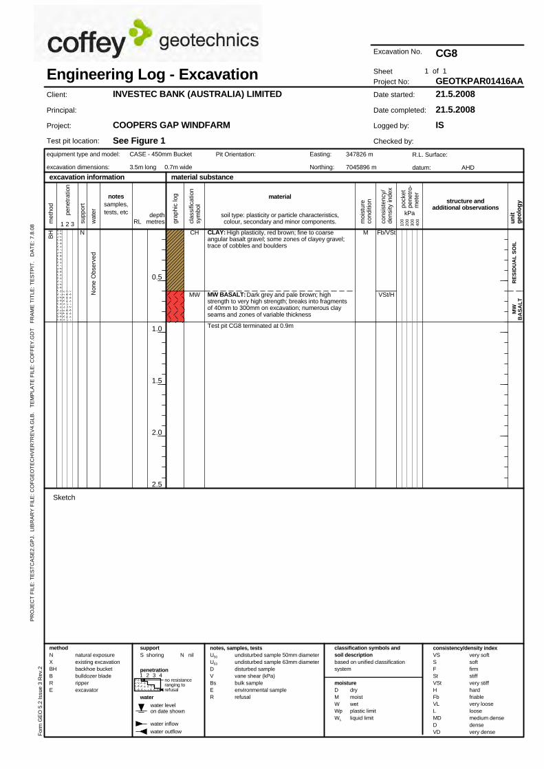
RE
SID
UA
L S
OIL
MW
BA
SA
LT
CLAY: High plasticity, red brown; fine to coarseangular basalt gravel; some zones of clayey gravel;trace of cobbles and boulders
MW BASALT: Dark grey and pale brown; highstrength to very high strength; breaks into fragmentsof 40mm to 300mm on excavation; numerous clayseams and zones of variable thickness
Test pit CG8 terminated at 0.9m
Fb/VSt
VSt/HNon
e O
bser
ved
BH CH
MW
MN
natural exposureexisting excavationbackhoe bucketbulldozer bladeripperexcavator
no resistanceranging torefusal
water outflow
consistency/density index
drymoistwetplastic limitliquid limit
Sketch
material substance
moisture
water
VSSFStVStHFbVLLMDDVD
met
hod
cons
iste
ncy/
dens
ity in
dex
water levelon date shown
1 2 3 4
100
200
300
400
classification symbols andsoil descriptionbased on unified classificationsystem
clas
sific
atio
nsy
mbo
l
excavation information
equipment type and model:
excavation dimensions:
notes, samples, testsvery softsoftfirmstiffvery stiffhardfriablevery looseloosemedium densedensevery dense
Engineering Log - Excavation
CASE - 450mm Bucket
3.5m long 0.7m wide
structure andadditional observations
un
itg
eolo
gy
water inflow
0.5
1.0
1.5
2.0
2.5
Easting:
Northing:
Pit Orientation:
For
m G
EO
5.2
Issu
e 3
Rev
.2
Test pit location:
depthmetres m
oist
ure
cond
ition
wat
er
RL
material
supportS shoring
DMWWpWL
methodNXBHBRE
penetration
U50
U63
DVBsER
undisturbed sample 50mm diameterundisturbed sample 63mm diameterdisturbed samplevane shear (kPa)bulk sampleenvironmental samplerefusal
Excavation No.
347826 m
7045896 m
soil type: plasticity or particle characteristics,colour, secondary and minor components.
pene
trat
ion
grap
hic
log
pock
etpe
netr
o-m
eter
1 2 3 supp
ort
1 of 1
N nil
kPa
notessamples,tests, etc
AHD
INVESTEC BANK (AUSTRALIA) LIMITED
COOPERS GAP WINDFARM
See Figure 1R.L. Surface:
datum:
Client:
Principal:
Project:
Sheet
Date started:
Date completed:
Logged by:
Checked by:
CG8
GEOTKPAR01416AA21.5.2008
21.5.2008
IS
Project No:
PR
OJE
CT
FIL
E: T
ES
TC
AS
E2.
GP
J. L
IBR
AR
Y F
ILE
: CO
FG
EO
TE
CH
VE
R7R
EV
4.G
LB.
TE
MP
LAT
E F
ILE
: CO
FF
EY
.GD
T
FR
AM
E T
ITLE
: TE
ST
PIT
. D
AT
E: 7
.8.0
8
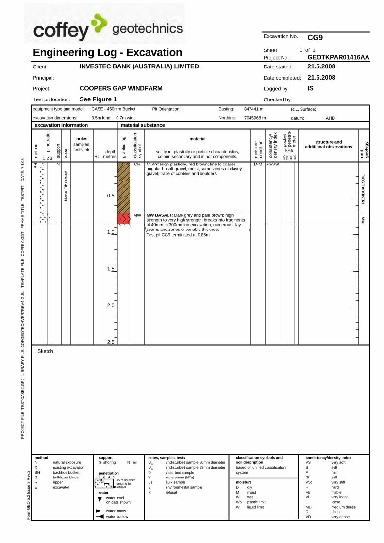
RE
SID
UA
L S
OIL
MW
CLAY: High plasticity, red brown; fine to coarseangular basalt gravel; moist; some zones of clayeygravel; trace of cobbles and boulders
MW BASALT: Dark grey and pale brown; highstrength to very high strength; breaks into fragmentsof 40mm to 300mm on excavation; numerous clayseams and zones of variable thicknessTest pit CG9 terminated at 0.85m
Fb/VSt
Non
e O
bser
ved
BH CH
MW
D-MN
natural exposureexisting excavationbackhoe bucketbulldozer bladeripperexcavator
no resistanceranging torefusal
water outflow
consistency/density index
drymoistwetplastic limitliquid limit
Sketch
material substance
moisture
water
VSSFStVStHFbVLLMDDVD
met
hod
cons
iste
ncy/
dens
ity in
dex
water levelon date shown
1 2 3 4
100
200
300
400
classification symbols andsoil descriptionbased on unified classificationsystem
clas
sific
atio
nsy
mbo
l
excavation information
equipment type and model:
excavation dimensions:
notes, samples, testsvery softsoftfirmstiffvery stiffhardfriablevery looseloosemedium densedensevery dense
Engineering Log - Excavation
CASE - 450mm Bucket
3.5m long 0.7m wide
structure andadditional observations
un
itg
eolo
gy
water inflow
0.5
1.0
1.5
2.0
2.5
Easting:
Northing:
Pit Orientation:
For
m G
EO
5.2
Issu
e 3
Rev
.2
Test pit location:
depthmetres m
oist
ure
cond
ition
wat
er
RL
material
supportS shoring
DMWWpWL
methodNXBHBRE
penetration
U50
U63
DVBsER
undisturbed sample 50mm diameterundisturbed sample 63mm diameterdisturbed samplevane shear (kPa)bulk sampleenvironmental samplerefusal
Excavation No.
847441 m
7045968 m
soil type: plasticity or particle characteristics,colour, secondary and minor components.
pene
trat
ion
grap
hic
log
pock
etpe
netr
o-m
eter
1 2 3 supp
ort
1 of 1
N nil
kPa
notessamples,tests, etc
AHD
INVESTEC BANK (AUSTRALIA) LIMITED
COOPERS GAP WINDFARM
See Figure 1R.L. Surface:
datum:
Client:
Principal:
Project:
Sheet
Date started:
Date completed:
Logged by:
Checked by:
CG9
GEOTKPAR01416AA21.5.2008
21.5.2008
IS
Project No:
PR
OJE
CT
FIL
E: T
ES
TC
AS
E2.
GP
J. L
IBR
AR
Y F
ILE
: CO
FG
EO
TE
CH
VE
R7R
EV
4.G
LB.
TE
MP
LAT
E F
ILE
: CO
FF
EY
.GD
T
FR
AM
E T
ITLE
: TE
ST
PIT
. D
AT
E: 7
.8.0
8