Embed Size (px)
Citation preview

Geosciences: The Future
Final Report of the IUGG Working Group Geosciences: The Future

Geosciences: The Future
S. Adlen, IAMAS E. E. Brodsky, IAVCEI, ChairAtmospheric, Oceanic and Planetary Physics Dept. of Earth and Space ScienceClarendon Laboratory University of California, Los AngelesParks Road Los Angeles, CA, USAOxford OX1 3PU ([email protected])([email protected])
T. Oki, IAHS A.J. Ridley, IAGA, EditorResearch Institute for Humanity and Nature Center for Space Environment ModelingKyoto 602-0878, Japan University of Michigan([email protected]) Ann Arbor, MI, USA
L. Sanchez, IAG C. Simionato, IAPSOInstituto Geografico Agustin Codazzi Centro de Investigaciones del Mar y la AtmosferaDivision de Geodesia (CIMA/CONICET-UBA)Bogota - Colombia Dpto. de Ciencias de la Atmosfera y los Oceanos([email protected]) de la Universidad de Buenos Aires
Ciudad Universitaria Pab. II Piso 2Ciudad Autonoma de Buenos Aires - Argentina
K. Yoshizawa, IASPEI U. Shamir, IUGG Vice President, WG CoordinatorDivision of Earth and Planetary Sciences Stephen and Nancy Grand Water Research InstituteGraduate School of Science, Hokkaido University Technion - Israel Institute of TechnologySapporo, 060-0810, Japan Haifa 32000, Israel([email protected]) ([email protected])
July 7, 2003
Preface”IUGG is a purely scientific organisation established to promote and co-ordinate studies of physical, chemical, and math-ematical properties of the Earth and its environment in space. These studies include the shape of the Earth; the nature of itsgravitational and magnetic fields; the dynamics of the Earth as a whole and of its component parts; the Earth’s internal structure,composition, and tectonics; the generation of magmas; volcanism and rock formation; the hydrological cycle, including snowand ice; the physics and chemistry of the oceans; the atmosphere, ionosphere, magnetosphere and solar-terrestrial relations;and analogous problems associated with the Moon and other planets. IUGG activities embrace studies of the Earth by artificialsatellites and other techniques for deploying instruments at high altitude.” (Objectives and Activities of IUGG, in the IUGG2003 Yearbook)In summer 2001, the Executive Committee of IUGG (Bureau, Presidents and Secretaries General of the seven Associations)approved a proposal I put forward, to set up a Working Group of young geo-scientists, one from each of the seven Associations,under the title ”Geosciences: The Future” (WG-GTF), to examine the state of the geosciences and identify research challenges,emphasizing inter-disciplinary research, integration of scientists from around the world, in particular in less developed nations,and the role that IUGG should play in advancing the geosciences into the future.The Executive Committee of IUGG, acting as Program Committee for the 2003 IUGG General Assembly in Sapporo, also ac-cepted the proposal to include in the program Union Symposium U8: ”Geosciences: The Future,” to be prepared and presentedby the Working Group.The WG-GTF, after preliminary discussion and consideration of its expected role and mode of operation, chose its Chairand Editor. Each member prepared a presentation of her/his discipline/Association, sometimes based on material producedby similar initiatives of the Association and/or on responses elicited from other members of their Association. These werecirculated among the members, and were discussed in extended conference-calls. Special emphasis was placed on identifyingcommon and inter-disciplinary interests and on encompassing scientists from all parts of the world.This publication comprises the material prepared by the WG-GTF ahead of the IUGG GA 2003 in Sapporo.Uri ShamirIUGG Vice PresidentCoordinator of the WG-GTF
3

4

Contents
1 IntroductionE. E. Brodsky 9
2 International Association of Seismology and Physics of the Earth’s InteriorK. Yoshizawa 112.1 Introduction . . . . . . . . . . . . . . . . . . . . . . . . . . . . . . . . . . . . . . . . . . . . . . . . . . . . . 112.2 Long-term Goals . . . . . . . . . . . . . . . . . . . . . . . . . . . . . . . . . . . . . . . . . . . . . . . . . . 112.3 Short-term Priorities: Issues and Strategies . . . . . . . . . . . . . . . . . . . . . . . . . . . . . . . . . . . . . 12
2.3.1 Seismic Observation and Data Acquisition . . . . . . . . . . . . . . . . . . . . . . . . . . . . . . . . 122.3.2 Physics of the Earth’s Interior: Structure, Composition and Dynamics . . . . . . . . . . . . . . . . . . 152.3.3 Physics of Earthquakes and Seismic Wave Field . . . . . . . . . . . . . . . . . . . . . . . . . . . . . . 162.3.4 Hazard Mitigation and Prediction of Earthquakes . . . . . . . . . . . . . . . . . . . . . . . . . . . . . 17
2.4 Recommendations for Seismology and Physics of Earth’s Interior . . . . . . . . . . . . . . . . . . . . . . . . 172.5 Seismological Researches and Societal Benefit . . . . . . . . . . . . . . . . . . . . . . . . . . . . . . . . . . 192.6 Opportunities for Interdisciplinary Researches . . . . . . . . . . . . . . . . . . . . . . . . . . . . . . . . . . . 192.7 Conclusions . . . . . . . . . . . . . . . . . . . . . . . . . . . . . . . . . . . . . . . . . . . . . . . . . . . . . 202.8 Acknowledgment . . . . . . . . . . . . . . . . . . . . . . . . . . . . . . . . . . . . . . . . . . . . . . . . . . 20
3 International Association of Volcanology and Chemistry of the Earth’s InteriorE. E. Brodsky 233.1 Long-term goals . . . . . . . . . . . . . . . . . . . . . . . . . . . . . . . . . . . . . . . . . . . . . . . . . . . 233.2 Short-Term Priorities . . . . . . . . . . . . . . . . . . . . . . . . . . . . . . . . . . . . . . . . . . . . . . . . 23
3.2.1 Initiation . . . . . . . . . . . . . . . . . . . . . . . . . . . . . . . . . . . . . . . . . . . . . . . . . . 243.2.2 Explosive/effusive transition . . . . . . . . . . . . . . . . . . . . . . . . . . . . . . . . . . . . . . . . 243.2.3 Eruptive Plumes . . . . . . . . . . . . . . . . . . . . . . . . . . . . . . . . . . . . . . . . . . . . . . 243.2.4 Climatic effects of eruptions . . . . . . . . . . . . . . . . . . . . . . . . . . . . . . . . . . . . . . . . 243.2.5 Flow Emplacement . . . . . . . . . . . . . . . . . . . . . . . . . . . . . . . . . . . . . . . . . . . . . 243.2.6 Interactions with Tectonics . . . . . . . . . . . . . . . . . . . . . . . . . . . . . . . . . . . . . . . . . 243.2.7 Magma Storage . . . . . . . . . . . . . . . . . . . . . . . . . . . . . . . . . . . . . . . . . . . . . . . 243.2.8 Conduit Transport . . . . . . . . . . . . . . . . . . . . . . . . . . . . . . . . . . . . . . . . . . . . . 24
3.3 Recommendations for Volcanology . . . . . . . . . . . . . . . . . . . . . . . . . . . . . . . . . . . . . . . . . 253.3.1 Observations and Modeling . . . . . . . . . . . . . . . . . . . . . . . . . . . . . . . . . . . . . . . . 253.3.2 Instrumentation . . . . . . . . . . . . . . . . . . . . . . . . . . . . . . . . . . . . . . . . . . . . . . . 25
3.4 Recommendations for IAVCEI and IUGG . . . . . . . . . . . . . . . . . . . . . . . . . . . . . . . . . . . . . 273.4.1 Travel for Observatory Scientists . . . . . . . . . . . . . . . . . . . . . . . . . . . . . . . . . . . . . . 273.4.2 WOVOdat . . . . . . . . . . . . . . . . . . . . . . . . . . . . . . . . . . . . . . . . . . . . . . . . . . 273.4.3 Communicating with Society . . . . . . . . . . . . . . . . . . . . . . . . . . . . . . . . . . . . . . . . 27
3.5 Opportunities for Interdisciplinary Research . . . . . . . . . . . . . . . . . . . . . . . . . . . . . . . . . . . . 273.6 Conclusions . . . . . . . . . . . . . . . . . . . . . . . . . . . . . . . . . . . . . . . . . . . . . . . . . . . . . 273.7 Acknowledgments . . . . . . . . . . . . . . . . . . . . . . . . . . . . . . . . . . . . . . . . . . . . . . . . . 27
5

4 International Association of the Physical Sciences of the OceansC. Simionato 294.1 Introduction . . . . . . . . . . . . . . . . . . . . . . . . . . . . . . . . . . . . . . . . . . . . . . . . . . . . . 294.2 A view of the future of research in Physical Oceanography . . . . . . . . . . . . . . . . . . . . . . . . . . . . 304.3 Long-term goals for Physical Oceanography . . . . . . . . . . . . . . . . . . . . . . . . . . . . . . . . . . . . 304.4 Short term focus for Physical Oceanography . . . . . . . . . . . . . . . . . . . . . . . . . . . . . . . . . . . . 31
4.4.1 Climate and climate change prediction . . . . . . . . . . . . . . . . . . . . . . . . . . . . . . . . . . . 314.4.2 Coastal oceans prediction . . . . . . . . . . . . . . . . . . . . . . . . . . . . . . . . . . . . . . . . . 35
4.5 Recommendations . . . . . . . . . . . . . . . . . . . . . . . . . . . . . . . . . . . . . . . . . . . . . . . . . . 384.6 Conclusion . . . . . . . . . . . . . . . . . . . . . . . . . . . . . . . . . . . . . . . . . . . . . . . . . . . . . 414.7 Acknowledgments . . . . . . . . . . . . . . . . . . . . . . . . . . . . . . . . . . . . . . . . . . . . . . . . . 41
5 International Association of Hydrological SciencesT. Oki 435.1 Introduction —Hydrology, the forgotten earth science— . . . . . . . . . . . . . . . . . . . . . . . . . . . . . 435.2 Long-term Goals . . . . . . . . . . . . . . . . . . . . . . . . . . . . . . . . . . . . . . . . . . . . . . . . . . 43
5.2.1 What is hydrology? . . . . . . . . . . . . . . . . . . . . . . . . . . . . . . . . . . . . . . . . . . . . . 435.2.2 Long-term Goals in Hydrology . . . . . . . . . . . . . . . . . . . . . . . . . . . . . . . . . . . . . . . 44
5.3 Short-term Goals . . . . . . . . . . . . . . . . . . . . . . . . . . . . . . . . . . . . . . . . . . . . . . . . . . 455.3.1 Current Demands on Hydrology . . . . . . . . . . . . . . . . . . . . . . . . . . . . . . . . . . . . . . 455.3.2 Contribution to solve the world water crisis . . . . . . . . . . . . . . . . . . . . . . . . . . . . . . . . 455.3.3 IAHS Hydrology 2020 Working Group . . . . . . . . . . . . . . . . . . . . . . . . . . . . . . . . . . 475.3.4 Scientific Bottlenecks . . . . . . . . . . . . . . . . . . . . . . . . . . . . . . . . . . . . . . . . . . . 47
5.4 Recommendations . . . . . . . . . . . . . . . . . . . . . . . . . . . . . . . . . . . . . . . . . . . . . . . . . . 485.4.1 Organizational Issue . . . . . . . . . . . . . . . . . . . . . . . . . . . . . . . . . . . . . . . . . . . . 485.4.2 Practical/Technological Issues . . . . . . . . . . . . . . . . . . . . . . . . . . . . . . . . . . . . . . . 49
5.5 Social Benefits . . . . . . . . . . . . . . . . . . . . . . . . . . . . . . . . . . . . . . . . . . . . . . . . . . . 505.5.1 Science as part of capacity building and governance . . . . . . . . . . . . . . . . . . . . . . . . . . . 505.5.2 Bridging the communication gap . . . . . . . . . . . . . . . . . . . . . . . . . . . . . . . . . . . . . . 505.5.3 Develop a scientifically based policy language . . . . . . . . . . . . . . . . . . . . . . . . . . . . . . 515.5.4 Recommendations for future actions – filling the gaps . . . . . . . . . . . . . . . . . . . . . . . . . . 51
5.6 Conclusions . . . . . . . . . . . . . . . . . . . . . . . . . . . . . . . . . . . . . . . . . . . . . . . . . . . . . 52
6 International Association of GeodesyL. Sanchez 536.1 Introduction . . . . . . . . . . . . . . . . . . . . . . . . . . . . . . . . . . . . . . . . . . . . . . . . . . . . . 536.2 A view of the future of research in Geodesy . . . . . . . . . . . . . . . . . . . . . . . . . . . . . . . . . . . . 54
6.2.1 Long term focus for Geodesy . . . . . . . . . . . . . . . . . . . . . . . . . . . . . . . . . . . . . . . 546.2.2 Short term focus for Geodesy . . . . . . . . . . . . . . . . . . . . . . . . . . . . . . . . . . . . . . . 54
6.3 Assessment of current research in the major geodetic disciplines . . . . . . . . . . . . . . . . . . . . . . . . . 576.3.1 Reference Frames . . . . . . . . . . . . . . . . . . . . . . . . . . . . . . . . . . . . . . . . . . . . . . 576.3.2 Gravity Field . . . . . . . . . . . . . . . . . . . . . . . . . . . . . . . . . . . . . . . . . . . . . . . . 576.3.3 Earth Rotation and Geodynamics . . . . . . . . . . . . . . . . . . . . . . . . . . . . . . . . . . . . . 586.3.4 Positioning and Applications . . . . . . . . . . . . . . . . . . . . . . . . . . . . . . . . . . . . . . . . 596.3.5 Theory . . . . . . . . . . . . . . . . . . . . . . . . . . . . . . . . . . . . . . . . . . . . . . . . . . . 60
6.4 Recommendations . . . . . . . . . . . . . . . . . . . . . . . . . . . . . . . . . . . . . . . . . . . . . . . . . . 606.5 Opportunities for interdisciplinary research . . . . . . . . . . . . . . . . . . . . . . . . . . . . . . . . . . . . 616.6 Conclusions . . . . . . . . . . . . . . . . . . . . . . . . . . . . . . . . . . . . . . . . . . . . . . . . . . . . . 62
7 International Association of Meteorological and Atmospheric SciencesS. Adlen 637.1 Introduction . . . . . . . . . . . . . . . . . . . . . . . . . . . . . . . . . . . . . . . . . . . . . . . . . . . . . 637.2 Long Term Goals . . . . . . . . . . . . . . . . . . . . . . . . . . . . . . . . . . . . . . . . . . . . . . . . . . 637.3 Short Term Priorities . . . . . . . . . . . . . . . . . . . . . . . . . . . . . . . . . . . . . . . . . . . . . . . . 64
6
7.3.1 Atmospheric Chemistry . . . . . . . . . . . . . . . . . . . . . . . . . . . . . . . . . . . . . . . . . . 647.3.2 Climate and Climate Change . . . . . . . . . . . . . . . . . . . . . . . . . . . . . . . . . . . . . . . . 667.3.3 Atmospheric Dynamics and Meteorology . . . . . . . . . . . . . . . . . . . . . . . . . . . . . . . . . 707.3.4 Planetary Atmospheres . . . . . . . . . . . . . . . . . . . . . . . . . . . . . . . . . . . . . . . . . . . 72
7.4 Recommendations for the Atmospheric Sciences . . . . . . . . . . . . . . . . . . . . . . . . . . . . . . . . . 737.5 Conclusions . . . . . . . . . . . . . . . . . . . . . . . . . . . . . . . . . . . . . . . . . . . . . . . . . . . . . 75
8 International Association of Geomagnetism and AeronomyA. J. Ridley 778.1 Long-term Goals . . . . . . . . . . . . . . . . . . . . . . . . . . . . . . . . . . . . . . . . . . . . . . . . . . 77
8.1.1 Focus Areas . . . . . . . . . . . . . . . . . . . . . . . . . . . . . . . . . . . . . . . . . . . . . . . . . 778.2 Short-Term Priorities . . . . . . . . . . . . . . . . . . . . . . . . . . . . . . . . . . . . . . . . . . . . . . . . 78
8.2.1 Thermosphere and Ionosphere . . . . . . . . . . . . . . . . . . . . . . . . . . . . . . . . . . . . . . . 788.2.2 Magnetosphere . . . . . . . . . . . . . . . . . . . . . . . . . . . . . . . . . . . . . . . . . . . . . . . 798.2.3 The Sun and the Heliosphere . . . . . . . . . . . . . . . . . . . . . . . . . . . . . . . . . . . . . . . . 818.2.4 Ground-based Measurements . . . . . . . . . . . . . . . . . . . . . . . . . . . . . . . . . . . . . . . . 83
8.3 Recommendations for the IAGA . . . . . . . . . . . . . . . . . . . . . . . . . . . . . . . . . . . . . . . . . . 848.4 Conclusions . . . . . . . . . . . . . . . . . . . . . . . . . . . . . . . . . . . . . . . . . . . . . . . . . . . . . 848.5 Acknowledgments . . . . . . . . . . . . . . . . . . . . . . . . . . . . . . . . . . . . . . . . . . . . . . . . . 84
9 Interdisciplinary ResearchS. Adlen 899.1 Introduction . . . . . . . . . . . . . . . . . . . . . . . . . . . . . . . . . . . . . . . . . . . . . . . . . . . . . 899.2 Over arching Opportunities for Inter-disciplinary Research . . . . . . . . . . . . . . . . . . . . . . . . . . . . 89
9.2.1 Planetary Exploration . . . . . . . . . . . . . . . . . . . . . . . . . . . . . . . . . . . . . . . . . . . . 899.2.2 Mathematical Techniques . . . . . . . . . . . . . . . . . . . . . . . . . . . . . . . . . . . . . . . . . 909.2.3 Observing Systems . . . . . . . . . . . . . . . . . . . . . . . . . . . . . . . . . . . . . . . . . . . . . 909.2.4 Communication and the Availability of Data . . . . . . . . . . . . . . . . . . . . . . . . . . . . . . . 919.2.5 High Resolution Earth System Modeling . . . . . . . . . . . . . . . . . . . . . . . . . . . . . . . . . 919.2.6 Looking to the Future . . . . . . . . . . . . . . . . . . . . . . . . . . . . . . . . . . . . . . . . . . . 91
9.3 Other Opportunities for Interdisciplinary Collaborations . . . . . . . . . . . . . . . . . . . . . . . . . . . . . . 919.3.1 The Hydrologic Cycle (IAMAS, IAPSO and IAHS) . . . . . . . . . . . . . . . . . . . . . . . . . . . . 929.3.2 The Role of Geodetic Sensing in Interdisciplinary Earth Science (IAG and Others) . . . . . . . . . . . 929.3.3 The Interaction of the Thermosphere, Upper Atmosphere and Solar Forcing (IAGA and IAMAS) . . . 939.3.4 Climate Response to SO2 Aerosol Forcing (IAVCEI, IAMAS) . . . . . . . . . . . . . . . . . . . . . . 939.3.5 Generation and Propagation of Tsunami (IASPEI, IAPSO) . . . . . . . . . . . . . . . . . . . . . . . . 939.3.6 Seismology for the Earth and the Sun (IASPEI, IAGA) . . . . . . . . . . . . . . . . . . . . . . . . . . 939.3.7 Water, Earthquakes and Volcanoes (IAHS, IASPEI, IAVCEI) . . . . . . . . . . . . . . . . . . . . . . 939.3.8 Interactions with Disciplines Outside Geoscience . . . . . . . . . . . . . . . . . . . . . . . . . . . . . 94
9.4 Conclusions and Recommendations . . . . . . . . . . . . . . . . . . . . . . . . . . . . . . . . . . . . . . . . 94
10 Societal ImpactK. Yoshizawa 9510.1 Introduction . . . . . . . . . . . . . . . . . . . . . . . . . . . . . . . . . . . . . . . . . . . . . . . . . . . . . 9510.2 Geophysical Risks: Prevention of Natural Hazards . . . . . . . . . . . . . . . . . . . . . . . . . . . . . . . . 95
10.2.1 Interactions Between Community and Geosciences . . . . . . . . . . . . . . . . . . . . . . . . . . . . 9510.2.2 Effective Use of Technology and Scientific Results . . . . . . . . . . . . . . . . . . . . . . . . . . . . 9610.2.3 Some Counter-measures Against Gigantic Natural Hazards . . . . . . . . . . . . . . . . . . . . . . . . 9610.2.4 The Role of the IUGG . . . . . . . . . . . . . . . . . . . . . . . . . . . . . . . . . . . . . . . . . . . 97
10.3 Human Life and Environment . . . . . . . . . . . . . . . . . . . . . . . . . . . . . . . . . . . . . . . . . . . 9710.3.1 Global Change and Human Activity . . . . . . . . . . . . . . . . . . . . . . . . . . . . . . . . . . . . 9710.3.2 Management of Water . . . . . . . . . . . . . . . . . . . . . . . . . . . . . . . . . . . . . . . . . . . 9810.3.3 Improvement of Quality of Life . . . . . . . . . . . . . . . . . . . . . . . . . . . . . . . . . . . . . . 9810.3.4 The Role of IUGG . . . . . . . . . . . . . . . . . . . . . . . . . . . . . . . . . . . . . . . . . . . . . 99
7

10.4 Geoscience Education and Outreach . . . . . . . . . . . . . . . . . . . . . . . . . . . . . . . . . . . . . . . . 9910.4.1 Efficient Use of Modern Technology for Scientific Education . . . . . . . . . . . . . . . . . . . . . . . 9910.4.2 Promoting International Schools . . . . . . . . . . . . . . . . . . . . . . . . . . . . . . . . . . . . . . 9910.4.3 Communication with Society . . . . . . . . . . . . . . . . . . . . . . . . . . . . . . . . . . . . . . . . 9910.4.4 International Assistance to Developing Countries . . . . . . . . . . . . . . . . . . . . . . . . . . . . . 99
10.5 Conclusion . . . . . . . . . . . . . . . . . . . . . . . . . . . . . . . . . . . . . . . . . . . . . . . . . . . . . 10010.6 Acknowledgment . . . . . . . . . . . . . . . . . . . . . . . . . . . . . . . . . . . . . . . . . . . . . . . . . . 100
11 Developing CountriesL. Sanchez 10111.1 Natural and energetic resources provision . . . . . . . . . . . . . . . . . . . . . . . . . . . . . . . . . . . . . 10111.2 Observing data world-wide . . . . . . . . . . . . . . . . . . . . . . . . . . . . . . . . . . . . . . . . . . . . . 10111.3 Strategic positions to analyse concrete phenomena . . . . . . . . . . . . . . . . . . . . . . . . . . . . . . . . . 10211.4 Importance of geosciences in the modern society, and especially in developing countries . . . . . . . . . . . . 10211.5 Vulnerability to natural disasters . . . . . . . . . . . . . . . . . . . . . . . . . . . . . . . . . . . . . . . . . . 10211.6 Sustainable development . . . . . . . . . . . . . . . . . . . . . . . . . . . . . . . . . . . . . . . . . . . . . . 10211.7 Transferring technology and improving scientific level . . . . . . . . . . . . . . . . . . . . . . . . . . . . . . 10311.8 The role of developing countries in geosciences . . . . . . . . . . . . . . . . . . . . . . . . . . . . . . . . . . 10311.9 Scientific cooperation beyond political and economical denominations . . . . . . . . . . . . . . . . . . . . . . 10311.10Conclusions . . . . . . . . . . . . . . . . . . . . . . . . . . . . . . . . . . . . . . . . . . . . . . . . . . . . . 104
12 ConclusionsE. E. Brodsky 105
8

Chapter 1
IntroductionE. E. Brodsky
It is both the tradition and responsibility of geoscience tohelp humanity. Seismologists and volcanologists attempt tosave lives by evacuating before eruptions or mitigating theeffects of earthquakes. Geodesists quantify the shape of theEarth so that cities can be built and airplanes flown. Spacephysicists provide a window into the nearly unknown worldin which our satellites are sent and spacecraft launched. Hy-drologists, oceanographers and atmospheric scientists mayhave the heaviest burden of all as they help guide the planetthrough the current climate crisis.
Geoscience also has the responsibility to not confine itselfto addressing current problems. As a science, we must de-velop a framework to address future issues. In order to pushknowledge forward, we must invest intellectually and finan-cially in basic science at a level commensurate with the ap-plied fields. Such an investment is intrinsically risky. Manyscientific leads turn out to be dead-ends. Other pathways maycontinue indefinitely, but are difficult to connect to the rest ofthe field. A field driven by pure thirst for knowledge runsthe danger of becoming a tangled spider web of seeminglyunrelated facts and personal theories.
Basic science needs to be guided by a long-range vision ofthe future of the field. Then geoscientists can advance knowl-edge in a focused way and real progress can be made. Thepurpose of this report is to present a particular vision thatcould guide research in the major fields of geophysics andgeodesy. This vision is articulated by a young generation ofgeoscientists with a stake in the future. Together, we havecompiled a view encompassing geosciences from the studyof the Earth’s core to the workings of the Sun.
The main body of this report is organized into chapters rep-resenting the domain of each of the associations of IUGG inorder from the center of the Earth. Each chapter discussesa long-term vision for the field for the next 50–100 yearsas well as short-term goals and strategies for achievement.Cross-societal chapters follow the disciplinary section. Theyoutline important directions for interdisciplinary studies, so-cietal benefits and projects targeting less developed countries.
The overall conclusions of the report provide a concise sum-mary of our recommendations for geoscientists in general andIUGG specifically.
This report would not have been possible without the assis-tance of numerous colleagues who gave generously of theirtime and insights. As young geoscientists, we had to com-bine our new point of view with an already extensive base ofknowledge and planning in the field. This report is a hybrid ofour enthusiastic dreaming and the somewhat more groundedreality of many reviewers, advisers and colleagues. Perhapstogether we can see the future.
9

10

Chapter 2
International Association of Seismology andPhysics of the Earth’s InteriorK. Yoshizawa
2.1 Introduction
The primary objectives of IASPEI (International Associationof Seismology and Physics of the Earth’s Interior) are to pro-mote scientific studies related to earthquakes and physicalproperties of the Earth’s interior, and to facilitate internationalresearch and education programs in seismology and physicsof the Earth’s interior. IASPEI has placed major research em-phasis on understanding the nature of earthquakes, the prop-agation of seismic waves, the physical makeup and dynam-ics of the Earth’s interior, and reducing catastrophic damagescaused by large earthquakes.
In this chapter, future research under the umbrella ofIASPEI are summarised. We first look at long-term goals forthe future development of geosciences relevant to IASPEI.Subsequently, we summarise new challenging topics of exist-ing disciplines covered by IASPEI, which should be tackledin the coming decade, followed by some recommendationsfor IASPEI and opportunities for interdisciplinary research.
A summary of current research programs of IASPEI hasbeen given in a brochure which is available from an offi-cial web site (http://www.iaspei.org/brochure/brochure.html).A comprehensive summary of the development in earth-quake and engineering seismology during the last centuryhas been published in International Handbook of Earthquakeand Engineering Seismology (Lee et al., 2002, 2003). Thepractice of observational seismology has been summarisedin IASPEI Manual of Seismological Observatory Practice(http://www.seismo.com/msop/msop intro.html).
2.2 Long-term Goals
The IASPEI has facilitated researches in understanding phys-ical phenomena taking place in the solid Earth. The studyof the Earth’s interior is a naturally multidisciplinary subject
because we need a variety of information from diverse dis-ciplines, such as seismology, mineral physics, geodynamicsand geochemistry, in order to better understand the inaccessi-ble parts of the Earth. In the future, more comprehensive in-terdisciplinary researches on the close interactions with otherparts of the Earth, i.e., oceans and atmosphere, will be in-evitable.
Scientific studies of earthquakes are critical to people wholive in seismically active areas. The possibility of a short-term prediction of earthquakes is still a controversial issuein seismology. However, the quest for the development ofpractical methods to predict earthquakes in both the long andthe short term, as well as to mitigate catastrophic damages, isessential to reduce threats of earthquakes on our society.
In seismology, a larger class of earthquake phenomenologyis still not understandable within the present framework ofknowledge, such as the dynamic rupture processes of earth-quake faults, high-frequency behaviour of seismic waves in3-D structures, and the physics of deep-focus earthquakes.Tackling such unsolved problems will require a long-term ef-forts to develop systematic theories complemented by geo-physical observations and laboratory experiments. The ac-cumulation of seismic data over a long period of time willenable us to propose, test and modify hypotheses related toearthquakes and physics of the Earth’s interior.
To extend our knowledge on the Earth as a system, includ-ing earthquakes, volcanic activities, water circulation, etc.,integration of all the available information on the dynamicsof the Earth should be pursued.
Towards an Integrated Earth Model
In order to provide a better understanding of the dynamicsof the Earth’s interior, a variety of information from a widerange of disciplines (e.g., seismology, mineral physics andother geophysical sciences) is necessary.
11

Seismic waves are one of the most reliable and optimumtools for probing the Earth’s interior. They have been utilisednot only to investigate the whole Earth structure, but also toexplore the natural resources. Of all geophysical methods,seismological investigation provides us with the highest reso-lution of the inside of the Earth, and thus the development ofseismology will, in turn, be the basis to promote the develop-ment of solid Earth geophysics.
Combining all available information, such as seismic struc-ture, surface deformation, plate tectonics, numerical resultsof mantle convection, heat transfer and material circulationin the Earth, we will be able to create a dynamic model ofthe Earth’s interior including both physical and chemical pro-cesses in the Earth. In order to interpret the seismic modelsof the Earth, contribution from other geophysical disciplines,such as mineral physics, geodynamics and geochemistry, arenecessary. Furthermore, in the future of geosciences, creatinga systematic Earth model, taking account of the interactionsbetween atmosphere, oceans and the solid Earth, will be anultimate goal to understanding the Earth as a dynamic sys-tem.
Water in the Earth: The role of liquid water can be a keyto combining the diverse fields of studies related to theEarth’s interior, as well as the outer shells of the Earth:ocean and atmosphere. From a perspective of the solidEarth geophysics, it will be most interesting to investi-gate the presence of liquid water, and its physical andchemical roles in dynamics of the Earth. Recent stud-ies with high-resolution seismic tomography suggest theexistence of fluids in fault areas (e.g., Zhao et al., 1996).Further investigation of the role of water in the occur-rence of earthquakes will be important for quantitativestudies on earthquake mechanisms. Water may also playan important role in the internal dynamics of the Earth,since it has been recognised that a number of mantleminerals are capable of sequestering significant amountsof water in hydrous phases.
Coupling Between the Solid Earth, Atmosphere, Ocean: Inthe late 1990s, we witnessed exciting new findingsabout the Earth’s continuous tremors even withoutearthquakes; i.e., the background free oscillations(e.g., Suda et al., 1998; Kobayashi and Nishida, 1998),which have been derived from high quality observationswith broad-band seismometers and superconductinggravimeters (Fig 2.1). The cause of this phenomenon isstill in the centre of debate, but it is likely to be relateddeeply to interactions with the Earth’s atmosphereand/or oceans. Such interactions of fluid and solidsystems will be of significant importance in the comingdecade.
The fact that the Earth is vibrating due to interactionswith Earth’s fluid layers gives us an insight into a possi-
bility of gaining information on planetary interiors with-out shaking sources in their inside; i.e., it may lead to abasis of the exploration of other planets where there maybe no seismic activity but still some atmospheric inter-action. Theoretical studies to uncover the mechanismsof the background free oscillations will be essential forapplications to planetary exploration.
Planetary Seismology: We can gain many sorts of informa-tion on the Earth’s interior, but we know very little aboutthe interior of other planets. There are some seismic datafrom the Moon, and we can deduce a very rough imageof its inside, but it is not as clear as what we know aboutthe Earth due to the lack of seismic data. Other planetshave been unreachable to seismologists so far, and whatwe can get is only a rough estimate of their density dis-tribution, which can be estimated from the moment ofinertia and mass.
Several projects to explore the Moon and the planet Marsare being conducted. The Japanese LUNAR-A project(Institute of Space and Astronomical Sciences of Japan)will launch seismometers and thermometers using pen-etrators to study the interior of the Moon, especiallyfocusing on the investigation of the existence of theMoon’s iron core. An European and American consor-tium planned the NetLander mission to bring seismome-ters to Mars to investigate the Martian interior with aspecial focus on the existence of buried water and ice,although the mission ran aground due to the withdrawalof two major participating nations.
Through such efforts to bring seismic instruments to theother planets, we will be able to get more concrete in-formation on the deep structure of other terrestrial plan-ets, which will be of great help to better understand theformation and evolution of our planet. A novel technol-ogy to bring high-resolution instruments to other planetsat a reasonable cost will be useful for the developmentof planetary seismology. Furthermore, international co-operation and partnership will be essential to make themissions of planetary exploration feasible and success-ful.
2.3 Short-term Priorities: Issues andStrategies
2.3.1 Seismic Observation and Data Acquisi-tion
Unlike the atmosphere and oceans that cover the solid part ofthe Earth, the Earth’s interior is invisible and untouchable. In-formation on the inside of the Earth can only be derived fromobservations near the Earth’s surface. Seismic stations playa role as a “telescope” to look into the Earth and provide us
12
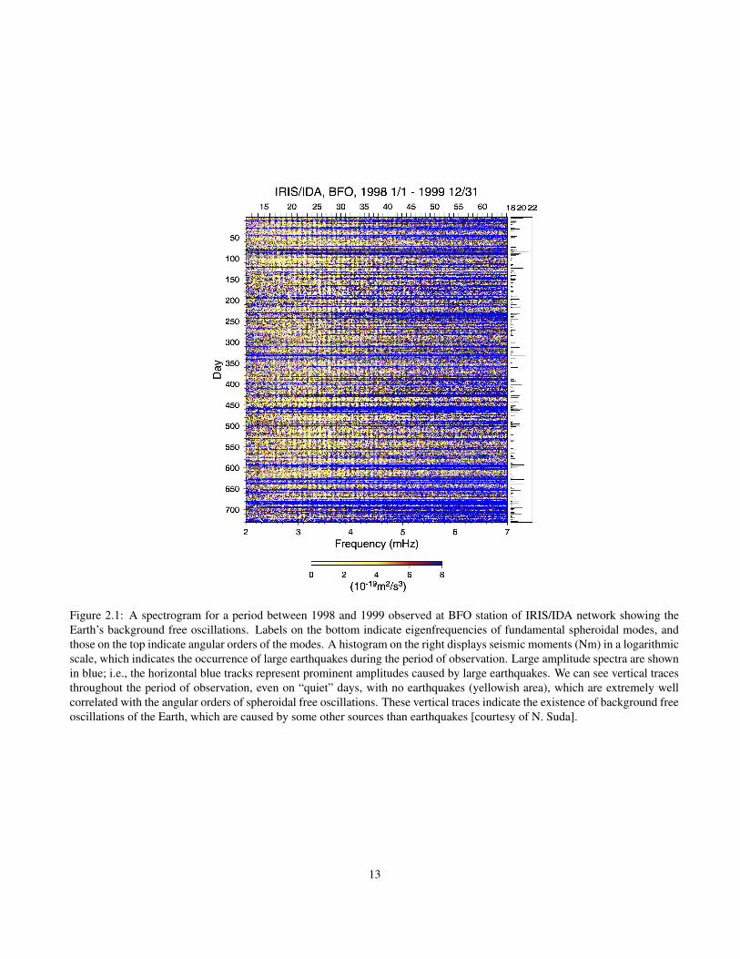
Figure 2.1: A spectrogram for a period between 1998 and 1999 observed at BFO station of IRIS/IDA network showing theEarth’s background free oscillations. Labels on the bottom indicate eigenfrequencies of fundamental spheroidal modes, andthose on the top indicate angular orders of the modes. A histogram on the right displays seismic moments (Nm) in a logarithmicscale, which indicates the occurrence of large earthquakes during the period of observation. Large amplitude spectra are shownin blue; i.e., the horizontal blue tracks represent prominent amplitudes caused by large earthquakes. We can see vertical tracesthroughout the period of observation, even on “quiet” days, with no earthquakes (yellowish area), which are extremely wellcorrelated with the angular orders of spheroidal free oscillations. These vertical traces indicate the existence of background freeoscillations of the Earth, which are caused by some other sources than earthquakes [courtesy of N. Suda].
13

with precious information about physical processes of Earth-quakes, as well as the structure of the solid Earth. For futuredevelopment of the studies of earthquakes and Earth’s inte-rior, continuous efforts to expand the seismograph network,at both global and regional scales and with high-quality in-struments, are essential.
Enhancing Global Coverage of Seismograph Network
Currently, over 120 permanent seismic stations affiliated toFDSN (Federation of Digital Broad-Band Seismic Network)are operated all around the globe, which make it possible toreveal a large-scale (∼ 1000 km) 3-D image of the Earth’sinside. Even so, the distribution of such seismic stations isfar from uniform, and some regions, such as most parts ofthe oceans, are yet to be covered. It is critical to achieve uni-form distribution of seismic stations with uniform seismome-ter characteristics to make observations of all signals of seis-mic phases that pass through the Earth’s interior.
Regional High-Density Seismic Array
To obtain a better resolution for 3-D Earth models, we needseismic data from dense seismic arrays with a concentrationof seismometers in a small region. The recent deploymentsof high density seismic arrays by a Japanese Agency, NIED(National Research Institute for Earth Science and DisasterPrevention), is an ideal example; the whole Japanese islandsare covered with 1000 high-sensitivity seismometers at 20 kmspacing. This is an unprecedented experiment of very high-density seismic network, providing an enormous amount ofrecords. The data sets derived from the array are beginningto provide us with evidences of interesting phenomena in-side the Earth. For example, we can “see” subtle movementof fluid in the lithosphere that is away from active volcanicfronts; i.e., it may be the first seismic evidence of the dehy-dration processes of subducting slabs in the mantle (Obara,2002).
The deployment of such very high-density seismic arrays,starting with the tectonically active regions, will be of greatimportance in the progress of the solid Earth sciences in thecoming decade.
Continent Probing with Portable Seismic Arrays
In seismically inactive areas, like the middle of most conti-nents, it seems rather impractical to make a permanent in-stallation of a high-density seismic array. However, such anarray is essential to probe into the Earth. One of the mostsuccessful field experiments of deployment of portable seis-mic arrays at a continental scale has been conducted in Aus-tralia throughout the 1990’s, (the SKIPPY Project – van derHilst et al., 1994). Following its great success in producinghigh-resolution seismic models in the Australasian region, an
extended experiment modeled on the SKIPPY philosophy, theUSArray, is being conducted (e.g., Levander et al., 1999).
The USArray is now a part of the EarthScope project(United States), which includes SAFOD (San Andreas FaultObservatory at Depth), PBO (Plate Boundary Observatory)and InSAR (Interferometric Synthetic Aperture Radar) aswell as the USArray to unveil the structure and evolutionof the North American continent. The USArray proposes tocover the continental United States with a set of transportablenetworks of around 400 broad-band seismometers over tenyears. The experiment will resemble a window blind pulledacross the country with about 400 instruments deployed at atime, with a process of redeployment to the farther side afterabout 18 months in place. Thus, around 2000 stations in totalare expected to cover the entire United States. The USAr-ray will enable us to reveal the seismic structure of the NorthAmerican Continent at an unprecedented resolution. Furtherdevelopments of this type are to be expected for other conti-nents.
Ocean Bottom Network
Seismic observations at the ocean bottom, which covers 70%of the Earth’s surface, are critical to achieve uniform coverageof seismograph stations over the globe. Several projects toinstall seismometers at the ocean bottom are currently beingundertaken, e.g., Ocean Hemisphere Project (University ofTokyo) and International Ocean Network. Continuous effortsto enhance such ocean bottom seismograph networks are re-quired. There are efforts underway to develop disposable au-tonomous floating devices equipped with hydrophones in or-der to improve data collection in inaccessible regions withoutthe human cost or ship time required to deploy and retrieveocean bottom instruments (Simons et al., 2003). Moreover,up to now, there has been no means to measure deformationof the Earth’s surface at the ocean bottom. Exploring seafloordeformation at GPS-level resolution will provide valuable in-formation about dynamic processes of the Earth.
Interpretation and Analysis of Seismic Data
The enhancement of seismological interpretation and analy-sis will provide better data sets, such as better seismic eventlocations, better event catalogues, and more accurate and richtravel timetables of seismic phases, for further seismologi-cal researches. Also, physical parameters describing earth-quake sources, such as radiated energy, seismic moment ten-sor, stress drop, rupture length, slip amount and slipping his-tory, can be provided by seismological observation and inter-pretation on routine basis. Dissemination of such enhanceddata sets will be an important contribution for a better under-standing of earthquakes and physics of the Earth’s interior.
14
2.3.2 Physics of the Earth’s Interior: Struc-ture, Composition and Dynamics
Seismology and related disciplines provide a means of look-ing into the inside of the Earth where dynamic activities onthe geological time-scale are taking place. Our knowledgeof the internal structure and dynamics of the Earth has ad-vanced significantly in the last a few decades. This is mainlydue to developments and advances in rapidly growing seis-mic networks, computer simulations of mantle convectionand laboratory-based experiments on the physical propertiesof constituents of the Earth. This section focuses on future re-search topics that are expected and are necessary to be tackledin the coming decade for further understanding of the natureof the Earth’s interior.
3-D Imaging of the Earth’s Interior
Construction of 3-D Reference Earth Model: Extended seis-mograph networks have enabled us to delineate three-dimensional distribution of heterogeneity in the Earth.We now have plenty of seismic information that shouldbe useful for constructing a three-dimensional ReferenceEarth Model, including large scale lateral heterogeneityin the Earth’s mantle (∼ 1000 km), which will be a sub-stitute for conventional 1-D Reference Earth Models. Inaddition, creating a high-resolution (less than 100 kmscale) reference crustal model will be crucial to enhancethe resolution of regional tomography models. The in-formation of an on-going project of creating a ReferenceEarth Model is available through a web site at UC SanDiego (http://mahi.ucsd.edu/Gabi/rem.html).
Extending Seismic Tomography: The development of tech-niques for seismic tomography has brought a significantjump in our understanding of the Earth’s interior, de-spite its relatively simple techniques mostly based onray theory. Recently, many efforts have been made toobtain more precise and accurate images of the Earth’sinterior, taking account of much more complicated ef-fects of seismic wave propagation, such as scattering anddiffraction at finite frequency of seismic waves (Dahlenet al., 2000; Yoshizawa and Kennett, 2002). Such newapproaches to seismic tomography require a significantamount of computation compared to the conventionalray theoretical methods, but will be applicable to large-scale inversion with the development of high-powercomputing facilities. Moreover, with powerful comput-ers, a fully non-linear inversion, employing a global op-timization method, can be applied to large-scale inverseproblems. The evaluation of the ensemble of models de-rived from such direct non-linear inversions (e.g., Sam-bridge, 1999) will also be useful to validate 3-D Earthmodels.
Material Properties of the Earth’s Interior
Physical Properties of Earth Materials and Seismic Models:What causes the lateral heterogeneity of seismic wavespeed in the mantle? What is the role of water in thecrust and mantle? Revealing rheological behaviour ofthe Earth materials is required to understand the natureof dynamic phenomena in the Earth, such as upwellingplumes, subducting plates, continental lithosphere,lithosphere-asthenosphere transition, etc. It is also im-portant to address the relationship between wave speedanomaly, density anomaly and anelastic attenuation ofthe Earth’s constituents working with in-situ laboratoryexperiments (e.g., Jackson, 2000).
Anisotropy and Dynamics of the Earth’s Interior: There area number of observations that suggest the existence ofanisotropy in the crust and upper mantle (e.g., Parkand Levin, 2002). The determination of the scaleof anisotropy from seismic data is not simple be-cause of trade-off between wave speed and anisotropy.Anisotropy of the Earth materials is likely to have a closerelation with the current and historical dynamics of theEarth. Therefore, the study of the anisotropy in the Earthcan be a clue to understand the convection processes ofthe mantle.
Dynamic Processes of the Earth’s Interior
Integrated Earth Models: It is critical to understand large-and small-scale phenomena in the context of plate tec-tonics, convection processes, and Earth’s rheology andmaterial constitution. In this regard, studies of mantleconvection and its effects on surface topography, platetectonics, physical and chemical processes, and thermalsources in the mantle and core will be essential. Also,measurements of surface deformation, strain field andits variation by various geophysical approaches will pro-vide useful constraints on the geodynamical models.
Seismic/Geophysical Discontinuities in the Earth: It is im-portant to unveil the physical and chemical propertiesof seismic/geophysical discontinuities within the Earth,which play important roles in dynamic processes in theEarth. For example, Mantle Transition Zone (410 - 660km depth), in which phase transformations in mantleminerals occur, plays a critical role in controlling thematerial circulation in the mantle. The existence of Ul-tra Low Velocity Zone (ULVZ) at the base of the mantleis suggested by many of recent researches. Further in-vestigation of the role of CMB and D” and inner-coreboundary are also important (see below).
Physics and Chemistry at the Core-Mantle Boundary (CMB):Of all the boundary layers in the Earth, the Core-MantleBoundary and the D” layer are the least known, but a
15

key region to understanding the thermal and dynamicalsystems of the Earth’s mantle. It should be clarifiedwhat causes the strong heterogeneity in the D” layer,and what is a real figure of the upwelling plumes; alarge-scale super plume or a cluster of small-scaleplumes? Dense broad-band three-component seismicarrays will be a key to revealing the actual makeup of theD” (e.g., Kendall, 2000). Linking the high-resolutionseismic evidences and numerical results of mantledynamics will be essential for a better understanding ofthe bottom of the mantle.
Inner-core Rotation and Anisotropy: Is the inner-core rotat-ing with respect to the mantle? The possibility of dif-ferential rotation of the inner core with respect to themantle has been one of the topics in the centre of debatein the studies of Earth’s deep interior. Some researchessuggested that there is observable rotation of around 1degree/year (Song and Richards, 1996), whilst otherssuggested negligible rotation rate (Laske and Masters,1999). The elucidation of this issue will require long-term observations since the rotation rate seems to be toosmall to be adequately resolved without data sets overmany years.
Recent studies also revealed that the inner-core is likelyto have two distinct layers; the uppermost inner-coremay be rather isotropic whereas the innermost inner-core may have anisotropic properties (Tromp, 2001). Itshould clarified how such a boundary between the inner-most and outermost inner-core is formed. Revealing thestate of the inner-core anisotropy is an important factorto clarify the formation and evolution of the solid core ofthe Earth. To obtain a better resolution of seismic mod-els in the deep interior of the Earth, high-density seismicarrays will be of great help.
Fluid-Solid Interactions: What is the role of water andvolatiles in the dynamics of the solid Earth? How doeswater affect plate tectonics, mantle convection and gene-sis of continents? In this respect, understanding the ori-gin, distribution and the transportation of H2O on thesurface and the inside of the Earth is essential. The in-teractions of the solid Earth with ocean and atmosphereshould also be investigated.
2.3.3 Physics of Earthquakes and SeismicWave Field
Physics of Earthquake Sources
Generation of Earthquakes: Studies of the initiation andpropagation of rupture processes at seismic sources arecritical to better understand the physics of earthquakes.The governing equations for physical and chemical pro-cesses of seismic sources, as well as the Earth’s mate-
rials, need to evolve from the microscopic scale to themacroscopic scale. Finding a bridge over such gapsbased on physics is fundamentally important. Many un-solved problems in studies of fault dynamics, includingstress state, dynamic rupture processes and the originof spatio-temporal earthquake complexities, will need tobe addressed in a common framework (e.g., Ben-Zion,2001).
Role of Fluids in Fault Slip: In order to understand physicaland chemical conditions that may lead to an immediateearthquake, interactions between fluid and rock will beof importance in the coming decade to understand therole of fluids in the facilitation of fault slip. Quantitativeevaluation of effects of elastohydrodynamic lubricationof faults (Brodsky and Kanamori, 2001) may be a clueto understand the nature of rupture processes of faults.
Mechanisms of Deep Focus Earthquakes: There are also anumber of puzzles in the mechanisms of the deep-focusearthquakes. Phase transition of the Earth’s materialsin the Mantle Transition Zone is likely to be one of thecauses. Recent studies also suggested that dehydrationprocesses in subducting slabs can be a cause of deep-focus earthquakes (Hacker et al., 2003). Further inves-tigation of the physical and chemical processes, whichmay lead to the occurrence of deep-focus earthquakesshould be pursued.
Modeling the Seismic Wave Field in 3-D Structures
Understanding the nature of seismic waves propagating incomplex 3-D Earth models at both regional and global scalesis indispensable for the progress of researches in seismicsources, Earth structure, and hazard mitigation. Recenthigh-power computing facilities, such as the Earth Simulator(Japan Marine Science and Technology Center), will enableus to simulate such numerical experiments, including highfrequency seismic waves.
Recent advancement of PC cluster architecture with freeoperating systems, such as LINUX, provides an alternativehigh power parallel computing facility, which is extremelyeconomical compared to costly supercomputers, and will becrucial for the development of computational seismology andgeophysics (Komatitsch et al., 2002) (Fig. 2.2).
Scientific Basis for Comprehensive Test Ban Treaty(CTBT)
Improvements of the capability to identify the natural andman-made seismic events as well as the enhancement ofglobal seismograph networks are essential to enforce theCTBT. A more accurate knowledge of 3-D Earth structureplays an important role in this regard. Global tomographymodels with the extended techniques as well as sophisticated
16
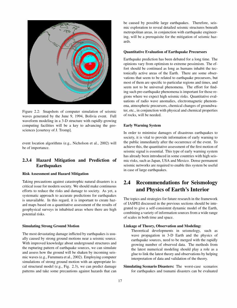
Figure 2.2: Snapshots of computer simulation of seismicwaves generated by the June 9, 1994, Bolivia event. Fullwaveform modeling in a 3-D structure with rapidly-growingcomputing facilities will be a key to advancing the geo-sciences [courtesy of J. Tromp].
event location algorithms (e.g., Nicholson et al., 2002) willbe of importance.
2.3.4 Hazard Mitigation and Prediction ofEarthquakes
Risk Assessment and Hazard Mitigation
Taking precautions against catastrophic natural disasters is acritical issue for modern society. We should make continuousefforts to reduce the risks and damage to society. As yet, asystematic approach to accurate predictions for earthquakesis unavailable. In this regard, it is important to create haz-ard maps based on a quantitative assessment of the results ofgeophysical surveys in inhabited areas where there are highpotential risks.
Simulating Strong Ground Motion
The most devastating damage inflicted by earthquakes is usu-ally caused by strong ground motions near a seismic source.With improved knowledge about underground structures andthe rupturing pattern of earthquake sources, we can simulateand assess how the ground will be shaken by incoming seis-mic waves (e.g., Furumura et al., 2002). Employing computersimulations of strong ground motion with an appropriate lo-cal structural model (e.g., Fig. 2.3), we can predict damagepatterns and take some precautions against hazards that can
be caused by possible large earthquakes. Therefore, seis-mic exploration to reveal detailed seismic structures beneathmetropolitan areas, in conjunction with earthquake engineer-ing, will be a prerequisite for the mitigation of seismic haz-ards.
Quantitative Evaluation of Earthquake Precursors
Earthquake prediction has been debated for a long time. Theopinions vary from optimism to extreme pessimism. The ef-fort should be continued as long as humans inhabit the tec-tonically active areas of the Earth. There are some obser-vations that seem to be related to earthquake precursors, butmost of them are specific to particular regions and times, andseem not to be universal phenomena. The effort for find-ing such pre-earthquake phenomena is important for those re-gions where we expect high seismic risks. Quantitative eval-uations of radio wave anomalies, electromagnetic phenom-ena, atmospheric precursors, chemical changes of groundwa-ter, etc., in conjunction with physical and chemical propertiesof rocks, will be needed.
Early Warning System
In order to minimise damages of disastrous earthquakes tosociety, it is vital to provide information of early warning tothe public immediately after the occurrence of the event. Toachieve this, the quantitative assessment of the first motion ofseismic signal is essential. This type of early warning systemhas already been introduced in some countries with high seis-mic risks, such as Japan, USA and Mexico. Dense permanentseismic networks are required to enable this system be usefulin case of large earthquakes.
2.4 Recommendations for Seismologyand Physics of Earth’s Interior
The topics and strategies for future research in the frameworkof IASPEI discussed in the previous sections should be inte-grated to give a self-consistent dynamic model of the Earth,combining a variety of information sources from a wide rangeof scales in both time and space.
Linkage of Theory, Observation and Modeling:Theoretical developments in seismology, such aswave propagation in 3-D Earth and the physics ofearthquake sources, need to be merged with the rapidlygrowing number of observed data. The methods fromthe latest numerical modeling should play a role as aglue to link the latest theory and observations by helpinginterpretation of data and validation of the theory.
Simulating Scenario Disasters: The worst-case scenariosfor earthquakes and tsunami disasters can be evaluated
17

Figure 2.3: Snapshots of ground motion for Nankai “scenario” earthquake (Mw 8.0) in south-west Japan, derived from 3-Dparallel simulation using the Earth Simulator. The bottom figure illustrates a 3-D model of the crust and upper mantle used inthe wavefield modeling. Purple zones indicate rupture areas of the fault [courtesy of T. Furumura].
quantitatively by integrating a variety of state-of-the-art information and techniques, such as high-resolutionseismic velocity models, the expected mechanism andmagnitude of earthquake sources, sophisticated numer-ical methods, and high-power computing facilities (Fig2.3). This will be helpful for the creation of seismic andtsunami hazard maps for regions with high risks of suchdisasters.
Gathering and Dissemination of Seismic Data: Coveringthe Earth uniformly with broad-band seismic stations isessential for the construction of high-resolution seismicmodels. International organizations, such as the Fed-eration of Digital Broad-Band Seismograph Network(FDSN) and the Incorporated Research Institutionsof Seismology (IRIS), have made efforts to facilitatecirculation of seismic data by gathering data fromregional seismic networks all over the globe. Still, thecurrent coverage of seismic stations is not sufficient. It
will be important to achieve a better global coverage ofseismic networks by deploying new regional seismicarrays, including ocean bottom instrumentation, as wellas by gathering data from existing regional networks,which are yet to join the FDSN.
Fostering International Schools for Young Researchers:Promoting educational programs for students andyoung researchers is important to fostering internationalcollaboration amongst young generations. Financialsupport for young researchers, especially those fromdeveloping countries, should be broadly available.
International training programs for researchers from de-veloping countries will also be important to educate andtrain scientists, technicians and science teachers in thoseregions. There is a successful example of an interna-tional training project, which has been offered by theBuilding Research Institute of Japan for more than 40
18
years, for educating professionals and technical expertsin seismology and earthquake engineering from devel-oping countries.
Promoting International Projects: It will be one of theimportant missions of IASPEI to foster internationalcollaborative observations and research projects. Inparticular, cooperation between developing and devel-oped countries will contribute to both the developmentof global seismology and the development of regionaleconomy and society in developing countries.
Efficient Use of Internet Resources: The internet providesus with enormous possibilities for easy and economi-cal communications with colleagues all over the world.With the advent and spread of the Giga-bit networks, itwill be possible to hold face-to-face international con-ferences, schools, workshops, and a variety of meetingsthrough the internet. Free access to geoscientific infor-mation through the internet would be of great help in theadvancement of geosciences.
2.5 Seismological Researches and So-cietal Benefit
Hazard Maps: It is essential to create hazard maps to eval-uate the seismic risk in local areas, based on geologicaland geophysical investigations of active faults and nu-merical simulations of strong ground motion in a localseismic structure. Basic researches on crustal deforma-tions and seismicity pattern analysis are also important.
Communication with Decision Makers: In case of catas-trophic disasters, scientific information must besmoothly transmitted to decision makers to take promptactions against hazards. Geoscientists should keep inmind that scientific information on natural disastersshould be provided in layman’s words to avoid miscom-munication.
Information Technology: It will be useful to create a sys-tem using information technology as a communicationtool in case of emergency. Outer space monitoring withsatellites for earthquakes and disasters may be helpfulin immediate transmission of rescue information. It isalso important to utilize rapid and reliable earthquakeground-motion information for controlling large struc-tures and complex systems to minimize the impact oflarge earthquakes on modern society.
Building Code and Quakeproof Building: In seismicallyactive areas, the legislation of appropriate buildingcodes is essential. Engineering solutions to strengthenbuildings against strong ground motions at a reasonable
cost will be of significant help in reducing damages indeveloping countries.
Insurance Policy: Disastrous earthquakes in urban areacause not only large numbers of casualties, but alsohuge economic losses. Insurance policies for the caseof catastrophe should be constructed based on the latestscientific information.
Personal Seismic Monitoring System: It will be useful todisseminate personal sensors and recoding systems thatcan be linked to personal computers, internet, TV, and/ormobile telephones, as a complement of professional ob-servation facilities. Such personal facilities can play arole as a component of education of the public and out-reach for the reduction of natural disasters.
2.6 Opportunities for Interdisci-plinary Researches
Linking Surface Tectonics and Mantle Dynamics (IAG,IAVCEI): The deformation of surface topography re-flects the dynamic processes that are going on in theEarth. Continuous geodetic observations of the surfacedeformation provide not only useful information for un-derstanding the dynamics of the Earth’s interior, but alsoindispensable information on the occurrence of earth-quakes and volcanic eruptions.
Volcano Seismology (IAVCEI, IAG): Most volcanic activi-ties are accompanied by seismic activities, and thus seis-mic observation in volcanic regions is inevitable. Re-vealing the processes of interaction between earthquakesand volcanic activities would be a clue to better under-standing the triggering effects between eruptions andearthquakes. Furthermore, seismology can provide use-ful tools for the development of physical volcanology.To obtain a detailed image of seismic structure of vol-canoes, enhanced seismic observations in volcanic areasas well as the advancement of theories and techniquesof seismic wave propagation and modeling in stronglyheterogeneous media will be essential.
Generation and Propagation of Tsunami (IAPSO):Earthquakes in oceanic regions sometimes generatehuge tidal waves, tsunamis, which bring catastrophicdamages in coastal areas. The scientific investigationof its generation and propagation is required to createa practical warning system to mitigate tsunami disasters.
Seismology for the Earth and the Sun (IAGA): Thestudies of free oscillations of the Earth and the Sunshare some common theoretical ground (e.g., Dahlen& Tromp, 1998). Further developments of seismologywould complement helioseismology, and vice versa.
19

Coupling Between Atmosphere, Ocean and Solid Earth(IAMAS, IAPSO, IAG): How do the solid Earth, atmo-sphere and ocean interact with each other? How do theatmosphere and ocean shake the solid Earth? The devel-opment of a systematic Earth model integrating a vari-ety of Earth processes, such as global warming, growthand retrogression of polar ice caps, plate tectonics, conti-nental evolution, etc, which fully incorporate the physicsand chemistry of the processes into their structure, con-sidering the significant differences in time-scale, will bea common ultimate goal of geosciences.
Water Cycle in the Earth (IAHS, IAPSO, IAVCEI): Howis water brought down into the deep Earth? What is therole of the water in the Earth? Can water be a catalyst forearthquakes? The process of transportation of ground-water and its implications to the precursory anomaliesof earthquakes will need to be evaluated quantitatively.
2.7 ConclusionsThere are a number of areas of challenging research relatedto IASPEI to extend our scientific knowledge in the future.Enhanced information about the Earth’s interior is importantfor a better understanding of the present status of the Earthas well as its historical evolution as a planet. Unveiling thenature of earthquakes and their generation, incorporating avariety of information of relevant disciplines, will be essen-tial to meet the societal needs, i.e., earthquake prediction andmitigation of their effects. The rapid advancement of mod-ern technology will make it possible to open new fields ofinterdisciplinary sciences. The first decade of the 21st cen-tury will be the exciting years for the younger generation toachieve a further understanding of the Earth’s interior as wellas a dynamic system of the whole Earth.
2.8 AcknowledgmentSome of the ideas outlined in this chapter have arisen fromanswers to a survey conducted in 2002. The author wouldlike to thank all of those who kindly shared their opinions;in particular, B. Chouet, E. R. Engdahl, H. Kanamori and K.Suyehiro for their comprehensive comments on important is-sues of the IASPEI. I would also like to thank E. R. Engdahl,B. L. N. Kennett, P. Suhadolc, Z. Wu, F. Simons and T. Harafor their reviews which helped to improving the report.
BibliographyBen-Zion, Y, Dynamic ruptures in recent models of earth-
quake faults J. Mech. Phys. Solids, 49, 2209-2244,2001.
Brodsky, E. E. and H. Kanamori, Elastohydrodynamic lu-brication of faults, J. Geophys. Res., 106, 16357-16374,2001
Dahlen, F. A., S. -H. Hung and G. Nolet, Frechet kernelsfor finite-frequency travel times - I. Theory, Geophys. J.Int., 141, 157-174, 2000.
Dahlen, F. A. and J. Tromp, Theoretical Global Seismology,Princeton University Press, Princeton, 1998.
Furumura, T., K. Koketsu,.and K.-L. Wen, PSM/FDM hy-brid simulation of strong ground motion for the 1999Chi-Chi, Taiwan earthquake, Pure Appl. Geophys., 159,2133-2146, 2002.
Hacker B.R., S. M. Peacock, G. A. Abers and S. D. Hol-loway, Subduction factory - 2. Are intermediate-depthearthquakes in subducting slabs linked to metamorphicdehydration reactions? J. Geophys. Res., 108, ESE 11,10.1029/2001JB001129, 2003.
Jackson, I. Laboratory measurement of seismic wave disper-sion and attenuation: Recent Progress, in Earth’s DeepInterior: Mineral Physics and Tomography From theAtomic to the Global Scale, pp. 265-289, ed. Karato,S., Forte, A. M., Liebermann, R. C., Masters, G. andStixrude, L., American Geophys. Union, 2000.
Kendall, J.-M., Seismic anisotropy in the Boundary Layersof the Mantle, in Earth’s Deep Interior: Mineral Physicsand Tomography From the Atomic to the Global Scale,pp. 133-159, ed. Karato, S., Forte, A. M., Liebermann,R. C., Masters, G. and Stixrude, L., American Geophys.Union, 2000.
Kobayashi N. and K. Nishida, Continuous excitation ofplanetary free oscillations by atmospheric disturbances,Nature, 395, 357-360, 1998.
Komatitsch, D., J. Ritsema and J. Tromp, The spectral-element method, Beowulf computing and three-dimensional seismology, Science, 298, 1737-1742,2002.
Laske, G. and G. Masters, Limits on differential rotation ofthe inner core from an analysis of the Earth’s free oscil-lations, Nature, 402, 66-69, 1999.
Lee, W. H. K., H. Kanamori, P. C. Jennings and C.Kisslinger, International Handbook of Earthquake andEngineering Seismology, Part A, Amsterdam; Tokyo,Academic Press, 2002.
Lee, W. H. K., H. Kanamori, P. C. Jennings and C.Kisslinger, International Handbook of Earthquake andEngineering Seismology, Part B, Amsterdam; Tokyo,Academic Press, Academic Press, 2003.
20

Levander, A., E. G. Humphreys, G. Ekstrom, A. S. Meltzerand P. M. Shearer, Proposed project would give unprece-dented look under north America, EOS Trans. AGU, 80,250-251.
Nicholson, T., M. Sambridge and O. Gudmundsson,Hypocenter location by pattern recognition, J. Geophys.Res., 107, ESE 5, 10.1029/2000JB000035, 2002.
Obara, K., Nonvolcanic deep tremor associated with sub-duction in southwest Japan, Science, 296, 1679-1681,2002.
Park, J. and V. Levin, Geophysics - Seismic anisotropy:Tracing plate dynamics in the mantle, Science, 296, 485-489, 2002.
Sambridge, M., Geophysical Inversion with a Neighbour-hood Algorithm -II. appraising the ensemble, Geophys.J. Int., 138, 727-746, 1999.
Simons, F. J., G. Nolet and D. Bohnenstiehl, Scrap the cable:identification and discrimination of seismic phases byautonomous floats, Geophys. Res. Abstracts, 5, 08035,European Geophysical Society, 2003.
Song X. and P.G. Richards, Seismological evidence for dif-ferential rotation of the Earth’s inner core, Nature, 382,221-224, 1996.
Suda N, K. Nawa, Y. Fukao, Earth’s background free oscil-lations, Science, 279, 2089-2091, 1998.
Tromp, J., Inner-core anisotropy and rotation, Ann. Rev.Earth Planet. Sci., 29, 47-69, 2001.
van der Hilst, R., B. Kennett, D. Christie and J. Grant,Project Skippy explores the lithosphere and mantle be-neath Australia, EOS Trans. AGU, 75, 177-182, 1994.
Yoshizawa K. and B.L.N. Kennett, Determination of the in-fluence zone for surface wave paths, Geophys. J. Int.,149, 440-453, 2002.
Zhao, D., H. Kanamori, H. Negishi, Tomography of thesource area of the 1995 Kobe earthquake: Evidencefor fluids at the hypocenter?, Science, 274, 1891-1894,1996.
21

22

Chapter 3
International Association of Volcanology andChemistry of the Earth’s InteriorE. E. Brodsky
The International Association of Volcanology and Chem-istry of the Earth’s Interior (IAVCEI) promotes both researchin volcanology and efforts to mitigate volcanic disasters. IAV-CEI also promotes research in the closely related fields of ig-neous petrology and geochemistry. As the major scientificproblem of volcanology is also one of societal import, thework and progress of the field is closely related to the indi-vidual situations in local communities. The value of an inter-national organization like IAVCEI is to help integrate knowl-edge across boundaries, both political and intellectual. Byintroducing this broad perspective, IAVCEI helps volcanolo-gists turn their discussions from fire-fighting to strategies forpushing forward a scientific frontier.
3.1 Long-term goals
We would like to know accurately what are the processesleading to an eruption, and how do these processes relate toobservable precursors such as volcanic tremor, earthquakes,gas discharge events and deformation. Why do volcanoeserupt; i.e., why does the magma not remain as an intrusionat depth? We would like to be able to use this knowledge toaccurately forecast not only when an eruption will occur, butalso the size and type of the eruption. We should also be ableto distinguish an impending eruption from mere unrest.
This wish list may seem difficult to achieve, but we arenot as far from it as some might imagine. Eruptions at well-monitored volcanoes seldom occur without warning. In broadoutlines, we know that volcanoes erupt because the overpres-sure of the volatiles exceeds the strength of the confining ma-terial. However, the quantitative details behind this scenarioare still elusive. The type of the eruption at a given volcano,including its potential explosiveness, is usually forecast basedon the previous history of the volcanic system with varyingdegrees of accuracy. Distinguishing true impending eruptions
from dike intrusions or merely a seismic swarm is still a diffi-cult matter that is often decided based on expert opinion andexperience rather than quantifiable scientific predictions. Thephysical process behind certain precursors, like inflation, maybe well-known, but others, such as tremor, remain enigmatic.Even the relatively well-understood precursors are associatedwith only isolated pieces of the magmatic system rather thana comprehensive view of the magma-volatile-wallrock evolu-tion.
3.2 Short-Term Priorities
In order to reach the long-term goal of quantifiable predic-tions based on physical interpretations of precursors, we needto concentrate on unraveling specific volcanic processes. Thefollowing section highlights a few major questions in vol-canology that could plausibly be answered by focused effortsin the next 10–20 years. The questions are organized by pro-cess rather than methodology or discipline because answeringmost problems will require a combination of techniques.
Strategies for achievement follow each set of questions. Alimited number of example studies are cited to illustrate andclarify the strategies suggested. The citations here are by nomeans a complete survey of all work done in the field nor isthis discussion an exhaustive list of interesting problems involcanology. The purpose of this report is to focus on op-portunities for rapid and important advancement of the basicscience.
Many of the important problems do not require state-of-the-art technology or large-scale research investments. Sev-eral of the suggested research strategies are achievable bysingle investigators in regions without major technologicalinfrastructure. Scientists in developing countries will likelycontinue to make fundamental contributions to the field.
23

3.2.1 Initiation
What begins an eruption? Is it the failure of the edifice or thepressurization of the chamber due to entirely internal proper-ties? What is the role of external sources of volatiles such asgroundwater? Is the intrusion of new magma or an episodeof mixing necessary to start a new eruptive episode?
Progress could be made here by detailed studies of instru-mental records of the first few minutes of an eruption, petro-logical studies including kinetic constraints on magma riserates [Rutherford and Hill, 1993; Geschwind and Rutherford,1995], and comparison of precursory activity across many ex-amples of historical eruptions [Newhall and Dzurisin, 1988;Benoit and McNutt, 1996].
3.2.2 Explosive/effusive transition
What combinations of volatile abundances and magmachemistries lead to explosive rather than effusive eruptions?Are there any observable indicators of the state prior to erup-tion for a volcano that has a history of both types of behavior?
Promising leads on the answer to the first question havecome from laboratory experiments on natural materials andanalog studies [Martel et al., 2001; Ichihara et al., 2002].Experimental petrological studies of silicate rheology as afunction of composition, volatile content, crystallinity, tem-perature and pressure connect the analog studies to the nat-ural systems. The observational question will likely be an-swered by well-integrated modeling and observational stud-ies of very active volcanic systems like the ongoing SoufriereHills, Montserrat eruption that regularly produces both typesof activity [Druitt and Kokelaar, 2002].
3.2.3 Eruptive Plumes
What are the expected plume heights and dispersal patternsfor realistic eruptions?
Much theoretical progress has been made on plume heightsfrom idealized eruptions [Wilson et al., 1980; Sparks and Wil-son, 1976; Valentine and Wohletz, 1989; Neri and Dobran,1994; Woods, 1995], yet there still are comparatively fewstudies comparing the predictions to field data. Field datanow encompasses satellite images as well as more conven-tional maps of deposits [Krotkov et al., 1999]. Comparisonswith the data will likely require incorporating realistic mul-tiphase properties, large depressurizations, 3-D effects andcompressibility into a new generation of numerical models.
3.2.4 Climatic effects of eruptions
Can we predict the global pattern and amplitude of temper-ature decrease from a given volcanic eruption? How region-ally variable are these effects? What is the long-term role ofvolcanic volatiles in the atmospheric mass budget?
The raw data of the climate and volcanological record willcome from a combination of geological studies, tree ringsand especially ice cores. Numerical climate modeling withGlobal Climate Models (GCM) informed by an accurate un-derstanding of the volcanological inputs and uncertainties canaddress these questions. Gas monitoring data including iso-topic compositions are necessary inputs to volatile mass bud-get considerations [Hilton et al., 2002].
3.2.5 Flow EmplacementWhat determines the runout distance of pyroclastic flows? Oflava flows? Of lahars?
Geological deposits record the emplacement of flows andso can be interpreted to determine the processes ending move-ment [Branney and Kokelaar, 1992]. Laboratory analog ex-periments have had considerable success in quantifying themorphology of lava flows in terms of dimensionless parame-ters; similar approaches can be taken to runout length [Finkand Griffiths, 1998]. Laboratory studies of silicate melt rhe-ology again help relate the analog materials to the real sys-tems. Images of flow on other planets can extend our param-eter ranges to test theories [Zimbelman, 1998].
3.2.6 Interactions with TectonicsWhen do earthquakes trigger eruptions? When do eruptionstrigger earthquakes? How?
Triggering problems can be approached with statisticalstudies of the historic record [Linde and Sacks, 1998] as wellas examining monitoring records (thermal, gas, hydrother-mal, deformation and seismic data) for evidence of coupling[Johnson et al., 2000].
3.2.7 Magma StorageAre magma storage areas chambers or plexuses? Is the stor-age body created by a single emplacement event or repeatedinjections? What is the relationship, if any, between storagebody size and eruptive volume? Do magma bodies convectand if so, for what parameter ranges? What is the volatilecontent in the storage areas?
Geological studies of either erupted ignimbrites and em-placed plutons give the most direct data on magma chamberheterogeneity [Hildreth and Fierstein, 2000]. Laboratory andtheoretical studies could connect microstructure and zonationto specific parameters. Seismic and other geophysical meth-ods provide direct constraints on the geometry of active bod-ies [Auger et al., 2001]. Ultimately, the petrological storyshould be connected to the physical story.
3.2.8 Conduit TransportAt what stage of an eruption is the conduit geometry deter-
24

mined? When is magma transport by percolation rather thanconduit flow? What role does thermal buoyancy play? Doesthe collapse of conduits end eruptions? Where and how doesdegassing take place in a conduit?
Coupled solid-fluid numerical models will likely be an im-portant part of answering these questions. Magmatic rheol-ogy is once again a crucial input to the models. Geologicalstudies of wallrock entrainment and abundance will pose fun-damental constraints for the models. Gas studies constrainthe degassing history.
3.3 Recommendations for Volcanol-ogy
In general, attacking these problems will require combiningmultiple techniques and comparing multiple eruptions acrossdifferent volcanoes. The above discussion suggests two gen-eral categories for improvement: (1) synthesis of observa-tions and modeling and (2) instrumentation.
3.3.1 Observations and Modeling
Although vast technological progress has been made in ob-serving volcanoes and major conceptual and numerical leapshave been made in modeling them, there is still a fundamen-tal lack of connection between these two major sides of vol-canology. The inputs to the models are generally not the ob-servables in the field. Theorists would like to know magmachamber volatile content and viscosity while field scientistsreport number of earthquakes and gas discharge. Closing thisgap is going to require efforts from both sides. The mod-elers need to develop models that include degassing and de-formation. A model that is not connected to data is useless.The field scientists are going to have to invert their resultsfor properties in the magma. Numbers that are not connectedto a real process are meaningless. New initiatives like theWOVOdat project discussed below could broadly dissemi-nate the raw observational data. This distribution will be animportant tool for making progress.
The study of volcanic seismicity is a special case of theinterface between observation and modeling. Many groupsconsider volcanic seismic signals to be the most reliable pre-cursors to an eruption, and therefore, their physical interpre-tation is a priority in the field. However, the interpretation ofthese precursors is still so preliminary that it was not possibleto work volcano seismicity into the process-oriented short-term priorities of the previous section. Is tremor giving in-formation about the initiation process, conduit transport orsome other physics? Volcano seismologists today are like theearly petrologists who first organized a taxonomy of observa-tions and only later developed an understanding of their gene-sis. Just as the early rock classifications that placed limestone
and diabase together caused much confusion, it is almost in-evitable that the currently used empirical seismicity classifi-cation is misleading in some respects.
Overcoming these barriers will require combining data andmodels by asking questions like: Where are the earthquakesrelative to the magma? Is their location controlled by thestress field or local structures at the hypocenters? What con-trols the frequency of volcanic seismicity?
High-resolution earthquake relocations provide powerfulinsights into the question of location [Gillard et al., 1996].Well-integrated studies of these locations and the theoreticalpredictions of coupled fluid-solid models can explain whythe earthquakes are located in the observed places [Rubinet al., 1998]. Connecting the frequency of volcanic tremorand long-period events to physical processes may benefitfrom comparing the volcanic timeseries with other observ-ables such as gas, chemistry or deformation. Forward modelsthat predict multiple observables based on coupled fluid andsolid mechanics will likely be a necessary step in solving thisproblem and others like it.
3.3.2 Instrumentation
As a natural science, volcanology is propelled forward by ob-servational data. Quantitative instrumental data connects ob-servations to processes and ultimately to predictive models.The last decade has seen major improvements in instrumen-tation, including the widespread use of InSAR (Figure 3.1),GPS monitoring and broadband seismometers. Increasingly,active eruptions are being monitored and forecast by primar-ily instrumental means. The education of the next generationof volcanologists must take this fact into account. In addition,further technological developments are needed to address thefollowing issues.
The narrowing geodesy/seismology bandwidth gap
The classical instrumentation of volcanic geodesy and seis-mology has converged. Broadband seismometers can mea-sure velocity and displacement from 50 Hz to hundreds ofseconds. Real-time kinematic GPS systems monitor displace-ment changes over seconds or months and years. Gravime-try has historically been used to measure changes over years,but now modern digitizers allow data to be logged over sec-onds. These overlapping bandwidths have some distinct ad-vantages. We can now completely cover the spectrum andcan reasonably compare data from diverse tools. However,there are also some subtle problems. Have certain techniquesbecome redundant? The interpretation of a classical tech-nique outside its classical bandwidth can be problematic andplagued by response issues as instrumentation is pushed toits limits. It now seems within reach to design a single mo-tion sensor over all relevant wavelengths. Such a leap could
25

Figure 3.1: Example of InSAR deformation data on a shaded relief topographic map of the central Andes. Black squares showthe radar frames used in this remote-sensing study. Black triangles show the 1113 potential volcanic edifices. The red line inthe ocean is the location of the trench. Color shows InSAR interferograms indicating active deformation. Each color cyclecorresponds to 5 cm of deformation in the radar line-of-sight (LOS) direction. Inset maps provide detailed views of the centersof volcanic deformation: a., Hualca Hualca, Peru, time span 6/92–4/96 (3.9 yr), b., Uturuncu, Bolivia, time span 5/96–12/00(4.6 yr), c., Lazufre, time span 5/96–12/00 (4.6 yr), all of which are inflating, and d., Robledo, time span 5/96–10/00 (4.4 yr),in NW Argentina which is deflating (From Pritchard and Simons [2002]).
greatly reduce the cost of volcanic monitoring while increas-ing the ease of interpretation of datasets.
Remote sensing & robotics
Fieldwork on active volcanoes is inherently dangerous. In-creasingly, technology is able to replace hand-sampling andin-person monitoring. Satellite remote sensing has madegreat strides in measuring deformation, thermal anomalies,ash dispersion and gas discharge. Satellites provide excel-lent spatial coverage, but they do not resolve rapid time-dependent processes or trace chemical compositions. Al-though we should certainly attempt to expand satellite dataand its availability, we will still need locally deployed instru-ments to measure such staples of the field as seismic wavesand fumarole chemistry. There have been some efforts to userobotics to deploy such nearfield instruments, no system hasyet been completely successful. A renewed push on this frontis necessary in order to assure high-temporal resolution in-tracrater monitoring.
Gas monitoring
Theoretical studies indicate volatile abundance is a major pa-rameter in determining eruptive style. Observational con-straints on in situ volatile concentrations coupled to a model
of degassing and partitioning can provide a useful startingpoint for predictive modeling of eruptive dynamics. SO2 con-centrations have been measured for decades, but it is only re-cently that other components of the plume have begun to bemeasured. Instrumentation, such as FTIR that measures mul-tiple volatiles, should be developed and deployed routinely.
Real-time integrated datastreams
Modern telemetry makes it possible to collect large quantitiesof data in real-time. Some techniques, like seismology, havealready been able to capitalize on this ability, while others,like gas monitoring, are still developing the technology. Real-time simultaneous display of multiple observables has obvi-ous advantages for hazard management. It would also ben-efit basic research by both facilitating the integration of datatypes and providing the framework for ready comparison ofmodels and data. In particular, if all the relevant observableswere acquired as digital datastreams, whole new methods oftimeseries analysis would become possible. Theoretical pre-dictions could be tested in a forward sense. Formal data as-similation techniques could be used to update and validatephysical models. Even more speculative methods, like time-series continuation, might someday become practical predic-tion tools and windows into physical processes.
26
3.4 Recommendations for IAVCEIand IUGG
3.4.1 Travel for Observatory Scientists
IAVCEI should raise funds specifically designated to bringvolcanic observatory scientists from the developing world tomajor conferences such as AGU, EUG and IAVCEI. This cen-tral observatory travel fund should be a priority as it wouldaddress several issues. The fund could help observatory sci-entists present their data themselves. The fund could alsofacilitate modeling-observation interactions by helping ob-servers appreciate state-of-the-art scientific questions and al-low modelers direct access to observers’ experiences. It couldalso help observatory scientists discuss logistical and proce-dural matters across international boundaries that could im-prove overall data quality and provide a uniformity of obser-vations that is required if we are to have true cross-volcanocomparative studies.
3.4.2 WOVOdat
Interdisciplinary research could be facilitated by dissemi-nating a variety of data in a uniform format to be accessi-ble to anyone without any special connections. WOVOdat(http://www.wovo.org/wovodat.htm) is a project to do justthis and deserves IUGG’s full and active support. The projectwould also be facilitated if the observatory scientists werebetter connected to the research process as suggested in theabove discussion of a the central observatory travel fund.
3.4.3 Communicating with Society
Scientific progress will not mitigate hazards unless results arecommunicated effectively to local decision makers during acrisis. Over the past 20 years, much attention has been paidto the interface between scientists and politicians with signif-icant practical and scholarly research on hazard management.Still, sometimes turf wars and scientists inexperienced in cri-sis management lead to difficult and dangerous situations. Asa new generation of scientists emerges, we all need to be con-stantly reminded of the seriousness of our task and retrainedon appropriate ways to interface with local communities. Cri-sis teams must effectively combine the local knowledge ofresident scientists and observers with the constantly evolvingskills of foreign specialists. Technical results must be madeaccessible without sacrificing factual accuracy and complete-ness. In order to facilitate this process, IAVCEI should con-tinue to serve as a central source of guidelines and training oncrisis management.
3.5 Opportunities for Interdisci-plinary Research
Volcanoes literally explode the boundaries between thespheres of geoscience. Opportunities for interaction exist be-tween IAVCEI and each of the other associations. Possibili-ties include:
• IAMAS: Exploration of the effects of volcanism on cli-mate (Section 3.2.4).
• IASPEI Earthquake-volcano interactions (Section3.2.6). Development of robust wave propagationmodeling tools suitable for the highly heterogeneouspaths of volcanoes. Characterization of explosive andother non-double couple seismic sources. Delineationof geometry of magma bodies (Section 3.2.7).
• IAG: Geodetic instrumentation at high time-resolution(Section 3.3.2).
• IAGA: Numerical and theoretical tools for modelinglarge-scale compressible jets (Section 3.2.3).
• IAPSO: Mid-ocean ridge volcanism and earthquake in-teractions (Section 3.2.6). The role of submarine volcan-ism in the biological and physical environment of ridges.
• IAHS: Groundwater as a trigger for explosive erup-tions (Section 3.2.1). Using water well data to measurestrain, temperature and chemical changes in the coupledhydrothermal-volcanic system.
3.6 Conclusions
Recent instrumental advances and the broad disseminationof observatory data are bringing volcanology into a new era.IAVCEI and the volcanology community can take advantageof the situation by targeting our resources to answer the ques-tions most likely to generate a quantitative, portable model ofwhy volcanoes erupt.
3.7 Acknowledgments
The author is grateful for responses to a survey in Septem-ber 2002, especially C. Newhall, who contributed a completereport on the intersection of modeling and observations. Sev-eral reviewers including K. Cashman, T. Fischer, M. Manga,M. Mangan, S. Prejean, M. Pritchard and R.S.J. Sparks con-tributed to improving the report.
27

BibliographyAuger, E., P. Gasparini, J. Virieux, and A. Zollo, Seismic
evidence of an extended magmatic sill under Mt. Vesuvius,Science, 294, 1510–1512, 2001.
Benoit, J.R., and S.R. McNutt, Global volcanic earthquakeswarm database 1979–1989, USGS Open-File Report, 96-69, 1996.
Branney, M.J., and B.P. Kokelaar, A reappraisal of ign-imbrite emplacement: changes from particulate to non-particulate flow during progressive aggradation of high-grade ignimbrite, Bull. Volcanol., 54, 504–520, 1992.
Druitt, T.H., and B.P. Kokelaar, The eruption of Soufrire HillsVolcano, Montserrat, from 1995 to 1999, Geological Soci-ety, London, 2002.
Fink, J.H., and R.W. Griffiths, Morphology, eruption rates,and rheology of lava domes: Insights from laboratory mod-els, J. Geophys. Res., 103, 527–545, 1998.
Geschwind, C.H., and M.J. Rutherford, Crystallization ofmicrolites during magma ascent: The fluid mechanics of1980–86 eruptions at Mount St. Helens, Bull. Volc., 57,356–370, 1995.
Gillard, D., A. M. Rubin, and P. Okubo, Highly concen-trated seismicity caused by deformation of Kilauea’s deepmagma system, Nature, 384( 6607 ), 343–346, 1996.
Hildreth, W., and J. Fierstein, Katmai volcanic cluster and thegreat eruption of 1912, Geol. Soc. Am. Bull., 112, 1594–1620, 2000.
Hilton, D. R., T. P. Fischer, and B. Marty, Noble gases ingeochemistry and cosmochemistry, chapter Nobles Gassesand Volatile Recyclying at Subduction Zones, pages 319–362, Mineral. Soc. of Amer., 2002.
Ichihara, M., D. Rittel, and B. Sturtevant, Fragmentation of aporous viscoelastic materials: implication to magma frag-mentation, J. Geophys. Res., 106( B10 ), 2229, 2002.
Johnson, H.P., M Hutnak, R.P. Dziak, C.G. Fox, I. Urcuyo,J.P. Cowen, J. Nabelek, and C. Fisher, Earthquake-inducedchanges in a hydrothermal system on the Juan de Fuca mid-ocean ridge, Nature, 407, 174–177, 2000.
Krotkov, N. A., O. Torres, C. Seftor, A. J. Krueger, A. Kostin-ski, W. I. Rose, G. J. S. Bluth, D. Schneider, and S. J.Schaefer, Comparison of TOMS and AVHRR volcanicash retrievals from the August 1992 eruption of Mt. Spurr,Geophys. Res. Lett., 26( 4 ), 455–458, 1999.
Linde, A.T., and I.S. Sacks, Triggering of volcanic eruptions,Nature, 395, 888–890, 1998.
Martel, C., D.B. Dingwell, O. Spieler, M. Pichavant, andM. Wilke, Experimental fragmentation of crystal- andvesicle-bearing silicic melts, Bull. Volcanol., 63, 398–405,2001.
Neri, A., and F. Dobran, Influence of eruption parameters onthe thermofluid dynamics of collapsing volcanic columns,J. Geophys. Res., 99, 11,833–11,857, 1994.
Newhall, C.G., and D. Dzurisin, Historical unrest at largecalderas of the world, U.S. Geol. Surv. Bull., 1855, 1988.
Pritchard, M.E., and M. Simons, A satellite geodetic surveyof large-scale deformation of volcanic centres in the centralAndes, Nature, 418, 167–171, 2002.
Rubin, A. M., D. Gillard, and J. L. Got, A reinterpretation ofseismicity associated with the January 1983 dike intrusionat Kilauea Volcano, Hawaii, J. Geophys. Res.-Solid Earth,103( B5 ), 10003–10015, 1998.
Rutherford, M.J., and P.M. Hill, Magma ascent rates fromamphibole breakdown: Experiments and the 1980–1986Mount St. Helens eruptions, J. Geophys. Res., 98, 11949–11959, 1993.
Sparks, R. S. J., and L. Wilson, A model for the formation ofignimbrite by gravitational column collapse, J. Geol. Soc.Lond., 132, 441–451, 1976.
Valentine, Greg A., and Kenneth H. Wohletz, Numericalmodels of plinian eruption columns and pyroclastic flows,J. Geophys. Res., 94, 1867–1887, 1989.
Wilson, Lionel, R. S. J. Sparks, and George P. L. Walker, Ex-plosive volcanic eruptions; IV, the control of magma prop-erties and conduit geometry on eruption column behaviour,Geophys. J. R. Astr. Soc., 63, 117–148, 1980.
Woods, A.W., The dynamics of explosive volcanic eruptions,Rev. Geophys., 33, 495–530, 1995.
Zimbelman, J. R., Emplacement of long lava flows on plane-tary surfaces, J. Geophys. Res., 103, 27,505–27,516, 1998.
28

Chapter 4
International Association of the PhysicalSciences of the OceansC. Simionato
4.1 Introduction
The aim of physical oceanography is to understand, modeland predict ocean processes by combining observations withmathematics and fluid mechanics. Physical oceanography isconcerned with how water moves and mixes in the ocean andhow water transports and distributes heat and dissolved and/orin suspension chemicals, nutrients, plankton, sediment, andpollutants. This discipline does not only include the study ofthe large oceans and shelf seas but also of estuaries, lakes andlarge bodies of water on other planets and moons.
Physical oceanography is an extremely challenging sci-ence. One of its central difficulties, in common with othergeosciences, is the lack of a laboratory to experiment in.Physical oceanographers must rely, therefore, on direct ob-servations and interpretations of these data with fluid me-chanics, applied mathematics, powerful computers and mod-ern descriptive tools. Another great challenge is the range ofspace and time scales that must be measured and modeled byany successful effort to understand the fluid behavior. Ev-ery scale, from the seconds to hours of the waves and tidesthat modify the shoreline to the centuries and even millenniaof the ocean thermohaline circulation response scale, goingthrough a number of intermediate scales, must be considered.
Comprehensive observation of these processes demands adifficult and expensive combination of in situ and remotemeasurements for very long periods of time and large dis-tances, which just started in relatively recent years. Othernot minor tasks include the need for an international coop-eration effort to observe and understand the system, giventhat the ocean knows no national boundaries but behaves as awhole, and the need for an interdisciplinary approach in orderto give answers to many important environmentally relevantquestions.
These needs make progress in physical oceanography to beintrinsically tied to progress in technology. Recent advances
in observational tools, especially in remote sensing, togetherwith the development of new and powerful computer basedtools are producing an increasingly global and complete pic-ture of the three-dimensional ocean circulation and great ad-vances in our physical understanding of the oceans. The fieldis beginning to assemble the elements to reach the ultimatescientific goal of attaining a comprehensive understanding ofthe physics of the ocean.
The International Association of the Physical Sciences ofthe Oceans (IAPSO) is one of the seven associations thatcomprise the International Union of Geodesy and Geophysics(IUGG), founded in 1919. IAPSO has as its prime goal ”pro-moting the study of scientific problems relating to the oceansand the interactions taking places at the sea floor, coastal, andatmospheric boundaries insofar as such research is conductedby the use of mathematics, physics, and chemistry.” One ofthe main objectives of IAPSO is to organize, sponsor, andco-sponsor formal and informal international forums, permit-ting ready means of communication amongst ocean scientiststhroughout the world. In this sense, the IUGG general as-sembly in Sapporo, Japan, provides an excellent context forreflection and interdisciplinary discussions about our visionof how geosciences should develop during the next decades.This report intends to provide a view of the main directions inwhich physical oceanography research could progress duringthat period and to serve as a starting point for those discus-sions.
The results of previous workshops and surveys, togetherwith a survey and revision process among several scientistsaround the world were very valuable in the preparation of thisreport.
29

4.2 A view of the future of research inPhysical Oceanography
Even though basic research, independent of any practical con-cerns, is critical to the advancement of science and the devel-opment of technology, the relevance of science is often mea-sured in terms of its value to the end user. If the world issurvival-oriented, then this last aspect will become increas-ingly more significant during next decades for geosciences ingeneral, and physical oceanography in particular. Nowadays,the main societal concerns relating to physical oceanographyare the humankind impact on the ocean and climate and thesustainability of the environment. Humanity is faced withpressing marine research problems, many of which arise fromthe need to accommodate multiple uses of the ocean and fromthe ever-increasing concentration of the population near thecoasts. The demand for ’ocean products’ from the societyincreases as it understands more about the anthropogenic im-pacts on the oceanic systems and the need for a better under-standing of the ocean’s role in controlling global chemical,hydrological, and climate processes. It can be expected thatapplied physical oceanography in support of socioeconomicplanning and regulatory activities will become more signifi-cant as we move closer to the limits of sustainable use of theenvironment, and it should be emphasized that ’good science’and ’societally relevant science’ are not necessarily mutuallyexclusive.
Physical oceanography has made giant steps in both direc-tions. In the past decade, major breakthroughs were made inour understanding of ocean biology, chemistry, geology andphysics. Such potential has been made possible by increas-ing capabilities in the areas of computation and rapid ocean-observing technologies. These new capabilities are providingunprecedented views of the ocean basins, their changing in-teraction with the atmosphere, the great biological shifts innear-surface waters, and the long-hidden deep ocean basins.Advances in ocean numerical modeling made possible by in-creased knowledge are going and will go on, greatly enhanc-ing our understanding and predicting capability on time andspace scales important to society. The promise of progress inthe future is predicated on these new tools and the new ”look”at the ocean that these tools have made possible.
4.3 Long-term goals for PhysicalOceanography
Considering the concepts of the previous section, ocean sci-entists’ ambitions and societal demands could merge in thefollowing long-term goal for physical oceanography:
To attain a comprehensive understanding of the func-tioning of the ocean and its interactions with the atmo-sphere, land, cryosphere and biota in every temporal and
spatial scale, and its response to natural and anthro-pogenic forcing to predict, manage, and modify its behav-ior to help sustaining the human race and our environ-ment.
Even though our knowledge of the oceans and their rolein the climate has substantially improved during the lastdecades, we are still far from fully reaching this goal thatrequires the construction of a valid ’Earth Model,’ encom-passing other geosciences in addition to physical oceanogra-phy. Besides the inherent limits of predictability (further dis-cussed in the IAMAS Chapter 6), the extreme complexity ofthe system imposes technological and knowledge limits to afast development of the desired predictability. The construc-tion of such a model will require a much better understandingof all of the processes taking place in the coupled ocean-land-atmosphere-cryosphere system and their interaction with bio-geochemical processes together with a much larger com-puting capability. Regarding ocean’s role in such a model,ocean’s physical, chemical and biological processes are in-timately interconnected through a number of networks, in-teraction and interdependencies and feedback processes thatmust be fully understood prior to any attempt to modelingthem and obtaining truly meaningful predictions. Meetingthis scientific challenge requires research ships, incorporat-ing new platforms of observation and sampling, acquiringlong-term records of the relevant variables, developing newinstruments, building a real time global observation system,improving theoretical knowledge, models and the ability toassimilate data and update forecast models, and increasingcomputer power.
Besides addressing the above goals, given the immediatesocietal demand related to environmental problems, physicaloceanography should also identify intermediate goals. Twosuitable aims for shorter time scales that meet great chal-lenges to ocean sciences in general, taking advantage of thedeveloping technology, providing important services to thesociety and constituting an intermediate step to the proposedlong-term goal, could be:
• To develop a comprehensive predictive capability for theclimate variations in a lifetime. The predictive capabil-ity should extend beyond foreseeing weather conditionsand ocean temperatures to include effects of natural andanthropogenic climate change on sea life, including infisheries and on land, which could, in turn, affect cli-mate. The result of this work will eventually be a sys-tem capable of predicting climate fluctuations and theireffects on the biosphere, both on land and at sea span-ning in a lifetime.
• To develop a comprehensive understanding of coastalprocesses and their effects. As a result of this, we wouldexpect to be able to deal with coastal problems withoutexclusive dependence on years of site-specific, routinemeasurements.
30

Our present knowledge and capability, the continued devel-opment in technology and progress in physical oceanographicresearch, promise that important advances can be done in thisdirection during the next decade.
4.4 Short term focus for PhysicalOceanography
Reaching the aims proposed in the previous section requiresdevelopment in almost every aspect and sub-discipline ofphysical oceanography, together with progress in meteorol-ogy, geochemistry and other geosciences besides a closer in-teraction among them. To be in position to reach those aimson shorter time scales, oceanography must improve our un-derstanding of the ocean processes at every spatial and tempo-ral scale. Some of the critical issues that should be addressedduring the next decade regarding the two aims proposed in theprevious section are outlined below. It must be emphasizedthat even though the global climate and coastal problems areanalyzed separately, they are intimately interconnected, asthey constitute two pieces of a unique ’ocean puzzle.’ There-fore, progress in one of the areas depends on, and reciprocallywill have important repercussion in, the other one. Moreover,many of the needs are common.
4.4.1 Climate and climate change predictionUnderstanding how global climate evolves on decadal to cen-tennial time scales is one of the most pressing environmentalchallenges that geosciences face today. Physical oceanogra-phy plays a huge role in unraveling the evolution of climatebecause of ocean’s enormous importance in establishing theclimate. Oceans contain 50 times more carbon than the at-mosphere, dominate the hydrological cycle and, given wa-ter’s large heat capacity, stores extremely large amounts ofheat. These features give the ocean the capability of acting asa buffer, moderating both natural and anthropogenic forcedchanges in the climate system. Ocean circulation, throughlarge-scale currents, thermohaline circulation, mesoscale mo-tions and diffusive processes, plays an important role in dis-tributing the heat, carbon and freshwater that is exchangedwith the atmosphere, determining the climate to a large ex-tent. The oceans absorb 40% of the carbon dioxide that isemitted into the atmosphere and are responsible for 50% ofthe polewards heat transport. As a result, the ocean sequestersheat and carbon in the deep waters and sediments.
Global climate prediction is probably the most difficultproblem that our field has encountered. The dynamics arecomplex and involve a number of processes and scales. Theirlong time scales combined with the relatively short period ofwell-instrumented records of observational data make the di-rect observation of climate variability difficult or even im-possible. Internal oscillations create climate variability sig-
nificant enough to complicate and/or mask climatic variabil-ity produced by anthropogenic action. To assess the degreeto which these forcing mechanisms are controlling our mod-ern climate and the degree to which man has affected theclimate system, the variability of the natural global climatemust be understood. Given that we cannot wait to gatherenough data to directly observe the climate variability, itis necessary to expand our data base and frame hypothesesabout past climate change and ocean circulation using paleo-oceanographic studies and proxies, like ice cores, varved sed-iments, tree rings and corals (See Figure 4.1). Models arethe essential tools for casting the results of theory and obser-vations and for providing new hypothesis about the involvedprocesses.
During the last decades, as a result of improved and ex-tended observations, the development of pilot experimentsand the evolution of numerical modeling and data assimila-tion techniques, there have been important advances in ourunderstanding of the present and past climate systems.
One of the most important achievements has been the largeimprovement in observation due to a combination of newobservational and measurement techniques and the develop-ment of global experiments. In-situ measurements of highaccuracy made through experiments as WOCE (World OceanCirculation Experiment http://www.woce2002.tamu.edu);CLIVAR (Climate Variability and Predictabilityhttp://www.clivar.org) and JGOFS (Join Global OceanFlux Study http://www.uib.no/jgofs/jgofs.html) have givenan unprecedented view of the contemporary ocean circula-tion, have created the first long time series of CO2 in theoceans and have allowed an improvement in the estimationsof oceanic heat and CO2 transports. Polar orbiting satel-lites are providing a global coverage of critical propertiesevery few days, like sea surface height (Topex-Poseidonhttp://topex-www.jpl.nasa.gov) and ocean color (SeaWIFShttp://seawifs.gsfc.nasa.gov), that allow the study of thefluctuations is near-real time and at global scale.
The new measurement techniques have made possible di-rect observations of diapycnal mixing and basin-scale ab-solute velocity and wind fields and improved measurementand parameterization of air-sea fluxes, allowing for a bettertheoretical understanding of the ocean’s role in climate andits modeling. The increasing sophistication of drifters andfloats has allowed a view of the ocean circulation through La-grangian pathways. The exploration under ice by sensors car-ried on autonomous vehicles permits us to survey the deepconvection in progress, improving our knowledge and un-derstanding of the water masses formation. Important ad-vances have also been made in paleo-oceanography by im-provements in the dating techniques and the development ofnew proxies. TOGA (Tropical Oceans and Global Atmo-sphere http://ioc.unesco.org) program has established the ba-sic dynamics of ENSO and has lead to seasonal predictionswith useful skill. Innovations in modeling and data assimi-
31

Figure 4.1: The ocean global thermohaline circulation (shown schematically in the upper left panel) maintains the presentmild climatic conditions on the Northern Hemisphere. Upper right panel displays the change in surface air temperature aftera collapse in the thermohaline circulation according to the Hadley Centre HadCM3 Model, showing an important coolingin that Hemisphere. Understanding this and other climate variability and climate change issues will require the applicationof realistic coupled models integrating all of the processes involved, the improvement of the observational base and a betterunderstanding of ocean processes. Proxy data, as those shown in the pictures of the figure, are necessary to expand our data baseand frame hypotheses about past climate change and ocean circulation Figs. courtesy of Clivar Project (http://www.clivar.org)and Vellinga, Michael and Richard Wood, 2002, Climatic Change, 54, 3 (251-267).
lation are including the full range of ocean biogeochemicalcycles in models, leading to better predictions.
Innovative pilot experiments, like the Iron Fertilization(SOFeX http://www.mbari.org/expeditions/SOFeX2002) andthe Brazil Basin Tracer Release Experiments (BBTREhttp://www.whoi.edu/science/AOPE/cofdl/bbasin), pave theway for rapid advances to the understanding of CO2 seques-tration in the deep ocean that could reduce or eliminate theatmospheric residence time of this gas, mitigating the climatechange.
Nevertheless, in order to reach the aim of developing acomprehensive predictive capability for the climate varia-
tions, a better understanding of the processes and couplingsbetween the different parts of the climate system is needed.The field requires, therefore, further research and investmentto develop, apply and evaluate more realistic coupled modelsthat integrate all of the processes involved, the improvementof the observational base and a better understanding of oceanprocesses. Some of the main problems in this field, clearlyinterconnected, and several ways in which progress might bemade are given in what follows.
Thermohaline circulationThe thermohaline circulation (See Figure 4.1) is one of the
most important aspects of the ocean role in climate at long
32
time scales. A quantitative understanding of these pathwaysand rates of the warm-to-cold conversion of water is crucialfor both climate and climate change prediction. In order tounderstand the nature and extent of the ocean-induced delayin atmospheric warming created by rising CO2 levels, deter-mining the ocean’s deep and intermediate water pathways fordistributing heat and CO2 and how these pathways influencethe lag between atmospheric input and response is fundamen-tal. An improvement of the understanding of the processesthat control convection, affecting the thermohaline circula-tion’s rate, volume and properties, is needed, particularly therole of fresh water. To reach this goal, a better understandingof the hydrologic cycle in climate is required. Knowledge offreshwater inputs from continents, precipitation, melting sea-ice, and an improved knowledge of the rates, pathways, stor-age and redistribution of water in all its phases are necessary.Understanding and quantifying the thermohaline circulationrequires the study of a number of oceanic processes as merid-ional overturning, subduction, convection, western boundarycurrents and diapycnal mixing. The study of these processesis important as well as they control the geochemical recyclingof nutrients.
Global freshwater circulation and sea-iceAs discussed above, the hydrological cycle is crucial for
the thermohaline circulation, and it also has a direct impacton human activity and ecosystems. Unfortunately, data aretoo sparse to describe and properly understand the fresh wa-ter cycle, and models are still too crude to represent its dif-ferent temporal and spatial scales of variability. A significanteffort is required to observe and model the different aspectsof the hydrological cycle and, in particular, of the fresh wa-ter fluxes between the different components of the climatesystem (land-ocean, land-atmosphere, ocean-atmosphere-seaice). As an example, a key aspect that needs further devel-opment is the representation of sea-ice in numerical models.Because of its insulating capacity, its radiative properties andits creation of saline brine during freezing, sea-ice exerts pro-found effects on air-sea exchange. Its effect is obviously amajor factor in high-latitude climate and has profound influ-ence on the thermohaline circulation. The soon to becomeavailable satellite borne surface salinity measurements are ex-pected to provide valuable information on the hydrologicalcycle.
Ocean mediated climate fluctuationsOur capability of predicting the dynamic evolution of
the climate system depends upon our understanding of thedecade-to-century climate variability of the coupled ocean-atmosphere system. Therefore, efforts must be made to un-derstand ocean and ocean-atmosphere coupled modes of os-cillation at those scales. Even though further studies arestill required, the development of ENSO theories, observa-tion, models and forecasting systems provide an example ofa success story when international capabilities are joined inobserving, understanding, modeling and predicting climate.
Other oceanic and climate phenomena would deserve sim-ilar international joined efforts. Examples are the Antarc-tic Circumpolar Wave, with a period of around 10 yearsand the North Atlantic Oscillation, with decadal periods.The strength and pattern structure and the coupled ocean-atmosphere dynamics of these climatic modes must be fur-ther understood. The role of greenhouse gases in forcing andmodifying these modes should also be further explored.
The surface mixed layerThe surface mixed layer of the ocean is the one that directly
interacts with the atmosphere, introducing into the ocean thewind and buoyancy fluxes. Misrepresentation of this layercan produce serious failures in predicting the onset, dura-tion and depth of convective overturning events that set theproperties of the subsurface water masses, and thus affect thethermohaline structure and the meridional circulation. Tur-bulence and flow structures of the scale of the mixed layerdepth greatly complicate the physical behavior of flows (seeFigure 4.2). Processes occurring at short time scales have,as well, an impact in this layer, as the diurnal cycle in heatflux that has a profound effect on the ocean surface, surfaceheating, and convection. Finding an optimal level of closurefor mixed-layer problems represents a challenge to model-ing. New instruments, like microstructure profilers, could op-timally support the modeling activities.
Effects of complex seafloor topography and down-slopeflows
Ocean circulation is very sensitive to bathymetry details.Seafloor mountains, ridges and continental rises exert hori-zontal pressure forces that are crucial elements of the circu-lation. Topography channels and breaks the flow into eddiesthat cannot be represented by moderate resolution models. Aspart of the meridional overturning circulation, water sinks innarrow streams or ’plumes’ at high latitudes. As they de-scend, waters from intermediate depth layers are entrainedinto them, their transport increases and recirculating flows inthe surrounding ocean are driven. Accurate representationof these concentrated flows in models is an important goal,which can be achieved as computer power increases.
Ocean turbulenceOcean turbulence plays a critical role in the transfer of
mass, momentum, salt, heat and other water properties fromthe larger scales of generation or input to the smallest scalesof dissipation by molecular processes. Turbulence also hasan impact on processes as diverse as zooplancton detection ofprey and avoidance of predators, transfer of CO2 across theair-sea interface, and mixing of heat and nutrients throughoutthe ocean. A better understanding of ocean turbulence andits role in ocean mixing, and how ocean mixing can be ac-curately parameterized is essential for developing new oceancirculation models for studies ranging from local ecosystemdynamics to coupled atmosphere-ocean dynamics.
Abrupt climate changePaleo-oceanographic records show clear evidence that
33

Figure 4.2: Sea surface elevation variability modeled by a high-resolution (1/12◦ grid), layered model of the Atlantic circulationwith ECMWF daily forcing for the years 1979-1984 (left panel) compared to TOPEX / ERS-1 data (right panel). The highvariability that characterizes oceanic circulation, increasingly better reproduced by models, is a central challenge to oceanmodeling. Fig. courtesy of R. Bleck, MICOM Project (http://panoramix.rsmas.miami.edu/micom) and P.Y. LeTraon (SpaceOceanography Division, CLS, Toulouse, France).
abrupt (within a few decades) climate change took place inthe past, persisting for centuries. Even though the causes forthese changes are still uncertain, the thermohaline overturn-ing and the tropical circulation have been both suggested aspossible mechanisms. Sophisticated climate models predictthat changes in the hydrological regime, resulting from globalwarming, could reduce the rate of deep-water formation athigh latitudes, producing a rapid collapse of the thermoha-line circulation. This collapse would have impressive conse-quences for the global climate, like an important reduction ofthe mean temperature over Europe (see Figure 4.1). There arealso indications that rapid releases of greenhouse gases to theatmosphere may have induced abrupt climate changes in thegeological past. Therefore, it is important to determine thelikelihood that such an event could result from anthropogenicactivities. For that, it is necessary to understand what types ofocean conditions caused abrupt climate changes in the past,and what the consequences were to the ocean’s ecosystemsand the atmosphere. Given that two mechanisms for rapidchange are known, and both of them involve the ocean partof the climate system, it is necessary to study whether othermechanisms have produced rapid changes in the past andwhether those events could be repeated in the future.
CO2 sequestrationTechniques for carbon sequestration are a possible option
to stabilize the greenhouse gasses concentration besides con-servation effort and development of alternate energy sources.Given that the oceans are the largest active reservoir of car-bon, they could be the appropriate repository for the excessthat humans produce. Pilot experiments that either enhancethe biological carbon pump or directly inject anthropogenicCO2 into the deep ocean have already been successfully car-ried out. These options of carbon sequestration should befurther explored together with the development of other tech-niques for mitigation.
SummaryOur predictive capability of the climate variations is cur-
rently handicapped by insufficient knowledge of the pro-cesses involved and the interactions between the differentcomponents of the climate system, by difficulties in repre-senting some of those processes in numerical models andby insufficient observations in the required time and spacescales. Nevertheless, with the observational database rapidlygrowing and with sufficient computational resources to sup-port experimentation with a variety of models, we are on trackto make rapid progress. One of the most important needs is
34
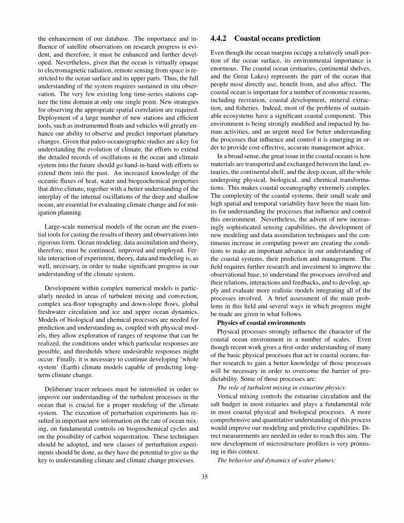
the enhancement of our database. The importance and in-fluence of satellite observations on research progress is evi-dent, and therefore, it must be enhanced and further devel-oped. Nevertheless, given that the ocean is virtually opaqueto electromagnetic radiation, remote sensing from space is re-stricted to the ocean surface and its upper parts. Thus, the fullunderstanding of the system requires sustained in situ obser-vation. The very few existing long time-series stations cap-ture the time domain at only one single point. New strategiesfor observing the appropriate spatial correlation are required.Deployment of a large number of new stations and efficienttools, such as instrumented floats and vehicles will greatly en-hance our ability to observe and predict important planetarychanges. Given that paleo-oceanographic studies are a key forunderstanding the evolution of climate, the efforts to extendthe detailed records of oscillations in the ocean and climatesystem into the future should go hand-in-hand with efforts toextend them into the past. An increased knowledge of theoceanic fluxes of heat, water and biogeochemical propertiesthat drive climate, together with a better understanding of theinterplay of the internal oscillations of the deep and shallowocean, are essential for evaluating climate change and for mit-igation planning.
Large-scale numerical models of the ocean are the essen-tial tools for casting the results of theory and observations intorigorous form. Ocean modeling, data assimilation and theory,therefore, must be continued, improved and employed. Fer-tile interaction of experiment, theory, data and modeling is, aswell, necessary, in order to make significant progress in ourunderstanding of the climate system.
Development within complex numerical models is partic-ularly needed in areas of turbulent mixing and convection,complex sea-floor topography and down-slope flows, globalfreshwater circulation and ice and upper ocean dynamics.Models of biological and chemical processes are needed forprediction and understanding as, coupled with physical mod-els, they allow exploration of ranges of response that can berealized, the conditions under which particular responses arepossible, and thresholds where undesirable responses mightoccur. Finally, it is necessary to continue developing ’wholesystem’ (Earth) climate models capable of predicting long-term climate change.
Deliberate tracer releases must be intensified in order toimprove our understanding of the turbulent processes in theocean that is crucial for a proper modeling of the climatesystem. The execution of perturbation experiments has re-sulted in important new information on the rate of ocean mix-ing, on fundamental controls on biogeochemical cycles andon the possibility of carbon sequestration. These techniquesshould be adopted, and new classes of perturbation experi-ments should be done, as they have the potential to give us thekey to understanding climate and climate change processes.
4.4.2 Coastal oceans prediction
Even though the ocean margins occupy a relatively small por-tion of the ocean surface, its environmental importance isenormous. The coastal ocean (estuaries, continental shelves,and the Great Lakes) represents the part of the ocean thatpeople most directly use, benefit from, and also affect. Thecoastal ocean is important for a number of economic reasons,including recreation, coastal development, mineral extrac-tion, and fisheries. Indeed, most of the problems of sustain-able ecosystems have a significant coastal component. Thisenvironment is being strongly modified and impacted by hu-man activities, and an urgent need for better understandingthe processes that influence and control it is emerging in or-der to provide cost-effective, accurate management advice.
In a broad sense, the great issue in the coastal oceans is howmaterials are transported and exchanged between the land, es-tuaries, the continental shelf, and the deep ocean, all the whileundergoing physical, biological, and chemical transforma-tions. This makes coastal oceanography extremely complex.The complexity of the coastal systems, their small scale andhigh spatial and temporal variability have been the main lim-its for understanding the processes that influence and controlthis environment. Nevertheless, the advent of new increas-ingly sophisticated sensing capabilities, the development ofnew modeling and data assimilation techniques and the con-tinuous increase in computing power are creating the condi-tions to make an important advance in our understanding ofthe coastal systems, their prediction and management. Thefield requires further research and investment to improve theobservational base, to understand the processes involved andtheir relations, interactions and feedbacks, and to develop, ap-ply and evaluate more realistic models integrating all of theprocesses involved. A brief assessment of the main prob-lems in this field and several ways in which progress mightbe made are given in what follows.
Physics of coastal environmentsPhysical processes strongly influence the character of the
coastal ocean environment in a number of scales. Eventhough recent work gives a first-order understanding of manyof the basic physical processes that act in coastal oceans, fur-ther research to gain a better knowledge of those processeswill be necessary in order to overcome the barrier of pre-dictability. Some of those processes are:
The role of turbulent mixing in estuarine physics:Vertical mixing controls the estuarine circulation and the
salt budget in most estuaries and plays a fundamental rolein most coastal physical and biological processes. A morecomprehensive and quantitative understanding of this processwould improve our modeling and predictive capabilities. Di-rect measurements are needed in order to reach this aim. Thenew development of microstructure profilers is very promis-ing in this context.
The behavior and dynamics of water plumes:
35

River plumes are one of the primary sources of freshwa-ter, nutrients, pollutants and sediments of the coastal ocean.The study of the factors that influence the plume’s movementand evolution over space and time and its interaction with theshelf and offshore or deep ocean currents systems is thereforeextremely important. Understanding of these processes canbe only reached through further observations and applicationof numerical models.
The dynamics of the surf zone and inner shelf:Understanding the dynamics of the inner shelf is not only
locally important because of, for instance, its influence in thecoastal morphology, but also because of its important impli-cation and the along and cross-shelf transports. Further fieldstudies are required to understand those processes and vali-date numerical model results.
The dynamics of wind-driven currents:The knowledge of the shelf flow regime and the off-shelf
transports is central for coastal applications. These processesare strongly influenced by details of the bathymetry and windforcing on very small scales. Further development of high-resolution numerical models and high-resolution observationof the forcing and topography are needed to address this prob-lem.
The bottom boundary layer:Due to the shallowness of the estuaries and shelf, turbulent
drag and mixing generated by near-bottom flow play a centralrole in controlling many processes. Biota also has an effecton the bottom drag given that benthic biology modifies thebottom roughness. A better understanding of these processesand their parameterizations is needed to improve numericalmodel’s predictions. Laboratory based studies and increasesin observational capabilities would improve this subject.
The shelf break fronts:Even though the shelf break fronts are features present in
many coastal oceans, not much is known yet about them.The detailed thermohaline and velocity structures of the shelfbreak fronts and shelf break jets need to be quantified, andthe impact of these processes on material transport, the spreadof marine organisms and the formation of geobiological do-mains needs to be understood.
Physical forcing and biological processesWhile some effects of physical forcing have been estab-
lished, there is a great uncertainty in the mechanisms bywhich they influence variability in biological phenomena,even though it is known that this effect can be dramatic. Biol-ogy can have, in turn, an effect on physics, for example, dueto the aforementioned modification of the bottom roughness.Assessing the effects of physical processes and their naturaland anthropogenic variability on coastal biological commu-nities is a problem of clear ecological and economical impor-tance that demands further efforts.
Land-Ocean fluxesMaterial inputs to the coastal zone from land include or-
ganic and inorganic sediment, dissolved elements, dust and
anthropogenic pollutants and nutrients. These inputs are in-fluenced by the local watershed, meteorological characteris-tics and biogenic habitat quantity and quality. These materialinputs have a major influence on the chemistry of the globalocean and are greatly influencing ecosystem processes, in-cluding food web dynamics, biological production and com-munity structure. Some important issues that require furtherstudy include:
Inputs of biologically important materials:Even though the water flow and major element composi-
tion of larger rivers are reasonably well known, the chemi-cal form of minor elements and organic matter that are trans-ported from terrestrial watersheds to coastal environments isless understood. Riverine oceanic matter is fundamental inthe global carbon balance, and the minor elements are oftencritical to coastal and oceanic ecosystems. The groundwa-ter discharge can locally influence, in a significant way, thefreshwater contributions and often, has higher concentrationsof dissolved species. Efforts must be made to identify regionsof groundwater influence, its role in material flux and conse-quent ecosystem response.
Sediment fluxes:Globally, rivers deliver around 20 billion tons of suspended
solids to the sea every year. These sediments are not chemi-cally inert and may serve as a source or sink for nutrients, pol-lutants and other materials in the coastal ocean. While someaspects of sediment resuspension and transport are under-stood and supported by field measurements, the conceptualand numerical modeling and prediction of sediment transportrequires further development. Bioturbation is a key process,as benthic organisms distribute the deposited material over acertain depth of the sea bottom, which in turn influences theerosion processes. There is a need, therefore, to investigatethe coupled system suspended particulate matter dynamics-biology-morphodynamics. This is a fundamental need in or-der to construct confident budgets and to predict the evolutionof the shoreface and bottom topography under different con-ditions.
Carbon fluxes:Margin sediments can be efficient in sequestering carbon,
and this preservation could influence the CO2/O2 balance ofthe atmosphere on geological time scales. Nevertheless, themechanisms that control this sequestration are not well un-derstood. Organic carbon buried in sediments may serve as asubstrate for microbial activity within the sediments, givingrise to gas hydrates in ocean margins. Given the enormoussize of the reservoirs, these hydrates may have significant in-fluence on the carbon cycle and the climate. Their distribu-tion, nevertheless, as well as their generation rates, migra-tion pathways through the sediments and rate of return to theocean environment are poorly known.
Anthropogenic influences:Deforestation, agriculture, flow modification, coastal con-
structions, urbanization and other human activities dramati-
36

cally influence rivers, watersheds and coastal sediment trans-ports by changing the amount of water that is transported andits chemistry. For instance, global river discharge of nitrogenand phosphorus and total organic carbon have doubled duringthe past two centuries. Together with fishery exploitation, ithas produced the largest impact on biological processes incoastal ecosystems. Human activity injects into the atmo-sphere particles, aerosols and chemicals. The amount of thedust flux, its variability and its influence on biological sys-tems through delivery of contaminants and limiting micronu-trients is not clear. Similarly, biological communities are af-fected by other chemicals of anthropogenic origin released tothe ocean, like trace elements and toxics. Greater researchis needed to determine the ecological effects of human andnatural alterations in the quantity, quality and spatially ex-plicit processes associated with coastal habitats. Efforts arealso needed to identify and predict how global warming andsea level rise will affect the distribution, abundance and land-scape connectivity of various habitat types and their influ-ence on associated processes and species. Interdisciplinaryresearch between physical oceanography, biology and chem-istry, involving modeling and observations integration will benecessary to address these questions.
Exchanges between the Deep Ocean and Shelf Ecosys-tems
The connections and exchanges between the small-scaleprocesses of the shelf and the large-scale of the ocean areincreasingly becoming an important oceanographic issue, asthey can have a global impact. Localized export of mate-rial, for instance, can have global importance as it is trans-ported far by ocean currents, changing the chemical proper-ties of distant environments. Other examples are the growthof plankton populations, which affect carbon dioxide levels,and thus may be important in global warming scenarios, theanthropogenic pollutants that have reached the open ocean,which are known to be transported far from their sourcesand the nitrogen global cycle, which is strongly dependenton denitrification that takes place on the ocean margins. Abetter understanding is needed of small-scale processes andsmall-scale aqueous systems (estuaries, wetlands, coral reefs)to understand these exchanges and evaluate their impacts onglobal issues. Quantifying the exchanges will be required todetermine the magnitude and time-dependent nature of shelf-ocean and sediment-water fluxes in interdisciplinary effortswith geologists, biologists, hydrologists and biogeochemists.
SummaryThe ocean margin occupies only about 10% of the global
ocean area, and a much smaller percentage of its volume,but it dominates the economic importance of the sea. Ma-terial fluxes to the coastal zone are largely unidirectional,from the land to the sea, and these fluxes of sediments, bi-ologically active materials and sometimes toxic compoundsare rapidly increasing. If we are to comprehend the impactof these fluxes, we must conquer the complexity of coastal
transport processes. The physical forcing of wind providescoastal upwelling, which enriches marine ecosystems andcreates rich fisheries. Natural climate variability can havestrong impact in these systems, as it happens with El Nio,for example. Other natural or anthropogenic climate shiftscould change these dynamics with enormous consequences.In order to solve these and other important coastal problems,advanced technologies in sensors and observing systems, in-terdisciplinary research to understand the processes and theirconnections, integrated numerical models and data assimila-tion are needed.
New eyes from satellites and coastal radar can provideneeded observations in the small time and space scales in-herent to many coastal processes. Even though the timeand space scales of the coastal processes can be small, theypresent large variability in interannual scales. Therefore,there is a need of monitoring them over long periods of time.Observing the system over an extended time will allow fora better determination of how the system responds to majornatural changes, enhancing our capability of predicting its be-havior and its response to anthropogenic perturbations.
In studying the diverse roles of physical processes in othercoastal phenomena and the local ecosystem dynamics, accu-rate in-situ observations play a fundamental role. The contin-ued development and use of moored instrumentation in phys-ical oceanography, biology and chemistry will result in majoradvances in a number of important areas as biophysical cou-pling, cross-shelf transport processes, turbulent mixing pro-cesses and their parameterization in numerical ocean mod-els, buoyancy-driven flows and fronts, sediment transport andbiogeochemical fluxes.
Turbulent mixing processes are critical to many coastalprocesses. So, continued emphasis should be placed on fieldstudies of the turbulent cascade of energy. Improvements inour knowledge of turbulence, for example by means of newlydeveloped microstructure profilers, will result in an importantimprovement of our modeling capabilities. Besides their in-trinsic interest, these studies provide the basis for comparisonwith new numerical studies of these proces8ses and the devel-opment of better parameterizations of turbulent mixing. Thislast, in turn, would benefit both coastal ocean research andthe use of models for practical applications.
As mentioned above, modeling plays a key role in coastaloceanography. Operational real-time regional ocean predic-tion systems (see Figure 4.3) are required to support criticalactivities in the coastal environment, like navigation and ma-rine operations, oil and pollutants dispersion control, searchand rescue, prediction of harmful algal blooms and otherecosystem or water quality phenomena. These systems re-quire, in turn, to be supported by operational oceanographicmonitoring of oceans.
Realistic interdisciplinary models in concert with data as-similation are an essential tool for improving our under-standing of complex coupled biogeochemical and physical
37

Figure 4.3: Coastal models can be valuable as management tools using monitoring and data assimilation. Figure displaysexamples of ocean model predictions (upper panel) of surface elevation and currents (left), surface salinity (center) and surfacetemperature (right), and satellite color observations (lower panel) from GoMOOS (Gulf of Main Ocean Observing Systemhttp://www.gomoos.org). This kind of systems, that bring together managers, industry, researchers, educators and others in acollaborative effort to establish a large-scale regional ocean observing system, can enhance, facilitate, and protect the livelihoodsand well-being of those who use the water bodies and depend on their ecosystems.
processes in coastal areas. Besides, given that biologicaland chemical data sets are sparse, it will permit to extendthe database through a dynamical interpolation providing aframework for detailed diagnosis of those processes. The in-strument and platform development occurred during the lastyears together with the rapid evolution in numerical model-ing, the development of theory and the continuous progressin communications are promising an important evolution ofthis field during the next years.
The need for a synoptic view of this environment to under-stand the processes that produce changes in coastal systemspresents major challenges for coastal oceanography. Newcouplings of chemistry, biology and physics will be neces-sary to develop a better sense of them.
4.5 Recommendations
Taking geosciences to a point where answers will be givento many of the urgent environmental questions of this newcentury will demand effort and commitment of both scien-tific community and policy makers. Physical oceanographyplays a crucial role in the development of the ’Earth systemscience’, required to meet this challenge, as the oceans are acentral piece of the puzzle. The field itself requires a bet-ter understanding of the ocean’s behavior, its connections,interactions, feedbacks and couplings. Therefore, physicaloceanography needs further research and investment to de-velop, apply and evaluate more realistic models integratingall of the processes involved, the improvement of the ob-servational base, a better understanding of ocean processesand a much larger interaction between ocean scientists. But
38

there will be, moreover, a need for further integration amonggeosciences to meet the real challenge of understanding andpredicting the environment for properly managing and sus-taining it in a multi-coupled system. On the other hand, theanthropogenic influence can no longer be neglected in an in-tegrated model in the long-term. The impact of, for exam-ple, fisheries, coastal constructions, like dikes, harbors windfarms, etc., and river management, has such a strong effect onthe coastal system that the governing socio-economic driversmust be taken into account; if it is intended to predict such asystem.
In what follows, a summary of the physical oceanographyscience needs and strategies for achievement emerging fromthis report, which can be regarded as a few recommendationsto the oceanographic community and policy makers, are high-lighted.
Global Observing SystemOcean observations have always been the driver of new
knowledge and predictive capabilities in the ocean and itsbasins. Despite this, the oceans remain vastly undersam-pled in time and space. Important progress in this aspecthas been derived, and will continue on, from the develop-ment of new observational satellite tools. Nevertheless, giventhat remote sensing from space is restricted to the ocean sur-face and its upper parts, sustained observation in the oceanis required. An international effort to support sustained high-quality global observations over decades must be done. Mea-surements of oceanographic, meteorological, hydrologic andbiogeochemical variables are necessary to meet new scientificchallenges and practical needs.
The need for a strong Global Ocean Observing Sys-tem (GOOS http://ioc.unesco.org/goos/) as a compo-nent of the Global Climate Observing System (GCOShttp://www.wmo.ch/web/gcos/gcoshome.html) is clear. Theinformation to deal with marine related issues is needed, byscientists, governments, industry, and the general public.This includes the effects of the ocean upon climate. Aunified global network to systematically acquire, integrateand distribute oceanic observations is required and must besupported.
New observing techniques and instrumentationThe success of new observing techniques and instrumenta-
tion in revealing aspects of the ocean circulation and climatehas been spectacular over the past 30 years. Good exam-ples are the recently developed microstructure profilers thatallow the observation of, for instance, the dissipation rate,and the ARGOS system which collects environmental datafrom autonomous platforms and delivers it to users world-wide. Improved observing techniques must continue to bedeveloped both to make more effective measurements of es-sential variables and to expand the suite of variables that canbe observed.
Data assimilationData assimilation can add considerable value to global ob-
serving systems by combining diverse sets of observationswith global numerical models to produce comprehensive andinternally-consistent fields. The assimilated products com-bine the accuracy of the observations with known geolog-ical, chemical and physical consistency and provide globalcoverage inherent in the models. Therefore, advancement ofassimilation techniques to reach optimal schemes must be apriority.
Operational oceanographyAn operational oceanographic near-real-time data collec-
tion, similar to the one existing for meteorology, needs tobe established. There is a need for efficient, integratedsystems for coastal and global ocean products, providedregularly and in real-time. That system, which requiresthe application of state-of-the art models, data assimila-tion methods, global observing and communication, wouldhave tremendous impact on improving coastal, open oceanand climate forecast, as well as on most of the aspectsof physical oceanography research. Experimental systemslike GODAE (Global Ocean Data Assimilation Experimenthttp://www.bom.gov.au/bmrc/ocean/GODAE, see Figure 4.4)must, therefore, make the transition from research mode tooperational GOOS and CGOOS (Coastal Global Ocean Ob-serving System http://ioc.unesco.org/goos/cozo.htm).
Numerical modelingA continued emphasis is needed on the development of
models in all their applications, and a special effort is neededin developing models that link the different parts of the oceansystem.
Numerical models are becoming a centerpiece of our sci-ence since results of theory and observational data are oftencast into the form of numerical models. This happens ei-ther through data-assimilation or through process-model ex-plorations of theoretical ideas. Models have proved essentialin determining the relative importance of variables in com-plex, nonlinear systems that have multiple feedbacks and arethe ultimate tool for prediction. Crucial physical effects arebeing now identified that have seriously limited the accuracyof model prediction in the recent past. By taking advantageof rapid advances in computer technology, and of new datastreams from powerful observing programs, great advanceswill be made. There is a need, therefore, for model and dataassimilation, development and improvement. Linked modelsthat tie together physical, geological, biological and/or chem-ical systems show great promise and should grow in impor-tance in oceanographic research. Interactions between suchmodeling effort and field programs will aid in both designingobservation strategies and in evaluating outcomes.
Closer interaction among physical oceanographersOvercoming the predictability barrier will require the con-
tinued development of in-situ and satellite observing systems,improved numerical models, the assimilation of data in mod-els, and the closer linking of the physical system to the impor-tant biogeochemical aspects of the ocean and climate. Reach-
39

Figure 4.4: Sea surface temperature nowcast for 5-21-2003 and one week forecast from MERCATOR mission. From 2003 to2005, the demonstration phase of the GODAE experiment will provide a routine and real time depiction of the global ocean.Half a dozen of operational oceanography centers will emerge in this purpose throughout the world. MERCATOR will be oneof them. The transition from the experimental phase to a truly operational one would have a tremendous impact in physicaloceanography. Fig. courtesy of MERCATOR Mission (http://www.mercator.com.fr).
ing these objectives will, therefore, demand a close interac-tion between seagoing oceanographers, scientists concernedwith the ocean-atmosphere interface, ocean modelers, theo-retical oceanographers and satellite remote-sensing scientiststhat could be promoted by improving the communication andinteraction among scientists of different fields and countries.IAPSO might play a fundamental role in this aspect. Somesuggestions are:
• A greater and better use of the Internet.
• Workshops that bring oceanographers from different in-stitutions and areas of expertise together for extendedperiods.
• Opportunity for investigators to make extended visits toinstitutions other than their own and to meet others withsimilar interests, but different approaches.
• Summer schools, workshops and post-doctoral pro-grams to encourage cross-fertilization between the dif-ferent methodologies.
• Encouragement of proposals using complementary ap-proaches (observations, modeling, laboratory, theory).
Earth System Science and interdisciplinary researchAs oceanography progresses and faces more often envi-
ronmental problems, it becomes increasingly necessary toformulate new research initiatives using an interdisciplinaryframework. We should facilitate closer ties and collaborationacross the geosciences.
To meet the aim of building up an ’Earth Model’ for under-standing and predicting the functioning of the whole climaticsystem, collaboration of experts in the traditional earth disci-plines (meteorology, oceanography, hydrology) as well as inecology, information technology, instrumentation and com-plex system theory will be necessary. In this new science, the
40

most challenging task is integration, as we need a vision asintegrated as possible of all the many elements of the system.Physical oceanography must make commitments to reach thedegree of co-ordination and co-operation among geosciencesdemanded by this enterprise. The IUGG and its comprisedassociations have a fundamental role to play here.
Public information and communication:The ocean plays a critical role in our everyday life and in
the future of our planet. As more people understand this andbegin to appreciate the Earth as a water planet, they will takeaction to conserve the ocean and the web of life it supportsand will give, consequently, a better support to oceanographicscientific research. Therefore, the oceanographic communityshould make an effort to improve presentation and communi-cation of results to society and policy makers, taking specialcare of avoiding misinformation and/or poor use of the infor-mation. This should not be a one-way road. In the frame ofintegrated models, oceanographers must also account for so-cial and political decisions if long-term predictions are envis-aged. Communication is an important aspect in which IAPSOcan play a central role.
E-science:A greater and better use of the possibilities of free informa-
tion and communication provided by the Internet would be ofgreat benefit for geosciences.
Infrastructure:In order to reach our aims, we need adequate updated tech-
nology. The availability of research ships requires inver-sion and planning. Continued enhancement of computing re-sources is required in order to meet the demands for climatemodeling and forecasting. Even though the power of comput-ers is doubling every few years, the complexity of the oceansensures that the needs of physical oceanographers will alwaysbe limited by computational resources. Physical oceanogra-phers need continued access to computing resources, whichare comparable to those of the international atmospheric andengineering communities.
Human resources:If we are to reach the goals, there must be sufficient sci-
entists with an adequate education researching all over theworld. On the other hand, we must assure that a steady sup-ply of experimental scientists and engineers continues alongwith modelers and theoreticians in order to keep the balancebetween the different fields. As environmental problems willincrease in the next decades, future graduates should haveincreased opportunities for interdisciplinary studies both in-side of and outside of the academic science community. Hu-man resources can constitute a serious problem in develop-ing countries, where the low number of experts (and some-times their lack) impedes the formation of new graduates.The degree of global expertise could be greatly enhanced bythe creation of inter-institutional PhD programs promoted byIAPSO.
4.6 ConclusionPhysical oceanography has reached a challenging point whereprogress in technology and the tools that this technologymake possible are allowing for a new ’look’ at the ocean. Thecomplexity of the ocean circulation may now be approachedwith sufficient detail to promise that significant progress willbe made on many scientifically and societally important is-sues during the next decade. IAPSO and the oceanographiccommunity should take advantage of this situation.
The great challenge of constructing an ’Earth Model’ toimprove our understanding, use and management of thePlanet for the benefit of the Human Race, in which physi-cal oceanography will play a fundamental role, can start totruly be faced. It will become a reality if the necessary re-sources are available and a genuine commitment is made bythe geosciences community to reach the required level of in-tegration and research effort. IUGG, through its actions, canplay a significant role in the realization of this vision.
4.7 AcknowledgmentsThe GTF committee would like to thank Alan A. Meyer forhis work on the IAPSO section of the report, and serving onthis committee for the amount of time that he was able.
Bibliography50 Years of Ocean Discovery: National Science Foundation
1950-2000. Commission on Geosciences, Environmentand Resources (CGER), Ocean Studies Board (OSB),National Academy Press. Washington, D.C. 2000.
Coastal Ocean Processes and Observatories: Advancingcoastal research. Coastal Ocean Processes (CoOP) Re-port No. 8. Technical Report. 2002.
Current Approaches to Seasonal to Interannual Climate Pre-dictions - IRI Technical Reports 00-01, 2000
IPCC, Climate Change 2001: The scientific basis. Technicalreport, IPCC, 2001.
Global Environmental Change: Research Pathways for theNext Decade, Committee on Global Change Research,National Research Council. National Academy Press.Washington, D.C.. 1999.
Global ocean science: toward an integrated approach.Ocean Studies Board, commission on Geosciences, En-vironment, and Resources, National Research Council.National Academy Press. Washington, D.C., 1999.
GODAE (Global Ocean Data Assimilation Experiment),2001: GODAE Strategic Plan, GODAE InternationalProject Office.
41

Ocean Circulation and Climate. Observing and Modellingthe Global Ocean. G. Siedler, J. Church and J. GouldEds. Academic Press. London. 2001.
Ocean Sciences at the New Millennium Report. Workshopsponsored by the National Science Foundation throughan award to the University Corporation for AtmosphericResearch Joint Office for Science Support. Edited byGeosciences Professional Services, Inc. 2001.
Oceanography in the Next Decade. National ResearchCouncil, Commission on Geosciences, Environment,and Resources, Ocean Studies Board. NationalAcademy Press, 202 pp., 1992.
Opportunities in Ocean Sciences: Challenges on the Hori-zon, Ocean Studies Board, Commission on Geosciences,Environment, and Resources, National Research Coun-cil, 1998.
Report of the Advances and Primary Research Opportuni-ties in Physical Oceanography (APROPOS) Workshop,Monterey, California, December 15-17, 1997.
Strategic Plan and Principles for the Global Ocean Observ-ing System (GOOS). GOOS Report N◦ 41. IOC/INF1091. 1998.
Exploration of the Seas: Interim Report. Ocean StudiesBoard (OSB). National Academy Press. Washington,D.C. 2003
The second report on the adequacy of the Global ObservingSystems for Climate in support of the UNFCCC. GCOS-82. WMO/TD No. 1143, 2003.
The integrated, strategic design plan for the coastal observa-tions module of the Global Observing System. GOOSReport No. 125; IOC Information Documents SeriesN1183; UNESCO 2003
Theory in Ocean Dynamics. P. B. Rhines. In The Future ofPhysical Oceanography, report of the APROPOS Work-shop, Monterey CA UCAR/NSF, 178pp. 1998
Towards Life and the Whole Earth; Ocean Science New Di-rections. Japan Marine Science and Technology Center,2002. 19
42

Chapter 5
International Association of HydrologicalSciencesT. Oki
5.1 Introduction —Hydrology, the for-gotten earth science—
There was a statement from Prof. R. Bras at MIT [Bras andEagleson, 1987] in the 2nd US-Japan Hydrology Seminar inHawaii [Kayane, 1989]:
Hydrology, the science of water, has natural placealongside oceanography, meteorology, geology,and others as one of the geo-sciences; yet in themodern science establishment, this niche is vacant.Why is this?
Such an awareness of the issues has been discussed repeat-edly in various workshops and symposia and even publishedin a few books [Kundzewicz et al., 1987; NRC, 1991; Buras,1997].
One of the answers to the above question is that hydrologyis too biased to engineering:
In practice, hydrology is regarded mostly as a tech-nological discipline rather than a science. This at-titude is responsible for much poor science in hy-drology, which, in turn, has led to much poor tech-nology in applied disciplines. It is urged that thepresent offers a unique opportunity to fill the va-cant niche of the science of hydrology and somesuggestions for action are offered. [Klemes, 1988]
Until recently, engineers in hydrology were forced to givesome account for demanding and sometimes unreasonablequestions from society, based on limited and uncertain infor-mation of water balances and hydrological cycles. Scientistsin hydrology tried to pursue “pure science” but not a few ofthem failed to overcome the temptation to relate their researchwith practical applications.
Here, the clue is that “pure science” and “practical engi-neering” should not always be exclusive, at least not in hy-
drology. Before the era of global environmental issues, hu-man activities were excluded from the view of natural sci-ences. However, anthropogenic effects should not be ex-cluded when the current Earth system is discussed, since “nat-ural” and “real” have different meanings in this Anthropocene[Crutzen, 2002]. The “real” situation of the Earth is not “nat-ural” anymore.
Hydrology should have the leading potential among geo-sciences to explore the interactions between human societyand natural earth systems. The current struggle of hydrol-ogy to realize potential achievements is reviewed, and theperspectives of hydrology are presented in this short report.
5.2 Long-term Goals
5.2.1 What is hydrology?
UNESCO defined the discipline in 1964 as:
Hydrology is the science which deals with the wa-ters of the earth, their occurrence, circulation anddistribution on the planet, their physical and chem-ical properties and their interactions with the phys-ical and biological environment, including their re-sponses to human society.
Hydrology is a field which covers the entire historyof the cycle of water on the earth.
It is noteworthy that the responses to human society are in-cluded in this statement issued just before the InternationalHydrological Decade, which was the first international re-search program on hydrology, organized by UNESCO for1965-1974.
The recent definition [UNESCO and WMO, 1992] says hy-drology is
43

1. Science that deals with the waters above and below theland surfaces of the Earth, their occurrence, circulationand distribution, both in time and space, their biologi-cal, chemical and physical properties, their reaction withtheir environment, including their relation to living be-ings.
2. Science that deals with the processes governing the de-pletion and replenishment of the water resources of theland areas of the Earth, and treats the various phases ofthe hydrological cycle.
The two parallel definitions are from the natural science sideand from application oriented side.
Then, which water and what hydrological cycle are ex-cluded from the view of the current hydrological science?These are for example:
• water out of the Earth: even though water is not uniqueon this planet.
• water in the Earth: even though water may have a sig-nificant role in the motion of the mantle, and the totalamount included in the Earth could be more than that onthe surface of the Earth.
• ocean: even though more than 97% of water on theEarth’s surface stays as oceanic water.
• atmospheric water: even though there are certainamounts of studies on precipitation by hydrologists andthe discipline of hydrometeorology exists, generally pre-cipitation is the given input to hydrological system onthe land surface.
• water in pipes: water cycles in purely artificial system isnot the main target of researchers in hydrology.
• organic water: even though water flow in plants is in-tensively examined in current hydrology, water cycle incirculatory organs is not generally dealt with by hydrol-ogists.
From the above list, it is apparent that hydrological sciencecovers the niche of other disciplines by nature. On the con-trary, transdisciplinary studies in these currently uninvesti-gated water cycles by hydrologists may have some potentialto break through the new frontier in hydrological sciences.
5.2.2 Long-term Goals in HydrologyThe ultimate objectives of the hydrology are to know:
• the quantity and quality of water in a defined area, and
• the inflow and outflow of water and its content to andfrom the area.
It could also be relevant for hydrology to utilize the knowl-edge of water for society and human beings.
Therefore to increase the ability to:
• monitor the quantity and quality,
• model/simulate the flux, and
• predict the quantity, quality, and flow of water as re-quired to promote the hydrological sciences.
All these monitoring, modeling, simulations, and predic-tions should be associated with the estimates of their uncer-tainties and reduction of the uncertainties is one of the targetsin hydrological science.
Similar to other geo-sciences, finding another principal lawgoverning the movement of water is not the central themeof hydrological science. However, it does not mean there isno opportunity that new laws in hydrological science havebeen/will be found. Because of the scaling effect and the het-erogeneity of the boundary condition and/or environment ofthe phenomena, theories and equations, which can be appliedto ideal, well controlled conditions, either molecular scale orlaboratory experimental scale, may not have enough capabil-ity to explain the phenomena we observe in the real field. Thisdemands the establishment of sophisticated systems of lawsand theories that can describe the hydrological cycles on theEarth, considering the spatial and temporal scales and the het-erogeneity.
In other words, consideration of scaling effects and het-erogeneity is identifying the dominant process governing theparticular hydrological phenomena. In a sense, hydrologicalscience formed its original discipline apart from fluid dynam-ics and hydraulics by neglecting the conservation of momen-tum by defining the target phenomena with viscosity prevailsthe motion and cancels the acceleration. Future hydrologi-cal science may include the detailed equations of Motion, ifneeded, for better simulation/prediction of hydrological Cy-cles. However, full descriptions of detailed hydrological pro-cesses in the real world, even for a hill slope of 1m length,will remain impractical and may be useless for understandingthe phenomena.
Here, “full description” indicates describing the phenom-ena based only on the principal physical laws with reliableparameters, which can be estimated in the laboratory or fieldexperiments. The value of the parameter should be repro-duced with enough accuracy when the experiments are re-peated, and it is preferable the parameter can be estimatedfrom other physical parameters.
In this sense, even Darcy’s law, which is one of the basiclaws in hydrology, is not the principal physical law. Darcy’slaw requires saturated hydraulic conductivity as its parame-ter, but it is well known that saturated hydraulic conductivityis various even within a one square meter field, which seemshomogeneous in terms of the density and the contents of the
44

soil. However, it should be still better for most of the prob-lems in hydrology to adopt Darcy’s law rather than consid-ering water flow through each microscopic pore in the soillayers. Therefore, integrated theories/models/equations cor-responding to the temporal and spatial scales and heterogene-ity will be used to describe the phenomena.
5.3 Short-term Goals
5.3.1 Current Demands on Hydrology
Conservative projections, based on current information aboutpopulation growth rates, pollution, salinization, waterloggingand groundwater overdraft, all indicate a high increase in thenumber of countries that will experience significant waterstress and scarcity in the near future. The United Nationssystem presented a Comprehensive Assessment of the Fresh-water Resources of the World [UN et al., 1997] to the nine-teenth Special Session of the United Nations General Assem-bly in 1997. This assessment made it clear that a ”business-as-usual” approach to water allocation and management is notsustainable.
The situation for a majority of the world’s population hasnot improved since the Comprehensive Assessment of theFreshwater Resources of the World was presented to theUnited Nations in 1997. Still, over a billion people lack ac-cess to safe drinking water, and almost 3 billion lack propersanitation. Millions of people die each year from water re-lated diseases, and there are no clear indications that thesetrends will improve in the near future. The increased use ofpollutants associated with the technological development ofcountries with evolving market economies, life-style changesall over the world and the increased need to develop sustain-able water resources and infrastructure for growing popula-tions all contribute to the urgency associated with advancinghydrological sciences and water management strategies. In-creased competition among and within sectors calls for strate-gies that will help to balance water use for the multitude ofpurposes required by humans, while protecting the integrityof the ecosystems. Some of the statistics are staggering. By2020, water use is expected to increase by 40%, and 17%more water will be required for food production to meet theneeds of the world’s growing population.
In the millennium declaration (55.2), which was adoptedby the General Assembly of the United Nations in September2000, it was stated in section 19;
To halve, by the year 2015, the proportion of theworld’s people whose income is less than one dol-lar a day and the proportion of people who sufferfrom hunger and, by the same date, to halve theproportion of people who are unable to reach or toafford safe drinking water.
A similar statement was included in the Plan of Implemen-tation from the World Summit on Sustainable Developmentheld in Johannesburg in August 2002, in article 6 of Chap-ter II Poverty Eradication. In addition to that, the access tobasic sanitation was also focused in article 7. In the WSSDPlan of Implementation, further research and development onwater related sciences was urged together with researches onenergy technologies, bio-technology, environmental manage-ment, marine resources, and sustainable development. All ofthese international vision/action statements aim to alleviatePoverty, particularly in developing countries.
Under such a movement, what kind of researches can be of-fered from the scientific community in order to contribute tosolve the current water related issues and the anticipated “wa-ter crisis” in the near future in the world? What are the sci-entifically excellent and practically/socially relevant researchtopics?
Over the last decade it has become increasingly clear thatif we are to face the water challenges of the future, we mustview the Earth as a single, though highly complex, integratedsystem. The atmosphere, the hydrosphere and the biosphereextend throughout the globe. They are very dynamic andhighly interactive. Changes that occur in one location caninfluence the environment somewhere else in ways that arenot always expected and are frequently poorly understood.The complicated interactions between the physical and hu-man systems are equally critical. The scientific and technicalcommunity has a very important role to play in this regard.This role is not only related to scientific monitoring, analy-sis, and interpretation, but also to guiding future policies andaction programs. Effective water management is not purely apolitical problem, a scientific problem, a technological prob-lem, nor a managerial problem; it is a complex problem thatdemands interaction between all of these areas. It is clear thatto assuage the impending water crisis, cooperation betweenthe scientific disciplines, as well as the scientific and waterpolicy arenas, must dramatically improve. A directed effortmust be taken now to improve the recognition of the impend-ing water crisis by all stakeholders and to improve the under-standing of the components involved with the natural systemand allocation of its resources.
5.3.2 Contribution to solve the world watercrisis
In preparation for WRAP (Water Resources ApplicationProject) under GEWEX (Global Energy and Water Cycle Ex-periment) Hydrometeorological Experiments Panel (GHP),these items were identified to contribute to solve the currentwater related issues. These are to provide
• reliable information on
– past and current global hydrological cycles,
45

– near-real time to seasonal prediction on naturalvariability of climate, such as El Nino and La Nina,and
– the change in hydrological cycles under climatechange conditions, such as global warming,
• quantitative estimates of how much water is (and will be)really available for further water withdrawal for humanbeings, and
• alternative measures to be taken in order to secure thewater supply to meet the water demand.
The first three items under the category of “provide reli-able dataset” can be done by natural scientific approaches,however, the other two should require inter-disciplinarycollaboration between natural and social sciences. Theplanned Global Water System Project by WCRP (World Cli-mate Research Programme), IGBP (International Geosphere-Biosphere Programme), IHDP (International Human Di-mensions Programme), and DIVERSITAS (An Interna-tional Programme of Biodiversity Science) will be an ap-propriate platform to pursue such a collaborative research(http://www.gwsp.org/).
To provide a reliable dataset of past and current global hy-drological cycles, continuation of observational network, re-search and development on new observational measure, and”data rescue” of historical records are important. Satelliteremote sensing could be the only hope to provide global cov-erage of hydro-climatic information, however, ground basednetwork should be held by all means to secure the reliabil-ity of global observation. Since there are not a few historicalrecords that are not digitized but cover more than hundredyears, database development of these data is also important.
Global offline simulation of LSMs (land surface models)can provide global flux and balances of water, energy, andeven more (such as carbon). However, the accuracy of the es-timates is subject to the accuracy of LSM itself, forcing data,model parameters, and temporal and spatial scales employed.Therefore the uncertainties associated with the global esti-mates by LSMs will be examined in the GSWP (Global SoilWetness Project) under GEWEX/GLASS, Global Land At-mosphere System Study(http://hydro.iis.u-tokyo.ac.jp/GLASS/).
There are many researches to improve providing seasonalprediction of water cycles. It seems widely believed thatthe improvement in giving boundary conditions over landwill improve the accuracy of seasonal prediction of watercycles over land. Usage of better LSMs in GCMs andsatellite derived surface conditions, such as soil moisture,may contribute for the improvement, however, how land sur-face conditions affect the prediction of hydrological cyclesover land should also be investigated. For that purpose, theGLACE (Global Land-Atmosphere Coupling Experiment)under GEWEX/GLASS is planned.
Statistical approaches may be useful to give predictions, aswell. Even though that could be only for ad-hoc applications,new insights in tele-connection of hydro-climatology may befound from the sensitivity tests of the statistical models.
The prediction of climate change, particularly globalwarming itself, is attracting a lot of attention. Since mostof the reliable predictions of hydrological cycles in the futureare estimated by GCM simulations, the way to interpret ortransform the GCM estimates to water resources assessmentis another key issue. Down-scaling the coarse spatial (andtemporal) resolution of GCM estimates is one of the scientificproblems, but there are many technical issues, such as biasreduction of GCM estimates and the reproductivity of statis-tical characteristics particularly on precipitation simulated inGCMs. How to extract robust information from GCM pre-dictions on water cycles in the future should be given moreattention.
As for the human dimension side, how to draw the prospecton water demand, withdrawals, and consumption is basicallyneeded. They are generally estimated with the outlook of thefuture growth of population, economy, etc., but it is very dif-ficult to fully include the impact of innovation in technologyand change in policy. Therefore, somehow scenarios shouldbe set to assess the future demand in water resources. Eventhough socio-economic scenarios are used in the projectionof future climate in IPCC, most of them do not include thefeed back mechanism of how water shortages suppress vari-ous social activities and economical growth.
There is no guarantee that complex models will providebetter results, but interactive modeling on water consists ofnatural climate system, hydrological cycles, anthropogenicactivities such as irrigation, regulation by reservoirs, landusechange, etc., may provide new insights in the global water re-sources assessments. Virtual water trade, how much domesticwater resources are saved by international trade of products,may be incorporated with the modeling of “real water.”
An improved understanding of the operation of hydrologi-cal processes at the local scale is also required; e.g., in orderto understand how land-use change and management affectwater resources and also to downscale from global models.
Regional studies should also be important for policy mak-ing, and it is recommended that information on water demandand water management should also be collected when hydro-climatic regional studies will be taken. Based on the regionalstudies, science-based decision-making tools should be de-veloped, which can cooperate with the uncertainties includedin each component of prediction.
Global studies are also expected to provide useful informa-tion for regional studies. In practice, there are many placesin the world where global datasets of precipitation, landuse,soil types, etc., are the only sources available for hydro-climatological studies. Therefore, the applicabilities of thisinformation on integrated water resources management onlocal/regional scales will be examined under the Project for
46

Prediction of Ungauged Basins (PUB) of IAHS (InternationalAssociation of Hydrological Sciences).
5.3.3 IAHS Hydrology 2020 Working Group
The Hydrology 2020 group
(http://hydro.iis.u-tokyo.ac.jp/H2020/)
was assembled by IAHS to assess how the discipline of hy-drology should evolve to meet the world water challenges thatare expected to prevail by 2020. The 2020 Group would fol-low the pattern established by the Hydrology 2000 WorkingGroup which was set up in Hamburg in 1983 and reported inVancouver in 1987 [Kundzewicz et al., 1987].
Nine commissions under IAHS nominated the names oftwo young hydrologists who are this year aged 35 or less,considering region and gender in the choice, and the presidentof IAHS determined that one of these two be the member ofthe group. WMO and UNESCO nominated one each, and thechair of the group was separately nominated by the presidentof IAHS, as well. The group was authorized at the plenarymeeting of IAHS general assembly at Maastricht in 2001 andexpected to report their vision of hydrology in 2020 at theIAHS general assembly meeting in 2005 with articles on anIAHS publication (“redbook”).
The group held face-to-face meetings twice in 2001, de-fined their mission, and drew their road map to synthesizetheir visions. At first, they looked back 20 years ago, re-viewed what were the most relevant research achievementsin those days, and defined the changes since then in each sub-discipline in hydrology. Then, they examined the 20 yearsahead with questions like:
• what will be the hydrology in 2020 under “business asusual” scenario?
• what shall be the hydrology in 2020?
• what should be done now to achieve the preferable situ-ation of hydrology in 2020?
The group prepared their intermediate report to stimulatediscussions with the general audience of IAHS/IUGG in theiropen workshop in Sapporo in July 2003.
The intermediate report consists of:
• uniqueness of hydrology
• advances in technology
• needs of society
• critical bottlenecks
The drafts of the latter two chapters are included in this report.
The most critical ”bottlenecks,” or barriers to the advance-ment of hydrological science, as well as some solutions nec-essary to overcome the obstacles, are described below. Orga-nizational and technical bottlenecks are presented in the rec-ommendation section.
5.3.4 Scientific Bottlenecks
The Hydrology 2020 group has recognized many fundamen-tal bottlenecks within hydrological sciences that must be rec-onciled in order for hydrology to meet the water scarcity andpollution challenges of the next few decades. These scientificbottlenecks include persistent obstacles that cut across manydisciplines, such as data integration, scaling, and numericalrepresentation of complex processes. However, some of thesebottlenecks are associated with the lack of understanding offundamental processes, systems, or cycles that are most ger-mane to hydrologists, such as the water cycle and the vadosezone. For some problems, the theory and approaches withinindividual subdisciplines are quite advanced, but the links toneighboring disciplines are often not well established. Theindividual scientific bottlenecks are described below.
Incomplete Understanding of Hydrological Processes
Deficiencies in our understanding of many of the hydrologicalprocesses and systems greatly handicap our efforts to guidewater resource planning, to predict hydrologic extremes, andto predict contaminant migration.
For example, as crucial as the water cycle is to humanand ecosystem existence, there are still many gaps in the un-derstanding of the individual components that comprise thewater cycle, as well as the interactions between these com-ponents. Additionally, the vadose zone, which supports ouragriculture, serves as the repository for most of our munici-pal, industrial and government wastes and contaminants, andsupports our infrastructure, plays a crucial role in both thewater cycle and in contaminant hydrology. In spite of its im-portance, the understanding and prediction of flow and trans-port of water and contaminants through the vadose zone andacross the upper (soil-air) and lower (groundwater) bound-aries are inadequate.
Improved understanding of the hydrological processes andsystem components can be obtained through nested and cou-pled experiments replete with field measurements using sev-eral techniques, remote sensing measurements, process in-vestigation, and modeling. Improved observations of watervapor, clouds, precipitation, evaporation, surface and subsur-face runoff, groundwater, soil moisture, snow and ice usingnew technologies and networks collected over various spa-tial and temporal scales are needed to improve our under-standing of the water cycle. These measurements must haveenhanced resolution, increased accuracy, and be maintainedfor long time periods relative to the currently available data
47
acquisition schemes. These measurements must be coupledwith process studies of the individual components as well asthe linkages between components over various spatiotempo-ral scales. The measurements and process studies must beincorporated into improved models (see below). Establishingcoordinated and linked field observations with remote sensingdata and modeling efforts over a variety of spatial and tem-poral scales is necessary for an improved understanding andprediction of water cycle, hydrological extremes, and con-taminant infiltration.
Successful implementation of the nested and coupled fieldexperiments will require advances in our approaches to mod-eling, data integration, and scaling. These topics are also cur-rent scientific bottlenecks, as described below.
Modeling
Many numerical models are based on hydrological princi-ples; these models range from flow and transport in thegroundwater to global circulation models. In most cases, acombination of both incomplete theory and data exist. Be-cause of these inadequacies, many different modeling ap-proaches have been developed, ranging from deterministicto stochastic and from data-driven to physics-based. Mod-eling should continue to be a research topic, with more em-phasis on uncertainty assessment, improved parameteriza-tion and data assimilation approaches, standardized valida-tion procedures, improved frameworks for incorporating in-direct data (tracers, geophysics, remote sensing, etc.) and im-proved numerical representation of coupled processes (suchas hydrogeological-biogeochemical) and systems (such asland and atmosphere).
Data Integration/Calibration
Various data sets, such as tracers, ground-based geophysics,and remote Sensing, are becoming increasingly available foruse in hydrological studies. More research is needed to fullydevelop the potential that these tools have for assisting withhydrological problems. Many current obstacles are associ-ated with improving the accuracy and resolution of the geo-physical and remote sensing measurements. With both datatypes, a better understanding of data integration approachesis needed to enable routine calibration (often using data setsthat are collected at different spatial scales) or to facilitate acomprehensive interpretation. With both ground-based geo-physics and remote sensing data sets, we should strive tomove beyond site-specific inference based on spatial patternstoward an improved understanding of the physics, so that thedata can be used to more generally and quantitatively estimatehydrological-climatological parameters of interest.
Scale problems
Issues related to scale are persistent across all aspects ofhydrological sciences as well as in many other disciplines.Other topics requiring additional research include investiga-tion of dominant processes and interactions between pro-cesses that occur at different spatial scales, and reconcil-ing the different spatial scales associated with measurements,physical processes and numerical models.
5.4 Recommendations
5.4.1 Organizational IssueWater issues are complex, as water acts as a link between vari-ous water uses, land use and ecosystems. Calls are often madefor integrated water resources management strategies, such asbasin-wide hydrosolaridarity, which focuses on water alloca-tion principles based on equity and efficiency. However, suchconcepts are still poorly defined and even more poorly under-stood. It is clear that effective policies are needed to strikecompromises among competing water uses, to develop sus-tainable water resource plans, to alleviate and mitigate pollu-tion, and to allay water-related disasters. These policies mustbe driven by scientific knowledge and scientifically based rec-ommendations, which stem from appropriately directed hy-drological research and adequate funding.
Although water quality and resource management cutacross political and national boundaries, no strong and well-funded intergovernmental global hydrological organizationexists that can coordinate and fund research and operationalefforts within the broad range of hydrological sciences. Aglobal hydrological intergovernmental organization is neededto serve as the authoritative scientific voice of hydrology andalso to organize research efforts toward world water prob-lems. It could have a role in facilitating integrated approachesto water development and management and offer a capacityto provide advisory services and implement and strengthentechnical cooperation and investment projects targeting crit-ical areas of water resource management. Scientific resultsmust be translated into action-oriented recommendations sothat they can be used in national and international policy eval-uation, formulation, and planning. These recommendationsshould be formulated in terms that are clear, specific and re-alistic. With substantial funds and commitment, this organi-zation could be developed anew, or the hydrology and wa-ter management sections of WMO/UNSECO and other UNagencies could be combined and expanded to meet the orga-nizational needs of the hydrological sciences. The primaryresponsibilities of this global organization would include:
Water policy : The organization would both coordinate andcontribute to water policy activities, serving a the cen-tral spokes-organization for global hydrology and watermanagement;
48

Coordinated Research Management : A central focus ofthe organization would be to develop, fund and coordi-nate long-term research programs. Included in this taskis the coordination of research programs that are devel-oped by individual countries and organizations in orderto most effectively tackle the existing scientific chal-lenges.
Testing Centers : The organization would be responsiblefor establishing linked testing centers/areas that scien-tists can use to test models and approaches, to sharedata/instrumentation, and to train students or represen-tatives from developing countries. The centers shouldwork together to establish acceptable data standards,formats and calibration approaches and to coordinatelong-term data acquisition, archiving, and dissemina-tion. These centers are currently critically needed, yetare too costly to develop by individual researchers orsmall groups of researchers.
Education/Outreach : The organization should establishstandards and advocate public education in hydrologicalsciences. The organization should oversee outreach ef-forts to engage young and bright scientists into the disci-pline, and to make formal connections between the manysub-disciplines that interact with hydrology.
Public Awareness : An important component of the organi-zation will be to raise public awareness about the im-pending water crisis in a manner similar to how aware-ness was raised about climate change and ozone deple-tion issues. Greater awareness translates into more polit-ical support and more funding geared toward hydrologi-cal sciences.
Technology Transfer and Capacity Building : The globalhydrological organization would strive to strike a bal-ance between supporting fundamental research and de-voting resources toward capacity building and towardfinding practical solutions to hydrological and watermanagement problems in developing countries. In manylocations, there is a current disconnect between thestate-of-the-art in hydrology (represented by complexresearch advances) and the state-of-the-practice (the ten-dency to implement the developed approaches in thefield). While many hydrologists in developed nationsfocus on issues such as resolution, uncertainty, and ac-curacy of advanced prediction/estimation approaches,those in less developed nations are enthusiastic about,for example, the development and dissemination of in-expensive treadle pumps that can deliver irrigation wa-ter to their crops using human (cycling) power. Thus, inaddition to support of fundamental research (which willbe described below), there also needs to be support andguidance for well-trained hydrologists and water man-agers who can focus on solving practical solutions, of-
ten in the face of incomplete fundamental theory, usingcurrently available approaches and instrumentation.
There have been unsuccessful attempts to develop such aglobal organization in the past. The attempts met with resis-tance, not only because of protectionism among existing or-ganizations, but because of the lack of willingness to supportadditional intergovernmental organizations among nationalfunding agencies. Water issues are far too often consideredto be part of national security with a strong unwillingness toopen up for international cooperation. However, the currentsituation, typified by a lack of coordination and the duplica-tion of efforts, is not an effective way to handle the challengesthat we face. Water quality and quantity trends are not auspi-cious, and no clear solutions are on the horizon. We urge thehydrological sciences and water policy communities to recon-sider the issue of developing a global hydrological intergov-ernmental organization that would serve as the authoritativescientific voice of hydrology and to organize research effortstoward world water problems.
5.4.2 Practical/Technological IssuesThere are several issues where funding or commitment isthe major impediment to progress rather than developmentof new theory. These practical/technological bottlenecks arebriefly described below.
Inexpensive access to data : Many of these obstacles haveto do with acquisition of and access to data. In order tobetter assess and manage the world’s water supplies andprevent hydrological catastrophes, free access to currenthydrological data is needed, concomitant with long-termcommitment to establishing and maintaining monitoringnetworks.
New Sensors : New sensors are needed to obtain improveddata sets. Although microsensors that are cheap, small,automated, smart, injectable and innocuous are currentlybeing developed in engineering and biomedical fields,development of such sensors for hydrological scienceshas been sluggish. On the other end of the spatial scale,satellite sensors, which have hydrological applicationsas the primary goal, should be developed. These sen-sors should be improved to offer higher spatial resolu-tion over more specific spectral bands, and should havefaster return periods.
Water Database development and management : An-other practical bottleneck within the hydrologicalcommunity is the lack of a worldwide water resourcesdatabase. Water resources cannot be managed unlesswe know where they are, in what quantity and quality,and how variable they are likely to be in the future.Development and maintenance of a database using
49
high quality data is crucial for assessing global waterresources and proper planning for their conservation.The Global Runoff Data Center is currently establishinga data base that compiles freshwater fluxes and longterm mean monthly discharges from selected monitoringstations. Databases such as this should be expanded toinclude complete information of all significant worldaquifers that includes information about capacity, waterbalances, purpose, and type of runoff control andassociated GIS coordinates.
Technologies for Developing Countries : Development ofsmall-scale technologies and approaches for dealingwith (often nation-specific) water supply and sanitationissues could dramatically improve conditions in manydeveloping countries. Although development and de-ployment of such technologies could be performed withminimal funds, a global commitment is needed to bothidentify the needs and to organize the effort.
5.5 Social Benefits
5.5.1 Science as part of capacity building andgovernance
The lack of financial resources in the water sector is only oneaspect of the problem. There are other aspects that are equallyimportant. Referring to Chapter 18 of Agenda 21, it is statedthat:
“In creating the enabling environment”. . . “the roleof governments includes mobilization of financialand human resources, legislation, standard settingand other regulatory functions, monitoring and as-sessment of the use of water and land resources andcreating the opportunities for public participation.”
The role of science is implicitly a part of this. To havea fundamental knowledge base is crucial. This can be tostrengthen international co-operation in studying processesrelated to the Earth’s atmosphere, hydrosphere, biosphere andgeosphere as a way to strengthen our understanding of wa-ter resources and the movement of water through the sys-tems. But it is also essential to develop viable and scien-tifically based solutions to current and potential future prob-lems. Although understanding the interconnections betweenthe different systems of the Earth is recognized as being es-sential, it remains a sad fact that they are often dealt with in-dependently of each other, not least in the scientific commu-nity. Promoting exchange of knowledge and ideas throughimproved communication among experts belonging to thevarious disciplines concerned will be a continuous challengeahead. Scientists must dare to leave their compartmentalizedthinking and policymakers must encourage and promote suchdialogues.
Science also has a role in the development of new tech-nologies, such as remote sensing and Geographical Informa-tion Systems (GIS) and demonstrate the applications of suchtechnologies to managers. They can offer the potential of in-creasing the capacity for monitoring of the relevant elementsat a moderate price. Information must then be made available.It must be recognized, however, that such technologies areoften associated with initial training and technology needs,especially in developing countries. Many international orga-nizations will have to play a more pro-active and supportingrole in the endeavor to promote the use of such technologies,and support the necessary technological exchange and train-ing associated with them. Strong partnerships between aca-demic institutions in developed and developing countries arean important aspect, and should be promoted by governmentsand international organizations.
5.5.2 Bridging the communication gap
Scientific projects need increasingly try to respond to, or atleast be linked to, issues relevant to socio-economic devel-opment. This is important, as there are signs of decliningrespect for science and scientists over recent years from pol-icy and decision-makers. More than two thousand years ago,Socrates stated that “There is only one evil for humanity – ig-norance.” Political ignorance is indeed dangerous, but prob-ably some of this declining respect could partly be attributedto the inability of scientists to present relevant informationand guidance in response to emerging issues, as well as in aform appropriate for policy and decision making in broaderterms. To provide “yes or no” answers is difficult, but theprecautionary principle, one of the Rio Principles, provide atool where the “best guess” approach can be applicable.
Hydrological sciences are no exception, and it can evenbe argued that other scientific disciplines are more activein providing policy guidance in this field, which is some-times a matter of serious concern. A problem, which oftenarises, is that policy-makers within water management arefrequently asking long-term questions, while many scientificprogrammes are restrained by short-term funding. Despitesuch limitations, scientist involved in such programmes canintensify their efforts to enhance the visibility and applica-bility of scientific results by using pro-active ways of com-municating them and by better addressing issues and provideguidance in response to specific societal needs.
In the international scientific debate (on water as well as onother issues) there is a tendency among scientists (includingthose dealing with water) to give to much weight to their ownarea of expertise. It is assumed that if we only are able todo this or that research-project the world would be in bettershape. Still, the improvements are forthcoming. While manyscientists think that good research results almost automati-cally permeate into policy this is seldom (if ever!) the case.Rather, if we are to understand why certain issues are high-
50

lighted and others are not we should analyze the actual policyprocess and what is decisive in that process. Communicationstrategies need to be formulated that would allow scientiststo identify better communications routes to “market” their re-sults. Otherwise our understanding will remain limited withregards to why certain aspects or research, which are high-lighted by international water scientists, are incorporated inthe policy of states and international organizations and whyothers are not.
It seems imperative for the water specialists of the world toincorporate issues such political feasibility, ideology and cul-tural aspects into their analysis. The politics of water is notonly about politicians, but also deals with how water special-ists interact with government agencies, international organi-zations and NGOs.
5.5.3 Develop a scientifically based policy lan-guage
There are certain concepts that can be developed to respond tothe need of policymakers while being firmly based on scien-tific understanding and knowledge. Such innovative conceptscan help to progress thinking and act as catalyst for more pro-gressive policy making – responding to the needs of peoplewhile recognizing the boundaries set by the hydrological situ-ation at each given point. Some examples are presented here:
The concept of “sanctioned discourse” essentially refers anormative paradigm within which certain hypothesis mightbe raised why others may not. Thus, the sanctioned discoursesets the “boundaries” for what is politically feasible to do.For example, if water scientists in a water scarce region haveagreed that the rational way to allocate the water would beto decrease the amounts of water being allocated to irrigatedagriculture. Still, this is not being done, in spite of scientistspreaching it. Why? It is argued that this is so since politicianshave to act within a limited arena in which they, in this casemight be heavily influenced by a strong farming lobby thatpressure them to maintain existing allocations to agriculture.Thus, the sanctioned discourse sets the boundaries for actionand thereby deter the politicians to act on the advise of thescientists.
The Stockholm International Water Institute has developeda concept called “Hydrosolidarity.” Hydrosolidarity couldbe developed into a commonly accepted framework and thusprovide guidelines for stakeholder interactions and problemsolving in a river basin. Rather than offering a universallyagreed set of principles, the hydrosolidarity concept should bebased upon what could be called commonly accepted think-ing in relation to basic needs of different stakeholders withina basin, where the joint water resource has to be shared be-tween both societal activities and vital ecosystem functions.Besides that, it should offer a set of recommendations linkednot only to principles and norms but also to legislative and en-forcement aspects of water management – recommendations
that could be used as a fundamental base for stakeholder dis-cussions, interactions and conflict reconciliation.
5.5.4 Recommendations for future actions –filling the gaps
The future will present us with many challenges that we, thenext generation of scientist and policy makers, must handle.Some of them are already known, others will emerge. Whatwill be the issues 1, 5, 10 years into the future?
Strong leadership is essential, based on both a positive vi-sion on what can be achieved, but also equally important onlong term persistence, not least within science. This leader-ship must be well informed. Only if the scientific communi-ties work together with policy and decision-makers can wa-ter issues be successfully addressed. An integrated approachto freshwater management is the way forward as it offersthe means of reconciling competing demands with dwindlingsupplies and a framework in which hard choices, and priori-ties, can be made, and effective responsive action taken.
We would like, in this paper, to present some points thatwe feel need to be considered to facilitate further progress:
• Knowledge and understanding of water issues is essen-tial and must be further encouraged. National and inter-national information networks, using modern technolo-gies, must be strengthened. This is especially crucialin many developing countries, where international assis-tance needs to be enhanced;
• Efforts should be directed at facilitating the internationalexchange of hydrological and related data and products,so that global studies of freshwater resources and itslinks to socio-economic and environmental issues canbe conducted and useful results produced of benefit tohumankind;
• Scientific results must be translated into action-orientedrecommendations so that they can be used in nationaland international policy evaluation, formulation, andplanning. These should be formulated as clear, specificand measurable goals. This is crucial if the scientificcommunity is to strengthen their credibility and furtherenhance the possibility of receiving financial support forwhat are sometimes costly long term projects;
• The scientific community has to find innovative waysof improving collaboration among scientific disciplines,and with new important actors such as the private sector;
• International, regional and national organizations shouldbe encouraged to find innovative ways to strengthen co-operation among countries which share river basins oraquifers, in particular through bilateral or other intergov-ernmental mechanisms. This includes the development
51

of agreements to share data and other information, andjoint scientific studies of shared resources;
• International organizations, including within the scien-tific community, must, within their mandate, continue tobe well focussed and action oriented and, in particular,enhance their efforts to strengthen the capacity of manydeveloping countries to deal with complex environmen-tal and socio-economic issues.
5.6 ConclusionsAccording to the paradigm shift of research in natural sci-ences, it is the era for geosciences to study the real situationof the Earth, including the various impact of anthropogenicactivities. Water cycles are among the most exposed natureand are vulnerable to human impacts. Therefore, hydrologi-cal science should deal with water cycles on the Earth, theirimpact on human society, and the anthropogenic impact onthe water cycles on the Earth. Regional characteristics andhistorical circumstances should be considered particularly inthe field of hydrological sciences.
The ultimate goal of the hydrological science is to increasethe ability of monitoring, modeling, and predicting the quan-tity and quality of water and their input/output to the system.The outcomes of hydrological researches should have the ca-pability to be used as a tool to know, to estimate, to under-stand, and to assess the water cycles on the Earth on varioustemporal and spatial scales by other scientific disciplines, thegeneral public, and even by decision makers.
Scientifically excellent research and socially relevant re-search are not necessarily exclusive, and recent situations an-ticipating world water crisis gives/widens a lot of opportuni-ties that excellent scientific research can contribute to solvepractical problems. International and interdisciplinary frameworks are also prepared to promote the hydrological sciences.More collaborations within hydrological sciences and withother disciplines is crucial, and formulating a system of hy-drological sciences philosophically and also institutionallyshould be required in coming years.
IAHS Hydrology 2020 Working GroupName Country lead authorshipJeanna Balonishnikova Russia
UkraineWolfgang Diernhofer AustriaPierre Etchevers FranceStewart Franks AustraliaGuobin Fu ChinaKate Heal UKSusan Hubbard USA bottle necksHarouna Karambiri Burkina FasoJohan Kuylenstierna Sweden social benefitsTaikan Oki Japan editorStephan Uhlenbrook GermanyCaterina Valeo Canada
BibliographyBras, R., and P. S. Eagleson, Hydrology, the forgotten earth
science, EOS Trans. Amer. Geophys. U., 68, (16), 1987.
Buras, Nathan, Reflections on hydrology’ science and prac-tice, American Geophysical Union, 1997.
Crutzen, P. J., Geology of mankind - the anthropocene, Na-ture, 415, 23, 2002.
Kayane, Isamu, Current status of researches on hydrolog-ical cycle and water balance, In Hydrological cycles andWater Balances, volume 167 of Meterological Monograph,pages 1–20. Meteorological Society of Japan, 1989, (inJapanese).
Klemes, V., A hydrological perspective, J. Hydrol., 100, 3–28, 1988.
Kundzewicz, Zbigniew W., Lars Gottschalk, and BruceWebb, editors, Hydrology 2000, Number 171 in IAHSPublication. IAHS, 1987.
NRC, , Opportunities in the hydrologic sciences, NationalAcademy Press, 1991, Committee on Opportunities in thehydrologic Sciences Water Science and Technology BoardCommission on Geosciences, Environment and ResourcesNational Research Council.
UN, , UNDP, UNEP, FAO, UNESCO, WMO, World Bank,WHO, UNIDO, and SEI, Comprehensive Assessment ofthe Freshwater Resources of the World, page pp.33, WorldMeteorological Organization, 1997.
UNESCO, , and WMO, International Glossary of Hydrology,page pp.413, World Meteorological Organization, 1992,second edition.
52

Chapter 6
International Association of GeodesyL. Sanchez
6.1 IntroductionGeodesy is classically defined as ”the science of the measure-ment and mapping of the Earth’s surface” (Helmert, 1880).This definition includes ”the determination of the Earth’s ex-ternal gravity field,” and it is complemented by the new con-cept of the temporal variations of both surface and gravityfield of the Earth, i. e. ”four-dimensional Geodesy” (Torge,2001). These activities are also extended to the study of othercelestial bodies (e. g., planets and natural satellites).
The study of the gravity field leads to the determination ofthe geoid. It is the main equipotential surface of the Earth’sgravity field and would coincide with the ocean surface with-out ocean currents and other disturbances, i. e., with the hy-pothetical sea surface. It is the natural reference to define thevertical position: the height. It is also defined as the physical(or gravimetric) reference system. With its determination therepresentation of 70% of the Earth’s surface (the oceans) isachieved.
The representation of the Earth’s solid surface is accom-plished point-wise by the coordinates of control points. Thesecoordinates can be expressed as a three-dimensional positionin Euclidean space [X, Y, Z], or as a combination of curvi-linear surface coordinates [Latitude (ϕ), Longitude (λ)] withthe vertical position [height (h)]. Since the currently avail-able techniques to determine coordinates on the Earth’s sur-face involve the observation of celestial bodies (natural andartificial satellites, extragalactic radio sources, etc.), the coor-dinates are defined according to conventional reference sys-tems, which are implemented by two levels: a celestial refer-ence system to describe the Earth’s orientation in space and,consequently, its relative position and orientation with respectto the observed celestial bodies, and a terrestrial referencesystem to describe the position of the detailed surface withrespect to the Earth’s body. The connection between celestialand terrestrial reference systems is given by the Earth rota-tion parameters (precession, nutation, polar motion, siderialtime and length of day). The two reference systems are alsoknown as geometric reference systems.
The coordinates on the Earth’s surface change in time dueto geodynamic processes (plate tectonics, earthquakes, fluiddisplacements, etc.), Earth rotation and gravity field varia-tions. Therefore, the position of a point must be comple-mented by a reference date, the origin of the fourth coordi-nate: the time.
Geodesy performs its tasks through collection, analysis andmodelling of observation data. Availability and quality arestrongly related to the technological advances in measure-ment and processing techniques. The precision level of thegeodetic observations achieved today forces us to develop ad-equate analysis criteria and to improve theory. This forms anew basis to refine the measurement techniques. The ultimategoal is the best representation of the figure, rotation (or ori-entation) and gravity field of the Earth and planets, togetherwith their temporal variations. This on going cycle leads thegeodesists to explore the actions of other geosciences and toaccomplish a closed feedback, the final purpose of which isthe welfare of mankind.
Almost every human activity requires a graphical or digitalrepresentation of the Earth. As a consequence, an adequatereference platform (coordinate definition), primary productsof geodesy, constitute the fundament to formulate and to exe-cute a big variety of projects (planning and development, en-gineering, communications, navigation, natural hazard mit-igation, energetic resources exploration, etc). In this way,geodesy is also engaged in facilitating and making under-standable its procedures to the ”every day” users, in orderto intensify the reciprocal benefits.
This document outlines the most important activities andprocedures, the geodesists under the umbrella of the Interna-tional Association of Geodesy (IAG) wish to implement in thecoming years to reach the new goals that the state-of-the-artimposes to geodesy under the global policy of achieving themaximum benefit for the scientific community and society ingeneral.
The completion of this document would not be possiblewithout the kind help of the members of the Planning Group
53

of the IGGOS project (see below), who have supplied all theirvaluable material, and many geodesists who answered a sur-vey questionnaire designed by the IUGG’s working groupGeosciences: The Future. This support is greatly appreciated.
6.2 A view of the future of research inGeodesy
The technological revolution in the second half of the twen-tieth century has strongly influenced the development ofgeodesy. In particular, the advances of artificial satellites andspace-geodetic measurement techniques made it possible toconceive the Earth as an unique dynamical system. Nowa-days, it is possible to acquire large observation data sets withhigh precision and resolution in space and time, where the in-fluences of the physics of the Earth’s interior, the interactionwith Sun, Moon and planets, and the relationship betweensolid Earth, ice, oceans and atmosphere are identifiable. Theprecision of the modern observational data asks for the im-provement of the theoretical models. High precision mea-surements and theory lead geodesy into the 1 ppb - accuracylevel. Our future activities are aiming at this level, to keepit consistent over long time periods, and to make it availableand useful to society.
6.2.1 Long term focus for GeodesyTo attain a better understanding of the functioning of ourplanet and to increase the welfare of Mankind
The shape of the Earth’s surface and its changes are pro-duced not only by the Earth’s rotation and gravity field, butalso by the interaction of diverse phenomena as a response tothe dynamics of the Earth as an integrated system. Amongthese phenomena one can name the convection processes inthe Earth’s interior (with plate motion, crustal deformation,earthquakes, volcano eruptions), exogenic forces (such astides, solar radiation, winds, and weather), tectonic processes(mountain building, faulting, sedimentation) and the interac-tion between solid Earth, ice, oceans and atmosphere (sealevel rise and fall, tides, circulation and eddy motion in theoceans, ice sheet defrost). These phenomena determine theenvironmental conditions of the Earth. In this way, geodesy,as the geoscience in charge of the representation of the Earth’ssurface, provides direct measurements of these phenomena.Its procedures and products provide the strategic tools to con-tinue, improve and preserve human life on this planet.
6.2.2 Short term focus for GeodesyTo integrate the three fundamental pillars of Geodesy -geometry and kinematics, Earth orientation and rotation,and gravity field and dynamics- to achieve the maximumbenefit for the scientific community and society in general
Short term priorities
1. Integrating different techniques, models and ap-proaches to achieve a better consistency, long-termreliability and understanding of geodetic, geophysi-cal, geodynamical and global change processes: Theuse of space techniques in geodesy complemented byterrestrial and airborne methods allows us, firstly, to col-lect large data sets, which are global, i.e., their cover-age over the world is homogeneous and consistent, andsecondly, generate time series of measurements withinreasonable intervals and with a reasonable repeat pe-riod to know in more detail the (temporal) character-istics of the Earth as an unique dynamic system. Ex-amples of the usefulness of space geodetic techniquesare: Direct and precise measurement of the continentaltectonic plates movements with Very Long Baseline In-terferometry (VLBI), Global Positioning System (GPS),and Satellite Laser Ranging (SLR). Quantification ofsmall Earth crust displacements in seismic/volcano areasusing GPS continuously observing stations. Monitor-ing of superficial deformation, displacement and stressaccumulations in seismic/volcano areas using interfero-metric synthetic aperture radar images (mission InSAR)combined with satellite positioning. Study of the inter-action between atmosphere and solid Earth by monitor-ing length of day and polar motion. Observation of theEarth’s masses redistribution, including postglacial re-bound, ocean circulation, deformation due to the massexchange between atmosphere, oceans, ice and solidEarth, etc. with the new gravity satellite missions. Anal-ysis of the sea level variations using satellite altimetry,including ocean circulation and its effects in global cli-mate events, such as El Nino. Table 1 list the relevantspace-geodetic techniques and their achievements. Thislist is far from complete, but it gives a general idea aboutthe challenges that the geodesists have to face in the nextdecade(s).
2. Consistent modelling of observable signals of theEarth’s system: Modern geodetic observing proceduresare mainly based on space techniques (VLBI, satellitepositioning systems, satellite altimetry, satellite gravitymissions), which provide global orientation, and are af-fected by the same physical (e. g., atmospherical) fac-tors. Often the processing and analysis of the observeddata is carried out ”independently” using different stan-dards and models. To take maximum benefit of thesedata, i. e., to produce consistent information, it is neces-sary to use one and the same fundamental reference sys-tem, which unifies constants, standards, geometric andgravitational reference frames, models and parameters.This is the motivation for the establishment of the In-tegrated Global Geodetic Observing System (IGGOS).With this Project, the scientific and infrastructural ba-
54

Table 6.1: Space techniques in geodesyGeodetic Area Use Space Techniques/Space MissionsGeometry and kinematics Geometrical reference systems,
global deformation processes,temporal variations of the Earth’ssurface (solid, ice and ocean areas),this includes plate tectonics,earthquakes, volcanoes, naturalhazards, climate change, etc.
VLBI (Very Long BaselineInterferometry) * SLR (SatelliteLaser Ranging) LLR (Lunar LaserRanging) * DORIS (DopplerOrbitography and RadiopositioningIntegrated by Satellite) * GPS(Global Positioning System) *GLONASS (Global NavigationSatellite System) * GALILEO(Global Navigation System) * T/P(TOPEX/Poseidon - OceanTopography Experiment) * ERS-2(European Remote Sensing Satellite- 2) * GFO (GeoSat Follow-On) *JASON (First altimetric satellitefollow-on mission toTOPEX/Poseidon) * ENVISAT(Environmental Satellite) * InSAR(Interferometric Synthetic ApertureRadar) * ICESAT (Ice, Cloud, andland Elevation Satellite) *CRYOSAT (Altimetry mission todetermine variations in the thicknessof the Earth’s continental ice sheetsand marine ice cover)
Earth’s rotation and orientation Polar motion and length of dayvariation (oscillations of the Earth’srotation, caused by mass interchangebetween atmosphere, ocean, icesheets, and solid Earth)
VLBI (Very Long BaselineInterferometry) * SLR (SatelliteLaser Ranging) * LLR (Lunar LaserRanging) * GPS (Global PositioningSystem) * DORIS (DopplerOrbitography and RadiopositioningIntegrated by Satellite)
Earth’s gravity field and dynamics Physical reference system, massbalance, quantification of massdisplacements (post glacial rebound,ocean circulation, hydrology,lithosphere)
CHAMP (Challenging MicrosatellitePayload for Geophysical Researchand Application) * GRACE (GravityRecovery and Climate Experiment)* GOCE (Global Ocean and ClimateExperiment) * Altimetry (T/P,ERS-2, GFO, JASON, ENVISAT)
55

sis for all geodetic global change research shall be pro-vided, viewing the Earth system as a whole by includingthe solid Earth as well as the fluid components, the sta-tionary and time-varying, geometry and gravity field.
3. Combining consistently geometrical and physical ref-erences systems: The widespread use of the space-geodetic techniques, in particular GPS, in the daily lifeof non-geodetic, ”normal” citizens requires an interfacebetween the developers (scientists) and the users, notonly to manage the technology contained in an instru-ment, but also to understand the scientific backgroundmaking the application of this technique useful and suc-cessful. The ”mm-level” precision, at times demandedby the users, is not yet disposable. Such requirementscan be achieved eventually by continuously improvingthe reference system realisations (materialisation). Thistask includes, from the geometric point of view, thedensification and maintenance of the reference framethrough a large and globally homogeneous set of con-trol points with coordinates of sub-centimetre accuracy,complemented by a velocity model at sub-millimetre peryear level. The velocity model should include both hori-zontal and vertical movements of the Earth’s crust, i. e.,a three-dimensional Earth’s deformation model is highlyrequired. On the other hand, from the physical point ofview, the natural reference surface for the heights, thegeoid, must reach the centimetre precision level, as well.Then, a consistent relationship between the two systemsshould be found to remove the incompatibilities of ver-tical positioning. More precisely, the following must beachieved: the GPS-derived heights (h) refer to the ellip-soid (a geometrical model of the Earth), the commonlyused heights (H), that are consigned on maps or in geo-information systems, refer to an equipotential surface ofthe Earth’s gravity field (the geoid, a physical model ofthe Earth). The connection between these two types ofheights is known as geoid undulation (N); it describesthe distance between geoid and ellipsoid. The practicaluse of GPS demands that the equation h = H + N be satis-fied in the 1 cm - level. This requirement includes otherimportant tasks, which must also be solved by geodesy.Among them are: Definition of a global vertical refer-ence system, and, since the geoid was classically definedas a surface, which coincides with sea level, determina-tion of the offsets between each local reference system,based on a local sea level and the global one.
Short term benefits to Society
1. Providing better information to improve the knowl-edge about the system Earth: The Integrated GlobalGeodetic Observing System (IGGOS) should be seen asgeodesy’s contribution to study the Earth system com-posed of solid geosphere, cryosphere, hydrosphere and
atmosphere. It will provide its findings to interdisci-plinary research, governmental agencies and the privatesector, inform and train the customers about the correctinterpretation and use of the geodetic products.
2. Promoting interdisciplinary actions to make the geo-scientific information suitable to improve the lifestandard on Earth: The Integrated Global Geode-tic Observing System (IGGOS) should be part of theIntegrated Global Observing Strategy (IGOS), spon-sored by the United Nations Educational, Scientificand Cultural Organisation (UNESCO) and the Interna-tional Council for Science (ICSU). It should also be arecognized partner of the other, already existing, ob-serving systems: Global Climate Observing System(GCOS), Global Ocean Observing System (GOOS) andGlobal Terrestrial Observing System (GTOS). In thisway, geodesy will participate more directly in provid-ing fundamental information ”... to detect, locate, under-stand and warn of changes in the terrestrial ecosystems”.
3. Supplying a global observing system for hazard as-sessment: The observable signals of geodesy providethe basis to identify regions with high risk in natural dis-asters. For instance, the repeated geodetic observationof crustal deformation zones allows us to locate possiblebreak points during earthquakes. The study of the grav-ity field variations in time leads to the detection of massmovements, for instance, in volcanic areas, i. e., to theprediction of possible eruptions. Satellite altimetry al-lows scientists to forecast El Nino phenomena, the influ-ence of which on the global climate (and also on agricul-ture, agronomy, hydrology) is very strong. The sea levelchanges, measured also with satellite altimetry, may be aresponse of global warming (part of the steering effect).In this way, geodesy observes the influence of the globalclimate changes on the ices sheets, as well. All thesegeodetic activities form an accurate and reliable tool forclimate prediction (short-term and long-term) as well assecurity warning in coastal zones. There are numerousgeodetic developments and applications supporting theformulation of policies to prevent and to mitigate nat-ural disasters. In order to achieve the necessary relia-bility level, the combined work of all Earth sciences isrequired.
4. Providing a precise and reliable reference frame fornavigation, engineering, cadastre, geo-information:The combination of the physical and geometrical ref-erence systems, together with the improvement of theircomponents, support the users to reach 1 cm - level innavigation, to increase up to centimetre level the kine-matic and real time positioning accuracy, and in general,to build a consistent global spatial data infrastructure un-der the new concept of the digital Earth.
56

5. Assisting international cooperation for developingregions: The global concept of geodesy requires astandardisation of the procedures world-wide. In thiscontext, the technical transfer to developing countriesshould be done at all levels: Densification of con-trol points, homogenisation of the observing and anal-ysis techniques, educational strategies, internationalprojects, joint meetings and reciprocal benefits in us-ing geodetic information to sustainable development, in-cluding hazard mitigation.
In accomplishing the above-mentioned goals, the contri-bution of all geodetic disciplines is required. The field ofgeodesy is vast, but each of its areas, studying different phe-nomena and looking for the correlations to achieve the bestresults, observe one and the same Earth. The convergence ofall these protagonists takes place under the auspicies of the In-ternational Association of Geodesy (IAG). In this framework,a general assessment of the current activities in the mainstructure of IAG is provided in the following paragraphs.
6.3 Assessment of current research inthe major geodetic disciplines
6.3.1 Reference Frames
Major scientific goals and challenges of the next decade
1. Determination of a reliable Earth reference frame:As the positioning techniques may refer to different ref-erence systems, the combination of their results maygenerate inconsistencies that must be resolved throughthe definition and realisation of a common (integrated)reference system, i.e., a reference frame.
2. Homogenisation of the geodetic control world-wide:The geodetic control has to be realised by a set of points(pillars or instruments) with highly accurate coordinates.Because the space-geodetic techniques (except GPS) arevery expensive, the control points are, at present, lo-calised mainly in Europe, North America, Japan andAustralia, with a clear unbalance towards the northernhemisphere. To improve the observing system and itsresults, it is necessary to achieve a more homogeneusglobal distribution.
3. Velocity field models and time dependence of the co-ordinates: The position of a geodetic site is describedby three cartesian coordinates [X, Y, Z] and the corre-sponding change in time, i. e., its velocities [Vx, Vy, Vz].Because the Earth is not rigid and because it is impossi-ble to measure these displacements ”everywhere,” a rep-resentative model must be derived for the velocity feld.
4. Implementation of a reference infrastructure forglobal 1-cm navigation: One of the most widespreadapplications of GPS is the precise navigation in realtime. Because the propagation of microwaves throughthe atmosphere is not well known in real time, this kindof positioning is limited by atmospheric effects. In thespecific case of navigation, the corresponding deficien-cies can be overcome by using complementary terrestrialcontrol navigation systems.
Strategies for achievement
1. Establishment and maintainance of the (four-dimensional) geometric reference frame. This taskis primarily solved by the geometry-related IAG ser-vices, namely IERS (International Earth Rotation Ser-vice), IGS (International GPS Service), IVS (Interna-tional VLBI Service) and ILRS (International LaserRanging Service). The geometric reference frame is(must be) used for all high-accuracy applications (e. g.,precise orbits for Low Earth Orbiting Satellites -LEOs-).
2. Improvement of the global reference frame. Design,development, and maintenance of a well- defined terres-trial IGGOS network, including all geodetic (and ancil-lary) techniques. The result might be called the IGGOSnetwork.
3. Atmospheric research using geodetic methods: De-termination of global ionosphere models based onmicrowave observations, high-resolution troposphericmodels and deploy standardised meteorological equip-ment on IGGOS network.
4. Participating in the definition and implementationof new Global Navigation Satellite Systems (GNSS).It is IAG’s declared goal to include upcoming alterna-tive navigation systems (like GLONASS, GALILEO, ...)into its scientific work. New systems should have at leastthe same accuracy level as GPS.
6.3.2 Gravity Field
Major scientific goals and challenges of the next decade
1. Implementation of a precise Earth gravity model:Global gravity field modelling is required for large-scaleproblems, including the determination of dynamic satel-lite orbits, inertial navigation and development of geo-physical and geodynamic models. This is achieved byhigh-degree gravity field models, which may then usedto establish a global vertical datum and for the transfor-mation of geometric GPS-heights to physical (normal ororthometric) heights.
57

2. Improvement of the knowledge of the Earth’s grav-ity field and its temporal variation: Conventionally,the gravity field has been treated as a static field becauseit is dominated by the internal mass distribution of thesolid Earth, which was created on time scales from mil-lions to billions of years. With the new satellite gravitymissions, complemented by airborne gravity, is possi-ble to observe variations caused by dynamic processes(mass redistribution) that vary on time scales from hoursto thousands years.
3. Combination of terrestrial and spatial gravity fieldinformation: This task has been studied intensively, buta complete, convincing and feasible methodology is stillmissing.
4. Developing an optimal strategy for the assimilation ofgeodetic gravity information into global inverse geo-dynamical models: This aspect has been traditionallytreated in geodesy, starting from the old isostatic theoryof the middle of the nineteenth century, and has provedto be important to assess modern rheological theories.
5. Definition and establishment of a unique global ver-tical reference System, including the determinationof a highly precise geoid (on 1- cm level): The clas-sical height datums are defined independently by meansea level observations at different tide gauges over dif-ferent time intervals. In this way, the combination ofheights referred to different tide gauges is not reliable;discrepancies up to meter level can be expected. It isnecessary to define a unique global reference level in-dependent of spatial and temporal sea level variations.On the other hand, the comparison of GPS-derived geoidundulations (N = h - H) with gravimetric geoid modelspresents still discrepancies in the decimetre-level. It isnecessary to improve the knowledge of the gravity field(gravity field satellite missions), of the solid Earth sur-face (spaceborne InSAR measurements), of the oceanicsurface (radar altimetry), and to complete surveying oflarge uncovered areas, like Antarctica.
6. Precise orbit determination, including the temporalvariation of the gravity field: This task is in essencesolved for the static part of the gravity field and for the”normal” tidal variation. For temporal variations, as theywill be revealed by the new space missions CHAMP,GRAVCE, GOCE, a new methodology must be devel-oped.
7. Identifying the relationship between the sea levelchange observed by satellite altimetry and globalwarming: The accuracy of the sea level determinationby satellite altimetry is presently approaching 10 mm.The combination of satellite altimetry and time varyinggravity leads to identify the influence of mass changes
and thermal expansion on sea level variations, includingsecular changes.
Strategies for achievement
1. Implementation of a collocated reference frame withhighly precise gravity instruments (absolut and relativegravimeters), selected tide gauges, and a zero-order lev-elling network. This task must be tackled by IGGOS.
2. Maintenance and improvement of a unified world-wide gravity network for monitoring gravity field timevariations and providing a net of ground control pointsfor spatial gravity surveying.
3. Establishment and maintenance of the ”official seasurface” based on the results of all available altimetermissions. Task for the altimetry service (to be created).
4. Establishment and maintenance of the official globalmodel of ”Earth’s gravity field and geoid,” which isconsistent with all available geometric information (in-cluding sea surface) and based on results from analysesof classical geodetic satellites (Lageos, etc.), dedicatedgravity missions (CHAMP, GRACE, GOCE, etc.), andoceanographic information. This is a key activity to becoordinated by IGGOS.
5. Improvement of gravity data with high spatial res-olution: Densification of terrestrial, marine, airborne,gravimetry and satellite gravity field observations (satel-lite altimetry, dedicated gravity satellite missions, etc).
6. Modelling of vertical velocities, sea level variationsand an adequate combination of terrestrial levellingtechniques and the global positioning system.
7. Implementation of a unified global height system: asa result of these six items. They should be coordinatedby IGGOS.
6.3.3 Earth Rotation and GeodynamicsMajor scientific goals and challenges of the next decade
1. Modelling of mass displacements within the systemEarth from geodetic observations: Earth rotation isgoverned by the three body problem Earth-Moon-Sun.The Earth has to be treated as a body of finite extensionsconsisting of the solid Earth (which has non-rigid prop-erties), the oceans, and the atmosphere. Geodynamicprocesses play an essential role. This includes the lunarand solar gravitation and mass redistribution in the atmo-sphere, the hydrosphere, the solid Earth and the liquidcore. The variations are secular, periodic or quasiperi-odic and irregular in nature. By observing these varia-tions, it is possible to reconstruct (to some extend) themass (re)distribution on the system Earth.
58
2. A three-dimensional Earth deformation model: Thechanges in time of the coordinates on the Earth’s sur-face are determined by repeatedly measured positions ofthe same points with the help of geophysical models ofplate tectonics. However, the geophysical models arebased on seismological and magnetic data observed inplate boundaries, showing only constant (linear) super-ficial (two-dimension) displacements and neglecting theinter- plate and intra-plate deformation. It is necessary toimplement a global, precise, detailed, physically realis-tic reference model for crustal movements to include andreplace the geophysical models. It should also describethe horizontal and vertical components of the deforma-tion.
3. Improvement of the knowledge about the remainingEarth’s rotation variations: There are still variationsin the Earth’s rotation rate, which are not totally under-stood (e. g., the driving mechanisms of the Chandlerwobble and all decadal variations, to mention only twoexamples).
4. Sea surface topography and sea level change: Varia-tions of the sea level with time are relevant in geodesyfor the definition and realisation of height reference sys-tems, especially the geoid. On the other hand, the deter-mination and interpretation of sea level changes lead toa better understanding of the ocean-atmosphere interac-tions and their influence on climate. An acceleration ofthe global sea level rise would indicate climate changesrelated to the global warming.
Strategies for achievement
1. Observation, analysis and data interpretation in tec-tonic regions, post-glacial rebound and sea-level fluctu-ations, including the proper modelling of them and theirrelationship with environmental changes.
2. Examination of the influence of the Earth’s mobileconstituents (fluids) on the Earth’s orientation and po-sition in space, defined broadly in terms of length ofday, polar motion, nutations, geocenter and gravity vari-ations.
3. Computation of time variations of angular momentaand related torques, gravitational coefficients, and geo-center shift for all geophysical fluids based on globalobservational data, and/or products from state-of-the-artmodels.
4. Establish ice mass balance and monitor the solidEarth as a continuum using space techniques such asInSAR, CRYOSAT, ICESAT.
5. Improve and maintain geophysical models relevantfor geodesy.
6. Integration of tide gauge data with satellite altimetryas well as oceanographic and meteorological data (seasurface temperature, salinity, current velocities, air pres-sure).
6.3.4 Positioning and ApplicationsMajor scientific goals and challenges of the next decade
1. Applications of geodetic positioning using three-dimensional geodetic networks (passive and activenetworks), including monitoring of deformations:Geodetic networks consist of monumented (passive)sites or of continuously observating (active) stations.They provide the reference frame for positioning at allscales. Global networks give the global realisation ofthe reference systems, which form the fundamental ba-sis for all national or continental geodetic surveys. Theyare the basis for geo-information systems and map se-ries. Local networks are established for engineering andexploration projects and for geodynamic investigations.
2. Applications of geodesy to engineering: Positioningbased on an adequate reference frame is a basic step inevery engineering project. Geodesy plays an importantrole in the planning and implementation of engineeringprojects. The high precision of the geodetic methodsalso allows it to monitor and predict deformation andmovements in engineering constructions, i. e., mines,bridges, dams, areas of geological hazard, etc.
3. Atmospheric investigations using space geodetictechniques: GPS radio occultation measurements area promising tool for remote sensing of Earth’s atmo-sphere. This technique, implemented in new satellitemissions (e. g., CHAMP), offers a wide spectrum ofapplications in climate monitoring, weather forecast andatmospheric research.
4. Modelling the path delay of electromagnetic wavesin the atmosphere: In practically all geodetic mea-surements, electromagnetic waves serve as signal carri-ers, this includes the methods of satellite and terrestrialgeodesy as well as geodetic astronomy. When travellingthrough the atmosphere, the waves experience changesin velocity and in the curvature of the path.
5. Increased accuracy of real time and absolutesatellite- based positioning, including the integrationof new systems for navigation and guidance of plat-forms: GPS plays a dominant role in many navigationsystems used today. It is beginning to play an increas-ingly important role in providing accurate time signalsfor many industries. Applications are comprised of landsurveying, autonomous vehicle control, including con-cepts like the smart highway system, marine navigation,
59

air traffic control, satellite navigation, and power signaltime synchronisation. By exploiting differential signals,GPS is capable of positioning with an accuracy in theorder of a few millimetres.
6. High-resolution global and regional Digital Eleva-tion Models (DEM): A DEM is a digital file consist-ing of terrain elevations for ground positions at regularlyspaced horizontal grids. They are useful to model terrainand gravity data in geoid determination, surface defor-mation, searching energy resources, calculating the vol-ume of proposed reservoirs, determining landslide prob-ability, etc.
7. The role of geodesy in the ”Digital Earth” project:Digital Earth is defined as ”a virtual representation ofour planet allowing it to explore and interact with thevast amounts of natural and cultural information gath-ered about the Earth.” Digital Earth Models allow it toscientists, teachers, policy-makers, etc., to develop de-tailed analyses of features and phenomena as small asone meter in size. The consistent combination of all ofthis information is only possible if the reference frameis provided by geodesy.
Strategies for achievement
1. Elimination or reduction of the atmospheric refrac-tion on geodetic measurements by improving the in-strument design, observation methodology, and by theuse of atmospheric models based on data collected onthe Earth’s surface and in space.
2. Implementation of algorithms for accurately and re-liably processing the GPS signals for timing and nav-igation leads to solving problems with reflected signals(multipath), integer solutions of positioning algorithms,to determine phase ambiguities in position determina-tion and to estimate the water content in the troposphereand the electron content in the ionosphere
3. Improvement of the currently avaliable Digital Ele-vation Models (DEM), based on digitised topographicand bathymetric information from the new space tech-niques. Satellite radar altimetry serves for the height de-termination of the Greenland and Antarctica ice sheetsand provides bathymetric information, due to the cor-relation between the ocean surface and the ocean bot-tom. Space and airborne interferometric synthetic aper-ture radar (InSAR) has become an efficient method forthe development of high resolution DEM’s.
4. Definition and maintenance of geodetic standards:The geodetic networks serve as a three-dimensional ref-erence for an increasing number of applications; these
applications essentially require merely low level accu-racy. Standards ”specify the absolute or relative accu-racy of a survey,” and they should be derived from theobjectives of the geodetic networks in terms of meetingactual needs. In this way, the users of geodetic informa-tion are in a position to plan new projects, thus reducingthe actual costs and the time requirements.
5. Strong cooperation to related surveying/navigationorganisations, such as International Federation of Sur-veyors (FIG), International Society of Photogrammetryand Remote Sensing (ISPRS), Institute of Navigation(ION), UNAVCO, etc., is required to achieve this goal.
6. Participation in the implementation of initiatives re-lated with ”referencing geo-information,” such asDigital Earth, Global Map, Global Spatial Data Infras-tructure (GSDI), etc.
6.3.5 Theory
The continuous increase in number and accuracy of geodeticmeasurements compels the models to become more and morecomprehensive in order to account for new effects, whichare becoming accessible to the new measurement techniques.When a new model is developed, it may become desirable toimprove the measurement procedures again testing the pre-dictions by the theory with the reality, and the cycle beginsagain. This process is only possible if the theory is constantlydeveloped in geodesy. The theory is the common basis for allgeodetic areas; it is ”understanding systematically the partic-ular area of the real world, which is object of the investiga-tion.” In this way, theory does not recognise specific bound-aries, and its development cannot be ”planned,” but it ad-vances according to the scientific requirements. In this case,its concrete task is related to developing fundamental math-ematical and physical concepts and methodologies requiredby geodesy. It includes the articulation of the challenges ofgeodesy, in terms of mathematics and physics, and commonactivities with scientists in other areas of science and engi-neering.
6.4 Recommendations
The scientific goals in geodesy and possible strategies forachievement in the next decade have been presented. Thereare some logistic aspects, which could contribute to the im-provement of the dialog between geodesy, other Earth sci-ences and society in general. Therefore, some organisationalrecommendations can be presented below. They may be use-ful not only for the International Association of Geodesy(IAG), but also for the International Union of Geodesy andGeophysics (IUGG).
60

1. Develop and define a consistent model for the SystemEarth: IUGG should promote and coordinate the imple-mentation of a global observing system and modelling,that includes all the disciplines of its Associations look-ing at the results in an integrated manner.
2. Prediction and mitigation of natural disasters: IUGGand its Associations should be instrumented to under-stand natural disasters and support the formulation ofprevention and mitigation policies. In this way, an in-tegrated vision of risk assessment supporting the actionof international and interdisciplinary services in terms ofrecognition by international institutions (UN, UNESCO,etc.) and national institutions (governments, agenciesetc.) is required.
3. Promotion of the geosciences products: IUGG and itsAssociations should increase the advertising concerningthe applicability of their products. They should, e. g.,explain and outline the importance of the achievementsfor society.
4. Interaction with other Earth societies : IUGG and itsAssociations should strive for a closer collaboration withother scientific organisations like the American Geo-physical Union (AGU), European Geophysical Society(EGS), etc.
5. Attracting young people: IUGG and its Associationsshould publicize new results with the goal to attractyoung and bright people from mathematics, physics, as-tronomy etc., to its disciplines, e.g., by establishing in-ternational prizes, by fostering the creation of interna-tional doctorates in geosciences, by supporting the cre-ation of international institutes, etc. Free and cheap pub-lication facilities (Internet sites, journals, etc.) are alsodesirable.
6. Geosciences world-wide:IUGG and its Associationsshould encourage a stronger participation of geo-scientists from developing countries. This can beachieved by assuring that they are able to participate inscientific collaborations (not necessarily only in meet-ings), like projects and programs, by making data avail-able to them and by encouraging all nations to becamemembers of IUGG. Another action would be to offer freemembership to individual scientists.
7. Geoinformation world-wide: IUGG should improvethe work in terms of services in its Associations and in-tegrate them into a unique system, which is justified ona scientific ground by the IUGG structure. It should in-clude a global policy of free and open data exchangein all fields of Earth sciences (sea level, meteorologicaldata, geodetic data, etc).
8. Interdisciplinary work: IUGG should promote moreinterdisciplinary schools and research units at the inter-national level, to improve mutual understanding and co-operation between its Associations.
6.5 Opportunities for interdisci-plinary research
Classically, mapping was viewed as the main purpose ofgeodesy; it should make control surveying to provide posi-tion control for mapping. However, by establishing referencegeodetic networks, geodesy became the fundamental sciencefor disciplines related to positioning, such as urban and envi-ronmental management, engineering projects, (internationaland national) boundary demarcation, ecology, geography, hy-drography, etc. Still other applications are found in scientificfields that have a two-way relationship with geodesy: whilegeodesy supplies one kind of information to them, they pro-vide another kind of information for use in geodesy, for ex-ample: theoretical and exploration geophysics, geodynamics,space science, astronomy, oceanography, atmospheric sci-ence, geology, etc. The new techniques to observe and toanalyse the Earth as one unique system make the relationshipbetween these disciplines stronger; it is almost impossible toidentify clear boundaries between their study fields. Based onthese considerations and keeping in mind that IAG is one ofthe seven Associations of IUGG, we mention a few projects,which may be of common interest to many (not to say all)IUGG associations:
1. Analysis and prediction of sea level variations, in-cluding ocean modelling: IAG, IAMAS, IAPSO,IAHS, and IASPEI. Geodesy provides precise informa-tion concerning the melting of glaciers and polar ice-caps, sea level change, atmospheric mass movements,ground water and soil moisture.
2. Precise modelling of crustal deformation, includingplate tectonics, volcanoes and earthquakes: IAG,IAVCEI, and IASPEI. Geodesy precisely monitorscrustal deformation (secular and episodic, extended andlocal), as well as gravity and Earth’s rotation changesdue to mass displacements.
3. Precise modelling of the atmosphere (ionosphere andtroposphere): IAG, IAGA, and IAMAS. Geodesy pro-vides information concerning TEC (Total Electron Con-tent), pressure and humidity from atmospheric sound-ing using GPS. It might also contribute information onshort-term variations.
4. Inverse modelling of the continental lithosphere andupper mantle: IAG, IAGA, IAVCEI, and IASPEI.Geodesy can model spatial and temporal variations of
61

the Earth’s gravity field due to internal mass imbalancesand quantify horizontal and vertical crustal movements.
5. Observing and understanding the global climatechanges: IAG, IAMAS, IAPSO, IAGA, IAVCEI, IAHS,and IASPEI. Geodesy provides precise informationabout variation (spatial, secular and temporal) of the sealevel and Earth’s rotation rate changes due to geophys-ical processes, including mass redistribution effects inthe atmosphere, hydrosphere, and solid Earth.
6. Implementation of a global Earth management sys-tem: IAG, IAMAS, IAPSO, IAGA, IAVCEI, IAHS, andIASPEI, coordinated by IUGG. It should include ob-servation, analysis, modelling and an adequate digitalrepresentation of the Earth’s dynamics as a function ofspace and time. This item could be seen as a combina-tion of the four previous topics.
7. Hazard prediction and mitigation: IAG, IAMAS,IAPSO, IAGA, IAVCEI, IAHS, and IASPEI, coordi-nated by IUGG. As a continuation (or direct application)of the previous item, it should lead to develop global, re-gional, national and local prediction systems to preventnatural disasters (such as landslides, inundation, volcanoeruptions, earthquakes, hurricanes, cyclones, etc).
These aspects do not exclude other common activitieswhich are being developed with organisations other thanIUGG, such as International Astronomical Union (IAU), In-ternational Union of Geological Sciences (IUGS), AmericanGeophysical Union (AGU), European Geosciences Union(EGU), and some global programs of the International Coun-cil for Science (ICSU), for instance: Scientific Commit-tee on Antarctic Research (SCAR), Program on CapacityBuilding in Science (PCBS), Committee in Data for Sci-ence and Technology (CODATA), Scientific Committee onProblems on the Environment (SCOPE), Scientific Commit-tee for the International Geosphere-Biosphere Program (SC-IGBP), Special Committee for the International Decade forNatural Disaster Reduction (SC-IDNDR), Special Commit-tee on Oceanic Research (SCOR), Science Committee onSolar-Terrestrial Physics (SCOSTEP), Committee on SpaceResearch (COSPAR), Committee on Frequency Allocationsfor Radio Astronomy and Space Sciences (IUCAF), Scien-tific Committee on the Lithosphere (SCL), etc.
6.6 ConclusionsThe presented reflections show a global assessment of the cur-rent and coming activities in geodesy. They should not beseen as isolated tasks; on the contrary, they are active compo-nents of the required analysis to better understand our planet.Geodesy is one of the oldest Earth sciences. Its challenges
and attainments share the same objective with the other geo-sciences: ”to improve the life standards of mankind.” Fromthe sole geodetic point of view, in spite of the presented fu-ture perspective, these activities are just the improved contin-uation of an interminable process that began more than 2600years ago with the first questions about the actual figure of theEarth. Now, our responsibility is keeping this process movingto inherit our best efforts to the coming generations.
BibliographyBeutler, G. On behalf of the IAG Committee for the
realisation of the new IAG structure. September 2002.http://www.gfy.ku.dk/ iag/newstructure/new iag s 02.htm
Beutler, G. Drewes, H. Reigber, Ch., Rummel, R. (2003):Proposal to establish the Integrated Global Geodetic Ob-serving System (IGGOS). IGGOS Planning Group.
Dickey, J. (2001): Interdisciplinary space geodesy: Chal-lenges in the new millennium. In: Vistas for Geodesyin the New Millennium. IAG Symposia, Vol. 125. pp.590-594, Springer Verlag, Berlin, Heidelberg.
Helmert, F. R. (1880): Die mathematischen und physikalis-chen Theorien der Hoeheren Geodaesie. Teubner,Leipzig (reprint Minerva GmbH, Frankfurt a. M. 1961).
Rummel, R. (2001): Space geodesy and Earth sciences. In:Vistas for Geodesy in the New Millennium. IAG Sym-posia, Vol. 125, pp. 584-589, Springer Verlag, Berlin,Heidelberg.
Rummel, R., Drewes, H., Beutler, G. (2001): IntegratedGlobal Geodetic Observing system, (IGGOS): a candi-date IAG project. In: Vistas for Geodesy in the NewMillennium. IAG Symposia, Vol. 125, pp. 609-614,Springer Verlag, Berlin, Heidelberg.
Sanso, F. (2001): The greeing of geodetic theory. In: Vis-tas for Geodesy in the New Millennium. IAG Symposia,Vol. 125, pp. 595-601, Springer Verlag, Berlin, Heidel-berg.
Senatskommission fuer Geowissenchaftliche Gemein-schaftsforschung der Deutschen Froschungsgemein-schaft (1999). Geotechnologien: Das ”System Erde”:Vom Prozessverstaendnis zum Erdmanagment. GFZ,Potsdam.
Torge, W. (2001): Geodesy. 3rd Edition. De Gruyter, Berlin,New York.
Vanicek P., Krakiwski E. (1986): Geodesy: The concepts.North Holland, Amsterdam.
62

Chapter 7
International Association of Meteorological andAtmospheric SciencesS. Adlen
7.1 Introduction
The Meteorological and Atmospheric sciences seek to under-stand physical processes in the atmosphere, including radi-ation, the physics of clouds, atmospheric electricity, bound-ary layer processes and atmospheric dynamics and chemistry.Despite the huge complexity of the problem, the atmosphericsciences have developed an impressive capability over thepast century to help society anticipate atmospheric events.Progress is accelerating today as improved observational andremote sensing capabilities provide more accurate resolutionof atmospheric processes, and enhanced physical understand-ing, new modeling strategies, and powerful computers com-bine with these measurements to result in continually improv-ing atmospheric simulations and predictions.
The rate of progress in such a diverse field as the atmo-spheric and meteorological sciences is, however, dependentupon several factors. Co-operation, collaboration and dissem-ination of data across the full breadth of the field are essential,along with a flexible road map to provide focus and directionfor research. The IUGG general assembly provides the per-fect platform for reflection upon the current status of researchand a re-assessment of the direction in which research in theatmospheric sciences should be progressing.
Many reports (e.g., IPCC [2001]) have been produced,assessing research in the atmospheric and climate sciences.This document differs by giving a young scientist’s perspec-tive on future research. Aims for the future in the atmosphericsciences are presented over long term timescales (> 50 years)along with more immediate research priorities to be pursuedover the next decade.
The report emphasizes atmospheric research, but alsotouches upon the societal benefits of atmospheric science.Goals for the future are presented, the current direction ofresearch in the atmospheric sciences summarised and severalrecommendations are suggested with the aim of moving to-
ward a vision of the future.Views presented within this report are those of the author
alone and are intended only as the basis for discussion. Theauthor would, however, like to thank all those who aidedin the development of this document, particularly Dr. D. J.Frame, Professor F. W. Taylor, Dr. W. A. Norton and Dr. J-NThepaut.
7.2 Long Term Goals
The relevance of science is often best measured by its valueto the end user. In the case of atmospheric science, the entirepopulation that breathes the atmosphere and experiences thevariability of the Earth’s weather systems could be consid-ered an end user. If one accepts both that the human race isworth preserving and that prior knowledge of events improves“quality of life,” then the value of atmospheric research is un-questionable. It is in the privileged position of being bothcritical to our future survival and a central feature in other“comfort factors” associated with everyday life.
To date, atmospheric research has already provided a num-ber of ways of improving both the quality and sustainabil-ity of life. In assessing the causes of and probable futuretrends in climate change and in the forecasting of high im-pact weather, the probability of our survival is constantly be-ing improved . At the current time, there is also a growingmarket in which atmospheric science benefits more specificend users, e.g., through energy, health and agriculture. It isthrough these benefits to society that atmospheric researchfinds its “raison de etre” beyond that of an extremely com-plex intellectual challenge.
The ultimate scientific aim of atmospheric research mustbe an atmospheric (and coupled Earth system) model with aninfinite temporal and spatial resolution and certainty in pre-diction. This ultimate goal is obviously eventually limited
63

by the underlying principles of both Quantum Mechanics andChaos. Thankfully, current limitations in a progression to-ward this ultimate limit are found in difficult, but surmount-able, problems, such as computing power, observational reso-lution and modeling inefficiencies. These limitations result inthe fact that an effectively continuous problem in space andtime must be represented on an unnecessarily coarse grid withan incomplete description of the physical processes describ-ing the situation.
Techniques developed in the field have already made enor-mous progress in characterising and reducing errors inherentin the process of modeling the atmosphere and its evolution.However, whilst knowledge of the atmosphere and climatehas improved dramatically over recent years, we are still notin the position to predict with sufficient certainty what thefuture holds or to exert any controlled influence over howthings might change. This applies with regard to both longterm (decadal to millennial) climate prediction and short term(hourly to seasonal) weather forecasting.
Climate change is arguably the greatest challenge facingmankind in the coming decades. The primary goal of atmo-spheric research must hence be to get to the point where wecan convince all policy makers that mechanisms of climatechange are adequately understood in order that detrimentalanthropogenic effects on our climate can be nulled before theonset of an irrevocable dynamic. Progress in atmospheric re-search is, however, accelerating rapidly and goals for the next50 years should stretch both our intellectual and engineeringcapabilities. A realistic but suitably challenging goal for thenext 50 years is:
“To develop and integrate models of all processes (at allscales) occurring both in the atmosphere and at its
boundaries, resulting in the capacity to predict events (onscales from hours to millennia) with sufficient accuracy so asto be able to understand their occurrence and minimise their
effect where possible.”
As previously stated, from the perspective of self-preservation, the most important role of the atmospheric sci-ences is the part they play in the perpetuation of the hu-man race and in the environment in which we reside. Ourimproved knowledge of atmospheric processes and climatechange should then be used in any possible way to enhancethe probability of the continuation of the human race. The fol-lowing two long term projects, utilising enhanced knowledgein the atmospheric sciences could reasonably be pursued.
• Forcing of the Atmosphere to Maintain a Habitable En-vironment
If and when atmospheric processes, climate and climatechange are understood sufficiently, it might be possibleto intentionally influence the climate in order to sustainthe Earth, improve our economies, mitigate any adverse
changes in climate or null the onset of any high impactweather events.
• Location and Development of other Habitable Environ-ments
There is a strong possibility that anthropogenic influ-ences upon our planet are spiraling out of control. Con-sideration should be put toward finding and developingother potential habitats in which the human race mightsurvive. These habitats might include additional plane-tary systems
The benefits of pursuing the goals and projects outlinedin this section are beyond doubt. However, all of the abovelong term undertakings require research over more immedi-ate timescales in order to be able to progress and will rep-resent the culmination of both atmospheric research and re-search in other related disciplines. Improvements in observa-tions, computing and modeling will all be required in orderto achieve these goals. Some more immediate priorities areoutlined in the following section.
7.3 Short Term PrioritiesOn intermediate timescales, the atmospheric sciences must belooking to improve upon the current understanding of atmo-spheric processes in order to be in a position to implement andsatisfactorily conclude the projects of section 7.2 if required.Recent advances in computing power are allowing unprece-dented opportunities as regards atmospheric modeling. Theefficient exploitation of these opportunities should be the im-mediate short term aim of the atmospheric community.
We are still in the position where our knowledge of the pro-cesses taking place in the atmosphere is far from complete.Progress required in each atmospheric discipline is in manyways limited by progress in each of the other fields. Each fieldis ultimately a constituent part of a single system and henceco-operation is required. Some of the most critical issues rel-evant to the bureau of IAMAS, regarding the enhancementof our knowledge that need to be addressed over the comingdecade are outlined below.
7.3.1 Atmospheric Chemistry
Underlying processes in the atmosphere are the chemical re-actions taking place. The ability to measure and parameterisethese microphysical processes is central to atmospheric sci-ence.
Clouds
Clouds are important in the atmosphere because they stronglymodulate incoming solar and outgoing thermal radiation.
64
They are also the source of precipitation, and a key ele-ment in the hydrologic cycle. They are currently under in-tense scrutiny by researchers to gain a better understandingof their role in our environment Liou [1986]. This knowledgeis needed for better predictions of both climate change, andforecasting.
Radiative properties of clouds depend upon their micro-physical properties such as water-ice content, size spectra andshape. These same properties determine the precipitation rateDowling and Radke [1990]. Understanding the role of theseproperties in geophysical processes and correctly parameter-ising the processes in models are essential. Cloud micro-physics is a growing area of research, but currently limitingprogress in other areas of atmospheric science (section 7.3.2).Forecasting and climate models both require improved pa-rameterisations of clouds as the effect of spatial and temporalresolution on all processes and couplings in the atmosphereare investigated.
A number of investigations are under-way into differentcloud types, including polar stratospheric clouds, notilucentclouds and cirrus clouds.
The ability to remotely sense cloud microphysical proper-ties from satellites is also crucial if the cloud data is to be in-put into real time forecasting models with the global coveragethat is required. Much research is occurring in the retrievalof cloud microphysical properties from remotely sensed data,e.g., Baran et al. [2001]. In addition, several missions, suchas Cloudsat and ICESat, are in progress to measure cloudproperties from remotely sensed data. With a combinationof experimental and modeling initiatives, real progress willbe made in what is undoubtedly one of the most complicatedproblems in atmospheric science.
Aerosols
Aerosol particles are also important in the atmosphere, di-rectly by absorbing, emitting and scattering light and indi-rectly by serving as cloud condensation nuclei and impactingprecipitation rates. They are considered a much greater un-certainty in climate forcing than CO2 concentrations as theyhave a much greater spatial and temporal variability makingtheir quantification more difficult. Their forcings are region-ally variable and their couplings to climatic effects requiresignificantly more research Penner and et al. [2001].
It is vital that aerosol distribution databases are both spa-tially and temporally resolved along with their sources andsinks. Further laboratory based study into the conversionmechanisms that transform precursors into aerosols, com-bined with 3-D global observations are required.
Existing systems, such as AVHRR, TOMS, GOES andMETEOSAT, have been used to aid in improving the chem-ical meteorology need to aid aerosol estimates. Newaerosol data products are also being obtained from SeaWiFS,MODIS, MISR and CERES instruments NASA [1999].
Ozone and Greenhouse Gases
Atmospheric abundances of most greenhouse gases are attheir highest values since measurements began. Much pub-licised research over the past few years has demonstrated thatozone changes since the pre-industrial period are coupled toclimate change. It is now the third most important greenhousegas behind CO2 and CH4 Ehhalt et al. [2001]. The magni-tude of its effect, however, is critically dependent upon the al-titudes at which depletion occurs and must be thoroughly un-derstood in order to unravel the detection of climate changefrom natural variability. It is understood that changes in allgreenhouse gas abundances and lifetimes will have the effectof altering climate forcings, but uncertainties remain high.
These uncertainties are improving, due largely to collabo-ration in various observation and modeling campaigns. Bettersimulation of the past two decades, and of the current decade,will improve confidence in projections of greenhouse gases.Global observations from satellites, radiosondes, and surfacedata all remain essential in monitoring and understanding thechemistry, transport and feedbacks of ozone and other green-house gases. Currently, one of the most important problemsthat needs addressing is the modeling of sub grid scale pro-cesses in chemical transport models. The chemistry in theatmosphere is generally highly non-linear, and thus highly de-pendent upon resolution. Surface emissions are often highlylocalised so model resolution becomes critical. Improving thespatial scale in chemical transport models is hence essential.Techniques, which allow an increase in resolution locally viaa two-way nesting approach, promise to provide the bridgebetween features from local to global scales.
The Carbon Cycle
Atmospheric chemistry is of substantial import in the under-standing of the carbon cycle in terms of its reactions both inthe atmosphere and at atmospheric boundaries Prentice andet al. [2001]. Carbon plays many roles in the Earth system.It forms our food and acts as our primary energy source butis also a major contributor to the planetary greenhouse effectand the potential for climate change (section 7.3.2). Carbondioxide and methane concentrations have been increasing inthe atmosphere, predominantly due to our use of fossil fu-els and land clearing. Of the carbon dioxide emitted into theatmosphere, about half is currently taken up as part of thenatural cycling of carbon into the ocean, and into land plantsand soils. Successful carbon management strategies need tobe based on solid scientific information of the basic processesaffecting the global carbon cycle.
Models that include ecosystem distribution and condition,biological processes determining exchanges with the atmo-sphere from the land and the ocean, and the transport of car-bon within the Earth system are required. These models willrely upon the integration of geographic information, remotesensing data and comprehensive databases.
65

The Global Water Cycle
Water plays integral roles in both surface conditions and theatmospheric circulation. The conversion of liquid and solidwater to water vapour results in a local latent cooling. Wa-ter molecules also have a large impact on Earth’s radiationbudget. They are strong absorbers of infrared radiation, andthe resulting greenhouse effect of atmospheric water vapouris, by far, the strongest determinant of the Earth’s surface cli-mate. Measuring and forecasting spatial and temporal pat-terns in water vapour and clouds are hence essential to ad-dressing climate, water resources, and ecosystem problems.Aside from the previously mentioned problem of modelingcloud processes, two further areas of the hydrologic cycle thatrequire improvement are in the subgrid scale modeling of soilmoisture and evaporation and the coupling of these models toGCMs.
The global water cycle interacts with all components ofthe Earth system. A hierarchy of simulation models are re-quired, including GCMs, mesoscale models, basin scale hy-drologic models along with validation against global obser-vation data such as EOS. Techniques utilising the recent ad-vances in computing power will allow for rapid progressionin the modeling of the hydrological cycle.
Summary
The parameterisation and modeling of cloud microphysicsand the high resolution modeling of chemical transports arecurrently both vital areas of research . With recent advancesin computing power, both climate and forecasting models areexperimenting with optimal methods for faithfully represent-ing cloud processes and chemical transports. The researchobjective of attaining sufficiently accurate parameterisationscan only be achieved through a synergism of transport mod-els and GCMs validated against comprehensive spatially re-solved databases. The implementation of global observingsystems measuring horizontally and vertically resolved criti-cal cloud and chemical parameters will be required as inputto both the models and the databases. These measurementsshould involve a combination of remote sensing, in-situ, air-craft and radio sonde data. Research will certainly be helpedby observations on improved spatial scales, such as HIRDLS(Gille et al. [1994]). In conjunction, a systematic effort isrequired to improve the documentation of time resolved at-mospheric composition over regional and global scales. Thisis a book keeping exercise but imperative for the monitoringof pollution and climate change.
7.3.2 Climate and Climate ChangeThe aim of understanding the physical and chemical basis ofclimate and climate change in order to predict climate vari-ability from timescales of seasons to centuries and beyondand to assess the role of human activities in affecting climate
is essential to our continued well-being. Directly coupled toclimate are factors central to sustaining life on the planet,such as water resources, food and temperature. For a fullerdiscussion on climate and climate change see IPCC [2001].
Development and Integration of High Resolution CoupledClimate Models
Numerical models of the Earth system must be based upon anaccurate representation of physical, chemical and biologicalprocesses. All processes and interactions, which occur on awide range of spatial and temporal scales and, in many cases,are highly non-linear, need to be included.
Modeling the climate system will require two basic strandsof development: improvements in model resolution and im-proved model parameterisations. The first of these allows usto more realistically model finer scale phenomena, with thesecond allowing us to better deal with those scales we cannotmodel explicitly.
It has long been known that small scale features can mani-fest an influence upon large scale processes in the atmosphereon finite timescales. This has probably been most memorablystated by Lorenz, “...one flap of a seagull’s wing may for-ever change the course of the weather.” It is imperative todevelop models that can explicitly simulate flows on smallerscales, enabling the capture of significant non-linear interac-tions between different space and time scales and differentcomponents of the Earth system. Whilst there will always beunresolved scales of motion, giving rise to a finite forecasthorizon, at the present time, an increase in resolution wouldgreatly improve the value of predictions.
Most current climate models have a typical resolution of∼ 3◦ in the atmosphere and ∼ 1◦ in the ocean. This does notallow for adequate representation of the climate system in ei-ther component. An eddy permitting ocean model has beenshown to provide a better representation of western boundarycurrents and a more accurate simulation of equatorial waves(which are a key element of El Nino). Higher resolution simu-lations of the atmosphere have also already demonstrated im-provements in regions where orographic effects are importantPope and Stratton [2002]. Both chemical and land surface ef-fects are again highly dependent upon resolution and wouldbenefit from resolving finer scales (sections 7.3.1 and 7.3.2).Higher resolutions of <∼ 1/3◦ ocean and <∼ 1◦ atmospherewill allow the exploration of the processes in climate systemthat give rise to its variability on all scales.
Even with increases in resolution, climate modellers stillalso face the on-going need to improve parameterisationsof sub-grid scale phenomena. Effects from arbitrarily smallscales will still affect behavior at larger scales Lorenz [1969],and the climate modeling community needs to address betterways of dealing with the residual incompleteness of models.Cloud microphysics, for example, will need to be parame-terised regardless of any foreseeable improvements in resolu-
66

tion.Within any general circulation model (GCM) there are
many parameters which are poorly constrained by observa-tions. Many of these have been found to be sensitive tosmall perturbations. Parameter perturbations can add non-linearly, and in order to better understand the physics of themodels we need to disentangle the physical mechanisms be-hind model response. We need to identify those processeswhich have little impact on the mean climate but a large ef-fect on climate sensitivity, and secondly identify those param-eterisations which are both influential and poorly constrained.The first of these undertakings will help us gain an improvedunderstanding of climate sensitivity and second will addresssystematic model errors. As we develop more convincing andhigher resolution component models, our reliance on param-eterisations will broaden and there will be a continual need tovalidate these parameterisations.
Recent advanced parallel super computers (such as theEarth Simulator in Japan) will enable the development andutilization of very high resolution climate models and verycomplex earth system models including atmosphere, ocean,land surface, chemistry, biosphere, cryosphere and so on.Such models will undoubtedly open the door to a new areaof study in the earth sciences and lead to new findings andunderstanding as results from the next generation of instru-ments measuring the atmosphere are established.
Improve Understanding of Anthropogenic Effects uponthe Atmosphere
Global climate change has attained enormous interest due toits potential to effect human activities and the environment. Acritical issue is to understand the possible anthropogenic rolein climate change.
Human-induced changes in climate observed on decadaltime scales are already evident. Atmospheric pollution nowhangs over many regions of the Northern Hemisphere. Thethinning of the stratospheric ozone layer, most notably overAntarctica, is a human-caused feature of the planet. Thegreenhouse gases being added to the atmosphere will residethere for decades to centuries and are predicted to increaseaverage global surface temperatures by several degrees, achange that is larger than the natural variation occurring overthe past 15,000 years. Precise understanding of the effects ofhuman influence on the environment and the communicationof theses results to policy makers is essential. The separationof natural climate change from that caused by the activities ofhumans needs to be established before the onset of a dynamicthat is irrevocable.
Research is continuing into the coupling between climateand anthropogenic influences, e.g., Giorgi and et al. [2001].Our anthropogenic emissions are often from highly localisedsources and experience highly non-linear interactions. Weare subjecting our planet to forcings to which it has never be-
fore been exposed and the repercussions need definitive eval-uation. Only through the development and application of ahigh resolution integrated global modeling and observationsystem can our influence on the climate and environment beestimated. A better understanding of sources, processes andcouplings between different parts of the climate system is re-quired so that anthropogenic effects can be accurately andefficiently represented in models. Data from the next gen-eration of Earth Observing Satellite programs (section 7.4)and the use of ultra high resolution computer models will un-doubtedly aid in the unraveling of our effects upon the envi-ronment.
Atmospheric Science in Environmental Issues
The atmospheric sciences are a vital component in the con-trol of environmental issues, e.g., in the monitoring of pollu-tion and greenhouse gases. As certainty in causes of climatechange improves, the thresholds of tolerable risks due to pro-jected climate change need to be defined and the communi-cation of scientific results to both society and policy makersimproved. The management of water resources is another en-vironmental issue in which results from atmospheric physicsresearch have an integral role to play.
In both cases our understanding of the processes involvedneeds furthering so that we are in a position to convince pol-icy makers. Policy makers have many factors to consider intheir decisions and policy changes cannot be expected untilwe can provide them with results based upon reliable predic-tion.
Regionalisation of Climate Change Projections
As the climate changes, there will be significant differencesbetween regions Giorgi and Mearns [1991]. Climate predic-tions, hence, require regionalisation, in terms of impacts andvulnerability.
Regional climate is often affected by forcings and dy-namics on a sub grid coupled Atmosphere-Ocean GCM(AOGCM) scale. Much of the current difficulty lies in ex-tracting fine scale regional information from coarse scaleAOGCMs. Improvements in the resolution of climate modelsas computing power increases will also aid in the regionalisa-tion of climate change predictions.
Land Surface Effects on Climate Variability
Understanding land-atmosphere interactions and their effecton climate variability is an important area in climate model-ing. The effect of the coupled terrestrial biosphere and globalatmosphere on climate change requires investigation, partic-ularly with regard to its effect on the hydrologic cycle, heatand momentum fluxes and increases in atmospheric CO2 En-tekhabi et al. [1992]; Randerson et al. [1997]. Variabilityin properties such as topographic height, vegetation cover,
67

soil properties and snow cover occur at all length scales andcombine non-linearly. The accurate modeling of surface pro-cesses is thus strongly constrained by horizontal resolution.Explicitly resolving finer scale features will lead to many im-provements in the simulation of climate. The use of remotesensing data from missions such as Terra will also signifi-cantly enhance current knowledge in concert with data fromother land surface experiments.
Climate and the Ocean
The ocean plays a critical role in the physical and biogeo-chemical dynamics of the ocean/atmosphere system.
Through heat exchange and freshwater transports, theoceans perform an active role in driving longer term atmo-spheric variations. The ocean also has a significant role inbiogeochemical dynamics, particularly in the carbon cycledue to the dissolution of CO2 in water and the release ofdimethlysulphide by plankton. Climate is additionally hugelyeffected by sea-ice due to its consequences for ocean watermasses. Correct parameterisation of this is needed, which re-quires high resolution atmospheric and oceanic fields.
The ocean feedback to climate must ultimately be man-ifested through air-sea exchanges and these interactions re-quire further study. Some phenomena over the ocean that re-quire study are the vertical exchanges of heat, moisture andenergy across the planetary boundary layer, boundary layerclouds, tropical convective clouds and midlatitude convectivesystems.
Coupled climate models certainly require an increase inresolution from ∼ 1◦ to <∼ 1/3◦. This resolution increaseis required in order to adequately capture eddies in the ocean.Planetary Rossby waves are also a key component of oceancirculation and may play a critical role in setting the timescalefor coupled modes of variability. Rossby wave propagationspeed and amplitude could be very different in ocean modelswith different resolutions. Models hence need to be tested incomparison to available data.
Better historical heat content estimates for the ocean wouldimprove Ocean General Circulation Model (OGCM) valida-tion. New remote sensing data and in-situ measurements (forprobing deeper into the ocean) will also augment OGCM per-formance and thus the understanding of the of the oceans inclimate. Instruments, such as TOPEX/Poseidon, are used tostudy large scale circulations, infrared sensors, such as theAdvanced Along-Track Scanning Radiometer (AATSR) pro-vide data on sea surface temperature, Scatterometers, such asSeawinds, supply sea wind data, passive microwave radiome-ters, such as AMSR-E, are used to calculate latent heat fluxesand ocean color sensors such as SeaWiFS, provide basic in-formation on biological processes. These data sets, whencombined with models, will allow a systematic investigationof the coupled atmosphere-ocean system.
The ocean is dealt with in considerably more detail by the
bureau of IAPSO.
Improve Uncertainties in the Hydrologic Cycle
Deficiencies in our understanding of the global water cycleseverely handicap efforts to improve climate prediction andguide water resource planning. Significant problems in cli-mate modeling are underpinned by our limited ability to un-derstand and model cloud processes (section 7.3.1) and thehydrologic cycle Stephens et al. [1990]. Clouds are strong ab-sorbers of infrared radiation, thus driving the greenhouse ef-fect. Water vapour is the largest component of the greenhouseeffect, and hence the strongest determinant of the Earth’s sur-face climate. Changes in precipitation distributions are likelyto have significant impacts on future climates, especially inthe form of water stress. Any adverse effects can be expectedto be borne by those countries already facing serious water re-source constraints. Model prediction of changes to the globalhydrologic cycle are still not reliable due to the non-linearresponse of precipitation to changes in forcing/temperature.This is illustrated in figure 7.3.2. It is clear that trends inglobal-mean temperature are predicted much more accuratelythan trends in precipitation. It is still proving difficult to iso-late the anthropogenic contribution to changes in the hydro-logic cycle, which seems to be dominated largely by natu-ral forcing. Measuring and forecasting spatial and temporalpatterns in water vapour and clouds are hence essential to ad-dress climate, water resources, and ecosystem problems Allenand Ingram [2002]; Lindzen [1994].
Research is in progress in trying to improve our knowl-edge of cloud processes and the water cycle (section 7.3.1).Through these undertakings, the urgent requirement for un-certainty reduction in climate prediction will be greatly aided.
The Carbon Cycle and Climate
Carbon cycle feedback has a very important influence on theclimate. The magnitude of this feedback is uncertain and de-pends strongly on the response of soil respiration to temper-ature, ocean exchanges and other processes, all of which re-quire research.
The Effects of Solar Variability on the Global ClimateSystem
The effects of solar variability on the climate may be signifi-cant and must be differentiated from other natural influencesand from climate effects associated with human activity.
Improved understanding of solar influences on the tropo-spheric and stratospheric circulation and the climate in gen-eral is needed Labitzke and et al. [2002]. Several experimentssuch as Earthshine (proposed) will greatly help in character-ising the solar influence on our atmosphere and climate Lock-wood [2002].
68

Figure 7.1: Changes in observed global-mean temperature and land precipitation over the last 55 years compared with a climatemodel. After Allen and Ingram [2002].
E-science Enterprises
Current and anticipated advances in network technologies areopening up new avenues for scientists. Chief among these isthe development of e-science or GRID technologies. GRIDprojects are based on making use of high speed network con-nections, distributed data and software to enhance scientificresearch.
Two very different e-science projects, which per-haps give an example of the breadth of these emerg-ing technologies, are the Earth System Grid [seehttp://www.earthsystemgrid.org/] and climateprediction.net[see http://www.climateprediction.net/]. The Earth SystemGrid seeks to build a community wide resource from verylarge sets of climate model data and analysis software, en-abling climate scientists to perform research more efficientlyand at a greater depth. Climateprediction.net, on the otherhand, makes use of distributed computing techniques toproduce a very large ensemble climate forecast, generatedby perturbing both model parameters and initial conditions.The general public will shortly be invited to participate inclimateprediction.net, performing pre-packaged (10-100year) simulations with the ultimate aim of establishing thespread of forecasts of 2050 climate consistent with currentobservations and recent climate change.
These are just two among many exciting projects, whichseek to exploit emerging technologies to enable us to enrichour scientific knowledge in new ways.
Summary
The overarching short-term aim of climate modeling is to re-duce the uncertainties (beyond those inherent in the system)in climate prediction, hence increasing the value of the pre-dictions to society. Uncertainties must be quantified, allowinguseful communication of information to end users and policymakers.
Construction and evaluation of higher resolution modelsthat are increasingly comprehensive, incorporating all the ma-jor components of the climate, are needed as we aim to pre-dict the future climate with greater accuracy. Current reso-lutions do not represent many processes within the climatesystem sufficiently well. In addition to improvements in res-olution, there needs to be a complimentary set of develop-ments in the parameterisations included in models. Recentadvances in computing power should facilitate the construc-tion of higher resolution models with the prime focus for re-search being the continuation and expansion of efforts to elu-cidate key climate processes, both chemical and dynamical.
The creation of a permanent global climate observing sys-tem is required in order to improve climate change predic-tion and thereby allow for regionalisation. This can only beachieved if the major global climate forcings and radiativefeedbacks are monitored with adequate precision. This wouldallow for tighter constraints on possible trends in future cli-mate. The extension of the observational climate recordthrough the development of integrated historical and currentdata sets will also contribute by allowing a greater probabilis-tic certainty in climate prediction. This could also be aidedby comparative planetology.
There is still great uncertainty in climate prediction but
69

significant progress is being made as the underlying physicsof the atmosphere is better understood and implemented intomodels IPCC [2001].
7.3.3 Atmospheric Dynamics and Meteorology
Along with chemical processes in the atmosphere, dynamicsprovides the building blocks of the atmospheric sciences. Im-provements in our knowledge over the last decade have leadto dramatic reduction in forecast errors over all timescales.This field of research is key to our quality of life and everydaycomfort. The capabilities of meteorology are already impres-sive but there exist many areas that allow for improvement.
Forecasting
Reliable forecasting is becoming increasingly important tosociety especially as regards its effect upon energy, health andagriculture. Accurate weather forecasting allows a greatercertainty when planning ahead. It also benefits the manage-ment of water resources and other elements having a directinfluence upon the sustainability of both our environment andour economies.
The skill in forecasting has improved dramatically over thelast 20 Years, and today, we enjoy considerable confidencein predictions from periods of days to years. Other, moreadvanced, measures of forecast skill exist today, but as an il-lustrative example, figure 7.2 shows the increase in forecastskill for 500hPa height forecasts. Whilst forecasting skill hasimproved dramatically, the useful range of forecasts is cur-rently of the order of a week. Extension of this range fromweeks to months is the next hurdle in forecasting. In orderto achieve this, the resolution of models will need to be im-proved in order to give a better representation of physical pro-cesses, particularly in the coupling of the ocean, atmosphereand land-surface. Progress in numerical weather forecastingwill be made as improvements in the way that physical pro-cesses are treated are improved and then incorporated intothe models. Some models are now fully non-hydro static andit is the parameterisation of sub grid scale processes that re-quire most research. New models for rainfall accumulation,surface hydrology, convective weather and cloud diagnosishave all aided in improving forecasting performance MetOf-fice [2002]. Prediction and modeling of cloud cover and cloudcondensate certainly needs improving. New schemes for thetemporal evolution of cloud fraction and condensate are beingdeveloped but require more research (section 7.3.1).
Many problems in forecasting will also benefit from pro-posed developments in the processing and assimilation ofsatellite data, especially in the direct assimilation of radiancesinto models. Meteorological observing systems continue toexpand and improve as observations throughout the world arebecoming more thorough and co-ordinated through undertak-ings such as the Working Group for Planning and Implemen-
Figure 7.2: The evolution of forecast skill for 500hPa heightforecasts, for 3, 5 and 7 day forecasts for both the Northernand Southern Hemispheres. Figure reproduced with kind per-mission from ECMWF.
Figure 7.3: The relative importance of different observa-tion techniques in forecasting. The effects of the removal ofsatellite (NOSAT), aircraft measurement (NOAIREP) and ra-diosonde (NOUPPER) data sets from a forecast of 500hPaheight are shown. Figure reproduced with kind permissionfrom ECMWF.
tation of World Weather Watch. Many surface observationsare becoming automated with significant success. Observa-tion times are also being reduced. Remotely sensed data isnow by far the most significant data set in forecasting. Figure7.3 shows the effect on forecasts caused by the removal ofcertain data sets.
The importance of remotely sensed satellite data is clear.New satellite programs such as Meteosat Second Genera-tion (MSG) and EUMETSAT Polar System (EPS) will fur-ther help in improving forecasts. Additionally, Radio-sondeand aircraft data remain highly important, especially for wind
70

and relative humidity measurements, and must not be allowedto deteriorate.
Synoptic Meteorology
Recent research has dealt with such diverse subjects as large-scale tropical and subtropical disturbances, extratropical cy-clones, polar lows, the interactions between tropical and ex-tratropical systems, and the large-scale effects of volcaniceruptions. The understanding and modeling of these largescale effects will improve in direct correlation with the reso-lution and integrity of atmospheric models.
Improve Predictability of Extreme Weather Events
Extreme weather events are at the heart of some of theplanet’s most devastating natural disasters. The ability to pre-dict these events and minimize their effects is vital. Progressin the study of atmospheric interactions that shape weatherphenomena has created the opportunity to make major ad-vances that have lead directly to improved weather warningsand predictions. This gives communities a greater confidence,an improved chance of minimizing the effects of any extremeweather events and hence a superior quality of life. Newmodels have the capability to run at horizontal resolutions ofaround 1km or less and open up the possibility of signifi-cantly improving predictions of severe weather. Increases incomputing power will probably be required before these highresolutions become fully operational. Elucidating relation-ships between extreme events and modes of climate variabil-ity, such as ENSO, will also be vital.
Atmospheric Dynamics Related to Climate Change
Several processes and feedbacks within the atmosphere re-quire improved understanding. ENSO is the largest of thenatural climate fluctuations and is now qualitatively under-stood, but quantitative understanding is still weak, mainly be-cause it involves interaction between sea surface temperatureanomalies and organised convection. It requires continuedmonitoring due to its potential social and economic implica-tions. Other important processes are the North Atlantic Os-cillation (Hurrell [1995]), the Arctic Oscillation and the Mad-den Julian Oscillation. There are many possible mechanismsat work and continued observations and modeling efforts arerequired to illicit the actual feedbacks responsible.
Research is also required into the dynamics and transportsin the tropics. The tropics act as heat source regions that driveglobal atmospheric circulation. Understanding short-termchanges in our climate requires an improved understanding ofthe mass and heat balances of the tropics. For example, whatprocesses maintain the western Pacific warm pool, and whatis the role of El Nino Southern Oscillation (ENSO) eventsin this maintenance? What role is played by surface heat
fluxes, and what role is played by tropical to extra-tropicalexchanges?
Research in the area of climate dynamics will be helped bynew observations and by high resolution simulations.
Global Changes in the Middle and Upper Atmosphere
Global changes in the middle and upper atmosphere, in re-sponse to both natural and anthropogenic influences, havesignificant effects on the lower atmosphere. The middle at-mosphere is a highly coupled system in which dynamical, ra-diative and chemical processes are intimately connected. Im-portant radiative roles are played by CO2 and O3. Exchangeswith the troposphere and higher atmospheric levels are alsoimportant, and it is vital that these processes are understood.An approach involving data from satellite programmes, suchas EOS, and sophisticated models are required to understandcirculation, chemical, dynamical and radiative processes andhorizontal and vertical coupling mechanisms.
Boundary Layer Dynamics
Most dynamical processes driving global change relate tophysical-chemical-biological linkages, and exchanges of en-ergy and materials across three main interfaces: between landand ocean, ocean and air, and air and land. As models are ad-vanced and the effect of both horizontal and vertical resolu-tion upon processes is established, it could well transpire thatgreater vertical resolution is required in surface layers and theatmospheric boundary layer in order to represent processesaccurately. In order to improve these models, the dynamicsand transports associated with exchanges in the atmosphericboundary layer will need further investigation. Increases inthe vertical resolution of observations at interfaces might beneeded to validate models.
Convection
Convection plays an important role in the surface heat budgetand whilst understood, is poorly characterised in most mod-els. Deep convection and stratosphere troposphere exchangeshave a great effect on the atmospheric vertical profiles of tracegases and aerosols. Organised convective transport processesdevelop on small scales but are globally important. Thesesmaller-scale hydrodynamic effects and non-hydrostatic mo-tions are typically poorly represented in most GCMs. COis an excellent tracer of convective transport and CO datafrom several satellites will help in improving current convec-tive models.
Atmospheric Electricity
Although the existence of the global electric circuit has beenknown for many decades, most recent research has concen-trated on the ’generators,’ i.e., the thunderstorms. There are
71

many knowledge gaps concerning, for example, the contribu-tion of other generators, such as the solar-wind and the upperatmosphere tides.
Projects, such as the U.K. Met Office long-range lightningdetection system, will allow the original position of lightningdischarge to be located with an accuracy of between 2 and5km over most areas of Europe. In addition, experimentsstudying the sun, such as SOHO, and those studying the in-teractions of the sun with the thermosphere, such as TIMED[see http://www.timed.jhuapl.edu/], will allow for improvedcharacterisation of the causes and effects of atmospheric elec-tricity.
Understanding the Nature and Characteristics of Turbu-lence in Rotating Fluid Motion
Underpinning the study of atmospheric dynamics is the studyof fluid flow and particularly turbulent motion. Further,laboratory-based study of the dynamical processes occurringin the atmosphere is needed alongside the continued model-ing efforts.
E-science and Computer-to-Computer Communication
Weather-dependent enterprises could incorporate atmo-spheric information more readily into their decisions withgreater computer-to-computer communication and increasedease of access to electronic resources. The atmospheric sci-ences should aid in this process wherever possible. The worlddata center system, created through the international councilof scientific unions, is one such undertaking that benefits at-mospheric scientists and could be used as a model for furtherinitiatives. The meteorological community also relys uponfast exchange of observational data on a national and inter-national scale. Use of internet protocol standards has alreadyallowed for much speedier and reliable exchanges of data. Itis important that the atmospheric sciences remain up to datewith advances in communications and utilise all of these inthe progression of research.
Summary
Better utilization of data, including the determination of op-timal combinations of available and new observations areneeded to enhance research in atmospheric dynamics and me-teorology. The deterioration of the global radio sonde net-work and other in-situ measurements needs halting. The ad-vances in satellite programs will also continue to assist infurther research in dynamics and meteorology. New satel-lite instruments will provide data with global coverage and avertical resolution that will be essential as modeling exercisesmove to higher resolution in order to model the processes inthe atmosphere. Furthermore, observations and understand-ing of boundary atmosphere interactions will be key in im-
proved forecasts of convection, precipitation, and seasonalclimate.
All of these efforts will likely be benefitted by e-science en-terprises and the improvements in computing capacity in thenext few years. As computing capacity increases, so mod-els, parameterisation and observations must be ready to fullyexploit the advances.
7.3.4 Planetary Atmospheres
Other planets in the solar system and beyond provide atmo-spheric scientists with full scale laboratories in which to testdynamical, chemical and climate theories. Missions proposedover the next few years will provide more data to improveplanetary GCMs and aid in comparative planetology.
Establish Climate Histories and GCMs of Earth, Mars,Venus, and other Planets
Regarding the aim of a sustainable Earth, the atmospheric sci-ences can also contribute to understanding how our planet islikely to develop over the coming centuries through compara-tive planetology. This provides an excellent base for the studyof other atmospheric regimes and provides additional under-standing on how our planet might develop. In the reconcilingof GCMs of the terrestrial planets, significant information canbe attained, particularly in terms of greenhouse (radiative en-ergy balance) models, that can help determine the stability ofpast, present and future climate on Earth. The gas giant plan-ets also pose noteworthy research problems for the future.
In order to facilitate the understanding of other planetarysystems, a greater emphasis must be placed upon planetarymissions. Systematic measurements are required, utilizingboth orbiters and landers and will pose problems from botha scientific and engineering perspective. Missions proposedover the next decade will begin to address this lack of data forboth Mars and Venus.
Climate Conditions for Life Elsewhere in the Galaxy
Assessing the possibilities for life elsewhere in the Galaxyis a growing area of interest and is important if the goals ofsection 7.2 are to be realised. Several projects looking forextra solar planets are currently in progress.
Summary
An increased number of planetary missions and greater em-phasis on comparative planetology will afford much addi-tional insight regarding the Earth and provide the founda-tions for development of new habitable environments on otherplanets .
72

7.4 Recommendations for the Atmo-spheric Sciences
Recommendations for Moving Towards Higher FidelityModels
Progress toward the goal outlined in section 7.2 is acceler-ating rapidly as the atmospheric science community is be-ginning to develop techniques to utilise the vast increases incomputing power that are becoming available today. The re-alisation that as greater computing power becomes available,the best way to exploit this is not just to run current models forlonger, or more often, but to improve the fidelity, spatial andtemporal resolution of models, is going to lead to huge devel-opments in the atmospheric sciences in the next few years.
The linkage between the Earth and its atmosphere is theultimate symbiotic relationship. Atmospheric studies are be-ing shaped today by the recognition that contemporary ap-proaches must seek to understand, model, and predict allcomponents of the Earth’s environment, including couplingbetween various systems. Critical scientific questions focuson the exchanges of energy, momentum, and chemical con-stituents between the troposphere and the surface below, aswell as with the layers above. In addition, many processeswithin the atmosphere itself, such as cloud processes andchemical transport, are not adequately represented in currentmodels. Parameterising all of these processes and elucidatingtheir resolution dependence, along with an understanding ofprocesses coupling different spatial and temporal scales, willbe the primary research focus over the next decade.
The over-riding recommendation for the atmospheric sci-ences is hence to improve co-ordination and co-operation inthe development of high resolution Earth System Models bothfor climate research and short-term forecasting.
A few other general recommendations for the atmosphericsciences, aimed at moving toward the development of higherfidelity models and ultimately the realisation of the goal out-lined in section 7.2 are given below.
• Improve Communication and Co-ordination with Scien-tists Studying other Elements of the Earth System
As models progress to greater resolutions, so better sim-ulation of the complex behavior of the full Earth sys-tem is required. It is the fluxes of materials and en-ergy between the atmosphere and the oceans, the land,the ecosystems, and the near-space environment that de-fine the structure and evolution of atmospheric processesand events. Most goals of research in the atmosphericsciences are likely to require considerable collaborationwith a broad range of other geoscientific disciplines. Bymoving toward higher resolution in atmospheric mod-els, the gap will be narrowed between climate modellersand scientists specialising in other aspects of the Earthsystem, so aiding better integration.
In developing Earth system models, subsystem mod-els on vastly differing scales, both temporal and spa-tial, must be reconciled and combined. In the test-ing and integration of these models, much greater co-ordination and co-operation is required between fieldswithin the Earth sciences. SOLAS (Surface Ocean-Lower Atmosphere Study) is an example of an interdis-ciplinary and international investigation of the dynamicprocesses occurring across the sea surface with theIGBP (International Geosphere Biosphere Programme)co-ordinating several other efforts in the research ofboundary-atmosphere interactions. These types of un-dertakings will be essential to accelerated progression.
• Use of Contemporary Numerical Computer Models
The atmospheric sciences must ensure that the most con-temporary computing facilities are used along with mod-els that fully utilise the capacity available. The parame-terisations required for higher resolution investigationsshould be developed in advance of increases in com-puting power so that they can be fully exploited as theyarise.
• Integrated Global Observing Systems
The increasing importance of integrated observation sys-tems and new observations of critical variables is clear.Ultra-high resolution satellite data is becoming impor-tant as models progress toward greater resolution. Theglobal coverage possible from satellites is vital, but highresolution in-situ measurements are also needed, partic-ularly for interactions and exchanges at the boundariesof the atmosphere. An increase in the number of surfaceexchange measurements will aid research, especially ifthe vertical resolution of models at boundaries is en-hanced. The atmospheric science community should de-velop a plan for optimizing global observations of theatmosphere, oceans, and land. This plan should takeinto account requirements for monitoring weather, cli-mate, and air quality and for providing the informationneeded to improve predictive numerical models used forweather, climate, atmospheric chemistry, air quality, andnear-Earth space physics activities. Both NASA’s EarthScience Enterprise and ESA’s Living Planet program aresignificant steps toward reaching this goal NASA [1999];ESA [1998]. Development of commercial remote sens-ing ventures might also be considered.
• Data Assimilation
The maximum amount of information must be extractedfrom observations. This requires continual adaptationsand advancement of assimilation techniques. The qual-ity of both observations and modeled data needs thor-ough assessment in optimal assimilation techniques.Current systems such as the 4-D Var system of the U.K.
73

Met. Office provide an excellent model for assimilationinto forecasts. Efficient assimilation of data into climatemodels requires similar thought.
• Laboratory Based Study
In elucidating key chemical processes and transportsin the atmosphere, laboratory based study of chemicaland dynamical processes needs to be continued and en-hanced. As models begin to require improved parame-terisations on higher resolution grids, so tests of theseparameterisations in the laboratory will be needed as anintegral part of the validation process.
• Database Management
One of the limiting factors associated with climate mod-els at the present time is data with which to validate re-sults. A concerted effort in the development and mainte-nance of spatially and temporally resolved chemical andclimatological databases will be central to the validationof models in the future.
• Mathematical Techniques
Perhaps the most challenging aspects of developinghigher resolution models are the mathematical tech-niques required to bridge the gaps between disparatespatial and temporal scales associated with different pro-cesses in the atmosphere and at its boundaries. Adap-tive gridding schemes, which employ a combination ofnested static and dynamic grids, which can each run attheir own optimal timestep, promise to significantly in-crease the performance of models. The development andvalidation of mathematical techniques is vital.
• Increased Emphasis on Comparative Planetology
In understanding processes in the atmosphere and mod-eling climate changes, there is a vast amount that couldbe gained from an increased use of comparative plan-etology and exchange of results between planetary andEarth scientists. As models of processes within the Earthsystem are improved to higher resolution, the ability tocompare the effects of different parameters on couplingswithin the atmosphere that is provided by comparativeplanetology will be invaluable.
• Greater Use of E-Science
In the modern era, a greater use of the freedom of infor-mation provided by the electronic age would be invalu-able in the atmospheric sciences.
Recommendations for Realising Long-Term Projects
Whilst we are not currently in the position to realise the longterm projects outlined in section 7.2, significant progress canalready be made, and the foundations for future research es-tablished. Through the undertaking of ambitious projects like
these, real progress is likely to be made in the basic under-standing of atmospheric processes. In challenging ourselvesand taking a truly long-term view, not only will great stridesbe made toward achieving the conclusion of the projectsthemselves, but new perspective and insight into more shortterm problems will also be revealed. Conservatism has neverbeen a friend of research.
• Intentional Forcing of the Atmosphere
It would be irresponsible in the extreme to begin forc-ing our atmosphere at the present time with our lim-ited knowledge of exactly what the consequences mightbe. However, this is something that society should cer-tainly consider in the future. Being able to modify thechances of precipitation or null the onset of extremeweather would certainly be of benefit to society. Re-search should be starting now with both computer andlaboratory based simulations. The study of point-likeforcings, such as volcanic eruptions and anthropogenicemissions, will also aid in the development of our abilityto effect a positive influence of aspects of our environ-ment.
• Location and Development of Alternative Habitable En-vironments
As previously mentioned, several projects are alreadyunderway into the detection of Earth-like planets aroundother stars. This type of undertaking is vital along withincreased investment in the engineering capabilities re-quired to inhabit another planet. In addition, estab-lishing terraforming projects would possibly be of hugebenefit to both society and the atmospheric community.Through these types of projects, significant informationwill be returned about different couplings within theEarth system along with detail about how to maintaina habitable environment, which has to be our ultimateaim.
Other Recommendations for the Atmospheric Sciences
• Increase Public Information and Communication
The atmospheric sciences should improve presentationand communication of results to society and policy mak-ers. We are all subjected to much misinformation aboutthe dangers of climate change Lomberg [2001]. This isparticularly important when relating details of extremeweather events to the general public. Uncertainties onprojections of weather and climate need to be quantifiedand properly represented to the public and policy mak-ers.
74
7.5 ConclusionsMany important and challenging opportunities are facing theatmospheric sciences. As the resolution and fidelity of at-mospheric models and observations improve and atmosphericprocesses are better understood, the accuracy and resolutionof atmospheric prediction will be enhanced. As a conse-quence, society will enjoy greater confidence in atmosphericinformation and will be able to act more decisively and effec-tively. Through the adoption of a forward thinking approachthe IUGG will have a significant role to play the realisationof this vision.
BibliographyAllen, M., and W. J. Ingram, Climate and water, Nature
Insight, 419( 6903 ), September 2002.
Baran, A. J., P. N. Francis, L. C. Labonnote, andM. Doutriaux-Boucher, A scattering phase function forice-cloud: tests of applicability using aircraft and satel-lite multi-angle multi-wavelength radiance measurementsof cirrus, QJR Meterol Soc, 127( 2 ), 2395–2416, 2001.
Dowling, D. R., and L. F. Radke, A summary of the physicalproperties of cirrus clouds, J. Appl. Meterol., 29, 970–978,1990.
Ehhalt, D., M. Prather, and et al., Atmospheric chemistryand greenhouse gases, In Houghton, J. T., and et al., ed-itors, Climate Change 2001: The Scientific Basis. Cam-bridge University Press, 2001.
Entekhabi, D., I. Rodriguez-Iturbe, and R. L. Bras, Variabilityin large-scale water balance with landsurface atmosphereinteraction, J. Climate, 5, 798–813, 1992.
ESA, , The science and research elements of ESA’s livingplanet programme, Technical report, ESA, 1998.
Gille, J., J. Barnett, M. Coffey, W. Mankin, B. John-son, M. Dials, J. Whitney, D. Woodward, P. Arter, andW. Rudolf, The High Resolution Dynamics Limb Sounder(HIRDLS) for the Earth Observing System, SPIE, 2266,330–339, 1994.
Giorgi, F., and et al., Emerging patterns of simulated regionalclimatic changes for the 21st century due to anthropogenicforcings., Geophys Res Lett, 28( 3 ), 3317–3320, 2001.
Giorgi, F., and L. O. Mearns, Approaches to the simulationof regional climate change:a review, Rev. Geophysics, 29,191–216, 1991.
Hurrell, J. W., Decadal trends in north atlantic oscillation re-gional temperatures and precipitation, Science, 269, 676–679, 1995.
IPCC, , Climate change 2001: The scientific basis, Technicalreport, IPCC, 2001.
Labitzke, K., and et al., The global signal of the 11-yearsolar cycle in the stratosphere: observations and models, JAtmos Sol-Terr Phys, 64, 203–210, 2002.
Lindzen, R. S., Climate dynamics and global change, Annu.Rev. Fluid Mech, 26, 353–378, 1994.
Liou, K. N., Influence of cirrus clouds on weather and climateprocesses: a global perspective, Mon. Weather Rev., 114,1167–1199, 1986.
Lockwood, M., The earthshine mission, Technical report,Rutherford Appleton Laboratory, 2002.
Lomberg, B., The Skeptical Environmentalist, CambridgeUniversity Press, 2001.
Lorenz, E. N., The predictability of a flow which possessesmany scales of motion, Tellus, 21, 298–307, 1969.
MetOffice, , Scientific and technical review, Technical report,U.K. Met Office, 2002.
NASA, , EOS reference handbook, Technical report, NASA,1999.
Penner, J. E., and et al., Aerosols, their direct and indirecteffects, In Houghton, J. T., and et al., editors, ClimateChange 2001: The Scientific Basis. Cambridge UniversityPress, 2001.
Pope, V. D., and R. A. Stratton, The processes governinghorizontal resolution sensitivity in a climate model, Clim.Dyn, 19, 211–236, 2002.
Prentice, I. C., and et al., The carbon cycle and atmosphericcarbon dioxide, In Houghton, J. T., and et al., editors, Cli-mate Change 2001: The Scientific Basis. Cambridge Uni-versity Press, 2001.
Randerson, J. T., M. V. Thompson, I. Y. Fung, t. Conway,and C. B. Field, The contribution of terrestrial sources andsinks to trends in the seasonal cycle of atmospheric carbondioxode., Global Biogeochem. Cycles, 11, 535–560, 1997.
Stephens, G. L., S. C. Tsay, P. W. Stackhouse Jr., and P. J.Flatau, The relevance of the microphysical and radiativeproperties of cirrus clouds to climate and climate feedback,J. Atmos. Sci, 47, 1742–1753, 1990.
75

76

Chapter 8
International Association of Geomagnetism andAeronomyA. J. Ridley
The International Association of Geomagnetism andAeronomy (IAGA) is focused on understanding the near-Earth space environment. This ranges from studying the dy-namics of the core magnetic field of the Earth, to the chem-istry, dynamics, and electrodynamics of the thermosphere andionosphere, to the interaction between the Earth’s magneticfield with the Sun’s atmosphere and magnetic field, to theSun’s atmosphere, and finally to the Solar dynamics whichultimately drive most of the science in the near-Earth spaceenvironment.
8.1 Long-term Goals
In order to lead an international effort on the understanding ofthis extremely large physical system, it is important to have along-range strategy outlined. This long-ranged strategy helpsto keep the research community focused on the central goals.
8.1.1 Focus Areas
Because IAGA includes such a diverse community, there area number of long-term goals. Most of them can be describedas having a complete understanding of the near-Earth spaceenvironment. Specifically,
1. Understanding the mechanism for the reversal of theSun’s magnetic field every 11 years and the flux emer-gence from the convective zone into the corona is of pri-mary importance. While this process is far away fromEarth, it sets up the solar wind structure and thereforeplays a crucial role in determining the magnetosphericand ionospheric conditions. Understanding these pro-cesses would allow solar physics to begin to predictwhen and where coronal mass ejections may occur,where corotating interaction regions may be, and other
processes which have a dramatic impact on our spaceenvironment.
2. Understanding reconnection. While this process issomewhat understood in general terms, the specifics arenot understood enough to predict when and where re-connection will take place in 3D. This means that a num-ber of processes on the Sun and in the Earth’s magneto-sphere can not be fundamentally understood. For exam-ple, the explosive reconnection in the Earth’s magneto-tail (i.e., substorms), or the explosive initiation of coro-nal mass ejections on the sun are not well understood atthis time. Once reconnection is understood thoroughly,substorm and CME initiations will most likely be under-stood.
3. Cross-scale processes in the ionosphere and thermo-sphere. It is known that auroral arcs can be very nar-row and intense, but it is not known what effect thosearcs have on the regional or global structure of the iono-sphere. In addition, the entire high-latitude energy de-position is known to influence the global thermosphere-ionosphere system, but the time-scales of the influence,as well as the dynamics and chemistry, are poorly un-derstood. As another example, the large-scale thermo-spheric and ionospheric structures are known to causesmall-scale events, such as ionospheric scintillation.
4. The changing magnetic field of the Earth. In order tounderstand the long-term stability of the magnetosphere,it is important to understand the processes that create themain field.
Benefits to SocietySatellites cost millions of dollars to build. Satellites can be
damaged or even destroyed by a number of phenomena thatoccur in the near Earth space environment, such as radiation
77
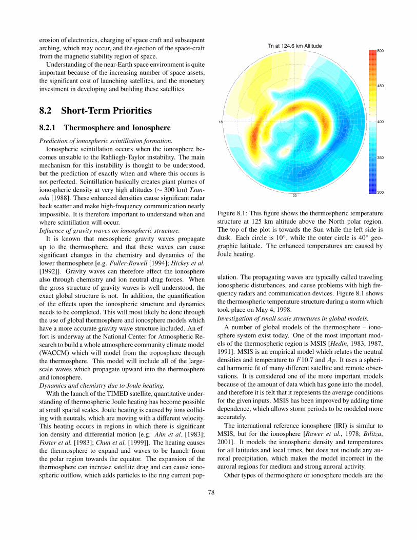
erosion of electronics, charging of space craft and subsequentarching, which may occur, and the ejection of the space-craftfrom the magnetic stability region of space.
Understanding of the near-Earth space environment is quiteimportant because of the increasing number of space assets,the significant cost of launching satellites, and the monetaryinvestment in developing and building these satellites
8.2 Short-Term Priorities
8.2.1 Thermosphere and IonospherePrediction of ionospheric scintillation formation.
Ionospheric scintillation occurs when the ionosphere be-comes unstable to the Rahliegh-Taylor instability. The mainmechanism for this instability is thought to be understood,but the prediction of exactly when and where this occurs isnot perfected. Scintillation basically creates giant plumes ofionospheric density at very high altitudes (∼ 300 km) Tsun-oda [1988]. These enhanced densities cause significant radarback scatter and make high-frequency communication nearlyimpossible. It is therefore important to understand when andwhere scintillation will occur.Influence of gravity waves on ionospheric structure.
It is known that mesospheric gravity waves propagateup to the thermosphere, and that these waves can causesignificant changes in the chemistry and dynamics of thelower thermosphere [e.g. Fuller-Rowell [1994]; Hickey et al.[1992]]. Gravity waves can therefore affect the ionospherealso through chemistry and ion neutral drag forces. Whenthe gross structure of gravity waves is well understood, theexact global structure is not. In addition, the quantificationof the effects upon the ionospheric structure and dynamicsneeds to be completed. This will most likely be done throughthe use of global thermosphere and ionosphere models whichhave a more accurate gravity wave structure included. An ef-fort is underway at the National Center for Atmospheric Re-search to build a whole atmosphere community climate model(WACCM) which will model from the troposphere throughthe thermosphere. This model will include all of the large-scale waves which propagate upward into the thermosphereand ionosphere.Dynamics and chemistry due to Joule heating.
With the launch of the TIMED satellite, quantitative under-standing of thermospheric Joule heating has become possibleat small spatial scales. Joule heating is caused by ions collid-ing with neutrals, which are moving with a different velocity.This heating occurs in regions in which there is significantion density and differential motion [e.g. Ahn et al. [1983];Foster et al. [1983]; Chun et al. [1999]]. The heating causesthe thermosphere to expand and waves to be launch fromthe polar region towards the equator. The expansion of thethermosphere can increase satellite drag and can cause iono-spheric outflow, which adds particles to the ring current pop-
Tn at 124.6 km Altitude
00
18
300
350
400
450
500
Figure 8.1: This figure shows the thermospheric temperaturestructure at 125 km altitude above the North polar region.The top of the plot is towards the Sun while the left side isdusk. Each circle is 10◦, while the outer circle is 40◦ geo-graphic latitude. The enhanced temperatures are caused byJoule heating.
ulation. The propagating waves are typically called travelingionospheric disturbances, and cause problems with high fre-quency radars and communication devices. Figure 8.1 showsthe thermospheric temperature structure during a storm whichtook place on May 4, 1998.Investigation of small scale structures in global models.
A number of global models of the thermosphere – iono-sphere system exist today. One of the most important mod-els of the thermospheric region is MSIS [Hedin, 1983, 1987,1991]. MSIS is an empirical model which relates the neutraldensities and temperature to F10.7 and Ap. It uses a spheri-cal harmonic fit of many different satellite and remote obser-vations. It is considered one of the more important modelsbecause of the amount of data which has gone into the model,and therefore it is felt that it represents the average conditionsfor the given inputs. MSIS has been improved by adding timedependence, which allows storm periods to be modeled moreaccurately.
The international reference ionosphere (IRI) is similar toMSIS, but for the ionosphere [Rawer et al., 1978; Bilitza,2001]. It models the ionospheric density and temperaturesfor all latitudes and local times, but does not include any au-roral precipitation, which makes the model incorrect in theauroral regions for medium and strong auroral activity.
Other types of thermosphere or ionosphere models are the
78

first principle models which model the different regions bydetermining the density, momentum, and energy of the fluidself-consistently. The T-GCM (TGCM, TIGCM, TIEGCM,TIMEGCM) series of models are examples of such modelswhich were created at the National Center for AtmosphericResearch. These models solve for mass mixing ratios of theneutral major species O2, N2, and O and the minor speciesN(2D), N(4S), NO, He, and Ar. They are full 3-dimensionalcodes with 5◦ latitude by 5◦ longitude by 0.5 scale height al-titude cells [Dickinson et al., 1981, 1984; Roble et al., 1988;Roble and Ridley, 1987; Richmond et al., 1992; Roble and Ri-dley, 1994]. A different first principles model is the CoupledThermosphere Ionosphere Model (CTIM) [Fuller-Rowell andRees, 1980, 1983; Rees and Fuller-Rowell, 1988; Rees. andFuller-Rowell, 1990].
Wang et al. [1999] and Wang et al. [2001] extended theTIGCM to include a high resolution nested grid to resolvefeatures which are less than 5◦ in latitude or longitude. Theytypically use the nested grid within the auroral region. Themaximum resolution of the nested grid is 1.3◦.
In the next decade, it is expected that the global thermo-sphere - ionosphere models will attain much higher resolu-tion than current models. This will allow for the investigationof how intense small-scale phenomena effect the regional andglobal environment. For example, auroral arcs are known tobe only a few tens of kilometers across down to meters acrossand can be associated with large electric fields and particleprecipitation fluxes. This causes intense heating in a verylocalized environment, which may spread through diffusionor may travel through waves. Current models can not comeclose to examining these types of effects.Data assimilation.
There are currently only a small number of groups whoare actively attempting to perform data assimilation withinthe thermosphere and ionosphere. The assimilative map-ping of ionospheric electrodynamics (AMIE) technique in-gests electrodynamic data to determine the electric field, par-ticle precipitation, and current structure of the high-latitudeionosphere [e.g., Richmond and Kamide [1988]; Richmond[1992]; Ridley et al. [1997, 1998]]. While this technique isquite useful, it only works on a 2-dimensional grid in thehigh-latitude region, and it only produces maps of electro-dynamic quantities and not fundamental quantities such asdensities, velocities, and temperatures.
One group has started to incorporate measurements of totalelectron content into a 3-dimensional model of the ionosphere[see http://gaim.cass.usu.edu/index.html]. This is being car-ried out by using data assimilation techniques developed inweather forecasting (i.e. Kalman filtering) and applying themto global simulations of the ionosphere. In the next decade, itis expected that a number of other groups will begin to exam-ine using Kalman filtering within thermosphere, ionosphere,and magnetosphere codes.Influence of Earth’s ionosphere and magnetosphere on the
lower atmosphere.Our understanding of how the magnetosphere influences
the mesosphere, stratosphere, and troposphere is quite lim-ited. It is known that there is relatively little influence overthe period of days to weeks, but some correlation has beenshown to occur over decadal time periods. The most commonexample of this is the Maunder minimum (1650-1710). Thisis a period of time in which there were very few Sun spots,so the magnetic activity in the near-Earth space environmentwas quite low. During this time, the Earth underwent a miniice age, which lasted about the same amount of time as thelow activity. The problem with this correlation is that the so-lar luminosity is also tied to Sun spots, so during this period,the Sun may not have been heating Earth quite as much as itnormally does.
There is currently an effort underway to couple loweratmosphere models to the T-GCM series of thermosphere-ionosphere models. This effort is called the Whole Atmo-sphere Community Climate Model (or WACCM). When thismodel is completed and applied to a large number of eventsor a large time period, research may begin to determine howmuch coupling actually occurs between these regions of ouratmosphere.Prediction of ionospheric current structures.
The first order global ionospheric field-aligned currentstructure was described many years ago [Iijima and Potemra,1976]. It is known that within this global structure there aremany other smaller structures. These small-scale structurescan be less that 100 km in latitudinal width and can movearound quite quickly. While the exact temporal and spatialstructure is difficult to study, the dynamics which control thismay be understood, and specifications of the types of struc-tures (e.g. stable location versus highly variable location) areimportant to learn about.Space Weather.
There are a number of research groups which are startingto run models in real-time, but have not fully validated them,nor do they insure that they will run automatically 24 hoursa day, 7 days a week. In the next decade, it is expected thata number of researchers will push their models to becomeoperational codes. This will allow space weather monitoringstations, such as the Space Environment Center, to use a va-riety of different codes for determining the conditions in thenear-Earth space environment.
For tropospheric weather forecasting, a number of modelsare run and are combined together to create an ensemble av-erage forecast. It will most likely be a number of years beforethis type of averaging can be done within the thermospheric- ionospheric community, but we expect there will be a lot ofprogress within this field.
8.2.2 MagnetosphereStability and dynamics of the magnetospheric tail
79

Magnetospheric substorms are global events, which pro-duce aurora near the Earth’s magnetic poles [as first describedby Akasofu [1964]]. Earth’s magnetospheric tail can grow tobe very long and thin (i.e. 1/2 Earth Radius) in Z. This thintail has a large gradient in magnetic field orientation, whichdrives a strong cross-tail current (or vise-versa, depending onyour view point). At some point, the cross tail current be-comes disrupted, and the current is diverted from the tail intothe ionosphere near the poles. This produces large auroraldisplays near the current regions. Figure 8.2 shows the mag-netosphere with a very long tail (possibly a highly energizedstate), and a short tail (a low energy state).
The exact mechanism, which causes the disruption of thecross-tail Current, is unknown. We list a few models of sub-storms here: the near-Earth neutral line model [e.g. Hones[1979]], the boundary layer model [Rostoker and Eastman,1987], the thermal catastrophe model [Goertz and Smith,1989], the current disruption model [Chao et al., 1977;Lui, 1996], the Magnetosphere – Ionosphere coupling model[Kan, 1993], and the interplanetary magnetic field triggeredsubstorm model [Lyons, 1995]. In addition, the current maynot disrupt over the whole tail; it may occur in localized re-gions [e.g. Lyons et al. [2003]], which complicates issues sig-nificantly since instrumentation, which measures these phe-nomena, is quite sparse. So, even identifying true global-scale events is problematic.The search for reconnection continues.
One of the most important processes for transferring en-ergy from the solar environment to Earth’s magnetosphere isreconnection [Dungey, 1961]. This process changes magneticenergy into particle energy. The understanding of this pro-cess is one of the most fundamental for understanding howthe magnetosphere interacts with the solar environment. Itis not well understood. There are still controversies aboutwhether reconnection has to occur for antiparrellel magneticfield lines or whether component merging can take place. Inthe magnetospheric tail, the reconnection process and its re-lations to current disruption is even less understood (as dis-cussed above).
With the launch of the Cluster satellites, a number of re-searchers have started to search for magnetospheric reconnec-tion sites [e.g. Phan et al. [2003]]. Recently, researchers haveshown evidence that the reconnection site has moved over thecluster of satellites. Studies with the Polar satellite have alsoshown evidence of crossing the reconnection region. More ofthese types of events will be found in the near future, and willhelp us to address some fundamental issues in reconnectiontheory.Data assimilation.
Data assimilation within the magnetosphere is almostnonexistent. There are a number of reasons for this: (1)lack of data to be assimilated; (2) the strong nonlinear pro-cesses within the magnetosphere; and (3) the strong spatialdiscontinuities, which exist because of the magnetic field. It
X [R]
Z[R
]
-500
-20
-10
0
10
20
30
40
50
60
70
80
Frame 001 4 Apr 2003 BATSRUS: Cut Y Data, 2000-03-24-08-55-00-500
X [R]
Z[R
]
-500
-25
0
25
Figure 8.2: These two figures show examples of how the mag-netospheric tail can be quite short (top) or long (bottom), de-pending on the interaction of the magnetosphere with the so-lar wind and IMF. The color indicates the density (differentscales), while the line traces are the magnetic field lines. Theblack circle represents the inner boundary on the magneto-spheric 3-D simulation. The Sun is off to the left.
is expected that over the next decade researchers will begin toinvestigate the use of data within global and localized simu-lations of the magnetosphere.Radiation belts.
The radiation belts are bands of very high-energy particles,which are at relatively low altitudes (within approximately 2Earth radii). Because of the altitudes of the radiation belts,many orbital planes cut through them. The exposure of satel-lite electronics to these particles is highly degrading, and lim-its the lifetime of the satellite severely. It may would be use-
80

ful and important if in the future we could more accuratelypredict the temporal and spatial specification of the radiationbelts [e.g. Elkington et al. [2003]]. This may allow satelliteoperators to extend the life of their satellites.Influence of the thermosphere and ionosphere on the magne-tospheric dynamics.
Recently, researchers have started to examine more closelyhow the ionosphere influences the magnetosphere. There area number of areas within this field which have been examinedon a small scale before. For example, it is well known that themagnetospheric ring current is partially composed of oxygenatoms, which originate from the ionosphere. Therefore it canbe said that ionospheric outflow plays a role in the amount ofenergy that can be fed into the ring current.
Another example is the control of the thermospheric neu-tral winds over the ionospheric and magnetospheric dynam-ics. Thayer and Vickrey [1992]; Sanchez et al. [1998]; Thayer[1998] make use of the Sondrestrom incoherent radar to de-termine how the thermospheric neutral winds effect the en-ergy flow from the magnetosphere to the ionosphere andback. Deng et al. [1991, 1993]; Lu et al. [1995] use a globalthermosphere - ionosphere model to determine the effect ofthe neutral winds on the ionosphere. The models presentedby Peymirat et al. [1998], Peymirat et al. [2002], and Rid-ley et al. [2003b] show results of a coupled TIEGCM differ-ent magnetospheric models. These studies start to quantifythe effects of the neutral winds on the global magnetosphericconvection and configuration.
Fedder and Lyon [1987] showed that the magnetosphereis neither a current nor a voltage generator by using aglobal MHD code by varying a constant ionospheric conduc-tance to determine whether the magnetosphere would self-consistently increase the field-aligned currents or not. Raederet al. [1996] showed that the ionospheric conductance spec-ification is crucial in determining the temporal history of themagnetospheric dynamics. They showed that by changing theconductance in the ionosphere, they could make the magne-tosphere go into either a steady convection state or storage-unloading state. Raeder et al. [2001] further describes howthe ionospheric conductance can determine the timing andstrength of auroral substorms through the use of a limitedparametric study. The study by Ridley et al. [2003a] begins toexamine the effect of the different ionospheric conductancepatterns on the global state of the magnetosphere.
One of the main issues with these types of studies is thelack of diverse measurement conditions to prove the causeand effect statistically. This must change in order to deter-mine how much of an effect the thermosphere - ionospheresystem has on the magnetosphere.Energy flow through the magnetosphere.
Statistical studies have shown that embedded regions ofsouthward interplanetary magnetic fields with intensity Bz <−10nT and duration of greater than three hours in the solarwind produce major magnetic storms at Earth with Dst dip-
ping below -100 nT [Gonzalez and Tsurutani, 1987]. Thephysical mechanism underlying the energy transfer from thesolar wind to the magnetosphere is reconnection at the day-side magnetopause. These regions of strong southward IMFare termed ”geoeffective” which is widely interpreted tomean that they create large geomagnetic storms. The inten-sity of the ring current enhancement is a primary measure ofthe magnitude of the geomagnetic storm. However, the wayin which energy is distributed throughout the global magne-tosphere in association with various types of solar wind tran-sients is not known. Recent studies indicate that energy flowthrough the inner magnetosphere and into the ring currentreservoir may account for as little as 20% of the total en-ergy dissipated during a major magnetic storm [Kozyra et al.,1998; Weiss et al., 1992]. If this is the case, then a large partof the magnetic storm energy is loaded into the magnetotaillobes, lost downtail as plasmoids and dissipated in the auroralionosphere. It is possible that the majority of the energy inputduring magnetic storms is contained in the highly disturbedmagnetotail configuration and dissipated in frequent and in-tense substorms. In fact, during the main phase of magneticstorms, magnetic field depolarizations and substorm injec-tion signatures are so frequent that identifying individual sub-storms is a nearly impossible task [c.f., Kamide et al. [1998]].Night side growth phase and injection signatures sometimesoccur simultaneously, separated by only a few hours in localtime. This high number of substorm recurrences must leadto elevated stormtime plasma sheet temperatures and largeamounts of energy pumped into the auroral ionosphere.
Over the next decade, a major focus of magnetospheric re-search is going to be attempting to quantify how much en-ergy is entering the magnetospheric system and partitioningthe loss of that energy into the different regions of the mag-netosphere. Specifically, the IMAGE mission is examiningthe ring current dynamics, while the TIMED mission is ex-amining the energy deposition into the ionosphere. One ofthe roles of the Cluster mission is to examine the dynamics ofthe plasma/current sheet, which will help to determine howmuch energy is flowing from the tail towards the Earth andhow much is being lost down tail.
8.2.3 The Sun and the Heliosphere
HelioseismologyThe science studying wave oscillations in the Sun is called
helioseismology. One can view the physical processes in-volved in the same way that seismologists learn about Earth’sinterior by monitoring waves caused by earthquakes [Chaplinet al., 2002; Dzhalilov et al., 2002]. Temperature, composi-tion, and motions deep in the Sun influence the oscillationperiods and yield insights into conditions in the solar interior.Because it is impossible to send satellites to sample the so-lar interior, helioseismology offers one of the only methodsof measuring the dynamics of the solar interior. Most of the
81

Figure 8.3: This image was generated by the computer to rep-resent an acoustic wave resonating in the interior of the Sun.Here, the radial order is n = 14, angular degree is l = 20,and the angular order is m = 16. Red and blue show elementdisplacements of opposite sign. The frequency of this modedetermined from the MDI data is 2935.88 +/− 0.2 µHz.
physics of the Sun derives from its interior, so understandingthe interior is of primary importance. That makes helioseis-mology very important also. It is expected that techniques formeasuring the waves on the solar surface will improve overthe coming decade, so that determining the interior dynamicswill be much easier.The Solar Dynamo
It is widely believed that the Sun’s magnetic field is gener-ated by a magnetic dynamo within the Sun. The fact that theSun’s magnetic field changes dramatically over the course ofjust a few years, and the fact that it changes in a cyclical man-ner indicates that the magnetic field continues to be generatedwithin the Sun [Solanki et al., 2002]. The solar dynamo is re-sponsible for several phenomena: 1) the 11-year period ofthe sunspot cycle, 2) the equator-ward drift of the active lat-itude, 3) Hale’s polarity law and the 22-year magnetic cycle,4) Joy’s law for the observed tilt of sunspot groups and, 5)the reversal of the polar magnetic fields near the time of cyclemaximum.
The reversing of the Sun’s dynamo causes significant ac-tivity to occur on the solar surface every 11 years. When theSun’s magnetic field is close to dipolar, there is very little ac-tivity, but when the field is strongly tilted, there are many ac-tive regions and coronal mass ejections (see Figure 8.4). Thisis of primary importance to Earth because every 11 years,
Figure 8.4: A magnetic field butterfly diagram. This imageshows how the magnetic field near the solar surface changesas a function of time. Equatorward propagation of the mag-netic field is evident.
when the dipole is highly tilted and the Sun is quite active,large events are launched towards the Earth, and dramaticmagnetic storms occur. While there are a number of theoriesof why the dipole flips every 11 years, there is little agree-ment. This will continue to be a large topic in space researchuntil it is solved.Coronal mass ejections
Coronal mass ejections (or CMEs) are huge bubbles of gasthreaded with magnetic field lines that are ejected from theSun over the course of several hours [Subramanian and Dere,2001]. Although the Sun’s corona has been observed duringtotal eclipses of the Sun for thousands of years, the existenceof coronal mass ejections was unrealized until the space age.The earliest evidence of these dynamical events came fromobservations made with a coronagraph on the 7th OrbitingSolar Observatory (OSO 7) from 1971 to 1973. A corona-graph produces an artificial eclipse of the Sun by placing an”occulting disk” over the image of the Sun. During a naturaleclipse of the Sun the corona is only visible for a few minutesat most, too short a period of time to notice any changes incoronal features. With ground based coronagraphs, only theinnermost corona is visible above the brightness of the sky.From space the corona is visible out to large distances fromthe Sun and can be viewed continuously.
CMEs disrupt the flow of the solar wind and producedisturbances that strike the Earth with sometimes catas-trophic results. The Large Angle and Spectrometric Coron-agraph (LASCO) on the Solar and Heliospheric Observatory(SOHO) has observed a large number of CMEs (e.g. Fig-ure 8.5). Understanding how CMEs occur and what triggersthem to erupt is very important to being able to predict whenthere will be activity at Earth. It is similar to the substormresearch, which is being conducted in Earth’s magnetosphere- both are explosive events, which are possibly triggered. Thetriggering mechanism is still unknown for both [Priest andForbes, 2002; Dikpati et al., 2002].
82

Figure 8.5: The CME event of April 7th, 1997. It produceda ”halo event” in which the entire Sun appeared to be sur-rounded by the CME. Halo events are produced by CMEsthat are directed toward (or away from) the Earth. As theyloom larger and larger they appear to envelope the Sun itself.
Solar energetic particlesStarting in 1942, Geiger counters and other detectors set
up to monitor cosmic rays have occasionally seen sudden in-creases in the intensity of the radiation associated with out-bursts on the Sun, mostly with visible flares [Gopalswamyet al., 2002]. The cosmic ray intensity returns to normalwithin minutes or hours as the acceleration process ends, andas accelerated ions disperse throughout interplanetary space[Aschwanden, 2002].
In many events, the Sun emits enormous numbers of lower-energy ions with no more than tens of Mev (=millions elec-tron volts). The Earth’s magnetic field diverts them to thevicinity of the magnetic poles where they may temporarilysmother the ionosphere and interfere with radio communica-tions. Such ”polar cap blackouts” used to bother US militaryradar installations, which scanned the polar cap for hostilemissiles.
Should we be concerned about solar energetic radiation?On Earth, we are safe, protected by the thick layer of our at-mosphere, equivalent to 10 meters (32 feet) of water or about4 meters of concrete. Astronauts on a space station orbitingnear the Earth’s equator are protected by the Earth’s mag-netic field but not enough for some solar particle event. Inthose cases, they are required to return to their spacecraft.Thus, predicting these events is important to astronauts work-ing outside their space vehicles. Also, astronauts on their wayto Mars, separated from space by just a thin metal shell, arequite vulnerable. Luckily, life threatening radiation events arerare, especially during low years of the sunspot cycle. Still,as the large particle events of August 1972 have shown, somedanger remains even then.
Researchers are just starting to incorporate solar ener-getic particles into global heliosphere models. Having CMEserupting into the global heliosphere will create large recon-nection sites and strong shock structures. In the future, it isexpected that researchers will better understand the accelera-tion mechanisms for these high energy particles.Propagation of structures through interplanetary space
When CMEs are observed near the Sun, it is unknownwhether they will encounter the Earth or not. If they are sus-pected to encounter the Earth, the exact time of arrival andintensity of the CME and the pile up of material in front ofit are unknown until these structures are measured by satel-lites located approximately 250 Earth Radii upstream of theEarth. CMEs typically take 24-72 hours to arrive at the Earth.Figure 8.6 shows an example of a 3-D simulation of a CMEencountering the Earth.
The propagation of the CME through interplanetary spaceis crucial in determining how much of an effect it will have onthe Earth system. If it is a fast CME moving through a slowmedium, there will be a huge pile-up in front of it, and thispile-up may cause as much of an effect as the CME itself. Inaddition, the slow medium will cause the CME to slow down,and it will take longer to reach the Earth.
Sophisticated models of the heliosphere and propagationof CMEs through the heliosphere are really in their infancy.Since the propagation is so important in determining whenthe CME will arrive and how strong it will be, significant re-sources are being put towards the improvement of these mod-els.
8.2.4 Ground-based MeasurementsMore observatories
In order to examine the global structure of the thermo-spheric, ionospheric, and magnetospheric dynamics, it is cru-cial to have a wide variety of data sources covering as muchof the globe as possible. IAGA research covers a huge regionof space, but has an extremely small number of data sources.It is surprising that any progress can be made at all. At anygiven time, there are less than 200 magnetometers running.This means that each magnetometer, on average, has to cover2.55 million km2. What it really means is that some regionshave relatively poor coverage, and other regions have awfulcoverage. One of the worst parts is that the coverage is notbased on economy of the country at all. So, for example,the United States has very poor data coverage considering theamount of money that is spent each year on research.
In order for progress to be made at any pace above whatis being done today, more observatories are needed. Whilesome researchers understand this and are proposing for chainsof observatories, there are not enough. In addition, the fund-ing agencies have to realize that ground-based observatoriesare very inexpensive ways to help scientists better understandour environment.
83
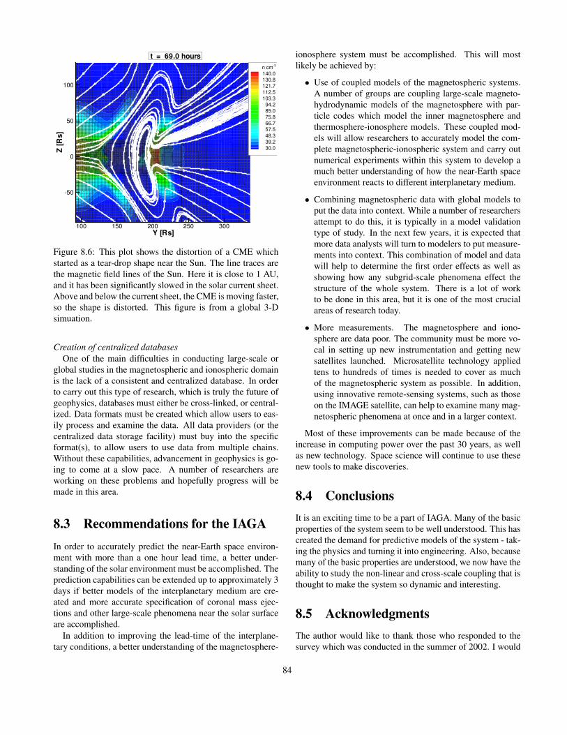
Y [Rs]
Z[R
s]
100 150 200 250 300
-50
0
50
100
n cm-3
140.0130.8121.7112.5103.3
94.285.075.866.757.548.339.230.0
t = 69.0 hours
Figure 8.6: This plot shows the distortion of a CME whichstarted as a tear-drop shape near the Sun. The line traces arethe magnetic field lines of the Sun. Here it is close to 1 AU,and it has been significantly slowed in the solar current sheet.Above and below the current sheet, the CME is moving faster,so the shape is distorted. This figure is from a global 3-Dsimuation.
Creation of centralized databasesOne of the main difficulties in conducting large-scale or
global studies in the magnetospheric and ionospheric domainis the lack of a consistent and centralized database. In orderto carry out this type of research, which is truly the future ofgeophysics, databases must either be cross-linked, or central-ized. Data formats must be created which allow users to eas-ily process and examine the data. All data providers (or thecentralized data storage facility) must buy into the specificformat(s), to allow users to use data from multiple chains.Without these capabilities, advancement in geophysics is go-ing to come at a slow pace. A number of researchers areworking on these problems and hopefully progress will bemade in this area.
8.3 Recommendations for the IAGAIn order to accurately predict the near-Earth space environ-ment with more than a one hour lead time, a better under-standing of the solar environment must be accomplished. Theprediction capabilities can be extended up to approximately 3days if better models of the interplanetary medium are cre-ated and more accurate specification of coronal mass ejec-tions and other large-scale phenomena near the solar surfaceare accomplished.
In addition to improving the lead-time of the interplane-tary conditions, a better understanding of the magnetosphere-
ionosphere system must be accomplished. This will mostlikely be achieved by:
• Use of coupled models of the magnetospheric systems.A number of groups are coupling large-scale magneto-hydrodynamic models of the magnetosphere with par-ticle codes which model the inner magnetosphere andthermosphere-ionosphere models. These coupled mod-els will allow researchers to accurately model the com-plete magnetospheric-ionospheric system and carry outnumerical experiments within this system to develop amuch better understanding of how the near-Earth spaceenvironment reacts to different interplanetary medium.
• Combining magnetospheric data with global models toput the data into context. While a number of researchersattempt to do this, it is typically in a model validationtype of study. In the next few years, it is expected thatmore data analysts will turn to modelers to put measure-ments into context. This combination of model and datawill help to determine the first order effects as well asshowing how any subgrid-scale phenomena effect thestructure of the whole system. There is a lot of workto be done in this area, but it is one of the most crucialareas of research today.
• More measurements. The magnetosphere and iono-sphere are data poor. The community must be more vo-cal in setting up new instrumentation and getting newsatellites launched. Microsatellite technology appliedtens to hundreds of times is needed to cover as muchof the magnetospheric system as possible. In addition,using innovative remote-sensing systems, such as thoseon the IMAGE satellite, can help to examine many mag-netospheric phenomena at once and in a larger context.
Most of these improvements can be made because of theincrease in computing power over the past 30 years, as wellas new technology. Space science will continue to use thesenew tools to make discoveries.
8.4 ConclusionsIt is an exciting time to be a part of IAGA. Many of the basicproperties of the system seem to be well understood. This hascreated the demand for predictive models of the system - tak-ing the physics and turning it into engineering. Also, becausemany of the basic properties are understood, we now have theability to study the non-linear and cross-scale coupling that isthought to make the system so dynamic and interesting.
8.5 AcknowledgmentsThe author would like to thank those who responded to thesurvey which was conducted in the summer of 2002. I would
84

also like to thank Mike Liemohn, Janet Kozyra, Laura Petico-lis, and Ilia Roussev for their helpful discussions on the futureof IAGA and reading this document.
BibliographyAhn, B.-H., S.-I. Akasofu, and Y. Kamide, The joule heating
production rate and particle energy injection rate as a func-tion of the geomagnetic indices AE and AL, J. Geophys.Res., 88, 6275, 1983.
Akasofu, S.-I., The development of the auroral substorm,Planet. Space Sci., 101, 273, 1964.
Aschwanden, M. J., Particle acceleration and kinematics insolar flares - A Synthesis of Recent Observations and The-oretical Concepts (Invited Review), Space Science Re-views, 101, 1, 2002.
Bilitza, D., International reference ionosphere 2000, RadioScience, 36, 261, 2001.
Chao, J.K., J.R. Kan, A.T.Y. Lui, and S.-I. Akasofu, A modelfor thinning of the plasma sheet, Planet. Space Sci., 25,703, 1977.
Chaplin, W. J., Y. Elsworth, G. R. Isaak, B. A. Miller, andR. New, On the measurement precision of solar p-modeeigenfrequencies, Monthly Not. of the Royal Astron. Soc.,330, 731, 2002.
Chun, F. K., D. J. Knipp, M. G. McHarg, G. Lu, B. A. Emery,S. Vennerstrom, and O. A. Troshichev, Polar cap index asa proxy for hemispheric joule heating, Geophys. Res. Lett.,26, 1101, 1999.
Deng, W., T.L. Killeen, A.G. Burns, and R.G. Roble, Theflywheel effect: Ionospheric currents after a geomagneticstorm, Geophys. Res. Lett., 18, 1845, 1991.
Deng, W., T.L. Killeen, A.G. Burns, R.G. Roble, J.A. Slavin,and L.E. Wharton, The effects of neutral inertia on iono-spheric currents in the high-latitude thermosphere follow-ing a geomagnetic storm, J. Geophys. Res., 98, 7775, 1993.
Dickinson, R.E., E.C. Ridley, and R.G. Roble, A three-dimensional, time-dependent general circulation model ofthe thermosphere, J. Geophys. Res., 86, 1499, 1981.
Dickinson, R.E., E.C. Ridley, and R.G. Roble, Thermo-spheric general circulation with coupled dynamics andcomposition, J. Atmos. Sci., 41, 205, 1984.
Dikpati, M., T. Corbard, M. J. Thompson, and P. A. Gilman,Flux Transport Solar Dynamos with Near-Surface RadialShear, Astrophys. J. Lett., 575, L41, 2002.
Dungey, J.W., Interplanetary magnetic field and the auroralzones, Phys. Rev. Lett., 93, 47, 1961.
Dzhalilov, N. S., J. Staude, and V. N. Oraevsky, Eigenoscil-lations of the differentially rotating Sun. I. 22-year, 4000-year, and quasi-biennial modes, Astron. Astrophys., 384,282, 2002.
Elkington, S.R., M.K. Hudson, and A.A. Chan, Resonant ac-celeration and diffusion of outer zone electrons in an asym-metric geomagnetic field, J. Geophys. Res., 2003.
Fedder, J.A., and J.G. Lyon, The solar wind – magnetosphere– ionosphere current – voltage relationship, Geophys. Res.Lett., 14, 880, 1987.
Foster, J.C., F.-P. St. Maurice, and V.J. Abreu, Joule heatingat high latitudes, J. Geophys. Res., 88, 4885, 1983.
Fuller-Rowell, T.J., and D. Rees, A three-dimensional, time-dependent, global model of the thermosphere, J. Atmos.Sci., 37, 2545, 1980.
Fuller-Rowell, T.J., and D. Rees, Derivation of a conservativeequation for mean molecular weight for a two constituentgas within a three-dimensional, time-dependent model ofthe thermosphere, Planet. Space Sci., 31, 1209, 1983.
Fuller-Rowell, T.J., The impact of gravity waves on nitricoxide in the lower thermosphere, J. Atmos. Terr. Phys., 56,1387, 1994.
Goertz, C.K., and R.A. Smith, Thermal catastrophe model ofsubstorms, J. Geophys. Res., 94, 6581, 1989.
Gonzalez, W.D., and B.T. Tsurutani, Criteria of interplane-tary parameters causing intense magnetic storms (Dst <−100nT ), Planet Space Sci., 35, 1101, 1987.
Gopalswamy, N., S. Yashiro, G. Michałek, M. L. Kaiser,R. A. Howard, D. V. Reames, R. Leske, and T. vonRosenvinge, Interacting Coronal Mass Ejections and SolarEnergetic Particles, Astrophys. J. Lett., 572, L103, 2002.
Hedin, A.E., A revised thermospheric model based on massspectometer and incoherent scatter data: MSIS-83, J. Geo-phys. Res., 88, 10170, 1983.
Hedin, A.E., MSIS-86 thermospheric model, J. Geophys.Res., 92, 4649, 1987.
Hedin, A.E., Extension of the MSIS thermosphere modelinto the middle and lower atmosphere, J. Geophys. Res.,96, 1159, 1991.
Hickey, M.P., G. Schubert, and R.L. Walterscheid, Seasonaland latitudinal variations of gravity wave-driven fluctua-tions in oh nightglow, J. Geophys. Res., 97, 14,911, 1992.
85

Hones, E.W. Jr., Transient phenomena in the magnetotail andtheir relation to substorms, Space Sci. Rev., 23, 393, 1979.
Iijima, T., and T. A. Potemra, The amplitude distribution offield-aligned currents at northern high latitudes observedby Triad, J. Geophys. Res., 81, 2165, 1976.
Kamide, Y., W. Baumjohann, I.A. Daglis, W.D. Gonzalez,M. Grande, J.A. Joselyn, R.L. McPherron, J.L. Phillips,E.G.D. Reeves, G. Rostoker, A.S. Sharma, H.J. Singer,B.T. Tsurutani, and V. M. Vasyliunas, Current understand-ing of magnetic storms: Storm-substorm relationships, J.Geophys. Res., 103, 17,705, 1998.
Kan, J.R., A global Magnetosphere – Ionosphere couplingmodel of substorms, J. Geophys. Res., 98, 17,263, 1993.
Kozyra, J. U., V. K. Jordanova, J. E. Borovsky, M. F. Thom-sen, D. J. Knipp, D. S. Evans, D. J. McComas, and T. E.Cayton, Effects of a high density plasma sheet on ring cur-rent development during the November 2-6, 1993 magneticstorm, J. Geophys. Res., 103, 26,285, 1998.
Lu, G., A.D. Richmond, B.A. Emery, and R.G. Roble,Magnetosphere-ionosphere-thermosphere coupling: Effectof neutral winds on energy transfer and field-aligned cur-rent, J. Geophys. Res., 100, 19,643, 1995.
Lui, A.T.Y., Current disruption in the earth’s manetosphere:Observations and models, J. Geophys. Res., 101, 13,067,1996.
Lyons, L. R., E. Zesta, Y. Xu, E. R. Sanchez, J. C. Sam-son, G. D. Reeves, J. M. Ruohoniemi, and J. B. Sigwarth,Auroral poleward boundary intensifications and tail burstyflows: A manifestation of a large-scale ULF oscillation?,J. Geophys. Res., 2003.
Lyons, L.R., A new theory for magnetospheric substorms, J.Geophys. Res., 100, 19,069, 1995.
Peymirat, C., A.D. Richmond, B.A. Emery, and R.G.Roble, A magnetosphere-thermosphere-ionosphere elec-trodynamics general circulation model, J. Geophys. Res.,103, 17467, 1998.
Peymirat, C., A.D. Richmond, and R.G. Roble, Neutralwind influence on the electrodynamic coupling betweenthe ionosphere and the magnetosphere, J. Geophys. Res.,107, 1029, 2002.
Phan, T., H. U. Frey, S. Frey, L. Peticolas, S. Fuselier,C. Carlson, H. Reme, J.-M. Bosqued, A. Balogh, M. Dun-lop, L. Kistler, C. Mouikis, I. Dandouras, J.-A. Sauvaud,S. Mende, J. McFadden, G. Parks, E. Moebius, B. Klecker,G. Paschmann, M. Fujimoto, S. Petrinec, M. F. Marcucci,A. Korth, and R. Lundin, Simultaneous Cluster and IM-AGE observations of cusp reconnection and auroral protonspot for northward IMF, J. Geophys. Res., 2003.
Priest, E. R., and T. G. Forbes, The magnetic nature of solarflares, Astron. Astrophys. Rev., 10, 313, 2002.
Raeder, J., J. Berchem, and M. Ashour-Abdalla, The im-portance of small scale processes in global MHD simu-lations: Some numerical experiments, In Chang, T., andJ. R. Jasperse, editors, The Physics of Space Plasmas, vol-ume 14, page 403, Cambridge, Mass., 1996. MIT Cent. forTheoret. Geo/Cosmo Plasma Phys.
Raeder, J., R.L. McPherron, L.A. Frank, S. Kokubun, G. Lu,T. Mukai, W.R. Paterson, J.B. Sigwarth, H.J. Singer, andJ.A. Slavin, Global simulation of the Geospace Environ-ment Modeling substorm challenge event, J. Geophys.Res., 106, 281, 2001.
Rawer, K., D. Bilitza, and S. Ramakrishnan, Goals and statusof the international reference ionosphere, Rev. Geophys.,16, 177, 1978.
Rees, D., and T.J. Fuller-Rowell, Understanding the transportof atomic oxygen in the thermosphere using a numericalglobal thermospheric model, Plan. Space Sci., 36, 935,1988.
Rees., D., and T.J. Fuller-Rowell, Numerical simulations ofthe seasonal/latitudinal variations of atomic oxgen and ni-tric oxide in the lower thermosphere and mesosphere, Adv.Space Res., 10(6), 83–102, 1990.
Richmond, A.D., and Y. Kamide, Mapping electrodynamicfeatures of the high-latitude ionosphere from localized ob-servations: Technique, J. Geophys. Res., 93, 5741, 1988.
Richmond, A.D., E.C. Ridley, and R.G. Roble, A thermo-sphere/ionosphere general circulation model with coupledelectrodynamics, Geophys. Res. Lett., 19, 369, 1992.
Richmond, A.D., Assimilative mapping of ionospheric elec-trodynamics, Adv. Space Res., 12, 59, 1992.
Ridley, A.J., C.R. Clauer, G. Lu, and V.O. Papitashvili, Iono-spheric convection during nonsteady interplanetary mag-netic field conditions, J. Geophys. Res., 102, 14,563, 1997.
Ridley, A.J., C.R. Clauer, G. Lu, and V.O. Papitashvili, Astatistical study of the ionospheric convection response tochanging interplanetary magnetic field conditions using theassimilative mapping of ionospheric electrodynamics tech-nique, J. Geophys. Res., 103, 4023, 1998.
Ridley, A.J., T.I. Gombosi, and D.L. De Zeeuw, Ionosphericcontrol of the magnetospheric configuration (1): Conduc-tance, Annales Geophys., 2003a, In Press.
Ridley, A.J., T.I. Gombosi, D.L. De Zeeuw, C.R. Clauer,and A.D. Richmond, Ionospheric control of the magne-tospheric configuration: Neutral winds, J. Geophys. Res.,2003b, In Press.
86

Roble, R.G., and E.C. Ridley, An auroral model for theNCAR thermospheric general circulation model (TGCM),Ann. Geophys., 5A, 369, 1987.
Roble, R.G., and E.C. Ridley, A thermosphere-ionosphere-mesosphere-electrodynamics general circulation model(time-gcm): Equinox solar cycle minimum simulations(300-500km), Geophys. Res., Lett., 21, 417, 1994.
Roble, R.G., E.C. Ridley, A.D. Richmond, and R.E. Dickin-son, A coupled thermosphere/ionosphere general circula-tion model, Geophys. Res. Lett., 15, 1325, 1988.
Rostoker, G., and T.E. Eastman, A boundary layer model formagnetospheric substorms, J. Geophys. Res., 92, 12,187,1987.
Sanchez, E.R., J.P. Thayer, J.D. Kelly, and R.A. Doe, En-ergy transfer between the ionosphere and magnetosphereduring the January 1997 CME event, Geophys. Res. Lett.,25, 2597, 1998.
Solanki, S. K., M. Schussler, and M. Fligge, Secular variationof the Sun’s magnetic flux, Astron. Astrophys., 383, 706,2002.
Subramanian, P., and K. P. Dere, Source Regions of CoronalMass Ejections, Astrophys. J., 561, 372, 2001.
Thayer, J.P., and J.F. Vickrey, On the contribution of the ther-mospheric neutral wind to high-latitude energetics, Geo-phys. Res. Lett., 19, 265, 1992.
Thayer, J.P., Height-resolved Joule heating rates in the high-latitude E region and the influence of neutral winds, J.Geophys. Res., 103, 471, 1998.
Tsunoda, R. T., High latitude F-region irregularities: A re-view and synthesis, Rev. Geophys., 26, 719, 1988.
Wang, W., T.L. Killeen, A.G. Burns, and R.G. Roble, A high-resolution, three-dimensional, time-dependentm nestedgrid model of the coupled thermosphere-ionosphere, J. At-mos. Terr. Phys., 61, 385, 1999.
Wang, W., T.L. Killeen, A.G. Burns, and B.W. Reinisch, Areal-time model-observation comparision of f2 peak elec-tron densities during the Upper Atmospheric Research Col-laboratory campaign of October 1997, J.Geophys. Res.,106, 21,077, 2001.
Weiss, L.A., P.H. Reiff, J.J. Moses, B.D. Moore, and R. A.Heelis, Energy dissipation in substorms, Eur. SpaceAgency Spec. Publ., pages ESA–SP–335, 309, 1992.
87

88
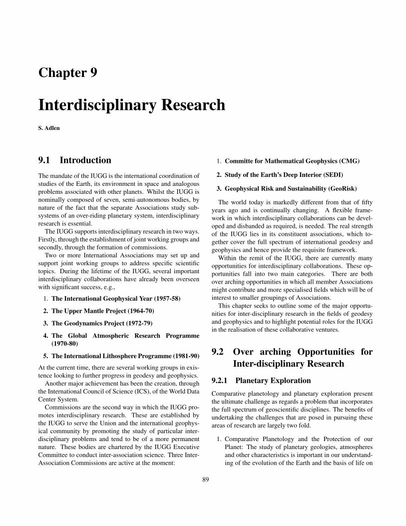
Chapter 9
Interdisciplinary ResearchS. Adlen
9.1 IntroductionThe mandate of the IUGG is the international coordination ofstudies of the Earth, its environment in space and analogousproblems associated with other planets. Whilst the IUGG isnominally composed of seven, semi-autonomous bodies, bynature of the fact that the separate Associations study sub-systems of an over-riding planetary system, interdisciplinaryresearch is essential.
The IUGG supports interdisciplinary research in two ways.Firstly, through the establishment of joint working groups andsecondly, through the formation of commissions.
Two or more International Associations may set up andsupport joint working groups to address specific scientifictopics. During the lifetime of the IUGG, several importantinterdisciplinary collaborations have already been overseenwith significant success, e.g.,
1. The International Geophysical Year (1957-58)
2. The Upper Mantle Project (1964-70)
3. The Geodynamics Project (1972-79)
4. The Global Atmospheric Research Programme(1970-80)
5. The International Lithosphere Programme (1981-90)
At the current time, there are several working groups in exis-tence looking to further progress in geodesy and geophysics.
Another major achievement has been the creation, throughthe International Council of Science (ICS), of the World DataCenter System.
Commissions are the second way in which the IUGG pro-motes interdisciplinary research. These are established bythe IUGG to serve the Union and the international geophys-ical community by promoting the study of particular inter-disciplinary problems and tend to be of a more permanentnature. These bodies are chartered by the IUGG ExecutiveCommittee to conduct inter-association science. Three Inter-Association Commissions are active at the moment:
1. Committe for Mathematical Geophysics (CMG)
2. Study of the Earth’s Deep Interior (SEDI)
3. Geophysical Risk and Sustainability (GeoRisk)
The world today is markedly different from that of fiftyyears ago and is continually changing. A flexible frame-work in which interdisciplinary collaborations can be devel-oped and disbanded as required, is needed. The real strengthof the IUGG lies in its constituent associations, which to-gether cover the full spectrum of international geodesy andgeophysics and hence provide the requisite framework.
Within the remit of the IUGG, there are currently manyopportunities for interdisciplinary collaborations. These op-portunities fall into two main categories. There are bothover arching opportunities in which all member Associationsmight contribute and more specialised fields which will be ofinterest to smaller groupings of Associations.
This chapter seeks to outline some of the major opportu-nities for inter-disciplinary research in the fields of geodesyand geophysics and to highlight potential roles for the IUGGin the realisation of these collaborative ventures.
9.2 Over arching Opportunities forInter-disciplinary Research
9.2.1 Planetary ExplorationComparative planetology and planetary exploration presentthe ultimate challenge as regards a problem that incorporatesthe full spectrum of geoscientific disciplines. The benefits ofundertaking the challenges that are posed in pursuing theseareas of research are largely two fold.
1. Comparative Planetology and the Protection of ourPlanet: The study of planetary geologies, atmospheresand other characteristics is important in our understand-ing of the evolution of the Earth and the basis of life on
89

Earth. By studying planets and other large bodies in thesolar system, we learn about the history and possible fu-ture of our own. In exploring our solar system, we widenour perspectives and gain a better understanding of themechanics of worlds in general, making us better ableto protect our planet’s fragile biosphere. Comparativeplanetology allows us to use other planets as full scalelaboratories to improve our theories. As we move to atime in which Earth system modeling is becoming in-creasingly important, having the opportunity to test the-ories in other full-scale laboratories will be invaluable.
2. Widening the intellectual, physical and technologicalboundaries of Mankind: Exploration of other planetswill push the technological capabilities of the humanrace and in doing so, will also expand our physicalboundaries and understanding of the universe.
The Role of the IUGG
The IUGG is in a strong position to promote planetary re-search as it represents all geoscientific disciplines. The IUGGmight consider the creation of a new association. An associa-tion which could better coordinate planetary exploration andmodeling would be invaluable.
9.2.2 Mathematical Techniques
The geosciences provide an impressive array of importantproblems that command the attention of applied mathemat-ics. They also offer a need, on top of an intellectual desire,to advance the foundations and techniques of applied mathe-matics to meet their challenges.
Methods in continuous and discrete dynamical systems,stochastic processes, homogenization, ergodic theory, renor-malization, inverse problems and the quantification of un-certainty are all required. Some recent developments thatrequire numerical and theoretical modeling tools are large-scale compressible jets (IAVCEI, IAGA), time series analy-sis and stochastic modeling of catastrophic events (IAVCEI)and tools, such as adaptive gridding techniques, to allow theincorporation of processes on disparate spatial and temporalscales into increasingly comprehensive models (IAMAS).
The Role of the IUGG
The Committee on Mathematical Geophysics is an inter-association committee of the IUGG, which already satisfiesthe need for co-ordination of research in the mathematicalfields associated with the geosciences. The committee orga-nizes bi-yearly conferences, and its continued presence is in-valuable to the whole of the geosciences.
9.2.3 Observing SystemsAll of the geoscientific disciplines require observations as abuilding block for their research. Combining these obser-vations in the most thorough and efficient way is essential.Questions of both spatial and temporal resolution need to beresolved as each of the geoscientific disciplines seeks to im-prove their models to smaller and smaller scales.
Recently the problem of coordinated, integrated global ob-serving systems has been addressed by the United Nations.Three inter-related global systems to observe the environmentof the planet are being organized by United Nations organi-sations in co-operation with the scientific community and na-tional governments.
1. Global Climate Observing System (GCOS): GCOS isresponsible for planning the collection of data on long-term climate change.
2. Global Ocean Observing System (GOOS): GOOS is im-plementing operational observation programmes for theoceans and coastal areas.
3. Global Terrestrial Observing System (GTOS): GTOS isdeveloping and networking observations of long-termchange of the land and its resources.
An Integrated Global Observing Strategy (IGOS) is alsobeing developed to improve coherence and joint planning forglobal observations of the environment. Whilst the above sys-tems represent significant progress, observing systems thatmonitor the whole Earth system also need to account for therequirements of other geoscientific disciplines. Some exam-ples of this are given below.
1. The Thermosphere requires improved monitoring.
2. Hydrologists require observations at a much higher spa-tial resolution than scientists concerned with climatechange or the environment.
3. The whole of the Earth system is underpinned by ac-curate physical geodesy, which requires observations atincreasingly higher spatial and temporal resolutions.
All desired observation goals and data products could easilybe attained with a well-constructed global observing system.Some progress is already being made in using data from spe-cific observing systems across a range of geoscientific disci-plines (section 9.3.2). Both NASA’s Earth Science Enterpriseand ESA’s Living Planet program are also significant stepstoward reaching this goal NASA [1999]; ESA [1998].
The Role of the IUGG
The ICS is involved with the three observing projects de-scribed above hence already representing the IUGG to some
90

extent. The IUGG should, however, ensure that the ICS isaware of its requirements as regards the data products re-turned from a global observing system that might benefit dis-ciplines across the whole range of the geosciences. Whilstmuch political emphasis is placed upon the monitoring of theclimate and environment, the needs of other scientific disci-plines should not be neglected at its expense. Once a trulyglobal observing system is in place then returning all of thedata products needed for all realms of geoscientific researchwill be easily realisable. The IUGG should be proactive inthe sponsorship of this goal.
9.2.4 Communication and the Availability ofData
The past decade has seen an explosion in information tech-nology and a revolution in global communications. A ma-jor achievement has been the creation, through the ICS, ofthe World Data Center System, from which the data gatheredduring several major programmes are available to researchworkers everywhere.
The above type of undertaking is vital. All research re-quires data and the sharing and availability of data is thusessential. In the modern age of global communications, thisshould be relatively easy to achieve and would result in hugebenefits to the scientific community.
The Role of the IUGG
The IUGG should advocate, and be active in promoting, freeaccess to all data sets. The IUGG is also in a strong positionto ensure that data is additionally made readily available toresearchers in developing countries.
9.2.5 High Resolution Earth System ModelingThe ultimate challenge of Earth system science is to consol-idate the scientific findings from different disciplines into anintegrated representation of the coupled atmosphere, ocean,ice, land and biosphere system. It has become clear thatmodels need to progress to higher resolutions in order to ad-equately represent processes taking place.
The Global Analysis, Integration and Modeling Task Force(GAIM) is a component of the International Geosphere Bio-sphere Program (IGBP) of the ICS. The goal of GAIM is toadvance the study of the coupled dynamics of the Earth sys-tem, using as tools both data and models. This is just oneexample of a number of such projects throughout the world.
A further development in Earth system modeling comesfrom projects such as “The Earth Simulator Project” in Japan.This project creates a ”virtual earth” on a supercomputer toshow what the world will look like in the future by meansof advanced numerical simulation technology. The reconcil-iation of processes occurring on vastly different spatial and
temporal scales into a comprehensive Earth system modelis non-trivial and demands input and co-operation across thewhole range of the geosciences. This a growing field whichwill produce invaluable results to society over the comingyears.
The Role of the IUGG
Each of the geoscientific disciplines feeds directly into an in-tegrated Earth system model. The IUGG is in a strong po-sition to coordinate Earth system modeling projects. Whilstthe IGBP has already been established by the ICS, the IUGGcould still promote the coupling of models for elements of theEarth system within the realm of the IUGG. Linking mod-els of subsystems together one by one is an important pro-cess. The difficulties involved in trying to reconcile modelsthat are based upon different spatial and temporal scales areenormous. If all of the subsystems represented within theIUGG could be coupled together then this would representenormous progress and is something that the IUGG is in aposition to actively encourage.
9.2.6 Looking to the Future
It is vital that the geosciences maintain a view a of future withthe continual re-assessment of goals and milestones. Under-taking projects that push our intellectual and engineering ca-pabilities to their limits are important in the advancement ofresearch. Projects such as the development and maintenanceof new habitable environments and the intentional forcing ofsystems to mitigate hazards could be established to the benefitof both society and research. Through this type of undertak-ing enormous progress is often made in more routine areas ofresearch. Aim for the stars, reach the sky!
The Role of the IUGG
The IUGG general assembly every four years provides an ex-cellent platform for reflection and re-assessment. The spon-sorship of working groups such as “Geosciences: The Fu-ture” and attaining ideas of young scientists is an excellentidea. Through the promotion and co-ordination of forwardthinking and far-reaching research ideas, the IUGG can be ofhuge value to the geoscience community.
9.3 Other Opportunities for Interdis-ciplinary Collaborations
In addition to the opportunities for interdisciplinary researchwhich encompass all fields of geoscientific research, there aremany chances for research between a smaller number of theassociations of IUGG. Some of the potential opportunities,
91

which are currently being, or could be exploited, are pre-sented below.
9.3.1 The Hydrologic Cycle (IAMAS, IAPSOand IAHS)
The International Association of the Physical Sciences of theOceans (IAPSO), the International Association of HydrologicSciences (IAHS) and the International Association of Meteo-rology and Atmospheric Sciences (IAMAS) have the chanceto work collaboratively to understand the dynamics and inter-action between ocean, atmosphere, surface and groundwater,which are closely linked via the hydrologic cycle. This isa difficult task that involves the reconciliation of models onvastly different spatial and temporal scales. The task is, how-ever, crucial to the maintenance of water supplies and hencelife on Earth.
During the IUGG general assembly in Sapporo, several in-terdisciplinary undertakings are already being investigated re-lated to the hydrologic cycle.
1. The Decadal to Centennial Variability of the Oceanand Atmosphere (IAPSO, IAMAS, CLIVAR)
2. The Surface Ocean-Lower Atmosphere Study (IA-MAS, [ICACGP,ICPM], IAPSO)
3. New Perspectives of Coupled Tropical Ocean-Atmosphere Dynamics and Predictability (IAPSO,IAMAS, CLIVAR)
4. Arctic Environment Change (IAMAS, IAPSO,IAHS)
5. Groundwater Inputs to the Ocean (IAPSO, IAHS)
6. Snow Processes: Representation in Atmospheric andHydrological Models (IAHS/ICSI, IAMAS)
7. Water and Energy Budget Workshop (IA-MAS,IAHS)
8. Measurement and Distribution of Precipitation (IA-MAS, [IPCC, ICPM], IAHS)
9. Worldwide Sea Level Change (IAPSO, IAG)
10. The Treatment of Precipitation in Cloud and ClimateModels (IAMAS, [ICCP, ICCI],IAHS)
11. Land Ocean Atmosphere Interaction in the CoastalZone (IAMAS, IAPSO, IAHS)
12. Global Sea Level Rise, Global Climate Change andPolar Ice Sheet Stability (IAMAS, [ICDM, ICCI,ICPM], IAPSO, IAG, IAHS)
13. Physical Aspects of Air-Sea Interaction (IAPSO, IA-MAS)
Improving and coordinating these investigations so as to bemore strongly linked with the over-riding goal of understand-ing the hydrologic cycle would be beneficial. There is scopefor the IUGG to endorse these studies through the develop-ment of a structured programme of research.
9.3.2 The Role of Geodetic Sensing in Interdis-ciplinary Earth Science (IAG and Oth-ers)
Classically, mapping has been viewed as the main purposeof geodesy. However, by establishing reference geodetic net-works, geodesy has become fundamental in the performanceof other disciplines, whose activities are related to position-ing, such as urban and environmental management, engineer-ing projects, (international and national) boundary demarca-tion, ecology, geography, hydrography, etc. Many applica-tions are also found in other scientific fields, e.g., theoreti-cal and exploratory geophysics, geodynamics, space science,astronomy, oceanography, atmospheric science and geology.New techniques to observe and to analyse the Earth as a com-plete system have made the relationships between disciplinesstronger. Accordingly, some interdisciplinary enterprises thatutilise or could utilise geodetic information are highlightedbelow.
1. The Hydrological Cycle ( IAG, IAMAS, IAPSO,IAHS, IASPEI) Geodesy can provide precise informa-tion about melting (glaciers and polar icecaps), sea levelchange, atmospheric mass movements, ground waterand soil moisture.
2. Precise modeling of crustal deformation, includingplate tectonics, volcanoes and earthquakes (IAG,IAVCEI, IASPEI) Geodesy can precisely monitorcrustal deformation (secular and episodic, extended andlocal), as well as gravity and Earth’s rotation changesdue to mass displacements. The deformation of surfacetopography reflects the dynamical processes that are oc-curring in the Earth. Continuous geodetic observationsof surface deformation provide not only useful infor-mation for understanding the dynamics of the Earth’sinterior, but also indispensable information on the oc-currence of earthquakes and volcanic eruptions. Mostvolcanic activities are accompanied by seismic activity.Revealing processes of interaction between earthquakesand volcanic activities would be a clue to better under-standing the triggering effects between eruptions andearthquakes. To obtain detailed images of the seismicstructure of volcanoes, enhanced seismic observationsin volcanic areas as well as the advancement of theoriesand techniques of seismic wave propagation and model-ing are essential.
92

3. Atmospheric Modeling (IAG, IAGA, IAMAS)Geodesy can provide valuable information about pres-sure and humidity from atmospheric sounding usingGPS.
4. Coupling Between Atmosphere, Ocean and SolidEarth (IAMAS, IAPSO, IAG) How do the solid Earth,atmosphere and ocean interact with each other? How dothe atmosphere and ocean shake the solid Earth? Doesthe melting of polar ice caps due to global warming in-duce the deformation of the surface topography?
The development of a systematic Earth model integrat-ing a variety of Earth processes, such as global warming,growth and regression of polar ice caps, plate tectonics,continental evolution, etc, which fully incorporate thephysics and chemistry of the processes considering thesignificant differences in time-scale, is a common goalof geosciences. This is a piece in the overall goal of acomplete Earth system model (section 9.2.5).
It is important that as much information as possible is ex-tracted from geodetic observations. Whilst this highlights thefact that not enough information is currently extracted fromavailable observations, it is, however, just a small issue in theultimate goal of achieving a global observing system (section9.2.3). Sessions on “Interdisciplinary Science from ImprovedEarth System Modeling” and “Interdisciplinary Science fromRemote Sensing” in Sapporo are positive steps toward ad-dressing this problem. The IUGG will continue to play animportant role in addressing both the issue of efficient datausage and the implementation of a truly global observing sys-tem.
9.3.3 The Interaction of the Thermosphere,Upper Atmosphere and Solar Forcing(IAGA and IAMAS)
The link between phenomena in the Upper Atmosphere andThermosphere and the additional role that solar forcing playsin both is an active area of research between the associationsof IAGA and IAMAS.
The mesosphere-thermosphere-ionosphere (MTI) systemis affected by long-term changes and trends in such thingsas atmospheric concentration of greenhouse gases, geomag-netic activity and solar activity. The phenomenology of theequatorial ionosphere-thermosphere system is controlled par-ticularly strongly by vertical coupling to lower atmosphericlayers. Understanding the coupling between these systems isessential. An additional connection between the associationsof IAGA and IAMAS is the fact that climate change couldpartially be of solar origin.
The relation between the Upper Atmosphere, Thermo-sphere and solar forcing is an important aspect that must be
included in any full Earth System Model. The IUGG is al-ready aiding this area of research through several joint sym-posia at the general assembly and continued support from theIUGG is required. The working group on Long-term Trendsin the Mesosphere, Thermosphere and Ionosphere alreadygoes some way to supporting this field of research.
9.3.4 Climate Response to SO2 Aerosol Forc-ing (IAVCEI, IAMAS)
The emission of SO2 from volcanic eruptions provides anexcellent opportunity for atmospheric scientists to study theresponse of the atmosphere to a point-like forcing and for vul-canologists to investigate the processes through which thesevolatiles are released into the atmosphere. The study of theseevents requires significant collaboration, particularly in termsof chemical modeling, prediction and observing systems. Ajoint symposium has been arranged by the IUGG to bring to-gether expertise from both fields with aim of tackling thisproblem. This initial step should be built upon to the long-term benefit of both associations.
9.3.5 Generation and Propagation of Tsunami(IASPEI, IAPSO)
Earthquakes in oceanic regions sometimes generate hugetidal waves, “tsunami,” which bring catastrophic damage incoastal areas. The scientific investigation of their generationand propagation is central to the creation of a practical warn-ing system to mitigate tsunami disasters. The commission onTsunami is already active in advancing research in this field.
9.3.6 Seismology for the Earth and the Sun(IASPEI, IAGA)
The studies of free oscillations of the Earth and the Sun sharessome common theoretical grounds. The development of seis-mology would complement helioseismology, and vice versa.
9.3.7 Water, Earthquakes and Volcanoes(IAHS, IASPEI, IAVCEI)
The process of groundwater transportation and its implica-tions to the precursory anomalies of earthquakes need to beevaluated quantitatively. Fluids in the crust may play a crucialrole in earthquake and volcanic dynamics.
It has long been known that fluid injection can gener-ate seismicity. In addition, within the last decade, it hasbeen discovered that seismic waves can trigger earthquakesin geothermal areas and many explanations involving mobile,hot fluids have been proposed. Fluids are also often invokedto explain the low friction on faults and other dynamical fea-tures of fault rupture.
93

Now that solid Earth geophysicists have posed these ques-tions about the role of crustal fluids, they need to answer theproblems using the knowledge-base of the hydrological sci-ences. Ground-water monitoring could constrain the mecha-nisms for long-range triggering and changes in water chem-istry and temperature may constrain the degassing history ofshallow magma bodies. The dynamic role of water duringrupture can, however, only be quantified if we also under-stand the groundwater flow in the vicinity of the fault bothduring and in between earthquakes. Many of these questionswill also push the boundaries of hydrology.
9.3.8 Interactions with Disciplines OutsideGeoscience
In addition to the potential for collaborations within the geo-sciences, there are also many opportunities for interactionswith disciplines from outside the realm of the geosciences.
1. Social and Political Sciences In association with the so-cial and political sciences, questions such as how thegeosciences might best serve society should receive at-tention. For example, issues of early warning systems,sustainable development and the support of science mustdealt with.
2. Biological Sciences As Earth system modeling becomesincreasingly important, so the understanding of the inter-action of biological systems with the geo-environmentbecomes essential. Quantitative understanding of bio-logical exchange processes, for example in the carboncycle, is a significant unknown in Earth system models.
3. Engineering Sciences The relationship between engi-neering science and the geosciences occurs on two lev-els. From a positive viewpoint, engineering science pro-vides the capacity for improved resilience to geo-forces.On the other hand, engineering projects can have a detri-mental effect on geo-systems, e.g., pumping that causessubsidence. The relationship between the engineeringand geosciences should be strengthened in order to en-sure that our engineering capabilities are used most ben-eficially for society.
9.4 Conclusions and Recommenda-tions
There exist many exciting opportunities for interdisciplinarycollaborations within the geosciences. The IUGG is alreadyassisting in the promotion of several of these opportunitieswith other worthwhile cases available which would benefitfrom the support of the IUGG in the future.
BibliographyESA, , The science and research elements of ESA’s living
planet programme, Technical report, ESA, 1998.
NASA, , EOS reference handbook, Technical report, NASA,1999.
Oki, T., The global water cycle, In Browning, K., and R. Gur-ney, editors, Global Energy and Water Cycles. CambridgeUniversity Press, 1999, pp.10-27.
94

Chapter 10
Societal ImpactK. Yoshizawa
10.1 Introduction
The Earth provides us with a number of benefits, such as natu-ral resources and an inhabitable climate, which help to enrichhuman life. However, it sometimes can harm us with naturaldisasters and severe weather. Sustainability of human societydepends strongly on the environment, and thus the develop-ment of geosciences is critical for a better understanding ofour living environment, and its sustainable development.
Scientific results, particularly those related to natural haz-ards and the human environment, should be transferred prop-erly to society, decision and policy makers, and the public,addressing issues and providing guidance in response to spe-cific societal needs.
Action-oriented recommendations from the geoscientificcommunity can be used to evaluate, formulate and create aplan of both national and international policies for sustain-able development of our society. Such an effort will be crucialfor the communities of geosciences to strengthen their cred-ibility, which will be helpful in enhancing the possibilitiesof gaining better financial support for further development ofgeosciences. It is also an important role of international scien-tific communities to make efforts to reinforce the capacity ofdeveloping countries to deal with environmental, social andeconomic issues.
IUGG stands in an important position for promoting scien-tific studies of the Earth and its environment and for commu-nicating with the international society. Therefore, the IUGGcan be an ideal facilitator to link the people’s interests andstate-of-the-art geoscientific researches. In this chapter, wediscuss some important aspects of the relationship betweensociety and geosciences, and what geoscientists can do forthe benefit of human beings living on this planet.
10.2 Geophysical Risks: Prevention ofNatural Hazards
The uniqueness of the Earth compared to other terrestrialplanets is its dynamic activity in a variety of forms, i.e., globalcirculation of the atmosphere and oceans, plate movement,volcanic activities and earthquakes, which sometimes causedevastating damage to our society. Society is affected botheconomically and socially by the impact of such natural haz-ards. Even if our life standard has been improved by virtueof technological development, there seems no practical wayto keep away from such disasters. Although we are alwaysgoing to be at risk from geohazards, it is certainly possible tolimit the damage they cause. Anything that can be done inthis respect is very worthwhile.
10.2.1 Interactions Between Community andGeosciences
Close Linkage with Decision Makers: Scientific progresswill not mitigate hazards unless results are transferredeffectively to local decision makers during a crisis.Usual practices in communication are inevitable for bothscientists and decision makers to take prompt actionsagainst geohazards. In order to make the most of thelatest results of geosciences, it is essential to establish ameans of interactive communications between decisionmakers, public and geoscientists. All important informa-tion must be passed to the public in a common languagethat can be understood by anybody. Only with such ef-forts can the latest results of geosciences be a usefulguide for the public. Through communication with pol-icy makers, society becomes aware of the potential risksand can account for them in terms of adequate insurancecoverage and defense against the potential hazards.
Efficient Use of Hazard Maps: To evaluate potential risksof geohazards, hazard maps based on geological andgeophysical researches are of great help for employing
95

countermeasures against natural disasters. Also, it canbe useful for creating practical manuals in case of anemergency, for the establishment of insurance policies,and for future land use. This type of information is par-ticularly useful for avoiding devastating disasters thatare still difficult to predict precisely, such as volcaniceruptions, earthquakes and tsunami.
Employing Early Warning Systems: With extensive obser-vation systems, it is now possible to transmit an emer-gent warning to the public immediately after a naturalhazard has occurred. For example, in the case of largeearthquakes, an automatic shutoff system for gas linesis important to prevent subsequent fires. Particularly formega-cities with growing populations, establishment ofan early warning system is essential to mitigate the dam-ages of geohazards.
10.2.2 Effective Use of Technology and Scien-tific Results
Comprehensive Observation for Hazard Mitigation:Continuous monitoring of the Earth is one of the mostessential factors to mitigate natural disasters. Obser-vation with satellites provides us with many usefulinformation about the current state of the Earth at bothglobal and regional scales, for example, monitoringrain falls, sea level rise, variation of gravity fields andso on. GPS observation provides us with informationon the crustal deformation, which may lead to faultrupture or volcanic eruptions. Continuous geodeticobservations of crustal deformation may enable us tolocate possible earthquake sources. The measurementsof the gravity fields can be helpful in detecting massmovements in the Earth, e.g., movement of a magmachamber beneath volcanic areas, which may lead to animmediate eruption.
Information Technology: In case of devastating natural dis-asters, such as earthquakes and tsunamis, efficient andstable ways to transmit the situation in a disaster areaare indispensable for taking prompt actions against thehazards. It will be useful to create a system utilising in-formation technology as a communication tool in caseof emergency. Outer space monitoring for disasters anddamages may be helpful in the immediate transmissionof rescue information.
Improve Predictability: The current situation of the pre-dictability of natural hazards depends significantly onthe type of natural phenomena, e.g., the occurrence ofsevere weather can be well observed and predictablethrough comprehensive means of monitoring the stateof the atmosphere and hydrosphere, whereas disastersrooted in the geosphere, such as volcanic eruptions and
earthquakes, are rather difficult to predict, since the di-rect monitoring of the Earth’s interior is impossible. Byimproving models of the system with which the riskis associated, and enhancing monitoring system, pre-dictability can be improved, thus allowing society to bebetter prepared when the hazard strikes.
Simulating Geohazards: It will be helpful to utilise newpowerful computing facilities, which enable us to sim-ulate the effects of natural hazards with high degree ofaccuracy. Especially, for some gigantic disasters withdifficulty in their predictions, such as earthquakes, thisapproach should be helpful to quantitatively assess pos-sible damages. The results of numerical simulations canbe a useful guide for taking precautions and countermea-sures against devastating natural disasters.
10.2.3 Some Counter-measures Against Gi-gantic Natural Hazards
Societal impact of some typical natural disasters are sum-marised below, along with raising some plausible counter-measures against these hazards.
Extreme Weather Events: Extreme weather events aresome of the planet’s most devastating natural disasters.There are many forms of meteorological phenomena ata variety of scales of both time and space, which some-times bring devastating damage to society, e.g., typhoon,hurricane, tornado, downfall, flood, drought and so on.Progress in the study of the atmospheric interactions thatshape weather phenomena has created an opportunity tomake major advances that have led directly to improvedweather warnings and predictions. This gives commu-nities a greater confidence, an improved chance of min-imising the effects of extreme weather events, and hencea superior quality of life. New atmospheric models havethe capability to run at horizontal resolutions of around1km or less, with the increasing power of computationalfacilities, and open up the possibility of significantly im-proving predictions of severe weather. Elucidating rela-tionships between extreme events and modes of climatevariability, such as El Nino, will also be vital.
Volcanic Activity: Most of volcanic activities are accompa-nied by some precursors, which can be observed in mostvolcanoes as sudden increases of seismic activity and/orcrustal deformation. These events are likely to be relatedto active movements of magma chambers beneath vol-canoes, which can be associated with subsequent erup-tions.
Prediction for volcanic eruptions seems more plausi-ble compared to that for earthquakes. In fact, therehave been successful examples for predicting eruptions,which saved a number of lives (e.g., an eruption of Mt.
96

Usu in Hokkaido, Japan in 2000). However, these suc-cessful predictions seem to be rather empirical, and thelong-term experience of observers is required for mak-ing decisions about warning society prior to the erup-tions. More quantitative methods for evaluating the stateof magma chambers underground will be inevitable.Continuous and massive monitoring of volcanoes withhigh potential risks of eruption should be essential.
Earthquakes: Preparing for catastrophic earthquakes is acritical issue for large cities with high seismic activ-ity. Practical ways to predict earthquakes are not yetavailable. However, it is invaluable to take precautionsagainst disastrous damages that may be caused by largeearthquakes.
In order to prevent hazardous disasters in urban areas,especially such as mega-cities with high population den-sities, it is vital to quantitatively evaluate potential seis-mic risks, utilising hazard maps based on geological andgeophysical investigations of active faults and local un-derground structure in conjunction with numerical sim-ulations of strong ground motion. Basic researches oncrustal deformations and seismicity pattern analysis arealso essential.
From the view point of societal benefit, the legislationof appropriate building codes is vital in areas with highpotential risks. It is also important to utilise real-time in-formation on strong ground motions for controlling largestructures in order to minimize the impact of large earth-quakes on metropolitan areas.
Tsunami: Some earthquake sources in the ocean bottom andland slides near coastal areas occasionally cause largetidal waves, tsunamis, which hit coastal inhabited ar-eas, bringing catastrophic damages to cities facing theoceans. In case of shallow earthquakes in the ocean bot-tom, the generation of tsunamis can be expected. Thus,the immediate determination of an earthquake sourcehelps for early warning of tsunamis, which gives com-munities great confidence, minimising the damages oftsunamis. With detailed information on bathymetry, itis possible to simulate propagation of tsunami waves,which helps to create tsunami hazard maps. Construc-tion of breakwater based on this information is essentialfor preventing hazardous tsunami disasters.
10.2.4 The Role of the IUGGIn 2000, IUGG launched the Commission on GeophysicalRisk and Sustainability (GeoRisk Commission) for promot-ing scientific studies to reduce the risks of natural hazardsin the modern society. The continuation and growth of thiscommission allows the IUGG to play a significant role in themanagement of georisk.
10.3 Human Life and Environment
For improving the quality of life for human beings, a betterunderstanding of the Earth system is invaluable. Continuedstudies of geosciences will be essential to keep the continuousand sustainable development of modern society and to keep abalance between human welfare and the natural environment.
10.3.1 Global Change and Human Activity
Global warming is one of the critical issues for modern soci-ety. Continuous temperature rise of the atmosphere will causemelting of polar ice caps, resulting in the sea-level rise, whichwill threaten most metropolitan cities near coastlines all overthe world. For some countries in the southern Pacific islands,the effect of the sea-level rise is a vital issue, which threatensthe existence of their home lands. The cause of the averagetemperature rise can be attributed to human activities, espe-cially the rapid industrial developments throughout the 20thcentury. Still, it is important to separate the effects of humanactivity from natural global changes, so that we can quantita-tively evaluate the limitation of industrialisation. As certaintyof the causes for climate change improves, the thresholds oftolerable risks due to projected climate change need to be de-fined, and the communication of scientific results to both so-ciety and policy makers needs to be improved.
Anthropogenic Effects: Global climate change has attainedthe enormous interest of the public due to its potential toeffect human activities and the environment. A criticalissue is to understand the possible anthropogenic role inclimate change. Human-induced changes in climate, ob-served on decadal time scales, are already evident. At-mospheric pollution now hangs over many regions of theNorthern Hemisphere. The thinning of the stratosphericozone layer, most notably over Antarctica, is a human-caused feature of the planet. The greenhouse gases be-ing added to the atmosphere will reside there for decadesto centuries and are predicted to increase average globalsurface temperatures by several degrees, a change that islarger than the natural variation occurring over the past15,000 years. The separation of natural climate changefrom that caused by the activities of humans needs to beestablished.
Observation System: Satellite altimetry enables scientiststo forecast El Nino, whose influence on the global cli-mate as well as on agriculture, agronomy and hydrology,is enormous. The sea level changes, measured also withsatellite altimetry, are a response to global warming. Theinfluence of the global climate changes on ice sheets canalso be observed in a similar way. All of these aspectsform an accurate and reliable tool for assessing the cur-rent climate and for predicting future climate changes in
97

both short and long terms as well as appropriate warningto countries and cities facing coastal areas.
Modeling Climate: Only through the development and ap-plication of a high-resolution integrated global modelingand observation system can our influence on the climateand environment be estimated. A better understandingof sources, processes and couplings between differentparts of the climate system is required so that anthro-pogenic effects can be accurately and efficiently repre-sented in models.
Role of Geoscience in Environmental Issues: The geo-sciences, especially atmospheric sciences, oceanog-raphy and hydrology, are a vital component in thecontrol of environmental issues, e.g., in the monitoringof air and water pollution and greenhouse gases. It isimportant to transmit the latest information to warnthe public about the influences of human activities onenvironmental problems.
Increased Public Awareness of Issues Affecting Our Climate:One of the most important factors of geosciences is thecommunication to the general public of the effects thathumans are imposing upon our climate. As certainty incauses of climate change improves, these results mustbe communicated, as a matter of urgency, to policymakers.
Political Aspects: Global environmental issues can partly beattributable to the for-profit disposition of the world’ssocieties. It is important to keep a balance between thepreservation of the natural environment and the contin-uous and sustainable development of society so that wecan sustain growing populations, especially in the devel-oping countries. Precise understanding of the effects ofhuman influence on the environment and the communi-cation of these results to policy makers are essential.
10.3.2 Management of Water
Water is one of the most fundamental resources necessary forall life inhabiting the Earth. In some parts of the world, theconstant shortage of water resources is a vital issue, whichdirectly threatens human life. The management of water re-sources is an environmental issue, which results from geo-scientific researches. Atmospheric physics, hydrology andoceanography, have an integral role to play.
Hydorological Cycle in the Earth: It is essential tostrengthen international cooperation for the study ofprocesses related to the Earth’s atmosphere, hydro-sphere, biosphere and geosphere as a way to betterunderstand water resources and the movement of waterthrough the Earth system.
Infrastructure for Stable Water Supply: The infrastruc-tures for water supply is not yet sufficient in many areas,especially in developing countries. In order to sustainthe growing population in the world, internationalcooperation and support for a stable water supply andsanitation are essential to provide fresh and clean water,particularly in developing countries. Prediction andmanagement of water resources is of vital importancefor the sustainable development of society.
Transferring Scientific Achievements: Only if the scien-tific communities work together with policy anddecision-makers can water issues be successfully ad-dressed. Knowledge and understanding of water issuesare essential and should be further encouraged. Nationaland international information networks on water issues,using modern technologies, must be strengthened. Thisis especially crucial in many developing countries whereinternational assistance needs to be enhanced. It maybe helpful to formulate communication strategies thatwould allow scientists to better communicate with soci-ety disseminating their latest results. It should be vital torespond to the needs of policymakers while being firmlybased on scientific understanding and knowledge.
10.3.3 Improvement of Quality of Life
The quality of human life can be improved by the effectiveuse of scientific results on the Earth system. Several geo-scientific topics that enrich our everyday life are discussedbelow.
Weather Forecasting: Reliable forecasting is becoming in-creasingly important to society, especially regqardingits effect upon energy, health and agriculture. Accu-rate weather forecasting allows a greater certainty whenplanning ahead in weather dependent industries. It alsobenefits the management of water resources and otherelements having a direct influence upon the sustainabil-ity of both our environment and our economies. Skill inforecasting has improved dramatically over the last 20years, and today, we enjoy considerable confidence inpredictions from periods of days to years.
Near-Earth Space Environment: Satellites, which are es-sential instruments for observing the Earth, are now alsoindispensable to our everyday life as communicationtools on the Earth. However, they cost a lot of moneyto build. Satellites can be destroyed by a number of phe-nomena, which occur in the near- Earth space environ-ment, such as radiation erosion of electronics, chargingof space craft and subsequent arching, which may occur,and the ejection of the space craft from the magnetic sta-bility region of space. Understanding of the near-Earth
98

space environment is quite important because of the in-creasing number of space assets, which incur significantcosts in their building and launching.
Precise and Reliable Reference Frame: The combinationof the physical and geometrical reference systems, to-gether with the improvement of their components, willsupport the users to achieve 1 cm level in navigation andto increase up to a few centimeters level of the real timepositioning accuracy. This will also help to build a con-sistent infrastructure of global spatial data under the newconcept of the ”digital Earth.”
Energy Resources and Sustainability: We have been rely-ing mainly on fossil fuels, such as oil, coal, and naturalgas, as the major sources for creating energy, which isconsumed enormous amount everyday. Although fos-sil fuels have been sustaining modern society, their usehas yielded drastic changes of the Earth’s climate due tothe emission of green house gases, which leads to globalwarming. Besides, there is a limitation in the storage ofsuch fossil resources in the Earth. For continuous devel-opment of the human society and, as a whole, preserv-ing the natural environment, the quest for alternative en-ergy sources is essential. As a possibility, wave energyof the ocean can be a clean and effective energy source.The recommendations for the use of other clean sources,such as solar and wind power, should also be promotedworldwide.
10.3.4 The Role of IUGG
IUGG is in the most appropriate position to be a facilitatorto try to adjust the balance between development and envi-ronment, making the most of its truly international characterand expertise in geosciences. Proactive actions of IUGG forcommunicating with society will be more important for sus-tainable development of international society in the future.
10.4 Geoscience Education and Out-reach
Geosciences are among the most important scientific stud-ies, which are directly related to our living environment andhave a significant impact on the modern society. For the con-tinuous development of geosciences in the future, promotingeducation at various levels is essential. In recent years, chil-dren’s incuriosity about science has been a serious concern ofmodern society. It is essential to enlighten people about thecurrent state of the Earth, and what we can speculate aboutthe future of our environment from the latest results of geo-sciences.
10.4.1 Efficient Use of Modern Technology forScientific Education
IUGG and its associations have been publishing educationalmaterials for school use. Still, most developing countries aresuffering from shortages of qualified teachers in geosciences.Recent rapid growth of internet technology provides us withthe possibility of a world-wide education system through theinternet.
In this regard, enhancing the contents of the IUGG web siteis fundamentally important to promote the scientific activitiesof IUGG, as well as to attract people’s interest in geosciences.It is also recommended to translate the contents into somemajor languages other than English and French. It may alsobe helpful to upload some educational materials on the IUGGweb site, so that people in any country can easily access them.
10.4.2 Promoting International Schools
IUGG should also facilitate international schools of geo-sciences for young generations. It should be useful to openIUGG summer schools, for example, for K-12 students, un-dergraduate and graduate students, and for the public, invitinglecturers from each association to foster the geosciences. Inthis regard, establishing an international education centre forgeosciences may be of great help in fostering geosciences tothe next generation.
10.4.3 Communication with Society
A critical issue for the IUGG to consider in the comingdecade may be to look for better ways to convert and dissem-inate scientific information for societal use. One area of im-provement could be a better education of the public throughmore convincing arguments about the importance and useful-ness of science, especially in dealing with the assessment andmitigation of natural hazards. Television is a great tool inthis respect; therefore, more educational television programsshould be developed to address such issues. Communicationswith mass media at regular intervals could also be useful fordissemination and preservation of scientific results.
10.4.4 International Assistance to DevelopingCountries
International cooperation is inevitable for bringing up younggeoscientists and promoting geoscience education and re-searches in developing countries. In this regard, professionaltraining programs for scientists from developing countries areuseful to better understand issues they face in their countries.Appropriate scientific and technological assistance to devel-oping countries is also vital in order to reduce damages andcasualties in these regions in case of disasters.
99

10.5 ConclusionThe role of geoscientists will become more important in the21st century to foster people’s understanding of our planet.Because of its truly international character, IUGG has an ad-vantage over other large geophysical associations, which areoriented toward a particular country or region. The role ofIUGG as a facilitator to link the international society and sci-entific community should become more important in the com-ing decade for the sustainable development and the preserva-tion of the natural environment.
10.6 AcknowledgmentThe author would like to thank B. Chouet and K. Suyehiro fortheir useful comments on issues of IUGG for societal benefit.
100

Chapter 11
Developing CountriesL. Sanchez
Geosciences have strongly developed in the last century,not only in observation techniques, but also in theory andmodelling. Their analyses are key in the quest towards aclearer understanding of the Earth, its natural resources andenvironment, and human interaction. However, this develop-ment has been negatively affected by its non-homogeneousappropriation world-wide. The phenomena that are studiedby geosciences have a global character, they are present overthe whole Earth, and their variations affect also the wholeEarth, so they have to be uniformly observed over the wholeEarth. In the same way, the advancements of the new discov-eries in geosciences have to be globally applied to continuea harmonized development, always looking for the maximumbenefit to society, seen also from the whole Earth point ofview. Nowadays, it is not possible to assume geosciences asisolated islands, they are strongly connected and their specificanalyses and complement each other. Similarly, the isolatedstudy of geoscientific phenomena in space and time leads tomisinterpretations that, in the end, will represent inaccura-cies in the corresponding models and results. Until now, theprimary role in the performance (development, applicationand benefits) of geosciences is being played by industrializedcountries; however, the state-of-the-art demands that devel-oping countries interact directly on knowing, developing andtaking advantage of the new global character of geosciences.According to this, the present chapter will discuss the princi-pal aspects of the relationship between developing countriesand the geosciences covered by the International Union ofGeodesy and Geophysics (IUGG).
11.1 Natural and energetic resourcesprovision
The growing population (more than six billion people) andglobal economies place enormous pressures on natural re-sources and environments. As a matter of fact, the energeticand natural resources reservoirs are mainly located in devel-
oping countries, and its exploitation generates strong dam-ages in the environmental conditions. This situation placesgeosciences in a strategic relationship with developing coun-tries: Firstly, preservation and adequate exploration of theseresources require new scientific knowledge and advances intechnology to facilitate their management. Secondly, they al-low enhanced environmental stewardship and make it pos-sible to avoid or minimize potential catastrophic problems,such as famine, waste, and environmental degradation. Keep-ing in mind that these resources are fundamental to life world-wide, their consequences are also a world-wide responsibility.The challenges of this century, among others, include howto stabilise the fast-growing global population, sustain foodproduction, avail all of sufficient fresh water, minimise theimpacts of natural disasters and address environmental con-cerns. This requires new commitments in science and tech-nology not only from industrialized countries, but also fromdeveloping ones. In this regard, the field of geosciences, rel-evant to the expertise of the IUGG, should contribute to ad-dressing the concerns and challenges of society.
11.2 Observing data world-wideRecent developments in science and technology, such as com-puters, communication and information technology, satellitesand new numerical methods, have greatly contributed to themonitoring, collection, processing and distribution of geode-tic and geophysical data and products for operational and re-search activities. In the same way, the Earth is observed asa unique system with an extended gamma of phenomena thatare strongly correlated and obligate the use of input data in aglobal scale with the convergence of all geosciences. How-ever, the observatories to these phenomena are mainly locatedin the industrialized countries, and its poor densification indeveloping countries (the greatest part of the globe) leads toinaccurate models that create obstacles for the continued ad-vancement of geosciences. As a consequence, it is necessaryto improve the local observing infrastructure (equipments,
101

procedures, modelling) in developing countries. Keeping inmind that these countries do not have sufficient financial re-sources, educational features or expertise to undertake thistask, IUGG should play an orientation role, promoting in-ternational projects with technology and educational trans-fer, making possible the integration of geoscientists from de-veloping countries in special working or study groups, orga-nizing scientific meetings in these countries to advertise geo-sciences among them, guaranteeing free and cheap publica-tion facilities, making data available for scientists in develop-ing countries.
11.3 Strategic positions to analyseconcrete phenomena
The geophysical variables in developed countries havestrongly been studied, and their new developments are relatedto improving already high accurate models (climate, gravity,magnetism, etc.) over these regions. However, the mod-ern observing techniques, especially satellite measurements,have demonstrated that some models present poor quality in aglobal scale. The new observations show special and uniquegeophysical features, that are located in regions of develop-ing countries. They define the geophysical behaviour of thewhole Earth, but they have been neglected in many prece-dent models, because they were not observed. This leadsto building a homogeneous in situ observation set that per-mits to control and improve the global observation networksand the space-borne measurements, making accurate globalmodels reliable. From this point of view, the participationof developing countries in the improvement of geodetic andgeophysical models has to be direct, not only by supplyingfield observations to scientists of industrialized countries, butalso by specialising their knowledge on the particular condi-tions. Examples are El Nino, electro jet effect, strong gravitygradients, volcanoes and geological faults, etc.
11.4 Importance of geosciences in themodern society, and especially indeveloping countries
Although a lot of work has been done to promote geoscientificinformation to the public in many countries, population andadministrators have very limited knowledge of geosciences,and of its importance inside society. In developing countries,the popularization of geosciences is worse than in the indus-trialized ones, being limited and hindered by many factors.Two important aspects are, firstly, the restricted purchasingpower of people and the relatively small investments in edu-cation, culture and technology, and secondly, the decreasingpublic support for research funding in geosciences. The use-
ful tools produced by geodesy and geophysics to natural dis-asters management, planning, sustainable development, etc.are not known, and as a consequence, these disciplines areneglected. In this way, the question of public awareness ofgeosciences is a very relevant and global theme for all thosewho work with geodetic and geophysical research. At thispoint, the role of IUGG is fundamental in providing the pub-lic, decision makers and industry with correct information onthemes related to geosciences and its professionals. However,these questions are not restricted only to developing coun-tries, but they also hold for the industrialized ones.
11.5 Vulnerability to natural disasters
The natural and social conditions in developing countriesmake them highly vulnerable to natural disasters, suchas earthquakes, flooding, volcanic eruptions, landslides,drought, severe weather events and changes in climate, whichfrequently affect the poorest parts of the population. Oneof the most important objectives of geosciences, as a conse-quence of IUGG, should be to supply technical tools that leadto mitigate these natural hazards. In this way, it is desirable toinvolve native scientists in large international initiatives, be-cause they know the problem and its particular features. Thebenefits will be reciprocal: developing countries could imple-ment actual effective policies to control the natural hazards,minimizing the number of victims, and geosciences couldtake maximum advantage of these natural tragic events to im-prove their theories and models.
11.6 Sustainable development
In the new century, the scientific disciplines have renewedtheir compromise to serve to improvement the quality oflife for mankind. The industrialized countries concentratetheir efforts in controlling climate and environmental prob-lems to maintain their high standards of life; however, theyare sharing the same environment with non-developed coun-tries, whose alternatives to follow the same way are inexis-tent. Overlooking the current problems in developing coun-tries will generate environmental damages on a global scale.In this way, one of the main purposes should be to enable peo-ple and organisations in these countries to improve their liv-ing conditions through their own efforts, alleviating poverty,protecting the environment and natural resources and improv-ing educational quality. Geosciences, under the umbrella ofIUGG, should promote the planning and implementation ofprojects and programmes of technical cooperation in the ar-eas of its Associations, the main tasks being soils, water, envi-ronment, mineral resources, energy resources, mining/wastedeposits as well as geohazards. The overall goal is the sat-isfaction of basic needs, sustainable economic development,
102
management of natural resources and protection from geo-hazards, as well as sector related spatial and regional plan-ning.
11.7 Transferring technology and im-proving scientific level
The best way to improve the performance (knowledge, de-velopment, applications) of geoscientific research in devel-oping countries is through teaching, research and services,increasing new geoscience ideas and concepts and preparingscientists of these countries. Specialists are needed in link-ing scientific understanding of resources and environmentswith other disciplines, such as public policy and law, to en-sure proper land use planning. However, this should be donein a critical manner, methods used in industrialized countriesshould not be applied directly to developing countries. Theyshould be adapted to the specific conditions and character-istics of the region and its people. This should be done instrict cooperation with the local scientists and entities thatare working in geosciences. In this way, IUGG should as-sist, in particular, the developing countries in the training ofoperational personnel and research scientists, and in the dis-semination and use of research outputs. IUGG should alsotake a leading role in ensuring free and unrestricted interna-tional exchange of geophysical data and products, and ensurethe availability of scientific journals and other research resultsrelated to geosciences and to the developing countries.
The solution of the problems in developing countries re-quires interventions from Earth sciences. IUGG should par-ticipate in this challenge and develop strategies for the reli-able assessment of natural resources and for optimising theirrational use. To support this process, progress in geosciencesand modern observing technologies should be used to developappropriate databases to support research and operational ac-tivities through international initiatives that invite the activeparticipation of developing countries.
11.8 The role of developing countriesin geosciences
The above items summarize some important aspects thatIUGG should address to support the performance of geo-sciences in developing countries. However, this cannot bea ”one-way” process; the developing countries have to un-derstand how important geosciences are to improve their dis-advantageous conditions and try to participate more activelyin the new challenges. Unfortunately, geosciences are notvery popular among policy makers, administrators and thepublic in general, not only in the industrialized nations, butalso in the developing countries, where the applicability ofgeosciences and their products is almost totally unknown.
In these countries, normally, professionals working in geo-sciences do not know about the existence and advantagesof international organisations like IUGG or its Associations,who are offering a world-wide setting to improve their dailyactivities. At this level, the scientists of developing coun-tries, who are involved in the IUGG (or its Associations),are requested to promote among their national (regional) col-leagues the offered opportunities to participate in the interna-tional structure of geosciences, improving directly their ex-perience, knowledge and quality results. The traditional con-viction of the industrialized countries about the insufficientcapability of developing countries to assume important rolesin scientific advances, and the ”natural” feeling of the devel-oping countries to be under classified to make only supple-mentary activities must disappear. Scientists from develop-ing countries have to improve their performance. This im-plies that the scientists must put forth a very strong effort,since their education and infrastructural facilities are not goodenough to allow equal status with the advanced nations, butthis ”hard work” should be done. They can not always waitfor the heritage of the ”developed” world. In contrast, thescientists of the developed nations, who are exploring newinvestigation fields or are applying older ones in developingcountries, should leave their overconfidence and share thenew methodologies and discoveries with the national scien-tists. They should understand, that the transfer of technologyis not only ceding used equipments.
11.9 Scientific cooperation beyond po-litical and economical denomina-tions
There are many examples of projects where scientists of de-veloped and not developed nations have worked well and arestill working in close cooperation with large benefits bothways. Just to mention some of them:
SIRGAS (Geocentric Reference System for the Ameri-cas) provides a modern reference frame for positioning (def-inition of station coordinates) in the new continent. It allowsthe formulation of new programs and projects, which conduceSouth America to study, understand and apply the most recentdevelopments of geodesy (http://www.ibge.gov.br/sirgas). Asa consequence of the successful performance of SIRGAS asimilar project is starting in Africa (AFREF: African Refer-ence System)
INTERMAGNET (International Real-time magneticobservatory network) to monitoring the Earth’s magneticfield. It allows the improvement of the technological in-frastructure in magnetic observatories in developing coun-tries, interchanging information and investigation programs(http://www.intermanet.org).
103

LBA-Hydro Net is a regional electronic hydro-meteorological data network to support water sciencesand water resource assessment in South America, CentralAmerica and the Caribbean (http://cig.ensmp.fr/ iahs)
The Alliance initiative stimulates the intensive collabo-ration between all meteorological and atmospheric entitiesworld-wide, providing special attention to the most vulner-able environments (http://iamas.org/iamas2002/alliance)
The EMI program (Earthquakes and mega cities ini-tiative) promotes and coordinates multidisciplinary researchrelated to the mitigation of the social, economic and environ-mental impact of earthquakes in big cities.
This list is far from complete, but it testifies to the need andto successful results of joint work between industrialized anddeveloping countries. In the same way, the discussions andfuture views presented in the other ten chapters of this reportoffer an extended catalogue of opportunities to formulate andexecute joint projects in the next decade, making closer tiesbetween the developed and less developed nations. Formu-lating specific projects to be conducted only by developingcountries makes no sense; this would help to increase the al-ready existing gap. Developed and non-developed countriesare sharing one and the same Earth, and geosciences can notbe classified into ”geosciences for developed countries” and”geosciences for non-developed countries;” geosciences, asthe Earth, are the same world-wide! The next lines presentsome recommendations related to the role of IUGG and itsAssociations to realise the equal participation of developingcountries in modern geoscience-projects:
Educational programs with international level quality:IUGG and its Associations should try to minimize the ed-ucational lack in geosciences existing in some developingcountries. One alternative is creating an ”Educational Ser-vice” that supports evaluation and improvement through rec-ommendations of present educational programs at universi-ties of developing countries. It should also include a staff ofscientists who are disposed to teach and train ”in situ” or in-vite scientists of developing countries. This service shouldalso procure the formulation and execution of actualizationschools, where the scientists from developing countries (alsofrom developed ones) can ”refresh” their knowledge accord-ing to the recent technological advances. The creation ofinter-institutional master and doctor degrees promoted by theIUGG and its Associations should be seen as the major ob-jective of this Educational Service.
Coordinate research management: A central focus ofIUGG and its Associations is to integrate scientists of devel-oping countries into the long-term investigation programs (e.g. the new satellite gravity missions, global change, etc). Thecommissions, sub-commissions, study groups and the otherstructural issues of IUGG and its Association should also in-clude scientists from developing countries, whose participa-tion in meetings (general assemblies, symposia, workshops)must be guaranteed by IUGG.
Balance between fundamental research and their appli-cations: Nowadays, there is an actual disconnect between thescientific developments (represented by complex research ad-vances) and their practical applications (the implementationof the developed approaches in the field). While scientistsin industrialized nations focus on issues like resolution, un-certainty and accuracy of observing techniques, analyses andpredictions, there are not always well-trained professionalsin developing counties who can focus on providing practi-cal solutions by applying those big advances. Therefore, itis necessary to improve the knowledge of fundamental the-ory in developing countries and give support and guidance togenerate solutions to real problems of society in developingworld.
Exchange of scientists: IUGG and its Associations shouldprocure the interchange of scientists from developed and non-developed countries. The ”developed” scientists can im-prove techniques and methods in observatories (or institu-tions in general) of developing countries by long-term visitsthat should also serve to train and transfer new concepts anddata analysis strategies. Scientists from developing countrieshosted in scientific institutions or observatories in industri-alized nations will have direct contact with the recent sta-tus of geosciences analysed by large infrastructures that canprovide innumerable tools to improve their developments intheir respective nations. In a more general point of view, thiscould help scientists to discuss logistical and procedural mat-ters across international boundaries to improve overall dataquality acquisition, modelling and application.
11.10 ConclusionsThe discussion about developing countries getting the samestatus as the industrialized nations is matter of all levels ofsociety, world-wide organizations (governmental and non-governmental) and policy makers. The existing gap is onlya consequence of the big economical differences that reg-ulate the disadvantageous life in the non-developed coun-tries. Maybe the scientific and technological advances in geo-sciences are not a priority for these nations, whose permanentfight concentrates on daily survival. These differences willnot disappear in the near future, but more than 80% of theworld belongs to the ”non-developed” people, and they cannot be ignored by geosciences and their up coming activities.If they are, what are geosciences for?
104

Chapter 12
ConclusionsE. E. Brodsky
Through the discussions of this report, a few broad themeshave emerged. We see prediction as a major long-range goalof all fields, whether it be prediction of earthquakes, eruptionsor space weather. In some fields, like meterology, oceanogra-phy and hydrology, scientists should aim to not only predictevents, but ultimately, to control them.
In the more immediate future, we recommend the follow-ing general priorities for geoscientists and the associationsthat represent them.
1. Interdisciplinary studies are clearly crucial to makingprogress in all of the fields in this report. The Earth andits environs are complex systems where the physics doesnot partition itself into neat compartments. The need fortrue crossing of boundaries is so great that we recom-mend that IUGG rethink the boundaries between asso-ciations. Most of the current member associations ofIUGG have their origins in the first half of the twentiethcentury when the fields of geoscience were radically dif-ferent than today. It no longer makes sense to segregatefreshwater from salt water scientists or those that mea-sure the Earth’s deformation via satellite from those thatuse the same satellites to measure ionospheric perturba-tions. There are also major new disciplines that haveemerged that are currently unrepresented in the structureof IUGG. Where do physicists who study surface pro-cesses fit in or chemical physicists who explain the frac-tionation of isotopes? What about planetary scientists?Even the distinction between geophysicists as opposedto geochemists or geologists has become blurred in prac-tice. In order to become an effective society for modernscientists, IUGG must grapple with the new shape of thefields.
2. All disciplines represented here found significant moti-vation in the societal benefits of their science. We alsosee that a healthy future of the field requires emphasison basic science. Not every project needs to be tied to aspecific benefit for society. The short-range goals artic-
ulated in each section are primarily scientific questionsrather than engineering ones. This identification of ex-tensive basic scientific needs supports the assertion inthe introduction that governments, funding agencies andprofessional societies must support basic science finan-cially and intellectually at a level comparable to appliedscience.
3. At the same time as basic science is being pursued, geo-scientists need to continue to put their short-term resultsto use. Knowledge transfer can be successfully accom-plished by utilizing mass media outlets as well as moretraditional advisories to policymakers. The web andtelevision are likely the best ways to reach the youth au-dience, a key demographic in ensuring the future of thefield. Regular, continued press communications fromIUGG could be a useful tool for sustained results.
4. Geoscience is intrinsically a global science. The inter-net and expansion of digital data has recently enhancedour ability to collect and distribute data and model re-sults across all fields and nations. Such data distributionis enhancing interdisciplinary collaborations by improv-ing individual investigators ability to combine datasets.The new openness could be a boon to scientists in devel-oping countries who can now, in principle, enjoy equalaccess to state-of-the-art datasets and model results. Inorder to make the promises of the digital age a reality,existing data centers must be expanded and new onesbegun for currently unrepresented disciplines. In partic-ular, this report cites the need for volcanic, hydrological,and space physics data and modeling centers. These cen-ters must provide free, unrestricted access to all users.
5. Massive datasets and numerical models have both be-come possible in recent years. One of the most signifi-cant challenges facing all areas of geoscience is to com-bine the new data with state of the art models to betterunderstand the complex systems in nature. Both modelvalidation and incorporating the data in the model are
105

important. One methodology that is gaining momentumin all fields is data assimilation, i.e., using a weightedcombination of observations and theoretical constraintsto produce predictions of future behavior. Such combi-nations will be a key component of progress in naturalsciences in the near future.
6. The coupling between spheres of geoscience is oftenlost at the interface between sciences. Regional mod-els could be a useful tool for both uncovering thesecouplings and answering specific scientific problems.Regional models are defined by a specific geographicarea rather than a methodology. Studies could focuson a locale such as the East Pacific rise or the Antarc-tic sky. Combined expertise from all the relevant dis-ciplines would help to quantify the observed processesand, more importantly, elucidate which interactions be-tween spheres are quantitatively important.
7. High-resolution Earth system studies pose challengesfor both data collection and modeling. Dense obser-vations need to be taken to resolve the physics of suchhighly variable processes, such as turbulence and othersubgridscale phenomena. Once these dense measure-ments are collected, the scale dependence of parame-ters must be investigated. In addition, incorporatingthese findings into global models is challenging in ev-ery field. For example, hydrologists have discovered thatfundamental parameters, like permeability, depend sig-nificantly on the scale of observation. Similar discov-eries probably await investigators in other fields. Newmodels must incorporate this inherent feature of naturalsystems.
8. All of the associations noticed the importance of studieson other planets as a method of testing and expandingtheir current understanding. As discussed in the Inter-disciplinary Chapter, IUGG should consider formalizingits activity in this important frontier by forming an inter-association body or even a new association.
The working group hopes that both the general and subject-specific recommendations of this report may provide a usefulframework for much exciting science to come. We look for-ward to being part of the future of geoscience.
106