Embed Size (px)
Citation preview

GEORGIA DEPARTMENT OF
TRANSPORTATION
Final Report
Optimization of Safety on Pavement Preservation Projects
Prepared for:
Georgia Department of Transportation
Office of Materials and Research
Prepared by:
James Tsai, Ph.D., P.E.
Associate Professor
Yiching Wu
Research Engineer
Chieh (Ross) Wang
Graduate Research Assistant
Georgia Institute of Technology

i
CONTENTS
I. Figures ........................................................................................................................................III
II. Tables ........................................................................................................................................ iv
III. Executive Summary ...................................................................................................................1
1 Introduction ..............................................................................................................................4
1.1 Background ...........................................................................................................................4
1.2 Significance of Research.......................................................................................................5
1.3 Research Objectives and Scope ............................................................................................5
1.4 Organization of This Report .................................................................................................6
2 Review of State DOTs’ Practices for Incorporating Safety Improvements into 3R Projects ..8
2.1 State Practices .......................................................................................................................8
2.1.1 Colorado ...............................................................................................................................8
2.1.2 Iowa......................................................................................................................................9
2.1.3 New York ...........................................................................................................................10
2.1.4 North Carolina ...................................................................................................................11
2.1.5 Oregon................................................................................................................................12
2.1.6 Pennsylvania ......................................................................................................................13
2.1.7 Washington ........................................................................................................................13
2.2 Selection and Prioritization of Safety Improvements in 3R Projects .................................14
2.2.1 Benefit-Cost Analysis ........................................................................................................14
2.2.2 Benefits ..............................................................................................................................15
2.2.3 Costs ...................................................................................................................................15
2.3 Summary .............................................................................................................................16
3 GDOT’s Resurfacing Program ..............................................................................................18
3.1 Overview of GDOT’s Resurfacing Program ......................................................................18
3.2 Procedures for GDOT’s Resurfacing Program ...................................................................20
3.3 Summary .............................................................................................................................30
4 GDOT’s Safety Improvement Program .................................................................................32
4.1 Overview of Georgia’s Strategic Highway Safety Plan .....................................................32
4.2 Process for Identifying Site and System-wide Improvements ............................................34
4.2.1 Site Improvement Study ....................................................................................................34

ii
4.2.2 System-wide Safety Improvement Study...........................................................................37
4.3 Summary .............................................................................................................................39
5 Proposed Safety-Incorporated Resurfacing Program.............................................................41
5.1 Overview .............................................................................................................................41
5.2 Safety Improvements Categorization ..................................................................................42
5.2.1 Category 1: Resurfacing ....................................................................................................43
5.2.2 Category 2: Safety Improvements Requiring No Environmental Studies .........................43
5.2.3 Category 3: Safety Improvements Requiring Environmental Studies ...............................44
5.3 Identification of Safety Concerns and Roadway Upgrade Needs .......................................45
5.3.1 Identification of Safety Concerns ......................................................................................46
5.3.2 Identification of Roadway Upgrade Needs ........................................................................50
5.4 Project Reprioritization .......................................................................................................52
5.5 A Safety-Incorporated Resurfacing Program for GDOT ....................................................54
6 Case Study .............................................................................................................................57
6.1 Project Description..............................................................................................................57
6.2 Identification of Safety Concerns .......................................................................................58
6.2.1 Computerized Search .........................................................................................................58
6.2.2 Field Evaluation .................................................................................................................60
6.3 Project Reprioritization .......................................................................................................60
6.3.1 Modified PACES Rating....................................................................................................61
6.3.2 Discussion ..........................................................................................................................61
7 Design For The Proposed Safety-Incorporated Resurfacing Program ..................................62
7.1 Functional Design ...............................................................................................................62
7.2 Use Cases ............................................................................................................................65
7.3 Databases ............................................................................................................................69
8 Conclusions And Recommendations .....................................................................................76
References ......................................................................................................................................79
Appendix I. NYSDOT’s Resurfacing Safety Assessment Form .....................................................1
Appendix II. PENNDOT’s Safety Improvements ...........................................................................3
Appendix III. Top 150 Sections And Intersections .........................................................................7

iii
I. Figures
Figure 3.1 Procedures for GDOT’s Resurfacing Program ............................................................ 21
Figure 3.2 Deduct Values for Load Cracking ............................................................................... 23
Figure 3.3 Field Data Entry (Project-Level And Segment-Level) in COPACES ......................... 24
Figure 3.4 GDOT’s Treatment Criteria ........................................................................................ 26
Figure 3.5 Example of Project Selection and Prioritization In GPAM......................................... 27
Figure 3.6 Pavement Condition History in GPAM ....................................................................... 28
Figure 3.7 General Office Finalizes the Projects Based on Constraint......................................... 29
Figure 3.8 Statewide Funding Distribution and Project Selection Criteria .................................. 29
Figure 4.1 Process for Site Improvement ..................................................................................... 35
Figure 4.2 Process for System-Wide Improvement ...................................................................... 38
Figure 5.1 Overview of the Proposed Safety-Incorporated Resurfacing Program ....................... 42
Figure 5.2 Two-Stage Safety Concerns Identification .................................................................. 46
Figure 5.3 Report to Support Field Safety Evaluation .................................................................. 49
Figure 5.4 Two-Stage Roadway Upgrade Needs Identification ................................................... 51
Figure 5.5 Project Reprioritization Method .................................................................................. 53
Figure 5.6 Safety-Incorporated Resurfacing Program for GDOT ................................................ 55
Figure 7.1 Use Cases for the Proposed Procedure ........................................................................ 63
Figure 7.2 Process and Data Flow of the Proposed Safety-Incorporated Resurfacing Program .. 64
Figure 7.3 Use Case Diagram ....................................................................................................... 64

iv
II. Tables
Table 3.1 GDOT’s Geometric and Safety Guidelines for Preventive Maintenance, 3R, and
Reconstruction Projects (GDOT, 2011) ................................................................................ 19
Table 3.2 Deduct Values for Rut .................................................................................................. 22
Table 5.1 Safety Factors and Weighted Values ............................................................................ 48
Table 5.2 Category 2 Safety Improvements ................................................................................. 52
Table 6.1 Safety Factors and Weighted Values ............................................................................ 59
Table 6.2 Initial Safety Index Results ........................................................................................... 60
Table 6.3 Modified PACES Ratings ............................................................................................. 61
Table 7.1 Use Case 1 – Report User-specified Safety Concerns .................................................. 65
Table 7.2 Use Case 2 – Identify Safety Concerns and Roadway Upgrade Needs ........................ 66
Table 7.3 Use Case 3 – Generate a Field Evaluation Report ........................................................ 67
Table 7.4 Use Case 4 – Record Field Evaluation ......................................................................... 68
Table 7.5 Use Case 5 – Reprioritize Projects ............................................................................... 69
Table 7.6 GPAM Database ........................................................................................................... 71
Table 7.7 RC Database ................................................................................................................. 72
Table 7.8 Crash Database ............................................................................................................. 75

v
ACKNOWLEDGEMENTS
The authors would like to thank the support of the Georgia Department of Transportation (GDOT).
The work conducted in this report was sponsored by the office of Material and Research (OMR) of
GDOT (Research Project 09-11). The strong support and valuable input provided by Mr. Keith
Golden, Mr. Eric Pitts, and Mr. Norm Cressman of GDOT in the course of this research project is
highly appreciated.

1
III. Executive Summary
To achieve a goal of reducing highway crash fatalities by 4% each year to improve roadway safety,
the Georgia Department of Transportation (GDOT) is actively seeking opportunities to
incorporate safety improvements into its current pavement preservation program. The pavement
preservation program, especially resurfacing activities, can effectively address safety concerns,
such as hydroplaning and skidding, caused by pavement deficiencies, such as deep rutting, low
skid resistance surface, inadequate superelevation, etc. With severe funding shortages in recent
years, GDOT has experienced an increasing number of deferred resurfacing projects, which
exacerbates pavement deficiencies, raises safety concerns, and, consequently puts the general
public and GDOT at risk. Integrating safety improvements into the existing resurfacing program
provides GDOT an opportunity to not only address the aforementioned issues, but also optimize
limited resources and minimize traffic interruptions to the general public. Therefore, a means for
incorporating safety improvements into GDOT’s existing resurfacing program is much needed and
has been studied in this research.
Although many state transportation agencies incorporate safety improvements into pavement
resurfacing, rehabilitation, and reconstruction (3R) projects by implementing the design guidelines
and/or road safety audit programs, limited safety improvements can be incorporated into the
fast-paced resurfacing program. In fact, resurfacing projects are often prioritized based on
pavement conditions but do not consider safety concerns. To the best of the authors’ knowledge,
no methodologies have been published that address the integration of safety improvements and
resurfacing projects at various levels (e.g., training, data integration, prioritization, programming,
etc.). Therefore, the objective of this project (Phase 1) is to propose a safety-incorporated
resurfacing program that will enable GDOT to effectively and systematically incorporate safety
improvements into its existing fast-paced resurfacing program, which is one of the most common
pavement preservation methods. The implementation of the proposed program will be completed
in Phase 2. Several tasks were undertaken to accomplish the objective, including the following:
Review state practices for incorporating safety improvements into 3R activities;
2
Review GDOT’s existing pavement resurfacing program and safety improvement
program;
Propose a safety-incorporated resurfacing program that effectively incorporates safety
improvements into GDOT’s existing fast-paced pavement resurfacing program; and
Design the functions, database, and refined process to support the implementation of the
proposed program.
An enhanced, safety-incorporated program consisting of the following three components is
proposed for GDOT to seamlessly integrate safety improvements into its existing fast-paced
resurfacing program:
1) First, a safety improvement categorization is proposed to make the integration of safety
improvements into the resurfacing program practically feasible by dividing safety
improvements into three categories in terms of duration, funding, and office coordination.
The three categories are: 1) resurfacing; 2) safety improvements that require no
environmental studies; and 3) safety improvements that require environmental studies.
2) Second, a two-stage approach to identify the projects with potential
pavement-deficiency-induced safety concerns and roadway upgrade needs to meet
enhanced safety standards is proposed. The two stages are 1) a computerized search based
on integrated data, including pavement condition (e.g., distress type, severity), roadway
characteristics (e.g., shoulder width), and crash history (e.g., type, frequency, and severity
of crashes), and 2) a field evaluation to confirm the safety concerns and roadway upgrade
needs. A safety index is also proposed to quantify the safety concerns/risks identified
through the two-stage approach.
3) Third, a project reprioritization method that takes pavement conditions and safety concerns
into account is proposed to minimize potential safety risks. To align the reprioritization
method with GDOT’s current resurfacing prioritization, the safety index is incorporated
into the Pavement Condition Evaluation System (PACES) rating computation.
To demonstrate the feasibility of the proposed program, a case study using the actual data of a
deferred resurfacing project in Cherokee County, Georgia was conducted. Preliminary results
show that project with safety concerns can be identified and moved to a higher priority, and the

3
project may, as a result, be resurfaced earlier.
The proposed safety-incorporated resurfacing program will enable GDOT to 1) identify and
reprioritize deferred resurfacing projects with safety concerns to minimize potential risks, 2) take
advantage of the existing fast-paced resurfacing program for upgrading Georgia’s roadway system
to meet enhanced safety standards, and 3) systematically integrate safety improvements into its
existing resurfacing program to optimize resources and minimize traffic interruptions to the
general public.
4
1 Introduction
1.1 Background
The Georgia Department of Transportation (GDOT) has had an effective pavement preservation
program since the 1980’s to cost-effectively extend pavement life in Georgia. With a goal of
reducing highway crash fatalities by 4% each year to improve highway safety (GOHS, 2010),
GDOT is actively seeking opportunities to incorporate safety improvements into its current
pavement preservation program. This project focuses on GDOT's resurfacing program, one of the
most common pavement preservation methods. Pavement resurfacing, including replacement of
the surface lift of dense-grade asphalt or an open-graded friction course (if present) not to exceed
three inches (GDOT, 2011), can redress pavement deficiencies (e.g., deep rutting and low skid
resistance) that contribute to crashes associated with pavement surface issues, such as
hydroplaning (Zimmerman and Larson, 2005).
Currently, GDOT’s pavement resurfacing projects and safety improvement projects are identified,
selected, prioritized, and programmed separately by the Office of Maintenance and the Office of
Traffic Operations. The resurfacing program, including pavement condition evaluation, project
selection and prioritization, budget allocation, and let package preparation, is operated at a fast
pace (e.g., within a few months) in order to preserve pavement in a timely manner. The decisions
on pavement treatment methods and project prioritization are made primarily based on pavement
conditions; however, on a project-by-project basis, safety considerations, such as adding rumble
strips or changing project priority for safety concerns, can also be included based on engineers’
judgments. There is a need for a systematic decision-making process for incorporating safety into
resurfacing projects.
This research to incorporate safety into GDOT’s current resurfacing program is motivated by the
two forces: 1) to address pavement-induced-deficiency safety concerns and 2) to enable a
system-wide roadway upgrade to meet the new safety standards. First, the projects with
pavement-deficiency-induced safety concerns can be identified using pavement conditions and

5
crash data and moved to a higher priority. This is especially important to GDOT now because there
are more deferred resurfacing projects due to funding shortages (Wang et al., 2009; Wang et al.,
2011). Second, proper safety improvements can be integrated into resurfacing projects to
cost-effectively upgrade roadways for meeting enhanced safety standards.
Therefore, in this study, we propose a safety-incorporated resurfacing program to integrate safety
improvements into the existing resurfacing program at various levels, including training, tools, and
data integration, to assist engineers in making informed decisions to improve roadway safety.
1.2 Significance of Research
It is anticipated that the proposed program can systematically incorporate safety into GDOT’s
current resurfacing program and will enable GDOT to
1) minimize potential pavement-deficiency-induced safety risks due to deferred resurfacing
projects;
2) take advantage of the fast-paced resurfacing program to cost-effectively and systematically
upgrade existing roadways for enhanced safety standards; and
3) optimize limited resources and reduce traffic interruptions to the general public.
1.3 Research Objectives and Scope
The objective of this project is to propose a safety-incorporated resurfacing program that
systematically incorporates safety into GDOT’s existing fast-paced resurfacing program. The
following are three work tasks undertaken in Phase 1 of this research project to accomplish the
objective:
1) Work Task 1: Literature review of optimizing safety in pavement preservation
projects or other operation projects.
This work task is to review 1) state practices on integrating safety and pavement
resurfacing, restoration, and rehabilitation (3R) projects, 2) GDOT’s resurfacing program
operated by the Office of Maintenance, and 3) GDOT’s safety improvement program
operated by the Office of Traffic Operations.

6
2) Work Task 2: Design refined processes, database, and functions.
This work task is to propose a safety-incorporated resurfacing for GDOT. Georgia Tech
research team has worked closely with the Office of Maintenance and the Office of Traffic
Operations to develop an enhanced, safety-incorporated resurfacing program that
incorporates safety at various levels, including refined resurfacing programming process,
tools (e.g., functions), and data integration, to support the proposed program.
3) Work Task 3: Develop a spatial and temporal search algorithm and prioritization
model.
This work task is to identify 1) current and upcoming pavement deficiencies that can cause
safety risks, and 2) the needs for roadway upgrades to comply with enhanced safety
standards. Georgia Tech research team has worked with the Office of Maintenance and the
Office of Traffic Operations to develop preliminary criteria for the computerized search
and a method for resurfacing reprioritization.
1.4 Organization of This Report
This report is organized into eight chapters, including the following:
1) Chapter 1 introduces the background, significance, objective, and work tasks of this
project.
2) Chapter 2 reviews the practices adopted by other state Departments of Transportation
(DOTs) for incorporating safety into 3R projects.
3) Chapter 3 reviews GDOT’s resurfacing program operated by the Office of Maintenance
with a focus on the steps involved in programming a resurfacing project, including
pavement condition evaluation, project selection and prioritization, budget allocation, and
let package preparation.
4) Chapter 4 reviews GDOT’s safety improvement program operated by the Office of Traffic
Operations.
5) Chapter 5 presents the proposed program to systematically incorporate safety into GDOT’s
existing resurfacing program.
6) Chapter 6 presents a case study using actual data to demonstrate the feasibility of the
proposed program to identify and reprioritize resurfacing projects with safety concerns.

7
7) Chapter 7 presents the functions and databases designed to support the proposed
safety-incorporated pavement resurfacing program.
8) Chapter 8 summarizes the findings of this project and makes recommendations for future
research.

8
2 Review of State DOTs’ Practices for Incorporating Safety
Improvements into 3R Projects
This chapter presents a review of state DOTs’ practices for incorporating safety improvements
into 3R projects. First, state DOTs’ practices, including the type of safety improvements to be
incorporated, the funding sources, and the selection criteria for safety improvements are
presented. Next, the benefits and costs considered for safety improvements selection and
prioritization are discussed. Finally, good practices and challenges identified in the literature are
summarized.
2.1 State Practices
Recognizing the benefits of integrating safety improvements with 3R projects, many state DOTs
have developed their own practices to consider safety in 3R projects and provide assistance to
their local agencies for incorporating safety improvements into their 3R projects (Mahoney et al.,
2006). In 2006, the Federal Highway Administration (FHWA) conducted a scan tour of several
states to document and disseminate information on good practices by state DOTs and local
agencies to integrate safety improvements into 3R projects (Mahoney et al., 2006).
Severn state DOTs, including states reviewed by the scan tour and other states with published
design guideline or manual on incorporating safety into 3R projects, are reviewed in this section.
The practices for incorporating safety into 3R projects with a focus on the types of safety
improvements to incorporate, the funding sources, and the safety improvement selection criteria
are discussed below.
2.1.1 Colorado
The Colorado Department of Transportation (CDOT) addresses safety requirements for 3R
projects in the design bulletin entitled “Procedures for Addressing Safety Requirements on

9
Resurfacing, Restoration, Rehabilitation (3R) Projects” (CDOT, 2006). According to the design
bulletin, a safety evaluation procedure is required for all 3R projects during the project design
stage. The safety evaluation is conducted by the Headquarter (HQ) Safety and Traffic Engineering
Branch and the regional design team. A Traffic Operational Analysis (TOA), which is an accident
history report with a brief recommendation section, or a Safety Assessment Report (SAR), which
is a comprehensive analysis of the accident history that includes specific recommendations, can be
given to a 3R project during the evaluation process (CDOT, 2006).
Only a few safety improvements, e.g., signing, striping, delineation, shoulder-up work, guardrail
adjustments, etc., are allowed to be funded by the Surface Treatment Program funds, other safety
improvements are funded by the Safety Enhancements Pool funds in CDOT. Approximately 11
percent of the Surface Treatment Program funds are expended on these safety items (Mahoney et
al., 2006).
2.1.2 Iowa
The Iowa Department of Transportation (IADOT) employs the road safety audit (RSA) program
strictly during the 3R projects design process. An independent RSA team consists of personnel
from IADOT’s Office of Traffic and Safety, the FHWA Division Office, the Iowa State
University Center of Transportation Research and Education, and other experts who will
complete a field review, thoroughly assess the crash records of the highway, and provide
feedback on the safety-related features of the proposed design (FHWA, 2006). Safety
improvements considered in 3R projects include, but are not limited to the following (Mahoney
et al., 2006):
Improve superelevation;
Extend small culverts;
Upgrade guardrail;
Add 2 to 6 ft. paved shoulders and shoulder rumble strips;
Add offset turn lanes;
Flatten transverse driveway entrance slopes;
Construct safety dikes at T-intersections;

10
Remove fixed objects within the clear zone;
Place chevrons on horizontal curves; and
Replace warning signs with florescent-yellow signs.
For national highway system (NHS) routes, some additional improvements are also considered
(Mahoney et al., 2006):
Widen travel lanes;
Upgrade granular shoulders with surface treatments; and
Convert existing four-lane undivided urban streets to three-lane facilities.
2.1.3 New York
The New York State Department of Transportation (NYSDOT) adopts the Safety Appurtenance
Program (SAFETAP), a modified road safety audits (RSA) program, to incorporate safety
improvement into 3R project (NYSDOT, 2010). The SAFETAP is required for all 3R projects in
the New York State (FHWA, 2006). Typically, an independent Safety Assessment Team consists
of licensed professional experts from traffic, design, maintenance, and other areas of expertise is
formed at the initial stage of the project scoping. This team will assess 3R projects using the
Resurfacing Safety Assessment Form (Appendix I) and make recommendations on which safety
improvements should be incorporated (NYSDOT, 2010).
NYSDOT divides safety improvements into pavement and non-pavement works. While only
pavement safety improvement works can be performed in resurfacing projects, non-pavement
safety improvement works can be employed in other 3R projects. The pavement safety
improvement works are listed as the following (NYSDOT, 2010):
Signing
Pavement markings
Delineation
Sight distance
Fixed objects
Guide rail

11
Bridge rail transitions
Railroad crossing
Rumble strips
Shoulder resurfacing
Edge drop-offs
Superelevation
The non-pavement safety improvement works include the following:
Speed change lanes
Clear zone(s)
Traffic signals
Shoulder widening
Lane widening
Turn lanes
Curbing
Drainage
Others
2.1.4 North Carolina
The North Carolina Department of Transportation (NCDOT) determines that the implementation
of safety improvements should be considered in the initial scope of 3R projects (NCDOT, 2004).
According to the Guide for Resurfacing, Restoration, and Rehabilitation (R-R-R) of Highways
and Streets (NCDOT, 2004), the following improvements are considered at the initial stage of
every 3R project:
Skid resistance: Only the surface course mixes containing aggregates approved by the
Material and Test Unit of NCDOT shall be utilized in 3R projects.
Improvements based on crash data analysis: The Traffic Engineering Branch will analyze
crash data and provide safety improvement recommendations. The safety measures range
from correction of hazardous alignment to the placement of warning signs and markers.

12
Roadside safety: Roadside safety measures include obstructions removal and shielding.
Barriers or attenuators are considered in accordance with the Roadside Design Guide
published by AASHTO and the standard of NCDOT’s Roadway Design Unit.
2.1.5 Oregon
In the Oregon Department of Transportation (ODOT), safety projects are evaluated by the
Statewide Transportation Improvement Program – Safety Investment Program (STIP-SIP)
(Monsere et al., 2009) and the Traffic-Roadway Section (TRS) of ODOT is in charge of the
safety projects' management and selection. The SIP is part of the design process of 3R projects,
and safety improvements selection is primarily based on the benefit-cost ratio (ODOT, 2003).
Safety improvements can be funded by the Pavement Preservation funds in ODOT (no more than
6%) for projects with low accident histories. However, for projects with a fatal or serious crash
history, safety improvements are typically funded by the Highway Safety Program. In addition,
the Highway Safety Program funds are typically used for stand-alone safety improvement
projects, yet they may be used in conjunction with other funds (e.g., Pavement Preservation
funds) to address safety problems in other projects (e.g., 3R projects) (ODOT, 2010). To be more
specific, the use of Highway Safety Program funds on 3R projects is limited to the following
guidance (ODOT, 2010):
For pavement preservation projects on segments with a low crash history, the Highway
Safety Program funds should not be expended.
For pavement preservation projects with a history of fatal or serious crashes,
effectiveness of proposed safety improvements shall be examined using benefit-cost
analysis. A cost-effective or high potential payback project should be considered to be
funded by the Highway Safety Program funds.
The replacement of existing features on STIP projects (e.g., striping, guardrail, signing,
rumble strips) shall not be funded by the Highway Safety Program funds. These features
should be funded out of the project’s program limitation (e.g., modernization,
preservation, bridge, etc.).

13
2.1.6 Pennsylvania
The Pennsylvania Department of Transportation (PennDOT) provides a comprehensive guideline,
such as the safety improvement selection criteria, for incorporating safety into 3R projects in the
District Highway Safety Guidance Manual (PennDOT, 2008). The safety improvement selection
criteria, including roadway characteristics, crash categories, and number of crashes in a 5-year
period, are listed and summarized in Appendix II. Projects involving geometric improvements
typically require an environmental study and generally take up to 2 years to implement if no
additional right-of-way is required (Mahoney et al., 2006). Safety works without geometric
alternations, on the other hand, can be implemented within a shorter period of time.
2.1.7 Washington
The Washington State Department of Transportation (WSDOT) considers safety in resurfacing
projects by identifying safety improvements that can be programmed with resurfacing projects in
its Design Manual (WSDOT, 2010). These safety improvements are indicated as “Basic Safety”
items as follows:
Install and replace delineation;
Install and replace rumble strips;
Adjust existing features affected by resurfacing;
Adjust guardrail height;
Replace signing;
Relocate, protect, or provide breakaway features for sign supports, luminaries, electrical
service poles, and other intelligent transportation systems (ITS) equipment inside the
Design Clear Zone;
Restore sight distance (removal or relocation of signs and other obstructions or cutting of
vegetative matter);
Upgrade bridge rail;
Upgrade barrier terminals and bridge end protection;
Restore the cross slope to 1.5% if the existing cross slope is flatter than 1.5%; and

14
Remove the rigid top rail and brace rails and retrofit with a tension wire design. (WSDOT,
2010)
Safety improvements other than “Basic Safety” items to be combined with resurfacing projects,
when appropriate, are, also, identified. These improvements include:
Spot safety enhancements;
Channelization;
Roadside safety hardware;
Utility objects; and
Addition of traffic signal control, illumination, and ITS equipment. (WSDOT, 2010).
The pavement resurfacing projects and the “Basic Safety” items in WSDOT are primarily funded
by the Pavement Preservation funds. For the two-year period from 2003 to 2005, while a major
portion of the Pavement Preservation funds were used for resurfacing, approximately 12 percent
of the Pavement Preservation funds in WSDOT were expended on “Basic Safety” items. Safety
Improvement funds in WSDOT, on the other hand, are the main funding source for safety
improvements beyond “Basic Safety” items and are installed based on a corridor or an area basis.
Safety Improvement funds are normally not used for resurfacing projects (Mahoney et al., 2006).
2.2 Selection and Prioritization of Safety Improvements in 3R Projects
In most state DOTs, safety improvements considered in 3R projects are prioritized using the
benefit-cost analysis method (Harwood et al., 2003). This section reviews the benefit-cost
analysis method with a focus on the benefits and costs considered in the analysis.
2.2.1 Benefit-Cost Analysis
Benefit-cost analysis is used by many state DOTs to select and prioritize safety improvements
projects. Two of the most commonly used benefit-cost analysis methods are the benefit-cost ratio
and the net value. The benefit-cost ratio for each alternative is obtained using the total benefits
divided by the total costs. A benefit-cost ratio greater than 1.0 indicates the considered

15
alternative is feasible. The net value, on the other hand, is computed using the total benefits
minus the total costs. The net values of different alternatives can be directly compared to identify
the best alternative that typically is the one with the highest net value. In general, if the net value
is greater than 0, the corresponding alternative is feasible (Harwood et al., 2003).
Determining the benefits and costs are the fundamentals of the benefit-cost analysis to select and
prioritize safety improvement alternatives, therefore, the benefits and costs considered in the
practices are reviewed in the following subsections.
2.2.2 Benefits
The benefits of safety improvements often refer to the reduction in fatality, injury, and property
damage costs, which are calculated using the unit cost of fatality, injury, or property damage
multiplied by the crash reduction factor (CRF), i.e., the percentage of expected reduction in
crashes resulting from the installation of safety improvements. These costs may be defined
differently among states. For example, IADOT considers the costs of a fatality, major injury,
minor injury, and possible injury and property damage as $1,000,000, $150,000, $10,000, $2,500,
respectively (IADOT, 2001); however, GDOT uses $5,800,000, $333,500, and $4,400 as the
fatality, injury, and property damage costs (GDOT, 2005).
In addition, as indicated in some studies, vehicle speed is expected to increase in a short period
right after the completion of resurfacing projects. Therefore, the travel time in this period will
decrease and the saving from travel time can be considered as traffic-operational benefits
(Harwood et al., 2003).
2.2.3 Costs
Typically, initial installation costs and the maintenance/operation costs are considered as the costs
of implementing a safety improvement in the benefit-cost analysis.

16
While the crash reduction benefits and installation/maintenance/operation costs of safety
improvements can be well-defined; there are no direct benefits or costs for the do-nothing
alternative. Hence, a penalty for not resurfacing a roadway segment for a specific number of years
(until complete replacement is required) is defined as the present value of the future pavement
replacement cost (Harwood et al., 2003).
In addition to the penalty for the do-nothing alternative, the Resurfacing Safety Resource
Allocation Program (RSRAP) also considers the penalty to be assigned to resurfacing projects
without geometric improvements for each improvement alternative (Harwood et al., 2003). The
primary concept of this is based on research conducted by Hauer, Terry, and Griffith (Hauer et al.,
1994) that indicates resurfacing without accompanying geometric improvements may result in a
short-term (approximately 12 to 30 months) increase in accident experience.
2.3 Summary
This chapter first reviews several state DOTs’ practices for incorporating safety improvements
into 3R projects and summarizes the selection and prioritization of safety improvements using
benefit-cost analysis in 3R projects.
In general, 3R projects may include geometric improvements, e.g., pavement widening and
culvert extensions. These improvements are often planned and programmed at the design stage
of project and, typically, require a longer time to accomplish (e.g., 2 years or more, as indicated
by PennDOT). Therefore, there are sufficient time and resource for incorporating safety into 3R
projects. Resurfacing projects, on the other hand, are typically operated at a fast pace without the
design process. With a tight programming schedule, it is challenging to incorporate additional
activities, such as safety improvements, into the resurfacing program. Therefore, it is important
to develop an enhanced resurfacing program that can incorporate safety improvements into
resurfacing projects and avoid interference to the current operations. The findings are
summarized below:

17
1) Most state DOTs have developed guidelines for incorporating safety improvements into
3R projects. The time required for incorporating safety into 3R projects is generally long
because of the nature of safety improvements (e.g., geometric improvements) mentioned
above. Incorporating safety improvements into 3R projects also requires more funding
sources and more office coordination efforts than resurfacing projects. Therefore, most
state DOTs consider incorporating safety improvements at the design or early scoping
stages of 3R projects in order to have enough time and source for the incorporation.
2) While 3R projects are funded by pavement preservation funds, safety improvements in
3R projects, on the other hand, are usually funded by the highway safety funds. However,
several state DOTs (e.g., WSDOT, CDOT, and ODOT) share a good practice that allows
a limited portion (e.g., approximately 6% to 12%) of the pavement preservation funds to
be used on essential safety improvements (e.g., Basic Safety items) that are incorporated
in the projects.
3) Although resource allocation programs (e.g., RSRAP) or other optimization programs
may be in place to prioritize safety improvements in 3R projects, pavement conditions
data is still the dominant factor for state DOTs to select 3R projects (Harwood et al.,
2003). There is a need to systematically consider safety, in addition to pavement
conditions, in the selection process of 3R projects.
4) Because of the differences between various safety improvements by their nature, some
state DOTs share a good practice that is to divide safety improvements into different
categories (e.g., Basic Safety items in WSDOT, pavement and non-pavement works in
NYSDOT) to identify adequate improvements that can be incorporated into resurfacing
projects.
5) While many states have published guidelines or design manuals to consider safety in 3R
projects, no program is identified in the literature to specify the integration of safety
improvements in resurfacing projects. Resurfacing projects, different than 3R projects,
often are accomplished at a fast pace and, therefore, allow limited time to prepare the
package. Systematically considering safety in resurfacing projects is, thus, more
challenging than in 3R projects.

18
3 GDOT’s Resurfacing Program
To develop a program that can effectively incorporate safety improvements into GDOT’s
resurfacing program, in addition to other state DOTs’ practices, the Georgia Tech research team
also reviewed GDOT’s current practices for the resurfacing program. This chapter first presents
an overview of GDOT’s resurfacing program, including its history, goals, and funding levels,
followed by detailed programming steps, including pavement condition evaluation, project
selection and prioritization, budget allocation, and let package preparation.
3.1 Overview of GDOT’s Resurfacing Program
GDOT’s resurfacing program, a major component of its pavement preservation program,
includes replacement of the surface lift of dense-grade asphalt or an open-graded friction course
(if present) not to exceed three inches (GDOT, 2011). This resurfacing program began
approximately 30 years ago at the insistence of a Commissioner who reported that Georgia had
the worst roads in the Southeast (Tsai et al., 2006). At that time, GDOT made a commitment to
perform resurfacing on 10% of the roadways each year so that the entire network would be
resurfaced every 10 years. To date, resurfacing 10% (or maintaining an overall rating of 80) of
the 18,000 centerline miles state-maintained roadways remains GDOT's goal, despite the budget
shortages that have made the goal unachievable.
GDOT’s resurfacing program is operated by the Office of Maintenance with an approximate
annual budget of $200 million, which is subject to change from year to year. In fiscal year 2010,
a total of $300 million in resurfacing projects were let (with a considerable portion on the
interstates). With the funding shortages in recent years, GDOT has experienced an increasing
number of deferred resurfacing projects, with some projects delayed up to 3 years (Wang et al.,
2009; Wang et al., 2011). There is much concern about that pavement deficiencies, such as
friction loss and raveling, in deferred projects may raise safety issues, including hydroplaning,
skidding, and loss of control (Zimmerman and Larson, 2005), and put the general public at risk.

19
Currently, there are limited safety requirements for the resurfacing projects. Table 3.1
summarizes the geometric and safety guidelines for different types of pavement preservation
projects, including pavement resurfacing. The resurfacing program in Georgia is a collaborative
decision among the General, District, and Area Offices. There are seven working districts in
Georgia, i.e., seven District Offices, and each of them manages five to seven Area Offices.
GDOT and the Georgia Tech research team have developed and implemented the Georgia
Pavement Management System (GPAM) to track pavement conditions and facilitate the
decision-making process of pavement preservation and the communication among different
offices (Tsai et al., 1998; Tsai and Lai, 2001; Tsai et al., 2002; Tsai and Lai, 2002; Tsai et al.,
2008). The Geographic Information System (GIS) functionality is incorporated into the GPAM
GIS module to provide an interactive map-based analysis for the multi-year project selection and
prioritization (Tsai et al., 2000; Tsai et al., 2004; Tsai and Gratton, 2004; Gao et al., 2006).
Table 3.1 GDOT’s Geometric and Safety Guidelines for Preventive Maintenance, 3R, and
Reconstruction Projects (GDOT, 2011)

20
3.2 Procedures for GDOT’s Resurfacing Program
This section presents the detailed procedure for developing a resurfacing program in GDOT.
Operated by the Office of Maintenance, the resurfacing program is a collaborative decision
among different offices (General, District, and Area Offices), and run on a yearly basis with a
tight programming schedule. Figure 3.1 shows the detailed steps for developing a resurfacing
program and the offices involved in each step. The process starts with a training on the pavement
condition evaluation system (PACES) in September each year (GDOT, 1990). The PACES
survey is conducted on the entire 18,000 centerline miles roadways between September and
December (the off-construction season) to minimize the employment of additional resources. The
District Offices are then responsible for selecting and prioritizing the projects requiring
resurfacing by March. Finally, the General Office allocates the budget and finalizes a state-wide
resurfacing program in May so that resurfacing project letting can take place in July, which is the
beginning of a fiscal year (Tsai et al., 2008). Resurfacing projects are let throughout the fiscal year
based on the budget schedule. Each of the following steps, as shown in Figure 3.1, is further
discussed in this section:
Step 1: Annual Pavement Condition Evaluation Training
Step 2: Annual Pavement Condition Evaluation by Area Offices
Step 3: Annual Pavement Condition Evaluation by District Offices and General Office
Step 4: Project Selection and Prioritization by District Offices
Step 5: Budge Allocation by General Office
Step 6: Field Plan Review by Area Offices and District Offices
Step 7: Let Package Preparation and Environmental Study
Step 8: Pavement Resurfacing Projects Letting

21
Figure 3.1 Procedures for GDOT’s Resurfacing Program
Step 1: Annual Pavement Condition Evaluation Training
GDOT has performed asphalt pavement condition evaluations annually since 1983 using the
PACES (GDOT, 1990) developed by GDOT to identify pavement resurfacing needs. The PACES
training is conducted by the Office of Maintenance annually for personnel participating in the
PACES survey to ensure the quality and integrity of the collected data. The PACES was designed
to identify the severity and extent of various types of asphalt pavement surface distresses at the
time of the survey. The system standardizes the terminology for the types of distresses that can be
found on asphalt pavements in Georgia and defines various levels of severity for each type of

22
distress. The types of distresses include load cracking, block/transverse cracking, rutting, raveling,
reflective cracking, loss of section, bleeding/flushing, corrugation/pushing, edge distress, and
patches and potholes (GDOT, 1990). Some types of distresses are not recorded in PACES
because they either occur infrequently or are included in one of the types listed above at a certain
severity level. For example, transverse cracking is considered to be an initial stage of block
cracking and is, therefore, rated in that category (Tsai and Lai, 2001).
The PACES adopts three levels of spatial units in managing the data: a project, a segment, and a
sampling section. A project, usually several miles long (e.g., 10 miles), is defined using a linear
reference system that consists of route type, route number, county code, route suffix, and
milepoint from and to. A project is further divided into 1-mile segments for the survey purpose.
In surveying cracking distresses, a representative 100-ft sample section is selected within each
segment by the rater during the field survey. Results of the distress survey of the 100-ft sample
section represent the averaged distress conditions of that 1-mile segment. The distresses recorded
for all the segments are then averaged to obtain the representative pavement condition of that
project. A project rating (on a scale of 0 to 100) is computed from deduct values which are
established for each distress based on the extent and severity level. A rating of 100 represents the
project is in excellent condition without any deduct values from any distresses. Table 3.2 and
Figure 3.2 show examples of the deduct values for rut and load cracking.
Table 3.2 Deduct Values for Rut

23
Figure 3.2 Deduct Values for Load Cracking
Step 2: Annual Pavement Condition Evaluation by Area Offices
The Area Offices conduct the PACES survey annually from September to December on all the
routes they are responsible for, which in fact cover the entire 18,000 centerline miles of
state-maintained highways. A Computerized Pavement Condition Evaluation System
(COPACES), which is a paperless field data collection system implemented in 1998, has been
used by GDOT to facilitate the data collection process and ensure the data quality and integrity
(Tsai and Lai, 2001; Tsai and Lai, 2002). Figure 3.3 shows the inputs at both project and segment
level, which are cross-checked to ensure the data quality and integrity.

24
Figure 3.3 Field Data Entry (Project-Level and Segment-Level) in COPACES
Step 3: Annual Pavement Condition Evaluation by District Offices and General Office
The District Offices and General Office conduct the PACES survey again on resurfacing project
candidates, which are the projects with a PACES rating equal to or less than 75 according to Area
Offices’ survey. This step is to seek concurrence on whether or not the pavement condition
warrants resurfacing, and the decision on resurfacing is based on the PACES survey conducted by
District and General Office.

25
Step 4: Project Selection and Prioritization by District Offices
Each District Office is responsible for selecting and prioritizing the projects in need of
resurfacing within the district. A District Project Selection (DPS) program has been implemented
by GDOT since 2000 to facilitate this decision-making process (Tsai et al., 2002; Tsai et al.,
2008). The DPS program supports the determination of proper treatment method for each project
according to GDOT’s treatment criteria, which consider rating, type of distress, and deduct
values. An example of the treatment criteria is shown in Figure 3.4. The cost of each resurfacing
project is also estimated using treatment unit cost and roadway characteristics data (e.g.,
pavement width), as shown in Figure 3.5. Resurfacing projects can then be prioritized based on
pavement conditions (mainly the PACES rating), as well as user-specified factors, such as traffic
volume (AADT & truck percent) and special concerns (e.g., safety). The DSP program also
allows District Offices to effectively review the detailed distress condition and historical
pavement condition data for each project, as shown in Figure 3.6, which is very crucial for
determining the treatment method. In addition, the engineers will make the final decision on the
treatment method and the project priority based on their expertise and understanding of the local
roadway condition. The final resurfacing treatment method is determined based on engineer’s
experience and pavement design guidelines developed by the Office of Materials and Research.
If engineers determine there are unusual pavement distresses on the roadways, a detailed
laboratory analysis will be performed and a recommendation on the treatment method will be
given by the Office of Materials and Research. The DSP program provides the flexibility for
engineers to make any necessary modification on the project priority, treatment method, and
treatment cost. Finally, District Offices will submit the final project list to the General Office
through the DSP program.

26
Figure 3.4 GDOT’s Treatment Criteria

27
Note: 1 mile = 1.61 km
Figure 3.5 Example of Project Selection and Prioritization in GPAM
28
.
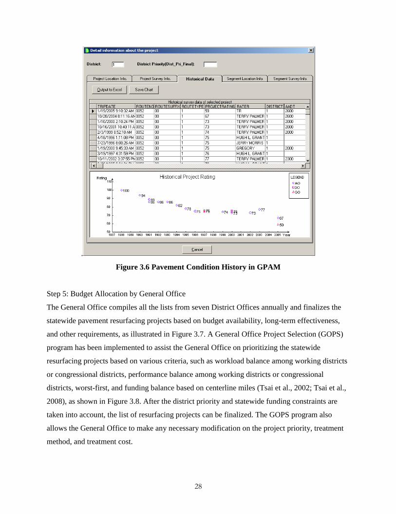
Figure 3.6 Pavement Condition History in GPAM
Step 5: Budget Allocation by General Office
The General Office compiles all the lists from seven District Offices annually and finalizes the
statewide pavement resurfacing projects based on budget availability, long-term effectiveness,
and other requirements, as illustrated in Figure 3.7. A General Office Project Selection (GOPS)
program has been implemented to assist the General Office on prioritizing the statewide
resurfacing projects based on various criteria, such as workload balance among working districts
or congressional districts, performance balance among working districts or congressional
districts, worst-first, and funding balance based on centerline miles (Tsai et al., 2002; Tsai et al.,
2008), as shown in Figure 3.8. After the district priority and statewide funding constraints are
taken into account, the list of resurfacing projects can be finalized. The GOPS program also
allows the General Office to make any necessary modification on the project priority, treatment
method, and treatment cost.

29
Figure 3.7 General Office Finalizes the Projects Based on Constraint
Figure 3.8 Statewide Funding Distribution and Project Selection Criteria
Step 6: Field Plan Review by Area Offices and District Offices
Once the General Office finalizes resurfacing program for the fiscal year, the District Offices are
advised to conduct field plan review for each resurfacing project in order to collect detailed

30
information to finalize the works and associated costs to be included in the let package. During
the field plan review, accident data may be obtained to determine if additional safety
improvements (e.g., rumble strips) can be included in the pavement resurfacing project. For
some projects, traffic operation engineers may provide recommendations on the safety
improvements.
Step 7: Let Package Preparation and Environmental Study
The General Office compiles all the data from the District Offices and formats all necessary
information, such as the environmental study if needed, into documents that are submitted to the
Office of Contract Bidding Administration to complete the package and let the contract.
Currently, a typical resurfacing project, including shoulder build, does not require an
environmental study, and an approval can be obtained within a few months. The let package is
usually prepared four months in advance of the scheduled letting of the project. The final
package includes cover sheet, index, location sketch, typical section, roadway log, detailed
estimate, general notes, erosion control plan, and construction details when applicable.
Step 8: Pavement Resurfacing Projects Letting
With the budget allocated and the let packages prepared, pavement resurfacing projects are put
out for bidding. The Office of Contract Bidding Administration advertises the project (usually
for one month) and the bids are opened to prequalified contractors. The project will be awarded
to the lowest reliable bidder whose proposal meets all the prescribed requirements.
3.3 Summary
GDOT’s resurfacing program is operated at a fast pace with limited funding to extend the
pavement life cost-effectively. With severe funding shortages in recent years, GDOT has
experienced an increasing number of deferred resurfacing projects. There is much concern that
pavement deficiencies, such as friction loss and raveling, in deferred projects could raise safety
concerns, including hydroplaning, skidding, and loss of control (Zimmerman and Larson, 2005),
and, consequently, put the general public at risk.

31
The decisions on GDOT’s pavement resurfacing projects, including treatment methods and
selection and prioritization of resurfacing projects, are mainly based on pavement conditions, i.e.,
the PACES rating. Although engineers have the flexibility to include certain safety
improvements and adjust a project's priority, the decision heavily relies on engineers’ judgments.
There is a need to develop a systematic approach within the resurfacing program to assist
engineers in addressing safety improvements throughout the decision-making process. Also, the
data to support safety concerns identification is not available in the pavement management
system (i.e., GPAM).
The “fast pace” characteristic of GDOT’s resurfacing program also makes it challenging to
incorporate safety improvements into the resurfacing program. A resurfacing project, which
typically does not require an environmental study under current regulations, can be programmed
(including the PACES survey, project selection, budget allocation, and let package preparation)
within a few months. Safety improvements, on the other hand, typically require an environmental
study that may take from a few months to 2 years depending on the type of safety improvement.
In summary, an enhanced, safety-incorporated resurfacing program is needed to assist the
engineers in effectively and systematically incorporating safety improvements into GDOT’s
current fast-paced resurfacing program without interfering the programming process.

32
4 GDOT’s Safety Improvement Program
This chapter presents a review of Georgia’s safety improvement program with a focus on the
program initiatives that address engineering solutions. First, a brief overview of Georgia’s
Strategic Highway Safety Plan (SHSP), including the goals, the key emphasis areas, and the
program initiatives, is presented. Second, the process adopted by the Office of Traffic Operations
for identifying site improvements and system-wide improvements is described.
4.1 Overview of Georgia’s Strategic Highway Safety Plan
Georgia’s SHSP, developed with the requirements of the Safe, Accountable Flexible and
Efficient Transportation Equity Act-A Legacy for Users (SAFETEA-LU), identifies the goals for
Georgia’s safety improvements, the key emphasis areas, and the implementation plan, which
encompasses the four "E" components, i.e., engineering, enforcement, education, and emergency
medical services to achieve its safety goals (GOHS, 2010).
Georgia’s SHSP goal of achieving zero deaths or injuries by reducing crash deaths by at least 4%
per year is based on the national safety goal of reducing highway fatalities by 1,000 per year,
which was set by the American Association of State Highway and Transportation Official
(AASHTO). Since Georgia fatalities contribute approximately 3.9 % to the national fatalities,
Georgia would need to reduce highway fatalities by 39 annually to help achieve the national
safety goal. The goal of reducing statewide fatalities by 4% is above the 39 fatality target, and
results in a goal of 41 fewer fatalities per year (GOHS, 2010). Due to the variation in yearly
statewide fatality numbers, safety programs will be evaluated using three-year averages.
To accomplish this goal, the Georgia’s SHSP (GOHS, 2010) identifies 10 highway safety
emphasis areas as follows:
Occupant Protection
Serious Crash Type

33
Aggressive Driving/Super Speeder
Impaired Driver
Age related issues
Non-motorized User
Vehicle Type
Trauma System/Increasing EMS Capabilities
Traffic/Crash Records and Data Analysis
Traffic Incident Management
Program initiatives developed by GDOT to address serious crash types through engineering
solutions are as follows (GDOT, 2005):
Preventing vehicle roadway departures
o Shoulder rumble strips
o Centerline rumble strips
Minimizing consequences of leaving the road
o Crash impact attenuators
o Cable barrier systems
Improve design and operation of intersections
o Implement the “Intersection Safety Action Plan”
o Traffic signal compliance
Pedestrian safety
o Pedestrian countdown timers program
o Mid-block crossing program
o Design accommodations at intersections
Reduce vehicle/train crashes
Off-system pilot office support and implementation
34
4.2 Process for Identifying Site and System-wide Improvements
To achieve the goal of reducing highway crash fatalities by 4% each year with limited funding,
GDOT has performed various safety studies to identify engineering solutions that can
cost-effectively reduce crashes as well as fatalities. The studies include the analyses of crash
trend (Washington et al., 2002; Dixon, 2005; Dixon et al., 2009), site selection methods (Alluri,
2008), strategies for improving work zone safety (Daniel et al., 1995; Wang et al., 2003), etc.
This section focuses on two basic types of safety studies performed by the Office of Traffic
Operations for identifying site improvements and system-wide improvements.
4.2.1 Site Improvement Study
A site improvement study is a traditional approach to identify, study, and select appropriate
safety improvements for the sites/locations with high crash rates (e.g., frequency) and/or
fatalities. Based on actual crash data, each year the Office of Traffic Operations generates a list
of intersections and sections of roadways, referred as the Top 150, that have a
higher-than-average number of vehicle crashes. The detailed steps for selecting site
improvements are shown in Figure 4.1, and each step is discussed as follows:

35
Figure 4.1 Process for Site Improvement
Step 1: High Crash Rate Sites Identification
The sites with safety improvement potential are identified in different ways. One of the common
ways is to analyze crash data to identify sites with a higher accident frequency and/or fatalities.
Each year, the Office of Traffic Operations generates a Top 150 Sections and Intersections
Report that ranks the sites with highest improvement potential (GDOT, 2006). The Top 150 list
is generated based on a rate quality-controlled method described in the report “Evaluation of
Criteria for Safety Improvements on the Highway” (Jorgensen, 1966). A statistical test is used to
determine if the crash rate at a particular site is abnormally high in comparison to the crash rate

36
of locations with similar roadway characteristics. Roadways are grouped by type and
characteristics (e.g., rural 2-lane roads) for a reasonable comparison. For example, interstates are
compared with interstates and four-lane urban roads are compared to other four-lane urban roads.
A review of GDOT’s Top 150 method is described in Appendix III. In addition to the Top 150,
the locations reported by citizens, elected officials, local governments, city and county engineers,
emergency agencies, and metropolitan planning organizations are also considered as candidate
sites.
Step 2: Field Evaluation by District Offices
The list of sites identified in Step 1 is distributed to the District Offices for a field evaluation,
which includes crash data analysis and a field survey to diagnose the nature of safety problems at
specific sites.
Step 3: Safety Improvements Recommendation
Proper action will be recommended based on the field evaluation and GDOT’s design guidelines.
According to the Plan Development Process (GDOT, 2000), “an action can be recommended
because of a positive impact on an existing safety problem, because of evidence that it will
prevent a hazardous condition, or because it may fall into one of several pre-approved
categories of improvements that are known to provide safety benefits.” Examples of the
pre-approved improvements include guardrail, traffic signals, railroad crossing warning devices,
and most intersection improvements. Currently, sites are being reviewed by consultants, in-house
engineers, and District Offices.
Step 4: Benefit-Cost Analysis
A benefit-cost analysis is performed for each site improvement project. For each candidate
project, the costs, including right-of-way (ROW), utilities, construction, and operations are
evaluated against the projected benefits from reduced property damages, injuries, and fatalities.
Crash reduction factors (CRF) provided by NCHRP are used in the analysis.
Step 5: Project Selection and Prioritization by District Offices
The projects are then prioritized based on the benefit-cost analysis.
37
Step 6: Budget Allocation
The Office of Traffic Operations allocates the budget based on factors such as benefit-cost ratio,
districts, and funding availability.
Step 7: Let Package Preparation and Environmental Study
The Office of Traffic Operations compiles all the data from the District Offices and formats the
information into documents submitted to the Office of Contract Bidding Administration, which
completes the package for letting the contract. The required formal approval, documentation, and
environmental study for each project follow the normal Plan Development Process. The time
needed for developing a safety improvement project varies significantly from a few months to 2
years, depending on the types of safety improvements. For example, lane widening and
realignment may require 8 to 24 months for the environmental study, while adding a left turn
lane can take 6 months.
Step 8: Safety Improvement Projects Letting
With the budget allocated and the let packages prepared, safety improvement projects are put out
to bid year round. The Office of Contract Bidding Administration will advertise the project
(usually for one month) and the bids are opened to prequalified contractors. The project will be
awarded to the lowest reliable bidder whose proposal meets all the prescribed requirements.
4.2.2 System-wide Safety Improvement Study
The system-wide safety improvement study provides a systematic approach to deploy low-cost
safety improvements at a larger number of locations with the potential for a certain types of
crashes. Figure 4.2 shows the detailed steps for identifying system-wide safety improvement
projects.

38
Figure 4.2 Process for System-wide Improvement
Step 1: High Fatality Crash Types Identification
The types of crashes with high fatalities in Georgia are first identified by analyzing crash data.
For example, in 2003, head-on and sideswipe opposite direction crashes represented 2% of the
total crashes, but accounted for 12% of the total number of fatalities statewide based on the crash
data. Thus, safety improvements that could prevent head-on and sideswipe opposite direction
could be implemented statewide.
Step 2: Safety Improvements Recommendation
Safety improvements are then recommended for selected high-fatality crash types based on the
national-level and/or GDOT’s studies.

39
Step 3: Budget Allocation
The budget is allocated for each safety improvement based on the damages, injuries, and
fatalities that can be reduced by adapting the safety improvement. Given the allocated budget,
the quantity (e.g., miles to treat) can be determined by dividing the allocated budget by the unit
cost of the safety improvement.
Step 4: Safety Improvement Locations Identification
The Office of Traffic Operation uses both roadway characteristics and crash data to identify the
locations that are suitable for the safety improvement. For example, two-lane roadways with a
lane width greater than 11 ft. and a shoulder greater than 4 ft. can be identified for centerline
rumble strips if head-on and sideswipe opposite direction crashes occur more often at the
location.
Step 5: Location Review by District Offices
The list of locations is distributed to the District Offices for review. The list is then finalized after
incorporating the District Offices’ inputs.
Step 6: Let Package Preparation and Environmental Study
The process and requirements for preparing a let package are the same as the site improvement
project described in Section 4.2.1. Again, the time needed for developing a project varies from a
few months to 2 years based on the types of safety improvements.
Step 7: Safety Improvement Projects Letting
See Section 4.2.1 for letting a project.
4.3 Summary
The safety program initiatives implemented by the Office of Traffic Operations are funded by
safety funds and developed based on GDOT’s normal Plan Development Process. Since safety
improvements are by their nature very time sensitive, it is common that they will follow a fast

40
track whenever possible. While most safety projects will be categorically exempt from federal air
quality requirements, they will also follow tracks that are appropriate to the types of the
improvements. For example, an improvement with a signing change, signal phasing change, or
pavement marking change requires little or no formal approval (e.g., environmental study),
documentation, or evaluation (other than a follow up to check the crash history). This type of
safety improvements can be implemented within a short period of time (within 4 months). Other
types of safety improvements, such as adding a turn lane and installing traffic signals, require an
environmental study and may take a long period of time (e.g., 12-24 months) to process before
being installed. While the safety program initiatives are implemented by the Office of Traffic
Operations, the benefits of incorporating safety into the resurfacing program are recognized by
both the Office of Traffic Operations and the Office of Maintenance. As indicated in the Safety
Action Plan (GDOT, 2005) and the interviews with the two offices, it is more effective in terms
of cost and operation to incorporate some safety improvements into the existing resurfacing
program. For example, the cost for centerline rumble strips is about $1,000 per centerline mile
when incorporated into a resurfacing project but is about $6,000 per centerline mile in a
stand-alone project. In addition, the traffic interruption to the general public can be reduced.

41
5 Proposed Safety-Incorporated Resurfacing Program
Georgia Tech research team has worked closely with GDOT’s Office of Maintenance and Office
of Traffic Operations to propose an enhanced resurfacing program that can systematically
incorporate safety improvements into GDOT’s existing fast-paced resurfacing program. This
chapter first presents an overview of the proposed safety-incorporated resurfacing program that
consists of three components, including safety improvements categorization, safety concerns and
roadway upgrade needs identification, and project reprioritization, followed by the detailed
description of each component.
5.1 Overview
A safety-incorporated resurfacing program is proposed in this study for GDOT to 1) identify
deferred or upcoming resurfacing projects with safety concerns or roadway upgrade needs, 2)
reprioritize these projects to minimize potential safety risks, and 3) seamlessly incorporate safety
improvements into its existing fast-paced resurfacing program. The proposed safety-incorporated
resurfacing program consists of the following three major components:
1) Safety improvements categorization:
All safety improvements are divided into three categories based on the integration efforts
needed for incorporating them into the resurfacing program.
2) Identification of safety concerns and roadway upgrade needs:
A two-stage approach, including an in-house computerized search and a field evaluation,
is proposed to systematically identify potential safety concerns and roadway upgrade
needs in deferred and upcoming resurfacing projects.
3) Project reprioritization:
A project reprioritization method, using a modified PACES rating that takes into account
safety concerns, is proposed to prioritize resurfacing projects to minimize potential safety
risks.

42
Figure 5.1 Overview of the Proposed Safety-Incorporated Resurfacing Program
5.2 Safety Improvements Categorization
Different safety improvements, such as rumble strips installation, guardrail delineation, traffic
sign installation, lane/shoulder widening, etc., may require different implementation times and
efforts. While some safety improvements, such as rumble strips and pavement raised markers,

43
can be installed during or right after the resurfacing, other safety improvements, such as lane
widening, shoulder widening, etc., may take a longer time due to planning, environmental study,
and/or right-of-way acquisition. Therefore, to systematically incorporate safety improvements
into the fast-paced pavement resurfacing program, safety improvements are divided into three
categories based on the integration efforts in terms of duration, funding sources, and office
coordination. Here, duration refers to the time required for GDOT to get approval (if needed) and
implement or install the safety improvements; funding sources indicate the primary source(s) of
budget for the installation of safety improvements; office coordination includes the required
collaboration and coordination among various offices.
Three categories, including 1) resurfacing, 2) safety improvements requiring no environmental
studies, and 3) safety improvements requiring environmental studies are discussed in the
following subsections. The objective of this categorization is to make the integration of safety
into the pavement resurfacing program practically feasible.
5.2.1 Category 1: Resurfacing
This category actually requires no safety improvement installations. The safety concerns in this
category include hydroplaning, skidding, and loss of control, which are caused by pavement
deficiencies (e.g., deep rutting, frictionless surface, etc.) and can be addressed directly by
resurfacing. In other words, the pavement resurfacing itself is the safety improvement. This
category typically requires less integration effort because it follows the typical process for
developing a resurfacing project and is funded and operated solely by the Office of Maintenance.
This category is the highest priority to be incorporated into GDOT’s existing fast-paced
resurfacing program.
5.2.2 Category 2: Safety Improvements Requiring No Environmental Studies
This category focuses on safety improvements that require no environmental studies. In other
words, the installation of this category of safety improvements does not require additional
environmental approval and can be done during or right after the resurfacing. Moreover, the

44
additional costs for improvements in this category are usually not significant compared to the
typical resurfacing costs; thus, they can be funded and operated by one or two offices (e.g.,
Office of Maintenance and/or Office of Traffic Operations). Therefore, it is feasible to
incorporate safety improvements in this category into GDOT’s fast-paced resurfacing program
without major interference to its current practices. Safety improvements in this category include
but are not limited to the following:
Centerline rumble strips/stripes;
Shoulder rumble strips/stripes;
Shoulder builds;
Cross-slope adjustments;
Superelevation adjustments;
Installation of guardrails (may require additional funding );
Installation of median barriers (may require additional funding).
In addition, incorporating safety improvements in this category into the current pavement
resurfacing program may provide an opportunity to systematically and cost-effectively upgrade
the roadway system to meet enhanced safety standards. As the roadway system is resurfaced
approximately in a 10-year cycle, these safety improvements, such as centerline rumble strips,
can be implemented to upgrade Georgia’s roadway system within the same cycle. Safety
improvements in this category may be funded by the Office of Maintenance through a designated
percentage of the pavement preservation funds; additional funds may also be set aside by GDOT
to leverage the safety-incorporated, fast-paced resurfacing program.
5.2.3 Category 3: Safety Improvements Requiring Environmental Studies
Safety improvements in this category require an environmental study, and, therefore, a longer
time is needed for programming the project. The time required for the environmental study
usually depends on the type of safety improvements, but it is often longer than 6 months. For
45
example, lane widening and realignment that require additional right of way may need 24
months for the environmental study.
Moreover, as mentioned in the literature, safety improvements in this category are often funded
by highway safety funds, whereas resurfacing projects are funded by pavement preservation
funds; therefore, the integration of multiple funding sources is needed to incorporate safety
improvements in this category into the resurfacing program. More coordination among GDOT’s
offices (i.e., the Office of Maintenance, the Office of Traffic Operations, the Office of Roadway
Design, the Office of Environmental Services, and others) is required to incorporate safety into
the resurfacing program at the design stage. The safety improvements in this category include:
Lane widening;
Shoulder widening;
Lane addition (turn lanes, accelerate/decelerate lanes, heavy vehicle climb lanes);
Major sight distance adjustments (vegetation clearing, object removal from clear zone,
etc.);
Horizontal alignment improvement;
Vertical alignment improvement;
Signal addition; and
Others.
5.3 Identification of Safety Concerns and Roadway Upgrade Needs
A two-stage approach has been proposed to systematically identify the need for Category 1 and
Category 2 safety improvements mentioned previously. This approach can address
pavement-deficiency-induced safety concerns and upgrade the roadways to meet enhanced safety
standards. The two stages are 1) an in-house computerized search based on pavement conditions
(e.g., distress type, severity), roadway characteristics (e.g., straight road, curved road) and crash
history (e.g., type, frequency, and severity of crashes), and 2) a field evaluation to confirm the
safety concerns and roadway upgrade needs. The two-stage approach is discussed in the
following subsections.

46
5.3.1 Identification of Safety Concerns
A two-stage safety concerns identification, as depicted in Figure 5.2, is proposed to
systematically identify the pavement-deficiency-induced safety concerns. The two stages, as
mentioned previously, are 1) an in-house computerized search based on pavement condition,
roadway characteristics, and crash history, and 2) a field evaluation to confirm the safety
concerns.
Figure 5.2 Two-Stage Safety Concerns Identification

47
Both deferred resurfacing projects and upcoming projects with the PACES rating less than or
equal to 80 are considered in the safety concerns identification process. First, a computerized
search is performed for each project at a segment level to identify specific sites with safety
concerns. To be consistent with the PACES survey, the computerized search is based on a 1-mile
segment except the beginning or end segment in the project.
Ten safety factors, including accident rate, fatality rate, injury rate, wet pavement accident
percentage, number of road defect in accident reports, roadway characteristics, PACES segment
rating, difference between project and segment rating, rut depth, and number of potholes/patches,
are searched in the GPAM and crash database for each segment. These factors are identified as
potential indicators that may lead to pavement-deficiency-induced safety concerns through
discussion with the Office of Maintenance and the Office of Traffic Operations. The factors are
categorized and given different weighted values based on the level of safety concerns, as shown
in Table 5.1. Each segment will be given 10 weighted values for the ten factors, and
one-hundredth of the sum of the 10 weighted values is defined as the safety index for the
segment. The safety index is on a scale of 0 to 1, with 1 representing the highest level of safety
concerns. The segment with the highest safety index in a project is then assigned as the initial
safety index for the project. A project that has an initial safety index greater than or equal to 0.5
is recommend for a field safety evaluation, i.e., the second stage of safety concerns identification.
Note that the proposed weighted values in Table 5.1 are preliminary results based on the
discussion with GDOT and a review of safety countermeasure installation policies (Russell and
Rys, 2005). These values (including factor, category and weighted values) may be further refined
by the Office of Traffic Operations based on statistical analyses of different road types (e.g.,
functional classes) in Phase 2.

48
Table 5.1 Safety Factors and Weighted Values
The safety concerns identified through the computerized search in the first stage will be confirmed
through a field evaluation if the initial safety index of the project is greater than or equal to 0.5. In
order to align the proposed program with the existing resurfacing program, the field evaluation
will be conducted by the District Offices and the General Office during their PACES survey.
Moreover, to assist in the field evaluation, a report consisting of the location information,
pavement conditions, crash history, roadway characteristics, and the initial safety index, as shown
in Figure 5.3, will be generated for projects identified with safety concerns. After the field
evaluation, GDOT’s engineers will confirm the level of safety concern by assigning a final safety
index to the project. The final safety index is categorized into four safety concern levels including
no concern (safety index = 0), low concern (safety index = 0.25), median concern (safety index =

49
0.5), or high concern (safety index = 1). This final safety index will be used to reprioritize the
resurfacing projects (see Section 5.4).
Figure 5.3 Report to Support Field Safety Evaluation
(Image Sources: Google Maps)

50
Figure 5.3 Report to Support Field Safety Evaluation (Cont’d)
5.3.2 Identification of Roadway Upgrade Needs
Figure 5.4 shows a two-stage approach proposed to identify the need for Category 2 safety
improvements in order to upgrade roadways to meet enhanced safety standards (e.g., edge line
rumble strips and guardrails). Again, the first stage is the in-house computerized search, and the
second stage is the field evaluation. Resurfacing project candidates will be evaluated, along with
crash data and roadway characteristics, and a field evaluation will be conducted if the criteria are
met in the first stage.

51
Figure 5.4 Two-Stage Roadway Upgrade Needs Identification
After discussion with the Office of Traffic Operations, certain roadway upgrade needs, such as
edge line rumble strips, identified through the system-wide study can be incorporated into the
resurfacing program. Table 5.2 shows the safety improvements that are included in Category 2
and the criteria for implementing/installing them. Again, the criteria may be refined by the Office
of Traffic Operations in Phase 2 based on statistical analysis of historical crash data. Among
those safety improvements listed in Table 5.2, edge line rumble strips installation is suggested as
the first safety improvement to be incorporated into the resurfacing program because it is one of
the top priority safety program initiatives identified by the Office of Traffic Operations to
mitigate Georgia's run-off-the-road accidents.

52
Table 5.2 Category 2 Safety Improvements
Safety Improvement Proposed Roadway Condition Proposed Crash Criteria
Shoulder Rumble Strips >= 4 ft. shoulder with adequate
pavement structure
10 crash per year
50% single vehicle run
off road
Centerline Rumble Strips 2-lane roadway
>=11 ft. lane width
>= 2 ft. paved outside shoulder
10 crash per year
40% head on and
opposite direction
sideswipe
Edge Line Rumble Strips 2-lane roadway
>=11 ft. lane width
< ft. paved outside shoulder
10 crash per year
50% single vehicle run
off road
Cable Barrier Systems
(3-cable system)
Limited access
<=40 ft. unprotected median
Crossover crash
Guardrail Delineation All state-maintained roads
Raised Pavement Marker All state-maintained roads
Sign Review manually
For the projects that meet the criteria in Table 5.2, a field evaluation will be conducted. This
process is similar to the pavement-deficiency-induced safety concerns identification. Again, a
report with crash history, pavement condition, and roadway characteristics will be provided to
GDOT’s engineers during the field evaluation. A final safety index (1, 0.5, 0.25, or 0) will also
be assigned by GDOT’s engineers for project reprioritization (see Section 5.4).
5.4 Project Reprioritization
In order to align with GDOT’s current resurfacing prioritization method, which is based on the
PACES rating, the final safety index is incorporated into the PACES rating to generate a
modified PACES rating, as shown in Figure 5.5. The modified PACES rating that takes into
account safety will be used for reprioritizing resurfacing projects. The design is to advance the
deferred resurfacing projects and upcoming projects with safety concerns or roadway upgrade
needs to minimize potential safety risks.

53
Figure 5.5 Project Reprioritization Method
Two alternatives for the modified PACES rating are proposed as follows:
Alternative A:
As shown in Equation 1, the modified PACES rating is computed by deducting a portion of the
original PACES rating to address safety concerns. The deducted portion is defined using the final
safety index and a weighting factor, a.
Modified PACES Rating = PACES Rating – a × (Safety Index × PACES Rating) (1)
where
a: a weighting factor to address safety concern in the PACES rating.
PACES Rating: a rating (0-100) represents the overall pavement condition.
Safety Index: the final safety index (i.e., 1, 0.5, 0.25, or 0).
The weighting factor a can be back-calculated and further adjusted by GDOT under the
consideration of the current PACES rating and the expected rating, which will take safety into
account. Currently, the weighting factor is set as 0.22 to bring a PACES rating of 90 down to 70
for the project with high safety concerns or urgent needs for roadway upgrade (i.e., with the final
safety index equals to 1). In addition, the above equation is designed to give a lower PACES
rating to reprioritize a project to a higher priority in the resurfacing list when the safety concern
is high. Take a project with an original PACES rating of 80, for example; the modified PACES
ratings with respect to the four final safety indices, i.e., 1, 0.5, 0.25, and 0, are 62, 71, 76, and 80,
respectively.

54
Alternative B:
Similar to Alternative A, Equation 2 is proposed to compute the modified PACES rating. The
modified PACES rating is computed using the original PACES rating divided by the safety index
plus one. For example, for a high safety concern project (i.e., the final safety index is 1), the
modified PACES rating will be only half of the original PACES rating based on this equation.
Modified PACES Rating = PACES Rating / (1+Safety Index) (2)
where
PACES Rating: a rating (0-100) represents the overall pavement condition.
Safety Index: the final safety index (e.g., 1, 0.5, 0.25, or 0).
After the discussion with the Office of Maintenance, Alternative A was selected for
implementation since the weighting factor, a, can be adjusted and determined by GDOT based
on the back-calculation given the pre-specified condition. Also, the formulation of Alternative A
can be easily extended to include other impact factors, such as traffic, population, economics,
and environmental impacts.
5.5 A Safety-Incorporated Resurfacing Program for GDOT
An enhanced, safety-incorporated pavement resurfacing program is proposed to systematically
integrate the aforementioned components into GDOT's existing fast-paced pavement resurfacing
program. The new operation procedure is shown in Figure 5.6, and the modified steps (in gray
color) are described below.

55
Figure 5.6 Safety-Incorporated Resurfacing Program for GDOT
Step 1: Annual Training
As described in Chapter 3, the Office of Maintenance conducts the PACES training for all
participating engineers before the annual PACES survey. A roadway safety evaluation training is
proposed to be included in the annual PACES training.
Step 3-1: Computerized Search by District Offices
The two-stage safety concerns and roadway upgrade needs identification approach is
incorporated into the PACES survey conducted by the District Offices and the General Office.

56
The District Offices conduct in-office computerized search to identify potential
pavement-deficiency-induced safety concerns and roadway upgrade need in deferred and
upcoming (e.g., a rating of PACES rating <=80) resurfacing projects, and further determine the
initial safety index to represent the safety concern level. A report covering the initial safety index,
pavement condition, crash history, and roadway characteristics is generated for any project that
meets the safety concerns or roadway upgrade needs criteria.
Step 3-2: Field Evaluation by District Offices and General Office
The projects identified as with safety concerns or roadway upgrade needs in Step 3-1are further
evaluated in the field by the District Offices and the General Office. The field evaluation
includes the pavement condition evaluation (i.e., PACES), as well as the proposed safety
evaluation. The District Offices will categorize the safety concern into four levels (i.e., high,
median, low, and no concern) and determine the final safety index (i.e., 1, 0.5, 0.25, and 0,
respectively). The safety index is used as the basis for the project reprioritization in the next step.
The safety data (e.g., safety index) collected during the field evaluation will be stored in the
database along with the pavement condition data for reprioritizing projects and tracking safety
concerns.
Step 4: Project Prioritization and Selection by District Offices
Instead of using the PACES rating solely based on pavement conditions, the District Offices will
use the modified PACES rating to select and prioritize resurfacing projects. This modified
PACES rating is computed using the safety index assigned by the District Offices in Step 3-2 to
give a higher priority (e.g., lower modified PACES rating) to projects with safety concerns.
Again, the District Offices can make final decisions on the treatment methods and the priority
based on their experience and understanding of the project.

57
6 Case Study
This chapter presents a case study conducted using the actual data of a deferred resurfacing project
to demonstrate the feasibility of the proposed program. This case study focuses on using the
proposed program to identify the safety concerns and assessing the feasibility of the project
reprioritization results. First, project information, such as the data used in this case study, is
introduced. Second, the two-stage safety concerns identification process, including computerized
search and field evaluation, is presented. Finally, the computation of the modified PACES rating
and the discussion over possible reprioritization results are presented.
6.1 Project Description
A deferred resurfacing project located on State Route 20 from the Bartow County line to Canton
Road Spur (i.e., Milepost 0 to 9.4) in Cherokee County, Georgia was selected for this case study. It
was a 3-lane rural highway project. According to GDOT’s current resurfacing project selection
criterion, i.e., a project is recommended for resurfacing if its PACES rating is 70 or below, this
project was qualified for a resurfacing treatment in 2007. However, it was not scheduled for
resurfacing until 2010 due to the funding shortage.
The data necessary to support the case study includes historical pavement condition data from the
GPAM database and historical crash data from the crash database. The GPAM database stores
pavement condition data collected through annual PACES survey, including segment-level
PACES rating project-level PACES rating, and detailed pavement distresses (e.g., type, severity
level, extent, etc.). The crash database stores crash report information including time, date,
weather conditions, pavement surface conditions, crash types, number of fatalities, number of
injuries, driver information, etc. Four consecutive years (2005 to 2008) of pavement condition data
in the GPAM database and associated crash data were used to demonstrate the ability of the
proposed program to reprioritize projects with safety concerns, and move the project with safety
concern to a higher priority for a timely treatment. Since the number of crashes may vary
58
excessively from year to year, crash data was compiled on a 3-year basis to attenuate possible
extreme cases. For example, the crash data compiled for year 2005 in fact covers the crash history
data in 2003, 2004, and 2005. In other words, a total of 6 years (i.e., 2003 to 2008) of crash history
data were used to support the analysis from 2005 to 2008.
6.2 Identification of Safety Concerns
According to the proposed program, project safety concerns are identified through a two-stage
approach: the computerized search stage and the field evaluation stage. This section presents the
detailed steps for identifying safety concerns using actual data.
6.2.1 Computerized Search
First, ten safety factors, including accident rate, fatality rate, injury rate, wet pavement accident
percentage, number of road defects in accident reports, roadway characteristics, PACES segment
rating, difference between project and segment rating, rut depth, and number of potholes/patches,
are extracted from different databases for each segment in the project. There are a total of 10
segments in this 9.4-mile project. Table 6.1 presents the values of these safety factors and their
corresponding weighted values determined based on the criteria in Table 5.1. For example, the
PACES rating for Segment 1 in 2005 was 76 and the corresponding weighted value was 1, as
shown in Table 6.1. For each segment, a safety index is computed as one hundredth of the sum of
the ten weighted values, and the highest segment safety index within the project is assigned as the
initial project safety index, as depicted in Table 6.2. For example, segment safety indexes in 2005
range from 0.06 (Segment 10) to 0.41 (Segment 4). Therefore, the initial project safety index is
assigned to 0.41 (the highest value).

59
Table 6.1 Safety Factors and Weighted Values

60
Table 6.2 Initial Safety Index Results
Segment Segment Safety Index
2005 2006 2007 2008
1 0.27 0.17 0.19 0.23
2 0.14 0.17 0.21 0.21
3 0.18 0.24 0.33 0.32
4 0.41 0.48 0.61 0.77
5 0.24 0.38 0.61 0.70
6 0.16 0.21 0.21 0.21
7 0.32 0.52 0.53 0.38
8 0.15 0.19 0.21 0.23
9 0.24 0.19 0.24 0.16
10 0.06 0.04 0.08 0.07
Initial Project Safety Index 0.41 0.52 0.61 0.77
6.2.2 Field Evaluation
According to the proposed program in Chapter 5, the field evaluation is needed for a project with
an initial safety index equal to or greater than 0.5. Based on the results shown in Table 6.2, a field
evaluation is required for three years from 2006 to 2008. A report including the information from
the computerized search (e.g., safety index and crash data summary for each segment) will be
provided to GDOT’s engineers to assist the field evaluation. A final safety index will be assigned
to the project by GDOT’s engineers after evaluating the field conditions. The final safety index
indicates the level of safety concern of the project. Projects with higher safety concerns (i.e.,
higher safety index) should be given a higher priority for resurfacing than other projects. For this
case study, however, since the actual field conditions of the past years cannot be observed and
evaluated, all four possible values of the final safety index, i.e., 1, 0.5, 0.25, and 0, are considered
and discussed in the following section.
6.3 Project Reprioritization
Based on the proposed program, a modified PACES rating is computed to reprioritize the projects
with safety concerns. This section first presents the computation of the modified PACES ratings
through the analysis period (2005 to 2008), followed by a discussion on the reprioritization results.

61
6.3.1 Modified PACES Rating
As proposed in Chapter 5, the modified PACES rating can be computed by deducting a portion of
the original PACES rating to address safety concerns; the deducted portion is defined using the
final safety index and a weighting factor, a, as shown in Equation 1 in Section 5.4.
The weighting factor a, which can be further adjusted by GDOT, as described previously in
Chapter 5, is set as 0.22 in order to bring the PACES rating of a project with high safety concerns
(i.e., safety index equals 1) from 90 to 70. The modified PACES ratings computed using different
values of the final safety index of this project are shown in Table 6.3.
Table 6.3 Modified PACES Ratings
Year 2005 2006 2007 2008
Original Project PACES Rating (SI=0.00) 76 74 68 67
Modified PACES Rating (SI=0.25) N/A 70 64 63
Modified PACES Rating (SI=0.50) N/A 66 61 61
Modified PACES Rating (SI=1.00) N/A 59 55 54
6.3.2 Discussion
Table 6.3 shows that the project could have been recommended for resurfacing in 2006 if there was
any safety concern. The modified PACES rating of this project would be 70 (which warrants a
resurfacing based on GDOT’s criteria) if there was low safety concern (safety index =0.25). If the
safety concern was high (i.e. safety index =1), the modified PACES rating would drop to 59, and,
therefore, a higher priority for resurfacing would be given to this project.
The proposed program has demonstrated its capability to reprioritize projects so that the projects
with higher safety concerns can have a higher priority for resurfacing. After discussion with
GDOT, a safety index of 1 is most likely to be assigned to this project given the crash history and
the wear-out on the pavement surface. This would result in a timely resurfacing in 2006, and the
potential safety risks of this project could be reduced.

62
7 Design for the Proposed Safety-Incorporated Resurfacing
Program
To facilitate the proposed safety-incorporated resurfacing program presented in Chapter 5,
various tools/applications are needed to provide GDOT’s engineers the abilities to conduct
computerized search, generate reports, record the field evaluation, compute the modified PACES
rating, and reprioritize projects. This chapter presents the design, including functions, use cases,
and databases, for these tools/applications to support the development and implementation of the
proposed program in Phase2.
7.1 Functional Design
The use cases necessary to support each step in the proposed safety-incorporated resurfacing
program are presented in Figure 7.1. The five use cases are to report user-specified safety
concerns, identify safety concerns and roadway upgrade needs, generate a report
summarizing the pavement conditions and crash history, record the field evaluation, and
reprioritize resurfacing projects based on both pavement conditions and safety concerns. The
process and data flow between different offices are depicted in Figure 7.2, and the use case
diagram is presented in Figure 7.3. The use cases are discussed in the subsequent section.

63
Figure 7.1 Use Cases for the Proposed Procedure

64
Figure 7.2 Process and Data Flow of the Proposed Safety-Incorporated Resurfacing
Program
Figure 7.3 Use Case Diagram

65
7.2 Use Cases
This section presents the design for each of the use cases identified in the previous section in
order to support the development and implementation of the proposed safety-incorporated safety
program.
Report User-Specified Safety Concerns
A function to allow the Area Offices to report the projects with safety concerns that are reported
by local governments, city and county engineers, local agencies, etc., is proposed. This function
will reside in the COPACES module in the GPAM; the use case is shown in Table 7.1.
Table 7.1 Use Case 1 – Report User-specified Safety Concerns
Use Case
Element
Description
Use Case
Number
1
Name Report User-specified Safety Concerns
Description This use case deals with entering the user-specific safety concerns that
were reported by local engineers, emergency agencies, etc.
Primary Actor Area Offices
Precondition Area Offices complete the PACES survey.
Trigger Transmittals requesting work on entering the data collected during the
PACES survey received from Area Offices.
Basic Flow 1) Area Offices accept the report for safety concerns.
2) Query pavement condition evaluation data for a specific location
based on county, route type, route number, route suffix, and
milepost.
3) Add the safety concerns to these projects if no concern is identified
by the program.
4) Assign a safety impact factor to the projects.
Input Sources Pavement condition data
Output Sources Modify database to store user-specified safety concerns.
Identify Safety Concerns and Roadway Upgrade Needs
A function is needed to identify the projects with safety concerns and/or roadway upgrade needs.
A computerized search is conducted based on integrated data, including the history and current
pavement condition data, roadway characteristics data, and crash history to identify locations

66
with potential safety concerns or roadway upgrade needs. This function will reside in the
COPACES module in the GPAM, and is only accessible to the District Offices and the General
Office. The use case, including the description, basic flow, input, and output, is shown in Table
7.2.
Table 7.2 Use Case 2 – Identify Safety Concerns and Roadway Upgrade Needs
Use Case
Element
Description
Use Case
Number
2
Name Identify Safety Concerns and Roadway Upgrade Needs
Description This use case deals with identification of safety concerns and/or
roadway upgrade needs using pavement condition data, road
characteristic data, and crash data
Primary Actor District Offices and General Offices
Precondition Area Offices submit the PACES survey to the GPAM
Trigger Transmittals requesting work on downloading the PACES survey by
the Area Offices received from District Offices or General Office.
Basic Flow 1) Query current year pavement condition data, crash history data, and
roadway characteristics data for the locations with potential safety
concerns and roadway upgrade needs based on the criteria discussed
in Chapter 5.
2) A safety index will be computed based on the pre-defined rules to
quantitatively represent the safety concern at the locations.
3) District Offices and General Office review the projects and add
notes for known safety concerns.
Input Sources Pavement condition data, road characteristic data, and crash data
Output Sources Modify database to store the results of computerized search and the
safety index.
Generate a Field Evaluation Report
A function will be developed to generate a report for each project with safety concerns and/or
roadway upgrade needs that requires a field evaluation by District and General Offices. This
function will be used by the District Offices to generate the report before conducting a field survey.
The function will reside in the COPACES module in the GPAM, and is only accessible to the
District Offices.
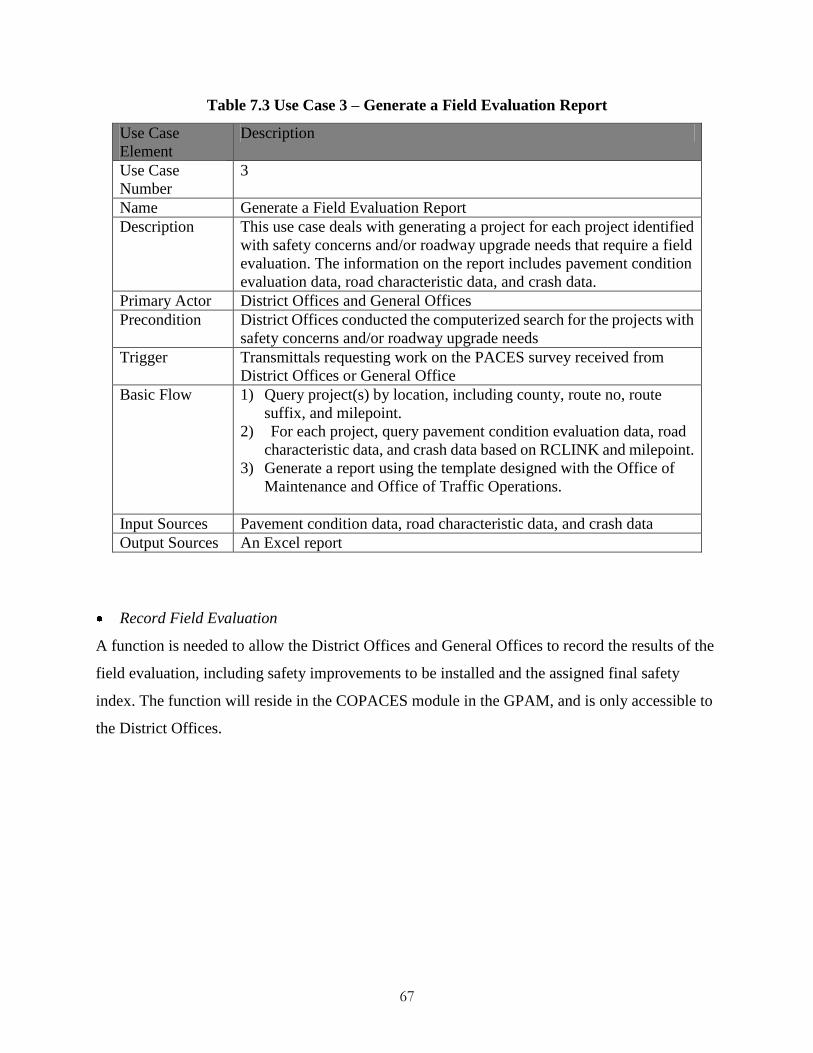
67
Table 7.3 Use Case 3 – Generate a Field Evaluation Report
Use Case
Element
Description
Use Case
Number
3
Name Generate a Field Evaluation Report
Description This use case deals with generating a project for each project identified
with safety concerns and/or roadway upgrade needs that require a field
evaluation. The information on the report includes pavement condition
evaluation data, road characteristic data, and crash data.
Primary Actor District Offices and General Offices
Precondition District Offices conducted the computerized search for the projects with
safety concerns and/or roadway upgrade needs
Trigger Transmittals requesting work on the PACES survey received from
District Offices or General Office
Basic Flow 1) Query project(s) by location, including county, route no, route
suffix, and milepoint.
2) For each project, query pavement condition evaluation data, road
characteristic data, and crash data based on RCLINK and milepoint.
3) Generate a report using the template designed with the Office of
Maintenance and Office of Traffic Operations.
Input Sources Pavement condition data, road characteristic data, and crash data
Output Sources An Excel report
Record Field Evaluation
A function is needed to allow the District Offices and General Offices to record the results of the
field evaluation, including safety improvements to be installed and the assigned final safety
index. The function will reside in the COPACES module in the GPAM, and is only accessible to
the District Offices.

68
Table 7.4 Use Case 4 – Record Field Evaluation
Use Case
Element
Description
Use Case
Number
4
Name Record Field Evaluation
Description This use case deals with recording the field evaluation, including the
assigned final safety index and the safety improvements to be
incorporated into a specific project. The information on the report
includes pavement condition evaluation data, road characteristic data,
and crash data.
Primary Actor District Offices and General Office
Precondition District Offices and General Office conducted field evaluation and
entered the PACES survey.
Trigger Transmittals requesting work on entering the PACES survey received
from District Offices and General Office.
Basic Flow 1) Query pavement condition evaluation data, road characteristic data,
and crash data to generate a report for each project.
2) Record the result of field evaluation, including final safety index
and the confirmation of the safety improvements to be included in
the resurfacing project.
3) Compute the modified PACES rating using the final safety index.
4) The user is allowed to edit, delete, and save the field evaluation
result.
Input Sources Pavement condition data
Output Sources Modify database to store the information gathered during the field
evaluation.
Reprioritize Projects
A function is needed to reprioritize the resurfacing projects based on the modified PACES rating
in order to take into account both pavement conditions and safety concerns. This function will
reside in the District Office Project Selection (DPS) and the Generate Office Project Selection
(GOPS) module in the GPAM.

69
Table 7.5 Use Case 5 – Reprioritize Projects
Use Case
Element
Description
Use Case
Number
5
Name Reprioritize Projects
Description This use case deals with reprioritizing resurfacing projects to
incorporate the safety concerns.
Primary Actor District Offices and General Office
Precondition District Offices complete recording the field evaluation, including the
safety index.
Trigger Transmittals requesting work on reprioritizing projects received from
District Offices or General Office.
Basic Flow 1) Compute the modified PACES rating based on the method proposed
in Chapter 5.
2) Users specify the prioritization criteria.
3) Reprioritize the resurfacing projects based on user-specified
criteria.
Input Sources Pavement condition data
Output Sources Modify database to store the priority for each project.
7.3 Databases
This chapter presents the identification of data integration required to support the necessary
analyses, including the identification of the projects with pavement-deficiency-induced safety
concerns and/or roadway upgrade needs, a recommendation for certain types of safety
improvements, and the computation of the modified PACES rating. Some data items that might
contribute to a roadway crash are the following:
Roadway Characteristics
Horizontal alignment, i.e., curvature
Slope and gradient
Pavement type and width
Shoulder type and width
Pavement Conditions
Pavement cracking
Pavement roughness

70
Pavement skid resistance
Traffic Management
Traffic counts
Traffic signs
Pavement markings
Signalization
Environments
Sight distance (stopping sight distance, intersection sight distance, etc.)
Artificial objects (pole, tree, guardrail, etc.)
Weather
The data listed above are collected and managed by different offices, including road inventory data
in the RC database maintained by the Office of Transportation Data, pavement condition data in
the GPAM database maintained by the Office of Maintenance, and crash data in the crash database
maintained by the Office of Traffic Operations. A location referencing system is first defined to
integrate the data across different databases, and the tables to be integrated are identified.
Linear Referencing System
GDOT uses a linear referencing system consisting of a unique RCLINK and milepoint. Each
section of roadway is associated with a RCLINK, which is a ten-digit code comprised of county
code, route type, route number, and route suffix. Both point and linear feature can be represented
using the RCLINK and milepoint. This linear referencing system will be used for integrating the
data from different sources.
GPAM Database
The GPAM database contains the pavement condition evaluation data, including PACES rating,
rutting, load cracking, etc. Each record in the GPAM database is location referenced using the
RCLINK and milepoint. The proposed database includes four tables in the GPAM database, as
shown in Table 7.6, that are essential for determining and predicting pavement conditions. The
location referencing information is stored in tblProjectLocatInfo (including county code, route

71
type, route number, route suffix, and milepoint from and to). The four tables are linked through
Tripdate and Routeno.
Table 7.6 GPAM Database

72
Road Characteristics (RC) Database
Maintained and updated by the Office of Transportation Data, GDOT’s RC database contains
rich information regarding to the roadway characteristics and condition (GDOT, 2009). More
than 50 features, such as functional classes, pavement widths, speed limits, signalization
information, etc., are stored in the database, and each record is location-referenced through
RCLINK and milepoint (BEG_MEASURE and END_MEASURE), which represent a specific
roadway segment. The RC database, as show in Table 7.7, is necessary for the implementation of
the proposed program and is included in the proposed database.
.
Table 7.7 RC Database
Field Name Abbreviated Field Name Directional Attribute
COUNTY COUNTY NO
ROUTE_TYPE ROUTE_TYPE NO
ROUTE_NUM ROUTE_NUM NO
BEG_MEASURE BEG_MEASURE NO
END_MEASURE END_MEASURE NO
SECTION_LENGTH LENGTH NO
DESCRIPTION DESCRIPTION NO
DISTRICT DISTRICT NO
MAINT_AREA MAINT_AREA NO
POPULATION POPULATION NO
INVENTORY_DATE INV_DATE NO
DESIGNATED_WAY DESIG_WAY NO
TRUCK_ROUTE TRK_ROUTE NO
TRAVEL_WAY TRVEL_WAY NO
RURAL_URAN RURL_URAN NO
SPEED_LIMIT SEEPD_LMT NO
FAS_NUM FAS_NUM NO
TRUCK_ROUTE_ID TRK_RTE_ID NO
CONGRESS_DIST CONG_DIST NO
STATE_ROUTE_SEQ SR_SEQ NO
ACCESS_CONTROL ACCES_CTRL NO
OPERATION OPERATION NO
TOTAL_LANES TOTAL_LANES NO
SPECIAL_CLASS SPEC_CLASS NO
DIV_HWY_SHLDR_WIDTH_LFT DHWSDWDLF YES (Opposite Inventory Dir)
DIV_HWY_SHLDR_TYPE_LFT DHWSDTPLF YES (Opposite Inventory Dir)
DIV_HWY_SURF_WIDTH DHWSUFWD YES (Opposite Inventory Dir)
DIV_HWY_SURF_TYPE DHWSUFTP YES (Opposite Inventory Dir)
DIV_HWY_SHLDR_WIDTH_RT DHWSDWDRT YES (Opposite Inventory Dir)
DIV_HWY_SHLDR_TYPE_RT DHWSDTPRT YES (Opposite Inventory Dir)

73
Field Name Abbreviated Field Name Directional Attribute
DIV_HWY_MEDIAN_WIDTH DHWMDWD NO
DIV_HWY_MEDIAN_TYPE DHWMDTP NO
DIV_HWY_BARRIER_TYPE DHWBARTP NO
UDIV_HWY_SHLDR_WIDTH_LFT UDHWSDWDLF YES (Inventory Dir)
UDIV_HWY_SHLDR_TYPE_LFT UDHWSDTPLF YES (Inventory Dir)
UDIV_HWY_SURFACE_WIDTH UDHWSUFWD YES (Inventory Dir)
UDIV_HWY_SURFACE_TYPE UDHWSUFTP YES (Inventory Dir)
UDIV_HWY_SHLDR_WIDTH_RT UDHWSDWDRT YES (Inventory Dir)
UDIV_HWY_SHLDR_TYPE_RT UDHWSDTPRT YES (Inventory Dir)
AUX_LANE_WIDTH_LFT AUXLN_WDLF NO (Inventory Dir Only)
AUX_LANE_TYPE_LFT AUXLN_TPLF NO (Inventory Dir Only)
AUX_LANE_WIDTH_RT AUXLN_WDRT NO (Inventory Dir Only)
AUX_LANE_TYPE_RT AUXLN_TPRT NO (Inventory Dir Only)
MAINT_YEAR MAINT_YEAR NO
MAINT_TYPE MAINT_TYPE NO
IMPROVE_YEAR IMPRV_YEAR NO
FUNC_CLASS FUNC_CLASS NO
TRAFFIC_COUNT_TYPE COUNT_TP NO
TRAFFIC_COUNT_YEAR COUNT_YEAR NO
RIGHT_OF_WAY ROW NO
RW_TYPE RW_TYPE NO
TC_NUMBER TC_NUMBER NO
MAINTENANCE_SUR_DES MANTSURDES NO
SIDEWALK_LEFT SIDEWALKLF NO (Inventory Dir Only)
SIDEWALK_RIGHT SIDEWALKRT NO (Inventory Dir Only)
IMPROVE_TYPE IMPRV_TYPE NO
SIGNAL SIGNAL NO
AADT_OLD AADT_OLD NO
HPMS_ID HPMS_ID NO
PACES_RATING PACE_RATIN NO
AADT AADT NO
INTERSECT_ROAD1 INTSEC_RD1 NO
INTERSECT_ROAD2 INTSEC_RD2 NO
S_FUNCLASS_ID S_FCLAS_ID NO
DUAL_MAINT_RATING DMNT_RATIN NO
ROAD_WIDTH ROAD_WIDTH NO
DIVIDED DIVIDED NO
OPEN_TO_TRAFFIC OPEN_TO_TRAFFIC NO
CITY_CODE CITY_CODE NO
T_LANES_LEFT T_LANE_LF YES (Opposite Inventory Dir)
T_LANES_RIGHT T_LANE_RT YES (Inventory Dir)
LAND_DOMAIN LAND_DOMAIN NO
RCLINK RCLINK
74
Crash Database
A standard police report for any vehicle crash on a public road in which there is an injury or
$500 or more in property damage, is recorded by law enforcement agencies and is submitted to
GDOT. The information on the report, including accident (e.g., citation issued and manner of
collision), vehicle (e.g., direction of travel and vehicle maneuver), driver (e.g., age and alcohol
test), passenger, as well as location, is coded and stored in the crash database. Again, the location
is recorded based on the mile log location referencing system developed in the RC. Table 7.8
shows the accident and location tables that are essential for identifying the safety concerns; these
tables will be included in the proposed database. The two tables are linked by an accident
identifier, and the location referencing fields are LOC_RCLINK_IDENTIFIER and
LOC_ACC_MILELOG in the location table.

75
Table 7.8 Crash Database

76
8 Conclusions and Recommendations
To improve highway safety for meeting its goal of reducing highway crash fatalities by 4% each
year (GOHS, 2010), GDOT is actively seeking opportunities to incorporate safety improvements
into its current pavement preservation program. This project is proposed, with a focus on GDOT’s
resurfacing program, one of the most commonly used pavement preservation methods. After a
review of GDOT’s and other states' current practices, and intensive discussions with the Office of
Maintenance and the Office of Traffic Operations, an enhanced, safety-incorporated resurfacing
program that can systematically integrate safety improvements into GDOT’s existing resurfacing
program has been proposed. The proposed safety-incorporated resurfacing program will enable
GDOT to 1) identify and reprioritize resurfacing projects that have a high potential of
pavement-deficiency-induced safety concerns, 2) systematically identify proper safety
improvements for a resurfacing project to comply with enhanced safety standards, and 3) optimize
limited resources and reduce traffic interruption. The following summarizes the results of this
study:
1) A safety improvements categorization strategy is proposed to make the integration of
safety into the pavement resurfacing program practically feasible. The proposed strategy
divides safety improvements into three categories based on the integration efforts in terms
of duration, funding, and office coordination. The three categories are 1) resurfacing that
addresses pavement-deficiency-induced safety concerns; 2) safety improvements require
no environmental studies that upgrade the roadway system to meet enhanced safety
standards; and 3) safety improvements that require environmental studies. The first two
categories are proposed to be incorporated into the resurfacing program and the third
category is proposed to be submitted to the Office of Roadway Design for further
evaluation and design.
2) A two-stage approach is proposed to identify pavement-deficiency-induced safety
concerns and roadway upgrade needs for meeting enhanced safety standards. The two
stages are 1) a computerized search based on the integrated data, including pavement
77
condition (e.g., distress type, severity), roadway characteristics (e.g., shoulder width), and
crash history (e.g., type, frequency, and severity of crashes), and 2) a field evaluation to
confirm the safety concerns and roadway upgrade needs. A safety index and criteria are
proposed to support the computerized search after discussions with the Office of
Maintenance and the Office of Traffic Operations. Refinement of these criteria and
thresholds will be carried out in Phase 2 based on the statistical analyses on historical crash
data performed by the Office of Traffic Operations.
3) A project reprioritization method based on the modified PACES rating that takes into
account both pavement conditions and safety concerns is proposed; the method will be able
to reprioritize deferred resurfacing projects with safety concerns to minimize safety risks.
4) A safety-incorporated resurfacing program based on the aforementioned strategy,
approach, and method is proposed for GDOT to incorporate safety improvements into its
existing fast-paced pavement resurfacing program.
5) A case study, using the actual data of a 9.4-mile resurfacing project in Cherokee County,
has demonstrated the feasibility of the proposed program to identify and reprioritize
deferred resurfacing projects with safety concerns, thus minimize safety risks.
6) The design for the functions and the databases to support the safety-incorporated
resurfacing program is also proposed in this study. The data needed from different offices,
such as the Office of Maintenance (pavement condition data), the Office of Traffic
Operations (crash data), and the Office of Transportation Data (roadway characteristics
data) has been identified, along with a linear referencing system for spatially integrating
these data.
The implementation of the proposed safety-incorporated resurfacing program will be carried out in
another project (Phase 2). Recommendations for future research of this study are as follows:
1) GDOT’s high priority statewide safety improvements (e.g., rumble strips) can be used for
initial implementation to align research focuses well with GDOT’s needs and to simplify
the potential challenges. A broader spectrum of safety improvements can be incorporated
after the successful implementation.
2) Training material, including roadway safety assessment and enhancement considerations,

78
can be developed and incorporated into the annual pavement condition evaluation training
in Phase 2 of this research to promote roadway safety consensus.
3) It is recommended that GDOT adopt the proposed program as a cost-effective means to
upgrade statewide roadways through the resurfacing program operated by the Office of
Maintenance. Additional funding may be allocated through different sources to
strategically upgrade Georgia’s roadway system to meet enhanced safety standards.
4) Besides incorporating safety factors, a comprehensive, risk-based resurfacing project
prioritization can be developed in the future by incorporating other risk factors, including
traffic, population, and economics.
5) Roadway characteristics data and pavement surface texture data are important information
to support the analyses on identifying roadways with safety concerns. However, most
transportation agencies lack a cost-effective means to collect such data. Developing an
intelligent and integrated system to conduct a cost-effective, comprehensive roadway
assessment at focused locations is recommended; the system should automatically extract
roadway characteristics (e.g., curve, cross slope, superelevation, sight distance
measurement, and obstruction identification), as well as pavement surface texture (e.g.,
macrotexture and friction) using advanced sensing technologies, such as GPS/GIS,
computer vision, and 3D laser/LiDAR technologies.

79
References
Alluri, P. (2008). Assessment of Potential Site Selection Methods for Use in Prioritizing Safety
Improvements on Georgia Roadways. Civil Engineering, Clemson University. Master of
Science Thesis.
CDOT. (2006). "Procedures for Addressing Safety Requirements on Resurfacing, Restoration,
Rehabilitation (3R) Projects." Colorado Department of Transportation. Retrieved May 22,
2011, from
http://www.coloradodot.info/business/designsupport/bulletins_manuals/design-bulletins/c
urrent/DB%202005-1%20REV%207-20-06.doc/at_download/file.
Daniel, J. R., M. Clement and J. Dawkins (1995). Evaluation of Enhanced Traffic Control on
Construction Projects, Office of Materials and Research, Georgia Department of
Transportation.
Dixon, K. (2005). Southeastern United States Fatal Crash Study Georgia Department of
Transportation.
Dixon, K., H. Zhu, S. Washington and K. Shin (2009). Examination of Crash Trends in the
Southeastern US: Analysis of Fatal Crashes, Georgia Department of Transportation.
FHWA (2006). FHWA Road Safety Audit Guidelines, Federal Highway Administration (FHWA).
Gao, B., Y. Wu, Y. Tsai and J. S. Lai (2006). Interactive GIS Map-based Decision Support
Program on Multi-year Pavement Needs Analysis. GeoCongress 2006 Geotechnical
Engineering in the Information Age. Atlanta, GA.
GDOT (1990). Road Surface Management - Pavement Condition Evaluation System (PACES),
Georgia Department of Transportation.
GDOT. (2000, updated Mar. 2011). "Plan Development Process - 2000." Georgia Department of
Transportation. Retrieved Jun. 25, 2011, from
http://www.dot.state.ga.us/doingbusiness/PoliciesManuals/roads/PDP/4050-1.pdf.
GDOT. (2005). "Safety Action Plan." Georgia Department of Transportation. Retrieved Jun. 28,
2011, from
http://www.dot.state.ga.us/informationcenter/programs/safety/Documents/sap/SAPIntro.p
df.

80
GDOT. (2006). "Manual: Top 150 Sections and Top 150 Intersections." Office of Traffic Safety
and Design, Georgia Department of Transportation.
GDOT. (2009). "Southwest Georgia Interstate Study - Data Collection Activities Technical
Memorandum." Georgia Department of Transportation. Retrieved Jul. 8, 2011, from
http://www.dot.state.ga.us/informationcenter/programs/studies/SWGAInterstate/Docume
nts/DataCollectionActivities/Data%20Collection.pdf.
GDOT. (2011, updated 04/22/11). "GDOT Design Policy Manual." Georgia Department of
Transportation. Retrieved Jun. 24, 2011, from
http://www.dot.state.ga.us/doingbusiness/PoliciesManuals/roads/DesignPolicy/GDOT-D
PM.pdf.
GOHS. (2010). "2010 Governor's Strategic Highway Safety Plan." Governor’s office of
Highway safety. Retrieved Jun. 6, 2011, from
http://www.gahighwaysafety.org/shsp/shsp2010.pdf.
Harwood, D. W., E. R. K. Rabbani, K. R. Richard, H. W. McGee and G. L. Gittings (2003).
Systemwide Impact of Safety and Traffic Operations Design Decisions for 3R Projects.
NCHRP Report 486, Transportation Research Board.
Hauer, E., D. Terry and M. S. Griffith (1994). "Effect of Resurfacing on the Safety of Two-Lane
Rural Roads in New York State." Transportation Research Record 1467: 30-37.
IADOT. (2001). "Economic Analysis (Benefit-to-Cost-Ratio)." Instructional Memorandums No.
3.216 Iowa Department of Transportation. Retrieved July 1, 2011, from
http://www.iowadot.gov/local_systems/publications/county_im/im_3_216.pdf.
Jorgensen, R. (1966). Evaluation of Criteria for Safety Improvements on the Highway, Bureau of
Public Roads.
Mahoney, K. M., F. Julian and H. W. Taylor, Jr. (2006). Good Practices: Incorporating Safety into
Resurfacing and Restoration Projects, Federal Highway Administration (FHWA).
Monsere, C. M., L. Diercksen, K. Dixon and M. Liebler (2009). Evaluating the Effectiveness of
the Safety Investment Program (SIP) Policies for Oregon, Oregon Department of
Transportation and Federal Highway Administration.
NCDOT. (2004). "Guide for Resurfacing, Restoration, and Rehabilitation (R-R-R) of Highways
and Streets." North Carolina Department of Transportation. Retrieved May 17, 2011,
from http://www.ncdot.gov/doh/preconstruct/altern/value/manuals/hdnov.pdf.

81
NYSDOT. (2010). "Highway Design Manual." New York State Department of Transportation.
Retrieved May 22, 2011, from
https://www.nysdot.gov/divisions/engineering/design/dqab/hdm.
ODOT. (2003). "Highway Design Manual." Current version, Oregon Department of
Transportation. Retrieved May 26, 2011, from
http://egov.oregon.gov/ODOT/HWY/ENGSERVICES/hwy_manuals.shtml#2003_Englis
h_Manual.
ODOT. (2010). "ODOT Highway Safety Program Guide." Oregon Department of Transportation.
Retrieved May 26, 2011, from
http://www.oregon.gov/ODOT/HWY/TRAFFIC-ROADWAY/docs/pdf/ODOT_Safety_P
rogram_Guide.pdf?ga=t.
PennDOT. (2008). "District Highway Safety Guidance Manual." Pennsylvania Department of
Transportation. Retrieved May 25, 2011, from
ftp://ftp.dot.state.pa.us/transfer/CDART/PUB%20638.pdf.
Russell, E. R. and M. J. Rys (2005). Centerline Rumble Strips: A Synthesis of Highway Practice.
NCHRP Synthesis 339, Transportation Research Board.
Tsai, Y., G. T. G. and G. B. (2002). IT-based Collaborative Highway Pavement Rehabilitation
Prioritization for Georgia DOT. The 3nd International Conference on Decision Making in
Urban and Civil Engineering, . London, UK.
Tsai, Y., B. Gao and J. Lai (2004). "GIS-Enabled Multi-Year Project-Linked Network Pavement
MR&R System." Transportation Research Record 1889: 21-30.
Tsai, Y. and B. Gratton (2004). Successful Implementation of A GIS-based Pavement
Management System. 8th International Conference on Applications of Advanced
Technologies in Transportation, Beijing, China.
Tsai, Y., J. L. Lai and L. Sun (1998). Developing A Prototype KBS Decision in Identifying the
Causes of Asphalt Pavement Distress. 1st Conference on New Information Technologies
for Decision Making in Civil Engineering, Montreal, Canada.
Tsai, Y. and J. S. Lai (2001). "Utilization of Information Technology to Enhance Asphalt
Pavement Condition Evaluation Program." The International Journal of Pavement
Engineering 2(1): 17-32.

82
Tsai, Y. and J. S. Lai (2002). "A Framework and Strategy for Implementing An IT-based
Pavement Management System." Transportation Research Record 1816: 56-64.
Tsai, Y., L. J. Lai and Y. Wu (2000). Using GIS for Supporting Network-level Pavement
Maintenance Management. 2nd International Conference on Decision Making in Urban
and Civil Engineering, Lyon, France.
Tsai, Y., Y. Wu and E. Pitts (2006). Implementing Enhanced Georgia Department of
Transportation Pavement Preservation Program. Transportation Research Board 85th
Annual Meeting Washington DC, United States.
Tsai, Y., Y. Wu and E. Pitts (2008). Improving GDOT’s Annual Preventive Maintenance Using A
Collaborative Decision Support System. 7th international conference on managing
pavement assets, Galgary, Canada.
Wang, C., K. Dixon and D. Jared (2003). "Evaluating Speed-Reduction Strategies for Highway
Work Zones." Transportation Research Record: Journal of the Transportation Research
Board 1824: 44-53.
Wang, I., Y. Tsai and L. Feng (2011). "A Network Flow Model for Clustering Segments and
Minimizing Total Maintenance and Rehabilitation Cost." Computers & Industrial
Engineering 60: 593-601.
Wang, Z., Y. Tsai and E. Pitts (2009). "Impact of Escalating Construction Cost on Long-term
Pavement Performance Loss." Transportation Research Record(2093): 84-92.
Washington, S., K. Dixon, D. White and C.-H. Wu (2002). Investigation of Fatal Motor Vehicle
Crashes on Two-Lane Rural Highways in Georgia, Georgia Department of Transportation.
WSDOT. (2010). "Design Manual." Washington State Department of Transportation. Retrieved
May 22, 2011, from http://www.wsdot.wa.gov/publications/manuals/m22-01.htm.
Zimmerman, K. A. and R. Larson (2005). Improving Safety as Part of a Pavement Preservation
Program. First National Conference on Pavement Preservation. Kansas City, Missouri,
Transportation Research Board: 159-172.

A-1
Appendix I. NYSDOT’s Resurfacing Safety Assessment Form
Table A-1 Resurfacing Safety Assessment Form (Page 1 of 2)

A-2
Table A-1 Resurfacing Safety Assessment Form (Page 2 of 2)

A-3
Appendix II. PennDOT’s Safety Improvements
Table A-2 Safety Improvements, Crash Type, and Implementation Criteria
Sources: (PennDOT, 2008)
Safety
Improvements
(Countermeasures)
Crash Type
Prevented
Roadway
Condition
Criteria
Crash
Reduction
Factor (%)
Suggested
5-yr
Threshold
Crash Level
Average
Crash
Costs ($)
Fatalities
(per 100
crashes)
Shoulder Rumble
Strips
Single
vehicle
run-off-road
crashes
Rural non
Interstate
state
with >= 4
ft.
paved
shoulders
20 of
run-off-road
crashes
8 single
vehicle
run-off-road
crashes
167,381.52 2.38
`Centerline Rumble
Strips
Head on and
opposing
sideswipe
crashes
State rural
open
access 22’
or
greater
25 of head
on and
opposing
sideswipe
crashes
3 head on
and
opposing
sideswipe
crashes
554,777.60 9.93
Centerline Rumble
Strips
Head on and
opposing
sideswipe
crashes
State rural
restricted
access
undivided
25 of head
on and
opposing
sideswipe
crashes
3 head on
and
opposing
sideswipe
crashes
792,146.34 12.20
Centerline Rumble
Strips
Head on and
opposing
sideswipe
crashes
State rural
open
access
undivided
25 of head
on and
opposing
sideswipe
crashes
3 head on
and
opposing
sideswipe
crashes
485,146.56 8.60
Centerline Rumble
Strips
Head on and
opposing
sideswipe
crashes
State rural
restricted
access
divided
25 of head
on and
opposing
sideswipe
crashes
3 head on
and
opposing
sideswipe
crashes
706,229.51 14.75
Centerline Rumble
Strips
Head on and
opposing
sideswipe
crashes
State rural
open
access
divided
25 of head
on and
opposing
sideswipe
crashes
3 head on
and
opposing
sideswipe
crashes
342,506.49 6.49

A-4
Table A-2 Safety Improvements, Crash Type, and Implementation Criteria (Cont’d)
Safety
Improvements
(Countermeasures)
Crash
Type
Prevented
Roadway
Condition
Criteria
Crash
Reduction
Factor
(%)
Suggested
5-yr
Threshold
Crash
Level
Average
Crash
Costs ($)
Fatalities
(per 100
crashes)
Wider Centerline
Markings
Head on
and
opposing
sideswipe
crashes
State rural open
access 18-20 ft. N/A
3 head on
and
opposing
sideswipe
crashes
374,017.06 6.56
Wider Centerline
Markings
Head on
and
opposing
sideswipe
crashes
State urban
restricted access
undivided
N/A
3 head on
and
opposing
sideswipe
crashes
371,384.62 5.77
Wider Centerline
Markings
Head on
and
opposing
sideswipe
crashes
State urban
open
access
undivided
N/A
5 head on
and
opposing
sideswipe
crashes
161,163.63 2.30
Wider Centerline
Markings
Head on
and
opposing
sideswipe
crashes
State urban
restricted access N/A
5 head on
and
opposing
sideswipe
crashes
569,245.35 11.34
Wider Centerline
Markings
Head on
and
opposing
sideswipe
crashes
State urban
open
access
N/A
5 head on
and
opposing
sideswipe
crashes
153,418.85 2.17
Median
Barrier/Edge
Rumble Strips
Head on
and
opposing
sideswipe
crashes
State urban
freeways
25 of
head on
and
opposing
sideswipe
crashes
3 head on
and
opposing
sideswipe
crashes
569,245.35 11.34
Median
Barrier/Edge
Rumble Strips
Head on
and
opposing
sideswipe
crashes
State rural
freeways
25 of
head on
and
opposing
sideswipe
crashes
3 head on
and
opposing
sideswipe
crashes
721,955.36 14.29
Skid Surface
Improvements
Wet
pavement
crashes
State rural
non-intersection
50 of wet
pavement
crashes
8 wet
pavement
crashes
and
wet/total
crash
ratio >.30
169,311.69 2.46
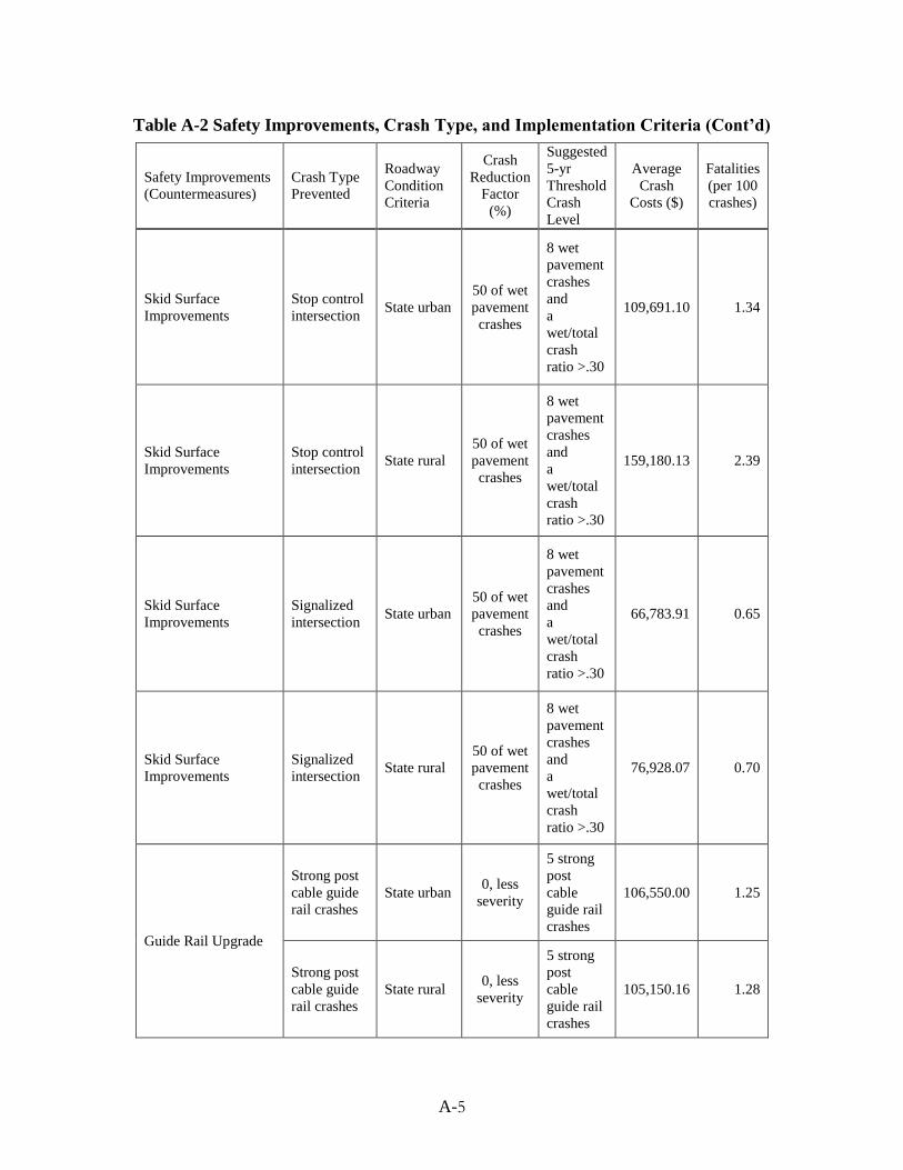
A-5
Table A-2 Safety Improvements, Crash Type, and Implementation Criteria (Cont’d)
Safety Improvements
(Countermeasures)
Crash Type
Prevented
Roadway
Condition
Criteria
Crash
Reduction
Factor
(%)
Suggested
5-yr
Threshold
Crash
Level
Average
Crash
Costs ($)
Fatalities
(per 100
crashes)
Skid Surface
Improvements
Stop control
intersection State urban
50 of wet
pavement
crashes
8 wet
pavement
crashes
and
a
wet/total
crash
ratio >.30
109,691.10 1.34
Skid Surface
Improvements
Stop control
intersection State rural
50 of wet
pavement
crashes
8 wet
pavement
crashes
and
a
wet/total
crash
ratio >.30
159,180.13 2.39
Skid Surface
Improvements
Signalized
intersection State urban
50 of wet
pavement
crashes
8 wet
pavement
crashes
and
a
wet/total
crash
ratio >.30
66,783.91 0.65
Skid Surface
Improvements
Signalized
intersection State rural
50 of wet
pavement
crashes
8 wet
pavement
crashes
and
a
wet/total
crash
ratio >.30
76,928.07 0.70
Guide Rail Upgrade
Strong post
cable guide
rail crashes
State urban 0, less
severity
5 strong
post
cable
guide rail
crashes
106,550.00 1.25
Strong post
cable guide
rail crashes
State rural 0, less
severity
5 strong
post
cable
guide rail
crashes
105,150.16 1.28

A-6
Table A-2 Safety Improvements, Crash Type, and Implementation Criteria (Cont’d)
Safety Improvements
(Countermeasures)
Crash Type
Prevented
Roadway
Condition
Criteria
Crash
Reduction
Factor
(%)
Suggested
5-yr
Threshold
Crash
Level
Average
Crash
Costs ($)
Fatalities
(per 100
crashes)
Guardrail Delineation
Night strong
and weak
post W-beam
guide rail
crashes
State urban
10 of
night
strong
and weak
post
W-beam
guide rail
crashes
4 night
strong
and weak
post
W-beam
guide rail
crashes
173,821.87 2.95
Guardrail Delineation
Night strong
and weak
post W-beam
guide rail
crashes
State rural
10 of
night
strong
and weak
post
W-beam
guide rail
crashes
4 night
strong
and weak
post
W-beam
guide rail
crashes
289,530.93 4.89
Guardrail Delineation Night guide
rail crashes Local urban
10 of
night
guide rail
crashes
4 night
guide rail
crashes
77,361.70 0.91
Guardrail Delineation Night guide
rail crashes Local rural
10 of
night
guide rail
crashes
4 night
guide rail
crashes
40,828.63 0.22

A-7
Appendix III. Top 150 Sections and Intersections
One of the common ways to identify the sites with potential for safety improvements is to analyze
crash data. Each year the Office of Traffic Safety & Design generates a TOP 150 Sections and
Intersections Report that ranks the sites (i.e., section and intersection) with highest improvement
potential. The method used to develop top 150 hazardous site list is based on “Evaluation of
Criteria for Safety Improvements on the Highway,” a report published in 1966 by Roy Jorgensen
and Associate (Jorgensen, 1966). For top 150 site selection, roadways are divided into categories,
as shown in Table A-3. Intersections and road sections (mid-blocks) are categorized into eight
types by different criteria, and the data is then processed separately. Note that Top 150 site
selection is only applied to state maintained roadway (e.g., 18,000 centerline miles of roadways).
Table A-3 Data Categories in GDOT’s Top 150 Procedures
Intersection Road section (midblock)
State Route with State Route, Urban, Signalized
State Route with State Route, Rural, Signalized
State Route with State Route, Urban, Unsignalized
State Route with State Route, Rural, Unsignalized
State Route with Other Route, Urban, Signalized
State Route with Other Route, Rural, Signalized
State Route with Other Route, Urban, Unsignalized
State Route with Other Route, Rural, Unsignalized
Rural interstate
Urban interstate
Rural 4 lanes, Divided
Urban 4 lanes, Divided
Rural 4 lanes, Undivided
Urban 4 lanes, Undivided
Rural 2 lanes
Urban 2 lanes
The list of Top 150 is created by using the rate quality-controlled method described in the 1966
report. This method, which was originally used to evaluate the quality control of manufacturing

A-8
industrial processes, uses a statistical test to determine if the crash rate at a particular segment is
abnormally high in comparison to the crash rate of locations with similar roadway characteristics.
The frequency, rate, and severity safety indexes sort the crash data file and generate the
appropriate reports; a final ranking report is produced based upon the previous three reports listing
the top 150 worst locations in Georgia. A weighted scale is used to rank these locations.
The following formulas define the three indexes:
equencyCriticalFr
quencyAverageFreindexFrequency (A-1)
teCriticalRa
eAverageRatindex Rate (A-2)
verityCriticalSe
erityAverageSevindexSeverity (A-3)
where
Average Frequency= number of accidents/m,
Average Rate= number of accidents * 1000, 000 / number of days *s um of ADT, and
Average Severity= (10* number of fatalities + 4 * number of no visible + 2 * number of no
complaint) / number of accidents.
The critical frequency is defined as follows:
2
1kFrequency Average Frequency Critical quencyaverageFre
(A-4)
The Critical Severity is defined like Critical Frequency.
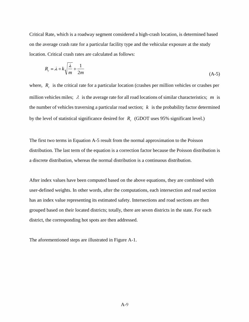
A-9
Critical Rate, which is a roadway segment considered a high-crash location, is determined based
on the average crash rate for a particular facility type and the vehicular exposure at the study
location. Critical crash rates are calculated as follows:
mmkRc
2
1
(A-5)
where, cR is the critical rate for a particular location (crashes per million vehicles or crashes per
million vehicles miles; is the average rate for all road locations of similar characteristics; m is
the number of vehicles traversing a particular road section; k is the probability factor determined
by the level of statistical significance desired for cR (GDOT uses 95% significant level.)
The first two terms in Equation A-5 result from the normal approximation to the Poisson
distribution. The last term of the equation is a correction factor because the Poisson distribution is
a discrete distribution, whereas the normal distribution is a continuous distribution.
After index values have been computed based on the above equations, they are combined with
user-defined weights. In other words, after the computations, each intersection and road section
has an index value representing its estimated safety. Intersections and road sections are then
grouped based on their located districts; totally, there are seven districts in the state. For each
district, the corresponding hot spots are then addressed.
The aforementioned steps are illustrated in Figure A-1.

A-10
Data acquisition
Selection of road categorization
Calculation of average and critical
frequency, rate, and severity for
the category and sites
Road and crash characteristics of
intersection and mid-block (section)
Intersection:
1. State or other
2. Urban or rural
3. Signalized or unsignalzied
Midblock:
1. Urban or rural
2. Interstate, 4 lanes divided, 4 lanes
undivided, or 2 lanes
Site ranking based on the resulted
frequency, rate, and severity
index
1. Chosen of k-factor (default=1.645)
2. Weight of severity: 10 (fatality), 4
(visible), 2 (complaint)
1. Index = Average/Critical value
2. Weight of three indexes (User defined)
Combination of different category
results
Top 150 lists
Figure A-1 GDOT Top 150 procedures


![TRANSPORTATION DEPARTMENT [761]](https://img.dokumen.tips/doc/110x75/61858e8b3fae02595c6f5634/transportation-department-761.jpg)

