Embed Size (px)
Citation preview

Geological Society of America Bulletin
doi: 10.1130/B26308.1 2009;121;100-116Geological Society of America Bulletin
Steven J. Davis, Andreas Mulch, Alan R. Carroll, Travis W. Horton and C. Page Chamberlain Developing topography and hydrology in the Laramide forelandPaleogene landscape evolution of the central North American Cordillera:
Email alerting servicesarticles cite this article
to receive free e-mail alerts when newwww.gsapubs.org/cgi/alertsclick
SubscribeAmerica Bulletin
to subscribe to Geological Society ofwww.gsapubs.org/subscriptions/click
Permission request to contact GSAhttp://www.geosociety.org/pubs/copyrt.htm#gsaclick
official positions of the Society.citizenship, gender, religion, or political viewpoint. Opinions presented in this publication do not reflectpresentation of diverse opinions and positions by scientists worldwide, regardless of their race, includes a reference to the article's full citation. GSA provides this and other forums for thethe abstracts only of their articles on their own or their organization's Web site providing the posting to further education and science. This file may not be posted to any Web site, but authors may postworks and to make unlimited copies of items in GSA's journals for noncommercial use in classrooms requests to GSA, to use a single figure, a single table, and/or a brief paragraph of text in subsequenttheir employment. Individual scientists are hereby granted permission, without fees or further Copyright not claimed on content prepared wholly by U.S. government employees within scope of
Notes
© 2008 Geological Society of America
on February 11, 2010gsabulletin.gsapubs.orgDownloaded from
100
ABSTRACT
Isotopic and elemental records of authi-genic calcite from lacustrine deposits in the intraforeland basins of Utah were analyzed in an effort to reconstruct the regional paleocli-mate, paleohydrology, and paleotopography of the early Cenozoic central North Ameri-can Cordillera. Isotopic profi les for Paleo-gene Lakes Uinta, Flagstaff, and Claron show relatively large oxygen isotopic shifts that are diachronous among basins with an ~7‰ decrease in δ18Ocalcite values at ca. 45 Ma in Lake Flagstaff, an ~5‰ decrease in δ18Ocalcite values between ca. 42 and 35 Ma in Lake Cla-ron, and an ~6‰ decrease in δ18Ocalcite values between ca. 44 and 43 Ma in Lake Uinta. We interpret these negative oxygen isotopic shifts to be the combined result of increased hypsometric mean elevation of basin catch-ments and related freshening associated with basin infi lling. The basins studied also have undergone periods of intense evaporation during periods of hydrologic closure, which, for example, produced an ~7‰ increase in δ18Ocalcite values in Lake Uinta beginning at ca. 51 Ma. Hydrologic closure in the Uinta Basin probably resulted from growth of local topography that diverted previously substan-tial infl ows from low elevation regions within the foreland.
This study adds to the growing body of
evidence that suggests a pattern of along-strike variations in the timing of topographic development and dissection of the Cordille-ran landscape during the early Cenozoic. We favor an interpretation that calls for the mid-dle Eocene rearrangement of regional drain-age patterns such that intraforeland basins that once received waters from far-fl ung foreland river systems became dominated by infl ows of low δ18O waters from catchments with higher hypsometric mean elevations that drained the adjacent hinterland and/or basin-bounding uplifts. This drainage reor-ganization is analogous but subsequent to the large-scale integration of catchments in the northern Cordillera that has been recog-nized on the basis of isotopic and sedimen-tological evidence in Montana and Idaho at ca. 50–47 Ma, with rivers fl owing southeast into Lake Gosiute at ca. 49 Ma and then for a time reaching Lake Uinta, causing a promi-nent highstand in that lake at 48.6 Ma. The negative oxygen isotopic shifts presented herein, which occurred between ca. 45 and ca. 35 Ma in the intraforeland basins of Utah, may refl ect the north-to-south progression of drainage integration in the Cordillera as mag-matism and related topography swept south-ward through the hinterland and increased the hypsometric mean of catchments that fed subjacent intraforeland basins.
Keywords: isotope ratios, lacustrine sediments, Paleogene, paleotopography, paleolimnology,
Laramide orogeny, Sevier hinterland, foreland basin, North American Cordillera.
INTRODUCTION
Despite profound relationships and feedbacks among climate, topography, and tectonics (e.g., Molnar and England, 1990; Ruddiman and Kutz-bach, 1990), paleoenvironmental reconstructions of evolving orogens remain diffi cult and contro-versial. Patterns in the distribution of stable oxy-gen and hydrogen isotopes in precipitation and surface waters have long been used as a tool for the study of hydrological and surface processes, but studies of geological proxies have generally focused on isotopic variation caused by changes in atmospheric circulation and/or surface eleva-tion (e.g., Chamberlain et al., 1999; Chamberlain and Poage, 2000; Garzione et al., 2000; Garzione et al., 2006; Rowley and Currie, 2006). In this study, we reconstruct trends in the oxygen iso-topic composition of lake and river water (δ18O
lw
and δ18Orw
, respectively) of the Uinta, Flagstaff, and Claron Basins of Paleogene Utah (Fig. 1), and make use of several geochemical techniques and proxies to argue that the observed trends were controlled by changing drainage patterns in the evolving late Laramide Cordillera and atten-dant changes in basin hydrology.
Precipitation is progressively depleted in 18O and D during cooling of air masses that travel along surface-temperature gradients or over orographic barriers (Dansguard, 1964; Ambach et al., 1968; Rozanski et al., 1993). Empirically
For permission to copy, contact [email protected]© 2008 Geological Society of America
Paleogene landscape evolution of the central North American Cordillera: Developing topography and hydrology in the Laramide foreland
Steven J. Davis†
Geological and Environmental Sciences, Stanford University, Stanford, California 94305, USA
Andreas MulchGeological and Environmental Sciences, Stanford University, Stanford, California 94305, USAInstitut für Geologie, Universität Hannover, 30167 Hannover, Germany
Alan R. CarrollDepartment of Geology and Geophysics, University of Wisconsin, Madison, Wisconsin 53706, USA
Travis W. HortonDepartment of Geological Sciences, University of Canterbury, Private Bag 4800, Christchurch, New Zealand
C. Page ChamberlainGeological and Environmental Sciences, Stanford University, Stanford, California 94305, USA
†E-mail: [email protected]
GSA Bulletin; January/February 2009; v. 121; no. 1/2; p. 100–116; doi: 10.1130/B26308.1; 8 fi gures; Data Repository item 2008140.
on February 11, 2010gsabulletin.gsapubs.orgDownloaded from

Paleogene landscape evolution of the central North American Cordillera
Geological Society of America Bulletin, January/February 2009 101
Elko
LakeGosiute
LakeFlagstaff
LakeClaron
LakeUinta
GGRB
UB
PB
RSU
WHU
WRU
SRS
MU
UNU
UU
FRU
SSU
KU
SCU
GU
OCU
BHUBTU
LU
BLHU
DCA
CCUJVA
PRB
BHB
SJB
DB
GB
RB
WRB
SCB
HU
FB
CB
EB
N200 km
X'
X
Sage Creek
1
2 3 45
67
98
1011
MTNDSD
WY NECO
KN
UTNV
ID
AZCA
NMOK
TX
OR
WA
102°105°108°111°114°117°120°
102°105°108°111°114°117°
44°
41°
38°
35°
44°
41°
38°
35°
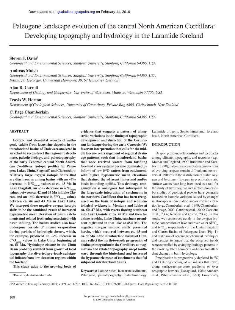
Figure 1. Digital elevation map of modern topography of the central North American Cordillera (UTM Zone 13N) with Paleogene structures superimposed (location and extent of structures after Dickinson et al., 1986, 1988). Bold line shows the Sevier fold-and-thrust belt, teeth on the upper plate. Dashed line between X and X′ corresponds to the cross section in Figure 2. Structures labeled as follows: BHB—Bighorn Basin; BHU—Bighorn Uplift; BLHU—Black Hills Uplift; BTU—Beartooth Uplift; CB—Claron Basin; CCU—Circle Cliffs Uplift; DB—Denver Basin; DCA—Douglas Creek Arch; EB—Elko Basin; FB—Flagstaff Basin; FRU—Front Range Uplift; GB—Galisteo Basin; GGRB—Greater Green River Basin; GU—Granite Mountain Uplift; HM—Hogback Monocline; JVA—Johns Valley and Upper Valley Anticlines; KU—Kaibab Uplift (its northwestern edge coincident with the Markagunt-Paunsaugunt Upwarp); LU—Laramie Uplift; MU—Monument Upwarp; OCU—Owl Creek Uplift; PB—Piceance Creek Basin; PRB—Powder River Basin; RB—Raton Basin; RSU—Rock Springs Uplift; SCB—Sage Creek Basin; SCU—Sangre de Cristo Uplift; SJB—San Juan Basin; SSU—Sawatch–San Luis Uplift; SRS—San Rafael Swell; UB—Uinta Basin; UNU—Uncompahgre Uplift; UU—Uinta Uplift; WHU—White River Uplift; WRB—Wind River Basin; WRU—Wind River Uplift. Circles indicate sampled sections within the Sage Creek Basin (Kent-Corson et al., 2006), the Washakie sub-basin of the Greater Green River Basin (Doebbert et al., 2006), and the Elko Basin (Horton et al., 2004). Numbered circles indicate sections sampled in this study as follows: (1) Willow Creek–Indian Canyon, (2) type section of Dry Gulch Member, (3) type section of Lapoint Member, (4) Twelvemile Wash, (5) Wagonhound Canyon of the Uinta Basin, (6) Redmond Canyon, (7) Soldier Canyon, (8) Asay Bench, (9) Brian Head Peak–Cedar Breaks, (10) Newcastle, and (11) Pinto.
on February 11, 2010gsabulletin.gsapubs.orgDownloaded from

Davis et al.
102 Geological Society of America Bulletin, January/February 2009
observed isotopic lapse rates and thermodynamic models have exploited this effect to reconstruct paleoaltitude using the isotopic composition of ancient surface waters recorded by authigenic minerals (e.g., Poage and Chamberlain, 2001; Rowley et al., 2001). However, isolation of the altitude effect demands accurate constraints on the source and seasonality of precipitation, paleogeography, variations in regional or global climate, and hydrologic setting.
As today, the central Cordillera during the Paleogene was probably situated at the atmo-spheric divide between areas dominated by either summer or winter precipitation, its topography having interacted with air masses transporting Pacifi c moisture along dominant westerlies as well as those drawn from the Mississippi Embay-ment and the Arctic (Mock, 1996). This complex-ity undermines quantitative estimates of altitude in the study area, and requires paleoenvironmental interpretations of isotopic data to carefully con-sider the sedimentological and tectonic context and draw upon multiple isotopic proxies, several isotopic systems, and numerous stratigraphic sec-tions that are well constrained in time.
Here, then, we present new data showing dia-chronous timing of isotopic shifts in neighboring basins, combined with geochemical analyses of basin hydrology and previous work on sedi-mentary provenance, paleofl ow, and regional tectonism to support the conclusion that local hydrologic setting and large-scale drainage pat-terns in the Cordillera were the primary con-trols on developing intraforeland basins and the isotopic record they preserve. We observe large (5–7‰) negative shifts in the oxygen isotopic composition of geologic proxy materials in each of these basins that are diachronous, beginning at ca. 44 Ma in the Uinta Basin, at ca. 45 Ma in the Flagstaff Basin, and at ca. 42 Ma in the Claron Basin. Because basin catchments are adjoining, these oxygen isotopic shifts cannot be the result of global or regional climate changes nor changes in the source of precipitation delivered directly to this region. Instead, we interpret these stable isotopic data as recording the evolution of fore-land basin catchments as a result of changes in the hypsometric mean elevations of their drain-age basins resulting from ongoing Laramide tectonism and the freshening of basin lakes as potential accommodation waned. When placed in the context of other paleoelevation studies in the hinterland of the North American Cordillera (Chase et al., 1998; Wolfe et al., 1998; Horton et al., 2004; Kent-Corson et al., 2006), our study is consistent with an along-strike migration of a high-elevation landscape from north to south with time. However, rather than a change in mean elevation of the intraforeland basins themselves, we suggest that topographic profi les of the catch-
ment areas that feed the basins may have evolved to areas of higher mean elevation and/or higher relief. This implies that from north to south the hypsometric mean elevation of catchment areas increased, because of either one or more of the following: (1) distal catchments within the low-lying foreland were diverted by developing topography, (2) catchments draining the adja-cent high Sevier hinterland expanded or became dominant relative to diminished foreland infl ows, or (3) catchments became locally confi ned in basin-bounding uplifts. As such, our work sup-ports recent work on the stable isotopic records of the Sage Creek (Kent-Corson et al., 2006) and Greater Green River Basins (Carroll et al., 2008), which suggests that stream capture of catchments that drain distal and developing volcanic topog-raphy modifi ed the hydrologic character of Lake Gosiute, and implies that an along-strike pattern of drainage integration may have connected topo-graphic changes in the hinterland to the foreland.
GEOLOGIC SETTING
By the Late Cretaceous the Sevier fold-and-thrust belt had produced highlands of moder-ate relief trending northeast across Utah into southwest Wyoming and draining eastward into the foreland basin of the ancestral Great Plains (Armstrong, 1968; Fouch et al., 1983; Heller et al., 1986; DeCelles and Coogan, 2006). Laramide deformation began during Campanian to Maas-trichtian time (ca. 70–80 Ma), and basement uplifts inboard of the Sevier thrust belt defi ned discrete intraforeland basins where drainages ponded and deposited great thicknesses of car-bonate and clastic sediments, the latter derived from both adjacent and distal mountain ranges (Surdam and Stanley, 1979, 1980; Dickinson et al., 1986, 1988). Though Laramide time is often considered to have ended by ca. 55 Ma, there is evidence that tectonism of basement uplift con-tinued into the middle Eocene (perhaps as late as 40 Ma; Anderson and Picard, 1974), a period herein referred to as late Laramide.
Thus, for much of Paleogene time, intermon-tane basins of southwest Wyoming, Utah, and northwestern Colorado were occupied by large lakes (Stokes, 1986). In Utah the largest of these ancient lakes were Lake Uinta in the northeast, Lake Flagstaff in the central part of the state, and Lake Claron in the southwest (Fig. 1). Though the maximum extent of each lake was not coeval, there is evidence for periods of con-nectivity between these lakes (Spieker, 1946; Stanley and Collinson, 1979; Roehler, 1992), as well as with Lake Gosiute in southwest Wyo-ming and the lake in the Piceance Creek Basin of northwest Colorado (Surdam and Stanley, 1979; Smith et al., 2006).
Lake Uinta
The largest lake of the Green River lake system, Lake Uinta, at its maximum, covered ~20,000 km2 in the Uinta and Piceance Creek Basins with depths of up to 50 m (Picard and High, 1968). The Uinta Basin spans ~210 km along its east-west axis and ~160 km between its steeply dipping northern edge to its southern margin. Laramide structures bound the depocen-ter on all sides: To the north, the Uinta uplift par-allels its axis. To the southwest and east-south-east are the San Rafael Swell and Uncompahgre uplifts, respectively. And to the east, the Douglas Creek Arch separated the Uinta Basin from the Piceance Creek Basin of northwest Colorado except during lake highstands (Fig. 1).
Lacustrine sediments in the Uinta Basin occur as the different facies of the Green River Formation and consist of cyclically interbed-ded limestone, marl, oil shale (kerogen-rich and fi ssile marls), and sandstone (Bradley, 1931; Dane, 1954, 1955; Picard, 1955, 1959). More recent stratigraphic analysis includes the Flagstaff, Main Body, Saline Facies, and Sandstone and Limestone Facies as members of the Green River Formation in the basin (e.g., Dyni et al., 1985; Bryant et al., 1989; Remy, 1992; Fig. 2; Smith et al., 2008). The Flagstaff Member (Flagstaff Formation in central Utah) was deposited along the southernmost margin of the Uinta Basin during the late Paleocene (Stanley and Collinson, 1979; Fouch et al., 1982; Wells, 1983; Fouch et al., 1987), and the lake transgressed southward into the Flagstaff Basin ahead of southwestwardly prograding deltaic claystone, mudstone, and sandstone of the early Eocene Colton Formation (Peter-son, 1976; Zawiskie et al., 1982; Fig. 2). In the early Eocene, Lake Uinta transgressed to the north, depositing the Main Body, Saline Facies, and Sandstone and Limestone Facies, which together make up a >2-km-thick section in the western reaches of the basin (Ryder et al., 1976) and span a time interval from approxi-mately 54 to 43 Ma (Bryant et al., 1989; Smith et al., 2008). Subsurface and outcrop stratig-raphy show the lacustrine rocks thinning and interfi ngering with fl uvial-deltaic mudstone and sandstone of the Uinta Formation in the eastern part of the basin (Douglass, 1914; Picard, 1957; Ryder et al., 1976; Cashion, 1982; Roehler, 1992). Westward progradation of these fl uvial sediments indicates the gradual regression of Lake Uinta, beginning ca. 48 Ma (Prothero, 1996). Fluvial sandstone, conglom-erate, and poorly stratifi ed fi ne-grained rocks of the Duchesne River Formation derived from the Uinta Uplift (i.e., the Uinta Mountains) conformably overlie and interfi nger with the
on February 11, 2010gsabulletin.gsapubs.orgDownloaded from

Paleogene landscape evolution of the central North American Cordillera
Geological Society of America Bulletin, January/February 2009 103
Uinta Formation in the east and the Sandstone and Limestone Facies of the Green River For-mation in the west (Kay, 1934; Anderson and Picard, 1972, 1974; Fig. 2), extending the con-tinuous sedimentary record of the basin into Oligocene time. The geochronology of all units in the basin is reasonably well constrained by radiometric and fi ssion track dating of tuffs, paleontology, and magnetostratigraphy, and ages further demonstrate the partial equiva-lence of the Green River, Uinta, and Duch-esne River Formations in the basin (Fig. 2 and Table DR21).
Lake Flagstaff
Extending ~150 km south-southwest from the Uinta Basin into central Utah, Lake Flagstaff occupied the low-lying region between the Sevier thrust sheets to the west and the Laramide San Rafael Swell to the east (Spieker and Reeside, 1925; Stanley and Collinson, 1979; Fig. 1).
As mentioned above, the lacustrine Flag-staff Member of the Green River Formation records the transgression of a lake from the late Paleocene southern Uinta Basin southwestward into the early Eocene Flagstaff Basin (Fig. 2). Upsection, the Flagstaff Member is overlain by the late early Eocene Green River Formation of the Flagstaff Basin. Though it has not been possible to correlate the Green River Forma-tion of the Flagstaff Basin with the formation of
the same name in the Uinta Basin, some work-ers have suggested that the limestone and marl of the Flagstaff Basin represent sedimentation in a southerly arm of a continuous Lake Uinta (Spieker, 1946). However, others argue for a dis-crete Flagstaff depocenter on the basis of geo-chemistry (Stanley and Collinson, 1979). The Green River Formation in the Flagstaff Basin is topped by an erosional unconformity of indefi -nite duration, overlain by yellow and red sand-stone and fi ne-grained rocks of the Crazy Hol-low Formation that were deposited in a fl uvial environment during the middle Eocene (Nelson et al., 1980; Weiss, 1982; Norton, 1986). The Crazy Hollow Formation is in turn conform-ably overlain by mudstone, paludal limestone, tuffaceous sandstone, and minor volcaniclastic conglomerate of the middle and late Eocene
Uinta Basin Flagstaff Basin Claron Basin
32
36
44
48
52
Age
(M
a)
28
40
Olig
oce
ne
Earl
y
Eoce
ne
Mid
dle
Late
5
9
13
Mio
cen
e
56
60
Pale
oce
ne
64
24
Late
Earl
yTs
X X′
Tb
Tch
Tg
Tgf
?
Tdb
Tum
TuwTgs
Tgsl
Tgm
Tc
50 km
18
13
1415
16
17
19MZ
??
???Tcw
Tcr
?
?
?
Tbh
Tnr
?
TKcp?
Tcu
F G
19
21
?????
20
22
?
Tdv
?
?
?3 456
17
A
B CD
E
0
2
Tdl
12
11Tdd
108 9
TKn
1GSA Data Repository Item 2008140, supplemen-tal data and tables, is available at www.geosociety.org/pubs/ft2008.htm. Requests may also be sent to [email protected].
Figure 2. Generalized time stratigraphic cross section of Paleogene strata in the Uinta, Flagstaff, and Claron Basins along cross section X–X′ (See Fig. 1). The Mahogany Zone of the Green River Formation in the Uinta Basin is indicated by the dashed line labeled MZ. Lacustrine units are shaded gray, and fl uvial units are patterned. Wavy lines represent unconformities of unknown duration. Circles represent new U/Pb ages (lettered) and previously published ages (numbered) that are listed in Table DR2 (see footnote 1). Units are abbreviated as follows: Tgm—Main Body of Green River Formation; Tgs—Saline Member of Green River Formation; Tgsl—Sandstone and Limestone Member of the Green River Formation; Tuw—Wagonhound Member of the Uinta Formation; Tum—Myton Member of the Uinta Formation; Tdb—Brennan Basin Member of the Duchesne River Forma-tion; Tdd—Dry Gulch Creek Member of the Duchesne River Formation; Tdl—Lapoint Member of the Duchesne River Forma-tion; TKn—North Horn Formation; Tgf—Flagstaff Member of Green River Formation; Tc—Colton Formation; Tg—Green River Formation in the Flagstaff Basin; Tch—Crazy Hollow Formation; Tb—Bald Knoll Formation (Formation of Aurora); Tdv—Dipping Vat Formation; Ts—Sevier River Formation; TKcp—Canaan Peak Formation; Tcr—Red Member of the Claron Formation; Tcu—Claron Formation, undivided; Tcw—White Member of the Claron Formation; Tbh—Brian Head Formation; Tnr—Needles Range Group (includes Wah Wah Springs Tuff near Brian Head type section).
on February 11, 2010gsabulletin.gsapubs.orgDownloaded from

Davis et al.
104 Geological Society of America Bulletin, January/February 2009
Bald Knoll Formation (Formation of Aurora) (Willis, 1986; Lawton and Willis, 1987) and the (lithologically similar but unconformable) late Eocene to Oligocene Dipping Vat Formation (McGookey, 1960; Nelson et al., 1980; Willis, 1988). An extensive sequence of ash-fl ow tuffs and volcaniclastic rocks related to the Marys-vale Volcanic Field was deposited in the basin beginning at ca. 25 Ma (Willis, 1988). Fluvial-lacustrine mudstone, sandstone, limestone, and conglomerate of the Sevier River Formation were deposited in the area during middle to late Miocene time (ca. 15–5 Ma) (Callaghan, 1938; Rowley et al., 1975; Willis, 1988; Fig. 2).
Lake Claron
Beginning in the late Paleocene, southwest Utah hosted the shallow Lake Claron in a slowly subsiding basin trending east-northeast (Rowley et al., 1979; Hintze, 1986; Goldstrand, 1990b, 1994). En echelon Sevier thrust sheets bordered the lake to the west (Goldstrand, 1994). To the south and east the basin was partitioned by Lar-amide structures: the Markagunt-Paunsaugunt Upwarp, Kaibab Monocline, Johns Valley and Upper Valley Anticlines, Monument Uplift, and Circle Cliffs Uplift (Goldstrand, 1994; Fig. 1).
The Claron Formation consists of interbed-ded limestone, marl, calcareous sandstone, and minor conglomerate, historically divided into a Red (lower) Member and White or gray (upper) Member, each ~400 m thick (Leith and Harder, 1908; Gregory, 1950; Mackin, 1960; Bowers, 1972; Anderson and Rowley, 1975; Taylor, 1993). Rocks of the Red Member of the Claron Formation were commonly altered by pedo-genic processes in the shallow and seasonally ephemeral lake (Mullet, 1989). Though the age of the Claron Formation is poorly constrained, basal rocks are time transgressive, with onset of deposition ranging from late Paleocene at its western extent in the modern Basin and Range near the Nevada border to middle Eocene east of the Johns Valley Anticline, suggesting east-northeast transgression of the lake (Goldstrand, 1990a, b, 1992, 1994). At the western end of the Claron Basin the upper Claron interfi ngers with tuffs of the Needles Range Group dated as early Oligocene (Taylor, 1993). On the mod-ern high plateaus near the eastern extent of the basin, faunal ages suggest that deposition of the Claron ceased by the latest middle Eocene (Eaton et al., 1999). Unconformably overlying the Claron Formation on the Markagunt Pla-teau are sandstones, claystones, limestones, and volcaniclastics of the Brian Head Formation (Gregory, 1950; Sable and Maldonado, 1997). As revised by Sable and Maldonado (1997), the Brian Head includes much of what was histori-
cally the White Member of the Claron, divided into a basal sandstone and conglomerate unit of nontuffaceous sandstone and pebbly conglom-erate with subangular clasts of chert and carbon-ate derived from the underlying Claron (~30 m), a gray volcaniclastic unit of tuffaceous sand-stone and claystone, with beds of ledge-forming limestone (~140 m), and a unit of mudfl ow breccia and conglomerate with volcanic wacke matrix (up to 100 m). Tuffaceous material in the Brian Head has yielded ages ranging from 35.2 ± 0.8 Ma (this study) to 31.0 ± 0.5 Ma (Fleck et al., 1975; Anderson and Kurlich, 1989; Sable and Maldonado, 1997). The Wah Wah Springs Tuff (29.5 Ma) of the Needles Range Group directly overlies the Brian Head in many areas, thus providing an upper age limit to the forma-tion (Best et al., 1989; Rowley et al., 1994). The boundary between the Red and White Members of the Claron Formation is not constrained in time; this study assumes constant sedimentation rates and interpolates between the poorly known maximum age and the better known minimum age of these rocks.
LAKE GEOCHEMISTRY
Minerals formed in lacustrine settings are particularly useful geological proxies owing to the continuity, longevity, and environmental sensitivity of lake deposits (Carroll and Bohacs, 1999). The hydrologic character of a lake is a function of rates of potential accommodation and sediment and water fi ll, thus infl uenced by both tectonic and climatic forcing, respectively (Fig. 3A). In turn, δ18O
lw and δD
lw values repre-
sent a weighted average of the freshwater input from extrabasinal drainages, intrabasinal pre-cipitation, outfl ow from the basin, and evapora-tion from the lake (Criss, 1999). The challenge in using lake deposits as isotopic proxies is in identifying and quantifying evaporative enrich-ment. In this study we employ three geochemi-cal techniques to do so: (1) the relationship of δD and δ18O in chert samples, (2) covariance of δ13C–δ18O values in carbonate samples, and (3) Mg mole percentages and Sr/Ca ratios of carbonate samples.
During evaporation a combination of equi-librium and kinetic effects fractionate oxygen and hydrogen isotopes as a function of relative humidity; in arid settings the result is that the isotopic composition of unevaporated water will become enriched in 18O and D with respect to infl ow (Gat, 1981). The relationship of δD–δ18O values in a single sample may be used to identify evaporative enrichment owing to mass depen-dent asymmetries. Because the mass difference between H
216O and HD16O is not as great as that
between H216O and H
218O, unevaporated liquid
is disproportionately enriched in 18O such that its isotopic composition evolves along a path in δD–δ18O space of lower slope than the global meteoric water line (GMWL) like that of ray E in Figure 4 (Gat, 1981). For this reason, chert recording both δD and δ18O of lake water that has not undergone much evaporation should plot in domains subparallel to the GMWL, such as the lines labeled with temperatures in Figure 4, with each composition x or y related to a meteoric water of composition X or Y, respectively (see Fig. 4). The correlation of δD–δ18O measured in a single proxy that instead describes a line of lower slope than the GMWL, such as that of ray e in Figure 4, indicates that lake waters were evaporatively enriched in 18O and D (Abruzzese et al., 2005). We use the approach of Abruzzese et al. (2005) to determine the role of evaporation in chert-bearing facies.
The δ13Ccalcite
of primary lacustrine carbon-ate is prescribed by the isotopic composition of dissolved inorganic carbon (DIC) in the lake water. Covariance of δ13C
calcite and δ18O
calcite in
such carbonates is characteristic of hydrologi-cally closed lakes, where long residence times allow preferential outgassing of 12C-rich CO
2
accompanied by evaporative enrichment of 18O (Talbot and Kelts, 1990). In contrast, δ13C
calcite
values of early diagenetic carbonates are deter-mined by bacterially mediated redox reactions, while δ18O
calcite values of such diagenetic phases
continue to record the isotopic composition of sediment pore waters (Talbot and Kelts, 1990; see Fig. DR1 [see footnote 1]). It has been sug-gested that partial diagenesis of primary cal-cite might result in a covariant δ13C–δ18O trend representative of a mixing line between unal-tered and diagenetic carbonate (Garzione et al., 2004). However, other studies (Talbot and Kelts, 1990) have found that diagenesis results in noncovariance of carbon and oxygen iso-topes. In fact, these studies use noncovariance to differentiate between primary and diage-netic minerals (Talbot, 1990). In our study, covariance of δ13C
calcite and δ18O
calcite occurs in
lacustrine sediments of all the sampled basins, supporting the primary nature of the analyzed carbonates and in some cases supporting hydrologic and evaporative control of δ18O
lw.
The partitioning of Mg and Sr between host water and authigenic carbonate precipitates is proportional to the ratio of these elements to Ca in the water (Müller et al., 1972). In hydrologi-cally closed lakes, Mg2+ and Sr2+ are not fl ushed from the system, and as CaCO
3 precipitates, these
elements are progressively concentrated and incorporated into authigenic carbonates (Eugster and Kelts, 1983). Thus, Mg mole percentages and Sr/Ca ratios in lacustrine carbonates are useful in assessing evaporative enrichment of δ18O
calcite.
on February 11, 2010gsabulletin.gsapubs.orgDownloaded from

Paleogene landscape evolution of the central North American Cordillera
Geological Society of America Bulletin, January/February 2009 105
METHODS
Sampling Strategy
We collected authigenic carbonate samples from 11 stratigraphic sections of Paleogene fl uvial-lacustrine facies within the Uinta, Flagstaff, and Claron Basins (Fig. 1). Details of sampling localities and key references for each are included in the GSA Data Repository (Table DR1; see footnote 1). In all, 364 samples of limestone, marl, and calcite-cemented sand-stone were collected, spaced along the out-crop every 5–10 m. We also collected 39 chert samples from closely spaced beds (~25–30 cm apart) at fi ve outcrops of the Green River For-mation in the Uinta Basin. We also sampled interbedded air-fall ashes, where present, for radiometric dating. In the Uinta Basin, collected
samples represent a sedimentary record from ca. 52 to 29 Ma, including equivalent middle Eocene rocks from different sections within the basin. Samples from the Flagstaff depocenter of central Utah, though punctuated by intermit-tent unconformities, span ca. 50–10 Ma. From the Claron Basin of southwest Utah, collected samples record from ca. 57 to 30 Ma.
Analytical Techniques
Stable Isotope AnalysesOxygen and carbon isotopic analyses of car-
bonate were performed using the phosphoric-acid-digestion method of McCrea (1950). Between 300 and 500 µg of sample material was drilled from each sample, sealed in reac-tion vials, fl ushed with helium, and reacted with pure phosphoric acid at 72 °C. Evolved CO
2 in
the vial headspace was then sampled using a Finnigan GasBench II, connected to a Finnigan MAT DeltaPlus XL mass spectrometer. Replicate analyses of NBS-19 (limestone) and laboratory standards yielded a precision ±0.2‰ or better for both δ18O and δ13C.
Chert samples were broken into small chips, and visually homogeneous chips in the size fraction 300–150 µm were selected for analy-sis from the interior of each sample. Some of the chips were powdered in a tungsten carbide shatterbox and treated with 3M HCl and 6% H
2O
2 to eliminate carbonate and organic mat-
ter in the samples, respectively. After thorough rinsing and drying, powdered samples were analyzed for δD of nonstoichiometric hydroxyl hydrogen and H
2O in microfl uid inclusions
(Knauth, 1992). Hydrogen isotope analyses of prepared chert samples were conducted by high
D Lake ClaronFl
uvia
l
Eolian
Fluv
ial
Eolian
Overfilled(open)
Balanced
Underfilled(Closed)
Thin
Thick
Sed
imen
t +
wat
erfil
l rat
e
Potential accommodation rate
P/E =1.0
P/E = ?
C Lake Flagstaff
Fluv
ial
Eolian
Fluv
ial
Eolian
?
Sed
imen
t +
wat
erfil
l rat
e
Potential accommodation rate
P/E =1.0
P/E = ?
Sed
imen
t +
wat
erfil
l rat
e
Potential accommodation rate
P/E =1.0
P/E = ?
Sed
imen
t +
wat
erfil
l rat
e
Potential accommodation rate
P/E =1.0
P/E = ?
Poorlypreserved
B Lake UintaA Lake-type model
44 Ma 46 Ma
49 Ma43 Ma
? 50 Ma45 Ma 50 Ma
42 Ma
37 Ma
Figure 3. Hydrologic evolution of paleolakes Uinta, Flagstaff, and Claron, as inferred from isotopic and elemental analyses of lacustrine samples and obser-vations of sedimentary facies. Panel (A) is the schematic lake-type model of Carroll and Bohacs (1999), showing that lake hydrology, and the type and thickness of sedimenta-tion, are functions of sediment plus water fi ll rate on the y-axis and potential accommodation rate on the x-axis. Note that fi ll rate is related to climate (P/E shown refers to the precipita-tion/evaporation ratio), and potential accommodation rate is usually dictated by tecton-ics. Bold arrows in panels (B), (C), and (D) depict the hydro-logic evolution of Lakes Uinta, Flagstaff, and Claron, respec-tively, with approximate ages indicated alongside. Question marks correspond to deposi-tional unconformities.
on February 11, 2010gsabulletin.gsapubs.orgDownloaded from

Davis et al.
106 Geological Society of America Bulletin, January/February 2009
temperature carbon reduction: ~5 mg of chert powder was wrapped in silver foil capsules, dried under vacuum at 80 °C for several hours, then dropped into a carbon reduction furnace heated to 1450 °C. Produced H
2 was entrained
in helium carrier gas and measured in continu-ous fl ow by a Finnigan MAT DeltaPlus XL mass spectrometer. A comparison of sample runs with replicate analyses of NBS-22 (oil), PEF-1 (poly-ethylene foil), NBS-30 (biotite), and laboratory standards yielded a relatively poor precision of ±6‰. Oxygen isotope analyses of prepared chert samples were made using infrared laser fl uorination (method modifi ed from Sharp, 1990; Alexandre et al., 2006): 700–900 µg of chert chips were reacted with BrF
5, and liber-
ated oxygen gas was introduced directly into the dual inlet system of a Finnigan MAT 252 mass spectrometer. Replicate analyses of laboratory
standards Lausanne-1 (quartz) and UWG-2 (garnet) gave a precision of ±0.2‰.
Petrography and X-Ray DiffractionThin sections of representative chert samples
exhibit cryptocrystalline and granular micro-crystalline quartz. X-ray diffraction of treated chert samples produced patterns of α-quartz uncontaminated by carbonate or clay minerals.
Trace and Major Element AnalysesMole percentage Mg and Sr/Ca ratios were
obtained from selected carbonate samples using inductively-coupled-plasma atomic-emis-sion spectroscopy (ICP-AES). Samples were digested in HNO
3, diluted with megapure water,
and fi ltered. Total dissolved Ca, Mg, and Sr were measured at wavelengths of 317.9, 285.2, and 407 nm, respectively (cf. de Villiers et al., 2002).
Replicate analyses of prepared blanks and stan-dard solutions of varying known concentrations indicated detection limits for Ca, Mg, and Sr of 6, 2, and 0.1 µg L–1, respectively, with precision better than 15 µg L–1 for Ca and Mg, and 1 µg L–1 for Sr. This analysis represents precision bet-ter than 1% for Mg mole percentages and better than 0.1 mmol/mol for Sr/Ca ratios.
Ion Microprobe GeochronologyZircon U-Pb geochronology was carried
out using the Stanford–U.S. Geological Sur-vey sensitive high-resolution ion microprobe (SHRIMP-RG). Zircon separates from sampled air-fall ashes were mounted in epoxy, polished, imaged by cathodoluminescence on a JEOL 5600LLV scanning electron microscope, and gold coated. Analytical spots 25–30 µm in diameter on the zircon grains were sputtered using an ~10 nA primary beam of 16O–
2 ions.
After rastering the spot for 90 s to remove surfi -cial contaminants, the secondary ion beam was repeatedly scanned for 90Zr
216O, 204Pb, 206Pb,
207Pb, 238U, 232Th16O, and 238U16O. Zircon stan-dard R33 (419 Ma from monzodiorite, Brain-tree Complex, Vermont) was used as a concen-tration standard. Concentration measurements were corrected and reduced using SQUID soft-ware (Version 1.02; Ludwig, 2001).
Presented results are grouped by formation and sedimentary facies. We interpolate sample ages assuming a constant rate of deposition between available age constraints, which are shown in Figures 5–7 and listed in Table DR2 of the GSA Data Repository (see footnote 1), including seven new U/Pb ages (SHRIMP-RG results and Tera-Wasserburg plots are also pro-vided in the Data Repository [see footnote 1], Figs. DR2–DR8). Results of all isotope analyses are reported in standard δ-notation relative to V-SMOW (Vienna standard mean ocean water), except where δ13C and δ18O are compared relative to V-PDB (Vienna Peedee belemnite). Major element Mg and trace element Sr are reported as mole percentages of Mg (Mg/Mg + Ca) and Sr/Ca ratios (mmol/mol), respectively. Isotopic and elemental compositions, as well as estimated ages, of all samples are presented in Table DR3 of the GSA Data Repository (see footnote 1). Statistical covariance was deter-mined following the geometric mean regression (i.e., reduced major axis) treatment of Ricker (1973) using MATLAB 7.3.0 (R2007b), and linearity of results is reported by the Pearson product-moment correlation coeffi cient (r2).
RESULTS
Oxygen isotopic records from each basin reveal three distinct trends: (1) Between
E
P
X
Y
x
yp
e
-250
-200
-150
-100
-50
0
50
-20 -10 0 10 20 30 40
GM
WL
SMOW
30°C
δ18O (V-SMOW)
δD (
V-S
MO
W)
Figure 4. Isotopic systematics of chert. Cherts in equilibrium with meteoric waters fall along lines parallel to the global meteoric water line (GMWL) that are defi ned by the temperature of forma-tion such as the dashed line labeled 30 °C. Water of composition X forms chert of composition x at 30 °C. During evaporation, water X evolves along ray E of minimum slope 3.9 (Gonfi antini, 1986), forming cherts corresponding to and falling along the parallel ray e. Mixing of meteoric water Y and evaporatively enriched water P can result in chert compositions along the low slope py. Closed circles denote data of Abruzzese et al. (2005) from cherts along such a mixing line in the Flagstaff Basin. Open symbols denote new data from Uinta Basin cherts that cluster tightly within the shaded rect-angle: circles and squares denote samples from the Main Body and Saline Facies, respectively. All chert compositions suggest forma-tion in evaporatively enriched waters at relatively low temperatures (15–30 °C). V-SMOW—Vienna standard mean ocean water.
on February 11, 2010gsabulletin.gsapubs.orgDownloaded from

Paleogene landscape evolution of the central North American Cordillera
Geological Society of America Bulletin, January/February 2009 107
10 15 20 25 30 0 10 20 30 40 50 1 2 3 4 5
Age
(M
a)
Age (M
a)
δ18O (V-SMOW) Mg (mole %) Sr/Ca (mmol/mol)
10 15 20 25 30 0 10 20 30 40 50 1 2 3 4 5
Age
(M
a)
Age (M
a)
δ18O (V-SMOW) Mg (mole %) Sr/Ca (mmol/mol)
MZMZ
30
35
40
45
30
35
40
45
50
30
35
40
45
50
35
40
45
50
A Uinta Basin (lacustrine units)
B Uinta Basin (fluvial units)
Ageconstraints
Ageconstraints
Figure 5. Oxygen isotopic and elemental composition of carbonates from the Uinta Basin. Filled symbols denote lacustrine samples, and open symbols denote fl uvial samples. Note the different time span on the y-axes of panels (A) and (B). Panel (A) shows samples from lacustrine rocks of the Green River Formation cropping out in the Willow Creek–Indian Canyon section: squares denote Main Body samples, circles denote Saline Facies samples, and diamonds denote Sandstone and Limestone Facies samples. Panel (B) shows a composite of samples from the mostly fl uvial rocks of the Uinta and Duchesne River Formations that are exposed in fi ve different sections (see Fig. 1): triangles denote samples of the Wagonhound Member, circles denote samples of the Myton Member, diamonds denote samples of the Brennan Basin Member, crosses denote samples of the Dry Gulch Creek Member, and squares denote samples of the Lapoint Member. Available age constraints for all units sampled are shown along the y-axis and listed in Table DR2 (see footnote 1). Gray shading indicates the maximum expected variation in oxygen isoto-pic values of calcite owing to terrestrial temperature changes inferred from paleobotanical analyses of Wolfe (1994). Dashed line labeled MZ indicates the lake highstand of the Mahogany Zone at 48.6 Ma.
on February 11, 2010gsabulletin.gsapubs.orgDownloaded from

Davis et al.
108 Geological Society of America Bulletin, January/February 2009
the early Eocene and early middle Eocene (ca. 51–46 Ma), δ18O
calcite values of lacustrine
samples in the Uinta Basin gradually increased by 7‰ and remained high for ~2 m.y. before steadily decreasing 8‰ between ca. 44 and 43 Ma (Fig. 5A). (2) In the Flagstaff Basin, between the Green River Formation and overlying fl uvial units in the early middle Eocene (ca. 45 Ma), δ18O
calcite values suddenly
decreased by ~7‰ and remained low through late Miocene time (Fig. 6). (3) Over ~5 m.y. in the late middle Eocene (ca. 42–37 Ma), δ18O
calcite values in the White Member of the
Claron Formation declined systematically upsection by 5‰ (Fig. 7A). Elemental com-positions of samples were measured in order to evaluate carbonate mineralogy as well as the chemistry and salinity of waters present during carbonate precipitation (i.e., dolomite formation and evaporative effects).
Uinta Basin
Oxygen and Carbon Isotopes of CarbonateBetween ca. 51 and 46 Ma, oxygen iso-
tope values of carbonate samples from the Main Body, Saline Facies, and Sandstone and Limestone Facies of the Green River Forma-tion fi rst progressed from low to high δ18O
calcite
values and then, beginning ca. 44 Ma, values decreased to near starting values of δ18O
calcite =
~19‰ (Fig. 5A). Between 51 and 46 Ma, the lowest measured δ18O
calcite values from Main
Body samples increased by ~7‰, from 20‰ to 27‰. Between 46 and 44.2 Ma, values from the Saline Facies remained high, varying from 27‰ to 30‰. But beginning at 44.2 Ma, values from the overlying Sandstone and Limestone Facies steadily decreased again by ~8‰, from 28.5‰ to 20.5‰ at 43.1 Ma.
To the east and north, fl uvial and time-equiv-alent rocks of the Uinta and Duchesne River Formations, respectively, preserve an isotopic record of scattered 18O
calcite values (Fig. 5B) that
are generally lower than those of the lacustrine Green River Formation (Fig. 5B). δ13C
calcite
values covary with δ18Ocalcite
values throughout samples of the Main Body of the Green River Formation (r2 = 0.49, n = 53; Fig. DR1-D, see footnote 1). In contrast, values from the Saline Facies, when examined as a single popula-tion, do not exhibit isotopic covariance (r2 = 0.08, n = 35). However, a subset of the oldest Saline Facies samples do reveal a positive cor-relation of δ13C
calcite and δ18O
calcite (r2 = 0.57, n
= 14; Fig. DR1-E [see footnote 1]) spanning an estimated 600 k.y. (46.0–45.4 Ma), as do a subset of the youngest samples (r2 = 0.63,
n = 14; Fig. DR1-E [see footnote 1]) over an estimated 200 k.y. (44.9–44.7 Ma). Similarly, isotopic covariance exists in only a subset of the oldest rocks from the Sandstone and Lime-stone Facies, representing ~400 k.y. (r2 = 0.90, n = 11; 44.2–43.8 Ma; Fig. DR1-F [see foot-note 1]).
Elemental Compositions of CarbonateMole percentages of Mg and Sr/Ca ratios
in samples from the Uinta Basin are linearly correlated with δ18O
calcite (mole% Mg: r2 = 0.64,
Sr/Ca: r2 = 0.52; Fig. DR9, see footnote 1). Between 51 and 46 Ma, when δ18O
calcite val-
ues increased, the mole% Mg varied from ~15% to nearly 50% Mg, and Sr/Ca trends from 1.2 mmol/mol to >3 mmol/mol. Where δ18O
calcite is high, in the Saline Facies, between
46 and 44.2 Ma, elemental compositions also remain high: between 40 and 50 mole% Mg and 2.8 and 4.7 mmol/mol Sr/Ca. As do δ18O
calcite values, Mg content and Sr/Ca ratios
decreased within the Sandstone and Limestone Facies from 48% and 4.6 mmol/mol at 44.2 Ma to 3% and 1.2 mmol/mol at 43.1 Ma.
In contrast to the lacustrine samples, fl uvial samples from the Duchesne River Formation and the Myton Member of the Uinta Formation, spanning ca. 45–30 Ma, generally contain much
Age (M
a)
30
35
40
45
50
25
20
15
10
30
35
40
45
10 15 20 25 30 0 10 20 30 40 50 1 2 3 4 5
Age
(M
a)
δ18O (V-SMOW) Mg (mole %) Sr/Ca (mmol/mol)
50
25
20
15
10
unconformity
unconformity
unconformity
Flagstaff Basin
Figure 6. Oxygen isotopic and elemental composition of carbonates from the Flagstaff Basin. Filled symbols denote lacustrine samples, and open symbols denote fl uvial samples. A composite of samples collected from two sections is shown (See Fig. 1): circles denote samples from the Green River Formation, diamonds denote samples from the Crazy Hollow Formation, squares denote samples from the Bald Knoll Forma-tion, triangles denote samples from the Dipping Vat Formation, and crosses denote samples from the Sevier River Formation. Available age constraints for all units sampled are shown along the y-axis and listed in Table DR2 (see footnote 1). Dashed lines indicate sedimentary uncon-formities. Gray shading indicates the maximum expected variation in oxygen isotopic values of calcite owing to temperature changes inferred from paleobotanical analyses of Wolfe (1994).
on February 11, 2010gsabulletin.gsapubs.orgDownloaded from

Paleogene landscape evolution of the central North American Cordillera
Geological Society of America Bulletin, January/February 2009 109
less Mg and Sr: <15 mol% Mg and <1 mmol/mol Sr/Ca (Fig. 5B).
Oxygen and Hydrogen Isotopes of ChertChert samples from the lacustrine units of
the Uinta Basin have consistently high δ18O values (hereinafter δ18O
chert) relative to previ-
ously studied fresh-water cherts from the Flag-staff Basin (Abruzzese et al., 2005; Fig. 4). In the Main Body of the Green River Formation, cherts from two ~4 m sections give values from 31.0‰ to 32.8‰ around a mean of 31.9‰ (1σ = 0.59). Assuming a constant rate of deposition between dated intervals, these sections have ages of ca. 50.5 and 48.5 Ma and span ~40 and 60 k.y., respectively). Samples from the Saline Facies of the same formation, again from two
distinct ~3 m outcrops (deposited at ca. 45.4 and 44.8 Ma, each spanning ~23 k.y.) yield 18O
chert values of 29.5‰–32.6‰, with a mean
of 31.7‰ (1σ = 0.68). δ18Ochert
of a single chert sample from the upper part of the Sandstone and Limestone Facies (ca. 43.1 Ma) is notably lower: 24.3‰.
δD values of the same chert samples (here-inafter δD
chert) from the Green River Formation
are consistent with previously reported values. The Main Body values fall between −141‰ and −119‰, with a mean of −130‰ (1σ = 7.6). Values from the Saline Facies are somewhat less negative, varying from −133‰ to −109‰, with a mean of −126‰ (1σ = 5.3). The sample from the upper part of the Sandstone and Limestone Facies has a δD of −101‰.
Flagstaff Basin
Oxygen and Carbon Isotopes of CarbonateOxygen isotopic values in the Flagstaff
Basin shift rapidly from high to low values; the magnitude of the shift is about −7‰ and occurred at ca. 45 Ma. Between ca. 51 and 45 Ma, values from the Green River Formation in the Flagstaff Basin vary between 22.7‰ and 30.5‰ (Fig. 6). Upsection, values from fl uvial units are abruptly and permanently much lower. The oldest samples from the unconformable Crazy Hollow Formation give values of 17.2‰ at ca. 44 Ma and decreased further within the formation to 13.2‰ prior to ca. 40 Ma, with a mean value of 15.9‰ (n = 9, 1σ = 2.1). Between 40.5 and 38 Ma, samples in the overlying Bald Knoll Formation (Formation
10 15 20 25 30 0 10 20 30 40 50 1 2 3 4 5
Age
(M
a)
Age (M
a)
δ18O (V-SMOW) Mg (mole %) Sr/Ca (mmol/mol)
unconformity
A Claron Basin (Markagunt Plateau)
5 10 15 20
30
35
45
55
Age
(M
a)
60
50
40
δ18O (V-SMOW)
B Claron Basin (Basin and Range)
30
35
45
55
60
50
40
30
35
45
55
60
50
40
Ageconstraints
Ageconstraints
Figure 7. Oxygen isotopic and elemental composition of carbonates from the Claron Basin. Filled symbols denote lacustrine samples, and open symbols denote fl uvial samples. Panel (A) shows a composite of samples collected from two sections on the Markagunt Plateau (See Fig. 1): circles denote samples from the Red (lower) Member of the Claron Formation, diamonds denote samples from the White (upper) Member of the Claron Formation, and squares denote samples from the Brian Head Formation. Panel (B) shows a composite of samples col-lected from two sections of undivided Claron Formation in the modern Basin and Range (See Fig. 1): circles denote samples from the Newcas-tle section, and diamonds denote samples from the Pinto section. Avail-able age constraints for all units sampled are shown along the y-axis and listed in Table DR2 (see footnote 1). Dashed line indicates a sedi-mentary unconformity. Gray shading indicates the maximum expected variation in oxygen isotopic values of calcite owing to temperature changes inferred from paleobotanical analyses of Wolfe (1994).
on February 11, 2010gsabulletin.gsapubs.orgDownloaded from

Davis et al.
110 Geological Society of America Bulletin, January/February 2009
of Aurora) are scattered around a mean of 17.8‰ (n = 20, 1σ = 2.4). After a brief depositional hia-tus, beginning at 34.6 Ma and continuing through ca. 25 Ma, values in the Dipping Vat Formation are more narrowly distributed around a mean of 15.4‰ (n = 11, 1σ = 0.4). Much younger sam-ples from the Miocene Sevier River Formation in the basin (15.0 to ca. 10 Ma) preserve a mean value of 17.5‰ (n = 10, 1σ = 2.0).
As a single population spanning an estimated 6 m.y., samples from the Green River Forma-tion in the Flagstaff Basin show a poor correla-tion between δ13C
calcite and δ18O
calcite (r2 = 0.13).
However, isotopic values from a subset of the youngest samples do covary (r2 = 0.50, n = 18; Fig. DR1-I, see footnote 1) between ca. 50.5 and 45.8 Ma. The much younger lacustrine rocks of the Sevier River Formation (15 to ca. 10 Ma) also demonstrate marked covariance between δ13C
calcite and δ18O
calcite (r2 = 0.82, n = 10).
Elemental Compositions of CarbonateMg content and Sr/Ca ratios in samples
from the Flagstaff Basin are correlated with δ18O
calcite (mole% Mg: r2 = 0.72, Sr/Ca: r2 = 0.78;
Fig. DR10, see footnote 1). Of the nine Green River Formation samples examined, seven con-tained >45 mol% Mg. However, these samples show an upsection decrease in Sr/Ca between ca. 51 and 45 Ma, from 3.4 to 1.0 mmol/mol. Samples from the unconformably overlying fl u-vial units have lower Mg and Sr/Ca ratios, and these values decrease over time: From ca. 44 to 25 Ma, samples from the Crazy Hollow, Bald Knoll, and Dipping Vat Formations decrease from 30.7 mol% Mg and 0.47 mmol/mol Sr/Ca to 2.3 mol% Mg and 0.40 mmol/mol Sr/Ca. From 15 to ca. 10 Ma, compositions from the Sevier River Formation are somewhat elevated: 13.1 and 37.7 mol% Mg and 0.8 and 1.83 mmol/mol Sr/Ca.
Claron Basin
Oxygen and Carbon Isotopes of CarbonateFrom ca. 49 to 42.5 Ma, δ18O
calcite values of
lacustrine carbonate in the Red (lower) Mem-ber of the Claron Formation on the Markagunt Plateau varied between 18.9‰ and 22.3‰ (Fig. 7A). Beginning at ca. 42 Ma and continu-ing to ca. 37 Ma, values from the White (upper) Member of the Claron Formation decreased from 22.5‰ to 14.6‰. From ca. 36 to 29.5 Ma, δ18O
calcite values from the unconformably overly-
ing Brian Head Formation remained relatively low, varying between 12.9‰ and 17.3‰.
Though their ages are speculative, samples of lacustrine carbonate from the undivided Claron Formation in the western extent of the basin (in the modern Basin and Range) yield very low δ18O
calcite values, between 16.3‰ and
6.6‰ (Fig. 7B). Between ca. 40 and 32 Ma, the δ18O
calcite values of these samples decreased
from 16.1‰ to 6.6‰.The δ13C
calcite and δ18O
calcite of Claron Formation
samples are poorly correlated within both the Red and White Members. However, carbon and oxygen isotopes covary in a subset of the oldest samples from the Red Member (r2 = 0.66, n = 12; Fig. DR1-L, see footnote 1) estimated to have been deposited between ca. 45 and 40.1 Ma.
Elemental Compositions of CarbonateElemental compositions in the Claron Forma-
tion were not as well correlated with δ18Ocalcite
as were lacustrine units in the other basins (mole% Mg: r2 = 0.45, Sr/Ca: r2 = 0.25; Fig. DR11, see footnote 1). Nonetheless, a few samples from the Red Member of the Claron Formation on the Markagunt Plateau (ca. 49–42.5 Ma) contained as much as 44 mol% Mg and 1 mmol/mol Sr/Ca. No samples from the White Member were analyzed, but samples from the Brian Head For-mation (ca. 36–29.5 Ma) contained at most 9.2 mol% Mg and 0.36 mmol/mol Sr/Ca.
INTERPRETATION
Overview
We interpret the fi rst-order isotopic shifts in each basin to be the result of (1) diver-sion of infl ows sourced within the foreland, which led to hydrologic closure and atten-dant evaporation in Lake Uinta after 48.6 Ma (the Mahogany highstand in the Piceance Creek and Uinta Basins) producing the ~7‰ increase in δ18O
calcite values; and (2) changing
hypsometric mean elevation of basin catch-ments and freshening of basin lakes owing to the increased infl uence of catchments drain-ing the adjacent high Sevier hinterland and/or basin-bounding uplifts. The effects of evolving basin catchments were diachronous within the foreland, as observed by an ~7‰ decrease in δ18O
calcite values beginning at ca. 45 Ma in Lake
Flagstaff, an ~5‰ decrease in δ18Occ
values between ca. 42 and 37 Ma in Lake Claron, and an ~6‰ decrease in δ18O
calcite values between
44 and 43 Ma in Lake Uinta.In all cases the isotopic shifts observed in the
basins studied refl ect reorganization of regional drainage patterns likely driven by tectonic pro-cesses that affected basement cored uplifts in the foreland, the region of previously thick-ened crust (and lithosphere) within the Sevier fold-and-thrust belt, as well as the hinterland to the west. For the reasons discussed below we dismiss other possible controls on the isotopic profi les, such as global or regional changes in temperature, changes in sources of precipita-
tion, seasonality, and diagenesis as the dominant controls responsible for the observed oxygen and hydrogen isotopic patterns.
Because the oxygen isotopic shifts in these lakes are diachronous, they cannot be the result of either global or regional changes in temperature. Nevertheless, global cooling between the early Eocene climatic optimum (EECO, ca. 52–50 Ma) and the early Oligocene certainly did affect these lakes (Wolfe, 1994; Wing, 1998), but the ~3‰ decrease in δ18O
calcite values that would have been
caused by the combined effects of such cool-ing is masked by more local isotopic changes in surface waters (compare shaded areas and data in Figures 5–7). The ~3‰ decrease in δ18O
calcite
values was calculated using the relationship between δ18O
mw and temperature (0.55‰ and
0.58‰; Rozanski et al., 1993; Fricke and O’Neil, 1999), the calcite-water isotopic fractionation (−0.21‰ per °C at temperatures between 20 and 30 °C; Kim and O’Neil, 1997), and the changes in terrestrial temperatures during the Paleogene inferred from paleobotanical analyses (Wolfe, 1994; Wing, 1998).
It is highly unlikely that the oxygen isotopic shifts in the sampled sections refl ect a change in the seasonal timing of calcite formation dur-ing the deposition of these rocks. In general, carbonates precipitate at elevated temperatures during summer months when solubility is at a minimum, alkalinity is at a maximum, and where peak productivity draws down CO
2 and
stimulates inorganic calcite precipitation. Thus, δ18O
calcite probably records the isotopic compo-
sition of surface or pore waters during similar conditions each year, and we have no reason to believe these conditions changed from the Eocene to the early Oligocene.
Further, we consider it unlikely that changes in source regions of local precipitation could have caused the observed isotopic patterns. Because the isotopic shifts are diachronous, this interpretation would require different sources of precipitation affecting basins whose catchments are adjoining. Moreover, isotopic studies (e.g., Fricke, 2003; Sjostrom et al., 2006) and climate models for the Paleogene (e.g., Sewall et al., 2000; Sewall and Sloan, 2006) indicate that the dominant source of moisture to the Laramide foreland was from the Mississippi Embayment during the summer monsoon. Although cer-tainly cooler and drier today (MacGinitie, 1969; Sheldon and Retallack, 2004; WRCC, 2006), monsoonal circulation remains a robust feature over the Utah basins, with the largest volume of precipitation in the studied basins still sourced from the Gulf of Mexico during the summer (Mock, 1996). However, it is possible and even likely that low δ18O surface waters delivered to the basins by catchments tapping the hinterland
on February 11, 2010gsabulletin.gsapubs.orgDownloaded from
Paleogene landscape evolution of the central North American Cordillera
Geological Society of America Bulletin, January/February 2009 111
were sourcing Pacifi c moisture that had sur-mounted the paleo–Sierra Nevada and which lacked a moderating southerly moisture contri-bution; but observing the effect of this different precipitation source requires changing intrafore-land basin catchments.
Finally, we point out that diagenesis is unlikely to be responsible for the observed trends in the isotopic data, although it may be the cause of some of the scatter. Because the isotopic composition of calcite is susceptible to diagenetic alteration, past interpretations of high elevations in the Uinta Mountains during the Eocene from lacustrine carbonates have, in fact, been questioned (Norris et al., 1996; Mor-rill and Koch, 2002). Because diagenesis gen-erally results in relatively low δ18O
calcite values,
to reproduce the observed trends would require the unlikely condition that the less deeply bur-ied rocks in these sections would have been more severely affected by diagenetic alteration. In addition, in this study only micritic samples were analyzed, and we specifi cally avoided any sparry calcite, following the protocols dis-cussed in Garzione et al. (2004).
Basin Hydrology
For the reasons discussed below we inter-pret the isotopic profi les of these three basins to have been controlled by rearrangement of basin catchments that altered the isotopic com-position and volume of infl ows and prompted periods of evaporation during basin closure. Because these basins were at times intercon-nected, the isotopic profi les are best presented in discrete time intervals rather than basin by basin. Figures 3 and 8 illustrate the interpreta-tions presented in this section.
50–45 MaLake Uinta transitions from balanced to
closed and becomes strongly evaporitic. At ca. 48.6 Ma, Lake Uinta reached a highstand delineated by the rich oil shales of the Mahogany Zone (Surdam and Stanley, 1979, 1980; Smith, 2002). The carbon and oxygen isotopic record in the Uinta Basin indicates that the lake was hydrologically balanced (oscillating between open and closed) prior to and during this time, but transitioned over the next 5 m.y. to a closed, evaporitic lake. Taken together, fi ve observations support this interpretation: First, δ18O
calcite values
from lacustrine carbonates of the Main Body of the Green River Formation increased by ~7‰ between 51 and 46 Ma, indicating increasing evaporative enrichment (Fig. 5A). Second, Mg content and Sr/Ca ratios of these same lacus-trine carbonates increased markedly between 51 and 46 Ma, indicating progressive concen-
tration of Mg2+ and Sr2+ in the lake as CaCO3
precipitated from the closed basin (e.g., Eugster and Kelts, 1983; Fig. 5A). Third, covariance of δ13C
calcite and δ18O
calcite in the Main Body (from
ca. 51–46 Ma, r2 = 0.49, n = 53; Fig. DR1-D, see footnote 1) suggests regular periods of hydrologic closure and correspondingly long residence times of lake water (e.g., Talbot and Kelts, 1990). Fourth, δD
chert and δ18O
chert values
of cherts sampled from the Main Body give very high values (Fig. 4), which we interpret to be the result of formation from evaporatively D- and 18O-enriched lake water. This interpretation is supported by the study of Abruzzese et al. (2005), who showed that cherts throughout the Green River Formation in the Flagstaff Basin have δD
chert and δ18O
chert values that plot along a
line with a slope of 1.6 (r2 = 0.72; Fig. 4), much lower than the slope of the GMWL and thus indicative of evaporation. Fifth, δ18O
calcite values
of coeval fl uvial samples from the northeast-ern margin of the Uinta Basin do not show the positive trend in oxygen isotope values and are lower than those from lacustrine samples from the Main Body of Lake Uinta (Fig. 5B).
Lake Flagstaff is closed and infills. During the same time period, Lake Flagstaff was hydro-logically closed and distinct from Lake Uinta, and accommodation in the Flagstaff Basin was exhausted by ca. 45 Ma. Again, several lines of evidence support this interpretation: First, δ18O
calcite values from the Green River Formation
in the Flagstaff Basin are substantially higher than coeval samples from Lake Uinta, suggest-ting that the lakes were not connected (Fig. 6). Second, Mg content and Sr/Ca ratios in the sam-ples from Lake Flagstaff are also high, suggest-ing that Flagstaff waters were enriched in these elements by evaporation (Fig. 6). Third, δ18O
calcite
and δ13Ccalcite
covary in the youngest Green River Formation samples from the Flagstaff Basin, which we interpret to refl ect cessation of peri-odic overfl ow from balanced Lake Uinta into Lake Flagstaff, thereby allowing uninterrupted evolution of lake water in a closed Lake Flag-staff (Fig. DR1-I; see footnote 1). Fourth, fl uvial samples of the overlying Crazy Hollow Forma-tion (44–40.5 Ma) are unconformable (Weiss, 1982), further evidence that the closed, evapo-ritic lake was completely infi lled and—after a brief period of erosion—new accommodation was created in the basin.
45–44 MaLake Uinta is closed and evaporitic. Between
46 and 44 Ma, Lake Uinta was hydrologically closed and evaporitic. Several lines of evidence support this interpretation: First, δ18O
calcite val-
ues, Mg content, and Sr/Ca ratios of the Green River Formation in the Uinta Basin reached a
maximum and remained high throughout depo-sition of the Saline Facies (Fig. 5A). Second, the carbonate samples collected from the Saline Facies commonly contain molds of halite. Third, δ13C
calcite and δ18O
calcite values covary during dis-
crete intervals of the Saline Facies (from 46.0 to 45.4 Ma, r2 = 0.57, n = 14; and again from 44.9 to 44.7 Ma, r2 = 0.62, n = 14; Fig. DR1-E, see footnote 1). A lack of covariance in the Saline Facies as a whole may be understood in light of sedimentological evidence that the closed lake episodically gave way to ephemeral lakes and playas (Pitman et al., 1996) as well as under-went periodic infusions of water from the bal-anced lake in the Piceance Creek Basin, either of which may have periodically disrupted the isotopic evolution of the lake water by complete desiccation or fl ushing, respectively. Fourth, high δD
chert and δ18O
chert values of samples from
the Saline Facies indicate that the waters present during chert formation were enriched in D and 18O by evaporation (Fig. 4).
Flagstaff Basin is freshened. After a brief unconformity, fl uvial deposition commenced in the Flagstaff Basin at ca. 44 Ma, indicating renewed accommodation in the basin. This interpretation is supported by δ18O
calcite values
that decrease by ~7‰ at ca. 45 Ma, indicating a shift in the oxygen isotopic composition of waters fl owing into the basin (Fig. 6). In addi-tion, Mg content and Sr/Ca ratios also decrease in the youngest samples from the Green River Formation of Lake Flagstaff, supporting a fresh-ening in the lake immediately prior to the rapid shift in δ18O
calcite values (Fig. 6).
Lake Claron is closed. We suggest that between ca. 49 and 42.5 Ma, Lake Claron was internally drained. Covariance of δ13C
calcite and
δ18Ocalcite
values in the oldest samples of the Red Member (from ca. 45 to 40.5 Ma, r2 = 0.66, n = 12; Fig. DR1-L, see footnote 1), along with elevated Mg content and Sr/Ca ratios (Fig. 7A), support this interpretation. However, low Mg content and Sr/Ca ratios in the younger Red Member samples (Fig. 7A) suggest that by 42.5 Ma, evaporative enrichment of δ18O
calcite in
the upper Claron Formation was minimal.
44–37 MaLake Uinta transitions from closed to open.
Beginning at ca. 44.2 Ma, evaporitic Lake Uinta began freshening and ultimately transitioned to an open basin before lacustrine deposition ended at ca. 43.1 Ma. Evidence for this transition comes from three separate observations: First, δ18O
calcite values from samples of the Sandstone
and Limestone Facies decreased by nearly 6‰ between 44.2 and 43.1 Ma (Fig. 5A). Second, Mg content and Sr/Ca ratios decrease throughout the Sandstone and Limestone Facies, indicating
on February 11, 2010gsabulletin.gsapubs.orgDownloaded from

Davis et al.
112 Geological Society of America Bulletin, January/February 2009
periods during which the lake was overfi lled (Fig. 5A). Third, values of δ13C
calcite and δ18O
calcite
covary in the lowermost Sandstone and Lime-stone Facies (from 37.6 to 35.3 Ma, r2 = 0.90, n = 11; Fig. DR1-F, see footnote 1), indicating hydrologic closure, but these values do not cor-relate in samples farther upsection, suggesting that the lake became open.
Fluvial system at paleo–Lake Flagstaff. The isotopic composition of calcite from the fl uvial system remained constant during this period. The δ18O
calcite values of these streams are lower
than those from Lake Uinta, suggesting minimal or no input from that lake (Fig. 6).
Lake Claron transitions from closed to open. Beginning ca. 42 Ma, Lake Claron became hydrologically open and transitioned to a fl uvial depocenter, probably owing to increasing infl ow of low-δ18O waters fl owing into the basin, proba-bly from both the south and west. This interpreta-tion is supported by the following: First, δ18O
calcite
values from lacustrine samples of the White Member of the Claron Formation in the eastern Claron Basin decreased by ~5‰ between ca. 42
and 37 Ma (Fig. 7A). Given lack of evidence for signifi cant evaporative enrichment prior to 42 Ma, this decrease suggests that a change in the δ18O value of waters fl owing into Lake Claron fully account for the decrease. Second, the undivided Claron Formation in the western extent of the basin contains a greater proportion of interfi ngering fl uvial rocks and gives δ18O
calcite
values that are lower than those from generally more lacustrine rocks on the modern Markagunt Plateau to the east (Fig. 7B). Third, a decrease in Mg content and Sr/Ca ratios within the Red
43 Ma
48.6 Ma51 Ma
35 Ma
ChallisVolcanics
AbsarokaVolcanics
SageCreek
LakeUinta
LakeFlagstaff
LakeClaron
LakeGosiute
Elko
10 15 20 25 30
Age
(M
a)
δ18O
52
44
45 Ma
10 15 20 25 30
Age
(M
a)
δ18O
48
40
-7‰-7‰
CopperBasin
10 15 20 25 30
Age
(M
a)
48
52
44
δ18O
TuscaroraVolcanics
10 15 20 25 30
Age
(M
a)
δ18O
32
36
40
10 15 20 25 30
Age
(M
a)
δ18O
43
46
40
-6‰-6‰San JuanVolcanics
10 15 20 25 30
Age
(M
a)
δ18O
34
g(
g(
5 10 15 20 25
Age
(M
a)
δ18O
Open lacustrineBalanced-fill lacustrineClosed lacustrineVolcaniclastic alluviumVolcanic fields
Isotopic samples from this study
Isotopic samples from previous studies
N200 km
-7‰-7‰
+7‰+7‰
44
-5‰-5‰
-8‰-8‰
48
-7‰-7‰
42
38
32
40
36
Figure 8. Landscape development of the Laramide foreland during the Paleogene (refer to Fig. 1 for names of structures, basins, and sample localities). Panels depict inferred arrangement of drainages and lake hydrology. Volcanic fi elds and related volcaniclastic sediments are indi-cated in orange and yellow, respectively. Inferred growth of Laramide uplifts is indicated by dark gray shading. Overfi lled (open) lakes are shown in turquoise, balanced fi ll lakes are blue, and underfi lled (closed) lakes are pink. Timing and magnitude of observed isotopic shifts are inset. Isotopic data compiled from previous studies include those from the Sage Creek Basin (Kent-Corson et al., 2006) and the Elko Basin (Horton et al., 2004). Isotopic data from Utah basins are presented in this study.
on February 11, 2010gsabulletin.gsapubs.orgDownloaded from

Paleogene landscape evolution of the central North American Cordillera
Geological Society of America Bulletin, January/February 2009 113
Member supports freshening as the lake transi-tioned from closed to open (Fig. 7A). Fourth, δ18O
calcite and δ13C
calcite do not covary in samples
from the White Member of the Claron Forma-tion, suggesting that the residence time of water in the lake was short (Fig. DR1; see footnote 1). And fi fth, δ18O
calcite values of the youngest lacus-
trine samples are nearly identical to the values of overlying fl uvial samples of the Brian Head For-mation, suggesting that Lake Claron was com-pletely open before diminishing accommodation and/or growing infl ows prompted a transition to fl uvial deposition (Fig. 7A).
Catchment Evolution
Though the isotopic and elemental records of the studied intraforeland basins undoubtedly refl ect changing basin hydrology, the magnitude of isotopic shifts and a rich context of previous studies suggest that basin hydrology was in turn controlled by regional drainage patterns that evolved in response to changing topography in the Cordillera. We interpret the pattern of dia-chronous negative isotope shifts to record an increase in the hypsometric mean elevation of the basin catchments. However, it is not known whether the increase in catchment hypsometry involved the growing infl uence of catchments draining distal uplands or growth of local basin-bounding structures that diverted low-elevation foreland infl ows and which themselves sourced waters fl owing into the basins. We favor distal uplift as a primary driver, but below we present evidence for each of these interpretations, which are not mutually exclusive. Figure 8 illustrates the inferred changes in regional drainages.
Six lines of evidence indicate that the negative isotopic shifts record basin catchments expand-ing in distal areas, perhaps related to increasing mean elevation in those areas. First, by way of precedent, and based on strontium and oxygen isotopic analyses of sediments in Lake Gosiute (Carroll et al., 2008) and paleosols in the Sevier hinterland in central Montana (Kent-Corson et al., 2006), it has been suggested that at ca. 49 Ma the drainage system feeding Lake Gosiute underwent a rapid (100–200 k.y.) river capture event that expanded the drainage system of Lake Gosiute deep into the Sevier orogen. This drain-age capture was likely the result of construction of volcanic edifi ces (Challis and Absaroka vol-canic centers) and associated regional surface uplift (Smith et al., 2008). Second, the basins studied here probably had long-lived catch-ments that extended west into the Sevier oro-gen, as indicated by Sr isotopic analysis of the late Paleocene Flagstaff Member of the Green River Formation of Lake Flagstaff (Gierlowski-Kordesch et al., 2008). Third, paleocurrrent
indicators from piggyback basins on the Sevier fold-and-thrust belt in central Utah indicate fl ow to the northeast during the Paleogene (Lawton et al., 1993). Fourth, magmatism (e.g., Copper Basin and Tuscarora volcanic fi elds) and nega-tive isotopic shifts took place in the hinterland of northeastern Nevada between ca. 45 and 40 Ma (Christensen and Yeats, 1992; Horton et al., 2004; Henry, 2008), and the decrease in δ18O
calcite values in the Uinta Basin began at
ca. 44.2 Ma (Fig. 8). The geochronology and distribution of ash-fl ow tuffs in the Elko Basin give evidence of eastward-fl owing paleorivers leading toward the Uinta Basin (Henry, 2008). Fifth, an isotopic gradient in δ18O
calcite values in
Lake Claron from lower values in the west to higher values in the east (Fig. 8) suggests that low-δ18O waters were sourced in highlands to the west during the early Paleogene. A source of water to the west is also supported by paleocur-rent and provenance data from the Claron Basin (Goldstrand, 1990b). Sixth, these Lake Claron sections all show a decrease in δ18O
calcite values,
beginning between ca. 42 and 40 Ma (Fig. 8), that may refl ect uplift or tilting of either or both the Colorado Plateau and the adjacent hinterland in the late Eocene, as supported by (1) increased erosion rates of Paleocene and Eocene “rim gravels” in northern Arizona, indicating a rever-sal of drainages along the Utah-Arizona border (Elston and Young, 1991); (2) (U-Th)/He cool-ing ages between 40 and 35 Ma that show an episode of rock uplift in northern Arizona at this time (Flowers et al., 2008); and (3) the coeval magmatism and negative isotopic shifts in the hinterland of northeastern Nevada between ca. 45 and 40 Ma (Christensen and Yeats, 1992; Horton et al., 2004).
Though there is substantial evidence that increasing hypsometric mean elevation of intra-foreland basin catchments was related to the changes in the distal topography of the hinter-land, an alternative interpretation for the isoto-pic profi les presented in this study would be that the δ18O
lw in Lakes Flagstaff, Uinta, and Claron
resulted from more localized uplift. If this had been the case, the basin drainages would have been largely sourced in basin-bounding struc-tures. Although this interpretation is consistent with geochemical evidence presented in this paper, it would require that the local relief dur-ing late Laramide time was >2500–3000 m, with highly elevated areas of basement uplifts capturing a volumetrically disproportionate amount of low-δ18O water to rapidly modify the isotopic composition of the studied lakes. Four lines of evidence indicate a local control of catchment evolution: First, the oxygen isoto-pic values of Lake Uinta (this paper) and Lake Gosiute (Carroll et al., 2008) at 49 Ma are essen-
tially the same, corroborating sedimentological evidence that these two lakes were hydrologi-cally connected during the Mahogany highstand (48.6 Ma). After this time, Lake Uinta became strongly evaporitic and isolated, which most likely indicates growth of local structures adja-cent to this basin that diverted waters fl owing from Lake Gosiute. Second, petrographic and geochronological analyses of fl uvial sandstones deposited in Lake Uinta indicate the waning of distal sources beginning at ca. 48 Ma, including both the Sawatch–San Luis Uplift to the south-east (Dickinson et al., 1986) and the volcani-clastic sediments from Lake Gosiute (Surdam and Stanley, 1979). Third, there is structural evidence for the reactivation of the Uinta Uplift at ca. 40 Ma, with synorogenic sediments of the Duchesne River Formation prograding south-ward off this uplift into the Uinta Basin (Ander-son and Picard, 1972, 1974). The freshening of Lake Uinta, as indicated by the decrease in δ18O
lw beginning at 44.2 Ma, may have been
an early result of this local tectonism (Fig. 8). Fourth, and perhaps the strongest piece of evi-dence for local control, the combined oxygen isotopic profi les of these three proximal lakes show distinct isotopic evolutions despite having adjoining catchments. This observation gener-ally supports strong local control of each lake’s accommodation and drainage basin.
Though existing data do not permit us to distinguish between these two possible inter-pretations, it is certain that these intrafore-land lakes had both distal and local sources of water, which proportionally varied through time. A more complete understanding of the relative contributions of these sources demands further study and will require additional data from other isotopic systems (such as Sr), geo-chronological studies (such as U/Pb zircons), and sedimentological provenance.
Space-Time Patterns of Cordilleran Evolution
During the past decade, numerous isotopic and paleobotanical studies focused on the paleoele-vational and climatic history of the western North American Cordillera (e.g., Chase et al., 1998; Wolfe et al., 1998; Poage and Chamberlain, 2002; Horton et al., 2004). In general these two independent approaches arrive at the same inter-pretation, calling for a spatially and temporally evolving pattern of high elevations from north to south in the Sevier hinterland. Stable isotopic studies of metamorphic core complexes show evidence of high elevations (~4 km) in British Columbia and Washington in the early Eocene at 49–47 Ma (Mulch et al., 2004; Mulch et al., 2007). Oxygen isotopic studies of intermontane
on February 11, 2010gsabulletin.gsapubs.orgDownloaded from

Davis et al.
114 Geological Society of America Bulletin, January/February 2009
basins suggest increased peak elevations and development of relief occurring between 50 and 47 Ma in southwestern Montana (Kent-Corson et al., 2006), between 40 and 35 Ma in northern Nevada (Horton et al., 2004), and by ca. 15 Ma in southern Nevada (Horton and Chamberlain, 2006), evidenced by large (5‰–7‰) negative shifts in oxygen isotopic ratios. Migration of high topography is independently supported by paleobotanical studies that show altitudes as high as 2.5–3 km in the early middle Eocene (50–48 Ma) in southern British Columbia and northeastern Washington, ~2 km in the late mid-dle Eocene (ca. 44–40 Ma) in northeast Nevada (Wolfe, 1994; Wolfe et al., 1998), and ~3 km in west-central Utah by 31.4 Ma (Gregory-Wodz-icki, 1997). Together, these studies suggest that surface uplift migrated into northern Nevada in the middle Eocene to Oligocene, with elevations as high as 3 km persisting into the early middle Miocene (Wolfe et al., 1997).
A separate body of work has recognized a southward sweep of magmatism within the Sevier hinterland that is roughly coincident with isotopic and paleobotanical evidence for high elevations (e.g., Lipman et al., 1972; Armstrong and Ward, 1991; Christensen and Yeats, 1992). This connection between surface uplift and magmatism has been used to constrain tectonic models calling for the north-to-south buckling of the Farallon slab (e.g., Humphreys, 1995) or the bidirectional delamination of mantle litho-sphere (e.g., Sonder and Jones, 1999). To the extent that evidence indicates that changes in distal hinterland topography caused the increase in hypsometric mean elevation of intraforeland basin catchments, the present study implies a genetic and large-scale linkage among drainage patterns throughout the Cordillera. If real, such a linkage has signifi cant implications for our understanding of topographic development and dissection of the Cordilleran landscape, as well as paleoenvironmental reconstructions of evolv-ing orogens in general.
CONCLUSIONS
New stable isotopic records from three intra-foreland basins of Paleogene Utah add to a grow-ing data set of evidence showing an evolving Cordilleran landscape in the early Cenozoic. The records from the Uinta, Flagstaff, and Claron Basins of Utah are characterized by large (>5‰), diachronous shifts in δ18O
calcite values. Coupled
with previous studies of provenance and paleo-fl ow, we interpret these isotopic results to refl ect changes in basin hydrology and catchment hyp-sometry as Cordilleran drainages responded to growing relief in the foreland and integration of catchments within the elevated Sevier hinterland.
A ~7‰ increase in δ18Ocalcite
values in Lake Uinta, beginning at ca. 51 Ma, corresponds to a protracted period of hydrologic closure and evaporite deposition, probably as a result of infl ows to the lake from the north being blocked by late Laramide tectonism of the Uinta Uplift. Decreases in δ18O
calcite values of ~7‰ in Lake
Flagstaff at ca. 45 Ma, ~5‰ in Lake Claron between ca. 42 and 35 Ma, and ~6‰ in Lake Uinta between ca. 44 and 43 Ma are interpreted as the combined result of increasing hypsometric mean elevation of basin catchments within the hinterland and freshening of fi lling basins. As such, isotopic profi les from the Utah basins imply a pattern of drainage integration that began ear-lier in the northern Cordillera and spread south-ward along strike as magmatism and related topography migrated through the hinterland and increased the hypsometry of catchments fl owing into subjacent intraforeland basins.
ACKNOWLEDGMENTS
We acknowledge the support of U.S. National Science Foundation grants EAR–0309011 and EAR-0609649 to C.P. Chamberlain, and Stanford Univer-sity Earth Sciences McGee grants to S.J. Davis. We thank Trevor Dumitru, Bettina Wiegand, and Joe Wooden for help with geochronology sample prepa-ration and data reduction, Stephan Graham and Mal-inda Kent-Corson for productive discussion, Doug Phelps, Stu Warren, and Austin Hart for their help in the fi eld and laboratory, and Mark Abruzzese for an invaluable head start in the fi eld. The paper was much improved by the careful reviews of Paul Koch and Henry Fricke.
REFERENCES CITED
Abruzzese, M., Waldbaur, J., and Chamberlain, C.P., 2005, Oxygen and hydrogen isotope ratios in freshwater chert as indicators of ancient climate and hydrologic regime: Geochimica et Cosmochimica Acta, v. 69, p. 1377–1390, doi: 10.1016/j.gca.2004.08.036.
Alexandre, A., Basile-Doelsch, I., Sonzogni, C., Sylvestre, F., Parron, C., Meunier, J.-D., and Colin, F., 2006, Oxygen isotope analyses of fi ne silica grains using laser-extrac-tion technique: Comparison with oxygen isotope data obtained from ion microprobe analyses and application to quartzite and silcrete cement investigation: Geochim-ica et Cosmochimica Acta, v. 70, p. 2827–2835, doi: 10.1016/j.gca.2006.03.003.
Ambach, W., Dansguard, W., Eisner, H., and Mooler, J., 1968, The altitude effect on the isotopic composition of precipitation and glacier ice in the Alps: Tellus, v. 20, p. 595–600.
Anderson, D.W., and Picard, M.D., 1972, Stratigraphy of the Duchesne River Formation (Eocene–Oligocene?), Northern Uinta Basin, Northeastern Utah: Utah Geo-logical and Mineralogical Survey Bulletin 97, p. 1–23.
Anderson, D.W., and Picard, M.D., 1974, Evolution of syno-rogenic clastic deposits in the intermontane Uinta Basin of Utah: Society of Economic Paleontologists and Min-eralogists Special Publication 22, p. 167–189.
Anderson, J.J., and Kurlich, R.A., 1989, Post-Claron Forma-tion, pre-regional ash-fl ow tuff early Tertiary stratigra-phy of the southern High Plateaus of Utah: Geological Society of America Abstracts with Programs, v. 21, no. 5, p. 50.
Anderson, J.J., and Rowley, P.D., 1975, Cenozoic stratigraphy of southwestern high plateaus of Utah, in Anderson, J.J., et al., eds., Cenozoic geology of southwestern High Pla-
teaus of Utah: Geological Society of America Special Paper 160, p. 1–51.
Armstrong, R.L., 1968, Sevier Orogenic Belt in Nevada and Utah: Geological Society of America Bulletin, v. 79, p. 429–458, doi: 10.1130/0016-7606(1968)79[429:SOBINA]2.0.CO;2.
Armstrong, R.L., and Ward, P., 1991, Evolving geographic patterns of Cenozoic magmatism in the North America Cordillera: The temporal and spatial association of magmatism and metamorphic core complexes: Journal of Geophysical Research, v. 96, p. 13,201–13,224, doi: 10.1029/91JB00412.
Best, M.G., Christiansen, E.H., and Blank, H.R., 1989, Oli-gocene caldera complex and calc-alkaline tuffs and lavas of the Indian Peak volcanic fi eld, Nevada and Utah: Geological Society of America Bulletin, v. 101, p. 1076–1090, doi: 10.1130/0016-7606(1989)101<1076:OCCACA>2.3.CO;2.
Bowers, W.E., 1972, The Canaan Peak, Pine Hollow, and Wasatch Formations in the Table Cliff Region, Garfi eld County, Utah: U.S. Geological Survey Bulletin 1331-B, p. 1–39.
Bradley, W.H., 1931, Origin and Microfossils of the Oil Shale of the Green River Formation of Colorado and Utah: U.S. Geological Survey Professional Paper 168, 58 p.
Bryant, B., Naeser, C.W., Marvin, R.F., and Mehnert, H.H., 1989, Upper Cretaceous and Paleogene Sedimentary Rocks and Isotopic Ages of Paleogene Tuffs, Uinta Basin, Utah: U.S. Geological Survey Bulletin 1787-J, 22 p.
Callaghan, E., 1938, Preliminary report of the alunite deposits of the Marysvale region, Utah: U.S. Geological Survey Bulletin 886-D, p. 91–134.
Carroll, A.R., and Bohacs, K.M., 1999, Stratigraphic classifi -cation of ancient lakes: Balancing tectonic and climatic controls: Geology, v. 27, p. 99–102, doi: 10.1130/0091-7613(1999)027<0099:SCOALB>2.3.CO;2.
Carroll, A.R., Doebbert, A.C., Booth, A.L., Chamberlain, C.P., Rhodes-Carson, M., Smith, E., Johnson, C.M., and Beard, B.L., 2008, Capture of high altitude precipitation by a low altitude Eocene lake, western U.S.: Geology, v. 36, p. 791–794, doi 10.1130/624783A.1.
Cashion, W.B., 1982, Descriptions of four stratigraphic sec-tions of parts of the Green River and Uinta Formations in the eastern Uinta Basin, Uintah County, Utah, and Rio Blanco County, Colorado: U.S. Geological Society Open File Report, v. 83-17.
Chamberlain, C.P., and Poage, M.A., 2000, Reconstructing the paleotopography of mountain belts from the isoto-pic composition of authigenic minerals: Geology, v. 28, p. 115–118, doi: 10.1130/0091-7613(2000)28<115:RTPOMB>2.0.CO;2.
Chamberlain, C.P., Poage, M.A., Craw, D., and Reynolds, R.C., 1999, Topographic development of the Southern Alps recorded by the isotopic composition of authigenic clay minerals, South Island, New Zealand: Chemi-cal Geology, v. 155, p. 279–294, doi: 10.1016/S0009-2541(98)00165-X.
Chase, C.G., Gregory-Wodzicki, K.M., Parrish-Jones, J.T., and DeCelles, P.G., 1998, Topographic history of the western Cordillera of North America and controls on climate, in Crowley, T.J., and Burke, K., eds., Tectonic Boundary Conditions for Climate Model Simulations: New York, Oxford University Press, p. 73–99.
Christensen, R.L., and Yeats, R.L., 1992, Post-Laramide geol-ogy of the U.S. Cordilleran region, in Burchfi el, B.C., et al., eds., The Cordilleran Orogen, Conterminous U.S.: Boulder, Colorado, Geological Society of America, Geology of North America, v. G-3, p. 261–406.
Criss, R.E., 1999, Principles of Stable Isotope Distribution: New York, Oxford University Press, 254 p.
Dane, C.H., 1954, Stratigraphic and facies relationships of upper part of Green River formation and lower part of the Uinta formation in Duchesne, Uintah, and Wasatch counties: American Association of Petroleum Geolo-gists Bulletin, v. 38, p. 405–425.
Dansguard, W., 1964, Stable isotopes in precipitation: Tellus, v. 16.
DeCelles, P.G., and Coogan, J.C., 2006, Regional structure and kinematic history of the Sevier fold-and-thrust belt, central Utah: Geological Society of America Bulletin, v. 118, p. 841–864, doi: 10.1130/B25759.1.
de Villiers, S., Greaves, M., and Elderfi eld, H., 2002, An intensity ratio calibration method for the accurate
on February 11, 2010gsabulletin.gsapubs.orgDownloaded from

Paleogene landscape evolution of the central North American Cordillera
Geological Society of America Bulletin, January/February 2009 115
determination of Mg/Ca and Sr/Ca of marine carbonates by ICP-AES: Geochemistry Geophysics Geosystems, v. 3, doi: 10.1029/2001GC000169.
Dickinson, W.R., Lawton, T.F., and Inman, K.F., 1986, Sandstone detrital modes, central Utah foreland region: Stratigraphic record of Cretaceous–Paleogene tectonic evolution: Journal of Sedimentary Petrology, v. 56, p. 276–293.
Dickinson, W.R., Klute, M.A., Hayes, M.J., Janecke, S.U., Lundin, E.R., McKittrick, M.A., and Olivares, M.D., 1988, Paleogeographic and paleotectonic setting of Laramide sedimentary basins in the central Rocky Mountain region: Geological Society of America Bul-letin, v. 100, p. 1023–1039.
Douglass, E., 1914, Geology of the Uinta formation: Geologi-cal Society of America Bulletin, v. 25, p. 417–420.
Dyni, J.R., Milton, C., William, B., and Cashion, J., 1985, The saline facies of the upper part of the Green River Forma-tion near Duchesne, Utah, in Picard, M.D., ed., Geology and Energy Resources, Uinta Basin, Utah: Utah Geo-logical Association, p. 51–60.
Eaton, J.G., Hutchison, J.H., Holroyd, P.A., Korth, W.W., and Goldstrand, P.M., 1999, Vertebrates of the Turtle Basin local fauna, middle Eocene, Sevier Plateau, south-cen-tral Utah, in Gilleue, D.D., ed., Vertebrate Paleontology in Utah: Utah Geological Survey Miscellaneous Publi-cation, p. 463–468.
Elston, D.P., and Young, R.A., 1991, Cretaceous–Eocene (Lar-amide) landscape development and Oligocene–Pliocene drainage reorganization of Transition Zone and Colo-rado Plateau, Arizona: Journal of Geophysical Research, v. 96, p. 12,389–12,406, doi: 10.1029/90JB01978.
Eugster, H.P., and Kelts, K., 1983, Lacustrine chemical sedi-ments, in Goudie, A.S., and Pye, K., eds., Chemical Sed-iments and Geomorphology: Precipitates and Residua in the Near-Surface Environment: San Francisco, Aca-demic Press, p. 321–368.
Fleck, R.J., Anderson, J.J., and Rowley, P.D., 1975, Chronol-ogy of mid-Tertiary volcanism in High Plateaus region of Utah, Cenozoic geology of the southwestern High Plateaus of Utah, in Anderson, J.J, et al., eds., Cenozoic geology of southwestern High Plateaus of Utah: Geo-logical Society of America Special Paper 160, p. 53–62.
Flowers, R. M., Wernicke, B., and Farley, K. A., 2008, Unroofi ng, incision, and uplift history of the southwest-ern Colorado Plateau from apatite (U-Th)/He thermo-chronometry: Geological Society of America Bulletin, v. 120, p. 571-587
Fouch, T.D., Lawton, T.F., Nichols, D.J., Cashion, W.B., and Cobban, W.A., 1982, Chart showing the preliminary correlation of major Albian to middle Eocene rock units from the Sanpete Valley in central Utah to the Book Cliffs in eastern Utah, in Nielson, D.L., ed., Overthrust Belt of Utah: Utah Geological Association Publication 10, p. 267–272.
Fouch, T.D., Lawton, T.F., Nichols, D.J., Cashion, W.B., and Cobban, W.A., 1983, Patterns and timing of synorogenic sedimentation in Upper Cretaceous rocks of central and northeast Utah, in Reynolds, M.W., and Dolly, E.D., eds., Mesozoic Paleogeography of the West-Central United States: Society of Economic Paleontologists and Mineralogists, Rocky Mountain Paleogeography Sym-posium 2, p. 305–328.
Fouch, T.D., Hanley, J.H., Forester, R.M., Keighin, C.W., Pitman, J.K., and Nichols, D.J., 1987, Chart Showing Lithology, Mineralogy, and Paleontology of the Nonma-rine North Horn Formation and Flagstaff Member of the Green River Formation, Price Canyon, Central Utah: A Principal Reference Section: U.S. Geological Survey, Miscellaneous Investigation Series, I-1797-A.
Fricke, H.C., 2003, Investigation of early Eocene water-vapor transport and paleoelevation using oxygen isotope data from geographically widespread mammal remains: Geological Society of America Bulletin, v. 115, p. 1088–1096, doi: 10.1130/B25249.1.
Fricke, H.C., and O’Neil, J.R., 1999, The correlation between 18O/16O ratios of meteoric water and surface temperature: Its use in investigating terrestrial climate change over geo-logic time: Earth and Planetary Science Letters, v. 170, p. 181–196, doi: 10.1016/S0012-821X(99)00105-3.
Garzione, C.N., Dettman, D.L., Quade, J., DeCelles, P.G., and Butler, R.F., 2000, High times on the Tibetan Plateau: Paleoelevation of the Thakkola graben, Nepal: Geology,
v. 28, p. 339–342, doi: 10.1130/0091-7613(2000)28<339:HTOTTP>2.0.CO;2.
Garzione, C.N., Dettman, D.L., and Horton, B.K., 2004, Car-bonate oxygen isotope paleoaltimetry: Evaluating the effect of diagenesis on paleoelevation estimates for the Tibetan plateau: Palaeogeography, Palaeoclimatology, Palaeoecology, v. 212, p. 119–140.
Garzione, C.N., Molnar, P., Libarkin, J.C., and McFadden, B.J., 2006, Rapid late Miocene rise of the Bolivian Alti-plano: Evidence for removal of mantle lithosphere: Earth and Planetary Science Letters, v. 241, p. 543–556.
Gat, J.R., 1981, Lakes, in Gat, J.R., and Gonfi antini, R., eds., Stable Isotope Hydrology: Deuterium and Oxygen-18 in the Water Cycle: Vienna, International Atomic Energy Agency, Technical Reports Ser., p. 203–221.
Gierlowski-Kordesch, E.H., Jacobson, A.D., Blum, J.D., and Valero-Garcés, B.L., 2008, Watershed reconstruction of a Paleocene–Eocene lake basin using Sr isotopes in car-bonate rocks: Geological Society of America Bulletin, v. 120, p. 85–95, doi: 10.1130/B26070.1.
Goldstrand, P.M., 1990a, Stratigraphy and ages of the basal Claron, Pine Hollow, Canaan Peak, and Grapevine Wash Formations, southwest Utah: Utah Geological and Min-eral Survey Open File Report, p. 188.
Goldstrand, P.M., 1990b, Stratigraphy and Paleogeography of Late Cretaceous and Paleogene Rocks of Southwest Utah: Utah Geological and Mineral Survey Miscella-neous Publication, 58 p.
Goldstrand, P.M., 1992, Evolution of late Cretaceous and early Tertiary basins of southwest Utah based on clas-tic petrology: Journal of Sedimentary Petrology, v. 62, p. 495–507.
Goldstrand, P.M., 1994, Tectonic development of Upper Creta-ceous to Eocene strata of southwestern Utah: Geological Society of America Bulletin, v. 106, p. 145–154, doi: 10.1130/0016-7606(1994)106<0145:TDOUCT>2.3.CO;2.
Gonfi antini, R., 1986, Environmental isotopes in lake studies, in Fritz, P., and Fontes, J.C., eds., Handbook of Envi-ronmental Isotope Geochemistry: London, Elsevier, p. 113–168.
Gregory, H.E., 1950, Geology of eastern Iron County, Utah: Utah Geological and Mineralogical Survey Bulletin 37, p. 1–96.
Gregory-Wodzicki, K.M., 1997, The Late Eocene House Range Flora, Sevier Desert, Utah: Paleoclimate and Paleoelevation: Palaios, v. 12, p. 552–567.
Heller, P.L., Bowdler, S.S., Chambers, H.P., Coogan, J.C., Hagen, E.S., Shuster, M.W., Winslow, N.S., and Lawton, T.F., 1986, Time of initial thrusting in the Sevier oro-genic belt, Idaho-Wyoming and Utah: Geology, v. 14, p. 388–391, doi: 10.1130/0091-7613(1986)14<388:TOITIT>2.0.CO;2.
Henry, C.D., 2008, Ash-fl ow tuffs and paleovalleys in north-eastern Nevada: Implications for Eocene paleogeogra-phy and extension in the Sevier hinterland, northern Great Basin: Geosphere, v. 4, p. 1–35, doi: 10.1130/GES00122.1.
Hintze, L.F., 1986, Stratigraphy and structure of the Bea-ver Dam Mountains, southwestern Utah, in Griffi n, D.T., and Phillips, W.R., eds., Thrusting and exten-sional structures and mineralization in the Beaver Dam Mountains, southwestern Utah: Utah Geological Asso-ciation Publication 15, p. 1–36.
Horton, T.W., and Chamberlain, C.P., 2006, Stable isotopic evidence for Neogene surface downdrop in the cen-tral Basin and Range province: Geological Society of America Bulletin, v. 118, p. 475–490, doi: 10.1130/B25808.
Horton, T.W., Sjostrom, D.J., Abruzzese, M.J., Poage, M.A., Waldbauer, J.R., Hren, M., Wooden, J., and Cham-berlain, C.P., 2004, Spatial and temporal variation of Cenozoic surface elevation in the Great Basin and Sierra Nevada: American Journal of Science, v. 304, p. 862–888, doi: 10.2475/ajs.304.10.862.
Humphreys, E.D., 1995, Post-Laramide removal of the Farallon slab, western United States: Geology, v. 23, p. 987–990, doi: 10.1130/0091-7613(1995)023<0987:PLROTF>2.3.CO;2.
Kay, J.L., 1934, The Tertiary formations of the Uinta Basin, Utah: Annals of the Carnegie Museum, v. 23, p. 357–371.
Kent-Corson, M.L., Sherman, L.S., Mulch, A., and Cham-berlain, C.P., 2006, Cenozoic topographic and cli-
matic response to changing tectonic boundary condi-tions in Western North America: Earth and Planetary Science Letters, v. 252, p. 453–466, doi: 10.1016/j.epsl.2006.09.049.
Kim, S.-T., and O’Neil, J.R., 1997, Equilibrium and non-equilibrium oxygen isotope effects in synthetic car-bonates: Geochimica et Cosmochimica Acta, v. 61, p. 3461–3475, doi: 10.1016/S0016-7037(97)00169-5.
Knauth, L.P., 1992, Origin and diagenetic history of cherts: An isotopic perspective, in Clauer, N., and Chaudhuri, S., eds., Isotopic Signatures and Sedimentary Rocks: New York, Springer-Verlag, p. 123–152.
Lawton, T.F., and Willis, G.C., 1987, The geology of Salina Canyon, Utah: Boulder, Colorado, Geological Society of America Centennial Field Guide, v. 2, p. 265–268, doi: 10.1130/0-8137-5402-X.265.
Lawton, T.F., Talling, P.J., Hobbs, R.S., James, H., Trex-ler, J., Weiss, M.P., and Burbank, D.W., 1993, Structure and stratigraphy of Upper Cretaceous and Paleocene strata (North Horn Formation), eastern San Pitch Mountains, Utah—Sedimentation at the front of the Sevier Orogenic Belt: U.S. Geological Survey Bulletin 1787, no. 2, p. 1–36.
Leith, C.K., and Harder, E.C., 1908, The Iron Ores of the Iron Springs District, Southern Utah: U.S. Geological Survey Bulletin 338, 102 p.
Lipman, P.W., Prostka, H.J., and Christensen, R.L., 1972, Cenozoic volcansim and plate tectonic evolution of the western United States. I. Early and Middle Cenozoic: Philosophical Transactions of the Royal Society of London, Ser. A: Mathematical and Physical Sciences, v. 271, p. 217–248, doi: 10.1098/rsta.1972.0008.
Ludwig, K.R., 2001, SQUID 1.02; a users manual: Berkeley, California, Berkeley Geochronology Center Special Publication 2.
MacGinitie, H.D., 1969, The Eocene Green River Flora of Northwestern Colorado and Northeastern Utah, Uni-versity of California Publications in Geological Sci-ences: Berkeley, University of California Press, 140 p.
Mackin, J.H., 1960, Structural signifi cance of Tertiary vol-canic rocks in southwestern Utah: American Journal of Science, v. 258, p. 81–131.
McCrea, J.M., 1950, On the isotopic chemistry of carbon-ates and a paleotemperature scale: Journal of Chemical Physics, v. 18, p. 849–857, doi: 10.1063/1.1747785.
McGookey, D.P., 1960, Early Tertiary stratigraphy of part of central Utah: American Association of Petroleum Geologists Bulletin, v. 44, p. 589–615.
Mock, C.J., 1996, Climatic controls and spatial variations of precipitation in the western United States: Journal of Climate, v. 9, p. 1111–1125, doi: 10.1175/1520-0442(1996)009<1111:CCASVO>2.0.CO;2.
Molnar, P., and England, P., 1990, Late Cenozoic uplift of mountain ranges and global climate change: Chicken or egg?: Nature, v. 346, p. 29–34, doi: 10.1038/346029a0.
Morrill, C., and Koch, P.L., 2002, Elevation or alteration? Evaluation of isotopic constraints on paleoaltitudes sur-rounding the Eocene Green River Basin: Geology, v. 30, p. 151–154, doi: 10.1130/0091-7613(2002)030<0151:EOAEOI>2.0.CO;2.
Mulch, A., Teyssier, C., Cosca, M.A., Vanderhaeghe, O., and Vennemann, T.W., 2004, Reconstructing paleoeleva-tion in eroded orogens: Geology, v. 32, p. 525–528, doi: 10.1130/G20394.1.
Mulch, A., Teyssier, C., Cosca, M.A., and Chamberlain, C.P., 2007, Stable isotope paleoaltimetry of Eocene core complexes in the North American Cordillera: Tectonics, v. 26, TC4001, doi: 10.1029/2006TC001995.
Müller, G., Irion, G., and Forstner, U., 1972, Formation and diagenesis of inorganic Ca-Mg carbonates in the lacustrine environment: Naturwissenchaften, v. 59, p. 158–164, doi: 10.1007/BF00637354.
Mullet, D.J., 1989, Interpreting the early Tertiary Claron For-mation of southern Utah: Geological Society of America Abstracts with Programs, v. 21, no. 5, p. 120.
Nelson, M.E., Madsen, J.H., and Stokes, W.L., 1980, A titan-othere from the Green River Formation, central Utah; Telodus uintensis (Perissodactyla; Bronotheriidae): Rocky Mountain Geology, v. 18, p. 127–134.
Norris, R.D., Jones, L.S., Corfi eld, R.M., and Cartlidge, J.E., 1996, Skiing in the Eocene Uinta Mountains? Isotopic evidence in the Green River Formation for snow melt
on February 11, 2010gsabulletin.gsapubs.orgDownloaded from

Davis et al.
116 Geological Society of America Bulletin, January/February 2009
and large mountains: Geology, v. 24, p. 403–406, doi: 10.1130/0091-7613(1996)024<0403:SITEUM>2.3.CO;2.
Norton, K.L., 1986, Lithofacies and paleogeography of the Crazy Hollow Formation, central Utah [M.S. thesis]: Northern Illinois University, 183 p.
Peterson, A.R., 1976, Paleoenvironments of the Colton For-mation, Colton, Utah: Brigham Young University Geol-ogy Studies, v. 23, p. 7–35.
Picard, M.D., 1955, Subsurface stratigraphy and lithology of Green River Formation in Uinta basin, Utah: American Association of Petroleum Geologists Bulletin, v. 39, p. 75–102.
Picard, M.D., 1957, Green River and lower Uinta Formation subsurface stratigraphy in central and eastern Uinta basin, Utah, in Seal, O.G., ed., Guidebook to the Geol-ogy of the Uinta Basin: Intermountain Association of Petroleum Geologists, Annual Field Conference Guide-book, p. 116–130.
Picard, M.D., 1959, Green River and lower Uinta Formation subsurface stratigraphy in western Uinta basin, Utah, in Williams, N.C., ed., Guidebook to the Geology of the Wasatch and Uinta Mountains Transition Area: Inter-mountain Association of Petroleum Geologists, Annual Field Conference Guidebook, p. 139–149.
Picard, M.D., and High, L.R., 1968, Sedimentary cycles in the Green River Formation (Eocene), Uinta Basin, Utah: Journal of Sedimentary Petrology, v. 38, p. 378–383.
Pitman, J.K., Norris, R.D., Jones, L.S., and Corfi eld, R.M., 1996, Effects of water-residence time on the isotopic evolution of an Eocene closed-basin lake complex: American Association of Petroleum Geologists Bulletin, v. 80, p. A112.
Poage, M.A., and Chamberlain, C.P., 2001, Empirical relation-ships between elevation and the stable isotope composi-tion of precipitation and surface waters: Considerations for studies of paleoelevation change: American Journal of Science, v. 301, p. 1–15, doi: 10.2475/ajs.301.1.1.
Poage, M.A., and Chamberlain, C.P., 2002, Stable isotopic evidence for a Pre–Middle Miocene rain shadow in the western Basin and Range: Implications for the pale-otopography of the Sierra Nevada: Tectonics, v. 21, p. 10.1029/2001TC001303.
Prothero, D.R., 1996, Magnetic stratigraphy and biostratigra-phy of the Middle Eocene Uinta Formation, Uinta Basin, Utah, in Prothero, D.R., and Emry, R.J., eds., The Ter-restrial Eocene–Oligocene Transition in North America: Cambridge, UK, Cambridge University Press, p. 3–24.
Remy, R.R., 1992, Stratigraphy of the Eocene part of the Green River Formation in the south-central part of the Uinta Basin, Utah: U.S. Geological Survey Bulletin 1787-BB, p. 1–79.
Ricker, W.E., 1973, Linear regressions in fi shery research: Journal of the Fisheries Research Board of Canada, v. 30, p. 409–434.
Roehler, H.W., 1992, Correlation, composition, areal distribu-tion, and thickness of Eocene stratigraphic units, Greater Green River Basin, Wyoming, Utah, and Colorado: U.S. Geological Survey Professional Paper 1506-E, p. 1–49.
Rowley, D.B., and Currie, B.S., 2006, Palaeo-altimetry of the Late Eocene to Miocene Lunpola basin, central Tibet: Nature, v. 439, p. 677–681, doi: 10.1038/nature04506.
Rowley, D.B., Pierrehumbert, R.T., and Currie, B.S., 2001, A new approach to stable isotope-based paleoaltimetry: Implications for paleoaltimetry and paleohypsometry of the High Himalaya since the Late Miocene: Earth and Planetary Science Letters, v. 188, p. 253–268, doi: 10.1016/S0012-821X(01)00324-7.
Rowley, P.D., Anderson, J.J., and Williams, P.L., 1975, A summary of Tertiary volcanic stratigraphy of the south-western high plateaus and adjacent Great Basin, Utah: U.S. Geological Survey Bulletin 1405-B, p. 1–20.
Rowley, P.D., Steven, T.A., Anderson, J.J., and Cunning-ham, C.G., 1979, Cenozoic Stratigraphic and Structural Framework of Southwestern Utah: U.S. Geological Sur-vey Professional Paper 1149, 22 p.
Rowley, P.D., Mehnert, H.H., Naeser, C.W., Snee, L.W., Cun-ningham, C.G., Steven, T.A., Anderson, J.J., Sable, E.G., and Anderson, R.E., 1994, Isotopic ages and stratigra-phy of Cenozoic rocks of the Marysvale Volcanic Field and adjacent areas, west-central Utah: U.S. Geological Survey Bulletin 2071, p. 1–35.
Rozanski, K., Araguas-Araguas, L., and Gonfi antini, R., 1993, Isotopic Patterns in Modern Global Precipitation, in Swart, P.K., et al., eds., Climate change in continental isotopic records: Washington, D.C., American Geophys-ical Union Geophysical Monograph 78, p. 1–37.
Ruddiman, W.F., and Kutzbach, J.E., 1990, Late Cenozoic plateau uplift and climate change: Transactions of the Royal Society of Edinburgh, Earth Sciences, v. 81, p. 301–314.
Ryder, R.T., Fouch, T.D., and Elison, J.H., 1976, Early Tertiary sedimentation in the western Uinta Basin, Utah: Geolog-ical Society of America Bulletin, v. 87, p. 496–512, doi: 10.1130/0016-7606(1976)87<496:ETSITW>2.0.CO;2.
Sable, E.G., and Maldonado, F., 1997, The Brian Head For-mation (revised) and selected Tertiary sedimentary rock units, Markagunt Plateau and adjacent areas, southwest-ern Utah: U.S. Geological Survey Bulletin 2153-A, p. 5–26.
Sewall, J.O., and Sloan, L., 2006, Come a little bit closer: A high-resolution climate study of the early Paleo-gene Laramide foreland: Geology, v. 34, p. 81–84, doi: 10.1130/G22177.1.
Sewall, J.O., Sloan, L., Huber, M., and Wing, S.L., 2000, Climate sensitivity to changes in land surface character-istics: Global and Planetary Change, v. 26, p. 445–465, doi: 10.1016/S0921-8181(00)00056-4.
Sharp, Z.D., 1990, A laser-based microanalytical method for the in situ determination of oxygen isotope ratios of silicates and oxides: Geochimica et Cosmochimica Acta, v. 54, p. 1353–1357, doi: 10.1016/0016-7037(90)90160-M.
Sheldon, N.D., and Retallack, G.J., 2004, Regional paleo-precipitation records from the Late Eocene and Oli-gocene of North America: Journal of Geology, v. 112, p. 487–494.
Sjostrom, D.J., Hren, M., Horton, T.W., Waldbauer, J.R., and Chamberlain, C.P., 2006, Stable isotopic evidence for a pre–late Miocene elevation gradient in the Great Plains–Rocky Mountain Region, USA, in Willet, S., et al., eds., Tectonics, Climate, and Landscape Evolution: Geologi-cal Society of America Special Paper 398, p. 309–319.
Smith, M.E., 2002, 40Ar/39Ar Geochronology of the Eocene Green River Formation, Wyoming and Utah [M.S. the-sis]: University of Wisconsin–Madison, 71 p.
Smith, M.E., Singer, B.S., Carroll, A.R., and Fournelle, J.H., 2006, High-resolution calibration of Eocene strata: 40Ar/39Ar geochronology of biotite in the Green River Formation: Geology, v. 34, p. 393–396, doi: 10.1130/G22265.1.
Smith, M.E., Carroll, A.R., and Singer, B.S., 2008, Synoptic reconstruction of a major ancient lake system: Eocene Green River Formation, western United States: Geologi-cal Society of America Bulletin, v. 120, p. 54–84, doi: 10.1130/B26073.1.
Sonder, L.J., and Jones, C.H., 1999, Western United States extension: How the west was widened: Annual Review of Earth and Planetary Sciences, v. 27, p. 417–462, doi: 10.1146/annurev.earth.27.1.417.
Spieker, E.M., 1946, Late Mesozoic and early Cenozoic his-tory of central Utah: U.S. Geological Survey Profes-sional Paper 205-D, p. 117–161.
Spieker, E.M., and Reeside, J.B., 1925, Cretaceous and Ter-tiary formations of the Wasatch Plateau, Utah: Geologi-cal Society of America Bulletin, v. 36, p. 435–454.
Stanley, K.O., and Collinson, J.W., 1979, Depositional history of Paleocene–lower Eocene Flagstaff Limestone and coeval rocks, Central Utah: American Association of Petroleum Geologists Bulletin, v. 63, p. 311–323.
Stokes, W.L., 1986, Geology of Utah: Salt Lake City, Univer-sity of Utah, Utah Museum of Natural History, 280 p.
Surdam, R.C., and Stanley, K.O., 1979, Lacustrine sedimenta-tion during the culminating phase of Eocene Lake Gos-iute, Wyoming (Green River Formation): Geological Society of America Bulletin, v. 90, p. 93–110, doi: 10.1130/0016-7606(1979)90<93:LSDTCP>2.0.CO;2.
Surdam, R.C., and Stanley, K.O., 1980, Effects of changes in drainage-basin boundaries on sedimentation in Eocene Lakes Gosiute and Uinta of Wyoming, Utah, and Colo-rado: Geology, v. 8, p. 135–139, doi: 10.1130/0091-7613(1980)8<135:EOCIDB>2.0.CO;2.
Talbot, M.R., 1990, A review of the paleohydrological inter-pretation of carbon and oxygen isotopic ratios in pri-mary lacustrine carbonates: Chemical Geology, v. 80, p. 261–279.
Talbot, M.R., and Kelts, K., 1990, Paleolimnological signa-tures from carbon and oxygen isotopic ratios in car-bonates from organic carbon-rich lacustrine sediments, in Katz, B.J., ed., Lacustrine basin exploration: Case studies and modern analogs: Tulsa, Oklahoma, Ameri-can Association of Petroleum Geologists Memoir 50, p. 99–112.
Taylor, W.J., 1993, Stratigraphic and lithologic analysis of the Claron Formation in southwestern Utah: Utah Geologi-cal Survey Miscellaneous Publication, v. 93-1, 52 p.
Weiss, M.P., 1982, Relation of the Crazy Hollow Formation to the Green River Formation, Central Utah, Overthrust Belt of Utah: Utah Geological Association Publication, v. 10, p. 285–289.
Wells, N.A., 1983, Carbonate deposition, physical limnol-ogy and environmentally controlled chert forma-tion in Paleocene–Eocene Lake Flagstaff, central Utah: Sedimentary Geology, v. 35, p. 263–296, doi: 10.1016/0037-0738(83)90062-3.
Willis, G.C., 1986, Geologic Map of the Salina Quadrangle, Sevier County, Utah, Map 83: Utah Geological and Min-eral Survey, scale 1:24,000, 2 sheets with 20 p. pamphlet.
Willis, G.C., 1988, Geologic Map of the Aurora Quadrangle, Sevier County, Utah: Utah Geological and Mineral Sur-vey, scale 1:24,000, 2 sheets with 21 p. pamphlet.
Wing, S.L., 1998, Tertiary vegetation of North America as a context for mammalian evolution, in Janis, C.M., ed., Evolution of Tertiary mammals of North America, Vol-ume 1: Terrestrial Carnivores, Ungulates, and Ungulate-like Mammals: Cambridge, UK, Cambridge University Press, p. 37–60.
Wolfe, J.A., 1994, Tertiary climatic changes at middle lati-tudes of western North America: Palaeogeography, Palaeoclimatology, Palaeoecology, v. 108, p. 195–205, doi: 10.1016/0031-0182(94)90233-X.
Wolfe, J.A., Schorn, H.E., Forest, C.E., and Molnar, P., 1997, Paleobotanical evidence for high altitudes in Nevada during the Miocene: Science, v. 276, p. 1672–1675, doi: 10.1126/science.276.5319.1672.
Wolfe, J.A., Forest, C.E., and Molnar, P., 1998, Paleobotani-cal evidence of Eocene and Oligocene paleoaltitudes in midlatitude western North America: Geological Society of America Bulletin, v. 110, p. 664–678, doi: 10.1130/0016-7606(1998)110<0664:PEOEAO>2.3.CO;2.
WRCC, 2006, Historical Climate Information, www.wrcc.dri.edu/newweb.html: Reno, Nevada, Western Regional Climate Center.
Zawiskie, J., Champman, D., and Alley, R., 1982, Deposi-tional history of the Paleocene–Eocene Colton Forma-tion, north-central Utah, in Nielson, D.L., ed., Overthrust Belt of Utah: Utah Geological Association Publication 10, p. 273–284.
MANUSCRIPT RECEIVED 12 AUGUST 2007REVISED MANUSCRIPT RECEIVED 14 MARCH 2008MANUSCRIPT ACCEPTED 18 MARCH 2008
Printed in the USA
on February 11, 2010gsabulletin.gsapubs.orgDownloaded from