Embed Size (px)
Citation preview
GEOLOGIC MAP OF THE DIVIDE AREA SOUTHWESTERN MONTANA
Mapped and compiled by Susan M. Vuke
Montana Bureau of Mines and Geology Open File Report MBMG 502
2004
Paleontology Text Revised— 10/04
This report has been reviewed for conformity with Montana Bureau of Mines and Geology’s
technical and editorial standards.
Partial support has been provided by the STATEMAP component of the National Cooperative
Geology Mapping Program of the U.S. Geological Survey under contract number 03HQAG0090.

1
CENOZOIC GEOLOGY OF THE DIVIDE AREA
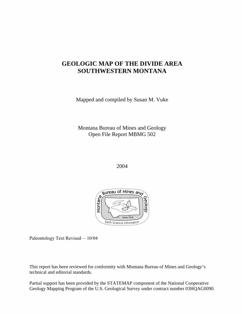
Introduction The narrow Cenozoic valley shown on the geologic map and in Figures 1, 2, and
3 is referred to as Divide Valley in this report. The Cenozoic deposits of the Divide Valley are the focus of this map. Older units are included to show the relations of Cenozoic structures to pre-existing structures, and were mapped only in some areas adjacent to Cenozoic deposits. In all other areas, they were compiled and generalized from previous mapping with some reinterpretation in places. Geologic maps by O’Neill and others (1996), Smedes (1967), and Zen (1988) provide detail not shown on this map for pre-Cenozoic rocks.
A central horst divides the valley into three parts: the northern, central (horst), and
southern segments of this report. Segmentation of the valley is reflected in offset of Cenozoic deposits, and in the present-day position of the Big Hole River.
Late Neogene
During the late Neogene, an ancestral river flowed through the entire Divide Valley. Its course and flow direction changed several times. The central segment horst exposes deposits of this ancestral river (QTal) that likely underlie the entire Divide Valley. The following is an interpretation of the late Neogene history of the Divide Valley based on geologic mapping of the Cenozoic deposits and physiography of the area.
1. North-flowing ancestral river During late Miocene or early Pliocene, northwest-striking faults diverted drainage from the northeast-trending Beaverhead Graben south of the map area (Sears and others, 1995; Sears and Ryan, 2003)(Fig. 4) into the Divide Valley. The river flowed northward toward the Deer Lodge Basin (Fig. 4). Dominantly well-rounded Proterozoic quartzite cobbles and pebbles of the ancestral river deposits (QTal) in the horst are similar in composition to Miocene deposits of the Beaverhead Graben to the south. In addition, red clay in the ancestral river deposits, probably derived from redbeds in the adjacent Eocene Climbing Arrow Member, is present north of the exposures of Climbing Arrow. The apparent southern source of clasts and the deposition of red clay north of its assumed source suggest northward paleoflow. This paleoflow direction agrees with the regional drainage for southwestern Montana at this time (Ruppel, 1967). Proximity to the gravel deposits of the Beaverhead Graben allowed deposition of this valley fill (QTal) by an aggrading outlet river from the graben. 2. Paleoflow Diversion and Development of Drainage Divide
Subsequent faulting diverted the ancestral Divide Valley river to the west (Sears and Ryan, 2003) toward the present-day Big Hole Basin, a Miocene graben (Sears and Ryan, 2003) that was still filling with sediment during the late Neogene. Movement of faults in the northwest-striking McCartney fault zone (Ruppel, 1993; Ruppel and others, 1993)(Fig. 1) may have promoted this westward diversion. With the diversion, a

������
������
�������
��������
�����
��������������
������
�����
����������
� ������
������
�����
������
����
� � � � � � � � � � � �
� � � �
�� ���� �� �����������
������
������
���
�����������
����
� � � � � � � � � �
�� ����
�������� �
����
��� �
�����
�
��
���
�
���� �
����� �
������ �
���
����
���
�
�� �
���
��
�������������������� �!��"#��������"���$�"����%%�#�
��������
� � �������
��
��

������������� ����
���������� ����
������������� ����
�����
�������
����
�������������� ������������������� ������������������������������������������������ �����������
����������������������������������� ������������� ��
������������������������ ������������ �������������������
��������������������������������������� ������������� ���������������������� ������������������������������������������������������ ���
����������������������!��"����#� ���������������������������!���"����!�����$�����������������������������������%��������������������������&���������������������������� ������������������� �������������������������������������������������������
'���������(������������
)������*����(�������)���(�������+�
,
������� ����������
������
���������
���������
��������� ������

����������� �����������������������������
�
����������
���
��������������
���� �������
�����������
�� ��
����� ����
����
���������
����������
������������������������������� ����� ���������������������������������������������������������������� ������������ ���������������������� ���������!���"�#$$%&�
'
���������
drainage divide developed just north of the map area (Fig. 1 and 2) between the Big Hole Basin and the Deer Lodge Basin, forming an unusual segment of the present-day Continental Divide that passes through Cenozoic deposits just north of the map area. Later, as the Big Hole Basin filled and the area experienced isostatic or seismic adjustments, the Big Hole River flowed back to the east, cutting across gravel fill of the older river in the Big Hole Basin (Sears and Ryan, 2003) and incising into Paleozoic and Mesozoic rocks west of Divide, Montana. From there the Big Hole River flowed south through the ancestral river valley south of Divide.
3. Horst Uplift and River Shift
As the central segment horst uplifted and apparently tilted southwestward, the Big Hole River was diverted toward the southwest out of its valley position. As the horst continued to rise, the river incised into relatively resistant Paleozoic and Mesozoic rocks of the horst, producing the present-day canyon of the Big Hole River near Maiden Rock (Fig.1), west of its original valley position in the central segment (Fig. 2). Younger alluvial deposits of the ancestral river in the northern and southern segments (Qat and Qato) align with older alluvial deposits (QTal) of the ancestral river exposed in the horst. Today, the underfit Divide Creek flows south through the northern segment, and the present-day Big Hole River flows south through the southern segment, but the central Divide Valley segment (in the horst) has been completely abandoned. The Big Hole River has shifted westward in all three segments.
Tertiary deposits Two major Tertiary unconformities in the Cordilleran foreland basin fill are the result of specific regional tectonic events related to changes in plate convergence: the Eocene unconformity or Rocky Mountain erosion surface, and a Hemingfordian (Fig. 5) unconformity (Constenius and others, 2003). The Eocene unconformity represents the relatively short-lived (perhaps less than 2 m.y.) hiatus between Laramide crustal shortening, and initiation of Tertiary extension with concurrent magmatism (Constenius and others, 2003). This unconformity is apparent in the southern part of the map area where the Eocene Climbing Arrow Member of the Renova Formation rests on thrusted Paleozoic and Mesozoic rocks, including volcanics.
The second tectonic unconformity, during the Hemingfordian (Fig. 5) (the mid-Tertiary unconformity in older literature), marks the initiation of Basin and Range extension and was also associated with magmatism (Constenius and others, 2003). The regionally extensive Hemingfordian unconformity has been documented in many Tertiary valleys of southwestern Montana (Robinson, 1960; Kuenzi and Richards, 1969; Kuenzi and Fields, 1971; Rasmussen, 1973; Fields and others, 1985; Hanneman, 1989). It is recognized in the southern two segments of the map area with a hiatus that spans at least the Arikareean as well as the Hemingfordian. In the northern segment, no definite physical evidence of the Hemingfordian unconformity was seen, although this unconformity is likely present. Lithostratigraphy for southwestern Montana Tertiary deposits was established in the Jefferson Valley east of the Divide map area by Kuenzi and Fields (1971) partly as a
6

7
modification of formal stratigraphy established in the Three Forks, Montana area (Robinson,1963). Modifications included restricting the Sixmile Creek Formation (Robinson, 1967) to Tertiary strata that overlie the mid-Tertiary (Hemingfordian) unconformity (Fig. 2), and defining a new stratigraphic unit, the Renova Formation, as underlying the unconformity. The Sixmile Creek Formation in the map area is early Barstovian and younger Tertiary (Axelrod, 1984; Lofgren, 1983; Kuenzi and Fields, 1971). Kuenzi and Fields (1971) described the Sixmile Creek Formation as typically coarse-grained (defined as fine sand and coarser) and the underlying Renova Formation as fine-grained (defined as greater than 70 per cent terrigenous very fine sand and finer).
The Renova Formation was divided into three members in the northern part of the map area (Kuenzi and Fields, 1971). Two of the members, the Dunbar Creek and Climbing Arrow were previously formally established as Tertiary formations by Robinson (1963) in the Three Forks, Montana area. Kuenzi and Fields (1971) revised the stratigraphic rank of these formations to member in the upper Jefferson Valley. The Dunbar Creek Member has not been recognized in the map area, but a younger unit (late Oligocene and early Miocene) Cabbage Patch member (informal) has been considered part of the Renova Formation (Rasmussen, 1985).
Five sequences have been recognized in the Cenozoic deposits of the southwestern Montana (Hanneman, 1989). These sequences are identified more from unconformities than lithology because of the lateral and vertical repetition of lithologies throughout the Tertiary section (Hanneman, 1989; Hanneman and Wideman, 1991). The sequence-bounding unconfomities are identified by paleosols (primarily stacked calcic paleosols), erosion surfaces, and angular stratal relationships. The paleosols have been traced from outcrop into the subsurface in the map area where they are recognized as seismic reflectors (Hanneman, 1989; Hanneman and Wideman, 1991). Mapping approach for Tertiary deposits Both the lithostratigraphic and sequence stratigraphic approach to the Tertiary deposits recognize unconformity-bounded units. The International Subcommission on Stratigraphic Classification prefers the name synthem (Chang, 1975) for unconformity-bounded stratigraphic units (Salvador, 1987). The latest (1983) North American Stratigraphic Code introduced the category of allostratigraphic units that are comparable to synthems (Salvador, 1987). A synthem (or allostratigraphic) mapping approach was informally used for the Tertiary in this report on the Divide Valley. Rather than lump all of the Tertiary deposits that overlie the mid-Tertiary (Hemingfordian) unconformity into the Sixmile Creek Formation (Kuenzi and Fields, 1971) or Sequence 4 (Hanneman, 1989), for example, separate facies were mapped as informal map units that comprise the Sixmile Creek synthem in the map area of this report, and other reports (Vuke, 2004; Vuke, 2003). This approach takes into account intrabasinal and interbasinal facies changes within the unconformity-bounded sedimentary packages and also helps in recognizing faults that may juxtapose a younger part of the synthem against and older part.
��
��
��
��
��
��
��
��
�
�
��
��
��
��
��
��
��
��
�
�
��
��
��
��
��
��
��
��
�
�
�
��
����������������������������
�����������
����������
!�����"���
������#������ ���$%������&'����#�����&
���(������
)�����&��
*������
���������
����
+�����
+���&
*��������
+���&
�������
������
����
,���
��������������� ��������������������������������������������������������������������������������
�����
�����
������ ��
������
�������� ��������������
���� ��� �
�����������
�����
������������������
����
���
����
�� �
��������������������������
���������
��
��
����
��
������������������������������������������������������������� ������������ ���� ����� ����� !��"�#$$%&�
'
10
Three of the informal units, Divide, Tucker Creek, and Melrose map units, are facies of the Miocene Sixmile Creek Formation as redefined by Kuenzi and Fields (1971). However, all three units differ markedly from the Sixmile Creek deposits of the Ruby and Beaverhead Miocene grabens (Sears and Ryan, 2003) (Fig. 2) to the southeast and from the Miocene deposits in other Tertiary valleys. Sediment of each of the Miocene map units was very locally derived. Although occasional boulders of monzogranite and limestone are present in both the Divide and Tucker Creek map units, these units are dominantly composed of granule and smaller clasts of monzogranite produced by weathering of Boulder Batholith rocks, and probably deposited primarily by sheetwash on slopes. The Melrose map unit is composed of platy clasts of Precambrian Belt rocks derived from exposures immediately upslope between Moose Creek and Soap Gulch (Fig. 1). South of Soap Gulch it includes other lithologies found immediately upslope, including Paleozoic limestone, chert, and quartzite. The lithostratigraphic and sequence stratigraphic approaches to dividing Tertiary deposits in the upper Jefferson Valley have both been greatly augmented by fossil data in southwestern Montana. Fossils are sparce in the Divide area, but are noted in the map unit explanations.
The following interpretations of the Tertiary history of the Divide Valley are based on work by other researchers cited below, and on field observations in the Divide Valley for this report.
Early Tertiary development of the Divide Valley The Divide Valley originated during the late Paleocene as a part of a large paleovalley along the leading edge of a thrust system (Sears and Ryan, 2003) (Fig. 6). Paleodrainage at that time was to the south, and it transported clasts of Proterozoic Belt rocks to a large southeast-trending fan (Janecke and others, 2000) southeast of the Divide Valley along the Montana-Idaho border (Sears and Ryan, 2003). Northern Valley Segment
The exposed Tertiary beds in the northern Divide Valley segment are Arikareean (late Oligocene and early Miocene) (Fig. 5) and younger deposits. Arikareean strata have been called the Cabbage Patch beds (Konizeski and Donohoe, 1958; Rasmussen, 1989; Rasmussen and Prothero, 2003) or the Cabbage Patch Formation (Rasmussen, 1977) and are equivalent to the upper Renova Formation (Rasmussen and Prothero, 2003). In this report, these strata are referred to informally as the Cabbage Patch member of the Renova Formation. Arikareean fossils have been found in the Cabbage Patch member in the map area (Douglass, 1907, 1908; Wood, 1936; Schultz and Falkenbach, 1950; and Rasmussen (1977).
Immature granitic and volcanic two-mica (muscovite and biotite) sandstones
occur in the Renova Formation in many Tertiary basins of southwestern Montana (Thomas, 1995). Studies of composition, spatial distribution, grain size and paleocurrent direction suggest that the sands originated from the Idaho Batholith and were deposited toward the east on a braidplain with subdued topography (Thomas, 1995) on the eastern

11
shoulder of an Eocene to Oligocene north-south-trending rift zone to the west (Janecke, 1994; Janecke, 1995; Thomas, 1995; Sears and Fritz, 1998; Sears and Ryan, 2003). Two-mica sandstone crops out just south of Divide (Thomas, 1995; written communication, 2004) and northeast of Divide in the Cabbage Patch member. It is a coarse-grained sandstone or locally a granule conglomerate.
Although much of the sediment of the Cabbage Patch member is reworked unaltered volcaniclastics and montmorillonitic mudstone (Rasmussen, 1989), there are also fluvial channel, and debris-flow deposits that contain locally derived angular to subangular clasts of granitic rock from the plutons of the Boulder Batholith; hornfels and quartzite primarily from contact-metamorphosed Mesozoic sedimentary rocks; and limestone from Paleozoic rocks, all of which were very locally derived. The abundance of these angular to subangular clasts, as much as 3 feet wide, suggests the presence of at least an incipient highland immediately to the west during deposition of the younger Cabbage Patch member, perhaps reflecting the initiation of the tectonic events that ultimately produced the regional Hemingfordian unconformity.
The younger Tertiary deposits that overlie the Cabbage Patch member in the
northern Divide Valley segment have been divided into two informal map units for this map based on lithology and fossils: (1) the Divide map unit from which Barstovian (mid to late Miocene) fossils have been found (Hanneman, 1989, identified by R. Nichols; this report, identified by A. Tabrum), and (2) the Tucker Creek map unit from which a tooth of a possible Clarendonian, but more likely Hemphillian hypsodont horse (A. Tabrum, written communication, 2004) was found during mapping for this report. All the sediment of the Divide and Tucker Creek map units is very locally derived, primarily arkose granules and granule conglomerate from the Boulder Batholith with occasional Paleozoic limestone clasts. Local lenses of breccia are present with very locally derived monzogranite and granodiorite, limestone, hornfels, and quartzite clasts.
The Hemingfordian unconformity has been recognized in most of the Tertiary
valleys of southwestern Montana (Robinson, 1960; Kuenzi and Richard, 1969; Kuenzi and Fields, 1971; Rasmussen, 1973; Fields and others, 1985; Hanneman, 1989). However, none of the physical features of Tertiary unconformities found elsewhere was observed between Arikareean and Barstovian strata in the northern segment. Some of these features are well-developed calcic paleosols, erosional features, and angular stratal relationships (Hanneman, and others 2003; Hanneman and others, 1994; Rasmussen, 1989). East of the Interstate 15 exit to Divide, exposed sections of the upper Cabbage Patch member, the Divide map unit, and the Tucker Creek map unit can be traversed in the draws that drain into Divide Creek. A Barstovian or younger fossil (D. Rasmussen, personal communication, 2003) was found near the contact between the Cabbage Patch member and the Divide map unit in one of the draws during field work for this map. Barstovian strata postdate the mid-Tertiary (Hemingfordian) regional unconformity (Fig. 5). Although weakly developed root zones are present in the upper Cabbage Patch member below where the fossil was found, there is no obvious physical evidence of an unconformity between the upper Cabbage Patch member and the Divide map unit, nor between the Divide and Tucker Creek map units.

12
Central and Southern Valley segments
The oldest exposed Tertiary unit in the central (horst) and southern segments is the Eocene Climbing Arrow Member of the Renova Formation. Oligocene fossils were reported from the Soap Gulch area (Fields, and others, 1985; Hanneman, 1989). However, they are more likely Eocene (Chadronian) in age (A. Tabrum, written communication, 2004). No fossils were found in the Melrose map unit, which is interpreted as a facies equivalent of the Tucker Creek and/or Divide map units. The facies change is directly related to provenance. The fault that bounds the northwest side of the central segment horst coincides with a fault that separates the southern margin of the Moose Creek Pluton from Paleozoic and Precambrian country rock. Sediment of the Divide and Tucker Creek map units was dominantly derived from the adjacent plutons of the Boulder Batholith, whereas sediment of the Melrose map unit was dominantly derived from Proterozoic Belt rocks north of Soap Gulch and Paleozoic rocks south of Soap Gulch, reflecting the local sources in areas just upslope from these deposits.
Structure The map area is located at the intersection of two major fault trends, northwest and northeast. The faults intersect in the map area, but northeast-striking faults are dominant in the northern part. The northwest-striking faults are part of a zone of faults that may have originated as basement rift faults during the Precambrian (Schmidt and Garihan, 1986b). Movement on the northwest-striking faults has occurred at least during the middle Proterozoic, the Laramide, and Neogene extension (Schmidt and Garihan, 1986b; O’Neill and others, 1986).
The northeast-striking faults are part of another zone of recurrent faults, the Great Falls Tectonic Zone that extends from Salmon, Idaho through the Great Falls, Montana area and into Saskatchewan. It overlies a basement suture zone (O’Neill and Lopez, 1985; O’Neill, 1997a). Movement on faults of this zone occurred from the middle Proterozoic through Holocene (O’Neill, 1997a). A bend in the Divide Valley, from a northwest trend in the southern part of the map area to northeast trend in the northern part, reflects these two structural trends because the valley is fault-bounded, at least on one side, throughout much of its length. The fault that bounds the Divide Valley on the east throughout its length, extends north of the map area to Rocker, Montana, and has been called the Rocker fault. It has experienced Quaternary offset (Stickney and others, 2000).
Cenozoic faults also appear to have developed along zones of weakness at the
southern boundaries of Boulder Batholith plutons. An inferred east-west-striking, down-to-the-north fault in the northern part of the map area extends to the southern boundary of the Climax Gulch Pluton. Veins in the pluton also have a dominant east-west strike (Smedes, 1967; F. Foster, personal communication, 2004).

13
A somewhat arcuate fault with an east-west-striking segment, but regional northeast strike, bounds the southern margin of the Moose Creek Pluton and appears to trend toward a zone of metasomatic and hydrothermally altered shear (Smedes and others, 1980) of the Moose Town fault zone (F. Foster, and R. McCullough, personal communication, 2004) east of the map area. The fault bounds the central Divide Valley horst block on the north (Fig. 2). Aeromagnetic maps of the region show steep, linear, northeast-trending gradients at the southeast boundary of the Moose Creek Pluton that continue across the Divide Valley (Hanna and others, 1993; Smedes and others, 1980; Johnson and others, 1965) in the position of the northeast edge of the horst and associated faults. The steep gradients indicate that the Moose Creek Pluton continues in the subsurface westward for 5 miles (Smedes and others, 1980). The steepness and linearity of the gradient suggest fault control. The Moose Creek Pluton has been interpreted as intruding a north-dipping regional homocline in Paleozoic rocks (Smedes and others, 1980). An alternative interpretation, supported by the aeromagnetic data, is that the contact is a fault that either controlled emplacement of the pluton or subsequently developed along a zone of weakness at its margin. The emplacement of the Boulder batholith overlapped in time with Laramide thrust faulting. The batholith might have moved eastward over an unidentified basal decollement (Schmidt and others, 1990). The eastern contact of the batholith farther north dips inward about 50º (Vejmelek and Smithson, 1995), supporting idea that the batholith has been thrust eastward. At the southern boundary of the Moose Creek Pluton, thrusting may have been to the southeast during the Laramide followed by listric normal faulting (down to the north) along the same fault plane during the Cenozoic.
Relations of Cenozoic deposits in the horst to those north and south of the horst
suggest at least two episodes of movement on the fault. Following the Arikareean or during latest Arikareean the fault that bounds the north side of the horst was down-dropped to the north. The lack of Arikareean deposits south of this fault suggests that either there was no deposition during the Arikareean, or there was erosional beveling on the south side of the fault resulting in the removal of Arikareean and possibly older deposits. Post-Hemingfordian Miocene and younger Tertiary deposits (Divide and Tucker Creek map units) rest on Arikareean deposits north of the fault. Correlative deposits of the Melrose map unit rest on Chadronian deposits in the horst and deposits ranging from Chadronian to possibly Orellan and Whitneyan south of the horst. The second episode of movement occurred after deposition of the ancestral valley deposits (QTal) and probably after deposition of younger alluvium (Qato and Qat).
Laramide thrust faults (incompletely shown on this map) do not appear to have
influenced Cenozoic structure in the area. Cenozoic faults offset the thrust faults in several places.
Northern Divide Valley Segment
In the northern Divide Valley segment, faults strike dominantly to the northeast, although northwest-striking faults are also present. At least two inferred northeast-striking faults north of Divide and west of Divide Creek may have had Pleistocene or

14
Holocene movement because they offset Pleistocene or Holocene colluvium dominantly composed of resistant, angular and subangular, cobble-size clasts.
The northeast valley trend and the strike of faults in the northern segment do not
appear to correlate with gravity and aeromagnetic anomalies. The presence of the Boulder Batholith in this area may mask deep basement structures of the Great Falls Tectonic Zone (O’Neill and Lopez, 1985; O’Neill, 1997a) that may have had the greatest influence on Cenozoic structures in this part of the valley. In the northern valley segment all of the Tertiary units were tilted to the east along northeast-striking, valley-bounding faults.
Central and Southern Divide Valley Segments
In the central and southern Divide Valley segments, Cenozoic faults strike both northwest and northeast, in some cases following older faults. The central segment horst is bounded by northeast-striking faults, as is a smaller horst southwest of it. Pliocene or Pleistocene debris-flow and related deposits (QTdf) are offset by northeast-striking faults, suggesting that these faults are latest Tertiary or Quaternary. The debris-flow deposits contain small to very large blocks of quartzite as much as 5 feet wide. The origin of the blocks is unclear, but they appear to be derived from the east based on their distribution and slope, possibly from a Pliocene upland erosion surface. Remnants of an upland erosion surface in the area are strewn with large quartzite boulders (Alden, 1953). In some places the quartzite boulders remain as a lag of quartzite blocks. The altitude and areal extent of the debris-flow deposits change from one fault block to another, suggesting that an episode of faulting post-dated their deposition.
Northwest-striking faults form the northeast margin of the Divide Valley in the
central and southern segments. These faults have resulted in northeast tilt of both the Climbing Arrow Member and the Melrose map unit, suggesting late Tertiary or Pleistocene movement. The northwest-striking faults are older than those that strike northeast in this part of the valley.
The South Rochester Fault extends into the southeast corner of the map
continuing from the northeastern flank of the Ruby Range across the valley south of Twin Bridges and through the Rochester mining district in the southern Highland Mountains (Garihan and others, 1982; Sahinen, 1939). Late Cenozoic movement is suggested on the South Rochester fault by right separation of the trace of a Laramide thrust fault near Camp Creek (Duncan, 1976; Garihan and others, 1982) in the southeastern corner of the map.
The generally east-west-striking Camp Creek Fault in the southeastern part of the
map area is a low-angle north-dipping fault that separates Archean rocks to the south from Proterozoic rocks to the north (McMannis, 1963; O’Neill and others, 1986). Cenozoic movement is suggested by the truncation of Laramide thrust faults at its westernmost exposure. The Precambrian precursor to the Camp Creek Fault separated the Proterozoic Helena Embayment of the Belt Basin from cratonic rocks to the south (O’Neill, 1995), so it is a significant basement structure with recurrent movement,
15
including during the Cenozoic. Its better-known counterpart to the east, the Precambrian Willow Creek fault, was overprinted by the right-lateral, oblique-slip thrust faults of the Southwest Montana Transverse Zone (Schmidt and O’Neill, 1982; O’Neill, 1995.) Summary The partially fault-bounded Divide Valley was segmented into three main parts by recurrent uplift of a central horst that also diverted the course of the Big Hole River where it crossed the horst. The northern part of the valley trends northeast, to a large extent because of northeast-striking faults that dominate that area. In addition, an east-west fault crosses the northern part of the valley following a fault that bounds the southern part of the Climax Gulch Pluton. The central and southern segments of the valley trend northwest, following a northwest-striking fault zone. They are segmented by northeast-striking faults that produced the central segment horst and a smaller horst in the southern segment.
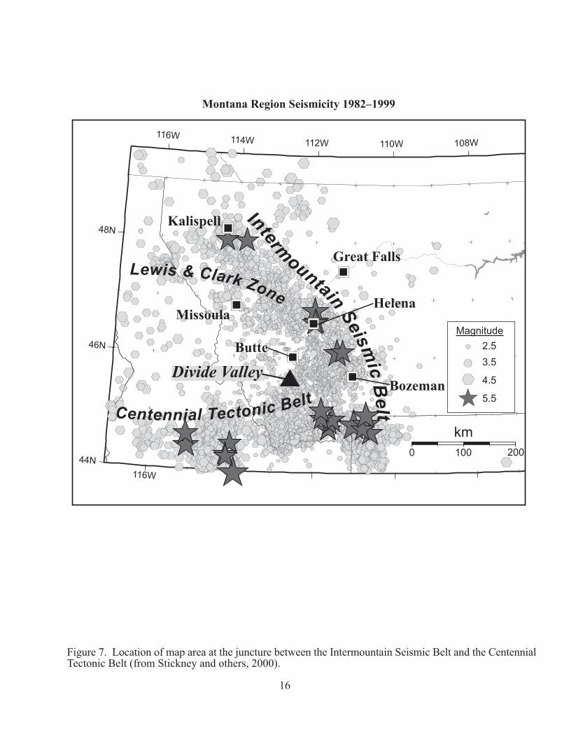
The following provide evidence for Cenozoic movement, in some cases recurrent, on many of the faults in the Divide Valley: (1) exposure of apparently the oldest alluvium of the ancestral Divide Valley river in the central horst segment; (2) an abrupt change in the oldest exposed Tertiary across the northern fault of the horst; (3) Tertiary unconformities that represent a greater hiatus in some blocks than others; (4) offset of Tertiary and/or Quaternary debris-flow deposits in the central and southern segments; (5) offset of Quaternary colluvium in the northern segment; (6) offset of northwest-striking faults by northeast-striking faults in the southern segment of the Divide Valley, (6) preservation of alluvial terrace deposits (Qato) only on the downthrown side of a fault that crosses the valley, and (7) post-Laramide offset of thrust faults by the Camp Creek and South Rochester faults. The map area lies at the juncture between the Centennial Tectonic Belt (east-west trend) and the Intermountain Seismic Belt (northwest trend) (Fig. 6), a region of on-going seismicity (Stickney, and others, 2000) (Fig. 7).
����
���� ���� ���� ���� ����
���
���
������������
���������
�������
������
��
��������������
������
���������
�
����������� �� ��� ����
���� � ���� ����
� ��� ���
�� ������
���
���
���
���
���������������������������������
������������ ��������� �� �� � ������������������������������������� ���������������� ��������������� ������������������������� ��!� ���������"�#$$$%
����������
&6

A
B
D
E F
INDEX OF 7.5’ QUADRANGLES AND SOURCES OF GEOLOGIC MAPPING GEOLOGIC MAP OF THE DIVIDE AREA
CB
E
A. Dewey 7.5’ quadrangle (part) B. Tucker Creek 7.5’ quadrangle C. Mount Humbug 7.5’ quadrangle (part) D. Cattle Gulch 7.5’ quadrangle (part) E. Melrose 7.5’ quadrangle F. Wickiup Creek 7.5’ quadrangle (part) Brumbaugh, 1973, 1:24,000 scale: E (part) Dresser, 1995, aerial photo maps; and 1996 unpublished map of Soap Gulch area: E (part) Duncan, 1976, 1:31,680 scale: F (part) Hanneman, 1989, 1:63,360 scale: B (part), E (all) Hutchinson, 1948, 1:30,000 scale: E (part) Puumala, 1948, 1:42,240 scale (map by Puumala and Roe): A (all), B (part) Richards and Pardee, 1925, 1:62,500 scale: A (all), B (part), D (all), E (all) Roe, 1948, 1:42,240 scale (map by Puumala and Roe): A (all), B (part) Ruppel, and others, 1993, 1:250,000 scale: entire map area Sahinen, 1938, unpublished field map of Soap Gulch area: E (part) Sahinen, 1939, scale 1:63,360, E (part), F (part) Sahinen, 1950, scale 1:63,360, B (part), C (all), E (part), F (part) Smedes, 1967, scale 1:24,000: B (all), C (all) Theodosis, 1956, 1:24,000 scale: A (all), B (part), D (all), E (part) Zen, 1988, 1:48,000 scale: D (all) U.S. Geological Survey Map I-2525 (out-of-print) by O’Neill and others (1996) was inadvertently and regretfully not used in the compilation of the geology of the southern Highland Mountains. 17

18
CORRELATION DIAGRAM GEOLOGIC MAP OF THE DIVIDE AREA
AR
CH
- E
AN
ME
SOZ
OIC
PAL
EO
ZO
IC
PRO
TE
RO
- Z
OIC
Qls
Qal
Qpa
Qaf
Qta
Qac
Qc
?
?
Qato QTal QTls QTdf
Tat
Ttc
Holocene
Pleistocene
Pliocene
Miocene
Oligocene
Eocene
?
?
unconformity
Tcp
Tme
Qat
?
?
Tdiv
?
Tv
QTgr
? ? ? ?
Kgd Kgb Kmog Cretaceous
Mzu
Pzu
Quaternary
Tertiary
CE
NO
ZO
IC
unconformity
unconformity
Tca
Ysg
unconformity
unconformity
Ynl
Ags
Sixmile Creek synthem
Renova synthem
Tv

19
EXPLANATION GEOLOGIC MAP OF THE DIVIDE AREA
Qal ALLUVIUM (Holocene)—Gravel, sand, silt, and clay in channels and floodplains. Divide Creek Qal estimated as much as 20 ft thick. Big Hole River Qal estimated as much as 50 ft thick (probably underlain by QTal alluvium).
Qpa PALUDAL DEPOSIT (Holocene)—Sand, silt, and organic matter
deposited in shallow water. Thickness estimate: less than 20 ft. Qaf ALLUVIAL FAN DEPOSIT (Holocene)—Gravel, sand, and silt
deposited in small alluvial fans where streams meet a valley floor. Thickness estimate: as much as 30 ft.
Qta TALUS (Holocene)—Angular, very locally derived, unconsolidated clasts
on and below relatively steep slopes. Thickness estimate: as much as 50 ft.
Qls LANDSLIDE DEPOSIT (Holocene and/or Pleistocene)—Unconsolidated
mixture of soil and blocks of bedrock that was transported down slopes by mass wasting.
Qc COLLUVIUM (Holocene and Pleistocene)—Bouldery gravel,
dominantly cobble size, with matrix of sand, silt, and clay, deposited on slopes. Boulders are small in contrast to large boulders in QTdf. Clasts are locally derived hornfels, quartzite, limestone, and marble; angular to subangular; and locally iron-oxide stained or calcium carbonate cemented. Locally, matrix is granitic sediment. Thickness as much as 20 ft.
Qac ALLUVIUM AND COLLUVIUM, UNDIVIDED (Holocene and
Pleistocene)—Pebbles, sand, silt, and clay deposited on valley floors and gentle slopes. Thickness estimate: as much as 15 ft.
Qat ALLUVIAL TERRACE DEPOSIT (Holocene and Pleistocene)—
Deposits of alluvium adjacent to, and slightly higher than the alluvium (Qal) of Divide Creek in the northern part of the Divide Valley, and of the Big Hole River in the southern part. Deposits generally covered by fine sediment and soil. Apparently removed by erosion in the central (horst) segment. Thickness not known.
Qato OLDER ALLUVIAL TERRACE DEPOSIT (Pleistocene?)—Rounded to
subrounded gravel, dominantly of cobbles and pebbles with sandy

20
matrix. Clasts composed dominantly of Proterozoic quartzite and igneous rocks with calcium carbonate rinds. Thickness about 20 ft.
QTal ALLUVIUM (Pleistocene and Pliocene?)—Gravel, dominantly of well-
rounded cobbles and pebbles, with a matrix of sand, silt, and clay, and sandy, locally red, clay interbeds. Clasts are dominantly Proterozoic quartzite with subordinate granitic rock. Interpreted as channel-fill deposits of a south-flowing aggrading ancestral Divide Valley river. Thickness as much as 300 ft.
QTls OLDER LANDSLIDE DEPOSIT (Pleistocene and/or Pliocene)—
Unconsolidated sand, silt, and clay with unoriented larger, subangular to angular clasts ranging from pebble to small boulder size. Deposit located on downthrown side of inferred fault. Thickness estimate: as much as 100 ft.
QTdf DEBRIS FLOW DEPOSIT (Pleistocene and Pliocene?)—Gravel with
large subangular tabular quartzite boulders as much as 5 ft in diameter. Other compositions include hornfels, dense fine-grained igneous rocks, and Paleozoic limestone. North of Soap Gulch, deposits are discontinuous. Some are lag deposits lacking finer sediment. South of the Soap Gulch area deposits are thicker and include rounded cobbles and small boulders of Proterozoic Belt quartzite. Thickness north of the Camp Creek area about 20 ft. Thickness estimate south of Soap Gulch as much as 75 ft.
QTgr GRAVEL (Pleistocene and Pliocene?)—Well-rounded to rounded
cobbles, pebbles, sand, silt and clay. Larger clasts dominantly Proterozoic Belt quartzite with subordinate granite and other rocks. Deposits may be of tributaries to older, now buried channel deposits of the ancestral Divide Valley river. Thickness about 20 ft.
Tat ALLUVIAL TERRACE DEPOSIT (Pliocene?)—Well-rounded to
rounded small boulders, cobbles, pebbles, and sand dominantly composed of Proterozoic quartzite and conglomerate. At higher altitudes than Qat and QTgr. Thickness as much as 20 ft.
Ttc TUCKER CREEK INFORMAL MAP UNIT (Pliocene)—Arkose granule
conglomerate and unconsolidated granules derived from weathered monzogranite in immediate area. Basal part to entire thickness relatively well-cemented with calcium carbonate. Local small pods of breccia or subangular conglomerate with clasts derived from the immediate area, generally of monzogranite, and hornfels with subordinate limestone. Local rounded boulders of monzogranite in matrix of monzogranite granules. Equivalent to the “lime-

21
cemented arkose” of Smedes (1967). Finer-grained in northern part of map area with many granule- to pebble-size clasts floating in a matrix of finer-grained sediment interbedded with arkose granule conglomerate. Tooth of a possible Clarendonian, but more likely Hemphillian, hypsodont horse was found during this study (identified by A. Tabrum, written communication, 2004) in the lower part. Age equivalent to Six Mile Creek Formation. Thickness 80 to110 ft.
Tme MELROSE INFORMAL MAP UNIT, (Miocene and/or Pliocene)—
Unconsolidated cobble-size clasts of platy, angular Newland and LaHood Formation rocks from the Moose Creek area to the Soap Gulch area. In the Soap Gulch area clasts also include limestone, conglomerate and other lithologies derived from rocks in the immediate area. Locally cemented with calcium carbonate in Soap Gulch and Camp Creek areas, and interbedded with fine-grained sandstone and argillic siltstone with floating, locally derived angular or subangular granules and pebbles. Unit interpreted as a facies equivalent of the Divide and/or Tucker Creek informal map units, and is therefore interpreted as mid to late Miocene and/or Pliocene. Age equivalent to Sixmile Creek Formation. Exposed thickness about 300 ft.
Tdiv DIVIDE INFORMAL MAP UNIT, (Miocene and Pliocene?)—
Unconsolidated granules and weakly cemented arkose granule conglomerate derived from weathered monzogranite in the immediate area. Local small pods of breccia or subangular conglomerate with clasts derived from the immediate area, generally of monzogranite, and hornfels with subordinate limestone. Local rounded boulders of monzogranite in matrix of monzogranite granules. Locally, granules are matrix-supported in a matrix of tan silt and clay. Age equivalent to Sixmile Creek Formation. Thickness 60-80 ft.
Tcp CABBAGE PATCH MEMBER OF RENOVA FORMATION (informal)
(Oligocene and Miocene)—Pinkish-tan, tuffaceous siltstone and poorly sorted arkosic sandstone with lenses of texturally very poorly sorted angular to subangular clasts of locally derived hornfels, quartzite, monzogranite, granodiorite, and limestone. Lenses vary greatly in size, and clasts within lenses also vary greatly, ranging to as much as 3 ft across. Upper part of unit is white, light gray, and yellowish siltstone and fine-grained sandstone with diatomite beds and weakly developed calcareous root horizons at the top. Two-mica coarse-grained sandstone present south of Divide (Thomas, 1995) and northeast of Divide where it is locally a poorly sorted granule conglomerate.

22
Arikareean fossils have been found in the map area near Woodin (between Feeley and Divide) (Wood, 1936; Schultz and Falkenbalk, 1950; Rasmussen, 1977). Zircons from a volcanic ash bed (SW ¼, SE ¼, NE ¼, Sec. 28, T1N, R9W) yielded a peak age of 20 m.y. and an overall age of 27.02 m.y. (Hanneman, 1989; analysis by C. Naser, USGS). Exposed thickness about 200 ft.
Tca CLIMBING ARROW FORMATION OF RENOVA FORMATION, (Eocene and Oligocene)—Dominantly red siltstone and shale, greenish-brown bentonitic mudstone, and yellowish chippy-weathering, hard, micaceous claystone and siltstone. Other lithologies include: poorly sorted pebble conglomerate with rounded clasts of light-colored igneous rock, brown chert, and Proterozoic quartzite; breccia of igneous rocks floating in yellowish-tan tuffaceous sandstone; dark brown, manganese-cemented coarse-grained sandstone; and black shale. In the Trapper Creek area includes white to yellowish, fine agglomeratic ash beds that are locally fossiliferous. A late Duchesnean to early Chadronian fossil (Hanneman, 1989; identified by A. Tabrum), and a pre-Arikareean Oligocene (probably Orellan or Whitneyan) fossil locality (Fields and others, 1985; Hanneman and others, 2003; identified by A. Tabrum) were found in this unit. The latter has been revised to Chadronian (A. Tabrum, written communication, 2004). Two Chadronian fossils were also found in this unit by Kay and others (1958). Exposed thickness about 200 ft.
Tv VOLCANIC ROCKS, UNDIVIDED (Miocene and Eocene)—Basalt,
andesite, trachyandesite, or rhyolite. Volcanic rocks south of the Big Hole River near Divide were dated as Miocene and Eocene (Zen, and others, 1979). A Miocene age was also determined in this area by Chadwick (1978).
Ki INTRUSIVE ROCKS, UNDIVIDED (Cretaceous)—Monzogranite,
granodiorite, and related granitic intrusive rocks, and gabbro. Large aeromagnetic anomaly between Melrose and Divide indicates that intrusive rocks near the Big Hole River in this area are part of a stock that is mostly buried beneath the valley fill (Pearson, 1982; Smedes and others, 1982).
Kgd GRANODIORITE (Cretaceous)(from Smedes, 1967)—Medium- to dark-
gray-, equigranular, fine- to medium-grained. Kgb GABBRO (Cretaceous) (from Smedes, 1967)—Fine- to coarse-grained
highly porphyritic rock with large phenocrysts of pyroxene.

23
Kmog MONZOGRANITE (Cretaceous)—Light gray, equigranular to strongly porphyritic, medium-grained to very coarse-grained granitic rocks of the Moose Creek Stock, and most of the Butte Quartz Monzonite (Ruppel, and others, 1993; Smedes, 1967) of the Boulder Batholith. Locally xenolith-rich with abundant large and small inclusions of dioritic rock. Local pegmatite, alaskite, and aplite. Moosetown Stock contains a facies with abundant phenocrysts of potassium feldspar and a fine-grained facies with aplitic groundmass (Smedes, 1967).
Mzu MESOZOIC ROCKS, UNDIVIDED Blackleaf Formation (Cretaceous)—Contact-metamorphosed in
map area to hornfels, quartzite, and quartzite conglomerate. Kootenai Formation (Cretaceous)—Contact-metamorphosed in
map area to quartzite, marble, hornfels, and quartzite conglomerate.
Dinwoody Formation (Triassic)—Fossiliferous limestone and silty shale or tuffaceous shale.
Pzu PALEOZOIC ROCKS, UNDIVIDED Phosphoria Formation (Permian)—Quartzite, phosphate rock,
black shale; locally contact metamorphosed to hornfels. Quadrant Formation (Pennsylvanian)—Cross-bedded
homogeneous quartzite and sandstone. Amsden Formation (Mississippian and Pennsylvanian)—Red
siltstone, reddish to brown sandstone, and chert-banded limestone, locally contact metamorphosed to hornfels and marble.
Madison Group (Mississippian)—Fossiliferous limestone locally contact-metamorphosed to marble.
Three Forks Shale (Devonian)—Light-orange, green or black shale, locally densely fossiliferous; grayish-brown argillaceous limestone; and light-orange siltstone.
Jefferson Dolomite (Devonian)—Dark-gray, fetid dolomite with algal structures and local solution breccia.
Red Lion Formation (Cambrian)—Sandy dolomite with algal structures.
Pilgrim Dolomite (Cambrian)—Light-gray massive dolomite. Park Shale (Cambrian)—Gray shale. Meagher Dolomite (Cambrian)—Mottled dolomite. Wolsey Shale (Cambrian)—Micaceous shale. Flathead Sandstone (Cambrian)—Sandstone with medial red
mudstone.
Ysg SPOKANE AND GREYSON FORMATIONS, UNDIVIDED (Middle Proterozoic )(from Ruppel and others, 1993)

24
Spokane Formation—Grayish-tan, structureless to laminated and commonly cross-bedded, argillaceous siltite and minor dark-grayish-green silty argillite interlayered with discontinuous very fine grained sandy lenses. Conspicuous white to pinkish-white, fine- to coarse-grained, grain-supported quartzite beds 1-2 m thick common in upper part of formation.
Greyson Formation—Upper dark-gray to black, laminated and platy to massive argillite and silty argillite that contains numerous soft-sediment slump structures. Basal part consists of light- to dark-gray, silty argillite and argillaceous siltite with uneven to even parallel laminations, locally interlayered with tan, discontinuous silty lenses, and with discontinuous beds of matrix-supported quartzite composed of well-rounded grains.
Thickness of map unit 400 m. Ynl NEWLAND AND LAHOOD FORMATIONS, UNDIVIDED (Middle
Proterozoic) (from Ruppel and others, 1993). Newland Formation—Dark-green to pinkish-gray argillite, silty
argillite, and minor marl with centimeter-thick planar tabular beds. Thin discontinuous lenses of crystalline medium-gray limestone in upper part.
Intermediate unit—Argillite, siltite, and minor sandstone that lack the planar tabular beds of the Newland Formation and the grit of the underlying LaHood Formation.
LaHood Formation—Coarse conglomerate and breccia that grade laterally into quartz-pebble conglomerate; coarse, argillaceous lithic grit; and arkose. The arkose grades into interlayered shale, siltstone, sandstone, and subordinate pebble conglomerate and argillaceous grit.
Thickness of map unit 700 m. Ags GNEISS AND SCHIST (Archean)(from Ruppel and others, 1993)—
Quartz-feldspar-biotite gneiss, and granitic gneiss interlayered with schist, and amphibolite.
��
��������������� ������������
����������������� ���� ������������������������� �!"!�#� ��$��� ���������#�%#��!��&
��������������������%'�����(��� ����������%'������'�)! ���#�%#��!��&����!!��%��*����%����% ����%�����&
���������������� ���������#�%#��!��$���� �� ���%�)������!� �&�%#���!� �!"���������%���) ���� ��%�#��%����'����&
��� ������� �������� ���+)�*����%��#� ����%,!���'������%��,����&
��� ������� &
�������������+)�*����%��#� ����%,!���'������%���,����&
��� ������� �������� �� ���+)�*����%��#� ����%,!���'������%��,����&
��
��
��

�-
����� �������%,� ��#���'�����!��!�%���%������# ��%��'��!)%,�$�� ���������#�%#��!��&���!)%,����������� ���������%� �!)%,�%,�����!)%,������# ��%�)%.%��%&
��� �� �������%,� ��#���'�����!��!�%���%������# ��%��'��!)%,�$�� ���������#�%#��!��&���!)%,����������� ���������%� �!)%,�%,�����!)%,������# ��%�)%.%��%&
������������ �� �������%,� ��#���'�����!��!�%�&���� ��������#�%#��!��&
�������������� �������%,� ��#���'�����!��!�%�&���� ��������#�%#��!��&
������������ ������ �� ���������� �� ����������� ��
����� �� �����

27
REFERENCES CITED AND SELECTED BIBLIOGRAPHY GEOLOGIC MAP OF THE DIVIDE AREA
Alden, W.C., 1953, Physiography and glacial geology of western Montana and adjacent
areas: U.S. Geological Survey Professional Paper 231, 200 p. Andretta, D.B., 1961, Geology of the Moose Creek Stock, Highland Mountains,
Montana: Bozeman, Montana State University, M.S. thesis, 67 p. Atwood, W.W., 1918, The physiographic conditions at Butte, Montana, and Bingham
Canyon, Utah, when the copper ores in these districts were enriched: Economic Geology, v. 12, p. 541–547.
Berggren, W.A., Kent, D.V., Aubry, M.-P., Swisher, C.C., III, and Miller, K.G., 1995, A
revised Paleogene geochronology and chronostratigraphy: Society of Economic Paleontologists and Mineralogists Special Publication 54, p. 129–212.
Biehler, S., and Bonini, W.E., 1969, A regional gravity study of the Boulder Batholith,
Montana, in Larsen, L., ed., Igneous and Metamorphic Geology: Geological Society of America Memoir 115, p. 401–422.
Burfeind, W.J., 1967, A gravity investigation of the Tobacco Root Mountains, Jefferson
Basin, Boulder Batholith, and adjacent areas of southwestern Montana: Bloomington, Indiana University, Ph.D. dissertation, 90 p.
Brumbaugh, D.S., 1973, Structural analysis of the complexly deformed Big Hole River
area, Madison, Beaverhead, and Silver Bow Counties, Montana: Bloomington, Indiana University, Ph.D. dissertation, 96 p.
Brumbaugh, D.S., 1981, The McCarthy Mountain structural salient, southwestern
Montana, in Tucker, T.E., ed., Southwest Montana: Montana Geological Society Field Conference and Symposium Guidebook, p. 201–209.
Chadwick, R.A., 1981, Chronology and structural setting of volcanism in southwestern
and central Montana, in Tucker, T.E., ed., Southwestern Montana: Montana Geological Society Field Conference and Symposium Guidebook, p. 301–310.
Chadwick, R.A., 1978, Chronology of post-Eocene rhyolitic and basaltic volcanism in
southwestern Montana: Isochron/West, no. 22, p. 25–28.

28
Chandler, V.W, 1973, A gravity and magnetic analysis of the McCarthy Mountain area, Madison and Beaverhead Counties, Montana: Bloomington, Indiana University, M.S. thesis, 47 p.
Constenius, K.N., Esser, R.P., and Layer, P.W., 2003, Extensional collapse of the
Charleston-Nebo salient and its relationship to space-time variations in cordilleran orogenic belt tectonism and continental stratigraphy, in Flores, R.M., and Raynolds, R.G., eds., Cenozoic systems of the Rocky Mountain region: Rocky Mountain section SEPM (Society for Sedimentary Geology), p. 303–343.
Dawkins, R.G., 1996, Paleocurrents in the Miocene Big Hole River gravel, southwest
Montana: Effect of the Yellowstone hotspot on sedimentation: Atlanta, Georgia State University, M.S. thesis, 89 p.
Douglass, Earl, 1905, The Tertiary of Montana: Carnegie Museum Memoir, v. 2, p. 204–
223. Douglass, Earl, 1907, Some new merycoidodonts: Annals of the Carnegie Museum, v. 4,
p. 99–109. Douglass, Earl, 1908, Fossil horses from North Dakota and Montana: Annals of the
Carnegie Museum, v. 4, p. 267–277. Dresser, Hugh, 1996, A stereo picture guide to some of Montana’s thrust faults,
unpublished. Dresser, Hugh, 1995a, Compressional tectonics of the Soap Gulch area, SW Montana, in
Thomas, R.C., ed., Geologic history of the Dillon area, southwestern Montana: Northwest Geology, v. 25, p. 27–32.
Dresser, Hugh, 1955b, A pictorial guide to the faults of the Camp Creek-Soap Gulch
area, southwestern Montana, unpublished. Duncan, M.S., 1976, Structural analysis of the pre-Beltian metamorphic rocks of the
southern Highland Mountains, Madison and Silver Bow Counties, Montana: Bloomington, Indiana University, Ph.D. dissertation, 222 p.
Fields, R.W., Tabrum, A.R., Rasmussen, D.L., and Nichols, R., 1985, Cenozoic rocks of
the intermontane basins of western Montana and eastern Idaho: A summary, in Flores, R.M., and Kaplan, S.S., eds., Cenozoic Paleogeography of West-Central United States: Rocky Mountain Paleogeography Symposium 3, Rocky Mountain Section, Society of Economic Paleontologists and Mineralogists, p. 9–36.
Fields, R.W., and Weidman, R.M., 1981, Third day geologic road log, Leg 4. Divide
Junction to Dillon via U.S. Interstate 15, in Tucker, T.E., ed., Southwest Montana: Montana Geological Society Field Conference and Symposium Guidebook, p. 397–398.

29
Gale, H.S., 1910, Rock phosphate near Melrose, Montana: U.S. Geological Survey Bulletin 470, p. 440–451.
Garihan, J.M., Schmidt, C.J., and Karasevich, L.P., 1982, Road log for the Ruby Range,
part of the Highland Range, and adjacent intermontane basins, southwest Montana, with emphasis on recurrent tectonic history: in Beaver, Patricia, ed., The overthrust province in the vicinity of Dillon, Montana, and how this structural framework has influenced mineral and energy resources accumulation: Tobacco Root Geological Society 7th Annual Field Conference Guidebook, p. 45–68.
Hamilton, W.B., and Myers, W.B., 1967, The nature of the Boulder Batholith of
Montana: Geological Society of America Bulletin, v. 85, p. 365–378. Hamilton, W.B., and Myers, W.B., 1974, Nature of the Boulder Batholith of Montana:
Reply: Geological Society of America Bulletin, v. 85, p. 1958–1960. Hanneman, D.L., 1989, Cenozoic basin evolution in part of southwestern Montana:
Missoula, University of Montana, Ph.D. dissertation, 347 p. Hanneman, D.L., Cheney, E.S., and Wideman, C.J., 2003, Cenozoic sequence
stratigraphy of northwestern USA: in Flores, R.M., and Raynolds, R.G., eds., Cenozoic systems of the Rocky Mountain region: Rocky Mountain section SEPM (Society for Sedimentary Geology), p. 135–155.
Hanneman, D.L., and Wideman, C.J., 1991, Sequence stratigraphy of Cenozoic
continental rocks, southwestern Montana: Geological Society of America Bulletin, v. 103, p. 1335–1345.
Hanneman, D.L., Wideman, C.J., and Halvorson, J.W., 1994, Calcic paleosols: their use
in subsurface stratigraphy: American Association of Petroleum Geologists Bulletin, v. 78, no. 9, p. 1360–1371.
Hanson, A.M., 1952, Cambrian stratigraphy in southwestern Montana: Montana Bureau
of Mines and Geology Memoir 35, 46 p. Hutchinson, R.M., 1948, Geology of the Browns Lake area, southwestern Montana: Ann Arbor, University of Montana, M.A. thesis, 45 p.
Hutchinson, R.M., 1948, Geology of the Browns Lake area, southwestern Montana: Ann
Arbor, University of Michigan, M.S. thesis, 45 p. Hyndman, D.W., Talbot, J.L., and Chase, R.B., 1975, Boulder Batholith: a result of
emplacement of a block detached from the Idaho Batholith infrastructure: Geology, v. 3, p. 401–404.
Janecke, S.U., 1995, Eocene to Oligocene half grabens of east-central Idaho: structure,
stratigraphy, age, and tectonics, in Mogk, D.W., ed., Field guide to geologic

30
excursions in southwest Montana, Geological Society of America, Rocky Mountain Section: Northwest Geology, v. 24, p. 159–199..
Janecke, S.U., 1994, Sedimentation and paleogeography of an Eocene to Oligocene rift
zone, Idaho and Montana: Geological Society of America Bulletin, v. 106, p. 1083–1095.
Janecke, S.U., 1995, Eocene to Oligocene half grabens of east-central Idaho: structure,
stratigraphy, age, and tectonics, in Mogk, D.W., ed., Field Guide to Geologic Excursions in southwest Montana, Geological Society of America Rocky Mountain Section: Northwest Geology, v. 24, p. 159–199.
Janecke, S.U., VanDenburg, C.J., Blankenau, J.J., and M’Gonigle, J.W., 2000, Long-
distance longitudinal transport of gravel across the Cordilleran thrust belt of Montana and Idaho: Geology, v. 28, p. 439–442.
Johnson, R.W., Jr., Henderson, J.R., and Tyson, N.S., 1965, Aeromagnetic map of the
Boulder Batholith area, southwestern Montana: U.S. Geological Survey Geophysical Investigations Map GP-538, scale 1:250,000.
Kay, J.L., Fields, R.W., and Orr, J.B., 1958, Faunal lists of Tertiary vertebrates from
western and southwestern Montana: Society of Vertebrate Paleontology, 8th Annual Field Conference Guidebook, p. 33–39.
Klepper, M.R., Robinson, G.D., and Smedes, H.W., 1971, On the nature of the Boulder
Batholith of Montana: Geological Society of America Bulletin, v. 82, p. 1563–1580.
Klepper, M.R., Robinson, G.D., and Smedes, H.W., 1974, Nature of the Boulder
Batholith of Montana: Discussion: Geological Society of America Bulletin, v. 85, p. 1953–1960.
Konizeski, R.L. and Donohoe, J.C., 1958, Faunal and stratigraphic relationships of the
Cabbage Patch beds, Granite County, Montana, in Fields, R.W., ed., Society of Vertebrate Paleontology, 8th Annual Field Conference Guidebook, p. 44–49.
Kuenzi, W.D., and Fields, R.W., 1971, Tertiary stratigraphy, structure, and geologic
history, Jefferson Basin, Montana: Geological Society of America Bulletin, v. 82, p. 3373–3394.
Kuenzi, W.D., and Richard, B.H., 1969, Middle Tertiary unconformity, North Boulder
and Jefferson Basins, southwest Montana: Geological Society of America Bulletin, v. 80, p. 315.
Lopez, D.A., and Schmidt, C.J., 1985, Seismic profile across the leading edge of the fold
and thrust belt of southwestern Montana, in Gries, R.R., and Dyer, R.C., eds.,

31
Seismic exploration of the Rocky Mountain region: Rocky Mountain Association of Geologists and Denver Geophysical Society, p. 45–50.
McMannis, W.J., 1963, LaHood Formation—a coarse facies of the Belt Series in
southwestern Montana: Geological Society of America Bulletin, v. 74, p. 407–436.
Moore, G.R., 1956, The geology of the Mount Fleecer area, Montana: Bloomington,
Indiana University, Ph.D. dissertation, 88 p. O’Neill, J.M., 1997a, The Great Falls tectonic zone, Montana-Idaho: an Early
Proterozoic collisional orogen beneath and south of the Belt Basin, in Berg, R.B., ed., Belt Symposium III: Montana Bureau of Mines and Geology Special Publication 112, p. 222–228.
O’Neill, J.M., 1997b, Stratigraphic character and structural setting of the Belt Supergroup
in the Highland Mountains, southwestern Montana, in Berg, R.B., ed., Belt Symposium III: Montana Bureau of Mines and Geology Special Publication 112, p. 12–16.
O’Neill, J.M., 1996, Table Mountain Quartzite and Moose Formation (new names) and
associated rocks of the Belt Supergroup, Highland Mountains, Montana: U.S. Geological Survey Bulletin 2121-A, 26 p.
O’Neill, J.M., 1995, Early Proterozoic geology of the Highland Mountains, southwestern
Montana, and field guide to the basement rocks that compose the Highland Mountain gneiss dome, in Mogk, D.W., ed., Field guide to geologic excursions in southwest Montana, Geological Society of America, Rocky Mountain Section: Northwest Geology, v. 24, p. 85–97.
O’Neill, J.M., 1988, Field Guide to the Highland Mountains, southwest Montana, in
Lewis, S.E., and Berg, R.B., eds., Precambrian and Mesozoic plate margins: Montana, Idaho, and Wyoming, with field guides for the 8th International Conference on Basement Tectonics: Montana Bureau of Mines and Geology Special Publication 96, p 151–154.
O’Neill, J.M., Duncan, M.S., and Zartman, R.E., 1988, An Early Proterozoic gneiss dome
in the Highland Mountains, southwestern Montana, in Lewis, S.E., and Berg, R.E., eds., Precambrian and Mesozoic plate margins: Montana, Idaho, and Wyoming, with field guides for the 8th International Conference on Basement Tectonics: Montana Bureau of Mines and Geology Special Publication 96, p. 81–88.
O’Neill, J.M., Ferris, D.C., Schmidt, C.J., and Hanneman, D.L., 1986, Recurrent
movement along northwest-trending faults at the southern margin of the Belt Basin, Highland Mountains, southwestern Montana, in Roberts, S.M., ed., Belt

32
Supergroup: A guide to Proterozoic rocks of southwestern Montana and adjacent areas: Montana Bureau of Mines and Geology Special Publication 94, p. 209–216.
O’Neill, J.M., Klepper, M.R., Smedes, H.W., Hanneman, D.L., Frazer, G.D, and
Mehnert, H.H., 1996, Geologic map and cross sections of the central and southern Highland Mountains, southwestern Montana: U.S. Geological Survey Miscellaneous Investigations Map I-2525, 1:50,000 scale.
O’Neill, J.M., and Lopez, D.A., 1985, Character and regional significance of the Great
Falls Tectonic Zone, east-central Idaho and west-central Montana: American Association of Petroleum Geologists Bulletin, v. 69, p. 437–447.
O’Neill, J.M., Schmidt, C.J., and Genovese, P.W., 1990, Dillon cutoff: basement
involved tectonic link between the disturbed belt of west-central Montana and the overthrust belt of extreme southwestern Montana: Geology, v. 18, p. 1107–1110.
Pardee, J.T., 1925, McCarthy Mountain area: U.S. Geological Survey Bulletin 780, p.
25–32. Pearson, R.C., 1982, Road log for field trip in the eastern Pioneer Mountains, Montana,
in Beaver, Patricia, ed., The overthrust province in the vicinity of Dillon, Montana, and how this structural framework has influenced mineral and energy resources accumulation: Tobacco Root Geological Society 7th Annual Field Conference Guidebook, p.1–25.
Perry, E.S., 1934, Physiography and ground-water supply in the Big Hole Basin,
Montana: Montana Bureau of Mines and Geology Memoir 12, 18 p. Peters, J.F., Stratigraphy and structure of the Rock Creek area, Beaverhead County,
Montana: Corvallis, Oregon State University, M.S. thesis, 112 p. Puumala, P.P., 1948, A geological reconnaissance of the igneous activity in the Mount
Fleecer area, Silver Bow County, Montana: Butte, School of Mines, M.S. thesis, 33 p.
Rasmussen, D.L., 1989, Depositional environments, paleoecology, and biostratigraphy of
Arikareean Bozeman Group strata west of the Continental Divide in Montana, in French, D.E., and Grabb, R.F., eds., Geologic Resources of Montana: Montana Geological Society Field Conference Guidebook: Montana Centennial Edition, v. 1, p. 205–215.
Rasmussen, D.L., 1977, Geology and mammalian paleontology of the Oligocene-
Miocene Cabbage Patch Formation, central-western Montana: Lawrence, University of Kansas, Ph.D. dissertation, 794 p.

33
Rasmussen, D.L., 1973, Extension of the middle Tertiary unconformity into western Montana: Northwest Geology, v. 2, p. 27–35.
Rasmussen, D.L., and Prothero, D.R., 2003, Lithostratigraphy, biostratigraphy, and
magnetostratigraphy of Arikareean strata west of the Continental Divide in Montana, in Flores, R.M., and Raynolds, R., eds., Cenozoic Systems of the Rocky Mountain Region: Rocky Mountain Section SEPM (Society for Sedimentary Geology), Denver, Colorado, p. 479–498.
Richards, R.W., and Pardee, 1925, The Melrose phosphate field, Montana: U.S.
Geological Survey Bulletin 780, p. 1–32. Riel, S.J., 1963, A basal Oligocene local fauna from McCarty’s Mountain, southwestern
Montana: Missoula, University of Montana, M.S. thesis, 74 p. Robinson, G.D., 1960, Middle Tertiary unconformity in southwestern Montana: U.S.
Geological Survey Professional Paper 400-B, Article 101, p. B227–B228. Robinson, G.D., 1963, Geology of the Three Forks quadrangle, Montana: U.S.
Geological Survey Professional Paper 370, 143 p. Robinson, G.D., 1967, Geologic map of the Toston quadrangle, southwestern Montana:
U.S. Geological Survey Miscellaneous Geologic Investigations Map I-486, scale 1:24,000.
Robinson, G.D., Klepper, M.R., and Obradovich, J.D., 1968, Overlapping plutonism,
volcanism, and tectonism in the Boulder Batholith region, western Montana, in Coats, R.R., Hay, R.L., and Anderson, C.A., eds., Studies in Volcanology: Geological Society of America Memoir 116, p. 557–576.
Roe, J.T., 1948, Geology of the Mount Fleecer area: Butte, Montana School of Mines,
M.S. thesis, 40 p. Rowe, J.P., 1903, Some volcanic ash beds of Montana: University of Montana Bulletin,
no. 17, Geological Series, no. 1, 32 p. Ruppel, E.T., 1982, Cenozoic block uplifts in southwest Montana and east-central Idaho:
U.S. Geological Survey Professional Paper 1224, 24 p. Ruppel, E.T., 1993, Cenozoic tectonic evolution of southwest Montana and east-central
Idaho: Montana Bureau of Mines and Geology Memoir 65, 62 p. Ruppel, E.T., O’Neill, J.M., and Lopez, D.A., 1993, Geologic map of the Dillon 1°x2°
quadrangle, Idaho and Montana: U.S. Geological Survey Miscellaneous Investigations Series Map I-1803-H, 1:250,000 scale.
34
Sahinen, U.M., 1950, Geology and ore deposits of the Highland Mountains, southwestern
Montana: Montana Bureau of Mines and Geology Memoir 32, 63 p. Sahinen, U.M., 1939, Geology and ore deposits of the Rochester and adjacent mining
districts, Madison County, Montana: Montana Bureau of Mines and Geology Memoir 19, 53 p.
Schmidt, C.J., and Garihan, J.M., 1986a, Middle Proterozoic and Laramide tectonic
activity along the southern margin of the Belt basin, in Roberts, S.M., ed., Belt Supergroup: A guide to Proterozoic rocks of western Montana and adjacent areas: Montana Bureau of Mines and Geology Special Publication 94, p. 217–235.
Schmidt, C.J., and Garihan, J.M., 1986b, Role of recurrent movement of northwest-
trending basement faults in the tectonic evolution of southwestern Montana, in Aldrich, M.J., Jr., and Laughlin, A.W., eds., Proceedings of the Sixth International Conference on Basement Tectonics: International Basement Tectonics Association, p. 1–15.
Schmidt, C.J., and O’Neill, J.M., 1982, Structural evolution of the southwest Montana
transverse zone, in Powers, R.B., ed., Geologic Studies of the Cordilleran Thrust Belt: Rocky Mountain Association of Geologists, v. 1, p. 193–218.
Schmidt, C.J., Smedes, H.W., and O’Neill, J.M., 1990, Syncompressional emplacement
of the Boulder and Tobacco Root Batholiths (Montana—USA) by pull-apart along old fault zones: Geological Journal, v. 25, p. 305–318.
Schultz, C.B., and Falkenbalk, C.H., 1950, Phenacocoelinae, a new subfamily of
oreodonts: Bulletin of the American Museum of Natural History, v. 95, p. 91–149.
Sears, J.W., and Fritz, W.J., 1998, Cenozoic tilt domains in southwestern Montana:
Interference among three generations of extensional fault systems: Geological Society of America Special Paper 323, p. 241–247.
Sears, J.W., Fritz, W.J., Alt, Dave, 1989, The Big Hole River gravel: Structural datum
for late Cenozoic faulting in southwestern Montana, in Childs, J.F., and Sears, J.W., eds., Structure, stratigraphy, and economic geology of the Dillon area, Northwest Geology, v. 18, p. 63–66.
Sears, J.W., Hurlow, Hugh, Fritz, W.J., and Thomas, R.C., 1995, Late Cenozoic
disruption of Miocene grabens on the shoulder of the Yellowstone hotspot track in southwest Montana: Field Guide from Lima to Alder, Montana, in Mogk, D.W., ed., Field guide to geologic excursions in southwest Montana, Geological Society of America, Rocky Mountain Section: Northwest Geology, v. 24, p. 201–219.
35
Sears, J.W., and Ryan, P.C., 2003, Cenozoic evolution of the Montana Cordillera:
Evidence from paleovalleys, in Flores, R.M., and Raynolds, R., eds., Cenozoic Systems of the Rocky Mountain Region: Rocky Mountain Section SEPM (Society for Sedimentary Geology), Denver, Colorado, p. 135–155.
Smedes, H.W., 1967, Preliminary geologic map of the Butte South quadrangle, Montana:
U.S. Geological Survey Open-File Map 67-203, 1:24,000 scale. Smedes, H.W., Hanna, W.F., and Hamilton, Michael, 1980, Geology and mineral
resources of the Humbug Spires Instant Study Area (Primitive Area and adjacent roadless areas), Silver Bow County, Montana: U.S. Geological Survey Open-File Report 80-836.
Stickney, M.C., Haller, K.M., and Machette, M.N., 2000, Quaternary faults and
seismicity in western Montana: Montana Bureau of Mines and Geology Special Publication 114.
Tabrum, A.R., and Nichols, Ralph, 2001, Species named by Earl Douglass from the
Tertiary intermontane basins of southwestern Montana, in Nichols, Ralph, ed. Cenozoic vertebrate paleontology and geology of southwestern Montana and adjacent areas, in Hill, C.L., ed., Guidebook for the Field Trips: Mesozoic and Cenozoic paleontology in the western plains and Rocky Mountains: Museum of the Rockies Occasional Paper, no. 3., p. 88–112.
Theodosis, S.D., 1956, The geology of the Melrose area, Beaverhead and Silver Bow
Counties, Montana: Bloomington, Indiana University, Ph.D. dissertation, 118 p. Thomas, R.C., 1995, Tectonic significance of Paleogene sandstone deposits in
southwestern Montana, in Mogk, D.W., ed., Field guide to geologic excursions in southwest Montana, Geological Society of America, Rocky Mountain Section: Northwest Geology, v. 24, p. 237–244.
Thomas, R.C., Sears, J.W., Ripley, A.A., and Berg, R.B., 1995, Tertiary extensional
history of southwestern Montana: Field trip guide for the Sweetwater and upper Ruby Valleys, Montana, in Thomas, R.C., ed., Geologic history of the Dillon area, southwestern Montana: Northwest Geology, v. 25, p. 5–25.
Tilling, R.I., 1973, The Boulder Batholith, Montana: a product of two contemporaneous
but chemically distinct magma series: Geological Society of America Bulletin, v. 84, p. 3879–3900.
Tilling, R.I., 1974, Composition and time relations of plutonic and associated volcanic
rocks, Boulder Batholith region, Montana: Geological Society of America Bulletin, v. 85, p. 1925–1930.

36
Tilling, R.I., Klepper, M.R, and Obradovich, J.D., 1968, K-Ar ages and time span of emplacement of the Boulder Batholith, Montana: American Journal of Science, v. 266, p. 681–689.
Vejmelek, Libor, and Smithson, S.B., 1995, Seismic reflection profiling in the Boulder
Batholith, Montana: Geology, v. 23, no. 9, p. 811–814. Vuke, S.M., 2004, Geologic map of the upper Jefferson Valley Cenozoic deposits:
Montana Bureau of Mines and Geology Open File Report 505, 1:50,000 scale. Vuke, S.M., 2003, Geologic map of the western and northern Gallatin Valley: Montana
Bureau of Mines and Geology Open File Report 481, 1:50,000 scale. Wood, H.E., 1936, Geomyid rodents from the middle Tertiary: American Museum
Novitates, no. 866, 31 p. Woodburne, M.O., 1987, A prospectus of the North American mammal ages, in
Woodburne, M.O., ed., Cenozoic Mammals of North America, Geochronology and Biostratigraphy: University of California Press, Berkeley, p. 285–290.
Zen, E-an, 1988, Bedrock geology of the Vipond Park 15-minute, Stine Mountain 7 ½-
minute, and Maurice Mountain 7 ½-minute quadrangles, Pioneer Mountains, Beaverhead County, Montana: U.S. Geological Survey Bulletin 1625, 49 p.
Zen, E-an, and Marvin, R.F., and Mehnert, H.H., 1975, Preliminary petrographic,
chemical, and age data on some intrusive and associated contact metamorphic rocks, Pioneer Mountains, southwestern Montana: Geological Society of America Bulletin, v. 86, p. 367–370.

������������� �
� ��������� ��
��
���
������������
� � ����� ���
����� ��
����������������� ������������ ��������������������������������������������������������������������������������� � ��������������������������������� ���!"#$��!!%!
�&����������'�(����������������������)��*�� ���������'�����������)��*��
�+������*�,����+-��&������.���+/+�0��.�����������������������������������������������������
��*���+���-����1!2
�������������������.��������������3��������������
�*���+���-����1!24�������5����5���������������.����������)��2!!6
������ �78�
�2!!6
�
������������������������� � !�"�#�����������#���������$!���!��������������%��"�&�
'())�*���� ��+�������$!���,���������-./)'01../
2��� �34)56�4.504'5/�7 �34)56�4.5044-'
2��� 88999:���&:���#2:��!
' -),)))��#�"�
' ) '���"�
�������� ��
�!"� ����2���92������������,��������92���#��#��"��,�����������""������9��2��9�����
���#"��� ��2�9��&����#������7��"��"��������"!�&������#�����92����+��9�;�������92����#��#��"��
���#"��� ��2�9��&����#������7��"��"��������"!�&������#�����92����+��9�;�������92����#��#��"��
�<���!��������#"��� ��2�9��&����#�����7��"��"������������#���������������������&;�������92����#��#��"��
�<���!���������#"��� ���2�9��&����#�����7��"��"������������#���������������������&;�������92����#��#��"��
����+�������������������&�0��!��������#�������&"��������������&����
(=
>����#�"�������&
����+���������������"������/-
�2�!�����!"� ��������92����#��#��"��;��9����2����!������"���:
�����#� ����2���92���������7�����"�"�#����;��������92����#��#��"��
����+��������������<���!�����������&/-
?���������#����#����##�������������##�����������2�����&
@!���A�<���
��+�
����������� ��������������� �������������