Embed Size (px)
Citation preview

Geologic Controls on the Growth of Petroleum Reserves
Chapter I ofGeologic, Engineering, and Assessment Studies of Reserve Growth
U.S. Department of the InteriorU.S. Geological Survey
U.S. Geological Survey Bulletin 2172-I
Oil and Gas Exploration in the United States, 1998
Each dot represents 1 square mile
Oil Gas Both Dry

Cover. This map represents historical oil and gas exploration and production data for the conterminous United States and Alaska. It was derived from data used in U.S. Geological Survey Geologic Investigations Series I-2582.* The map was compiled using Petroleum Information Corporation’s (currently IHS Corporation) database of more than 2.2 million wells drilled in the United States as of June 1993. The area of the United States was subdivided into 1 mi2 grid cells for which oil and gas well completion data were available. Each colored symbol represents a 1 mi2 cell (to scale) for which exploration has occurred. Each cell is identified by color as follows: red, a gas-producing cell; green, an oil-producing cell; yellow, an oil- and gas-producing cell; gray, a cell that has been explored through drilling, but no production has been reported. Mast and others (1998) gives details on map construction.
*Mast, R.F., Root, D.H., Williams, L.P., Beeman, W.R., and Barnett, D.L., 1998, Areas of historical oil and gas exploration and production in the conterminous United States: U.S. Geological Survey Geologic Investigations Series I-2582, one sheet.

Geologic Controls on the Growth of Petroleum Reserves
By Neil S. Fishman, Christine E. Turner, Fred Peterson, Thaddeus S. Dyman, and Troy Cook
U.S. Geological Survey Bulletin 2172–I
U.S. Department of the InteriorU.S. Geological Survey
Chapter I of
Geologic, Engineering, and Assessment Studies of Reserve GrowthEdited by T.S. Dyman, J.W. Schmoker, and Mahendra Verma

U.S. Department of the InteriorDIRK KEMPTHORNE, Secretary
U.S. Geological SurveyMark D. Myers, Director
U.S. Geological Survey, Reston, Virginia: 2008
About USGS Products
For product and ordering information: World Wide Web: http://www.usgs.gov/pubprod Telephone: 1-888-ASK-USGS
For more information on the USGS—the Federal source for science about the Earth, its natural and living resources, natural hazards, and the environment: World Wide Web: http://www.usgs.gov Telephone: 1-888-ASK-USGS
Any use of trade, product, or firm names is for descriptive purposes only and does not imply endorsement by the U.S. Government.
Although this report is in the public domain, permission must be secured from the individual copyright owners to reproduce any copyrighted materials contained within this report.
Suggested citation:Fishman, N.S., Turner, C.E., Peterson, Fred, Dyman, T.S., and Cook, Troy, 2008, Geologic controls on the growth of petroleum reserves: U.S. Geological Survey Bulletin 2172–I, 53 p.

iii
Contents
Abstract ...........................................................................................................................................................1Introduction.....................................................................................................................................................1Reservoir Categories .....................................................................................................................................2
Eolian Reservoirs ..................................................................................................................................3Norphlet Formation ......................................................................................................................3Minnelusa Formation .................................................................................................................3
Interconnected Fluvial, Deltaic, and Shallow Marine Reservoirs ................................................7Frio Formation ...............................................................................................................................7Morrow Formation .......................................................................................................................7
Deeper Marine Shales ........................................................................................................................7Barnett Shale ................................................................................................................................7Bakken Formation ........................................................................................................................7
Marine Carbonate Reservoirs ............................................................................................................7Ellenburger Group ........................................................................................................................7Smackover Formation .................................................................................................................8
Submarine Fan Reservoir ....................................................................................................................8Spraberry Formation ...................................................................................................................8
Fluvial Reservoir ....................................................................................................................................8Wasatch Formation .....................................................................................................................8
Quantitative Measures of Well Production Variability ............................................................................9Results and Discussion ...............................................................................................................................27Conclusions...................................................................................................................................................27Acknowledgments .......................................................................................................................................28References Cited..........................................................................................................................................28Appendix. Stratigraphy and Depositional History of Formations Studied ......................................39

iv
Figures
1–3. Maps showing—
1. Gulf of Mexico Basin region, from which Norphlet and Smackover Formations produce petroleum ................................................................................................................4
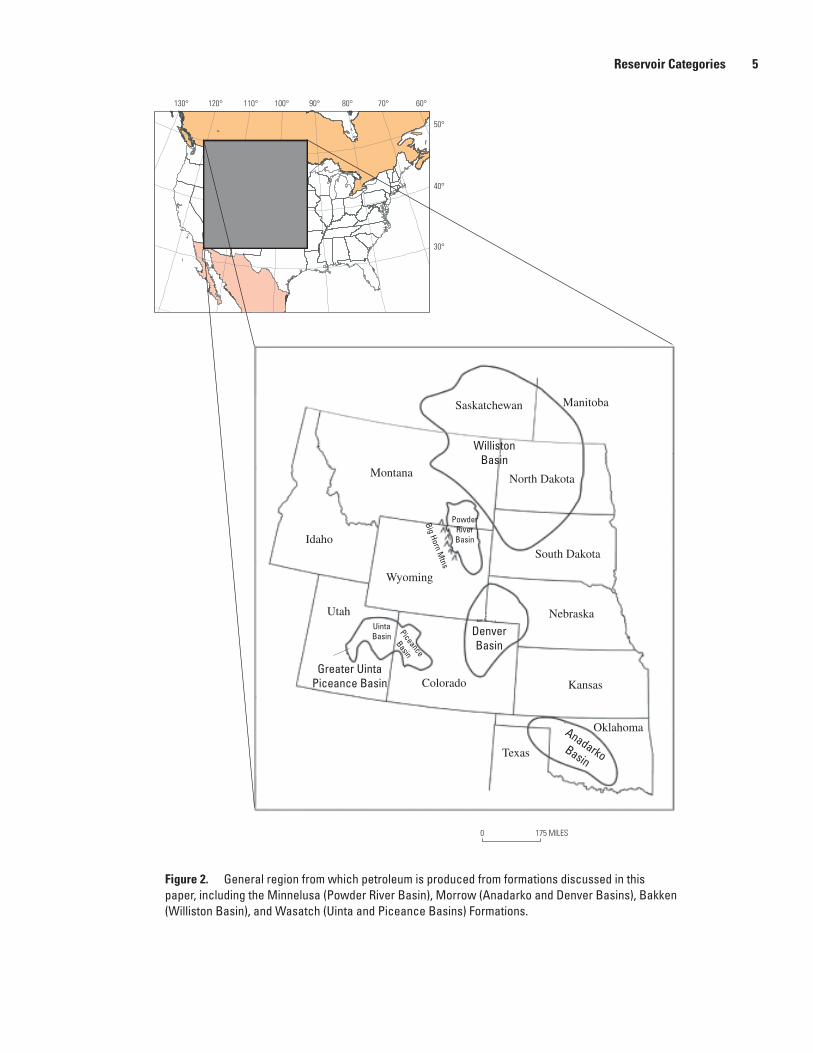
2. General region (west central Untied States) from which the Minnelusa, Morrow, Bakken, and Wasatch Formations produce petroleum ..................................5
3. General region (New Mexico, Oklahoma, Texas, Louisiana) from which the Frio Formation, Barnett Shale, Ellenberger Group, and Spraberry Formation produce petroleum ................................................................................................................6
4. Diagram based on hypothetical data showing probability distributions for production from wells of an oil or gas field ............................................................................24
5. Diagram showing production data of gas wells producing from various reservoir categories in the Ellenberger Group and in the Frio, Morrow, Minnelusa, and Wasatch Formations ..................................................................................................................25
Tables
1. Depositional environments and rock units selected for study of reserve growth, and geologic age and general location of units ......................................................................3
2–11. Summary of geological characteristics and reserve growth potential of reservoirs for:
2. Norphlet Formation, Gulf of Mexico Basin ........................................................................8 3. Minnelusa Formation, Powder River Basin. ....................................................................10 4. Frio Formation, Gulf of Mexico Basin ...............................................................................12 5. Morrow Formation, Anadarko and Denver Basins ........................................................14 6. Barnett Shale, Fort Worth Basin .......................................................................................16 7. Bakken Formation, Williston Basin ...................................................................................16 8. Ellenburger Group, Permian Basin ...................................................................................18 9. Smackover Formation, Gulf Coast region ........................................................................20 10. Spraberry Formation, Midland Basin ...............................................................................22 11. Wasatch Formation, greater Uinta-Piceance Basin......................................................22 12. Characteristics of reservoir categories analyzed in this study ..........................................26
Abbreviations Used in This Report
ft foot, feetmD millidarciesmi mile, milesCCRC central class rate of changeUCRC upper class rate of change

Abstract
The geologic characteristics of selected siliciclastic (largely sandstone) and carbonate (limestone and dolomite) reservoirs in North America (largely the continental United States) were investigated to improve our understanding of the role of geology in the growth of petroleum reserves. Reservoirs studied were deposited in (1) eolian environ-ments (Jurassic Norphlet Formation of the Gulf Coast and Pennsylvanian-Permian Minnelusa Formation of the Powder River Basin), (2) interconnected fluvial, deltaic, and shal-low marine environments (Oligocene Frio Formation of the Gulf Coast and the Pennsylvanian Morrow Formation of the Anadarko and Denver Basins), (3) deeper marine environ-ments (Mississippian Barnett Shale of the Fort Worth Basin and Devonian-Mississippian Bakken Formation of the Wil-liston Basin), (4) marine carbonate environments (Ordovician Ellenburger Group of the Permian Basin and Jurassic Smack-over Formation of the Gulf of Mexico Basin), (5) a submarine fan environment (Permian Spraberry Formation of the Mid-land Basin), and (6) a fluvial environment (Paleocene-Eocene Wasatch Formation of the Uinta-Piceance Basin).
Reservoirs in each formation were further subdivided into categories, as appropriate, where the reservoirs had suf-ficiently different geological attributes to warrant separate treatment. Variables viewed as important when we considered the designation of a reservoir category included depositional setting, source rock for contained petroleum, postdepositional alteration of the reservoirs, and type of trap or seal.
The connection between an oil reservoir’s production history and geology was also evaluated by studying production histories of wells in disparate reservoir categories and wells in a single formation containing two reservoir categories. This effort was undertaken to determine, in general, if different reservoir production heterogeneities could be quantified on the basis of gross geologic differences. Of the formations studied, wells in oil fields producing from the Frio Formation (fluvial category) demonstrated the least production heterogeneity; heterogeneity increased successively in the Morrow Forma-tion (incised valley-fill category), Ellenburger Group (platform category), Wasatch Formation (Green River–source category),
Minnelusa Formation (Minnelusa category), and Ellenburger Group (karst category). The differences in intraformational geologic variability and production heterogeneity between the Ellenburger Group karst and platform reservoir categories are especially large. The greatest production heterogeneity was observed in fields of the Ellenburger karst category, where production is enhanced by porous, fractured, cave-roof and by clast-supported, brecciated, cave-floor materials. In contrast, the Ellenburger platform category produces from rocks that have low porosity and permeability.
It appears that reserve growth in existing fields is most predictable for those in which reservoir heterogeneity is low and thus production differs little between wells, prob-ably owing to relatively homogeneous fluid flow. In fields in which reservoirs are highly heterogeneous, prediction of future growth from infill drilling is notably more difficult. In any case, success at linking heterogeneity to reserve growth depends on factors in addition to geology, such as engineer-ing and technological advances and political or cultural or economic influences.
Introduction
The majority of additions to domestic oil and gas reserves (reserves are defined as the identified accumulations that can be extracted at a profit by use of existing technology (after McKelvey, 1972)) are attributed to growth of existing fields and reservoirs. In fact, from 1978 to 1990, growth of known fields in the United States accounted for more than 85 percent of known additions to proven reserves (Root and Attanasi, 1993; McCabe, 1998). Thus, field growth and reserve growth are essentially synonymous for discussions of domestic resources. Evaluating the nature of growth in fields requires understanding of both geologic and nongeologic factors that affect growth estimations. Ultimately, however, geology is the underlying control on accumulations of oil and gas, so know-ledge of the effects of geologic characteristics of reservoirs and associated strata on growth in reserves is critical not only from the perspective of exploration and production of energy resources in known fields but also for the purpose of assessing
Geologic Controls on the Growth of Petroleum Reserves
By Neil S. Fishman, Christine E. Turner, Fred Peterson, Thaddeus S. Dyman, and Troy Cook

2 Geologic Controls on the Growth of Petroleum Reserves
the undiscovered resources of oil and gas in a region. How geology affects growth in reserves is particularly important in the United States, which is considered to be a mature petro-leum province where new accumulations of oil and gas are becoming more difficult to find.
Fields may grow when (1) additional geologic data on existing reservoirs becomes available and are used to identify new reservoirs or to guide infill drilling, (2) there are annual updates of reserves data, (3) field boundaries are extended, (4) recovery technology is improved, or (5) nongeologic factors such as economics, reporting policies, or politics favor expanded production and development. In this study, we specifically focus on the growth of fields by infill drilling of existing reservoirs.
To date, reserve growth investigations have largely emphasized mathematical approaches; in fact, as stated by Attanasi and others (1999), “…the modeling approach used by the USGS (U.S. Geological Survey) to characterize this phenomenon is statistical rather than geologic in nature.” Volumetric estimates of reserve growth are calculated by using these mathematical approaches and large data bases that record field reserves through time. Crovelli and Schmoker (2001), Verma (2003), and Klett (2003) present details of vari-ous methods used to estimate reserve growth.
Our goal is not to assess the growth of fields through time but to try to evaluate some of the geologic controls that may bear on the growth of reserves. Although growth is also affected by nongeologic factors, geology controls the location and characteristics of all oil and gas accumulations as well as the fluid flow dynamics that affect production, and thus it is of fundamental importance in evaluating reserve growth.
Geologists tend to think in terms of entire reservoirs, in some cases down to facies level, whereas reservoir engineers deal with measurements at the well bore. To fully understand the geologic factors that affect growth in reserves, this gap in investigative approaches must be bridged. It has become increasingly important to integrate different scales and dif-ferent observational techniques as secondary and tertiary recovery methods are applied more frequently in mature petro-leum provinces such as the United States.
Fluid-flow pathways, governed predominantly by rock porosity and permeability, are a reflection of heterogeneities of varying scales within a reservoir. Because these reservoir hetereogeneities are fundamentally geologic in nature (Ham-ilton and others, 1998; Dyman and others, 2000), an adequate understanding of the reservoir architecture, obtained through evaluation of geologic, engineering, or production data, or a combination of these data sets, can provide the basis for “…geologically targeting potential infill and stepout drilling locations, recompletions, and field management,” as stated by Hamilton and others (1998).
In spite of the different scales of observation, several attempts have been made to integrate geologic, engineering (Hamilton and others, 1998; Pulham, 1999), and well produc-tion data (Dyman and Schmoker, 2000). These approaches lead toward a more precise understanding of reserve growth
because the engineering and production data are ultimately a function of geologic parameters. For engineering data, the link between direct measurement of rock properties and a deter-mination of the processes involved that contribute to those rock properties can be established through systematic study. Currently, petrophysical analysis of a given reservoir is used to establish its storage capacity and its hydrocarbon pore volume at the well bore, which serve as the basis for determining areal variation in reservoir quality (Hamilton and others, 1998). These characteristics, which are a function of porosity and permeability, are then used to measure the capacity of the res-ervoirs to yield fluids such as hydrocarbons. Production data such as peak-monthly or 12-month production figures, as well as cumulative production volumes, are potentially valuable for documenting reservoir heterogeneity (Dyman and Schmoker, 1998; Dyman and others, 2000, Dyman and Schmoker, 2003).
Reservoir Categories
To evaluate the geologic factors that affect reserve growth in both siliciclastic (largely sandstone) and carbonate (lime-stone and dolomite) reservoirs, we selected 10 formations in the United States (one of which extends into southern Canada) that represent various depositional environments in both silici-clastic and carbonate settings (table 1). We then categorized reservoirs within formations in cases where geological criteria warrant separate treatment; these criteria were principally depositional setting, source rock for contained petroleum, and postdepositional alteration of the reservoirs. Details of the geology of all reservoirs in each category can be found in the appendix.
Formations studied were deposited in (1) eolian envi-ronments—Norphlet Formation of the Gulf of Mexico Basin (fig. 1) and Minnelusa Formation of the Powder River Basin (fig. 2); (2) interconnected fluvial, deltaic, and shallow marine environments—Frio Formation of the Gulf of Mexico Basin (fig. 3) and Morrow Formation of the Anadarko and Denver Basins (fig. 2); (3) deeper marine environments—Barnett Shale of the Fort Worth Basin (fig. 3) and Bakken Formation of the Williston Basin (fig. 2); (4) marine carbonate environ-ments—Ellenburger Group of the Permian Basin (fig. 3) and Smackover Formation of the Gulf of Mexico Basin (fig. 1); (5) submarine fan environment—Spraberry Formation of the Midland Basin (fig. 3); and (6) fluvial environment—Wasatch Formation of the Uinta-Piceance Basin (fig. 2).
Reservoir categories are briefly discussed below; detailed descriptions of each of the formations evaluated, the criteria used to establish reservoir categories within them, and strati-graphic and structural data are given in the Appendix to this report. A table for each formation summarizes the criteria that were evaluated for all reservoir categories. Each table, there-fore, attempts to be inclusive but may be modified in the future when additional reservoir categories are evaluated or when additional geological information is available.

Reservoir Categories 3
Depositional environment and formation studied
Age General location
Eolian sandstone Norphlet Formation Minnelusa Formation
Upper Jurassic Pennsylvanian-Permian
Gulf of Mexico Basin Powder River Basin
Fluvial or deltaic–shallow marine Frio Formation Morrow Formation
Tertiary (Oligocene)Pennsylvanian (Morrowan)
Gulf of Mexico BasinAnadarko and Denver Basins
Marine shale Barnett Shale Bakken Formation
Mississippian (Chesterian)Devonian-Mississippian
Fort Worth BasinWilliston Basin
Marine carbonates Ellenburger Group Smackover Formation
Ordovician (Early Ordovician)Upper Jurassic (late Oxfordian)
Permian BasinGulf of Mexico Basin
Submarine sands Spraberry Formation Permian (Leonardian) Permian Basin
Nonmarine fluvial–deltaic Wasatch Formation Tertiary (Paleocene-Eocene) Uinta-Piceance Basin
Eolian Reservoirs
Norphlet FormationThe Middle(?) to Upper Jurassic Norphlet Formation
of the Gulf of Mexico Basin consists largely of eolian sand-stones, with minor black shale, conglomerate, and red beds; thicknesses are as much as 100 ft. The Norphlet produces oil and gas largely in Alabama, offshore in Mobile Bay, and in Mississippi (fig. 1). Principal reservoirs in the Norphlet are eolian sandstones (table 2), which are known to have excellent porosity (as much as 20 percent) and permeability (as much as 500 mD).
Broad similarities in reservoir characteristics throughout the area of production suggest that only a single reservoir cat-egory is warranted (table 2). Although characteristics such as the geographic distribution of wells and the type of petroleum (oil or gas) produced were considered when we attempted to categorize Norphlet reservoirs, the available literature pointed out more similarities than differences between reservoirs in the formation. For this reason we designated only a single reser-voir category for the Norphlet.
Minnelusa Formation The Pennsylvanian to Early Permian Minnelusa For-
mation of the Powder River Basin, northeastern Wyoming, consists largely of eolian sandstones, with minor shale and carbonate; thicknesses are as much as 1,200 ft. Most produc-tion is in the north-central and northeastern parts of the basin; lesser production is in the southerly and southeastern parts (fig. 2). Principal reservoirs are the eolian sandstones (table 3), which can have excellent porosity (as much as 47 percent) and permeability (as much as 830 mD).
Reservoirs in the Minnelusa Formation are placed into two categories, Minnelusa and Leo (table 3). This twofold division seemed warranted because of differences in strati-graphic position, depositional environment, and geographic distribution of producing wells; in addition, reservoirs in the two categories may have different source rocks. Reservoir rocks of the Leo category have been variously referred to by previous workers as the “Leo sandstone” (Hunt, 1938), “Leo section” (Desmond and others, 1984), “Leo Formation” (Morel and others, 1986), or the “Leo sandstone of the Min-nelusa Formation” (Dolton and Fox, 1995).
Table 1. Depositional environments and rock units selected for study of reserve growth, and geologic age and general location of units.

4 Geologic Controls on the Growth of Petroleum Reserves
120°130° 110° 100° 90° 80° 70° 60°
50°
40°
30°
MobileBay
Gulf of Mexico
Oklahoma
Texas
Louisiana
Arkansas
Mississippi
Alabama Georgia
Florida
SouthCarolina
Tennessee
100 MILES0
Figure 1. Gulf of Mexico Basin region, the petroleum-producing region of the Norphlet and Smackover Formations. Both formations produce in both onshore and offshore locations; the Norphlet produces from Mobile Bay.
Reservoir Categories 5
WillistonBasin
DenverBasin
PowderRiverBasin
UintaBasin
Greater UintaPiceance Basin
Piceance
Basin
Big Horn Mtns
AnadarkoBasin
120°130° 110° 100° 90° 80° 70° 60°
50°
40°
30°
Montana
Idaho
Wyoming
Utah
Colorado
North Dakota
Saskatchewan Manitoba
South Dakota
Nebraska
Kansas
Oklahoma
Texas
175 MILES0
Figure 2. General region from which petroleum is produced from formations discussed in this paper, including the Minnelusa (Powder River Basin), Morrow (Anadarko and Denver Basins), Bakken (Williston Basin), and Wasatch (Uinta and Piceance Basins) Formations.

6 Geologic Controls on the Growth of Petroleum Reserves
New Mexico
Texas
Oklahoma
Louisiana
Central Basinplatform
Midland Basin
HorseshoeAtoll
Eastern shelfN
oria
s de
lta
com
plex
Ft WorthBasin
Ouch
ita th
rust
bel
t
Greta-Carancahuabarrier-strand plain system
San Marcosarch
Guey
dan
fluvi
al s
yste
m
Buna barrier strandplain system
Chita-Corrigon
fluvial system
Delaware Basin
Permian Basin
LlanoUplift
Houston
delta
complex
Gulf of Mexico
150 MILES0
120°130° 110° 100° 90° 80° 70° 60°
50°
40°
30°
Figure 3. Area from which petroleum is produced from the Frio Formation, Barnett Shale, Ellenburger Group, and Spraberry Formation. Extent of depositional environments in the Frio (such as the Norias delta complex or the Buna barrier–strandplain) from Galloway and others (1982). For the Barnett, the locations of the Llano uplift and Ouachita thrust belt mark the southern and eastern limits of the Fort Worth Basin, respectively. Horseshoe Atoll is a Pennsylvanian structure that effectively separates productive rocks of the Spraberry Formation (to the south) from nonproductive rocks (to the north).

Reservoir Categories 7
Interconnected Fluvial, Deltaic, and Shallow Marine Reservoirs
Frio FormationThe Oligocene Frio Formation of the Gulf of Mexico
Basin consists largely of sandstone and shale deposited in various environments; it is as much as 15,000 ft thick. The Frio produces largely from onshore and offshore locations in Texas. Principal reservoirs in the Frio are sandstones (table 4), which are known to have good to excellent porosity (as much as 35 percent) and variable permeability (as much as 3,500 mD).
Reservoir categories defined in the Frio Formation are flu-vial, deltaic, strandplain-barrier, and shelf sandstones (table 4). These four categories were selected principally because reser-voirs within them differ in terms of their broad depositional and geographic settings, structural setting, proximity to structures and potential source rocks, and reservoir characteristics.
Morrow FormationThe Lower Pennsylvanian Morrow Formation of the
Anadarko and Denver Basins consists largely of sandstone and shale; it is as much as 1,500 ft thick. The Morrow pro-duces oil and gas in Oklahoma, Texas, Kansas, and Colorado (fig. 2). Principal reservoirs in the Morrow are sandstones (table 5), which are known to have good porosity (as much as 22 percent) and permeability (as much as several darcies).
Petroleum reservoirs in the Morrow Formation were placed into three categories—incised valley-fill, deltaic, and shallow marine (table 5). These categories were selected because reservoirs within them differ in terms of their broad geographic and depositional setting. The differing deposi-tional settings of the reservoir categories have led to differing reservoir-rock characteristics, such as porosity and perme-ability, which bear directly on the reservoir properties and contained resources.
Deeper Marine Shales
Barnett ShaleThe Middle to Late Mississippian Barnett Shale of the
Fort Worth Basin, Texas, consists largely of black marine shales with some limestone; it is as much as 650 ft thick. Most production is of nonassociated gas, principally in the northeastern part of the basin (fig. 3). Reservoirs of this self-sourced unit are marine shales in the Barnett (table 6), which have very low porosity (less than 6 percent) and extremely low permeability (a few nanodarcies).
Reservoirs in the Barnett Shale are grouped in a single category termed the shale (unconventional) category (table 6). Until recently, the lower shale member has been the more productive, although considerable production is now being realized from the upper shale member as well (Bowker, 2002). Both members characteristically have a high content of
organic material, which is largely Type–II (Jarvie and others, 2001; Hill and others, 2007). In general, the current average content of organic material in both members is 4 to 5 percent (Jarvie and others, 2007), although in places the Barnett is thought to have contained as much as 20 percent total organic carbon when it was deposited (Bowker, 2002). The organic material serves as the source of the gas, thereby defining these reservoirs as self sourced and unconventional.
Bakken FormationThe Late Devonian to Early Mississippian Bakken
Formation (of the Williston Basin of North Dakota, Montana, and the Canadian provinces of Saskatchewan and Manitoba (fig. 2)) consists largely of marine shale with minor sandstone; it is as much as 140 ft thick. The Bakken produces mostly oil, principally in North Dakota and Montana and lesser amounts in Saskatchewan and Manitoba. Reservoirs in the Bakken are principally marine shales, although smaller reservoirs are found in interbedded near-shore to shoreface sandstones (table 7). Porosity of the shales is very low (typically less than 5 percent) as is their permeability (<0.01–60 mD). Porosity of sandstone reservoirs is higher (as much as 10 percent) as is permeability (<0.01–109 mD).
Two categories of reservoirs were defined in the Bakken Formation—shale (unconventional) and siltstone-sandstone (unconventional) (table 7). These two categories were selected because they have different characteristics, stratigraphic positions, and geographic distributions. In each, however, the petroleum is thought to be generated within the Bakken, so both categories are considered to be unconventional, similar to those in the Barnett Shale.
Marine Carbonate Reservoirs
Ellenburger GroupThe Early Ordovician Ellenburger Group of the Permian
Basin (fig. 3) consists largely of marine carbonate rocks; the group is as much as 1,500 ft thick. Units in the Ellenburger produce oil and gas chiefly in Texas. Principal reservoirs in the Ellenburger are in karstified parts of a carbonate platform and in dolomitized carbonate muds (table 8). Reservoirs in karsti-fied rocks have low but variable porosity (2–7 percent) and moderate but variable permeability (2–750 mD). Reservoirs in dolomitized muds have higher porosity (2–14 percent) but lower permeability (1–44 mD) than karstified reservoirs.
Reservoirs in the Ellenburger Group are placed into three categories (table 8)—karstified, platform, and tectonically fractured—based primarily on differences in the nature and volume of porosity and permeability, geographic distribution, produced petroleum, and the degree to which structure influ-enced reservoir development. This threefold division is similar to that presented by others (Kerans and others, 1989; Kosters and others, 1989c; Holtz and Kerans, 1992) and is also consis-tent with that presented by Ball (1995).

8 Geologic Controls on the Growth of Petroleum Reserves
Reservoir category
Depositional characteristics Reservoir characteristics
Environ-ment
Reservoir facies
Nonreservoir facies
Lithology
Porosity (bulk rock)
Principal pore space
Diagenetic enhancement
Diagenetic occlusion
Porosity
Norphlet Sand sea Eolian sands
Overlying and interbedded marine shale and interdune sedi-ments
Sandstone Primary intergranu-lar and secondary intergranular and moldic
Dissolution of early authi-genic cements and authigenic chlorite
Local quartz, anhydrite, halite, illite. Intense quartz cementa-tion may seal some accumulations
As much as 20% in onshore reservoirs and 12% in deeper offshore reservoirs
Smackover FormationThe Upper Jurassic Smackover Formation in onshore
parts of Texas, Arkansas, Louisiana, Mississippi, Alabama, and Florida, as well as offshore in the Gulf of Mexico Basin, consists largely of carbonate rocks with minor black shale and siltstones; it is as much as 1,000 ft thick. Most oil and gas is produced from onshore locations in the above-listed states (fig. 1). Principal reservoirs in the Smackover are in carbonate rocks deposited in a ramp setting (table 9) that have good to excellent porosity (as much as 35 percent) and variable perme-ability (<1–4,100 mD).
Reservoir categories in the Smackover Formation are salt structure, basement structure, graben, stratigraphic, and updip fault (table 9). These categories, which were defined or later refined through regional studies by other workers (for example, Bishop, 1973; Collins, 1980; Moore, 1984; Mancini and others, 1990; Kopaska-Merkel and Mann, 1993; Tew and others, 1993) were selected because of differences in their geographic extent and in the role that structures played in both source-rock deposition and petroleum trapping.
Submarine Fan Reservoir
Spraberry FormationThe Early Permian Spraberry Formation of the Midland
Basin consists largely of turbiditic sandstones, with minor black shales, silty dolostones, and argillaceous siltstones; it is as much as 1,000 ft thick. Most production of oil is in west-central Texas, in the Midland Basin (fig. 3). Principal
reservoirs in the Spraberry are the tubiditic sandstones (table 10), which have good porosity (as much as 18 percent) but relatively low permeability (maximum, 10 mD). A single reservoir category, submarine sand, was defined for the Spraberry Formation.
Fluvial Reservoir
Wasatch FormationThe Paleocene-Eocene Wasatch Formation of the
Uinta-Piceance Basin of Utah and Colorado consists largely of overbank and lacustrine mudstones with some fluvial and fluvial-dominated deltaic sandstones; it is as much as 5,000 ft thick. The Wasatch produces oil and associated gas mostly in the Uinta Basin of northeastern Utah, although minor gas is also produced in the Piceance Basin of Colorado (fig. 2). Principal reservoirs in the Wasatch are the fluvial sandstones (table 11), which are known to have good porosity (maximum, 15 percent) but low permeability (maximum, 40 mD).
Reservoirs in the Wasatch Formation are categorized as Green River source and Mesaverde source (table 11). The two categories are distinguished by (1) the source of the petroleum produced from each, (2) the nature of the petroleum produced from each, and (3) the geographic distribution of production. This division is important because it recognizes that petroleum produced from the Wasatch comes from two different source rocks; hence, two petroleum systems generated economic amounts of petroleum within the greater Uinta-Piceance Basin.
Table 2. Norphlet Formation, Gulf of Mexico Basin—Summary of geological characteristics and reserve growth potential of reservoirs.
[mD, millidarcies]

Quantitative Measures of Well Production Variability 9
Reservoir characteristics—Continued
Source rock
Stratigraphic controls Structural controls
Oil or gasPermeability Fractures
Reservoir location
Traps or seals
Reservoir location
Traps or seals
Generally high; as much as 500 mD
May be com-plexly faulted
Overlying marine shale of Smack-over Formation; interbedded or interfingering organic-rich shale in Norphlet Formation
Updip pinchout against base-ment complex
Overlying shale and interbedded interdune, sabkha, or playa units
Reservoir rocks thicken in basement- controlled grabens and are absent or thin over basement- controlled highs
Anticlines, faulted anti-clines, faults associated with basement structures and halokinesis of Louann Salt
Dominantly nonasso-ciated gas (cracked) and minor oil
Quantitative Measures of Well Production Variability
Our preliminary reservoir analysis (based largely on the examination of pertinent literature and the field and laboratory experience of the authors) was supplemented by an analysis of well production data to determine if produc-tion heterogeneities could be quantified based on gross geo-logic differences between reservoirs in five of the formations we have discussed (see also the Appendix to this report) and also internally within an individual formation. Such quantifi-cation could be a valuable tool in evaluating the potential for identifying more reserves in a formation.
We compared historical well production data of the five formations by use of proprietary information. In addition, we considered data from two specific reservoir categories in the Ellenburger Group (karst and platform, table 8), which are based on gross geologic differences, to evaluate the possible intraformational variability in production within that forma-tion. This analysis was an attempt to determine whether the production variabilities seen in each reservoir type could be identified and related to the growth of field reserves. Pro-duction data for the formations studied were obtained from IHS Energy Group (petroRom production data on CD-ROM (petroRom is a trademark of Petroleum Information/Dwights, d.b.a. IHS Energy Group)).
Our analysis of the production histories of the five formations was modified from that discussed in Dyman and Schmoker (2003). In their study, they (1) tested the use of cer-tain well-production parameters—peak monthly production,
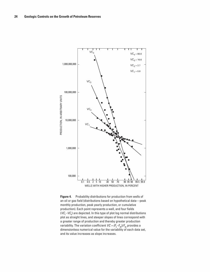
peak consecutive 12-month production, and cumulative pro-duction—in older wells as a means to quantify and understand the heterogeneity in a population of reservoirs; (2) defined measures of variability (variation coefficients) in peak monthly production, peak consecutive 12-month production, and cumu-lative production; and calculated variation coefficients with respect to internal consistency, type of production parameter, conventional and unconventional accumulations, and reservoir depth; and (3) discussed the application of well-production parameters to field growth. Because in most wells produc-tion declines exponentially or hyperbolically as a function of time, cumulative production from older wells (those for which current monthly production is less than 10 percent of initial monthly production) asymptotically begins to approximate ultimate recovery. In such wells, variations in cumulative production reflect variations in the volume of reservoir rocks accessed by the well bore. The slopes of the probability distributions for cumulative production (fig. 4) are direct indi-cators of the variability as shown by the data set. For example, steeper slopes reflect greater production heterogeneity (fig. 4), whereas a horizontal line represents uniform production characteristics. A dimensionless parameter that is proportional to the slopes of the four probability distributions of figure 4 would provide a quantitative numerical representation of production heterogeneity. Such a parameter, referred to here as a variation coefficient (VC), can be calculated by using a measure of the dispersion (range) of the data set divided by a measure of central tendency such as the mean or the median (Stell and Brown, 1992; Dyman and others, 1996; Schmoker, 1966; Dyman and Schmoker, chapter E, this volume).
Table 2. Norphlet Formation, Gulf of Mexico Basin—Summary of geological characteristics and reserve growth potential of reservoirs.—Continued
[mD, millidarcies]

10 Geologic Controls on the Growth of Petroleum Reserves
Table 3. Minnelusa Formation, Powder River Basin—Summary of geological characteristics and reserve growth potential of reservoirs.
[mD, millidarcies]
Reservoircategory
Depositional characteristics Reservoir characteristics
Environ-ment
Reservoir facies
Nonreservoir facies
Lithology
Porosity (bulk rock)
Principal pore space
Diagenetic enhancement
Diagenetic occlusion
Porosity
Minnelusa Coastal sand sea
Eolian dunes
Overlying shallow marine shales, anhydrite, and carbonate rocks
Sandstone, quartz arenite, sublitharenite
Primary and secondary intergranular; moldic
Dissolution of early authigenic cements and of some unstable detrital grains
Quartz, carbon-ates minerals, and anhydrite/gypsum where not dissolved. Cemented zones may act as seals
Averages 12–24% but may be as high as 47%
Leo Coastal dunes
Eolian dunes
Overlying shallow marine shales, anhydrite, and carbonate rocks
Sandstone, quartz arenite, sublitharenite
Primary and secondary intergranular; moldic
Dissolution of early authigenic cements and of some unstable detrital grains
Quartz, carbon-ates minerals, and anhydrite/gypsum where not dissolved. Cemented zones may act as seals
Averages 12–24%
A dimensionless VC is calculated as
VC = (F5–F
95)/F
50 ,
where F5, F
95, and F
50 are the 5th, 95th, and 50th (median)
fractiles of the probability distribution for peak monthly production, peak cumulative 12-month production, or cumu-lative production. These fractiles are picked directly from diagrams such as that in figure 4. Note that in figure 4 increas-ing variation coefficient corresponds with increasing slope of the probability distribution and thus to increasing variability in well production.
Cumulative production measures the net result of multiplicative geologic processes and so might be expected to approximate a log-normal distribution. For this reason, production was plotted on graph paper having axes arranged such that a log normal distribution plots as a straight line (see fig. 4).
In this study, we modified the uncertainty coefficient of Dyman and Schmoker (chapter E, this volume) by not considering wells in the upper 5 percent and lower 20 percent, as described further below, because we realized that the log-
normal distribution defining the productive behavior of wells can be broken into component parts. The different parts of the distribution behave differently—that is, a single straight-line fit does not adequately describe the behavior of the entire distribution of production data. We are interested in the central part of the distribution because it represents production from the vast majority of wells. Extreme production behavior, categorized by wells in the upper 5 percent and lower 20 per-cent of the production distribution, were not examined; the former generally includes old wells with production combined from more than one formation, and the latter are typically unproductive. Wells were sorted by production from lowest to highest and subdivided into two size classes: a central class representing a productive range of 20–60 percent along the distribution and an upper class representing a productive range of 80–95 percent (fig. 5).
We measured rates of change in productivity for both size classes by calculating the variation coefficient (slope) of each line segment for each well distribution and compared each new variation coefficient with the original variation coeffi-cients of Dyman and Schmoker (2003). We then compared the central and upper well classes for each distribution as well as

Quantitative Measures of Well Production Variability 11
Table 3. Minnelusa Formation, Powder River Basin—Summary of geological characteristics and reserve growth potential of reservoirs.—Continued
[mD, millidarcies]
Reservoir characteristics—Continued
Source rock
Stratigraphic controls Structural controls
Oil or gasPermeability Fractures
Reservoir location
Traps or seals
Reservoir location
Traps or seals
Generally high, 10–830 mD, and as high as 3,200 mD
Negligible Phosphoria Forma-tion, but requires long-distance migra-tion before uplift of Big Horn Mountains
Uncertain Reservoir rocks overlain by marine shale and carbonate rocks; lateral pinchouts; bounding surfaces
Low-relief closures associated with minor anticlines
Largely stratigraphic structures play a minor role
Oil
Uncertain Negligible Interbedded organic-rich shale, short-distance migration
Uncertain Reservoir rocks overlain by marine shale and carbon-ate rocks; lateral pinchouts; bound-ing surfaces
Low-relief closures associated with minor anticlines
Largely stratigraphic structures play minor role
Oil
both central and upper classes for different well distributions as slope ratios. The slope ratio (SR) is defined as follows:
SR = UCRC/CCRC
where UCRC is the upper class rate of change and CCRC the central class rate of change. The higher the slope ratio, the greater the difference in rate of change between the two classes, which indicates that the most productive wells are more productive than would be expected if the slope ratio were smaller. Our focus was on wells in fields producing oil from the reservoirs representing the (1) fluvial category of the Frio Formation, (2) incised valley-fill category of the Morrow Formation, (3) Green River–source category of the Wasatch Formation, (4) Minnelusa category of the Minnelusa Forma-tion, and both the (5) platform and karst categories of the Ellenburger Group.
Table 12 contains the basic data used in calculating production variability for each reservoir category. We selected a minimum of 35 producing wells as necessary to adequately describe the production behavior for each category and to calculate upper class and central class rates of recovery and
slope ratios for each. We also identified a well productive life of at least 10 years on the basis of data in the IHS Energy Group production file. For example, 6,301 wells were selected from IHS data as Frio Formation producers in all or parts of Starr, Hidalgo, Brooks, Jim Hills, and Kleburg Counties, Texas (table 12). Our computer program then calculated upper and central class rates of recovery and slope ratios on the basis of a subset of these wells that met our selection criteria. The six reservoirs analyzed in this study have produced more than 2 billion barrels of oil and 12 trillion cubic feet of gas from nearly 13,000 producing wells. The results are plotted in figure 5.
The geologic implications of the slope ratio are the primary focus of this study. One of the questions we attempted to address was, Do gross geologic variables such as deposi-tional environment, diagenesis, and lithology affect reservoir productivity as can be determined by production parameters? Comparing the slope ratios and variation coefficients of reservoirs with different geologic characteristics may provide insight into productivity analysis and ultimately into estimat-ing field growth through time.

12 Geologic Controls on the Growth of Petroleum Reserves
Reservoir category
Depositional characteristics Reservoir characteristics
Environ- ment
Reservoir facies
Nonreservoir facies
Lithology
Porosity (bulk rock)
Principal pore space
Diagenetic enhancement
Diagenetic occlusion
Porosity
Fluvial, chiefly the Gueydan and Chita/Corrigan fluvial systems
Chiefly fluvial with associ-ated channel fill, point bar, crevasse splay, and floodplain sediments
Channel sands, point bars, and crevasse splay sands
Floodplain and lacustrine muds
Feldspathic litharenite, litharen-ite, and sublitharenite sandstone
Intergranular and moldic
Dissolution of unstable detrital grains and earlier formed cements, resulting in secondary pore space
Quartz, calcite, and clay cements; mechanical compaction
15–35%
Deltaic; chiefly the Norias and Houston delta complexes
Delta-plain, delta-front, and delta-flank environments of a prograd-ing continental margin in the Gulf Basin. Norias contains more sediment and more sand, and was less influenced by marine processes than Houston
Distributary channel, delta-front and delta-flank, and channel-mouth bar sands
Prodelta and shelf shales
Feldspathic litharenite, litharen-ite, and sublitharenite sandstone
Intergranular and moldic
Dissolution of unstable detrital grains and earlier formed cements, resulting in secondary pore space
Quartz, calcite, and clay cements; mechanical compaction
10–35%
Strandplain-barrier; chiefly the Buna and Greta/Carancahua barrier strandplains
Shoreface, beach, barrier, and lagoonal deposits adja-cent to deltaic depocenters
Shoreface, beach, and barrier sands
Marsh and lagoonal muds
Feldspathic litharenite, litharen-ite, and sublitharenite sandstones
Intergranular and moldic
Dissolution of unstable detrital grains and earlier formed cements, resulting in secondary pore space
Quartz, calcite, and clay cements; mechanical compaction
20–35%
Shelf; off-shore Gulf Coast Basin
Shelf, slope, and perhaps submarine fan environments in deeper parts of the Gulf Coast Basin
Shelf, slope, and possibly fan sand-stones
Marine shales and siltstones
Feldspathic litharenite, litharen-ite, and sublitharenite sandstones
Intergranular and moldic
Dissolution of unstable detrital grains and earlier formed cements, resulting in secondary pore space
Quartz, calcite, and clay cements; mechanical compaction
As much as 30%
Table 4. Frio Formation, Gulf of Mexico Basin—Summary of geological characteristics and reserve growth potential of reservoirs.
[mD, millidarcies]

Quantitative Measures of Well Production Variability 13
Reservoir characteristics—Continued
Source rock
Stratigraphic controls Structural controls
Oil or gasPermeability Fractures
Reservoir location
Traps or seals
Reservoir location
Traps or seals
20– 1,500 mD
Important in hydro-carbon migration from source to reservoir
Shales that underlie reservoirs
Gueydan system largely a single drainage; leads to stacked channels and lateral amalgamation of channels. Chita Corrigan largely multiple channels with somewhat less stacking of sands
Stratigraphic component of trap is the inter-val where facies change to mud-rich floodplain rocks; mud-rich rocks are seals
Production best where fluvial and splay sands cross anti-clines, faulted anticlines, or growth-fault trends, and faults served as conduits for upward petro-leum migration
Rollover anticlines, particularly on downdip side of Vicksburg growth fault
Oil and gas
10– 2,400 mD
Important in hydro-carbon migration from source to reser-voir; also juxtapose reservoirs and seals
Shales that underlie or are basinward facies of reservoirs
Abundant sediment supply and single fluvial system input lead to vertically stacked sandy del-taic lobes (Norias), whereas Houston delta fed by several smaller fluvial systems that led to numerous small dispersed lobes with less continuous sands
Stratigraphic component of trap is at abrupt facies changes from reservoir to fine-grained rocks; mud-rich rocks are seals
Syndepositional movement on growth faults and salt diapirs but no thicken-ing of deltaic sediments, including reser-voir rocks
Anticlines and faulted anticlines, some of which are associated with growth faults (Noria and Houston) or salt diapirism (Hous-ton); also growth faults juxtapose res-ervoirs with seals or compartmentalize reservoirs
Associated gas and oil from more proximal parts, and nonassoci-ated gas from more distal parts
8–3,500 mD Important in hydro-carbon migration from source to reser-voir; also juxtaposes reservoirs and seals
Shales that underlie or are basinward facies of reservoirs
Greater marine influence on Houston delta led to greater redistribu-tion of sands into strandplain systems than on sands that originated in Norias delta
Stratigraphic component of trap is the inter-val where facies change to mud-rich floodplain rocks; mud-rich rocks are seals
Vertical stacking of sands and strike-parallel orientation of sands greatly influenced by orientation and movement of growth faults
Anticlines, rollover anticlines, and faulted anticlines
Associated gas and oil
As much as 1,500 mD
Important in hydro-carbon migration from source to reser-voir; also juxtaposes reservoirs and seals
Shales that interbed with or underlie reservoir rocks
Stratigraphic controls on reservoir location unclear
Stratigraphic component of trap is at abrupt change from reservoir to fine-grained rocks; fine-grained rocks serve as seals
Sediment accu-mulation in sub-marine canyons or intraslope basins that formed from active faulting or salt diapirs (or both)
Faulted anticlines and salt-related structures. Seals formed by fault-related juxtaposi-tion of reservoirs with impermeable rocks
Largely gas
Table 4. Frio Formation, Gulf of Mexico Basin—Summary of geological characteristics and reserve growth potential of reservoirs.—Continued
[mD, millidarcies]

14 Geologic Controls on the Growth of Petroleum Reserves
Reservoir category
Depositional characteristics Reservoir characteristics
Environ- ment
Reservoir facies
Nonreservoir facies
Lithology
Porosity (bulk rock)
Principal pore space
Diagenetic enhancement
Diagenetic occlusion
Porosity
Incised valley fill
Braided streams that grade upward into meandering and estuarine environments
Dominantly in coarser grained fluvial sands that fill incised valleys
Floodplain, estuarine, and marine mud-stone
Sandstone; varies from quartz arenite to litharenite or arkosic
Intergranu-lar; variable volume of moldic porosity due to dissolution of detrital grains
Secondary pore space from dissolution of early formed authigenic cements and some unstable detrital grains
Extensive cement in lower parts of channel sands with calcite or iron carbonate minerals, or both
12–21%
Deltaic Lower delta plain
Point bar, meander channel, stream-mouth bar, and distributary channel sands
Overbank, backswamp marsh, prodelta, and marine mudstone
Sandstone; varies from quartz arenite to litharenite or arkosic
Secondary pore space from dissolution of early formed authigenic cements and some unstable detrital grains
Late-stage calcite or iron carbonate minerals, or both
12–22%
Shallow marine
Near-shore and marginal marine
Beach, barrier island, and shoreline parallel sand bar sands
Marine shale and siltstone
Sandstone; varies from quartz arenite to litharenite or arkosic; locally fossiliferous
Secondary pore space from dissolution of early formed authigenic cements and some unstable detrital grains
Late-stage calcite or iron carbonate minerals, or both; mechanical compaction
4–20%
Table 5. Morrow Formation, Anadarko and Denver Basins—Summary of geological characteristics and reserve growth potential of reservoirs.
[mD, millidarcies]

Quantitative Measures of Well Production Variability 15
Reservoir characteristics—Continued
Source rock
Stratigraphic controls Structural controls
Oil or gasPermeability Fractures
Reservoir loca-tion
Traps or seal
Reservoir location
Traps or seals
As much as several darcies
Could have helped hydrocarbons to migrate from any overlying or underlying sources
Possibly marine muds of the Morrow Formation, where mature in Anadarko Basin; other organic-bearing forma-tions outside the Morrow
Downcutting and formation of paleoval-leys localized fluvial channel–reservoirs, dominantly in upper part of Morrow
Underlying marine lime-stone or shale and overlying floodplain muds
Paleostruc-tures and perhaps sub-sidence from dissolution of underlying evaporates may have localized areas of downcutting and incision
Anticlines may influence but are secondary to stratigraphic controls
Associated gas and oil
1–100 mD Could have helped hydrocarbons to migrate from any overlying or underlying sources
Possibly marine muds of the Morrow Formation, where mature in Anadarko Basin; other organic-bearing forma-tions outside the Morrow
Unclear Lateral pinch out of sands into fine-grained marine muds
Unclear Anticlines may influence but are secondary to stratigraphic controls
Dominantly gas
<1–200 mD Could have helped hydrocarbons to migrate from any overlying or underlying sources
Possibly marine muds of the Mor-row Formation, where mature in Anadarko Basin; other organic-bearing formations outside the Morrow
Location of sands in part a function of longshore currents, domi-nantly in lower part of Morrow
Lateral pinch out of sands into fine-grained marine muds
Unclear Anticlines may influence but are secondary to stratigraphic controls
Dominantly nonassoci-ated gas
Table 5. Morrow Formation, Anadarko and Denver Basins—Summary of geological characteristics and reserve growth potential of reservoirs.—Continued
[mD, millidarcies]

16 Geologic Controls on the Growth of Petroleum Reserves
Reservoircategory
Depositional characteristics Reservoir characteristics
Environ-ment
Reservoir facies
Nonreservoir facies
Lithology
Porosity (bulk rock)
Principal pore space
Diagenetic enhancement
Diagenetic occlusion
Porosity
Shale (unconven-tional)
Deep marine, below wave base
Black, organic-rich mudstone
Overlying shallow marine carbonates and shales
Black mudstone
Fracture Little or none Little or none Very low, typically <5%
Siltstone-sandstone (unconven-tional)
Near-shore and shoreface
Siltstone and very fine to medium-grained sandstone
Enclosing black mudstone
Dolomitic siltstone and sandstone
Fracture Dissolution of carbonate cement
Carbonate cement Can be >10% but typically 3–10%
Reservoircategory
Depositional characteristics Reservoir characteristics
Environ-ment
Reservoir facies
Nonreservoir facies
Lithology
Porosity (bulk rock)
Principalpore space
Diagenetic enhancement
Diagenetic occlusion
Porosity
Shale (unconven-tional)
Offshore marine
Marine shale
Dense limestone Organic-rich shale
Matrix, but very low
Uncertain Calcite along fractures
Very low, typically <6%
Table 6. Barnett Shale, Fort Worth Basin—Summary of geological characteristics and reserve-growth potential of reservoirs.
[mD, millidarcies]
Table 7. Bakken Formation, Williston Basin—Summary of geological characteristics and reserve-growth potential of reservoirs.
[mD, millidarcies]

Quantitative Measures of Well Production Variability 17
Reservoir characteristics—Continued
Source rock
Stratigraphic controls Structural controls
Oil or gasPermeability Fractures
Reservoir location
Traps or seals
Reservoir location
Traps or seals
<0.01–60 mD Critical for production
Black, organic-rich mudstone; is also the reservoir rock
Apparently not important
Apparently not important
Fracture zones overlying anticlinal or monoclinal folds and solution fronts in underlying salts
Minimal; reservoirs unconventional
Oil
<0.01–109 mD Critical for production
Organic-rich mud in Bakken, interbedded with or perhaps downdip from reservoirs
Local thick-ening owing to subsidence associated with dis-solution of underlying salts
Overlying shales of the Bakken
Fracture zones overlying anticlinal or monoclinal folds and solution fronts in underlying salts
Updip against enclosing mudstone strata
Oil
Reservoir characteristics—Continued
Source rock
Stratigraphic controls Structural controls
Oil or gasPermeability Fractures
Reservoir location
Traps or seals
Reservoir location
Traps or seals
Very low, typically in the range of nanodarcies
Naturally fractured in deeper parts of basin and over structures; fractures reduce productivity
Organic-rich shale in the Barnett that also serves as reser-voir rock
Uncertain Gas trapped by fine-grained nature of shale reservoir
Best produc-tion away from frac-tured areas
Open faults tended to leak gas out of formation, whereas calcite-filled faults prevented gas migration
Non- associated gas
Table 6. Barnett Shale, Fort Worth Basin—Summary of geological characteristics and reserve-growth potential of reservoirs.—Continued
[mD, millidarcies]
Table 7. Bakken Formation, Williston Basin—Summary of geological characteristics and reserve-growth potential of reservoirs..—Continued
[mD, millidarcies]

18 Geologic Controls on the Growth of Petroleum Reserves
Reservoir category
Depositional characteristics Reservoir characteristics
Environ-ment
Reservoir facies
Nonreservoir facies
Lithology
Porosity (bulk rock)
Principal pore space
Diagenetic enhancement
Diagenetic occlusion
Porosity
Karstified, principally in Cen-tral Basin platform and Midland Basin
Shallow aggrading marine carbonate platform
Inner platform
Reef, forereef, supratidal
Dolo-mitized mudstone
Interbreccia fragment and within fractures
Dissolution of lime mud leading to karstification and brecciation; intercrystal-line owing to dolomitization of muds
Late-stage saddle dolomite
Average, 3%Range, 2–7%
Platform, dominantly in southern and eastern parts of Mid-land Basin
Shallow aggrading marine carbonate platform
Middle to outer platform
Reef, forereef, supratidal
Dolo-mitized packstone and mudstone
Intercrystalline Intercrystalline porosity owing to dolomitization
Late-stage saddle dolomite
Average, 14% Range,2–14%
Tectonically fractured, dominantly in the eastern Delaware Basin
Shallow aggrading marine carbonate platform
Inner platform
Reef, forereef, supratidal
Dolo-mitized mudstone
Fracture (tectonic)
Dissolution of lime mud leading to karstification and brecciation; intercrystal-line owing to dolomitization of muds
Late-stage saddle dolomite
Average, 4%Range,1–8%
Table 8. Ellenburger Group, Permian Basin—Summary of geological characteristics and reserve-growth potential of reservoirs.
[mD, millidarcies]

Quantitative Measures of Well Production Variability 19
Reservoir characteristics—Continued
Source rock
Stratigraphic controls Structural controls
Oil or gasPermeability Fractures
Reservoir location
Traps or seals
Reservoir location
Traps or seals
Mean, 32 mDRange, 2–750 mD
Channeled pore fluids that allowed vertical infiltra-tion of dissolving waters into various stratigraphic hori-zons to promote karstification
Overlying Ordo-vician Simpson Group
Lime muds remaining after early dolomitization, which became horizons sub-ject to dissolu-tion leading to karstification
Traps and seals include overlying Simpson Group and unkarsted Ellen-burger dolomite. Seals also include impermeable cave-fill sediments and collapse zone adja-cent to reservoirs
Anticlines, faulted anticlines, and fault-bounded anticlines
Uncertain Principally oil with some associated gas and gas condensate
Average, 12 mDRange,<1–44 mD
Focused early dolomitizing fluids, which resulted in intercrystal-line porosity and permeability
Overlying Devo-nian Woodford Shale?
Lime muds that were dolomitized
Traps and seals include overlying Simpson Group
Anticlines, faulted anticlines
Uncertain Largely oil
Average,4 mDRange,1–100 mD
Early fracturing pro-moted karstification, whereas later fractur-ing improved poros-ity and permeability of the reservoir
Overlying Ordo-vician Simpson Group
Lime muds that were dolomitized
Traps and seals include overlying Simpson Group
Fractured anticlines and faults critical
Uncertain Nonassociated gas
Table 8. Ellenburger Group, Permian Basin—Summary of geological characteristics and reserve-growth potential of reservoirs.—Continued
[mD, millidarcies]

20 Geologic Controls on the Growth of Petroleum Reserves
Table 9. Smackover Formation, Gulf Coast region—Summary of geological characteristics and reserve-growth potential of reservoirs.
[mD, millidarcies]
Reservoircategory
Depositional characteristics Reservoir characteristics
Environ- ment
Reservoir facies
Nonreservoir facies
Lithology
Porosity (bulk rock)
Principalpore space
Diagenetic enhancement
Diagenetic occlusion
Porosity
Salt structure, domi-nantly in southern and eastern Texas, southern Arkan-sas, southern and central Mississippi, southwestern Ala-bama, and northern Louisiana
Slow regressive to stillstand marine carbonate ramp
Ramp, higher energy shoaling facies
Subtidal mudstone, wackestone, supratidal units, and outer ramp dolostones
Largely dolomitic oolitic grain-stones and packstones
Dominantly intercrystal-line where dolomitized, oomoldic in updip regions, intergranular in basinal regions
Intercrystal-line owing to dolomitization; ooid dissolu-tion; late calcite dissolution; diagenesis most pronounced on structural highs
Late-stage saddle dolomite, anhydrite, and calcite
2–35%
Basement struc-ture, primarily in eastern Texas, central Mississippi, southern Arkansas, and southwestern Alabama
Slow regressive to stillstand marine carbonate ramp
Ramp, higher energy shoaling facies
Subtidal mudstone, wackestone, supratidal units, and outer ramp dolostones
Largely dolomitic oolitic grain-stones and packstones
Principally oomoldic; minor primary interparticle and intercrys-talline where dolomitized
Principally oomoldic; minor intercrystalline owing to minor dolomitization; diagenesis pronounced on structural highs
Late-stage calcite and dolomite
As much as 20%
Graben, principally along Arkansas-Louisiana border
Slow regressive to stillstand marine carbonate ramp
Ramp, higher energy shoaling facies
Subtidal mudstone, wackestone, supratidal units, and outer ramp dolostones
Oolitic limestone, locally dolomitic
Considerable interparticle pore space preserved; also oomoldic
Some inter-particle and intercrystalline owing to dolo-mitization; some oomoldic
Partial cementation by calcite
4–19%
Stratigraphic, prin-cipally in southern Arkansas
Slow regressive to stillstand marine carbonate ramp
Ramp, higher energy shoaling facies
Subtidal mud-stone, pelloid packstone, wackestone, supratidal units, and outer ramp dolostones
Oolitic, oncolitic, or skeletal grainstone limestone minimally dolomitized
Considerable interparticle; some oomoldic and intercrystal-line where dolomitized
Some inter-particle and intercrystal-line owing to dolomitization; considerable early- and late-stage dissolution of particles and late-stage cement
Cements such as early and late stage calcite and anhydrite; some compaction
3–30%
Updip fault, principally in eastern Texas, southern Arkansas, central Mississippi, southwestern Ala-bama, and Florida Panhandle
Slow regressive to stillstand marine carbonate ramp
Ramp, higher energy shoaling facies
Subtidal mudstone, wackestone, supratidal units, and outer ramp dolostones
Oolitic limestone, locally dolomitic
Principally oomoldic
Ooid dissolution common; some dolomitization
Early calcite cement
10–20%
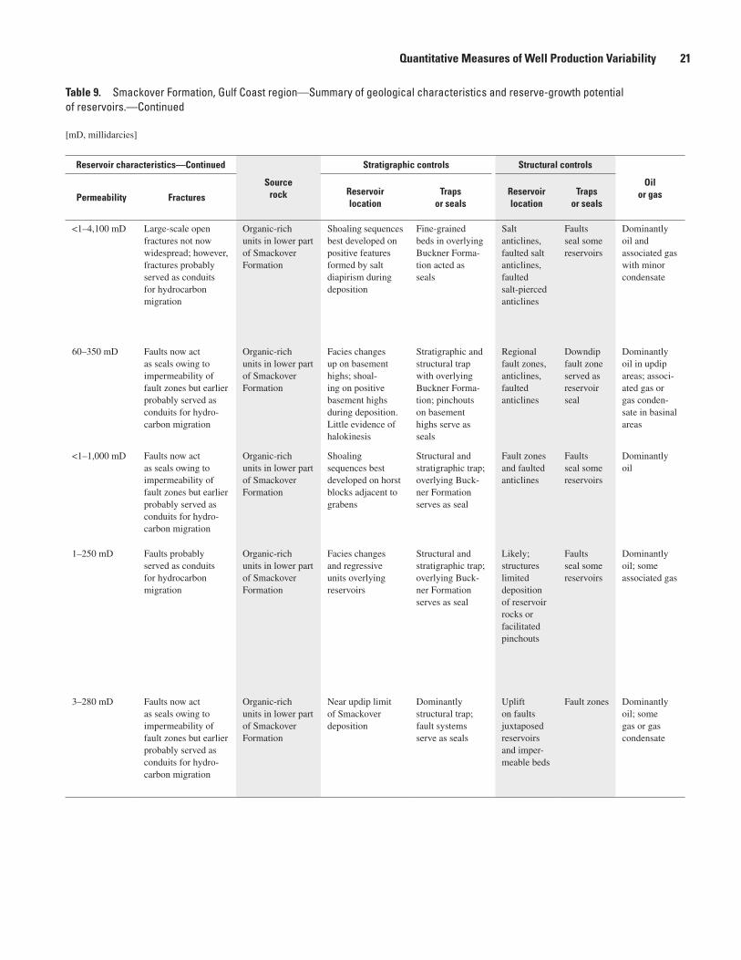
Quantitative Measures of Well Production Variability 21
Table 9. Smackover Formation, Gulf Coast region—Summary of geological characteristics and reserve-growth potential of reservoirs.—Continued
[mD, millidarcies]
Reservoir characteristics—Continued
Sourcerock
Stratigraphic controls Structural controls
Oilor gasPermeability Fractures
Reservoirlocation
Trapsor seals
Reservoir location
Trapsor seals
<1–4,100 mD Large-scale open fractures not now widespread; however, fractures probably served as conduits for hydrocarbon migration
Organic-rich units in lower part of Smackover Formation
Shoaling sequences best developed on positive features formed by salt diapirism during deposition
Fine-grained beds in overlying Buckner Forma-tion acted as seals
Salt anticlines, faulted salt anticlines, faulted salt-pierced anticlines
Faults seal some reservoirs
Dominantly oil and associated gas with minor condensate
60–350 mD Faults now act as seals owing to impermeability of fault zones but earlier probably served as conduits for hydro-carbon migration
Organic-rich units in lower part of Smackover Formation
Facies changes up on basement highs; shoal-ing on positive basement highs during deposition. Little evidence of halokinesis
Stratigraphic and structural trap with overlying Buckner Forma-tion; pinchouts on basement highs serve as seals
Regional fault zones, anticlines, faulted anticlines
Downdip fault zone served as reservoir seal
Dominantly oil in updip areas; associ-ated gas or gas conden-sate in basinal areas
<1–1,000 mD Faults now act as seals owing to impermeability of fault zones but earlier probably served as conduits for hydro-carbon migration
Organic-rich units in lower part of Smackover Formation
Shoaling sequences best developed on horst blocks adjacent to grabens
Structural and stratigraphic trap; overlying Buck-ner Formation serves as seal
Fault zones and faulted anticlines
Faults seal some reservoirs
Dominantly oil
1–250 mD Faults probably served as conduits for hydrocarbon migration
Organic-rich units in lower part of Smackover Formation
Facies changes and regressive units overlying reservoirs
Structural and stratigraphic trap; overlying Buck-ner Formation serves as seal
Likely; structures limited deposition of reservoir rocks or facilitated pinchouts
Faults seal some reservoirs
Dominantly oil; some associated gas
3–280 mD Faults now act as seals owing to impermeability of fault zones but earlier probably served as conduits for hydro-carbon migration
Organic-rich units in lower part of Smackover Formation
Near updip limit of Smackover deposition
Dominantly structural trap;fault systems serve as seals
Uplift on faults juxtaposed reservoirs and imper-meable beds
Fault zones Dominantly oil; some gas or gas condensate

22 Geologic Controls on the Growth of Petroleum Reserves
Reservoir category
Depositional characteristics Reservoir characteristics
Environ-ment
Reservoir facies
Nonreservoir facies
Lithology
Porosity (bulk rock)
Principal pore space
Diagenetic enhancement
Diagenetic occlusion
Porosity
Submarine sand
Deep-water submarine basin and fan
Submarine fan and turbidite sandstones
Silty dolostone, organic-rich shale, and argillaceous sandstone
Sandstone Largely inter-granular but some minor moldic
Dissolution of preexisting authi-genic cements and unstable detrital grains
Mechanical compaction and authigenic cements such as illite, chlorite, quartz, and dolomite
Matrix porosity usually 5–15% but may be as high as 18%
Reservoir category
Depositional characteristics Reservoir characteristics
Environ-ment
Reservoir facies
Nonreservoir facies
Lithology
Porosity (bulk rock)
Principal pore space
Diagenetic enhancement
Diagenetic occlusion
Porosity
Green River source
Fluvial, deltaic, and lacustrine
Fluvial, channel sandstone, and sands deposited in lacustrine deltas
Overlying and interbedded overbank, flood-plain, delta plain, and lacustrine mudstone and claystone
Sandstones, lithic arkoses, or feldspathic litharenites
Inter-granular, principally secondary; some minor moldic
Dissolution of early authigenic cements and unstable detrital grains
Some quartz and carbonate cements and authigenic clays
Ranges up to 15% at shallow (<4,000 ft) depths but <10% at greater depths (>8,500 ft)
Mesaverde source
Fluvial, deltaic, and lacustrine
Fluvial, channel sandstone, and sands deposited in lacustrine deltas
Overlying and interbedded overbank, flood-plain, delta plain, and lacustrine mudstone and claystone
Sandstones, lithic arkoses, or feldspathic litharenites
Inter-granular, principally secondary; some minor moldic
Dissolution of early authigenic cements and unstable detrital grains
Some quartz and carbonate cements and authigenic clays
Ranges up to 15% at shallow (<4,000 ft) depths but <10% at greater depths (>8,500 ft)
Table 10. Spraberry Formation, Midland Basin—Summary of geological characteristics and reserve-growth potential of reservoirs.
[mD, millidarcies]
Table 11. Wasatch Formation, greater Uinta-Piceance Basin—Summary of geological characteristics and reserve-growth potential of reservoirs.
[mD, millidarcies]

Quantitative Measures of Well Production Variability 23
Reservoir characteristics—Continued
Source rock
Stratigraphic controls Structural controls
Oil or gasPermeability Fractures
Reservoir location
Traps or seals
Reservoir location
Traps or seals
Average matrix permeability low, <1 mD, but may be as high as 10 mD
Very common; multiple orienta-tions observed; fractures cemented to vari-ous degrees
Interbedded organic-rich shales
Most reservoirs downdip from the ancient Horseshoe Atoll at mouth of sub-marine canyons or where facies change from channel to inter-channel deposits
Pinchouts of reservoir rocks updip and downdip into fine-grained rocks serve as traps. Shales seal reservoirs
Uncertain Mostly strati-graphic traps; one small field on an anticline
Largely oil
Reservoir characteristics—Continued
Source rock
Stratigraphic controls Structural controls
Oil or gasPermeability Fractures
Reservoir location
Traps or seals
Reservoir location
Traps or seal
Generally low; as much as 40 mD but commonly <0.1 mD
Reservoirs may be complexly faulted; faults allow production
Organic-rich lacustrine mud-stones of Green River Formation, which largely interfingers with the Wasatch
Reservoir rocks deposited adja-cent to and in del-tas within ancient Lake Uinta
Overlying and interbedded shales, mud-stones, and claystones trap and seal reservoirs
Uncertain Secondary to stratigraphic traps or seals
Dominantly oil; some associated gas
Generally low; as much as 40 mD but commonly <0.1 mD
Reservoirs may be complexly faulted; faults allow production; migration along fractures
Coals and organic-rich shale of the Mesaverde Group, which underlies the Wasatch
Reservoir rocks deposited adja-cent to and in del-tas within ancient Lake Uinta
Overlying and interbedded shales, mud-stones, and claystones trap and seal reservoirs
In areas where gas could migrate up fractures that cut from source to res-ervoir rocks
Secondary to stratigraphic traps or seals
Nonassoci-ated gas
Table 10. Spraberry Formation, Midland Basin—Summary of geological characteristics and reserve-growth potential of reservoirs.—Continued
[mD, millidarcies]
Table 11. Wasatch Formation, greater Uinta-Piceance Basin—Summary of geological characteristics and reserve-growth potential of reservoirs.—Continued
[mD, millidarcies]
24 Geologic Controls on the Growth of Petroleum Reserves
VC1
VC2
VC3
VC4
1,000,000
100,000
10,000,000
100,000,000
1,000,000,000
PRO
DUCT
ION
, IN
ARB
ITRA
RY U
NIT
S
WELLS WITH HIGHER PRODUCTION, IN PERCENT
VC4 = 66.6
VC3 = 16.6
VC2 = 2.7
VC1 = 0.8
0.1 30 99.90.5 99.598907050102 955
Figure 4. Probability distributions for production from wells of an oil or gas field (distributions based on hypothetical data—peak monthly production, peak yearly production, or cumulative production). Each point represents a well, and four fields (VC1–VC4) are depicted. In this type of plot log normal distributions plot as straight lines, and steeper slopes of lines correspond with a greater range of production and thereby greater production variability. The variation coefficient VC = (F5–F95)/F50 provides a dimensionless numerical value for the variability of each data set, and its value increases as slope increases.

Quantitative Measures of Well Production Variability 25
10 20 30 40 50 60 70 80 90 100
INCR
EASI
NG
PROD
UCTI
ON H
ETER
OGEN
EITY
CUMULATIVE SAMPLE, IN PERCENT
Frio
Ellenburger, karst
Ellenburger, platform
Morrow
Minnelusa
Wasatch
Frio
Ellenburger, karst
Ellenburger, platform
Morrow
Minnelusa
Wasatch
EXPLANATION
20–60 percent production 80–95 percent production
Figure 5. Production data of gas wells in fields in the Ellenburger Group karst and platform categories, Frio Formation fluvial category, Morrow Formation incised-valley category, Minnelusa Formation Minnelusa category, and Wasatch Formation Green River–source category.

26 Geologic Controls on the Growth of Petroleum Reserves
Table 12. Location of, number of fields and wells in, cumulative production of, and largest fields in each reservoir category analyzed in this study.
[BCF, billion cubic feet; MMBO, million barrels oil; No., number of; cum., cumulative]
Reservoir category
LocationNo.
fieldsNo.
wellsCum. oil (MMBO)
Cum. gas (BCF)
Largest oil fieldsCum. oil (MMBO)
Cum. gas (BCF)
Frio Texas1 272 6,301 534.4 11,193.0 SeeligsonTijerina-Canales-BlucherStratton
238.1
87.041.8
2,306.0
753.81,841.5
Morrow Colorado2 38 386 74.7 116.8 ArapahoeMt. PearlSorrento
23.213.612.6
35.741.28.5
Wasatch Utah3 24 436 89.9 139.2 AltamontBluebellCedar Rim
48.634.94.4
74.548.66.6
Ellenburger (karst)
Texas4 141 2,784 1,155.8 1,042.5 AndectorTXLPegasus
178.4129.396.3
70.229.8
361.2
Ellenburger (ramp)
Texas5 134 928 65.0 29.0 BarnhartSwenson-BarronSwenson-Garza
16.7
5.8
4.2
11.9
1.2
0.7
Minnelusa Wyoming6 315 1,936 586.8 14.9 Raven CreekTimber CreekDillinger Ranch
44.216.216.2
0.031.21.6
1All or parts of Starr, Hidalgo, Brooks, Jim Hills, and Kleburg Counties, Texas.
2Morrow Formation producing wells in Colorado.
3Wasatch Formation producing wells in Utah.
4All or parts of Andrews, Winkler, Ector, Midland, Upton, and Crane Counties, Texas.
5All or parts of Borden, Garza, Scurry, Coke, Mitchell, Irion, Reagan, and Crockett Counties, Texas.
6All of Campbell, Crook, and Johnson Counties, Wyoming.

Conclusions 27
Results and Discussion
Of the formations studied, oil wells in fields from the Frio Formation (fluvial category) demonstrated the least production variability as shown by the relatively low slope of the central (20–60 percent) size class (fig. 5). After the Frio, successively increasing production heterogeneity (based on the slope of the central size class) was observed for the Morrow Formation (incised valley-fill category), Ellenburger Group (platform category), Wasatch Formation (Green River–source category), Minnelusa Formation (Minnelusa category), and finally Ellenburger Group (karst category) (fig. 5). Although the slopes for the formations of the upper (80–95 percent) size class are, overall, steeper than slopes for the central class, the lowest degree of production heterogeneity is again the Frio, and production heterogeneity increases following the same order as discussed above for the central size class.
Low variation coefficients suggest that Frio fluvial reservoirs, particularly those deposited in the Gueydan fluvial system (the fluvial reservoirs analyzed in this study; see Appendix for detailed geologic information), are lithologically homogeneous at the field scale. Gueydan channel sands tend to be thick and coarse grained, stack vertically, and amalga-mate laterally; the sands probably were deposited in a single river complex (Galloway, 1977; Galloway and others, 1982). These characteristics are probably the reason that the Frio fluvial reservoirs are relatively homogeneous and why there is little difference in reservoir characteristics from field to field.
The intraformational production heterogeneity between the Ellenburger Group karst and platform categories is large (fig. 5). The same is true for geologic variability; in fact, the striking geologic differences between fields producing from the platform and karst categories prompted a closer look at their respective production characteristics. The greatest pro-duction heterogeneity noted in this study is in the Ellenburger karst category, where production is largely from pore spaces within fractured cave roof and clast-supported, brecciated, cave-floor materials (see the Appendix). In contrast, Ellen-burger platform-category units produce primarily from inter-crystalline porosity and permeability, different from the type of porosity and permeability in reservoirs of the karst category.
Although it is tempting to extrapolate production hetero-geneities to a reservoir’s potential for reserve growth on the basis of geologic characteristics, other factors (such as engineering and technological advances in production and political or cultural or economic influences on drilling) must also be fully considered. Furthermore, much additional study is needed before reliable extrapolations of the production char-acteristics of one reservoir category to the production charac-teristics of another reservoir that possesses similar geologic features can be made—for example, determining whether the production heterogeneities of the Ellenburger Group karst-category reservoirs share anything in common with the production heterogeneities of karst reservoirs found elsewhere in the world.
It was not our purpose to calculate the growth rate of fields for the six reservoir categories described here but rather to calculate the production variabilities for the reser-voirs. By using the variation coefficient concept as modified from Dyman and Schmoker (2003) those variabilities were calculated. Results show that for fields with low variation coefficients, such as the Frio (fluvial category), wells also show low variation coefficients (fig. 5), and hence succes-sive field size estimates are predictable. For fields with high variation coefficients, such as the Ellenburger (karst category), wells show high production variability (fig. 5) to the extent that field size estimates are likewise subject to greater variabil-ity. Consequently, we feel that future growth of existing fields through infill drilling is more predictable for fields with low production variability in part because fluid flow is homoge-neous in these fields and, thus, there is less internal production variability (that is, less reservoir heterogeneity) in these reser-voirs. In contrast, high variability in well productivity makes prediction of future field growth from infill drilling of that res-ervoir more difficult because fluid flow is heterogeneous and, thus, there is more internal production variability, resulting in a greater degree of reservoir heterogeneity. Although our analysis was based on a relatively limited data set, use of larger data sets will help to refine the methodology for estimating reserve growth through study of reservoir characteristics.
Conclusions
Numerous factors contribute to the growth in reserves but, ultimately, geology is the underlying control on produc-tion variability in oil and gas accumulations. In this study we identified 10 formations that possess gross geologic differ-ences as determined by environments of deposition, and we defined various categories of reservoirs within many of the formations on the basis of such parameters as (1) environ-ments in which the reservoirs were deposited, (2) reservoir characteristic such as porosity and permeability, (3) source rocks, (4) traps and seals, (5) structural evolution of the reservoir rocks, and (6) postdepositional alteration history of the reservoirs.
The connection between well production and geology was evaluated by studying the oil production histories of six disparate reservoir categories, two of which were found within one formation. Of the formations studied, oil wells in fields from the Frio Formation (fluvial category) demonstrated the least production heterogeneity, whereas successively increas-ing oil-production heterogeneity was observed for fields in the Morrow Formation (incised valley-fill category), the Ellen-burger Group (platform category), Wasatch Formation (Green River–source category), Minnelusa Formation (Minnelusa category), and Ellenburger Group (karst category). The intra-formational geologic variability between the Ellenburger karst and platform reservoir categories is large, as is the production heterogeneity between these two reservoir categories.

28 Geologic Controls on the Growth of Petroleum Reserves
Fields with low production variability have the potential for more predictable growth than fields with high production variability, on the basis of evaluation of historic production information from various reservoirs including reservoirs from within the same formation. The variability in production history is likely due to reservoir heterogeneity. Nevertheless, linking such heterogeneity with field growth requires consid-eration of factors in addition to geology, including engineering and technological advances in production and the political or cultural or economic influences on drilling. Additional investigations utilizing large data sets are required before the production heterogeneity of one reservoir category can be reliably extrapolated to another reservoir that demonstrates similar geologic features.
Acknowledgments
The authors are grateful to Tim Klett, Mahendra Verma, Doug Nichols, Dick Keefer, and Mary-Margaret Coates for their comprehensive and constructive reviews. We also thank Steve Cazenave for his assistance in preparing the figures used in this report.
References Cited
Adams, W.L., 1964, Diagenetic aspects of lower Morrowan, Pennsylvanian, sandstones, northwestern Oklahoma: Ameri-can Association of Petroleum Geologists Bulletin, v. 48, p. 1568–1580.
Ahr, W.M., 1973, The carbonate ramp—An alternative to the shelf model: Gulf Coast Association of Geological Societies Transactions, v. 23, p. 221–225.
Allison, M., 1995, Increased oil production and reserves from improved completion techniques in the Bluebell field, Uinta Basin, Utah: Utah Department of Natural Resources, Geo-logical Survey Division Annual Report, 123 p.
Andrews, D.I., 1960, The Louann Salt and its relationship to Gulf Coast salt domes: Gulf Coast Association of Geologi-cal Societies Transactions, v. 10, p. 215–240.
Attanasi, E.D., Mast, R.F., and Root, D.H., 1999, Oil, gas field growth projections—Wishful thinking or reality?: Oil and Gas Journal, v. 97, no. 14, p. 79–81.
Ball, M.M., 1995, Permian Basin Province (044), in Gautier, D.L., Dolton, G.L., Takahashi, K.I., and Varnes, K.L., eds., 1995 National assessment of United States oil and gas resources: U.S. Geological Survey DDS–30, CD-ROM.
Barbat, W.N., 1967, Crude-oil correlations and their role in exploration: American Association of Petroleum Geologists Bulletin, v. 51, p. 1255–1292.
Barnes, V.E., Cloud, P.E., Jr., Dixon, L.P., Folk, R.L., Jonas, E.C., Palmer, A.R., and Tynan, E.J., 1959, Stratigraphy of pre-Simpson Paleozoic subsurface rocks of Texas and southeast New Mexico: University of Texas Bureau of Economic Geology Publication 5924, 836 p.
Barrett, M.L., 1986, Replacement geometry and fabrics of the Smackover (Jurassic) dolomite, southern Alabama: Gulf Coast Association of Geological Societies Transactions, v. 36, p. 9–18.
Bartberger, C.E., Dyman, T.S., and Cook, S.A., 2001, Solution-subsidence origin, architecture, and hydrocarbon-trapping mechanisms of basal-Pennsylvanian Morrow fluvial valleys, southwest Kansas [abs.]: American Associa-tion of Petroleum Geologists Abstracts with Program, v. 10, p. A12–A13.
Bean, D.W., Duchene, H.R., and King, W.A., 1984, Edsel field (Minnelusa), Powder River Basin, Wyoming, in Goolsby, J., and Morton, D., eds., The Permian and Pennsylvanian geol-ogy of Wyoming: Wyoming Geological Association, 35th annual field conference, Guidebook, p. 65–74.
Benson, D.J., Mancini, E.A., Groshong, R.H., Fang, J.H., Pultz, L.M., and Carlson, E.S., 1997, Petroleum geology of Appleton field, Escambia County, Alabama: Gulf Coast Association of Geological Societies Transactions, v. 47, p. 35–42.
Benson, D.J., Pultz, L.M., and Bruner, D.D., 1996, The influence of paleotopography, sea level fluctuation, and carbonate productivity on deposition of the Smackover and Buckner Formations, Appleton field, Escambia County, Alabama: Gulf Coast Association of Geological Societies Transactions, v. 46, p. 15–23.
Bingham, D.H., 1938, Developments in Arkansas-Louisiana-Texas area, 1936–1937: American Association of Petroleum Geologists Bulletin, v. 21, p. 1068–1073.
Bingham, T.L., and Woodward, M., 1993, Morrow nearshore, shallow-marine sandstone, Arkoma Basin, Oklahoma and Arkansas—Atlas of major mid-continent gas reservoirs: Gas Research Institute Publication, p. 48–49.
Bishop, W.F., 1968, Petrology of upper Smackover Limestone in North Haynesville field, Claiborne Parish, Louisiana: American Association of Petroleum Geologists Bulletin, v. 52, p. 92–128.
Bishop, W.F., 1973, Late Jurassic contemporaneous faults in north Louisiana and south Arkansas: American Association of Petroleum Geologists Bulletin, v. 57, p. 858–877.

References Cited 29
Bowen, D.W., and Weimer, Paul, 2003, Regional sequence stratigraphic setting and reservoir geology of Morrow incised-valley sandstones (Lower Pennsylvanian), eastern Colorado and western Kansas: American Association of Petroleum Geologists Bulletin, v. 87, p. 781–815.
Bowker, K.A., 2002, Recent development of the Barnett Shale play, Fort Worth Basin, in Law, B.E., and Wilson, Mike, eds., Conference on Innovative gas exploration concepts: Rocky Mountain Association of Geologists, Proceedings, 16 p.
Bowker, K.A., 2007, Barnett Shale gas production—Issues and discussion: American Association of Petroleum Geolo-gists Bulletin, v. 91, p. 523–533.
Boyd, D.R., and Dyer, B.F., 1964, Frio barrier bar system of south Texas: Gulf Coast Association of Geological Societies Transactions, v. 14, p. 309–322.
Brown, R.L., Parham, K.D., and Campbell, J.A., 1993, Atlas of major midcontinent gas reservoirs: Austin, Tex. Univer-sity of Texas, Bureau of Economic Geology, p. 44–47.
Budd, D.A., and Loucks, R.G., 1981, Smackover and lower Buckner Formations, South Texas—Depositional systems on a Jurassic carbonate ramp: Bureau of Economic Geology Report of Investigations 112, 38 p.
Burrus, Jean, Osadetz, K., Wolf, S., Doligez, W., Visser, K., and Dearborn, D., 1996, A two-dimensional regional basin model of Williston Basin hydrocarbon systems: American Association of Petroleum Geologists Bulletin, v. 80, no. 2, p. 265–291.
Carlisle, Joe, 1991, The Bakken Formation of the Williston Basin—Deposition, maturation, and fracturing [abs.], in Hansen, W.B., ed., Geology and horizontal drilling of the Bakken Formation: Montana Geological Society, 1991 Guidebook, p. 89.
Clayton, J.L., and Ryder, R.T., 1984, Organic geochemistry of black shales and oils in the Minnelusa Formation (Perm-ian and Pennsylvanian), Powder River Basin, Wyoming, in Woodward, Jane, Meissner, F.F., and Clayton, J.L., eds., Hydrocarbon source rocks of the greater Rocky Moun-tain region: Rocky Mountain Association of Geologists, p. 231–253.
Collins, S.E., 1980, Jurassic Cotton Valley and Smackover reservoir trends, East Texas, north Louisiana, and south Arkansas: American Association of Petroleum Geologists Bulletin, v. 64, p. 1004–1013.
Cramer, D.D., 1991, Stimulation treatments in the Bakken Formation—Implications for horizontal drilling, in Hansen, W.B., ed., Geology and horizontal drilling of the Bakken Formation: Montana Geological Society, 1991 Guidebook, p. 117–142.
Crovelli, R.A., and Schmoker, J.W., 2001, Probabilistic method for estimating future growth of oil and gas reserves, in Dyman, T.S., Schmoker, J.W., and Verma, Mahendra, eds., Geologic, engineering, and assessment studies of reserve growth: U.S. Geological Survey Bulletin 2172–C, Accessed August 9, 2007, at URL http://pubs.usgs.gov/bul/b2172-c/
Dean, Bill, 1998, Keeping an eye on the geology improves well selection in the Frisco City/Norphlet play: The Leading Edge, v. 17, no. 1, p. 24–28.
Deans, W.S., Scherer, L.R., and Pulley, John, 1991, A study of horizontal drilling and the Bakken Formation, Williston Basin, North Dakota, in Hansen, W.B., ed., Geology and horizontal drilling of the Bakken Formation: Montana Geo-logical Society, 1991 Guidebook, p. 95–104.
De Bruin, R.H., 1993, Overview of oil and gas geology of Wyoming, in Snoke, A.W., Steidtmann, J.R., and Roberts, S.M., eds., Geology of Wyoming: Geological Survey of Wyoming Memoir 5, p. 837–873.
DeMis, W.D., and Milliken, J.V., 1993, Shongaloo field—A recent Smackover (Jurassic) discovery in the Arkan-sas-Louisiana state line graben: Gulf Coast Association of Geological Societies Transactions, v. 43, p. 109–119.
Desmond, R.J., Steidtmann, J.R., and Cardinal, D.F., 1984, Stratigraphy and depositional environments of the middle member of the Minnelusa Formation, central Powder River Basin, Wyoming, in Goolsby, J., and Morton, D., eds., The Permian and Pennsylvanian geology of Wyoming: Wyoming Geological Association, 35th annual field confer-ence, Guidebook, p. 213–239.
Dickinson, K.A., 1968, Upper Jurassic stratigraphy of some adjacent parts of Texas, Louisiana, and Arkansas: U.S. Geo-logical Survey Professional Paper 594–E, 25 p.
Dixon, S.A., Summers, D.M., and Surdam, R.C., 1989, Diagenesis and preservation of porosity in Norphlet Forma-tion (Upper Jurassic), southern Alabama: American Asso-ciation of Petroleum Geologists Bulletin, v. 73, p. 707–728.
Dolton, G.L., and Fox, J.E., 1995, Powder River Basin Province (033), in Gautier, D.L., Dolton, G.L., Takahashi, K.I., and Varnes, K.L., eds., 1995 National assessment of United States oil and gas resources: U.S. Geological Survey DDS–30, CD-ROM.
Donnell, J.R., 1961, Tertiary geology and oil-shale resources of the Piceance Creek Basin between the Colorado and White Rivers, in Contributions to economic geology, 1958: U.S. Geological Survey Bulletin 1082–L, p. L835–L891.

30 Geologic Controls on the Growth of Petroleum Reserves
Druyff, Lorraine, 1991, Reservoir properties of the Bakken Shale [abs.], in Hansen, W.B., ed., Geology and horizontal drilling of the Bakken Formation: Montana Geological Society, 1991 Guidebook, p. 91.
Dubiel, R.F., 2003, Geology, depositional models, and oil and gas assessment of the Green River total petroleum system, Uinta-Piceance Province, eastern Utah and western Colo-rado, Ch. 5, in USGS Uinta-Piceance Assessment Team, compilers, Petroleum systems and geologic assessment of oil and gas in the Uinta-Piceance Province, Utah and Colo-rado: U.S. Geological Survey Digital Data Series DDS–69–B, version 1, CD-ROM.
Dyman, T.S., and Schmoker, J.W., 1998, The use of well-production data in quantifying gas-reservoir heterogeneity: U.S. Geological Survey Open-File Report 98–778, 7 p.
Dyman, T.S., and Schmoker, J.W., 2003, Well production data and gas reservoir heterogeneity—Reserve growth applica-tions in Dyman, T.S., Schmoker, J.W., and Verma, M.K., eds., Geologic, engineering, and assessment studies of reserve growth: U.S. Geological Survey Bulletin 2172–E, Accessed August 7, 2007, at URL http://pubs.usgs.gov/bul/b2172-e/
Dyman, T.S., Schmoker, J.W., and Quinn, J.C., 1996, Reser-voir heterogeneity as measured by production characteris-tics of wells—Preliminary observations: U.S. Geological Survey Open-File Report 96–059, 14 p.
Dyman, T.S., Schmoker, J.W., and Quinn, J.C., 2000, Hetero-geneity of Morrow Sandstone reservoirs measured by production characteristics, in Johnson, K.S., ed., Marine clastics in the southern Midcontinent, 1997 symposium: Oklahoma Geological Survey Circular 103, p. 119–127.
Feazel, C.T., 1985, Diagenesis of Jurassic grainstone reser-voirs in the Smackover Formation, Chatom field, Alabama, in Roehl, P.O., and Choquette, P.W., eds., Carbonate petro-leum reservoirs: New York, Springer-Verlag, p. 359–368.
Ferdous, H.S., and Renaut, R.W., 1997, Dolomitization in the Bakken Formation in southeastern Saskatchewan, Canada [abs.]: American Association of Petroleum Geologists Bul-letin, v. 81, p. 685.
Fouch, T.D., Nuccio, V.F., Anders, D.E., Rice, D.D., Pitman, J.K., and Mast, R.F., 1994, Green River (!) petroleum sys-tem, Uinta Basin, Utah, USA, in Magoon, L.B., and Dow, W.G., eds., The petroleum system—From source to trap: American Association of Petroleum Geologists Memoir 60, p. 399–421.
Fryberger, S.G., 1984, The Permian upper Minnelusa For-mation, Wyoming—Ancient example of an offshore prograding eolian sand sea with geomorphic facies and system-boundary traps for petroleum, in Goolsby, Jim, and Morton, D.M., eds., The Permian and Pennsylvanian geol-ogy of Wyoming: Wyoming Geological Association, 35th annual field conference, Guidebook, p. 241–271.
Fryberger, S.G., 1990, Bounding surfaces in eolian sediments, in Fryberger, S.G., Krystinik, L.F., and Schenk, C.J., eds., Modern and ancient eolian deposits—Petroleum exploration and production: Rocky Mountain Section S.E.P.M. (Society for Sedimentary Geology), p. 7–1 to 7–15.
Galloway, W.E., 1977, Catahoula Formation of the Texas Coastal Plain—Depositional systems, composition, struc-tural development, ground-water flow history, and uranium distribution: The University of Texas at Austin Bureau of Economic Geology Report of Investigations 87, 59 p.
Galloway, W.E., 1986, Depositional and structural framework of the distal Frio Formation, Texas coastal zone and shelf: The University of Texas at Austin, Bureau of Economic Geology Geological Circular 86–9, 16 p.
Galloway, W.E., 1989, Genetic stratigraphic sequences in basin analysis II—Application to northwest Gulf of Mexico Cenozoic basin: American Association of Petroleum Geolo-gists Bulletin, v. 73, p. 143–154.
Galloway, W.E., Hobday, D.K., and Magara, K., 1982, Frio Formation of the Texas Gulf Coast Basin—Depositional systems, structural framework, and hydrocarbon origin, migration, distribution, and exploration potential: University of Texas at Austin, Bureau of Economic Geology Report of Investigations 122, 78 p.
Groeger, Alicia, and Bruhn, R.L., 2001, Structure and geo-morphology of the Duchesne graben, Uinta Basin, Utah, and its enhancement of a hydrocarbon reservoir: Ameri-can Association of Petroleum Geologists Bulletin, v. 85, p. 1661–1678.
Guevara, E.H., 1988, Geological characterization of Perm-ian submarine fan reservoirs of the Driver waterflood unit, Spraberry trend, Midland Basin, Texas: University of Texas at Austin, Bureau of Economic Geology, Report of Investi-gations 172, 44 p.
Guevara, E.H., and Mukhopadhyay, P.K., 1987, Source rock potential and oil source correlation, Permian (Leonardian) strata, central Spraberry trend, Midland Basin, Texas—Preliminary study: American Association of Petroleum Geologists Bulletin, v. 71, p. 561–562.
Guevara, E.H., and Tyler, Noel, 1991, The Spraberry trend, Midland Basin, Texas—Development, innovation, and reserve growth potential in a mature giant [abs.]: American Association of Petroleum Geologists Bulletin, v. 75, p. 586.
References Cited 31
Hamilton, D.S., Holtz, M.H., Ryles, P., Lonergan, T., and Hillyer, M., 1998, Approaches to identifying reservoir heterogeneity and reserve growth opportunities in a continental-scale bed-load fluvial system—Hutton Sand-stone, Jackson field, Australia: American Association of Petroleum Geologists Bulletin, v. 82, p. 2192–2219.
Hammes, Ursula, Kerans, C., and Lucia, F.J., 1996, Reservoir heterogeneity in karst-related reservoirs—Lower Ordovi-cian Ellenburger Group, west Texas, in Stoudt, E.L., ed., Precambrian-Devonian geology of the Franklin Mountains, west Texas—Analogs for exploration and production in Ordovician and Silurian karsted reservoirs in the Permian Basin: West Texas Geological Society, 1996 Guidebook, p. 99–115.
Handford, C.R., 1981, Sedimentology and genetic stratigra-phy of Dean and Spraberry Formations (Permian), Midland Basin, Texas: American Association of Petroleum Geolo-gists Bulletin, v. 65, p. 1602–1616.
Hansen, W.B., and Long, G.I.W., 1991a, Bakken production and potential in the U.S. and Canada—Can the fairway be defined?, in Hansen, W.B., ed., Geology and horizontal drilling of the Bakken Formation: Montana Geological Society, 1991 Guidebook, p. 69–88.
Hansen, W.B., and Long, G.I.W., 1991b, Horizontal and verti-cal prospects in the Bakken Formation, Williston Basin, in Hansen, W.B., ed., Geology and horizontal drilling of the Bakken Formation: Montana Geological Society, 1991 Guidebook, p. 151–163.
Helmold, K.P., and Loucks, R.G., 1985, Origin of high- permeability reservoirs in the upper Minnelusa Sandstone (Permian), Powder River Basin, Wyoming and Montana [abs.]: American Association of Petroleum Geologists Bul-letin, v. 69, p. 264.
Henry, J.D., 1982, Stratigraphy of the Barnett Shale (Missis-sippian) and associated reefs in the northern Fort Worth Basin, in Martin, C.A., ed., Petroleum geology of the Fort Worth Basin and Bend arch area: Dallas Geological Society, p. 157–177.
Henry, M.E., and Hester, T.C., 1995, Anadarko Basin prov-ince (058), in Gautier, D.L., Dolton, G.L., Takahashi, K.I., and Varnes, K.L., eds., 1995 National assessment of United States oil and gas resources: U.S. Geological Survey DDS–30, CD-ROM.
Hill, R.J., Jarvie, D.M., Zumberge, John, Henry, Mitchell, and Pollastro, R.M., 2007, Oil and gas geochemistry and petro-leum systems of the Fort Worth Basin: American Associa-tion of Petroleum Geologists Bulletin, v. 91, p. 445–473.
Holtz, M.H., and Kerans, Charles, 1992, Characterization and categorization of west Texas Ellenburger reservoirs, in Candelaria, M.P., and Reed, C.L., eds., Paleokarst, karst related diagenesis and reservoir development—Examples from Ordovician-Devonian age strata of west Texas and the Mid-Continent: Permian Basin Section Society of Eco-nomic Paleontologists and Mineralogists Publication 92–33, p. 197–206.
Hunt, E.H., 1938, Developments in Rocky Mountain region in 1937: American Association of Petroleum Geologists Bul-letin, v. 22, p. 677–693.
Imlay, R.W., 1980, Jurassic paleobiogeography of the con-terminous United States in its continental setting: U.S. Geological Survey Professional Paper 1062, 134 p.
James, S.W., 1989, Diagenetic history and reservoir charac-teristics of a deep Minnelusa reservoir, Hawk Point field, Powder River Basin, Wyoming, in Coalson, E.B., ed., Rocky Mountain reservoirs—1989: Rocky Mountain Asso-ciation of Geologists, p. 81–96.
Jarvie, D.M., Claxton, B.L., Henk, Floyd, and Breyerd, J.T., 2001, Oil and shale gas from the Barnett Shale, Fort Worth Basin, Texas [abs.]: American Association of Petroleum Geologists Abstracts with Program, v. 10, p. A100.
Jarvie, D.M., Hill, R.J., Ruble, T.E., and Pollastro, R.M., 2007, Unconventional shale gas systems—The Mississip-pian Barnett Shale of north-central Texas as one model for thermogenic shale-gas assessment: American Association of Petroleum Geologists Bulletin, v. 91, p. 475–499.
Johnson, R.C., and Roberts, S.B., 2003, The Mesaverde total petroleum system, Uinta-Piceance Province, Utah and Colorado, Ch. 7, in USGS Uinta-Piceance Assessment Team, compilers, Petroleum systems and geologic assess-ment of oil and gas in the Uinta-Piceance Province, Utah and Colorado: U.S. Geological Survey Digital Data Series DDS–69–B, version 1, CD-ROM.
Jorgensen, S.D., and James, S.W., 1988, Integration of strati-graphic high resolution dipmeter data into the development of the Minnelusa “B” sand reservoir in Hawk Point field, Campbell County, Wyoming, in Diedrich, R.P., Dyka, M.A.K., and Miller, W.R., eds., Eastern Powder River Basin–Black Hills: Wyoming Geological Association, 39th annual field conference, Guidebook, p. 105–116.
Kasino, R.E., and Davies, D.K., 1979, Environments and diagenesis, Morrow sands, Cimarron County (Oklahoma), and significance to regional exploration, production and well completion practices, in Hyne, N.J., ed., Pennsylvanian sandstones of the Mid-Continent: Tulsa Geological Society Special Publication 1, p. 169–194.

32 Geologic Controls on the Growth of Petroleum Reserves
Kasper, D.L, Hendry, H.E., and Renaut, R.W., 1992, Stratig-raphy and diagenesis of the Bakken Formation, west central Saskatchewan [abs.]: American Association of Petroleum Geologists Bulletin, v. 76, p. 62.
Kerans, Charles, 1988, Karst-controlled reservoir heterogene-ity in Ellenburger Group carbonates of west Texas: Ameri-can Association of Petroleum Geologists Bulletin, v. 72, p. 1160–1183.
Kerans, Charles, Holtz, M.H., and Tyler, N., 1989, Contrast-ing styles of reservoir heterogeneity in Ellenburger Group carbonates, west Texas [abs.], in Cunningham, B.K., and Cromwell, D.W., eds., The lower Paleozoic of west Texas and southern New Mexico—Modern exploration concepts: Permian Basin Section Society of Economic Paleontologists and Mineralogists Publication 89–31, p. 131.
Klett, T.R., 2003, Graphic comparison of reserve-growth models for conventional oil and gas accumulation, in Dyman, T.S., Schmoker, J.W., and Verma, M.K., eds., Geologic, engineering, and assessment studies of reserve growth: U.S. Geological Survey Bulletin 2172–F, Accessed August 9, 2007, at URL http://pubs.usgs.gov/bul/b2172-f/
Kocurek, Gary, 1981, Significance of interdune deposits and bounding surfaces in eolian dune sands: Sedimentology, v. 28, p. 753–780.
Kocurek, Gary, 1988, First-order and super bounding surfaces in eolian sequences—Bounding surfaces revisited: Sedi-mentary Geology, v. 56, p. 193–206.
Kopaska-Merkel, D.C., and Mann, S.D., 1993, Upward shoal-ing cycles in Smackover carbonates of southwest Alabama: Gulf Coast Association of Geological Societies Transac-tions, v. 43, p. 173–181.
Kosters, E.C., Bebout, D.G., Seni, S.J., Garrett, C.M., Brown, L.F., Jr., Hamlin, H.S., Dutton, S.P., Ruppel, S.C., Finley, R.J., and Tyler, N., 1989a, Atlas of major Texas gas reser-voirs: Austin, Tex. University of Texas, Bureau of Eco-nomic Geology, p. 32–51.
Kosters, E.C., Bebout, D.G., Seni, S.J., Garrett, C.M., Brown, L.F., Jr., Hamlin, H.S., Dutton, S.P., Ruppel, S.C., Finley, R.J., and Tyler, N., 1989b, Atlas of major Texas gas reser-voirs: Austin, Tex. University of Texas, Bureau of Eco-nomic Geology, p. 136–139.
Kosters, E.C., Bebout, D.G., Seni, S.J., Garrett, C.M., Brown, L.F., Jr., Hamlin, H.S., Dutton, S.P., Ruppel, S.C., Finley, R.J., and Tyler, N., 1989c, Atlas of major Texas gas reser-voirs: Austin, Tex. University of Texas, Bureau of Eco-nomic Geology, p. 94–97.
Kosters, E.C., Bebout, D.G., Seni, S.J., Garrett, C.M., Brown, L.F., Jr., Hamlin, H.S., Dutton, S.P., Ruppel, S.C., Finley, R.J., and Tyler, N., 1989d, Atlas of major Texas gas reser-voirs: Austin, Tex. University of Texas, Bureau of Eco-nomic Geology, p. 59–62.
Krystinik, L.F., 1990a, Development geology in eolian reser-voirs, in Fryberger, S.G., Krystinik, L.F., and Schenk, C.J., eds., Modern and ancient eolian deposits—Petroleum explo-ration and production: Rocky Mountain Section, S.E.P.M. (Society for Sedimentary Geology), p. 13–1 to 13–2.
Krystinik, L.F., 1990b, Diagenesis in ancient eolian sandstone, in Fryberger, S.G., Krystinik, L.F., and Schenk, C.J., eds., Modern and ancient eolian deposits—Petroleum exploration and production: Rocky Mountain Section, S.E.P.M. (Society for Sedimentary Geology), p. 14–1 to 14–14.
Krystinik, L.F., and Blakeney, B.A., 1990, Sedimentology of the upper Morrow Formation in eastern Colorado and western Kansas, in Sonnenberg, S.A., Shannon, L.T., Rader, K., von Drehle, W.F., and Martin, G.W., eds., Morrow sandstones of southeast Colorado and adjacent areas: Rocky Mountain Association of Geologists Guidebook, p. 37–50.
Kugler, R.L., 1993, Depositional texture-dependent and independent diagenetic control of petrophysical properties, Norphlet Sandstone, onshore and offshore Alabama [abs.]: American Association of Petroleum Geologists Bulletin, v. 77, p. 1591.
Kuuskraa, V.A., Koperna, G., Schmoker, J.W., and Quinn, J.C., 1998, Barnett Shale rising star in Fort Worth Basin: Oil and Gas Journal, v. 96, no. 21, p. 67–76.
Lancaster, D.E., McKetta, Steve, and Lowry, P.H., 1993, Research findings help characterize Fort Worth Basin’s Bar-nett Shale: Oil and Gas Journal, v. 91, no. 10, p. 59–64.
LeFever, J.A., 1991, History of oil production from the Bakken Formation, North Dakota, in Hansen, W.B., ed., Geology and horizontal drilling of the Bakken Formation: Montana Geological Society, 1991 Guidebook, p. 3–18.
Lloyd, J.M., Ragland, P.C., Ragland, J.M., and Parker, W.C., 1986, Diagenesis of the Jurassic Smackover Formation, Jay field, Florida: Gulf Coast Association of Geological Societ-ies Transactions, v. 36, p. 201–211.
Lock, B.E., and Broussard, S.W., 1989, The Norphlet reser-voir in Mobile Bay—Origin of deep porosity: Gulf Coast Association of Geological Societies Transactions, v. 39, p. 187–194.

References Cited 33
Lorenz, J.C., Sterling, J.L., Schechter, D.S., Whigham, C.L., and Jensen, J.L., 2002, Natural fractures in the Spraberry Formation, Midland Basin, Texas—The effects of mechanical stratigraphy on fracture variability and reservoir behavior: American Association of Petroleum Geologists Bulletin, v. 86, p. 505–524.
Loucks, R.G., and Anderson, J.H., 1982, Depositional facies, diagenetic terranes, and porosity development in the Lower Ordovician Ellenburger Dolomite, Puckett field, west Texas, in Roehl, P.O. and Choquette, P.W., eds., Carbonate petro-leum reservoirs: New York, Springer-Verlag, p. 21–38.
Loucks, R.G., Dodge, M.M., and Galloway, W.E., 1984, Regional controls on diagenesis and reservoir quality in lower Tertiary sandstones along the Texas Gulf Coast, in McDonald, D.A., and Surdam, R.C., eds., Clastic diagen-esis: American Association of Petroleum Geologists Memoir 37, p. 15–45.
Loucks, R.G., and Handford, C.R., 1992, Origin and recogni-tion of fractures, breccias, and sediment fills in paleocave-reservoir networks, in Candelaria, M.P., and Reed, C.L., eds., Paleokarst, karst related diagenesis and reservoir development—Examples from Ordovician-Devonian age strata of west Texas and the Mid-Continent: Permian Basin Section, Society of Economic Paleontologists and Mineralo-gists Publication 92–33, p. 31–44.
Lucia, F.J., 1969, Lower Paleozoic history of the western Dia-blo platform of west Texas and south-central New Mexico, in Seewald, K.O., and Sundeen, D.M., eds., The geologic framework of the Chihuahua tectonic belt: West Texas Geo-logical Society, Guidebook, p. 39–56.
Lucia, F.J., 1995, Lower Paleozoic cavern development, col-lapse, and dolomitization, Franklin Mountains, El Paso, Texas, in Budd, D.A., Saller, A.H., and Harris, P.M., eds., Unconformities and porosity in carbonate strata: Ameri-can Association of Petroleum Geologists Memoir 63, p. 279–300.
Lynch, F.L., 1996, Mineral/water interaction, fluid flow, and Frio Sandstone diagenesis—Evidence from the rocks: American Association of Petroleum Geologists Bulletin, v. 80, p. 486–504.
MacGowan, D.B., Jiao, Z.S., Surdam, R.C., and Miknis, F.P., 1993, Normally pressured vs. abnormally pressured compartments in sandstones in the Powder River Basin, Wyoming—A comparative study of the Muddy Sandstone and the Minnelusa Formation, in Stroock, B., and Andrew, S., eds., Jubilee anniversary field conference: Wyoming Geological Association, 50th annual field trip, Guidebook, p. 281–295.
Mancini, E.A., and Benson, D.J., 1980, Regional stratigra-phy of Upper Jurassic Smackover carbonates of southwest Alabama: Gulf Coast Association of Geological Societies Transactions, v. 30, p. 151–165.
Mancini, E.A., Mink, R.M., and Bearden, B.L., 1986, Inte-grated geological, geophysical, and geochemical interpreta-tion of Upper Jurassic petroleum trends in the eastern Gulf of Mexico: Gulf Coast Association of Geological Societies Transactions, v. 36, p. 219–226.
Mancini, E.A., Mink, R.M., Bearden, B.L., and Wilkerson, R.P., 1985, Norphlet Formation (Upper Jurassic) of south-western and offshore Alabama—Environments of deposi-tion and petroleum geology: American Association of Petroleum Geologists Bulletin, v. 69, p. 881–898.
Mancini, E.A., Mink, R.M., Tew, B.H., and Bearden, B.L., 1990, Natural gas plays in Jurassic reservoirs of southwest-ern Alabama and the Florida panhandle area: Gulf Coast Association of Geological Societies Transactions, v. 40, p. 513–518.
Markert, J.C., and Al-Shaieb, Z.A., 1984, Diagenesis and evo-lution of secondary porosity in upper Minnelusa sandstones, Powder River Basin, Wyoming, in McDonald, D.A., and Surdam, R.C., eds., Clastic diagenesis: American Associa-tion of Petroleum Geologist Memoir 37, p. 367–390.
Martiniuk, C.D., 1991, Regional geology and petroleum potential of the Bakken Formation, southwestern Manitoba, in Hansen, W.B., ed., Geology and horizontal drilling of the Bakken Formation: Montana Geological Society Guide-book, p. 43–67.
Martinsen, R.S., 1997, Stratigraphic controls on the develop-ment and distribution of fluid-pressure compartments, in Surdam, R.C., ed., Seals, traps, and the petroleum system: American Association of Petroleum Geologists Memoir 67, p. 223–241.
Marzano, M.S., Pense, G.M., and Andronaco, P., 1988, A comparison of the Jurassic Norphlet Formation in Mary Ann field, Mobile Bay, Alabama, to onshore regional Nor-phlet trends: Gulf Coast Association of Geological Societies Transactions, v. 38, p. 85–100.
Matthews, M.D., and Perlmutter, M.A., 1994, Global cyclostratigraphy—An application to the Eocene Green River Basin, in DeBoer, P.L., and Smith, D.G., eds., Orbital forcing and cyclic sequences: International Association of Sedimentologists Special Publication 19, p. 459–481.
McBride, E.F., Land, L.S., and Mack, L.E., 1987, Diagen-esis of eolian and fluvial feldspathic sandstones, Norphlet Formation (Upper Jurassic), Rankin County, Mississippi and Mobile County, Alabama: American Association of Petroleum Geologists Bulletin, v. 71, p. 1019–1034.
34 Geologic Controls on the Growth of Petroleum Reserves
McCabe, P.J., 1998, Energy resources—Cornucopia or empty barrel?: American Association of Petroleum Geologists Bulletin, v. 82, p. 2110–2134.
McKelvey, V.E., 1972, Mineral resource estimates and public policy: American Scientist, v. 60, p. 32–40.
McManus, D.A., 1959, Stratigraphy and depositional history of the Kearny Formation (Lower Pennsylvanian) in western Kansas: Unpublished Ph.D. dissertation, Lawrence, Univer-sity of Kansas, 150 p.
Meissner, F.F., 1978, Petroleum geology of the Bakken Formation, Williston Basin, North Dakota and Montana, in Estelle, D., and Miller, R., eds., Economic geology of the Williston Basin: Montana Geological Society 1978 Sympo-sium, p. 207–227.
Meissner, F.F., 1991, Petroleum geology of the Bakken Formation Williston Basin, North Dakota and Montana, in Hansen, W.B., ed., Geology and horizontal drilling of the Bakken Formation: Montana Geological Society, 1991 Guidebook, p. 19–42.
Milliken, K.L., Land, L.S., and Loucks, R.G., 1981, History of burial diagenesis determined from isotopic geochemistry, Frio Formation, Brazario County, Texas: American Associa-tion of Petroleum Geologists Bulletin, v. 65, p. 1397–1413.
Milliken, K.L., Mack, L.E., and Land, L.S., 1994, Elemental mobility in sandstones during burial—Whole-rock chemical and isotopic data, Frio Formation, south Texas: Journal of Sedimentary Research, v. A64, p. 788–796.
Mink, R.M., and Mancini, E.A., 1995, Upper Jurassic and Lower Cretaceous oil reservoirs of the updip basement structure play: Southwest Alabama, in John, C.J., and Byrnes, M.R., eds., Gulf Coast Association of Geological Societies Transactions, v. 45, p. 441–448.
Momper, J.A., and Williams, J.A., 1979, Geochemical explo-ration in the Powder River Basin: Oil and Gas Journal, p. 129–134.
Montgomery, S.L., and Morgan, C.D., 1998, Bluebell field, Uinta Basin—Reservoir characterization for improved well completion and oil recovery: American Association of Petroleum Geologists Bulletin, v. 82, p. 1113–1132.
Montgomery, S.L., Schechter, D.S., and Lorenz, J.C., 2000, Advanced reservoir characterization to evaluate carbon dioxide flooding, Spraberry trend, Midland Basin, Texas: American Association of Petroleum Geologists Bulletin, v. 84, p. 1247–1273.
Moore, C.H., 1984, The upper Smackover of the Gulf Rim—Depositional systems, diagenesis, porosity evolution and hydrocarbon production: Gulf Coast Association of Geo-logical Sciences Transactions, v. 34, p. 283–307.
Moore, C.H., and Druckman, Y., 1981, Burial diagenesis and porosity evolution, Upper Jurassic Smackover, Arkansas and Louisiana: American Association of Petroleum Geolo-gists Bulletin, v. 65, p. 597–624.
Morel, J.A., Bursk, P.H. and Finch, J.W., 1986, A seismic-stratigraphic analysis of North Hollingsworth field, Fall River County, South Dakota, in Noll, J.H., and Doyle, K.M., eds., Rocky Mountain oil and gas fields: Wyoming Geologi-cal Association 1986 symposium, p. 257–271.
Morgan, C.D., 1997, Second field demonstration of comple-tion techniques in a (DOE class 1) fluvial-dominated deltaic lacustrine reservoir, Uinta Basin, Utah [abs.]: American Association of Petroleum Geologists, v. 81, p. 85.
Mudford, Brett, Lundegard, Paul, and Lerche, Ian, 1995, Timing of hydrocarbon generation and accumulation in fault-bounded compartments in the Norphlet Formation, offshore Alabama: Marine and Petroleum Geology, no. 5, p. 549–558.
Murray, G.E., 1961, Geology of the Atlantic and Gulf Coastal Province of North America: New York, Harper and Brothers, 692 p.
Murray, G.H., 1968, Quantitative fracture study—Sanish pool, McKenzie County, North Dakota: American Association of Petroleum Geologists Bulletin, v. 52, p. 57–65.
Osmond, J.C., 1992, Greater Natural Buttes gas field, Uintah County, Utah, in Fouch, T.D., Nuccio, V.F., and Chidsey, T.C., Jr., eds., Hydrocarbon and mineral resources of the Uinta Basin, Utah: Utah Geological Association, Guide-book 20, p. 143–163.
Paige, Sidney, 1912, Description of the Llano and Burnet quadrangles [Texas]: U.S. Geological Survey Atlas of the United States, Llano-Burnet folio 183, 16 p.
Parrish, J.T., and Curtis, R.L., 1982, Atmospheric circula-tion, upwelling, and organic-rich rocks in the Mesozoic and Cenozoic Eras: Palaeogeography, Palaeoclimatology, Palaeoecology, v. 40, p. 31–66.
Pedersen, T.F., and Calvert, W.E., 1990, Anoxia vs. produc-tivity—What controls the formation of organic-carbon-rich sediments and sedimentary rocks?: American Association of Petroleum Geologists Bulletin, v. 74, no. 4, p. 454–466.
Peterson, Fred, 1988, Pennsylvanian to Jurassic eolian trans-portation systems in the western United States: Sedimentary Geology, v. 56, no. 1/4, p. 207–260.
Petta, T.J., and Rapp, S.D., 1990, Appleton field—U.S.A. Gulf of Mexico Basin, Alabama, in Beaumont, E.A., and Foster, N.D., eds., Structural traps IV—Tectonic and nontectonic fold traps: American Association of Petroleum Geologists atlas of oil and gas fields and the treatise of petroleum geol-ogy, p. 299–318.

References Cited 35
Pitman, J.K., Anders, D.E., Fouch, T.D., and Nichols, D.J., 1986, Hydrocarbon potential of nonmarine Upper Creta-ceous and lower Tertiary rocks, eastern Uinta Basin, Utah, in Spencer, C.W., and Mast, R.F., eds., Geology of tight gas reservoirs: American Association of Petroleum Geologists Studies in Geology 24, p. 235–252.
Pitman, J.K., and Sprunt, E.S., 1986, Origin and distribution of fractures in lower Tertiary and Upper Cretaceous rocks, Piceance Basin, Colorado, and their relation to the occur-rence of hydrocarbons, in Spencer, C.W., and Mast, R.F., eds., Geology of tight gas reservoirs: American Association of Petroleum Geologists Studies in Geology 24, p. 221–233.
Pollastro, R.M., Hill, R.J., Ahlbrandt, T.A., Charpentier, R.R., Cook, T.A., Klett, T.R., Henry, M.E., and Schenk, C.J., 2004, Assessment of undiscovered oil and gas resources of the Bend arch–Fort Worth Basin Province of north-central Texas and southwestern Oklahoma, 2003: U.S. Geological Survey Fact Sheet 2004–3022, 2 p.
Pollastro, R.M., Jarvie, D.M., Hill, R.J., and Adams, C.W., 2007, Geologic framework of the Mississippian Barnett Shale, Barnett-Paleozoic total petroleum system, Bend arch, Fort Worth Basin, Texas: American Association of Petro-leum Geologists Bulletin, v. 91, p. 405-436.
Pollastro, R.M., and Schenk, C.J., 1991, Origin and diagenesis of clay minerals in relation to sandstone paragenesis—An example in eolian dune reservoirs and associated rocks, Permian upper part of the Minnelusa Formation, Powder River Basin, Wyoming: American Association of Petroleum Geologists Bulletin, v. 75, p. 1136–1137.
Prather, B.E., 1992, Evolution of a Late Jurassic carbonate/evaporite platform, Conecuh embayment, northeastern Gulf Coast, U.S.A.: American Association of Petroleum Geolo-gists Bulletin, v. 76, p. 164–190.
Price, Leigh, 2000, Causes, characteristics, and implications of pervasive oil-induced horizontal fracturing in Bakken source system reservoir rocks [abs.]: American Association of Petroleum Geologists Bulletin, v. 84, p. 1244.
Pulham, Andrew, 1999, Reservoir characterization—Sedimen-tology, trace fossils, biostratigraphy, and permeability: The Outcrop, v. 48, no. 2, p. 4–5.
Rader, Kathleen, 1990, Petrography of Morrow sandstones in southeast Colorado, southwest Kansas, and northwest Oklahoma, in Sonnenberg, S.A., Shannon, L.T., Rader, K., von Drehle, W.F., and Martin, G.W., eds., Morrow Sand-stones of southeast Colorado and adjacent areas: Rocky Mountain Association of Geologists—Morrow Sandstone, 1990, p. 51–58.
Rascoe, Bailey, and Adler, F.J., 1983, Permo-Carboniferous hydrocarbon accumulations, Midcontinent, U.S.A.: Ameri-can Association of Petroleum Geologists Bulletin, v. 67, p. 979–1001.
Rhodes, J.A., and Maxwell, G.B., 1993, Jurassic stratigraphy of the Wiggins arch, Mississippi, in Sartin, A.A., Barrett, M.L., and Rosen, N.C., eds., Transactions of the 43rd Annual Convention: Gulf Coast Association of Geological Societies Transactions, v. 43, p. 333–344.
Root, D.H., and Attanasi, E.D., 1993, A primer in field growth estimation, in Howell, D.G., ed., The future of energy gases: U.S. Geological Survey Professional Paper 1570, p. 547–554.
Ruble, T.E., Lewan, M.D., and Philp, R.P., 2001, New insights on the Green River petroleum system in the Uinta Basin from hydrous pyrolysis experiments: American Association of Petroleum Geologists Bulletin, v. 85, p. 1333–1372.
Ryder, R.T., Fouch, T.D., and Elison, J.H., 1976, Early Tertiary sedimentation in the western Uinta Basin, Utah: Geological Society of America Bulletin, v. 87, p. 496–512.
Saller, A.H., and Moore, B.R., 1986, Dolomitization in the Smackover Formation, Escambia County, Alabama: Gulf Coast Association of Geological Societies Transactions: v. 26, p. 275–282.
Schenk, C.J., 1990, Overview of eolian sandstone diagenesis, Upper Jurassic Denkman Sandstone Member of the Norphlet Formation, Mississippi and Alabama, in Fryberger, S.G., Krystinik, L.F., and Schenk, C.J., eds., Modern and ancient eolian deposits—Petroleum exploration and production: Rocky Mountain Section, S.E.P.M. (Society for Sedimentary Geology), p. 20–1 to 20–12.
Schenk, C.J., 1995a, Mississippi-Louisiana Salt Basins Prov-ince (049), in Gautier, D.L., Dolton, G.L., Takahashi, K.I., and Varnes, K.L., eds., 1995 National Assessment of United States Oil and Gas Resources: U.S. Geological Survey DDS–30, CD-ROM.
Schenk, C.J., 1995b, Western Gulf Coast Province (047), in Gautier, D.L., Dolton, G.L., Takahashi, K.I., and Varnes, K.L., eds., 1995 National Assessment of United States Oil and Gas Resources: U.S. Geological Survey DDS–30, CD-ROM.
Schenk, C.J., and Richardson, R.W., 1985, Recognition of interstitial anhydrite dissolution—A cause of secondary porosity, San Andres Limestone, New Mexico, and upper Minnelusa Formation, Wyoming: American Association of Petroleum Geologists Bulletin, v. 69, p. 1064–1076.

36 Geologic Controls on the Growth of Petroleum Reserves
Schenk, C.J., and Schmoker, J.W., 1993, Role of halite in the evolution of sandstone porosity, Upper Jurassic Norphlet Formation, Mississippi salt basin, in Sartin, A.A., Barrett, M.L., and Rosen, N.C., eds., Transactions of the 43rd Annual Convention: Gulf Coast Association of Geological Societies Transactions, v. 43, v. 43, p. 357–362.
Schenk, C.J., Schmoker, J.W., and Scheffler, J.M., 1986, Char-acterizing Permian upper Minnelusa sandstone reservoirs, Powder River Basin, Wyoming, for enhanced oil recovery [abs.]: American Association of Petroleum Geologists Bul-letin, v. 70, p. 1054.
Schmoker, J.W., 1995, Williston Basin Province (031), in Gau-tier, D.L., Dolton, G.L., Takahashi, K.I., and Varnes, K.L., eds., 1995 National Assessment of United States Oil and Gas Resources: U.S. Geological Survey DDS–30, CD-ROM.
Schmoker, J.W., 1996, A resource evaluation of the Bakken Formation (Upper Devonian and Lower Mississippian) con-tinuous oil accumulation, Williston Basin, North Dakota and Montana: The Mountain Geologist, v. 33, p. 1–10.
Schmoker, J.W., and Hester, T.C., 1983, Organic carbon in Bakken Formation, United States portion of Williston Basin: American Association of Petroleum Geologists Bulletin, v. 67, p. 2165–2174.
Shebl, M.A., 1995, The impact of reservoir heterogeneity on fluid flow in the Tensleep Sandstone of the Bighorn Basin, in Jones, R.E., ed., Resources of southwestern Wyoming: Wyoming Geological Association, 1995 Guidebook, p. 343–359.
Sheldon, R.P., 1967, Long-distance migration of oil in Wyo-ming: Mountain Geologist, v. 4, p. 53–65.
Sigsby, R.J., 1976, Paleoenvironmental analysis of the Big Escambia Creek–Jay–Blackjack Creek field area: Gulf Coast Association of Geological Societies Transactions, v. 26, p. 258–278.
Smith, M.G., and Bustin, R.M., 1998, Production and preser-vation of organic matter during deposition of the Bakken Formation (Late Devonian and Early Mississippian), Wil-liston Basin: Palaeogeography, Palaeoclimatology, Palaeo-ecology, v. 142, p. 185–200.
Smith, M.G., and Bustin, R.M., 2000, Late Devonian and Early Mississippian Bakken and Exshaw black shale source rocks, western Canada sedimentary basin—A sequence stratigraphic interpretation: American Association of Petro-leum Geologists Bulletin, v. 84, p. 940–960.
Sonnenberg, S.A., 1985, Tectonic and sedimentation model for Morrow sandstone deposition, Sorrento field area, Denver Basin, Colorado: Mountain Geologist, v. 22, p. 180–191.
Sonnenberg, S.A., Shannon, L.T., Rader, K., and von Drehle, W.F., 1990, Regional structure and stratigraphy of the Mor-rowan Series, southeast Colorado and adjacent areas, in Sonnenberg, S.A., Shannon, L.T., Rader, K., von Drehle, W.F., and Martin, G.W., eds., Morrow Sandstones of south-east Colorado and adjacent areas: Rocky Mountain Associa-tion of Geologists—Morrow Sandstone, 1990, p. 1–8.
Spencer, C.W., 1995, Uinta-Piceance Province (020), in Gau-tier, D.L., Dolton, G.L., Takahashi, K.I., and Varnes, K.L., eds., 1995 National assessment of United States oil and gas resources: U.S. Geological Survey DDS–30, CD-ROM.
Sperr, J.T., 1991, Exploration models for Bakken reservoirs, in Hansen, W.B., ed., Geology and horizontal drilling of the Bakken Formation: Montana Geological Society, 1991 Guidebook, p. 143–149.
Stell, J.R., and Brown, C.A., 1992, Comparison of produc-tion from horizontal and vertical wells in the Austin Chalk, Niobrara, and Bakken plays, in Schmoker, J.W., Coalson, E.B., and Brown, C.A., eds., Geological studies relevant to horizontal drilling—Examples from western North Amer-ica: Rocky Mountain Association of Geologists, p. 67–87.
Stone, D.S., 1967, Theory of Paleozoic oil and gas accumula-tion in Big Horn Basin, Wyoming: American Association of Petroleum Geologists Bulletin, v. 51, p. 2056–2114.
Story, Chip, 1998, Norphlet geology and 3–D geophysics—Fairway field, Mobile Bay, Alabama: The Leading Edge, v. 17, no. 2, p. 243–248.
Swanson, D.C., 1979, Deltaic deposits in the Pennsylvanian upper Morrow Formation of the Anadarko Basin: Tulsa Geological Society Special Publication 1, p. 115–168.
Tew, B.H., Mink, R.M., Mancini, E.A., Mann, S.D., and Kopaska-Merkel, D.C., 1993, Geologic framework of the Jurassic (Oxfordian) Smackover Formation, Alabama and panhandle Florida coastal waters and adjacent Federal waters area: Gulf Coast Association of Geological Societies Transactions, v. 43, p. 399–411.
Tromp, P.L., Cardinal, D.F., and Steidtmann, J.R., 1981, Stra-tigraphy and depositional environments of the “Leo sands” in the Minnelusa Formation, Wyoming and South Dakota, in Reid, S.G., and Miller, D.D., eds., Energy Resources of Wyoming: Wyoming Geological Association, 32d annual field conference, Guidebook, p. 11–22.
Trotter, J.F., 1984, The Minnelusa revisited, in Goolsby, J., and Morton, D., eds., The Permian and Pennsylvanian Geol-ogy of Wyoming: Wyoming Geological Association, 35th annual field conference, Guidebook, p. 127–151.

References Cited 37
Tyler, Noel, and Gholston, J.C., 1988, Heterogeneous deep-sea fan reservoirs, Shackelford and Preston waterflood units, Spraberry trend, west Texas: University of Texas at Austin, Bureau of Economic Geology, Report of Investigations 171, 38 p.
Tyler, Noel, Gholston, J.C., and Guevara, E.H., 1997, Basin morphological controls on submarine-fan depositional trends—Spraberry Sandstone, Permian Basin, Texas: Bureau of Economic Geology, Geological Circular 97–6, 43 p.
Verma, M.K, 2003, Modified Arrington method for calculat-ing reserve growth—A new model for United States oil and gas fields, in Dyman, T.S., Schmoker, J.W., and Verma, M.K., eds., Geologic, engineering, and assessment studies of reserve growth: U.S. Geological Survey Bulletin 2172–D, Accessed August 9, 2007, at URL http://pubs.usgs.gov/bul/b2172-d/
Wade, W.J., and Moore, C.H., 1993, Jurassic sequence stra-tigraphy of southwest Alabama: Gulf Coast Association of Geological Societies Transactions, v. 43, p. 431–443.
Warn, G.F., and Sidwell, Raymond, 1953, Petrology of the Spraberry sands of west Texas: Journal of Sedimentary Petrology, v. 23, p. 67–74.
Wilson, G.V., 1975, Early differential subsidence and con-figuration of the northern Gulf Coast Basin in southwest Alabama and northwest Florida: Gulf Coast Association of Geological Societies Transactions, v. 25, 196–206.
Wheeler, D.M., Scott, A.J., Coringrato, V.J., and Devine, P.E., 1990, Stratigraphy and depositional history of the Morrow Formation, southeast Colorado and southwest Kansas, in Sonnenberg, S.A., Shannon, L.T., Rader, K., von Drehle, W.F., and Martin, G.W., eds., Morrow Sandstones of south-east Colorado and adjacent areas: Rocky Mountain Asso-ciation of Geologists—Morrow Sandstone, 1990, p. 9–36.
Wyoming Geological Association, 1981, Powder River Basin Oil and Gas Fields: Wyoming Geological Associa-tion Symposium, v. II, p. 243–472.


Appendix


Appendix 41
The geology of the 10 formations evaluated for this study is described below. Although much of this information is summarized by formation in tables 2–11, we felt that inclu-sion of detailed geologic descriptions would benefit those readers who wanted to further explore the differing nature of the formations studied as well as the criteria used to establish reservoir categories. Formations evaluated were deposited in (1) eolian environments (the Norphlet and Minnelusa Forma-tions) (2) interconnected fluvial, deltaic, and shallow marine environments (Frio and Morrow Formations) (3) deeper marine environments (Barnett Shale and the Bakken Forma-tion) (4) marine carbonate environments (Ellenburger Group and the Smackover Formation) (5) submarine fan environ-ment (Spraberry Formation), and (6) fluvial environment (Wasatch Formation).
Norphlet Formation
The Norphlet Formation, which reaches thicknesses of as much as 1,000 ft (Dixon and others, 1989), is present in the Gulf Coast from Texas eastward to at least the northwestern part of Florida (fig. 1) and has produced both oil and gas since 1967 (Marzano and others, 1988). The formation is consid-ered to be Late Jurassic (Oxfordian) in age by most workers (for example, Andrews, 1960; Murray, 1961; Imlay, 1980), although some consider it to be late Middle Jurassic (late Call-ovian) (Wade and Moore, 1993). It consists largely of eolian sandstone beds that were deposited in an extensive sand sea formed by northwesterly winds (Peterson, 1988); interdune, fluvial, and marine rocks, such as black shale, conglomerate, and red beds are also present (Schenk, 1990). The eolian sand-stones are bordered to the north by fluvial strata washed off the ancestral Appalachian and Ouachita Mountain belts and to the south by either open marine or hypersaline marine strata depos-ited in the ancestral Gulf of Mexico, when South America was beginning to separate from North America.
Although the Norphlet Formation is regionally extensive, most of its production comes from a relatively narrow band in central and southern Alabama and Mississippi and in the shal-low offshore in Mobile Bay, Alabama (fig. 1; Schenk, 1995a). South of the producing area, the Norphlet is deeply buried (>25,000 ft), so the production potential there is uncertain; however, the formation is known to have excellent porosity and permeability even at depths greater than 20,000 ft (Marzano and others, 1988; Dixon and others, 1989; Mancini and others, 1990). Oil is produced largely from reservoirs in south-central Mississippi (Schenk, 1995a), whereas gas is produced in more southwesterly areas as well as offshore in Mobile Bay.
Broad similarities in reservoir characteristics of Norphlet Formation reservoirs throughout the area of production suggest that only a single reservoir category is warranted (table 2).
Although characteristics such as the geographic distribution of wells and the type of petroleum produced were considered when we attempted to categorize Norphlet reservoirs, the available data indicate that more similarities than differences exist between reservoirs, and thus we designated only a single reservoir category.
Porosity and permeability of reservoirs in the formation are relatively high, even for offshore fields in deeper parts of the Gulf of Mexico Basin. Porosity is as much as 20 percent in fields producing from locations onshore, and it may be as high as 12 percent in deep fields producing from offshore locations in Mobile Bay (Schenk, 1995a). Permeabilities are as much as 500 mD (Schenk, 1995a), even in some of the deep fields.
Diagenesis has played an important role in either trapping or sealing petroleum accumulations or influencing porosity and permeability in the Norphlet Formation reservoirs. A zone pervasively cemented by authigenic quartz has been observed at the top of the formation in many places (Dixon and others, 1989; Lock and Broussard, 1989; Kugler, 1993), making these low-porosity or -permeability cemented zones an effective intraformational seal. Elsewhere, authigenic cements act as barriers or baffles to fluid flow (Kugler, 1993; Schenk and Schmoker, 1993), which also contributes to trapping or sealing petroleum. In contrast, chlorite (a common authigenic clay in the Norphlet) is thought to inhibit pressure solution and cementation (Schenk, 1990). In fact, chlorite has been consid-ered responsible for preserving at least some of the excellent porosity and permeability observed in the Norphlet even at great depths (Dixon and others, 1989). In contrast, authigenic illite possibly promoted pressure solution of some detrital grains, thereby degrading reservoir properties by reducing porosity and permeability (MacGowen and others, 1993). Secondary porosity, resulting from dissolution of unstable detrital grains as well as some cements (for example, calcite, anhydrite, and halite), has also been thought to contribute significantly to production, even where the Norphlet is deeply buried (McBride and others, 1987; Lock and Broussard, 1989; Kugler, 1993).
Structural features served to not only influence sand depositional patterns but also to later trap hydrocarbons in some of the Norphlet Formation fields. The syndepositional downdropping of basement-controlled grabens led to local thickening of sandstones in these paleolows, whereas sand-stones thinned or are absent on paleohighs, the uplift of which was also structurally controlled (Wilson, 1975; Sigsby, 1976; Mancini and Benson, 1980; Mancini and others, 1985). Structurally controlled traps may be anticlines, faulted anti-clines, and extensional faults that formed after movement of either or both basement structures and salts in the underly-ing Louann Salt (Mancini and others, 1985). Norphlet fields are complexly faulted in several places in southern Alabama,
Appendix. Stratigraphy and Depositional History of Formations Studied

42 Geologic Controls on the Growth of Petroleum Reserves
where the position of the water table beneath the hydrocarbons is a guide to compartmentalization once the faults have been located by seismic surveys (Mancini and others, 1985; Mud-ford and others, 1995; Story, 1998).
Although mudstones of the overlying Upper Jurassic Smackover Formation are considered one of the dominant units that seal Norphlet Formation reservoirs (Schenk, 1995a), other stratigraphic features also serve to trap and seal petroleum. Stratigraphic traps occur where reservoir sands pinch out against the flanks of large structures (Mancini and others, 1985; Schenk, 1995a) or basement knobs and ridges and possibly by updip onlap against the metamorphic rocks at the edge of the depositional basin (Rhodes and Maxwell, 1993; Mink and Mancini, 1995; Dean, 1998). Thin interdu-nal, sabkha, or playa lake deposits (strata originally deposited horizontally and ranging from a few inches to several tens of feet thick) also serve as stratigraphic traps and seals owing to their low porosity and permeability, which results from the considerable quantities of silt, clay, and alteration products in them (Krystinik, 1990a). Lateral intraformational fluid flow barriers also exist in Norphlet reservoirs insofar as permeabil-ity trends tend to be closely related to the orientation of cross-bedding in eolianites, and that orientation is in turn a function of paleowind flow. As an example, permeability tends to have maximum values horizontally and perpendicular to paleowind flow and lower values horizontally but parallel to paleowind flow (Krystinik, 1990a). Lateral barriers within a reservoir have been documented in Mobile Bay, where the boundar-ies of northwest-southeast–trending linear paleodunes in the Norphlet compartmentalize the reservoir (Story, 1998).
Minnelusa Formation
The Minnelusa Formation of Pennsylvanian to Early Permian (Morrowan to Wolfcampian) age, which achieves thicknesses as much as 1,200 ft (Martinsen, 1997), has been a major producer of oil for some 40 years in the Powder River Basin in northeastern Wyoming (fig. 2) (Krystinik, 1990a; De Bruin, 1993; Dolton and Fox, 1995; Martinsen, 1997). The formation, which was deposited in a cratonal basin on the edge of a large, shallow inland seaway, the Midcontinent Sea (Trotter, 1984), consists of sandstone, dolomite, anhydrite, and sparse shale beds deposited in cyclic sequences in eolian, sabkha, shoreface, hypersaline marine, and shallow marine environments (Krystinik, 1990b; Schenk, 1990). Almost all of the reservoir rocks are eolian sandstones, although some petro-leum may extend into laterally adjacent shoreface sandstone beds where they interfinger with eolianites (Tromp and others, 1981; Desmond and others, 1984; Trotter, 1984; Jorgensen and James, 1988). The eolianites formed in a coastal dune field deposited by generally southward-blowing winds (oriented in terms of present geographic coordinates) along the west edge of the sea (Peterson, 1988). Nonreservoir strata consist of marginal marine limestone, dolomite, and shale.
Reservoirs were placed into two categories, referred to as Minnelusa and Leo. This division seemed warranted because of differences in the stratigraphic positions of reservoirs in the two categories and the geographic distribution of produc-ing wells; moreover, the two categories may have different source rocks. Note that previous workers have variously referred to the reservoir rocks of the Leo category as the “Leo sandstone”(Hunt, 1938), “Leo section” (Desmond and others, 1984), “Leo Formation” (Morel and others, 1986), and the “Leo sandstone of the Minnelusa Formation” (Dolton and Fox, 1995).
Reservoirs in the Minnelusa category are stratigraphi-cally in the uppermost part of the formation, whereas those in the Leo category are in the middle part. Minnelusa-category reservoirs are principally in the north-central and northeastern parts of the Powder River Basin. In contrast, Leo reservoirs produce largely in the more southern and southeastern parts of the basin as well as outside the basin near the conjunction of the Wyoming–South Dakota–Nebraska state lines. Although reservoirs in both categories are eolianites, those of the Minnelusa category were deposited as extensive sand sheets whereas those of the Leo category were more isolated dune sands (Martinsen, 1997).
Sandstones in both reservoir categories were originally well-sorted and largely clay-free quartz arenites and subfeld-spathic arenites (James, 1989). Average porosity of reservoirs in both categories is 12–24 percent (Dolton and Fox, 1995), although maximum porosity can be about 47 percent. Perme-abilities in the Minnelusa-category reservoirs are typically 10–830 mD (Wyoming Geological Association, 1981); how-ever, some have been reported as high as 3,200 mD (Helmold and Loucks, 1985). Little information has been reported on permeabilities for Leo-category reservoirs.
In general, early cementation helped to prevent perma-nent loss of porosity and permeability from mechanical com-paction, and later dissolution of some of these cements created secondary porosity that allowed for accumulation of oil. Gypsum or anhydrite cementation is most common in dune sands, whereas widespread quartz cementation appears pref-erentially in sands deposited in other environments (Schenk and others, 1986). Much of the anhydrite was removed at or near maximum burial depth to produce a large amount of secondary porosity (Markert and Al-Shaieb, 1984; Schenk and Richardson, 1985). Subsequent quartz and dolomite cements are present in increasing amounts in more deeply buried rocks, reducing porosity to <4 percent. Clay content is low (about 2–5 percent), and illite makes up 80 percent of those clays; minor amounts of mixed-layer illite-smectite, corrensite, and kaolinite have also been reported (Markert and Al-Shaieb, 1984; James, 1989; Pollastro and Schenk, 1991).
Oil in reservoirs of both categories is principally in strati-graphic traps. The primary trapping mechanism consists of an overlying, relatively impermeable barrier of marine shale and dolomite, such as the Permian Opeche Shale for reservoirs in the Minnelusa category (Bean and others, 1984; James, 1989). Lateral pinchouts are common where an eolian dune ridge

Appendix 43
thins and pinches out against impermeable marine carbonate rocks and shales (Jorgensen and James, 1988; James, 1989). In addition, various bounding surfaces within eolian beds mark local or widespread interruptions in deposition within a sand sea (Kocurek, 1981, 1988; Fryberger, 1990; Shebl, 1995). The bounding surfaces, which are most common in reservoirs of the Minnelusa category, may be characterized by greater cementation or diagenesis in underlying rocks, or they may be associated with strata of markedly different lithologies above them; either of these conditions can create permeability barriers. The surfaces are not necessarily planar and, where they possess some relief, lateral compartmentalization of the reservoir may be substantial. Overlying shales and carbonate rocks seal Leo-category reservoirs; bounding surfaces and lateral pinchouts do so as well.
Structural features may also serve to control reservoir location, although these features seem to be less important than stratigraphic or diagenetic controls. Low-relief closures of anticlines, which are present in areas of production from reservoirs in both categories, place some controls on reservoir location (Dolton and Fox, 1995). Reduced porosity and perme-ability across lithologic and diagenetic zones commonly serve to seal reservoirs.
Source rocks have been considered to be either distant from or interbedded with reservoirs of the two categories in the Minnelusa Formation. Volumetrically, however, oil produced from the reservoirs of the Minnelusa category far exceeds that produced from reservoirs of the Leo category (Dolton and Fox, 1995; Martinsen, 1997), making the source for Minnelusa-category reservoirs of much greater impor-tance. The Lower Permian Phosphoria Formation has been considered the source of oil in Minnelusa-category reservoirs, even though likely source beds in western Wyoming are far removed from reservoirs in eastern Wyoming (Barbat, 1967; Sheldon, 1967; Stone, 1967; Fryberger, 1984; MacGowan and others, 1993). Because the sands in the upper part of the Minnelusa are areally widespread, long-distance migration of oil into reservoirs of the Minnelusa category is possible. However, the early Tertiary (Laramide) timing of uplift of what are now the Big Horn Mountains (fig. 2), which lie between areas of possible source rocks in the Phosphoria and reservoirs in the Minnelusa category, indicates that oil had been generated and had migrated before uplift (Barbat, 1967). Later Laramide deformation served to disrupt fault migration pathways, making the flow of oil through the area of the Big Horn Mountains highly unlikely. In contrast, reservoir sands of the Leo category are areally more restricted than those of the Minnelusa category, so it is much less likely that they were in hydrologic communication with regional fluid flow, such as the flow of petroleum that might have also migrated from distant Phosphoria source rocks. Instead, organic-rich shales within the Minnelusa may have served as the source of oil for at least some reservoirs (Momper and Williams, 1979; Tromp and others, 1981; Clayton and Ryder, 1984; James, 1989). The limited lateral extent of reservoirs of the Leo category, the relative stratigraphic isolation of the reservoir sandstones,
and the fact that in places the sandstones interfinger with organic-rich shale suggest that oil in Leo-category reservoirs probably migrated relatively short distances from intraforma-tional source beds.
Frio Formation
The Oligocene Frio Formation, which reaches a thickness of more than 15,000 ft, is present both onshore and offshore throughout much of the Texas Gulf Coast region (fig. 3) and has produced oil and gas since the 1920s. The formation rep-resents a large progradational wedge of siliciclastic sediments that were shed from the continent into the Gulf of Mexico Basin periodically during the Tertiary. Deposition of the Frio resulted in considerable basinward advancement of the North American continental margin: the coastal plain aggraded hun-dreds of feet and the continental margin prograded as much as 50 mi (Galloway and others, 1982; Galloway, 1989). Although much of Frio deposition occurred during continental margin outbuilding, several transgressional units reflect marine flood-ing of the platform and concomitant deposition of tongues of marine shale (Galloway and others, 1982).
Reservoirs in the Frio Formation are placed into four categories (table 4)—fluvial, deltaic, barrier-strandplain, and shelf—because reservoirs within them differ in terms of their broad depositional, geographic, and structural settings; prox-imity to structures and potential source rocks; and reservoir characteristics.
Two major fluvial complexes in the Frio Formation, the Gueydan and the Chita-Corrigan fluvial systems (fig. 3; Galloway, 1977; Galloway and others, 1982; Kosters and others, 1989a), transported much of the detritus in the for-mation (Galloway and others, 1982). The Gueydan system delivered sediment to the Norias delta complex, whereas the Chita-Corrigan fluvial system delivered sediment to the Houston delta complex (fig. 4; Galloway and others, 1982). The two deltaic complexes were separated by the interven-ing San Marcos arch (Galloway and others, 1982; Galloway, 1986). Longshore currents reworked some sediment from the deltas, resulting in the lateral intertonguing of barrier and strandplain sandstones with deltaic strata. Between the two delta complexes was the Greta-Carancahua barrier-strandplain system (Boyd and Dyer, 1964), whereas sediments of the Buna barrier-strandplain system were deposited east of the Houston delta complex, from south Texas into Louisiana (fig. 3; Gal-loway and others, 1982). The delta and strandplain systems, in turn, grade basinward into Frio shelf rocks.
Reservoirs in the fluvial category were deposited in either the Gueydan or the Chita-Corrigan fluvial systems, and all res-ervoirs in this category are combined because of their fluvial origin. These reservoirs are widespread, occur principally in south Texas (Galloway and others, 1982; Schenk, 1995b), and account for approximately 30 percent of all the gas produced from the Frio (Kosters and others, 1989a) although oil is also produced from them. Most gas produced from fluvial rocks in

44 Geologic Controls on the Growth of Petroleum Reserves
the Frio appears to be from sandstones deposited in the Guey-dan system (Kosters and others, 1989a).
Characteristics of reservoirs in the fluvial category differ depending on the fluvial system and spatial position within that system. Gueydan channel sandstones tend to be coarse grained and stack vertically or amalgamate laterally, features that probably reflect deposition from a single river complex (Galloway, 1977; Galloway and others, 1982). In contrast, the Chita-Corrigan fluvial system contains many rivers, which led to many channel sandstones that are more isolated, laterally discontinuous, and finer grained than those of the Gueydan system (Galloway, 1977; Galloway and others, 1982). In both systems, mud-rich floodplain strata serve as stratigraphic traps and seals. The thickness and extent of sandstones in the Gueydan system, as well as their generally coarse grain size, make them more favorable for exploration and production than those of the Chita-Corrigan. Within the Gueydan fluvial system, production is generally best where reservoirs lie on the downthrown (basinward) side of the Vicksburg fault zone, one of the major growth faults in the region. Although reservoir characteristics are somewhat similar throughout the system (for instance, porosity is 15–35 percent and permeability is 20–1,500 mD) (Loucks and others, 1984; Kosters and others, 1989a; Schenk, 1995b), traps such as rollover anticlines on the downthrown side of the Vicksburg fault zone were more effective in localizing economic accumulations of petroleum (Kosters and others, 1989a). The fault zone was also the likely conduit for upward migration of petroleum from deeper units (Schenk, 1995b), insofar as potential intraformational source rocks (for example, interbedded floodplain mudstones) are largely immature (Galloway and others, 1982).
Frio Formation reservoirs of the deltaic category were deposited in delta-plain, delta flank, delta-front, and distribu-tary channel environments in either the Norias or Houston delta complexes. Although different in overall size, volume of sediment input, degree of influence of underlying salt, and rates of progradation (Galloway and others, 1982), in this report the two delta systems are grouped in a single reservoir category because both were deposited in active delta-building areas. Reservoirs in this category are widespread, principally in southern and southeastern Texas and southern Louisiana (Galloway and others, 1982; Kosters and others, 1989a; Schenk, 1995b). Roughly equivalent volumes of gas have been produced from reservoirs in each delta system, and together they account for about 34 percent of the total volume of gas removed from the Frio (Kosters and others, 1989a). Oil is also produced from reservoirs in this category.
Characteristics of the reservoirs in the deltaic category differ depending on the delta system. In general, greater volumes of coarse sediment were deposited in the Norias delta system, which prograded farther basinward than did the Houston delta system farther east (Galloway, 1977; Galloway and others, 1982). Additionally, growth of the Norias delta was strongly influenced by growth faults that were active during deposition of the Frio (Galloway and others, 1982), whereas strata in the Houston delta system were complexly
influenced by both salt tectonics and growth fault movement (Galloway and others, 1982). These differing structural histo-ries resulted in differing sandstone thicknesses and geometries, which has led to differing reservoir configurations in the two delta systems. Anticlines, rollover anticlines, and faulted anticlines appear in both systems; however, salt tectonics was responsible for at least some structures that controlled hydro-carbon accumulations in the Houston delta system. Porosity of reservoir rocks from both systems is about 10–35 percent and permeability is about 10–2,400 mD (Kosters and others, 1989a). Oil and gas are produced from both delta systems (Kosters and others, 1989a; Schenk, 1995b), and nonassociated gas is more common in distal parts of each.
Reservoir sandstones of the barrier-strandplain category were deposited in shoreface, beach, and barrier environments in either of the Greta-Carancahua or Buna barrier-strandplain systems. Sediments in both systems were reworked from delta complexes by longshore drift (Galloway and others, 1982); the reservoirs are some of the most productive along the Gulf Coast and have produced about 35 percent of the gas in the Frio (mostly sandstones in the Greta-Carancahua system; Kosters and others, 1989a).
Barrier-strandplain sandstones are unique among all the Frio Formation reservoirs, in part because the sandstone bodies are typically the thickest, averaging about 55 ft (Galloway and others, 1982). These units are typically elongate parallel to the strike of growth faults, and the faults likely influenced stacking of the sandstones (Galloway and others, 1982). Seals within the thickest sandstones are rare, however, so reservoirs of this category are more common where individual sandstones are thinner and are interbedded with marine (basinward) or lagoonal (shoreward) shales (Galloway and others, 1982). Anti-clines, rollover anticlines, and faulted anticlines play a key role in structural trapping styles in both systems, and seals are prin-cipally fine-grained interbeds and fault-juxtaposed fine-grained units (Galloway and others, 1982; Kosters and others, 1989a). Porosity of reservoir rocks in the barrier-strandplain category is about 20–35 percent and permeability is about 8 to >3,500 mD (Kosters and others, 1989a).
Reservoirs sandstones of the shelf category were depos-ited in shelf, slope, and possibly submarine fan environments throughout the Gulf of Mexico Basin. Although these units tend to be mud rich, redistribution of some coarser sediments by gravity- and storm-driven events caused sand to accumulate in delta-front, shelf, and slope settings (Galloway and others, 1982). The reservoirs produce largely gas, although collectively they contribute <2 percent of all gas produced from the Frio Formation (Kosters and others, 1989a).
Shelf reservoirs are typically the most distal of all Frio Formation reservoirs. Sandstones deposited in this environment are highly variable in thickness but average about 33 ft (Gallo-way and others, 1982). Active faulting or salt diapirism created depressions in some places on the slope, and these depressions trapped submarine sediments (Galloway and others, 1982). Structures such as anticlines, faulted anticlines, and salt-related features also served as traps for these reservoirs, and in places

Appendix 45
faults act as seals by juxtaposing reservoirs with more imper-meable units (Galloway and others, 1982). Maximum porosity of reservoir rocks in shelf systems is as much as 30 percent and permeability is as much as 1,500 mD (Kosters and others, 1989a), although porosity and permeability decrease with increasing depth.
Diagenesis was important in forming economic accumula-tions of hydrocarbons in all reservoir categories of the Frio For-mation. The deeply buried sandstones were subjected to intense mechanical compaction, and stress continues from overburden and multiple events of cementation (that emplaced quartz, feldspar, carbonate minerals, and clay) and dissolution (Mil-liken and others, 1981; Loucks and others, 1984; Milliken and others, 1994). These compactional events occurred both before and after hydrocarbon generation and migration. Sandstones not deeply buried may also demonstrate a complex diagenetic history depending on the relative abundance of contained unstable detrital mineral grains and the nature of pore fluids that passed through the rocks. In spite of ongoing mechani-cal and chemical compaction, some deeply buried sandstone reservoirs, particularly those of the delta, barrier-strandplain, and shelf categories, currently have sufficient porosity and permeability to produce hydrocarbons owing largely to forma-tion of secondary porosity from dissolution of earlier formed cements and detrital grains (Loucks and others, 1984; Milliken and others, 1994; Lynch, 1996). However, secondary porosity had to form before hydrocarbon generation and migration for this process to facilitate petroleum accumulation. The absence of secondary porosity, or its formation well after hydrocarbon generation and migration, severely limits the likelihood that any given sandstone in any reservoir category could produce economic quantities of petroleum.
Morrow Formation
The Morrow Formation (Lower Pennsylvanian), princi-pally located in the Anadarko Basin of Oklahoma and Texas; adjacent areas in southern and western Kansas; southeastern Colorado; and the Denver Basin in eastern Colorado (fig. 2) is typically 250–750 ft thick, but it thickens in a southeasterly direction to >1,500 ft in the deepest part of the Anadarko Basin in Oklahoma (Rascoe and Adler, 1983). It has been an impor-tant gas-producing and, to a lesser degree, oil-producing unit since the early 1930s (Kosters and others, 1989b; Bingham and Woodward, 1993). The formation represents a wedge of silici-clastic sediment that was shed into an asym metric depositional basin that includes the present-day region of the Anadarko Basin and surrounding areas (Rascoe and Adler, 1983). In east-ern Colorado and western Kansas, the upper part is dominantly of fluvial and deltaic origin (Krystinik and Blakeney, 1990; Wheeler and others, 1990; Bowen and Weimer, 2003), whereas much of the formation to the southeast in the Anadarko Basin is largely of marine origin (Rascoe and Adler, 1983).
Several transgressive-regressive sequences are recorded in Morrow Formation strata. Global climate change, which resulted in several episodes of glaciation followed by
deglaciation, is considered the likely cause for the alternat-ing transgression-regression sequences that characterize the Morrow (Sonnenberg, 1985; Sonnenberg and others, 1990; Krystinik and Blakeney, 1990). The episodic change in sea level resulted in multiple sequences of genetically related fluvial, deltaic, and nearshore marine rocks.
In Early Pennsylvanian time, a broad, shallow shelf with relatively low relief lay adjacent to and northward of deep-water environments that existed in central Oklahoma. During periods of low sea level, which roughly corresponded with times of maximum glaciation, the shallow shelf was subaeri-ally exposed and became a site of erosion and accompanying incision into underlying sediments. Although in places valleys formed largely through incision, subsidence related to dissolu-tion of underlying marine evaporites may have also caused valleys to form (Bartberger and others, 2001). Basinward from the valleys, deltaic and slope sedimentation continued near the shelf-slope break area in western Oklahoma (Sonnenberg and others, 1990). The incised drainages that formed became sites of infilling with clastic sediment upon the subsequent rise in sea level (Sonnenberg, 1985; Krystinik and Blakeney, 1990; Wheeler and others, 1990; Bowen and Weimer, 2003). Sub-sequently, the sands of the incised valleys became reservoirs throughout the region as did the more distal sands deposited in delta and marine environments (Rascoe and Adler, 1983; Son-nenberg and others, 1990; Wheeler and others, 1990). Fore-shore sands and shore-parallel bars, which also locally became reservoir rocks, accumulated concurrently in the marine environment.
On the basis of depositional setting and reservoir charac-teristics, hydrocarbon reservoirs in the Morrow Formation have been placed into three categories—incised valley fill, deltaic, and shallow marine (table 5). These categories were selected because of differences in their broad geographic and deposi-tional settings, which led to differing reservoir rock characteris-tics (such as porosity and permeability) that bear directly on the reservoirs’ physical properties and contained resources.
Reservoirs in the incised-valley-fill category, located principally in eastern Colorado and western Kansas, record multiple episodes of incision and valley filling during which fluvial sands overlain by overbank deposits and possibly estua-rine sands and muds were deposited (Krystinik and Blakeney, 1990; Wheeler and others, 1990; Bowen and Weimer, 2003). Both fluvial and estuarine sandstones serve as reservoirs, but fluvial sandstones commonly are the more productive. Finer grained units such as floodplain mudstone and estuarine mudstone are nonreservoir rocks and may serve to compart-mentalize Morrow reservoirs in this category (Bowen and Weimer, 2003).
Reservoir characteristics of the incised-valley-fill cat-egory are generally favorable for production of petroleum. Sandstones deposited in braided fluvial environments are commonly medium to coarse grained and are compositionally quartz arenites, litharenites, or arkoses; they can have excel-lent porosity of 12–21 percent (Brown and others, 1993) and permeability of several darcies (Krystinik and Blakeney, 1990; Brown and others, 1993), although diagenetic cements may

46 Geologic Controls on the Growth of Petroleum Reserves
locally occlude pore space (Krystinik and Blakeney, 1990). In contrast, sandstones deposited in estuarine environments, although relatively porous (locally 20–23 percent; Kasino and Davies, 1979), are finer grained than fluvial sandstones and also have lower permeabilities of <1–200 mD (Kasino and Davies, 1979; Krystinik and Blakeney, 1990).
Reservoirs of the deltaic category are widespread throughout southwestern Kansas, western Oklahoma, and the Oklahoma-Texas panhandle, where a broad delta plain existed during much of the depositional period of the upper part of the Morrow Formation (Swanson, 1979). Sandstones, deposited as sand sheets by streams that meandered across the delta plain as well in point bars, distributary channels, and in stream-mouth bars, are the most important deltaic reservoirs in the Morrow (Swanson, 1979). They are commonly interbedded with or enclosed within nonreservoir rocks such as finer grained units (overbank, backswamp marsh, prodelta, and marine muds), which compartmentalize the sandstones (Swanson, 1979).
Sandstone reservoirs within the deltaic category in the Morrow Formation possess variable characteristics. Those deposited in the lower part of point bars, where interstitial clays and clay laminations are rare or absent, are commonly good reservoirs and are compositionally quartz arenites, lithic arenites, or arkoses with porosities of 15–22 percent (Swan-son, 1979). In contrast, the upper parts of stream mouth bars contain the least amount of interstitial and laminated clays and have porosities of 12–18 percent (Swanson, 1979). Perme-abilities vary from 1 to 100 mD in deltaic-category reservoirs (Kosters and others, 1989b).
Reservoirs of the shallow-marine category are largely in the lower part of the Morrow Formation in southwestern Kansas, western Oklahoma, and the Oklahoma-Texas pan-handle; some are also in the upper part of the Morrow in south-central Kansas (Brown and others, 1993). Sandstone reservoirs in the marine category were deposited largely in beach, barrier-island, and offshore-bar environments. Most of these sands are thought to have been redistributed by long-shore currents, following their original deposition in fluvial systems (McManus, 1959; Rascoe and Adler, 1983; Brown and others, 1993).
As with sandstones of other reservoir categories, those in the shallow-marine category possess variable composi-tions (quartz arenites, litharenties, or arkoses), porosities (4–20 percent), and permeabilities (<1 to about 200 mD) (Kasino and Davies, 1979; Kosters and other, 1989b; Brown and others, 1993). Although some of the bar sandstones coarsen upward at the base and fine upward at the top, sand-stone of highest porosity tends to be within the central portions of these intervals (Kosters and others, 1989b).
Diagenesis was important in the formation of economic accumulations of hydrocarbons in all reservoir categories of the Morrow Formation. Although most sandstones in the formation underwent a complex history of diagenetic cemen-tation (Adams, 1964; Kasino and Davies, 1979; Krystinik and Blakeney, 1990; Rader, 1990), sandstones of the incised valley-fill category have a relatively simple history. In those
reservoirs, dissolution of early-formed cements and some unstable detrital grains produced secondary porosity, which is the most important alteration as it pertains to petroleum accumulations in incised valley-fill reservoirs (Krystinik and Blakeney, 1990). In contrast, in marine sandstones in the deeper parts of the Anadarko Basin, pore space is occluded and permeability is reduced by authigenic cements and exces-sive mechanical compaction, both of which diminish the potential for favorable reservoir conditions (Rascoe and Adler, 1983). Although cementation may have occluded primary pore space in marine sandstones deposited in shallower parts of the Anadarko Basin, variable secondary porosity in these sand-stones promoted their development as reservoirs (Kasino and Davies, 1979).
Traps and seals associated with most Morrow Formation reservoirs are almost entirely stratigraphic (Henry and Hester, 1995). Although the formation contains fluvial, deltaic, and marine depositional environments, most porous and permeable reservoir sandstones are encased within finer grained rocks—the dominant rock type of Morrow strata as a whole (Swanson, 1979). Thus, lithofacies relations are responsible for trap-ping and sealing most of the hydrocarbons that are produced from the formation (Swanson, 1979; Rascoe and Adler, 1983; Kosters and others, 1989b; Brown and others, 1993; Henry and Hester, 1995). Although subsidence and structural condi-tions may have played a role in forming valleys and influ-encing sedimentation in them (Bartberger and others, 2001; Bowen and Weimer, 2003), their role in trapping and sealing reservoirs seems to be subsidiary to stratigraphic factors.
Barnett Shale
The Barnett Shale of Middle to Late Mississippian age (Lancaster and others, 1993) is an unconventional (or con-tinuous) gas reservoir in the Fort Worth Basin of north Texas (Pollastro and others, 2004; Pollastro and others, 2007; fig. 3). The formation crops out on the north flank of the Llano uplift of central Texas (Fig. 4) and extends into the subsurface north and northeast from there into the basin (Henry, 1982; Lancaster and others, 1993). Gas has been produced from the formation since 1981, largely from rocks positioned down the hydrologic gradient from water-saturated rocks (Kuusk-raa and others, 1998), and although oil has been discovered in some areas, its low flow rate makes oil extraction largely uneconomic (Bowker, 2002). Since about the year 2000, however, gas production has increased dramatically (Pol-lastro and others, 2004), largely owing to the recognition and refinement of appropriate reservoir stimulation technologies (Bowker, 2007). Because of its relatively recent production history, publicly available information is limited; nevertheless, the Barnett recently became the largest gas-producing forma-tion in Texas (Bowker, 2007).
The Barnett Shale, which has been divided into three informal members in the Fort Worth Basin, reaches a maximum thickness of about 650 ft (Pollastro and others, 2007). Principal producing intervals are marine shale units,

Appendix 47
informally termed the lower shale (average thickness 300 ft in producing region) and upper shale (average thickness 150 ft in producing region). In much of the area of current produc-tion, the two shale members are separated by a limestone of variable thickness. Constituents of the shales include quartz (possibly altered radiolarian tests), clay (dominantly smectite), carbonate, feldspar, and organic matter.
Reservoirs in the Barnett Shale are grouped in a single shale category (table 6). Until recently, most production has been from the lower shale member, although appreciable production is now being realized from the upper shale mem-ber (Bowker, 2002). Both members characteristically have a high content of organic material, which is largely Type–II (Jarvie and others, 2001; Hill and others, 2007). In general, the average total organic carbon in both members is about 4 to 5 percent (Jarvie and others, 2007), although in places the Barnett is thought to have contained as much as 20 percent total organic carbon when it was deposited (Bowker, 2002). The organic material in these shales is the source of the gas produced from them, thereby defining these reservoirs as self sourced.
Recent studies have been undertaken to better understand the variability and degree of thermal maturity of the organic matter in the Barnett Shale in the Fort Worth Basin. Within the area of gas production, there is an eastwardly increase in vitrinite reflectance (R
o) from about 1.1 to >1.9 percent
(Pollastro and others, 2007). Interestingly, portions of the Barnett closest to the Ouachita thrust belt, which marks the east margin of the Fort Worth Basin (fig. 3), tend to possess the highest degree of thermal maturity, whereas the Barnett is less thermally mature in the deepest part of the basin; this difference suggests a relation between maturation and the Ouachita thrust belt (Bowker, 2002). Outside the area of gas production, in areas where R
o<1.1 percent, oil is the common
hydrocarbon but it is uneconomic to produce owing to low porosity and permeability of the rocks (Bowker, 2002). Never-theless, the presence of oil in areas of lower thermal maturity and gas in the more thermally mature rock, along with the nature (Type–II) of the organic matter, suggests that the gas was generated either by primary cracking of kerogen or by cracking of gas from oil, or both (Jarvie and others, 2001; Hill and others, 2007; Jarvie and others, 2007).
Effective matrix porosity and permeability in Barnett Shale reservoirs are low. The productive portions have an average porosity of <6 percent and permeabilities are exceed-ingly low, typically in the nanodarcy range (Bowker, 2002). Although fractures, both induced and natural, play a critical role in the producibility of gas from Barnett reservoirs, more than a decade of experimentation and research (largely by Mitchell Energy and Development Corporation) has dem-onstrated that the best production is in areas lacking large natural faults and fractures. Apparently, where open, such features facilitated slow but possibly continuous migration of gas out of the Barnett into other formations or to the surface. Furthermore, where mineralized with authigenic calcite, the fractures are largely impermeable (Bowker, 2002). In con-
trast to the commonly detrimental affects of natural fractures on production, induced fractures are critical for production. Results of experiments and research have indicated that massive induced fracturing through well stimulation was necessary to achieve economic levels of gas production from the formation (Lancaster and others, 1993; Bowker, 2002). Induced fracturing disrupts the apparent pressure equilibrium in the reservoirs, allowing gas, whether in matrix porosity or possibly sorbed onto organic material, to diffuse into the borehole through the porosity and permeability created by the induced fractures (Bowker, 2002). Although natural fractures may contribute to gas flow, the permeability of most natural fractures is low relative to that produced by induced fractures; thus, natural fractures contribute only in a subordinate way to gas production.
Bakken Formation
The Bakken Formation of Late Devonian and Early Mississippian age is an entirely subsurface marine strati-graphic unit that is present in the Williston Basin in North Dakota and Montana and the Canadian provinces of Saskatch-ewan and Manitoba (fig. 2). Production from the formation dates back to at least 1953 (LeFever, 1991). The Bakken was deposited in the ancestral Williston Basin, an intracratonic basin just north of the paleoequator that, during Late Devo-nian and Early Mississippian time, was near the west edge of the North American continent (Smith and Bustin, 1998). Shales in the formation were deposited in a partially isolated marine basin in which underflow from the ancestral Pacific Ocean moved through a channel in the old Montana aulac-ogen into the ancestral Williston Basin (Smith and Bustin, 1998). The eastward-flowing nutrient-rich underflow from the ancestral Pacific mixed with surface waters that were driven westward by prevailing winds, all of which promoted high production of organic matter of algal origin. Some thought that the water in the Williston Basin was stratified; the bottom waters were anoxic and therefore preserved organic matter that fell through the water column (Carlisle, 1991; Meissner, 1991; Smith and Bustin, 1998). This view is questioned by other workers who postulate that the organic matter was preserved because of high organic productivity rather than anoxia at depth (Parrish and Curtis, 1982; Pedersen and Calvert, 1990). Siltstone and sandstone were deposited in shoreface and nearshore environments (Carlisle, 1991; Smith and Bustin, 2000).
The Bakken Formation is a thin unit whose average thick-ness is only about 52 ft (16 m) and whose maximum thickness is about 140 ft (43 m). It is divided into three members that are recognized throughout much of the Williston Basin: lower and upper organic-rich black mudstone members and an interven-ing organic-poor siltstone-sandstone member. Average and maximum thicknesses, respectively, for the upper member are 6.5 ft (2 m) and 23 ft (7 m), for the middle member 33 ft (10 m) and 98 ft (30 m), and for the lower member 13 ft (4 m)
48 Geologic Controls on the Growth of Petroleum Reserves
and 66 ft (20 m) (Martiniuk, 1991; Meissner, 1991; Smith and Bustin, 1998). Subsidence owing to dissolution of salts in the underlying Devonian “Prairie Evaporite” of Martiniuk (1991) allowed for local thickening of all members (Martiniuk, 1991).
The lower and upper members are finely laminated, organic-rich, hemipelagic black mudstones deposited below wave base (Carlisle, 1991; Smith and Bustin, 2000), whereas the middle member was deposited in shoreface or nearshore environments. Detrital constituents in the black mudstones are principally organic material and differing amounts of quartz, feldspar, dolomite, pyrite, clay (dominantly illite), and calcite (Druyff, 1991; Smith and Bustin, 2000). In contrast, the middle member contains a variety of rock types that coarsen northward, from siltstone in the United States’ part of the Williston Basin into sandstone in the Canadian part, reflect-ing proximity to a sediment source from the Canadian Shield (Carlisle, 1991). Commonly the middle member is dolomitic and variably bioturbated (Smith and Buston, 2000).
Reservoirs in the Bakken Formation are placed into two categories—shale and siltstone-sandstone (table 7)—selected on the basis of differences in character, stratigraphic position, and geographic distribution.
Reservoirs in the shale category occur in either or both of the upper and lower members of the Bakken Formation (Smith and Bustin, 2000), and they account for considerable production from the formation in North Dakota and Montana (Smith and Bustin, 2000). Both members are black owing to a high content of organic material derived from marine algae (Smith and Bustin, 2000). In general, the average total organic carbon in both members is similar (~11–13 percent; Schmoker and Hester, 1983), although the upper member locally contains intervals with high total organic carbon (>35 percent), whereas such high values are not observed in the lower member (Smith and Bustin, 2000). The organic material in these shales is the source of the oil produced from them, thereby defining these reservoirs as self sourced (Schmoker, 1995). It is likely, however, that some oil migrated out and charged reservoirs in other units (Price, 2000). Thus, the Bakken can be viewed as both an internally sourced reservoir and as the source rock for oil in other formations.
Although high in oil-prone organic material, this forma-tion generated oil in only part of the area throughout which it was deposited because of variable thermal conditions. Studies of the organic material reveal that it is mature enough for oil generation largely in western North Dakota and northeastern Montana (Hansen and Long, 1991a; Meissner, 1991), and that maturity increases in a southwesterly direction (Meiss-ner, 1978; Schmoker and Hester, 1983; LeFever, 1991; Meissner, 1991).
Effective porosity and permeability in the shale reservoirs are low (Meissner, 1991); porosity is typically <5 percent and permeability is <0.01 to ~60 mD (Cramer, 1991; LeFever, 1991; Meissner, 1991). The reservoirs are self sourced.
Reservoirs in the siltstone-sandstone category are in the middle member of the Bakken Formation. They produce most of the oil from the formation in Saskatchewan and Manitoba as well as a large proportion of that produced in the United
States (Hansen and Long, 1991a; Martiniuk, 1991; Smith and Bustin, 2000). The reservoir rocks are typically organic poor. Porosity generally is 3–10 percent but locally may exceed 10 percent (Deans and others, 1991; Hansen and Long, 1991a; LeFever, 1991). Some or most of this porosity is secondary, resulting from dissolution of carbonate cements that formed prior to oil migration (Kasper and others, 1992; Ferdous and Renaut, 1997). Pemeability is <0.01–109 mD (LeFever, 1991). Although the porosity and permeability of the reservoir rocks are low, the lack of an internal source of oil in the middle member indicates that the oil must have migrated into it, presumably from the surrounding, organic-rich shales. Areas of thickening in the middle member, owing to salt-induced subsidence, may also coincide with areas of better sand devel-opment and improved reservoir quality (such as coarser grain size, good grain sorting, possibly higher porosity and perme-ability). The overlying shales serve to stratigraphically trap and seal oil in the middle member (Martiniuk, 1991).
Fractures, both natural and induced, are critical to production of oil from all Bakken Formation reservoirs because they provide the porosity and permeability necessary to increase the flow of oil to the well bore. Most produc-tion is related to natural fractures created by tectonic stresses (Murray, 1968; Meissner, 1978; Hansen and Long, 1991b) and possibly through overpressuring that may have developed in association with oil generation (Meissner, 1991; Burrus and others, 1996). Tensional fractures over anticlinal folds, drapes over monoclinal folds, or drapes over strata that are flexed over solution fronts several hundred feet (or meters) deeper in the older Devonian “Prairie Evaporite” of Martiniuk (1991) salt deposits (Carlisle, 1991; Druyff, 1991; Meissner, 1991; Sperr, 1991) are also important for oil production (Martiniuk, 1991).
Ellenburger Group
The Ellenburger Group, which locally exceeds a total thickness of 1,500 ft, is present in the Permian Basin through-out west Texas and southeastern New Mexico (fig. 3) and has produced both oil and gas since at least the early 1930s. Much of the formation is Early Ordovician in age although the onset of deposition may have been as early as Late Cambrian (Paige, 1912). Deposition occurred on a shallow, mud-dominated, marine carbonate platform that covered most of present-day Texas (Barnes and others, 1959; Loucks and Anderson, 1982; Kerans, 1988; Kerans and others, 1989; Kosters and oth-ers, 1989c). Reservoirs are in rocks deposited from the inner to outer parts of the platform, whereas reef, forereef, and supratidal deposits are largely nonreservoir rocks. Relatively open-marine conditions persisted throughout most of the time the Ellenburger was deposited, resulting in accumulation of carbonate mud; only subtle facies changes are preserved, which points to the likelihood that deposition occurred during a regional aggradational phase with limited progradation (Kerans, 1988).

Appendix 49
Reservoirs in the Ellenburger Group are placed into karstified, platform, and tectonically fractured categories (table 8), selected principally because the reservoirs, although demonstrating certain similarities, differ in the nature and volume of porosity and permeability, geographic distribution, and produced hydrocarbons as well as in the extent to which structure influenced reservoir development. This threefold division is similar to that presented by Kerans and others (1989), Kosters and others (1989c), Holtz and Kerans (1992), and Ball (1995).
The karstified category refers to reservoirs that were deposited in the inner parts of the platform and in which postdepositional dissolution and karstification played a critical role in their development. These reservoirs are principally in the Central Basin platform and Midland Basin of west Texas (fig. 3), and collectively they have produced much of the oil extracted from the Ellenburger (Holtz and Kerans, 1992). Fur-thermore, some wells completed in reservoirs of the karstified category have the highest recovery efficiency of reservoirs in the Ellenburger (Holtz and Kerans, 1992).
Karstification of the Ellenburger Group carbonate rocks commenced shortly after deposition and upon subaerial exposure, which was caused by a pronounced and prolonged drop in sea level that began at the end of the Early Ordovician (Barnes and others, 1959; Lucia, 1995). Waters responsible for karstification were probably introduced into the unit along pathways created by faults, fractures, and joints. The vertical and lateral dissolution of limestone beds led to formation of an extensive network of caves, sinks, and collapse features at several stratigraphic levels (Lucia, 1969; Kerans, 1988; Loucks and Handford, 1992; Lucia, 1995; Hammes and others, 1996). Most caves in the Ellenburger contain a frac-tured cave roof, a clast-supported cave-floor collapse breccia, and an intervening clay-rich cave fill. Of these three “facies,” the cave roof and cave floor maintained sufficient porosity to ultimately form reservoirs; porosity is 2–7 percent (average 3 percent) and permeability of 2–750 mD (average 32 mD) (Kerans, 1988; Holtz and Kerans, 1992). The cave-fill deposits commonly are impermeable and thus inhibited fluid commu-nication between the cave floor and roof, resulting in reservoir compartmentalization. Structural traps may be anticlines, faulted anticlines, or fault-bounded anticlines. Fine-grained cave-fill sediments, impermeable collapse zones adjacent to reservoirs, and shale in the overlying Simpson Group form reservoir seals. Oil is the principal hydrocarbon produced from these reservoirs in the karstified category, although gas and condensate are also produced (Ball, 1995).
Dolomitization and some karstification were critical in formation of reservoirs of the platform category. These res-ervoirs are largely in the southern and eastern marginal areas of the Midland Basin and the Eastern shelf in west-central Texas (Kerans and others, 1989; Holtz and Kerans, 1992), where they largely produce oil (Ball, 1995) as well as minor gas. Overall, these reservoirs contribute about 4 percent of all hydrocarbon produced from the Ellenburger (Holtz and Kerans, 1992).
An important feature of reservoirs in the platform category is their diagenetic history, which greatly enhanced reservoir quality. Dolomitized packstone and mudstone deposited toward the middle and outer portions of the plat-form of the Ellenburger Group depositional system (southern and eastern parts of the Midland Basin) are typical reservoirs formed by dolomitization of the lime mud that led to intercrys-talline pore space and permeability (Holtz and Kerans, 1992). The process was probably facilitated by early-formed fractures that allowed freer infiltration of dolomitizing fluids. Anticlines and faulted anticlines serve as structural controls on reservoir development, and overlying and laterally adjacent limestones form seals.
Platform-category reservoir porosity is 2–14 percent (average 14 percent) and permeability is 1–44 mD (average 12 mD) (Holtz and Kerans, 1992), values that favor the pro-duction of economic quantities of petroleum.
The third reservoir category, the tectonically fractured category, is defined largely by reservoir porosity and perme-ability that resulted from tectonic fracturing, which developed after deposition of the Ellenburger Group. These reservoirs are in the Delaware Basin of west Texas (fig. 3) and contain most of the hydrocarbons that originally accumulated in the Ellenburger (Holtz and Kerans, 1992). The fracture porosity, along with relatively low permeability values for tectonically fractured reservoirs, results in a high mobility of gas relative to oil, which is the reason that these reservoirs typically produce dominantly nonassociated gas (Holtz and Kerans, 1992; Ball, 1995).
Although the Ellenburger Formation in the Delaware Basin was subjected to both early dolomitization and karsti-fication, the reservoirs in this area produce largely because of porosity (1–8 percent, average 4 percent) and permeability (1–100 mD, average 4 mD) that had been increased by fractur-ing (Holtz and Kerans, 1992). Regional tectonic processes associated with the Marathon-Ouachita orogeny were respon-sible for the fracturing.
Smackover Formation
The Upper Jurassic Smackover Formation lies entirely in the subsurface, principally in onshore parts of Texas, Arkan-sas, Louisiana, Mississippi, Alabama, and Florida (fig. 1), as well as offshore in the Gulf of Mexico; it has produced oil and natural gas since the 1930s (Bingham, 1938; Col-lins, 1980). The formation thickens to more than 1,000 ft in the Gulf of Mexico from its depositional margin in the central part of the Gulf Coast states (Bishop, 1968; Budd and Loucks, 1981; Moore, 1984). The Smackover was deposited on a broad carbonate ramp that existed throughout much of the Gulf Coast region during the Late Jurassic (Ahr, 1973; Collins, 1980; Mancini and Benson, 1980; Budd and Loucks, 1981; Moore, 1984; Kosters and others, 1989d). A rapid transgression, marking the beginning of Smackover deposi-tion, resulted in the accumulation of fine-grained organic-rich

50 Geologic Controls on the Growth of Petroleum Reserves
carbonate mudstone and siliciclastic siltstone basinal sediments (Dickinson, 1968), whereas the upper parts were deposited during a slow regression (Mancini and Benson, 1980; Budd and Loucks, 1981) or under stillstand conditions (Moore, 1984). Shoaling on top of and adjacent to paleotopographic highs resulted in formation of thick sequences of ooid-rich grainstones and packstones, the dominant reservoir lithologies in the Smackover (Mancini and Benson, 1980; Moore, 1984; Benson and others, 1997). Sabkha units, including bedded anhydrite in the Buckner Formation, overlie the Smackover and reflect a marine regression in response to a drop in sea level (Mancini and Benson, 1980; Budd and Loucks, 1981; Moore, 1984; Wade and Moore, 1993).
Reservoirs in the Smackover Formation are placed into five reservoir categories—salt structure, basement structure, graben, stratigraphic, and updip (table 9)—that were defined and later refined through regional studies by other workers (for example, Bishop, 1968; Collins, 1980; Moore, 1984; Mancini and others, 1990; Kopaska-Merkel and Mann, 1993; Tew and others, 1993). Selection was based on differences in geo-graphic extent and the role that structures played in both source rock deposition and hydrocarbon trapping.
The salt structure category refers to those reservoirs in which structures related to salt movement in the underlying Louann Salt (Jurassic) influence both the areal distribution of reservoirs and formation of traps. They are associated with salt basins in three geographic areas: (1) southern and east Texas, (2) southern Arkansas and northern Louisiana, and (3) south-central Mississippi and southwestern Alabama (Collins, 1980; Moore, 1984; Tew and others, 1993; Schenk, 1995a,b). Paleotopographic highs related to halokinesis of the Louann Salt served to develop shoals, which in turn led to formation of ooids; thick accumulations of ooids subsequently evolved into the oolitic grainstones and packstones typical of the reservoirs (Moore, 1984; Kopaska-Merkel and Mann, 1993; Tew and others, 1993). Porosity is largely intercrystalline (2–35 percent) owing to dolomitiza-tion and permeablilities are 1–4,100 mD); there is some oomoldic porosity in updip regions. The salt-cored structures (salt anticlines, faulted salt anticlines, and faulted salt-pierced anticlines) also served to control fluid flow after Smackover deposition, and associated faults probably served as migra-tion conduits for hydrocarbons (Moore, 1984; Mancini and others, 1986; Tew and others, 1993). Fine-grained units and beds of anhydrite in the overlying Buckner Formation serve as reservoir seals.
Characteristics of reservoirs in the salt structure category differ regionally—porosity is largely intercrystalline where the Smackover Formation has been dolomitized, oomoldic in some updip regions, and intergranular in basinal areas; porosities are 2–35 percent and permeabilities are 1–4,100 mD. The reser-voirs produce either oil or gas as the dominant hydrocarbon, with minor condensate, but gas is dominant in deeper, more basinward (southerly) locations (Moore, 1984; Mancini and others, 1986; Petta and Rapp, 1990; Tew and others, 1993; Schenk, 1995a).
The basement structure category defines reservoirs that are a combination of structural and stratigraphic traps, and they are associated with structures extending from the basement in areas containing little or no salt and removed from regional fault zones. They are located in east Texas, southern Arkansas, central and southern Mississippi, and southwestern Alabama (Collins, 1980; Moore, 1984; Tew and others, 1993; Schenk, 1995a). Horst blocks that formed as positive elements dur-ing deposition of the Smackover Formation served to localize shoals. In general, areas adjacent to paleohighs became sites of ooid formation and thick accumulation that formed the princi-pal reservoirs (Moore, 1984; Kosters and others, 1989d; Petta and Rapp, 1990; Prather, 1992; Schenk, 1995b), whereas the oolitic rocks are thin or absent on the crests of the structures (Schenk, 1995b). The horst blocks also contributed to forma-tion of small anticlines and faulted anticlinal features that sub-sequently focused fluid flow, and the faults served as hydrocar-bon migration conduits (Collins, 1980; Moore, 1984; Tew and others, 1993). Downdip regional fault zones and fine-grained evaporitic units in the overlying Buckner Formation served as seals for these reservoirs (Moore, 1984; Schenk, 1995b).
Reservoirs in the basement structure category differ regionally. Gas and condensate are the dominant hydrocarbons in the more basinal areas, whereas oil is produced in more updip areas (Collins, 1980; Moore, 1984; Schenk, 1995a). Porosity is principally oomoldic but also is formed by minor intercrystalline pores in dolomitized areas; maximum porosity is as much as 20 percent; permeabilities are 60–350 mD.
The graben trap category represents a complex mixture of stratigraphic and structural traps that are most common in a region along the present-day Louisiana-Arkansas border (Collins, 1980; Moore, 1984; DeMis and Milliken, 1993). Movement along graben-edge faults, probably related to salt tectonics of the underlying Louann Salt near the north edge of the north Louisiana salt basin, served to raise adjacent horst blocks to become positive features during Smackover depo-sition. Fine-grained sediment accumulated in the grabens, whereas the horst blocks promoted shoaling and the accumu-lation of oolites on and near them (Moore, 1984). Continued movement along these faults after Smackover deposition not only led to fragmentation of the potential reservoirs but also facilitated trap formation owing to a juxtaposition of porous (porosity 4–19 percent) and permeable (permeability 1–1,000 mD) oolites with impermeable shale and anhydrite of the overlying Buckner in adjacent grabens. The impermeable units acted as reservoir seals. Because the traps in this reservoir category owe their origin in part to complex faulting associated with salt tectonics, the reservoirs differ in origin from those of the salt anticline category described above, where syndepo-sitional faulting and horst or graben structural relations are less complex. Oil is the dominant hydrocarbon produced from reservoirs in this category.
Appendix 51
Although most traps in the Smackover Formation have a stratigraphic component to them, some can be considered to be dominantly stratigraphic, so reservoirs demonstrating these fea-tures were defined as the stratigraphic category; they are identi-fied principally in southern Arkansas (Collins, 1980). The rocks, which are thick oolites, pinch out laterally into less permeable basinal or lagoonal-sabkha units such as mudstone or pelloid packstones. As a result, hydrocarbon reservoirs are trapped and sealed through facies changes that are concomitant with poros-ity pinchouts. Although deposition of some of these reservoirs may have been influenced by subtle salt structures most were, instead, deposited independent of structure (Moore, 1984). Thus, the relative absence of structural controls on the formation or trapping of reservoirs in this category distinguishes them from reservoirs in other categories.
Characteristics of reservoirs in the stratigraphic category are quite variable even though their geographic extent is limited. Porosity, which is interparticle or intercrystalline where rocks are dolomitized, is 3–30 percent, and permeability is 1–250 mD. Oil is the dominant hydrocarbon although some gas is also produced.
The updip fault category defines reservoirs that are in a combination of structural and stratigraphic traps; they formed near the updip limit of Smackover Formation deposition in east Texas, southern Arkansas, central Mississippi, southwestern Ala-bama, and in the Florida panhandle (Collins, 1980; Moore, 1984; Tew and others, 1993; Schenk, 1995a). Faulting subsequent to Smackover deposition juxtaposed upthrown reservoir rocks and downthrown blocks containing impermeable seals such as shale or thick beds of anhydrite of the overlying Buckner Formation. This reservoir subtype is only a minor producer of petroleum because each of the graben blocks moved independently and has only a small areal extent.
Characteristics of reservoirs in the updip fault category are also quite variable despite their limited distribution. Poros-ity is principally oomoldic (10–20 percent), and permeability is 3–280 mD. Oil is the dominant hydrocarbon, although some associated gas and gas condensate are also produced.
The role of diagenesis in opening or occluding pore space differed in grainstones and packstones in the Smackover Forma-tion, the typical lithologies of reservoirs. In general, secondary (oomoldic) porosity, which is common in stratigraphic, updip fault, and graben reservoirs, is best developed in updip regions of the depositional basin but is less important basinward (Moore and Druckman, 1981; Moore, 1984). In contrast, primary poros-ity is best preserved in basinal parts of the Smackover deposi-tional system (Moore and Druckman, 1981; Moore, 1984), but compaction increases toward the basin center (Feazel, 1985). Dolomitization of salt- and basin-structure reservoir rocks, resulting from infiltration of brines from the overlying Buckner Formation, is extensive where oolite dissolution occurred (Feazel, 1985; Barrett, 1986; Saller and Moore, 1986; Benson and others, 1996). Where dolomitization is pervasive, reservoir porosity is largely interparticle and intercrystalline (Feazel, 1985; Mancini and others, 1986; Benson and others, 1996). Late-stage carbonate minerals, anhydrite, and compaction locally occlude pore space in the Smackover (Lloyd and others, 1986).
Spraberry Formation
The Spraberry Formation of Early Permian (late Leon-ardian) age is a submarine unit deposited in the deeper part of the Midland Basin of west-central Texas (fig. 3, Tyler and others, 1997). The formation, as much as 1,000 ft thick (Montgomery and others, 2000), is one of the most wide-spread petroleum plays in the world: it produces throughout an area of 25,000 mi2 (Lorenz and others, 2002). Further-more, the formation contains the largest oil accumulation in Texas (>10 billion barrels). Although the formation has produced since about 1949 (Montgomery and others, 2000; Lorenz and others, 2002), recovery from most wells is typi-cally low, rarely exceeding about 15 percent of the original oil in place (Lorenz and others, 2002). However, despite its low recovery, it appears to have good potential for reserve growth from enhanced oil-recovery methods and from a greater understanding of geologic conditions (Montgomery and others, 2000).
The Spraberry Formation was deposited in a large, basin-floor, submarine fan (Handford, 1981; Guevara, 1988; Tyler and Gholston, 1988; and Tyler and others, 1997); sediment probably was derived from eolian sand blown into the mar-gins of the ancestral Midland Basin (Handford, 1981). Influx of sand to the heads of major submarine channels is thought to have occurred when sea levels were dropping to low levels (Tyler and others, 1997). Density currents carried the sand basinward to form southward-thinning submarine fans and turbidites. Units deposited by suspension settling, such as silty dolostones, organic-rich shale, and argillaceous silt-stones, constitute either poor reservoir or nonreservoir rocks (Montgomery and others, 2000).
An important structure that governed petroleum accu-mulations in the Spraberry Formation is the Horseshoe Atoll, an arcuate, concave-northward structure in underlying strata of Pennsylvanian (Desmoinesian-Virgillian) age that is present beneath the northern part of the Midland Basin. The topographic relief above the ancient atoll, increased by differential compaction, divided the ancestral basin into two subbasins. The northern subbasin contains only minor quanti-ties of hydrocarbons, whereas the southern one contains by far the largest hydrocarbon resource in the Spraberry (Tyler and others, 1997) and is of most interest with respect to the present study.
A single reservoir category, the submarine sand category, was defined for the Spraberry Formation (table 10). Porosity and permeability of the sandstones are characteristically low. Porosity, mostly intergranular or minor moldic, is about 5–15 percent (Guevara and Mukhopadhyay, 1987; Ball, 1995; Lorenz and others, 2002), although in the lower and upper parts of the formation it can be as high as about 18 percent (Warn and Sidwell, 1953; Guevara and Mukhopadhyay, 1987). The matrix permeability averages <1 mD (Guevara and Mukhopadhyay, 1987; Guevara and Tyler, 1991; Ball, 1995; Montgomery and others, 2000), although it can locally be as high as 10 mD (Montgomery and others, 2000; Lorenz and others, 2002).

52 Geologic Controls on the Growth of Petroleum Reserves
Diagenesis in the Spraberry Formation includes both reservoir degradation owing to mechanical compaction and precipitation of authigenic cements and porosity enhance-ment resulting from dissolution. Mechanical compaction, particularly where reservoirs contain little authigenic cement, permanently reduced porosity and permeability. Cements contributing to low porosity and permeability include illite, chlorite, quartz, and dolomite (Warn and Sidwell, 1953; Montgomery and others, 2000). Clays, particularly illite, not only fill pores but bridge pore throats and thus dimin-ish permeability (Montgomery and others, 2000). Porosity was increased by dissolution of some previously precipitated cement and some unstable detrital grains (Montgomery and others, 2000).
A key to successful extraction of oil from the Spraberry Formation is intersection of the well bore with natural frac-tures. At least two systems of vertical fractures, which differ in fracture orientation and volume of fracture cement, have been identified, and both are probably related to Laramide tectonic events (Lorenz and others, 2002). The two systems owe their origin, at least in part, to the volume of authigenic cement in the reservoir rocks at the time of fracturing. Reservoirs that were more competent owing to greater volumes of quartz cement were broken by subparallel extension fracturing, whereas those of lesser competence owing to higher volumes of authigenic clay were broken by conjugate shears or by hybrid fracturing (Lorenz and others, 2002). Notwithstanding work by Lorenz and others (2002) and by Montgomery and others (2000), who cautioned against extrapolating fracture information outside of study areas, the influence of fractures and fluid movement in the Spraberry remains unclear.
Traps and seals associated with reservoirs of the Spra-berry Formation are largely stratigraphic, although minor structural trapping is known. In the updip direction, reser-voirs pinch out into finer grained slope sediments, and in the downdip direction into mudstones at the base of the slope (Guevara and Tyler, 1991; Ball, 1995; Tyler and others, 1997). In addition, facies changes from submarine-channel to inter-channel deposits also result in stratigraphic trapping (Guevara and Tyler, 1991). Interbedded shales not only trap but seal the reservoir rocks (Guevara and Tyler, 1991; Ball, 1995). A few minor anticlinal traps exist, contributing to some production (Ball, 1995).
Wasatch Formation
The Tertiary Wasatch Formation is part of the lower Green River–Wasatch interval that produces oil and gas (both associated and nonassociated) in the greater Uinta-Piceance Basin of Utah and Colorado (fig. 2). The formation, which can exceed 5,000 ft in thickness (Donnell, 1961), is continental in origin and was deposited in fluvial, deltaic, and lacustrine environments (Ryder and others, 1976; Pitman and others, 1986). Production began in 1890 and continues to the present (Spencer, 1995). Most current production is in the Uinta Basin in northeastern Utah, although relatively minor amounts of gas
are produced in the Piceance Basin of northwestern Colo-rado (Fouch and others, 1994; Spencer, 1995; Dubiel, 2003; Johnson and Roberts, 2003). Oil and gas is produced from both conventional and unconventional accumulations (Fouch and others, 1994; Spencer, 1995; Dubiel, 2003; Johnson and Roberts, 2003).
Sandstones of the Wasatch Formation were deposited in fluvial settings as well as in fluvial-dominated deltas and lacustrine shoreline areas (Fouch and others, 1994; Allison, 1995; Morgan, 1997; Montgomery and Morgan, 1998), along the margins of and in deltas prograding into ancient Lake Uinta (Ryder and others, 1976; Pitman and others, 1986), a large lacustrine system that existed in the early Tertiary in much of the central area of the present Uinta Basin (fig. 2). Ancient Lake Uinta occupied an internally drained, closed basin where tectonically driven long-term depositional cycles and climatically driven short-term cycles controlled the distribution of large-scale fluvial-lacustrine sequences, such as those in the Wasatch, that were similar to those in the Green River Basin (Fouch and others, 1994; Matthews and Perlmutter, 1994).
The Wasatch Formation consists predominantly of varie-gated overbank floodplain and shallow lacustrine or wetland mudstone and also contains light brown fluvial and fluvial-dominated deltaic sandstones or other sandstones deposited along lacustrine shorelines (Montgomery and Morgan, 1998; Groeger and Bruhn, 2001). Reservoir rocks are the coarser fluvial or fluvial-dominated deltaic sandstones, whereas nonreservoir rocks are finer grained units such as overbank, floodplain, delta plain, and lacustrine mudstones and clay-stones. The formation grades laterally into the lacustrine Colton and Green River Formations in many places, and its fluvial-deltaic beds intertongue with lacustrine strata, some of which are organic rich.
Reservoirs of the Wasatch Formation are placed into two categories—Green River source and Mesaverde source (table 11)—distinguished by (1) the source of the hydrocarbon produced from each, (2) the nature of the hydrocarbons pro-duced, and (3) the geographic distribution of production. This twofold division is important because it recognizes that hydro-carbons produced from the Wasatch derive from two different source rocks and thus reflect two petroleum systems, both of which generated economic amounts of petroleum within the greater Uinta-Piceance Basin.
Reservoir rocks in of the Wasatch Formation, in both categories, are typically fine- to medium-grained lithic arkoses or feldspathic litharenites (Pitman and others, 1986; Fouch and others, 1994; Spencer, 1995). Porosities differ largely as a function of depth: at depths less than 4,000 ft, porosity can reach 15 percent (Pitman and others, 1986; Spencer, 1995), whereas at depths greater than 8,500 ft it is commonly <10 percent (Spencer, 1995). Permeability is also variable but is typically <0.1 mD (Osmond, 1992; Spencer, 1995); however, locally, permeabilities can be as high as 40 mD in reservoirs where clay content is low (Morgan, 1997).

Appendix 53
The dominant hydrocarbon produced from reservoirs of the Green River–source category is oil along with some asso-ciated gas (Fouch and others, 1994; Spencer, 1995; Dubiel, 2003). In contrast, reservoirs of the Mesaverde source category produce nonassociated gas (Spencer, 1995; Johnson and Roberts, 2003). Reservoirs of the Green River category occur largely in the Uinta Basin, whereas those of the Mesaverde category occur in both the Uinta and Piceance Basins (Dubiel, 2003; Johnson and Roberts, 2003).
Diagenesis has played an important role in the development potential of Wasatch reservoirs. Although early cementation of reservoir sands by quartz and carbonate minerals served to occlude intergranular pore space (Pitman and others, 1986), the cements did preserve some of the inter-granular volume by preventing early mechanical compaction. Subsequent dissolution of some of the early-formed carbonate minerals and some unstable detrital grains promoted formation of both secondary and moldic porosity; secondary porosity is the dominant type of intergranular porosity (Pitman and others, 1986). Subsequent precipitation of clays, such as illite, illite-smectite, chlorite, kaolinite, and corrensite, occluded some of the secondary pores that formed from carbonate dissolution (Pitman and others, 1986). The clays are impor-tant in that they form complex micropores that are generally disconnected and thereby limit permeability, which in turn markedly lowers the transmissivity of the formation and its ability to store or release hydrocarbons for production (Pitman and others, 1986).
Hydrocarbons in both reservoir categories are largely in stratigraphic traps that formed during initial deposition of the Wasatch Formation and related stratigraphic units in the Colton and Green River Formations. The fine-grained units that serve as traps also seal reservoirs (Fouch and others, 1994; Dubiel, 2003; Johnson and Roberts, 2003).
Although structures play a minor role in trapping hydro-carbons in reservoirs in both reservoir categories, fractures are important as they relate to production. Fracturing is thought to be, at least in part, related to high fluid pressures associated with hydrocarbon generation (Pitman and others, 1986; Johnson and Roberts, 2003), although some is probably also associated with late Tertiary uplift in the region (Pitman and Sprunt, 1986). The fractures, some of which are open or only partly mineralized, are thought to provide conduits through which hydrocarbons are delivered to well bores in otherwise tight Wasatch Formation sandstones (Pitman and Sprunt, 1986). Furthermore, larger fractures appear to cut across stratigraphic intervals, which suggests that they served as the likely conduits for hydrocarbon migration from sources in the underlying Cretaceous Mesaverde Group for reservoirs of the Mesaverde source category (Pitman and others, 1986; Fouch and others, 1994; Johnson and Roberts, 2003).
As indicated above, two different source rocks generated the hydrocarbons produced from the Wasatch Formation. For reservoirs of the Green River–source category, organic-rich lacustrine beds within the Green River Formation were the source of the oil and associated gas produced from the Wasatch (Fouch and others, 1994; Ruble and others, 2001). Lateral migration of the hydrocarbons from the Green River into the Wasatch was facilitated by the interfingering of the source (Green River) and reservoir (Wasatch) rocks. In contrast, reservoirs in the Mesaverde source category received nonassociated gas generated from coals and organic-rich shales in rocks of the Mesaverde Group, which underlies the Wasatch (Fouch and others, 1994; Johnson and Roberts, 2003). Migration of the gas occurred along vertical fractures which hydrologically connected the two stratigraphic intervals.
For more information concerning this publication, contact: Team Chief Scientist, USGS Central Energy Resource Surveys Team Box 25046 Denver Federal Center MS 939 Denver, CO 80225-0046 (303) 236-1735
Or visit the Central Region Energy Resource Surveys Team Web site at: http://energy.cr.usgs.gov
This publication is available online at: http://esp.cr.usgs.gov
Publishing support provided by: Denver Publishing Service Center, Denver, Colorado Manuscript approved for publication, March 4, 2008 Edited by Mary-Margaret Coates, Contractor, ATA Services Layout by Margo VanAlstine
Fishman and others—
Geologic Controls on the G
rowth of Petroleum
Reserves—B
ulletin 2172-I
Printed on recycled paper