Embed Size (px)
Citation preview

Sembar Goru/Ghazij Composite Total Petroleum System, Indus and Sulaiman-Kirthar Geologic Provinces,Pakistan and India
By C.J. Wandrey, B.E. Law, and Haider Ali Shah
U.S. Geological Survey Bulletin 2208-C
U.S. Department of the InteriorU.S. Geological Survey
Petroleum Systems and Related Geologic Studies in Region 8, South AsiaEdited by Craig J. Wandrey

U.S. Department of the InteriorGale A. Norton, Secretary
U.S. Geological SurveyCharles G. Groat, Director
This publication is only available online at:http://pubs.usgs.gov/bul/b2208-c/
Posted online May 2004, version 1.0

Foreword
This report describing the petroleum resources within the Sembar-Goru/Ghazij Composite Total Petroleum System, Pakistan and India, was prepared as part of the World Energy Assessment Project of the U.S. Geological Survey. For this project, the world was divided into 8 regions and 937 geologic provinces, which were then ranked according to the discovered oil and gas volumes within each (Klett and others, 1997). Of these, 76 “priority” provinces (exclusive of the United States and chosen for their high ranking) and 26 “boutique” provinces (exclusive of the United States and chosen for their anticipated petroleum richness or special regional economic importance) were selected for assessment of undiscovered oil and gas resources. The petroleum geology of these priority and boutique provinces is described in this series of reports.
The purpose of the World Energy Project is to assess the quantities of oil, gas, and natural gas liquids that have the potential to be added to reserves within the next 30 years. These volumes either reside in undiscovered fields whose sizes exceed the stated minimum-field-size cutoff value for the assessment unit (variable, but must be at least 1 million barrels of oil equivalent) or occur as reserve growth of fields already discovered.
The total petroleum system constitutes the basic geologic unit of the oil and gas assessment. The total petroleum system includes all genetically related petroleum that occurs in shows and accumulations (discovered and undiscovered) and that (1) has been generated by a pod or by closely related pods of mature source rock, and (2) exists within a limited, mappable geologic space, along with the other essential, mappable geologic elements (reservoir, seal, and overburden) that control the fundamental processes of generation, expulsion, migration, entrapment, and preservation of petroleum. The minimum petroleum system is that part of a total petroleum system encompassing discovered shows and accumulations along with the geologic space in which the various essential elements have been proved by these discoveries.
An assessment unit is a mappable part of a total petroleum system in which discovered and undiscovered fields constitute a single, relatively homogeneous population such that the chosen methodology of resource assessment based on estimation of the number and sizes of undiscovered fields is applicable. A total petroleum system may equate to a single assessment unit, or it may be subdivided into two or more assessment units if each unit is sufficiently homogeneous in terms of geology, exploration considerations, and risk to assess individually.
A graphical depiction of the elements of a total petroleum system is provided in the form of an event chart that shows the times of (1) deposition of essential rock units, (2) trap formation, (3) generation, migration, and accumulation of hydrocarbons, and (4) preservation of hydrocarbons.
A numeric code identifies each region, province, total petroleum system, and assessment unit; these codes are uniform throughout the project and will identify the same type of entity in any of the publications. The code is as follows:
��������
� ��������������������� �� ��������������������������������������������������� ����� ����������������������������������������������������������������� ������� ������������������������������������������������������������������������ ��������
The codes for the regions and provinces are listed in Klett and others (1997).

Oil and gas reserves quoted in this report are derived from Petroconsultant’s Petroleum Exploration and Production database (Petroconsultants, 1996) and other area reports from Petroconsultants, Inc., unless otherwise noted.
Figure(s) in this report that show boundaries of the total petroleum system(s), assessment units, and pods of active source rocks were compiled using geographic-information-system (GIS) software. Political boundaries and cartographic representations were taken, with permission, from Environmental Systems Research Institute’s ArcWorld 1:3,000,000 digital coverage (1992), have no political significance, and are displayed for general reference only. Oil and gas field centerpoints, shown on these figures, are reproduced, with permission, from Petroconsultants (1996).

Contents
Foreword ....................................................................................................................................................... iiiAbstract .......................................................................................................................................................... 1Acknowledgments ........................................................................................................................................ 1Introduction ................................................................................................................................................... 1Regional Geologic History ........................................................................................................................... 2
Stratigraphy .......................................................................................................................................... 7Precambrian and Paleozoic Stratigraphy............................................................................... 7Mesozoic Stratigraphy............................................................................................................... 7Cenozoic Stratigraphy` .............................................................................................................. 9
Oil and Gas Exploration and Production ................................................................................................... 9Sembar-Goru/Ghazij Composite Total Petroleum System.................................................................... 13
Source Rocks ..................................................................................................................................... 13Reservoirs ........................................................................................................................................... 14Traps ................................................................................................................................................. 17Seals ................................................................................................................................................. 18Overburden Rock ............................................................................................................................... 18
Assessment Units ....................................................................................................................................... 18Assessment of Undiscovered Oil and Gas ............................................................................................. 19Summary ...................................................................................................................................................... 21Selected References.................................................................................................................................. 21
Figures
1. Map showing location of Indus Basin, Sulaiman-Kirthar, and Kohat-Potwar geologic provinces ....................................................................................................................... 2
2. Generalized geology of the Sembar-Goru / Ghazij Composite Total Petroleum System area...................................................................................................... 3
3. Map showing assessment units for the Sembar-Goru / Ghazij Composite Total Petroleum System......................................................................................................................... 4
4. Generalized stratigraphy of the Upper Indus Basin area ...................................................... 5 5.–10. Paleogeographic maps from a perspective of lat 20°S., long 68°E. for the: 5. Middle Jurassic (approximately 166 Ma) ...................................................................... 6 6. Early Cretaceous (approximately 130 Ma)..................................................................... 6 7. Late Cretaceous (approximately 94 Ma)........................................................................ 6 8. Latest Cretaceous (approximately 69 Ma)..................................................................... 6 9. Middle Eocene (approximately 50 Ma) .......................................................................... 7 10. Late Oligocene Epoch (approximately 27 Ma) .............................................................. 7

11. Generalized cross sections showing structure across the Lower, Middle, and Upper Indus Basin, foldbelt, and Kohat-Potwar area ...................................... 8
12. Generalized map showing the Sembar-Goru/Ghazij Composite Total Petroleum System outline, extent of Sembar Formation, thermal maturity contours, and oil and gas field locations ................................................. 10
13. The cumulative number of new field wildcat wells versus well completion year is an indication of exploration effort ................................................. 11
14. Maturity of exploration indicator plot showing a comparison of known oil field sizes grouped by discovery thirds ................................................................ 11
15. Maturity of exploration indicator plot showing a comparison of known gas field sizes grouped by age of discovery in thirds ............................................. 12
16. Increased exploration effort (number of new field wildcat wells drilled) to find smaller fields (cumulative volume) is an indicator of a mature play ..................... 12
17. Increased exploration effort (number of new field wildcats drilled) to find smaller fields (cumulative volume) is an indicator of a mature play ..................... 12
18. The hydrogen-oxygen index plot for Sembar samples in the Sulaiman Foldbelt and Badin area of the Lower Indus Basin indicates a gas-prone source rock ............... 14
19. Generalized cross sections showing structure across the Lower Middle and Upper Indus Basin, foldbelt, and Kohat-Potwar area with approximate 0.6-percent vitrinite reflectance equivalent horizon ............................................................ 15
20. Burial history plots for the Shahdapur-1 and the Sakhi-Sarwar-1 wells........................... 16 21. Isoprenoid and carbon isotope ratios show two distinct oil families ................................ 16 22. Plot showing lithologic and temporal numeric distribution of productive
reservoirs in the Sembar-Goru/Gazij Composite Total Petroleum System ....................... 17 23. Sembar-Goru/Ghazij Composite Total Petroleum System generalized events
chart including parts of the Patala-Nammal TPS of the Kohat Potwar area ................... 18
Tables
1. Estimates of undiscovered oil and gas for the onshore and offshore parts of the Sembar-Goru/Ghazij Composite Total Petroleum System ........................................ 20
2. Estimates of undiscovered oil and gas for the portion allocated to the Indus Province part of the Sembar-Goru/Ghazij Composite Total Petroleum System............................................................................................................. 20
3. Estimates of undiscovered oil and gas for the portion allocated to the Sulaiman-Kirthar Province part of the Sembar-Goru/Ghazij Composite Total Petroleum System............................................................................................................. 21

Abstract
Geochemical analyses of rock samples and produced oil and gas in the Indus Basin have shown that the bulk of the hydrocarbons produced in the Indus Basin are derived from the Lower Cretaceous Sembar Formation and equivalent rocks. The source rocks of the Sembar are composed of shales that were deposited in shallow marine environments, are of mixed type-II and type-III kerogen, with total organic carbon (TOC) content ranging from less than 0.5 percent to more than 3.5 percent; the average TOC of the Sembar is about 1.4 percent. Vitrinite reflectance (Ro) values range from immature (< 0.6 percent Ro) to overmature (>1.35 percent Ro). Thermal gen-eration of hydrocarbons in the Sembar Formation began 65 to 40 million years ago (mya) during Paleocene to Oligocene time. Hydrocarbon expulsion, migration, and entrapment are interpreted to have occurred mainly 50 to 15 mya, during Eocene to Miocene time, prior to and contemporaneously with the development of structural traps in Upper Cretaceous and Tertiary reservoirs. The principal reservoirs in the Sembar-Goru/Ghazij Composite Total Petroleum System are Upper Cretaceous through Eocene sandstones and limestones.
Acknowledgments
Most of the data presented in this report were provided by the Oil and Natural Gas Development Corporation (OGDC), Islamabad, Pakistan, and Amoco Production Co., Houston, Texas. We are especially grateful to Mr. Marten James of Amoco for his help in obtaining geologic data from Pakistan.
Introduction
The area referred to as the Greater Indus Basin in this report includes the Lower, Middle, and Upper Indus Basins including that part of the Upper Indus Basin defined as the Kohat-Potwar Plateau. The Greater Indus Basin extends over most of eastern Pakistan and the westernmost parts of India, covering an area of about 873,000 square kilometers (km2) (fig. 1). The area discussed in this report is defined by the expected maximum extent of the Sembar-Goru/Ghazij Com-posite Total Petroleum System (TPS) (fig. 2) and includes the Lower, Middle, and part of the Upper Indus Basin, including the southwestern Kohat Plateau, and much of the Sulaiman-Kirthar Geologic Province. The area of the TPS is character-ized by the relatively flat flood plain of the Indus Basin to the east and the uplifted and folded mountainous areas of Potwar, Kohat, Surgar, Sulaiman, and Kirthar on the north and west side of the basin (fig. 2).
Structurally, the area is divided into foldbelt and foreland regimes. The foldbelt part of the TPS includes the southwest-ern Kohat Plateau along the northern boundary and the tightly folded Sulaiman and Kirthar Ranges along the western bound-ary of the Indian plate. The gently westward sloping continen-tal shelf that makes up the foreland extends from the foldbelt eastward to the Indian Shield and southward to the 2,000-m bathymetric line of the Indus Cone (fig. 2). The foreland is subdivided into lower, middle, and upper parts that are sepa-rated by the Mari-Kandhot and Sargodha structural highs.
The Sembar-Goru/Ghazij Composite Total Petroleum System (804201) was further divided into two assessment units (AU), the Greater Indus Basin Foreland and Foldbelt (80420101) and the Indus Fan AU (80420102) (fig. 3). The Greater Indus Basin Foreland and Foldbelt AU includes all of the foreland, foldbelt, and offshore area within the TPS south-ward to a water depth of 200 m. The Indus Fan AU is located entirely offshore of southeastern Pakistan between the Murray Ridge and the Indian border and extends from a water depth of 200 m (approximate shelf edge) to a water depth of 3,000 m (approximate base of the middle portion of the fan).
Sembar-Goru/Ghazij Composite Total Petroleum System, Indus and Sulaiman-Kirthar Geologic Provinces, Pakistan and India
By C.J. Wandrey,1 B.E. Law,2 and Haider Ali Shah3
1 U.S. Geological Survey, Denver, Colorado.2 Consultant, Lakewood, Colorado.3 Oil and Natural Gas Development Corporation Limited of Pakistan,
Islamabad, Pakistan.
1

Regional Geologic History
The TPS and AU discussed herein (fig. 3) acquired their primary structural and stratigraphic features (fig. 4) from tec-tonic events associated with plate movements that occurred from latest Paleozoic time to the present (figs. 5–10). From Permian through Middle Jurassic time, the Indian plate, including the continental shelf that is now the greater Indus Basin, was located in the southern hemisphere, between the African, Antarctic, and Australian plates, making up part of southern Gondwana (fig. 5). Basal Permian glacial deposits on the southern part of the Indian plate and Lower Permian Tobra Formation tillites (fig. 4) in the Kohat-Potwar area (Upper Indus Basin) indicate a cool Permian climate (Shah, 1977). Following the period of glaciation, the area that is now the Upper Indus Basin, Kohat and Potwar Plateaus, and Sulaiman-Kirthar foldbelts became part of a shelf system. The shelf and shallow marine stages are reflected in the rocks of the Permian Nilawahan and Permian Zaluch Groups.
In the Triassic, shelf-system strata extended to the Lower Indus Basin and are preserved in the Triassic Wulgai Forma-tion and Jurassic Shirinab Group. A carbonate-dominated shelf environment persisted at least intermittently on the western part of the Indian plate through Late Jurassic, exemplified by the interbedded shales and thick limestones of the Springwar Formation and as much as 1,400 m of the Middle and Late Jurassic Sulaiman Limestone Group, which accumulated on the western and northern portions of the plate. Jurassic or earlier extensional tectonics and failed rifting along the Indus River contributed to a postulated deep-seated shear zone and horst-and-graben regime and later, a division of the greater Indus Basin into three subbasins at the Mari-Kandhot and Sargodha structural highs (fig. 2) (Kemal and others, 1992; Zaigham and Mallick, 2000). Late Jurassic rifting also initi-ated separation of Australia and Antarctica from India.
During Early Cretaceous time the Indian plate drifted northward, entering warmer latitudes (fig. 6). On the western shelf, marine shales, limestones, and nearshore sandstones of the Lower Cretaceous Sembar and Goru Formations were
����
����
����
��������
����
����
����
��������
����
����
����
����
����
����
����
����
����
�������� ����
��������
���� ����
����
����
����
���������
�������
�����
�����
������
������
���������������������������
���������������
�������������������
���������������
�����������������
���������������������
������������
�����������������
�������������������������
������������
����������������������
�������������������
������������������������
���������������
����������������������
�������������
�����������������������
�����������
�����������������
�����������
������������
�������������
����������������������
��������������
������������������������������
�����������������������
��������������
�����������������
������������
���
���
���
���
���
���
���
���������
����
������
������
������
���
����
����
Figure 1. Location of Indus Basin, Sulaiman-Kirthar, and Kohat-Potwar geologic provinces shown in green (8042 and 8026); other assessed provinces within region 8 shown in yellow.
2 Petroleum Systems and Related Geologic Studies in Region 8, South Asia Sembar-Goru/Ghazij Composite TPS, Indus and Sulaiman-Kirthar Geologic Provinces, Pakistan and India 3

deposited over a regional erosional surface on the Sulaiman Limestone Group. In the Kohat-Potwar area, this erosional surface is present at the top of the Samana Suk Limestone Formation and is overlain by Lower Cretaceous Chichali For-mation sandstones and shales (Shah, 1977; Iqbal and Shah, 1980). Along the eastern portion of the Indian plate, Rajmohal Trap volcanics and the Bolpur and Ghatal Formations were deposited. Although the carbonates are recognized primarily on the eastern and western shelves today, it is likely that they were deposited over much of the northern Indian shelf. This shelf environment persisted through Late Cretaceous time when regressive sandstones such as the Lumshiwal and Pab Formations in the west and Tura Formations in the east were deposited.
During Late Cretaceous time the Indian plate continued drifting northward toward the Asian plate, the seafloor of the Bengal Basin began to form, and flysch accumulated around much of the Indian plate (fig. 7). Northward plate movement continued during the latest Cretaceous, and a transform fault became active along the Ninety-East Ridge (fig. 8). In the Assam area, a southeasterly dipping shelf and block faulting developed. Rifting between Madagascar and the Seychelles initiated formation of Mascarene Basin. Extensional faulting occurred or was reactivated as the western part of the Indian plate sheared southward relative to the main plate (Kemal and others, 1992). Counter-clockwise rotation of the Indian plate was initiated, and the Seychelles portion of the Indian plate began to break away (Waples and Hegarty, 1999). Latest
200 m
200 m
������ ��������
����
��
����
�������
��
��
��
�
�
��
���
�
��
��
���� ��
��
��
��
��
��
���
��
���
���
����
���
����
��
��
��
����
����
���� ���� ����
��
����
��
��
����
����
����
��
�����������
�����������������������������
� ��� ��� �����
����������
������������������������������������������
��������������������������������
�������������
���������������������������������������
��������������������
������������������������������
��������������������������������
������������������������������������������������
�����������������������
������������������������������������������������������������
��������������������������������������������
�����������������������������������������������
�����
�����
�������������������
�����
�����������
�����
�����
�����
�������
�������
�����
�����
���������
�����������
�����
������������
�����
������������������
���������
���
�������������
�������������
�����
������������
����������
�����������������������
�����������������
��������������������
���������������
���������
�������������������������������
���������������������
������������������������������������
������������������
��������������������������
�����������������������������������������
���
�����
������������
�������������
�����
����
�������������
����
��
��
��
��
��
����
���
Figure 2. Generalized geology of the Sembar-Goru/Ghazij Composite Total Petroleum System area modified from (Oil and Natural Gas Devel-opment Company, 1997; Wandrey and Law, 1997; Wandrey and others, 2000; and Petroconsultants, 1996).
2 Petroleum Systems and Related Geologic Studies in Region 8, South Asia Sembar-Goru/Ghazij Composite TPS, Indus and Sulaiman-Kirthar Geologic Provinces, Pakistan and India 3

Cretaceous time also brought to western India intense volca-nism, expulsion of the Deccan Trap basalts, and further rifting, which began and then failed, leaving the Cambay and Kutch Grabens just south of the Lower Indus Basin floored with the Deccan Trap basalts (Biswas and Deshpande, 1983). The rifting event in the Cambay and Kutch areas may be tectoni-cally related to the extensional faulting and shear zone that was developing in the southern Indus Basin area (Sarwar, oral commun., 2001).
From Late Cretaceous through middle Paleocene time, trap deposits and basal sands continued to accumulate on the Assam-Arakan, Indus, Bombay, and Bengal shelves (fig. 9). Oblique convergence of the Indo-Pakistan plate with the Afghan and other microplates resulted in wrench faulting and development or reactivation of regional arches such as the Jacobabad and Sargodha Highs in the Indus Basin (Kemal and others, 1992) (fig. 2).
The Indian plate continued to move northward at an accelerated rate of 15–20 cm/yr. When the eastern edge of the plate passed over the Kerguelen hot spot, a chain of islands began to form near E 90° longitude (fig. 9). Continued north-ward movement and counter-clockwise rotation of the Indian plate slowly closed the Tethyan Sea along the northern and northwestern plate boundaries. The Sulaiman-Kirthar foldbelt began to develop as a result of the oblique collision and rota-tion, with the Sulaiman lobe developing in a thin-skinned roof-
duplex geometry (Jadoon and others, 1994). Regional uplift and rising mountain ranges on the Eurasian plates to the north and west created a new sediment source, and the prevailing sediment transport direction of south to north was reversed. From Eocene through middle Miocene time, carbonate plat-form buildup occurred intermittently on the shelves around much of the Indian plate. A trench formed along the subduc-tion zone as the Indian plate began to slip beneath the Eurasian plate (fig. 10).
The Eurasian plate shed large volumes of sediments into the trench as subduction continued. This terrestrial sedi-ment influx from the rapidly rising Himalayan, Sulaiman-Kirthar, Sino-Burman, and Indo-Burman Ranges significantly exceeded carbonate buildup rates on late Miocene platforms (Roychoudhury and Deshpande, 1982) and smothered car-bonate reef formation along the shelf areas. The former shelf areas along the collision zones were either subducted or became emergent fluvial-deltaic environments. The shelf in the greater Indus Basin area tilted downward toward the west and northwest. In the Kohat-Potwar geologic province, shal-low southwest-northeast-trending anticlines and overturned folds developed on multiple detachment surfaces (fig. 11). The detachment surfaces as deep as Eocambrian salts developed as a result of continued plate convergence, and associated crustal shortening of as much as 55 km occurred (Kemal and others, 1992; Jaswal and others 1997).
��� ��
��
���� �
� ���� � ����� �� ������ ��
������������ ����� �� �������� ��������������������������������
��
��
��
���� ��
��
��
����
��
���
� ��� ��� ����������
����������
���������
������
���
�����
���������
��������������
��������
���������
�������
�����������
��������
�����
��
��
��
��������
����
����
����
� �
�����������������������
������������������������
�������������
���������������������
�������������
������������������
����������
�
� ���������
���������
200 m
3000 m
� ����
Figure 3. Map showing Assessment Units for the Sembar-Goru/Ghazij Composite Total Petroleum System.
4 Petroleum Systems and Related Geologic Studies in Region 8, South Asia Sembar-Goru/Ghazij Composite TPS, Indus and Sulaiman-Kirthar Geologic Provinces, Pakistan and India 5

��
��
��
��
��
��
��
�������
���
���
���
���
���
���
�
�����
���������
���������
�������������������������������
�������������������������������
���������������������
����������������������������
��������������������
������
�����������
���������
������������
�������
�������
������������������
������
�
�
�
������
������
��������
������
������
�������
�
�����������
�����
��������
��
�
��
�
������������������������������������
�
������
��������
�������������
��������
����
����
���
�����
���
���
������
�����
���
���
��������
���
����
���
����
����
����
����
�����
����
����
�����
���
����
����
����
���
�
�������������� ����� ����������� ������������ �����������
��������
������
����������
���� ����
��������������
������
���������� ����������
���������� ����������
������������
������������������������������� ����������
����������
�������
��������
������ ������
���� ���� ����
�������� ��������
������
���������
����������
�������������
����� �����
����������
��������� ���������
��������� ���������
��������������
����������������
����������
��������
����������
�����
����������
����������������
���������
���������
������
�����
�����
��������
����������������
�
�
�
��
�
�
�
�������
���������
���������
�����������
������
�������
������������������
���
��������
Figure 4. Generalized stratigraphy of the Upper Indus Basin area (modified from OGDC, 1996; Quadri and Quadri, 1996; Kemal, 1992; Raza, 1992; Iqbal and Shah, 1980; and Shah, 1977).
4 Petroleum Systems and Related Geologic Studies in Region 8, South Asia Sembar-Goru/Ghazij Composite TPS, Indus and Sulaiman-Kirthar Geologic Provinces, Pakistan and India 5

�������
�����
����������
�����
�������
�����
���������
�����
����������
���������������
�������
�����
��������
���������
�����
������
����������
�����
�������
�����
���������
�����
���������������
����������
Figure 5. Middle Jurassic (approximately 166 Ma). Perspective lat 20°S., long 68°E. (modified from Scotese and others, 1988).
Figure 6. Early Cretaceous (approximately 130 Ma). Perspective lat 20°S., long 68°E. (modified from Scotese and others, 1988).
�������
�����
����������
�����
�������
�����
���������
�����
���������
������
�����������
���������
�����
��������
���������
�����
������
�������
�����
���������
�����
�������
�����
����������
�����
�����������
����������
����������
����������
���
����
���
�����
��
���������
��������
���������
��������
���������
������
�����������
���
�������
Figure 7. Late Cretaceous (approximately 94 Ma). Perspective lat 20°S., long 68°E. (modified from Scotese and others, 1988).
Figure 8. Latest Cretaceous (approximately 69 Ma). Perspective lat 20°S., long 68°E. (modified from Scotese and others, 1988).
6 Petroleum Systems and Related Geologic Studies in Region 8, South Asia Sembar-Goru/Ghazij Composite TPS, Indus and Sulaiman-Kirthar Geologic Provinces, Pakistan and India 7

The proto Indus, Narmada, Ganges, Brahmaputra, Megna, Chindwin, and Irrawaddy Rivers developed extensive deltas as the Himalayas and other ranges continued to shed sediments at a high rate. Today, uplift of the mountain ranges, crustal shortening, and subduction of the Indian plate contin-ues, and the growth rate of the Indus, Ganges-Brahmaputra (Megna), and Irrawaddy deltas remains high.
Stratigraphy
Precambrian and Paleozoic Stratigraphy
Precambrian and Paleozoic rocks are exposed in the Upper Indus Basin/Kohat-Potwar area. In the Middle and Lower Indus Basins, Precambrian and Paleozoic rocks have been encountered during drilling and observed in outcrop only at the easternmost edge of the basin. Precambrian granite basement rocks are overlain by the Precambrian-Cambrian, closed-basin, sedimentary rocks of the Jehlum Group (fig. 4). In the Kohat-Potwar area the Jehlum Group includes the Salt Range Formation shales and evaporites and sandstones of the Khewra and Kussak Formations (Iqbal and Shah, 1980; Shah, 1977). Potential source beds and oil shows have been identi-fied within the evaporite sequence, and 3 fields on the Potwar Plateau have produced oil from the Khewra Formation (Khan
and others, 1986; Petroconsultants, 1996). The Middle and Lower Indus Basins are floored by the Indian Shield, Nagar Parkar Granite, and the younger interbedded slates, quartzites, andesites, and rhyolites of the Kirana Group (Iqbal and Shah, 1980; Shah, 1977).
Following a basinwide hiatus lasting from Cambrian to Permian, the Permian Nilawahan Group was deposited at least in the Kohat-Potwar area. The Nilawahan Group consists of the Tobra Formation glacial tillites, siltstones, and shales; the Dandot Formation alluvial or glacial coarse sandstones and shales; the Warchha Formation coarse-grained argillaceous sandstones and minor shales; and the sandstones and shales of the Sardhai Formation (Shah, 1977; Iqbal and Shah, 1980; and Kemal, 1992). Overlying the Nilawahan Group are the shelf carbonates of the Middle to Upper Permian Amb and Wargal Formation of the Zaluch Group and the marls and coarsening-upward sandstones of the Chhidru Formation. The Tobra and Wargal Formations have produced oil and gas on the Potwar Plateau.
Mesozoic Stratigraphy
Mesozoic rocks in the Indus Basin are generally pre-served in the Salt Range and southeast Potwar Basin; however, part or all of the Mesozoic stratigraphic section is missing from the Kohat Plateau and northwestern Potwar deformed
�������
�����
��������
���������
�����
������
����������
�����
�������
�����
���������
�����
��������
������
�����������������
�����
��
����������
����������
������
�����
��������������
���������
�����
�������
�����
����������
�����
�������
�����
���������
������
���������� �����������������
������
�����
����������
�����������
��������������
�������
�����
������
������
�����������
�����
�����
�����
Figure 9. Middle Eocene (approximately 50 Ma). Perspective lat 20°S., long 68°E. (modified from Scotese and others, 1988).
Figure 10. Late Oligocene Epoch (approximately 27 Ma). Perspective lat 20°S., long 68°E. (modified from Scotese and others, 1988).
6 Petroleum Systems and Related Geologic Studies in Region 8, South Asia Sembar-Goru/Ghazij Composite TPS, Indus and Sulaiman-Kirthar Geologic Provinces, Pakistan and India 7

������������������������
����������������������������������������������������
����������������
���������
��
����
�����
�
�
�
�
��
��
��
��
����������������� ���������������
��������������� �����������
���������
������������������
�������������������������� ���������������
�������
���������
��������
�������
�����������
��������
������������
�����������
�����
�������������
����������
�������������
����������
������������ �������
���������
����
����
����������
�
�
�� ��������
�� �������������
���� ����
�����������
������
��������������������������
�����������
����������������
�����
����������
���������
�����������������
�������
���������
����������
��������
��������
�����������
�������
��������
������������
�����������
�����
Figure 11. Generalized cross sections showing structure across the Lower, Middle, and Upper Indus Basin, foldbelt, and Kohat-Potwar area (modified from Quadri and Shuaib, 1986; Malik and others, 1988; Khadri, 1995; and OGDC, 1996).
8
Petroleum System
s and Related Geologic Studies in Region 8, South A
siaSem
bar-Goru/G
hazij Composite TPS, Indus and Sulaim
an-Kirthar Geologic Provinces, Pakistan and India
9

zone (Jaswal and others, 1997). Westward depositional thin-ning and erosion account for the missing rocks. The Triassic Musa Kehl Group Mianwali and Tredian Formations con-tinental, sandstones, shales, and carbonates were deposited unconformably on the Permian rocks. Overlying the Tredian are shelf carbonates of the Triassic Kingriali Formation. The Triassic formations were formerly referred to collectively as the Wulgai Formation. The overlying Jurassic rock sequence includes the Shirinab or Datta and Shinawari Formations that were deposited as nearshore variegated siliciclastics contain-ing some nonmarine sandstone intervals (Khan and others, 1986). The Datta has produced oil and gas. Overlying these nearshore rocks are as much as 900 m of platform carbonates of the Samana Suk Formation. The Lower Cretaceous section consists of Chichali basinal shales and massive crossbedded sandstones of the Lumshiwal Formation (maximum basin flooding surface). The Upper Goru, Ranikot, Pab, and Moghal Kot siliciclastics, representing Late Cretaceous lowstand events, are present southeast of the Salt Range but are not reported within the Potwar Basin.
The Cambrian–early Mesozoic hiatus in the Middle and Lower Indus Basin was probably followed by deposition of shallow-marine shales and limestones of the Triassic Wulgai Formation that are exposed in the Axial belt (Iqbal and Shah, 1980; Shah, 1977). Jurassic shallow-marine limestones and shales of the Shirinab, Chiltan, and Mazar Dirk Formations extend over the Lower Indus Basin, Sulaiman-Kirthar geologic province, and Axial belt (fig. 4). The top of the Jurassic is marked by a basinwide unconformity.
Lower Cretaceous rocks are represented by as much as 250 m of black shale and siltstone and argillaceous limestone of the Sembar Formation and as much as 500 m of limestone, interbedded shale, and sandstone of the lower Goru Formation. The Sembar is considered to be the primary petroleum source rock for most of the Lower and Middle Indus Basins and for the Sulaiman-Kirthar geologic province (fig. 2). Lower Goru sandstone reservoirs make up the majority of productive res-ervoirs in the Sembar-Goru/Ghazij Composite TPS (Petrocon-sultants, 1996). The shelf to shallow-marine environment per-sisted through most of Late Cretaceous time, represented by carbonates of the Parh, shales, sandstones, and limestones of the Moghal Kot, and limestones and shales of the Fort Munro/Pab Formations. The regressive Pab Sandstone represents a change to a nearshore environment. Unconformably overly-ing the Pab are the shallow marine limestones and shales of the Upper Cretaceous Moro Formation (Iqbal and Shah, 1980; Shah, 1977).
Cenozoic Stratigraphy
In the Lower Indus Basin and the Sulaiman-Kirthar geologic province, fluvial sandstones and estuarine shales and limestones make up the Paleocene Ranikot Group. Shal-low marine to estuarine limestones and calcareous shales of the Eocene Laki Formation and contemporaneous shales and
sandstones of the Ghazij Formation are conformably overlain by interbedded limestones and shales of the Eocene Kirthar Formation. The Kirthar was deposited in the Lower Indus Basin, Sulaiman-Kirthar geologic province, and Kohat Plateau (Iqbal and Shah, 1980; Shah, 1977). Nearshore sandstones and shales of the Oligocene Nari Formation and shales of the lower Miocene Gaj Formation make up the Momani Group. The Miocene to Pliocene clays, sandstones, and conglomerates of the Siwalik Group mark a change to nonmarine deposition.
Hangu Formation siliciclastics were deposited first, on an erosional surface marking the top of the Cretaceous Lum-shiwal. There is a transitional contact between the Hangu and the overlying Lockhart Formation carbonate shelf system. The contact between the Lockhart and the overlying Patala Forma-tion is also transitional (Shah, 1977; Iqbal and Shah, 1980; and Kemal 1992). The Patala and Lockhart have been identified as both oil source and reservoir. The overlying Eocene Namal and Panoba Formations are shallow-marine to lagoonal shales and interbedded limestones with a transitional contact between the Patala and the Namal. Overlying the Namal and Panoba are marine limestones and shales of the Eocene Sakesar or Margala Hill Formations. Although Iqbal and Shah (1980) indicated that the probably contemporaneous lower Eocene Bahadur Khel Salt is present only in the Kohat Plateau area (fig. 5), oil and/or gas production at three fields on the Potwar Plateau has been attributed to the Bahadar Khel Salt Formation or Bahadur Formation (Petroconsultants, 1996). The Chharat Group includes marine shales and interbedded limestones in the early Eocene Chorgali Formation, shale in the upper Eocene Kohat Formation shale, and shales and carbonates in the Oligocene Kirthar Formation. Oligocene rocks are missing or not recognized in most of the Upper Indus Basin. Uncon-formably overlying Eocene rocks are fluvial sandstones, silt-stones, and clays of the Miocene to Pliocene Murree Forma-tion, Kamlial Formation, and Rawalpindi Group. The Murree Formation contains the youngest reported oil production in the Kohat-Potwar geologic province. Fluvial sandstones and con-glomerates in the Pliocene and Pleistocene Siwalik Group are the youngest rocks in the Kohat-Potwar area.
Oil and Gas Exploration and Production
The first oil well drilled in present-day Pakistan was at Kundal on the Potwar Plateau in 1866 (fig. 12). The first com-mercial oil discovery was made in the Greater Indus Basin in 1914 when the Attock Oil Company completed a 214-ft well on a thrust-faulted anticline near Khaur on the Potwar Plateau (Khan and others, 1986) (fig. 12). Early success in the Kohat-Potwar geologic province served to focus much of the early exploration activity in that area. The Sui field in the Sulaiman-Kirthar Foreland geologic province was the first dis-covery outside of the Kohat-Potwar geologic province and is
8 Petroleum Systems and Related Geologic Studies in Region 8, South Asia Sembar-Goru/Ghazij Composite TPS, Indus and Sulaiman-Kirthar Geologic Provinces, Pakistan and India 9

the largest gas discovery in Pakistan, with more than 5 trillion cubic feet (TCF) of gas reserves. Discovered in 1952, the Sui field is a dome-shaped reef structure with an anticlinal surface expression. The largest reserves were found in the 625-m-thick Eocene Sui Formation Sui Main Limestone Member. The Sui Upper Limestone Member and upper Eocene Habib Rahi Limestone were also productive. In 1999, Upper Cretaceous Pab Sandstone Formation gas production began at Sui field. Although exploratory wells had been previously drilled in the Middle and Lower Indus Basins, the discovery of the Sui field accelerated exploration efforts (fig. 13) in the 1950’s.
More discoveries followed in that area with the Zin gas
field in 1954, the Uch gas field in 1955, and the Mari gas field in 1957. Exploration activity increased again in the 1980’s, when identification of a tilted fault block in the Lower Indus Basin led to the discovery of a series of oil fields. Although there have been significant oil discoveries in the Lower Indus Basin, it remains a gas-prone province. Gas discoveries that are attributed to the Sembar-Goru/Ghazij TPS have been made in Eocene, Paleocene, and Lower Cretaceous rocks on the Mari-Kandhot High in the Rajasthan Province of India. The Cambrian oil discoveries in Rajasthan, however, are beyond the extent of Sembar deposition and are either sourced by updip hydrocarbon migration from the Sembar or more likely
�����
������������������
�������
������������
��������������������
�����������
�����������������������
�����������������
��������������������
���������������
���������
�������������������������������
����������
���������
����������������������������������������
�����������������������������������������������
������������������������������������������������
������������������
�������
�������
�����������
����������������������������������
���������������������������������������������
����������������������������������
��� ���
��� ��� ��� ��� ��� ��������������
��� ��� ��� ����������
�
������������������
����������
�������������
����
�����������
����
������
���� ����������������
�������
�������
����������
�����
Figure 12. Generalized map showing the Sembar-Goru/Ghazij Composite Total Petroleum System outline, extent of Sembar Formation, thermal maturity contours, and oil and gas field locations (OGDC, 1995; Quadri and Quadri 1998a; and Petroconsultants, 1996).
10 Petroleum Systems and Related Geologic Studies in Region 8, South Asia Sembar-Goru/Ghazij Composite TPS, Indus and Sulaiman-Kirthar Geologic Provinces, Pakistan and India 11

by proximal older Mesozoic and early Paleozoic rocks. The grown oil and gas field sizes were ranked by date of
discovery and grouped in thirds to standardize and increment time in the context of exploration maturity for comparative purposes (figs. 14 and 15). Figure 14 shows a normal discov-ery history where the largest oil fields were found during the first third of the discovery history and there is no crossover of discovery third curves. Figure 15 shows the largest gas fields discovered during the first third of the discovery history, but there is significant crossover of the second and third third curves. This crossover may indicate discovery of a new play, a better understanding of the play, or improved exploration and engineering techniques. The assessed area appears to be mature for oil exploration, and the oil fields that have been
found represent a relatively homogeneous population in terms of trap type and size range. The gas discoveries indicate a less mature and more heterogeneous population. Cumulative oil and gas volume versus new-field wildcat well plots (figs. 16 and 17) both indicate that the exploration effort required to find the same volume of oil or gas has increased. Figures 16 and 17 indicate a mature assessment unit (AU). While the oil and gas plays of the onshore Lower Indus Basin and Mari-Kandkot High are relatively well understood, recent significant additions to field reserves have been attained by recomplet-ing existing wells and completing new wells in reservoirs that were previously bypassed or not penetrated. Additional gas potential in this area may be found in deeper, relatively untested, Jurassic shelf carbonates and in shallow-water depths
Figure 13 - The cumulative number of new field wildcat wells versus well completion year plot is an indication ofexploration effort. Based on Petroconsultants well and field data (Petroconsultants, 1996).
0
50
100
150
200
250
300
1880 1900 1920 1940 1960 1980 2000
DRILLING-COMPLETION YEAR
CU
M. N
EW-F
IELD
WIL
DC
AT
WEL
LS (N
o.)
Figure 13. The cumulative number of new-field wildcat wells versus well-completion year is an indication of exploration effort. Based on Petroconsultants well and field data (Petroconsultants, 1996).
Figure 14 - Maturity of exploration indicator plot showing a caomparison ofknown oil field sizes grouped by discovery thirds. Based on Petroconsultants
field data (Petroconsultants, 1996)
1
10
100
0 2 4 6 8OIL-FIELD RANK BY SIZE
KN
OW
N O
IL-F
IELD
SIZ
E(M
MB
O)
First third of fieldsdiscoveredSecond third of fieldsdiscoveredThird third of fieldsdiscovered
Figure 15 - Maturity of exploration indicator plot showing a comparison of known gasfield sizes grouped by age of discovery in thirds. Based on Petroconsultants field data
(Petroconsultants, 1996).
1
10
100
1,000
10,000
100,000
0 2 4 6 8 10 12 14 16
GAS-FIELD RANK BY SIZE
KN
OW
N G
AS
-FIE
LD S
IZE
(B
CFG
)
Figure 14. Maturity of exploration indicator plot showing a comparison of known oil field sizes grouped by discovery thirds. Based on Petroconsultants field data (Petroconsultants, 1996).
10 Petroleum Systems and Related Geologic Studies in Region 8, South Asia Sembar-Goru/Ghazij Composite TPS, Indus and Sulaiman-Kirthar Geologic Provinces, Pakistan and India 11

Figure 15 - Maturity of exploration indicator plot showing a comparison of known gas field sizes grouped by age of discovery in thirds. Based on Petroconsultants field data (Petroconsultants, 1996).
1
10
100
1,000
10,000
100,000
0 2 4 6 8 10 12 14 16
GAS-FIELD RANK BY SIZE
KN
OW
N G
AS
-FIE
LD S
IZE
(BC
FG)
Figure 15. Maturity of exploration indicator plot showing a comparison of known gas field sizes grouped by age of discovery in thirds. Based on Petroconsultants field data (Petroconsultants, 1996).
Figure 16 - Increased exploration effort (number of new field wildcat wells drilled) to find smaller fields (cumulativevolume) is an indicator of a mature play. Based on Petroconsultants well and field data (Petroconsultants, 1996).
0
50
100
150
200
250
300
350
0 50 100 150 200 250 300
CUM. NEW-FIELD WILDCAT WELLS (No.)
CU
M. K
NO
WN
OIL
VO
LUM
E (M
MB
O)
Figure 16. Increased exploration effort (number of new field wildcat wells drilled) to find smaller fields (cumulative volume) is an indicator of a mature play. Based on Petroconsultants well and field data (Petroconsultants, 1996).
(less than 200 m) of the offshore portion of the Indus Fan. In the shallow offshore area, there have been several uneconomic or marginal gas tests, and seismic work has been done; but most of the area has not been drilled (fig. 12).
Exploration of the Sulaiman-Kirthar Foldbelt has been successful, but limited due to geographic and cultural chal-lenges and the complex geology of the area. The foldbelt is still in the early stages of exploration, with many structures and play concepts remaining to be tested. Recent advances in exploration and production technology are making exploration
efforts in the Sulaiman-Kirthar Foldbelt more economically feasible.
The Indus Fan, which developed on the edge of the Indian continental crust and adjacent oceanic crust, like other large deltas of the world, may hold substantial opportunity for further discoveries in Eocene through Pliocene siltstones and sandstones of the fan facies, filled channels, interchan-nel ridges, turbidites, and mud diapirs. No wells have been drilled in water deeper than 200 m, but a few (approximately 10) wells have been drilled in water depths of less than 200
12 Petroleum Systems and Related Geologic Studies in Region 8, South Asia Sembar-Goru/Ghazij Composite TPS, Indus and Sulaiman-Kirthar Geologic Provinces, Pakistan and India 13

m, on structures. Gas discoveries in shallow water have been made in Miocene and Pliocene rocks (fig. 12). In the adjacent Indian offshore waters of Kutch, oil and gas were discovered in the KD 1 well. The Indus Fan from a water depth of 200 m (approximate shelf edge) to 3,000 m (approximate base of the middle portion of the fan) will most likely prove to be gas prone.
Sembar-Goru/Ghazij Composite Total Petroleum System
The Sembar-Goru/Ghazij Composite Total Petroleum System (TPS) as defined for this assessment, is a north-south elongated area extending from the Potwar-Kohat geologic province in the north to the 2,000 m bathymetric contour in the Arabian Sea (fig. 3). The west boundary coincides with the axial belt and western edge of the Indian plate and the eastern boundary extends into India on the Indian Shield (fig. 12). Geochemical analyses of potential source rocks and produced oil and gas have demonstrated that the Lower Cretaceous Sembar Formation is the most likely source of oil and gas for most of the producing fields in the Indus Basin.
Source Rocks
While the Sembar has been identified as the primary source rock for much of the Greater Indus Basin, there are other known and potential source rocks. Rock units contain-ing known or potential source rocks include the Salt Range Formation “Eocambrian” shales, Permian Dandot and Tredian Formations, Triassic Wulgai Formation, Jurassic Datta Forma-
tion, Paleocene Patala Formation, Eocene Ghazij Formation, and lower Miocene shales. Of all the possible source rocks in the Indus Basin, however, the Sembar is the most likely source for the largest portion of the produced oil and gas in the Indus foreland. In the Kohat-Potwar geologic province the Paleocene Patala Shale is the primary source rock for most, if not all of the province. In the offshore areas of the Indus geologic prov-ince, Miocene rocks are postulated to be good hydrocarbon sources, with the Sembar contributing in the shelf area.
The Lower Cretaceous Sembar Formation consists mainly of shale with subordinate amounts of siltstone and sandstone. The Sembar was deposited over most of the Greater Indus Basin in marine environments and ranges in thickness from 0 to more than 260 m (Iqbal and Shah, 1980). Rock-eval pyrolysis analyses of 10 samples from the Jan-dran-1 well in the Sulaiman Range of the foldbelt, indicate an average total organic carbon content (TOC) of 1.10 per-cent. The TOC values from the Sembar in two Badin area wells in the foreland portion of the Lower Indus Basin have TOC’s ranging from 0.5 to 3.5 percent and averaging about 1.4 percent. A cross-plot of pyrolysis data on a modified van-Kreveln diagram (fig. 18) indicates that the organic matter in the Sembar is mainly type-III kerogen, capable of generating gas; however, additional proprietary data indicate the presence of type-II kerogen as well as type-III kerogen. With respect to the oil window (0.6–1.3 percent vitrinite reflectance), the Sembar ranges from thermally immature to overmature (fig. 12). The Sembar is more thermally mature in the western, more deeply buried part of the shelf and becomes shallower and less mature toward the eastern edge of the Indus Basin (figs. 19 and 20).
Conclusive geochemical data supporting a Sembar source for most of the produced oil and gas in the Indus Basin are lacking; however, limited available geochemical and thermal data favor a Sembar source. To date, the only oil-productive
Figure 17 - Increased exploration effort (number of new field wildcats drilled) to find smaller fields (cumulative volume) is an indicator of a mature play. Based on Petroconsultants well and field data (Petroconsultants, 1996).
0
10,000
20,000
30,000
40,000
50,000
60,000
0 50 100 150 200 250 300
CUM. NEW-FIELD WILDCAT WELLS (No.)
CU
M. K
NO
WN
GA
S VO
LUM
E (B
CFG
)
Figure 17. Increased exploration effort (number of new-field wildcats drilled) to find smaller fields (cumulative volume) is an indicator of a mature play. Based on Petroconsultants well and field data (Petroconsultants, 1996).
12 Petroleum Systems and Related Geologic Studies in Region 8, South Asia Sembar-Goru/Ghazij Composite TPS, Indus and Sulaiman-Kirthar Geologic Provinces, Pakistan and India 13

regions in the Greater Indus Basin are the Potwar Plateau in the north and the Badin area in the Lower Indus Basin. Cross-plots of the carbon isotope ratios and the isoprenoid ratios of produced oils in these two regions are distinctly different (fig. 21), indicating two different source rocks.
Gas content varies throughout the basin with CO2 ranging from < 1 percent to > 70 percent, nitrogen < 1 percent to > 80 percent, and H2S < 0.1 percent to > 13 percent (IHS Energy Group, 2001).
Reservoirs
Productive reservoirs in the Sembar-Goru/Ghazij Com-posite TPS include the Cambrian Jodhpur Formation; Jurassic Chiltan, Samana Suk, and Shinawari Formations; Cretaceous Sembar, Goru, Lumshiwal, Moghal Kot, Parh, and Pab Forma-tions; Paleocene Dungan Formation and Ranikot Group; and the Eocene Sui, Kirthar, Sakesar, Bandah, Khuiala, Nammal, and Ghazij Formations (fig. 11). The principal reservoirs are
��������������
���������������
����������������
�����
���
���
���
���
���
���
���
���
����
�� ��� ��� �����
�������������������������
����
����������������������������
������������������
���������
Figure 18. The hydrogen-oxygen index plot for Sembar samples in the Sulaiman Foldbelt and Badin area of the Lower Indus Basin indicates a gas-prone source rock.
14 Petroleum Systems and Related Geologic Studies in Region 8, South Asia Sembar-Goru/Ghazij Composite TPS, Indus and Sulaiman-Kirthar Geologic Provinces, Pakistan and India 15

��������
��������
���������
���
����
�����
�
�
�
�
��
��
��
��
��������������������������������
��������������� ����������
���������
������������������
�������������������������� ����������������������������
����������
�������������
���������������������
����������������
����
����
����������
�
�
�� ��������
�� �������������
�������������������
������
��������������������������
�����������
����������������
�����
����������
���������
�����������������
�������
���������
����������
��������
��������
�����������
�������
��������
������������
�����������
�����
������������������������
����������������������������������������������������
�����������������
��������������
������������������
�������
������
Figure 19. Generalized cross sections showing structure across the Lower Middle and Upper Indus Basin, foldbelt, and Kohat-Potwar area with approximate 0.6 percent vitrinite reflec-tance equivalent horizon (modified from Quadri and Shuaib, 1986; Malik and others, 1988; Khadri, 1995; and OGDC, 1995).
14
Petroleum System
s and Related Geologic Studies in Region 8, South A
siaSem
bar-Goru/G
hazij Composite TPS, Indus and Sulaim
an-Kirthar Geologic Provinces, Pakistan and India
15

�������
��������
���������
�������������
���������
��
���������
����������������
�
�����
�����
�����
�����
�����
�����
� � �� � �
��������������
�����������������������
��� ��� ��� �� ����
������
�������
�������
�������
����������
�������
��������
���������
���
����������
���������
��
���������
������
�������
�������������������
�
�����
�����
�����
�����
�����
�����
� � �� � �
��������������
�����������������������
��� ��� ��� �� ����
Figure 20. Burial history plots for the Shahdapur-1 and the Sakhi-Sarwar-1 wells.
������������
������������
����
A B
�
�
��
�
�
�
������������
������������
������������
����
��
���
���
��� ����
�����
��� �����
���
�����
���� ���� ���� ����
����
����
����
����
����
����
����
����
�������
��
�
���
���
��������
�����
������������������ ������������������
����������
�����
���
����
����
���
���
���
����
���
���
���������������� ��� ��� ��� ��� ���
���
���
���
���
���
���
���
�������������
��������� �����������
����� �������
�����������������
����
��������������������
��������������� ����
������������ �������
������� �����
�������� ���������
�������� ������������
������� �������
�������� ����������
��������������� ����
��������
��������������� ����
������������ �������
������� �����
�������� ���������
�������� ������������
������� �������
�������� ����������
��������������� ����
�������������������
�������������������
�����������������
����������������������
���������������������
���������������������
�����������������
����������������������
Figure 21. Isoprenoid and carbon isotope ratios show two distinct oil families, the Badin block oils of the Lower Indus Basin and the oils of the Potwar Plateau.
16 Petroleum Systems and Related Geologic Studies in Region 8, South Asia Sembar-Goru/Ghazij Composite TPS, Indus and Sulaiman-Kirthar Geologic Provinces, Pakistan and India 17

deltaic and shallow-marine sandstones in the lower part of the Goru in the Lower Indus Basin and the Lumshiwal Forma-tion in the Middle Indus Basin and limestones in the Eocene Ghazij and equivalent stratigraphic units (fig. 22). Potential reservoirs are as thick as 400 m. Sandstone porosities are as high as 30 percent, but more commonly range from about 12 to 16 percent; and limestone porosities range from 9 to 16 percent. The permeability of these reservoirs ranges from 1 to > 2,000 millidarcies (mD). Reservoir quality generally dimin-ishes in a westward direction but reservoir thickness increases. Because of the progressive eastward erosion and truncation of Cretaceous rocks, the Cretaceous reservoirs all have erosional updip limits, whereas Tertiary reservoirs extend farther east overlying progressively older rocks.
Traps
All production in the Indus Basin is from structural traps. No stratigraphic accumulations have been identified, although the giant Sui gas field is a dome-shaped reef structure (possibly an algal mound) expressed on the surface as an anticline. The variety of structural traps includes anticlines, thrust-faulted anticlines, and tilted fault blocks. The anticlines and thrusted anticlines occur in the foreland portions of the Greater Indus
Basin as a consequence of compression related to collision of the Indian and Eurasian plates. The tilted fault traps in the Lower Indus Basin are a product of extension related to rift-ing and the formation of horst and graben structures. The temporal relationships among trap formation and hydrocarbon generation, expulsion, migration, and entrapment are variable throughout the Greater Indus Basin. In the foreland portion, formation of structural traps predate hydrocarbon generation, especially in the Lower Indus Basin. In the Middle and Upper Indus Basins, traps may also have formed prior to hydrocarbon generation, although the temporal relationships between trap formation and hydrocarbon generation are not as distinct as in the Lower Indus Basin. The structural deformation in the fold-belt region is generally contemporaneous with hydrocarbon generation, suggesting that some of the hydrocarbons generated from the Sembar probably leaked to the surface prior to trap formation. Burial history reconstructions based on data from the Sakhi-Sarwar no. 1 well (fig. 20), located in the foreland part of the Middle Indus Basin, and the Shahdapur no. 1 well, located in the foreland part of Lower Indus Basin, indicate that hydrocarbon generation began 40 and 65 Ma, respectively (fig. 23). The main differences in the hydrocarbon generation times between these wells are due to large differences in the thermal gradients; the present-day thermal gradient in the Sakhi-Sarwar well is 2.6°C/km as opposed to 3.3°C/km in the Shahdapur
Figure 22 - Plot showing the lithologic and temporal numeric distribution of productive reservoirs in the Sembar-Goru/GazijComposite Total Petroleum System based on the 2001 IHS Energy Probe Database (IHSEnergy Group, 2001)..
Paleocene �andstone
Eocene sandstone
Miocene sandstone
Cretaceous sandstone
Eocene carbonate
Jurassic sandstone
Jurassic carbonate
Cretaceous carbonate
Paleocene carbonate
Figure 22. Plot showing lithologic and temporal numeric distribution of productive reservoirs in the Sembar-Goru/Gazij Composite Total Petroleum System, based on the 2001 IHS Energy Probe Database (IHS Energy Group, 2001).
16 Petroleum Systems and Related Geologic Studies in Region 8, South Asia Sembar-Goru/Ghazij Composite TPS, Indus and Sulaiman-Kirthar Geologic Provinces, Pakistan and India 17
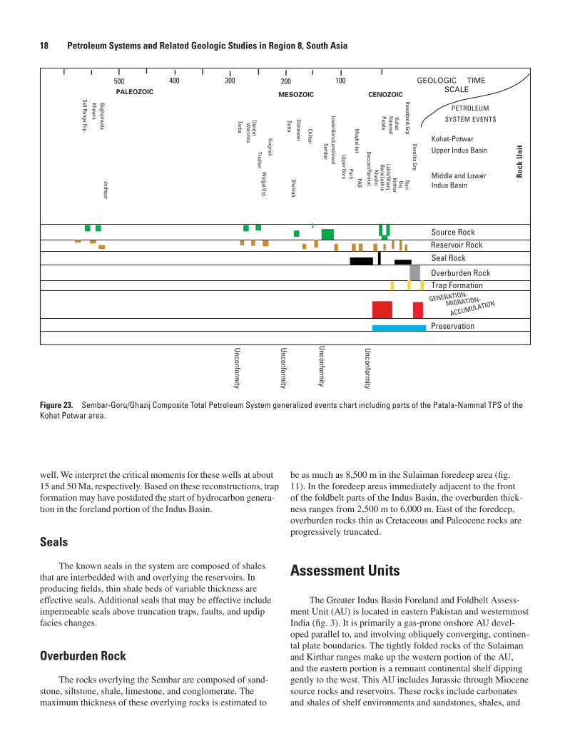
well. We interpret the critical moments for these wells at about 15 and 50 Ma, respectively. Based on these reconstructions, trap formation may have postdated the start of hydrocarbon genera-tion in the foreland portion of the Indus Basin.
Seals
The known seals in the system are composed of shales that are interbedded with and overlying the reservoirs. In producing fields, thin shale beds of variable thickness are effective seals. Additional seals that may be effective include impermeable seals above truncation traps, faults, and updip facies changes.
Overburden Rock
The rocks overlying the Sembar are composed of sand-stone, siltstone, shale, limestone, and conglomerate. The maximum thickness of these overlying rocks is estimated to
be as much as 8,500 m in the Sulaiman foredeep area (fig. 11). In the foredeep areas immediately adjacent to the front of the foldbelt parts of the Indus Basin, the overburden thick-ness ranges from 2,500 m to 6,000 m. East of the foredeep, overburden rocks thin as Cretaceous and Paleocene rocks are progressively truncated.
Assessment Units
The Greater Indus Basin Foreland and Foldbelt Assess-ment Unit (AU) is located in eastern Pakistan and westernmost India (fig. 3). It is primarily a gas-prone onshore AU devel-oped parallel to, and involving obliquely converging, continen-tal plate boundaries. The tightly folded rocks of the Sulaiman and Kirthar ranges make up the western portion of the AU, and the eastern portion is a remnant continental shelf dipping gently to the west. This AU includes Jurassic through Miocene source rocks and reservoirs. These rocks include carbonates and shales of shelf environments and sandstones, shales, and
�����������
����������
Rock
Uni
t
��������������
���������
�����������������������������
������������
GEOLOGIC TIMESCALE
��� ���
�������� ��������
��������������
���������
���
�����������
�����������
�
���������
�����
���������������
�������
��������
���
�����
������
������������
��
�������
������
����������
��
�������
���
������������
����������
���
���������
���
���������
���������������������������
�����������������
������ ����
�������
����
������
�����������
���
�������
��������
���
���
������������
�������
�����
�������
���������
���
���������
���
������
����������������
�����
���������
�����������
�������������
���������
���
Figure 23. Sembar-Goru/Ghazij Composite Total Petroleum System generalized events chart including parts of the Patala-Nammal TPS of the Kohat Potwar area.
18 Petroleum Systems and Related Geologic Studies in Region 8, South Asia Sembar-Goru/Ghazij Composite TPS, Indus and Sulaiman-Kirthar Geologic Provinces, Pakistan and India 19

coals of deltaic and fluvial facies. Although the Lower Cretaceous Sembar Formation
appears to be the major source of hydrocarbons, there are many other potential source rocks that may be important in different parts of the basin and foldbelt. Other potential source rocks are the Permian Dandot, Triassic Wulgai, and Paleocene Patala Formations. Total organic carbon content ranges from 0.5 percent to > 3.5 percent with an average of 1.4 percent. The organic carbon is composed of type-II and type-III kero-gens. Vitrinite reflectance values range from 0.3 percent to > 1.6 percent where sampled. The Lower Cretaceous Sembar may be overmature offshore. Hydrocarbon generation occurred at least two different times in the basin; first at the beginning of the Paleocene and again, in late Miocene and Pliocene.
Migration is primarily vertical and updip into adjacent reservoirs and through extensional faults associated with plate collision. Reservoir rocks are carbonates and sandstones of the Permian Tobra and Wargal, Lower Cretaceous Sembar, Goru, and Lumshiwal, Upper Cretaceous Pab, Paleocene Nammal, and Eocene Ghazij Formations. Porosity ranges from 9 per-cent to 30 percent, more commonly ranging from 12 percent to 16 percent. While almost all fields discovered to date are structural features such as anticlines and tilted fault blocks, the Sui gas field appears to be a reeflike stratigraphic trap. Strati-graphic traps are also likely to have formed in the deltaic and alluvial sequences. Seals include interbedded shales and the thick shales and clays of the Miocene-Pliocene Siwalik Group and fault truncations.
The Indus Fan assessment unit is located offshore of southeastern Pakistan between the Murray Ridge and the Pakistan-Indian border from a water depth of 200 m (approxi-mate shelf edge) to 3,000 m (approximate base of the middle portion of the fan) (fig. 3). It is a gas-prone offshore fan devel-oped on the edge of the Indian continental crust and adjacent oceanic crust. No wells have been drilled in water deeper than 200 m, but wells have been drilled in water less than 200 m deep on structures located with seismic data. This AU includes Eocene through Pliocene rocks of the upper part of the Sembar-Goru/Ghazij Composite TPS. These rocks include siltstones, sandstones, and mudstones of the fan facies.
Source rocks are postulated to be primarily Oligocene, Miocene, and Pliocene mudstones of the delta slope. Total organic carbon content ranges from 0.5 percent to > 3.5 per-cent, with an average of 1.4 percent where sampled onshore. Organic mater is composed of type-II and type-III kerogens. Although this AU is assumed to be charged primarily by Oligocene and younger source rocks, there may be some con-tribution from Upper Cretaceous source rocks near the shelf edge. Maturation most likely occurred in late Miocene and Pliocene with generation continuing today.
Migration pathways are presumed to be vertical and updip into adjacent reservoirs and along fault planes associ-ated with fan development. Reservoir rocks are Miocene through Pliocene siltstones and sandstones. Reservoirs include filled channels, interchannel ridges, and turbidites. Seals include interbedded mudstones and fault truncations.
The composite Petroleum System Events Chart for the Sembar-Goru/Ghazij Composite TPS (fig. 23) includes all rec-ognized potential source and reservoir rocks within the areal extent of the Sembar-Goru/Ghazij Composite TPS.
Assessment of Undiscovered Oil and Gas
Based on data current to 1996, provided by Petroconsul-tants International Data Corp., the Indus geologic province was ranked 87th in cumulative production and reserves of oil and gas (Klett and others, 1997), including U.S. geologic prov-inces. This categorized the Indus geologic province as a prior-ity geologic province for the USGS World Petroleum Assess-ment 2000 (U.S. Geological Survey World Energy Assessment Team, 2000). Known petroleum volumes are 0.2 billion barrels of oil (BBO) of oil and 19.6 trillion cubic feet of gas (TCFG), for a total of 3.5 billion barrels of oil equivalent (BBOE) including natural gas liquids (Petroconsultants International Data Corp., 1996). This volume is approximately 0.1 percent of the world’s estimated total volume of petroleum, excluding the United States In the Indus and Sulaiman-Kirthar geologic provinces 93 oil and gas fields had been discovered by 1996 (Petroconsultants, 1996) and 124 by 2001 (IHS Energy Group, 2001).
Previous estimates of undiscovered oil and gas in this region include those by Kingston (1986) and Masters and others (1998). Kingston estimated the mode of remaining undiscovered petroleum resources in the region at 0.2 BBO and 16.5 TCFG. The 1993 assessment (Masters and others, 1998) estimate of mean undiscovered petroleum resources in the region, both onshore and offshore combined, was 0.23 BBO and 29 TCFG. The methodology used in those assess-ments employed analogs from well-known productive regions of the world and relied heavily on volumetric considerations. The areas assessed by Masters and others (1998) are difficult to compare with the current assessment because it is unknown whether the Sulaiman-Kirthar foldbelt was included in their assessment. It is also unclear how much of the shelf and fan was considered in the Kingston (1986) and Masters and others (1998) assessments.
The U.S. Geological Survey World Energy Assessment (2000) incorporates the petroleum system concept as defined by Magoon and Dow (1994). The TPS used for the geologic basis of the 2000 assessment in the Indus Basin, Sulaiman-Kirthar, and part of the Kohat-Potwar geologic provinces is the Sembar-Goru/Ghazij Composite TPS. Table 1 shows the estimated ranges of assessed undiscovered oil and gas volumes allocated by AU and the totals for the Sembar-Goru/Ghazij Composite TPS. No estimate was made for oil in the Indus Fan AU. Tables 2 and 3 show the estimated ranges of assessed undiscovered oil and gas volumes allocated by geologic prov-ince and AU and the totals for the geologic provinces.
18 Petroleum Systems and Related Geologic Studies in Region 8, South Asia Sembar-Goru/Ghazij Composite TPS, Indus and Sulaiman-Kirthar Geologic Provinces, Pakistan and India 19

���� ������������������������������� ��� ����� �������������� ����� ��� ��� �� ���� ��� ��� �� ���� ��� ��� �� ����
�������� ������������������������������������������������������������� � �� ��� ��� ��� �� ��� ��� ��� � �� �� ��
���������� � ����� ������ ������ ������ ��� ��� ����� ���
����� ���� �� ��� ��� ��� ����� ������ ������ ������ ��� ��� ����� ���
�������� ����������������������������������� �� � � � � � � � � � � � �
���������� �� � ����� ������ ����� � �� ��� ���
����� ���� � � � � � ����� ������ ����� � �� ��� ���
������ ����������������������������������������������������������������������� �� ��� ��� ��� �� ��� ��� ��� � �� �� ��
���������� ����� ������ ������ ������ ��� ��� ����� �����
����� ���� �� ��� ��� ��� ����� ������ ������ ������ ��� ��� ����� �����
����
����
����
���������� ������������
Table 1. Estimates of undiscovered oil and gas for the onshore and offshore parts of the Sembar-Goru/Ghazij Composite Total Petroleum System.
[MMBO, million barrels of oil. BCFG, billion cubic feet of gas. MMBNGL, million barrels of natural gas liquids. MFS, minimum field size assessed (MMBO or BCFG). Prob., probability (including both geologic and accessibility probabilities) of at least one field equal to or greater than the MFS. Results shown are fully risked estimates. For gas fields, all liquids are included under the NGL natural gas liquids) category. F95 represents a 95-percent chance of at least the amount tabulated. Other fractiles are defined similarly. Fractiles are additive under the assumption of perfect positive correlation. Shading indicates not applicable]
���� ������������������������������� ��� ����� �������������� ����� ��� ��� �� ���� ��� ��� �� ���� ��� ��� �� ����
���� ������������������������������������������������������������� �� �� ��� �� �� ��� ��� ��� � �� �� ��
���������� ����� ����� ������ ������ ��� ��� ��� ���
����� ���� �� �� ��� �� ����� ����� ������ ������ ��� ��� ��� ���
���� �������������������������������������������������������������� � � �� �� � �� �� �� � � � �
���������� ��� ����� ������ ����� �� ��� ��� ���
����� ���� � � �� �� ��� ����� ������ ����� �� ��� ��� ���
���� ����������������������������������������������������������� �� �� ��� ��� �� ��� ��� ��� � �� �� ��
���������� ����� ������ ������ ������ ��� ��� ����� ���
����� ���� �� �� ��� ��� ����� ������ ������ ������ ��� ��� ����� ���
���������� ������������
����
����
����
Table 2. Estimates of undiscovered oil and gas for the portion allocated to the Indus Province part of the Sembar-Goru/Ghazij Composite Total Petroleum System.
[MMBO, million barrels of oil. BCFG, billion cubic feet of gas. MMBNGL, million barrels of natural gas liquids. MFS, minimum field size assessed (MMBO or BCFG). Prob., probability (including both geologic and accessibility probabilities) of at least one field equal to or greater than the MFS. Results shown are fully risked estimates. For gas fields, all liquids are included under the NGL natural gas liquids) category. F95 represents a 95-percent chance of at least the amount tabulated. Other fractiles are defined similarly. Fractiles are additive under the assumption of perfect positive correlation. Shading indicates not applicable]
20 Petroleum Systems and Related Geologic Studies in Region 8, South Asia Sembar-Goru/Ghazij Composite TPS, Indus and Sulaiman-Kirthar Geologic Provinces, Pakistan and India 21

Summary
The Sembar-Goru/Ghazij Composite Total Petroleum System in the Greater Indus Basin of Pakistan and India is low to moderately well explored. All of the necessary attributes for petroleum generation, expulsion, migration, entrapment, and preservation are present. The system has favorable character-istics for additional hydrocarbon discoveries using existing and new play concepts. While this report focuses on a com-posite TPS, that composite TPS could be further subdivided into numerous smaller petroleum systems with other primary source rocks such as the Permian Dandot Formation, Trias-sic Wulgai Formation, Paleocene Patala Shale, Eocene Ghazij Formation, and Miocene shales.
Selected ReferencesAhmad, S., Alam, Z., and Khan, A.R., 1996, Petroleum exploration and
production activities in Pakistan: Pakistan Petroleum Information Service, 72 p.
Biswas, S.K., and Deshpande, S.V., 1983, Geology and hydrocarbon prospects of Kutch, Saurashtra, and Narmada basins: Petroleum Asia Journal, v. 6, no. 4, p. 111–126.
Drewes, Harald,1995, tectonics of the Potwar Plateau Region and the development of syntaxes, Punjab, Pakistan: U.S. Geological Survey Bulletin 2126, 25 p.
Environmental Systems Research Institute Inc., 1992, ArcWorld 1:3M digital database: Environmental Systems Research Institute, Inc. (ESRI), available from ESRI, Redlands, CA, scale: 1:3,000,000.
Government of Pakistan, 2001, Privatisation Commission, Finance Division, Government of Pakistan Web page [//www.gop-sale.com].
IHS Energy Group, [formerly Petroconsultants], 2001, Probe 4.0 Petroleum exploration and production database: [includes data current as of September 2001], IHS Energy Group; database available from IHS Energy Group, 15 Inverness Way East, D205, Englewood, CO 80112, U.S.A.
IHS Energy Group [formerly Petroconsultants], 1996, Petroleum Exploration and Production Database: Petroconsultants, Inc., P.O. Box 740619, 6600 Sands Point Drive, Houston TX 77274-0619, USA or Petroconsultants, Inc., P.O. Box 152, 24 Chemin de la Marie, 1258 Perly, Geneva, Switzerland.
Iqbal, M.W.A., and Shah, S.M.I., 1980, A guide to the stratigraphy of Pakistan, Geological Survey of Pakistan Records: Geological Survey of Pakistan, Quetta, v. 53, p. 34.
Jadoon, Ishtiaq A.K., Lawrence, Robert D., and Lillie, Robert J., 1994, Seismic data, geometry, evolution, and shortening in the active Sulaiman Fold-and-Thrust Belt of Pakistan, southwest of the Himalayas: American Association of Petroleum Geologists Bulletin, v. 78, no. 5, p. 758–774.
Jaswal, T.M., Lillie, R.J., and Lawrence, R.D., 1997, Structure and evolution of the northern Potwar deformed zone, Pakistan: American Association of Petroleum Geologists Bulletin, v. 81, no. 2, p. 308–328.
���� ������������������������������� ��� ����� �������������� ����� ��� ��� �� ���� ��� ��� �� ���� ��� ��� �� ����
���� ������������������������������������������������������������������������ � �� �� �� � �� �� �� � � � �
���������� ����� ������ ������ ������ ��� ��� ��� ���
����� ���� � �� �� �� ����� ������ ������ ������ ��� ��� ��� ���
���� ������������������������������������������������������������������������� � � � � � � � � � � � �
���������� � � � � � � � �
����� ���� � � � � � � � � � � � �
���� ���������������������������������������������������������������������� � �� �� �� � �� �� �� � � � �
���������� ����� ������ ������ ������ ��� ��� ��� ���
����� ���� � �� �� �� ����� ������ ������ ������ ��� ��� ��� ���
���������� ������������
����
����
����
Table 3. Estimates of undiscovered oil and gas for the portion allocated to the Sulaiman-Kirthar Province part of the Sembar-Goru/Ghazij Composite Total Petroleum System.
[MMBO, million barrels of oil. BCFG, billion cubic feet of gas. MMBNGL, million barrels of natural gas liquids. MFS, minimum field size assessed (MMBO or BCFG). Prob., probability (including both geologic and accessibility probabilities) of at least one field equal to or greater than the MFS. Results shown are fully risked estimates. For gas fields, all liquids are included under the NGL natural gas liquids) category. F95 represents a 95-percent chance of at least the amount tabulated. Other fractiles are defined similarly. Fractiles are additive under the assumption of perfect positive correlation. Shading indicates not applicable]
20 Petroleum Systems and Related Geologic Studies in Region 8, South Asia Sembar-Goru/Ghazij Composite TPS, Indus and Sulaiman-Kirthar Geologic Provinces, Pakistan and India 21
Johnson, E.A., Warwick, P.D., Roberts, S.B. and Khan, I.H., 1999, Lithofacies, depositional environments, and regional stratigraphy of the lower Eocene Ghazij Formation, Baluchistan, Pakistan: U.S. Geological Survey Professional Paper 1599, 76 p.
Kemal, A., 1992, Geology and new trends for hydrocarbon exploration in Pakistan, in Ahmed, G., Kemal, A., Zaman, A.S.H., and Humayon, M., eds., New directions and strategies for accelerating petroleum exploration and production in Pakistan: Proceedings, international petroleum seminar, Ministry of Petroleum and Natural Resources, Islamabad, Pakistan, November, 22–24, 1991, p. 16–57.
Kemal, A., Balkwill, H.R., and Stoakes, F.A., 1992, Indus Basin hydrocarbon plays, in Ahmed,G., Kemal, A., Zaman, A.S.H., and Humayon, M., eds., New directions and strategies for accelerating petroleum exploration and production in Pakistan: Proceedings of an international petroleum seminar, Ministry of Petroleum and Natural Resources, Islamabad, Pakistan, November, 22–24, 1991, p. 76–105.
Khadri, I.B., 1995, Petroleum geology of Pakistan: Karachi, Pakistan Petroleum Ltd., p. 275.
Khan, M.A., Ahmed, R., Raza, H.A., and Kemal, A., 1986, Geology of petroleum in Kohat-Potwar depression, Pakistan: American Association of Petroleum Geologists Bulletin, v. 70, no. 4, p. 396–414.
Kingston, John, 1986, Undiscovered petroleum resources of South Asia: U.S. Geological Survey Open-File Report 86-80,131 p.
Klett, T.R., Ahlbrandt, T.A., Schmoker, J.W., and Dolton, G.L., 1997, Ranking of the world’s oil and gas provinces by known petroleum volumes: U.S. Geological Survey Open-File Report 97-463, one CD-ROM.
Kolla, V., and Coumes, E., 1987, Morphology, internal structure, seismic stratigraphy, and sedimentation of Indus Fan: American Association of Petroleum Geologists Bulletin, v. 71, no. 6, p. 650–677.
Law, B.E., Shah, S.H.A., and Malik, M.A., 1998, Abnormally high formation pressures, Potwar Plateau, Pakistan, in Law, B.E., Ulmishek, G.F., and Slavin, V.I., eds., Abnormal pressures in hydrocarbon environments: American Association of Petroleum Geologists Memoir 70, p. 247–258.
Magoon, L.B., and Dow, W.G., 1994, The TPS—From source to trap: American Association of Petroleum Geologists Memoir 60.
Malik, Z., Kemal, A., Malik, Azam M., and Bodenhausen, J.W.A., 1988, Petroleum potential and prospects in Pakistan, in Raza, H.A. and Sheikh, A.M., eds., Petroleum for the future, Islamabad.
Masters, C.D., Root, D.H., and Turner, R.M., 1998, World conventional crude oil and natural gas identified reserves, undiscovered resources, and futures: U.S. Geological Survey Open-File Report 98-468, 105 p.
McHarque, T.R., and Webb, J.E., 1986, Internal geometry, seismic facies, and petroleum potential of canyons and inner fan channels of the Indus Submarine Fan: American Association of Petroleum Geologists Bulletin v. 70, no. 2, p. 161–180.
Mitra, P., Zutshi, P.L., Chourasia, R.A., Chugh, M.I., Ananthanarayanan, S., and Shukla, B., 1983, Exploration in western offshore basins: Petroleum Asia Journal, v. 6, no. 4, p. 15–24.
Oil and Gas Development Corporation [OGDC], 1995, Pakistan petroleum prospects—An overview: Oil and Gas Development Corporation, Islamabad, 22 p.
Pecock, E.S., Lillie, R.J., Zaman, A.S.H., and Yousaf, M., 1989, Structural interpretation of seismic reflection data from eastern Salt Range and Potwar Plateau, Pakistan: American Association of Petroleum Geologists Bulletin, v. 73, p. 841–857.
Peters, K.E., Clark, M.E., Gupta. U. Das, McCaffrey, M.A., and Lee, C. Y., 1995, Recognition of an infracambrian source rock based on biomarkers in the Baghewala-1 Oil, India, v. 79, i. 10, p. 1481–1493.
Petroconsultants, 1996, Petroleum exploration and production database: Petroconsultants, Inc., P.O. Box 740619, 6600 Sands Point Drive, Houston TX 77274-0619, USA or Petroconsultants, Inc., P.O. Box 152, 24 Chemin de la Mairie, 1258 Perly, Geneva.
Petzet, G. Alan, 1997, Union Texas hopes to reproduce its Pakistan Badin experience: Oil and Gas Journal, v. 95, i. 44.
Powell, C.M.A., 1979, A speculative tectonic history of Pakistan and surroundings; some constraints from the Indian Ocean, in Farah, Abdul, and Dejohn, K.A., eds., Geodynamics of Pakistan: Geological Survey of Pakistan, p. 5–24.
Quadri, V.N., Chughtai, S.A., Farani, Z., Quadri, G.J., 2000, Oil and Gas Development Corp., Islamabad, Here are recommendations in search of giants in Pakistan: Oil and Gas Journal, v. 98, no. 2, p. 57–60.
Quadri, Viqar-un-Nisa, and Shuaib, S.M., 1986, Hydrocarbon prospects of southern Indus Basin, Pakistan: American Association of Petroleum Geologists Bulletin, v. 70, no. 4, p. 396–414.
Quadri, Viqar-un-Nisa, and Quadri, S.M.G.J., 1996, Exploration—Anatomy of success in oil and gas exploration in Pakistan, 1915–94, Oil and Gas Journal, May 13, 1996.
Quadri, Viqar-un-Nisa, and Quadri, S.M.G.J., 1997, Indus basin off Pakistan contains few wells: Oil and Gas Journal, v. 95, i. 24.
Quadri, Viqar-un-Nisa, and Quadri, S.M.G.J., 1998a, Failure-to-success targets may lie in Pakistan basins: Oil and Gas Journal, v. 96, i. 1.
Quadri, Viqar-un-Nisa, and Quadri, S.M.G.J., 1998b, Pakistan has unventured regions, untested plays: Oil and Gas Journal, v. 96, i. 12.
Raza, H.A., 1992, Petroleum source rocks in Pakistan, in Gulfaraz, A., Kemal, A., Zaman, A.S.H, and Humayon, M., eds., New directions and strategies for acceleration petroleum exploration in Pakistan: Proceedings of an international petroleum seminar, Ministry of Petroleum and Natural Resources, Islamabad, Pakistan, Nov. 22–24, 1991, p. 129–136.
Roychoudhury, S.C., and Deshpande, S.V., 1982, Regional distribution of carbonate facies, Bombay Offshore region, India, in The American Association of Petroleum Geologists Bulletin, v. 66 no. 10, p. 1483–1496.
Scotese, C.R., 1997, PALEOMAP Software, PALEOMAP Project: http://scotese.com.
Scotese, C.R., Gahagan,L.M., and Larson, R.L., 1988, Plate tectonic reconstructions of the Cretaceous and Cenozoic ocean basins: Tectonophysics, v. 155, p. 27–48.
22 Petroleum Systems and Related Geologic Studies in Region 8, South Asia Sembar-Goru/Ghazij Composite TPS, Indus and Sulaiman-Kirthar Geologic Provinces, Pakistan and India 23

Sercombe, W.J., Pivnik, D.A., Wilson, W.P., Albertin, M.L., Beck, R.A., and Stratton, M.A., 1998, Wrench faulting in the Northern Pakistan Foreland: American Association of Petroleum Geologists Bulletin, v. 82, no. 11, p. 2003–2030.
Sercombe, W.J., Stratton, M., Albertin, M., Wilson, W.P., Roth, B.L., Van Nieuwenhuise, R., Pivnik, D.A., and Beck, R.A., 1994, Wrench faulting in the northern Pakistan foreland region: The Leading Edge, November 1994, p. 1107–1110.
Shah, S.M.I., Ahmed, R., Cheema, M.R., Fatmi, A.N., Iqbal, M.W.A., Raza, H.A., and Raza, S.M., 1977, Stratigraphy of Pakistan: Geological Survey of Pakistan, Memoirs, v. 12, 137 p.
Soulsby, A., and Kemal, A., 1988, A review of exploration activity in Pakistan: Oil and Gas Journal, November, 21, 1988, p. 56–59.
Tobin, R.C., and Claxton, B.L., 2000, Multidisciplinary thermal maturity studies using vitrinite reflectance and fluid inclusion microthermometry—A new calibration of old techniques: American Association of Petroleum Geologists Bulletin, v. 84, no. 10, p. 1647–1665.
U.S. Geological Survey World Energy Assessment Team, 2000, U.S. Geological Survey World Petroleum Assessment 2000—Description and results: USGS Digital Data Series DDS-60, 4 CD-ROMs.
Wandrey, C.J., 2002, Kohat-Potwar Geologic Province Patala-Namal Composite Total Petroleum System: U.S. Geological Survey Bulletin 2208-B.
Wandrey, C.J., and Law, B.E., 1999, Map showing geology, oil and gas fields, and geologic provinces of South Asia: U.S. Geological Survey Open-File Report 97-470C, version 2, one CD-ROM.
Wandrey, C. J., Milici, Robert, and Law, B.E., 2000, Region 8 Assessment Summary—South Asia, Chapter R8 for DDS-60 in U.S. Geological Survey World Petroleum Assessment 2000—Description and results: U.S. Geological Survey Digital Data Series DDS-60, 28 p., CD-ROM.
Waples, D.W., and Hegarty, Kerry, 1999, Seychelles thermal history hydrocarbon generation traced: Oil and Gas Journal, v. 97, no. 21, p. 78–82.
Warwick, P.D., Javed, S., Mashhadi, S.T.A., Shakoor, T., Khan, A.M., and Khan, A.L., 1993, Lithofacies and palynostratigraphy of some Cretaceous and Paleocene rocks, Surghar and Salt Range coal fields, northern Pakistan: U.S. Geological Survey Bulletin 2096, 35 p.
Zaigham N.A., and Mallick, K.A., 2000, Prospect of hydrocarbon associated with fossil-rift structures of the southern Indus basin, Pakistan: American Association of Petroleum Geologists Bulletin, v. 84, no. 11, p. 1833–1848.
Manuscript approved for publication March 17, 2004Published in the Central Region, Denver, ColoradoEditing, Mary A. KiddPage layout, photocomposition, Richard W. Scott, Jr.Section 508 compliance, David G. WaltersWebmaster, Tracy A. PintoGraphics by the authors
22 Petroleum Systems and Related Geologic Studies in Region 8, South Asia Sembar-Goru/Ghazij Composite TPS, Indus and Sulaiman-Kirthar Geologic Provinces, Pakistan and India 23