Embed Size (px)
Citation preview


Workshop 1Defining, exploring, imaging and assessing
reservoirs for potential heat exchange6 - 8 November 2006
GEOFORSCHUNGSZENTRUM - POTSDAM - GERMANY
ENGINEENhanced Geothermal
Innovative Network for Europe
http
://en
gine
.brg
m.fr
Workshop Abstracts
EDITED BY: DAVID BRUHN (GFZ) & ADELE MANZELLA (IGG)
Intérieur Potsdam 26/10/06 15:24 Page 2

This document has been coordinated / edited by: David BRUHN, Section 5.2 Geothermics, GFZ Potsdam, 14473 Potsdam, Germany Adele MANZELLA, Leader of the “Investigation of Unconventional Geothermal Resources and in particular Enhanced Geothermal Systems” Workpackage of the ENGINE project, IGG, Via Moruzzi 1, 56124 Pisa, Italy In bibliography, each abstract of this document will be referenced as the following example: Sliaupa S., et al., 2006. Evaluation of the Geothermal Prospects of the hot Granites of West Lithuania. From Bruhn D. & Manzella A. (eds.) 2006, in Actes/Abstracts of the Engine Workshop 1 " Defining, exploring, imaging and assessing reservoirs for potential heat exchange ", 6-8 November 2006, Potsdam, Germany, p. 41. Keywords: Geothermal Energy; European Co-ordination Action; Renewable Energy; Enhanced Geothermal Systems; EGS; Unconventional Geothermal Systems; UGS; Exploration, Geology, Geophysics, Geochemistry, Rock Physics, Reservoir Modeling, Reservoir Characterization Cover pictures Thunbail upper top: Potsdam, Germany, Alter Markt © Karsten Stopp www.galerie-potsdam.de. Thunbail lower top: GeoForschungsZentrum, Potsdam, Germany, by GFZ Press Service. Background: Gross-Schönebeck drilling site, Germany, by GFZ Potsdam section 5.2.
http
://en
gine
.brg
m.fr
Organising CommitteeErnst HUENGES ([email protected])Patrick LEDRU ([email protected])Angela SPALEK ([email protected])
Scientific CommitteeDavid BRUHN ([email protected]) ChairpersonAdele MANZELLA ([email protected]) Chairperson
Intérieur Potsdam 26/10/06 15:23 Page 1

Engine Partners
BRGM 3, avenue C. Guillemin BP 36009 - 45060 Orléans Cedex 2 FRANCE
ENGINE
GFZ Telegrafenberg 14473 Potsdam GERMANY
CRES 19th km, Marathonos Ave 19009 Pikermi Attikis GREECE
ISOR Gresasvegi 9 – 108 Reykjavik ICELAND
NCSRD Patriarchou Grigoriou & Neapoleos st Aghia Paraskevi - 15310 Attiki GREECE
SIEP B.V. Carel van Bylandtlaan 30 2596 HR Den Haag NETHERLANDS
GPC 14, rue de la Perdrix, ZI Paris Nord 2, Lot 109, BP 50030 95946 Villepinte CDG cedex FRANCE
TNO PO Box 6060 2600 JA Delft NETHERLANDS
IFE PO Box 40 - 2027 Kjeller NORWAY
IGR DSC RAS Imama Shamil str. 39-A Makhachkala RUSSIAN FEDERATION
PGI Rakowiecka 4 00-975 Warsawa POLAND
CNR-IGG Via G. Moruzzi 1 - 56124 Pisa ITALY
GEUS Oster Voldgade 10 1350 Copenhagen DENMARK
CFG 3, avenue Claude Guillemin BP 6429 - 45064 Orléans cedex 2 FRANCE
UOR Aramtei Romane, 5-9 410087 Oradea ROMANIA
IE Torgauer Str. 116 04347 Liepzig GERMANY
GEMRC IPE RAS Box 30 - Troitsk 142190 Moscow Region RUSSIAN FEDERATION
ELTE Egyetem tér 1-3 - 1053 Budapest HUNGARY
IVT RAN Izhorskaya str. 13/19 125412 Moscow RUSSIAN FEDERATION
CNRS PO Box 20 - 23, rue du Loess 67037 Strasbourg FRANCE
JSC 9/1 Krasnokazarmennaya Str. 111250 Moscow RUSSIAN FEDERATION
GGA-Institute Stilleweg 2 - 30655 Hannover GERMANY
DHMA Haering Geo-Project- Im Unter Tollacher 2 8162 Steinmaur SWITZERLAND
GEIE BP 38 - Route de Soultz 67250 Kutzenhausen FRANCE
GEOWATT AG Dohlenweg 28 - 8050 Zürich SWITZERLAND
IGGL T. Sevcenkos g. 13 - 03223 Vilnius LITHUANIA
ORME Hosdere Cad. 190/7-8-12 06550 Ankara TURKEY
MeSy Meesmannstr. 49 - 44807 Bochum GERMANY
IGME Rios Rosas, 23 - 28003 Madrid SPAIN
VUA De Boelelaan 1085 1081 HV Amsterdam NETHERLANDS
CERTH 6th km Charilaou-Thermi Road PO Box 361 - 57001 Thermi-Thessaloniki GREECE

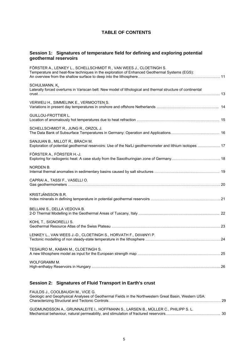
TABLE OF CONTENTS
Session 1: Signatures of temperature field for defining and exploring potential geothermal reservoirs
FÖRSTER A., LENKEY L., SCHELLSCHMIDT R., VAN WEES J., CLOETINGH S. Temperature and heat-flow techniques in the exploration of Enhanced Geothermal Systems (EGS): An overview from the shallow surface to deep into the lithosphere………………………………………………………… 11 SCHULMANN, K. Laterally forced overturns in Variscan belt: New model of lithological and thermal structure of continental crust……………………………………………………………………………………………………………………………….. 13 VERWEIJ H., SIMMELINK E., VERMOOTEN S. Variations in present day temperatures in onshore and offshore Netherlands ………………………………………….. 14 GUILLOU-FROTTIER L. Location of anomalously hot temperatures due to heat refraction ………………………………………………………… 15 SCHELLSCHMIDT R., JUNG R., ORZOL J. The Data Bank of Subsurface Temperatures in Germany: Operation and Applications………………………………… 16 SANJUAN B., MILLOT R., BRACH M. Exploration of potential geothermal reservoirs: Use of the Na/Li geothermometer and lithium isotopes ……………… 17 FÖRSTER A., FÖRSTER H.-J. Exploring for radiogenic heat: A case study from the Saxothuringian zone of Germany………………………………… 18 NORDEN B. Internal thermal anomalies in sedimentary basins caused by salt structures ……………………………………………. 19 CAPRAI A., TASSI F., VASELLI O. Gas geothermometers ………………………………………………………………………………………………………….. 20 KRISTJÁNSSON B.R. Index minerals in defining temperature in potential geothermal reservoirs ……………………………………………….. 21 BELLANI S., DELLA VEDOVA B. 2-D Thermal Modelling in the Geothermal Areas of Tuscany, Italy ……………………………………………………….. 22 KOHL T., SIGNORELLI S. Geothermal Resource Atlas of the Swiss Plateau …………………………………………………………………………… 23 LENKEY L., VAN WEES J.-D., CLOETINGH S., HORVATH F., DöVéNYI P. Tectonic modelling of non steady-state temperature in the lithosphere …………………………………………………… 24 TESAURO M., KABAN M., CLOETINGH S. A new lithosphere model as input for the European strength map ………………………………………………………… 25 WOLFGRAMM M. High-enthalpy Reservoirs in Hungary …………………………………………………………………………………………. 26 Session 2: Signatures of Fluid Transport in Earth's crust FAULDS J., COOLBAUGH M., VICE G. Geologic and Geophysical Analyses of Geothermal Fields in the Northwestern Great Basin, Western USA: Characterizing Structural and Tectonic Controls……………………………………………………………………………… 29 GUDMUNDSSON A., GRUNNALEITE I., HOFFMANN S., LARSEN B., MÜLLER C., PHILIPP S. L. Mechanical behaviour, natural permeability, and stimulation of fractured reservoirs…………………………………….. 30
5

SCHILL E., REGENAUER-LIEB K. Geothermal resources in central Europe: A geodynamic view……………………………………………………………… 31 GERAUD Y., ROSENER M. Mineralogy, porosity and thermal conductivity mapping of different flowing structures in geothermal granite of Soultz-sous-Forets (France)………………………………………………………………………………………………….. 32 RUGGIERI G., GIOVANNI, G., GIOLITO, C. Fluid evolution and water-rock interaction in the Larderello geothermal field: Evidence from mineralogical, petrographic and fluid inclusion studies……………………………………………………………………………………….. 33 CALCAGNO P., DAGALLIER A., COURRIOUX G., GENTER A. How 3DGeoModeller Helps to Define and Assess a Geothermal Reservoir: The Limagne Case-Study (French Massif Central)……………………………………….………………………………………………………………… 35 ROYER J.-J., LALOS P., VOILLEMONT J.-C., CONIN M., SAUSSE J., GERARD A Method for Estimating the Increase in Permeability of Reservoirs During Hydro-fracturing Stimulations……………… 36 CAPRAI A., CALVI E., DOVERI M., LEONE G., MUSSI M. Methods and apparatus for feeding samples of gas at controlled pressure into a gas chromatograph and its application to geochemical surveillance of reactive gas from Pozzuoli Solfatara………………………………………… 37 LEDRU P., BOUCHOT V., GENTER A. Naturally Mineralized Systems and Mineralisations, a natural analogue of Enhanced Geothermal Systems?……….. 39 SLIAUPA S., MOTUZA G., CIURAITE K. Evaluation of the Geothermal Prospects of the hot Granites of West Lithuania………………………………………….. 41 MOECK I., BLÖCHER G. External drift kriging as method to interpretate data of different accuracy degrees……………………………………… 42 Session 3: State of the Art in the Exploration of Potential Geothermal Reservoirs FIORDELISI A., BERTANI R. Exploration of Geothermal Resources in Italy………………………………………………………………………………… 45 WEBER M., BAUER K., MUNOZ G., RITTER O., SCHULZE A. First results from the I-GET project on Integrated Geophysical Exploration……………………………………………… 46 MENDRINOS D., KARYTSAS C. MIlos Site (Greece): Integration and evaluation of exploration data……………………………………………………….. 47 FLOVENZ O., ÁRNASON K., KARLSDÓTTIR R. The state of the art in high temperature geothermal exploration in volcanic environment………………………………. 48 MANZELLA A., and the IGG GROUP The contribution of IGG to the exploration of Larderello geothermal area: A multdisciplinary approach……………… 49 KARLSDóTTIR R., ÁRNASON K., EYSTEINSSON H. Subsurface geothermal flow patterns derived from TEM soundings………………………………………………………. 51 JOUSSET P., PÉRICAT J., FABRIOL H., CHOUET B. Broadband seismology for monitoring and exploring hydrothermal systems……………………………………………… 52 DEZAYES C., GENTER A., VALLEY B., SAUSSE J. Borehole imagery contribution to EGS reservoir exploration……………………………………………………………….. 53 PLACE J., GERAUD Y., DIRAISON M., NAVILLE C., GERARD A., CHAMING M. Fracture network analysis at the hectometric Scale of the Soultz-sous-Forets granite: Combination of well seismic data and field analog in Catalunia……………………………………………………………………………………. 54 TRAPPE H., GIERSE G., FREHERS S., PRUESSMANN J. Modern Seismic Methods for Geothermal Projects………………………………………………………………………….. 55
KRAWCZYK C.M., LOHR T., TANNER D.C., ENDRES H., TRAPPE H., ONCKEN O., KUKLA. P. Sub-/Seismic Structure and Deformation quantification on different Scales from 3D Reflection seismics in the North German Basin………………………………………………………………………………………………………… 56 SPICHAK V. Geophysical Exploration of Russian Geothermal Resources……………………………………………………………….. 57 SPICHAK V. Advances in Magnetotelluric study of geothermal areas…………………………………………………………………….. 58 MANZELLA A. Electrical resistivity distribution in geothermal systems characterized by crystalline rocks……………………………… 60 Session 4: Processes in Geothermal Reservoirs OATES S. DARNET M., HUSTEDT B Microseismic monitoring of hydraulic stimulation of well TR8A in the Berlin Geothermal Field, El Salvador…………. 63 JOHANNESSEN Peter N. Reservoir characterization of a deep Jurassic hydrocarbon bearing sandstone in the Central Graben, North Sea…………………………………………………………………………………………………………………………. 64 RATH V. Characterizing geothermal reservoirs using inverse methods……………………………………………………………… 65 MILSCH H., SPANGENBERG E., KULENKAMPFF J., SCHULDT S., HUENGES E. Experimental Long-term Investigations on Geothermal Reservoir Rock Properties at Simulated In situ-Conditions………………………………………………………………………………………………………………… 66 KOHL T. Combined transport experiments under In situ conditions…………………………………………………………………. 67 GHERGUT J., SAUTER M., LODEMANN M., BEHRENS H., LICHA T., ORZOL J., ZIMMERMANN G., ROSE P. Tracer-assisted evaluation of hydraulic stimulation experiments in deep crystalline and sedimentary formations in Germany…………………………………………………………………………………………………………………………. 68 Authors' Index 69
7

8

ENGINE – ENhanced Geothermal Innovative Network for Europe Workshop 1, Defining, Exploring, Imaging and Assessing Reservoirs for Potential Heat Exchange
Potsdam, 6-8 November 2006, Germany
Session 1
Signatures of Temperature Field for Defining and Exploring Potential Geothermal Reservoirs
9

ENGINE – ENhanced Geothermal Innovative Network for Europe Workshop 1, Defining, Exploring, Imaging and Assessing Reservoirs for Potential Heat Exchange
Potsdam, 6-8 November 2006, Germany
10

ENGINE – ENhanced Geothermal Innovative Network for Europe Workshop 1, Defining, Exploring, Imaging and Assessing Reservoirs for Potential Heat Exchange
Potsdam, 6-8 November 2006, Germany
Temperature and heat-flow techniques in the exploration of Enhanced Geothermal Systems (EGS): An overview from the shallow surface to deep into
the lithosphere
FÖRSTER Andrea, GFZ Potsdam, Germany, [email protected] LENKEY Laszlo, Hungarian Academy of Sciences, Hungary SCHELLSCHMIDT Rüdiger, GGA Institute, Germany VANWEES Jan-Diederik, TNO, Netherlands CLOETINGH Sierd, Vrije Universiteit, Amsterdam, Netherlands Since the 1980s, much effort has been devoted to the investigation of the thermal field in Europe culminating in regional mapping projects, such as the ‘Geothermal Atlas of Europe’ published in 1992 and the ‘Atlas of Geothermal Resources in Europe’ released in 2002. These maps form a broad base to assess Europe’s thermal field on a global scale. They are based on information from a huge amount of boreholes, whereby a great portion of these data stems from the exploration for hydrocarbons. Using these data, stored in national databases and updated whenever new data are available, assessments of the thermal potential have been made at regional and even at local scale to develop geothermal prospects. Simultaneously, a wealth of new data has become available over the past two decades on the thermal signature of the deeper crust and lithosphere. The signature is largely derived from tomography data, closely linked to deep seismic reflection, and earthquake data. The interpretation of deep crustal and lithospheric temperatures from these data requires careful tectonic interpretation and integrated lithospheric process models. The interpreted deep lithosphere and crustal temperatures reveal at some points a strong relation with the measured surface heat-flow pattern. This is best reflected in areas of great lithosphere thickness (e.g. the Precambrian and Caledonian terranes), which show lower heat flow and temperature at drillable depth than areas with lithosphere thinning. Active tectonic settings can result in strong dynamic effects of crustal and lithospeheric heat flow, which can help predicting and understanding regional patterns in heat flow, constraining exploration assumptions. However, of less global significance, but usually of great importance to the temperatures in a particular area, are relative shallow (< 10 km) static and dynamic phenomena such as (1) magma intrusions into high crustal levels (e.g. the Larderello field); (2) thermal conductivity variations, both vertical and horizontal as they occur in sedimentary basins; (3) large- and small-scale fluid flow (e.g. the Rhine Valley); and (4) radiogenic sources in the upper crust (e.g. areas of high-heat-production granites). The scale of control on temperatures by these globaland regional-scale processes is variable and many examples now are available to quantify these effects. In the exploration of EGS, geothermists are in the comfortable situation to profit from efforts made in the last several decades by heat-flow researchers in the assessment of the quality of thermal data used for heat-flow calculation. Thus, there are excellent examples in the literature showing the advantages of temperature logs to single temperature data (BHTs, DSTs) to explore the thermal state and the thermal signatures of an area. In a heat conduction geological environment, the most basic parameter affecting subsurface temperature is the thermal conductivity of rocks. Assessments were made on the different quality of thermal conductivity measured in the laboratory either from core or sample cuttings. Although it is common knowledge that information on thermal conductivity changes in an exploration setting is important, data on these changes are difficult to obtain. The measurement of thermal conductivity has been labour-intensive and thus usually not part of conventional laboratory programs. However, the optical-scanning technology currently is readily available to measure efficiently and at low cost the thermal conductivity of many rock samples in the laboratory. The second obstacle in
11

ENGINE – ENhanced Geothermal Innovative Network for Europe Workshop 1, Defining, Exploring, Imaging and Assessing Reservoirs for Potential Heat Exchange
Potsdam, 6-8 November 2006, Germany
getting an appreciation of thermal conductivity is the lack of rock samples in industrial exploration. In addition, laboratory measurements in some situations are unreliable, especially for shales, one of the most abundant lithologies in sedimentary basins. For this reason, a general methodology to obtain thermal conductivity from a set of well-log parameters is sought and convincing approaches already have been obtained. With good control of thermal conductivity versus depth, the variation of heat flow versus depth can be delineated in interpreted in terms of heat-transfer processes, which again is essential for the assessment of an EGS. In summary, temperature/heat-flow techniques, bridging several disciplines in earth sciences, need to form an integral part in the exploration for geothermal resources, and for the EGS in particular. Although the general picture of Europe’s heat anomalies is known, much work needed to decipher the local situation and for particular prospects, the boundary conditions for the development of an EGS. Measures to be taken need to involve a critical screening of thermal data, developing baseline temperature models, and investigating the modification through the time of reservoir exploitation, providing the essential thermal rock properties, and combining the temperature field properties with reservoir properties. Examples are needed on how predictions of the temperature at depth may fail by improper use of subsurface data or by insufficient exploration.
12

ENGINE – ENhanced Geothermal Innovative Network for Europe Workshop 1, Defining, Exploring, Imaging and Assessing Reservoirs for Potential Heat Exchange
Potsdam, 6-8 November 2006, Germany
Laterally forced overturns in Variscan belt: New model of lithological and thermal structure of continental crust
SCHULMANN Karel, EOST Strasbourg, France, [email protected] New observations from the European Palaeozoic belt indicate significant material transfers, far from plate boundaries, which are incompatible with the current concepts of collision tectonics. These material and heat transfer called “laterally forced overturns” (LFO) are enhanced by grain-scale melt-induced softening reducing significantly the strength of orogenic lower crust. The LFO is accomplished by vertical extrusion of the OLC from the bottom of the crustal root along steep channels of variable dimension and, by lateral viscous spreading of partially molten OLC in supra-crustal levels. Detailed structural and geophysical characterization of LFO records (e.g., vertical and horizontal channel flows) is shown in the Variscan orogenic root. This model is suplemented by thermodynamic modelling (Thermocalc, Perplex) of PTt evolutions aiming to determine transient thermal evolutions of orogenic roots. The thermodynamic modelling is also applied to evaluate melting processes as well as the equilibrium between infiltrated melts and host rocks. The extruded orogenic lower crust is significantly compositionally modified by melt infiltration process, so that it becames more felsic and radiogenic. In addition, the new vertical and horizontal distribution of crustal material favour high proportion of felsic material in supracrustal levels and melting of buried supracrustal material. It will be shown, how the vertical material transfer process modify the radiogenic heat production, thereby influencing possible heat flow pattern in Varszican orogenic belt.
13

ENGINE – ENhanced Geothermal Innovative Network for Europe Workshop 1, Defining, Exploring, Imaging and Assessing Reservoirs for Potential Heat Exchange
Potsdam, 6-8 November 2006, Germany
Variations in present-day temperatures in onshore and offshore Netherlands
VERWEIJ Hanneke, TNO, The Netherlands, [email protected] SIMMELINK Erik VERMOOTEN Sophie The subsurface temperature and heat flow of onshore and offshore Netherlands are subject of active study. Projects include the creation of a quality-controlled database of temperatures from released well data, correction of temperature measurements and the analysis and interpretation of temperature data. This paper provides an overview of these projects and presents some preliminary results of analysis and interpretation of the temperature data. Initial analysis and interpretation of the variations in temperature and temperature gradients at different scales reveal a close relation with spatial variations in bulk thermal conductivity of the Netherlands subsurface. Vertical variations in temperature gradients are widespread both at a regional scale and at well locations. The vertical changes in bulk thermal conductivity of the subsurface play an important role inducing these variations. The relatively low thermal conductivity of the Tertiary and especially the Quaternary sedimentary units of high porosity, and the high thermal conductivity of the Zechstein salts are important in this respect. The well known influence of salt structures on temperature was clearly identified from the temperature data from wells penetrating the Zechstein Group. The regional distribution of temperature gradients reveals a difference between the temperature gradients in the Mesozoic basins, reaching magnitudes exceeding 32.5 oC/1000m, and platform areas, where most gradients are less than 32.5 oC/1000m.
14

ENGINE – ENhanced Geothermal Innovative Network for Europe Workshop 1, Defining, Exploring, Imaging and Assessing Reservoirs for Potential Heat Exchange
Potsdam, 6-8 November 2006, Germany
Location of anomalously hot temperatures due to heat refraction GUILLOU-FROTTIER Laurent, BRGM, France, [email protected] To explain temperature differences at a given depth, several mechanisms can be invoked. In volcanic areas, magma chambers heat the overlying crust and several hundreds of °C may be expected at a few kms depth. Outside these regions, variations in mantle heat flow can trigger differences in crustal temperatures, but they only act over several tens to hundreds of kms. At a smaller scale, temperature differences at shallow depths can only be explained by crustal heterogeneities and/or fluid flows. When fluid motion is negligible, heat transfer processes and thus subsurface temperatures are basically controlled by thermal properties of rocks (mainly thermal conductivity and heat production rates). Actually, because of the heterogeneous nature of the crust, one can say that heat refraction occurs everywhere as soon as the working scale is comparable with typical lengths of crustal bodies (layer thicknesses, granitoids sizes, etc). Results from thermal modelling of heat refraction allow to quantify simple effects due to crustal heterogenities, and thus may be compared with real data (heat flow measurements and/or temperature profiles). However, some subtle additional parameters, like the geometry of the heterogeneity, appear to play a significant role in the interpretation of field data. In particular, an anomalous conductive body with a small aspect ratio (width over depth) will not disturb the underlying isotherms even if a high surface heat flow is measured (e.g. heat flow anomaly in Manitoba). On the opposite, one may easily miss a large-scale temperature anomaly when a large aspect ratio insulating body is considered, because surface heat flow is only affected at the very edges of the heterogeneity (e.g. sedimentary basins, ash-flow calderas). The case of one sedimentary basin in south France will be discussed. Other heat refraction effects associated with contrasts in heat production, or with depth-dependent thermal conductivity, will be presented. Nevertheless, knowledge and measurements of appropriate thermal properties remain unavoidable as soon as theoretical and modelling results are performed to locate potential geothermal reservoirs.
15

ENGINE – ENhanced Geothermal Innovative Network for Europe Workshop 1, Defining, Exploring, Imaging and Assessing Reservoirs for Potential Heat Exchange
Potsdam, 6-8 November 2006, Germany
The Data Bank of Subsurface Temperatures in Germany: Operation and Applications
SCHELLSCHMIDT Rüdiger, GGA-Institute, Germany, [email protected] JUNG Reinhard ORZOL Jens For the site selection of potential geothermal plants for heat and/or power production as well for the estimation of geothermal resources, the knowledge of the subsurface temperature field is an essential prerequisite. Temperature prognoses for specific sites need to be as precise as possible as the temperature of the produced water has a major influence on the economics of the plant to be installed. Information on the temperature regime is therefore decisive for investors and also for potential insurances contracted on the success of the project.
Also a detailed analysis of measured temperature depth profile allows to detect and quantify crustal fluid flow. Besides for geothermal application this is of importance for scientific investigations and also for e.g. the site selection for nuclear waste plants.
To provide information on the temperature field our institute hosts Germanys most up to date and comprehensive data base for subsurface temperatures. Herein data from close to 10.000 wells, including research wells, geothermal wells and wells from the oil and gas industry, are contained. Data comprise mainly (non-) equilibrium logs and BHT values. To enhance quality of the data, correction procedures for non equilibrium logs are used and improved ongoing. The data bank is also kept up to date by logging that is done by GGA-institute itself using its own logging equipment with a depth capacity of 5000 m.
The entirety of the data is used to derive temperature profiles and temperature maps using interpolation methods. Their construction is hampered by the non uniform lateral and vertical distribution of the data. Due to the activity of the oil and gas industry being laterally confined to sedimentary basins, the local distribution of data is not uniform and also the number of data is decreasing with increasing depth, as fewer wells extend to larger depth. This is displayed in the resulting maps by less detailed images in region with sparse data.
These maps have been used to e.g. constrain the potential for geothermal power in Germany and are also contained in the “Atlas of Geothermal Resources in Europe” published by the European Commission. Another field of application is the derivation of heat flow density maps.
Part of the data is already online available via the web site of our institute (www.gga-hannover.de). Currently, a more comprehensive internet based Geothermal Information System (GeotIS) is developed that contains not only temperature data, but also data on hydraulic properties and structural information. This tool will be accessible for public use and will promote the further development of geothermal energy use in Germany.
16

ENGINE – ENhanced Geothermal Innovative Network for Europe Workshop 1, Defining, Exploring, Imaging and Assessing Reservoirs for Potential Heat Exchange
Potsdam, 6-8 November 2006, Germany
Exploration of potential geothermal reservoirs: Use of the Na/Li geothermometer and lithium isotopes
SANJUAN BERNARD, BRGM, France, [email protected] ROMAIN BRACH MICHEL One of the major applications of water geochemistry in the exploration of the potential geothermal reservoirs involves estimation of their temperature using chemical and isotopic geothermometers. These tools are based on empirical or semi-empirical laws and commonly use data obtained from chemical and isotopic analyses of surface thermal waters. Unfortunately, the estimations of reservoir temperatures using these tools are not always concordant. The mixing of the deep geothermal fluids with surface waters or their cooling and the associated precipitation/dissolution processes during their rising to the surface are often responsible of these discordances. Other factors such as the presence of sea water, the water salinity or the nature of the rocks surrounding the reservoirs can also influence the temperature values given by geothermometry. For instance, the silica geothermometer underestimates the reservoir temperature when applied to deep geothermal fluids diluted by surface waters or after silica precipitation due to a fluid cooling. Conversely, for dilute thermal waters collected from volcanic or granite areas, the Na/K geothermometer often yields overestimated reservoir temperatures. The Na/K and Na/K/Ca geothermometers cannot be used with sea water.
Through some examples, the aim of this study is to better understand the use of the Na/Li geothermometer and more especially, the behavior of the lithium and its isotopes, which can result relevant and decisive tools in numerous cases to estimate or validate the temperature of the fluids in the geothermal reservoirs. The behavior of this geothermometer is relatively complex because it doesn’t only depend on temperature but also on other factors such as the dissolved chloride concentration or the nature of the rocks interacting with the reservoir fluid.
17

ENGINE – ENhanced Geothermal Innovative Network for Europe Workshop 1, Defining, Exploring, Imaging and Assessing Reservoirs for Potential Heat Exchange
Potsdam, 6-8 November 2006, Germany
Exploring for radiogenic heat: A case study from the Saxothuringian zone of Germany
FÖRSTER Andrea, GFZ Potsdam, Germany, [email protected] FÖRSTER Hans-Jürgen, University of Potsdam, Germany The Saxothuringian zone in eastern Germany is part of the Central European Variszides and located at the northwestern edge of the Bohemian Massif. This zone is of interest for geothermal research as metamorphic rocks of different composition and petrophysical properties are invaded by (partly) voluminous masses of high heat production (HHP) igneous rocks ranging from monzonite/syenite to alkali-feldspar granite. Data from three regions with a significant geothermal potential are investigated: the Erzgebirge and Vogtland, the Granulite massif, and the Meissen massif. These regions display different geological features and complexity, and therefore different degrees of suitability for geothermal utilization from the thermal point of view. All are reasonably well investigated for the chemical composition of the igneous rocks and their metamorphic cover, but only the Erzgebirge/Vogtland is well analyzed in terms of heat flow and petrophysical properties. Although there is a lack of borehole data in the Granulite massif and the Meissen massif, a basic appreciation is developed for rock thermal conductivity and heat flow so that thermal models can be generated for the evaluation of the thermal potential of these areas.
Especially the Erzgebirge/Vogtland region has undergone intensive exploration for, and exploitation of, mineral deposits in the last several decades, resulting in substantial amounts of data from surface outcrops, underground mines, wells, and geophysical investigations comprising gravity, electric, and seismic surveys that may be used in the development of an EGS. Knowledge from the near-surface thermal situation was gained from continuous temperature logs, measured in 39 boreholes to maximum depths of 1200 m.
The granites in this region are responsible for the rise in surface heat flow from about 60 mW/m² to a maximum of 112 mW/m². U−Th−K2O data show granite heatproduction rates on the order of 4 to 12 µW/m³, dependent on chemical type and degree of fractionation. The Erzgebirge HHP granites are silica-rich (73−77 wt% SiO2) and, thus, display relatively high thermal conductivities, between 2.8 and 3.6 W/mK. To achieve temperatures of about 100°C in the development of an EGS, boreholes need to be drilled in granite to depths of 2.5−3 km. Since the thermal gradient is inversely proportional to the thermal conductivity for a given heat flow, those igneous rocks might be preferred in general that show high abundances in radiogenic elements combined with a low thermal conductivity. These conditions are met in the Granulite massif, where monzogranites (69−73 wt% SiO2; 4−14 µW/m³), with a calculated thermal conductivity between 2.2 and 2.8 W/mK, are intrusive into felsic to mafic granulites. Even more prospective are monzonitic to syenitic rocks (52−64 wt% SiO2) from the Meissen massif, which exhibit heat-production rates between 4 and 13 µW/m³ and calculated thermal conductivities of < lt; 2.2 W/mK.
18

ENGINE – ENhanced Geothermal Innovative Network for Europe Workshop 1, Defining, Exploring, Imaging and Assessing Reservoirs for Potential Heat Exchange
Potsdam, 6-8 November 2006, Germany
Internal thermal anomalies in sedimentary basins caused by salt structures
NORDEN Ben, GFZ Potsdam, Germany, [email protected] Salt structures are abundant features in sedimentary basins, locally affecting the thermal field and therefore may be of special interest for the geothermal exploration and exploitation. The thermal conductivity of salt is a factor of two or three higher than that of typical clastic sediments. Thus, heat tends to be focused through a salt diapir at the expense of heat in the surrounding basal sediments. Consequently, sediments close to the apex of a diapir are warmer than sediments far from the salt, while sediments located close beneath the salt and in the rim syncline are cooler. To quantify these thermal effects for Permian Zechstein salt structures in the Northeast German Basin (NEGB), 1-D, 2-D, and 3-D thermal modeling was performed. In the NEGB, the Permian salt was originally deposited with an average thickness of 1000 m. Whereas the base of the salt bottom is at depth of about 3 – 5 km, the top of the salt pillows and diapirs sometimes are near the surface. It was observed that compared to 3-D models, 2D models do overestimate the area of the disturbed temperature field. The 3-D model of the Gransee salt structures, which consist of several single salt diapirs as well as combinations of diapir and pillow structures within an area of 25 x 25 km, changes in heat flow were observed horizontally over a distance of 5 – 7 km off salt. Within and above the salt, heat flow is increased, whereby this increase is variable with depth. For example, at the Gransee diapir, which is 3.5 km thick, 2 – 4 km in diameter, and whose top is at 500 m depth, near surface heat flow is increased by about 50 mW/m². The greatest increase of temperature (about 10 – 15 °C) is in a 50 – 100 m-thick interval immediately above the salt. In the lower part of the salt diapir and its adjacent and underlying sediments temperatures are reduced by up to 15°C. To perform a proper evaluation of a specific site and its suitability for geothermal applications, the salt-structure geometry and the in-situ thermal properties of the salt and of the surrounding rocks must be known in detail. Different geological settings in terms of salt thickness and shape and different thermal-conductivity contrasts between salt and surrounding rocks will provide different results. Thus, the nearly 10-km-thick salt diapirs in the northern part of the Gulf of Mexico show a stronger increase in temperatures above the salt (20 – 30 °C in a depth of about 2 km) compared to the conditions in the NEGB.
19

ENGINE – ENhanced Geothermal Innovative Network for Europe Workshop 1, Defining, Exploring, Imaging and Assessing Reservoirs for Potential Heat Exchange
Potsdam, 6-8 November 2006, Germany
Gas geothermometers
CAPRAI Antonio, CNR - Institute of Geosciences and Earth Resources, Italy, [email protected] TASSI Franco, University of Florence, Italy VASELLI Orlando Gas geothermometers are based on equilibrium chemical reactions between gaseous species. For each reaction considered a thermodynamic equilibrium constant may be written, where the concentration of each species is represented by his partial pressure in vapor phase.
The gas-gas equilibrium in geothermal fields with two phase-components should not reflect the real gas composition present in the reservoir. It depends from many factors like gas/steam ratio. It is assumed that there is no re-equilibration of the chemical species from the source or sources to wellhead. The fluids analyzed are those collected at the well head.
In geothermal fields the concentrations (or ratios) of gases like CO2, H2S, H2, N2, NH3, and CH4 are controlled by temperature. Because of that, data from gas have been used to study a correlation between the relative gas concentrations and the temperature of the reservoir using the D’Amore and Panichi (1980) geothermometer based on partial pressures of CO2, H2S, CH4, H2, where CO2 is externally fixed.
Hydrocarbon compounds in fumarolic gases result less abundant (up to one order of magnitude) with respect to those measured in gases sampled from the productive wells. This compositional difference is likely to be caused by the partial dissolution into the superficial aquifer of hydrocarbons which fed the fumaroles, since these compounds are characterized by a higher solubility with respect to that of the other inert gases (mainly due to their higher molecular weight). On the contrary, productive-well fluids, directly derived from the geothermal reservoir, are not affected by this "scrubbing" process. Nevertheless, light hydrocarbon compounds, such as methane, ethane, propane, propene, i-butane and i-butene, show very similar solubility, thus the equilibrium reactions among them, depending on their reciprocal ratios and not on their absolute abundances, result almost independent from both phase transfer processes and the influence of superficial aquifer. Therefore, it is reasonable to consider that the application of geothermometric techniques based on thermodynamic equilibrium of organic gases is a reliable tool to evaluate the temperature of deep systems even by adopting the hydrocarbon composition of natural discharges.
20

ENGINE – ENhanced Geothermal Innovative Network for Europe Workshop 1, Defining, Exploring, Imaging and Assessing Reservoirs for Potential Heat Exchange
Potsdam, 6-8 November 2006, Germany
Index minerals in defining temperature in potential geothermal reservoirs
KRISTJÁNSSON Bjarni Reyr, Iceland GeoSurvey, Iceland, [email protected] During exploration drilling in Icelandic geothermal systems drill cuttings are sampled at every two meters. The cuttings are analyzed on site during drilling operations using a binocular microscope. These analyses reveal the lithology and the occurrence of identifiable alteration minerals in the well. After the well has been drilled a number of samples are selected for more detailed study, including XRD-analysis and optical microscopy investigation with a petrographical microscope.
During drilling operations in high-temperature geothermal areas it is necessary to keep the well temperature below a certain temperature in order to secure the integrity of the drill string and prevent well discharge during drilling. This is done by continuously pumping cold fluids into the well during drilling. As a result, it is impossible to measure aquifer temperature directly at the time of drilling.
Traditionally all exploration geothermal wells in high-temperature areas in Iceland are designed and drilled as production wells. This implies that all aquifers colder than the desired production temperature have to be cased off. An empirical relationship between formation temperature and the occurrence of specific alteration minerals is used to determine a proper depth for the production casing. This method is currently best estimation of aquifer production temperature that can be made during drilling. Therefore aquifers that are too cold for production can be excluded from the production part of a well based on the absence or presence of certain index minerals. The relationship between formation temperature and alteration mineral assemblages is based on empirical observations in Icelandic geothermal systems from 1970 up to the present (Kristmannsdottir 1979, Franzson 1998).
Alteration mineral growth can represent the temperature history of the geothermal system. Many mineral generations can be found in cavities and fractures in the geothermal system tell the story of its development. In the case of progressive heating many of the low temperature minerals become unstable, dissolve and disappear. Other alteration minerals are stable over a wide temperature range and their temperature history can be revealed by fluid inclusion studies. Cooling on the other hand is observed as overprinting of low temperature minerals covering minerals characteristic of higher temperatures.
21

ENGINE – ENhanced Geothermal Innovative Network for Europe Workshop 1, Defining, Exploring, Imaging and Assessing Reservoirs for Potential Heat Exchange
Potsdam, 6-8 November 2006, Germany
2-D Thermal Modelling in the Geothermal Areas of Tuscany, Italy
BELLANI Stefano, CNR - Istituto di Geoscienze e Georisorse, Italy, [email protected] DELLA VEDOVA Bruno, D.I.C.A. - Università di Trieste, Italy The lithospheric extension affecting the Tuscan-Tyrrhenian domain represents one of the most relevant and recent tectonic processes within the entire Alpine-Mediterranean deformation area. The heat input from the mantle is responsible for the presence of large geothermal resources at accessible depths in the crust, as testified by temperature and heat flow anomalies, locally extremely high. Despite intensive exploration and exploitation drilling programs carried out in Tuscany, mainly since the 70s, the nature, physical properties and structure of the intermediate and lower crust and of the upper mantle are still debated. The available dataset for the Tuscan area was significantly improved by the acquisition of the deep crustal seismic reflection profiles (CROP Profiles), in the mid 90s.
The profiles CROP 18A and 18B, crossing NW-SE wards the Larderello and Monte Amiata geothermal fields, and the CROP 03 profile, intersecting with W-E direction the CROP 18B, were recently reprocessed to better characterize the crustal and upper mantle structures of the entire Tuscan geothermal area. The results show new remarkable and interesting features, i.e.: the presence of extensional structures below the “K Horizon” regional high-amplitude discontinuous reflector; a second deeper and more continuous similar horizon; mantle intrusions; strong reflectors in the lower crust and a discontinuous crust/mantle transition with possible underplating. Accurate analyses of the seismic attributes suggest the presence of fluids/melts from the “K Horizon” down to about 10 km depth.
These new data were put into a simple and conceptual 2-D model, aimed to provide a set of preliminary thermal models, to be compared with the experimental borehole temperature and heat flow data. The 2-D numerical modelling followed a two-steps process: first, modelling the regional conductive heat transfer in the upper 10-12 km of the crust and, secondly, superimposing local advection, in correspondence of the geothermal fields. The 2-D regional conductive model was realized by means of a steady-state forward simulation, under the assumption of a purely conductive heat transfer. The unknowns are the basal heat flow and the thermal properties of the crustal rocks, whereas the results are the temperature distribution with depth and the surface heat flow. To account for the uncertainties in the physical properties of the crustal rocks we produced two sets of models, using the parameters and assumptions which maximise and minimise, respectively, the surface heat flow output to be compared with the experimental data. Local heat transfer by advection was introduced in the upper crustal structures of the geothermal fields, where the CROP seismic profiles were indicating presence of fluids. The temperature, depth and extension of these reservoirs can explain most of the present extremely high surface heat flow anomalies.
22

ENGINE – ENhanced Geothermal Innovative Network for Europe Workshop 1, Defining, Exploring, Imaging and Assessing Reservoirs for Potential Heat Exchange
Potsdam, 6-8 November 2006, Germany
Geothermal Resource Atlas of the Swiss Plateau KOHL Thomas, GEOWATT AG, Switzerland, [email protected] SIGNORELLI Sarah The growing interest in geothermal energy as attractive supply of base load energy is demanding technological progress and more sophisticated analyses of the available resources. Former geothermal evaluation methods traditionally used interpretation methods based on a one-dimensional layered medium. Recent computational progress, allows application of 3D numerical models, for visualization and calculations. As such, GEOWATT AG has integrated available geothermal data into GOACAD models covering multiple areas of the Swiss Plateau of approximately 30x30 km2 size. The models focus on well-known aquifer systems like Upper Marine Molasse, Cretaceous Malm, Upper Muschelkalk and Crystalline Basement. In order to extrapolate the temperature from individual boreholes to arbitrary subsurface points an extensive numerical procedure was chosen. The 3-D geological model was transformed into a finite element mesh. By discretizing the subsurface into tetrahedra the geological structures were exactly reproduced. After calibrating the numerical model with measured temperature data, the temperature of individual aquifers can be reproduced. This allows a classification into formations that are promising for pure heat utilization (T < 100°C) or for combined heat and electricity production (T >100°C, higher temperatures yielding higher efficiencies). The future utilization of high temperature systems depends on the identification of appropriate formations. The recent experience from existing geothermal projects in the Rhine Graben (Soultz, Landau) highlights the importance of naturally fractured systems for the success of geothermal systems. An important concern is therefore the identification and characterization of subsurface permeability. Here, the geothermal mapping allows one to identify these systems by evaluating possible advective signatures in the temperature field. Well-permeable systems are often evident from a convective fluid pattern that have an important impact on the thermal energy distribution in subsurface. Various examples of circulation systems will be shown. The swiss resource geothermal resource atlas indicates a possible annually extractable energy of 10 PJ per km3 that would potentially cover a broad range of Swiss energy needs.
23

ENGINE – ENhanced Geothermal Innovative Network for Europe Workshop 1, Defining, Exploring, Imaging and Assessing Reservoirs for Potential Heat Exchange
Potsdam, 6-8 November 2006, Germany
Tectonic modelling of non steady-state temperature in the lithosphere
LENKEY Laszlo, Eötvös University, Hungary, [email protected] WEES Jan-Diederik, TNO, The Netherlands CLOETINGH Sierd, Vrije Universiteit; The Netherlands HORVATH Frank DöVéNYI Peter, Eötvös University; Hungary It is a general problem in geothermal exploration to extrapolate temperatures measured in shallow depth to greater depth. It is made generally assuming steadystate condition. Before the extrapolation topographic and paleoclimatic corrections of temperatures must be carried out, and the effect of sedimentation, erosion and groundwater flow must be taken into account. Additionally, the tectonic processes must also be assessed, because they generally result in non steady-state thermal field. In this study we present a range of tectonic processes, their thermal models and examples how they influence the lithospheric and crustal and sediment temperature distribution.
During extension, the lithosphere is stretched, resulting in a thinned lithosphere. In the thermal model pure shear is assumed, which means that each part of the lithosphere preserves its original temperature as it rises to shallower depth due to thinning. Thus, the geothermal gradient in the lithosphere, and consequently the heat flow increases. This mechanism is widely accepted to explain the high heat flow in the Western Mediterranean sea, Pannonian basin and Aegean region. The thermal model is used to calculate the thermal history of sediments and predict maturation of organic materials.
Significant crustal extension may lead to the formation of metamorphic core complexes. Metamorphic core complexes are middle or lower crustal rocks uplifted to the surface as the overlying rocks are removed by extension. When the extension and the uplift is fast the metamorphic core complexes can keep their original temperature and geothermal gradient. As they cool or sediments are deposited on top of them, the near surface temperature gradient and heat flow can be high, but both quantities decrease with depth approaching the original values. Metamorphic core complexes are frequently found in the Pannonian basin and the Aegean region and their effect on the thermal field can be significant. Furthermore lithospheric extension can be accompanied by (often localized) magmatism, generally resulting in thermal advection in various levels in the crust.
Opposite to extension shortening and nape stacking reduces the geothermal gradient and heat flow. In Europe this mechanism is mainly important in the tectonic and thermal history of the Alps. The tectonic processes are usually accompanied by sedimentation or erosion modifying the thermal effects of tectonics. Sometimes a number of tectonic processes are combined or follow each other. For many examples in Europe it can be shown that heat flow in the crust and mantle is not steady state. Consequently, it is not straightforward to extrapolate shallow temperatures to greater depth or laterally beyond well control, even if the geometry and thermal properties of basins are considered well known. Therefore, to obtain reliable thermal models and deep temperature predictions, beyond exsiting well control, the tectonic history of the area must be known, correct rock thermal properties must be used, and the model results must be calibrated by measured temperatures and heat flow data.
24

ENGINE – ENhanced Geothermal Innovative Network for Europe Workshop 1, Defining, Exploring, Imaging and Assessing Reservoirs for Potential Heat Exchange
Potsdam, 6-8 November 2006, Germany
A new lithospehre model as input for the European strength map
TESAURO Magdala, Vrije Universiteit, Netherlands, [email protected] KABAN Mikhail, GFZ Potsdam, Germany CLOETINGH Sierd, Vrije Universiteit Tectonic studies made in intraplate Europe have shown that this area is more active than would be expected from its location far away from plate boundaries.The first strength map showed that the European lithosphere is characterized by major spatial mechanical strength variations, with a pronounced contrast between the strong lithosphere of the East-European Platform (EEP) east of the Tesseyre-Tornquist Zone (TTZ) and the relatively weak lithosphere of Western Europe.
In order to improve the results previously obtained, we have constructed a new crustal model, in which we implement the results of recent seismic studies. The new crustal model consists for continental realms, of two or three crustal layers and an overlying sedimentary cover layer, whereas for oceanic areas one crustal layer is used. The results of deep seismic reflection and refraction and/or receiver function studies are used to define the depth of the crustal interfaces and P-wave velocity distribution. The Moho map is reconstructed by merging the most recent maps compiled for the European regions. To each layer of the model we associate a density value and corresponding lithology. Strong differences are found in the structure of the Baltica crust of the EEP and the Variscan crust of Western Europe. The first one has an high thickness (42-44 km) and an high velocity of the lowest layer (Vp~7.1km/s). By contrast, the second one is thinner (30-35 km) and is generally characterized by slower P-wave velocity in the lower crust (Vp~6.8km/s). Seismic tomography data are used to get the location of the lithosphereastenosphere boundary and calculate the temperature distribution. These results, jointly with the new crustal model, allowed us to refine the previous strength map. Furthermore, the gravity effect of the crustal model is calculated and removed from the observed gravity field in order to get residual mantle anomalies. These anomalies distribution are compared with the new strength results. Negative mantle gravity anomalies and relative low strength values characterize Western Europe, while the reverse is true for Eastern Europe. Large differences exist also for specific tectonic units: a pronounced contrast in lithosphere properties is found between the strong Adriatic plate and the weak Pannonian Basin area, as well as between the Baltic Shield and the North Sea rift system.
25

ENGINE – ENhanced Geothermal Innovative Network for Europe Workshop 1, Defining, Exploring, Imaging and Assessing Reservoirs for Potential Heat Exchange
Potsdam, 6-8 November 2006, Germany
High-enthalpy Reservoirs in Hungary
WOLFGRAMM Markus, GTN Neubrandenburg, Germany, [email protected] Within the framework of the I-GET research programme, the high-enthalpy reservoirs proven in Hungary are investigated more deeply. Having selected as a result of the first working step the site of Fábiánsebestyén-Nagyszénás as the most suitable region in Hungary, now all the available relevant geophysical and well logs are selected and reviewed for their usability. The Fábiánsebestyén-Nagyszénás site is located in the Békés basin forming a subbasin within the Great Hungarian Platform in the Pannonian basin. Mesozoic and older rocks are deposited here under 2,500 – 300 m thick Tertiary layers filling the basin.
In the course of the Pannonian basin, NW striking overthrusting can be proven. In 1985, heavy and 202 °C hot steam and water eruptions occurred at a depth of 3.800 – 4.000 m (Triassic carbonates) in the hydrocarbon exploratory well Fab-4. The well is located near the Békés line which is one of the most significant overthrust zones.
In the course of the work on the project, geological, petrological and geophysical well logs as well as geophysical areal data (seismics, MT) are registered now. It is the objective to determine possibilities of predicting the location of relevant high-enthalpy reservoirs based on geophysical investigations. The results of these investigations will be presented at the conference.
26

ENGINE – ENhanced Geothermal Innovative Network for Europe Workshop 1, Defining, Exploring, Imaging and Assessing Reservoirs for Potential Heat Exchange
Potsdam, 6-8 November 2006, Germany
Session 2
Signatures of Fluid Transport in Earth's Crust
27
ENGINE – ENhanced Geothermal Innovative Network for Europe Workshop 1, Defining, Exploring, Imaging and Assessing Reservoirs for Potential Heat Exchange
Potsdam, 6-8 November 2006, Germany
28

ENGINE – ENhanced Geothermal Innovative Network for Europe Workshop 1, Defining, Exploring, Imaging and Assessing Reservoirs for Potential Heat Exchange
Potsdam, 6-8 November 2006, Germany
Geologic and Geophysical Analyses of Geothermal
Fields in the Northwestern Great Basin, Western USA: Characterizing Structural and Tectonic Controls
FAULDS James, University of Nevada, Reno, USA, [email protected] COOLBAUGH Mark VICE Garrett The northwestern Great Basin of the western USA includes one of the youngest and least developed parts of the Pacific – North American transform boundary. Here, a system of right-lateral strike-slip faults known as the Walker Lane accommodates ~20% of the dextral motion between the Pacific and North American plates. The rest of the motion is taken up along the San Andreas fault. Similar to the San Andreas, the Walker Lane terminates northwestward, but unlike the San Andreas, the terminus of the intra-continental Walker Lane is not accommodated in a triple junction. Dextral shear from the Walker Lane is instead transferred to NW-directed extension within the northwestern Great Basin.
Some of the most prolific geothermal activity in North America occurs within the northwestern Great Basin. Magmatism is not the cause of this activity, because it generally ceased 3-10 Ma. The abundant activity probably results from enhanced dilation on N- to NNE-striking normal faults induced by the transfer of NW-directed dextral shear from the Walker Lane to NW-directed extension in the Great Basin. Although faults are known to control most geothermal activity in the Great Basin, few detailed investigations have been conducted on specific structural controls of individual fields. Because knowledge of such structures would facilitate exploration models, we have embarked upon a comprehensive study of the controls on several geothermal systems. This work includes detailed geologic mapping, structural analysis, and geophysical investigations.
Our findings from geothermal fields in the Black Rock Desert, Pyramid Lake, and Carson Sink regions suggest that many systems occupy discrete steps in fault zones or lie in belts of intersecting, overlapping, and/or terminating faults. In addition, most fields are associated with steeply dipping faults and, in many cases, with Quaternary faults. The structural settings favoring geothermal activity all involve subvertical conduits of highly fractured rock within fault zones oriented approximately perpendicular to the least principal stress. Features indicative of these settings that may be helpful in guiding exploration include: 1) major steps in range-fronts, 2) interbasinal highs, 3) mountain ranges consisting of relatively low, discontinuous ridges, and 4) lateral terminations of mountain ranges.
29

ENGINE – ENhanced Geothermal Innovative Network for Europe Workshop 1, Defining, Exploring, Imaging and Assessing Reservoirs for Potential Heat Exchange
Potsdam, 6-8 November 2006, Germany
Mechanical behaviour, natural permeability, and stimulation of fractured reservoirs
GUDMUNDSSON Agust, University of Göttingen, Germany, [email protected] GRUNNALEITE Ivar, International Research Institute of Stavanger, Norway HOFFMANN Steffan, University of Göttingen, Germnay LARSEN Belinda, University of Bergen, Norway MÜLLER Christian, University of Göttingen, Germany PHILIPP Sonja L., University of Göttingen, Germany A fractured, fluid filled natural reservoir normally consists of three main phases: (1) host-rock matrix, (2) fractures, and (3) fluid. The host-rock matrix may itself be a complex material, containing contacts, pores and other inhomogeneities and inclusions. Similarly, the fluid phase may consist of gas, liquid, or both. The mechanical behaviour of a natural fluid-filled fractured reservoir during drilling of wells and subsequent extraction of fluids depends much on its overall properties and the associated local stresses. The rock properties, in turn, depend strongly on the nature and distribution of inhomogeneities and inclusions in the rock and, for fractured reservoirs, particularly on the geometry and arrangement of the fractures themselves. Young’s modulus, for example, may vary widely within a reservoir depending on its fractures and layering.
The heat stored in fractured, crustal rocks can be used to produce geothermal water for direct heating, electricity production, or both. There are two basic ways by which the heat can be used. One is direct use of natural geothermal fields, such as in Iceland; the other is through man-made reservoirs in hot rocks, such as are currently being made in Germany. In both cases the fundamental parameter to be understood and maintained for economic use of the heat stored is the rock permeability. In fractured natural geothermal reservoirs the permeability is largely maintained through active (often seismogenic) faulting and hydrofractures. In man-made geothermal reservoirs, the permeability is primarily initiated and maintained through stimulation methods such as hydraulic fracturing, as has been used for increasing permeability in petroleum reservoirs for nearly 60 years.
In this talk we first describe natural fractured reservoirs in various rock types, using examples from Iceland, Italy, UK, and Germany. Field examples and numerical models are used to explain the effects of mechanical layering in reservoirs on fracture propagation, fracture arrest, and the development of interconnected fracture networks. Then we show, using theoretical examples, how the mechanical properties of reservoirs, such as Young’s modulus, vary in relation to fracture and cavity frequencies and distributions. Finally, we present results on hydraulic fracture propagation, and associated permeability effects, in fractured reservoirs. These include (1) the effects of the mechanical contrast between the target unit (the potential reservoir) and the adjacent rock units in confining the hydraulic fracture to the target layer, and (2) the effects of existing faults on hydraulic fracture paths and associated permeability in man-made geothermal reservoirs.
30

ENGINE – ENhanced Geothermal Innovative Network for Europe Workshop 1, Defining, Exploring, Imaging and Assessing Reservoirs for Potential Heat Exchange
Potsdam, 6-8 November 2006, Germany
Geothermal resources in central Europe: A geodynamic view SCHILL Eva, IGeM Mainz, Germany, [email protected] REGENAUER-LIEB Klaus The largest geothermal resources in the world are coupled with active plate boundaries (e.g. Japan, New Zealand) and areas of extension and rift development such as the African rift. However, geothermal resources are also observed in areas of continent-continent collision. Hochstein and Regenauer-Lieb (1998) showed, that in the India-Asia collision heat is discharged in 30-50 km wide heat bands, that are associated with more than 600 geothermal systems. These bands have been interpreted as segments of major, concentric slip lines caused by plastic deformation within the Asian plate resulting from the indentation of India into Asia. Assuming that this crust behaves like an ideal plastic medium, the heat transfer within and along a slip line can be estimated. It amounts to about 55 mW/m2 for a 40-km-wide band. Estimates for present-day heat discharges point to 20–35 mW/m2 for convective, and 10–30 mW/m2 for anomalous conductive losses for a heated crustal strip in the greater Lhasa area. Computed geotherms indicate that partial melting can develop at c. 30- to 50-km depth within the heat bands.
Regenauer-Lieb et al. (subm.) showed that three different deformation modes fully describe the large scale deformation during indentation: the vertical thickening, the near-field indentation, and the far-field cutting mode. The heat lines in the Himalayan Geothermal Belt are the outcome of the near-field indentation mode. The far-field cutting of the European plate has been described by Regenauer-Lieb and Petit (1997). Here we present new comparative analyses indicating that in central Europe heat anomalies (e.g. the distribution of high temperatures at depth in the Upper Rhine valley) can be related to the far-field cutting mode. These analyses provide a new perspective in the validation of geothermal resources in central Europe.
References
Hochstein, M. and Regenauer-Lieb, K., 1998: Heat generation associated with collision of two plates: the Himalayan Geothermal Belt. Journal of Volcanology and Geothermal Research, 83, 75-92.
Regenauer-Lieb, K. and Petit, P.-J., 1997: Cutting of the European continental lithosphere; plasticity theory applied to the present Alpine collision. Journal of Geophysical Research, B, 102, 7731-7746.
Regenauer-Lieb, K., Schill, E. and Wiemer, S., subm: Analytical approaches to the India-Asia indentation. Geology
31

ENGINE – ENhanced Geothermal Innovative Network for Europe Workshop 1, Defining, Exploring, Imaging and Assessing Reservoirs for Potential Heat Exchange
Potsdam, 6-8 November 2006, Germany
Mineralogy, porosity and thermal conductivity mapping of different flowing
structures in geothermal granite of Soultz sous forets (France) GERAUD Yves, Institut de physique du globe de Strasbourg, France, [email protected] ROSENER Michel Mineralogy, porosity permeability and thermal conductivity are mean parameters of the material that control fluid rock interaction processes like dissolution, fracturation or cementation processes. They could influence drastically the fluid pathway within the geothermal exchanger. In the aim to constrain these factors we propose, using the optical scanning technology developed by Pr Y. Popov, a set of maps linking them. Different kinds of structures are sampled from a low strained matrix to damage zone and core of fault zones. These maps point out the importance of the altered plagioclase forming a network within the matrix and K-feldspar had low porosity an thermal conductivity value and decrease the flow of fluid and heat through the material. Quartz cemented fractures are generally high porous and thermal conductivity pathway.
32

ENGINE – ENhanced Geothermal Innovative Network for Europe Workshop 1, Defining, Exploring, Imaging and Assessing Reservoirs for Potential Heat Exchange
Potsdam, 6-8 November 2006, Germany
Fluid evolution and water-rock interaction in the Larderello geothermal field: evidence from mineralogical, petrographic and fluid inclusion studies
RUGGIERI Giovanni, CNR-Istituto di Geoscienze e Georisorse, Italy, [email protected] GIOVANNI, Gianelli GIOLITO, Chiara Hydrothermal and contact metamorphic minerals, filling veins or replacing previous phases, are often found in core-samples and cuttings from geothermal wells. These minerals result from fluid-rock interaction processes. The past fluid circulation in geothermal systems are also recorded by fluid inclusions trapped in minerals. Mineralogical, petrographic and fluid inclusions studies, therefore, can provide useful data on the physical-chemical evolution of the fluid migrating in geothermal systems. A good example of the information which can be obtained using these studies is represented by the reconstruction of the fluid history in the Larderello geothermal field. The Larderello geothermal field is a long-living systems characterized by different phases of evolution and a complex hydrothermal activity. The examination of cuttings and core-samples showed that contact-metamorphic rocks, developed during the early stage of the fluid circulation and related with the intrusion of the granites of 3.8–1.0 Ma age, occur in the deep part (2.5–4.5 km) of the field. Whereas, a more recent hydrothermal activity was responsible for both the widespread propylitic and sericitic alterations found in veins at different depths and for the replacement of the deep contact-metamorphic mineral assemblage and the granite alteration. The contact-metamorphic assemblage consist of post-tectonic biotite, cordierite, andalusite, tourmaline, plagioclase, corundum, K- feldspar etc.. These minerals commonly crystallize in Paleozoic metapelites and gneisses. Whereas, amphibolite and carbonatic rocks are transformed in mafic hornfelses (consisting of hornblende, plagioclase, biotite, quartz and Fe-Ti- oxides) and carbonatic hornfelses (consisting of dolomite, calcite, phlogopite, wollastonite, diopside, andraditic garnet or olivine), respectively. In some places, contact metamorphic rocks are affected by a retrograde metamorphism before the hydrothermal alteration. Epidote, serpentine minerals, actinolite and a Mg-Fe chlorite are formed during these metamorphic phase. Fluid inclusion data indicate that the fluids present during these stage were Li-Na-rich high-salinity fluids, and aqueous-carbonic fluids with varying proportions of H2O and CO2 that formed during the contact metamorphism. These fluids were trapped at 425-690 °C, under a lithostatic pressure regime of 90-130 MPa or between lithostatic and hydrostatic conditions. These pressure conditions are in agreement with the present-day depths of the contact metamorphic minerals assuming an uplift rate of 0.2 mm/years in the last 4 Ma. The Na-Li-rich fluids were probably exsolved from granites, whereas aqueous-carbonic fluids are interpreted as metamorphic fluids produced by heating (de-hydration reactions) of Paleozoic rocks during contact metamorphism. The carbonic phase of aqueous-carbonic fluids may have originated from high-temperature graphite–water interaction in the metamorphic basement (often C-rich), and/or from decarbonation reactions. Fluid inclusion temperatures agree with the temperature estimated by contact metamorphic minerals, for example corundum in equilibrium texture with K-feldspar, observed in some core-samples, indicates temperature of C. The hydrothermal stage at Larderello produced in the reservoir rocks�about 620 basically two types of late hydrothermal alteration: a propylitic-type alteration, characterised by epidote, chlorite, quartz, calcite, K-feldspar, titanite, actinolite, anhydrite, albite and pyrite in variable proportions; and sericitic- type, with K-mica, chlorite and quartz in different proportions. The propylitic-type alteration is probably related to the circulation of nearly neutral-pH solution, whereas the sericitic-type alteration, which has been found in cordierite-bearing contact metamorphic rocks and granite, formed from a solution
33

ENGINE – ENhanced Geothermal Innovative Network for Europe Workshop 1, Defining, Exploring, Imaging and Assessing Reservoirs for Potential Heat Exchange
Potsdam, 6-8 November 2006, Germany
with a pH below neutrality. The hydrothermal phases occur as fracture filling, hydraulic breccias cement and, more commonly, as filling of secondary porosity originated by the dissolution of previous minerals. Fluid inclusion studies indicate that fluids with different compositions were present during this hydrothermal activity: aqueous liquids with low-to-moderate salinity of meteoric-derivation, relatively high-salinity waters formed during boiling processes or as consequence of evaporite-fluid interaction, low-density vapours derived from boiling, and nearly pure H2O resulting from condensation of vapours. All these fluids were trapped at temperatures varying from 150 to 400 °C, under hydrostatic pressures (<35 MPa). The final evolution of the hydrothermal system resulted in the development of the present-day vapour-dominated conditions. Present-day temperatures of about 200–400 °C are consistent with the stability of the hydrothermal minerals.
34

ENGINE – ENhanced Geothermal Innovative Network for Europe Workshop 1, Defining, Exploring, Imaging and Assessing Reservoirs for Potential Heat Exchange
Potsdam, 6-8 November 2006, Germany
How 3D GeoModeller Helps to Define and Assess a Geothermal Reservoir: The
Limagne Case-Study (French Massif Central) CALCAGNO Philippe, BRGM, France, [email protected] DAGALLIER Adrien COURRIOUX Gabriel GENTER Albert 3D geometric modelling is a powerful tool to better understand geology. It allows to check and validate the consistency of the separate 1D or 2D data interpretations. Building a 3D model is also a way to share and communicate a geological view. Furthermore, a consistent 3D geometric model is essential for post-process computations that need an accurate and coherent geometry of geological bodies.
By constructing a 3D geological model, geologists in charge of defining and exploring a geothermal reservoir can test different geological hypotheses using the data they have collected. Then the resulting 3D geometrical model can be used to calculate geological volumes, heat flow and related computations depending on the geometry of the reservoir.
An original methodology has been developed in BRGM (French Geological Survey) to interpolate at the same time geological contacts locations and dips of the formations. The model is calculated by co-kriging these 2 types of data to obtain a 3D potential field. A geological pile allows automatic computation of intersections and volume reconstruction using the geological history of the area and the relationship between geological units. The 3DGeoModeller software has been developed for geologists to apply this methodology to their data.
The 3DGeoModeller was used in the Clermont-Ferrand basin, a part of the Limagne Graben System, where a new hospital is planned to be built. The Limagne area is characterized by a geothermal anomaly with clastic reservoirs showing 100 °C at 1.5 km depth. A 35 km x 30 km x 3km 3D model was set in order to study the feasibility of heating the new building by geothermal power. Field, drill holes and seismic data collected over the last 25 years were input in the software. The inconsistencies in their respective interpretations were checked and turned into a coherent 3D interpretation of the whole area. The 3D model was then used to compute volume of the geological formations of the reservoir. The next step will be to calculate the heat flow by meshing the geometry of the 3D model.
35

ENGINE – ENhanced Geothermal Innovative Network for Europe Workshop 1, Defining, Exploring, Imaging and Assessing Reservoirs for Potential Heat Exchange
Potsdam, 6-8 November 2006, Germany
Method for Estimating the Increase in Permeability of Reservoirs During Hydro-fracturing Stimulations.
ROYER Jean-Jacques, Nancy School of Geology, France, [email protected] LALOS Pierre, ENSG, France VOILLEMONT Jean-Charles, Earth Decision, France CONIN Mariane, ENSG, France SAUSSE Judith, Université Henri Poincarré, France GERARD André, EEIG Heat Mining, France Hydro-fracturing stimulation is a classical method to achieve better flow rate in hard geothermal rock reservoirs. The stimulation is performed by maintaining a high fluid pressure (several MPa) into pilot boreholes. The pore pressure increases gradually from the injection source to the surrounding rocks, implying local changes in the stress field that induces shears and/or opening of sealed micro fractures or faults, and, when the differential pressure is greater than the rock cohesion, leads to normal faulting. Each of these events induces small magnitude micro-seismic events which can be recorded from the surface by tri-axial geophones located deep in observation boreholes. This induced micro-seismicity provides indirect information on the reservoir permeability. A new methodology is proposed to characterize the geothermal reservoir potentialities by estimating its 3D anisotropic heterogeneous diffusivity and its time evolution during the stimulation. This approach has been applied to the Soultz-sous-Forêts, France HDR geothermal reservoir for depths ranging from 3.500 to 5.000 m. It provides a detailed map of the permeability and of its variations before and after stimulation with a resolution of tenths of meters over an extension of several hundred meters around the injection source. Then, by interpreting and processing the boreholes UBI images, the main active fractures zones were identified on the three available wells. Orientation and opening of each fracture were evaluated using the GMI software, and integrated into a comprehensive 3D model using the gOcad geomodeler. The 3D fracture network seems to be coherent with a strike slip model related to the formation of the Soultz horst. The relationship between the induced miroseismicity and the identified fracture zones are then discussed in terms of hydraulic potentialities.
36

ENGINE – ENhanced Geothermal Innovative Network for Europe Workshop 1, Defining, Exploring, Imaging and Assessing Reservoirs for Potential Heat Exchange
Potsdam, 6-8 November 2006, Germany
Methods and apparatus for feeding samples of gas at controlled pressure into a gas chromatograph (international patent pending PCT/IB2005/001568) and its application to geochemical surveillance of reactive gas from Pozzuoli Solfatara
(Naples, Italy): chronological evolution and local ground displacement CAPRAI Antonio, CNR - Institute of Geosciences and Earth Resources, Italy, [email protected] CALVI Enrico DOVERI Marco LEONE Gabriello, Pisa University, Italy MUSSI Mario, CNR-IGG, Italy This new apparatus (International patent Caprai-CNR pending no. PCT/IB2005/001568) for use in the analysis of gas mixtures can be fitted on one or more gas chromatographers working in parallel or at different times, and used to adjust the internal pressure of the gas to the value most convenient for introducing the sample into the analyzer. It can also be used for only one or two points of calibration of a pure gas standard (no preparation of a particular external standard is necessary). No detector overloading of any kind will occur.
Main uses
It can be applied to any kind of gas analysis, but is particularly suited to environmental and geochemical investigations.
1. Where a number of runs are required, there is no need to take different samples of gas from the flask.
2. We have a continual knowledge of the internal pressure of the flasks.
3. We achieve similar conditions for standards and samples.
4. We simplify the standardization procedure.
5. We can increase pressure so as to introduce more absolute small quantities of a given component.
Advantages
The advantages of this system include:
1. Analytical error is minimized because pressure is completely under control.
2. One quantity of sample only can be analyzed several times in different gas chromatographers.
3. The pressure inside the flasks is legible.
4. Both sample and standard can be introduced at the same pressure.
5. Excellent standardization can be achieved with two calibration points.
6. Errors in preparation of standards can be avoided.
7. The pressure of low-pressure samples can be increased.
37

ENGINE – ENhanced Geothermal Innovative Network for Europe Workshop 1, Defining, Exploring, Imaging and Assessing Reservoirs for Potential Heat Exchange
Potsdam, 6-8 November 2006, Germany
Application at Pozzuoli Solfatara Caprai A., Calvi E., Doveri M., Leone G. and Mussi M.
In 2001, a team from the Institute of Geosciences and Earth Resources working in the Phlegrean Fields area began a new survey consisting of the systematic sampling of the fluids emerging from the Pozzuoli Solfatara, and particularly from the fumarole known as Bocca Grande; the same team had carried out a similar survey from 1982 to 1985, while Cioni (CNR-IGG) and his co-workers monitored the same parameters in the area from 1982 to1997 and Martini (Università di Firenze – DST) from 1994 to 2000. The results of chemical analyses of the most reactive gases, such as H2, CH4, and H2S, from 2001 until now, have revealed a trend that is shown in the triangular diagram. The main feature of this trend is the temporal evolution of the chemical composition of the above gases in Pozzuoli Solfatara during the period 2001-2005, which indicates a gradual return to the same compositions measured during the period 1983-1985, with a significant increase in bradyseism. The chemical composition of these gases reached values very similar to the current values in coincidence with the maximum displacement of bradyseism recorded at the end of 1984. A similar trend in gas chemical composition can also be observed for the period 1989-1997 and 1998-2000. Comparison of triangular diagrams H2, CH4, H2S with the plot of altitude variations available up to 2003 reveals a correspondence between the evolution of relative gas concentrations and the trend of bradyseism. On the basis of the data available, we can observe a typical trend characterized by a relative increase of H2S and decrease of CH4 during the phase of changing tendency in bradyseism. These observations should be verified by a careful comparison with renewed measurements of ground movement. Further evidence of an apparent correspondence between temporal evolution of gas chemical composition and the trend in bradyseism would confirm the important role of geochemical monitoring of these parameters in the prediction of bradyseismic phenomena.
38

ENGINE – ENhanced Geothermal Innovative Network for Europe Workshop 1, Defining, Exploring, Imaging and Assessing Reservoirs for Potential Heat Exchange
Potsdam, 6-8 November 2006, Germany
Naturally Mineralized Systems and Mineralisations, a natural analogue of Enhanced Geothermal Systems (EGS)?
LEDRU Patrick, BRGM, France, [email protected] BOUCHOT Vincent GENTER Albert
One of the most important discoveries of crustal mechanics in the past 15 years is, according to K. Evans (2006), the realisation that the Earth's crust is generally close to failure, even in tectonically quiet areas. This deduction results especially from induced seismicity recorded during fluid injection in Enhanced Geothermal Systems (EGS) like in Soultz and from in situ measurements (Evans et al., 2005). Monitoring of seismic events shows the progression of microshearing along potential structures perpendicular to the minimum stress direction. However, deformation mechanisms and strain regime remains poorly constrained and hinder prediction and repeatability of stimulation of reservoir by hydrofracturing. Thus, if the link is well established between fluid injection and microseismicity, the resulting increase in permeability of the system after injection and its distribution in 3D remains debated.
The in situ observation of the induced effects of hydrofracturing should be obviously the best way to increase our knowledge of the processes occurring during fluid injection. This is of course difficult as it requires re-drilling or sophisticated imaging and monitoring. Another way could be to look for a natural analogue for which shearing is caused by an increase in fluid pressure. To explore this way, it is proposed to establish a comparison between EGS and mineralisations systems. Pervasive alteration, vein systems, stockwork and dissemination are among the most obvious signatures of fluid transport in Earth's crust. Within metallogenic Archaean provinces of Canada or Australia, processes of hydrothermal alteration have been widely documented through structural analysis, mineralogical, isotopic and fluid inclusion studies. Concepts like seismic pumping and fault valve systems have been proposed that defines a genetic link between shear zones, fluid pressure and mineralisations (Sibson et al., 1975; Sibson, 1992). Moreover, a continuum is established through the crust from catazone lode deposits to epizone vein networks (Groves, 1993; Groves et al. 1998; Cuaig and Kerrich, 1998) showing that a whole range of mineralisations are formed at depth that are presently explored in EGS. Finally, Soultz is a Naturally Fractured and Mineralized Systems that has been intensively studied. All natural fractures are filled by minerals of hydrothermal origin mainly calcite, clay, quartz, sulfides. Thus, although economic mineralisations are absent, the link between hydrothermal alteration and paleogeothermal system is implicit.
A first topic for advanced studies could be a comparison between the geometry of these mineralized systems (that can be easily studied within underground mines) with the available dataset and imagery for EGS. Thus, Boullier and Robert (1992) have shown that gold-quartz vein networks in Archean can be used to reconstitute paleoseismic events and cyclic fluid pressure fluctuations. It is considered that such fault-valve mechanisms present many similarities with suspected fluid circulation within the fracture network during injection.
On the other hand, a better understanding of the fluid redistribution related to transitional tectonic stress field constitutes another way of research (Sibson, 2000). For example, changes in fluid circulation during uplift and exhumation is a widespread phenomenon identified in many tectonic environments that could be of great interest to understand the role of pre-existing structures (Bouchot et al., 2005), Pressure-Temperature conditions and lithological composition for fluid channelling and seismic activity of the faults.
39

ENGINE – ENhanced Geothermal Innovative Network for Europe Workshop 1, Defining, Exploring, Imaging and Assessing Reservoirs for Potential Heat Exchange
Potsdam, 6-8 November 2006, Germany
Bibliography
Boullier A.M., Robert F. (1992). Paleoseismic events recorded in Archaean gold-quartz vein networks, Val d’Or, Abitibi, Quebec, Canada. Journal of Structural geology, 14, 161-179.
McCuaig T. C., Kerrich R. (1998). P-T-t-deformation-fluid characteristics of lode gold deposits: evidence from alteration systematics. Ore Geology Reviews, 12, 381-453
Groves D.I. (1993). The crustal continuum model for late-Archaean lode gold deposits of the Yilgarn Block, Western Australia. Mineralium Deposita 28, 366– 374.
Groves D.I., Goldfarb R.J., Gebre-Mariam M., Hagemann S.G., Robert, F. (1998). Orogenic gold deposits: a proposed classification in the context of the crustal distribution and relationship to other gold deposit types. Ore Geology Reviews 13, 7–27.
Evans K., Genter A., Sausse J. (2005). Permeability creation and damage dur to massive fluid injections into granite at 3.5 km at Soultz : 1. Borehole observations. Journal Geophysical research, 10.
Evans K. (2006). The importance of natural rock stress in the stimulation process, and the difficulty of its characterisation. In : Baujard C., Kohl T., Eds. Proceedings of the Workshop 3 "Stimulation of reservoir and induced microseismicity", June 29-July 1 2006, Karthause Ittingen, Switzerland., p. 56.
Sibson R H., Moore J. M. M., Rankin A. H. (1975) Seismic pumping--a hydrothermal fluid transport mechanism. Journal Geological Society of London, 131, 653-659.
Sibson R.H. (1992). Implication of fault-valve behaviour for rupture nucleation and recurrence. Tectonophysics, 211, 283-293.
Sibson R.H. (2000). Tectonic controls on maximum sustainable over pressure: fluid redistribution from stress transitions. Journal of Geochemical Exploration, 69-70, 471-475.
40

ENGINE – ENhanced Geothermal Innovative Network for Europe Workshop 1, Defining, Exploring, Imaging and Assessing Reservoirs for Potential Heat Exchange
Potsdam, 6-8 November 2006, Germany
Evaluation of the Geothermal Prospects of the hot Granites of West Lithuania
SLIAUPA Saulius, Institute of Geology and Geography, Lithuania, [email protected] MOTUZA Gediminas, Vilnius University, Lithuania CIURAITE Kristina, Vilnius Uuniversity, Lithuania The west Lithuania is situated in the central part of the Baltic sedimentary basin. The Phanerozoic sediments of about 2 km thick overly the Early Precambrian basement of the East European Craton. In west Lithuania the basin is characterised by high heat flow ranging from 70 mW/m2 to more than 90 mW/m2. The inventory of the drill core material of the crystalline basement of more than 100 wells shows that the maximum heat flow is confined to the Middle Proterozoic anorogenic granitoids intruding the Lower Proterozoic crust. The anorgenic granitoids are characterised by the high production in the range of 4-19 µW/m3 against the much lower potential of the hosting rocks having the heat production 0.8-2.4 µW/m3. Due to the high heat flow anrogenic intrusions are considered as highly prospective bodies for developing enhanced geothermal systems in west Lithuania. The geometry of intrusions was reconstructed by 23/4D modelling of the gravity and magnetic fields. The distribution of the geotherms was modelled using 2D FE techniques seeking to obtain the depth of prospective temperatures. The isotherm 150°C is predicted at the depth of 4.2-5.0 km. The high geothermal potential is related to activity of the mantle processes, the high heat production of granitoids, and thermal blanketing by sediments. The most prospective site is related to the Zemaiciu Naumiestis intrusion that is as large as 30*40 km and as thick as 4 km. The interpretation of the potential fields indicates that it was established at the intersection of the three large-scale shear zones that resulted in complex geometry of the intrusion. The reservoir properties of granitoids have not been tested. However, the drill core material indicates significant variations in rock structures that may have considerable influence on the potential of the intrusions, ranging from massive to brecciated and cataclistic granitoids.
41

ENGINE – ENhanced Geothermal Innovative Network for Europe Workshop 1, Defining, Exploring, Imaging and Assessing Reservoirs for Potential Heat Exchange
Potsdam, 6-8 November 2006, Germany
External drift kriging as method to interpolate data of different accuracy
degrees
MOECK Inga, GFZ Potsdam, Germany, [email protected] BLÖCHER Guido In geological site investigations, often more than one method or data source is used to measure the same property, but the distribution of the measurements and the accuracy of each method may be different. In this case study pre-existing data are used for geothermal exploration. The study aims to describe the architecture of a geothermal reservoir as accurate as possible by a 3D structural stratigraphic model. The reservoir is situated in the Lower Permian rocks of the NE German basin located at the drill site Groß Schönebeck, 30 km north of Berlin. The rock of the reservoir is faulted and located in around 4000 m depth. The used pre-existing data come from former gas exploration and encompass 132 km of 2D seismic sections and data from 4 deep wells. Combining these data sets from various sources (different tools) and various age (1964 to 1990) means to combine different levels of accuracy. The interpolation of the seismic data and well data with a commonly used bi-cubic spline function resulted in bumps and bows in the horizon grids at well data points. The bumps and bows, however, do not reflect the real structure of a geological layer but are the effect of a spatially not related interpolation of the differently accurate data. An algorithm that deals with more than one variable at a time, is expected to improve the estimated depth value. Therefore, the unknown between the scattered horizon data is estimated by kriging with external drift defining the seismic data as auxiliary variables in order to calculate an external trend model that is fitted to the well data defined as target variable. Effectively, the bows and bumps around well data are removed because the horizon grids are geostatistically corrected by the well data depth values. The fault surfaces are processed with a 2D minimum tension technique and the final structural model consists of 82 faults, 101 fault blocks and 16 horizons. It is assumed that external drift kriging is the appropriate algorithm for interpolation of pre-existing data, provided that these data reflect different degrees of accuracy.
42

ENGINE – ENhanced Geothermal Innovative Network for Europe Workshop 1, Defining, Exploring, Imaging and Assessing Reservoirs for Potential Heat Exchange
Potsdam, 6-8 November 2006, Germany
Session 3
State of the Art in the Exploration of Potential Geothermal Reservoirs
43

ENGINE – ENhanced Geothermal Innovative Network for Europe Workshop 1, Defining, Exploring, Imaging and Assessing Reservoirs for Potential Heat Exchange
Potsdam, 6-8 November 2006, Germany
44

ENGINE – ENhanced Geothermal Innovative Network for Europe Workshop 1, Defining, Exploring, Imaging and Assessing Reservoirs for Potential Heat Exchange
Potsdam, 6-8 November 2006, Germany
Exploration of geothermal resources in Italy FIORDELISI Adolfo, ENEL-PRODUZIONE GEOTERMICA, Italy, [email protected] BERTANI Ruggero ENEL Generation and Energy Management (GEM), the main electric producer in Italy, is particularly engaged in the development of renewable energies and, among these, high temperature geothermal resources have been explored and exploited in Italy since the beginning of last century.
Exploration activities started in the Larderello and Travale areas (Tuscany) and then, in the second half of the last century, were extended to several other areas of potential interest in central and southern Italy. These activities were mainly and widely carried out in Tuscany and Latium regions, with the integration of many surface surveys (geological, geophysical etc.) and drilling activities. Many geophysical methodologies were performed and tested on the base of the geological features and the depth of the potential targets.
Unfavorable reservoir characteristics together with others logistical or environmental problems hindered geothermal development in many of these areas. At the present Enel is operating 32 power generation units, only in Tuscany (Larderello, Travale and Amiata areas), with a total capacity of about 700 MW The highest costs in the geothermal exploration are related to the drilling activity, particularly when the geothermal reservoirs are deep (> 2500 m) and characterized by fractures-controlled permeability. These cases are very frequent in the deep metamorphic reservoirs of the main geothermal areas in Italy. The reconstruction, as detailed as possible, of the structural-geological model and the location, prior to drilling, of promising targets for the wells (high fractured levels) are at the present the main purposes of the surface exploration. Different geological systems need different geosciences technologies, depending on which physical parameter is better defined and able to discriminate geothermal signatures (acoustic impedance, resistivity contrast, etc.).
Seismic surveys (2D and more recently 3D) are providing encouraging results for the deep target individuation in the metamorphic reservoir of Larderello-Travale areas.
45

ENGINE – ENhanced Geothermal Innovative Network for Europe Workshop 1, Defining, Exploring, Imaging and Assessing Reservoirs for Potential Heat Exchange
Potsdam, 6-8 November 2006, Germany
First results from the IGET project on integrated geophysical exploration WEBER Michael, GFZ Potsdam, Germany, [email protected] BAUER Klaus MUNOZ Gerard RITTER Oliver SCHULZE Albrecht The EU funded research project I-GET is designed to develop an innovative geothermal exploration approach based on advanced geophysical methods. I-GET contributes directly to the ENGINE goals, research results are reported at ENGINE meetings on a regular basis. The objective is to improve the detection, prior to drilling, of fluid bearing zones in naturally and/or artificially fractured geothermal reservoirs. This new approach has been tested in three European geothermal systems with different geological and thermodynamic reservoir characteristics: two high enthalpy (metamorphic rocks at Larderello, Travale in Italy and volcanic rocks at Hengill, Iceland), one middle enthalpy geothermal system (deep sedimentary rocks in the Southern Permian Basin, Gross Schönebeck/Germany), and will be applied to a low enthalpy geothermal system (shallow sedimentary rocks at Skierniewice, Poland).
The novel aspect of the approach lies in the integration of several geophysical methods that are commonly used independently. In the field, the most commonly used techniques are seismic 2-D lines (relatively cheap) or 3-D grids (expensive) and magnetotelluric recordings (relatively cheap).For I-GET, the same profile is used for seismic and magnetotelluric recordings, complementing the structural information. The combined interpretation and the joint inversion of these measurements has the potential to provide more information than the sum of the two used independently.
The data were acquired in the test sites using new acquisition and processing techniques developed to solve problems related to the particular target. The data are compared with existing and new logs from boreholes, such that the method using surface measurements (geophysics) will be calibrated against subsurface information.
The information provided by field measurements, well-logging and laboratory experiments will be used to develop numerical models of the reservoirs in 3D in order to produce a static image of the reservoirs and calculate the fluid-dynamic behaviour of the fracture systems. The input of the results of new geophysical prospecting into reservoir modelling will be a crucial test of the quality of the new exploration method.
46

ENGINE – ENhanced Geothermal Innovative Network for Europe Workshop 1, Defining, Exploring, Imaging and Assessing Reservoirs for Potential Heat Exchange
Potsdam, 6-8 November 2006, Germany
Milos Site (Greece): Integration and evaluation of exploration data MENDRINOS Dimitrios, CRES, Pikermi, Greece, [email protected] KARYTSAS Constantine In Milos island, Cyclades Greece, geothermal exploration includes geological mapping, mapping thermal manifestations, mapping temperature gradients by temperature measurements within shallow wells, DC-Schlumberger resistivity soundings, geochemical surveys, gravity mapping, SP and magnetic surveys, MT and AAMT soundings, and drilling of the 5 deep wells. The geology of the island includes from top to bottom lavas, alluvia deposits, volcanic products (tuffs, hydrothermally altered tuffs, lahars and breccias), neogene sediments and the metamorphic basement (schists). The gravity survey indicated that the top of the basement is located deeper at depths 600-800m around the bay of Milos. The thermal manifestations, as well as geochemical and passive microseismic surveys indicate the presence of an active deep hydrothermal system beneath the east and the southcentral-east parts of the island. Geothermal gradients and earlier DC soundings pointed at Zefyria plain, the south-central-east part of Milos and Adamas as the most promising areas for production drilling, area which was further broadened by MT and AAMT soundings. Passive seismic surveys indicated that the hydrothermal system extends down to 5km through a system of active faults and fracture zones. The magnetic survey, hydrothermal alterations and some geochemical data indicate that the west part of the island is also of geothermal interest, but no deep wells have been drilled there yet. Drilling with many shallow and five deep wells proved the existence of the following three main types of fluids for geothermal exploration: (a) low enthalpy (up to 100°C) shallow water table in areas of high temperature gradient, (b) 100-250°C water within the neogene sediments in places where it is present at sufficient depth and has enough thickness, and (c) high enthalpy pressurized water of 300-325°C temperature within the faults and fracture zones of the basement at depths between 1-5 km.
47

ENGINE – ENhanced Geothermal Innovative Network for Europe Workshop 1, Defining, Exploring, Imaging and Assessing Reservoirs for Potential Heat Exchange
Potsdam, 6-8 November 2006, Germany
The state of the art in high temperature geothermal exploration in volcanic environment
FLOVENZ Olafur, ISOR, Iceland, [email protected] ÁRNASON Knútur KARLSDÓTTIR Ragna ISOR has developed and applies standard methods of exploring high temperature fields. They have proved to be effective in Iceland and should apply as well to other high temperature fields in the world, at least in volcanic environment.
The exploration includes three main types of methods, a detailed geological mapping with main emphasis on volcanic and tectonic structures as well as geothermal fingerprints, resistivity mapping by TEM methods followed by the use of chemical geo-thermometers. Analysis of micro-seismicity is also used to give information on permeable fractures.
The geological mapping is the first step and is used to define the prospect areas for the TEM surveys. The resistivity structure revealed by the TEM soundings can be interpreted in terms of possible temperature distribution and gives an indication of the depth to the 230°C isothermal surface. If hot springs or fumaroles are present the chemical geo-thermometers are used to predict the reservoir temperature prior to drilling.
After completion of the basic surface exploration, exploratory wells are drilled at strategic places to confirm or modify the conceptual model derived from the surface exploration.
The penetration depth of the TEM soundings is generally limited to the uppermost 1 km of the geothermal fields so, in order to explore deeper parts of the reservoir, MT soundings are necessary. More reliable methods for determining the resistivity values from electrical soundings is desirable. Furthermore, there is a need for better understanding of the mechanisms of electrical conduction in reservoir rocks at high temperature and pressure in order to allow the use resistivity to predict the actual in-situ temperature. These are among the targets of the EU supported I-GET project.
48

ENGINE – ENhanced Geothermal Innovative Network for Europe Workshop 1, Defining, Exploring, Imaging and Assessing Reservoirs for Potential Heat Exchange
Potsdam, 6-8 November 2006, Germany
The contribution of IGG to the exploration of the Larderello geothermal area: A multidisciplinary approach
MANZELLA Adele, CNR-IGG, Italy, [email protected] IGG GROUP Thanks to various projects funded or co-funded by CNR and to the scientific collaboration with ENEL, IGG has taken an active part in the investigation of southern Tuscany, in particular for geothermal exploration. We will give an overview of the most recent results of the many activities and research, underlying the multidisciplinarity of our Institute, taking as example the famous Larderello area.
Metamorphic and granitic rocks hosting the deep geothermal reservoir have been studied from various perspectives. Geochemical and petrographic methods have been applied to core samples to study magmatic and hydrothermal minerals and fluid inclusions, and together with geophysical methods were applied to study the signature of geothermal fluid circulation. These studies provided important information regarding the geothermal system and its evolution with time. Contact metamorphic isogrades were defined at Larderello, as well as ages of granites and contact metamorphic rocks.
Geological surveys and structural analysis of major structures integrated with analogue modelling studies provide useful insights into the understanding of the Larderello tectono-magmatic evolution.
Noble gases isotopes in fluids from geothermal wells, fumaroles and fluid inclusions allow to trace the different sources (mantle, crust and air) and the evolution in space and time of the hydrothermal system. Source and evolution of crustal magmas have been studied using isotopic geochemistry.
Fluid geochemistry provided reservoir temperature and origin of noble gases. Isotopic composition of oxygen, carbon and hydrogen in steam and carbon dioxide can provide useful information about origin of water and gases.
Chemical and isotopic characteristics of fluids (geothermal, surface and ground water, thermal and cold springs) are investigated to identify the origin of some geochemical anomalies that are peculiar for local groundwater. Connected study on Quaternary alluvial sediments provided significant information on the role that the geothermal fluids had on the geochemical signature of the local sediments. Heat flow and thermal gradients have been defined, and thermal models allowed the reconstruction of temperature distribution in the crust, providing also indication of fluid circulation.
Magnetotelluric method has provided a useful contribution to geothermal exploration and exploitation; data interpretation has revealed a good correlation between the feature of the geothermal field and the resistivity distribution at depth: low resistivity corresponds to productive areas under exploitation. Medium-deep crustal decrease of resistivity has also been defined.
The changes over time of R/Ra and its spatial distribution have given indication regarding both the evolution of fluid circulation and temperature and the origin of fluids. Comparison of geochemical and geophysical data have provided important information regarding transport mechanism in the crust.
Reservoir Engineering modeling studies were addressed to investigate the origin and natural state of the system, and effects of exploitation and recharge of the reservoir. Processes,
49

ENGINE – ENhanced Geothermal Innovative Network for Europe Workshop 1, Defining, Exploring, Imaging and Assessing Reservoirs for Potential Heat Exchange
Potsdam, 6-8 November 2006, Germany
such as, e.g., boiling, capillary pressure effects, CO2 mineral buffering, and precipitation/ dissolution of salt, were analyzed using and enhancing TOUGH2 and its precursor since the end of '70.
Recently, IGG has gained experience in the fluidodynamic-geochemical modeling using and improving the TOUGHREACT code in the framework of ENI's projects on greenhouse and sour gas geological sequestration/storage processes.
50

ENGINE – ENhanced Geothermal Innovative Network for Europe Workshop 1, Defining, Exploring, Imaging and Assessing Reservoirs for Potential Heat Exchange
Potsdam, 6-8 November 2006, Germany
Subsurface geothermal flow patterns derived from TEM soundings KARLSDóTTIR Ragna, ÍSOR, Reykjavík, Iceland, [email protected] ÁRNASON Knútur EYSTEINSSON Hjálmar Resistivity methods have been used for decades in geothermal explorations in Iceland. The most extensively used method is the TEM (Transient-ElectroMagnetic) method that has proven effective in delineating high temperature fields in the uppermost 1 km of the geothermal field.
The subsurface resistivity in high temperature geothermal fields in volcanic rock depends on mainly on temperature, the presence of conductive clay minerals, and the porosity. Fluid salinity is only important at high salinities.
Recent improvements in interpretation methods open up the possibility to look closer into the details of the temperature distribution and flow pattern within a geothermal system. Two new examples from geothermal fields in Iceland are presented. A TEM resistivity survey in the Reykjanes brine geothermal field shows an indication of two up-flow zones crossing at depth and lateral discharge zones at shallow depths.
Results from Öxarfjörður, a geothermal field in sedimentary costal environments, show that up-flow zones are detected as well as lateral warm discharge zones and seawater flow along sedimentary layers.
51

ENGINE – ENhanced Geothermal Innovative Network for Europe Workshop 1, Defining, Exploring, Imaging and Assessing Reservoirs for Potential Heat Exchange
Potsdam, 6-8 November 2006, Germany
Broadband seismology for monitoring and exploring hydrothermal systems JOUSSET Philippe, BRGM, France, [email protected] PéRICAT Jérôme FABRIOL Hubert CHOUET Bernard, USGS BRGM has been involved for many years in the study of the Bouillante geothermal system (Guadeloupe, West Indies). Bouillante has been used as a natural laboratory to test, validate and improve geophysical and geochemical methodologies aimed at improving our understanding of both the structure and dynamic behaviour of a hydrothermal system under controlled depressurisation (there is no re-injection of cold fluid). Marine seismic and terrestrial geophysical surveys performed by the BRGM have improved our knowledge of the 3D structure of this hydrothermal system.
Géothermie Bouillante has been exploiting the Bouillante hydrothermal system since 1988 for local power supply. In October 2004, the extraction rate of the hydrothermal fluids was increased up to 15 MWe to reach 10% of the electrical power supply needs of Guadeloupe. To monitor possible seismicity induced by stress changes, BRGM started the operation of a network of 5 Güralp CMG-40T broadband seismometers (0.02 - 60 s) in August 2004. Data recorded with this network reveal various types of signals, none of which show a clear relationship to the geothermal field. The data mainly consist of local seismicity and regional tectonic earthquakes, including aftershocks of the Mw 6.3 earthquake of 21 November 2004 near the Island of Les Saintes.
Interestingly, however, the records obtained at the northernmost station in the Bouillante network reveal the existence of events of small amplitudes with an average repeat time of ~30s, whose spectra are characterized by dominant frequencies in the range 0.5 - 10 Hz. Cross-correlation analyses performed on a record of several months duration show that these events are highly repeatable in time, which is suggestive of a stable source location and non-destructive source mechanism. Most events display resonant signatures reminiscent of long-period events seen in other hydrothermal systems. To better characterize the origin of the events seen at Bouillante, we carried out a survey in a 1x1 km area in the immediate vicinity of the northernmost station of the permanent network. During this survey, 20-min-long records were obtained with a single broadband seismometer temporarily deployed at 19 sites within the selected area. Each period of observation common to the permanent and temporary stations is marked by the presence of events that are clearly recorded at the permanent station, but which are not always recorded by the temporary station. Based on the highly repeatable character and frequency of occurrence of the events, we infer their source location by using event arrival times measured at individual stations, combined with polarity analyses and temporal and spectral amplitude measurements. We discuss possible mechanisms at the origin of the events and their implications in light of the known tectonic features and available geochemical data. We also compare these data with similar events observed at Yellowstone, U.S.A.
52

ENGINE – ENhanced Geothermal Innovative Network for Europe Workshop 1, Defining, Exploring, Imaging and Assessing Reservoirs for Potential Heat Exchange
Potsdam, 6-8 November 2006, Germany
Borehole imagery contribution to EGS reservoir exploration DEZAYES Chrystel, BRGM, France, [email protected] GENTER Albert VALLEY Benoit, ETH Zürich, Switzerland SAUSSE Judith, University of Nancy, France For Enhanced Geothermal Systems (EGS) controlled by pre-existing fracture networks, it is necessary to explore the reservoir by borehole imagery techniques during the phase of drilling reconnaissance. As pre-existing fractures represent the permeable pathways, such techniques permit to get at the end of the drilling a consistent fracture characterisation in terms of location, geometry, thickness, aperture and alteration. The main borehole imagery tools, which are based on acoustic or electrical methods, provides an oriented mapping of the borehole wall. In this paper, the contribution of borehole imagery to EGS reservoir is based on the exhaustive database of the deep Soultz-sous-Forêts wells which were systematicall investigated by means of images logs.
On these high resolution images, different structures, detected due to their own geophysical contrast, could be interpreted such as pre-existing fractures, fracture zones, alteration zones or locally lithological variations. Structural analysis of the borehole image logs permits to reconstruct the natural fracture network in 3D at different scale (small-scale fractures, fracture zones) Induced fractures could also be interpreted and measured on the borehole image logs. Their relationship with the present-day stress field could be derived and computed. Comparison between the main fracture sets, or the main fracture zones, and the present-day stress field brings lot of information for understanding fluid circulation in the EGS fractured reservoir.
However, despite of the high resolution of the tools, all fractures present in the rock mass are not systematically visible on the image logs and about 20% of fractures are only detected properly in crystalline rocks. Moreover, lot of fractures are not clearly visible on the images or are not ideal 3D planes. Thus, the measurements of their orientation could be difficult to obtain and extrapolate in 3D and could bring some biases which have to taken into account. Similarly, there is another limit by using borehole image logs to characterize the fracture network which is related to the absence of vision beyond the drill wall of the fracture extension.
In conclusion, the borehole imageries constitute reliable tools to detect fractures, which are natural or induced, fracture zones and altered zones. These methods permit to obtain high quality fracture datasets of a geothermal EGS reservoir and contribute to a better understanding of the fluid circulation through a deep seated fractured rocks.
53

ENGINE – ENhanced Geothermal Innovative Network for Europe Workshop 1, Defining, Exploring, Imaging and Assessing Reservoirs for Potential Heat Exchange
Potsdam, 6-8 November 2006, Germany
Fracture network analysis at the hectometric Scale of the Soultz-sous-Forêts granite: Combination of well seismic data and field analog in Catalunia.
PLACE Joachim, EOST Strasbourg, France, [email protected] GERAUD Yves DIRAISON Marc NAVILLE Charles, IFP, France GERARD André, GEIE, France CHAMING Marc, EOST, France At Soultz-sous-Forêts geothermal site, the fluid flow paths between the injection and production boreholes are mainly composed by a set of structures existing from the hectometric to micrometric scales. The objective of our work is to define the architecture of these paths within the heat exchanger, what is not obvious due to the great depth of the heat exchanger (5 km).
We thus propose a coupled approach with first, a direct investigation of the geometry of the faults affecting the Soultz site in the vicinity of the geothermal wells by using borehole geophysical data (Vertical Seismic Profiling). Second, an analog field made of outcrops of a granite similar than the Soultz one will be studied: in Catalunia (Spain), complex structures can indeed be directly observed, such as the alterated granitic contact between pink and grey granitic massifs, relays zones between two major faults, hydrothermal alterations… whereas in the Rhine graben these structures are located at 5 km in depth.
54

ENGINE – ENhanced Geothermal Innovative Network for Europe Workshop 1, Defining, Exploring, Imaging and Assessing Reservoirs for Potential Heat Exchange
Potsdam, 6-8 November 2006, Germany
Modern Seismic Methods for Geothermal Projects TRAPPE Henning, TEEC, Germany, [email protected] GIERSE Guido FREHERS Sven PRUESSMANN Jürgen Seismic methods proved to be powerful tools in oil and natural gas exploration and production projects for a long time. Resolution and accuracy of imaging were improved by more and more sophisticated algorithms and methods. Three workflows using leading edge technologies will be presented that address different problems in geothermal projects.
1. CRS Processing on sparse seismic datasets to improve imaging of low fold seismics
2. Quantified Fault Characterisation using 3D seismics to provide an accurate fault inventory
3. Seismic Facies Classification to identify lithology from seismic patterns
The Common Reflection Surface (CRS) processing replaces standard DMO processing and results in improved imaging of dipping events, a better overall signal-to-noise ratio and event continuity. It proved to be beneficial for imaging fault patterns. In addition, the method works well on old, low fold datasets, for which many modern methods like prestack depth migration fail. Therefore it is an ideal processing approach for seismic data used for identifing geothermal projects.
A method is described how to predict fault attribute in well scale from seismic data. The basis of this approach is a high resolution coherency processing with advanced algorithms. Only this ensures the best possible fault inventory which is essential for such predictions. The manually or automatically picked fault data is converted into fault attribute maps which are then tied to well information by geostatistical methods.
Neural networks are used to classify seismic patterns into facies classes. This can be done target-oriented using a map based algorithm or, in 3D, for the entire volume. The facies classes are then calibrated to petrophysical meanings by well information.
55

ENGINE – ENhanced Geothermal Innovative Network for Europe Workshop 1, Defining, Exploring, Imaging and Assessing Reservoirs for Potential Heat Exchange
Potsdam, 6-8 November 2006, Germany
Sub-/Seismic Structure and Deformation quantification on different Scales from 3D Reflection seismics in the North German Basin
KRAWCZYK Charlotte M., GFZ Potsdam, Germany, [email protected] LOHR Tina TANNER D.C., Universität Göttingen, Germany ENDRES H., RWTH Aachen, Germany TRAPPE H., TEEC, Germany ONCKEN Onno, GFZ Potsdam, Germany KUKLA. P., TEEC The evolution of a sedimentary basin is mostly affected by deformation. Large-scale, subsurface deformation is typically identified by seismic data, sub-seismic small-scale fractures by well data. Between these two methods, we lack a deeper understanding of how deformation scales. We analysed a 3D reflection seismic data set in the North German Basin (NGB), in order to determine the magnitude and distribution of deformation and its accumulation in space and time. A five-step approach is introduced for quantitative deformation and fracture prediction. An increased resolution of subtle tectonic lineaments is achieved by coherency processing, allowing to unravel the kinematics in the NGB from structural interpretation. Extensional events during basin initiation and later inversion are evident. 3D retro-deformation shows major-strain magnitudes between 5-15% up to 1.5 km away from a fault trace, and variable deviations of associated extensional fractures. Good correlation of FMI data, strain distribution from retro-deformation and from geostatistic tools allows the validation of the results and makes the prediction of small-scale faults/fractures possible. The temporal component will be gained by analogue models. The suggested workflow is applicable to reflection seismic surveys and yields in great detail both the tectonic history of a region as well as predictions for hydrocarbon plays.
56

ENGINE – ENhanced Geothermal Innovative Network for Europe Workshop 1, Defining, Exploring, Imaging and Assessing Reservoirs for Potential Heat Exchange
Potsdam, 6-8 November 2006, Germany
Geophysical Exploration of Russian Geothermal Resources SPICHAK Viacheslav, Geoelectromagnetic Research Center IPE RAS, Russia, [email protected] A review of geophysical exploration and current utilisation of Russian geothermal resources is presented. The hydrogeothermal resources of Russia are rather wellstudied (Atlas of the USSR thermal..., 1983; Boguslavsky et al., 2003; Kononov et al., 2003). Most of them are low temperature ones (Eastern and Western Siberia, Northern Caucasus, Kaliningrad region, Chukotka, Baikal rift zone, Moscow syneclise). They are used depending on temperature, pressure and fluid composition for space heating of apartment houses and industrial buildings, in agriculture (greenhouse heating), cattle breeding and fish-farming, drying of grain, tea, algas, wood, some industrial productions (wool washing, paper production), extraction of valuable dissolved components, improvement of oil-bearing reservoir recovery, thawing of frozen ground, balneological and recreational use (geothermal baths and swimming pools).
The high-temperature geothermal resources are located in Kamchatka and Kuril Islands (High-temperature geothermal..., 1981). The most developed of them are Mutnovka and Pauzhetka (Kamchatka), where heat flow is used for electric power generation. In the former one the production occurs from a fault zone of approximately 80 m thickness with a north-east-north strike and 60° south-eastsouth dip. High-temperature liquid (40 kg/s, 1390 kJ/kg) upflows from southeast of the fracture, where a deep 280 °C liquid-dominated zone shows quartz-epidotechlorite secondary hydrothermal mineralization. In the upper part of the main production zone, ascending fluids encounter two-phase conditions characterized by prehnite-wairakite precipitation. Fracture host rocks are diorites, Miocene-Pliocene sandstones, rhyolites and ande-site tuffs and lavas. Shallow steam condensate and a meteoric water mixing zone are characterized by calcite-chloriteillite mineralization. Geophysical exploration of this region (using gravimetric, magnetometric and seismic methods) revealed the systems of tectonic disturbances elongated in the north-east and meridional directions (High-temperature geothermal…, 1981). Electroprospecting has detected here two large resistivity anomalies (less than 5 Ohm.m): one in the north-east (3x5 km) and another in the south-west (3x3 km) of the area. Inside these anomalies even less resistive zones were found with resistivity 2.5 Ohm.m. Magnetotelluric sounding of this region has revealed low resistivity zones (deepening up to the depths 5-6 km) interpreted as fluid conductors of the heat carrier.
References
Atlas of the USSR Thermal Water Resources (Eds. Kulikov G.V. and Mavritskii B.F.), 1983. Moscow, VSEGINGEO Publ. (in Russian).
Boguslavsky, E.I., Vainblat, A.B., Pevzner, L.A., Smislov, A.A., Khakhaev, B.N., Boguslavskaja, I. Geothermal resources of Russia. Proc. Int. Geothermal seminar, Sochi, Russia.
High-temperature geothermal reservoirs (Ed. Sugrobov, V.M.), 1981. Moscow, Nauka Publ., 158pp. (in Russian)
Kononov, V.I., Polyak, B.G., and Khutorskoy, M.D., 2003. Hydrogeothermal resources of Russia. Proc. Int. Geothermal seminar, Sochi, Russia.
57

ENGINE – ENhanced Geothermal Innovative Network for Europe Workshop 1, Defining, Exploring, Imaging and Assessing Reservoirs for Potential Heat Exchange
Potsdam, 6-8 November 2006, Germany
Advances in Magnetotelluric study of geothermal areas SPICHAK Viacheslav, Geoelectromagnetic Research Center IPE RAS, Russia, [email protected] Magnetotelluric sounding of the geothermal zones enables constructing 3-D electric resistivity model of the studied area, mapping the geothermal reservoir and monitoring its macro-parameters. Spichak (1999, 2002) applied Bayesian inversion of MT data in order to construct 3-D resistivity model of the Minamikayabe geothermal zone (Hokkaido, Japan). It was found, in particular, that rather thin highly conductive layers attributed to the clay cap (with resistivity values not exceeding 6 Ohm.m) cluster in the southern part of the studied area and their horizontal dimensions at first increase with depth, reaching a maximum in the depth range from about 200 to 800 m, and then decrease again.
Spichak (2001) has found the most suitable data transforms for adequate interpretation of MT measurements carried out with the purpose of monitoring variations in the geothermal reservoir resistivity with temperature. It was also shown that the conductive channel (for instance, fluid filled fault) connecting the reservoir with the surface strengthens the effect of the resistivity variation inside the reservoir. Firstly, it increases the diameter of the zone for reliable monitoring, and, secondly, reduces the period threshold sufficient for detection of even small variations of the electrical resistivity.
Spichak and Popova (2000) developed an Artificial Neural Network (ANN) expert system for detection of 3-D fault macro-parameters from MT data. Using this system enables not only to get an idea about the fault location but also to monitor the fluid circulation manifested in its electric resistivity variation. Accurate interpretation of magnetotelluric data in the presence of near-surface geological noise is still an unresolved problem. In order to overcome this difficulty Spichak (2001) proposed a technique based on the upward analytical continuation of the anomalous MT field to the reference plane located 200-500 m higher than the top topographic point by means of the integral transformations. This allows not only to filter the data that is necessary for proper imaging, but also to reduce the data to a “common denominator” in the case of their collection over the relief surface.
Finally, Spichak et al. (2006) have proposed the method of indirect temperature estimations from MT measurements in the geothermal areas. Practical application of this method enables, first, to decrease the temperature uncertainty range when the amount of temperature logs available is insufficient; second, to perform more precise temperature estimates in extrapolation mode; third, to monitor the well temperature basing on surface observations of MT field and, at last, to carry out remote temperature assessment in wells at depths with extreme conditions unsuitable for available geothermometers.
The study was supported by RFBR grants (05-05-08013 and 07-05-00017) and INTAS grant 03-51-3327.
References
Spichak, V.V., 1999. Magnetotelluric fields in three-dimensional geoelectric models (in Russian). Scientific World, Moscow, 204pp.
Spichak, V.V., 2001. Three-dimensional interpretation of MT data in volcanic environments (computer simulation). Annali di Geofisica 44 (2), 273-286.
58

ENGINE – ENhanced Geothermal Innovative Network for Europe Workshop 1, Defining, Exploring, Imaging and Assessing Reservoirs for Potential Heat Exchange
Potsdam, 6-8 November 2006, Germany
Spichak, V.V., 2002. Advanced three-dimensional interpretation technologies applied to the MT data in the Minamikayabe thermal area (Hokkaido, Japan). Expanded abstr. EAGE 64th Conference, Florence, Italy.
Spichak, V.V., and Popova, I.V., 2000. Artificial neural network inversion of MT - data in terms of 3D earth macro – parameters. Geoph. J. Int. 42, 15-26.
Spichak, V.V., Zakharova, O.K., Rybin, A.K., 2006. On the possibility of the indirect electromagnetic geothermometer. Dokl. Russian Akad. Sci. (in Russian) (in press).
59

ENGINE – ENhanced Geothermal Innovative Network for Europe Workshop 1, Defining, Exploring, Imaging and Assessing Reservoirs for Potential Heat Exchange
Potsdam, 6-8 November 2006, Germany
Electrical resistivity distribution in geothermal systems characterized by crystalline rocks
MANZELLA Adele, CNR-IGG, Pisa, Italy, [email protected]
The magnetotelluric (MT) method is used to estimate the electrical characteristics of earth structures using naturally occurring electromagnetic fields. It is particularly suited to the task of exploring areas of high heat flow since these areas are commonly associated with dynamic activities such as magma emplacement, crustal fracturing, and the circulation of hot, electri¬cally conductive fluids. Southern Tuscany, which is characterized by a high heat flow and the presence of two of the most important geothermal areas of the world, Larderello and Mt. Amiata, is an excellent test site for resistivity characterization. The region is characterized by sequences of sedimentary, metamorphic and igneous rocks, and the main geothermal reservoirs are located within the metamorphic basement, at depths of more than 2 km, at pressures of up to 70 bar and temperatures between 300 and 350 °C.
The MT surveys in southern Tuscany were undertaken primarily for geothermal and deep crustal exploration. For a long time MT surveys have encountered significant difficul¬ties that mainly stem from three factors: 1) the high level of electromagnetic signals from industrial and cultural sources, which interfere with the natural fields used in the method; 2) the presence of very conductive shallow formations, and hence the necessity to acquire data for long periods; and 3) the naturally-occurring structural complexity commonly found in these areas, which requires two- or three-dimensional MT modelling for interpretation purposes, thus significantly increasing the amount of effort required by modelling.
The picture emerging from these MT surveys is that of a resistivity structure that is only partly related to the heat flow regime of the area. A very low resistivity has been found below the steam-dominated geothermal system of Larderello and below areas that have no clear connection to any geothermal system, whereas this reduction of resistivity is less conspicuous below the water-dominated geothermal system of Mt. Amiata.
The reasons of the resistivity variation in this region are an interesting subject: resistivity varies with lithology, both as matrix and alteration minerals, and with fluid distribution and state. The latter are in turn created and controlled by temperature, pressure and tectonic processes. In Tuscany rock matrix should not provide strong variation since resistivity changes from metamorphic to granitic rocks are little. Moreover, the most anomalous area is Larderello where the exploited geothermal fluid is superheated steam, which by itself should not contribute to a resistivity reduction. Partial melting reduces resistivity, and this effect is very probable in the medium-lower crust where teleseismic tomography defined low velocity bodies. However, melts are not present at the depths of geothermal reservoir where many resistivity anomalies are located.
What remains are two possible explanations for the resistivity reduction from 103 to 100 ohm-m observed in Larderello: the effect of alteration minerals and the presence of brines at liquid phase whose interconnection is sufficient to produce electrolytic conduction. The former is a very known effect in volcanic rocks and appears to be by far the main source of resistivity reduction even in water dominated systems. These aspects are now under study.
60

ENGINE – ENhanced Geothermal Innovative Network for Europe Workshop 1, Defining, Exploring, Imaging and Assessing Reservoirs for Potential Heat Exchange
Potsdam, 6-8 November 2006, Germany
Session 4
Processes in Geothermal Reservoirs
61

ENGINE – ENhanced Geothermal Innovative Network for Europe Workshop 1, Defining, Exploring, Imaging and Assessing Reservoirs for Potential Heat Exchange
Potsdam, 6-8 November 2006, Germany
62

ENGINE – ENhanced Geothermal Innovative Network for Europe Workshop 1, Defining, Exploring, Imaging and Assessing Reservoirs for Potential Heat Exchange
Potsdam, 6-8 November 2006, Germany
Microseismic monitoring of hydraulic stimulation of well TR8A in the Berlín Geothermal Field, El Salvador
OATES Steve, Shell, The Netherlands, [email protected] DARNET Mathieu HUSTEDT Bernhard In a previous ENGINE workshop we discussed the seismic hazard/risk aspects of the Berlín, El Salvador HDR project. In this presentation the seismological and hydraulic aspects will be summarised. The project, a joint venture with the Salvadorean geothermal operator, GeSal, set out to extend the Berlín hydrothermal field by means of a Hot Dry Rock stimulation of a low injectivity well, TR8A, located outside the currently productive zone. The HDR approach was based on the expectation that experiences in the Soultz granites could be carried over and applied in the layered lavas and tuffs of the Berlín field on the flanks of the Cerro Tecapa volcano. A seismic monitoring array, comprising 12 stations deployed in 6 boreholes ranging in depths from 50 m to 550 m below surface, was set up to monitor the injection operations which took place in three periods between mid 2003 and early 2004. Sustained injection of waste water from the Berlín power plant at rates of 35-140 litres/s into two distinct intervals in the well resulted in surprisingly low levels of microseismic activity. Analysis of the hydraulic data and a quantitative comparison with the summer of 2000 data set from Soultz suggest that the injection resulted in cleaning of the near-wellbore region and/or the propagation of hydrofractures rather than large-scale shearing along pre-existing planes of weakness. The injection operations resulted nevertheless in a greatly increased well injectivity but, with the limited subsurface image provided by the sparse microseismic catalogue, it was difficult to confidently build a case for a circulation trial between TR8A and one of the other nearby wells in the field. Practical details of the monitoring array deployment and the learnings based on these experiences conclude the presentation.
63

ENGINE – ENhanced Geothermal Innovative Network for Europe Workshop 1, Defining, Exploring, Imaging and Assessing Reservoirs for Potential Heat Exchange
Potsdam, 6-8 November 2006, Germany
Reservoir characterization of a deep Jurassic hydrocarbon bearing sandstone
in the Central Graben, North Sea JOHANNESSEN Peter N., Geological Survey of Denmark and Greenland, Denmark, [email protected] Jurassic sandstones are often situated very deeply in the Central Graben in the North Sea. Later they are very often faulted during several deformation phases, thus fragmentizing the reservoir sandstone. The reservoir sandstones may have been deposited during active faulting and differential subsidence which may result in different thickness’ and facies developments in the area. It is important to restore the structural development so it is possible to reconstruct the basin configuration at the time when the reservoir sandstones were deposited. Where was the sand source areas located? Where were the highs, plateau areas and the basin areas situated? In which different sedimentary environments were the sandstones deposited? By examining cores from the reservoir sandstone it is possible to determine the depositional environments. Extrapolating these to petrophysical logs it is possible to expand the interpretation of depositional environments above and below the cored sections in each well. Depositional environments may be correlated from well to well by logs. This way palaeogeographic maps may be reconstructed at the time when the reservoir sandstones were deposited. Some depositional environments, such as beach sands, may develop very porous and permeable reservoirs. The thickness of these beach sandstones may be determined knowing the basin configuration when these sandstones were deposited. Thus thick porous and permeable sandstones may be mapped and volumes of hydrocarbons can be estimated. It may turn out that the reservoir contains heterogeneities where impermeable sediments may separate the reservoir sandstone in different units which are not in communication. Later faulting activities may separate porous and permeable sandstone units. Faults may be tight so there is no communication between the sandstone units. The reservoir sandstones may undergo a diagenetic evolution where the porosity and permeability decreases and perhaps later increases. A case study of the development of deeply buried Jurassic reservoir sandstones in the Central Graben will be presented.
64

ENGINE – ENhanced Geothermal Innovative Network for Europe Workshop 1, Defining, Exploring, Imaging and Assessing Reservoirs for Potential Heat Exchange
Potsdam, 6-8 November 2006, Germany
Characterizing geothermal reservoirs using inverse methods
RATH Volker, RWTH Aachen University, Germany, [email protected] Geothermal reservoirs can be considered as a promising target for inverse techniques based on thermal and hydraulic observations. In many cases, reservoir temperatures are highly sensitive to heat transport by fluid advection and thus carry information which can be used to estimate hydraulic permeabilities as well as thermal rock properties. Temperatures and hydraulic data, however, are usually sparse and comparatively expensive. Enlarging the data base for inverse techniques is particularly important in the pre-development phases. The use of geochemical data and self-potential measurements will be discussed. Later, during development and production the interaction with the target is stronger and thus more information can be extracted, e.g., from production histories and reservoir responses. Earlier reservoir models then can be optimized, or new revised ones may emerge.
65

ENGINE – ENhanced Geothermal Innovative Network for Europe Workshop 1, Defining, Exploring, Imaging and Assessing Reservoirs for Potential Heat Exchange
Potsdam, 6-8 November 2006, Germany
Experimental Long-term Investigations on Geothermal
Reservoir Rock Properties at Simulated In-situ Conditions MILSCH Harald, GeoForschungsZentrum Potsdam, Germany, [email protected] SPANGENBERG Erik KULENKAMPFF Johannes, Institut für Interdisziplinaere Isotopenforschung; Germany SCHULDT Soeren, GeoForschungsZentrum Potsdam HUENGES Ernst Sustainable energy production from geothermal reservoirs requires an exact knowledge of the hydrological aquifer rock properties as well as the processes that could potentially alter its productivity. The latter comprise both mechanical (e.g. fines migration) and chemical (fluid-rock interactions) effects. To perform controlled long-term investigations on the evolution of sedimentary rock transport properties at conditions pertinent to deep geothermal reservoirs two new permeameters have been set up at the GFZ-Potsdam.
The apparatuses allow for a variety of continuous petrophysical measurements at a maximum temperature, lithostatic- and pore pressure of 200 °C, 140 and 50 MPa, respectively. The permeability, ultra-sonic p- and s-wave velocities and the specific electric conductivity of the rock can be determined. In particular, the use of corrosion-resistant parts allows for experiments with highly saline formation pore fluids that can be sampled under pressure for further chemical analysis. The typical duration of an individual test is four to twelve weeks. Experiments are comparatively performed on two types of sandstones: a Lower Permian (Rotliegend) reservoir rock from Eberswalde, Germany and a pure Quartzite from Fontainebleau, France. In addition, two kinds of pore fluids are used: a low salinity brine (0.1 mol NaCl) and a synthetic Ca-Na-Cl formation fluid with a TDS-content of 250 g/l.
In a first series the former fluid was used to petrophysically characterize both rocks as a function of temperature and effective pressure within the relevant range of up to 150 °C and 75 MPa, respectively. In addition, in a continuous flow experiment the permeability and the specific electric conductivity of the reservoir sandstone were monitored as a function of time during six weeks at constant p-T-conditions. In an ongoing series similar continuous flow experiments are performed using the second, highly saline reservoir fluid. These tests are also complemented by pH and redox potential measurements of the pore fluid that is sampled in regular time intervals.
66

ENGINE – ENhanced Geothermal Innovative Network for Europe Workshop 1, Defining, Exploring, Imaging and Assessing Reservoirs for Potential Heat Exchange
Potsdam, 6-8 November 2006, Germany
Combined transport experiments under In situ conditions
KOHL Thomas, GEOWATT AG, Switzerland, [email protected] The analysis of flow through fractured rock is a central problem of "Enhanced Geothermal Systems", EGS. Most data are derived from field experiments. There are only a limited number of laboratory experiments available and even less on a well-observable in-situ scale. The latter require rather low rate injection rates (< 0.1 l/s, depending on transmissivity) for observing the flow behaviour of a fractured system whereas high rate injections (>> 1 l/s) are used for testing the rock behaviour and fracture propagation under field conditions. The present study focuses on an experiment performed by the Swiss National Organisation for Nuclear Waste Disposal (NAGRA) in the Grimsel Rock Laboratory. At the BK site of this tunneling system an in-situ salt and heat tracer (SHT) experiment VE520 was performed from February 22 to March 24, 1993. The primary goal of NAGRA was to extract all possible information on transport properties by evaluating the significance and characteristics of transport parameters. The experiment was performed in a steady state dipole flow field between the two boreholes (BK05 and BK15). The advantages of the flow experiment in our actual study were: * A good observation of an in-situ experiment was enabled by the design as a mid-scale experiment (~10 m) at the BK site investigated by a total of 12 boreholes that could be used for observation. * Heat is as a non-reactive tracer which does not disturb the chemical equilibrium of the aqueous phase in the fracture network * The two independent salt and heat datasets were collected by one experiment in the same spatial domain at very reasonable costs The finite element code FRACTure was used for the interpretation of combined solute and heat transport processes. Different model assumptions from single jointed to multiple heterogeneous conditions were assumed. The results indicate strongly heterogeneous transport properties with dispersion lengths in the same order of magnitude like the dipole field. The thermal match the VE520 dataset requires several partly independent flow paths, each with much larger surface than individual single fracture models. This provides clues that the heterogeneous flow in a fractured medium slows down a thermal front. Under realistic field conditions in a fractured medium a thermal breakthrough can be much slower and its occurrence is less evident in EGS type reservoirs than idealized model might predict.
67

ENGINE – ENhanced Geothermal Innovative Network for Europe Workshop 1, Defining, Exploring, Imaging and Assessing Reservoirs for Potential Heat Exchange
Potsdam, 6-8 November 2006, Germany
Tracer-assisted evaluation of hydraulic stimulation experiments in deep crystalline and sedimentary formations in Germany
GHERGUT Julia, University of Göttingen; Germany, [email protected] SAUTER Martin LODEMANN Manuela BEHRENS Horst LICHA Tobias ORZOL Jens, GGA Hannover; Germany ZIMMERMANN Günter, GFZ Potsdam; Germany ROSE Peter, EGI Utah, USA Heat and solute tracer tests accompanying fluid injection experiments can provide additional information on transport properties like fluid velocities and fluid-rock contact surface areas, which are not reflected by pressure signals. This is illustrated for long-term (1a) and short-term (1b) moderate-rate hydraulic stimulations in crystalline formations, as well as for a short-term, high-rate hydrofracturing (2a) and for the design of a sequence of short-, mid- and long-term hydraulic tests following hydrofracturing (2b) in sedimentary formations: (1a) at the pilot KTB hole (German 'Kontinentale Tiefbohrung' in Bavaria), about 85,000 m3 of cold water (of which the first 22,000 m3 to compensate abstractions by earlier pumping test) were injected at rates up to 3.3 l/s over 1 year into a highly-permeable fracture system in 4 km deep crystalline, with the aim of basic research into injection-induced, coupled THM processes in large-scale fault systems of suspected extreme heterogeneity. Heat and solute push-pull tests repeated at similar volume scales before/after injection helped quantify the THM-induced change of fluid-rock contact-surface per-volume areas. Several post-injection heat and tracer push-pull tests conducted at different volume scales provide information on fracture heterogeneity. Late tracer recoveries lower than expected suggest a large-scale drift away from the pilot hole; (1b) at the Urach pilot HDR site, a tracer push-pull test conducted at the end of a short-term stimulation revealed the gradual change in total fracture appertures and specific surface areas; (2a) at the pilot geothermal borehole Horstberg in the N-German sedimentary basin, over 20.000 m3 of cold water were injected at rates up to 15 l/s in 3.8 km depth with the aim of connecting 2 sandstone horizons by a hydrofrac induced in the separating clayey sandstone formation, supposed to provide the basis for a innovative, economical single-well technique of geothermal energy extraction. A multi-tracer slug was added before the last 1.800 m3 injected into the lower horizon, and the tracer breakthrough curves recorded with the 3.600 m3 fluid produced from the upper horizon (divergent flow field) enabled estimating the transport properties of the established flow path: fluid residence time (reservoir size), approximate fluid-rock contact-surface area. After 1.5 year shut-in, tracer BTCs recorded during short-term production phases from both the upper (flow-path) and the lower (push-pull) horizon in the still highly-pressurized system provided further information on fluid-rock contact-surface areas in both horizons and transport property changes; (2b) for the series of hydraulic tests planned by the GFZ Potsdam in 4 km deep sandstone and vulcanite formations at Gross Schoenebeck as of 2007, it is shown how spiking the injected fluid by different tracers at 5 different stages of the test sequence can aid in characterizing the heterogeneous reservoir at different scales. Tritiated water and 1,5-naphthalene disulfonate, used as tracers in (1a), (1b) and (2a), showed similar transport properties, with differences attributable to matrix diffusion only.
68

ENGINE – ENhanced Geothermal Innovative Network for Europe Workshop 1, Defining, Exploring, Imaging and Assessing Reservoirs for Potential Heat Exchange
Potsdam, 6-8 November 2006, Germany
Authors’ Index
69

ENGINE – ENhanced Geothermal Innovative Network for Europe Workshop 1, Defining, Exploring, Imaging and Assessing Reservoirs for Potential Heat Exchange
Potsdam, 6-8 November 2006, Germany
70
ENGINE – ENhanced Geothermal Innovative Network for Europe Workshop 1, Defining, Exploring, Imaging and Assessing Reservoirs for Potential Heat Exchange
Potsdam, 6-8 November 2006, Germany
ÁRNASON Knútur 48,51 JUNG Reinhard 16 BAUER Klaus 46 KABAN Mikhail 25 BEHRENS Horst 68 KARLSDÓTTIR Ragna 48,51BELLANI S. 22 KARYTSAS Constantine 47 BERTANI Ruggero 45 KOHL Thomas 23,67BLÖCHER Guido 42 KRAWCZYK Charlotte M. 56 BOUCHOT Vincent 39 KRISTJáNSSON Bjarni Reyr 21 BRACH Michel 17 KUKLA. P. 56 CALCAGNO Philippe 35 KULENKAMPFF Johannes 66 CALVI Enrico 37 LALOS Pierre 36 CAPRAI Antonio 20, 37 LARSEN Belinda 30 CHAMING Marc 54 LEDRU Patrick 39 CHOUET Bernard 52 LENKEY Laszlo 11,24CIURAITE Kristina 41 LEONE Gabriello 37 CLOETINGH Sierd 11,24,25 LICHA Tobias 68 CONIN Mariane 36 LODEMANN Manuela 68 COOLBAUGH Mark 29 LOHR Tina 56 COURRIOUX Gabriel 35 MANZELLA Adele 49,60DAGALLIER Adrien 35 MENDRINOS Dimitrios 47 DARNET Mathieu 63 MILLOT ROMAIN 17 DELLA VEDOVA Bruno 22 MILSCH Harald 66 DEZAYES Chrystel 53 MOECK Inga 42 DIRAISON Marc 54 MOTUZA Gediminas 41 DöVéNYI Peter 24 MÜLLER Christian 30 DOVERI Marco 37 MUNOZ Gerard 46 ENDRES H. 56 MUSSI Mario 37 EYSTEINSSON Hjálmar 51 NAVILLE Charles 54 FABRIOL Hubert 52 NORDEN Ben 19 FAULDS James 29 OATES Steve 63 FIORDELISI Adolfo 45 ONCKEN Onno 56 FLÓVENZ Ólafur 48 ORZOL Jens 16,68FÖRSTER Andrea 11,18 PÉRICAT Jérôme 52 FÖRSTER Hans-Jürgen 18 PHILIPP Sonja L. 30 FREHERS Sven 55 PLACE Joachim 54 GENTER Albert 35,39,53 PRUESSMANN Jürgen 55 GERARD André 36,54 RATH Volker 65 GERAUD Yves 32,54 REGENAUER-LIEB Klaus 31 GHERGUT Julia 68 RITTER Oliver 46 GIERSE Guido 55 ROSE Peter 68 GIOLITO Chiara 33 ROSENER Michel 32 GIOVANNI Gianelli 33 ROYER Jean-Jacques 36 GRUNNALEITE Ivar 30 RUGGIERI Giovanni 33 GUDMUNDSSON Agust 30 SANJUAN Bernard 17 GUILLOU-FROTTIER Laurent 15 SAUSSE Judith 36,53HOFFMANN Steffan 30 SAUTER Martin 68 HORVATH Frank 24 SCHELLSCHMIDT Rüdiger 11,16HUENGES Ernst 66 SCHILL Eva 31 HUSTEDT Bernhard 63 SCHULDT Soeren 66 JOHANNESSEN Peter N. 64 SCHULMANN Karel 13 JOUSSET Philippe 52 SCHULZE Albrecht 46
71

ENGINE – ENhanced Geothermal Innovative Network for Europe Workshop 1, Defining, Exploring, Imaging and Assessing Reservoirs for Potential Heat Exchange
Potsdam, 6-8 November 2006, Germany
SIGNORELLI Sarah 23 VANWEES Jan-Diederik 11,24SIMMELINK Erik 14 VASELLI Orlando 20 SLIAUPA Saulius 41 VERMOOTEN Sophie 14 SPANGENBERG Erik 66 VERWEIJ Hanneke 14 SPICHAK Viacheslav 57,58 VICE Garrett 29 TANNER D.C. 56 VOILLEMONT Jean-Charles 36 TASSI Franco 20 WEBER Michael 46 TESAURO Magdala 25 WOLFGRAMM Markus 26 TRAPPE Henning 55,56 ZIMMERMANN Günter 68 VALLEY Benoit 53
Graphic concept: Direction de la communication et des éditions BRGM France
Printed in Potsdam, November 2006 E-mail : [email protected]
72


The ENGINE Workshop 1 Defining, exploring, imaging and assessing
reservoirs for potential heat exchangeis sponsored by:
Document edited for the EuropeanENGINE Workshop 1Potsdam - Germany
6 - 8 November 2006
Jointly organized by
http
://en
gine
.brg
m.fr
The ENGINE partners:
IGG3Via Moruzzi 1
56124 Pisa – ItalyTel: +39 050 315 23 92
www.igg.cnr.it
GFZTelegrafenberg14473 Potsdam - GermanyTel: +49 (0)331 288 1440www.gfz-potsdam.de


![[GEOTHERMAL RESOURCE] 10-PM...[GEOTHERMAL RESOURCE] 10-PM Geothermal Reservoir Monitoring Using Multi-geophysical Survey Techniques Tsuneo ISHIDO Institute for Geo-Resources and Environment,](https://img.dokumen.tips/doc/110x75/5f23860250a1a91a656a1312/geothermal-resource-10-pm-geothermal-resource-10-pm-geothermal-reservoir.jpg)