Embed Size (px)
Citation preview

Geography IGCSE Introduction
1
Geography
IGCSE
Introduction
Aims
The main aims of the Introduction are to describe:
• the specification content of IGCSE and how it relates
to the general structure of your course
• the paper that you will sit in your examination
Context In the course of your study of this Geography course, you
will acquire knowledge and understanding about a variety of
human and physical Geography topics. The course also includes activities that give practice in a range of
geographical skills that students will need to acquire for
their examination.
Oxfor d Open Learning

Geography IGCSE Introduction
2
Welcome!
Welcome to your IGCSE Geography course! Geography is the study of the Earth, its physical form and features, its political and physical
divisions, the climate, productions and populations of different countries. By understanding the Earth, we give ourselves a much better chance of understanding the present and making the right decisions that will affect our future. The Edexcel IGCSE in Geography enables students to:
• actively engage in the process of geography to develop as effective and independent learners and as critical and reflective thinkers with enquiring minds
• develop their knowledge and understanding of geographical concepts and appreciate the relevance of these concepts to our changing world
• develop a framework of spatial awareness in which to appreciate the importance of the location of places and environments from a local to global
• appreciate the differences and similarities between people’s views of the world, its environments, societies and cultures
• understand the significance of values and attitudes to the development and resolution of issues
• develop their responsibilities as global citizens and recognise how they can contribute to a future that is sustainable and inclusive
• develop and apply their learning to the real world through fieldwork and other out-of-classroom learning
• use geographical skills, appropriate technologies, enquiry and analysis.
The written exam(s) you will take at the end of this course cover a series of geographical topics based on topics relating to both physical and human Geography. Naturally the examiners will be looking for good factual knowledge,
but the IGCSE examination is designed to test more than this — the successful candidate will also have acquired the skills necessary to any true geographer.
Course Aims
The course is structured around the aims set out in the Edexcel syllabus:
• that coverage should touch, in a selective manner, the main subject areas which are appropriate at this level: the natural environment; resources and production; population and settlement, as well as the related topics of globalisation, human welfare and sustainability

Geography IGCSE Introduction
3
• emphasis should be placed on the relationship between people and the environment
• that geography be recognised as a dynamic discipline in continuous change
• that content should be specified in such a way that students can explore the geography of their own countries
• that case studies are used to exemplify key ideas
• that students should be encouraged to undertake local fieldwork and other practical exercises to underpin knowledge and understanding as well as to illustrate content themes
• that students should become competent in the use of a range of skills and techniques.

Geography IGCSE Introduction
4
The Arrangement of Lessons
Preliminary Module: Geographical Skills
Lesson No. Title
1 Map References
2 Height and Relief Features
3 Cross-Sections
4 Rivers and Valleys
5 Glaciation; Coastlines
6 Communications and Settlement
7 Vegetation and Land Use
8 Interpreting Photographs
Tutor-marked Assignment A
9 Simplified Maps
10 The Interpretation of Data
11 The Interpretation of Data (2)
Tutor-marked Assignment B
Section A: The Natural Environment and People
Module One: River Environments
12 Hydrological Cycle
13 Running Water and the Development of Land Forms
14 The Uses of Water
15 Differences in Water Quality
Virtual Fieldwork Opportunity (2018 candidates only): Measuring Water Quality
16 Flooding
Tutor-marked Assignment C
17 Measuring Channel Features: Fieldwork
Tutor-marked Assignment D: Practical Fieldwork 1.
Investigation of change in a river channel through
primary and secondary fieldwork evidence

Geography IGCSE Introduction
5
Module Two: Coastal Environments
18 Physical Processes and Coastal Landforms
(Virtual) Fieldwork Opportunity: Measuring Beach Profile and Sediment Characteristics (2018 candidates only)
Investigation of coastal processes and form through primary and secondary fieldwork evidence (2019 onward candidates)
19 Ecosystems and Coastlines
20 Coastal Ecosystems and the Threat of Development
21 The Conflict between Development and Conservation
22 Coasts as a Natural System
(Virtual) Fieldwork Opportunity (2018 candidates only): Investigating the conflicts between development and conservation on a stretch of coastline
Tutor-marked Assignment E
Section B: People and their Environments
Module Three: Economic Activity and Energy
23 Employment and the Location and Growth of Employment Sectors
(Virtual) Fieldwork Opportunity: Investigating the Location of Factories or Services (2018 candidates only)
24 Employment Structures and Development
25 Energy Resources and Demand, Production, and the Energy Gap
26 Renewable vs Non-Renewable Energy Sources (Virtual) Fieldwork Opportunity: Investigating people’s conflicting views on the use and impacts of renewable and non-renewable energy (2018 candidates only)
2019 candidates (onward): Investigating changing energy use through primary and secondary evidence
Tutor-marked Assignment F
Module Four: Urban Environments
27 The Nature of Urbanisation
28 Problems of Rapid Urbanisation
(Virtual) Fieldwork Opportunity: Investigating Change in Environmental Quality Survey (2018 candidates only)
29 Urban Land Use and Urban Challenges

Geography IGCSE Introduction
6
Tutor-marked Assignment G: Practical Fieldwork 2: Investigating Change in Land Use: Transect Plotting:
2019 (onward) candidates: Investigating the changing use of central/inner urban environments through primary
and secondary evidence
30 Urban Change
31 Sustainable Management of Urban Environments
Tutor-marked Assignment H
Section C: Global Issues
Module Five: Fragile Environments (and climate change from 2019 onward)
32 Fragile Environments, Sustainability, Soil Erosion and
Desertification
33 Deforestation
34 Causes, Consequences, and Management of Global Warming and Climate Change
Tutor-marked Assignment I
Module Six: Revision and Mock Exam
35 Revision and Mock Exam
Tutor-marked Assignment J (36) Appendix: Fieldwork Guidance and Exemplars

Geography IGCSE Introduction
7
The Specification Content and General Structure of the Course
This course prepares you for the Edexcel IGCSE Geography examinations. There are significant difference between the Edexcel
specification that is examined in June 2018 and the one examined in later years. This course contains all the information you need for both of these alternatives.
2018 (4GE0) candidates:
2018 sees the last sitting of the Edexcel 4GE0 Issue 2 specification (first examined in May/June 2014). The Issue 2 syllabus requires candidates to take one written exam paper of 3 hours. It consists of four sections. Candidates will answer two questions in Section A; two questions in Section B, two questions in Section C,
and one question in Section D. The single tier of entry will contain a variety of questions types, such as multiple-choice questions, short and extended answer questions, graphical and data questions and fieldwork questions. Each question in Section A, B and C is worth 25 marks; each question in Section D is worth 30 marks.
Topic Coverage
The 4GE0 topics included in this course are: Section A
1. River environments 2. Coastal environments
Section B
4. Economic Activity and Energy 6. Urban Environments
Section D 7. Fragile Environments
*Section C is the fieldwork section The exam is 3 hours long and covers the above
2019 onward (4GE1) candidates:
This course prepares you for the Edexcel IGCSE Geography examination (4GE1, for first examination in 2019). There will be two examination papers; Paper 1, Physical Geography (1 hr 10 minutes), and Paper 2, Human Geography (1 hr 45 minutes) You will answer a total of five questions on the five topics included in this course, and also two fieldwork-related questions, from any of those that you have studied making a total of 7 questions.

Geography IGCSE Introduction
8
The 4GE1 topics included in this course are: Paper 1 – Physical Geography (1hr 10 minutes)
Section A
• River environments
• Coastal environments
Section B – Fieldwork Paper 2 – Human Geography (1hr 45 minutes) Section A
• Economic Activity and Energy
• Urban Environments Section B – Fieldwork
Section C – Fragile Environments
Your course includes lessons on each of the five topics listed above, and also several geography fieldwork enquiries, of which two are practical fieldwork investigations (TMAs D and G). The others may include virtual fieldwork involving research based on secondary sources such as books, articles or the internet, or secondary data provided to you. In the examination, questions may be asked on any of the practical geography enquiries. These are therefore an important element of the course. Do not underestimate the time it will take to plan, implement and report a project satisfactorily. When developing your study plan, you should set aside at least two weeks per investigation. Further information about fieldwork is given below; and you should read this very carefully.
The Method of Study
The OOL course is contained in five main sections or modules to match the five course topics. Each module is divided into a number of lessons with specific aims grouped under a key idea. The lessons contain everything that you should learn, and there are activities and ‘tests’ to help you to check your understanding of it all. There are also case studies included within each module; these act as ‘examples’ to illustrate a particular topic area that you have studied. The specifications sets clear guidelines as to what case studies are required and where, and all must be learnt for the exam as some questions require the use of (a) case study/studies.

Geography IGCSE Introduction
9
Self-assessment is part of the learning process so when you have completed each activity you check your results against the model answers before you proceed to the next stage. Self-Assessment
Tests follow some of the lessons. It is most important that you do not proceed to the next lesson till you have mastered and understood all the activities of a lesson. Answers to a lesson’s activities, and to its self-assessment tests, are included at the end of the lesson.
Tutor-marked Assignments follow the completion of a major theme within a Section. They are more searching and are designed to test skills, knowledge and understanding at various levels of ability and over a wider area of the syllabus. Again, these tests must be completed under strict test conditions. When completed, they should be sent to your Tutor who will then assess them before they are returned to you with comments and suggested answers.
The final part of the learning and assessment process comes at the end of the Course when you sit the mock exam. Since this paper covers the whole course it is essential that you allow a period of revision beforehand. Again, the answers to these papers must be sent to your Tutor for detailed assessment and final comments.
It is your responsibility to plan out a lesson timetable bearing in mind the date of your actual examination. You should therefore aim to complete the course at least a month before the examination. This will allow time for revision, sorting out any aspects of the syllabus about which you are not sure, and competing past papers/practice questions.
Fieldwork: the Geographical Enquiry
Guidance for the practical skills and techniques required for fieldwork
will be found particularly in Lessons 1-11, but almost every part of the course should prove useful. Do not hesitate to ask for your tutor’s advice about this crucial aspect of your studies. The specification states that, in the exam, questions may be asked about any of the geography fieldwork enquiries. There are two practical fieldwork enquiries; these two pieces of fieldwork comprise TMA D and TMA G in your course. It is also recommended that the remaining enquiries also involve practical learning. However, the exam board appreciates that this may be difficult, e.g. where geographical location/security does not allow candidates to collect data first-hand. In this instance, the exam board allows for these to be carried out using secondary data. However, the exam board makes it clear that:

Geography IGCSE Introduction
10
“virtual fieldwork is not to be used as a way of short-cutting or bypassing the original fieldwork opportunities which are central to the delivery of the course.”
And that:
“learners should work with the substitute data, e.g. graphing, analysis, conclusions, evaluations, etc, as if it were their own.”
In other words, although secondary data may, in certain circumstances, be used to substitute primary data (data collected first-hand), candidates MUST write the investigation up in full, following the ‘enquiry process’ (see below) as if they did collect it themselves. All fieldwork studies must involve the consideration of an argument or problem or an assertion to be tested. First-hand data collection
(e.g. a questionnaire, stream survey or pedestrian count), recording and use should take place within the two (minimum) practical investigations. Edexcel also offer further guidance and examplars of fieldwork opportunities to enable students to gain further understanding of examination requirements. Their guidance is included in the Appendix to this course.
The Fieldwork Opportunities you will undertake
SECTION A
1. River environments
• Measuring water quality (see Lesson 14) (2018 candidates only)
• Measuring channel characteristics (see Lesson 17)
2. Coastal environments
• Investigating coastal processes / Measuring beach profiles and sediment characteristics (see Lesson 18)
• Investigating the conflicts between development and conservation on a stretch of coastline (see Lesson 22) (2018 candidates only)

Geography IGCSE Introduction
11
SECTION B
4. Economic activity and energy
• Investigating the location factors of factories or services (see Lesson 24) (2018 candidates only)
• Investigating people’s conflicting views on the use and impacts of renewable and non-renewable energy / changing energy use (see Lesson 26)
6. Urban environments
• Investigating change in environmental quality survey (see Lesson 28) (2018 candidates only)
• Investigating change in land use / the changing use of central/inner urban environments (see Lesson 29)
The enquiry process
Fieldwork will be assessed in the examination. You will be assessed according to five clearly defined criteria:
• applied understanding (of what you aim to do)
• methodology (how you go about it)
• data presentation
• data interpretation
• evaluation (how successful your study was) Throughout their course, learners need to acquire a range of geographical skills through fieldwork and linked practical exercises. Fieldwork and enquiry skills in readiness for assessment must include:
• pre-fieldwork planning — designing a fieldwork investigation, as per the qualification content. This may include a degree of planning research.
• primary field skills — undertaking a field investigation; the need for sampling, data collection and recording techniques.
• presentation, analysis, conclusions and evaluation skills — using the range of data presentation techniques; analysis of data and drawing conclusions;
• evaluating the techniques used and the conclusions drawn.
• Fieldwork and practical enquiry-based learning should also support wider practical skills. In particular:
o analysis of information — reviewing data and other information, to see if they are accurate, suitable for the purpose or misleading;
o atlas skills — using an atlas wherever relevant to the course (book or electronic);

Geography IGCSE Introduction
12
o data analysis skills — simple descriptive statistics, such as lines of best fit, means, medians, modes; also measures of central tendency if relevant/possible;
o graphical skills — compiling graphs and flow lines; using
proportional symbols; annotating maps; diagrams and photographs;
o map skills — with particular reference to maps (including digital maps/Geographical Information Systems): using grid references; understanding scales; recognising symbols; identifying landforms and human features of the landscape;
o photo-interpretation skills — reading vertical and oblique aerial photographs and satellite images;
o problem-solving skills — identifying the views of interested people (stakeholders), recognising that stakeholders may have different views on specific issues;
o sketching and photographing skills — communicating ideas through simple sketch maps, field sketches and
annotated photographs; o spatial awareness — identifying the relative locations and
relationships between features. All fieldwork investigations in Geography follow the ‘enquiry process’. It is a bit like a recipe for baking a cake – all of the ingredients need to be included, in the right order, for the ‘end result’ to be a success! Take a look at what this involves:

Geography IGCSE Introduction
13
Note that, in the exam:
• in the diagram above indicate areas where there are strong links to questioning in the exam, e.g. these are common assessment areas.
• fieldwork questions will use ‘unseen information’, but in environments that have been studied. In other words, although
Geography IGCSE Introduction
14
you have not seen the information provided to you in the exam, you are expected to apply your fieldwork knowledge/understanding, and skill, in order to answer the questions related to this information.
You would be well advised to follow the above sequence of in order to show, through your section headings, etc, that you are aware of the various criteria that will be used in marking you. In the exam, questions may range from those asking you to suggest a suitable hypothesis or title, to those asking you about appropriate equipment, methods or data display. They may give you data and ask you to draw a suitable diagram to display it. They may describe a method and ask you to suggest limitations. They may show you graphs and charts and ask you to draw conclusions You should take time and care with every fieldwork investigation during the course, so that they are completed to the very best of your ability, and this will ensure that you are fully prepared for the
fieldwork questions in the exam. The more you put into this element of this course, the easier the fieldwork will become, and the better you will do in the exam. The fieldwork form below is designed to help you organise your thoughts about fieldwork, during the planning stage of each investigation. It gives you some ideas of the sorts of things you should think about, and include, in each section. You will also find one with each fieldwork opportunity in the folder, along with a blank copy for you to use to plan/brainstorm your ideas before starting the fieldwork.
Geography IGCSE Introduction
15
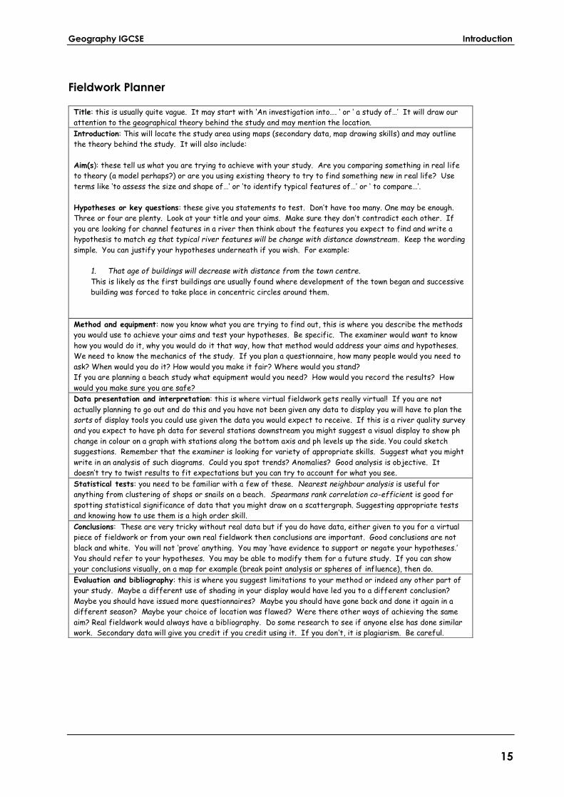
Fieldwork Planner
Title: this is usually quite vague. It may start with ‘An investigation into…. ‘ or ‘ a study of…’ It will draw our
attention to the geographical theory behind the study and may mention the location.
Introduction: This will locate the study area using maps (secondary data, map drawing skills) and may outline
the theory behind the study. It will also include:
Aim(s): these tell us what you are trying to achieve with your study. Are you comparing something in real life
to theory (a model perhaps?) or are you using existing theory to try to find something new in real life? Use
terms like ‘to assess the size and shape of…’ or ‘to identify typical features of…’ or ‘ to compare…’.
Hypotheses or key questions: these give you statements to test. Don’t have too many. One may be enough.
Three or four are plenty. Look at your title and your aims. Make sure they don’t contradict each other. If
you are looking for channel features in a river then think about the features you expect to find and write a
hypothesis to match eg that typical river features will be change with distance downstream . Keep the wording
simple. You can justify your hypotheses underneath if you wish. For example:
1. That age of buildings will decrease with distance from the town centre.
This is likely as the first buildings are usually found where development of the town began and successive
building was forced to take place in concentric circles around them.
Method and equipment: now you know what you are trying to find out, this is where you describe the methods
you would use to achieve your aims and test your hypotheses. Be specific. The examiner would want to know
how you would do it, why you would do it that way, how that method would address your aims and hypotheses.
We need to know the mechanics of the study. If you plan a questionnaire, how many people would you need to
ask? When would you do it? How would you make it fair? Where would you stand?
If you are planning a beach study what equipment would you need? How would you record the results? How
would you make sure you are safe?
Data presentation and interpretation: this is where virtual fieldwork gets really virtual! If you are not
actually planning to go out and do this and you have not been given any data to display you will have to plan the
sorts of display tools you could use given the data you would expect to receive. If this is a river quality survey
and you expect to have ph data for several stations downstream you might suggest a visual display to show ph
change in colour on a graph with stations along the bottom axis and ph levels up the side. You could sketch
suggestions. Remember that the examiner is looking for variety of appropriate skills. Suggest what you might
write in an analysis of such diagrams. Could you spot trends? Anomalies? Good analysis is objective. It
doesn’t try to twist results to fit expectations but you can try to account for what you see.
Statistical tests: you need to be familiar with a few of these. Nearest neighbour analysis is useful for
anything from clustering of shops or snails on a beach. Spearmans rank correlation co-efficient is good for
spotting statistical significance of data that you might draw on a scattergraph. Suggesting appropriate tests
and knowing how to use them is a high order skill.
Conclusions: These are very tricky without real data but if you do have data, either given to you for a virtual
piece of fieldwork or from your own real fieldwork then conclusions are important. Good conclusions are not
black and white. You will not ‘prove’ anything. You may ‘have evidence to support or negate your hypotheses.’
You should refer to your hypotheses. You may be able to modify them for a future study. If you can show
your conclusions visually, on a map for example (break point analysis or spheres of influence), then do.
Evaluation and bibliography: this is where you suggest limitations to your method or indeed any other part of
your study. Maybe a different use of shading in your display would have led you to a different conclusion?
Maybe you should have issued more questionnaires? Maybe you should have gone back and done it again in a
different season? Maybe your choice of location was flawed? Were there other ways of achieving the same
aim? Real fieldwork would always have a bibliography. Do some research to see if anyone else has done similar
work. Secondary data will give you credit if you credit using it. If you don’t, it is plagiarism. Be careful.
Geography IGCSE Introduction
16
Presentation of Fieldwork
Each of the two Fieldwork TMAs should be completed and compiled into a folder. This should be presented on A4 paper (any larger
material must be folded to this size). If posting, each sheet must be numbered and secured together and must be identified with your name, and the relevant cover sheet also included. The other fieldwork tasks as not formal ‘assignments’ but it is strongly recommended that you send these to your tutor as well. They will be able to provide you with vital feedback in order to make sure that you are 100% confident with ALL fieldwork, and are therefore ready for questions relating to any of the fieldwork you have undertaken in the exam Investigations may be handwritten or word-processed, but remember that in the exam you will need to do everything by hand! The quality
of presentation and range of skills used, regardless of the methods employed, will be assessed. The total word-count for the fieldwork investigations should be between 2000-2500 words. Candidates exceeding this by more than 500 words should edit their fieldwork down!
Risk Assessment
It is the responsibility of the candidate (and any relevant parent or guardian) to ensure that a risk assessment is carried out before any practical fieldwork. Where a candidate is under eighteen, an adult should be present to supervise the candidate’s practical fieldwork, and ensure that local conditions do not present unacceptable risks.
Additional Guidance and Support with Fieldwork
The Edexcel website contains additional support materials, e.g. the
specification outlines the requirements for fieldwork, and past papers offer a wealth of examples of the types of questions you may be asked.
Each fieldwork opportunity/task in the folder gives you specific guidance relating to completing that particular fieldwork investigation. You should read this very carefully indeed! The Field Studies Council (FSC) and The Royal Geographical Society (RGS) also have a huge amount of extremely useful information regarding fieldwork on their websites. Both links below should be used to support you with your fieldwork during the course: www.ool.co.uk/0016gi and www.ool.co.uk/0016gi2

Geography IGCSE Introduction
17
Your tutor is also there to support you with any questions you may have – use them!
Studying the Syllabus
You should be sure to acquire your own copy of the specification or
syllabus from the Edexcel website at www.ool.co.uk/0017gi (2018
candidates) or www.ool.co.uk/0017gi2 (2019 candidates) We advise that you download a copy of the syllabus and use it throughout your studies as a tool to help you as you progress. Edexcel also provides a handbook for private candidates at www.ool.co.uk/0017gi3.
Closer to your exam you may also find useful tips on Edexcel’s
Examzone at www.ool.co.uk/0017gi4. You should also use past exam papers as part of your revision. You can access these at www.ool.co.uk/0017gi5.
Please take care to access the right past papers for the exam you are taking. 2018 candidates should look at the 2014 – 2017 papers. 2019 candidates will sit the ‘new’ exam and so it will take a few years for there to be past papers for this exam on the website. However, ALL past papers for the IGCSE Geography exam may be used to view and revise / do practice questions on both the 5 main topics, and also the fieldwork, that you have studied during the course. To make revision easier at the end, consider what you can do from the start to help you later on, e.g. summarizing case studies, highlighting or underlining key information as you go, or making flash cards e.g. for key terms as you go along. It is your folder – you can ‘use’ it as you wish to help you as much as possible to do the best
that you possibly can!
Using the Internet
All students benefit from access to the Internet. You will find a wealth of information on all the topics in your course. As well as the Edexcel website (www.edexcel.com), you should get into the habit of checking the Oxford Open Learning site (www.ool.co.uk) where you may find news, additional resources and interactive features as time goes by.
Course Links to Online Resources

Geography IGCSE Introduction
18
The course has been written specifically with the demands of the IGCSE specification in mind and no supporting textbook is required for you to be able to follow the course successfully. However, some
students may wish to purchase the accompanying course textbook to support their learning. Given the advantages that online resources offer to the study of geography, some of the course activities will require you to go online to access, for example, videos of geographical processes or other communities, interactive maps, or photographic material. It is assumed, therefore, that students will be able to access a computer either at home or in your local library. Some of the course activities ask you to access the GeographyAlltheWay website at http://www.geographyalltheway.com (or www.ool.co.uk/0018gi). The resources on this website have been compiled by a teacher of
Geography IGCSE and are specifically designed to support the course specification. You should find that they are free although a password may be required. The resources include videos, simulations, maps, diagrams, graphs, tables, activities, and ‘mysteries’. They provide excellent support materials for the course, and it is expected that all students will be able to access the materials as a means to consolidate, explore further, and enjoy the course.
A note on web addresses
This course is full of instructions and suggestions to look at specific websites. So to gain full benefit from this course you will need regular access to the internet. But please note the following: Webpages are being deleted and moved all the time. By the time you reach a specific lesson, it is inevitable that some of the webpages to which you are directed will have disappeared (or moved). Sometimes
OOL will be able to find an adequate substitute, sometimes not. Please do not panic! If you come across a link that seems to be broken, please continue with the lesson. You should find that there is enough material and practice within the lesson itself to enable you to understand all the topics. If the link seems essential, it may be that you can find equivalent webpages yourself (via a Google search, say) but very few weblinks are that critical. Because Oxford Open Learning is not responsible for the content of external websites, there may be some changes to material that are beyond our control. Please let us know at [email protected] if you find a link that does not work and we will do our best to correct this, or provide an alternative source.

Geography IGCSE Introduction
19
Please note: where downloaded from the internet, some images reproduced in this course folder include details of website addresses and the source is acknowledged. Where the source is not given, the image is in the public domain. You might find all these images in
colour online.
Further Resources
To supplement your study we recommend that you explore a wide range of sources, to which the following is a brief guide. Until a new book is published, the best supporting text you could get hold of is this one: Steve Milner and Mike Witherick, Edexcel IGCSE Geography (Student Book) (Edexcel, 2010; ISBN-13: 978-0435016951)
Other potentially valuable resources include: Google Earth: http://earth.google.co.uk/ http://www.ordnancesurvey.co.uk/oswebsite/ http://www.bbc.co.uk/schools/gcsebitesize/geography/ Many geographical processes can now be viewed on video and image websites such as: You Tube: http://www.youtube.com/ Flickr: http://www.flickr.com/ Google Images: http://images.google.com/ Google Maps: http://maps.google.co.uk/ The Royal Geographical Society website includes photographic
images and other resources useful to project work: http://www.rgs.org/HomePage.htm Edexcel include lists of resources for IGCSE geography on their website at www.ool.co.uk/0019gi. Click on the link and scroll to the section called ‘Resources’. The Cambridge examining board also includes a list of resources for Geography IGCSE at www.ool.co.uk/0019gi2.
Lesson activities will refer you to specific resources both in print and online.

Geography IGCSE Introduction
20
n.b. Google offer schools and young people tutorials on how to use their sites at www.ool.co.uk/0019gi3.
The short quizzes offer an excellent introduction to online searching and provide a useful introduction to searching not only geography, but all sorts of other subjects as well. The short tutorial will help you search accurately and save lots of time later on. Have a go!
It is important to look at a variety of different approaches to key topics. One easy way to buy supporting texts is through the OOL website (www.ool.co.uk). Some of the activities in the lessons may require you to use your initiative in hunting out information either online, in your atlas or (via your local library) in other textbooks. Such initiative is one of the skills you are supposed to be learning and the more sources you refer to the better your work is likely to be.
Finally, good luck!
Contributing authors:
ALISON LEADBETTER and LISA BELL
© Oxford Open Learning, 2017