Embed Size (px)
Citation preview

Geog 3 Tectonics
Full recap – everything in one handy PowerPoint....enjoy
Mr V

What do we need to know?Plate movement Earth structure, plate tectonics theory: convection
currents and sea-floor spreading. Continental drift and palaeomagnetism.
Plate boundaries Destructive, constructive and conservative platemargins. Associated landforms: young fold mountains, rift valleys,ocean ridges, deep sea trenches and island arcs.
Hotspots Hot spots associated with plumes of magma andtheir relationship to plate movement.
Volcanoes (vulcanicity)
types of volcanoesForms of intrusive activity – dykes, sills, batholiths.Minor forms of extrusive activity – geysers, hotsprings and boiling mud.
Earthquakes(seimisity)
The causes and main characteristics of earthquakes:focus and epicentre; seismic waves and earthquakemeasurement.
Tsunamis Characteristics and causes.

What case studies you we need?Volcanoes Two case studies of recent (ideally within the last 30
years) seismic events should be undertaken fromcontrasting areas of the world. In each case, thefollowing should be examined:• the nature of the seismic hazard;• the impact of the event;• management of the hazard and responses to theevent.
Earthquakes Two case studies of recent (ideally within the last 30years) seismic events should be undertaken fromcontrasting areas of the world. In each case, thefollowing should be examined:• the nature of the seismic hazard;• the impact of the event;• management of the hazard and responses to theevent.

Structure of the Earth
• Earth’s interior divided into its four concentric spheres: the crust, the mantle, the outer core and inner core.

Lithosphere and Asthenosphere

Key terms Defined
Crust• Earth’s crust made up of 3 kind of rock: • Igneous• Sedimentary• Metamorphic
• 2 types of crust:• Oceanic is dense and basaltic in name. approx 10km
thick.• Continental crust less dense up to 70 km thick.

• Lithosphere = Rigid ‘plate’ comprising of the crust and upper mantle.
• Asthenoshere = Plastic like in upper layer. Allows the plate to move
• Mantle = Dense solid layer. Rich in iron and magnesium. Beneath this is the semi-molten outer core and a solid inner core.

How do we know this structure is true?’
• Answer = we use measurements from earthquakes
• Both P and S waves travel through the interior of the earth and are recorded on seismographs. P and S waves travel at different velocities according to the density of the material which they travel.
• E.g S waves are not able to travel through liquids. Using this data scientists can build a picture of the thickness and composition of the layers.

Continental Drift Theory• Earthquakes, volcanoes and fold mountains all occur in similar areas.
They occur in long narrow bands thousands of miles long but only hundreds of kms wide. These narrow bands are the Plate Boundaries.
• Over millions of years the continents have drifted apart from an original supercontinent called Pangea.
• The idea of Continental Drift was first put forward by Alfred Wegener in 1912. His evidence came from things like:
• The similarity in the shape of the coastlines of S. America and Africa• Similar glacial deposits from 290 million years ago are found in S.
America, Antarctica and India• Similar geological sequences are seen in Scotland and eastern
Canada.• Fossil remains are found on different continents• Coal reserves are found in Antarctica - the climate there must have
been much warmer.


Plate Tectonics• The more modern theory of Plate Tectonics comes from much later – 1960s.
Supporting evidence came from: • discovery of the mid-Atlantic Ridge in 1948• studies of palaeomagenetism in the `1950s• sea floor spreading – in 1962 Harry Hess confirmed that the newest rocks were in the middle
of the Atlantic (near Iceland) and got older to the edges e.g. USA. He said that the Atlantic could be widening at 5cm/year.
• If the Atlantic was getting wider, and if the earth was not getting bigger, then somewhere else old crustal rocks must be being ‘eaten up’. Evidence for this came from the fringes of the Pacific Ocean.
• Many of the oceans are under 200 _____________ Years old.• Some of the plates are only oceanic crust e.g. ____________• Others carry oceans and continents on their back e.g. _____________• Continental plates (40kms) are much thicker than ocean plates (10kms) and are thickest
under _____________________An example of thick continental crust is ______________• The_______________ crust is much older than the ______________Crust.• The crust and the top part of the mantle makes up the lithospheric plates which float on the
underlying ___________________

Evidence for sea floor spreading
• Palaeomagnetism.

What drives the motion of the plates?
• Answer = The movement of the tectonic plates is driven by thermal convection currents in the upper mantle using heat derived from the radioactive decay of minerals deep within the Earth and residual heat from the Earth’s formation (some 4,600 million years ago). This heat causes plumes of magma to rise, then cool and fall.

Plate boundaries
• The plates form the solid lithosphere (crust and top part of the mantle) – which is thought to ‘float’ on the underlying asthenosphere.
• Rates of movement of the plates varies between about 60mm / year and 100mm /year. On the map low rates are seen _________________________

Constructive
• In some places – Constructive plate boundaries – new molten lava pours out onto the surface along mid-ocean ridges.
• An example is the mid-Atlantic ridge. New basalt lava pours out onto the ocean floor and by sea-floor spreading gradually widens the sea floor pushing two continents apart.
• The Atlantic was made like this over a period of about 200 million years. These plate boundaries have both volcanoes and earthquakes.

Destructive
• At other places old oceanic crust slides down into the mantle and is melted. This happens in N. America where the little Juan de Fuca ocean plate descends (subducts) underneath North America.
• This created the Cascade Range of volcanic peaks like Mount St. Helens and Mt. Rainier. These volcanoes can be destructive. There are also earthquakes.

Collision Boundary
• At a collision boundary, two continental plates move together. The collision forces them upwards forming mountains. This kind of plate movement has caused the Himalayan mountain range to form. We get earthquakes at collision boundaries, but not volcanoes. This is because the two plates are rising upwards rather than being subducted and melting to form magma.
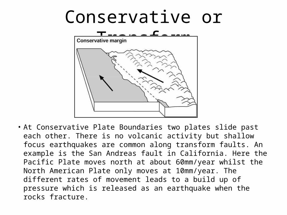
Conservative or Transform
• At Conservative Plate Boundaries two plates slide past each other. There is no volcanic activity but shallow focus earthquakes are common along transform faults. An example is the San Andreas fault in California. Here the Pacific Plate moves north at about 60mm/year whilst the North American Plate only moves at 10mm/year. The different rates of movement leads to a build up of pressure which is released as an earthquake when the rocks fracture.

Hotspots
• In some places – like in Hawaii – there is a rising plume of magma within the mantle. This has found a weak spot in the Earth’s crust and so basaltic lava pours out onto the ocean floor.This builds huge underwater shield volcanoes which gradually grow even larger to make islands. As the ocean plate slides over the Hot Spot new islands to the south of the earlier ones are made. Currently Kilauea – the world’s most active volcano – is above the Hot Spot.

Hotspots
• Hot Spots The places known as hot spots in geology are volcanic regions thought to be fed by underlying mantle that is anomalously hot compared with the mantle elsewhere.
• They may be on, near to, or far from tectonic plate boundaries. There are two hypotheses to explain them. One suggests that they are due to hot mantle plumes that rise from the core-mantle boundary.
• The other hypothesis suggests that it is not high temperature that causes the volcanism, but lithospheric extension that permits the passive rising of melt from shallow depths.
• Source: Wikipedia

Associated landforms: young fold mountains, rift valleys,ocean ridges, deep sea trenches and island arcs.

Constructive Plate Boundary –
initial stage
Rift Valley
e.g. East African rift valley

Rift Valley with stepped faults, and tilted blocks (horsts)
Initial doming from upwelling magma
Leads to Y-shaped rifting.

A shallow sea basin may form – lots of evaporite salt deposits.
Middle Stage

Mid ocean ridge created by sea floor spreading.
Magnetic stripes as evidence for the spreading.
Fissure volcanoes e.g. Iceland
Later stage

Underwater mountain range
Central rift valley
Offset by transform faults

Destructive Plate Boundary – type 1
Ocean plate v. Ocean plate
Ocean trench e.g. Aleutian trench
Island arc volcanoes e.g. Aleutians (off Alaska)

Pacific Ring of Fire

Ocean plate v. Continental plate (Sometimes called a SUBDUCTION ZONE)
Ocean plate subducts as it is denser
Ocean trench e.g. Peru-Chile trench
Cordillera range of Young Fold Mountains e.g. Andes
Andesitic volcanic peaks e.g. Nevada del Ruiz
Destructive Plate Boundary – type 2

Destructive Plate Boundary – type 3
Continental plate v. continental Plate collision
A collision zone
Major fold mountains e.g. Himalayas and High Plateau e.g. Tibet
e.g. Ocean plate carrying India drifted northwards until India collided with Eurasian plate.

Conservative Plate Boundary
No volcanic features
Plenty of earthquakes e.g. San Andreas fault.
Fault line scarp slopes
Horizontal movement faults

Fault displacement features

Mid ocean ridge
Transform fault
Conservative Plate Boundaries are transform faults
which displace mid ocean ridges in Constructive plate Boundaries

The Main Plates
• Convergent boundaries = Destructive Plate Boundaries: e.g ____________________
• Divergent Boundaries = Constructive Plate Boundaries e.g_____________________
• Transform Faults = Conservative Plate Boundaries e.g_________________________

Vulcanicity (Volcanoes)
• Volcanoes can be classified by their size and shape or by the nature of their eruptions. However, these features are connected as the type of eruption affects the consequent landform. Eruptions may be categorised as either effusive or explosive. Effusive eruptions involve the outpouring of magma that is relatively low in viscosity and in gas content, whereas explosive eruptions generally involve magma that is more viscous and acidic.

Shield Volcano
• Basalt lava is low in silica which is called a 'basic' chemical composition. They are hotter at 1000*C to 1200*C and have low viscosity. Gases are released more easily and the eruptions tend to be less explosive like the fissure eruptions of Constructive Plate Boundaries like Heimaey 1973 in Iceland or like lava flows from Kilauea in Hawaii at an Intra-Plate Hot Spot which builds shield volcanoes.
• Shield Volcanoes have gentle sides because the lava is runny and moves away from the vent quite freely before solidifying.
• They are very tall wide structures compared to conical (composite) volcanoes - although in places like Hawaii much of the volcano may be below sea level.

composite volcanoes.
• These volcanoes have steeper sides and are smaller in scale than shield volcanoes - they have the typical volcano conical shape and are often alternating layers of ash and pyroclastic lavas called a composite volcano or stratovolcano.

Composite volcanoes
• Lavas with high silica content have an acidic chemical composition and form rocks called rhyolites. They are viscous and have relatively low temperatures of 600*C to 1000*C. The lavas flow slowly, the gases do not escape easily and build up to produce more explosive eruptions. They are typical of Destructive Plate Boundary volcanoes either ocean v. ocean plate collisons or ocean v. continent plate collisions.
• Andesite lava is intermediate but rather silica rich and therefore also likely to be quite explosive in eruption. Andesite volcanoes are also typical of Destructive Plate Boundary subduction zones.

Composite Cones
• Examples include Mount Fuji in Japan, Cotopaxi in Ecuador and Merapi in Indonesia, all located around the Pacific Ring of Fire. The sequence of slow-flowing lava and pyroclastic material erupted produces steep layers of ash and lava domes. This increases the risks of landslides.

Types of Eruption• Hawaiian – These occur from a central vent or along
fissures. The lava may feed lava streams that flow downslope or be erupted to a height of several hundred metres. They are rarely explosive but may be accompanied by jets of gas. Kilauea in Hawaii (a hotspot) erupts in this way.
• Icelandic – These occur at constructive plate margins, emit large volumes of fluid lava from fissures, are often several kilometres in length and spread in sheets over the land.
• Strombolian – named after the Italian volcano, these are moderate explosions accompanied by scoria (porous sponge-like lava) and a white vapour cloud. The gases rise faster than the magma and escape with small explosions, throwing out lumps of molten lava which then flow downslope in streams.
•Plinian and Vulcanian – These eruptions have more viscous lava that forms a solid crust over the crater between the infrequent eruptions. Ash fallout can affect large areas hundreds of kms downwind. Lava flows from the crater and then from fissures on the sides of the cone. Fast moving pyroclastic flows often occur during these eruptions, which include Mount St. Helens in 1980 and Pinatubo in 1991.
• Pelean – named after Mount Pelee on the island of Martinique, these eruptions produce the most viscous lava and the greatest explosions as the magma is blocked by a plug in the vent forcing a horizontal blast. A nuee ardente (glowing cloud) is formed as hot gas, dust, ash and lava fragments are blown out and which rushes down the mountain slopes at speeds up to 160kph. These volcanoes often collapse to form large calderas.
• Krakatauan – these explosions are cataclysmic – a huge caldera is formed in these ‘ultraplinian’ events.

Intrusive and Extrusive Landforms:

GEYSERS:• This is where volcanic activity heats up water which eventually
explodes on to the surface. These features are only temporary as the only last up to a few thousand years. The magma needs to be relatively near the earth’s surface in order to heat the water up, this is why these features are only found in volcanic areas. These are fairly rare as they need very specific hydrological conditions to occur. When an eruption occurs there are four main stages. First of all the steam rises from the geothermally heated water, this leads to pulses of water swelling up wards. Eventually the surface is broken and the ejected water explodes.
• Examples include the Haukadalur spring in Iceland. Almost 50% of all geysers are situated in Yellowstone National Park, USA

Hot Spring:
• Hot springs are caused by the emergence of geothermally heated water on the surface. Boiling Mud is water which is heated up by volcanic activity that doesn’t always explode onto the surface. Occasionally it mixes with surface deposits which cause boiling mud. This kind of feature usually occurs in Iceland. These springs have a very high mineral content which makes them a very popular tourist attraction. However, some of them contain Biota which makes them dangerous to humans.
• Examples include Bath and Iceland.

Batholiths, Dykes and Sills:
• Batholiths are formed deep below the surface when large masses of magma cool and solidify.
• Dykes are vertical intrusions with horizontal cooling cracks. They cut across the bedding planes of the rocks into which they have been intruded.
• Sills are horizontal intrusions along the lines of bedding planes. They have vertical cooling cracks.


Why do earthquakes occur?
• Fractures, faults• Energy released and propagates in
all directions as seismic waves causing
earthquakes
focusepicenter

Where do earthquakes occur:
1) Most earthquakes occur along the edge of the oceanic and continental plate
2) Along faults: normal, reverse, transform

definitions• Earthquake = Vibration of the Earth produced by the
rapid release of energy
• Seismic waves = Energy moving outward from the focus of an earthquake
• Focus= location of initial slip on the fault; where the earthquake origins
• Epicenter= spot on Earth’s surface directly above the focus

Seismic waves: forms• P-waves:
– called compressional, or push-pull waves– Propagate parralel to the direction in which the wave is moving– Move through solids, liquids
• S-waves:– Called shear waves– Propagate the movement perpendicular to the direction in which the wave ismoving
• Surface waves (L-waves or long waves).– Complex motion– Up-and-down and side-to-side– Slowest– Most damage to structures, buildings

Seismic waves: properties• Velocity: function of the physical properties of the
rock the wave is traveling through– Velocity increases with rock density– Velocity changes when passing from one material
to another (increases/decreases)– Liquids: S-waves do not get transmitted through
liquid; P-waves slow down
• Why is this important?– If we know the velocity of the wave, we can infer
the type of rock it traveled through- that’s how we map the interior of the Earth!!!

Measuring earthquakes
• Seismometers: instruments that detect seismic waves
• SeismographsRecord intensity, height and amplitude of seismic waves

Earthquake size: two ways to measure
1) Magnitude: Richter Scale• Measures the energy released by fault
movement• related to the maximum amplitude of the S wave
measured from the seismogram• Logarithmic-scale; quantitative measure• For each whole number there is a 31.5 times
increase in energy• eg. an increase from 5 to 7 on the Richter scale = an
increase in energy of 992 times!!

2) Intensity: Mercalli Scale:
– What did you feel?– Assigns an intensity or rating to measure an earthquake at
a particular location (qualitative)– I (not felt) to XII (buildings nearly destroyed)– Measures the destructive effect
• Intensity is a function of:• Energy released by fault• Geology of the location• Surface substrate: can magnify shock waves e.g. Mexico
City (1985) and San Francisco (1989)

Frequency of Occurrence of Earthquakes
Descriptor Magnitude Average Annually
Great 8 and higher 1 ¹
Major 7 - 7.9 17 ²
Strong 6 - 6.9 134 ²
Moderate 5 - 5.9 1319 ²
Light 4 - 4.9 13,000(estimated)
Minor 3 - 3.9 130,000(estimated)
Very Minor 2 - 2.9 1,300,000(estimated)
¹ Based on observations since 1900. ² Based on observations since 1990.

Largest earthquake in the world
Chile : 1960 May 22 19:11:14 UTC Magnitude 9.5
More than 2,000 killed, 3,000 injured, 2,000,000 homeless, and $550 million damage in southern Chile tsunami caused 61 deaths$75 million damage in Hawaii; 138 deaths and $50 million damage in Japan; 32 dead and missing in the Philippines; and $500,000 damage to the west coast of the United States.

Most Destructive Known Earthquakes on Record in the World
Date Location Deaths Magnitude Comments
May 31, 1970 Peru 66,000 7.9 $530,000,000damage, great rockslide, floods.
July 27, 1976 China, Tangshan
255,000(official)
7.5 Estimated death toll as high as 655,000.
Sept 19, 1985 MexicoMichoacan
9500(official)
8.0 Estimated death toll as high as 30,000Old lake bed magnified shock waves by 500%
2001 Jan 26 India 20,023 7.7 166,836 injured, 600,000 homeless.
2004 Dec 26 Sumatra 283,106 9.0 Deaths from earthquake and tsunami

Earthquake damage
• Ground Failure - constructions collapse• Fires - from broken gas and electrical lines• Landslides - EQ's triggered; occur in
hilly/mountainous areas. • Liquefaction - water-saturated,
unconsolidated materials flow • Tsunami (seismic sea waves; "tidal" waves) -
can grow up to 65 m

Case Study – Japan 2011
• Location
• Timing: 2.46pm Friday• Sendai (Japan) Earthquake – March 11th 2011

Japan 2011 - Causes

Japan 2011 – nature of the event
• Japan's most powerful earthquake since records began - measured at 9.0 by the US Geological Survey - has struck the north-east coast, triggering a massive tsunami. Many modern buildings are earthquake ‘proof’ but cities like Tokyo also contain many vulnerable older residential communities with narrow wooden houses in narrow streets, where roofs are touching almost each other. Much more damage could have occurred in Tokyo.
• After the earthquake came a 7metre high tsunami wave that devastated 1300 kms of the north east coast around Sendai. The wave moved up to 10km inland in flat coastal areas. The tsunami arrived just over 1 hour after the earthquake struck. 14.46 and 15.55 JST.

Japan 2011 - Impacts
• The death toll one week after the disaster was at least 7,500 fatalities and over 12,000 officially listed as missing (Sunday Telegraph).

Minamisanriku - feared more than half the 17,000 population were lost as the 8m wall of water came crashing inland at 500mph an hour on Friday 11th March after a huge earthquake beneath the ocean.

• Fukushima – nuclear reactors badly damaged.Evacuation zone of 20kms – at least 200,000 people were evacuated.
• Other nations advised their citizens to leave Japan. Britain has advised its nationals currently in Tokyo and to the north of the capital to consider leaving the area, and to keep outside an 80km (50 miles) radius of the Fukushima plant, in line with US state department instructions.

Social Impacts
• Social Impacts - Hundreds of thousands of victims have been made homeless, with more than 400,000 struggling to survive in emergency shelters with no power and little food or water.One 80 year old woman rescued alive from the rubble of her home after 9 days.

Social Impacts• 25% of Japan’s population is
elderly and many of them struggled to survive in shelters without heating or electricity as supplies of food and medicine ran low. Snow fell and temperatures were -5*C in the week after the earthquake.
• Many of the rural, seaside towns hit by the tsunami were in economic decline and had seen an exodus of young people, who moved to major cities for work.

Economic impacts
• Economic Impacts: Some countries that export energy and raw materials could see a surge in demand from Japan.But others that rely on Japan for manufacturing components will be bracing themselves for shortages in supply.Cargo containers were strewn about in Sendai Japan March 12.

Economic impacts
• Japanese shares have tumbled on the first trading day after the massive earthquake and tsunami. Amid record share trading, the Nikkei index ended down 6.18% at 9,620 points.The benchmark crude oil price fell to less than $99 a barrel on weaker demand from the world's third-largest economy. Meanwhile, the Bank of Japan tried to support the economy, saying it would inject 15 trillion yen ($183bn; £114bn) into the banking system.

Economic Impacts
• Production was stopped at some of Japan's best-known companies, heavily denting their share prices. Carmaker Nissan was down by 9.5% after it shut all its plants, while Toshiba, whose products include semiconductors and nuclear reactors, fell 16%. European stocks also began the day lower, with German shares hit hardest. The main Dax index fell 1.3%, dragged lower by power companies and insurers.