Embed Size (px)
Citation preview
1
Geodetic activities in Sweden 1998-2002
Edited by Dan Norin Lantmäteriet, SE-801 82 Gävle, Sweden
1. Geodetic activities at Lantmäteriet (National Land Survey of Sweden)
1.1 Introduction At Lantmäteriet (National Land Survey of Sweden) the geodetic activities during 1998-2002 have been focused on:
- The Swedish network of permanent reference stations (SWEPOS™) including developments towards network RTK services.
- The ongoing project RIX 95 with development of transformation formulas between national reference frames and local ones.
- The introduction of the new ETRS 89 realisation SWEREF 99.
- The finalisation of the third national precise levelling.
- The completion of the national gravity networks.
- A report that has been prepared called Geodesy 2000, which contains proposals for the geodetic activities for the first decade of the 21st century
Other to mention is the Lantmäteriet web page (www.lantmateriet.se), which has been updated with extensive geodetic information and the present
work with making the geodetic archive digital.
1.2 Satellite positioning (GPS)
1.2.1 GPS campaigns GPS data from permanent reference stations from June 13th-July 24th 1999 were used to establish the reference frame SWEREF 99 (se section 1.5.1).
During August 20-23 2002 a GPS campaign to connect the Swedish and Finnish levelling networks over the Åland Sea has been carried out. On the Swedish side four points (along the coast between Stockholm and Gävle) in the national precise levelling network together with some SWEPOS stations were observed for 3x24 hours. The project is a co-operation within NKG between Lantmäteriet, Onsala space Observatory, Royal Institute of Technology (KTH) and the Finnish Geodetic Institute (FGI).
1.2.2 Galileo and EGNOS Lantmäteriet has an active part in covering questions concerning Galileo.
In the end of 2002 an EGNOS (European Geostationary Navigation Overlay System) RIMS station will be inaugurated at Lantmäteriet in Gävle.
1.2.3 Workshops and seminars In December 1998 the seventh European meeting of the International Information Sub-Committee (IISC) of

2
the Civil GPS Service Interface Committee (CGSIC) was hosted by Lantmäteriet. About 100 persons from over 15 countries participated.
In March 2002 an international workshop on network RTK was arranged in Gävle by Lantmäteriet. All manufacturers of Network RTK software and the main part of the manufactures of GPS receivers participated.
In March 2000 and 2001 seminars for Swedish GPS users were arranged in Gävle by Lantmäteriet. The aim of the seminars is to highlight the develop-ment of GPS techniques, applications of GPS and experiences from the use of GPS.
1.2.4 Diploma works The use of network RTK in the SWEPOS network for production measurements has been studied in two different diploma works (“Production measurements with Network RTK – Tests and analysis” and “Kompatibilitet för Nätverks-RTK-programvaran Trim-ble GPS-Net med olika typer av rörliga mottagare”), where the later one put special emphasis on the use of RTCM message 59 in the software GPS-Net.
In another diploma work the multipath effect at the SWEPOS stations has been studied (“Multipath at the SWEPOS stations – evaluation of eccosorb, a microwave absorbing material”). Still a diploma work has been carried out with the purpose to investigate the possibility for RTK surveying at long distances (“RTK at long distances with a dual frequency GPS/GLONASS receiver”).
The use of DGPS measurements for updating of forest roads have also been
investigated in a diploma work (“Metodstudie för inmätning av skogsbilvägar”). Another diploma work has finally examined the services for differential GPS available in Sweden (“Undersökning av tjänster för differen-tiell GPS”).
1.3 Network of permanent reference stations (SWEPOS)
Since July 1st 1998 the Swedish network of permanent reference stations (SWEPOS), see figure 1, is operational in IOC mode, i.e. for positioning in real- time on the metre level and by post-processing on the centimetre level. Positioning in real time on the centimetre level is today (September 2002) possible in regional parts of Sweden.
Figure 1: The SWEPOS network September 2002 (squares are complete
3
SWEPOS stations and dots are simplified ones).
The purposes of SWEPOS are to:
- Provide single- and dual-frequency data for relative GPS measurements.
- Provide DGPS corrections and RTK data for broadcasting to real time users.
- Act as the continuously monitored foundation of the Swedish geodetic reference frame (SWEREF 99).
- Provide data for geophysical research.
- Monitor the integrity of the GPS system.
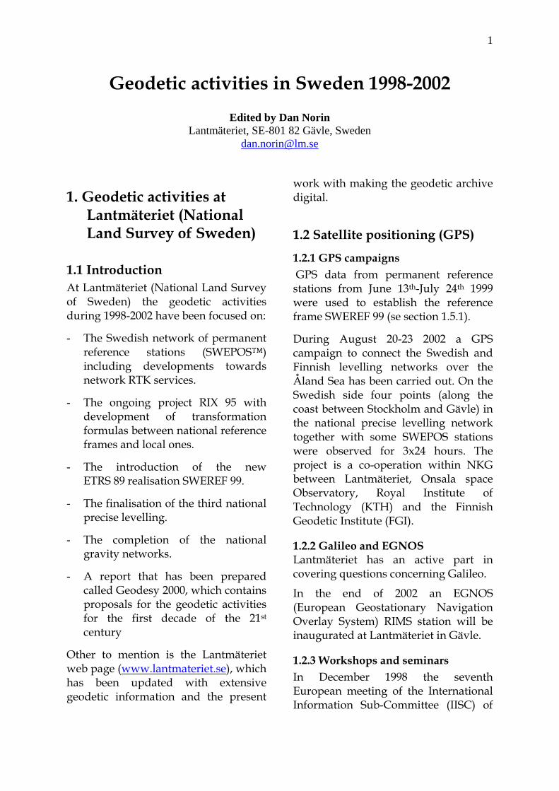
Figure 2: The SWEPOS station Överkalix.
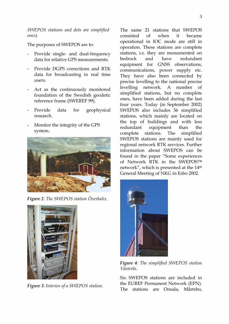
Figure 3: Interior of a SWEPOS station.
The same 21 stations that SWEPOS consisted of when it became operational in IOC mode are still in operation. These stations are complete stations, i.e. they are monumented on bedrock and have redundant equipment for GNSS observations, communications, power supply etc. They have also been connected by precise levelling to the national precise levelling network. A number of simplified stations, but no complete ones, have been added during the last four years. Today (in September 2002) SWEPOS also includes 36 simplified stations, which mainly are located on the top of buildings and with less redundant equipment than the complete stations. The simplified SWEPOS stations are mainly used for regional network RTK services. Further information about SWEPOS can be found in the paper “Some experiences of Network RTK in the SWEPOS™ network”, which is presented at the 14th General Meeting of NKG in Esbo 2002.
Figure 4: The simplified SWEPOS station Västerås.
Six SWEPOS stations are included in the EUREF Permanent Network (EPN). The stations are Onsala, Mårtsbo,
4
Visby, Vilhelmina, Kiruna och Borås (ONSA, MAR6, VIS0, VIL0, KIR0 and SPT0), where Borås (SPT0) also is a SWEPOS/IGS/IGLOSS station. Both daily and hourly data are delivered. Lantmäteriet co-operates with Onsala Space Observatory in the operation of NKG EPN analysis centre.
Furthermore Onsala, Mårtsbo, Visby, Kiruna and Borås (ONSA, MR6G (identical to MAR6), VS0G (identical to VIS0), KR0G (identical to KIR0) and SPT0,) are included in the International GPS Service for Geodynamics (IGS) network. All EPN and IGS stations are planned to be equipped with GPS/GLONASS receivers (Javad) during 2002.
1.4 SWEPOS services Quality checked SWEPOS data for post-processing has been available on a WWW/FTP server in RINEX format for a long time. In October 2000 an automated post processing service, based on the Bernese software, was introduced at www.swepos.com, the SWEPOS web page. This service has grown in popularity, making it possible for GPS users to automatically determine his position with centimetre accuracy using only one receiver and data from the SWEPOS network. It is also possible to make some online transformations and to get satellite alerts on the SWEPOS web page. Further information can be found in the paper “SWEPOS™ Automated Proces-sing Service”, which is presented at the 14th General Meeting of NKG in Esbo 2002.
The DGPS service EPOS is using correction data from SWEPOS since the service started in December 1994. The
service is using the RDS channel on the FM radio network for the distribution and is from December 2001 operated by Cartesia Informationsteknik AB. Before December 2001 the service was operated by Teracom. SWEPOS DGPS correction data is also distributed by the companies Generic Mobile (Mobipos) and Fugro Seastar (Omnistar), where Mobipos was terminated on September 1st 2002.
During the four past years single station RTK data have been distributed from up to eight SWEPOS stations. The service is called Ciceron and is (nowadays) operated by Cartesia Informationsteknik AB. The service was terminated in the middle of August 2002
To investigate the conditions for regional services for real-time positioning on the centimetre level, three pre-study projects with network RTK have been carried out during the period 1999-2001. The projects called NeW-RTK, SKAN-RTK and Position Stockholm-Mälaren were carried out with Lantmäteriet, Onsala Space Observatory, local authorities, government agencies and private consulting firms as partners in all or some of them.
Based on the results from the pre-studies, three prototype regional positioning services have been launched during 2002 as one-year projects. Position Stockholm-Mälaren-2 was in operation on February 7th and it has been followed by SKAN-RTK-2 and VÄST-RTK. The services are using GPS-Net from Trimble as network RTK software and GSM as distribution channel. The aim of these services is to evaluate and improve the network RTK techniques and to carry out production

5
work. The intention is to provide regional services on a regular basis after this first year.
In a Nordic co-operation, steps towards a Nordic positioning service have been taken.
1.5 Reference systems
1.5.1 New reference systems A new ETRS 89 reference frame, named SWEREF 99, has been adopted by the IAG Subcommission for Europe (EUREF) as an ETRS 89 realisation at the symposium in Tromsö 2000. It replaced SWEREF 93 and was introduced as the national reference frame for GPS during 2001.
SWEREF 99 was established during 1999-2000 and is based on data from totally 49 permanent reference stations in Sweden (SWEPOS), Finland (FinnRef), Norway (SATREF) and Denmark. The campaign gives an estimation of the coordinate differences between the different national ETRS 89 realisations in the Nordic area.
Transformation parameters between SWEREF 99 and the national reference frame RT 90 have also been determined.
Discussions about reference systems were included in the project RefStrat, which presented strategies to realise scenarios for reference networks and reference frames. In a next step, a report was presented to the Swedish government during the autumn 2001 (“Övergång till ett enhetligt nationellt referenssystem för lägesbestämning”), where Lantmäteriet recommended that SWEREF 99 should be the official reference frame and replace RT 90 for surveying and mapping. It is also
recommended that SWEREF 99 would replace the local reference frames resulting in a more homogenous situation for mapping and surveying locally and regionally as well as nationally and internationally. Some response from the government will likely come during 2002.
Before SWEREF 99 can replace RT 90 and the local reference frames used in the municipalities, an official map projection has to be defined to SWEREF 99. Lantmäteriet recommen-ded the following in the report to the government:
• As national map projection a Transverse Mercator with central meridian λ0=15° and scale reduction factor k0 = 0.9996.
• For local surveying a system of, zones with 1° 30' between central meridians and k0 = 1.
During 2001 SWEN 01L was introduced as a height correction model for transformation of ellipsoidal heights in SWEREF 99 to heights in the national height system RH 70. The height correction model handles the land uplift between 1970.0 and 1999.5 based on a land uplift model made by Mr Martin Ekman.
1.5.2 RIX 95 Since 1995, a project involving GPS measurements on triangulation stations and selected local control points called RIX 95 has been in operation. It is supported by a group of national agencies. The principal aims are to establish transformation formulas between local coordinate systems and the national reference frames (SWEREF 99 and RT 90), and to establish new points easily accessible for local GPS
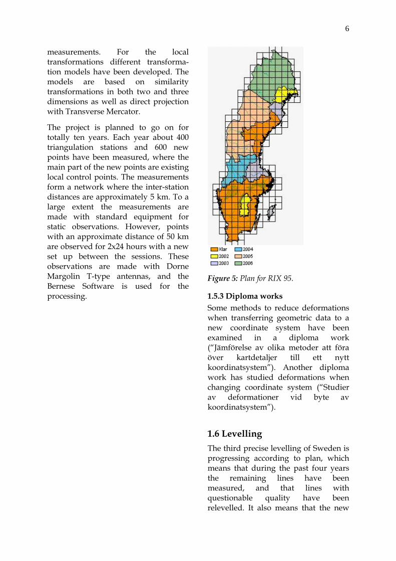
6
measurements. For the local transformations different transforma-tion models have been developed. The models are based on similarity transformations in both two and three dimensions as well as direct projection with Transverse Mercator.
The project is planned to go on for totally ten years. Each year about 400 triangulation stations and 600 new points have been measured, where the main part of the new points are existing local control points. The measurements form a network where the inter-station distances are approximately 5 km. To a large extent the measurements are made with standard equipment for static observations. However, points with an approximate distance of 50 km are observed for 2x24 hours with a new set up between the sessions. These observations are made with Dorne Margolin T-type antennas, and the Bernese Software is used for the processing.
Figure 5: Plan for RIX 95.
1.5.3 Diploma works Some methods to reduce deformations when transferring geometric data to a new coordinate system have been examined in a diploma work (“Jämförelse av olika metoder att föra över kartdetaljer till ett nytt koordinatsystem”). Another diploma work has studied deformations when changing coordinate system (“Studier av deformationer vid byte av koordinatsystem”).
1.6 Levelling The third precise levelling of Sweden is progressing according to plan, which means that during the past four years the remaining lines have been measured, and that lines with questionable quality have been relevelled. It also means that the new

7
national height network should be calculated during the winter 2003/2004.
Figure 6: The third precise levelling of Sweden.
The final network will consist of about 50,000 bench marks representing roughly 50,000 km double run precise levelling, measured with the motorised levelling technique. The accuracy in the new height system is expected to be 1.15 mm/√km.
Preparation for the computation of a new height system started in 2001 with a project called “Preliminary adjustment”. It has continued during 2002 in two different projects aiming at preparing data for the final calculation, as well as investigating how the new height network should be implemented. The work with this preparation includes building up more knowledge on the more theoretical aspects of a new height system.
The bridge across Öresund was levelled during the spring 2000. This made it possible for Sweden to get a stronger link to Denmark and Europe.
Sweden is also involved in the work concerning calculation of a Nordic Height Block as well as an improved land uplift model. This work is done within the NKG working group on Height Determination.
In March 1999 the seminar “Geodesy and Surveying in the future – the Importance of Heights” was held in Gävle. The background to the seminar was to celebrate 25 years of motorised levelling in Sweden and it gathered about 115 persons from over 20 countries.
1.7 Gravimetry During the last two years 105 points in the 1st order gravity network have been measured. In 2001 the 2nd order gravity network was completed. Around 1,500 points were totally measured since the last NKG General Meeting.
Lantmäteriet and SGU (Geological Survey of Sweden) also took part in the airborne gravity measurements over the Baltic sea and the lakes Vänern and Vättern in 1999.

8
Figure 7: Points in the zero (dots) and 1st (squares) order gravity network of Sweden.
1.8 Geodynamics In co-operation with Onsala Space Observatory, crustal motion, especially postglacial rebound in three dimensions (i.e. booth vertical uplift and horizontal strain), have been monitored since 1993, with the continuous GPS observations on the SWEPOS stations.
The 63° land uplift gravity line was remeasured in a Nordic co-operation in 1998. Lantmäteriet participated using two (of totally seven) relative gravimeters (LaCoste & Romberg).
2. Geodetic activities at the Royal Institute of Technology
At the Royal Institute of Technology (KTH) in Stockholm graduate and postgraduate education as well as research are carried out in geodesy and surveying. Below we summarize these activities for the period 1998-2002.
2.1 Graduate programme The graduate programme in geomatics engineering ("Tekniskt Lantmäteri"), including geodesy, photogrammetry and geoinformatics, is unique for Sweden, and some 10-25 students pass the programme every year. As the number of students has been decreasing for the last few years, and KTH is reorganising its programmes in civil engineering and surveying, the future of the programme is not clear for the time being. The titles of recent M.Sc. theses are listed at the end of this report.
2.2 Postgraduate programme Since 1998 five postgraduate students have completed their Ph.D.s in the fields of the theory of GPS positioning (Almgren 1998 and Jansson 1998) and improvements of the theory of geoid determination (Nahavandchi 1998, Mårtensson 2001 and Hunegnaw 2001). In addition, three students have completed the Licentiate Degree: Danielsen (1999) on the determination of land uplift in areas not covered by repeated levellings, Ågren (2001) on the processing of repeated GPS data in the Landsjärv deformation traverse and Ellmann (2001) on the least squares modification of Stokes' formula with application to the Estonian geoid. For
9
the time being there are five active postgraduate students.
2.3 Research on improved geoid determination
Since many years there is an on-going programme at KTH to improve the theory for gravimetric geoid determination. The theory is based on the least squares modification of Stokes' formula. During this period the methods for treating the topographic effects, the atmospheric effects, the effect of downward continuation, and, finally, the effect of the ellipsoidal rather than spherical shape of the Earth have been considered in more rigour than so far. We show that all these effects are much more significant than previously assumed, which result calls for a more rigorous treatment of the corrections to achieve the requested "1-cm geoid". For example, the IAG approach to treat the atmospheric effect may lead to a geoid bias of the order of 3 metres if Stokes integral is truncated to a cap.
In the future GPS/levelling derived geoidal undulations will also play an essential role in precise geoid determinations. This research has started up with the Ph.D. thesis of Mårtensson (2001).
Since 2001 KTH is also involved in the GOCE satellite mission research programme with a financial support from the Swedish Space Administration.
Some papers dealt with the topographic-isostatic effect on gravity and the geoid, and a theoretical study treated the gravitational potential changes of a spherically symmetric earth model caused by a surface load.
2.4 Improved methods of positioning
The geodesy group at KTH has developed a method for quick fixing of GPS phase ambiguities from dual frequency code and phase data. The goal is to fix the ambiguities in real-time also for long baselines, and this goal has been successfully tested for baselines within 50 km. This research also includes the study of a future triple frequency design of GPS (or Galileo).
Another project started with a two-year contract with the Strategic Research Foundation, under which period software was developed for optimal combination of data from GPS, INS and any other positioning sensor. This project has now got some spin-off effects e.g. for FOI's development of an un-manned aircraft and for a road mapping system. We participate also in the development of so called “inertial cameras”. A small-size inertial measurement unit (IMU) is combined with a digital camera. The IMU provides the camera orientation and position and the image coordinates help to estimate systematic errors of the IMU. Such a system can be used for navigation and/or for quick surveying of various objects. The project is financed by TFR.
2.5 GPS deformation networks Since 1989/1990 KTH carries out long-term projects in Sweden (Skåne and Landsjärv), Ethiopian Rift Valley, Antarctica and at Vatnajökull on Iceland) to study possible crustal motions by repeated GPS measure-ments. Significant motions have been detected in Ethiopia, Skåne and Iceland, but further GPS campaigns are needed to confirm the results.

10
During 1999-2002 a small GPS network close to Oskarshamn in the south-east of Sweden was repeatedly observed 6 times and analysed for possible detection of crustal motions as a feasibility study for the Swedish Nuclear Waist and Disposal Company.
2.6 Research co-operation with developing countries
A more than ten year long research co-operation on geodesy and gravimetry in the Ethiopian rift valley with the Geophysical Observatory of Addis Abeba, Ethiopia, supported by SAREC, came to an end when A. Hunegnaw achieved his Ph.D. in November 2001. A Sida financed two-year research co-operation with the University of Zambia including the establishment of a nationwide set of GPS determined first order reference points as well as a local feasibility study of using real-time GPS for positioning of real estate markers will be completed during Spring 2003.
As a co-operation project between KTH and Swedesurvey, a national geoid model (MOZGEO2002) for Mozam-bique has been computed using available terrestrial gravity data, digital terrain data and global geopotential models. A simple PC-based interpolation software has also been developed for practical use of the geoid model in Mozambique.
A new co-operation project has just started with the Technical University of Moldova. Staff members from both universities have visited each other. Two Moldovan students will study geodesy and other subjects at KTH for one year, starting from the autumn semester. A joint research project on
landslide monitoring in Moldova is under planning.
2.7 Other projects Members of the group have been active in the IAG sub-commission GALOS (Geodetic Aspects of the law of the Sea), and a number of papers stem from these activities. For example, in this context it is still appropriate to further develop classical routines for geodetic computations on the ellipsoid. Since 2002 L. E. Sjöberg is also one of three IAG members of ABLOS (Advisory Board of the Law of the Sea).
Our group has established a monitoring system of the warship Vasa. The system is based on semi-automatic total station measurement of a set of points marked by reflective tape. The system is able to detect millimetre-level changes in the position of the measured points.
3. Geodetic activities at Chalmers University of Technology and Onsala Space Observatory
3.1 Background The space geodesy group at the Onsala Space Observatory utilises primarily two space-based techniques for geodetic, geophysical and other earth oriented applications. One is Very-Long-Baseline Interferometry (VLBI), which in its geodetic application mode is the primary method today for monitoring earth rotation and earth orientation variations. The group's activities in technical development and participation in international research programs is centered on the 20 m

11
telescope at Onsala and the VLBI receiver and data acquisition system.
The other technique is provided by navigational satellite systems (GPS and GLONASS). The group has been one of the creative forces behind SWEPOS, the continuously operating GPS network in Sweden. The major areas of application include geophysics (measuring three-dimensional rates of deformation at continent scale with sub-millimetre per year resolution) and geodesy (establishment and maintenance of reference systems); also, rapid positioning in real-time and navigation utilise these satellite systems.
In support of these techniques, aiming at a reduction of systematic errors and widening the range of applications towards meteorology, the group also develops, builds and uses ground-based instruments for sensing of the atmosphere. A permanent microwave radiometer is also operating at the observatory with the main goal of acquiring data on the atmospheric emission from water vapor and liquid and inferring “maps” on the propagation delay of radio signals through the atmosphere along different azimuth and elevation angles.
The activities build up and contribute to international databases in order to gain advantage for the analysis and interpretation of results by drawing from rich statistics. Special attention is directed to the studies of sources of systematic errors, striving for higher and higher accuracies of the measurement.
3.2 Very Long Baseline Interferometry for Geodesy The Onsala Space Observatory is active in the International VLBI Service for Geodesy and Astrometry (IVS) as a Network Station, a Technical Development Centre, and a Special Analysis Centre. The VLBI observations provide the fundamental (global) reference frame needed for more regional studies of crustal dynamics.
The research using VLBI has focused on:
1. Variations in the earth rotation parameters
2. Determination of the large-scale strain-rates field in Europe
3. Determination of tidal effects
4. Comparison of atmospheric parameters derived from different space geodetic and remote sensing techniques and numerical weather models.
The year 2001 was the last year of the EU-TMR project on European VLBI for geodesy (final report currently in the press). The most important results of this project are the first Europe-wide reliable estimates of vertical site motion, showing a) the magnitude of motion and b) the direction (up or down) in relation to a fixed reference site in central Europe. The magnitude of annual vertical motion of eight European VLBI stations is confined to a range of –2 mm/yr to +6 mm/yr. The sites of Onsala and Ny Ålesund are rising at rates of 2 and 6 mm/yr respectively, due to postglacial rebound (Ny Ålesund has an additional effect from the nearby North Atlantic Rift System).

12
The reliability of measured results has been assessed through a comparison with independent techniques. To this end, the results from the permanent GPS measurements at the VLBI sites, as well as from other sites with long temporal records, have been included in this research. The agreement between the VLBI and GPS sets of annual rates is better than 1 mm/yr (the maximum difference amounts to 0.8 mm/yr).
As one activity within the EU-TMR project we have created an Internet-service for automatic computation of ocean tide loading parameters http://www.oso.chalmers.se during the scholarship visit by Machiel S. Bos (now at TU Delft). During this visit tide loading at Ny Ålesund was studied with special emphasis on the long-period tides in the Arctic Ocean. The group has also developed station motion models, which describe the periodical motions of the sites due to Earth tides, and ocean loading. In the frame of this work, an automatic Ocean Loading Provider has been developed, which allows any user to obtain the corrections on the basis of the coordinates of the site considered over Internet. In addition, atmospheric loading tables from global pressure data are available upon request.
The VLBI results for both the vertical and horizontal site motions are being included in the successive realisations of the International Terrestrial Reference Frame (ITRF) via the annual contributions of the participating analysis centres. In this way, the work accomplished has contributed to the improvement of the accuracy and stability of the European part of the global terrestrial reference frame.
3.3 GPS Measurements for Geodesy and Geodynamics New questions can be answered with the increasing precision of station motion solutions for the 36 continuous GPS sites in Fennoscandia in the BIFROST project. Significant motions both in the vertical and in the horizontal coordinates have been observed since 1993. The horizontal motion components could be shown to constrain earth mantle viscosity models.
We have started to work on strain rates and related analysis methods to enhance the crustal deformation signatures. The methods were also applied to European VLBI results, revealing the large-scale deformation inside the Eurasian plate.
The time series of vertical crustal motion from GPS and VLBI are together with mean sea level records from tide gauges and absolute gravity measurements important subjects in the study of vertical change in Europe. We routineously compare the kinematic space geodetic results with tide gauge data from the European coasts. Assuming a 1 to 1.5 mm/yr North Atlantic sea level rise, the first comparison with the measured vertical motions on the European land masses shows a general agreement of to-day's motions with the 100-year trends from the sea level records within bounds of 1 mm/yr.
3.4 Geodetic Ties Work on strengthening the ties between the space geodetic systems is an activity that is welcome internationally as it addresses a common problem. At Onsala we have VLBI and GPS

13
antennas on different monuments. Motion between the monuments may come about mainly by deformations in the monuments and changes in the antenna structures, electrical as well as mechanical. Among the electrical ones, the interaction of an antenna with objects in its near field is important. Our activities comprise length measurements of different kind: (i) with an invar rod in the foundation of the 20 m telescope and (ii) with GPS antennas mounted on and around the 20 m telescope. We also monitor ancillary temperatures in the relevant structures.
3.5 Using the GPS Technique for Meteorology Another result that is obtained from the analysis of the GPS data is the time series of the amount of atmospheric water vapor above the different GPS sites. These are accurate results with high temporal and spatial resolution and may have a significant impact on the quality of short-term weather forecasting during variable conditions.
We collaborate with the Swedish Meteorological and Hydrological Institute (SMHI) on the assessment of the impact of using GPS data in weather forecasting. In order to efficiently use GPS data in the assimilation scheme in Numerical Weather Prediction (NWP) models it is important to understand and correctly model any spatial correlation of the estimation errors in the GPS data. We certainly expect the GPS errors to show some degree of correlation, since all GPS receivers in the network observe the same satellites whose orbit errors will cause correlated errors. A complication is to separate the influence on the observed spatial
correlation caused by the atmospheric signals and the correlated estimation errors in the GPS data analysis. These difficulties led to the study by simulations of the spatial correlation of errors.
It is also possible to calculate the atmospheric total delay estimates almost in real time (with a delay of just a few seconds). Here we obtain approximately 50 % larger uncertainties due to the difficulty to derive accurate satellite orbits in real time. The real time solution is provided by an experimental software based on the Kalman filter theory. The new approach was applied to a set of 8 SWEPOS sites and is a bi-product of the NeW-RTK project.
Furthermore, since water vapor is a very efficient greenhouse gas, the GPS technique appears to be a valuable tool for climate applications as the time series becomes longer. GPS data have been used to validate climate models. We have also assessed the possibility of using GPS data for climate monitoring. The first seven years of data indicate regional as well as seasonal differences in the water vapor trends over the area of Sweden. A study of diurnal components in the water vapor content has also been initiated using three years of GPS data. This work is in progress using longer time series. This is necessary due to the fact that the studied signals are one to two orders of magnitude smaller than the dominating variations due to weather.
A tomographic analysis of GPS data from a small-scale network, operated around the Onsala observatory for three weeks in August 1998, showed the potential of estimating the three-dimensional structure of the refractivity

14
(mainly due to water vapor) in the atmosphere. This work is now pursued using data from the continuously operating GPS sites in and around the area of Göteborg.
Several of our activities in GPS meteorology are co-ordinated within the European COST Action 716: “Exploitation of Ground Based GPS for Climate and Numerical Weather Prediction Applications”. See also the web address http://www.oso. chalmers.se/geo/cost716.html for the current status.
3.6 GPS research related to industry The time and frequency system at the Onsala observatory contributes to the BIPM and the time services available using Internet. This research is carried out in collaboration with SP Swedish National Testing and Research Institute in Borås.
In addition to the geophysical applications already mentioned, the GPS station at Onsala contributes to the establishment of global and national reference systems. Data from the station are used in post-processing analysis or in real time for accurate positioning and navigation applications. This research is mainly carried out together with the Lantmäteriet in Gävle.
The research activities related to space geodesy have led to several research contracts with industry and governmental organisations such Alcatel, Alenia, the European Space Agency, and the Swedish Rail Administration.
3.7 International collaboration The space geodesy group at the Onsala Space Observatory participates in many and co-ordinates several international observation programs. A wide range of research and development projects is carried out in international collabora-tion including the exchange of staff and ideas.
The group was during 1998-2002 actively involved, as a contractor, in many EC projects. It has the status of a Regional Data Processing Center for the International GPS Service (IGS) and the Nordic Commission for Geodesy (NKG) maintaining a precise coordinate reference system in the Nordic countries as a part of the European network (EUREF).
In conjunction with the International VLBI Service (IVS) the group acts as
1. Network Station
2. Special Analysis Center
3. Technical Development Center

15
List of published geodetic papers 1998-2002 Lantmäteriet (National Land Survey of Sweden)
Alfredsson A (2002): Studier av
deformationer vid byte av koordinatsystem. Lantmäteriet, Rapportserie: Geodesi och Geografiska informationssystem, 2002:5.
Andersson B (1999): RIX 95-projektet. SKMF, Dokumentation MätKart 99, 1:4:1-1:4:4, Kalmar.
Andersson B, Eurenius B, Jivall L, Lidberg M, Reit B-G, Ågren J (2000): RefStrat – Strategier för referenssystem och referensnät. Lantmäteriet, Rapportserie: Geodesi och Geografiska informationssystem, 2000:5.
Andersson B (2002): Vad händer i RIX 95-projektet? SKMF, Dokumentation MätKart 02, 1:2:1-1:2:4, Falkenberg.
Andreasson T-B & Engman L (1999): Multipath at the SWEPOS stations – evaluation of eccosorb, a microwave absorbing material. Lantmäteriet, Reports in Geodesy and Geographical Information Systems, 1999:2.
Becker J-M (1998): Internationellt perspektiv på mätningingenjörsyrket. SKMF, Dokumentation MätKart 98, 3:3:1-3:3:9, Gävle. Även i SLF, Lantmäteritidskriften, 2-3: 1998, 10-17.
Becker J-M, Lilje M, Eriksson P-O (1998): Tredje precisions-avvägningen. SKMF, Sinus, 4-1998, 20-22.
Becker J-M, Lilje M, Eriksson P-O (1998): The establishment of the third precise levelling network of Sweden. FIG, Proceedings from the XXI International Congress, commission 5, 264-279, Brighton. . Även i SLF, Lantmäteritidskriften, 4: 1998, 23-31.
Becker J-M (1998): A test track for real time measurements. For what and for whom? FIG, Proceedings from the XXI International Congress, commission 5, 209-220, Brighton. Also in Jonsson (ed): Proceedings of the 13th General Meeting of the Nordic Geodetic Commission, Lantmäteriet, Reports in Geodesy and Geographical Information Systems, 1999:12, 469-477, Gävle.
Becker J-M (1999): History and evolution of height determination techniques especially in Sweden. In Lilje (ed): Geodesy and Survey-ing in the future – the Importance of Heights, Proceedings, Lantmäteriet, Reports in Geodesy and Geographical Information Systems, 1999:3, 43-57, Gävle.
Becker J-M (1999): The new updated ISO Standards for survey equipment. In Lilje (ed): Geodesy and Surveying in the future – the Importance of Heights, Proceedings, Lantmäteriet, Reports in Geodesy and Geographical Information Systems, 1999:3, 253-260, Gävle.
Becker J-M (1999): Automatiserat vägbyggande -sett från

16
mätningsperspektivet! SLF, Lantmäteritidskriften, 1:1999, 15-22.
Becker J-M, Heister H, Slaboch V (2000): New technical standards improving the quality in positioning and measurement. FIG, FIG Working Week, Prague.
Becker J-M (2000): The international technical developments and their implications for the land surveyor. SLF, Lantmäteritidskriften, 2:2000, 17-21.
Becker J-M (2001): Field procedures for determining achievable precision of surveying instruments: levels. FIG, FIG Working Week, Seoul.
Becker J-M (2002): Levelling over the Öresund bridge at the millimetre level. FIG, XXII International Congress, Washington DC.
Becker J-M (2002): Recommendations Concerning Survey Instruments Maintenance and Quality Specification. FIG, XXII International Congress, Washington DC.
Becker J-M (2002): Commission 5 Activities 1998-2002 Overview. FIG, XXII International Congress, Washington DC.
Becker J-M, Lilje M, Olsson P-A, Erikson P-O (2002): Motorised levelling – the ultimate tool for production of classic national height networks. In Drewes, Dodson, Fortes, Sánchez, Sandoval (eds): Vertical Reference Systems, IAG, IAG Symposium 124, 137-141, Cartagena.
Björklund S (1998): GPS inom fastighetsbildning. SKMF,
Dokumentation MätKart 98, 2:1:1-2:1:10, Gävle.
Ekman M (1998): Jordellipsoider, geoider, koordinatsystem, höjdsystem och tyngdkrafts-system i Sverige genom tiderna. Lantmäteriet, Rapportserie: Geodesi och Geografiska informationssystem, 1998:4.
Ekman M (1998): Recent postglacial rebound of Fennoscandia – A short review and some numerical results. In Wu (ed): Dynamics of the Ice Age Earth: A modern perspective, Trans Tech Publications, 383-392.
Ekman M (1999): Using mean sea surface topography for determination of height system differences across the Baltic Sea. In Jonsson (ed): Proceedings of the 13th General Meeting of the Nordic Geodetic Commission, Lantmäteriet, Reports in Geodesy and Geographical Information Systems, 1999:12, 129-135, Gävle. Also in Marine Geodesy, 22, 31-35.
Ekman M (1999): Postglacial uplift rates for reducing vertical positions in geodetic reference systems. In Jonsson (ed): Proceedings of the 13th General Meeting of the Nordic Geodetic Commission, Lantmäteriet, Reports in Geodesy and Geographical Information Systems, 1999:12, 401-407, Gävle.
Engberg L E (1999): The Swedish geodetic networks today and in the future. In Lilje (ed): Geodesy and Surveying in the future – the Importance of Heights, Proceedings, Lantmäteriet, Reports in Geodesy and
17
Geographical Information Systems, 1999:3, 403-405, Gävle.
Engberg L E (2001): Geodesi 2000 – svensk geodesiverksamhet under kommande tioårsperiod. Lantmäteriet, Rapportserie: Geodesi och Geografiska informationssystem, 2001:1.
Engberg L E & Lilje M (2002): A new co-ordinate System for Sweden. FIG, XXII International Congress, Washington DC.
Engberg L E, Olsson A, (2002): Enhetligt nationellt referens-system. SLF, Lantmäteri-tidskriften. Även i Kartografiska Sällskapet, Kartbladet, 1:2002, 6-15.
Engberg L E, Olsson A, Lilje M, Eriksson P-O (2002): Enhetligt nationellt referenssystem. SKMF, Dokumentation MätKart 02, 1:1:1-1:1:9, Falkenberg.
Engberg L E (2002): Revision av HMK och Mätningskungörelsen pågår! SKMF, Dokumentation MätKart 02, 6:2:1, Falkenberg.
Engberg L E, Andersson B, Jivall L, Lilje M, Reit B-G (2002): A new co-ordinate System for Sweden. NKG, 14th General Meeting of the Nordic Geodetic Commission, Esbo.
Engfeldt A (1999): Detaljmätning med GPS/GLONASS. SKMF, Dokumentation MätKart 99, 2:2:1-2:2:11, Kalmar.
Engfeldt A (2000): Flyggravimetri över Östersjön – Ett nordiskt samarbetsprojekt. SKMF, Sinus, 1-2000, 5-7.
Engfeldt A & Jivall L (2000): Kort introduktion till GNSS. Lantmäteriet, Rapportserie: Geodesi och Geografiska informationssystem, 2000:2.
Envall L & Björklund S (1998): Test av GPS inom normalförrättningar – ett fullskaleprojekt hos Lantmäterimyndigheten i Västmanlands län. Lantmäteriet, Rapportserie: Geodesi och Geografiska informationssystem, 1998:1.
Eriksson P-O (1999): Requirements on the height benchmarks in the third precise levelling of Sweden. In Lilje (ed): Geodesy and Surveying in the future – the Importance of Heights, Proceedings, Lantmäteri-et, Reports in Geodesy and Geographical Information Systems, 1999:3, 321-332, Gävle.
Eriksson P-O, Lilje M, Olsson P-A, Svensson R (2002): Validation and preparation of data for the computation of a new height system in Sweden. FIG, XXII International Congress, Washington DC.
Eurenius B & Jivall L (1998): The use of SWEPOS and GPS in local control networks. FIG, Proceedings from the XXI International Congress, commission 5, 318-330, Brighton. Även i SLF, Lantmäteritidskriften, 4: 1998, 8-14.
Eurenius B (2002): GPS inom den statliga förrättningsverksamheten. SKMF, Dokumentation MätKart 02, 2:2:1-2:2:3, Falkenberg.
Hedling G, Jonsson B, Lilje C, Lilje M (2001): SWEPOS® - the Swedish network of permanent GPS
18
reference stations (status February 2001). EUREF, Report on the Symposium of the IAG Subcommission for Europe (EUREF), 135-141, Dubrovnik. Also in FIG, FIG Working Week, Seoul.
Hedling G, Jivall L, Olsson P-A (2001): Geodetic activities at the National Land Survey of Sweden. EUREF, Report on the Symposium of the IAG Subcommission for Europe (EUREF), 269-271, Dubrovnik.
Jansson R (1998): Utstakning av fastighetsgräns i skogsmark med hjälp av GPS hos Lantmäteri-myndigheten i Norrbottens län. Lantmäteriet, Rapportserie: Geodesi och Geografiska informationssystem, 1998:5.
Jivall L & Lidberg M (1999): National preparation for the use of the global reference frame. EUREF, Symposium of the IAG Subcommission for Europe (EUREF), Prague. Also in IUGG, XXII General Assembly, Birmingham.
Jivall L, Jonsson B, Lidberg M (1999): Geodetic activities at the National Land Survey of Sweden. EUREF, Symposium of the IAG Subcommission for Europe (EUREF), Prague.
Jivall L (1999): Stommätning med GPS samt utnyttjande av fasta referensstationer. SKMF, Dokumentation MätKart 99, 2:1:1-2:1:12, Kalmar.
Jivall L & Lidberg M (2000): SWEREF 99 – an updated EUREF realisation for Sweden. EUREF, Report on the Symposium of the
IAG Subcommission for Europe (EUREF), 167-175, Tromsö.
Jivall L & Lidberg M (2000). Geodetic activities at the National Land Survey of Sweden. EUREF, Report on the Symposium of the IAG Subcommission for Europe (EUREF), 313-314, Tromsö.
Jivall L ,Westberg M, Frisk A, Hedling G, Jonsson B (2000). SWEPOS automated processing service. Report on the Symposium of the IAG Subcommission for Europe (EUREF), 352-353, Tromsö.
Jivall L (2000): Web-baserad automatisk beräkningstjänst på SWEPOS. SKMF, Sinus 2-2000, 12-15.
Jivall L (2001): SWEREF 99 – New ETRS 89 coordinates in Sweden, analysis report. Lantmäteriet, Reports in Geodesy and Geographical Information Systems, 2001:6.
Jivall L, Lidberg M, Lilje M, Reit B-G (2001): Transformationssamband mellan SWEREF 99 och RT 90/RH 70. Lantmäteriet, Rapportserie: Geodesi och Geografiska informationssystem, 2001:7.
Jivall L, Jonsson B, Lilje M, Olsson A (2002): Geodetic activities at Lantmäteriet, the National Land Survey of Sweden. EUREF, Symposium of the IAG Subcommission for Europe (EUREF), Ponta Delgada.
Jivall L (2002): Daily Static Monitoring of the SWEPOS Stations. EUREF, Symposium of the IAG Subcommission for Europe (EUREF), Ponta Delgada.
Jivall L (2002): Daily static monitoring of the SWEPOS™ stations. NKG,

19
14th General Meeting of the Nordic Geodetic Commission, Esbo.
Jivall L & Johansson J (2002): Activity report from the NKG EPN analysis center for the period 1998-2002. NKG, 14th General Meeting of the Nordic Geodetic Commission, Esbo.
Jonsson B & Lilje M (1998): Geodetic activities at the National Land Survey of Sweden. EUREF, Symposium of the IAG Subcommission for Europe (EUREF), Bad Neuenahr-Ahrweiler.
Jonsson B (ed) (1999): Proceedings of the 7th European Meeting of the Civil Service Interface Committee International Information Subcommittee. Lantmäteriet, Reports in Geodesy and Geographical Information Systems, 1999:4, Gävle.
Jonsson B (ed) (1999): Proceedings of the 13th General Meeting of the Nordic Geodetic Commission. Lantmäteriet, Reports in Geodesy and Geographical Information Systems,1999:12, Gävle.
Jonsson B, Lilje M, Becker J-M, Sjöberg L E, Engen B, Harsson B G, Andersen N, Villadsen S S, Kuittinen R, Vermeer M, Gudmundsson M, Sigurdsson T (2002): Nordic Geodetic Commission – a successful collaboration between the nordic countries in the field of geodesy. FIG, XXII International Congress, Washington DC.
Jonsson B (2002): Some experiences of network-RTK in the SWEPOS
network. EUREF, Symposium of the IAG Subcommission for Europe (EUREF), Ponta Delgada.
Jonsson B, Hedling G, Wiklund P (2002): Some experiences of network-RTK in the SWEPOS™-network. NKG, 14th General Meeting of the Nordic Geodetic Commission, Esbo.
Kasser M & Becker J-M (1999): Error sources in high precise levelling -How to minimise their effects on the heights. In Lilje (ed): Geodesy and Surveying in the future – the Importance of Heights, Proceedings, Lantmäteriet, Reports in Geodesy and Geographical Information Systems, 1999:3, 213-221, Gävle.
Kempe C (2000): Metodstudie för inmätning av skogsbilvägar. Lantmäteriet, Rapportserie: Geodesi och Geografiska informationssystem, 2000:3.
Kempe T & Jivall L (2002): SWEPOS™ automated processing service. NKG, 14th General Meeting of the Nordic Geodetic Commission, Esbo.
Lidberg M (1998): Litteraturstudie om RTK-tekniken, ett samarbetsprojekt mellan Banverket, Lantmäteriverket och Vägverket. Lantmäteriet, Rapportserie: Geodesi och Geografiska informations-system,1998:3.
Lidberg M (1999): RefStrat-projektet. SKMF, Dokumentation MätKart 99, 1:6:1-1:6:7, Kalmar.
Lidberg M (2001): SWEREF 99 – Sveriges nya referenssystem. SKMF, Sinus 2-2001, 5-7. Även i
20
Kartografiska Sällskapet, Kartbladet, 1:2001, 6-10.
Lilje C (2001): Projekt NeW-RTK – en utvärdering av programvaror för nätverks-RTK. SKMF, Sinus, 1-2001, 22-24.
Lilje M (1998): GPS positioning with cm-level accuracy in real time in the future using SWEPOS. FIG, FIG Seminar, Brno.
Lilje M (1999): FIG kommission 5 med svensk ordförande och sekrete-rare. SKMF, Sinus, 3-1999, 5-8. Även i SLF, Lantmäteritidskriften, 4: 1998, 2-7.
Lilje M (1999): Reseberättelse från FIG Working Week 1999. SKMF, Sinus, 3-1999.
Lilje M (ed) (1999): Geodesy and Surveying in the future – the Importance of Heights, Proceedings. Lantmäteriet, Reports in Geodesy and Geographical Information Systems, 1999:3, Gävle.
Lilje M & Eriksson P-O (1999): The production line used in the third precise levelling of Sweden. In Lilje (ed): Geodesy and Surveying in the future – the Importance of Heights, Proceedings, Lantmäteriet, Reports in Geodesy and Geographical Information Systems, 1999:3, 107-117, Gävle.
Lilje M (2000): Considerations and national preparation for the use of the global reference frame in Sweden. FIG, the FIG Seminar Mediterranean Surveyor in the new Millennium, Malta.
Lilje M (2000): Reseberättelse från FIG Working Week 1999. SLF,
Lantmäteritidskriften, 1:2000, 30-32.
Lilje M, Olsson P-A, Erikson P-O, Svensson R (2002): Minimising the error budget in the third precise levelling in Sweden. In Drewes, Dodson, Fortes, Sánchez, Sandoval (eds): Vertical Reference Systems, IAG, IAG Symposium 124, 125-130, Cartagena.
Lilje M, Engberg L E, Andersson B (2002): A new co-ordinate system for Sweden. EUREF, Symposium of the IAG Subcommission for Europe (EUREF), Ponta Delgada.
Lilje M, Eriksson P-O, Olsson P-A, Svensson R (2002): Kvalitets-säkring av riksavvägningsdata och förberedelser för införandet av ett nytt nationellt höjdsystem. SKMF, Sinus, 2-2002, 5-9.
Lilje M, Olsson P-A, Eriksson P-O, Svensson R (2002): Validation and preparation of data for the computation of a new height system in Sweden. NKG, 14th General Meeting of the Nordic Geodetic Commission, Esbo.
Lilje M, Olsson P-A, Eriksson P-O, Svensson R, Nielsen S W, Schmidt K, Engsager K, Vestøl O, Saaranen V, Mäkinen J, Takalo M (2002): The Nordic height block: Status report on data transfer and calculation. NKG, 14th General Meeting of the Nordic Geodetic Commission, Esbo.
Lithén T & Eriksson P-O (1999): Motorized Trigonometric Levelling (MTL) for precise levelling – the Swedish tests and results. In Lilje (ed): Geodesy and Surveying in the future – the

21
Importance of Heights, Proceedings, Lantmäteriet, Reports in Geodesy and Geographical Information Systems, 1999:3, 119-127, Gävle.
Ottoson C & Jonsson B (1998): GPS positioning with cm-level accuracy in real time. FIG, Proceedings from the XXI International Congress, commission 5, 43-56, Brighton. Även i SLF, Lantmäteritidskriften, 4: 1998, 15-22.
Ottoson C (1998): Noggrann GPS-mätning i realtid idag och i morgon. SKMF, Dokumentation MätKart 98, 2:2:1-2:2:7, Gävle.
Ottoson P & Ottoson C (2000): Noggrannare GPS-mätningar utan SA. Kartografiska Sällskapet, Kartbladet, 2:2000, 13-14.
Persson J & Brynte S (2002): Kompatibilitet för nätverks-RTK-programvaran Trimble GPS-Net med olika typer av rörliga mottagare. Lantmäteriet, Rapportserie: Geodesi och Geografiska informationssystem, 2002:7.
Poutanen M, Koivula H, Häkli P, Jivall L, Engfeldt A (2002): The Åland GPS levelling campaign. NKG, 14th General Meeting of the Nordic Geodetic Commission, Esbo.
Reit B-G (1998): The 7-parameter transformation to a horizontal geodetic datum. Survey Review, 34, 400-404.
Reit B-G (1999): Improving a horizontal datum without changing the coordinates. In Jonsson (ed):
Proceedings of the 13th General Meeting of the Nordic Geodetic Commission, Lantmäteriet, Reports in Geodesy and Geographical Information Systems, 1999:12, 236-241, Gävle. Also in Lilje (ed): Geodesy and Surveying in the future – the Importance of Heights, Proceedings, Lantmäteriet, Reports in Geodesy and Geographical Information Systems, 1999:3, 289-295, Gävle.
Reit B-G (1999): A simple way of transforming coordinates between geodetic reference frames. In Jonsson (ed): Proceedings of the 7th European Meeting of the Civil Service Interface Committee International Information Subcommittee, Lantmäteriet, Reports in Geodesy and Geographical Information Systems, 1999:4, 277-281, Gävle.
Reit B-G (2000): SWEN 98L – en ny nationell geoidmodell. SKMF, Sinus, 1-2000, 17-18.
Rönnberg A (2001): Undersökning av tjänster för differentiell GPS. Lantmäteriet, Rapportserie: Geodesi och Geografiska informationssystem, 2001:10.
Sporrstedt Å (2002): GPS till 100% i Jämtland. SKMF, Dokumentation MätKart 02, 2:3:1-2:3:2, Falkenberg.
Svanholm N (2000): Jämförelse av olika metoder att föra över kartdetaljer till ett nytt koordinatsystem. Lantmäteriet, Rapportserie: Geodesi och Geografiska informationssystem, 2000:4.

22
Wahlund S (2002): Production measurements with network RTK – Tests and analysis. Lantmäteriet, Reports in Geodesy and Geographical Information Systems, 2002:2.
Wiklund P (2002): Slutrapport för projekt ”Position Stockholm-Mälaren – 1”. Lantmäteriet, Rapportserie: Geodesi och Geografiska informationssystem, 2002:1.
Wiklund P (2002): Erfarenheter från nätverks-RTK projektet Position Stockholm-Mälaren. SKMF, Dokumentation MätKart 02, 3:1:1-3:1:8, Falkenberg.
Ågren J (1998): Några viktiga felkällor vid noggrann positionsbestäm-ning mot SWEPOS. SKMF, Dokumentation MätKart 98, 2:5:1-2:5:15, Gävle.
Ågren J (1999): Problems regarding the estimation of tropospheric parameters in connection with the determination of new points in SWEREF 93. In Jonsson (ed): Proceedings of the 13th General Meeting of the Nordic Geodetic Commission, Lantmäteriet, Reports in Geodesy and Geographical Information Systems, 1999:12, 312-319, Gävle.

23
List of published geodetic papers 1998-2002 Royal Institute of Technology (KTH)
Almgren K., A new method for GPS
ambiguity resolution on-the-fly at short baselines, Doctoral Dissertation, Division of Geodesy Report No. 1047, Department of Geodesy and Photogrammetry, Royal Institute of Technology, Stockholm, 1998.
Danielsen J., Determination of Land Uplift in Areas Not Covered by Repeated Levellings with application to South-Norway, Licentiate Thesis in Geodesy, Geodesy Report No. 1052, Department of Geodesy and Photogrammetry, Royal Institute of Technology, Stockholm, 1999.
Ellmann A., Least squares modification of Stokes formula with application to the Estonian geoid, Licentiate Thesis in Geodesy, Geodesy Report No. 1056, Department of Geodesy and Photogrammetry, Royal Institute of Technology, Stockholm, 2001.
Fan H., Development of the Mozambican geoid model MOZG2002, TRITA INFRA 2002-013, 2002.
Horemuz M. and L.E. Sjöberg,, Quick GPS ambiguity resolution for short and long baselines, Division of Geodesy Report No. 1051, RIT, Stockholm, March 1999. TRITA-GEOFOTO 1999:3, ISSN 1400-3155.
Horemuz M. and L.E. Sjöberg, Rapid GPS ambiguity resolution for
short and long baselines. J Geod. 76, 6-7, 381-391.
Horemuz M. and L E Sjöberg, Integration of GPS and INS at raw observable level. Paper presented to The 3rd Int. Symp. on Mobile Mapping Technology, Cairo, June 3-5, 2001.
Hunegnaw A., Geoid Determination over Ethiopia with Emphasis on Downward Continuation of Gravity Anomalies, Doctoral Dissertation, Division of Geodesy Report No. 1057, Department of Geodesy and Photogrammetry, Royal Institute of Technology, Stockholm, 2001.
Jansson P., Precise Kinematic GPS Positioning with Kalman Filtering and Smoothing, Theory and Applications, Doctoral Dissertation, Division of Geodesy Report No. 1048, Department of Geodesy and Photogrammetry, Royal Institute of Technology, Stockholm, 1998.
Mårtensson S.-G., Height Determination by GPS A Practical Experiment in Central Sweden, Doctoral Dissertation, Division of Geodesy Report No. 1054, Department of Geodesy and Photogrammetry, Royal Institute of Technology, Stockholm, 2001.
Nahavandchi H., Precise Gravimetric-GPS Geoid Determination with Improved Topographic Corrections Applied over Sweden,

24
Doctoral Dissertation, Division of Geodesy Report No. 1050, Department of Geodesy and Photogrammetry, Royal Institute of Technology, Stockholm, 1998.
Nahavandchi H. and L. E. Sjöberg Terrain correction to power H3 in gravimetric geoid determination. Journal of Geodesy, vol. 72, No. 3, pp. 124 – 135, 1998.
Nahavandchi H.and L.E. Sjöberg, Unification of vertical datums by GPS and gravimetric geoid models using modified Stokes’s Formula. Marine Geodesy, Vol. 21, No. 4, pp.261-273, 1998.
Nahavandchi H. and L.E. Sjöberg, The atmospheric geoid effects in Stokes´s formula. Geophysical J. Int., Vol. 140, 95-100, 2000.
Nahavandchi H. and L.E. Sjöberg, Precise geoid determination over Sweden by the Stokes-Helmert method and improved topographic corrections. J of Geod. 75: 74-88, 2001.
Nahavandchi H. and L.E. Sjöberg, Two different views of topographical effects and downward-continuation corrections in the Stokes-Helmert approach to geoid computation. J of Geod. 74: 816-822.
Pan M. and L. E Sjöberg Unification of vertical datums by GPS and gravimetric geoid models with application to Fennoscandia, Journal of Geodesy, vol. 72, pp. 64-70, 1998.
Pan M. and L.E. Sjöberg, Estimating present- day postglacial rebound in Fennoscandia by repeated GPS
campaigns in 1993 and 1997. In M. Poutanen and J. Kakkuri (Eds.): Final results of the Baltic Sea Level 1997 GPS campaign. Reports of the Finnish Geodetic Institute, Report No. 99:4, pp. 85-91, 1998.
Pan M., L E Sjöberg and C Talbot, GPS measurements of crustal deformation in Skåne, Sweden, between 1989 and 1996. GFF, Vol. 121, 67-72, 1999.
Pan M., L E Sjöberg, E Asenjo, A Alemu and L M Asfaw, An analysis of the Ethiopian Rift Valley GPS campaigns in 1994 and 1999. J Geodynamics, 33(2002): 333-343, 2002.
Pan M., L E Sjöberg and E Asenjo., A preliminary analysis of the Äspö GPS deformation network in 2000. Technical Document TD-01-03, Svensk Kärnbränslehantering AB, Stockholm, 2001.
Pan M., L E Sjöberg and C Talbot, Crustal movements in Skåne, Sweden, between 1992 and 1998 as observed by GPS. Journal of Geodynamics, 31: 311-322, 2001.
Sjöberg L. E., On the downward continuation error at the Earth's surface and the geoid of satellite derived geopotential models. Bolletini di Geodesia e Scienze Affini, Vol. 58 (1999), No. 3, pp. 215-229, 1999.
Sjöberg L. E., On the Pratt and Airy models of isostatic geoid undulations. Presented to the EGS General Meeting, The Hague, 6-11 May, 1996. Abstract in M. Bonatz (Ed.): Journeés Luxembourgeoises de Geodynamique, 82nd session, 17-19 March 1997, Conte-Rendus,

25
pp. 30-31. J. of Geodynamics, Vol. 26, No. 1, pp. 137-147, 1998.
Sjöberg L. E., A new method for GPS phase base ambiguity resolution by combined phase and code observables. Survey Review Vol. 34, No. 268, pp. 363 – 372., 1998.
Sjöberg L. E., On the estimation of GPS phase ambiquities by triple frequency phase and code data. Zeitschrift für Vermessungswesen,Vol.123, No.5, pp. 162-165, 1998.
Sjöberg L. E., Linear estimation of GPS phase ambiquities from dual frequency code and phase observables. Division of Geodesy Research Report No. 1049, Royal Institute of Technology, Stockholm, December, 1998.
Sjöberg L. E., The atmospheric geoid and gravity corrections. Second Continental Workshop on the geoid in Europe, Budapest, 10-14 March, 1998. Reports of the Finnish Geodetic Institute No. 98:4, pp. 161-167, 1998. Also in Boll.Geod. Sci. Aff., Vol. 57, No.4, pp. 421-435, 1998.
Sjöberg L. E., The external Airy/Heiskanen topographic-isostatic gravity potential, anomaly and the effect of analytical continuation in Stokes’ formula. Journal of Geodesy, Vol. 72, pp. 654-662, 1998.
Sjöberg L. E., The ionospheric problem in GPS phase ambiguity resolution and some possible solutions. In Bo Jonsson (Ed.): Proc. 13th general meeting of the NKG, Gävle, May 1998, part 2, pp. 320-330, Reports in Geodesy and
Geographic Information Systems, Lantmäteriet, Gävle, 1999.
Sjöberg L. E., The IAG approach to the atmospheric geoid correction in Stokes´ formula and a new strategy, J. of Geodesy, Vol. 73, No. 7, pp. 362-366,1999.
Sjöberg L. E., Topographic effects by the Stokes-Helmert method of geoid and quasi-geoid determinations. J. of Geodesy, 74, 2, 255-268, 2000.
Sjöberg L. E., On the topographic effects of Helmert´s method of condensation. In B. Benciollini (Ed.): IV Hotine-Marussi Symposium on Mathemathical Geodesy, IAG Symposia, 22, 40-47, Springer Verlag , 2001.
Sjöberg L. E., Estimating present-day postglacial rebound and horizontal movements in Fennoscandia by repeated GPS campaigns in 1993 and 1997, Geophysical Research Letters, Vol.26, No.6, pp. 771-774, 1999.
Sjöberg L. E., An efficient iterative solution to transform rectangular to geocentric coordinates, ZfV, Vol. 126, No.9, pp. 295-297,1999.
Sjöberg L. E., Unbiased vs biased estimation of GPS phase ambiguities from dual frequency phase and code observables, Journal of Geodesy, Vol. 73, pp. 118-124 ,1999.
Sjöberg L. E., The effect of downward continuation of gravity anomaly to sea level in Stokes´ formula, J. of Geodesy, 74, 796-804
Sjöberg L. E., Triple frequency GPS for precise positioning. In F. Krumm
26
and V.S. Schwarze (Eds.): Festschrift fur Erik W. Grafarend on the occasion of his 60th birthday, 4-5 November, 1999, pp 467-471, 1999.
Sjöberg L. E., Topographic and atmospheric corrections of the gravimetric geoid determination with special emphasis of the effects of degrees zero and one. J Geod. (2001) 75: 283 – 290, 2001.
Sjöberg L. E., The three-point problem of the median line turning point: solutions for the sphere and ellipsoid. Paper presented at the International Conference on "Accuracies and Uncertainties in Maritime Boundaries and Outer Limits", The International Hydrographic Bureau, Monaco, October 18-19, 2001.
Sjöberg L. E., The three-point problem of the median line turning point: on the solutions for the sphere and ellipsoid. International Hydrographic Review 3(2002), 1, 81-87, 2002.
Sjöberg L. E., The BLUE of the GPS double difference satellite-to-receiver range for precise positioning. Accepted by ZfV.
Sjöberg L. E., The ellipsoidal correction to Stokes' formula. Paper presented to the International Gravity and Geoid Commission Meeting GG2002, Thessaloniki, 26-30 August, 2002.
Sjöberg L. E. and H. Nahavandchi, On the indirect effect in geoid determination by the Stokes-Helmert method. Journal of Geodesy, Vol.73, pp. 87-93, 1999.
Sjöberg L. E. and A. Hunegnaw, Some modifications of Stokes formula that account for truncation and potential coefficient errors, J. of Geodesy, 74, 2, 232-238, 2000.
Sjöberg L. E., M. Pan, E. Asenjo and S. Erlingsson Glacial rebound near Vatnajökull, Iceland, studied by GPS campaigns in 1992 and 1996. J. of Geodynamics, Vol. 29, 63-70, 1999.
Sjöberg L. E., M. Horemuz and H. Fan, The precision of the median line turning points for various reference surfaces and computing algorithms. Proceedings of the International Conference on the Technical Aspects of the Maritime Boundary Delineation and Delimitation, International Hydrographic Bureau, Monaco, 1999, pp. 120-132, 1999.
Sjöberg L. E., I Andersson and E Asenjo, Intersections on the sphere and ellipsoid. J Geod. (2002) 76: 115-120 201. A Swedish geodetic survey in Antarctica in 1999-2000. In E. Grönlund (Ed.): Polarforskningssekretariatet Årsbok 2000, The Swedish Polar Research Sectretary, Stockholm, 2001, pp. 53-55, 2001.
Sjöberg L. E., M. Pan and E. Asenjo, An analysis of the Äspö crustal motion monitoring network observed by GPS in 2000, 2001 and 2002. SKB Rapport R-02-33, Stockholm, August 2002.
Sun W. and L. E. Sjöberg, Gravitational potential changes of a spherically symmetric earth model caused by a surface load. Phys. Chem. Earth, Vol. 23, No. 1, pp. 47-52, 1998.
27
Sun W. and L. E. Sjöberg, A new global topographic-isostatic model, J. of Physics and Chemistry of the Earth, Vol. 24, No. 1, pp. 27-32, 1999.
Sun W. and L. E. Sjöberg, A new global topographic-isostatic model, Geophys. J. Int., Vol. 137,449-468, 1999.
Sun W. and L. E. Sjöberg A global topographic-isostatic model based on a loading theory. In B. Bencioullini (Ed.): IV Hotine-Marussi Symposium on Mathematical Geodesy, IAG Symposia 122, Springer verlag, pp. 61-76, 2001.
Sun W. and L .E. Sjöberg, Convergence and optimal truncation of binomial expansions used in isostatic compensations and terrain corrections, J Geod. 74: 627-636, 2001.
Sun W. and L. E. Sjöberg, Tidal effects on determining a point at the bottom of the Sea by combining GPS and sonar observations. Marine Geodesy, 24: 35-51, 2001.
Sun W. and L.E. Sjöberg, Permanent components of the crust, geoid and ocean depth tides. J. of Geodynamics, 31: 323-339, 2001.
Sun W. and L.E. Sjöberg, Tidal effects on sea bottom positioning by combining GPS and sonar observations. Division of geodesy report No. 1053, KTH, Stockholm, ISSN 1400-3155, March 2000.
Ågren J., Processing of the 1992, 1994 and 1997 Campaigns on the Northern GPS Deformation Traverse, Licentiate Thesis in
Geodesy, Geodesy Report No. 1055, Department of Geodesy and Photogrammetry, Royal Institute of Technology, Stockholm, 2001.
Lecture notes, compendiums
Fan H., Theoretical geodesy, TRITA GEOFO 2000:23, 2000.
Sjöberg L. E., Positionsbestämning med GPS. Division of Geodesy, KTH, Stockholm, 1998.
Sjöberg L. E., Positionsbestämning med GPS, del 2, KTH, Stockholm, 2000.
Sjöberg L. E., Geodetiska satellitmetoder, KTH, Stockholm, 2001.
Master's of Science theses in Geodesy
3057 Eklund Ulf and Mika Forsblom. Deformationsmätning av Slussen med GPS-teknik - en utvärdering. Mars 1998.
3058 Ekefjärd Fredrik and Niklas Åhsman. Bestämning av landhöjning med mätdata från Sveriges tredje precisionsavvägning. Maj 1998. (Handledare: Huaan Fan)
3059 Mulenga Mwambela Elias. Geodetic Works in Tunnelling with Application to Bergshamra Tunnel. June 1998.
3060 Fondelius, Eva and Kiiski, Rebecca. Absolute Point Positioning with GPS. TRITA-GEOFOTO 1998:20. December 1998. (Handledare: Sjöberg)
3061 Friborg, Klas. Differential GPS in A Tested Mobil Environment – An Accuracy Study. TRITA-
28
GEOFOTO 1999:1. March 1999. (Handledare: Horemuz)
3062 Magnus Johansson och Christer Bylund. Landhöjning i södra Sverige beräknad från tredje precisionsavvägningen och RH70 höjder. TRITA-GEOFOTO 1999:9. June 1999. (Handledare: Huaan Fan)
3063 Albert Morales Pérez and Pere Carmona Ortega. Movements monitoring of a high building. TRITA-GEOFOTO 1999:13. June 1999. (Handledare: Horemuz)
3064 Rannala, Marek. Surveying of road geometry with Real Time Kinematics GPS. TRITA-GEOFOTO 1999:16. Oktober 1999. (Handledare: Horemuz)
3065 Thomas Rehders. Noggrannhetsstudier vid RTK-mätning och kvalitetsundersökning av GPS-mottagare. Februari 2000. TRITA-GEOFOTO 2000:3. (Handledare: Horemuz)
3066 Malin Skagerström och Karin Wiklander. Extension of a control network in Dar es Salaam using GPS-technology. Februari 2000. TRITA-GEOFOTO 2000:5. (Handledare: Stoimenov)
3067 Anna Källander och Elin Söderström. Deformationsanalys i horisontal- och vertikalled på Slussenkonstruktionen. Mars 2000. TRITA-GEOFOTO 2000:8. (Handledare: Horemuz och Lewen)
3068 Fredrik Ahlman. Automatisk styrning av vägmaskiner med GPS, laser och totalstation. Maj
2000. TRITA-GEOFOTO 2000:14. (Handledare: Horemuz)
3069 Niklas Svanholm. Jämförelse av olika metoder att föra över kartdetaljer till ett nytt koordinat-system. Maj 2000. TRITA-GEOFOTO 2000:15. (Handledare: Engberg och Fan)
3070 Jerker Boman. RTK at long distances with a dual frequency GPS/GLONASS receiver. Maj 2000. TRITA-GEOFOTO 2000:16. (Handledare: Horemuz)
3071 Susanne Reinicke. GPS deformation measurement in controlled environment. May 2000. TRITA-GEOFOTO 2000:17. (Handledare: Sjöberg och Horemuz)
3072 Annelie Macias. Definition of coordinates and the influence of geodynamic effects. TRITA-GEOD Report 3072. November 2000.
3073 Jesper Svedberg. Autonom mätalgoritm för DGPS-mätning. TRITA-GEOFOTO 2000:26. November 2000
3074 Martin Ehrlén och Magnus Lindqvist. Transformation av koordinatbestämda objekt till linjärt referenssystem med kvalitetssäkrad metodik för Vägverkets Vägdatabank. TRITA-GEOFOTO 2001:6. Mars 2001.
3075 Ivar Andersson. Geodetiska mätningar vid station Wasa, Antarktis 1999 – 2000. TRITA-GEOFOTO 2001:8. Mars 2001.
3076 Anders Åkerberg. Analys av amplituddata från ELAC multibeamekolod. TRITA-

29
GEOFOTO 2001:20. September 2001.
3077 Anders Alfredsson. Studier av deformationer vid byte av koordinatsystem. Examensarbete i tekniskt lantmäteri 2002:4, TRITA-INFRA EX 02-024, mars 2002. (Handledare: Engberg och Fan)
3078 Christian Svanström och Henrik Åkerlund. Test av KTH:s metod för bestämning av periodobekanta vid GPS-mätning för korta och långa baslinjer. Examensarbete i tekniskt lantmäteri 2002:5, TRITA-INFRA EX 02-025, mars 2002. (Handledare: Horemuz)
3079 Sara Wahlund. Production measurements with network RTK - tests and analysis. Examensarbete i tekniskt lanmäteri nr 2002:7, TRITA-INFRA EX 02-027, april 2002. (Handledare: Sjöberg och Horemuz)
3080 Towe Dahl. Studie av metoder för precisionspositionering med en GPS-mottagare. Examensarbete i tekniskt lantmäteri nr 2002:13, TRITA-INFRA EX 02-045, juli 2002. (Handledare: Horemuz)